Seminar Human Factors, Logistics & Jan 11 , 2012 ...
4
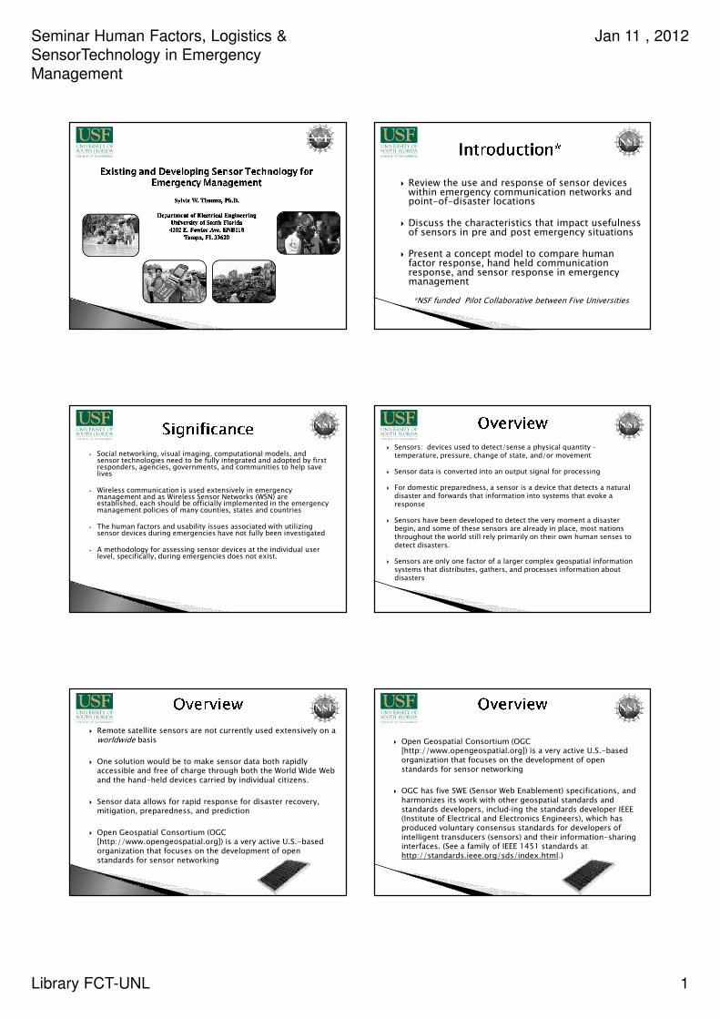
Seminar Human Factors, Logistics & SensorTechnology in Emergency Management Jan 11 , 2012 Library FCT-UNL 1 Review the use and response of sensor devices within emergency communication networks and point-of-disaster locations Discuss the characteristics that impact usefulness of sensors in pre and post emergency situations Present a concept model to compare human factor response, hand held communication response, and sensor response in emergency management *NSF funded Pilot Collaborative between Five Universities • Social networking, visual imaging, computational models, and sensor technologies need to be fully integrated and adopted by first responders, agencies, governments, and communities to help save lives • Wireless communication is used extensively in emergency management and as Wireless Sensor Networks (WSN) are established, each should be officially implemented in the emergency management policies of many counties, states and countries • The human factors and usability issues associated with utilizing sensor devices during emergencies have not fully been investigated • A methodology for assessing sensor devices at the individual user level, specifically, during emergencies does not exist. Sensors: devices used to detect/sense a physical quantity – temperature, pressure, change of state, and/or movement Sensor data is converted into an output signal for processing For domestic preparedness, a sensor is a device that detects a natural disaster and forwards that information into systems that evoke a response Sensors have been developed to detect the very moment a disaster begin, and some of these sensors are already in place, most nations throughout the world still rely primarily on their own human senses to detect disasters. Sensors are only one factor of a larger complex geospatial information systems that distributes, gathers, and processes information about disasters Remote satellite sensors are not currently used extensively on a worldwide basis One solution would be to make sensor data both rapidly accessible and free of charge through both the World Wide Web and the hand-held devices carried by individual citizens. Sensor data allows for rapid response for disaster recovery, mitigation, preparedness, and prediction Open Geospatial Consortium (OGC [http://www.opengeospatial.org]) is a very active U.S.-based organization that focuses on the development of open standards for sensor networking Open Geospatial Consortium (OGC [http://www.opengeospatial.org]) is a very active U.S.-based organization that focuses on the development of open standards for sensor networking OGC has five SWE (Sensor Web Enablement) specifications, and harmonizes its work with other geospatial standards and standards developers, includ-ing the standards developer IEEE (Institute of Electrical and Electronics Engineers), which has produced voluntary consensus standards for developers of intelligent transducers (sensors) and their information-sharing interfaces. (See a family of IEEE 1451 standards at http://standards.ieee.org/sds/index.html .)
Transcript of Seminar Human Factors, Logistics & Jan 11 , 2012 ...
Seminar Human Factors, Logistics &
SensorTechnology in Emergency
Management
Jan 11 , 2012
Library FCT-UNL 1
� Review the use and response of sensor devices within emergency communication networks and point-of-disaster locations
� Discuss the characteristics that impact usefulness of sensors in pre and post emergency situations
� Present a concept model to compare human factor response, hand held communication response, and sensor response in emergency management
*NSF funded Pilot Collaborative between Five Universities
• Social networking, visual imaging, computational models, and sensor technologies need to be fully integrated and adopted by first responders, agencies, governments, and communities to help save lives
• Wireless communication is used extensively in emergency management and as Wireless Sensor Networks (WSN) are established, each should be officially implemented in the emergency management policies of many counties, states and countries
• The human factors and usability issues associated with utilizing sensor devices during emergencies have not fully been investigated
• A methodology for assessing sensor devices at the individual user level, specifically, during emergencies does not exist.
� Sensors: devices used to detect/sense a physical quantity –temperature, pressure, change of state, and/or movement
� Sensor data is converted into an output signal for processing
� For domestic preparedness, a sensor is a device that detects a natural disaster and forwards that information into systems that evoke a response
� Sensors have been developed to detect the very moment a disaster begin, and some of these sensors are already in place, most nations throughout the world still rely primarily on their own human senses to detect disasters.
� Sensors are only one factor of a larger complex geospatial information systems that distributes, gathers, and processes information about disasters
� Remote satellite sensors are not currently used extensively on a worldwide basis
� One solution would be to make sensor data both rapidly accessible and free of charge through both the World Wide Web and the hand-held devices carried by individual citizens.
� Sensor data allows for rapid response for disaster recovery, mitigation, preparedness, and prediction
� Open Geospatial Consortium (OGC [http://www.opengeospatial.org]) is a very active U.S.-based organization that focuses on the development of open standards for sensor networking
� Open Geospatial Consortium (OGC [http://www.opengeospatial.org]) is a very active U.S.-based organization that focuses on the development of open standards for sensor networking
� OGC has five SWE (Sensor Web Enablement) specifications, and harmonizes its work with other geospatial standards and standards developers, including the standards developer IEEE (Institute of Electrical and Electronics Engineers), which has produced voluntary consensus standards for developers of intelligent transducers (sensors) and their information-sharing interfaces. (See a family of IEEE 1451 standards at http://standards.ieee.org/sds/index.html.)

Seminar Human Factors, Logistics &
SensorTechnology in Emergency
Management
Jan 11 , 2012
Library FCT-UNL 2
� The OGC SWE Standards Framework includes the following:
� Geographic Information Systems Observations and Measurements (O&M)t (www.opengeospatial.org/standards/dp), - model for representing and exchanging observation results,
� Sensor Model Language (SensorML) Implementation Specification (http://portal.opengeospatial.org/files/index.php?artifact_id=12606) –information model for the discovery and manipulation of web-based sensors and their data;
� Transducer Markup Language (TML) Implementation Specification (http://portal.opengeospatial.org/files/index.php?artifact_id=14282) –standardized transducer (sensor) message format that facilitates accessing, exchanging, and storing sensor data;
� Sensor Observation Service (SOS) Implementation Specification (www.opengeospatial.org/standards/requests/32), - application interface providing a standard way to access information from all sensor systems; and
� Sensor Planning Service (SPS) Implementation Specification (www.opengeospatial.org/standards/requests/34), which helps large enterprises in sensor planning vis-a-vis large information flows of both live and stored sensor and imaging data.
A Global Sensor Network for Disaster Warnings, August 5, 2009 · Filed Under Diana Hopkins,
� Use of wireless sensors vs. non-wireless sensors;
� Adding intelligence to sensors;
� Positioning and spacing of sensors;
� Data communications and data development;
� Mining and processing of information;
� Spatial and temporal randomness;
� Incorporation of data received from multiple sources;
� Validation, accuracy, and precision of the data received.
� Enviro-Net Project: Canadian based deployment of sensors across five countries to monitor conditions in tropical dry forests.
� Challenge: Commercial availability of wireless sensor networks (WSN), which can be critical for environmental monitoring of large areas
G. Pastorello, G. Sanchez-Azofeifa, M. Nascimento, “Enviro-Net: From Networks of Ground-Based Sensor Systems to a Web Platform for Sensor Data Management, Sensors, 2011, 11, 6454-6479, ISSN 1424-8220.
Wireless sesnor node in Argentina used to monitor climatic conditions and soil
conditions (e.g. temp. and moisture)
� Center for Optical Sensors and Spectroscopies (COSS): improve optical sensing using emerging laser and spectroscopic technologies on environmental, biomedical, and national security
� Oil spill highlighted the critical
need for rapid environmental
monitoring of hazardous wastes
and other pollutants and determining
the aftermath hazards to responders
and the affected communities.
� COSS uses a laser-based “optical nose” to rapidly sense contamination of spills and discharges of hazardous organic compounds
Environmental Contamination Sensor Development and Evaluations Associated with Natural Disasters NSF and the Center for Optical Sensors and Spectroscopies (COSS), University of Alabama at Birmingham
FTIR at UAB used to secure sensing data
Unmanned Aircraft Systems:� National Oceanic and Atmospheric Adm.
uses UAS for hurricane alertness
� NASA developed UAS Ikhana, which has special
heat sensors installed for temp. mapping
� Navy’s Center for Asymmetric Warfare (CAW) helps improve preparedness for chemical spills, natural disasters and terrorist attacks by using UAS with sophisticated sensors for heat, chemicals, electromagnetic energy and biological airborne micro-organisms
� CAW developed Sensor Island, a Web-based program, for gathering critical data and making it immediately available to emergency response teams. Sensor Island filters and presents sensor data in a usable format for first responders.
Unmanned Aircraft Offer New Tools for the Emergency
Response Arsenal By: Kimberlie Nitti on March 24, 2011
Unmanned Aircraft System (UAS)
• Devices that require little physical and cognitive effort
• Devices that are portable
• Devices that are durable
• Devices that consider user capability
• Devices that are cost effective
• Devices that consider usability
• Weather resistant
• Alternative methods for powering devices

Seminar Human Factors, Logistics &
SensorTechnology in Emergency
Management
Jan 11 , 2012
Library FCT-UNL 3
Concept Paper on Emergency Communications during Natural
Disasters: Infrastructure and TechnologyTo be carried out by: Broadband Mobile Communications Research Lab (BMCRL), Asian
Institute of Technology, Bangkok, Thailand
sensor data
processing center
(24-hr monitored)
individuals
wireless(radio,
SMS, etc.)
wireline (cable TV, Internet, etc.)
visual/soundalarms
relateddisaster
area
satellites
disasterarea
sensor data
processing center
(24-hr monitored)
individuals
wireless(radio,
SMS, etc.)
wireline (cable TV, Internet, etc.)
visual/soundalarms
relateddisaster
area
satellites
disasterarea
Pre/ Emergency
Sensors
Post Emergency
Sensors
sensor data
processing center
(24-hr monitored)
sensorsin the field
satellite
wireless satellitereceiver
wireline
sensor data
processing center
(24-hr monitored)
sensorsin the field
satellite
wireless satellitereceiver
wireline
24 Hr Sensor Data Processing
Center
iPad
iPad
Towards a societal scale, mobile sensing system byRichard Edward Honicky Jr. Doctor of Philosophy in Computer
Science, University of California, Berkeley, Fall, 2010
UC Berkeley prototype of the Bluetooth board
with a CO sensor, a NOx/CO dual sensor, a
temperature sensor and an accelerometer. This
board will integrate directly with the phone.
Towards a societal scale, mobile sensing system byRichard Edward Honicky Jr. Doctor of Philosophy in Computer
Science, University of California, Berkeley, Fall, 2010
The Intel badge device, with the battery and electrochemical ozone sensor. The
Intel “badge” platform integrates a GPS and GPRS modem, plus an
electrochemical ozone sensor.
Concept Paper on Emergency Communications during Natural
Disasters: Infrastructure and TechnologyTo be carried out by: Broadband Mobile Communications Research Lab (BMCRL), Asian
Institute of Technology, Bangkok, Thailand
sensor data
processing center
(24-hr monitored)
individuals
wireless(radio,
SMS, etc.)
wireline (cable TV, Internet, etc.)
visual/soundalarms
relateddisaster
area
satellites
disasterarea
sensor data
processing center
(24-hr monitored)
individuals
wireless(radio,
SMS, etc.)
wireline (cable TV, Internet, etc.)
visual/soundalarms
relateddisaster
area
satellites
disasterarea
Pre/ Emergency
Sensors
Post Emergency
Sensors
sensor data
processing center
(24-hr monitored)
sensorsin the field
satellite
wireless satellitereceiver
wireline
sensor data
processing center
(24-hr monitored)
sensorsin the field
satellite
wireless satellitereceiver
wireline
24 Hr Sensor Data Processing
Center
iPad
iPad
� Social and human interaction issues
� Automatic acquisition of data
� Accessibility of data,
� Ethical issues,
� Data updating and synchronizing
� Energy constraints,
� Management of volumes of sensor data
HFER = overall human factors and ergonomics rating for device use in emergency management

Seminar Human Factors, Logistics &
SensorTechnology in Emergency
Management
Jan 11 , 2012
Library FCT-UNL 4
� The technology and capability is current available to research and define the impact of sensor technology on a human factors model in high consequence emergency management
� This proposed work will advance understanding of response processes and preparedness in emergency management and establish the foundation for a global human and sensor factors communication model for international emergency management.
� While sensors are essential and are only one part of a complex system in natural disasters, if an appropriate and valid integration of human factors and sensors is not applied, the usefulness of the technology can be rendered stagnant.
� A study and comparative of communication/response models (human detecting, wireless/non-wireless/satellite sensing, mobile communication) in emergency management is vital to realize the full-cycle analysis.