Semi-detailed soil survey of Barro Colorado Island,...
61
Semi-detailed soil survey of Barro Colorado Island, Panama I. Baillie 1 *, H. Elsenbeer 2 , F. Barthold 2 , R. Grimm 2 , & R. Stallard 3 1 National Soil Resources Institute, Cranfield University, MK45 4DT, UK 2 Institut für Geoökologie, Universität Potsdam, Karl-Liebknecht-Str. 24-25, 14476 Golm, Germany 3 Smithsonian Tropical Research Institute, Panama City, (APO AA 34002-0948, USA) & US Geological Survey, Boulder, CO 80303, USA. * Corresponding author: [email protected]
Transcript of Semi-detailed soil survey of Barro Colorado Island,...
Semi-detailed soil survey of Barro Colorado Island, Panama
I. Baillie1*, H. Elsenbeer
2, F. Barthold
2, R. Grimm
2, & R. Stallard
3
1 National Soil Resources Institute, Cranfield University, MK45 4DT, UK
2 Institut für Geoökologie, Universität Potsdam, Karl-Liebknecht-Str. 24-25, 14476 Golm, Germany
3 Smithsonian Tropical Research Institute, Panama City, (APO AA 34002-0948, USA) & US Geological
Survey, Boulder, CO 80303, USA. * Corresponding author: [email protected]

CONTENTS
Summary
i
Acknowledgements
iii
Abbreviations and acronyms
iv
1 Introduction 1 1.1 Barro Colorado Island 1 1.2 Soil-related ecological research on BCI 1 1.3 Aims of BCI soil survey 2 2 BCI survey area 3 2.1 Location and access 3 2.2 Climate 3 2.3 Geology and soil parent materials 3 2.4 Topography 7 2.5 Drainage and hydrology 8 2.6 Land surface age 8 2.7 Biota 9 3 Previous soil data for BCI 9 3.1 Previous soil surveys 9 3.2 Other pedospatial data 10 4 Soil survey methods 11 4.1 Field 11 4.2 Soil mapping 15 4.3 Laboratory analyses 15 5 Soils of BCI 16 5.1 BCI soil forms and pedogenetic trends 16 5.2 Classification of BCI soils 17 5.3 Characteristics of BCI soil classes 19 5.4 Correlations of BCI soils 36 6 Soil mapping 41 6.1 BCI soil mapping units 41 6.2 Updating and using the BCI soil map 41 7 Soils of specific research areas 43 7.1 Soils of 50 ha CTFS Long Term Ecological
Research plot and upper catchment of Conrad Creek
43
7.2 Soils of Lutz Creek catchment 44 8 Highlights of BCI soils 45 8.1 Pedological comparisons 45 8.2 Ecological implications 46 References and general BCI soils bibliography
49
i
SUMMARY
1. This is the report of a semi-detailed soil survey in 2005-6 of the Smithsonian Tropical Research Institute’s 1560 ha research reserve of Barro Colorado Island in the man-made Gatun Lake, Republic of Panama.
2. This was a conventional free survey, in which the field observations were subjectively
sited following landscape prompts. There were almost 500 soil survey sites plus an additional 250 sites where members of the soil survey team identified soil classes during when working on other projects. The density of observations qualifies the survey as 2
nd order by USDA, and detailed by FAO, criteria. There are detailed
descriptions of 30 soil profiles.
3. The climate of the island is wet seasonal tropical with a mean annual rainfall of about 2300 mm. The four volcanic and associated marine sedimentary geological formations are all of intermediate–mafic lithology. The topography of the island is dominated by two muted cuestas. The dipslope of the larger and higher of these in the west forms a very gently sloping plateau on andesite in the centre of the island. The dipslope of the eastern cuesta stretches southwards from the Thomas Barbour trail to the Harvard peninsula. The dissected scarps of the cuestas form the steep terrain in the north of the island and N-S down the centre.
4. All of the soils are fine textured. Even where deeply weathered, many of the soils
have substantial clast contents.
5. The most extensive soils are stony and shallow brown fine loams. Their cracking, colours and high cation exchange capacities confirm the X-ray diffraction data that these soils contain some smectitic as well as the predominant kaolinitic clay minerals. This and their shallowness indicate that weathering is not far advanced. They are also not intensively leached, as their high CEC’s are highly base- saturated, and they are only slightly acid. There are some fine loams with particularly deep dark topsoils
6. There are extensive red light clays on the more gentle topography, especially on the
central andesite plateau. These are well weathered, and the main clay mineral is kaolinite, commonly with subordinate gibbsite. These soils are deep, and have bright red unmottled colours. The predominant silty clays and clays are micro-aggregated into pseudo-silt and –sand particles, giving moderate porosity, and moderately free drainage. These soils are leached and acid. The low –moderate CEC’s are variably base-saturated, and there is significant extractable Al in some subsoils.
7. There are substantial areas of pale swelling clays, especially on the Caimito marine
sedimentary facies in the southwest of the island. Smectites are the dominant clay minerals. The swelling properties of these minerals seem to impede water movement in the wet season. This gives apparently imperfectly drained soils, characterised by very pale matrix colours, often with slight bluish or greenish tinges, and prominent bright orange and red mottles. All of these soils have high cation exchange capacities. In one class the exchange complex is highly base-saturated, giving very high total exchangeable bases. The other classes are slightly more acid and are more or less dominated by labile Al. Al-smectites are rare anywhere, but especially in soils of tropical forests.
8. In the Lutz Creek catchment, the combination of Caimito marine parent materials and
steep slopes give shallow mottled clays. These have very high base-saturated cation exchange capacities
9. There are small areas of poorly drained gleys in the plateau swamp and ephemeral
ponds.
10. The soils are classified according to the morphological form and the geology of the

ii
parent material. Lithogenic differences are not readily apparent in the field but are used as pedotaxonomic differentiae at this stage, as regolith lithology may later be shown to be ecologically significant. If found to be irrelevant, the lithological criteria and subdivisions can be discarded in the future.
11. The soil classes are correlated with the multi-attribute coding system of Catapan and
the two main international soil classification systems. In the FAO World Reference Base, the brown fine loams and other shallow soils are Eutric Cambisols, with Lithic and Mollic variations. In USDA Soil taxonomy these soils are Eutrudepts.
12. The pale swelling clays are stagnic or gleyic variations of Luvisols or Alisols in World
Reference Base, and Aquic variations of Udalfs in Soil Taxonomy.
13. The most difficult soils to correlate with the data available are the deep red light clays. In World Reference Base, we designate them as Luvic, Lixic, Alumic, and Acric variations of the Ferralsols. Similarly we use Kandi- and Hapl- variations of the Alfisols and Ultisols as descriptive qualifiers for Oxisols in Soil Taxonomy.
14. The soil mapping units are consociations, in which one soil class is dominant but
which contains intricately and unmappably intricate areas of named minor classes.
15. There are 13 mapping units, 11 of which account for 98% of the area of the island. The spatial pattern of the soils follows the geological structure, as is to be expected from the lithological emphasis in the definitions of the soil classes.
16. The soils of BCI are edaphically variable with respect to the physical aspects of –
water supply, root aeration and site stability.
17. Stoichiometric comparisons with the soils of two tropical forest research sites in Asia indicate that soils the BC are with respect to labile forms of Ca and Mg, but have very low exchangeable K contents.
iii
ACKNOWLEDGMENTS This survey was done by the Institut für Geoökologie, Universität Potsdam, Germany, under a contract to the Smithsonian Tropical Research Institute, Panama. We are grateful to the Universität Potsdam for allocating more resources and time than were budgeted. The survey team received a warm welcome and great logistical support and assistance from STRI staff on BCI and at the Tupper campus, Ancon. We particularly appreciate the logistic coordination by Señoras Oris Acevedo and Belkys Jiménez, and the hard work of Señor Olivio Apolonio in digging spacious profile pits in stony and compact soils. Frauke Barthold and Rosina Grimm received financial assistance from the German Academic exchange service (DAAD) We are grateful to Senor Villarreal of the Ministerio de Desarollo Agropecuaria, Santiago for allowing and facilitating access to the Catapan (1970) 1:20 000 land resource maps. We received advice from many scientists in the BCI community, and particularly much background to science on BCI from Dr Egbert J Leigh Jr. Dr E Veldkamp provided useful information on the comparison of the soils of Barro Colorado Island with those at La Selva in Costa Rica. The soil samples were analysed by in the laboratories of the Institut für Geoökologie and Institut für Chemie, Universität Potsdam, with granulometric analyses performed by the Institut für Geographie, Universität Mainz. We are grateful to Mr S. Tan of the Sarawak Department of Forestry, Malaysia; Professor I.A.U.N. Gunatilleke of Peradeniya University, Sri Lanka; for permission to use unpublished data from the CTFS plots at Lambir and Sinharaja respectively.
iv
ABBREVIATIONS
asl Above sea level AvK Available potassium AvP Available Phosphate AWC Available water capacity (amount of water held in soil at suctions in
the range for root uptake, = MC%@ FC – MC% @PWP) BCI Barro Colorado Island BS% Base saturation percentage (=TEB/CEC) C Clay. Finest size class of mineral particles (< 0.002 mm) Catapan Catastro de Panama (CRA) CEC Cation exchange capacity (conventionally determined at pH7) CL Clay loam COLE Coefficient of linear extension (%) Colluvium Local hillwash, moved by overland flow and slow creep Complex Soil mapping unit with several co-dominant soil classes Consociation Soil mapping unit with one soil class dominant and others as minor
constituents CRA Comision de Reforma Agraria (MIDA) Creep Slow gravitational mass movement of colluvium downslope. CTFS Center for Tropical Forest Studies C/V Chroma and value in Munsell Soil Color coding system Dbh, drh Diameter at breast (1.3 m above ground level) or reference (0.6 m
above the highest buttress) height EBS% Effective base saturation (= TEB/ECEC) ECEC Effective cation exchange capacity (=TEB + Extr Al) Eluvial Soil horizon formed by the selective washing out of some original
components Exch Exchangeable (for cations extracted with 1M NH4OOCH3) Extr Extractable with 1M KCl FAO Food & Agriculture Organisation of United Nations FC Field capacity (MC% at suction of 0.1 or 0.3 atmosphere) Fine earth Soil particle size < 2mm GIS Geographical information system Gley Soil that is permanently wet, poorly aerated and has predominantly
greyish colours, due to the reduction of free iron; may have locally oxidised rust - coloured mottles around root channels
GPS Global positioning system HAC High activity clay HKK CTFS LTER plot at Huai Kha Khaeng, western Thailand. Horizon Soil layer ICP Induction coupled plasma spectrometer IGN Instituto Geografico Nacional Tommy Guardia Illuvial Soil horizon formed by enrichment of some components washed in
from eluvial horizon(s) above L Loam (Mixed soil with substantial proportions of all three fine earth
size classes, i.e. clay, silt and sand) LAC Low activity clay Linear Straight slope with more or less similar gradients up- and downslope LTER Long term ecological research MC% Moisture content % (by mass) MIDA Ministerio de Desarollo Agropecuaria (RoP) Munsell System of soil colour notation, operated by matching soil against
standard color chips. Colour described by ‘hue’ (Spectral composition - red, yellow, blue, green); ‘value’ (dilution with multispectral white), & ‘chroma’ (darkness)
ND No data NGO Non-government organisation NH4OOCH3 Ammonium acetate (1M, buffered at pH 7, for extracting
exchangeable cations)

v
OC Organic carbon PM Soil parent material Profile Sequence of soil horizons from surface to parent material PWP Permanent wilting [point (soil moisture suction of pF 4.2 = 1.5 MPa) RoP Republic of Panama S Sand (coarsest fine earth particle size class, 0.05 – 2 mm in USDA) Series Equivalent to soil class on BCI. Sixth level of subdivision in USDA
Soil Taxonomy SI Smithsonian Institution Si Silt (intermediate fine earth mineral particle size class, 0.002 – 0.05
mm in USDA) SMR Soil Moisture Regime, as defined in ST SMU Soil mapping unit SOC Soil organic carbon Solum True soil, in which physicochemical and bio-turbation processes have
obliterated visible traces of parent rock structure SOM Soil organic matter ST Soil Taxonomy (USDA system of soil classification) STR Soil temperature regime, as defined in ST STRI Smithsonian Tropical Research Institute Surface wash Movement of detached surface soil particles by overland flow Tr Trace TEB Total exchangeable bases (= exchangeable Ca + Mg + Na + K) USDA United States Department of Agriculture WRB World Reference Base for Soil Resources (FAO system of soil
classification) Z, Zi Silt (intermediate fine earth particle size class, 0.002 – 0.05 mm in
USDA)
1
1 INTRODUCTION
1.1 Barro Colorado Island Barro Colorado Island (BCI) was created in 1914 by the construction of the Panama Canal, during which the lower valley of Rio Chagres was flooded to form the freshwater Gatun Lake. The flooding isolated the upper and middle slopes of a group of low hills to form BCI, and the island is now separated from the Panamanian mainland by open fresh water, nowhere less than 200 m wide. In 1914 the island was largely under moist deciduous tropical forest, some of it regrowth after cutting and disturbance during the construction of the Canal in 1880 –1905. There were also substantial areas of old growth forest (Foster & Brokaw, 1996) and small areas of cultivation. The few smallholder farmers were bought out when the island was designated as a Biological Reserve in 1923. The reserve was dedicated to watershed protection, conservation and scientific research. A committee of the US National Academy of Science administered it until 1946, when the Smithsonian Institution (SI), specifically the Smithsonian Tropical Research Institute (STRI), assumed responsibility. STRI extended the range of research, especially into forest ecology (Leigh et al., 1982 & 1996). The post-1979 phased transfer of sovereignty of the Canal Zone from U.S.A to the Republic of Panama (RoP) is now complete. RoP designated BCI and five nearby mainland peninsulae as a Nature Monument in 1993. This status gives rigourous protection under Panamanian law, and also internationally under the 1940 hemispheric Convention on Nature Protection and Wildlife Preservation (STRI, 1987). The adjacent Soberania National Park provides a physical buffer that should further enhance the protection of the Monument and BCI. Under agreement with the Government of RoP the management of BCI remains with STRI, whose activities are mainly resourced through US Congress budget appropriations and by endowments from other sources in the USA. 1.2 Soils – related ecological research on BCI
BCI is the most intensively researched tropical forest site in the world (Ocana et al. 1988; Rubinoff & Leigh, 1990). Work done on BCI has greatly contributed to current understanding of the ecology of neotropical moist forests and of the tropical forest biome in general. There are overviews of scientific investigations and publications on BCI in Leigh (1999) and Leigh et al. (1996).
One of the activities pioneered on BCI was the setting up of large long-term ecological research (LTER) plots in tropical forests. There is now a pantropical network of 16 such plots, coordinated by the Center for Tropical Forest Science (CTFS), an entity within STRI, and, for the nine Asian plots, the Arnold Arboretum of Harvard University. The plots are large (ideally 50 ha, with up to a third of a million stems on each plot), so that they contain statistically robust populations (ideally > 100 stems) of all but really rare species. The freestanding vegetation (i.e. excluding climbers) down to 1 cm diameter at reference height (1.3 m above ground level or 0.6 m above the highest buttress) is inventoried and monitored at five-year intervals, so that the life history of every tree in the forest can be traced from young sapling to death and disappearance.
The first CTFS plot was established on BCI, and the CTFS standard methodologies were pioneered, tested and codified on the BCI 50 ha LTER plot (Condit, 1998). The run of data for BCI is the longest of all CTFS plots, with the initial inventory in 1981-2, and the fifth quinquennial re-census in 2005. This enables analyses of forest dynamics to be extended over decades rather than just years, and a picture of the effects of medium term climatic variations on tropical forest is starting to emerge (Condit et al. 1995, 1996; Chave et al. 2003).
One of the major themes that consistently interests ecologists on BCI, as in all other tropical forests, is the origin and maintenance of high tree species diversities at local, regional and biome scales. Suggestions for influences and determinants include:
2
• Density-dependent biological processes and pressures, such as from predation by pests and infection by pathogens;
• Mathematically predictable variation arising from stochastic assembly-dispersal processes;
• Irregular intensive disturbances (e.g. climatic, seismic, volcanic);
• Refined specialisation for diverse abiotic niches
(Leigh et al., 2004).
In general, less importance has been accorded to abiotic niche specialisation for species composition and distribution on BCI than in some Asian forests. This is true for island–wide studies (e.g. Knight, 1975; Svenning et al., 2004), and on the 50 ha LTER Plot (e.g. Harms et al., 2001). Research into the role of abiotic niche specialisation cannot progress far without detailed characterisation of the physical environment, including soils. Soil data for BCI are limited and edaphic habitats have hitherto been differentiated and characterised on the basis of topographic classes, topographic attributes - elevation, slope angle, and hydrological indices. BCI soils have so far been differentiated only as generalised classes (Croat 1978; Harms et al., 2001; Knight, 1975; Svenning et al. 2004). 1.3 Aims of BCI soil survey
There are several on-going activities that will substantially enhance understanding of BCI’s soils, including: studies of: soil hydrology; systematic soil nutrient characterization of the 50 ha LTER plot; microbial rock mineral weathering; follow-up of the long term dry-season irrigation experiment; fertiliser trials on pedologically similar areas on adjacent mainland penisulae; and this survey.
The objective of this survey is to compile a soil map of the island, including the soils of the 50 ha LTER Plot. The emphasis is pedological but the overview provided should facilitate:
• Characterisation and spatial differentiation of the edaphic environments of BCI.
• Interpretation of existing and future detailed and specialized data on nutrients, water, aeration and other soil-related features in a spatio-pedological context.
• Comparison of the soils of BCI with those of other tropical forests.
• Comparison of the soils of the BCI 50 ha LTER plot with those of other plots in the CTFS network.
The survey is at semi-detailed scale, with a density of field observations (ca 1 per 2 ha), which is sufficient to support a map of scale of 1:15 000.
Soil patterns, as elucidated by soil survey, can account for much variation in vegetation distribution and performance (e.g. Veldkamp et al., 1990), depending on circumstances. However, not all soil maps are immediately and obviously useful. Nonetheless, because the pedogenic characteristics of soils, especially those relating to the mineral components, change only slowly, soil maps are valid for long periods. This especially true if the original data are retained and are available for re-interpretation to meet future research needs.
3
2 BCI SURVEY AREA
2.1 Location and access
BCI is in the Gatun Lake, at the northwestern (Caribbean) end of the Panama Canal, in the central part of the Republic of Panama, Central America, at latitude 9
o 08’ – 9
o 11’ N’ and
longitude 79o
49’ – 79o
52’W (Figure 2.1). Access is easy, 20 - 50 minutes by boat from Gamboa, which is 25 km by blacktopped road from Panama City. The area of the island is about 1560 ha, and the shape is of fairly compact star, with a series of spurs now forming peninsulae and valleys forming bays. It stretches about 6 km N-S and E-W. There is a well-maintained 41 km network of foot trails. The laboratory/residential complex is on the northeastern coast. All points on the trail system can be reached in 1.5 hours walk from the lab, and there is nowhere on the island that is more than 1.2 km from a trail. Less accessible areas can be reached by boat and then on foot inland from the shore. 2.2 Climate
There are summaries of the climate of BCI in Leigh (1999) and Leigh et al. (1996). Important features for soil development and correlation include:
• Warm temperatures, with an annual mean of about 27o
C, and an annual range of monthly means of less than 2
oC; and diurnal ranges of about 8 – 10
o C.
• Mean annual rainfall of about 2600 mm, with a strongly seasonal distribution. Monthly rainfall averages less than 60 mm for January - April. Individual dry seasons vary in severity, and range in length from three to five months. The wet season precipitation and annual totals also vary. Consequently the amount of water surplus to evapotranspiration and soil recharge needs and available for overland flow, erosion, solute leaching, hydrolytic weathering, and catenary redistribution of solutes and colloids is temporally (as well as spatially) variable, probably ranging from zero up to about 1500 mm p.a.
• The rainfall can attain potentially erosive intensities of up to 100 mm hr-1
for short periods.
• There are strong gusts of wind that can uproot trees (Foster & Brokaw, 1996), especially from across the wider parts of the lake to the west. However, BCI lies to the south of the main hurricane tracks.
2.3 Geology and soil parent materials
2.3.1 Solid geology
There are only a few outcrops on BCI, nearly all in streambeds, and most of the following geological summary is based on Woodring’s (1958) geological map of BCI. We have made a few adjustments based on streambed outcrops and surface stones seen in 2005-6, mainly with respect to his andesite-Bohio boundary in the area NE of the radio mast. The Isthmus of Panama is part of a volcanic arc that connects North with South America. The arc results from the collision of the South American, Nazca, Cocos and Caribbean plates during the Miocene (13 to 2.7 Ma ago). The Nazca is still subducting under the Caribbean plate and the subduction zone forms a NE-SW trending chain of active volcanoes parallel to the Pacific Coast. The recent geological activity history in Central America has resulted in considerable lithological diversity.
4
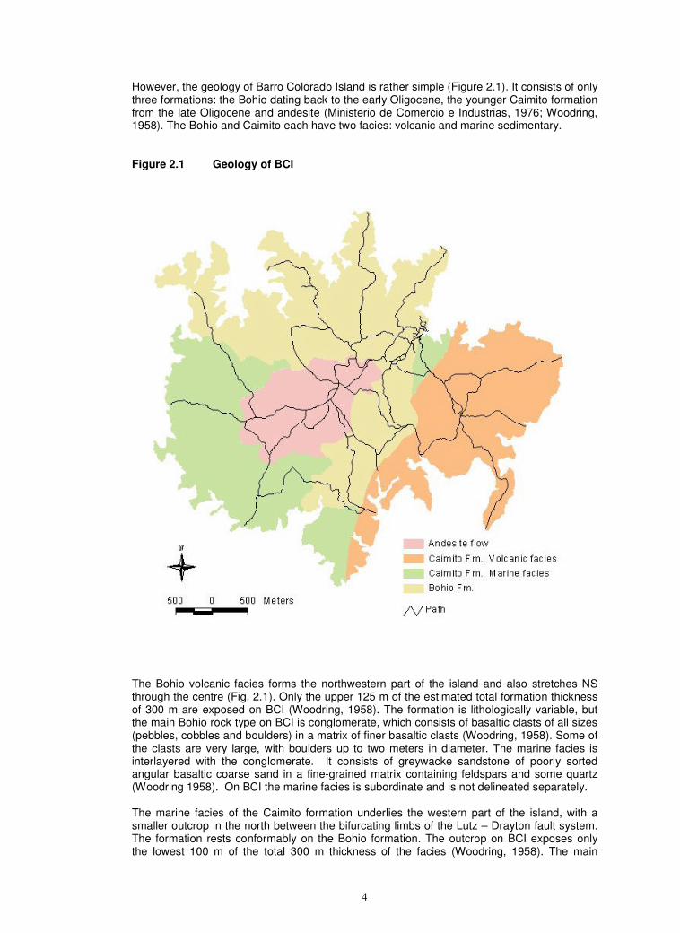
However, the geology of Barro Colorado Island is rather simple (Figure 2.1). It consists of only three formations: the Bohio dating back to the early Oligocene, the younger Caimito formation from the late Oligocene and andesite (Ministerio de Comercio e Industrias, 1976; Woodring, 1958). The Bohio and Caimito each have two facies: volcanic and marine sedimentary. Figure 2.1 Geology of BCI
The Bohio volcanic facies forms the northwestern part of the island and also stretches NS through the centre (Fig. 2.1). Only the upper 125 m of the estimated total formation thickness of 300 m are exposed on BCI (Woodring, 1958). The formation is lithologically variable, but the main Bohio rock type on BCI is conglomerate, which consists of basaltic clasts of all sizes (pebbles, cobbles and boulders) in a matrix of finer basaltic clasts (Woodring, 1958). Some of the clasts are very large, with boulders up to two meters in diameter. The marine facies is interlayered with the conglomerate. It consists of greywacke sandstone of poorly sorted angular basaltic coarse sand in a fine-grained matrix containing feldspars and some quartz (Woodring 1958). On BCI the marine facies is subordinate and is not delineated separately. The marine facies of the Caimito formation underlies the western part of the island, with a smaller outcrop in the north between the bifurcating limbs of the Lutz – Drayton fault system. The formation rests conformably on the Bohio formation. The outcrop on BCI exposes only the lowest 100 m of the total 300 m thickness of the facies (Woodring, 1958). The main
5
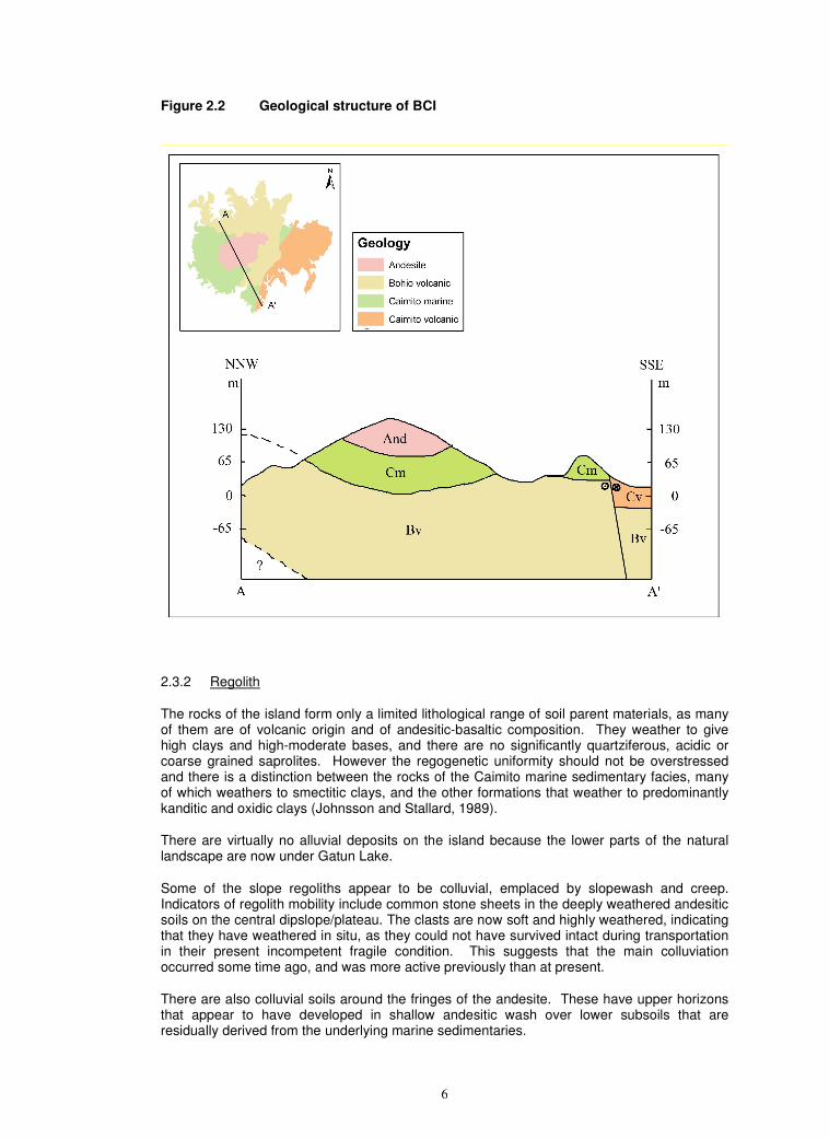
constituents are well sorted, tuffaceous, and fossiliferous sandstones of varying grain-size. There are also subordinate interlayers of various types of calcareous and carbonaceous sandstones. Fossiliferous limestone occurs as lenticular beds between the sandstone layers, mainly in the northern outcrop of the island (Woodring, 1958). Johnsson and Stallard (1989) emphasise the biogenic constituents and identify the Caimito marine facies primarily as foraminiferal limestone with abundant pelecypods. They describe a substantial detrital component of vitric volcaniclastic debris, plagioclase and quartz. There are two separate outcrops of the Caimito marine facies on BCI, and these are distinct with respect to topography and soils. The more extensive is in the SW of the island. The other is the central and eastern sections of the catchment of Lutz Creek between the bifurcating limbs at the northern end of the Lutz-Drayton fault system. The combination of volcanic and various sedimentary constituents makes the Caimito marine facies the lithologically and pedogenetically most diverse of the four geologies. The volcanic facies of the Caimito formation underlies the eastern side of the island, with a thickness on BCI of about 100 m (Fig. 2.1). It abuts the Bohio volcanic formation on its western flank, separated by the main fault system (Woodring 1958). The main constituents of the Caimito volcanics are basaltic agglomerate, which weathers to give a bouldery regolith. There are also some greywacke beds, which vary with respect to size sorting. In addition to the Bohio and Caimito formations, there are intrusive and extrusive igneous rocks, which date back to the Oligocene and early Miocene. The main extrusive component is andesite, which caps the centre of the island (Johnson & Stallard, 1989). In the west, it rests on the Caimito marine formation, on its northern and eastern flanks it seems to be in contact with the Bohio volcanic formation. It forms a flat, slightly tilted hilltop, which is also called the dipping plateau. The cuestic form is attributed to the gentle dip of the lava sheets down from NE to SW. The gentle dip is caused by a syncline, which plunges westward (Fig 2.2). The southern and western outer edge drops down a short and moderately steep slope to a second step. The upper tread surfaces of the steps may relate to individual flow sheets. About 85 m of the flows are exposed on BCI (Woodring 1985). Elsewhere on BCI andesite is also mapped as dikes and sills (Woodring, 1958). These are difficult to identify, as they are highly weathered and are lithologically similar to the country rock. This unit has sometimes been described as basaltic, but the presence of fine quartz grit in the soil profiles indicates an intermediate andesitic-basaltic rather than truly mafic lithology. The main structural feature is the fault system that trends NNE-SSW across the centre of the island (Fig. 2.2). This is a sinistral strike slip fault with an eastward normal faulting component of a few tens of meters (Fig 2.2). The left lateral movement, where the eastern block has been displaced northward relative to the western, is as much as 10 to 15 kilometers. The fault bifurcates in the northern part of the island, with the two branches more or less defining the Lutz Creek catchment and the northern outcrop of the Caimito marine facies. The general structure of BCI is a syncline which trends SSW-ENE and plunges westward (Fig. 2.2). North of this syncline there is an anticline with its northern limb steeper than the southern. Its axis has not yet been located on the ground.
6
Figure 2.2 Geological structure of BCI
2.3.2 Regolith
The rocks of the island form only a limited lithological range of soil parent materials, as many of them are of volcanic origin and of andesitic-basaltic composition. They weather to give high clays and high-moderate bases, and there are no significantly quartziferous, acidic or coarse grained saprolites. However the regogenetic uniformity should not be overstressed and there is a distinction between the rocks of the Caimito marine sedimentary facies, many of which weathers to smectitic clays, and the other formations that weather to predominantly kanditic and oxidic clays (Johnsson and Stallard, 1989).
There are virtually no alluvial deposits on the island because the lower parts of the natural landscape are now under Gatun Lake.
Some of the slope regoliths appear to be colluvial, emplaced by slopewash and creep. Indicators of regolith mobility include common stone sheets in the deeply weathered andesitic soils on the central dipslope/plateau. The clasts are now soft and highly weathered, indicating that they have weathered in situ, as they could not have survived intact during transportation in their present incompetent fragile condition. This suggests that the main colluviation occurred some time ago, and was more active previously than at present.
There are also colluvial soils around the fringes of the andesite. These have upper horizons that appear to have developed in shallow andesitic wash over lower subsoils that are residually derived from the underlying marine sedimentaries.
7
The regolith derived from the Caimito volcanic facies in the east of the island contains many boulders. These give extensive boulders fields, especially on the upper parts of the dipslope, between Barbour and Chapman trails. There are also many subsurface boulders and the soils of the Hood and Chapman classes have bouldery subsoils.
2.4 Topography
2.4.1 Main features
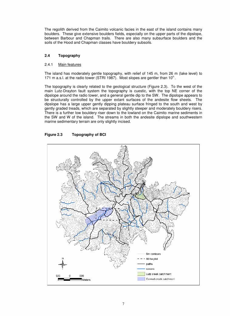
The island has moderately gentle topography, with relief of 145 m, from 26 m (lake level) to 171 m a.s.l. at the radio tower (STRI 1987). Most slopes are gentler than 10
o..
The topography is clearly related to the geological structure (Figure 2.3). To the west of the main Lutz-Drayton fault system the topography is cuestic, with the top NE corner of the dipslope around the radio tower, and a general gentle dip to the SW. The dipslope appears to be structurally controlled by the upper extant surfaces of the andesite flow sheets. The dipslope has a large upper gently dipping plateau surface fringed to the south and west by gently graded treads, which are separated by slightly steeper and moderately bouldery risers. There is a further low bouldery riser down to the lowland on the Caimito marine sediments in the SW and W of the island. The streams in both the andesite dipslope and southwestern marine sedimentary terrain are only slightly incised. Figure 2.3 Topography of BCI
8
The topography on the Bohio Formation in the north and northwest and also along the fault system down the centre of the island is steeper, and forms the scarp element of the cuesta. The terrain consists of spurs running down from the edges of the andesite dipslope. In the north the spurs run down to the lake edge. In the east they run down to the low terrain on the Caimito marine volcanic deposits in the east. The eastern scarp swings round to SW in the south and there are low but steep-sided NW-SE and N-S aligned spurs crossing the eastern end of the Wetmore trail. The streams dissecting this part of the Bohio terrain are the most active on the island, with steep, root-stepped slopes. Rapid backsapping, some of it by piping and roof collapse, has left live roots suspended across fresh gullies. The geomorphic activity in this area may be due to local recent tectonic tilting.
The landscape to the east of the fault system is almost entirely underlain by the volcanic facies of the Caimito formation. This part of the island also has a slight cuesta-like form, but this is lower and even less pronounced than in the west, and the dip is down to due south. The scarp of this cuesta forms the slopes down towards the lake from the northern side of the eastern Barbour trail. It has a discontinuous midslope ledge, on which pale, heavy soils occur (see Barbour soil class in Chapter 5). The gentle dipslope flattens out to the south, on the Harvard peninsula.
2.4.2 Age of surfaces and paleoclimates
The central andesite plateau appears to be a structurally controlled cuesta dipslope, with its elevation and form determined by the configuration of the lava flows. An alternative explanation is that it is an old erosion surface, which has been slightly tilted by minor tectonic uplift after pediplanation (Hare & Gardner, 1985; Johnsson & Stallard, 1989).
However formed, the surface appears to be old judging from the depth of sola and advanced weathering of the clasts in the subsoil stone sheets. These sheets may be inherited from residual corestones in the andesite, or may result from size sorting of regolith materials during lateral colluviation, or from vertical size sorting by biopedoturbation. However emplaced, the coarse stones the plateau sheets must have been harder at the time of deposition than they are now. Their current softness and rubefaction occurred post-emplacement, and imply a long period of regolith stability. Stone sheets are sometimes interpreted as indicators of palaeoclimates that were drier, and had more intense rainfall, sparser vegetation, and more mobile regoliths than at present. However, more active colluviation in the past need not necessarily be palaeoclimatic. Pollen and phytolith records indicate more or less continuous forest cover in the whole of the Canal Basin of Panama throughout the Late Quaternary (Bush & Colinvaux, 1990; Colinvaux, 1996; Foster et al., 1996), suggesting that climatic variation on BCI may not have been severe. Tectonic uplift, consequent rejuvenation of topographic dissection by the depression of local base levels, and colluvial burial are also possible explanations for these sheets. 2.5 Drainage and hydrology
The whole of the island is drained by low Strahler order headwaters remnants of the upper sections of stream systems radiating from the centre of the island. The higher order downstream channels have been flooded under the lake. Most streambeds are gently or moderately graded, but many are bouldery. By the end of the dry season there may be pools but little flow in larger streams, whilst the beds of minor streams are dry. Data on soil moisture for the 50 ha LTER plot and its environs (Becker et al., 1988; Daws et al., 2002), and for five years in two 2.25 ha control plots in a large dry season irrigation experiment on the Poacher peninsula (Kursar et al. 1995) indicate that soils can dry to tensions of 3 kPa by the end of the dry season. However, the intensity and duration of high moisture tensions vary with topographic position. Daws et al. (2002) showed that moisture stress is more intense and prolonged on the main dipslope/plateau tread than on the risers. This may be due to significant lateral transfers downslope by subsurface throughflow.
9
2.6 Biota
Apart from the small areas for the lab complex, sight lines for shipping lights, and other minor infrastructures, BCI is now entirely covered by tropical moist forest. The forest cover was disturbed during the construction of the Canal, and there were patches of farming on the north and south coasts. The younger regrowth is mostly in the north and east of the island. Much old growth forest, possibly dating back to the 17
th century, has been identified in the west and
south (Foster & Brokaw, 1996).
Leigh (1999) and Leigh et al. (1996) give overviews of the tropical moist forest ecosystem of BCI. Aspects of the biota that directly affect soil formation include:
• There is much soil excavation, especially by ants. They may contribute for the burial of stone sheets.
• As seen during our fieldwork at the end of the dry season, there are common worm casts on the soil surface. Pockets of endogeic casting were seen in some subsoils (e.g. Profile PF02 in Appendix B), but the pedogenic importance of earthworms on BCI is unknown.
• Treefalls appear to be unevenly distributed on the island (Putz, 1983; Putz et al., 183 & 1985). They appear to be frequent on the Bohio formation, probably because of the generally steep topography. Frequencies also seem to be high on the western side of the line, possibly due to winds across Gatun Lake (Foster & Brokaw, 1996). The soils in frequent treefall areas are subject to frequent disturbance and patchy profile truncation.
3 PREVIOUS SOILS DATA FOR BCI
3.1 Previous soil surveys
The earliest soil survey known for the area is the pioneering reconnaissance of the whole Canal Zone and its environs by Bennett (1926 &1929). He mapped the whole of BCI as the Frijoles red clay, with a topographic subdivision for the central plateau. He admitted that the separation of the moderately fertile red clays derived from different lithologies of intermediate composition in Panama was problematic. He noted that the clastic sedimentary formations contain much volcanic material and that their soils - the Gatun clays - are morphologically similar to the Frijoles clays, as are the Arraijan clays derived from biogenic calcareous sedimentary rocks.
BCI is covered by a soil survey of the Canal area (Catapan, 1970) for the Comision de Reforma Agraria (CRA) of the Ministerio de Desarollo Agropecuaria (MIDA). The general map (1:100 000) shows the whole of BCI as ‘Red Mountain Soils’, where ‘mountain’ presumably means upland and non-alluvial rather than montane. BCI is also covered by 1:20 000 soils maps for the same study. These are held at the Comision’s office in Santiago, and were made readily available by MIDA staff for inspection and copying. STRI and University of Potsdam now have copies of the Catapan 1:20 000 sheets covering BCI. The Catapan maps appear to be based mainly on the interpretation of aerial photography of unknown scale and dating from the mid-1960’s, with limited field checking. The boundaries generally accord with our findings, and clearly separate the dipslope plateau from the more rugged Bohio scarp terrain, the sedimentary and volcanic lowlands. Their mapping units are parametric compilations that incorporate: the topsoil and subsoil diagnostic horizon designation according to the Seventh Approximation (Soil Survey Staff, 1960 - the precursor to Soil Taxonomy (Soil Survey Staff, 1975, 1999 & 2006); profile drainage; textual class; depth class; parent material group; slope gradient class; erosion class; stoniness class; and an evaluation of the land’s potential capability using a system similar the eight class hierarchy then employed by USDA (Klingebiel & Montgomery, 1961). The Catapan mapping units are
10
therefore of land in general, rather than just soils. Similarities with our findings include the recognition of the subsoils on the Bohio scarplands as cambic, compared to the oxic subsoils elsewhere. Differences include their omission of smectitic mineralogy and impeded drainage on the Caimito marine facies, their designation of the Bohio scarpland soils as having worse drainage than the rest of the island, and their differentiation of umbric (dark) topsoils on the plateau compared with ochric (lighter coloured and less organic) topsoils elsewhere. 3.2 Other pedospatial data
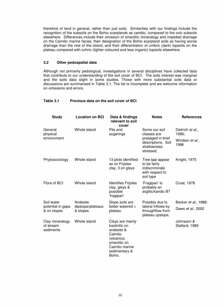
Although not primarily pedological, investigations in several disciplines have collected data that contribute to our understanding of the soil cover of BCI. The soils interest was marginal and the soils data slight in some studies. Those with more substantial soils data or discussions are summarised in Table 3.1. The list is incomplete and we welcome information on omissions and errors. Table 3.1 Previous data on the soil cover of BCI
Study Location on BCI Data & findings relevant to soil
cover
Notes References
General physical environment
Whole island Pits and augerings
Some our soil classes are presaged in brief descriptions. Soil shallowness stressed.
Dietrich et al., 1996;
Windsor et al., 1996
Phytosociology Whole island 13 plots identified as on Frijoles clay, 3 on gleys
Tree spp appear to be fairly indiscriminate with respect to soil type
Knight, 1975
Flora of BCI Whole island Identifies Frijoles clay, gleys & possible ‘fragipan’
‘Fragipan’ is probably an argillic/kandic B?
Croat, 1978
Soil water potential in gaps & on slopes
Andesite dipslope/plateaus & slopes
Slope soils are better watered > plateau
Possibly due to lateral inflows by throughflow from plateau upslope.
Becker et al., 1988;
Daws et al., 2002
Clay mineralogy of stream sediments
Whole island Clays are mainly kaolinitic on andesite & Caimito volcanics; smectitic on Caimito marine sedimentary & Bohio.
Johnsson & Stallard, 1989
11
4 METHODS
4.1 Field
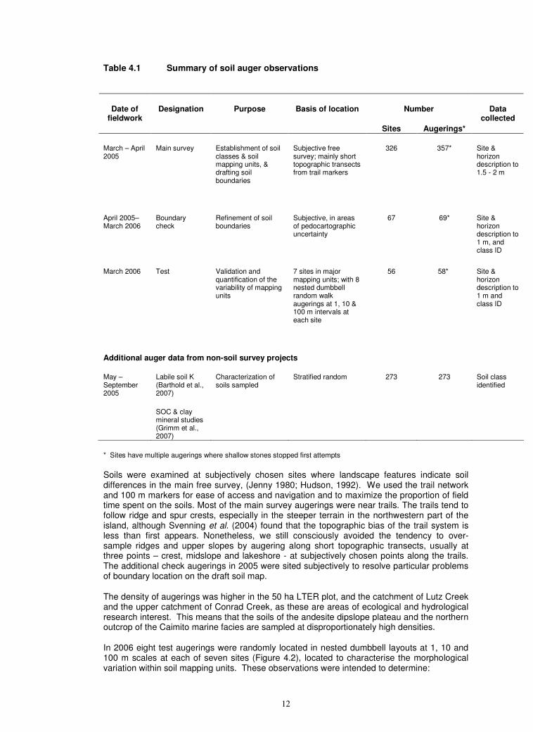
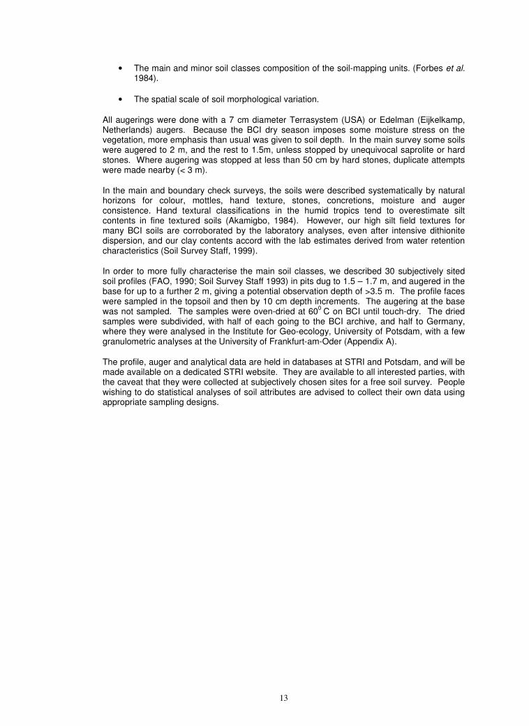
The survey is based on 484 dedicated soil survey auger observations at 443 sites and 30 detailed soil profile descriptions. The augering for the soil survey was done in three stages – main survey, boundary checking, and spatial variability testing (Table 4.1).
There are a further 273 sites at which the soil classes were identified by members of the soil survey team in the course of other studies (e.g., Barthold, F., R.F. Stallard, and H. Elsenbeer. 2007. Soil nutrients and landscape relationships in a lowland tropical rainforest in Panama. Submitted to For. Ecol. Manage.) Soils classes have therefore been identified in > 750 observations at > 700 sites (Figure 4.1), giving an observation density of slightly less than one site per two hectares. This qualifies the survey as 2
nd order (Soil Survey Staff, 1997; Schoenberger et al. 1998), level 2 detailed (Dent
& Young, 1981), detailed (FAO
Fine root biomass
Gigante Profile description & some analyses of red clay
The study soil appears to be equivalent to our Ava class
Cavalier, 1992
Control (=non-irrigated) monitoring of soil water & O2
Kursar et al., 1995
Litter decomposition on control plots
Wieder & Wright, 1996
5 years dry season irrigation experiment
Caimito marine sedimentaries, Poacher’s Peninsula
Litter nutrients Yavitt et al.,2004
Nutrient dynamics Control plots give detailed chemical analyses of top- & upper subsoil.
Yavitt et al., 1993,
Soil charge characteristics
Yavitt & Wright, 2002
Nutrient dynamics on three soil parent materials
Topsoil N, P & S at 15 m intervals along 200 m stretches of trail on andesite, Bohio & Caimito marine
Some parent material differences for P, but very slight for N & S
Yavitt, 2000
12
Table 4.1 Summary of soil auger observations
Number Date of fieldwork
Designation Purpose Basis of location
Sites Augerings*
Data collected
March – April 2005
Main survey Establishment of soil classes & soil mapping units, & drafting soil boundaries
Subjective free survey; mainly short topographic transects from trail markers
326 357* Site & horizon description to 1.5 - 2 m
April 2005– March 2006
Boundary check
Refinement of soil boundaries
Subjective, in areas of pedocartographic uncertainty
67 69* Site & horizon description to 1 m, and class ID
March 2006 Test Validation and quantification of the variability of mapping units
7 sites in major mapping units; with 8 nested dumbbell random walk augerings at 1, 10 & 100 m intervals at each site
56
58* Site & horizon description to 1 m and class ID
Additional auger data from non-soil survey projects
May – September 2005
Labile soil K (Barthold et al., 2007)
SOC & clay mineral studies (Grimm et al., 2007)
Characterization of soils sampled
Stratified random 273 273 Soil class identified
* Sites have multiple augerings where shallow stones stopped first attempts
Soils were examined at subjectively chosen sites where landscape features indicate soil differences in the main free survey, (Jenny 1980; Hudson, 1992). We used the trail network and 100 m markers for ease of access and navigation and to maximize the proportion of field time spent on the soils. Most of the main survey augerings were near trails. The trails tend to follow ridge and spur crests, especially in the steeper terrain in the northwestern part of the island, although Svenning et al. (2004) found that the topographic bias of the trail system is less than first appears. Nonetheless, we still consciously avoided the tendency to over-sample ridges and upper slopes by augering along short topographic transects, usually at three points – crest, midslope and lakeshore - at subjectively chosen points along the trails. The additional check augerings in 2005 were sited subjectively to resolve particular problems of boundary location on the draft soil map.
The density of augerings was higher in the 50 ha LTER plot, and the catchment of Lutz Creek and the upper catchment of Conrad Creek, as these are areas of ecological and hydrological research interest. This means that the soils of the andesite dipslope plateau and the northern outcrop of the Caimito marine facies are sampled at disproportionately high densities.
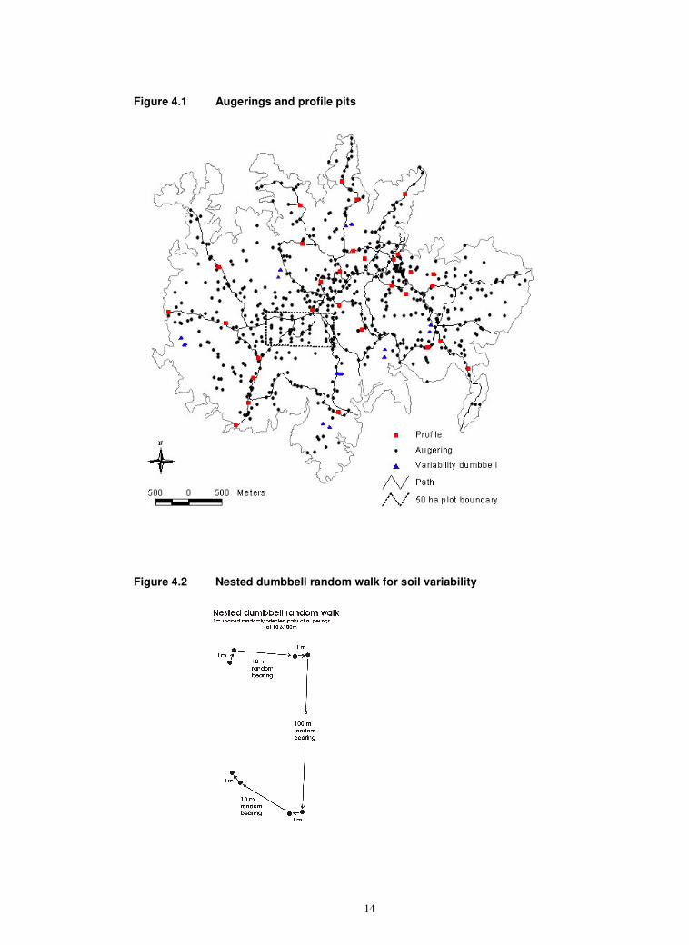
In 2006 eight test augerings were randomly located in nested dumbbell layouts at 1, 10 and 100 m scales at each of seven sites (Figure 4.2), located to characterise the morphological variation within soil mapping units. These observations were intended to determine:
13
• The main and minor soil classes composition of the soil-mapping units. (Forbes et al. 1984).
• The spatial scale of soil morphological variation.
All augerings were done with a 7 cm diameter Terrasystem (USA) or Edelman (Eijkelkamp, Netherlands) augers. Because the BCI dry season imposes some moisture stress on the vegetation, more emphasis than usual was given to soil depth. In the main survey some soils were augered to 2 m, and the rest to 1.5m, unless stopped by unequivocal saprolite or hard stones. Where augering was stopped at less than 50 cm by hard stones, duplicate attempts were made nearby (< 3 m).
In the main and boundary check surveys, the soils were described systematically by natural horizons for colour, mottles, hand texture, stones, concretions, moisture and auger consistence. Hand textural classifications in the humid tropics tend to overestimate silt contents in fine textured soils (Akamigbo, 1984). However, our high silt field textures for many BCI soils are corroborated by the laboratory analyses, even after intensive dithionite dispersion, and our clay contents accord with the lab estimates derived from water retention characteristics (Soil Survey Staff, 1999).
In order to more fully characterise the main soil classes, we described 30 subjectively sited soil profiles (FAO, 1990; Soil Survey Staff 1993) in pits dug to 1.5 – 1.7 m, and augered in the base for up to a further 2 m, giving a potential observation depth of >3.5 m. The profile faces were sampled in the topsoil and then by 10 cm depth increments. The augering at the base was not sampled. The samples were oven-dried at 60
0 C on BCI until touch-dry. The dried
samples were subdivided, with half of each going to the BCI archive, and half to Germany, where they were analysed in the Institute for Geo-ecology, University of Potsdam, with a few granulometric analyses at the University of Frankfurt-am-Oder (Appendix A).
The profile, auger and analytical data are held in databases at STRI and Potsdam, and will be made available on a dedicated STRI website. They are available to all interested parties, with the caveat that they were collected at subjectively chosen sites for a free soil survey. People wishing to do statistical analyses of soil attributes are advised to collect their own data using appropriate sampling designs.
14
Figure 4.1 Augerings and profile pits
Figure 4.2 Nested dumbbell random walk for soil variability
15
4.2 Mapping
The soil map is based on collective iterative interpretation of the auger and profile data, the Woodring (1958) geological map and our modifications of it, and all discernible landscape indicators. 4.3 Laboratory
The methods of soils analysis obeyed routine procedures and are described in an appendix of the online version. There are two aspects that need discussion here, as they greatly affect the characterization and correlation of BCI soils.
Firstly, the granulometric analysis of fine-textured kaolinitic and oxidic soils is problematic. The oxidic minerals have strong bonding effects, and much of the clay in such soils is aggregated into pseudo-silt or pseudo-sand particles. These give the soil high macroporosity and free drainage typical of medium or coarse textured soils. However, the aggregates are not dense and relatively inert primary minerals, as in most true sands and silts. They have high internal microporosity and the voids are lined with surfaces of low or moderate electrochemical activity. The result is that these soils behave like sands or silts with respect to drainage, aeration and moisture release at low moisture tensions, but like clays with respect to cation exchange and other sorption/desorption, and moisture retention at high tensions.
The micro-aggregation affects the determination of clay content. If the soils are treated with a mild dispersant, as normally used in soils with non-oxidic mineralogies, the aggregates remain intact and the soils analyse as high in silt and/or sand. If dispersed fiercely, the aggregates break up and the soils analyse as clay. Reliance on only one method of dispersion gives an incomplete picture of these soils, with mild dispersion missing the clay characteristics and fierce dispersion missing the aggregation and silt- and sand-like features. We have therefore estimated the clay contents of some samples with both sodium pyrophosphate (mild) and sodium dithionite (strong) dispersants and indirectly from moisture retention at tensions above the conventional permanent wilting point (1500kPa) (Soil Survey Staff, 1999). The indirect moisture retention estimates of clay for the same soils are in the range 60 – 90%. The dithionite dispersion gives intermediate estimates, with clay contents in the range 40 - 60%. These are similar to the hand textures in the field. All of the laboratory granulometric methods make heavy demands on resources, and the number of determinations is limited. In contrast, we have several thousands of field textures, many of them by multiple observers. Our soil characterizations and correlations are based on the field textures.
The second laboratory methodological point concerns the determination of cation exchange capacity (CEC). The CEC’s of kaolinitic and oxidic clay minerals are variable and are low in their usual proton-rich acid environments. The conventional laboratory determination of CEC is done at pH 7. Deprotonation of cation exchange sites occurs at the artificially high pH, and conventional CEC values are considerably higher than the actual working CEC in field conditions. This problem has long been recognised (e.g. Hesse, 1971; Pleysier et al. 1979). There are other problems with CEC, and they are sometimes considerably lower than the sum of the exchangeable bases and appear to be substantially underestimated. This is not a problem that is unique to BCI and has been noted in related soils in Mexico (Calderon et al., 2005).
These problems are partially circumvented by the use of the effective CEC (ECEC). We here use the term in the ST sense, i.e. ECEC = the sum of the exchangeable bases (TEB) + extractable Al (Soil Survey Staff, 1999), rather than the WRB definition of ECEC = TEB + exchangeable acidity (FAO, 1998), although the two are probably similar in BCI soils. TEB is relatively unaffected by pH, and labile Al is extracted at close to field pH, so ECEC is a less variable and more realistic characterisation of the exchange complex in acid soils in filed conditions.
16
Some ST and WRB taxa are differentiated on base saturation (BS = TEB/CEC). The methodological problems with CEC lead to corresponding anomalies in BS. In order to better characterise base status, we estimate Effective BS (EBS = TEB/ECEC). EBS is the complement of Al saturation, and indicates the balance on the exchange complex between nutrient bases and toxic Al.
5 SOILS OF BCI
5.1 BCI soil forms and pedogenetic trends
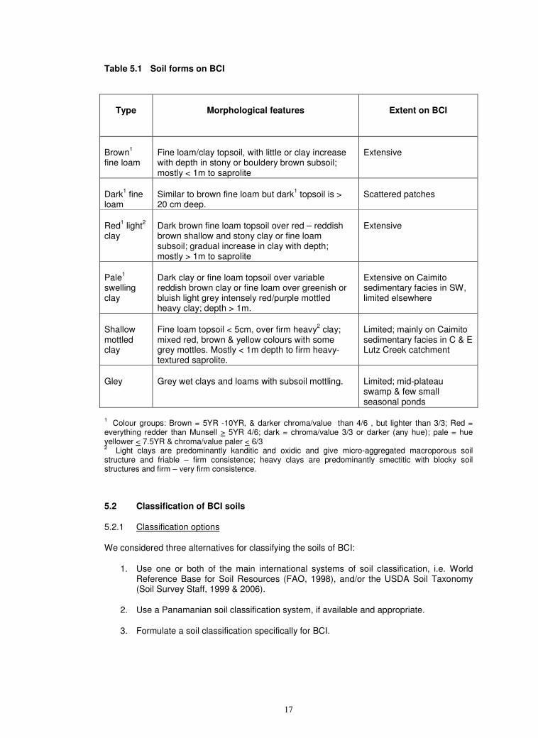
As the name Barro Colorado implies, there are many bright reddish soils of medium and fine texture on the island. The soils are texturally limited, with virtually all soils having high silt and clay contents. However, they vary with respect to colour, depth, stoniness and drainage, and a number of soil forms can be distinguished (Table 5.1). These are similar in concept and level of detail to soils forms in the South African Binomial system (MacVicar, 1991)
The most extensive soil form is brown stony clay and fine loam, overlying weathered rock (saprolite) or stone and boulders. These soils are immature, and on the andesite, Bohio and Caimito (volcanic facies) formations they develop to deep red kanditic and oxidic clays, by prolonged and mainly vertical leaching, deep and intensive weathering, aluminosilicate desilication and rubefaction.
There are also deep red clays on the Caimito marine sedimentary facies, mainly on the western part of the Poacher Peninsula and steeper slopes elsewhere. However, most of the mature soils on the main Caimito marine outcrop in the SW of the island are deep, imperfectly drained heavy silty clays, with pale matrix colours, some of which have distinct bluish or greenish grey tinges, with variable but often prominent red-purplish mottling. Swelling smectitic clay minerals give substantial surface cracking in the dry season and severely limited permeability when the cracks close in the wet season. Similar pale swelling clays occurs in smaller patches on the other geological formations, presumably where impeded drainage limits leaching and maintains soil solution cation status high enough for 2:1 minerals to survive. These soils may develop from brown fine loams. However, there are some shallow, immature-looking, mottled clays in the Lutz Creek catchment, and these may be the precursors of the swelling clays
Other less extensive soil forms on BCI are:
• Fine loams, with deep dark humic topsoils;
• Gleyed clays and loams in the limited areas of swamps and ponds, especially in the mid-plateau swamp on the andesite dipslope.
Where soils combine features of several forms, they are assigned according the dominant features in the top metre and in the preferential sequence; gley > pale clay > dark loam > other loams.
We cannot as yet discern major differences in soil morphology that can be attributed to human disturbance. Similarly, there are no immediately obvious associations between vegetation and soils, although it possible the pale swelling clays affect the frequency of windthrow and gap recurrence (see 8.2 below).
17
Table 5.1 Soil forms on BCI
Type
Morphological features Extent on BCI
Brown1
fine loam Fine loam/clay topsoil, with little or clay increase with depth in stony or bouldery brown subsoil; mostly < 1m to saprolite
Extensive
Dark1 fine
loam Similar to brown fine loam but dark
1 topsoil is >
20 cm deep. Scattered patches
Red1 light
2
clay Dark brown fine loam topsoil over red – reddish brown shallow and stony clay or fine loam subsoil; gradual increase in clay with depth; mostly > 1m to saprolite
Extensive
Pale1
swelling clay
Dark clay or fine loam topsoil over variable reddish brown clay or fine loam over greenish or bluish light grey intensely red/purple mottled heavy clay; depth > 1m.
Extensive on Caimito sedimentary facies in SW, limited elsewhere
Shallow mottled clay
Fine loam topsoil < 5cm, over firm heavy2 clay;
mixed red, brown & yellow colours with some grey mottles. Mostly < 1m depth to firm heavy-textured saprolite.
Limited; mainly on Caimito sedimentary facies in C & E Lutz Creek catchment
Gley
Grey wet clays and loams with subsoil mottling. Limited; mid-plateau swamp & few small seasonal ponds
1 Colour groups: Brown = 5YR -10YR, & darker chroma/value than 4/6 , but lighter than 3/3; Red =
everything redder than Munsell > 5YR 4/6; dark = chroma/value 3/3 or darker (any hue); pale = hue yellower < 7.5YR & chroma/value paler < 6/3 2
Light clays are predominantly kanditic and oxidic and give micro-aggregated macroporous soil structure and friable – firm consistence; heavy clays are predominantly smectitic with blocky soil structures and firm – very firm consistence.
5.2 Classification of BCI soils
5.2.1 Classification options
We considered three alternatives for classifying the soils of BCI:
1. Use one or both of the main international systems of soil classification, i.e. World Reference Base for Soil Resources (FAO, 1998), and/or the USDA Soil Taxonomy (Soil Survey Staff, 1999 & 2006).
2. Use a Panamanian soil classification system, if available and appropriate.
3. Formulate a soil classification specifically for BCI.
18
We prefer local to international systems, because they define taxa polythetically on locally appropriate criteria, and better accommodate overlaps and transitions (Baillie, 2001). Furthermore, experience at other tropical forest research sites shows that local soil classifications are relatively stable, whereas new data can lead to substantial reclassification in the international systems. Also, the World Reference Base (FAO, 1998; Deckers et al., 2005) explicitly recommends that it be used in conjunction with, not instead of, local classifications.
The Panamanian system, as formulated for the Catapan (1970) 1:20 000 soil maps, uses a multi-attribute coding system. This is agriculturally oriented and complex, and we decided against it as the main system for BCI, although we to code the BCI soils for intra-Panamanian correlation (Table 5.7).
We therefore opted for a local BCI classification system. Its classes are at about the taxonomic level of soil series, but are not series sensu stricto, because they are as yet insufficiently characterised (Clayden & Hollis, 1984; Soil Survey Staff, 1999), and are not wholly defined on solum attributes.
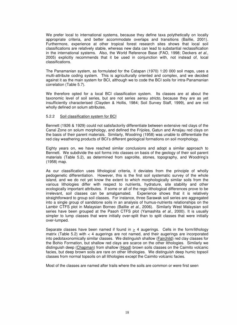
5.2.2 Soil classification system for BCI
Bennett (1926 & 1929) could not satisfactorily differentiate between extensive red clays of the Canal Zone on solum morphology, and defined the Frijoles, Gatun and Arraijau red clays on the basis of their parent materials. Similarly, Woodring (1958) was unable to differentiate the red clay weathering products of BCI’s different geological formations on soil morphology.
Eighty years on, we have reached similar conclusions and adopt a similar approach to Bennett. We subdivide the soil forms into classes on basis of the geology of their soil parent materials (Table 5.2), as determined from saprolite, stones, topography, and Woodring’s (1958) map.
As our classification uses lithological criteria, it deviates from the principle of wholly pedogenetic differentiation. However, this is the first soil systematic survey of the whole island, and we do not yet know the extent to which morphologically similar soils from the various lithologies differ with respect to nutrients, hydrature, site stability and other ecologically important attributes. If some or all of the rego-lithological differences prove to be irrelevant, soil classes can be amalgamated. Experience shows that it is relatively straightforward to group soil classes. For instance, three Sarawak soil series are aggregated into a single group of sandstone soils in an analysis of humus-nutrients relationships on the Lambir CTFS plot in Malaysian Borneo (Baillie et al., 2006). Similarly West Malaysian soil series have been grouped at the Pasoh CTFS plot (Yamashita et al., 2000). It is usually simpler to lump classes that were initially over-split than to split classes that were initially over-lumped.
Separate classes have been named if found in > 4 augerings. Cells in the form/lithology matrix (Table 5.2) with < 4 augerings are not named, and their augerings are incorporated into pedotaxonomically similar classes. We distinguish shallow (Fairchild) red clay classes for the Bohio Formation, but shallow red clays are scarce on the other lithologies. Similarly we distinguish deep (Chapman) from shallow (Hood) brown soils classes on the Caimito volcanic facies, but deep brown soils are rare on other lithologies. We distinguish deep humic topsoil classes from normal topsoils on all lithologies except the Caimito volcanic facies.
Most of the classes are named after trails where the soils are common or were first seen
19
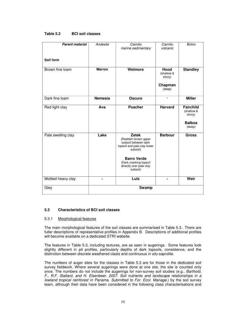
Table 5.2 BCI soil classes
Parent material
Soil form
Andesite Caimito marine sedimentary
Caimito volcanic
Bohio
Brown fine loam
Marron Wetmore Hood (shallow &
stony)
Chapman
(deep)
Standley
Dark fine loam
Nemesia Oscuro - Miller
Red light clay
Ava Poacher
Harvard
Fairchild (shallow &
stony)
Balboa (deep)
Pale swelling clay
Lake Zetek (Reddish brown upper subsoil between dark
topsoil and pale clay lower subsoil)
Barro Verde
(Dark cracking topsoil directly over pale clay
subsoil)
Barbour
Gross
Mottled heavy clay
- Lutz
- Weir
Gley
Swamp
5.3 Characteristics of BCI soil classes
5.3.1 Morphological features
The main morphological features of the soil classes are summarised in Table 5.3. There are fuller descriptions of representative profiles in Appendix B. Descriptions of additional profiles will become available on a dedicated STRI website.
The features in Table 5.3, including textures, are as seen in augerings. Some features look slightly different in pit profiles, particularly depths of dark topsoils, consistence, and the distinction between discrete weathered clasts and continuous in situ saprolite.
The numbers of auger sites for the classes in Table 5.3 are for those in the dedicated soil survey fieldwork. Where several augerings were done at one site, the site is counted only once. The numbers do not include the augerings for non-survey soil studies (e.g., Barthold, F., R.F. Stallard, and H. Elsenbeer. 2007. Soil nutrients and landscape relationships in a lowland tropical rainforest in Panama. Submitted to For. Ecol. Manage.) by the soil survey team, although their data have been considered in the following class characterisations and
20
used in soil mapping Because of more intensive sampling in areas of research interest and in the variability testing, some classes - especially Ava, Barbour, Fairchild, and Lutz - are over-represented in the auger data.
Within the dominant well drained fine loams and light clays, there is a strong association between colour and depth. Most of the red clays are deep and most brown loams are shallow. Only on the Bohio formation are there sufficient shallow red soils to warrant a separate class (Fairchild). Similarly, there are sufficient deep brown soils for a separate class (Chapman) only on the Caimito volcanic facies.
The brown fine loams mostly appear shallow when augered. The solum is often genuinely shallow, with the weathering front to saprolite in the upper metre. In other profiles augering is blocked, even with repeated attempts, by high densities of stones and boulders. The relative importance of these kinds of limitation varies between classes. Shallow saprolite is encountered in high proportions of the augerings in Standley, Marron and Wetmore, but Hood is more bouldery.
There is moderate cracking in the surfaces of many of the soils and slight micro-gilgai in more stable sites. Standley and Marron have dark friable crumbly silty loam and silty clay loam topsoils, often with worm casts. The brown and reddish brown subsoils are stony but many of the stones are brightly coloured, soft and highly weathered. Fine earth textures in the subsoil are similar to those in the topsoil, but stone contents increase. There are cutans in some subsoils but these are not always associated with systematic increase in clay content and some are pressure faces from the shrink-swell of the mixed mineralogy clays. The upper few decimetres of the saprolite are often varicolored, soft and well rooted, so that these soils are edaphically deeper than indicated by their shallow sola.
Most Wetmore soils are similar, with shallow brown fine loam over saprolite. However the lithological heterogeneity of the Caimito marine formation means that there are also a few soils that are grey, rather than brown and which have discernible sand contents (e.g. Profile PF11 in Appendix B)
Hood is similar in its brown colours and fine loam texture. However, its shallowness is more often due to unaugerably and undiggably hard and dense stones and boulders than to saprolite (e.g. Profile PR07). This is consistent with the extensive boulder fields on the northern part of the Caimito volcanic dipslope.
The only deep brown clay class is Chapman, which is of limited extent on the Caimito volcanics, and is similar to Hood, but can be augered to below 1 m. When augering is limited by clasts, it may give a false impression of shallowness. Profile PF07 in Appendix B shows how a soil that augers as a brown bouldery fine loam actually has a reddish, lower light clay subsoil over a pale mottled heavy clay-textured saprolite.
The contents of black ferrimanganiferous concretions vary considerably between the brown shallow and stony fine loam classes (Table 5.4a). They occur at low frequency and density in Standley and Wetmore, which occur mainly on relatively steep scarp topographies but are plentiful in Marron and Hood, which are dipslope soils. The main reason for the difference may be palaeo-hydrological, with the dipslope soils being more stable, older, and subject to seasonal moisture fluctuations for longer. Alternatively the main cause may be geochemical and due to the higher Mn contents of the andesite and Caimito volcanics than in the other rocks.
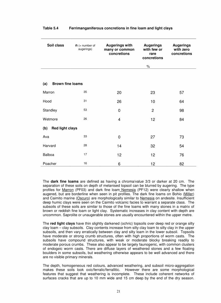
21
Table 5.4 Ferrimanganiferous concretions in fine loam and light clays
Augerings with many or common
concretions
Augerings with few or
rare concretions
Augerings with zero
concretions
Soil class n (= number of
augerings)
%
(a) Brown fine loams
Marron 35 20 23 57
Hood 31 26 10 64
Standley 53 0 2 98
Wetmore 26 4 12 84
(b) Red light clays
Ava 33 0 27 73
Harvard 28 14 32 54
Balboa 17 12 12 76
Poacher 16 6 12 82
The dark fine loams are defined as having a chroma/value 3/3 or darker at 20 cm. The separation of these soils on depth of melanised topsoil can be blurred by augering. The type profiles for Marron (PF03) and dark fine loam Nemesia (PF12) were clearly shallow when augered, but are borderline when seen in pit profiles. The dark fine loams on Bohio (Miller) and Caimito marine (Oscuro) are morphologically similar to Nemesia on andesite. Insufficient deep humic clays were seen on the Caimito volcanic facies to warrant a separate class. The subsoils of these soils are similar to those of the fine loams with many stones in a matrix of brown or reddish fine loam or light clay. Systematic increases in clay content with depth are uncommon. Saprolite or unaugerable stones are usually encountered within the upper metre.
The red light clays have thin slightly darkened (ochric) topsoils over deep red or orange silty clay loam – clay subsoils. Clay contents increase from silty clay loam to silty clay in the upper subsoils, and then vary erratically between clay and silty loam in the lower subsoil. Topsoils have moderate or strong crumb structures, often with high proportions of worm casts. The subsoils have compound structures, with weak or moderate blocky breaking readily to moderate porous crumbs. These also appear to be largely faunogenic, with common clusters of endogeic worm casts. There are diffuse layers of weathered stones and a few floating boulders in some subsoils, but weathering otherwise appears to be well advanced and there are no visible primary minerals.
The depth, homogeneous red colours, advanced weathering, and subsoil micro-aggregation makes these soils look oxic/ferralic/ferrallitic. However there are some morphological features that suggest that weathering is incomplete. These include coherent networks of surfaces cracks that are up to 10 mm wide and 15 cm deep by the end of the dry season.
22
These suggest the persistence of some expansible aluminosilicate clay minerals, and a transitional fersiallitic - ferrallitic stage of weathering.
The red light clay classes show great morphological similarities and overlap considerably. Ava has somewhat wider surface cracking and more compact subsoils. Harvard and Balboa tend to be slightly more orange, with hues commonly 5YR, than, whereas nearly all subsoils in Ava and Poacher have mainly 2.5YR subsoil hues. At one stage we contemplated a separate orange class (Lathrop – see Profile PR06 in online appendix) on the Bohio, but it is now subsumed into Balboa.
The compaction of the subsoils counteracts the micro-aggravation and may impede water percolation during high intensity rainfall. This accounts for the tendency to patchy, shallow and ephemeral ponding on the Ava red clays on the andesite dipslope plateau during the wet season. It may also lead to subsurface throughflow, by which water infiltrating the permeable topsoils is constrained to flow off laterally when it meets less permeable subsoil horizons. Throughflow supplementation from upslope is a possible explanation for the occurrence of better watered soils on the scarp slopes than on the upper surface of the plateau (Becker et al., 1988: Daws et al. 2002).
Ferrimanganiferous concretions are common in the red clays (Table 5.4 (b)). In parallel with the brown clays, they appear to be most frequent in Harvard, on the Caimito volcanics, but occur in similar densities and frequencies in the other classes on the other formations
Fairchild is the only class of shallow red fine loams and clays. Apart from colour, it is similar to Standley.
There are five classes of pale swelling clays. The two most extensive are on the larger outcrop of the Caimito marine sedimentary facies in the southwest of the island. Zetek has dark brown cracking clay or fine loam topsoil over a reddish or dark brown blocky clay or fine loam upper subsoil. At somewhere between 30 and 80 cm, there is a clear boundary to pale mottled heavy clay lower subsoil. Common colour combinations in the lower subsoil are prominent coarse port-red, mauve and purplish mottles in a slightly bluish light grey matrix, or distinct medium orange mottles in a greenish light grey or very pale yellow matrix. Lower subsoils hand texture as heavy clay because of their mineralogy, but sand and/or silt contents vary in bands. Barro Verde is also on the SW outcrop of the Caimito marine facies soil. It lacks the reddish brown upper subsoil of Zetek, and consists of a very dark, cracking, clay topsoil directly overlying pale mottled heavy clay, similar in colour, structure, hydrature and texture to the lower subsoil of Zetek.
The predominantly smectitic clay minerals result in the surface cracking, slight micro-gilgai and dark colours of the topsoils and the almost complete impermeability of the subsoils when wet. Once these soils are thoroughly wetted, profile pits remain flooded for the rest of the wet season. The shrink-swell capabilities of the smectites make the subsoils unstable in unconfined pit faces and they spalled and slumped badly in the 2005 wet season, leaving the well-rooted topsoil and (in Zetek) reddish brown upper subsoil as overhangs. The degradation of the pale swelling clay pits contrasts with the almost intact pits in the red light clays and brown fine loams. Despite the high smectite contents, the pale swelling clays are not vertic. Although surface cracks are wide by the end of the dry season they do not extend much below 25 cm depth. The subsoils look more gleyed than vertic, and no wedge structures or slickenside were seen.
The soils of Lake, Barbour and Gross are the analogues of Zetek on andesite, Caimito volcanics and Bohio formations respectively (Table 5.2). They all have reddish brown well-structured blocky upper subsoils. They are morphologically fairly similar, although the Barbour soils have particularly firm and sticky lower subsoils. These classes are of limited extent. There are no equivalents of Barro Verde on these geologies. It is not clear if Lake, Barbour and Gross form on intra-formational bands of marine sediments in their respective bedrocks, on outliers of the Caimito marine, or where local drainage conditions impede leaching and weathering irrespective of local lithology.
23
The smaller northern outcrop of the Caimito marine is on steeper slopes than most of this formation. This gives rise to the mottled heavy clays. These are mostly shallow, with saprolite at < 1m. The subsoil is predominantly brown or reddish heavy clay, with hydromorphic grey and rust coloured mottles mixed in with dark and bluish grey fragments of incompletely weathered rock. The main class of these soils is Lutz. There are also small patches scattered patches of similar soils of Weir class on the Bohio formation,
Swamp soils are poorly drained gleys. They have grey matrix rust mottled subsoils, which are wet throughout the year. As they are formed in local alluvium, subsoil textures show some depositional layering. Some subsoil horizons have significant contents of coarse sand and grit, but textures are mainly fine loams and clays, as expected from the andesitic lithology and clay soil cover of the upper Conrad catchment.
5.3.2. Chemical and mineralogical features
The laboratory data for selected samples in 24 of the described profiles are summarized in Table 5.5. There are more details an appendix of the online version.
Because the data are from a limited number of profiles, Table 5.5 groups the soils by form rather than classes. The premise underlying our classification, i.e., that parent material lithology affects soil chemical attributes, cannot be tested with these few and subjectively sited cases. In places we speculate about inter-class differences but these are not statistically validated. However, additional non-survey studies (e.g., Barthold, F., R.F. Stallard, and H. Elsenbeer. 2007. Soil nutrients and landscape relationships in a lowland tropical rainforest in Panama. Submitted to For. Ecol. Manage.) do systematically quantify and test class differences for soil potassium and soil organic matter.
Many analytical features of the brown fine loams confirm the morphological indications of incomplete weathering and pedogenetic immaturity. The dominant clay mineral is kaolinite, but there are substantial contents of montmorillonite (smectite) in most profiles and it is the dominant clay mineral in one of them. The montmorillonite accounts for the moderate shrink-swell features in these soils. Although substantial systematic increases in clay content with depth are uncommon, several profiles have cutans in the upper subsoil. These may be pressure coatings from clay swelling rather than argillans. The montmorillonite also accounts for high cation exchange capacities of these soils, with CEC and ECEC > 24 cmolc.kg
-1clay
throughout most profiles. These large exchange complexes are highly base saturated, and BS and EBS are close to 100% in all topsoils and remain high throughout in most profiles. Labile Al is correspondingly negligible. Exchangeable Ca is, the dominant exchangeable cation, and there is also substantial exchangeable Mg. In contrast exchangeable K is variable and often extremely low, even undetectable, in some subsoils. Most of these soils are neutral or slightly acid, and all topsoils have pH (water) > 5, with two > 6. SOM is high in the topsoil of the single profile analysed for OC.
Two profiles that deviate from the general picture of high base status, incomplete weathering and limited leaching. They are PF07, in the deeper (Chapman), and PR12, in the redder (Fairchild), classes. Both these profiles have very acid subsoils and low CEC, ECEC and base saturation. The Chapman profile also has kaolinite and gibbsite as its main clay minerals, and no significant montmorillonite. The increased depth and rubefaction both appear to indicate more intense leaching and more advanced desilication.
Our analytical data for the inextensive dark fine loams come from only two profiles. These confirm the morphological indications that they are similar to the brown fine loams. They have high cation exchange capacities, with CEC and ECEC > 24 cmolc.kg
-1clay throughout.
The exchange complexes are highly base saturated, and BS and EBS are close to 100% and negligible labile Al. Both profiles are neutral or slightly acid. There are large contents of exchangeable Ca and substantial exchangeable Mg. Exchangeable K is variable and extremely low in some subsoil samples. SOM is high in the topsoil of the single profile analysed for OC.
24
Analytical features of the red light clays confirm the morphological indications of pedogenetic maturity and fairly complete weathering. In all of the profiles with X-ray diffraction data, kaolinite is the dominant and gibbsite the subordinate clay mineral, with no significant montmorillonite. The absence of montmorillonite accounts for limited shrink-swell. These soils are quite heterogeneous with respect to their exchange complexes and base status. Some have low cation exchange capacities, with CEC and ECEC < 24 cmolc.kg
-1clay. Others
have larger exchange complexes and more active clays. All topsoils are highly base saturated, with BS and EBS at or close to 100%. The subsoils with small exchange complexes remain highly base saturated throughout the subsoil and extractable Al is negligible. The subsoils with larger exchange complexes and higher CEC and ECEC values are base depleted with minimum BS < 20% and EBS < 50%. These soils have significant contents of extractable Al. Ca is the dominant exchangeable base, also with substantial exchangeable Mg. Exchangeable K contents are variable, and low - extremely low in most subsoils. The soils with small but base saturated exchange complexes are moderately acid, with pH (water) in the range 4.5 – 6.5. The base-depleted soils are more acid, with pH (water) < 4 in one subsoil. In the two profiles analyzed for SOM topsoil OC contents are higher than the ochric colours suggest, with one almost 7%. The weak melanisation is attributed to masking by the intense reds of ferruginous oxidic minerals.
The analytical features of the pale swelling clays confirm the morphological indications that they have developed along pedogenetic lines quite different from those in the light clays. Montmorillonite is the dominant and kaolinite the subordinate clay mineral. The predominance of montmorillonite accounts for strong seasonal shrink-swell in these soils and their impermeability when wet. The dominance by smectitic clays gives high cation exchange capacities in these soils, with topsoil CEC and ECEC > 24 cmolc.kg
-1clay. All topsoils have
EBS > 90% and appear highly base saturated. However the BS values in some topsoils are < 50%, possibly due to methodological inflation of CEC. The subsoils CEC and ECEC are > 16 cmolc.kg
-1clay, with some > 50. These substantial exchange complexes have variable base
saturation. The Barro Verde subsoil has BS and EBS > 90% and Ca as the dominant exchangeable basic cation. However the subsoils of the other classes have low base saturations, and very high extractable Al, with > 30 cmolc.kg
-1clay in one profile. Topsoil
exchangeable K contents are moderate to high, at 0.2 - >1 cmolc.kg-1
clay, and slightly better than in the other soil forms. Subsoil values, however, are low to extremely low.
Our limited data for the inextensive shallow mottled clays confirm that they are less weathered and less developed analogues of the pale heavy clays. They have very large and active exchange complexes, with some CEC values > 100 cmolc.kg
-1clay, The ECEC values are
also very high > 50 cmolc.kg-1
clay., We have no clay mineralogy data for our profiles, but stream sediment sampling in Lutz Creek indicate that these soil contain large quantities of montmorillonite (Johnsson & Stallard, 1989). The large cation exchange capacities are wholly base-saturated and contents of extractable Al are negligible in the sola, although the saprolite of one profile has about 3 cmolc.kg
-1clay. These soils are slightly acid with pH (water) values >
5.5 in the topsoils but dropping to 4.4 in the subsoil of one profile. Ca is the dominant exchangeable basic cation, and these soils contain large quantities of exchangeable Ca, up to > 50 cmolc.kg
-1fine earth , which is equivalent to > 70 cmolc.kg
-1clay.. These are among the highest
values encountered in non-carbonate soils under tropical forests. The quantities of Ca leached from these soils are sufficient to form tufa in the bed of Lutz Creek (Johnsson & Stallard, 1989), which is very rare in tropical forest non-carbonate catchments. Exchangeable Mg is also high and may exceed 10 cmolc.kg
-1clay. These soils appear to be well endowed
with K by BCI standards, with moderate to high topsoil contents of exchangeable K > 0.8 cmolc.kg
-1clay, although they fall to < 0.2 cmolc.kg
-1 clay in the subsoil of one profile.
25
Table 5.3 Morphology of BCI soil classes
Soil form Geology BCI Soil Class
Number of
auger sites
Main profile features Topography Drainage
Differences from similar & associated
classes
Type profile
(Appendix B)
Other profiles *
Brown fine loam
Andesite Marron 35 0 – 4/10 cm: Dark brown cracking silty clay loam, friable crumb;
4/10 – 30/100: Brown – reddish brown increasingly stony silty clay - clay, friable - firm, compound block - crumb, variable FeMn concretions
30/100+: Red, orange, brown & grey saprolite, with patches of stony brown & reddish brown loam.
On lower steps & scarp slopes fringing andesite dipslope/plateau
Freely drained Browner, stonier & sometimes shallower; more & larger FeMn concretions, & less compact than Ava
Fewer Mn concretions than Chapman
More over saprolite than boulders, cf Hood
PR03 (PR11, transitional to Lake)
Brown fine loam
Bohio Standley 67 0 – 4/10 cm: Dark brown cracking silty clay loam, friable crumb;
4/10 – 30/100: Brown – reddish brown increasingly stony silty clay - clay, still friable crumb, variable FeMn concretions
30/100+: Red, orange, brown & grey
Steep Bohio scarp slopes in N & Centre of island
Freely drained Similar to Marron & Wetmore
More over saprolite than boulders, cf Hood
PF03 -
26
saprolite, with patches of stony brown & reddish brown loam.
Brown fine loam
Caimito marine sedimentary
Wetmore 30 0 – 4/10 cm: Dark brown cracking silty clay loam, friable crumb;
4/10 – 30/100: Brown – reddish brown increasingly stony silty clay - clay, still friable crumb, variable FeMn concretions
30/100+: Red, orange, brown & grey saprolite, with patches of stony brown & reddish brown loam.
Also profiles with grey subsoils, some with sandy loam & sandy clay layers
Steep slopes on Caimito marine facies, especially on eastern section of SW outcrop
Freely drained Many of brown clays are similar to Marron & Standley
Over saprolite more than boulders, cf Hood
More variable than other brown light clays, with some grey & sandier subsoils
PR08 (PF11 transitional to Zetek & Oscuro)
Brown fine loam
Caimito volcanic
Hood 39 0 – 4/10 cm: Bouldery dark brown silty clay loam, friable crumb
4/10 – 20/100: Bouldery brown silty clay - clay, common FeMn concretions, increasing stones
20/100+: Undiggable/ unaugerable coarse boulders with interstitial brown loam - clay
Moderate-gentle graded boulder field upper & mid dipslopes in E of island
Freely drained More over boulders than saprolite, cf Marron, Standley & Wetmore
Boulders impenetrable at shallower depth than Chapman
PR09 PF09
27
Dark fine loam
Andesite Nemesia 7 0 – 5/40 cm: Black – v dark brown humic silty clay loam, friable crumb;
5/40 – 50/150+: Dark brown increasingly stony silty clay - clay, friable - firm, compound block - crumb, variable FeMn concretions
50/150+: Grey, red, orange, brown & yellow saprolite.
Patches in Marron Freely drained Dark topsoil deeper than Marron
PF12
Dark fine loam
Bohio Miller 22 0 – 5/35 cm: Black – v dark brown humic silty clay loam, friable crumb;
5/35– 50/100+: Dark brown very stony bouldery silty clay (loam)
50/100+: Grey, red, yellow, orange, & brown saprolite, with patches of stony brown loam.
(Sometimes subsoil is undiggable stones & boulders)
Patches in Standley & Fairchild
Freely drained Dark topsoil deeper than Standley
PR05 (PR03, transitional to Standley)
Dark humic
Caimito marine
Oscuro 5 0 – 5/25cm: Black – v dark brown humic silty
Patches in Wetmore Mostly freely drained
Dark topsoil deeper than Wetmore
- (PF11 – transitional
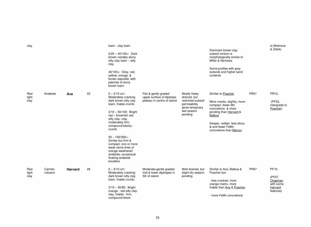
28
clay loam - clay loam
5/25 – 40/100+: Dark brown variably stony silty clay loam – silty clay
40/100+: Grey, red, yellow, orange, & brown saprolite, with patches of stony brown loam.
Dominant brown clay subsoil version is morphologically similar to Miller & Nemesia
Some profiles with grey subsoils and higher sand contents
to Wetmore & Zetek)
Red light clay
Andesite Ava 33 0 – 3/10 cm: Moderately cracking dark brown silty clay loam, friable crumb;
3/10 – 50/100: Bright red – brownish red silty clay- clay, moderately firm, compound blocky -crumb
50 – 100/300+: Similar but firm & compact; one or more weak stone lines of orange weathered andesite; occasional floating andesite boulders
Flat & gently graded upper surface of dipslope plateau in centre of island
Mostly freely drained, but restricted subsoil permeability gives temporary wet season ponding
Similar to Poacher
More cracks, slightly, more compact, fewer Mn concretions & more ponding than Harvard & Balboa
Deeper, redder, less stony & and fewer FeMn concretions than Marron
PR01 PR10,
(PF02, intergrade to Poacher)
Red light clay
Caimito volcanic
Harvard 28 0 – 3/10 cm: Moderately cracking dark brown silty clay loam, friable crumb;
3/10 – 30/80: Bright orange - red silty clay- clay, friable - firm, compound block-
Moderate-gentle graded mid & lower dipslopes in SE of island
Well drained, but slight dry season ponding
Similar to Ava, Balboa & Poacher but :
- less cracked, more orange matrix, more friable than Ava & Poacher
- more FeMn concretions
PR07 PF10,
(PF07, Chapman with some Harvard features)
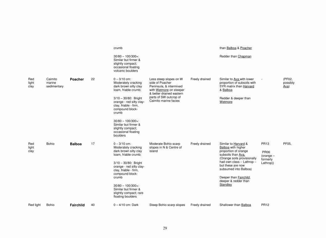
29
crumb
30/80 – 100/300+: Similar but firmer & slightly compact; occasional floating volcanic boulders
than Balboa & Poacher
Redder than Chapman
Red light clay
Caimito marine sedimentary
Poacher 22 0 – 3/10 cm: Moderately cracking dark brown silty clay loam, friable crumb;
3/10 – 30/80: Bright orange - red silty clay- clay, friable - firm, compound block-crumb
30/80 – 100/300+: Similar but firmer & slightly compact; occasional floating boulders
Less steep slopes on W side of Poacher Peninsula, & intermixed with Wetmore on steeper & better drained eastern parts of SW outcrop of Caimito marine facies
Freely drained Similar to Ava with lower proportion of subsoils with 5YR matrix than Harvard & Balboa
Redder & deeper than Wetmore
- (PF02, possibly Ava)
Red light clay
Bohio Balboa 17 0 – 3/10 cm: Moderately cracking dark brown silty clay loam, friable crumb;
3/10 – 30/80: Bright orange - red silty clay- clay, friable - firm, compound block-crumb
30/80 – 100/300+: Similar but firmer & slightly compact; rare floating boulders
Moderate Bohio scarp slopes in N & Centre of island
Freely drained Similar to Harvard & Balboa with higher proportion of orange subsoils than Ava. (Orange soils provisionally had own class – Lathrop – but these are now subsumed into Balboa)
Deeper than Fairchild, deeper & redder than Standley
PR13
PR06 (orange – formerly Lathrop))
PF05,
Red light Bohio Fairchild 40 0 – 4/10 cm: Dark Steep Bohio scarp slopes Freely drained Shallower than Balboa PR12
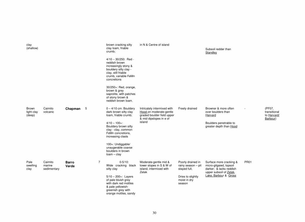
30
clay (shallow)
brown cracking silty clay loam, friable crumb;
4/10 – 30/250: Red -reddish brown increasingly stony & bouldery silty clay - clay, still friable crumb, variable FeMn concretions
30/250+: Red, orange, brown & grey saprolite, with patches of stony brown & reddish brown loam.
in N & Centre of island
Subsoil redder than Standley
Brown light clay (deep)
Caimito volcanic
Chapman 5 0 – 4/10 cm: Bouldery dark brown silty clay loam, friable crumb;
4/10 – 100+: Bouldery brown silty clay - clay, common FeMn concretions, increasing clasts
100+: Undiggable/ unaugerable coarse boulders in brown loam – clay
Intricately intermixed with Hood on moderate-gentle graded boulder field upper & mid dipslopes in e of island
Freely drained Browner & more often over boulders than Harvard
Boulders penetrable to greater depth than Hood
- (PF07, transitional to Harvard/ Barbour)
Pale swelling clay
Caimito marine sedimentary
Barro Verde
7 0-5/10: Wide cracking black silty clay
5/10 – 200+: Layers of pale bluish grey with dark red mottles & pale yellowish-greenish grey with orange mottles, sandy
Moderate-gentle mid & lower slopes in S & W of island, intermixed with Zetek
Poorly drained in rainy season – pit stayed full,
Dries to slightly moist in dry season
Surface more cracking & micro-gilgaied, topsoil darker; & lacks reddish upper subsoil of Zetek, Lake, Barbour & Gross
PR01
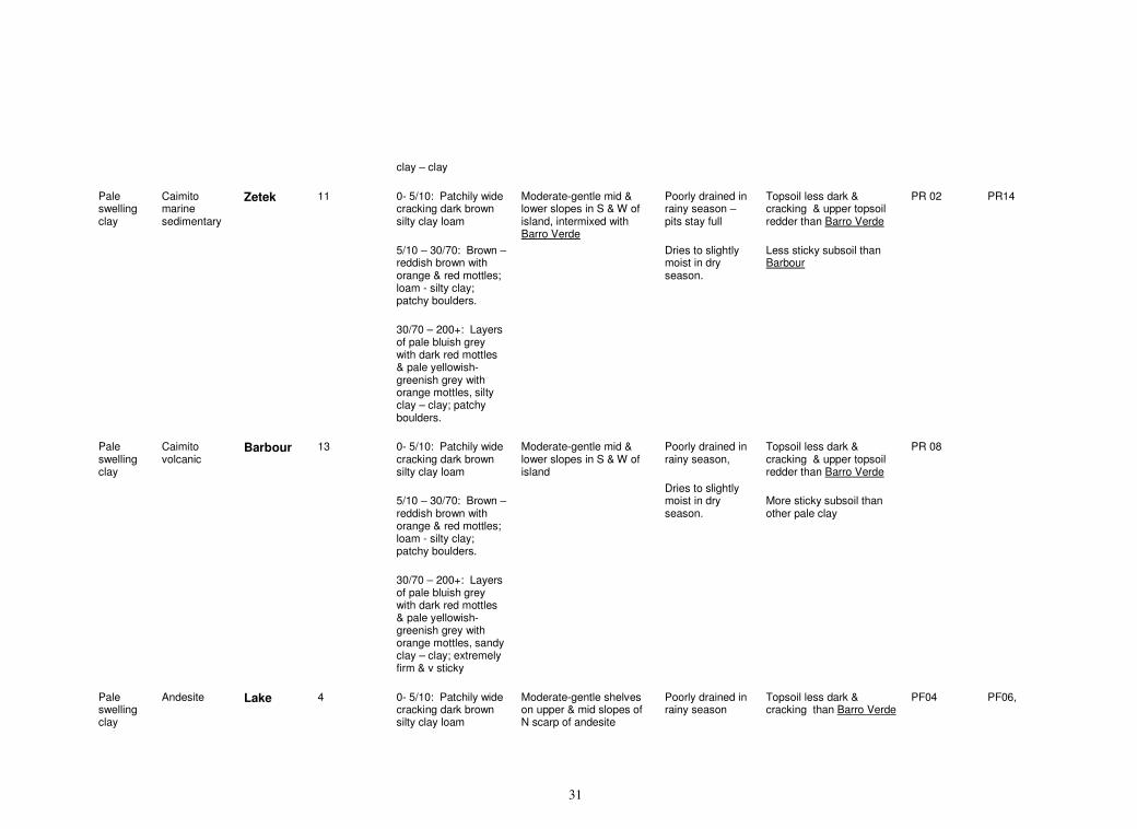
31
clay – clay
Pale swelling clay
Caimito marine sedimentary
Zetek 11 0- 5/10: Patchily wide cracking dark brown silty clay loam
5/10 – 30/70: Brown – reddish brown with orange & red mottles; loam - silty clay; patchy boulders.
30/70 – 200+: Layers of pale bluish grey with dark red mottles & pale yellowish-greenish grey with orange mottles, silty clay – clay; patchy boulders.
Moderate-gentle mid & lower slopes in S & W of island, intermixed with Barro Verde
Poorly drained in rainy season – pits stay full
Dries to slightly moist in dry season.
Topsoil less dark & cracking & upper topsoil redder than Barro Verde
Less sticky subsoil than Barbour
PR 02 PR14
Pale swelling clay
Caimito volcanic
Barbour 13 0- 5/10: Patchily wide cracking dark brown silty clay loam
5/10 – 30/70: Brown – reddish brown with orange & red mottles; loam - silty clay; patchy boulders.
30/70 – 200+: Layers of pale bluish grey with dark red mottles & pale yellowish-greenish grey with orange mottles, sandy clay – clay; extremely firm & v sticky
Moderate-gentle mid & lower slopes in S & W of island
Poorly drained in rainy season,
Dries to slightly moist in dry season.
Topsoil less dark & cracking & upper topsoil redder than Barro Verde
More sticky subsoil than other pale clay
PR 08
Pale swelling clay
Andesite Lake 4 0- 5/10: Patchily wide cracking dark brown silty clay loam
Moderate-gentle shelves on upper & mid slopes of N scarp of andesite
Poorly drained in rainy season
Topsoil less dark & cracking than Barro Verde
PF04 PF06,
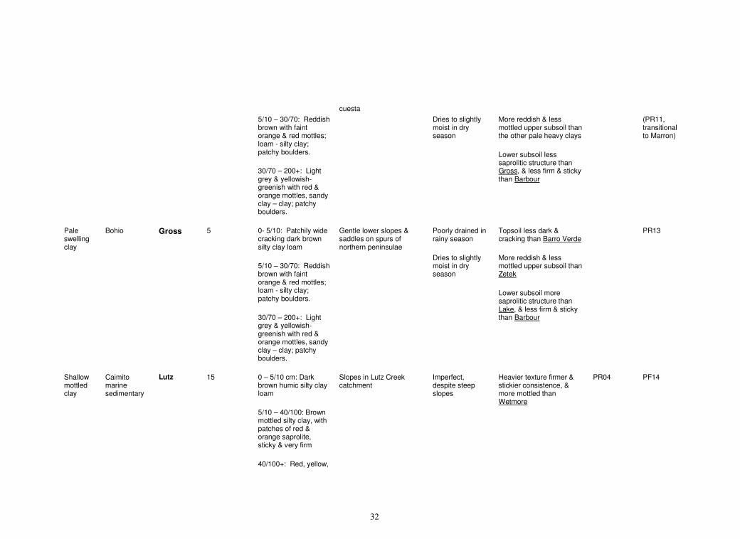
32
5/10 – 30/70: Reddish brown with faint orange & red mottles; loam - silty clay; patchy boulders.
30/70 – 200+: Light grey & yellowish-greenish with red & orange mottles, sandy clay – clay; patchy boulders.
cuesta
Dries to slightly moist in dry season
More reddish & less mottled upper subsoil than the other pale heavy clays
Lower subsoil less saprolitic structure than Gross, & less firm & sticky than Barbour
(PR11, transitional to Marron)
Pale swelling clay
Bohio Gross 5 0- 5/10: Patchily wide cracking dark brown silty clay loam
5/10 – 30/70: Reddish brown with faint orange & red mottles; loam - silty clay; patchy boulders.
30/70 – 200+: Light grey & yellowish-greenish with red & orange mottles, sandy clay – clay; patchy boulders.
Gentle lower slopes & saddles on spurs of northern peninsulae
Poorly drained in rainy season
Dries to slightly moist in dry season
Topsoil less dark & cracking than Barro Verde
More reddish & less mottled upper subsoil than Zetek
Lower subsoil more saprolitic structure than Lake, & less firm & sticky than Barbour
PR13
Shallow mottled clay
Caimito marine sedimentary
Lutz 15 0 – 5/10 cm: Dark brown humic silty clay loam
5/10 – 40/100: Brown mottled silty clay, with patches of red & orange saprolite, sticky & very firm
40/100+: Red, yellow,
Slopes in Lutz Creek catchment
Imperfect, despite steep slopes
Heavier texture firmer & stickier consistence, & more mottled than Wetmore
PR04 PF14
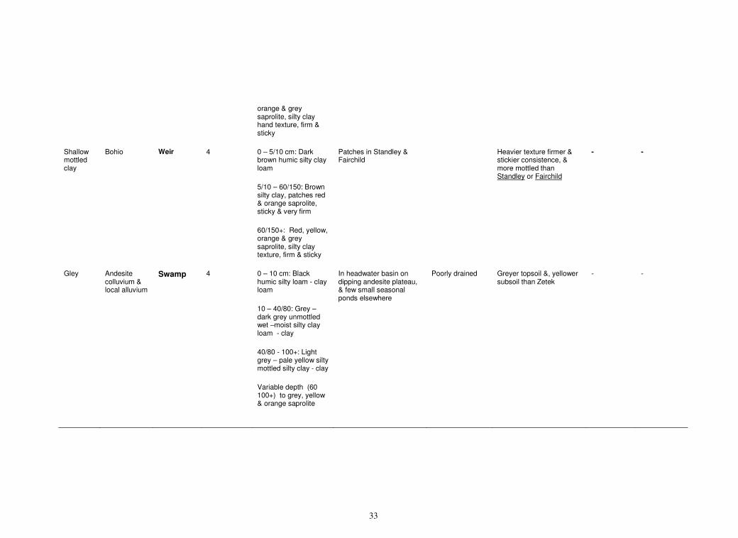
33
orange & grey saprolite, silty clay hand texture, firm & sticky
Shallow mottled clay
Bohio Weir 4 0 – 5/10 cm: Dark brown humic silty clay loam
5/10 – 60/150: Brown silty clay, patches red & orange saprolite, sticky & very firm
60/150+: Red, yellow, orange & grey saprolite, silty clay texture, firm & sticky
Patches in Standley & Fairchild
Heavier texture firmer & stickier consistence, & more mottled than Standley or Fairchild
- -
Gley Andesite colluvium & local alluvium
Swamp 4 0 – 10 cm: Black humic silty loam - clay loam
10 – 40/80: Grey – dark grey unmottled wet –moist silty clay loam - clay
40/80 - 100+: Light grey – pale yellow silty mottled silty clay - clay
Variable depth (60 100+) to grey, yellow & orange saprolite
In headwater basin on dipping andesite plateau, & few small seasonal ponds elsewhere
Poorly drained Greyer topsoil &, yellower subsoil than Zetek
- -
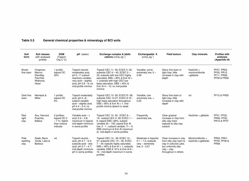
34
Table 5.5 General chemical properties & mineralogy of BCI soils
Soil form
Soil classes with analysed
profiles
SOM (Topsoil
Org C %)
pH (water) Exchange complex & labile cations (cmolc.kg
-1)
Exchangeable K (cmolc.kg
-1)
Field texture Clay minerals Profiles with analyses
(Appendix B)
Brown fine loam
Chapman, Marron, Standley, Fairchild, Wetmore, Hood
1 profile; topsoil OC 20%
Topsoil neutral- moderately acid, pH 5 –7; subsoil reactions variable, very acid – slightly acid, pH 3.8 – 6; no mid-profile minima
Topsoil CEC 11- 46, ECEC 5 -52; subsoils CEC 6 – 45, ECEC 2 – 33; subsoils with low CEC highly saturated, EBS > 80% & Extr Al > 1; subsoils with high CEC low base saturation, EBS < 40% & Extr Al 4 – 10; no mid-profile minima
Variable, some extremely low, 0 – 0.08
Stony fine loam or light clay; little increase in clay with depth
Kaolinite > montmorillonite >gibbsite
PF07, PR03, PF03, PR12, PF11, PR08, PF09 & PR09
Dark fine loam
Nemesia & Miller
1 profile; topsoil OC 6%
Topsoil moderately acid, pH 5 –6; subsoil variable acid – slightly acid, pH 4.4 – 5.4; no mid-profile minima
Topsoil CEC 13- 28, ECEC15 -36; subsoils CEC 12-27, ECEC 8-19 ; high base saturation throughout, EBS > 85% & Extr Al > 1; mid-profile minima absent or weak
Variable, one extremely low, < 0.05
Stony fine loam or light clay; little increase in clay with depth
nd PF12 & PR05
Red light clay
Ava, Harvard, Poacher, Balboa
2 profiles; topsoil OC 2 – 7 %; higher than colours indicate
Variable acid – v acid; 6.4 – 3.8; maximum in topsoil, mid-depth minimum in some profile
Topsoil CEC 13- 32, ECEC 8 – 14; subsoil CEC 4- 28; ECEC 1 – 6; topsoil EBS >90%; subsoil variable 20 – 100; topsoil Extr Al low, 0 - 1 ; subsoil variable, Tr – 5; EBS minimum & Extr Al maximum at mid-depth in some profiles
Frequently extremely low,
Clear gradual increase in clay from silty clay loam topsoils to silty clay subsoil
Kaolinite > gibbsite PF01, PF02, PR06, PF05, PR15 & PF07
Pale swelling clay
Zetek, Barro Verde, Lake & Barbour
nd Topsoil neutral –acid, pH 4.7 – 6.3; subsoils acid - very acid, pH 3.7 – 4.7; mid-depth minimum pH in some profiles
Topsoil CEC 14 - 38, ECEC 12 -37; subsoils CEC 13 – 46, ECEC 7 – 34; topsoils highly saturated, EBS > 90% & Extr Al > 1; subsoils variable, EBS 8 -91% & Extr Al 6 – 10, mid-depth maximum in some profiles
Moderate in topsoils; 0.1 – 1.0; subsoils very – extremely low, 0 - 0.07
Clear increase in clay from silty clay loam to clay in colluvial Lake, but uniformly silty clay – clay throughout in others
Montmorillonite > kaolinite (>gibbsite)
PR02, PR01, PF04, PF06 & PR08
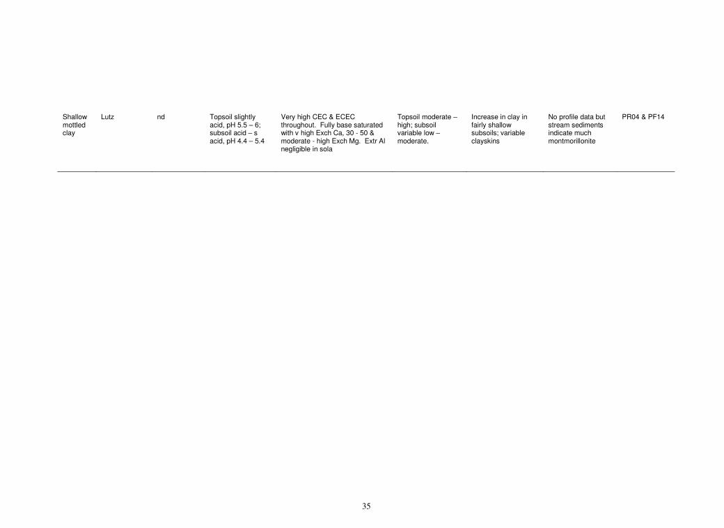
35
Shallow mottled clay
Lutz nd Topsoil slightly acid, pH 5.5 – 6; subsoil acid – s acid, pH 4.4 – 5.4
Very high CEC & ECEC throughout. Fully base saturated with v high Exch Ca, 30 - 50 & moderate - high Exch Mg. Extr Al negligible in sola
Topsoil moderate – high; subsoil variable low – moderate.
Increase in clay in fairly shallow subsoils; variable clayskins
No profile data but stream sediments indicate much montmorillonite
PR04 & PF14
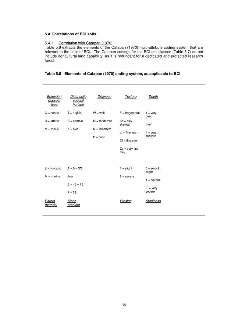
36
5.4 Correlations of BCI soils
5.4.1 Correlation with Catapan (1970) Table 5.6 extracts the elements of the Catapan (1970) multi-attribute coding system that are relevant to the soils of BCI. The Catapan codings for the BCI soil classes (Table 5.7) do not include agricultural land capability, as it is redundant for a dedicated and protected research forest. Table 5.6 Elements of Catapan (1970) coding system, as applicable to BCI
Epipedon (topsoil)
type
Diagnostic subsoil horizon
Drainage Texture Depth
O = ochric
U =umbric
M = mollic
T = argillic
C = cambic
X = oxic
W = well
M = moderate
N = imperfect
P = poor
F = fragmental
Kc = clay skeletal
Lf = fine loam
Cf = fine clay
Cv = very fine clay
1 = very deep
thro’
4 = very shallow
E = volcanic
M = marine
A = 0 – 3%
thro’
E = 45 – 75
F = 75+
1 = slight
2 = severe
0 = zero & slight
1 = severe
2 = very severe
Parent material
Slope gradient
Erosion Stoniness
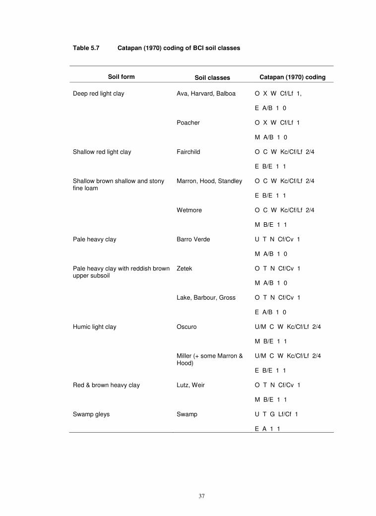
37
Table 5.7 Catapan (1970) coding of BCI soil classes
Soil form
Soil classes Catapan (1970) coding
Ava, Harvard, Balboa O X W Cf/Lf 1,
E A/B 1 0
Deep red light clay
Poacher O X W Cf/Lf 1
M A/B 1 0
Shallow red light clay Fairchild O C W Kc/Cf/Lf 2/4
E B/E 1 1
Marron, Hood, Standley O C W Kc/Cf/Lf 2/4
E B/E 1 1
Shallow brown shallow and stony fine loam
Wetmore O C W Kc/Cf/Lf 2/4
M B/E 1 1
Pale heavy clay Barro Verde U T N Cf/Cv 1
M A/B 1 0
Zetek O T N Cf/Cv 1
M A/B 1 0
Pale heavy clay with reddish brown upper subsoil
Lake, Barbour, Gross O T N Cf/Cv 1
E A/B 1 0
Oscuro U/M C W Kc/Cf/Lf 2/4
M B/E 1 1
Humic light clay
Miller (+ some Marron & Hood)
U/M C W Kc/Cf/Lf 2/4
E B/E 1 1
Red & brown heavy clay Lutz, Weir O T N Cf/Cv 1
M B/E 1 1
Swamp gleys Swamp U T G Lf/Cf 1
E A 1 1
38
5.4.2. International
A disadvantage of local soil systems is that they are not known outside their home area. For international communication and comparisons, they need to be correlated with widely known soil taxa and names. Table 5.9 correlates the BCI soil classes with the two main international systems of classification; the FAO World Reference Base (WRB) for Soil Resources (FAO, 1998; Deckers et al., 2005), and the USDA Soil Taxonomy (ST) (Soil Survey Staff, 1999 & 2006).
The correlations are tentative for the present, because both systems require differentiation of argic (WRB), argillic/kandic (ST) horizons as an early step in their pauci-thetic multi-level hierarchies. Argic/argillic horizons are defined on systematic, sharp and substantial increases in clay content with depth, i.e. > 20% proportional over a depth interval of < 30 cm. In ST, argillic horizons also need to have morphological indications of vertical argilluviation, especially clay skins on the faces of soil structural units. These are desirable but not mandatory for argic horizons in WRB.
As discussed in 4.3 and Appendix A, laboratory determination of clay content is problematic in well aggregated oxidic clays. We therefore base our identification of argic/argillic horizons on field textures and the presence of at least moderate clay skins. These morphological indicators show that there are clay increases with depth in most of the deeper and more mature soils on BCI, but these are usually too attenuated and have insufficiently developed clayskins to be unequivocally argic/argillic.
The subsoils of the BCI red light clays should therefore be designated as ferralic (WRB) or oxic (ST) horizons, and the soils correlated with the Ferralsols (WRB) / Oxisols (ST). However, some textural profiles are transitional to the Luvisols, Acrisols, Lixisols or Alisols in WRB and Ultisols or Alfisols in ST. Similarly transitionally argic/argillic reddish clays and fine loams are extensive in the wet zone of Sri Lanka (Leinweber et al., 1998; Mapa et al., 1999), Indonesia (Soepartohardjo & Ismangun, 1985) and elsewhere in the humid tropics (Kaufmann et al., 1998). The non-alluvial soils at the La Selva research forest in Costa Rica appear to be similarly equivocal. They were originally designated as Ultisols (Sollins et al., 1994), but have since been re-assigned to the Oxisols (Schwendenmann et al., 2003) This uncertainty at the highest hierarchical level makes the international systems unstable and impracticable in some tropical areas, and is the reason why we do not use either of them as the primary soil classification system for BCI.
For soils with clay increases that are sharp enough to be argic, WRB has four main groups differentiated on clay activity and base saturation (Table 5.8). WRB explicitly permits the use of group names as adjectival qualifiers (Deckers et al., 2005) of other groups. We have therefore used the argic group names to subdivide the BCI Ferralsols on clay activity and base status (Table 5.9 and Appendix B).
ST makes similar distinctions on clay activity and base status in the argillic (Table 5.8). ST makes a further distinction between profiles with a ‘clay step’, in which clay contents stay high from the argillic horizon downwards (‘pale-’), and those with a distinct mid-profile ‘clay bulge’, below which there is a systematic decrease from the clay maximum (‘hapl‘). Field textures indicate that most clay increases in the BCI clays are paleargillic ‘steps’. As with WRB, we use elements from the argillic group names as informal qualifiers of the BCI Oxisols in Table 5.9 and for individual profiles in Appendix B.
The ST names include the element ‘ud ’. This refers to the differentiation on soil moisture regime at suborder level. Although the atmospheric climate of BCI has a dry season of over three months in many years, the soils do not dry out immediately after the cessation of rain, and are rarely at wilting point for more than 90 days cumulative p.a. Soil moisture regimes are therefore deemed to be udic rather than ustic. The soil temperature regime is used at fifth and lower (family and series) levels in ST, and is isohyperthermic for BCI, but we are not correlating to that level at present.
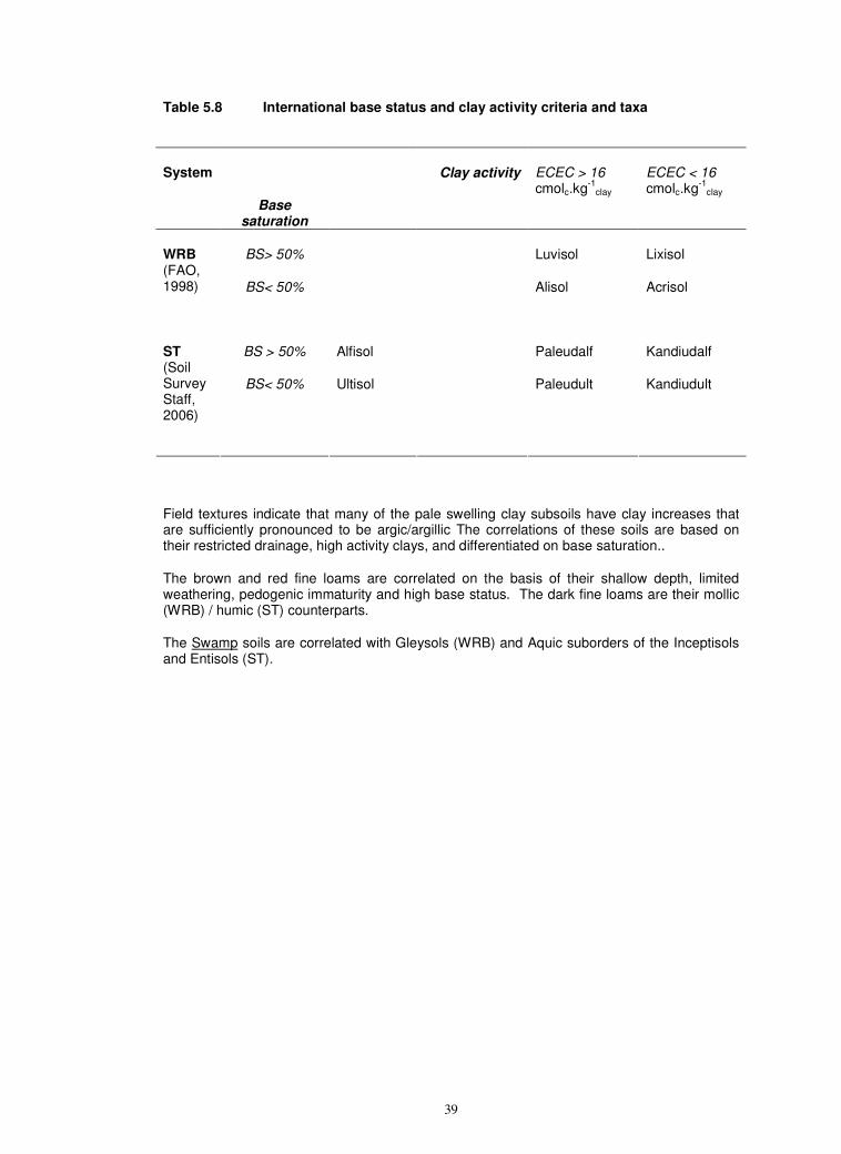
39
Table 5.8 International base status and clay activity criteria and taxa
System
Base saturation
Clay activity ECEC > 16 cmolc.kg
-1clay
ECEC < 16 cmolc.kg
-1clay
BS> 50% Luvisol Lixisol WRB (FAO, 1998)
BS< 50% Alisol Acrisol
BS > 50% Alfisol Paleudalf Kandiudalf ST (Soil Survey Staff, 2006)
BS< 50% Ultisol Paleudult Kandiudult
Field textures indicate that many of the pale swelling clay subsoils have clay increases that are sufficiently pronounced to be argic/argillic The correlations of these soils are based on their restricted drainage, high activity clays, and differentiated on base saturation..
The brown and red fine loams are correlated on the basis of their shallow depth, limited weathering, pedogenic immaturity and high base status. The dark fine loams are their mollic (WRB) / humic (ST) counterparts.
The Swamp soils are correlated with Gleysols (WRB) and Aquic suborders of the Inceptisols and Entisols (ST).
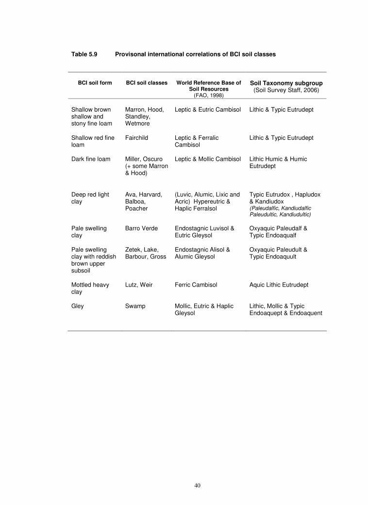
40
Table 5.9 Provisonal international correlations of BCI soil classes
BCI soil form BCI soil classes World Reference Base of Soil Resources
(FAO, 1998)
Soil Taxonomy subgroup (Soil Survey Staff, 2006)
Shallow brown shallow and stony fine loam
Marron, Hood, Standley, Wetmore
Leptic & Eutric Cambisol Lithic & Typic Eutrudept
Shallow red fine loam
Fairchild Leptic & Ferralic Cambisol
Lithic & Typic Eutrudept
Dark fine loam Miller, Oscuro (+ some Marron & Hood)
Leptic & Mollic Cambisol Lithic Humic & Humic Eutrudept
Deep red light clay
Ava, Harvard, Balboa, Poacher
(Luvic, Alumic, Lixic and Acric) Hypereutric & Haplic Ferralsol
Typic Eutrudox , Hapludox & Kandiudox (Paleudalfic, Kandiudalfic Paleudultic, Kandiudultic)
Pale swelling clay
Barro Verde Endostagnic Luvisol & Eutric Gleysol
Oxyaquic Paleudalf & Typic Endoaqualf
Pale swelling clay with reddish brown upper subsoil
Zetek, Lake, Barbour, Gross
Endostagnic Alisol & Alumic Gleysol
Oxyaquic Paleudult & Typic Endoaquult
Mottled heavy clay
Lutz, Weir Ferric Cambisol Aquic Lithic Eutrudept
Gley Swamp Mollic, Eutric & Haplic Gleysol
Lithic, Mollic & Typic Endoaquept & Endoaquent
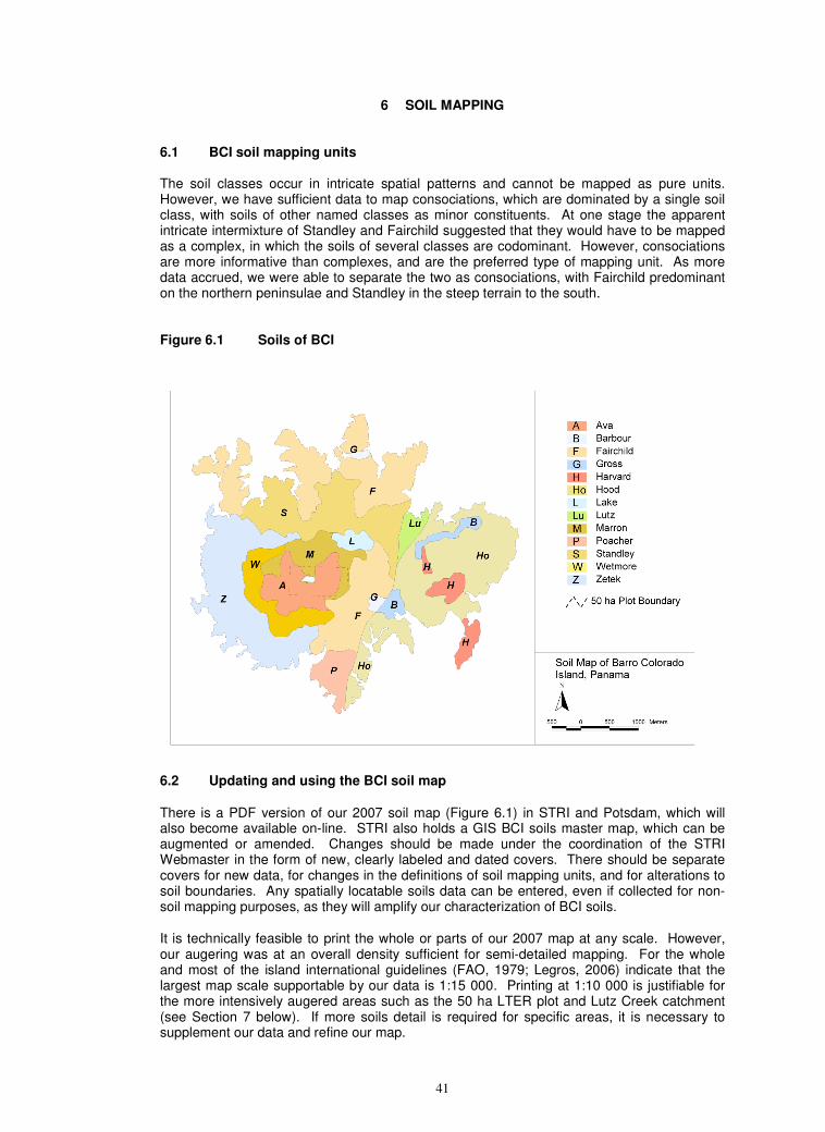
41
6 SOIL MAPPING
6.1 BCI soil mapping units The soil classes occur in intricate spatial patterns and cannot be mapped as pure units. However, we have sufficient data to map consociations, which are dominated by a single soil class, with soils of other named classes as minor constituents. At one stage the apparent intricate intermixture of Standley and Fairchild suggested that they would have to be mapped as a complex, in which the soils of several classes are codominant. However, consociations are more informative than complexes, and are the preferred type of mapping unit. As more data accrued, we were able to separate the two as consociations, with Fairchild predominant on the northern peninsulae and Standley in the steep terrain to the south. Figure 6.1 Soils of BCI
6.2 Updating and using the BCI soil map
There is a PDF version of our 2007 soil map (Figure 6.1) in STRI and Potsdam, which will also become available on-line. STRI also holds a GIS BCI soils master map, which can be augmented or amended. Changes should be made under the coordination of the STRI Webmaster in the form of new, clearly labeled and dated covers. There should be separate covers for new data, for changes in the definitions of soil mapping units, and for alterations to soil boundaries. Any spatially locatable soils data can be entered, even if collected for non-soil mapping purposes, as they will amplify our characterization of BCI soils.
It is technically feasible to print the whole or parts of our 2007 map at any scale. However, our augering was at an overall density sufficient for semi-detailed mapping. For the whole and most of the island international guidelines (FAO, 1979; Legros, 2006) indicate that the largest map scale supportable by our data is 1:15 000. Printing at 1:10 000 is justifiable for the more intensively augered areas such as the 50 ha LTER plot and Lutz Creek catchment (see Section 7 below). If more soils detail is required for specific areas, it is necessary to supplement our data and refine our map.
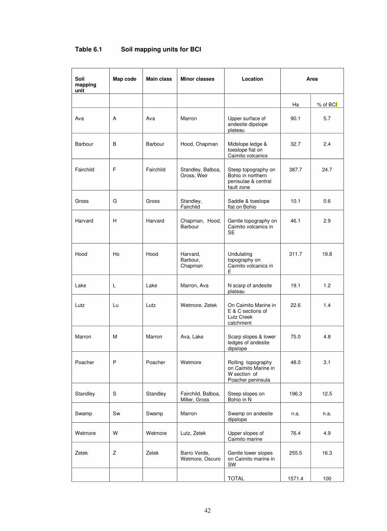
42
Table 6.1 Soil mapping units for BCI
Soil mapping unit
Map code Main class Minor classes Location Area
Ha % of BCI
Ava A Ava Marron Upper surface of andesite dipslope plateau
90.1 5.7
Barbour B Barbour Hood, Chapman Midslope ledge & toeslope flat on Caimito volcanics
32.7 2.4
Fairchild F Fairchild Standley, Balboa, Gross, Weir
Steep topography on Bohio in northern penisulae & central fault zone
387.7 24.7
Gross G Gross Standley, Fairchild
Saddle & toeslope flat on Bohio
10.1 0.6
Harvard H Harvard Chapman, Hood, Barbour
Gentle topography on Caimito volcanics in SE
46.1 2.9
Hood Ho Hood Harvard, Barbour, Chapman
Undulating topography on Caimito volcanics in E
311.7 19.8
Lake L Lake Marron, Ava N scarp of andesite plateau
19.1 1.2
Lutz Lu Lutz Wetmore, Zetek On Caimito Marine in E & C sections of Lutz Creek catchment
22.6 1.4
Marron M Marron Ava, Lake Scarp slopes & lower ledges of andesite dipslope
75.0 4.8
Poacher P Poacher Wetmore Rolling topography on Caimito Marine in W section of Poacher peninsula
48.0 3.1
Standley S Standley Fairchild, Balboa, Miller, Gross
Steep slopes on Bohio in N
196.3 12.5
Swamp Sw Swamp Marron Swamp on andesite dipslope
n.a. n.a.
Wetmore W Wetmore Lutz, Zetek Upper slopes of Caimito marine
76.4 4.9
Zetek Z Zetek Barro Verde, Wetmore, Oscuro
Gentle lower slopes on Caimito marine in SW
255.5 16.3
TOTAL 1571.4 100
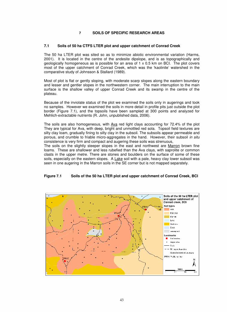
43
7 SOILS OF SPECIFIC RESEARCH AREAS
7.1 Soils of 50 ha CTFS LTER plot and upper catchment of Conrad Creek
The 50 ha LTER plot was sited so as to minimize abiotic environmental variation (Harms, 2001). It is located in the centre of the andesite dipslope, and is as topographically and geologically homogeneous as is possible for an area of 1 x 0.5 km on BCI. The plot covers most of the upper catchment of Conrad Creek, which was the ‘kaolinite’ watershed in the comparative study of Johnsson & Stallard (1989).
Most of plot is flat or gently sloping, with moderate scarp slopes along the eastern boundary and lesser and gentler slopes in the northwestern corner. The main interruption to the main surface is the shallow valley of upper Conrad Creek and its swamp in the centre of the plateau.
Because of the inviolate status of the plot we examined the soils only in augerings and took no samples. However we examined the soils in more detail in profile pits just outside the plot border (Figure 7.1), and the topsoils have been sampled at 300 points and analyzed for Mehlich-extractable nutrients (R. John, unpublished data, 2006).
The soils are also homogeneous, with Ava red light clays accounting for 72.4% of the plot They are typical for Ava, with deep, bright and unmottled red sola. Topsoil field textures are silty clay loam, gradually fining to silty clay in the subsoil. The subsoils appear permeable and porous, and crumble to friable micro-aggregates in the hand. However, their subsoil in situ consistence is very firm and compact and augering these soils was strenuous, The soils on the slightly steeper slopes in the east and northwest are Marron brown fine loams. These are shallower and less rubefied than the Ava clays, with saprolite or common clasts in the upper metre. There are stones and boulders on the surface of some of these soils, especially on the eastern slopes. A Lake soil with a pale, heavy clay lower subsoil was seen in one augering in the Marron soils in the SE corner but is not mapped separately. Figure 7.1 Soils of the 50 ha LTER plot and upper catchment of Conrad Creek, BCI
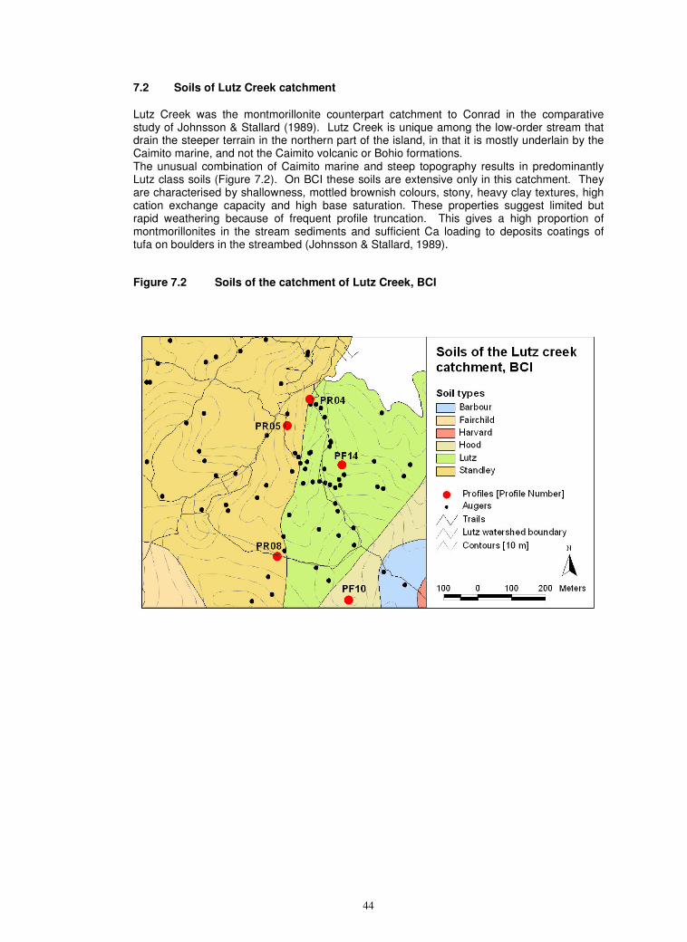
44
7.2 Soils of Lutz Creek catchment
Lutz Creek was the montmorillonite counterpart catchment to Conrad in the comparative study of Johnsson & Stallard (1989). Lutz Creek is unique among the low-order stream that drain the steeper terrain in the northern part of the island, in that it is mostly underlain by the Caimito marine, and not the Caimito volcanic or Bohio formations. The unusual combination of Caimito marine and steep topography results in predominantly Lutz class soils (Figure 7.2). On BCI these soils are extensive only in this catchment. They are characterised by shallowness, mottled brownish colours, stony, heavy clay textures, high cation exchange capacity and high base saturation. These properties suggest limited but rapid weathering because of frequent profile truncation. This gives a high proportion of montmorillonites in the stream sediments and sufficient Ca loading to deposits coatings of tufa on boulders in the streambed (Johnsson & Stallard, 1989).
Figure 7.2 Soils of the catchment of Lutz Creek, BCI
45
8 BCI SOILS IN TROPICAL FOREST CONTEXT 8.1 Pedological comparisons
The soils of BCI are derived from volcanic materials or marine sediments with high proportions of volcanic constituents. Their pedogenic development is therefore substantially different from the dystrophic soils derived from siliceous and feldspathic parent materials that predominate over large tracts of tropical forest on continental shields and in intra- continental plate sedimentary basins.
There are many studies of tropical forest soils derived from mafic or near mafic extrusive lithologies. The most useful comparisons for BCI are with elsewhere in Central America, because of geographical proximity, and with Hawaii, because of the sustained, coherent and clearly reported series of detailed studies on soil-related factors and processes in the ecology of Hawaiian forests (Vitousek, 2004).
Comparison of BCI with the detailed findings on soil morphological, mineralogical and chemical development on volcanic deposits of various ages in the coastal lowlands of Costa Rica (Nieuwenhuyse et al, 2005) highlights differences between pedogenesis on lavas and ash of similar lithochemical composition. The ash soils in coastal Costa Rice inherit volcanic glass and high porosity from their ash origins. The clay minerals develop along a glass – allophane – halloysite trajectory, and the main soils are Andosols (WRB) / Andisols (ST), in contrast to the primary minerals – smectite – kaolinite trajectory on BCI. The balance between Al and Mg in the initial weathering products may also influence pedogenic pathways.
The non-alluvial soils of the forest research site at La Selva in Cost Rica are developed on volcanic deposits of various ages from Volcan Barva. The regoliths at La Selva appear to be similar to those on BCI, in that they are lava flows of intermediate andesitic-basaltic composition.
The Hawaiian volcanic deposits are, derived from a mid-oceanic mantle plume (Clouard & Bonneville, 2001. They are lithologically uniform, being so predominantly basaltic that quartz and micas found in the soils are attributed either to aeolian imports or pedogenic neoformations (Beltzer et al., 1088; Juang & Uehara, 1968; Rex et al., 1969. Jackson et al., 1971; Dymond et al., 1971). Although of limited lithochemical variability the volcanic materials are physically and structurally diverse, consisting of ash, pumice and lavas, with the latter subdivided on structure and porosity. The soils appear to develop along both volcanic – glass – halloysite and smectite – kaolinite + sesquioxide pathways (Chadwick et al., 1999; Sherman, 1969).
These comparisons show that:
1. The BCI shallow fine loams are not exceptional and that morphologically and chemically similar soils are widespread under tropical forests on crystalline rocks of intermediate – mafic composition, especially on steep slopes and unstable sites.
2. Reddish aggregated light clays similar to those on BCI are common but not vastly extensive in plate margin areas in the tropics. The BCI red clays have unusually compact subsoils, and their permeability and profile drainage may be inferior to many similar soils.
3. The pale swelling clays on BCI are rare soils. Smectites can occur under tropical forest in shallow immature soils on steep slopes on mafic rocks, in dark clays on limestone platforms, such as in Belize and Yucatan, or on ultramafic rocks. However, all of these smectitic clays are fully base saturated, with either Ca or Mg as the dominant cation, and with zero or negligible extractable Al. Acid Al-dominated smectitic clays like Zetek and most other BCI pale swelling clay classes combine features that associate intense leaching with rudimentary weathering. They therefore appear to be chemically unstable and are expected to be ephemeral. Al-smectites are rare in any environment. Their extent and depth on BCI is very unusual, and
46
apparently unique amongst well researched tropical forest sites. The inherent instability of the Al-smectites may be partly offset by the poor drainage of these soils on BCI, as this retards the leaching of weathering products that would hasten their desilication.
8.2 Ecological implications
The emphasis in reporting this survey is mainly pedological. However, the findings, map and data provide potential insight into many aspects of the edaphic environments of the BCI forests. The fuller ecological implications of the data and map will be explored more fully elsewhere.
Preliminary points include:
1. The edaphic substrate of all forests must furnish the trees and other vegetation with water, nutrients, root aeration, and a mechanically stable root environment. There is a tendency to over-emphasise water and nutrient supplies and neglect the aeration and stability aspects of site fertility. When all aspects are considered, the soils of BCI provide a considerable range of edaphic environments.
2. The brown and dark loams and red clays are well drained and appear to be well aerated. The limited areas of swamp soils are more or less permanently imperfectly or poorly drained, and air supplies to roots are severely restricted.
3. Drainage in the pale swelling clays appears to vary considerably with the seasons. Once their smectitic clays are thoroughly wetted and expanded in the early wet season, aeration of the subsoils is expected to be very limited. When the clays contract in the early dry season, surface cracking allows free air flow into the topsoil and upper subsoil. This in turn will enhance root activity and facilitate the uptake of water and drying of the lower subsoils.
4. The red clays occur mainly on gentle topography and apparently stable sites. The steeper slopes, shallow sola and limited weathering of the fine loams suggest that profile truncation and site disturbance recur within pedogenic time scales (10
1 –
105 years). Treefalls appear to be more frequent on the steep Bohio terrain than
elsewhere (Putz, 1983; Putz et al., 1983 & 1985)). However, many treefalls are caused by tree senility and senescence or other entirely biological processes, recur within biological time frames (10
1 – 10
4 years), and need not be associated
with site disturbance.
5. The pale swelling clays occur on gentle slopes and most of their sola appear moderately deep. However, the rapid spalling from profile faces and degradation of our pits show that these soils are unable to retain a free face for much more than one seasonal single shrink-swell cycle. The implications of this for forest site stability need examination. There are few free faces under intact forest on gentle slopes. However the soils are heaving and buckling with each season and this may destabilize root anchorage and render trees vulnerable to windthrow. Once a tree is uprooted, its pit has free faces. These can then spall and slump, and destabilize adjacent soils. The effects of treefall may therefore be more severe on these soils (Foster & Brokaw, 1996), and site instability may be a more significant ecological factor than on the red clays.
6. Water supply is largely determined by rainfall seasonality. The ability of some BCI soils to store and maintain water supplies to the forest during the dry season has been examined in a large scale, five-year irrigation trial on the Poacher Peninsula. The soils of the area are red light clays (Poacher) and shallow fine loams (Wetmore).
7. It is not possible to generalize about nutrient supply by tropical forest soils. Each
47
nutrient has different locales and dynamics in soils. Characterization of each nutrient needs to specify their partition between mineral and organic components, their distribution between horizons down the profile, their physical accessibility, their ease of dissociation from the solid phase into the soil solution, and their stoichiometric balance with respect other nutrients. In practice this means that nutrients should be extracted with several reagents of different power, from several depths down the profile and reported as relative as well as in absolute values.
8. Much remains to be done in the characterization of the nutrient status of the soils of BCI. There are some data for the anionic nutrients P and N but these are only for available forms and only from topsoils (Yavitt and Wieder, 1988; R. John unpublished data).Our data are only available (exchangeable) forms of the main cationic mineral-derived nutrients Ca, Mg, and K.
9. Despite their limitations, these data already indicate that, compared with many tropical forests, the soils of BCI are well endowed with available Ca and Mg.
10. Extrapolation from other tropical forest soils on intermediate - mafic parent materials suggests that BCI soils probably inherit moderate levels of P. However, much of the P from weathering is immobilized by sorption on to mineral and organic solids. On BCI P- immobilization is likely to be high in the red clays and the Al-dominated pale swelling clays.
11. K is the main nutrient likely to be in short supply in BCI soils, as indicated from the very low –zero levels of exchangeable K, and by extrapolation from findings similar soils in Hawaii and elsewhere. Barthold et al. (2007) show that the low K status of the BCI soils is due to low total contents, which do not vary significantly between parent materials.
12. The low labile K and high labile Ca and Mg status of the BCI soils contrast with situation in the soils of some Asian CTFS plot. Although generally acid and dystrophic, the soils at Lambir in Malaysian Borneo are relatively well endowed with exchangeable K, and soil analyses indicate Ca is the critically low cation (S, Tan, unpublished data). The scant data for the soils of the super-wet Sinharaja plot in Sri Lanka indicate the very low contents of all the main labile cations (I.A.U.N. Gunatilleke, unpublished data). The stoichiometric differences are clear in the graphic comparison (Alvim, 1979) of labile subsoil cations (Figure 8.1). Data for less available forms and from a range of depths are needed for fuller comparisons (Baillie et al., 2006). It is noticeable in Figure 8.1 that pH (water) is a poor indicator of overall base status.
13. A feature of some of the red light clays is that pH, total exchangeable bases, and base saturation have mid-profile minima. The higher values in the topsoils are attributed to nutrient cycling and returns to the surface and topsoil in litter. The rise seen in the lower subsoils of some profiles may be due to inputs from mineral weathering. If confirmed, this suggests that weathering in these spoils is less advanced than indicated by their morphology. Barthold et al. (2007) show that this effect actually occurs on all four geological formations. Their data show that nutrient cycling and litter returns enhances topsoil exchangeable K much more than weathering does in the lower subsoil.
14. Na is normally regarded as a highly mobile element, the labile forms of which are rapidly depleted under intense leaching from tropical forest soils. Exchangeable Na levels are low in many BCI profiles but moderate levels occur in several. This may be another indication of weathering being less advanced in BCI soils than first appears. This is corroborated by the survival of small quantities of albite, the most sodic mineral of the plagioclase series, in two subsoils on Bohio.
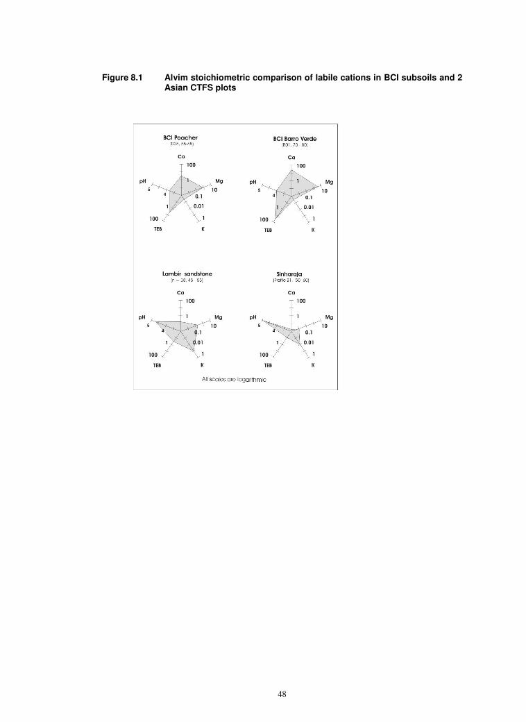
48
Figure 8.1 Alvim stoichiometric comparison of labile cations in BCI subsoils and 2 Asian CTFS plots

49
References and general BCI soils bibliography
Akamigbo, F.O.R. 1984. The accuracy of field textures in a humid tropical environment. Soil Survey and Land Evaluation, 4, 63 – 70.
Alvim, P. de T. 1978. Perspectiva de producao agricola na regiao Amazonica. Interciencia 3: 343 – 349. Ashton, P.S. & Hall, P. 1992. Comparisons of structure among dipterocarp forest of northwestern Borneo. Journal of Ecology 80: 459 – 481.
Baillie, I.C., Ashton, P.S., Chin, S.P., Davies, S.J., Palmiotto, P.A., Russo, S.E. & Tan S. 2006. Spatial associations of humus, nutrients and soils in mixed dipterocarp forest. Journal of Tropical Ecology.
Barberis, I.M. & Tanner, E.V.J. 2005. Gaps and root trenching increase tree seedling growth in a Panamanian semi-evergreen forest. Ecology 86 667 – 674.
Becker, P., Rabenold, P.E., Idol, J.R. & Smith, A.P. 1988. Water potential gradients for gaps and slopes in a Panamanian tropical moist forest’s dry season. Journal of tropical Ecology 4, 173 – 184.
Becker, P. & Anyani, C. 1990. Root architecture of shrubs and saplings in the understory of a tropical moist forest in lowland Panama. Biotropica 22 242 - 249
Beltzer, P.R & 11 others. 1988. Long range transport of giant mineral aerosol particles, Nature, 336, 568 – 571.
Bennett, H.H. 1926. Some comparisons of the properties of humid-tropical and humid-temperate American soils; with special reference to indicated relations between chemical composition and physical properties. Soil Science 21 349 –375.
Bennett, H.H. 1929. Soil reconnaissance of the Panama Canal Zone and contiguous territory. USDA Technical Bulletin 94, 1 – 46
Bush, M.K. & Colinvaux, P.A. 1990. A pollen record of a complete glacial cycle from lowland Panama. Journal of Vegetation Science, 1, 105 – 188.
Calderon, N.E.G., Krasilnikov, P.V., Huerta, P.I., Arteaga, G.A., Romero, E.F., & Castro, B.M. 2005. WRB classification of polygenetic soils of Sierra Sur de Oaxaca, Mexico. Eurasian Soil Science, 38 Supplement, S27 – S34.
Catapan, 1970. See ‘Maps’ below.
Cavalier, J. 1992. Fine root biomass and soil properties in a semi-deciduous and a lower montane rain forest in Panama. Plant & Soil 142, 187 – 201.
Cavalier, J. Wright, S.j. & Sanatmaria, J. 1999. Effects of irrigation on litterfall, fine root biomass and production in a semi-deciduous forest in Panama. Plant & Soil 211, 207 - 213
Chave, J. Condit, R., Lao, S., Caspersen, J.P., Foster, R.B., & Hubbell, S.P. 2003. Spatial and temporal variation of biomass in a tropical forest: results from a large census plot in Panama. Journal of Ecology 91, 240 – 252.
Clark, D.B., Palmer, W. M. & Clark, D.A. 1999. Edaphic factors and the landscape distribution of tropical rain forest trees. Ecology 80: 2662 – 2675.
Clayden, B. & Hollis, J.M. 1984. Criteria for differentiating soils series. Technical Monograph 17, Soil survey of England & Wales, Harpenden, UK. vi + 159 pp
50
Clouard, V.. & Bonneville, A. 2001. How many Pacific hotspots are fed by mantle plumes? Geology, 29, 695 – 698.
Colinvaux, P.A. 1996. Quaternary environmental history and forest diversity in the neotropics. Pp 359 – 406. in ‘Evolution and environment in Tropical America’ (Jackson, J.B.C., Budd, A.F. & Coates, A.G., Eds), University of Chicago Press, Chicago, USA.
Condit, R. 1998. Tropical forest census plots: Methods and results from Barro Colorado Island, Panama and a comparison with other plots. Springer Verlag, Berlin, Germany. Xi + 211 pp.
Condit, R, Hubbell, S. & Foster, R. 1995. Mortality rates of 205 neotropical tree and shrub species and the impact of severe drought. Ecological Monographs 65 419 – 439.
Cornejo, F.H., Varela, A. & Wright, S.J. 1994. Tropical forest litter decomposition under seasonal drought,: Nutrient release, fungi and bacteria. Oikos 70 183 – 190.
Couto, W., Sanzonwizc & Barcellos, A. de O. 1985. Factors affecting oxidation and reduction processes in an Oxisol with a seasonal water table. Soil Science Society of America Journal 49 1245 – 1248.
Croat, T.B. 1978. Flora of Barro Colorado Island. Stanford University Press, Stanford, USA. 943 pp. Davies, S.J., Tan, S., LaFrankie, J.V., & Potts, M.D. 2005. Soil-related floristic variation in the hyperdiverse dipterocarp forest in Lambir Hills, Sarawak. In: D.W. Roubik, S. Sakai & A., Hamid, eds. Pollination Ecology and Rain Forest Diversity, Sarawak Studies, 22 –
Daws, M.I., Mullins, C., Burslem, D., Paton, R. & Dalling, J. 2002. Topographic position affects the water regime in a semi-deciduous tropical forest in Panama. Plant & Soil 238, 79 – 90.
Deckers, J., Spaargaren, O., Nachtergaele, F., Berdig, F., Ahrens, R., Micheli, E. & Schad, P. 2005. Rationale for the key and the qualifiers of the WRB 2006. Eurasian Soil Science, 38 Supplement, S6 – S12.
Dent, D. & Young, A. 1981. Soil survey and land evaluation. George Allen & Unwin, London, UK.
Dietrich, W.E., Windsor, D.M. & Dunne, T. 1996. Geology, climate and hydrology of Barro Colorado Island. In ‘The ecology of a tropical forest, Seasonal rhythms and long term changes.’ (Eds. Leigh, E.G. Jr., Rand, A.S. & Windsor, D.M.) 2
nd edition. Pp 21 – 46.
Smithsonian Institution, Washington, DC, USA.
Dymond, I., Biscayne, P.E & Rex, R.W.. 1971. Aeolian origin of mica in Hawaiian soils. Geological society of America Bulletin, 85, 37 - 40.
FAO 1979. Soil survey investigations for irrigation. Soils Bulletin 42, Food & Agriculture Organisation of United nations, Rome, Italy.
F.A.O. 1998. World reference base for soils. World Soil Resources Report 84. Food & Agriculture Organisation of United Nations, Rome, Italy.
Hare, P.W. &b Gardner, T.W. 1985. Geomorphic indications of vertical neo-tectonism along converging plate margins, Nicoya Peninsula, Cost Rica. In ‘Tectonic geomorphology’ (Eds. Morisawa, M., & Hack, J.T.), pp 75 –104. Allen & Unwin, Boston, USA.
Harms, K., Condit, R., Hubbell, S.P. & Foster, R.B. 2001. Habitat associations of trees and shrubs in a 50 ha neotropical forest plot. Journal of Ecology 89, 947 – 959.
51
Hesse, P.R. 1971. A textbook of soil chemical analysis. John Murray, London, UK.
Hudson, B.D. 1992. The soil survey as paradigm-based science. Soil Science Society of America Journal 56, 836 -841
Jackson, M.L., Levett, T.H., Syers, J.K., Rex, R.W , Clayton, R.N., Sherman, G.D. & Uehara, G. 1969. Geomorphological relationships of tropospherically-derived quartz in the soils of the Hawaiian Islands. Soil Science Society of America Proceedings, 35, 515 – 525.
Jenny, H. 1980. The soil resources: origin and behaviour. Springer Verlag, New York, USA.
Johnsson, M.J. 1990. Overlooked sedimentary particles from a tropical weathering environment. Geology 18 107 –110.
Johnsson M.J. & Stallard, R.F. 1989. Physiographic controls on the composition of sediments derived from volcanic and sedimentary terrains on Barro Colorado Island, Panama. Journal of Sedimentary Petrology 59, 768 – 781.
Juang, T.C. & Uehara, G. 1968. Mica genesis in Hawaiian soils. Soil Science Society of America Proceedings 32: 31 – 35.
Kaufmannn, S., Sombroek, W. & Mantel, S. 1998. Soils of rain forests: characterisation and major constraints of dominant forest soils in the humid tropics. Pp 10 – 28 in: ‘Soils of tropical forest ecosystems. (Eds S Schulte & D Ruhiyat), Springer, Berlin.
Klingebiel, A.A. & Montgomery, P.H. 1961. Land capability classification. Soil Conservation Handbook 210, US Department pf Agriculture, Washington, D.C. USA.
Knight, D.H. 1975. A phytosociological analysis of species-rich tropical forest on Barro Colorado Island, Panama. Ecological Monographs 45, 259 – 284.
Kursar, T.A. 1989. Evaluation of soil respiration and soil CO2 concentration in a lowland tropical moist forest in Panama. Plant and Soil 113 21 – 29.
Kursar, T.A., Engelbrecht, B.M.J. & Tyree, M.T. 2005. Journal of Tropical Ecology.
Kursar, T.A., Wright, S.J. & Radulovich, R. 1995. The effects of the rainy season and irrigation on soil water and oxygen in a seasonal forest in Panama. Journal of Tropical Ecology 11, 497 – 515.
Landon, J.R. (ed.) 1984. Booker tropical soil manual. Booker Agriculture International, London & Longman, Harlow, UK. xiv + 450 pp.
Legros, J.-P. 2006. Mapping the soil. Science Publishers, Enfield, NH, USA.
Leigh, E.G. Jr 1999. Tropical forest ecology: a view from Barro Colorado Island. Oxford University Press, New York, USA. Xvi + 245 pp.
Leigh, E.G. Jr, Rand, A.S. & Windsor, D.M. (Eds.) 1996. The ecology of a tropical forest: seasonal rhythms and long-term changes. 2
nd edition. Smithsonian Institution Press
Washington, DC, USA. 468pp.
Leigh E.G Jr, Davidar, P., Dick, C.W., Puyravaud, J.P., Terborgh, J., ter Steege, H. & Wright, S.J. 2004. Why do some tropical forests have so many species of trees? Biotropica, 36, 447 – 473.
Leinweber, P., Preu, C. & Jankin, C. 1998. Classification and properties of soil under different land use types in southwest Sri Lanka. Advances in Geoecology, 31, 113 – 119.
52
MacVicar, C.N. (ed.) 1991. Soil classification .A taxonomic system for South Africa. Second Edition. Memoir 15, Department of Agricultural Development, Pretoria, South Africa. xvi + 257 pp
McLeod, M. 1984. Seasonal changes in soil colours on the Hauraki Plains. New Zealand Soil News, 32, 201. Mapa, R. B., Somasiri, S. & Nagarajah, S. (Eds.), 1999. Soils of the wet zone of Sri Lanka. Special Publication 1, Soil Science Society of Sri Lanka, Colombo, Sri Lanka.
Nieuwenhuyse, A., Verburg, P.S.T. & Jongmans, A.G. 20000. Mineralogy of a soil chronosequence on andesitic lava in humid tropical Costa Rica. Geoderma, 98, 61 – 83.
Ocana, G., Rubinoff, I, Smythe, N. & Werner, D. 1988. Alternatives to destruction. Research in Panama. In ‘Biodiversity’ (Ed. Wilson, E.O.) pp 370 – 376. National Academy of Science, Washington, DC, USA.
Pleysier, J.L., Juo, A.S.R. & Herbillon, A.J. 1979. Ion exchange equilibria involving aluminum in a kaolinitic Ultisol. Soil Science Society of America Journal, 43, 875 – 880. Potts, M.D., Ashton, P.S., Kaufman, L.S. & Plotkin, J.B. 2002. Habitat patterns in tropical rain forests: A comparison of 105 plots in northwest Borneo. Ecology 83: 2782 – 2797.
Putz, F.E., 1983. Treefall pits and mounds, buries seeds and the importance of soil disturbance to pioneer tree species on Barro Colorado Island, Panama. Ecology 64 1069 – 1074.
Putz, F.E., Coley, P.D., Lu, K., Montalvo, A. & Aiello, A. 1983. Uprooting and snapping of tree; Structural determinants and ecological consequences. Canadian Journal of Forestry Research. 13 1011 – 1020.
Putz, F.E., Coley, P.D., Lu, A., Montalvo, A. & Aiello, A. 1985. Uprooting and snapping of tree on Barro Colorado Island. In ’The botany and natural history of Panama’. (Eds. W.G. D’Arcy & M.D. Correa). Missouri Botanical Gardens, St Louis, MO, USA. X11 + 455 pp.
Pyke, C.R., Condit, R., Aguilar, S, & Lao, S. 2001. Floristic composition across a climatic gradient in a neotropical lowland forest. Journal of Vegetation Science 12 553 – 566.
Rex, R.W., Syers, J.K., Jackson, M.L. & Clayton, R.N. 1969. Eolian origin of quartz in soils of Hawaiian Islands and in Pacific pelagic sediments. Science, 163, 277 – 279.
Richter, D.D. & Babbar, L.I. 1991. Soil diversity in the tropics. Advances in Ecological research, 21, 315 – 389. Rubinoff, I. & Leigh, E.G. Jr.1990. Dealing with diversity: the Smithsonian Tropical Research Institute and tropical biology. Trends in Ecology & Evolution 5. 115 – 118. Russo, S.E., Davies, S.J., King, D.A. & Tan, S. 2005. Soil-related performance variation and species’ distribution patterns in a Bornean rain forest. Journal of Ecology 93: 879 – 889.
Santiago, L.S., Schuur, E.A.G. & Silvera, K. 2005. Nutrient cycling and plant-soil feedbacks along a precipitation gradient in lowland Panama.
Schoenberger, P.J., Wysozki, D.A., Benham, E.C. & Broderson, W.D. 1998. Field book for describing and sampling soils. National Soil Survey Center, Natural Resources Conservation Service, Lincoln, NE, USA.
Sherman, G.D., 1969. Mineral weathering in relation to utilization of soils. Symposium on Tropical Weathering. UNESCO, Jakarta and Paris.
53
Soepraptohardtjo, M & Isamangun. 1980. Classification of red soils in Indonesia by Soil Research Institute. In: P. Buurman ed., Red soils in Indonesia, 15 – 22. Bulletin 5. Soil Research Institute, Bogor, Indonesia.
Soil Survey Staff, 1997. Soil survey manual. Handbook 18, National Resources Conservation Service, US Department of Agriculture, Washington, DC, USA. Soil Survey Staff, 1999. Soil Taxonomy. 2
nd edition. Agricultural Handbook 436, United
States Department of Agriculture. Washington D.C., U.S.A. Soil Survey Staff, 2006. Keys to Soil Taxonomy. 10th edition. United States Department of Agriculture. Washington D.C., U.S.A. Sollins, P., Sancho, F., Mata, R. & Sanford, R.L. 1994. Soils and soil process research. In: A. McDade, K.S. Bawa, H. Hespenheide & G.S. Hartshorn, Eds., La Selva: ecology and natural history of a neotropical rainforest, 34 – 53. University of Chicago Press, Chicago, U.S.A.
Stemmler, S.J. & Bertelin, J. 2003. Microbial activity as a major factor in the mobilisation of iron in the humid tropics. European Journal of Soil Science 54 725 – 734.
STRI 1987. The Barro Colorado Nature Monument. Smithsonian Tropical Research Institute, Panama City.
Svenning, J.C., Kinner, D.A., Stallard, R.F., Engelbrecht, B.J.M. & Wright, S.J. 2004. Ecological determinism in plant community structure across a tropical forest landscape. Ecology 85 2526 – 2538.
Veldkamp, E., Huising, E.J., Stein, A. & Bouma, J. 1990. Variation of measured banana yields in a Costa Rica plantation as explained by soil survey and Thematic Mapper data. Geoderma 47 337 – 348.
Wieder, R.K. & Wright, S.J. 1995. Tropical forest litter dynamics and dry season irrigation on Barro Colorado Island, Panama. Ecology 76 1971 – 1979.
Windsor, D.M. 1990. Climate and moisture variability in a tropical forest: long term records from Barro Colorado Island, Panama. Smithsonian Contributions to Earth Science 29 1 –148.
Woodring, W. P. 1958. Geology of Barro Colorado Island. Smithsonian Miscellaneous Collections. 135 1 – 39.
Wright, S.J & Cornejo, F.H. 1990. Seasonal drought and leaf fall in a tropical forest. Ecology 71 1165 – 1175.
Wright, S.J. 1991. Seasonal drought and the phenology of understory shrubs in a tropical moist forest. Ecology 72 1643 – 1657.
Wright, S.J. 1992. Seasonal drought, soil fertility and the species’ diversity of tropical plant communities. Trends in Ecology and Evolution 7 260 –263.
Yavitt, J.B. 2000. Nutrient dynamics of soil derived from different parent materials on Barro Colorado Island, Panama. Biotropica 32 198 - 207.
Yavitt, J.B., Wieder, R.K. & Wright, S.J. 1993. Soil nutrient dynamics in response to irrigation of a Panamanian tropical moist forest. Biogeochemistry 19 1-25.
Yavitt, J.B. & Wieder, R.K. 1988. Nitrogen, phosphorus and sulfur properties of some forest soils on Barro Colorado Island, Panama. Biotropica 20 2-10.
54
Yavitt, J.B. & Wright, S.J. 1996. Temporal patterns of soil nutrients in a Panamanian moist forest revealed by ion-exchange resin and experimental irrigation. Plant & Soil 183 117 – 129.
Yavitt, J.B. & Wright, S.J. 2001. Drought and irrigation effects on fine root dynamics in a tropical moist forest. Biotropica 33 421 – 434,
Yavitt, J.B. & Wright, S.J. 2002. Charge characteristics of soil in a lowland tropical moist forest in Panama in response to dry-season irrigation. Australian Journal of Soil Research 40 269 – 281.,
Yavitt, J.B. & Wright, S.J. & Wieder, R.K 2004. Seasonal drought and dry season irrigation influence leaf litter, nutrients and soil enzymes in a moist lowland forest in Panama. Australian Ecology 29 177 – 188.
MAPS & IMAGERY
ARI, 1996. Land use and natural resources 1:125 000. Autoridade Regional Inter-oceanico, Panama.
Catapan, 1970. Soil maps 1:100 000 & 1:20 000. Jacobs & Co for CRA-Catapan, MIDA, Santiago, Panama.
Google Earth, 2006.
IGN 1975. National Atlas. Instituto Geografico Nacional Tommy Guardia, Panama.
IGN 1984. 1:50 000 topographic sheets based on US Army Map Service 1:25 000 (1963) series. Instituto Geografico Nacional Tommy Guardia, Panama.
RoP, 1996. Protected areas in the Canal Zone 1:375 000. Republic of Panama.
RoP, 1970. Ecological map of Panama. 1:500 000. Republic of Panama & United Nations Development Programme.


![An introduction to statistics for spatial point processesrw/Talks/lectures.pdf · Data example (Barro Colorado Island Plot) Observation window W = [0,1000] ×[0.500]m2 Beilschmiedia](https://static.fdocuments.in/doc/165x107/604da80e6c9a325b2d1b3e81/an-introduction-to-statistics-for-spatial-point-processes-rwtalkslecturespdf.jpg)