Selection of Rockfall Mitigation Techniques Based on Colorado Rockfall Simulation...
3
20 TRANSPORTATION RESEARCH RECORD 1343 Abridgment Selection of Rockfall Mitigation Techniques Based on Colorado Rockfall Simulation Program RI CHARD D. ANDREW Until recently, predicting rockfall behavior has, at best, been extremely subjective. Many of the existing rockfall models had proven to be inaccurate and unrealistic in characterizing real-life rockfall occurrences with variable slope conditions. The inability to characterize a rock in motion led engineering geologists with the Colorado Department of Transportation and the Colorado Geological Survey to develop, test, and adopt the Colorado Rockfall Simulation Program (CRSP). Since its first release in late 1987, the program has been used to analyze a number of hazardous rockfall areas along the Interstate 70 project through Glenwood Canyon in Colorado. This, in turn, has led to the development of some fairly innovative mitigation techniques. Three devices have undergone extensive testing and have been applied to several locations along this scenic highway with an impressive record of performance. For years, engineering geologists with the Colorado Depart- ment of Transportation (CDOT) and the Colorado Geological Survey (CGS) have attempted to understand the random behavior of rocks in motion and to control their effects on Colorado's highways. Many of the mountainous roadways traverse hazardous rockfall areas, which exhibit highly vari- able slope conditions and are difficult to analyze. During con- struction of the J-70 project through Glenwood Canyon, not only were these conditions encountered, but also there was the concern for minimizing the environmental impact of the mitigation procedures. The Colorado Rockfall Simulation Program (CRSP) was developed to provide an understanding of rockfall behavior along the highly irregular canyon walls. The program models varying slope conditions and provides information on the velocities. bounding heights, and energies of falling rocks at any point along the slope (1, 2). This infor- mation is critical in determining the most appropriate type and location of mitigation. Since its development in 1987, CRSP has been useful in designing several forms of mitigation, including the tire atten- uator. the Colorado Flexpost fence, and, more recently, the use of geosynthetics as reinforcement in rockfall barriers. These systems have undergone extensive field testing and have proven to be effective in controlling rockfall. Several locations throughout Glenwood Canyon have received these systems for mitigation of rockfall hazards. Colorado Geological Survey, 1313 Sherman Street, Denver, Colo. 80203. APPLICATION For years, the Glenwood Canyon geotechnical staff has been monitoring rockfall events on and around the 1-70 improve- ment project. A data base was established that reflected the areas receiving the highest incidence of rockfall. This data, in addition to extensive field review, Jed geologists to priority- rank the rockfall-prone areas. CRSP was used to analyze these area and assist in determining the most suitable mitigation system. Tire Attenuator The tire attenuator system was developed during the calibra- tion of CRSP at the West Rifle test site near Rifle, Colorado (see Figure 1) . It was designed to absorb kinetic energy and reduce bounding heights of incoming rockfall, then return to its original position without maintenance intervention. The system utilizes columns of used tires on rims supported by a series of 3-in. steel pipes. which are attached to a large- diameter wire rope suspended across a gully or draw. Rock anchors are used to secure the wire rope assembly to bedrock. For aesthetic reasons, a facade consisting of 8-in. wooden posts suspended from a separate wire rope may be placed downslope of the tire elements. Rocks that detach from the source area encounter the tire attenuator while their energy is at or near maximum . After impact, most of the energy is absorbed, thus increasing the summers of 1989 and 1990. The most durable utilized nineteen 270-ksi , 0.6-in.-diameter ten- dons grouted in two sections of 3Y"·in. inside diameter steel casing. The flexibility of the posts was provided by leaving 18 in. of the tendons uncased near the ground surface. The overall height of the posts was 11 ft. Maccaferri rock mesh strengthened with steel aircraft cables provided the net mate- rial in the fence. It was observed during the testing that when the netting was placed on the downhill side, the interaction between the fence and the rock was more prolonged , thus enabling more components of the fence to react to the impact (4). The Colorado Flexpost fence has been utilized in three locations on the Glenwood Canyon Project. Construction has recently begun at 22 additional locations throughout the can- yon as part of a comprehensive rockfall mitigation project for
Transcript of Selection of Rockfall Mitigation Techniques Based on Colorado Rockfall Simulation...

20 TRANSPORTATION RESEARCH RECORD 1343
Abridgment
Selection of Rockfall Mitigation Techniques Based on Colorado Rockfall Simulation Program
R ICHARD D. ANDREW
Until recently, predicting rockfall behavior has, at best, been extremely subjective. Many of the existing rockfall models had proven to be inaccurate and unrealistic in characterizing real-life rockfall occurrences with variable slope conditions. The inability to characterize a rock in motion led engineering geologists with the Colorado Department of Transportation and the Colorado Geological Survey to develop , test, and adopt the Colorado Rockfall Simulation Program (CRSP). Since its first release in late 1987, the program has been used to analyze a number of hazardous rockfall areas along the Interstate 70 project through Glenwood Canyon in Colorado. This, in turn, has led to the development of some fairly innovative mitigation techniques. Three devices have undergone extensive testing and have been applied to several locations along this scenic highway with an impressive record of performance.
For years, engineering geologists with the Colorado Department of Transportation (CDOT) and the Colorado Geological Survey (CGS) have attempted to understand the random behavior of rocks in motion and to control their effects on Colorado's highways. Many of the mountainous roadways traverse hazardous rockfall areas, which exhibit highly variable slope conditions and are difficult to analyze. During construction of the J-70 project through Glenwood Canyon, not only were these conditions encountered, but also there was the concern for minimizing the environmental impact of the mitigation procedures. The Colorado Rockfall Simulation Program (CRSP) was developed to provide an understanding of rockfall behavior along the highly irregular canyon walls. The program models varying slope conditions and provides information on the velocities . bounding heights, and energies of falling rocks at any point along the slope (1, 2). This information is critical in determining the most appropriate type and location of mitigation.
Since its development in 1987, CRSP has been useful in designing several forms of mitigation, including the tire attenuator. the Colorado Flexpost fence, and, more recently, the use of geosynthetics as reinforcement in rockfall barriers. These systems have undergone extensive field testing and have proven to be effective in controlling rockfall. Several locations throughout Glenwood Canyon have received these systems for mitigation of rockfall hazards.
Colorado Geological Survey, 1313 Sherman Street, Denver, Colo . 80203.
APPLICATION
For years, the Glenwood Canyon geotechnical staff has been monitoring rockfall events on and around the 1-70 improvement project. A data base was established that reflected the areas receiving the highest incidence of rockfall. This data, in addition to extensive field review, Jed geologists to priorityrank the rockfall-prone areas. CRSP was used to analyze these area and assist in determining the most suitable mitigation system.
Tire Attenuator
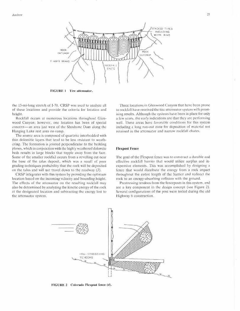
The tire attenuator system was developed during the calibration of CRSP at the West Rifle test site near Rifle, Colorado (see Figure 1) . It was designed to absorb kinetic energy and reduce bounding heights of incoming rockfall, then return to its original position without maintenance intervention. The system utilizes columns of used tires on rims supported by a series of 3-in. steel pipes. which are attached to a largediameter wire rope suspended across a gully or draw. Rock anchors are used to secure the wire rope assembly to bedrock. For aesthetic reasons, a facade consisting of 8-in. wooden posts suspended from a separate wire rope may be placed downslope of the tire elements. Rocks that detach from the source area encounter the tire attenuator while their energy is at or near maximum . After impact, most of the energy is absorbed, thus increasing the summers of 1989 and 1990. The most durable utilized nineteen 270-ksi , 0.6-in.-diameter tendons grouted in two sections of 3Y"·in. inside diameter steel casing. The flexibility of the posts was provided by leaving 18 in. of the tendons uncased near the ground surface. The overall height of the posts was 11 ft. Maccaferri rock mesh strengthened with steel aircraft cables provided the net material in the fence. It was observed during the testing that when the netting was placed on the downhill side, the interaction between the fence and the rock was more prolonged , thus enabling more components of the fence to react to the impact (4).
The Colorado Flexpost fence has been utilized in three locations on the Glenwood Canyon Project. Construction has recently begun at 22 additional locations throughout the canyon as part of a comprehensive rockfall mitigation project for
Andrew
TIM BE R BEAMS
FI GURE I Tire attenuator.
the 15-mi-long stretch of 1-70. CRSP was used to analyze all of these locations and provide the criteria for location and height.
Rockfall occurs at numerous locations throughout Glenwood Canyon; however. one location has been of special concern-an area just west of the Shoshone Dam along the Hanging Lake rest area on-ramp.
The source area is composed of quartzite interbedded with thin dolomitic layers that tend to be Jess resistant to weathering. The formation is jointed perpendicular to the bedding planes. which in conjunction with the highly weathered dolomite beds results in large blocks that topple away from the face. Some of the smaller rockfall occurs from a revelling cut near the base of the talus deposit, which was a result of poor grading techniques probability that the rock will be deposited on the talus and will not travel down to the roadway (3).
CRSP integrates with this system by providing the optimum location based on the incoming velocity and bounding height. The effects of the attenuator on the resulting rockfall may also be determined by analyzing the kinetic energy of the rock at the designated location and subtracting the energy lost to the attenuator system.
FIGURE 2 Colorado Flexpost fen ce (4).
21
STACKED TIRES
Three locations in Glenwood Canyon that have been prone to rockfall have received the tire attenuator system with promising results . Although the systems have been in place for only a few years. the early indications are that they are performing well. These areas have favorable conditions for this system including a long run-out zone for deposition of material not retained in the attenuator and narrow rockfall chutes.
Flexpost Fence
The goal of the Flexpost fence was to construct a durable and effective rockfall barrier that would utilize surplus and inexpensive elements. This was accomplished by designing a fence that would distribute the energy from a rock impact throughout the entire length of the barrier and redirect the rock to an energy-absorbing collision with the ground.
Prestressing tendons from the fenceposts in this system . and are a key component in the design concept (see Figure 2). Several configurations of the post were tested during the old Highway 6 construction.
22
FA CADE
BARRIER
ROADWAY
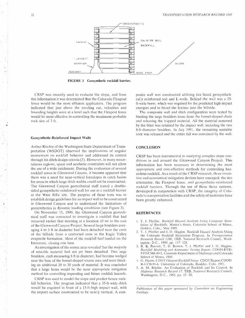
FIGURE 3 Geosynthetic rockfall barrier .
CRSP was recently used to evaluate the slope, and from this information it was determined that the Colorado Flexpost fence would be the most efficient application. The program indicated that just above the raveling cut, velocities and bounding heights were at a level such that the Flexpost fence would be most effective in controlling the maximum probable rock size of 3 ft.
Geosynthetic-Reinforced Impact Walls
Arthur Ritchie of the Washington State Department of Transportation (WSDOT) observed the implications of angular momentum on rockfall behavior and addressed its control through his ditch design criteria (5). However, in many mountainous regions, space and aesthetic constraints will not allow the use of a wide catchment. During the evaluation of several rockfall zones in Glenwood Canyon , it became apparent that there was a need for near-vertical foreslopes in catch basins for areas in which large ditch widths could not be constructed. The Glenwood Canyon geotechnical staff tested a doublesided geosynthetic-reinforced wall for use as a rockfall barrier at the West Rifle site. The purpose of these tests was to establish design guidelines for an impact wall to be constructed in Glenwood Canyon and to understand the limitations of geosynthetics in dynamic loading conditions (see Figure 3) .
On November 15, 1990, the Glenwood Canyon geotechnical staff was contacted to investigate a rockfall that had occurred earlier that morning at a location 10 mi to the east of the Glenwood Canyon Project. Several large boulders averaging 4 to 5 ft in diameter had been detached near the crest of the hillside from a contorted zone in the Eagle Valley evaporite formation. Most of the rockfall had landed on the Interstate. closing one lane .
An investigation of the source area revealed that the majority of unstable material had not yet been detached. Two large boulders, each measuring 8 ft in diameter, had become wedged near the base of the funnel-shaped source area and were blocking an additional 20 to 30 yards of material. It was concluded that a large berm would be the most appropriate mitigation method for controlling impending and future rockfall hazards .
CRSP was used to model the slope and predict future rockfall behavior. The program indicated that a 35-ft-wide ditch would be required in front of a 15-ft-high impact wall, with the impact surface constructed to be nearly vertical. A com-
TRANSPORTATION RESEARCH RECORD 1343
ON-SITE SOIL
BACKFILL
SLOPE
ROCK TRA P
posite wall was constructed utilizing tire-faced geosynthetically reinforced soil and L-walls. Behind the wall was a 25-ft-wide berm, which was required for the predicted high-impact energies and to blend the feature into the hillside.
The composite wall and ditch configuration were tested by blasting the large boulders loose from the funnel-shaped chute and releasing the trapped material. All the material removed by the blast was retained by the impact wall, including the two 8-ft-diameter boulders . In July 1991. the remaining unstable rock was released and the entire fall was contained by the wall.
CONCLUSION
CRSP has been instrumental in analyzing complex slope conditions in and around the Glenwood Canyon Project. This information has been necessary in determining the most appropriate and cost-effective methods for controlling hazardous rockfall. As a result of the CRSP research. three inventive and economical mitigation devices have emerged: the tire attenuator, the Flexpost fence. and geosynthetic-reinforced rockfall barriers. Through the use of these three systems. developed in conjunction with CRSP, the integrity of Colorado's transportation facilities and the safety of motorists have been greatly enhanced .
REFERENCES
l. T . J. Pfeiffer. Rockfi1/I Hazard A1w/\•sis Usil/g Co111p111er Si11111-latio11 of Rock.fi1/ls . ·Master's thesis. Colorado School of Mines. Golden. Colo . . Mav 1989.
2. T. J. Pfeiffer and J : D . Higgins. Rockfall Hazard Anal ysis Using the Colorado Rockfall Simulation Program . In Tronsportatiol/ Research Record 1288. TRB. National Research Council. Washington. D.C.. 1990. pp . 117-126.
3. R. K. Barrett. T . D. Bowen. T . J. Pfeiffer and J. D . Higgins. Rockfall Mode/i11g and Atlel/uator Testing Report . CDOH-DTDED3/CSM-89-2. Colorado Department oJ Highways and Colorado School of Mines . 1989.
4. G. Hearn . CDOT Flexpost Rockfall Fence. COOT Report CDOHR-UCB-91-6. University of Colorado . Boulder. Colo. 199 1.
5. A. M. Ritchie. An Evaluation of Rockfall and Its Control. Jn Highway Research R ecord 17. TRB. National Research Council. Washington. D.C.. 1963. pp. 13-28.
Publication of this paper sponsored by Comlllillee on Engineering Geology.