Selected Papers 8 - spf.org
27
Selected Papers No. 8 October 2007
Transcript of Selected Papers 8 - spf.org

S e l e c t e d P a p e r s
No.8October 2007

Ship & Ocean Newsletter Selected Papers/No.8
�2
D i r e c t o r ' s M e s s a g e
� The News let te r Ed i to r ia l Commit tee
�Chief Editors
Tomoya AKIMICHIVice Director-General, Research Institute for Humanity and Nature
Toshio YAMAGATAVice Dean, Department of Earth and Planetary Science, Graduate School of Science, The University of Tokyo
�Members
Masahiko ISOBEProfessor, Course of Socio-Cultural and Socio-Physical Environmental Studies, Graduate School of Frontier Sciences, The University of Tokyo
Shin KISUGIExecutive Director/Vice-President, Yokohama National University
Tadao KURIBAYASHIProfessor Emeritus, Keio University
Toshitsugu SAKOUProfessor Emeritus, Tokai University
Takashi HAMADAHonorary Chairman, The Japan Science Society
Yukiko HORIChairman, Enoshima Aquarium
Hisaaki MAEDAProfessor, Nihon University
� Publ i sher
Hiroshi TERASHIMAExecutive Director, Ocean Policy Research Foundation
Ocean Policy Research FoundationKaiyo Senpaku Building, 1-15-16 Toranomon, Minato-ku, Tokyo, JAPAN 105-0001 Tel. 81-3-3502-1828/Fax. 81-3-3502-2033URL. http://www.sof.or.jp/english ©2007 Ocean Policy Research Foundation
As mankind moves into the 21st century, integrated policies of ocean governance arenecessary for the sustainable development and use of our oceans and their resourcesand the protection of the marine environment.
Towards this end, the Ocean Policy Research Foundation (formerly: Ship & OceanFoundation) has started an "Ocean Policy Research", with the mission statement "Liv-ing in Harmony with the Oceans".
The Ocean Policy Research Foundation aims to conduct cross-sectoral research inocean related issues in order to initiate debate on marine topics and formulate bothdomestic and international policy proposals.
We publish a Japanese-language newsletter called the "Ship & Ocean Newsletter"twice a month. The "Ship & Ocean Newsletter" seeks to provide people of diverseviewpoints and backgrounds with a forum for discussion and to contribute to the for-mulation of maritime policies to achieve coexistence between mankind and the ocean.
Our Foundation believes that the Newsletter can expand effective communication onthese issues through its function as editor, publishing timely research and welcomingresponses from readers, which might then be published in turn.
"Ship & Ocean Newsletter Selected Papers No.8" contains English-language versionsof papers from the Japanese Newsletter edition, published from No.111(2005.3.20) toNo.130(2006.1.5).
It is our sincere hope that these Selected Papers will provide useful insights on policydebate in Japan and help to foster global policy dialogue on various issues.
Hiroshi TERASHIMAExecutive Director

Ship & Ocean Newsletter Selected Papers/No.8
�3
C o n t e n t sNaGISA ProjectYoshihisa Shirayama Professor, Field Science Education and Research Center, Kyoto University
(Ship & Ocean Newsletter No.111 March 20, 2005)
Freak Waves ExistTakuji Waseda Associate Professor, Department of Environmental and Ocean Engineering, School of Engineering, University of Tokyo
(Ship & Ocean Newsletter No.112 April 5, 2005)
Piracy Problems in the Straits of MalaccaYoshihiko Yamada Team Leader, Maritime Education, Maritime Group, The Nippon Foundation
(Ship & Ocean Newsletter No.113 April 20, 2005)
Floating Marine DebrisMasahisa Kubota Professor, School of Marine Science and Technology, Tokai University
(Ship & Ocean Newsletter No.114 May 5, 2005)
The Modern Undersea Highway: Communications CablesMitsuhiro Takase CEO & President, NTT World Engineering Marine Corporation
(Ship & Ocean Newsletter No.118 July 5, 2005)
Two Policy Proposals to IMO Council MembersYohei SasakawaChairman, The Nippon Foundation
(Ship & Ocean Newsletter No.119 July 20, 2005)
Ocean TravelsMasahiro Akiyama Chairman, Ocean Policy Research Foundation (OPRF)
(Ship & Ocean Newsletter No.120 August 5, 2005)
Jewel of the Sea–Precious Coral–Its Appeal as a Research SubjectNozomu Iwasaki Usa Marine Biological Institute, Kochi University
(Ship & Ocean Newsletter No.122 September 5, 2005)
What is the Volume of Japan's 200-nm Exclusive Economic Zone?Takatoshi Matsuzawa Researcher, National Maritime Research Institute,Former Research Fellow, Ocean Policy Research Foundation
(Ship & Ocean Newsletter No.123 September 20, 2005)
Tsunami-Caused Damage and Restoration—referencing to the cases of Okushiri Island, hit by the 1993 Hokkaido SW tsunami and Banda Aceh, Sumatra, by the 2004 Indian Ocean Tsunami—Fumihiko Imamura Professor, Tsunami Engineering, Disaster Control Research Center, Graduate School of Engineering, Tohoku University
(Ship & Ocean Newsletter No.129 December 20, 2005)
Further Recommendations for a Japanese Ocean PolicyTadao Kuribayashi Professor Emeritus, Keio University
(Ship & Ocean Newsletter No.130 January 5, 2006)
On Becoming a True Ocean StateHiroshi Terashima Executive Director, Ocean Policy Research Foundation(OPRF)
(Ship & Ocean Newsletter No.130 January 5, 2006)
4
6
8
10
12
14
16
18
20
22
24
26
S e l e c t e d P a p e r s No.8October 2007

Yoshihisa Shirayama
NaGISA Project
Despite the continuing controversy regarding the crisis of biodiversity and the necessity forconserving biodiversity, the actual state of biodiversity among marine organisms is not yet fullyunderstood and the basic information we do have is not sufficient as a means to take effectiveaction. The NaGISA (Natural Geography in Shore Area) Project is a research program designed tocompare biodiversity along seacoasts in various regions of the world through sampling inaccordance with unified protocols and capacity building in the field of taxonomy. A further goal ofNaGISA is to establish a system by which to monitor changes in biodiversity.
Professor, Field Science Education and Research Center, Kyoto University
Ship & Ocean Newsletter Selected Papers/No.8
�4
What is NaGISA?The NaGISA Project is one of the field endeavors being
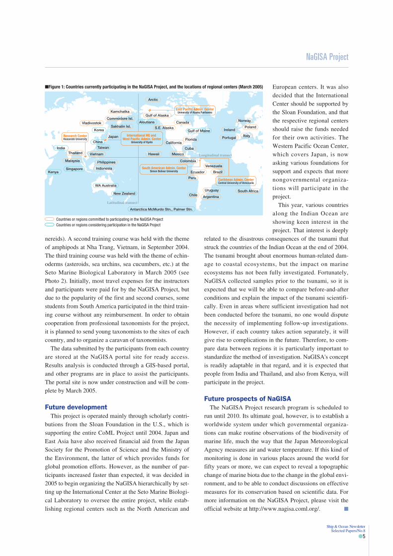
carried out under the CoML (Census of Marine Life) Pro-ject (http://www.coml.org/), a scientific research programestablished as a means to evaluate and analyze the diver-sity, distribution, and population of marine life in theworld's oceans. From our headquarters at the Seto MarineBiological Laboratory, belonging to the Field Science Edu-cation and Research Center, Kyoto University, I serve asthe Principal Investigator for the NaGISA Project, in whichmore than twenty countries from North America, SouthAmerica, Southeast Asia and elsewhere are already partic-ipating (Figure 1). The name of the project was derivedfrom the Japanese word nagisa (the shore). No other lan-guage has such a beautifully poetic word to describe theinterface between the land and the sea. Professor RonO'Dor is the chief researcher for the overall CoML Project,and it was from his strong affinity for Japan that the ideaemerged of having NaGISA serve as the project's acronym,something, however, that required considerable ingenuityon the part of the planning group.
SamplingThis field project aims to clarify the topographic patterns
of diverse marine organisms on a global scale. Accord-ingly, all the participants collect and analyze marine organ-isms through the use of a unified method, and subsequentlythey meet to exchange data for regional comparisons. The
method is simple enough to allow the participation of manymore people, in addition to specialists. In Japan, non-governmental scuba divers' organizations have participatedin the project, and in the U.S. state of Alaska many privatecitizens have taken part. In 2004, high school students fromTanabe Commercial High School, Japan, and NicevilleHigh School, in the U.S. state of Florida, took samples in asea area near the Seto Marine Biological Loboratory, andalong the coast near Niceville City, respectively.
This joint activity was based on the Fulbright MemorialFund's Master Teacher Program, with support from Japan'sMinistry of Education, Culture, Sports, Science and Tech-nology (see Photo 1). It is expected that these efforts willcontinue in the future.
Promotion of taxonomyTo support research on sample collection under the NaG-
ISA Project, a sorting center has been established at Thai-land's Phuket Marine Biological Center, where young,trained local researchers were employed to identify organ-isms and prepare specimens. The sorting center was thenrelocated to Kasetsart University in Bangkok, where itsactivities have continued. Additionally, in order to train"para-taxonomists" to independently clarify and identifyorganisms in each country, an educational course on taxon-omy was established, with the first training course takingplace at Phuket in September 2003. The theme at that timewas polychaetes (belonging to the same group as the
(Ship & Ocean Newsletter No.111 March 20, 2005)
Photo 1: High-school students from Japan and the U.S. partic-ipated in the NaGISA Project, and took samples jointly in a seaarea near the Seto Marine Biological Laboratory based on the Ful-bright Memorial Fund's Master Teacher Program in July 2004.
Photo 2: A scene from a tax-onomy training course onechinoderms held in March2005 at the Seto Marine Bio-logical Laboratory in Shira-hama Town, Wakayama Pre-fecture.
nereids). A second training course was held with the themeof amphipods at Nha Trang, Vietnam, in September 2004.The third training course was held with the theme of echin-oderms (asteroids, sea urchins, sea cucumbers, etc.) at theSeto Marine Biological Laboratory in March 2005 (seePhoto 2). Initially, most travel expenses for the instructorsand participants were paid for by the NaGISA Project, butdue to the popularity of the first and second courses, somestudents from South America participated in the third train-ing course without any reimbursement. In order to obtaincooperation from professional taxonomists for the project,it is planned to send young taxonomists to the sites of eachcountry, and to organize a caravan of taxonomists.
The data submitted by the participants from each countryare stored at the NaGISA portal site for ready access.Results analysis is conducted through a GIS-based portal,and other programs are in place to assist the participants.The portal site is now under construction and will be com-plete by March 2005.
Future developmentThis project is operated mainly through scholarly contri-
butions from the Sloan Foundation in the U.S., which issupporting the entire CoML Project until 2004. Japan andEast Asia have also received financial aid from the JapanSociety for the Promotion of Science and the Ministry ofthe Environment, the latter of which provides funds forglobal promotion efforts. However, as the number of par-ticipants increased faster than expected, it was decided in2005 to begin organizing the NaGISA hierarchically by set-ting up the International Center at the Seto Marine Biologi-cal Laboratory to oversee the entire project, while estab-lishing regional centers such as the North American and
European centers. It was alsodecided that the InternationalCenter should be supported bythe Sloan Foundation, and thatthe respective regional centersshould raise the funds neededfor their own activities. TheWestern Pacific Ocean Center,which covers Japan, is nowasking various foundations forsupport and expects that morenongovernmental organiza-tions will participate in theproject.
This year, various countriesalong the Indian Ocean areshowing keen interest in theproject. That interest is deeply
related to the disastrous consequences of the tsunami thatstruck the countries of the Indian Ocean at the end of 2004.The tsunami brought about enormous human-related dam-age to coastal ecosystems, but the impact on marineecosystems has not been fully investigated. Fortunately,NaGISA collected samples prior to the tsunami, so it isexpected that we will be able to compare before-and-afterconditions and explain the impact of the tsunami scientifi-cally. Even in areas where sufficient investigation had notbeen conducted before the tsunami, no one would disputethe necessity of implementing follow-up investigations.However, if each country takes action separately, it willgive rise to complications in the future. Therefore, to com-pare data between regions it is particularly important tostandardize the method of investigation. NaGISA's conceptis readily adaptable in that regard, and it is expected thatpeople from India and Thailand, and also from Kenya, willparticipate in the project.
Future prospects of NaGISAThe NaGISA Project research program is scheduled to
run until 2010. Its ultimate goal, however, is to establish aworldwide system under which governmental organiza-tions can make routine observations of the biodiversity ofmarine life, much the way that the Japan MeteorologicalAgency measures air and water temperature. If this kind ofmonitoring is done in various places around the world forfifty years or more, we can expect to reveal a topographicchange of marine biota due to the change in the global envi-ronment, and to be able to conduct discussions on effectivemeasures for its conservation based on scientific data. Formore information on the NaGISA Project, please visit theofficial website at http://www.nagisa.coml.org/. �
NaGISA Project
Ship & Ocean Newsletter Selected Papers/No.8
�5
Latitudinal transect
Longitudinal transect
ItalyPortugal
Ecuador
Colombia
Uruguay
Argentina
Venezuela
Brazil
IrelandPoland
Norway
East Pacific Admin. CenterUniversity of Alaska Fairbanks
Arctic
Canada
Gulf of Maine
Gulf of Alaska
Aleutians
S.E. Alaska
FloridaCalifornia
Mexico
Cuba
South Africa
Peru
Chile
Antarctica McMurdo Stn., Palmer Stn.
South American Admin. CenterSimon Bolivar University
Hawaii
Sakhalin Isl.
Commodore Isl.
Kamchatka
Vladivostok
Japan
Korea
China
Taiwan
Indonesia
Philippines
WA Australia
New Zealand
Vietnam
SingaporeKenya
India
Malaysia
Thailand
Research CenterKeaserate University
International HQ and West Pacific Admin. Center
University of Kyoto
Caribbean Admin. CenterCentral University of Venezuela
�Figure 1: Countries currently participating in the NaGISA Project, and the locations of regional centers (March 2005)
Countries or regions committed to participating in the NaGISA ProjectCountries or regions considering participation in the NaGISA Project

Takuji Waseda
Freak Waves Exist
A giant ocean wave more than twenty meters in height is no longer a maritime myth. Now that itsexistence is becoming scientifically evident, what should scientists, engineers, shipbuilders,shipping bureaus, ship owners and insurance companies do? As a scientist and engineer, I suggestthe need for the prediction and observation of giant ocean waves to prevent accidents that couldotherwise occur.
Associate Professor, Department of Environmental and Ocean Engineering, School of Engineering, University of Tokyo
Ship & Ocean Newsletter Selected Papers/No.8
�6
Why is a giant ocean wave called a "freak"wave?
Research has been actively conducted on giant oceanwaves that suddenly roll up in the open ocean. Under theMaxWave Project 1) in Europe, researches on satelliteobservation, the generation mechanisms of giant oceanwaves, impacts on ships and others have been conductedover a period of four years. The Royal Institution of NavalArchitects has periodically conducted workshops on opera-tion under abnormal marine conditions, with the thirdworkshop being conducted this year 2). At such workshops,a Japanese woodblock print has been frequently presented.The print, called "The Great Wave off Kanagawa," is fromthe series of Thirty-six Views of Mt. Fuji (see Photo 1). It issaid to have been drawn by Hokusai Katsushika when hewas over 70 years of age. A giant ocean wave that is justabout to swallow a small boat is depicted in the woodblockprint, which not only Japanese but many other people in theworld might have seen at one time or another. The white,finger-like crest of breaking waves looks dreadful, and it ishard to believe it depicts reality. Though I admired theartist's talent for depicting the mentality of seamen as theyare tossed about by the waves, ultimately I believed it was afantasy.
The existence of giant ocean waves that could suddenlyroll up on the open ocean has been known to seamen formany decades. Their depictions vary; a giant ocean waveof extraordinary size strikes a ship during stormy weather
and on another day in a calm sea on a sunny day. Sea menhave referred to such anomalies as freak waves or roguewaves. However, little attention has been paid by scientiststo the giant ocean waves reported by seamen, for the reasonthat they have been statistically rare. According to the sta-tistical distribution of waves (Rayleigh distribution), theprobability of occurrence of a giant ocean wave of the kindreported by seamen is once in every 10,000 years. Becausesuch an occurrence was unrealistic, it has been considereduseless to take precautionary measures. It resembles the sit-uation where doctors used to call a disease that struck oneout of a million people a "rare disorder," without lending ahelping hand to the victim.
The realities of giant ocean wavesIt is said that the occurrence of giant ocean waves is
linked to areas near strong ocean currents (such as theAgulhas current in South Africa and the Kuroshio Exten-sion off Cape Nojima), and to sudden blowing of highwinds. Seamen's reports and photos (Photo 2) exist as evi-dence for such connections. Over the past forty years, therehave been dozens of reports of the possible accidental sink-ing of big ships as results of their encounters with giantocean waves, involving over 500 casualties. The accidentof the Onomichi-Maru off Cape Nojima in 1980 was alsobelieved to have been caused by a giant ocean wave of overtwenty meter-height. On January 1, 1995, a giant oceanwave with twenty-six meter in height was measured in theNorth Sea offshore oil-platform and further confirmed theexistence of giant ocean waves. Later on, a large numberof giant ocean waves were also observed from the space bysatellite-borne synthetic aperture radar under the MaxWaveProject.
By synthesizing all these observational facts, it hasbecome known that there are two types of giant oceanwaves: a giant ocean wave with a long, horizontal wavecrest (i.e. two-dimensional), traveling from afar with itswaveform intact (Photo 2); and a short-crested giant oceanwave (triangular pyramidal shape), which suddenly rollsup, breaks apart and disappears. It is considered that theformer wave is caused by the amplitude modulation ofocean waves due to instability of the wave train, while the
(Ship & Ocean Newsletter No.112 April 5, 2005)
Photo 1: "Great Wave off Kanagawa" (from a series of thirty-six views of Mt. Fuji)
latter is caused by the linear focusing of wave energy due tothe interaction with the ocean currents, gusty winds and soforth. It has also been found that by taking into account theinstability of ocean waves, the Rayleigh distribution is cor-rected, and consequently the occurrence of giant oceanwaves more closely approximates the reality. Moreover,due to the advancement in oceanographic and meteorologi-cal forecasting through satellite observation and numericalweather prediction, deeper understanding has been gainedregarding the way ocean currents and gusty winds relate tothe generation of a giant ocean wave. For instance, the rela-tionship between the eye wall of a typhoon and the genera-tion of a giant ocean wave has also been pointed out.
Prediction, observation and avoidanceNow that the existence of giant ocean waves is becoming
certain, the need to predict them is urgent. What is neces-sary to make that possible? For example, the interaction ofthe ocean currents, winds and ocean waves known to causegiant ocean waves, should be predicted at high-resolution.Recently high-resolution ocean current forecast productshave become available. Each day the JCOPE system 3) ofJAMSTEC predicts ocean currents in ocean areas close toJapan, at a resolution of approximately ten kilometers.However, to accurately estimate the wave energy conver-gence due to ocean current, the resolution of the oceanmodel should be increased to about one kilometer, becausethe giant ocean waves are said to be several hundred metersin length. At the same time, it is also necessary to predicthigh resolution atmospheric motion that drives the oceancurrents and generates ocean waves. What about observa-tions? In order to detect danger in advance, it is necessaryto establish a new network of satellite, ship-borne and air-borne radar observations, in-situ observations with moor-ing and drifting buoys, and the alert system that makes fulluse of information technology. Combined with the oceanmodels, these will lead to the finding of secure sea routes.To prepare for the worst situations, it is necessary to esti-
mate the impact of the giant ocean wave on marine struc-tures based on theories, wave-tank experiments and numer-ical models, and to develop design technology with highersafety standards. Are the current design standards for thestrength of ships and marine structures sufficient to with-stand giant ocean waves, whose existence can no longer bedenied? More detailed verification is needed.
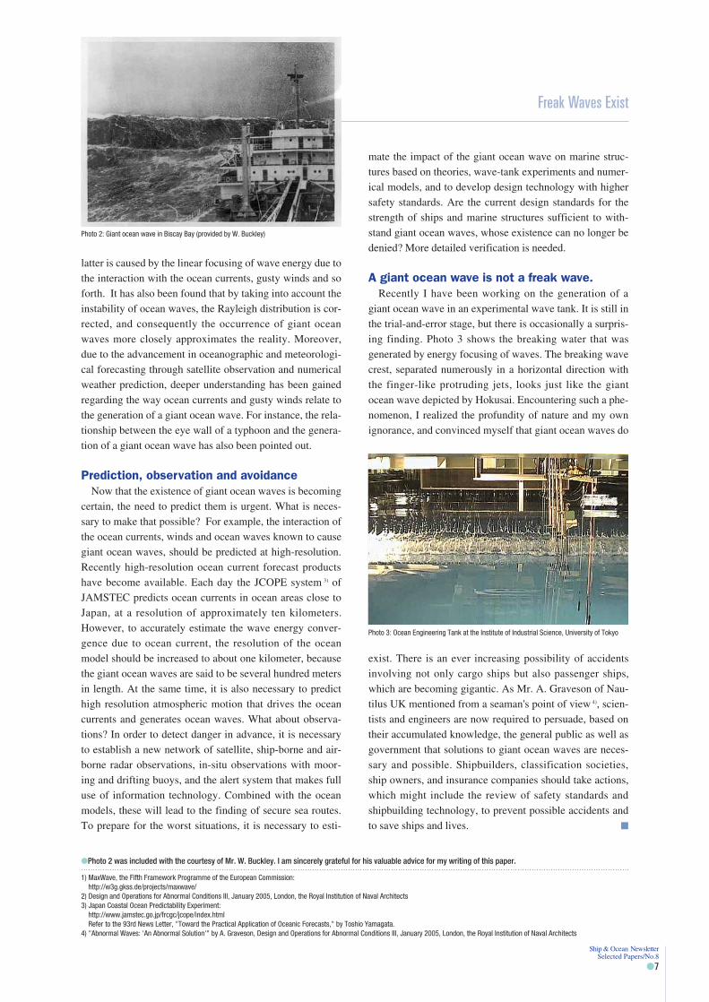
A giant ocean wave is not a freak wave.Recently I have been working on the generation of a
giant ocean wave in an experimental wave tank. It is still inthe trial-and-error stage, but there is occasionally a surpris-ing finding. Photo 3 shows the breaking water that wasgenerated by energy focusing of waves. The breaking wavecrest, separated numerously in a horizontal direction withthe finger-like protruding jets, looks just like the giantocean wave depicted by Hokusai. Encountering such a phe-nomenon, I realized the profundity of nature and my ownignorance, and convinced myself that giant ocean waves do
exist. There is an ever increasing possibility of accidentsinvolving not only cargo ships but also passenger ships,which are becoming gigantic. As Mr. A. Graveson of Nau-tilus UK mentioned from a seaman's point of view 4), scien-tists and engineers are now required to persuade, based ontheir accumulated knowledge, the general public as well asgovernment that solutions to giant ocean waves are neces-sary and possible. Shipbuilders, classification societies,ship owners, and insurance companies should take actions,which might include the review of safety standards andshipbuilding technology, to prevent possible accidents andto save ships and lives. �
Freak Waves Exist
Ship & Ocean Newsletter Selected Papers/No.8
�7
Photo 2: Giant ocean wave in Biscay Bay (provided by W. Buckley)
1) MaxWave, the Fifth Framework Programme of the European Commission:http://w3g.gkss.de/projects/maxwave/
2) Design and Operations for Abnormal Conditions III, January 2005, London, the Royal Institution of Naval Architects3) Japan Coastal Ocean Predictability Experiment:
http://www.jamstec.go.jp/frcgc/jcope/index.htmlRefer to the 93rd News Letter, "Toward the Practical Application of Oceanic Forecasts," by Toshio Yamagata.
4) "Abnormal Waves: 'An Abnormal Solution'" by A. Graveson, Design and Operations for Abnormal Conditions III, January 2005, London, the Royal Institution of Naval Architects
Photo 3: Ocean Engineering Tank at the Institute of Industrial Science, University of Tokyo
�Photo 2 was included with the courtesy of Mr. W. Buckley. I am sincerely grateful for his valuable advice for my writing of this paper.

Yoshihiko Yamada
Piracy Problems in the Straits of Malacca
While the existence of pirates is declining globally, it is still increasing in the Straits of Malacca.Formerly, incidents of piracy aimed at cargo stood out, but today many crimes of piracy involvekidnapping for ransom. Pirates commit crimes by cunningly using the national borders along theStraits of Malacca as barriers. Anti-piracy measures need to be strengthened and an internationalcooperative regime that recognizes no boundaries needs to be implemented.
Team Leader, Maritime Education, Maritime Group, The Nippon Foundation
Ship & Ocean Newsletter Selected Papers/No.8
�8
The Idaten incidentOn March 14, 2005, the Idaten, a Japanese-owned 498-
ton tugboat, was attacked by pirates in the Straits ofMalacca, and the boat's captain and chief engineer–bothJapanese nationals–were abducted along with the thirdengineer, a Filipino national.
The incident occurred in the Malaysian sea area off theisland of Penang in the northwest part of the straits, whenthe Idaten, which was loaded with oil-drilling machinery,was on the way to Myanmar from Batam Island, Indonesia.According to the testimony from the crew of the Idaten, thepirates approached on a fishing boat and, after several rifleshots, boarded the tugboat. They seized money, valuables,sea charts and the tugboat's register, kidnapped three sea-men as hostages, and fled toward Indonesia. The pirategroup consisted of about ten persons, all of whom wereheavily armed with rifles and rocket launchers. The factthat it took only ten minutes to commit the crime indicatesthat the pirate group was well organized and trained. In theStraits of Malacca over the past several years, pirates havebeen responsible for increasing numbers of kidnappings forransom. In 2004 alone, thirty-six seamen were reportedkidnapped, and ransoms were demanded for each of them.
Among the piracy incidents that have occurred in the
Straits of Malacca, the Alondra Rainbow incident of Octo-ber 1999 brings back vivid memories. The Alondra Rain-
bow, loaded with ¥1.2 billion worth of aluminum ingots,was attacked by pirates while en route to Japan from KualaTanjung Port in the central part of Sumatra, Indonesia. Thepirates seized the load and the vessel, and seventeencrewmembers–including the Japanese captain and chiefengineer–were put in a life raft and left at sea. After driftingfor ten days, they were rescued by Thai fishermen andreported that they had narrowly escaped death. With its hullrepainted and its name changed, the Alondra Rainbow wasdiscovered by the Indian Coast Guard as it sailed westwardin the Indian Ocean. The vessel was captured together withthe pirate group that had taken it. Half of the load remainedon the vessel, but the other half had disappeared. It waslater found that the other half had been sold in the Philip-pines via China.
The Alondra Rainbow incident and an interna-tional cooperative regime
The occurrence of the Alondra Rainbow incidentprompted the establishment of an international cooperativeregime for anti-piracy measures. In April 2000, an interna-tional conference on anti-piracy measures was held in
(Ship & Ocean Newsletter No.113 April 20, 2005)
�Straits of Malacca and Singapore, and separated passages
Buffalo Rock BeaconBatu Berhanti Beacon
Bintan IslandBatam Island
S t r a i t s o f S i n g a p o r e
Horsburgh Lighthouse
Tacon Beacon
Karimun Island
12 NM
I n d o n e s i a
Dumai S t r a i t s o f M a l a c c a
Piai
Cap
eJo
hor B
ahruUndan Island
Kling CapeMalacca
Port Dickson
Port Kelang
One fathom. Bank
M a l a y s i a
S i n g a p o r e
Warning sea area
Deep-sea route
Prepared by the Ocean Policy Research Foundation based on the eighth version of Ships' Routing issued by the IMO (2003)
Tokyo, where it was confirmed that each Asian countryshould stand against piracy, work with coast-guard authori-ties through information exchange, and build up an interna-tional cooperative regime. Since then, expert meetings onanti-piracy measures have been held annually in a rotationinvolving each participating Asian country. In 2004, theHeads of Asian Coast Guard Agencies Meeting was held inTokyo to address maritime security concerns, including ter-rorism. There it was confirmed that Asian countries shouldcooperate in order to combat maritime crime. The NipponFoundation has been providing support, including the costof a series of meetings.
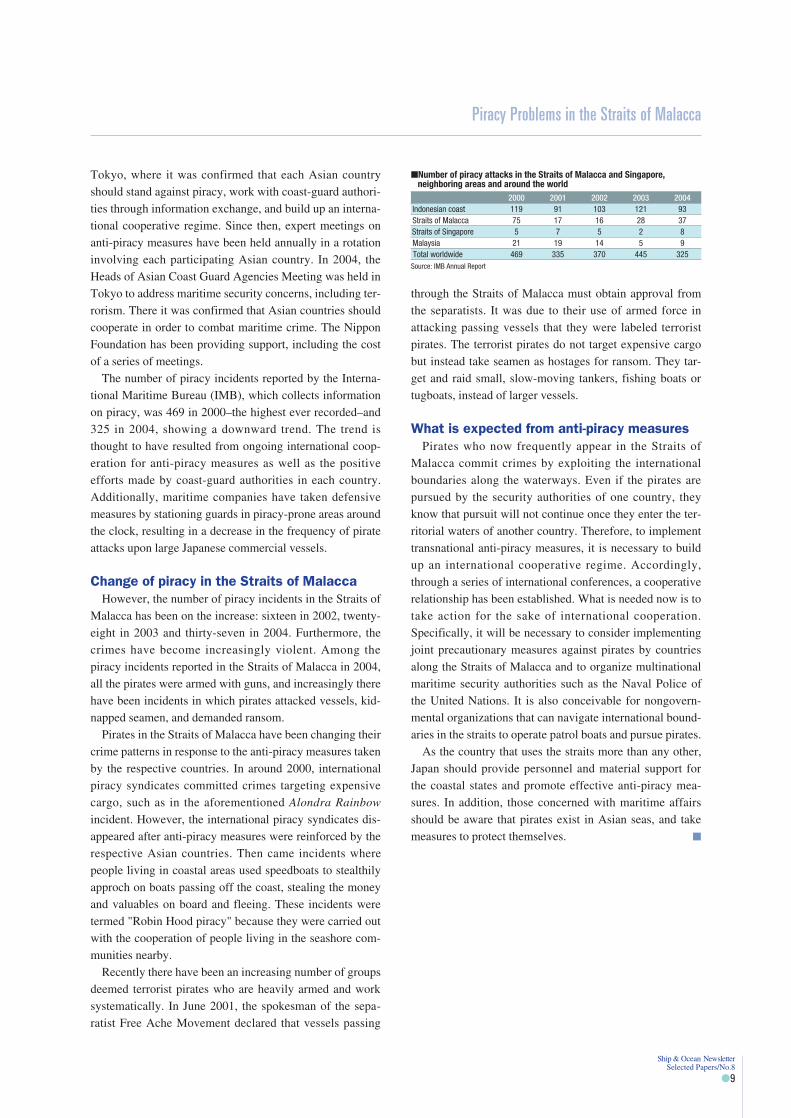
The number of piracy incidents reported by the Interna-tional Maritime Bureau (IMB), which collects informationon piracy, was 469 in 2000–the highest ever recorded–and325 in 2004, showing a downward trend. The trend isthought to have resulted from ongoing international coop-eration for anti-piracy measures as well as the positiveefforts made by coast-guard authorities in each country.Additionally, maritime companies have taken defensivemeasures by stationing guards in piracy-prone areas aroundthe clock, resulting in a decrease in the frequency of pirateattacks upon large Japanese commercial vessels.
Change of piracy in the Straits of MalaccaHowever, the number of piracy incidents in the Straits of
Malacca has been on the increase: sixteen in 2002, twenty-eight in 2003 and thirty-seven in 2004. Furthermore, thecrimes have become increasingly violent. Among thepiracy incidents reported in the Straits of Malacca in 2004,all the pirates were armed with guns, and increasingly therehave been incidents in which pirates attacked vessels, kid-napped seamen, and demanded ransom.
Pirates in the Straits of Malacca have been changing theircrime patterns in response to the anti-piracy measures takenby the respective countries. In around 2000, internationalpiracy syndicates committed crimes targeting expensivecargo, such as in the aforementioned Alondra Rainbow
incident. However, the international piracy syndicates dis-appeared after anti-piracy measures were reinforced by therespective Asian countries. Then came incidents wherepeople living in coastal areas used speedboats to stealthilyapproch on boats passing off the coast, stealing the moneyand valuables on board and fleeing. These incidents weretermed "Robin Hood piracy" because they were carried outwith the cooperation of people living in the seashore com-munities nearby.
Recently there have been an increasing number of groupsdeemed terrorist pirates who are heavily armed and worksystematically. In June 2001, the spokesman of the sepa-ratist Free Ache Movement declared that vessels passing
through the Straits of Malacca must obtain approval fromthe separatists. It was due to their use of armed force inattacking passing vessels that they were labeled terroristpirates. The terrorist pirates do not target expensive cargobut instead take seamen as hostages for ransom. They tar-get and raid small, slow-moving tankers, fishing boats ortugboats, instead of larger vessels.
What is expected from anti-piracy measuresPirates who now frequently appear in the Straits of
Malacca commit crimes by exploiting the internationalboundaries along the waterways. Even if the pirates arepursued by the security authorities of one country, theyknow that pursuit will not continue once they enter the ter-ritorial waters of another country. Therefore, to implementtransnational anti-piracy measures, it is necessary to buildup an international cooperative regime. Accordingly,through a series of international conferences, a cooperativerelationship has been established. What is needed now is totake action for the sake of international cooperation.Specifically, it will be necessary to consider implementingjoint precautionary measures against pirates by countriesalong the Straits of Malacca and to organize multinationalmaritime security authorities such as the Naval Police ofthe United Nations. It is also conceivable for nongovern-mental organizations that can navigate international bound-aries in the straits to operate patrol boats and pursue pirates.
As the country that uses the straits more than any other,Japan should provide personnel and material support forthe coastal states and promote effective anti-piracy mea-sures. In addition, those concerned with maritime affairsshould be aware that pirates exist in Asian seas, and takemeasures to protect themselves. �
Piracy Problems in the Straits of Malacca
Ship & Ocean Newsletter Selected Papers/No.8
�9
�Number of piracy attacks in the Straits of Malacca and Singapore, neighboring areas and around the world
2000 2001 2002 2003 2004Indonesian coast 119 91 103 121 93Straits of Malacca 75 17 16 28 37Straits of Singapore 5 7 5 2 8Malaysia 21 19 14 5 9Total worldwide 469 335 370 445 325
Source: IMB Annual Report

Masahisa Kubota
Floating Marine Debris
Human activity has led to a drastic increase in debris such as non-biodegradable plastic. Much ofthe floating marine debris consists of plastic products, and such debris is certain to increase withtime.We carried out a simulation on the movement and accumulation of floating marine debris withcurrent speed at the sea surface, using satellite data as the basis. As a result, we demonstratedthat floating debris tends to gather in a specific sea area in the mid-latitudes within less than ayear.
Professor, School of Marine Science and Technology, Tokai University
Ship & Ocean Newsletter Selected Papers/No.8
�10
Human activity and debrisHojoki (An Account of My Hut) starts with the famous
statement, "Rivers flow incessantly, so no water remainsthe same. Bubbles floating on stagnant water disappear, orget united, so no bubble remains the same." There may bemany people who learned while studying the Japanese clas-sics that the statement essentially explains the concept ofthe impermanence of all things. The concept of the imper-manence of all things is based on the concept of transfor-mation. In the natural world, it is obvious that everything istransformed, and one can say that the idea of transforma-tion was also accepted by people in earlier times. However,transformation also implies deformation and destruction.This may be unacceptable to people in the short run, whichis why people try to produce more durable, unbreakablethings. That, however, goes against the course of nature.
For instance, plastic is a strong, durable and wonderfulmaterial for people, but it is incompatible with the conceptof the impermanence of all things because plastic does notdisintegrate over time. The fact that plastic does not disin-tegrate means that it accumulates over time. As long asplastics are used effectively as part of human activity, theirnon-breakable properties can be justified, but the use ofplastic will no longer be justified once the item becomesunnecessary, such as when it is discarded as debris.
There is an old saying, "Let the water carry it away."This implies that everything will be cleaned and restored toits original state once it has been washed in water. How-ever, what will happen to things that have been washedaway? If they are discharged into rivers, they will ulti-mately flow into the sea. We used to think that all the thingswashed away would be taken care of by Mother Ocean inher great tolerance. However, we now know that only per-ishable things can be embraced by Mother Ocean, so plas-tics –which will only increase over time–remain trouble-some.
Major currents at the sea surfaceIt is very difficult to directly observe the actual condi-
tions of floating marine debris on the open ocean. There-fore, in most cases there is no way other than to guess from
the actual conditions of debris drifting ashore. As a resultof guessing, it is said that approximately seventy percent ofthat debris is plastic. We wonder how the mechanism of themovement and accumulation of floating marine debrisworks. Because floating debris itself does not have a swim-ming function, its movement depends on the flow of cur-rents. In other words, the actual conditions of the move-ment and accumulation of floating marine debris can beassumed if we can find currents at the ocean surface.
It can be thought that major currents at the sea surfaceconsist primarily of a flow that combines an Ekman flowand a geostrophic flow. Probably not many people haveheard of either term, but they are major currents that areclosely linked to the rotation of the earth. The former is acurrent generated mainly by winds, and it has been showntheoretically that the Ekman flow moves at 45 degreestoward the right (left) in the north (south) hemispherebecause of the effect of the earth's rotation. On the otherhand, the geostrophic flow is generated under conditionswhere the Coriolis force–which is apparently generated bythe effect of the earth's rotation–and an inclination force arebalanced 1).
How can we make observations of the Ekman flow andthe geostrophic flow? Considering the vastness of theocean, we can readily acknowledge that it is technicallyimpossible to make observations of the Ekman flow and thegeostrophic flow by boat. However, it has recently becomepossible to observe the Ekman flow and the geostrophicflow globally for a short period of time by satellite. TheEkman flow can be estimated theoretically by observingocean winds. On the other hand, the geostrophic flow canbe estimated once a pressure distribution is known. There-fore, it can estimated if the distribution of ocean surfaceheights can be observed. Recently it has become possible tomake observations of ocean surface heights with surprisingaccuracy through the use of a satellite-mounted instrumentcalled a ocean-surface altimeter.
Movement and accumulation of floatingmarine debris in the North Pacific Ocean
The question remained of how floating marine debris
(Ship & Ocean Newsletter No.114 May 5, 2005)
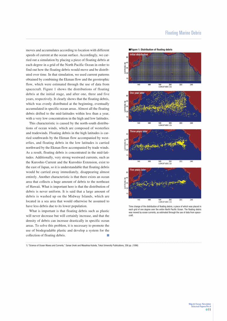
moves and accumulates according to location with differentspeeds of current at the ocean surface. Accordingly, we car-ried out a simulation by placing a piece of floating debris ateach degree in a grid of the North Pacific Ocean in order tofind out how the floating debris would move and be distrib-uted over time. In that simulation, we used current patternsobtained by combining the Ekman flow and the geostrophicflow, which were estimated through the use of data fromspacecraft. Figure 1 shows the distributions of floatingdebris at the initial stage, and after one, three and fiveyears, respectively. It clearly shows that the floating debris,which was evenly distributed at the beginning, eventuallyaccumulated in specific ocean areas. Almost all the floatingdebris drifted to the mid-latitudes within less than a year,with a very low concentration in the high and low latitudes.
This characteristic is caused by the north-south distribu-tions of ocean winds, which are composed of westerliesand tradewinds. Floating debris in the high latitudes is car-ried southwards by the Ekman flow accompanied by west-erlies, and floating debris in the low latitudes is carriednorthward by the Ekman flow accompanied by trade winds.As a result, floating debris is concentrated in the mid-lati-tudes. Additionally, very strong westward currents, such asthe Kuroshio Current and the Kuroshio Extension, exist tothe east of Japan, so it is understandable that floating debriswould be carried away immediately, disappearing almostentirely. Another characteristic is that there exists an oceanarea that collects a huge amount of debris to the northeastof Hawaii. What is important here is that the distribution ofdebris is never uniform. It is said that a large amount ofdebris is washed up on the Midway Islands, which arelocated in a sea area that would otherwise be assumed tohave less debris due to its lower population.
What is important is that floating debris such as plasticwill never decrease but will certainly increase, and that thedensity of debris can increase drastically in specific oceanareas. To solve this problem, it is necessary to promote theuse of biodegradable plastic and develop a system for thecollection of floating debris. �
Floating Marine Debris
Ship & Ocean Newsletter Selected Papers/No.8
�11
�Figure 1: Distribution of floating debris
Initial distribution
One year later
Three years later
Five years later
Time change of the distribution of floating debris, a piece of which was placed ineach grid of one degree over the entire North Pacific Ocean. The floating debriswas moved by ocean currents, as estimated through the use of data from space-craft.
1) "Science of Ocean Waves and Currents," Sanae Unoki and Masahisa Kubota, Tokai University Publications, 356 pp. (1996)

Mitsuhiro Takase
The Modern Undersea Highway: Communications Cables
The network of submarine cable spanning the globe has a length of approximately 800,000kilometers, and if arranged end to end would circle the earth up to twenty times.The cable network is indispensable in the present-day broadband era. It carries information acrossthe globe and has become quite simply an undersea highway.In Japan's waters, there is a need not only to work on the maintenance of a stable communicationsinfrastructure but also to find new ways of using submarine cable, such as in the promotion ofindustry on isolated islands, environmental awareness, and the removal of old cables.
CEO & President, NTT World Engineering Marine Corporation
Ship & Ocean Newsletter Selected Papers/No.8
�12
What is a submarine communications cable?To conduct trade and exchange with other people, roads
and sea courses have long been used. The Silk Road, whichis famous for its role in the exchange of goods betweenEast and West, is mainly thought of as a land route. Recentstudy, however, indicates that sea courses thrived to a con-siderable extent, that they eventually surpassed the landroutes, and finally helped open the age of geographical dis-covery. We now live in an age of worldwide information,which is also the broadband era. In this respect, submarinecables–our undersea roads–play a major role.
Today, communications networks connecting countriesand people around the world consist of roughly two sys-tems: wired networks (on-land and submarine cables) andwireless networks (land-based wireless stations and com-munication satellites). On the seabed around the globe,watertight and pressure-proof communication cables (sub-marine cables), durable enough to be laid in deep waters,are laid in a finely meshed pattern from one continent toanother and from one island to another. Recently, subma-rine cables have mainly consisted of high-capacity opticalcables. These cables make up the undersea roads, servingas highways that connect not only phones but also facilitate
the exchange of images, all kinds of business and personalinformation over the internet. They play a vital role as abasic infrastructure in the broadband era.
The submarine cable has a long history, and it is said thatthe first submarine cable was laid between England andFrance (across the English Channel) in 1851. Even inJapan, submarine cables were first used from home andabroad during the early Meiji period (the 1870s). It is notknown exactly how many submarine cables have been laidand are used worldwide. According to a report made at acertain conference, the major submarine cables across theglobe amount to approximately 800,000 kilometers andcould circle the earth up to twenty times.
Conditions of submarine cables in Japan'swaters
Japan is surrounded by the sea and has many islands. Forthe implementation of broadband in the island nation ofJapan, it is essential that we have not only internationalsubmarine cables connecting Japan with Asia, the U.S. andother foreign countries, but also a large volume of domesticsubmarine cables between domestic islands. Our company,NTT World Engineering Marine Corporation, has beenfully entrusted with the construction and maintenance ofdomestic submarine cables from each NTT company. Thetotal length of the cables adds up to approximately 5,500kilometers, covering about 400 sections. That length ismuch less than that of international submarine cables, butour assignment is characterized by the high number of sec-tions used. This may not be a good comparison, but 5,500kilometers roughly equals the length of the West JapanRailway Company's track network, while being slightlyless than the total length of the Nippon Express Companies'expressways.
The national government, local governments, and privatecompanies such as NTT have recently been working onbroadband implementation for isolated islands as part oftheir efforts in regard to the e-Japan strategy 1). The subma-rine cables serve as one element in the basic infrastructurefor that effort. For example, last year, when NTT West
(Ship & Ocean Newsletter No.118 July 5, 2005)
�Network of submarine cables

Japan planned and executed the construction of the latestsubmarine optical-fiber cables between Okinawa-Honto,Miyako Island and Ishigaki Island, our company wasentrusted with the design and installation. We laid a total ofapproximately 500 kilometers of cable with our submarinecable laying vessel, the Subaru. To protect the environ-ment, we designed a route away from coral reefs, devisedways of installing the cables without damaging coral reefs,and performed the actual installation. Our companybelieves it has thus contributed to the realization of whathad long been needed by local people in the isolatedislands: the infrastructure necessary in order to close thedigital divide and promote industry in those locations. Cur-rently, many autonomous bodies with isolated islands arealso considering the introduction of information technologyfor regional administration and medical care, as well asbroadband connections to attract industry. Accordingly,submarine optical-fiber cables are included as a basic infra-structure. However, the autonomous bodies have financialdifficulties and other challenges, so it is never easy to do. Inthe future, we think it will be necessary to promote a coop-erative system between the private sector, what has alreadypartially introduced information technology and broadbandimplementation, and autonomous bodies, the national gov-ernment, and others.
Future issues and activitySubmarine cables will be indispensable to the future
broadband society, but certain issues and problems areassociated with such cables. One such problem is that thecapacity of submarine cables, particularly in global com-munications, has not been fully employed from a globalperspective, and a large amount of capacity remains
unused. This is mainly due to the impact of the collapse ofthe dotcom bubble 2) in around 2000, and due to the multi-plexing that has become possible through technologicalinnovation. Because of this, many companies in the indus-try related to submarine cables (including manufacturers ofcables and relays, and cable-laying companies) in Japanand elsewhere have become bankrupt or undergone majorrestructuring. Apparently, it will take time for the overallindustry to recover.
The problem of safety for the submarine cable networkhas also been a topic of study and discussion. Last year,Japan was hit by a record number of typhoons, as well asmany earthquakes. Given the impact of these disasters, thenumber of malfunctioning submarine cables in coastalareas around Japan increased considerably. The causesincluded the anchors of drifting boats, as well as the expo-sure of buried cables due to the impact of currents andocean waves. Considering that abnormal weather is likelyto continue worldwide in the future, we are convinced ofthe importance of daily maintenance and a prompt repairsystem for submarine cables in securing the communica-tions lifelines.
Environmental considerations will also be important inthe future. They include the impact on fisheries, the protec-tion of coral reefs and other marine life, the removal of oldor unused submarine cables, and other problems. Approvalmust be obtained from the national government and localautonomous bodies when submarine cables are laid inJapanese waters, and the waters must be restored to theiroriginal conditions after the cables have been used, inaccordance with the Seacoast Law. Our company removesunnecessary cables gradually, and restores the waters totheir original conditions.
Communications traffic is sharply increasing worldwidedue to the internet and other factors. Many of thoseinvolved with submarine cables expect a recovery indomestic and global demand for submarine cables over thenext several years, as well as the laying of new cables invarious places around the world. In addition to the originalneed and use of submarine cables, the pursuit of new possi-bilities represents another issue. The use of submarinecables with has already been implemented in certain places,and research on the use of submarine cables for surveysrelated to the continental shelves is ongoing. In the future,and with consideration for the environement, new possibili-ties for the use of submarine cables should be continuouslypursued. �
The Modern Undersea Highway: Communications Cables
Ship & Ocean Newsletter Selected Papers/No.8
�13
1) e-Japan strategy: This is the Japanese government's strategy for providing the world's most advanced environment for information technology. (Implementation started in 2001.) One of itspriorities is to rectify the digital divide due to geographical restrictions and other factors.
2) Dotcom bubble: This is the term for the economic crisis involving companies related to information technology and the internet, which occurred in or around the years 1999 and 2000. Facilitieswere substantially expanded and the stock markets soared, but the bubble collapsed and stock prices crashed while excessive production capacity remained.
Cable landing in Miyako forsubmarine cables running toand from Okinawa-HontoIsland and Miyako Island
Submarine cable laying vessel Subaru, owned bythe NTT World Engineering Marine Corporation
Yohei Sasakawa
Two Policy Proposals to IMO Council Members
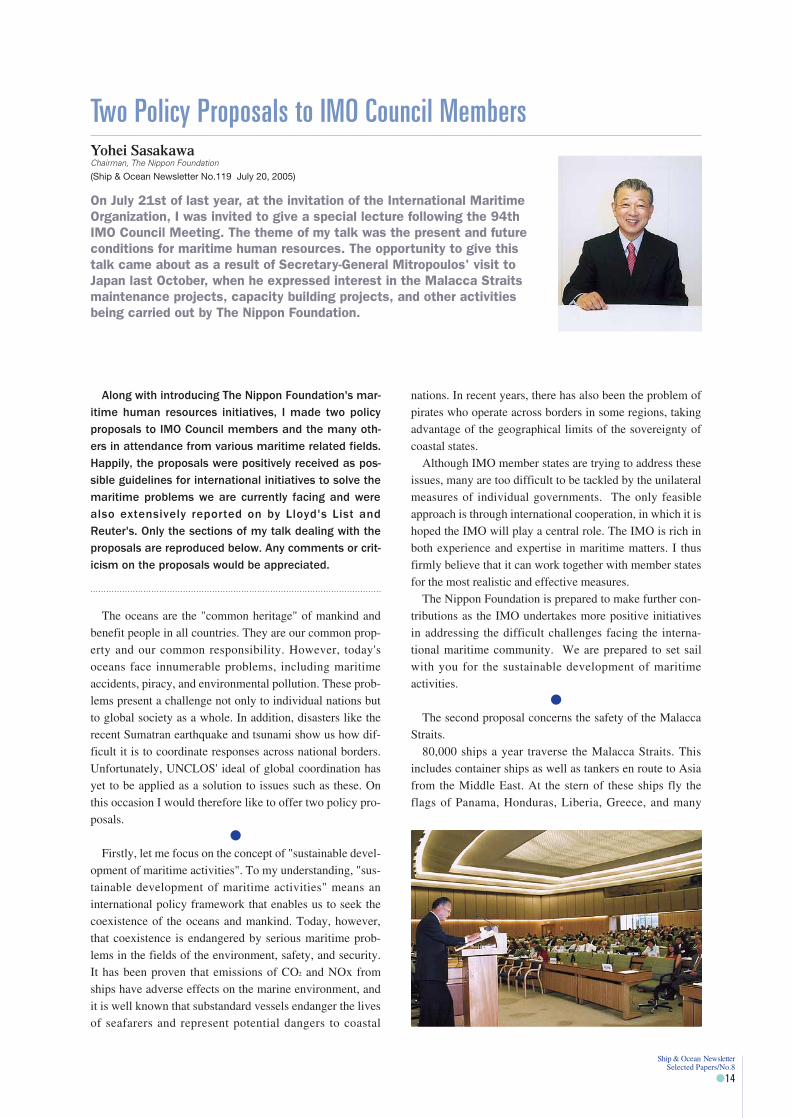
On July 21st of last year, at the invitation of the International MaritimeOrganization, I was invited to give a special lecture following the 94thIMO Council Meeting. The theme of my talk was the present and futureconditions for maritime human resources. The opportunity to give thistalk came about as a result of Secretary-General Mitropoulos' visit toJapan last October, when he expressed interest in the Malacca Straitsmaintenance projects, capacity building projects, and other activitiesbeing carried out by The Nippon Foundation.
Chairman, The Nippon Foundation
Ship & Ocean Newsletter Selected Papers/No.8
�14
Along with introducing The Nippon Foundation's mar-itime human resources initiatives, I made two policyproposals to IMO Council members and the many oth-ers in attendance from various maritime related fields.Happily, the proposals were positively received as pos-sible guidelines for international initiatives to solve themaritime problems we are currently facing and werealso extensively reported on by Lloyd's List andReuter's. Only the sections of my talk dealing with theproposals are reproduced below. Any comments or crit-icism on the proposals would be appreciated.
The oceans are the "common heritage" of mankind andbenefit people in all countries. They are our common prop-erty and our common responsibility. However, today'soceans face innumerable problems, including maritimeaccidents, piracy, and environmental pollution. These prob-lems present a challenge not only to individual nations butto global society as a whole. In addition, disasters like therecent Sumatran earthquake and tsunami show us how dif-ficult it is to coordinate responses across national borders.Unfortunately, UNCLOS' ideal of global coordination hasyet to be applied as a solution to issues such as these. Onthis occasion I would therefore like to offer two policy pro-posals.
�Firstly, let me focus on the concept of "sustainable devel-
opment of maritime activities". To my understanding, "sus-tainable development of maritime activities" means aninternational policy framework that enables us to seek thecoexistence of the oceans and mankind. Today, however,that coexistence is endangered by serious maritime prob-lems in the fields of the environment, safety, and security.It has been proven that emissions of CO2 and NOx fromships have adverse effects on the marine environment, andit is well known that substandard vessels endanger the livesof seafarers and represent potential dangers to coastal
nations. In recent years, there has also been the problem ofpirates who operate across borders in some regions, takingadvantage of the geographical limits of the sovereignty ofcoastal states.
Although IMO member states are trying to address theseissues, many are too difficult to be tackled by the unilateralmeasures of individual governments. The only feasibleapproach is through international cooperation, in which it ishoped the IMO will play a central role. The IMO is rich inboth experience and expertise in maritime matters. I thusfirmly believe that it can work together with member statesfor the most realistic and effective measures.
The Nippon Foundation is prepared to make further con-tributions as the IMO undertakes more positive initiativesin addressing the difficult challenges facing the interna-tional maritime community. We are prepared to set sailwith you for the sustainable development of maritimeactivities.
�The second proposal concerns the safety of the Malacca
Straits.80,000 ships a year traverse the Malacca Straits. This
includes container ships as well as tankers en route to Asiafrom the Middle East. At the stern of these ships fly theflags of Panama, Honduras, Liberia, Greece, and many
(Ship & Ocean Newsletter No.119 July 20, 2005)

other countries. Countries from around the world benefitfrom the Malacca Straits, which are the busiest in the worldand therefore always at great risk of maritime accidents.
To date, The Nippon Foundation has provided financialassistance totaling approximately 100 million dollars forthe emplacement of 45 lighthouses and other navigationalaids. Engineers from Japan also visit the Straits to helpmaintain the navigational aids and train local personnel.We have recently built buoy tender ships for both Indonesiaand Malaysia.
Last June, our foundation invited high-level representa-tives from Asian coast guards to an international confer-ence that we sponsored in Tokyo, where we discussedcooperative measures against crimes at sea. Building onthis opportunity, Asian coast guards have begun to movetoward sharing information and building cooperativeframeworks.
In this connection, I welcome the initiative of the IMO inholding a Malacca Straits Conference in Indonesia this fall.I sincerely hope that the conference will be an importantstep forward, for all parties concerned, for safety of naviga-tion in the Malacca Straits.
Whenever I contemplate the situation in the MalaccaStraits, I am always left with the certainty that dependenceon traditional approaches to securing safe navigation in thishigh-risk area are no longer realistic. To secure the safetyof navigation in high-risk areas, I feel we need to reevaluateour traditional thinking that safety on the seas is alwaysoffered free of charge. In high-risk areas where the safetyof navigation incurs high costs, we need to examine a newsystem whereby the burden is born not only by CoastalStates but by Users as well.
I hope that the IMO will exercise leadership in consider-ation of such a new system, taking advantages of all theexpertise and enthusiasm of its member countries.
�My father, the founder of our foundation, Ryoichi
Sasakawa, made the following his philosophy: "The worldis one family; all mankind are brothers and sisters." Thefamily of the mankind is endowed with a very preciousasset: our common heritage of the oceans. I hope that all ofus will continue to work together to protect and preserveour common heritage and ensure our coexistence with theoceans. Thank you very much. �
Two Policy Proposals to IMO Council Members
Ship & Ocean Newsletter Selected Papers/No.8
�15

Masahiro Akiyama
Ocean Travels
Over the past six months, I traveled to Russia, the U.S., India, Turkey and China. My visits toforeign countries are always related to the research activities of OPRF, and each visit always givesme an opportunity to consider, from different perspectives, the issues related to the ocean.Issues such as the safety of maritime traffic, the marine environment, and maritime security areinterrelated, and they are vividly revealed when one travels the world.
Chairman, Ocean Policy Research Foundation (OPRF)
Ship & Ocean Newsletter Selected Papers/No.8
�16
I often travel abroad. Over the past six months, I havetraveled to Russia, the U.S., India, Turkey and China. InJuly, I visited Indonesia on business for the first time ineight years. Whenever I make an overseas trip --always inrelation to the research activities of OPRF--I have anopportunity to think about the ocean.
Petroleum and natural gas development inSakhalin
To study the relationship between petroleum and naturalgas development and the ocean, I visited Sakhalin, a land ofsevere cold, at the end of last year. The Sakhalin I and II 1)
sites for petroleum and natural gas development were justabout to start operating, and Sakhalin had the atmosphereof a northern frontier, not a western one. There was a mix-ture of vitality, development and waste. I was not able tovisit the Sakhalin I site because of the secretive Exxoncompany, which is developing Sakhalin I. I was interestedin what kind of environmental measures were being taken.Government authorities in charge and other related corpo-rate parties said they were working hard on environmentalmeasures. However, once major marine contaminationoccurs its impact on Hokkaido will be unfathomable.
It is bitterly cold in the Okhotsk Sea, even though it is notlocated at a very high latitude. It is important to know thethickness, properties, and amounts of ice to be formed, andhow the ice moves from the perspective of climatic fluctua-tions. It is also necessary to conduct thorough investiga-tions on the collisions between the ice and the petroleumand natural gas drilling facilities, workboats, transportboats, and underwater pipelines.
I would like to add that OPRF has been conducting aninvestigative research project on the promotion of the useof waterways in the North Pole region and a safe navigationsystem in arctic seas 2), and an analysis research project onthe state of ice in the Okhotsk Sea through the parameter oftemporal changes in sea ice.
United Nations' Headquarters, New YorkIn January of this year, I visited Washington D.C. and
New York for a short time. I had chosen to visit those citiesaround that time because I wanted to listen to PresidentBush's second inaugural address in the U.S. However, I had
to give up on myplanned visit toWashington D.C.before the deliveryof the inauguraladdress because ofunprecedented tightsecurity, so I wentto New York. Iexchanged opinionsabout extension ofthe continentalshelves with thestaff of the Divisionfor Ocean Affair and the Law of the Sea (DOALOS) 3), atUN Headquarters. The problem of the shift in the Japan-China border through the action of the continental shelveshas become serious, as China has proceeded with the devel-opment of submarine petroleum resources. Moreover,China insists that it is not permissible to admit OkinotoriIsland as a base for the demarcation of the Exclusive Eco-nomic Zone, so the tension between Japan and China hasincreased further. Japan has not taken quick action inresponse to the problems of the continental shelves, and asa result its national interests are suffering. We must say thatJapan has lost status as an ocean state.
We can say that Japan is an ocean state, but I am con-cerned about the lack of an ocean strategy. As long ago asthe 1960s, the U.S. had already established its comprehen-sive ocean policy. The U.S. reviewed that policy last year,and now is going to establish a new ocean policy. Japan hasnot established its ocean policy, and still has a verticallysegmented administrative system for ocean affairs. OPRFhas research projects on U.S. ocean policy as well as on theproblems of the extension of continental shelves.
A visit to Madras, IndiaA conference between Japan and India was held in New
Delhi in March. From the Japan side, Former Prime Minis-ter Mori, Former Foreign Minister Ms. Kawaguchi, andMr. Okamoto, the former assistant to the Prime Minister,attended the event. At the conference, I made a speechabout Japan-India cooperation for ocean security. During my
(Ship & Ocean Newsletter No.120 August 5, 2005)
O k h o t s k S e a
S o y a S t r a i t
Mam
iya Strait
J a p a n S e a
Sakhalin
Hokkaido
Russia
• Sakhalin I• Sakhalin II

speech, I explainedthe joint statementissued in autumnlast year by theJapan-India Dia-logue on OceanSecurity, whichwas supported byOPRF. After theconference, I vis-
ited Madras in the southeastern part of India. To my sur-prise, Madras University had a research course on marinesecurity, and its professors, researchers, and students wereseriously engaged in research and study of many aspects ofthis field. India is not an ocean state, but the country real-ized the importance of the ocean in the 1970s, and startedlaying out not only a military but also an academic struc-ture.
The Palk Strait lies between Madras and Sri Lanka, and ithas shallow waters of four to five meters in an area of morethan 10 kilometers in length. However, a seabed diggingplan that would allow the navigation of vessels has recentlybeen established, in which the east-west navigation timevia the Indian subcontinent will be reduced by approxi-mately three hours. Nevertheless, it presents a big problem.How will a likely seabed explosion be coordinated withenvironmental protection? The area offers good fishinggrounds, so the issue of compensation will present a majorchallenge. In fact, a digging plan was proposed quite a longtime ago, but was not implemented because of these prob-lems. Even now, environmental protectionists and fishingpeople are strongly opposed to the plan because the impactof digging cannot be predicted. I presume that the planmight also be suspended based on the concept of the pre-cautionary principle. OPRF is conducting a research pro-ject on the "precautionary principle under the InternationalEnvironmental Law and the protection of the marine envi-ronment."
The Black Sea, viewed from TurkeyI had leave in May through the use of consecutive holi-
days, and thus was able to take a long-planned trip toTurkey. I traveled across Asia Minor by car for six days. Ikept driving for such a long time because I wanted to makea return trip between Trabzon, the capital of the Byzantine
Empire on the Black Sea side, and Georgia along the BlackSea. The weather was fine, and the sea was calm. Thinkingof the Shonan Coast, I drove at full speed, but ran out oftime while driving toward the national border and insteadreturned at a point forty kilometers from the national bor-der.
The Black Sea is connected to the Mediterranean Sea bythe Bosporus Strait. However, because the circulation ofseawater is limited to a very small area, a dead zone lies at adepth of two hundred meters or more. Considering thelength of the Bosporus Strait, one should not be surprised.However, fish catches are actually high, and many fish arecaught in an area at a depth of two hundred meters or less.The sardine dish I had in Trabzon was excellent. In Turkey,it is said that people from the Black Sea area are either fish-ing people or boat builders. The Black Sea is an almostcompletely enclosed sea area. The environmental degrada-tion of enclosed bays has become a problem in Japan, but itseems that the problem can be solved in various ways if wetake advantage of the analytical investigation into the con-ditions of enclosed bays carried out in one of OPRF'sresearch projects 4). I believe positive actions are also possi-ble based on OPRF's research on "the disappearance andprevalence of a dysoxic water mass in enclosed bays."
To realize the Black Sea Ring Highway Project, the high-way is under construction along the Black Sea in Turkey,with work proceeding at a rapid pace. The highway runsmostly along a sandy beach. The environment of the areaalong the Black Sea has been undergoing a transformationdue to massive structures, construction waste and dust. It isincomparable to our ongoing efforts to remove waste frombeaches 5). I would like to visit the area again five yearsfrom now and see whether the project has achieved "sus-tainable development 6)."
ConclusionI travel abroad for various purposes, and I always feel
that various issues such as the safety of marine traffic, themarine environment, marine security, resources, fisheriesand battles over borders are interrelated. However, itshould be remembered that these problems cannot be defi-nitely solved under a vertically segmented administrativesystem and fixed ideas. Accordingly, I value the opportu-nity for many people to express opinions from variousviewpoints on these issues. �
Ocean Travels
Ship & Ocean Newsletter Selected Papers/No.8
�17
B a y o f B e n g a l
A r a b i a n S e a
P a l k S t r a i t sSri Lanka
India
1) Petroleum and natural gas development called the Sakhalin Project is divided into nine mining sections, including a coastal area consisting of Sakhalin I-IX. Of those sections, Sakhalin I andII–located on the eastern shore of the northern area–are in operation. Sakhalin II started the production of crude oil in 1999, and its crude oil has been exported to Japan since 2001. Sakhalin Iaims to start the production of crude oil at the end of 2005.
2) For information on the OPRF's research project, please visit the official website.3) Division for Ocean Affair and the Law of the Sea (DOALOS), United Nations4) Analytical investigation on the conditions of national closed bays5) Investigative research on the problem of waste in sea and coastal areas6) Investigative research on marine policy and marine sustainable development

Nozomu Iwasaki
Jewel of the Sea–Precious Coral–Its Appeal as a Research Subject
Precious coral is familiar to us as an ornamental comb or a Japanese hairpin, but its true image asa living organism is less well known. Precious coral has long been prized by man as an art object,an accessory, and trade good.This is the reason that precious coral is an appealing subject ofresearch in the humanities as well as biology.We began an interdisciplinary study on the appeal ofcoral, its biology and cultural history.
Usa Marine Biological Institute, Kochi University
Ship & Ocean Newsletter Selected Papers/No.8
�18
Precious corals and hermatypes Speaking of corals, I am sure that many people will
imagine a scene of coral reefs in a blue sea populated bycolorful fishes. There may be people who think that pre-cious corals are also picked from coral reefs. But coralsfrom coral reefs and precious corals are different livingorganisms. Taxonomically, the former belongs to the sub-class Hexacorallia, and is called hermatypic coral becauseit forms a coral reef. In contrast, the latter belongs to thesubclass Octocorallia.
Both have different modes of life. The distribution depthof the Acropora species, a typical hermatypic coral, is ahundred meters or less. However, the distribution depth ofprecious corals is deeper than that. A red coral Corallium
japonicum, from Japan, exists at a depth of a hundred totwo hundred meters, and precious corals from Midway arefound at a depth of a thousand to fifteen hundred meters.Additionally, symbiotic algae called zooxanthellae livewith hermatypic corals, but no algae lives with preciouscorals. Furthermore, the calcium-carbonate crystals thatform the skeletons of the respective corals are different.Hermatypic corals made of aragonite are brittle and easilysoluble, but precious corals made of calcite are hard andstable. Both are generalized as a coral, but though they areclosely related they're not the same living organism.
The progress of research on the respective corals is dif-ferent as well. Research on hermatypic corals has prolifer-ated due to growing public concern for the protection ofcoral reefs. However, research on precious corals–particu-larly those of Japan–has been delayed, so their growth andreproductive periods are unknown and species without tax-onomic names are marketed as products.
Encounter with a precious coral I became interested in precious corals when I encoun-
tered one unexpectedly. In 2001, research conducted by mylaboratory with regard to deep-sea animals was compiled asa documentary video called "Life in the Abyss, 4 YearsObservations in Nankai Trough, Japan" (Tokyo CinemaInc.). During the course of production, Dr. Yoko Watanabe(a former professor at Ochanomizu University), to whom Iowe much, said that an Italian researcher had been looking
for precious coral from Japan, so she asked me how pre-cious coral could be collected. I had heard that preciouscorals in the Mediterranean Sea are attacked by boringmarine sponges, diminishing their commercial value.Because precious corals are mainly collected in theMediterranean Sea and Japan, the researcher wanted toinvestigate the distribution of boring sponges in Japan. Iasked my colleagues to search for a precious coral, and Iasked participants in academic conferences whenever suchgatherings were held, but I was not able to obtain any use-ful information. Meanwhile, I remembered that there wereseveral stores selling corals in the Obiyamachisuji shop-ping arcade in Kochi. I went through a telephone directoryand found that an organization called the All Japan CoralFishery Association was located in Kochi. I immediatelyvisited the association, and there I was told that bidding oncoral was held twice a year in Kochi City, that corals fromwaters close to Okinawa and Kagoshima were the mainitems of trade, and that bidding for coral from Kochi washeld also in Sukumo City, Kochi Prefecture. Thus itbecame possible to collect samples of corals in Kochi with-out imposing on other researchers.
Thanks to the Sukumo Coral Union, I visited a biddingsession in Sukumo on September 12, 2003. Boards withcasters were placed in a U-shape configuration in a roomthe size of a classroom, and boxes with corals in them wereplaced on the boards. Red coral Corallium japonicum, pink
(Ship & Ocean Newsletter No.122 September 5, 2005)
Bidding for corals in Sukumo, Kochi Prefecture

coral Corallium elatius, white coral Corallium konojoi andother corals were presented, and there was also a coralcalled Magai, of a color somewhere between pink andwhite. Bidders sat around the boards, examined the coralsand entered bidding prices in notebooks called nagecho
(meaning to throw a notebook). Then, to propose biddingprices the bidders literally threw the nagecho to a bidopener who was seated before them. For good-quality redcoral, bidding prices went high enough to buy a car. It tookless than three minutes to win a bid of corals in a box, sothe bidders had to make a judgment on the quality of coralsand enter bidding prices instantaneously. I was impressedby the bidders' ability to make such accurate observation.The bidders not only distinguished the quality of the coralsbut also guessed, based on their delicate colorations, thenames of the islands where the corals were collected. WhileI was looking at the various corals that passed by, I won-dered whether a difference in the colors of the coralsresulted from the species or reflected the marine habitat.Moreover, various questions such as their reproductiveperiods and speed of growth came to mind. Suddenly, I hadbecome interested in precious corals. Then, at a biddingheld in Kochi City, I was able to obtain a long-sought bor-ing sponge from a coral collected in waters close to Oki-nawa.
The attraction of precious corals I promptly sent the boring sponge to Dr. Giorgio
Bavestrello in Italy, who was looking for such a marinesponge. There it was found that the marine sponge was thesame as a marine sponge (Alectona verticillata) discovered
in the Madeira Islands (Portugal) in the Atlantic Ocean in1899. The species had not been seen since it was discov-ered in the Madeira Islands, and thus it was rediscoveredafter a hundred years, in the Pacific Ocean, far away fromthe Madeira Islands.
Many of the people involved in coral told me that notonly marine sponges and other creatures but also people inJapan (especially Kochi) and Europe have been connectedfor more than a hundred years through precious corals. InJapan, it was known in the early 1800s (Edo period) thatprecious corals could be collected off Muroto in Kochi Pre-fecture, but it was prohibited to collect them by the Tosa(Kochi) Domain. During the Meiji period, when the banwas lifted, precious corals began being exported to Europe.At around the end of Meiji period, Italian brokers of pre-cious coral visited the little fishing village of Kosaitsuno inKochi Prefecture. Today there is no one who has first-handknowledge of the time, but I did meet an eighty-seven-year-old woman and was able to ask about things that herdeceased husband used to tell her. Italian people broughtfried chicken as food, and when they slept they used twosets of futons because the futons were short. The people ofKosaitsuno have long been involved in coral trading, andsome still are today. Thus, a small fishing village in Kochihas been open to the world through precious coral tradingsince the Meiji period.
In Muroto, where it is said that precious coral was dis-covered for the first time in Japan, dozens of coral fishingboats still moor for coral fishery. Thanks to the owner ofone of the boats, I decided to conduct research on preciouscorals. I also initiated a research project called "SustainableUse and Cultural History of Precious Corals" in order toobtain a general understanding of the relationship betweenprecious corals and people. This I did with the participationof biologists, chemists, historians, cultural anthropologists,artists, and others. Biology and culture are related to pre-cious corals, and the history of exchange between the Eastand the West through precious corals becomes more attrac-tive with time, just as the coral increases in value as ajewel. �
Jewel of the Sea–Precious Coral–Its Appeal as a Research Subject
Ship & Ocean Newsletter Selected Papers/No.8
�19
Pink coral Corallium elatius, from Okinawa
[Reference material]"Corals," Katsumi Suzuki, Hosei University Press (1999)
Takatoshi Matsuzawa
What is the Volume of Japan's 200-nm Exclusive Economic Zone?
The ocean, the new frontier, has three dimensions. People tend only to notice its planar extent, butit is time to start paying attention to what lies beneath the surface. That is especially true of theexclusive economic zones defined in the United Nations Convention on the Law of the Sea: thesewill need to be viewed in spatial terms if they are to be successfully exploited and their ecologyprotected. The present paper focuses on volume of ocean waters in an attempt to identify thecharacteristics of waters under Japanese jurisdiction and determine how they compare with thosein other parts of the world.
Researcher, National Maritime Research Institute,Former Research Fellow, Ocean Policy Research Foundation
Ship & Ocean Newsletter Selected Papers/No.8
�20
Why volume?The question of whom the ocean belongs to often arises.
Politically speaking, the oceans are parceled out among dif-ferent countries. The United Nations Convention on the Lawof the Sea demarcates, in two dimensions, the waters inwhich each country can exercise sovereign rights and juris-diction. In particular, coastal states can declare an exclusiveeconomic zone (EEZ) not to extend more than 200 nauticalmiles from a defined baseline; here they can claim exclu-sive rights to exploit fish stocks and other resources.
One often encounters two-dimensional maps showingthese 200-mile zones 1), and the question of which countriesrank highest by area thereof is a topic of frequent discussion.Countries around the world typically gather planar infor-mation on these zones as part of their basic data. In Japan,the Japan Coast Guard supplies the relevant official figures 2).
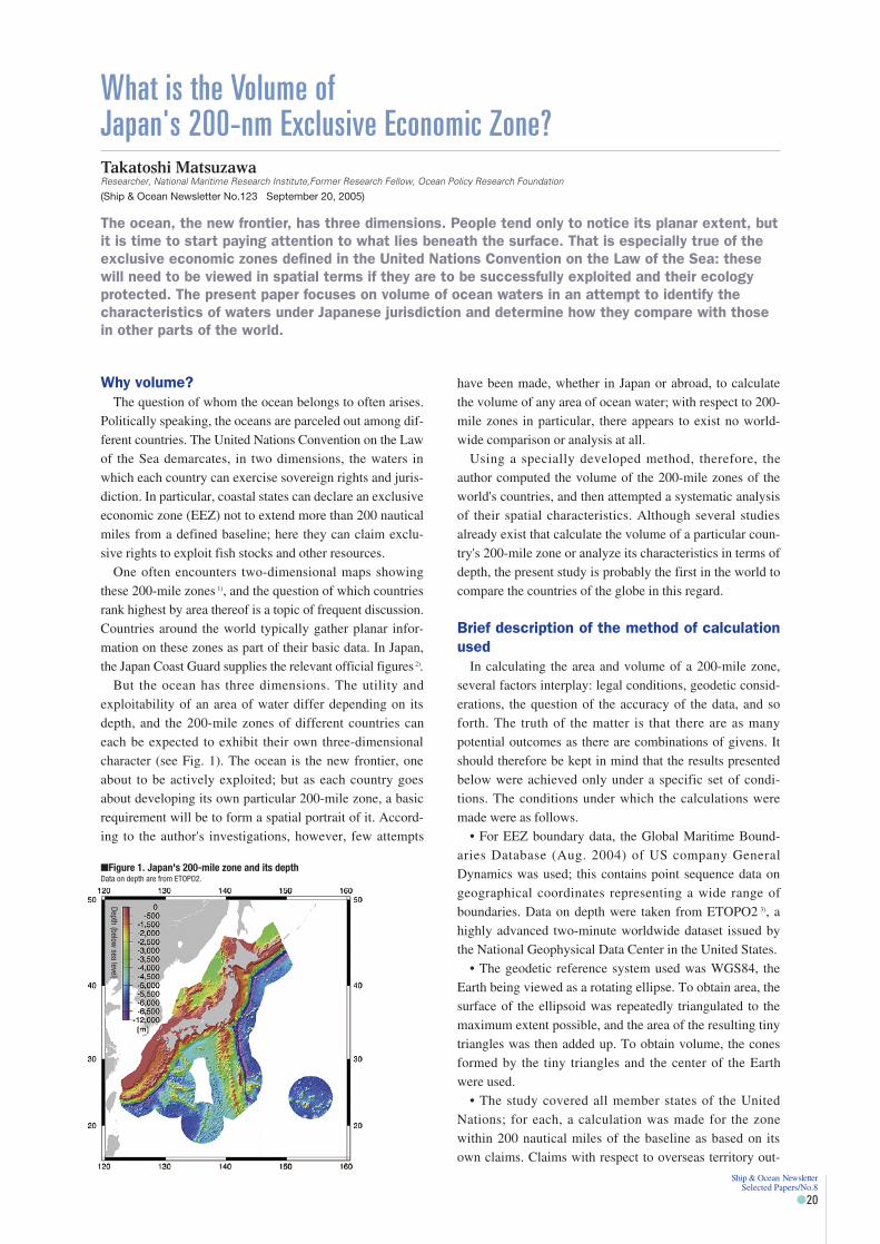
But the ocean has three dimensions. The utility andexploitability of an area of water differ depending on itsdepth, and the 200-mile zones of different countries caneach be expected to exhibit their own three-dimensionalcharacter (see Fig. 1). The ocean is the new frontier, oneabout to be actively exploited; but as each country goesabout developing its own particular 200-mile zone, a basicrequirement will be to form a spatial portrait of it. Accord-ing to the author's investigations, however, few attempts
have been made, whether in Japan or abroad, to calculatethe volume of any area of ocean water; with respect to 200-mile zones in particular, there appears to exist no world-wide comparison or analysis at all.
Using a specially developed method, therefore, theauthor computed the volume of the 200-mile zones of theworld's countries, and then attempted a systematic analysisof their spatial characteristics. Although several studiesalready exist that calculate the volume of a particular coun-try's 200-mile zone or analyze its characteristics in terms ofdepth, the present study is probably the first in the world tocompare the countries of the globe in this regard.
Brief description of the method of calculationused
In calculating the area and volume of a 200-mile zone,several factors interplay: legal conditions, geodetic consid-erations, the question of the accuracy of the data, and soforth. The truth of the matter is that there are as manypotential outcomes as there are combinations of givens. Itshould therefore be kept in mind that the results presentedbelow were achieved only under a specific set of condi-tions. The conditions under which the calculations weremade were as follows.
• For EEZ boundary data, the Global Maritime Bound-aries Database (Aug. 2004) of US company GeneralDynamics was used; this contains point sequence data ongeographical coordinates representing a wide range ofboundaries. Data on depth were taken from ETOPO2 3), ahighly advanced two-minute worldwide dataset issued bythe National Geophysical Data Center in the United States.
• The geodetic reference system used was WGS84, theEarth being viewed as a rotating ellipse. To obtain area, thesurface of the ellipsoid was repeatedly triangulated to themaximum extent possible, and the area of the resulting tinytriangles was then added up. To obtain volume, the conesformed by the tiny triangles and the center of the Earthwere used.
• The study covered all member states of the UnitedNations; for each, a calculation was made for the zonewithin 200 nautical miles of the baseline as based on itsown claims. Claims with respect to overseas territory out-
(Ship & Ocean Newsletter No.123 September 20, 2005)
�Figure 1. Japan's 200-mile zone and its depthData on depth are from ETOPO2.
Depth(below
sealevel)
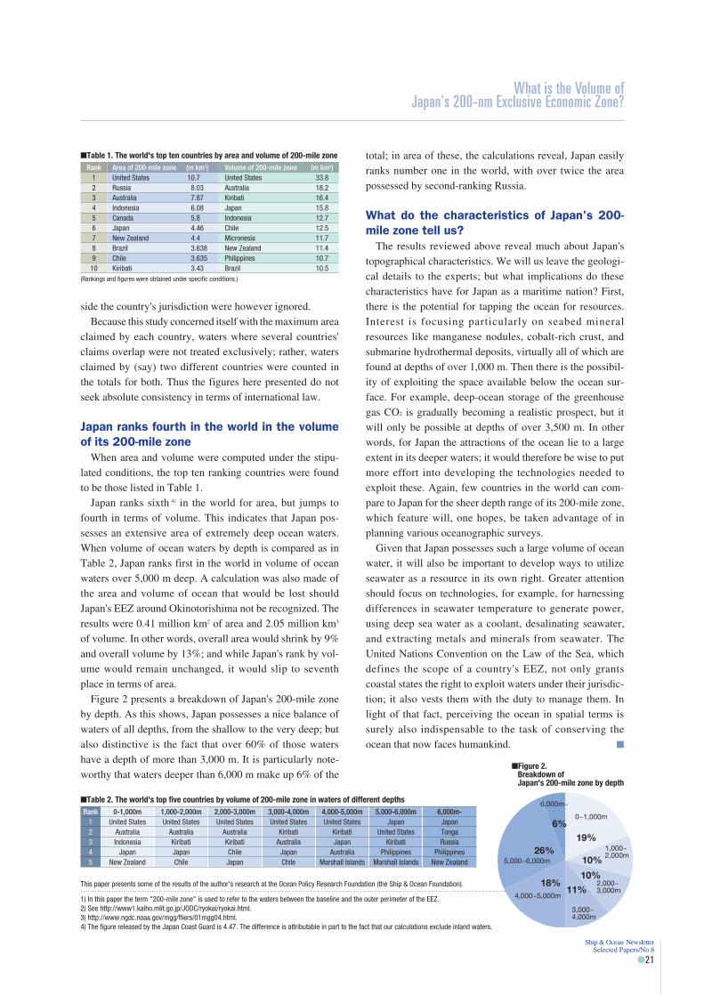
side the country's jurisdiction were however ignored.Because this study concerned itself with the maximum area
claimed by each country, waters where several countries'claims overlap were not treated exclusively; rather, watersclaimed by (say) two different countries were counted inthe totals for both. Thus the figures here presented do notseek absolute consistency in terms of international law.
Japan ranks fourth in the world in the volumeof its 200-mile zone
When area and volume were computed under the stipu-lated conditions, the top ten ranking countries were foundto be those listed in Table 1.
Japan ranks sixth 4) in the world for area, but jumps tofourth in terms of volume. This indicates that Japan pos-sesses an extensive area of extremely deep ocean waters.When volume of ocean waters by depth is compared as inTable 2, Japan ranks first in the world in volume of oceanwaters over 5,000 m deep. A calculation was also made ofthe area and volume of ocean that would be lost shouldJapan's EEZ around Okinotorishima not be recognized. Theresults were 0.41 million km2 of area and 2.05 million km3
of volume. In other words, overall area would shrink by 9%and overall volume by 13%; and while Japan's rank by vol-ume would remain unchanged, it would slip to seventhplace in terms of area.
Figure 2 presents a breakdown of Japan's 200-mile zoneby depth. As this shows, Japan possesses a nice balance ofwaters of all depths, from the shallow to the very deep; butalso distinctive is the fact that over 60% of those watershave a depth of more than 3,000 m. It is particularly note-worthy that waters deeper than 6,000 m make up 6% of the
total; in area of these, the calculations reveal, Japan easilyranks number one in the world, with over twice the areapossessed by second-ranking Russia.
What do the characteristics of Japan's 200-mile zone tell us?
The results reviewed above reveal much about Japan'stopographical characteristics. We will us leave the geologi-cal details to the experts; but what implications do thesecharacteristics have for Japan as a maritime nation? First,there is the potential for tapping the ocean for resources.Interest is focusing particularly on seabed mineralresources like manganese nodules, cobalt-rich crust, andsubmarine hydrothermal deposits, virtually all of which arefound at depths of over 1,000 m. Then there is the possibil-ity of exploiting the space available below the ocean sur-face. For example, deep-ocean storage of the greenhousegas CO2 is gradually becoming a realistic prospect, but itwill only be possible at depths of over 3,500 m. In otherwords, for Japan the attractions of the ocean lie to a largeextent in its deeper waters; it would therefore be wise to putmore effort into developing the technologies needed toexploit these. Again, few countries in the world can com-pare to Japan for the sheer depth range of its 200-mile zone,which feature will, one hopes, be taken advantage of inplanning various oceanographic surveys.
Given that Japan possesses such a large volume of oceanwater, it will also be important to develop ways to utilizeseawater as a resource in its own right. Greater attentionshould focus on technologies, for example, for harnessingdifferences in seawater temperature to generate power,using deep sea water as a coolant, desalinating seawater,and extracting metals and minerals from seawater. TheUnited Nations Convention on the Law of the Sea, whichdefines the scope of a country's EEZ, not only grantscoastal states the right to exploit waters under their jurisdic-tion; it also vests them with the duty to manage them. Inlight of that fact, perceiving the ocean in spatial terms issurely also indispensable to the task of conserving theocean that now faces humankind. �
Ship & Ocean Newsletter Selected Papers/No.8
�21
�Table 1. The world's top ten countries by area and volume of 200-mile zoneRank Area of 200-mile zone (m km2) Volume of 200-mile zone (m km2)
1 United States 10.7 United States 33.82 Russia 8.03 Australia 18.23 Australia 7.87 Kiribati 16.44 Indonesia 6.08 Japan 15.85 Canada 5.8 Indonesia 12.76 Japan 4.46 Chile 12.57 New Zealand 4.4 Micronesia 11.78 Brazil 3.638 New Zealand 11.49 Chile 3.635 Philippines 10.710 Kiribati 3.43 Brazil 10.5
(Rankings and figures were obtained under specific conditions.)
0~1,000m
1,000~2,000m
2,000~3,000m
3,000~4,000m
4,000~5,000m
5,000~6,000m
6,000m~
19%
10%
10%
11%18%
26%
6%
What is the Volume of Japan's 200-nm Exclusive Economic Zone?
1) In this paper the term "200-mile zone" is used to refer to the waters between the baseline and the outer perimeter of the EEZ.2) See http://www1.kaiho.mlit.go.jp/JODC/ryokai/ryokai.html.3) http://www.ngdc.noaa.gov/mgg/fliers/01mgg04.html.4) The figure released by the Japan Coast Guard is 4.47. The difference is attributable in part to the fact that our calculations exclude inland waters.
This paper presents some of the results of the author's research at the Ocean Policy Research Foundation (the Ship & Ocean Foundation).
�Table 2. The world's top five countries by volume of 200-mile zone in waters of different depthsRank 0-1,000m 1,000-2,000m 2,000-3,000m 3,000-4,000m 4,000-5,000m 5,000-6,000m 6,000m-
1 United States United States United States United States United States Japan Japan2 Australia Australia Australia Kiribati Kiribati United States Tonga3 Indonesia Kiribati Kiribati Australia Japan Kiribati Russia4 Japan Japan Chile Japan Australia Philippines Philippines5 New Zealand Chile Japan Chile Marshall Islands Marshall Islands New Zealand
�Figure 2. Breakdown of Japan's 200-mile zone by depth

Fumihiko Imamura
Tsunami-Caused Damage and Restoration—referencing to the cases of Okushiri Island, hit by the 1993 Hokkaido SW tsunami and Banda Aceh, Sumatra, by the 2004 Indian Ocean Tsunami—
It is important, when carrying out restoration and reconstruction projects after a disaster, to avoidfuture ones by including a long-term perspective in planning and implementing preventivemeasures.This article introduces restoration works from tsunami-caused disasters and preventive measuresagainst future tsunamis, seeing examples of restoration works from the Hokkaido Nansei-OkiEarthquake of 1993, as well as the ongoing restoration work in Banda Aceh, Sumatra, an areadevastated by the Indian Ocean tsunami of 2004.
Professor, Tsunami Engineering, Disaster Control Research Center, Graduate School of Engineering, Tohoku University
Ship & Ocean Newsletter Selected Papers/No.8
�22
IntroductionDue to mantle convection in the earth's interior, some
plates on the earth's surface move at varying with eachspeed but slow rates. There are also places as plate bound-aries where one plate slips under another plate, so that dis-tortion energy is easily accumulated along the correspond-ing borders. As a result, marine earthquakes, volcanicactivity and landslides occur frequently, directly or indi-rectly generating tsunamis, causing great damage alongcoastal areas. Japan is located along such a border. As theresult, the country accounts for only two percent of theentire globe, but the number of felt earthquakes accountsfor more than twenty percent. Moreover, forty percent ofmajor tsunamis with fatalities in excess of a thousand haveactually occurred in Japan. That is why the Japanese word"tsunami" is used worldwide.
Approximately two hundred tsunamis have occurred incoastal area in Japan over the past thirteen hundred years,which were documented in the historical records andbooks. During that period, a major tsunami recorded in his-torical documents occurred once every five to six years.The frequency of occurrence of tsunamis is very small incomparison with flooding and earthquakes, therefore it ishard to say that people have a high awareness in regard totsunamis. We should be reminded that a tsunami is a low-frequency disaster, it is not easy to take measures against it.And, closer look reveals that, in a disaster-stricken area, thewisdom and ingenuity gained from experience with the dis-aster have been passed on to succeeding generations. Thesedays, highly systemized, modern measures against disastersmay be the mainstream, but we should not forget the cul-ture of disaster prevention among people who have beenstricken by disasters and lived with the suffering thatensued.
We should also note that a response to disasters developsin a disaster cycle from the time a disaster strikes, proceed-ing to restoration and reconstruction, and that this cycleresults in deterrents against damage and mitigation. Inother words, though restoration and reconstruction mea-
sures must be taken immediately after the occurrence of adisaster, we can at the same time prevent subsequent disas-ter-caused damage by planning and implementing mea-sures from a long-term perspective.
An Abrupt and Unpredictable CatastrophicDisaster
A catastrophic disaster occurred suddenly, destroying thepeacefulness of life on July 12, 1993. A big earthquakemeasuring M7.8 occurred to the immediate west ofOkushiri Island, Southwestern part of Hokkaido. Five min-utes after the occurrence of the earthquake, as people triedto recover from the jolt and shock, a tsunami at least tenmeters in height hit various places along the coast of theisland. Life became the nightmare of a major earthquake,with landslides, tsunami, fires, and the number of dead andmissing reaching 198 on the island alone. At that time, theJapan Meteorological Agency issued a tsunami warning,but only those who had evacuated upland with only thebarest necessities right after the jolt were saved, becausethe earthquake and tsunami occurred almost simultane-ously.
The Sumatra Offshore Earthquake of December 26, 2004was a much worse disaster. The coastal area in the Indianocean had been struck by earthquakes and accompanyingtsunamis, but nobody could remember that a great earth-quake measuring M9 and a massive tsunami causing dam-age to the entire Ocean, like the Sumatra Offshore Earth-quake, had previously occurred. It was reported that thefirst tidal wave struck the northern coast of Sumatra Islandwithin ten to twenty minutes after the strong ground-quake.The tsunami run-up height was thirty meters or more alongthe western coast, and five to ten meters in Banda Acehcity, a plat area in the northern region where its destructiveenergy was beyond imagining: A run-up area of ten kilo-meters or more, a vanished coastline of one to two kilome-ters in width. The total casualties of more than 150,000 inIndonesia, and the complete destruction of residentialareas. Banda Aceh–where 70,000 people out of a popula-
(Ship & Ocean Newsletter No.129 December 20, 2005)
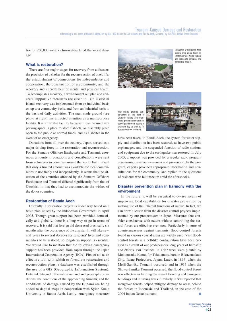
tion of 260,000 were victimized–suffered the worst dam-age.
What is restoration?There are four major stages for recovery from a disaster:
the provision of a shelter for the reconstruction of one's life;the establishment of connections for independence andcooperation; the construction of a community; and therecovery and improvement of mental and physical health.To accomplish a recovery, a well-thought out plan and con-crete supportive measures are essential. On OkushiriIsland, recovery was implemented from an individual basison up to a community basis, and from an industrial basis tothe basis of daily activities. The man-made ground (seephoto at right) has attracted attention as a multipurposefacility. It is a flexible facility because it can be used as aparking space, a place to store fishnets, an assembly placeopen to the public at normal times, and as a shelter in theevent of an emergency.
Donations from all over the country, Japan, served as amajor driving force in the restoration and reconstruction.For the Sumatra Offshore Earthquake and Tsunami, enor-mous amounts in donations and contributions were sentfrom volunteers in countries around the world, but it is saidthat only a limited amount was available for local commu-nities to use freely and independently. It seems that the sit-uation of the countries affected by the Sumatra OffshoreEarthquake and Tsunami differed significantly from that ofOkushiri, in that they had to accommodate the wishes ofthe donor countries.
Restoration of Banda AcehCurrently, a restoration project is under way based on a
basic plan issued by the Indonesian Government in April2005. Though great support has been provided domesti-cally and globally, there is a long way to go in terms ofrecovery. It is said that foreign aid decreased drastically sixmonths after the occurrence of the disaster. It will take sev-eral years to several decades for residents' lives and com-munities to be restored, so long-term support is essential.We would like to mention that the following emergencysupport has been provided from Japan through the JapanInternational Cooperation Agency (JICA). First of all, as aneffective tool with which to formulate restoration andreconstruction plans, a database was established throughthe use of a GIS (Geographic Information System).Detailed data and information on land and geographic con-ditions, the conditions of the approaching tsunami, and theconditions of damage caused by the tsunami are beingadded to degital maps in cooperation with Syiah KualaUniversity in Banda Aceh. Lastly, emergency measures
have been taken. In Banda Aceh, the system for water sup-ply and distribution has been restored, as have two publicorphanages, and the suspended function of radio stationsand equipment due to the earthquake was restored. In July2005, a support was provided for a regular radio programconcerning disasters awareness and prevention. In the pro-gram, experts provided appropriate information and con-sultations for the community, and replied to the questionsof residents who felt insecure amid the aftershocks.
Disaster prevention plan in harmony with theenvironment
In the future, it will be essential to devise means ofimproving local capabilities for disaster prevention bymaking use of the inherent functions of nature. In fact, wecan draw a lesson from the disaster control projects imple-mented by our predecessors in Japan. Measures that con-sider coexistence with nature without controlling the nat-ural forces are effective even now. Particularly in terms ofcountermeasures against tsunamis, flood-control forestsfound in various coastal areas are widely used. Vast flood-control forests in a belt-like configuration have been cre-ated as a result of our predecessors' long years of hardshipand efforts. For instance, in 1667 trees were planted byMokunosuke Kanno for Takatamatsubara in RikuzentakataCity, Iwate Prefecture, Japan. Later, in 1896, when theMeiji-Sanriku Tsunami occurred, and in 1933 when theShowa-Sanriku Tsunami occurred, the flood-control forestwas effective in limiting the area of flooding and damage tobuildings and in saving lives. Similarly, it was reported thatmangrove forests helped mitigate damage to areas behindthe forests in Indonesia and Thailand, in the case of the2004 Indian Ocean tsunami. �
Conditions of the Banda Acehcoastal area (photo taken onSeptember 23, 2005). Rubbleand debris still remains, andpeople live amid it.
Man-made ground con-structed at the port ofOkushiri Island (The man-made ground can be used forparking and events activity inordinary day as well as forevacuation from tsunamis.)
Tsunami-Caused Damage and Restoration—referencing to the cases of Okushiri Island, hit by the 1993 Hokkaido SW tsunami and Banda Aceh, Sumatra, by the 2004 Indian Ocean Tsunami—
Ship & Ocean Newsletter Selected Papers/No.8
�23
Tadao Kuribayashi
Further Recommendations for a Japanese Ocean Policy
Major countries throughout the world have begun formulating and implementing ocean policies asa means to deal with the new international ocean regime that is centered on the U.N. Conventionon the Law of the Sea.To rectify the negative effects of a compartmentalized decision-making process (which is theunderlying cause of Japan's conspicuously obvious delays) and to conceive the structure of anadministrative agency for comprehensive, systematic policy making, Japan's basic policy should bebased on the concept of ocean governance.This article introduces the major points in the recent recommendations by the Ocean PolicyResearch Foundation (OPRF).
Professor Emeritus, Keio University
Ship & Ocean Newsletter Selected Papers/No.8
�24
Ocean and Japan–Proposal for a 21st CenturyOcean Policy
OPRF's Ocean and Coastal Zone Research Committeecompiled "Ocean and Japan: Proposal for a 21st CenturyOcean Policy," and published it in November 2005. Theproposal integrates the findings of research conducted suc-cessively following "Ocean and Japan: Proposal for Japan's21st Century Ocean Policy," which was prepared and pub-lished in 2002 by the Ocean Management Study Group(Nippon Foundation).
The latest document proposes that Japan should elabo-rate upon the content of the National Ocean Policy Guide-line for the promotion of a comprehensive ocean policy,doing so based on the proposal made in 2002, and that itshould promptly initiate the formulation and implementa-tion of Japan's integrated ocean policy according to a basicphilosophy consisting of three concepts: "sustainable oceandevelopment," "leadership in the international oceanregime and international coordination," and "comprehen-sive ocean management."
The proposal includes the formulation of a new BasicOcean Law that has not yet been formulated in Japan, aswell as the fundamental provision of administrative organi-zations that would take charge of formulating and imple-menting a comprehensive ocean policy (specifically theprovision or appointment of ocean-related ministerial meet-ings, an Ocean Minister, a section for controlling the oceanpolicy in the Cabinet Office–with an officer in charge ofocean policy–and an ocean council). The proposal alsoidentified various important issues that Japan should workon, such as the establishment of a framework for the man-agement of exclusive economic zones (EEZ) in seas aroundJapan; the continental shelves; the establishment of oceansecurity; the protection, conservation, and regeneration ofthe marine environment; the development of oceanresources in consideration of ocean ecosystems; moreefforts for the establishment of a comprehensive coastalmanagement system; the prevention and mitigation of dis-
asters; the provision of information for ocean management;and the promotion of research, training, and outreachefforts. (Please refer to the opening article of this Numberfor an outline of the proposal.)
As one who is involved with the Committee's work as itshead, having served successively since the previousresearch effort, I would like to take this opportunity tothank all the committee members who were activelyinvolved in preparing the proposal, along with the OPRFstaff who provided their dedicated support. Next, I wouldlike to explain why we ventured another proposal for aJapanese ocean policy, and include my personal views aswell.
Formulation of an ocean policy suitable forthe twenty-first century
Concerning the international ocean regime that hasdeveloped rapidly based on the U.N. Convention on theLaw of the Sea, which came into force in 1994 (agreedupon in 1982 and ratified in Japan in 1996), each countryhas been responding with originality and ingenuity, and theU.S. and many other countries have begun formulating andimplementing their respective ocean policies. In compari-son, Japan has generally lagged behind in improving itslegal system and other aspects in the field of ocean policy,and it is believed that the delay has been due to the funda-mental lack of a national system that can formulate a com-prehensive ocean policy. As a result, Japan does not haveits own comprehensive ocean policy. Ocean problems intoday's Japanese society, as well as the world, are inter-linked in complicated ways, so comprehensive efforts areincreasingly needed.
Though the overall comprehension of ocean problems,the awareness of their interrelatedness, and the necessityfor comprehensive ocean management have often beenemphasized and recommended in international writing andvarious international forums, the vertically compartmental-ized Japanese administrative system has not seriously
(Ship & Ocean Newsletter No.130 January 5, 2006)

responded to the world's shared awareness and needs. Evennow, Japan remains unable to make a sufficient response.At the time of publicizing the previous proposal, I made thefollowing urgent statement in the Ship & Ocean Newsletter:"People's consciousness of the order of the sea must bereexamined in the twenty-first century, the harmful resultsof bureaucratic sectionalism must be remedied, and theframework for formulating and implementing ocean policymust be fundamentally reconsidered. Otherwise, Japan willfall behind the international order on the ocean and finditself unable to make an active contribution to internationalcooperation concerning the use of the ocean." ("Be theCountry that Leads the World in the International Order onthe Ocean," Ship & Ocean Newsletter No. 41, April 20,2002). However, these issues have not been resolved;instead our concern grows more intense.
Despite the fact that efforts have been made by certainministries and agencies in response to the era of the twohundred-nautical-mile economic zone, and some actionsbeen taken by communicating and coordinating betweenrelated ministries and agencies in regard to specific oceanproblems, Japan's decision-making process for ocean pol-icy has not basically changed since the end of World WarII. The formulation and implementation of a truly compre-hensive, systematic ocean policy has been hampered byvertically compartmentalized administration, ministerialrivalries, inefficiencies such as delays and redundancy inpolicy making. This has been partly due to the verticallycompartmentalized systems of the governmental, industrialand academic sectors, and partly due to the negative effectsof the ambiguity of decision-making bodies and responsi-ble parties. In disclosing information on ocean affairs, and
by fulfilling our obligation to be accountable, we must setaside our usual practices, which are passive and conserva-tive. For all the issues Japan is facing, including the oceanenvironment, resources, traffic and security, there arenumerous international and domestic problems that Japanmust urgently resolve. We must acknowledge that it isbeyond the capabilities of the current system to thoroughlycomprehend and analyze Japan's position and respondproactively to these problems within the current oceanregime, which is based on the shift from the traditional"freedom of the seas" to the new "management of oceans"paradigm. We can no longer say, "We have been able tomanage somehow." Unless we change, we will be caught inour own system, and capable persons in the field of admin-istrative practice that deal with ocean problems will beunable to exercise their abilities.
To recover from this seriously backward situation, it isstrongly urged that the structure of an administrativeagency for systematic and comprehensive policymaking, assuggested in the latest proposal, will be promptly con-ceived, and that a basic policy for coexistence of mankindand the oceans will be set forth as a national goal of thetwenty-first century so that Japan, as an ocean state, canrespond to its domestic ocean problems and also play anactive role in the formation and development of the oceanregime in international society, especially that of Asia. Weexpect that the national debate on the future relationshipbetween Japan and the oceans will continue to grow. Fur-ther, it is hoped that those in charge of formulating andimplementing Japan's ocean policy will value the intentionof this proposal, and take the initiative on behalf of its earlyrealization. �
Further Recommendations for a Japanese Ocean Policy
Ship & Ocean Newsletter Selected Papers/No.8
�25

Hiroshi Terashima
On Becoming a True Ocean State
Today, in the early twenty-first century, and in the ocean that determines the fate of maritimeJapan, the ocean regime and policy frameworks that address the issues of natural resources, theenvironment, security and safety are experiencing major changes, and various countries around theworld are steadily implementing measures for ocean management based on a new internationalframework. However, Japan lags behind when it comes to comprehensive ocean management.Therefore, this article proposes we promptly formulate a National Ocean Policy Guideline in order toimprove our political policies and structures, including the appointment of an Ocean Minister, withthe goals of establishing a Basic Ocean Law and promoting the management of Japan's expandedocean area.
Executive Director, Ocean Policy Research Foundation(OPRF)
Ship & Ocean Newsletter Selected Papers/No.8
�26
1. Structural Changes and the OceanJapan, which is surrounded by the ocean, enjoys the
bounties of abundant marine products, along with trans-portation and trade routes. Moreover, the country devel-oped with the ocean as a natural shield. Today, however, inthe early twenty-first century, the ocean environment thataffects the country's future is undergoing major structuralchanges–including natural conditions, such as resourcesand the environment, but also the legal system and policiesconcerning ocean management–and a response to thesechanges has become a major issue.
The ocean accounts for seventy percent of the earth's sur-face. It is a huge area, and 149 countries border the ocean.Additionally, the ocean is filled with water, so it is highlyunified., and its phenomena are closely interrelated, soocean problems almost invariably take on an internationalaspect. Accordingly, in recent years, as shared awarenessincreases that problems of the oceans need to be consideredas a whole and managed comprehensively 1), internationalsociety has undertaken far-reaching ocean initiatives.
The U.N. Convention on the Law of the Sea, otherwiseknown as the "Ocean Constitution," came into effect in1994, and typifies the change in the legal system. As part ofthat law, an exclusive economic zone (EEZ) and continen-tal shelf system was established giving coastal states juris-dictional rights over a vast ocean area of two hundred nau-tical miles from shore. UNCLOS not only greatly increasedthe areas over which coastal states have jurisdictionalrights, but also introduced a new framework concerningocean resource management and the protection and conser-vation of the ocean environment.
At present, we are seeing the direct impact and problemsof this new ocean regime through the overlapping of exclu-sive economic zones and continental shelves betweenneighboring countries. This problem can be seen aroundthe world. A Japan-China dispute over petroleum and gasfields in the East China Sea originates from the problem ofborder demarcation related to the reorganization of ocean
areas, and underlying this is the competition betweenneighboring countries that attempt to take advantage of thechanges in the international framework concerning oceanarea management for their national benefit. The ocean is nolonger a neutral buffer zone, and we have entered a new agewhere we face each other directly, across a national borderset on the ocean 2). Japan needs to fully recognize thesechanges. It must address the issues of natural resources, theenvironment, security and safety in the ocean.
The structural change regarding the ocean is also appar-ent in policies on the environment and resources. The nat-ural environment and resources in ocean and coastal areashave been badly damaged due to human activities sup-ported and activated by the technologies of recent years. Itis said that eighty percent of ocean contamination is land-based. Because of this, in 1992 the "Agenda 21" action planfor sustainable development was adopted and respectivecountries agreed to the action plan for seven program areasin Chapter 17 of the Agenda in order to promote the "sus-tainable development" and "comprehensive management"of the ocean. Ten years later, in 2002, the World Summit onSustainable Development (WSSD) 3) formulated the WSSDPlan of Implementation for their further promotion, andrequested that each country implement the plan.
We now frequently encounter abnormal weather and sealevel rise due to global warming, natural disasters such astsunamis and tidal waves, and man-made threats such asmaritime terrorism, piracy, and spy ships. Therefore,responding to various threats in ocean and coastal areas hasemerged as an urgent issue both domestically and globally.
2. Japan's Response and the Proposal for a21st Century Ocean Policy
To deal with these structural changes, various countriesacross the world are now steadily implementing measuresfor comprehensive ocean management based on the newlyestablished international framework. Australia, Canada, theU.S., the U.K., Korea, and China have taken the initiative
(Ship & Ocean Newsletter No.130 January 5, 2006)

in doing so. However, Japan is unfortunately trapped by itsconventional view of the ocean, as well as by a verticallycompartmentalized state system based on that view. There-fore, little effort has been made in regard to comprehensiveocean management initiatives. If nothing is done, it is likelythat Japan will be left out of ongoing worldwide initiativesin ocean affairs, and thereby lose a base for its develop-ment.
OPRF has been concerned about this delay in Japan'scomprehensive ocean management initiatives. It has beenactively discussing Japan's ideal ocean policy for more thantwo years with experts in many fields related to the ocean,with support provided by the Nippon Foundation. OPRFcompiled the results of our discussions as a "Proposal for a21st Century Ocean Policy," submitted it to the then ChiefCabinet Secretary Mr. Shinzo Abe, and made it public. (Forthe proposal, please refer to http://www.sof.or.jp)
Based on the Proposal for Ocean Policy made by theNippon Foundation in 2002, the Proposal for a 21st Cen-tury Ocean Policy integrates the subsequent progress madeboth at home and abroad, along with the results of researchon ocean policy. It was compiled into a concrete proposalas a comprehensive policy concerning comprehensiveocean management and sustainable ocean development. Iwould like to express my gratitude to Dr. Tadao Kurib-ayashi, chair of the Council, and all the council memberswho put forth the hard work needed to prepare the pro-posal.
As a basic philosophy for Japan to become a true oceanstate, the Proposal for a 21st Century Ocean Policy advo-cates "Sustainable development and utilization of theocean"; "Leadership in the international ocean regime andinternational coordination"; and "Comprehensive manage-ment of the ocean." Moreover, it requests the formulationof a comprehensive ocean policy following the proposaland the immediate start of policy implementation. The fol-lowing are the main points of the proposal:(1) Formulation of a National Ocean Policy Guideline
To steadily promote a comprehensive ocean policy inJapan, the first thing to do is to specify the important mat-ters to work on in the future and compile them as a NationalOcean Policy Guideline. The National Ocean PolicyGuideline should include the manifestation of the basic phi-
losophy on ocean policy; the provision of a framework forpromotion of the ocean policy, including the Basic OceanLaw and administrative organizations; the reinforcement ofmeasures for resolving issues; the reinforcement of partner-ships; and the promotion of understanding, research andeducation regarding the ocean.(2) Provision of a promotional system aiming for theestablishment of a Basic Ocean Law
In Japan, various issues concerning the ocean have beenhandled under vertically compartmentalized and individu-ally purposed positive laws, so the country lacks a policyframework and legal grounds for comprehensive oceanmanagement. To deal comprehensively with ocean prob-lems, a Basic Ocean Law should be established promptly.Considering the present situation, in which the lack of agovernmental agency responsible for promoting compre-hensive ocean policy poses an impediment, the improve-ment of administrative organization (including the appoint-ment of an Ocean Minister) must be made immediately.(3) Management of Japan's Expanded Ocean Space andInternational Cooperation
To fulfill the rights and obligations in Japan's ocean areabased on the new ocean regime, it is necessary to formulateand comprehensively and systematically implement a con-crete policy regarding the management of Japan's expandedocean space, as well as in regard to international coopera-tion. Therefore, the proposal proposes concrete measures inregard to eight items, including the establishment of aframework for the management of the exclusive economiczone and continental shelves, and the establishment ofocean security.
Japan should take the recent structural changes regardingthe ocean seriously and immediately review its policy as anocean state. In pursuit of its goal of becoming a true oceanstate, Japan should demonstrate its leadership and establishan ocean policy in response to the needs of the times thatwould serve as a model to others.
I earnestly hope that this proposal will be accepted bythose in charge of state affairs, related ministries and agen-cies, as well as by people from various fields and walks oflife, and that initiatives for comprehensive ocean manage-ment and sustainable development will be undertaken assoon as possible. �
On Becoming a True Ocean State
Ship & Ocean Newsletter Selected Papers/No.8
�27
1) Preamble of the U.N. Convention on the Law of the Sea2) Strictly speaking, the exclusive economic zone (EEZ) is not a national territory but a ocean area falling under functional jurisdiction for a specific purpose. However, considering that wide power
is given to coastal countries, the exclusive economic zone conceptually contains an element of territorialization ("Modern International Law," Tadao Kuribayashi, p. 292), and many countriesare heading in that direction.
3) World Summit on Sustainable Development (WSSD): To mark the 10th anniversary of the Rio de Janeiro Earth Summit, the World Summit on Sustainable Development was held inJohannesburg, South Africa, in 2002 with the attendance of leaders from various countries and numerous nongovernmental organizations. The WSSD Plan of Implementation was adoptedthere.