Seismic evidence for bottom current activity at the Agulhas …epic.awi.de/3670/1/Wil2000a.pdf ·...
14
Seismic evidence for bottom current activity at the Agulhas Ridge Etienne Wildeboer Schut * , Gabriele Uenzelmann-Neben, Rainer Gersonde Alfred-Wegener-Institut fu ¨r Polar-und Meeresforschung, Bremerhaven, Germany Received 12 August 2000; accepted 11 April 2001 Abstract In the South Atlantic water masses from the Atlantic and Indian Oceans meet Antarctic water masses. The Agulhas Ridge, a pronounced elevation of the ocean bottom in the eastern South Atlantic, has acted as a barrier for deep oceanic currents since the Cretaceous, such as the North Atlantic Deep Water (NADW) and Antarctic Bottom Water (AABW), or water masses derived from AABW such as Circumpolar Deep Water (CDW). The history of these currents is recorded in the sedimentary sequence in the adjacent Cape and Agulhas Basins. Seismic profiles over the Agulhas Ridge show sediment packages in the Cape Basin which are interpreted as contourite sheets. These consist of thick sequences interrupted by widespread hiatuses, with a predominantly low seismic reflectivity. The seismic data shows prominent reflectors inside contourite drift bodies which, at the location of the drill-sites of Ocean Drilling Program (ODP) Leg 177, can be attributed to hiatuses in the Early Oligocene, the Middle Miocene, around the Miocene/Pliocene boundary and in the early Pleistocene. In this way, ODP Leg 177 cores were used to date an elongate contourite drift in the Cape Basin. This drift shows sediments deposited by a westward current, implying that the bottom current in the Oligocene followed the same trajectory as present-day CDW does. D 2002 Elsevier Science B.V. All rights reserved. Keywords: South Atlantic; Agulhas Ridge; seismic reflection; palaeo-reconstruction; bottom currents 1. Introduction One of the prime factors controlling regional climate is ocean circulation. The present-day inter ocean exchange of water masses is driven by a global thermo-haline convection system, which transports deep water sediments and partly erodes the ocean bottom. Past ocean circulation can be studied from the effects of deposition and erosion by bottom currents observed in seismic data. This paper focuses on the southern Atlantic, a region where water masses of Atlantic, Indian/Pacific and Antarctic origin meet. Sea-floor spreading and the opening of the South Atlantic Ocean started in the Early Cretaceous (Ben- Avraham et al., 1993, 1997). The Agulhas Ridge has formed along the Falkland – Agulhas Fracture Zone (FAFZ), a transform fault between the African and South American plates related to the breakup of West Gondwanaland (Ben-Avraham et al., 1997). The Agulhas Ridge represents a pronounced elevation of the sea-floor relative to the adjacent ocean basins, extending from approx. 41jS, 13.5jE to 43jS, 9jE (Fig. 1) southwest of the coast of South Africa. It separates the Cape Basin north of the ridge from the Agulhas Basin to the south and coincides with the 0921-8181/02/$ - see front matter D 2002 Elsevier Science B.V. All rights reserved. PII:S0921-8181(02)00114-5 * Corresponding author. E-mail address: [email protected] (E. Wildeboer Schut). www.elsevier.com/locate/gloplacha Global and Planetary Change 34 (2002) 185 – 198
Transcript of Seismic evidence for bottom current activity at the Agulhas …epic.awi.de/3670/1/Wil2000a.pdf ·...

Seismic evidence for bottom current activity at the Agulhas Ridge
Etienne Wildeboer Schut *, Gabriele Uenzelmann-Neben, Rainer Gersonde
Alfred-Wegener-Institut fur Polar-und Meeresforschung, Bremerhaven, Germany
Received 12 August 2000; accepted 11 April 2001
Abstract
In the South Atlantic water masses from the Atlantic and Indian Oceans meet Antarctic water masses. The Agulhas Ridge, a
pronounced elevation of the ocean bottom in the eastern South Atlantic, has acted as a barrier for deep oceanic currents since the
Cretaceous, such as the North Atlantic Deep Water (NADW) and Antarctic Bottom Water (AABW), or water masses derived
from AABW such as Circumpolar Deep Water (CDW). The history of these currents is recorded in the sedimentary sequence in
the adjacent Cape and Agulhas Basins. Seismic profiles over the Agulhas Ridge show sediment packages in the Cape Basin
which are interpreted as contourite sheets. These consist of thick sequences interrupted by widespread hiatuses, with a
predominantly low seismic reflectivity. The seismic data shows prominent reflectors inside contourite drift bodies which, at the
location of the drill-sites of Ocean Drilling Program (ODP) Leg 177, can be attributed to hiatuses in the Early Oligocene, the
Middle Miocene, around the Miocene/Pliocene boundary and in the early Pleistocene. In this way, ODP Leg 177 cores were
used to date an elongate contourite drift in the Cape Basin. This drift shows sediments deposited by a westward current,
implying that the bottom current in the Oligocene followed the same trajectory as present-day CDW does.
D 2002 Elsevier Science B.V. All rights reserved.
Keywords: South Atlantic; Agulhas Ridge; seismic reflection; palaeo-reconstruction; bottom currents
1. Introduction
One of the prime factors controlling regional
climate is ocean circulation. The present-day inter
ocean exchange of water masses is driven by a global
thermo-haline convection system, which transports
deep water sediments and partly erodes the ocean
bottom. Past ocean circulation can be studied from the
effects of deposition and erosion by bottom currents
observed in seismic data. This paper focuses on the
southern Atlantic, a region where water masses of
Atlantic, Indian/Pacific and Antarctic origin meet.
Sea-floor spreading and the opening of the South
Atlantic Ocean started in the Early Cretaceous (Ben-
Avraham et al., 1993, 1997). The Agulhas Ridge has
formed along the Falkland–Agulhas Fracture Zone
(FAFZ), a transform fault between the African and
South American plates related to the breakup of West
Gondwanaland (Ben-Avraham et al., 1997). The
Agulhas Ridge represents a pronounced elevation of
the sea-floor relative to the adjacent ocean basins,
extending from approx. 41jS, 13.5jE to 43jS, 9jE(Fig. 1) southwest of the coast of South Africa. It
separates the Cape Basin north of the ridge from the
Agulhas Basin to the south and coincides with the
0921-8181/02/$ - see front matter D 2002 Elsevier Science B.V. All rights reserved.
PII: S0921 -8181 (02 )00114 -5
* Corresponding author.
E-mail address: [email protected]
(E. Wildeboer Schut).
www.elsevier.com/locate/gloplacha
Global and Planetary Change 34 (2002) 185–198
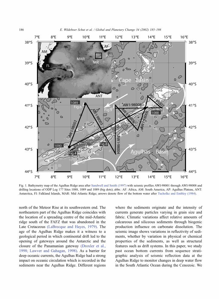
north of the Meteor Rise at its southwestern end. The
northeastern part of the Agulhas Ridge coincides with
the location of a spreading centre of the mid-Atlantic
ridge south of the FAFZ that was abandoned in the
Late Cretaceous (LaBrecque and Hayes, 1979). The
age of the Agulhas Ridge makes it a witness to a
geological period in which continental drift led to the
opening of gateways around the Antarctic and the
closure of the Panamanian gateway (Droxler et al.,
1998; Lawver and Gahagan, 1998). As a barrier for
deep oceanic currents, the Agulhas Ridge had a strong
impact on oceanic circulation which is recorded in the
sediments near the Agulhas Ridge. Different regions
where the sediments originate and the intensity of
currents generate particles varying in grain size and
fabric. Climatic variations affect relative amounts of
calcareous and siliceous sediments through biogenic
production influence on carbonate dissolution. The
seismic image shows variations in reflectivity of sedi-
ments, whether by variation in physical or chemical
properties of the sediments, as well as structural
features such as drift systems. In this paper, we study
past ocean bottom currents from sequence strati-
graphic analysis of seismic reflection data at the
Agulhas Ridge to monitor changes in deep water flow
in the South Atlantic Ocean during the Cenozoic. We
Fig. 1. Bathymetry map of the Agulhas Ridge area after Sandwell and Smith (1997) with seismic profiles AWI-98001 through AWI-98008 and
drilling locations of ODP Leg 177 Sites 1088, 1089 and 1089 (big dots); abbr.: AF: Africa, AM: South America, AP: Agulhas Plateau, ANT:
Antarctica, FI: Falkland Islands, MAR: Mid Atlantic Ridge; arrows denote flow of the bottom water after Tucholke and Embley (1984).
E. Wildeboer Schut et al. / Global and Planetary Change 34 (2002) 185–198186
correlate our seismic data with data from the Ocean
Drilling Program (ODP) Leg 177 (Gersonde et al.,
1999) for calibration.
2. Oceanography
The present general circulation of oceanic currents
around the Agulhas Ridge mainly constitutes the
North Atlantic Deep Water (NADW), the Circumpolar
Deep Water (CDW), and the Agulhas Current coming
from the Indian Ocean (Lutjeharms, 1996; Reid,
1996). Near the southernmost tip of the African
continent, the Agulhas current dissolves in a ring
pattern and mixes with other water masses (Lutje-
harms, 1996; De Ruijter et al., 1999). Cold Antarctic
Bottom Water (AABW) mixes in the Antarctic Cir-
cumpolar Current (ACC) with water masses from the
north to form the CDW (Orsi et al., 1999). Northward
flowing branches of CDW are deflected in a mainly
western direction near the Agulhas Ridge (Tucholke
and Embley, 1984; Sykes et al., 1998). A branch
enters the Cape Basin along the western coast of
South Africa (Fig. 1), from where it flows in a
southwestern direction along the ridge until it bends
in a northward direction again at the southwestern part
of the ridge. This water mass is significantly warmer
in the Cape Basin than in other areas with comparable
latitude due to mixing and the longer flow path
(Tucholke and Embley, 1984). Part of the mixing
comes from the NADW which is vertically located
between upper and lower CDW (Reid, 1996). Cooling
of the northern hemisphere since the Late Pliocene
increased the input of NADW at the expense of CDW
in the South Atlantic ocean during glaciation cycles
(Turneau and Ledbetter, 1989). The shallower Ant-
arctic Intermediate Water originates from surface
water around Antarctica. It flows northward into the
South Atlantic, extending to depths of approximately
1000 m around 40jS (Turneau and Ledbetter, 1989).
In the Cape Basin, it follows an anticyclonic path
(Shannon and Hunter, 1988) opposing the direction of
underlying CDW. Historically, the onset of the
AABW finds its origin in the Oligocene (Mackensen
and Ehrmann, 1992; Zachos et al., 1994), during
which the opening of the Drake Passage between
South America and Antarctica and the separation of
Australia and Antarctica took place. This led to the
formation of the ACC (Barker and Burrell, 1977;
Kennett, 1977; Lawver and Gahagan, 1998) and is
responsible for the thermal insulation of Antarctica.
3. Contourites
Sediment supply deep in the South Atlantic orig-
inates mainly from biogenic production and from
deposition by bottom currents (e.g. Tucholke and
Embley, 1984). Downslope turbidity currents and
along-slope contour currents deposit and erode sedi-
ments in the oceanic basins (Faugeres and Stow, 1993;
Faugeres et al., 1999). Contourites are defined as
sediment bodies deposited or reworked by the sus-
tained flow of thermo-haline driven geostrophic bot-
tom currents (Heezen et al., 1966; Faugeres and Stow,
1993) that are flowing parallel to bathymetric con-
tours in deep sea basins. Such currents are also
involved in the exchange of water masses between
ocean basins, carrying mainly fine grained sediments
due to the generally low current velocity. Deep-sea
bottom currents are capable of redistributing sediment
bodies over 1000 km in length (Faugeres and Stow,
1993). On the other hand, high velocity bottom
currents are also responsible for the creation of large
erosional surfaces by scouring the sea-floor. Faugeres
and Stow (1993) classify contourite drifts in three
main morphological types: (a) Giant elongate drifts,
parallel to continental margins, or mid-ocean ridge
flanks, (b) contourite sheets, sheet like, morphologi-
cally flat facies in more or less closed basins, and (c)
channel related drifts. Giant elongate drifts have been
found to originate in the Oligocene and Early Mio-
cene (Stow et al., 1998). Elongate mounded drifts in
seismic sections appear mostly lenticular in shape
with a convex geometry and a base that is usually a
more or less flat major erosional surface (Faugeres et
al., 1999). In oceanic basins, the contourite facies are
often characterised by an asymmetric levee system
due to enhanced deposition on one side and erosion
on the other under the influence of the Coriolis force.
On the Southern hemisphere, this leads to preferential
deposition on the left flank of the channel. This
Coriolis effect, interaction between currents and mor-
phology and variation in intensity and interaction with
other currents also lead to a prograding lateral migra-
tion of the crest (Faugeres et al., 1999). Sheet-like
E. Wildeboer Schut et al. / Global and Planetary Change 34 (2002) 185–198 187
drift systems often have a discontinuous internal
seismic structure, and tend to have low amplitude
reflectors, mostly due to the fine and homogeneous
sediments (Faugeres and Stow, 1993). However, even
a small change in supplied sediments, or a variation in
current velocity can create erosional surfaces or beds
with different seismic reflectivity properties, creating
higher amplitude reflectors. Channel-confined drifts
have an appearance similar to elongate mounded
drifts, with moats along both margins (Faugeres et
al., 1999). These types of drifts are less commonly
observed than the other types. It still is not clear how
sea level would influence the occurrence of contour-
ites (Faugeres et al., 1999). However, contourites are
often observed from periods of climatic instability and
sea-level change (Faugeres and Stow, 1993). High sea
level enhances water mass exchange between the
ocean basins, which leads to increased bottom current
activity, but also tends to reduce turbidity current
activity. On the other hand, bottom current activity
is often masked by increased turbidity current activity
during low-stands of the sea level (Faugeres and Stow,
1993). Antarctic glaciation had an impact on the
composition of sediments through alteration in bio-
genic production rates, as well as variations of the
source region and due to flow intensity variations also
grain size of supplied terrigenous material. Whether a
glaciation favours or diminishes bottom current activ-
ity depends on both time scale and origin of the water
masses. Although contourite development and glaci-
ation do not seem to be directly linked to each other,
there still is an indirect link, as the opening or closing
of gateways for ocean water exchange affect both.
4. Data and methods
4.1. Reflection seismic data
In this paper, we present data from the seismic
survey expedition with R/V Petr Kottsov during
December 1997 and January 1998 carried out by the
Alfred Wegener Institute for Polar and Marine
Research (see Uenzelmann-Neben, 1998). Eight pro-
files of seismic data with a total length of approx-
imately 2000 km were collected over the Agulhas
Ridge extending into the Agulhas and Cape Basins
(Fig. 1). An energy source of two GI-gunsk, each
with a volume of 45 in.3, operating at a pressure of
150 bar were used to obtain 96 channel records with
25 m spacing between the channels and a recorded
length of 8 s, 1 ms sample-interval. The bandwidth of
the data was around 150 Hz, with a maximum
frequency of 75 Hz. Special care for noise reduction
was necessary due to extreme weather conditions
during acquisition. The data were sorted in CMPs
with a distance of 25 m between the consecutive
locations. Noisy traces have been removed and the
data were filtered for noise reduction prior to velocity
analysis. Stacked seismic sections were created after
normal moveout correction and additional coherency
filtering for further noise reduction. These sections
were time-migrated to enhance the resolution of geo-
logical structures in the subsurface.
4.2. ODP Leg 177 data
The seismic profiles connect three ODP sites
drilled during Leg 177 with R/V Joides Resolution
between December 1997 and February 1998 (Ger-
sonde et al., 1999). Sites 1088 and 1090 were drilled
at the Agulhas Ridge while Site 1089 is located in the
adjacent Cape Basin (Fig. 1). Middle Miocene to
Holocene sediments have been recovered. The core
samples were studied with respect to sedimentologi-
cal, physical and chemical properties and preliminary
age models have been established based on combined
magneto- and biostratigraphic methods (Gersonde et
al., 1999).
Site 1088, at 2092 m depth on top of the Agulhas
Ridge, consists mainly of calcareous sediments (Ship-
board Scientific Party, 1999a), with carbonate percen-
tages varying from 85 to 95 wt.% (Fig. 2). In total,
233.7 m of Holocene to Middle Miocene sediments
were cored with the objective to recover a long Ceno-
zoic carbonate sequence to study palaeoceanographic
changes near the Sub-tropical Front (Shipboard Sci-
entific Party, 1999a). Due to technical problems, it
was not possible to drill sediments of early Cenozoic
age. Two hiatuses were found, in the Middle Miocene
and between Pliocene and Pleistocene.
At Site 1089, in the southernmost Cape Basin (Fig.
1), a sedimentary sequence of 264.9 m at a water depth
of 4620 m was obtained, which documents the Hol-
ocene to the Late Pliocene (2.4 Ma) (Fig. 2). The
Pleistocene section has been deposited at high sedi-
E. Wildeboer Schut et al. / Global and Planetary Change 34 (2002) 185–198188

mentation rates (ca. 130–140 m/Ma), while Pliocene
sedimentation rates decline to f 40 m/Ma (Zielinski
and Gersonde, in press). Core samples between 95
and 156 meters composite depth (mcd) (Shipboard
Scientific Party, 1999b) show that the sediments are
slightly slumped. However, the sedimentary sequence
remains stratigraphically continuous (Zielinski and
Gersonde, in press). This provides records of Pleis-
tocene glaciation cycles with high temporal resolu-
tion. The sediments have a fluctuating carbonate con-
tent between 0 and 60 wt.% due to variation in
the amounts of terrigenous mud and changes in car-
Fig. 2. Summary of lithologies for ODP Leg 177 Sites 1088, 1089 and 1090 after Gersonde et al. (1999) and Shipboard Scientific Party
(1999a,b,c). wd =Water depth, mcd =meters composite depth.
E. Wildeboer Schut et al. / Global and Planetary Change 34 (2002) 185–198 189
bonate preservation. The Pliocene/Pleistocene boun-
dary is well defined in Site 1089 and is located at
ca. 230 mcd (Zielinski and Gersonde, in press).
Site 1090, at the southern end of the Agulhas
Ridge, was placed at a water depth of 3702 m. Due to
one or two disconformities between 71.5 and 78.5
mcd, which separate lower Pliocene and probably
uppermost Miocene sediments from lower Miocene
sequences, drilling at Site 1090 reached the Middle
Eocene at 397 meters below sea floor (mbsf) (Ship-
board Scientific Party, 1999c). While the study of
planktic foraminifers by Galeotti et al. (submitted for
publication) indicates two disconformities at 71.5 and
78.5 mcd, separating Early Pliocene from Late Mio-
cene and Late Miocene from Early Miocene, respec-
tively, shipboard stratigraphic data also including the
geomagnetic inclination record reveal one discon-
formity at around 70 mcd which separates the Early
Pliocene from the Early Miocene and spans ca. 14
Ma (Shipboard Scientific Party, 1999c). Increased
bottom-current velocity caused widespread hiatuses
in oceanic sediments in many other areas as well (e.g.
Ledbetter and Ciesielski, 1982; Keller, 1987). The
study of planktic foraminifers also indicates strong
reworking of late Cretaceous (Campanian–Maas-
trichtian to Miocene) planktic foraminifers at around
71.5 mcd (Galeotti et al., submitted for publication).
Three other short-ranging disconformities have been
encountered in the Pleistocene (Venz and Hodell, in
press), two being close to the Plio/Pleistocene boun-
dary at around 40–43 mcd. Calcareous nannofossil
investigations point to a hiatus at around 220 mcd, in
the Early Oligocene, which spans about 3 Ma (Mar-
ino and Flores, submitted for publication). Nannofos-
sils, diatoms and mud comprise the major lithologic
components of the sediments recovered at Site 1090.
While the Middle and early Late Eocene consist of
mud-bearing nannofossil ooze and chalk, the Late
Eocene to Early Miocene is characterised by mud-
bearing diatom ooze and diatom bearing nannofossil
ooze and chalk. The Plio/Pleistocene sequences are
characterised by alternations of nannofossil ooze and
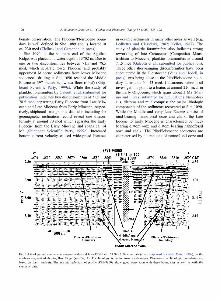
Fig. 3. Lithology and synthetic seismograms derived from ODP Leg 177 Site 1088 core data (after: Shipboard Scientific Party, 1999a), on the
northern segment of the Agulhas Ridge (see Fig. 1). The lithology is predominantly calcareous. Placements of lithologic boundaries are
based on fossil analysis. The seismic reflectors of profile AWI-98008 show good correlation with these boundaries as well as with the
synthetic data.
E. Wildeboer Schut et al. / Global and Planetary Change 34 (2002) 185–198190
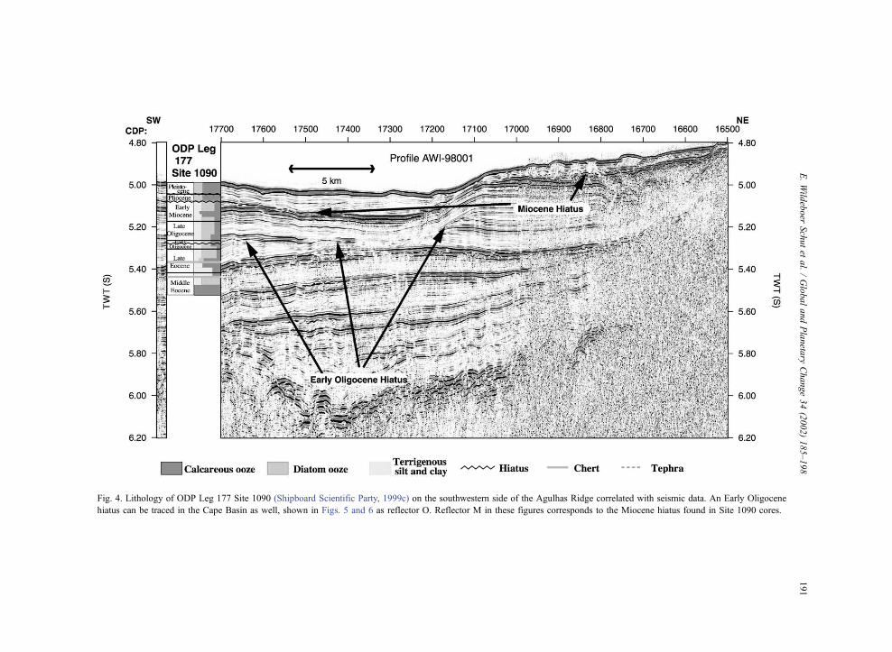
Fig. 4. Lithology of ODP Leg 177 Site 1090 (Shipboard Scientific Party, 1999c) on the southwestern side of the Agulhas Ridge correlated with seismic data. An Early Oligocene
hiatus can be traced in the Cape Basin as well, shown in Figs. 5 and 6 as reflector O. Reflector M in these figures corresponds to the Miocene hiatus found in Site 1090 cores.
E.Wild
eboer
Schutet
al./GlobalandPlaneta
ryChange34(2002)185–198
191

diatom-bearing nannofossil ooze. A chert layer has
been encountered at 290 and 340 mbsf, respectively,
in the Eocene section (Shipboard Scientific Party,
1999c). The disconformity at around 70 mcd is
underlain by a tephra layer (Shipboard Scientific
Party, 1999c).
4.3. Incorporation of geological and seismic data
The physical properties measured on the recovered
sediments include density and seismic P-wave veloc-
ity (Gersonde et al., 1999). From these data, synthetic
seismic data were constructed at the core locations,
which can be compared with the recorded seismic
data. In this way, age control of the seismic data is
possible, as the synthetic data is based on the same
core samples as is used for age dating by the analysis
of fossils in the sediments. Erosional surfaces found in
core samples, as well as changes in depositional
conditions as inferred from core data, can be linked
with reflection seismic horizons. Both chemical and
physical properties of sediments have an impact on
the density and P-wave velocity, and thus influence
the reflectivity of seismic horizons.
Density and P-wave velocity are available for all
three sites (Shipboard Scientific Party, 1999a,b,c).
After removal of spurious data, correlation between
various holes and interpolation to fill in depth ranges
with missing data, it was possible to construct a series
of seismic impedances, and with these, a reflectivity
sequence. The P-wave velocities were used to convert
the data from depth-domain into time-domain and
after convolution with a 75-Hz Ricker wavelet syn-
thetic seismograms were generated.
Fig. 5. Part of seismic profile AWI-98004 in the Cape Basin showing a contourite deposit. The � symbol denotes flow direction in westward
direction of the palaeo bottom current, responsible for deposition of the contourite. Reflector E corresponds to the top of a pre-Oligocene
sedimentary sequence, probably Late Eocene, reflector O marks an Early Oligocene erosional surface, reflector M corresponds to a Miocene
hiatus, reflector P denotes base Pleistocene. B denotes top basement.
E. Wildeboer Schut et al. / Global and Planetary Change 34 (2002) 185–198192

4.4. Results
On the basis of constructed synthetic seismograms,
we identified the seismic reflectors on profile AWI-
98008, at the location of Site 1088, corresponding
with hiatuses like at the Pliocene/Pleistocene boun-
dary (Shipboard Scientific Party, 1999a) and a hiatus
at 209 mcd (Marino and Flores, submitted for pub-
lication) in the Middle Miocene. Also, increased
sediment rates often accompany lithologic variations,
creating reflectors, like at the Miocene/Pliocene boun-
dary (denoted A in Fig. 3), where sedimentation
increases from 7.5. to 17 m/Ma, and in the Late
Miocene (denoted B) where sedimentation increases
from 17 to 30 m/Ma (Shipboard Scientific Party,
1999a).
Fig. 4 shows that the Miocene hiatus as cored at
Site 1090 and the Early Oligocene hiatus are related to
distinct seismic reflectors as well. A comparison of
the stratigraphic sequence in the seismic data at CDP
17000 of profile AWI-98001 (Fig. 4) and CDP 17700
near the location of Site 1090 shows that a sequence
of approximately 80 m of sediments is missing at the
Early Oligocene hiatus at Site 1090. Considering a
duration of 3 Ma of the Early Oligocene hiatus at Site
1090 (Marino and Flores), this would suggest sed-
imentation rates of 25–30 m/Ma during the Early
Oligocene. These reflectors can be identified on sev-
eral profiles in the Cape Basin, for instance profile
AWI-98004 (Fig. 5) and profile AWI-98002 (Fig. 6),
where the Early Oligocene and the Miocene hiatus are
denoted as reflectors O and M, respectively. The
sequence between O and M can be identified not only
based on these strong reflectors and clear unconform-
ities, like for the Early Oligocene hiatus on profile
AWI-98001, but also by the transparent seismic char-
acter of the sediments in between these reflectors.
This is attributed to the moderate sedimentation rates
of 10–20 m/Ma without drastic change in the depo-
sitional facies (Diekmann et al., submitted for pub-
lication) and a relatively high concentration of sili-
ceous sediments (Diekmann et al., submitted for
publication). Several hundred meters of sediment have
accumulated in a buried drift where a mound has been
built up in the CMP range 9450–9850 (Fig. 5). The
strong reflector over this drift structure, just before a
westward migration of the crest, can be related to the
Early Oligocene hiatus recovered at Site 1090 (Fig. 4).
Fig. 6. Part of seismic profile AWI-98002 with bottom current deposits. The reflector O denotes an Early Oligocene erosional surface, reflector
M corresponds to a Miocene hiatus and reflector P corresponds to base Pleistocene. B denotes top basement.
E. Wildeboer Schut et al. / Global and Planetary Change 34 (2002) 185–198 193
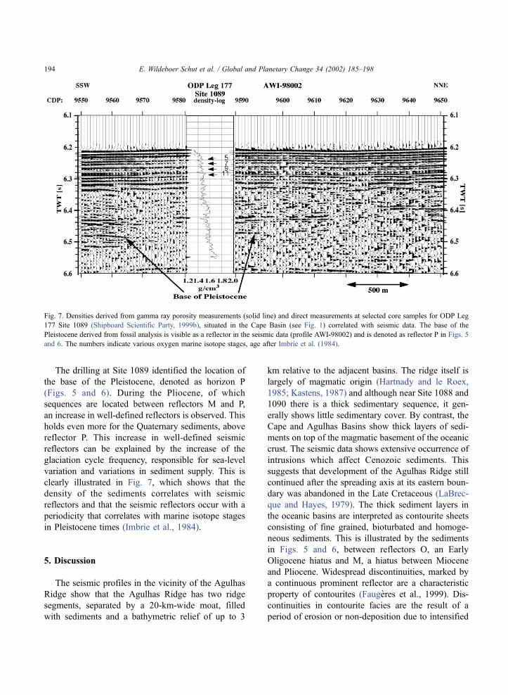
The drilling at Site 1089 identified the location of
the base of the Pleistocene, denoted as horizon P
(Figs. 5 and 6). During the Pliocene, of which
sequences are located between reflectors M and P,
an increase in well-defined reflectors is observed. This
holds even more for the Quaternary sediments, above
reflector P. This increase in well-defined seismic
reflectors can be explained by the increase of the
glaciation cycle frequency, responsible for sea-level
variation and variations in sediment supply. This is
clearly illustrated in Fig. 7, which shows that the
density of the sediments correlates with seismic
reflectors and that the seismic reflectors occur with a
periodicity that correlates with marine isotope stages
in Pleistocene times (Imbrie et al., 1984).
5. Discussion
The seismic profiles in the vicinity of the Agulhas
Ridge show that the Agulhas Ridge has two ridge
segments, separated by a 20-km-wide moat, filled
with sediments and a bathymetric relief of up to 3
km relative to the adjacent basins. The ridge itself is
largely of magmatic origin (Hartnady and le Roex,
1985; Kastens, 1987) and although near Site 1088 and
1090 there is a thick sedimentary sequence, it gen-
erally shows little sedimentary cover. By contrast, the
Cape and Agulhas Basins show thick layers of sedi-
ments on top of the magmatic basement of the oceanic
crust. The seismic data shows extensive occurrence of
intrusions which affect Cenozoic sediments. This
suggests that development of the Agulhas Ridge still
continued after the spreading axis at its eastern boun-
dary was abandoned in the Late Cretaceous (LaBrec-
que and Hayes, 1979). The thick sediment layers in
the oceanic basins are interpreted as contourite sheets
consisting of fine grained, bioturbated and homoge-
neous sediments. This is illustrated by the sediments
in Figs. 5 and 6, between reflectors O, an Early
Oligocene hiatus and M, a hiatus between Miocene
and Pliocene. Widespread discontinuities, marked by
a continuous prominent reflector are a characteristic
property of contourites (Faugeres et al., 1999). Dis-
continuities in contourite facies are the result of a
period of erosion or non-deposition due to intensified
Fig. 7. Densities derived from gamma ray porosity measurements (solid line) and direct measurements at selected core samples for ODP Leg
177 Site 1089 (Shipboard Scientific Party, 1999b), situated in the Cape Basin (see Fig. 1) correlated with seismic data. The base of the
Pleistocene derived from fossil analysis is visible as a reflector in the seismic data (profile AWI-98002) and is denoted as reflector P in Figs. 5
and 6. The numbers indicate various oxygen marine isotope stages, age after Imbrie et al. (1984).
E. Wildeboer Schut et al. / Global and Planetary Change 34 (2002) 185–198194
current activity or by a compositional change (Fau-
geres et al., 1999). The sediments encountered on
profiles AWI-98004 (Fig. 5) and AWI-98002 (Fig. 6)
are seismically relatively transparent, i.e. they show
mainly low amplitude seismic reflections. This is
indicative of a contouritic sheet that has been built
up by a steady bottom current with little variations in
sediment supply. Reflectors in intermittent reflective
sequences are highly discontinuous, a result of bio-
turbation and differential compaction.
An expression of bottom currents forced to follow
the Agulhas Ridge is observed in this sediment
sequence at the northern end of profile AWI-98004
in the Cape Basin (Fig. 5). The transect of this drift is
up to 7.5 km in a direction perpendicular to the
Agulhas Ridge, with the crest migrating towards the
Agulhas Ridge for younger sediments. The reflectors
below the Oligocene hiatus within this elongate con-
tourite drift (Fig. 5, CMP 9450–9850) are more
pronounced than younger sediments. The explanation
for this variation in reflectivity lies within changes
in depositional environment, for instance relative
changes in current velocities, as a higher velocity
environment leads to coarser grain-sized sediments.
Another possibility is a compositional change of the
sediments, e.g. by an increase or decrease of siliceous
components. Indeed, the lithology of Site 1090 (Fig.
2) shows a change towards more terrigenous material
in sediments younger than Early Oligocene. An asym-
metric signature of deposition and migration of the
crest towards the left side of the current (on the
southern hemisphere) is characteristic for elongate
contouritic drifts due to the Coriolis effect and sug-
gests a westward bottom current. This drift is also
apparent on profile AWI-98008 as a very wide
sequence of sediment layers as this profile is mostly
parallel to the drift. The Agulhas Ridge has clearly
acted as a barrier for sediment carrying ocean currents,
forcing the current to flow parallel to the ridge. The
present-day bottom current in this part of the Cape
Basin also follows a westward path (Tucholke and
Embley, 1984; Faugeres et al., 1993). From this
observation we deduce that since the Early Oligocene
a bottom water current comparable to the present-day
bottom current sweeps the Cape Basin and follows the
same trajectory. Previously, Johnson (1985) found a
rapidly accumulating bottom current deposits begin-
ning in the Early Oligocene due to AABW flow in the
western South Atlantic. This suggests that bottom
current activity occurred already on a large scale in
the Oligocene.
In the Agulhas Basin bottom current activity can be
observed as well. Here, the bottom current direction is
more ambiguous, as the main branch of ACC in the
Agulhas Basin follows a westward path (Tucholke
and Embley, 1984), but part of it is deflected in
an eastward direction and flows counter-clockwise
around the Agulhas Ridge. A result of this eastward
branch is present in section AWI-98003, just south of
the Agulhas Ridge (Fig. 8), where a small elongate
contourite drift can be observed between CMP 9050
and 9150. The scale of this contourite is of much lesser
extent than the drift on profile AWI-98004 in the Cape
Basin (Fig. 5), due to the more pronounced basement
topography in the Agulhas Basin which confines the
drift on profile AWI-98003. The location of this drift
limits its vertical scale since the location on the flank
of the Agulhas Ridge prohibits the development of
thick sediment packages and for this reason it is not
possible to attach a known time scale from any of the
ODP drill sites to the drift. The mound has a lateral
extent of less than 2 km, overlain by sediments at 5.5 s
TWT, probably originating at the top of the Agulhas
Ridge and resedimented by downslope currents. Giant
sheets of bottom current sediments are not observed in
the Agulhas Basin as the topography is much rougher
than it is in the Cape Basin. Material from the ridge,
eroded by shallow currents, can be a source of the
sediments in the form of turbidites, to be redeposited
by bottom currents in the basins. Possible sources for
erosion could be intermediate water masses or perhaps
interaction with Agulhas Rings. As most recent ocean-
floor spreading in the area of the Agulhas Ridge took
place near the location of Site 1088, it is this part of the
ridge which has the shallowest sea-floor. Closest to the
African continent, this is also the location where
possible interaction with rings shedded from the
Agulhas Retroflection would be strongest. This effect
should be one of supply of sediments, as in contrast to
most of the Agulhas Ridge, Site 1088 shows a thick
sediment cover for which core analysis shows that
accumulation rates at Site 1088 are relatively high
(Shipboard Scientific Party, 1999a). If this is the case,
relatively high input of terrigenous particles from the
African continent could be expected. The high carbo-
nate content of 85 to 95 wt.% (Shipboard Scientific
E. Wildeboer Schut et al. / Global and Planetary Change 34 (2002) 185–198 195

Party, 1999a) suggests that deposition of sediments
transported by Agulhas Rings does not play a big role
on the Agulhas Ridge itself. Deeper in the Cape Basin
where very high sedimentation rates are found, with a
high content of terrigenous components the situation
may be different.
6. Conclusions
Opening and closing of critical gateways for inter-
ocean water exchange at the Eocene–Oligocene boun-
dary contributed to the development of currents like
the ACC and Circumpolar Deep Water, a mixture of
AABWand water masses from the Atlantic, Indian and
Pacific oceans. The effects of early bottom water
currents can be found in the oceanic basins adjacent
to the Agulhas Ridge, which already existed at the
onset of AABW development. Our seismic data show
bottom current activity, documented by contourite
deposits, already in the Oligocene. A southwestward
bottom current was inferred for the Cape Basin, along
the northern slope of the Agulhas ridge. South of the
Agulhas Ridge, a small contourite drift in the Agulhas
Basin indicates an eastward flow of bottom water
during deposition. It is not clear if this flow can be
attributed to a branch of bottom water with an Antarc-
tic origin, and neither can its age be determined, but
like the Oligocene bottom current in the Cape Basin, it
has the same direction as the present-day bottom
current circulation as shown by Tucholke and Embley
(1984). Widespread hiatuses formed in the Early
Oligocene and in the Miocene, related to periods of
erosion or non-deposition, and rapidly increased sed-
imentation, near the Pliocene/Pleistocene boundary
and in theMiocene, lead to abrupt lithologic variations.
Fig. 8. Profile AWI-98003 just south of the Agulhas Ridge. The outlined area shows a buried contourite drift, probably overlying a sequence of
turbidites. The asymmetric appearance of the horizons suggests a current direction oblique to the profile in eastern direction (denoted by symbol
O). B denotes top basement.
E. Wildeboer Schut et al. / Global and Planetary Change 34 (2002) 185–198196

Such variations appear as outstanding reflectors in the
otherwise low reflective seismic sequences as found
throughout the Cape Basin. Variations in current activ-
ity, resulting in increased or decreased supply of sedi-
ments and intensity of current velocity are also re-
sponsible for the characteristics of the seismic
reflections. Sediments of Early Oligocene origin as
well as Quaternary sediments show clear seismic
reflectors, whereas sediments between the Early Oli-
gocene and the Miocene hiatus are seismically trans-
parent with few, discontinuous reflectors. This trans-
parent package corresponds with an increase in the
relative amount of terrigenous mud in the sediments,
during a period in which deposition took place at
moderate sedimentation rates. This indicates constant,
low velocity, currents and hence small grain size sedi-
ments during Late Oligocene and Miocene. For Pleis-
tocene sequences, the climate instability resulted in
rapid variation in sediment supply which leads to
pronounced seismic reflectors.
Acknowledgements
We are grateful for the support of the captain and
crew of R/V Petr Kottsov for their help during the
expedition. We also want to thank Bernhard Die-
kmann for his comments and review of the draft
paper. The expedition was funded by the German
Bundesministerium fur Bildung, Forschung und
Technologie under contract No. 03G0532A. This
research was funded by the Deutsche Forschungsge-
meinschaft. We also want to thank the reviewers for
their valuable comments. This is AWI contribution
number awi-n10080.
References
Barker, P.F., Burrell, J., 1977. The opening of Drake Passage. Mar.
Geol. 25, 15–34.
Ben-Avraham, Z., Hartnady, C.J.H., Malan, J.A., 1993. Early tec-
tonic extension between the Agulhas Bank and the Falkland
Plateau due to the rotation of the Lafonia microplate. Earth
Planet. Sci. Lett. 117, 43–58.
Ben-Avraham, Z., Hartnady, C.J.H., Kitchin, K.A., 1997. Structure
and tectonics of the Agulhas–Falkland fracture zone. Tectono-
physics 282, 83–98.
De Ruijter, W.P.M., Biastoch, A., Drijfhout, S., Lutjeharms, J.R.E.,
Matano, R.P., Pichevin, T., Van Leeuwen, P.J., Weijer, W., 1999.
Indian–Atlantic inter-ocean exchange: dynamics, estimation
and impact. J. Geophys. Res., C 104, 20885–20910.
Diekmann, B., Kuhn, G., Gersonde, R., et al., submitted for pub-
lication. Middle Eocene to Early Miocene sediment record of
long long-term climate change and environmental implications
of a late eocene opal event in the pelagic SE Atlantic sector of
the Southern Ocean (ODP Site 1090).
Droxler, A.W., Burke, K.C., Cunningham, A.D., Hine, A.C., Rosen-
crantz, E., Duncan, D.S., Hallock, P., Robinson, E., 1998. Car-
ibbean constraints on circulation between Atlantic and Pacific
Oceans over the past 40 million years. In: Crowley, T.J., Burke,
K.C. (Eds.), Tectonic Boundary Conditions For Climate Recon-
struction, Oxford Monographs on Geology and Geophysics, vol.
39. Oxford Univ. Press, New York, pp. 169–191, Chap. 8.
Faugeres, J.C., Stow, D.A.V., 1993. Bottom-current-controlled sed-
imentation: a synthesis of the contourite problem. Sediment.
Geol. 82, 287–297.
Faugeres, J.C., Mezerais, M.L., Stow, D.A.V., 1993. Contourite drift
types and their distribution in the North and South Atlantic
Ocean basins. Sediment. Geol. 82, 189–203.
Faugeres, J.C., Stow, D.A.V., Imbert, P., Viana, A., 1999. Seismic
features diagnostic of contourite drifts. Mar. Geol. 162, 1–38.
Galeotti, S., et al., submitted for publication.
Gersonde, R., Hodell, D.A., Blum, P., et al. (Eds.), 1999. Proceed-
ings of the Ocean Drilling Program, Initial Reports, vol. 177
[CD-ROM]. Available From: Ocean Drilling Program. Texas
A&M University, College Station, TX 77845-9547, USA.
Hartnady, C.J.H., le Roex, A.P., 1985. Southern ocean hotspot
tracks and the Cenozoic absolute motion of the African, Ant-
arctic and South American plates. Earth Planet. Sci. Lett. 75,
245–257.
Heezen, B.C., Hollister, C.D., Ruddiman, W.F., 1966. Shaping of
the continental rise by deep geostrophic contour currents. Sci-
ence 152, 502–508.
Imbrie, J., Hays, J.D., Martinson, D.G., McIntyre, A., Mix, A.C.,
Morley, J.J., Pisias, N.G., Prell, W.L., Shackleton, N.J., 1984.
The orbital theory of Pleistocene climate: support from a revised
chronology of the marine d18O record. In: Berger, A., Imbrie, J.,
Hays, J., Kukla, G., Saltzman, B. (Eds.), Milankovitch and Cli-
mate. Reidel, Dordrecht, pp. 269–305.
Johnson, D.A., 1985. Abyssal teleconnections: II. Initiation of Ant-
arctic Bottom Water flow in the southwestern Atlantic. In: Hsu,
K.J., Weissert, H.J. (Eds.), South Atlantic Paleoceanography.
Cambridge Univ. Press, Cambridge, pp. 243–281, Chap. 14.
Kastens, K.A., 1987. A compendium of causes and effects of pro-
cesses at transform faults and fracture zones. Rev. Geophys. 25,
1554–1562.
Keller, G., 1987. Paleodepth distribution of Neogene deep-sea hia-
tuses. Paleoceanography 2, 697–713.
Kennett, J.P., 1977. Cenozoic evolution of Antarctic glaciation, the
circum-Antarctic ocean, and their impact on global paleocea-
nography. J. Geophys. Res. 82, 3843–3860.
LaBrecque, J.L., Hayes, D.E., 1979. Seafloor spreading history of
the Agulhas Basin. Earth Planet. Sci. Lett. 45, 411–428.
Lawver, L.A., Gahagan, L.M., 1998. Opening of Drake Passage and
its impact on Cenozoic ocean circulation. In: Crowley, T.J.,
Burke, K.C. (Eds.), Tectonic Boundary Conditions for Climate
E. Wildeboer Schut et al. / Global and Planetary Change 34 (2002) 185–198 197

Reconstruction, Oxford Monographs on Geology and Geophy-
sics, vol. 39. Oxford Univ. Press, Oxford, pp. 212–223, Chap.
10.
Ledbetter, M.T., Ciesielski, P.F., 1982. Bottom-current erosion
along a traverse in the south Atlantic sector of the Southern
Ocean. Mar. Geol. 46, 329–341.
Lutjeharms, J.R.E., 1996. The exchange of water between the South
Indian and the South Atlantic oceans. In: Wefer, G., Berber,
W.H., Siedler, G., Webb, D.J. (Eds.), The South Atlantic: Pres-
ent and Past Circulation. Springer-Verlag, Berlin, pp. 125–162.
Mackensen, A., Ehrmann, W.U., 1992. Middle Eocene through
Early Oligocene climate history and palaeoceanography in
the Southern Ocean: stable oxygen and carbon isotopes from
ODP sites on Maud Rise and Kerguelen Plateau. Mar. Geol. 108,
1–27.
Marino, M., Flores, J.A., submitted for publication.
Orsi, A.H., Johnson, G.C., Bullister, J.L., 1999. Circulation, mixing
and production of Antarctic Bottom Water. Progr. Oceanogr. 43,
55–109.
Reid, J.R., 1996. On the circulation of the South Atlantic Ocean. In:
Wefer, G., Berber, W.H., Siedler, G., Webb, D.J. (Eds.), The
South Atlantic: Present and Past Circulation. Springer-Verlag,
Berlin, pp. 13–44.
Sandwell, D.T., Smith, W.H.F., 1997. Marine gravity anomaly from
Geosat and ERS-1 satellite altimetry. J. Geophys. Res., B 102,
10039–10054.
Shannon, L.V., Hunter, D., 1988. Antarctic Intermediate Water
around South Africa. S. Afr. J. Mar. Sci. 6, 107–117.
Shipboard Scientific Party, 1999a. Site 1088. In: Gersonde, R.,
Hodell, D.A., Blum, P., et al. (Eds.), Proc. ODP, Init. Repts.,
vol. 177. Available from: Ocean Drilling Program. Texas A&M
University, College Station, TX 77845-9547, USA, pp. 1–66
[CD-ROM].
Shipboard Scientific Party, 1999b. Site 1089. In: Gersonde, R.,
Hodell, D.A., Blum, P., et al. (Eds.), Proc. ODP, Init. Repts.,
vol. 177. Available from: Ocean Drilling Program. Texas A&M
University, College Station, TX 77845-9547, USA, pp. 1–97
[CD-ROM].
Shipboard Scientific Party, 1999c. Site 1090. In: Gersonde, R.,
Hodell, D.A., Blum, P., et al. (Eds.), Proc. ODP, Init. Repts.,
vol. 177. Available from: Ocean Drilling Program. Texas A&M
University, College Station, TX 77845-9547, USA, pp. 1–101
[CD-ROM].
Stow, D.A.V., Faugeres, JC., Viana, A., Gonthier, E., 1998. Fossil
contourites: a critical review. Sediment. Geol. 115, 3–31.
Sykes, T.J.S., Ramsay, A.T.S., Kidd, R.B., 1998. Southern hemi-
sphere Miocene bottom-water circulation: a palaeobathymetric
analysis. In: Cramp, A., MacLeod, C.J., Lee, S.V., Jones, E.J.W.
(Eds.), Geological Evolution of Ocean Basins: Results from the
Ocean Drilling Program, Special Publications, vol. 131. Geo-
logical Society, London, pp. 43–54, Chap. 10.
Tucholke, B.E., Embley, R.W., 1984. Cenozoic regional erosion of
the abyssal sea floor off South Africa. In: Schlee, J.S. (Ed.),
Interregional Unconformities and Hydrocarbon Accumulation.
AAPG Memoir, vol. 36, pp. 145–164.
Turneau, R., Ledbetter, M.T., 1989. Deep circulation changes in the
South Atlantic ocean: response to initiation of northern hemi-
sphere glaciation. Paleoceanography 4, 565–583.
Uenzelmann-Neben, G. (Ed.), 1998. Sedimentation and tectonics of
Agulhas Ridge and Agulhas Plateau. Reports on Polar Research,
vol. 273. Alfred Wegener Institute for Polar and Marine Re-
search, D-27568 Bremerhaven, Federal Republic of Germany,
22 pp.
Venz, K.A., Hodell, D.A., in press. New evidence for changes in
Plio-Pleistocene deep water circulation from Southern Ocean
ODP Leg 177 Site 1090. Palaeogeography, Palaeoclimatology,
Palaeoecology.
Zachos, J.C., Stott, L.D., Lohmann, K.C., 1994. Evolution of early
Cenozoic marine temperatures. Paleoceanography 9, 353–387.
Zielinski, U., Gersonde, R., in press. Plio-Pleistocene diatom bio-
stratigraphy from ODP Leg 177, Atlantic sector of the Southern
Ocean. Palaeogeography, Palaeoclimatology, Palaeoecology.
E. Wildeboer Schut et al. / Global and Planetary Change 34 (2002) 185–198198