Seismic Attributes Aided Fault Detection and Enhancement...
4
Seismic Attributes Aided Fault Detection and Enhancement in the Sirte Basin, Libya Abdalla Abdelnabi, Kelly H. Liu, and Stephen Gao, Missouri University of Science and Technology Yousf Abushalah, Uinversity of Texas Summary Cambrian-Ordovician and Upper Cretaceous reservoir formations, the primary producing formations in the Sirte Basin, Libya have complex structures which affect the performance of the reservoirs. It is critical to understand the complicated relationships between fault networks, fractures, and stratigraphy of the area for future field development. However, detecting faults especially subtle faults and fractures is a challenging task using conventional seismic data due to the low signal-to-noise ratio. Seismic attributes provide effective tools in identifying and enhancing fault and fracture interpretation beyond the seismic resolution of the conventional seismic data. In this study, we focus on coherence and curvature attributes extracted from the post- stack 3D seismic data acquired in the central Sirte Basin to delineate subtle fault and fracture zones. We applied a median filter and spectral whitening to enhance the data quality and remove noise resulted from acquisition and processing effects. We utilized these methods to produce high-resolution data and preserve structural features. A total of 17 faults have been identified in the study area. The most common fractures in the Cambrian-Ordovician reservoir formations are in the northwest and southeast of the field. Seismic data conditioning and seismic attribute analyses applied on the 3-D seismic data effectively increased our understanding of the reservoir complex and help detect and identify subtle faults and fracture zones in the study area. Introduction The Sirte Basin located in the north central part of Libya is one of the most prolific oil producing fields in the world (Figure 1). From the beginning of the Late Cretaceous, extensional tectonics caused a partial collapse of the Sirte Arch that resulted in the development of a system of horsts and grabens (Ahlbrandt, 2001; Hallett, 2002). The major structural features that have affected the sedimentation pattern in the study area include four northwest-southeast- trending structures, i.e., the Zallah trough and Dahra platform to the west, Beda Platform in the central part of the area, and Zelten platform and Ajdabiya Trough to the east (Figure 2). Numerous faults and fractures located in the Cambrian-Ordovician and Upper Cretaceous reservoir formations have a significant effect in reservoir producing and efficiency (Abadi et al., 2008; Brennan, 1992). The study area is situated within the Beda Platform in the southern part of the Sirte Basin (Figures 1 and 2). The trap in the RG-oil Field is a large irregular dome-shaped structure covering an area of about 25,000 acres. It is bounded on the west by a major NE-SW-trending normal fault with minor faults cut into the interior of the structure. Faults and fractures play a significant role in the field. Faults are believed to affect the distribution and thickness of the primary producing Cambrian-Ordovician and Upper Cretaceous reservoir formations. Natural fractures in the reservoir formation in the study area represent the most significant factor in the reservoir capacity and performance (Abdelnabi et al., 2016; Brennan, 1992). Because of its complex structure, it is crucial to understand the relationships between the fault network and stratigraphy of the area for future field development. Figure 1: Topography map showing the major sedimentary basins in Libya, including the Sirte, Kufra, Murzuq, and Ghadames basins. The study area is located in the Sirte Basin marked by the red rectangle box. It has long been recognized that seismic attributes can reveal features hidden in seismic data. Among hundreds of seismic attributes developed, coherency or similarity and curvature are proven to be the most effective attributes in the interpretation of structural discontinuities. The objective of this study is to utilize the seismic attributes to determine the faults and fractures systematically in the RG-oil Field in the north central Sirte Basin and to better understand their relationship to the reservoir formations.
Transcript of Seismic Attributes Aided Fault Detection and Enhancement...
Seismic Attributes Aided Fault Detection and Enhancement in the Sirte Basin, Libya Abdalla Abdelnabi, Kelly H. Liu, and Stephen Gao, Missouri University of Science and Technology Yousf Abushalah, Uinversity of Texas Summary Cambrian-Ordovician and Upper Cretaceous reservoir formations, the primary producing formations in the Sirte Basin, Libya have complex structures which affect the performance of the reservoirs. It is critical to understand the complicated relationships between fault networks, fractures, and stratigraphy of the area for future field development. However, detecting faults especially subtle faults and fractures is a challenging task using conventional seismic data due to the low signal-to-noise ratio. Seismic attributes provide effective tools in identifying and enhancing fault and fracture interpretation beyond the seismic resolution of the conventional seismic data. In this study, we focus on coherence and curvature attributes extracted from the post-stack 3D seismic data acquired in the central Sirte Basin to delineate subtle fault and fracture zones. We applied a median filter and spectral whitening to enhance the data quality and remove noise resulted from acquisition and processing effects. We utilized these methods to produce high-resolution data and preserve structural features. A total of 17 faults have been identified in the study area. The most common fractures in the Cambrian-Ordovician reservoir formations are in the northwest and southeast of the field. Seismic data conditioning and seismic attribute analyses applied on the 3-D seismic data effectively increased our understanding of the reservoir complex and help detect and identify subtle faults and fracture zones in the study area. Introduction The Sirte Basin located in the north central part of Libya is one of the most prolific oil producing fields in the world (Figure 1). From the beginning of the Late Cretaceous, extensional tectonics caused a partial collapse of the Sirte Arch that resulted in the development of a system of horsts and grabens (Ahlbrandt, 2001; Hallett, 2002). The major structural features that have affected the sedimentation pattern in the study area include four northwest-southeast-trending structures, i.e., the Zallah trough and Dahra platform to the west, Beda Platform in the central part of the area, and Zelten platform and Ajdabiya Trough to the east (Figure 2). Numerous faults and fractures located in the Cambrian-Ordovician and Upper Cretaceous reservoir formations have a significant effect in reservoir producing and efficiency (Abadi et al., 2008; Brennan, 1992). The study area is situated within the Beda Platform in the southern part of the Sirte Basin (Figures 1 and 2). The trap in the RG-oil Field is a large irregular dome-shaped structure covering an area of about 25,000 acres. It is bounded on the west by a major NE-SW-trending normal fault with minor
faults cut into the interior of the structure. Faults and fractures play a significant role in the field. Faults are believed to affect the distribution and thickness of the primary producing Cambrian-Ordovician and Upper Cretaceous reservoir formations. Natural fractures in the reservoir formation in the study area represent the most significant factor in the reservoir capacity and performance (Abdelnabi et al., 2016; Brennan, 1992). Because of its complex structure, it is crucial to understand the relationships between the fault network and stratigraphy of the area for future field development.
Figure 1: Topography map showing the major sedimentary basins in Libya, including the Sirte, Kufra, Murzuq, and Ghadames basins. The study area is located in the Sirte Basin marked by the red rectangle box. It has long been recognized that seismic attributes can reveal features hidden in seismic data. Among hundreds of seismic attributes developed, coherency or similarity and curvature are proven to be the most effective attributes in the interpretation of structural discontinuities. The objective of this study is to utilize the seismic attributes to determine the faults and fractures systematically in the RG-oil Field in the north central Sirte Basin and to better understand their relationship to the reservoir formations.
Seismic Attributes Aided Fault Detection and Enhancement in the Sirte Basin, Libya
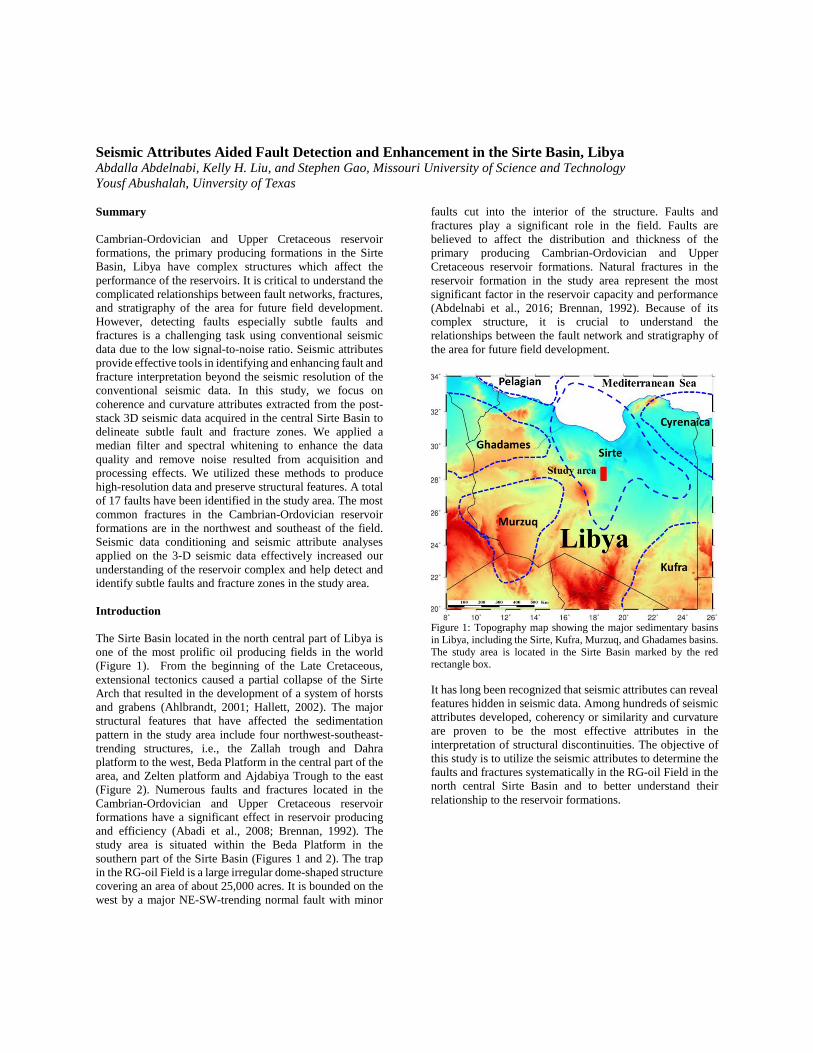
Figure 2: A cross-section showing the main structural features related to the sedimentation pattern in the study area. From west to east, the structures include the Zallah trough, Dahra platform, Beda Platform in the central, Zelten platform, and Ajdabiya Trough to the east (Modified after Abdi et al., 2008). Data, Methodology, and Results The data set utilized in this study includes a 3-D post-stack seismic volume acquired in 2004 covering a surface area of 350 km2. The data consist of 746 inlines and 1465 crosslines with a line spacing of 20 m. The procedure to map and enhance fault interpretation in this study includes data conditioning and seismic attribute analysis. The workflow employed is shown in details in Figure 3. Data conditioning. Seismic attributes used in this study to detect the discontinuities are typically sensitive to noise. Previous studies indicate that most attributes calculated from seismic data are only as good as the quality of the input (Barnes, 2016). The quality of the seismic data employed in the study ranges from fair to good. The data quality decreases with increasing depth due to several factors occurring during data acquisition and processing. Random noise, acquisition related noise, and processing related noise are present in the post-stack data despite the effort and careful process of the pre-stack data. It is essential to remove the unwanted signal (noise) resulted from acquisition and processing and to improve the data resolution before any attribute analysis. We use the data whitening method to enhance the resolution of the data. Data whitening mainly uses the information contained in low frequencies to correct and predict the high frequencies and improve the resolution of the seismic data without adding any noise to the original data (Barnes, 2016; Helmore, 2009). A median filter was also applied to the post-stack data and was used as a noise filter. Both processes were utilized at each time before we extract attributes to improve the resolution (Figure 4).
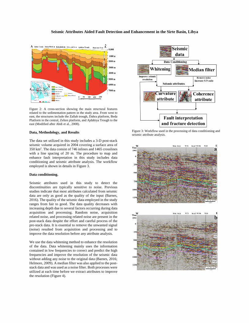
Figure 3: Workflow used in the processing of data conditioning and seismic attribute analysis.

Seismic Attributes Aided Fault Detection and Enhancement in the Sirte Basin, Libya
Figure 4: (a) Original seismic inline 1215. (b) After application of whitening. (c) After applying the median filter. Note data quality and fault image are significantly improved after the median filter and spectral whitening compared to original seismic data. Coherence or similarity attribute. Coherence or Similarity attribute quantifies the similarities between two or more traces. A similarity of “1” means seismic reflections have consistent phase and amplitude. The similarity of “0” means seismic reflections have inconsistent phase and amplitude and reveals the break in the trace which could result from faults, channel, fracture, and pinch-outs (Chopra and Marfurt, 2010; Dewett and Henza, 2016). The attribute is used in this study to improve delineation of the major faults and detect small faults and fracture zones. We extract the coherence attribute at 950 ms at the top of reservoir formation from the 3-D seismic data (Figure 5). It apparently detects major faults and minor fault and to some degree fracture zones. Curvature attribute. Different types of curvature attributes can be computed from seismic data which include most positive, most negative, along dip, and along strike. Most positive and most negative curvatures are the best attributes in defining fractures and faults, and they are widely used to determine the upthrown fault blocks and downthrown fault blocks (Bailey et al., 2016; Chopra and Marfurt, 2007; Schneider et al., 2016). In this study, we use both most positive and most negative curvatures to determine upthrown and downthrown fault blocks. The most positive curvature indicates the upthrown side of the fault and the most negative curvature indicates the downthrown side of the fault (Figure 6). The most positive and most negative curvature slices are used to detect the fracture zones which typically occur at or near anticlines, synclines, or in folded layers of brittle strata. Using the attribute, we have detected fractures in the study area in the northwest and southeast in the Cambrian-Ordovician reservoir formation (Figure 7). The better defined fracture
zones are crucial for the development of the reservoir, as it depends on the natural fracture zones for its production. Fault interpretation and fault visualization. Data conditioning and seismic attributes help better understand the location, trend of major and minor faults. The interpreted faults are labeled in Figure 8. The major F1 is a NE-SW-trending normal fault with a throw of 800 ft. It is believed to seal the structural on the west side of the field. The major fault F2 has a throw of 400 ft and is believed to seal the structural on the east side of the field. With the use of seismic attributes, we have identified numerous minor faults which cut the interior of the structure with throw ranging from 50 to 150 ft. After mapping the faults in the Cambrian-Ordovician and Upper Cretaceous reservoir formations, we have constructed a fault model (Figure 8). Conclusions Data conditioning is a critical tool to improve the data quality and remove random noise. Median filter and spectral whitening significantly improved the data quality and increased the resolution of the data set, and preserved edges and structural features. The integration of the attributes has improved confidence in the seismic mapping of the faults and the fractures which were difficult to identify in the input data. Coherence and curvature attributes efficiently detected and enhanced faults and fracture zones of the Cambrian-Ordovician and Upper Cretaceous reservoir formations in the study area. Coherence or similarity attribute works the best in delineating fault with sharp edges, while the curvature attributes (most positive, most negative) are efficient in defining the fracture zone and determining the upthrow and downthrow of the faults. Acknowledgments The authors wish to acknowledge the National Oil Company and the Sirte Oil Company for providing data used in this study.

Seismic Attributes Aided Fault Detection and Enhancement in the Sirte Basin, Libya
Figure 5: Time slice at 950 ms from (a) the original data and (b) Coherence slice extracted from the conditioned data. The horst, graben, and major and minor faults are visible in the coherence slice.
Figure 6: (a) Most positive curvature seismic inline 1215. The high positive value in red color indicates upthrow of the faults. (b) Most negative curvature seismic inline 1215 showing the high negative value. Blue color indicates downthrow of the faults.
Figure 7: (a) Most positive curvature slice at 950 ms. (b) Most negative slice at 950 ms. Black circles outline the locations of the fracture zones in the Cambrian-Ordovician reservoir formation.
Figure 8: Fault model showing the major and minor faults identified in the Upper Cretaceous and Cambrian-Ordovician reservoir formations.