Sedimentary Environments in Long Island Sound: A Guide - USGS
2
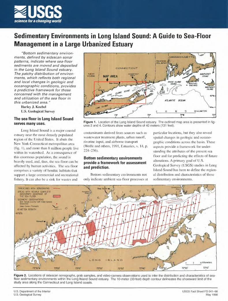
USGS science for a changing world Sedimentary Environments in Long Island Sound: A Guide to Sea-Floor Management in a Large Urbanized Estuary "Bottom sedimentary environ- ments, defined by sidescan-sonar patterns, indicate where sea-floor sediments are moved and deposited in the Long Island Sound estuary. The patchy distribution of environ- ments, which reflects both regional and local changes in geologic and oceanographic conditions, provides a predictive framework for those concerned with the management and utilization of the sea floor in this urbanized area." Harley J. Knebel U.S. Geological Survey The sea floor in Long Island Sound serves many uses. Long Island Sound is a major coastal estuary near the most densely populated region of the United States. It abuts the New York-Connecticut metropolitan area (fig. 1), and more than 8 million people live within its watershed. As a consequence of this enormous population, the sound is heavily used, and, thus, the sea floor can be affected by human activities. The sea floor comprises a variety of benthic habitats that support a large commercial and recreational fishery. It can also be a sink for wastes and CONNECTICUT NEW I YORK I MAP AREA ; f 7PW 70« Figure 1 . Location of the Long Island Sound estuary. The outlined map area is presented in fig- ures 2 and 4. Contours show water depths of 40 meters (131 feet). contaminants derived from sources such as wastewater treatment plants, urban runoff, riverine input, and airborne transport (Wolfe and others, 1991, Estuaries, v. 14. p. 224-236). Bottom sedimentary environments provide a framework for assessment and prediction. Bottom sedimentary environments not only indicate ambient sea-floor processes at particular locations, but they also reveal spatial changes in geologic and oceano- graphic conditions across the basin. These aspects provide a framework for under- standing the attributes of the present sea floor and for predicting the effects of future alterations. A primary goal of U.S. Geological Survey (USGS) studies in Long Island Sound has been to define the region- al distribution and characteristics of these sedimentary environments. TRACKLINES WITH SONOGRAPHS AREAS WITH NEARLY COMPLETE SONOGRAPH COVERAGE OF ,___. THE SEA FLOOR ["""""I SEDIMENT OBSERVATIONS Grab Sample Location with Video-Camera Observation Video-Camera Transects 10-METER ISOBATH -4I°IO'N Figure 2. Locations of sidescan sonographs, grab samples, and video-camera observations used to infer the distribution and characteristics of sea- floor sedimentary environments within the Long Island Sound estuary. The 10-meter (33-foot) depth contour delineates the shoreward limit of the study area along the Connecticut and Long Island coasts. U.S. Department of the Interior U.S. Geological Survey USGS Fact Sheet FS 041-98 May 1998
Transcript of Sedimentary Environments in Long Island Sound: A Guide - USGS
USGSscience for a changing world
Sedimentary Environments in Long Island Sound: A Guide to Sea-Floor Management in a Large Urbanized Estuary
"Bottom sedimentary environ ments, defined by sidescan-sonar patterns, indicate where sea-floor sediments are moved and deposited in the Long Island Sound estuary. The patchy distribution of environ ments, which reflects both regional and local changes in geologic and oceanographic conditions, provides a predictive framework for those concerned with the management and utilization of the sea floor in this urbanized area."
Harley J. KnebelU.S. Geological Survey
The sea floor in Long Island Sound serves many uses.
Long Island Sound is a major coastal estuary near the most densely populated region of the United States. It abuts the New York-Connecticut metropolitan area (fig. 1), and more than 8 million people live within its watershed. As a consequence of this enormous population, the sound is heavily used, and, thus, the sea floor can be affected by human activities. The sea floor comprises a variety of benthic habitats that support a large commercial and recreational fishery. It can also be a sink for wastes and
CONNECTICUT
NEW IYORK I MAP AREA
; f
7PW 70«
Figure 1 . Location of the Long Island Sound estuary. The outlined map area is presented in fig ures 2 and 4. Contours show water depths of 40 meters (131 feet).
contaminants derived from sources such as wastewater treatment plants, urban runoff, riverine input, and airborne transport (Wolfe and others, 1991, Estuaries, v. 14. p. 224-236).
Bottom sedimentary environments provide a framework for assessment and prediction.
Bottom sedimentary environments not only indicate ambient sea-floor processes at
particular locations, but they also reveal spatial changes in geologic and oceano graphic conditions across the basin. These aspects provide a framework for under standing the attributes of the present sea floor and for predicting the effects of future alterations. A primary goal of U.S. Geological Survey (USGS) studies in Long Island Sound has been to define the region al distribution and characteristics of these sedimentary environments.
TRACKLINES WITH SONOGRAPHS AREAS WITH NEARLY COMPLETE
SONOGRAPH COVERAGE OF ,___. THE SEA FLOOR ["""""I
SEDIMENT OBSERVATIONS Grab Sample Location with Video-Camera Observation Video-Camera Transects
10-METER ISOBATH -4I°IO'N
Figure 2. Locations of sidescan sonographs, grab samples, and video-camera observations used to infer the distribution and characteristics of sea- floor sedimentary environments within the Long Island Sound estuary. The 10-meter (33-foot) depth contour delineates the shoreward limit of the study area along the Connecticut and Long Island coasts.
U.S. Department of the Interior U.S. Geological Survey
USGS Fact Sheet FS 041-98 May 1998

Sea-floor sedimentary environments can be recognized by characteristic sidescan-sonar patterns.
The USGS, in cooperation with the State of Connecticut Department of Environmental Protection and the U.S. Environmental Protection Agency, collected an extensive set of sidescan sonographs to characterize the sea floor within the Long Island Sound basin (fig. 2). Backscatter patterns in the sonographs (fig. 3) were interpreted with the aid of strategically located sediment samples and video- camera observations, as well as modeled current and wave data. The sonograph pat terns define four categories of long-term sedimentary environments: erosion or non- deposition; coarse-grained bedload trans port; sediment sorting and reworking; and fine-grained deposition. The distribution of these environments has been mapped across the sound (fig. 4).
The distribution of sedimentary envi ronments is patchy.
Broad areas of fine-grained deposition are present across the generally wide cen tral and western parts of the sound (fig. 4). Here, deposition results from the accumula tion of particle aggregates under relatively weak bottom tidal currents. Locally, how ever, the fine-grained deposits are discon tinuous where bottom currents cause sedi ment winnowing and bypassing. In con trast, the funnel-shaped eastern part of the sound contains large areas of sediment ero sion, transport, and sorting caused by a combination of strong tidal currents and a net westward movement of sediments into
Figure 3. Sonograph obtained across the east- central part of Long Island Sound showing an environment of coarse grained bedload trans port depicted by patterns of sand ribbons and sand waves. Such areas contain only small amounts of fine-grained sediments and associat ed contaminants and may have significant sand resources. A sunken vessel about 18 meters (59 feet) long (marked by asterisk) is present in the sand- ribbon area.
the estuary. Such environments remove most fine-grained detritus and cause selec tive enrichment of sand and gravel on the sea floor.
USGS studies provide essential data for environmental managers.
Environmental managers can use the distribution of bottom sedimentary environ ments to define the locations and variability of benthic habitats because the distributions of benthic habitats and sedimentary envi ronments are largely controlled by the same geologic and oceanographic conditions, such as sea-floor substrate and bottom-cur rent strength. Likewise, the distribution of environments provides insight into the long-term fate of contaminants that are associated with fine-grained detritus. Managers can use this insight to predict where contaminants will ultimately be transported and deposited or to design
effective monitoring programs to document future anthropogenic changes. Managers also can use the distribution of environ ments as a guide to the future utilization of the sea floor. Future activities in Long Island Sound might include the emplace ment of structures on or within the bottom sediments, the disposal of dredged spoil, or the assessment of sand and gravel resources.
For more information, please contact:Harley J. Knebel U.S. Geological Survey Woods Hole Field Center 384 Woods Hole Road Woods Hole, MA 02543-1598 Telephone: (508) 457-2269 Fax:(508)457-2310 E-mail: [email protected]
SEDIMENTARY ENVIRONMENTS
EROSION OR NONDEPOSITION
SEDIMENT SORTING AND REWORKING
FINE-GRAINED DEPOSITION
Figure 4. Reconnaissance map showing the distribution of sedimentary environments across the Long Island Sound estuary. Sedimentary environ ments have been inferred from sonograph patterns, sediment samples, video-camera observations, and modeled current and wave data. The 10- meter (33-foot) depth contour delineates the shoreward limit of the study area along the Connecticut and Long Island coasts.