SECTIONFOUR Consultation and Coordination
25
AT&T NexGen/Core Project 4-1 Consultation and Coordination SECTION SECTION SECTION SECTIONFOUR Consultation and Coordination 4.1 PUBLIC NOTIFICATION Nearly 1,500 landowners in 15 counties within the four states crossed by the project were notified of the project by certified letter during January through May of 2000. Newsletters for the project were also distributed to organizations and individuals that have expressed interest in this type of project. The newsletters contained comment forms and information about other ways to contact the BLM and provide comments about the project. Residents and landowners will be contacted directly and personally prior to construction activities. 4.2 TRIBAL CONSULTATION Tribal consultation was conducted in compliance with Section 106 of the National Historic Preservation Act (NHPA), Native American Graves Protection and Repatriation Act (NAGPRA), and Executive Order 13007, with a primary goal of identifying, documenting, and evaluating properties with traditional cultural significance in terms of National Register criteria. Native American tribes contacted also were asked to provide comments regarding their concerns about the impact of the proposed project on potential traditional cultural properties (TCPs), sacred sites, and burials that may be in or adjacent to the proposed project. Table 4-1 Native American Tribes Contacted Link Tribe Contacted Person Contacted Type of Contact Response/Comments 1 Commanche of Oklahoma § Phyllis Attocknie, former Chairperson § Johnny Wauqua, Chairman § BLM letter and telephone calls § Telephone calls Draft reports sent. Tribe has not yet been contacted regarding joining in PA of Link One. 1 Kiowa of Oklahoma § Lawrence Edge, Cultural and Historical Liaison § George Daingkau § Telephone calls, BLM letter, and draft reports § Telephone call Draft reports sent. Tribe has not yet been contacted regarding joining in PA of Link One. 1 Apache of Oklahoma § Alonso Chalepah, Chairman § Darren Cisco, Cultural Programs Office § Jennifer Hill, Cultural Programs Office § BLM letter and telephone calls § Telephone call § Telephone call Draft reports sent. On 11/8/00 Tribal Chairman called to state that the Tribe wants to be consulted and will review a draft PA. Tribe requested a meeting with BLM. 1,2 Ysleta del Sur Pueblo § Governor Albert Alvidrez § Governor Elias Torres § Rick Quezada, War Captain § Robert Truhill, Attorney § BLM letter § BLM letter § BLM letter § BLM letters and telephone calls Mr. Truhill requested all available information related to Texas including draft reports, EA, draft MOA documents and maps. On 11/3 the Tribe sent a certified letter stating interest in Jornada Mogollon, but no mention of MOA participation. Tribe has not yet been contacted regarding joining in PA of Link One. 1,2,3 Mescalero Apache § Tribal Council § Ms. Ellyn Bigrope, NAGPRA Coordinator and Curator § Donna McFadden, Tribal Historic Preservation Officer § BLM letter § BLM letter § BLM letter and telephone calls Donna McFadden requested copies of summary tables from draft reports for review and draft MOA. WCRM has no record of Tribe requesting to participate in MOA. Tribe has not yet been contacted regarding joining in PA of Link One.
Transcript of SECTIONFOUR Consultation and Coordination

AT&T NexGen/Core Project 4-1 Consultation and Coordination
SECTIONSECTIONSECTIONSECTIONFOUR Consultation and Coordination
4.1 PUBLIC NOTIFICATIONNearly 1,500 landowners in 15 counties within the four states crossed by the project were notified of theproject by certified letter during January through May of 2000. Newsletters for the project were alsodistributed to organizations and individuals that have expressed interest in this type of project. Thenewsletters contained comment forms and information about other ways to contact the BLM and providecomments about the project. Residents and landowners will be contacted directly and personally prior toconstruction activities.
4.2 TRIBAL CONSULTATIONTribal consultation was conducted in compliance with Section 106 of the National Historic PreservationAct (NHPA), Native American Graves Protection and Repatriation Act (NAGPRA), and Executive Order13007, with a primary goal of identifying, documenting, and evaluating properties with traditionalcultural significance in terms of National Register criteria. Native American tribes contacted also wereasked to provide comments regarding their concerns about the impact of the proposed project on potentialtraditional cultural properties (TCPs), sacred sites, and burials that may be in or adjacent to the proposedproject.
Table 4-1Native American Tribes Contacted
Link Tribe Contacted Person Contacted Type of Contact Response/Comments1 Commanche of
Oklahoma� Phyllis Attocknie, former
Chairperson� Johnny Wauqua,
Chairman
� BLM letter andtelephone calls
� Telephone calls
Draft reports sent. Tribe has not yetbeen contacted regarding joining in PAof Link One.
1 Kiowa ofOklahoma
� Lawrence Edge, Culturaland Historical Liaison
� George Daingkau
� Telephone calls,BLM letter, and draftreports
� Telephone call
Draft reports sent. Tribe has not yetbeen contacted regarding joining in PAof Link One.
1 Apache ofOklahoma
� Alonso Chalepah,Chairman
� Darren Cisco, CulturalPrograms Office
� Jennifer Hill, CulturalPrograms Office
� BLM letter andtelephone calls
� Telephone call
� Telephone call
Draft reports sent. On 11/8/00 TribalChairman called to state that the Tribewants to be consulted and will review adraft PA. Tribe requested a meetingwith BLM.
1,2 Ysleta del SurPueblo
� Governor Albert Alvidrez� Governor Elias Torres� Rick Quezada, War
Captain� Robert Truhill, Attorney
� BLM letter� BLM letter� BLM letter
� BLM letters andtelephone calls
Mr. Truhill requested all availableinformation related to Texas includingdraft reports, EA, draft MOA documentsand maps. On 11/3 the Tribe sent acertified letter stating interest in JornadaMogollon, but no mention of MOAparticipation. Tribe has not yet beencontacted regarding joining in PA ofLink One.
1,2,3 MescaleroApache
� Tribal Council� Ms. Ellyn Bigrope,
NAGPRA Coordinator andCurator
� Donna McFadden, TribalHistoric PreservationOfficer
� BLM letter� BLM letter
� BLM letter andtelephone calls
Donna McFadden requested copies ofsummary tables from draft reports forreview and draft MOA. WCRM has norecord of Tribe requesting to participatein MOA. Tribe has not yet beencontacted regarding joining in PA ofLink One.

AT&T NexGen/Core Project 4-2 Consultation and Coordination
Table 4-1Native American Tribes Contacted
Link Tribe Contacted Person Contacted Type of Contact Response/Comments2,3 San Carlos
Apache� Raymond Stanley, Sr.,
Chairman� Paul Nosie, Jr., Director,
San Carlos Apache TribeRecreation and Wildlife
� Vernalda Grant, TribalArchaeologist
� Jenette Cassa/Seth Pilsk,Elders Cultural AdvisoryCouncil
� BLM letter
� BLM letter
� Telephone calls
� BLM letter
Vernalda Grant requested all draftArizona reports and draft MOA. BLMMOA letter sent 8/2/00.
2,3 Fort Sill Apache � Mrs. Ruey Darrow, TribalChairperson
� Mr. Leland MichaelDarrow, NAGPRA Contact
� Michael Darrow, Historian
� BLM letter
� BLM letter
� Telephone calls
Michael Darrow requested draft reportsand made no response when askedabout participating in the MOA.
2,3 White MountainApache
� Dallas Massey, Sr.,Chairman
� Ramom Riley, HeritageProgram Director
� John Welch, TribalHistoric PreservationOffice
� BLM letter
� BLM letter
� BLM letter andtelephone calls
Mr. Welch requested copies of draftreports. Mr. Welch declined toparticipate in the MOA.
2,3 Ak-Chin IndianCommunity
� Leona Kakar, Chairperson� Elaine Peters, Him Dak
Museum Director� Jon Shumaker,
Archaeologist
� BLM letter� BLM letter
� BLM letter andtelephone calls
Mr. Shumaker requested 2 copies ofdraft Arizona reports and draft MOA.BLM MOA letter sent 8/2/00.
2,3 Salt River Pima-MaricopaCommunity
� Ivan Makil, President� Ron Chiago, Cultural
Resource Coordinator
� BLM letter� BLM letter and
telephone calls
Mr. Chiago requested draft Arizonareports and draft MOA. BLM MOA lettersent 8/2/00.
2,3 Fort McDowellMohave-ApacheIndianCommunity
� Bernadine Boyd,President
� Louis Hood, PlanningCoordinator
� Marcie Matson, CulturalDevelopment Office
� BLM letter
� BLM letter
� BLM letter andtelephone calls
Ms. Matson stated that the Tribe hasreviewed the letter and has noquestions and no need for additionalinformation.
2,3 TohonoO’Odham Nation
� Edward D. Manuel,Chairman
� Tony Burrell, LegislativeCouncil
� Peter Steere, Manager ofCultural Affairs
� BLM letter
� BLM letter
� BLM letter andtelephone calls
Mr. Steere requested 2 copies of draftreports and draft MOA. BLM MOA lettersent 8/2/00. Met with ATT and ASM todiscuss monitoring plan agreement forthe southern Tribes.
2,3 Gila River IndianCommunity
� Donald Antone, Governor� Elaine Blackwater, Land
Use OrdinanceEnforcement Officer
� Barnaby Lewis, CulturalResource Specialist
� BLM letter� BLM letter
� BLM letter andtelephone calls
Draft Arizona reports and MOA sent toMr. Lewis. BLM MOA letter sent 8/2/00.
2,3 Pascua YaquiTribe
� Bentio F. Valencia,Chairman
� Fernand de Escalante,Vice-Chairman
� Amalia Reyes, CulturalSpecialist
� BLM letter
� BLM letter
� Telephone calls
Ms. Reyes requested copies of draftArizona reports and draft MOA. BLMMOA letter sent 8/2/00.

AT&T NexGen/Core Project 4-3 Consultation and Coordination
Table 4-1Native American Tribes Contacted
Link Tribe Contacted Person Contacted Type of Contact Response/Comments1,2,3 Hopi Tribe � Wayne Taylor, Jr.
Chairman� Leigh Kuwanwisiwma,
Director, Hopi CulturalPreservation Office
� Clay Hamilton, CulturalPreservation Office
� BLM letter
� BLM letter andtelephone calls
� BLM letter
Draft Reports and draft MOA sent to Mr.Kuwanwisiwma. The Tribe sent a letterto BLM CA on August 8, 2000accepting the BLM invitation to consult.Tribe has not yet been contactedregarding joining PA of Link One but on11/1/00, sent BLM-AZ a letter statingthat the Tribe will not participate inagreement documents but wishes to beconsulted.
2,3 Pueblo of Zuni � Malcom B. Bowekaty,Governor
� Jonathan Damp, ActingDirector, Zuni CulturalResources Enterprize
� BLM letter
� BLM letter andtelephone calls
Mr. Damp requested copies of draftreports and draft MOA. The Governor,Pueblo of Zuni, stated in a letter to theBLM on August 1, 2000 that he wantedto participate in consultation. BLM MOAletter sent 8/2/00.
2,3 Tonto ApacheTribe
� Vivian Burdette, Chairman� Vincent Randall, Tribal
Historian
� BLM letter� BLM letter and
telephone calls
No response at this time. Draft reportsand draft MOA sent to Mr. Randall.BLM MOA letter sent 8/2/00.
2,3 Yavapai-ApacheNation
� Vincent Randall,Chairman
� Chris Coder,Archaeologist
� Katherine Marquez,Yavapai CulturePreservation
� BLM letter
� BLM letter andtelephone calls
� BLM letter
No response at this time. Draft reportsand draft MOA sent to Mr.Coder. BLMMOA letter sent 8/2/00.
2,3 Cocopah Tribe � Ms. Sherry Cordova,Chairperson
� Ms. Felicia Guttierez
� Paul Soto, Tribal Planner
� BLM letter
� BLM letter andtelephone calls
� BLM letter
Draft reports sent per request. BLMMOA letter sent 8/2/00.
3 Colorado RiverIndian Tribes
� Daniel Eddy, Jr.,Chairman
� Betty Cornelius, Director,CRIT Museum
� BLM letter
� BLM letter andtelephone calls
No response at this time. Draft reports,Quartzite Race Track site form, anddraft MOA sent to Betty Cornelius. BLMMOA letter sent 8/2/00.
3 Ft. MohaveIndian Tribe
� Nora Helton, Chair� Elda Butler, Aha Makav
Cultural Society� Chad Smith, Archaeologist
� BLM letter� BLM letter
� BLM letter andtelephone calls
Draft reports, Quartzite Race Track siteform, and draft MOA sent to ChadSmith. BLM MOA letter sent 8/2/00.BLM-CA received letter that Tribewanted to consult.
3 Yavapai-PrescottIndian Tribe
� Stan Rice, Jr., President� Nancy Hayden, Culture
Research Director
� BLM letter� BLM letter and
telephone calls
Ms. Hayden requested copies of draftreport and draft MOA. WCRM has norecord of Tribe requesting to participatein MOA. BLM MOA letter sent 8/2/00.
3 Ft. YumaQuechan
� Mike Jackson, Sr.,President
� Chair (Unknown),Quechan CulturalCommittee
� BLM letter andtelephone calls
� BLM letter
No response at this time. Draft reportsand draft MOA sent to PresidentJackson.
4,5 Gabrielino John Jeffredo Certified letter andphone contact
none
4,5 Gabrielino,Chumash,Tataviam, Yaqui
Rudy Ortega Certified letter andphone contact
none
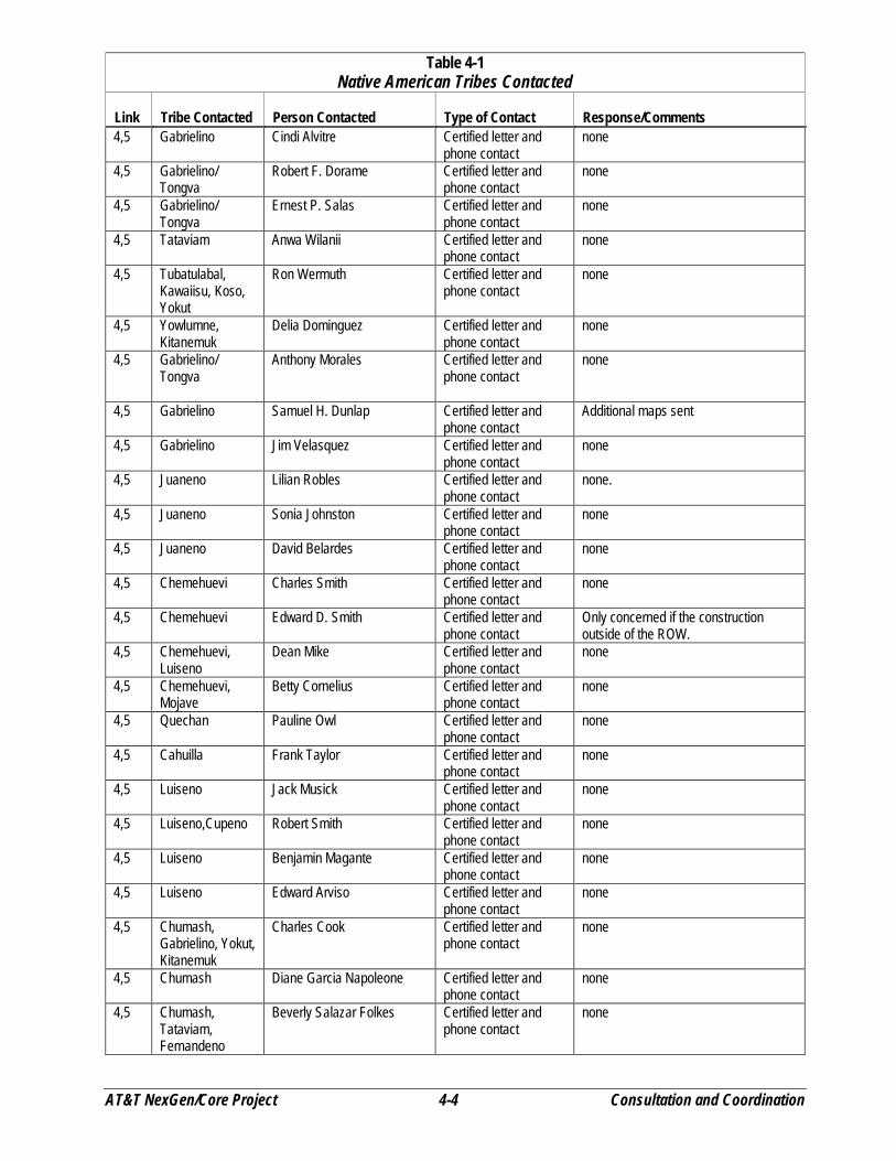
AT&T NexGen/Core Project 4-4 Consultation and Coordination
Table 4-1Native American Tribes Contacted
Link Tribe Contacted Person Contacted Type of Contact Response/Comments4,5 Gabrielino Cindi Alvitre Certified letter and
phone contactnone
4,5 Gabrielino/Tongva
Robert F. Dorame Certified letter andphone contact
none
4,5 Gabrielino/Tongva
Ernest P. Salas Certified letter andphone contact
none
4,5 Tataviam Anwa Wilanii Certified letter andphone contact
none
4,5 Tubatulabal,Kawaiisu, Koso,Yokut
Ron Wermuth Certified letter andphone contact
none
4,5 Yowlumne,Kitanemuk
Delia Dominguez Certified letter andphone contact
none
4,5 Gabrielino/Tongva
Anthony Morales Certified letter andphone contact
none
4,5 Gabrielino Samuel H. Dunlap Certified letter andphone contact
Additional maps sent
4,5 Gabrielino Jim Velasquez Certified letter andphone contact
none
4,5 Juaneno Lilian Robles Certified letter andphone contact
none.
4,5 Juaneno Sonia Johnston Certified letter andphone contact
none
4,5 Juaneno David Belardes Certified letter andphone contact
none
4,5 Chemehuevi Charles Smith Certified letter andphone contact
none
4,5 Chemehuevi Edward D. Smith Certified letter andphone contact
Only concerned if the constructionoutside of the ROW.
4,5 Chemehuevi,Luiseno
Dean Mike Certified letter andphone contact
none
4,5 Chemehuevi,Mojave
Betty Cornelius Certified letter andphone contact
none
4,5 Quechan Pauline Owl Certified letter andphone contact
none
4,5 Cahuilla Frank Taylor Certified letter andphone contact
none
4,5 Luiseno Jack Musick Certified letter andphone contact
none
4,5 Luiseno,Cupeno Robert Smith Certified letter andphone contact
none
4,5 Luiseno Benjamin Magante Certified letter andphone contact
none
4,5 Luiseno Edward Arviso Certified letter andphone contact
none
4,5 Chumash,Gabrielino, Yokut,Kitanemuk
Charles Cook Certified letter andphone contact
none
4,5 Chumash Diane Garcia Napoleone Certified letter andphone contact
none
4,5 Chumash,Tataviam,Fernandeno
Beverly Salazar Folkes Certified letter andphone contact
none

AT&T NexGen/Core Project 4-5 Consultation and Coordination
Table 4-1Native American Tribes Contacted
Link Tribe Contacted Person Contacted Type of Contact Response/Comments4,5 Chumash Carol A. Pulido Certified letter and
phone contactnone
4,5 Chumash, Yaqui Melissa M. Para-Hernandez Certified letter andphone contact
none
4,5 Chumash Dr. Kote & Lin A-Lul’KoyLotah
Certified letter andphone contact
none
4,5 Chumash Julie Lynn Tumamait Certified letter andphone contact
none
4,5 Chumash Qun-tan Shup Certified letter andphone contact
none
4,5 Chumash Patrick Tumamait Certified letter andphone contact
none
4,5 Chumash Mark Steven Vigil Certified letter andphone contact
none.
4,5 Chumash Dwayne Vigil Certified letter andphone contact
none
4,5 Gabrielino Art Alvitre Certified letter andphone contact
Notify if artifacts are recovered
4,5 Chumash,Tataviam,Kitanemuk,Tongva, Serrano
Paul (Valenzuela) Varela Certified letter andphone contact
none
4,5 Diegueno Howard Maxcy Certified letter andphone contact
none
4,5 Diegueno Clifford LaChappa Certified letter andphone contact
Notify if artifacts are recovered
4,5 Diegueno Allen Lawson Certified letter andphone contact
none
4,5 Diegueno Ralph Goff Certified letter andphone contact
Additional maps sent
4,5 Diegueno Ben Scerato Certified letter andphone contact
none
4,5 Diegueno Tony Pinto Certified letter andphone contact
none
4,5 Diegueno Georgia Tucker Certified letter andphone contact
none
4,5 Diegueno Anthony Pico Certified letter andphone contact
none
4,5 Diegueno Kenneth Maze Certified letter andphone contact
none
4,5 Diegueno,Kumeyaay
Frank Salazar Certified letter andphone contact
none
4,5 Diegueno Gwendolyn Parada Certified letter andphone contact
none
4,5 Diegueno,Kwaaymil
Camaren Lucas Certified letter andphone contact
Wants monitors at certain locations.
4,5 Diegueno Frances Shaw Certified letter andphone contact
none
4,5 Diegueno,Kumeyaay
Ron Christman Certified letter andphone contact
none
4,5 Diegueno,Kumeyaay
Steven Banegas Certified letter andphone contact
Notify if artifacts recovered
AT&T NexGen/Core Project 4-6 Consultation and Coordination
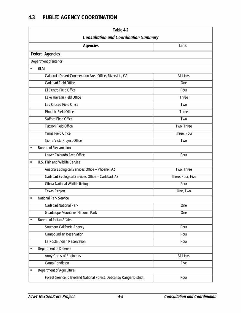
4.3 PUBLIC AGENCY COORDINATION
Table 4-2Consultation and Coordination SummaryAgencies Link
Federal AgenciesDepartment of Interior
� BLM
California Desert Conservation Area Office, Riverside, CA All Links
Carlsbad Field Office One
El Centro Field Office Four
Lake Havasu Field Office Three
Las Cruces Field Office Two
Phoenix Field Office Three
Safford Field Office Two
Tucson Field Office Two, Three
Yuma Field Office Three, Four
Sierra Vista Project Office Two
� Bureau of Reclamation
Lower Colorado Area Office Four
� U.S. Fish and Wildlife Service
Arizona Ecological Services Office – Phoenix, AZ Two, Three
Carlsbad Ecological Services Office – Carlsbad, AZ Three, Four, Five
Cibola National Wildlife Refuge Four
Texas Region One, Two
� National Park Service
Carlsbad National Park One
Guadalupe Mountains National Park One
� Bureau of Indian Affairs
Southern California Agency Four
Campo Indian Reservation Four
La Posta Indian Reservation Four
� Department of Defense
Army Corps of Engineers All Links
Camp Pendleton Five
� Department of Agriculture
Forest Service, Cleveland National Forest, Descanso Ranger District Four
AT&T NexGen/Core Project 4-7 Consultation and Coordination
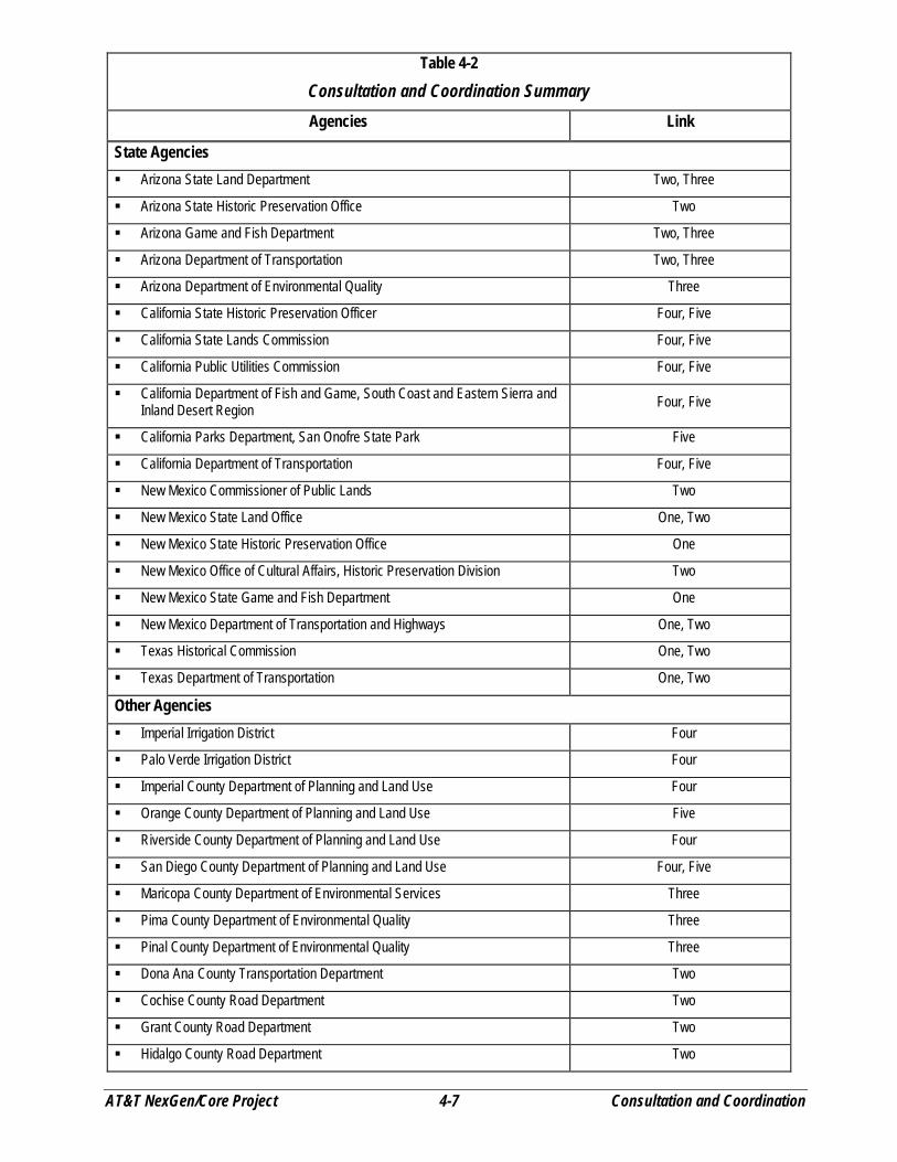
Table 4-2Consultation and Coordination SummaryAgencies Link
State Agencies� Arizona State Land Department Two, Three
� Arizona State Historic Preservation Office Two
� Arizona Game and Fish Department Two, Three
� Arizona Department of Transportation Two, Three
� Arizona Department of Environmental Quality Three
� California State Historic Preservation Officer Four, Five
� California State Lands Commission Four, Five
� California Public Utilities Commission Four, Five
� California Department of Fish and Game, South Coast and Eastern Sierra andInland Desert Region Four, Five
� California Parks Department, San Onofre State Park Five
� California Department of Transportation Four, Five
� New Mexico Commissioner of Public Lands Two
� New Mexico State Land Office One, Two
� New Mexico State Historic Preservation Office One
� New Mexico Office of Cultural Affairs, Historic Preservation Division Two
� New Mexico State Game and Fish Department One
� New Mexico Department of Transportation and Highways One, Two
� Texas Historical Commission One, Two
� Texas Department of Transportation One, Two
Other Agencies� Imperial Irrigation District Four
� Palo Verde Irrigation District Four
� Imperial County Department of Planning and Land Use Four
� Orange County Department of Planning and Land Use Five
� Riverside County Department of Planning and Land Use Four
� San Diego County Department of Planning and Land Use Four, Five
� Maricopa County Department of Environmental Services Three
� Pima County Department of Environmental Quality Three
� Pinal County Department of Environmental Quality Three
� Dona Ana County Transportation Department Two
� Cochise County Road Department Two
� Grant County Road Department Two
� Hidalgo County Road Department Two

AT&T NexGen/Core Project 4-8 Consultation and Coordination
Table 4-2Consultation and Coordination SummaryAgencies Link
� Luna County Road Department Two
� City of Blythe Planning Department Four
� City of Oceanside Planning Department Five
� City of Santa Ana Planning Department Five

AT&T NexGen/Core Project 5-1 List of Preparers
SECTIONSECTIONSECTIONSECTIONFIVE List of Preparers
5.1 FEDERAL AGENCIESTable 5-1
Bureau of Land ManagementName Office Location Project Responsibility Link
Stephen Johnson Riverside, CA Project Manager All LinksLarry Foreman Riverside, CA Project Biologist All LinksJoan Oxendine Riverside, CA Project Archaeologist All LinksCynthia Sandoval New Mexico State Office Realty Assistant One, TwoSteve Daly Carlsbad, NM Soil, Water, Air Quality OneFrank D’Amore Carlsbad, NM Recreation and Visual Resources OneJames Goodbar Carlsbad, NM Cave Resources Management OneJohn Sherman Carlsbad, NM Wildlife Management Biologist OneBobbe K. Young Carlsbad, NM Realty and Surface Protection OneBruce Call Las Cruces, NM Soil Scientist TwoMark Hakkila Las Cruces, NM Natural Resource Specialist TwoWilliam Gilbert Las Cruces, NM Natural Resource Specialist TwoRuss Jentgen Las Cruces, NM Geologist TwoBill Merhege Las Cruces, NM Wildlife Program Leader TwoLisa Phillips Las Cruces, NM Range Management Specialist TwoSheila Richmond Las Cruces, NM Contracted Biologist TwoLorraine Salas Las Cruces, NM Realty Specialist TwoJoe Sanchez Las Cruces, NM Natural Resource Specialist TwoRonna Simon Las Cruces, NM Hydrologist TwoPam Smith Las Cruces, NM Archaeologist TwoCarol Kershaw Arizona State Office Realty Specialist Two, ThreeShela McFarlin Arizona State Office Project Management Two, ThreeCory Bodman Lake Havasu, AZ Realty Specialist ThreeAngela Mogul Phoenix, AZ Realty Specialist ThreeScott Evans Safford, AZ Realty Specialist TwoTim Goodman Safford, AZ Range Management TwoTom Schnell Safford, AZ Outdoor Recreation TwoSusan Bernal Tucson, AZ Realty Specialist Two, ThreeBill Childress Tucson, AZ Manager Two, ThreeLucas Lucero Yuma, AZ Realty Specialist Three, FourLynda Kastoll El Centro, CA Manager FourNancy Nikolai El Centro, CA Biologist FourGavin Wright Palm Springs, CA Biologist FourJeff Schultz Palm Springs, CA Biologist Five
AT&T NexGen/Core Project 5-2 List of Preparers
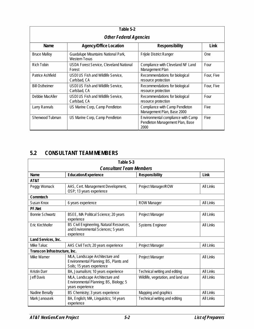
Table 5-2Other Federal Agencies
Name Agency/Office Location Responsibility Link
Bruce Malloy Guadalupe Mountains National Park,Western Texas
Frijole District Ranger One
Rich Tobin USDA Forest Service, Cleveland NationalForest
Compliance with Cleveland NF LandManagement Plan
Four
Patrice Ashfield USDI US Fish and Wildlife Service,Carlsbad, CA
Recommendations for biologicalresource protection
Four, Five
Bill Ostheimer USDI US Fish and Wildlife Service,Carlsbad, CA
Recommendations for biologicalresource protection
Four, Five
Debbie MacAller USDI US Fish and Wildlife Service,Carlsbad, CA
Recommendations for biologicalresource protection
Four
Larry Rannals US Marine Corp, Camp Pendleton Compliance with Camp PendletonManagement Plan, Base 2000
Five
Sherwood Tubman US Marine Corp, Camp Pendleton Environmental compliance with CampPendleton Management Plan, Base2000
Five
5.2 CONSULTANT TEAM MEMBERSTable 5-3
Consultant Team MembersName Education/Experience Responsibility LinkAT&TPeggy Womack AAS, Cert. Management Development,
OSP; 13 years experienceProject Manager/ROW All Links
CommtechSusan Knox 6 years experience ROW Manager All LinksPF.NetBonnie Schwartz BSEE, MA Political Science; 20 years
experienceProject Manager All Links
Eric Kirchhofer BS Civil Engineering, Natural Resources,and Environmental Sciences; 5 yearsexperience
Systems Engineer All Links
Land Services, Inc.Mike Takac AAS Civil Tech; 20 years experience Project Manager All LinksTranscon Infrastructure, Inc.Mike Warner MLA, Landscape Architecture and
Environmental Planning; BS, Plants andSoils; 15 years experience
Project Manager All Links
Kristin Darr BA, Journalism; 10 years experience Technical writing and editing All LinksJeff Davis MLA, Landscape Architecture and
Environmental Planning; BS, Biology; 5years experience
Wildlife, vegetation, and land use All Links
Nadine Benally BS Chemistry; 3 years experience Mapping and graphics All LinksMark Janousek BA, English; MA, Linguistics; 14 years
experienceTechnical writing and editing All Links
AT&T NexGen/Core Project 5-3 List of Preparers
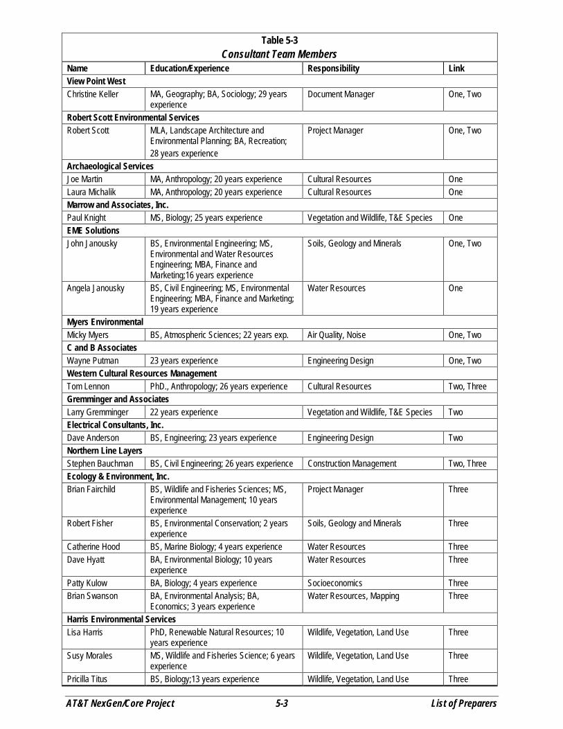
Table 5-3Consultant Team Members
Name Education/Experience Responsibility LinkView Point WestChristine Keller MA, Geography; BA, Sociology; 29 years
experienceDocument Manager One, Two
Robert Scott Environmental ServicesRobert Scott MLA, Landscape Architecture and
Environmental Planning; BA, Recreation;28 years experience
Project Manager One, Two
Archaeological ServicesJoe Martin MA, Anthropology; 20 years experience Cultural Resources OneLaura Michalik MA, Anthropology; 20 years experience Cultural Resources OneMarrow and Associates, Inc.Paul Knight MS, Biology; 25 years experience Vegetation and Wildlife, T&E Species OneEME SolutionsJohn Janousky BS, Environmental Engineering; MS,
Environmental and Water ResourcesEngineering; MBA, Finance andMarketing;16 years experience
Soils, Geology and Minerals One, Two
Angela Janousky BS, Civil Engineering; MS, EnvironmentalEngineering; MBA, Finance and Marketing;19 years experience
Water Resources One
Myers EnvironmentalMicky Myers BS, Atmospheric Sciences; 22 years exp. Air Quality, Noise One, TwoC and B AssociatesWayne Putman 23 years experience Engineering Design One, TwoWestern Cultural Resources ManagementTom Lennon PhD., Anthropology; 26 years experience Cultural Resources Two, ThreeGremminger and AssociatesLarry Gremminger 22 years experience Vegetation and Wildlife, T&E Species TwoElectrical Consultants, Inc.Dave Anderson BS, Engineering; 23 years experience Engineering Design TwoNorthern Line LayersStephen Bauchman BS, Civil Engineering; 26 years experience Construction Management Two, ThreeEcology & Environment, Inc.Brian Fairchild BS, Wildlife and Fisheries Sciences; MS,
Environmental Management; 10 yearsexperience
Project Manager Three
Robert Fisher BS, Environmental Conservation; 2 yearsexperience
Soils, Geology and Minerals Three
Catherine Hood BS, Marine Biology; 4 years experience Water Resources ThreeDave Hyatt BA, Environmental Biology; 10 years
experienceWater Resources Three
Patty Kulow BA, Biology; 4 years experience Socioeconomics ThreeBrian Swanson BA, Environmental Analysis; BA,
Economics; 3 years experienceWater Resources, Mapping Three
Harris Environmental ServicesLisa Harris PhD, Renewable Natural Resources; 10
years experienceWildlife, Vegetation, Land Use Three
Susy Morales MS, Wildlife and Fisheries Science; 6 yearsexperience
Wildlife, Vegetation, Land Use Three
Pricilla Titus BS, Biology;13 years experience Wildlife, Vegetation, Land Use Three

AT&T NexGen/Core Project 5-4 List of Preparers
Table 5-3Consultant Team Members
Name Education/Experience Responsibility LinkPivotal CommunicationsWilliam Rauch BS, Civil Engineering; 22 years experience Project Design ThreeFoster Wheeler EnvironmentalDwight Mudry BS Zoology; MA Biology; PhD Biology; 28
years experienceProject Manager Four, Five
Penny Eckert BA Marine Biology; BS ForestManagement, MFR. Forestry; PhD NaturalResource Sociology; 2 years experience
EA Project Manager Four, Five
Doug Davy BA Anthropology; MA Anthropology; PhD.,Archaeology; 18 years experience
Cultural Resources Four, Five
Lenny Malo BS, Biology and Ecology; 4 yearsexperience
Biological and Water Resources Four, Five
Steve Pavich BA Economics; MS EnvironmentalResource Economics; 2 years experience
Air Quality, Noise, Health and Safety,Recreation and Wilderness
Four, Five
Darcy Tiglas BA Biology; MS Range Science; 15 yearsexperience
Biological and Water Resources Four, Five
ASM AffiliatesJohn Cook BA Anthropology; BA Philosophy; 26 years
experienceField Survey - Cultural Resources Four, Five
Deborah Huntley BA Anthropology; MA Anthropology; PhDCandidate Anthropology; 6 yearsexperience
Field Survey - Cultural Resources Four, Five
Ken Victorino BA Anthropology, MA Anthropology; 9years experience
Field Survey - Cultural Resources Four, Five
Dudek AssociatesAnita Hayworth BS Ecology; MS Avian Science, PhD
Ecology; 20 years experienceField Survey - Ornithology Four, Five
ReconCindy Jones BA Geography – Ecosystems; MS
Environmental Studies; 9 years experienceField Survey – Quino CheckerspotButterfly
Four, Five
Wendy Loeffler BA Biology; MA Biology; 10 yearsexperience
Field Survey - Desert Tortoise Four
Jennifer Radtkey BA Biology; MS Biology; 8 yearsexperience
Field Survey – Quino CheckerspotButterfly
Four, Five
May ConsultingBill Roper BS, Rangeland Resources; 3 years
experienceField Survey – Noxious Weeds Four, Five
Brent Helm BS, Wildlife Management; MS, Ecology;PhD, Ecology; 17 years experience
Field Survey – T&E Invertebrates andNoxious Weeds
Four, Five
Independent ContractorsMarie Barrett BS, Biology; 5 years experience Field Survey – Flat-Tailed Horned
LizardFour
Jeff Kidd BS, Wildlife; 2 years experience Field Survey – Quino CheckerspotButterfly
Four, Five
John Konecny BS, Biology; 17 years experience Field Survey – Ornithology Four, FiveMichael Luhrs 25 years experience with Amphibian and
ReptilesField Survey – Desert Tortoise Four
Ted Rado BA, Zoology; MA, Biology; 26 yearsexperience
Field Survey – Desert Tortoise Four
Peggy Wood BS, Wildlife; MS, Wildlife Ecology; 16 yearsexperience
Field Survey – Desert Tortoise Four

AT&T NexGen/Core Project 6-1 References
SECTIONSECTIONSECTIONSECTIONSIX References
6.1 LINK ONE – LAMESA, TEXAS TO EL PASO, TEXASBLM. 1986. Carlsbad District Resource Management Plan. BLM Carlsbad District Office. December.
BLM. 1990. Chosa Draw Area of Critical Environmental Concern Management Plan. BLM NewMexico Roswell District, Carlsbad Resource Area. September 28, 1990.
BLM. 2000a. Locatable Minerals. http://www.nv.blm.gov/Minerals/locatable/ Locatable_Minerals.htm.April 4, 2000.
BLM. 2000b. Salable Minerals. http://www.nv.blm.gov/Minerals/salable/Salable_Minerals.htmApril 4, 2000.
Bridges, R.A. 2000. Cave and Karst Survey of Cable ROW, Cable Post 1848 to 1029, Eddy County, NewMexico. subTerra Consulting. April 10, 2000.
Broilo, Frank J. 1971. An Investigation of Surface Collected Clovis, Folsom and Midland Points fromBlackwater Draw and Adjacent Localities. Master's thesis, Department of Anthropology, Eastern NewMexico University. Portales.
Brown, D.E. 1982. Biotic Communities of the American Southwest-United States and Mexico. DesertPlants, 4:1-342.
Bureau of Economic Geology, University of Texas at Austin 1998. Map of Mineral-ProducingLocalities. Developed with U.S. Geological Survey.http://minerals.usgs.gov/minerals/pubs/state/tx.html. April 20, 2000.
Campbell, R.G. 1976. The Panhandle Aspect of the Chaquaqua Plateau. Texas Tech UniversityGraduate Studies 11. Lubbock.
Chronic, H. 1987. Roadside Geology of New Mexico. Mountain Press Publishing, Missoula, MT.
Code of Federal Regulations. 1999. Environmental Protection Agency, Part 81.334, NonattainmentAreas of Texas.
Code of Federal Regulations. 1999. Environmental Protection Agency, Part 81.332, NonattainmentAreas of New Mexico.
Congressional Research Service 1995. Major Federal Land Management Agencies: Management of OurNation's Lands and Resources. Betsy A. Cody, Coordinator, Environment and Natural Resources PolicyDivision. Congressional Research Service Report for Congress. 95-599 ENR. May 15, 1995.
Degenhardt, W.C., C.W. Painter, and A.H. Price. 1996. Amphibians and Reptiles of New Mexico.University of New Mexico Press, Albuquerque, NM.
Dick-Peddie, William A. 1993. New Mexico Vegetation, Past, Present and Future. University of NewMexico Press, Albuquerque, NM.
Environmental Protection Agency. 1992. Screening Procedures for Estimating the Air Quality Impactsof Stationary Sources, Revised, EPA-454/R-92-019.
EPA. 2000a. Total Maximum Daily Load (TMDL) Program. http://www.epa.gov/OWOW/tmdl/index.html. April 18, 2000.
EPA. 2000b. Unified Watershed Assessments. Clean Water Action Plan: Restoring and ProtectingAmerica’s Waters. http://www.epa.gov/owow/uwa/. April 18, 2000.
EPA. 2000c. Surf Your Watershed. A Service to Help You Locate, Use and Share EnvironmentalInformation about your place. http://www.epa.gov/surf3/ April 18, 2000.
Fenneman, N.M. 1931. Physiography of Western United States. McGraw Hill Book Company, Inc.,New York.
AT&T NexGen/Core Project 6-2 References
Findley, J.S., A.H. Harris, D.E. Wilson, and C. Jones. 1975. Mammals of New Mexico. University ofNew Mexico Press, Albuquerque, NM.
Jelinek, Arthur J. 1967. A Prehistoric Sequence in the Middle Pecos Valley, New Mexico. Museum ofAnthropology, Anthropological Paper No. 31. University of Michigan, Ann Arbor.
Lehmer, Donald. 1948. The Jornada Branch of the Mogollon. Social Science Bulletin, University ofArizona, 17.
Ligon, J.S. 1961. New Mexico Birds and Where to Find Them. University of New Mexico Press,Albuquerque, NM.
National Academy of Science (NAS). 1977. Guidelines for Preparing Environmental Impact Statementson Noise, Washington, D.C.
National Oceanic and Atmospheric Administration (NOAA). 1992. Monthly Station Normals ofTemperature, Precipitation, and Heating and Cooling Degree Days, 1961-90, Texas, Ashville, NorthCarolina.
National Oceanic and Atmospheric Administration (NOAA). 1998. Climatic Wind Data for the UnitedStates, Ashville, North Carolina.
New Mexico Bureau of Mines and Mineral Resources 1998. Map of Mineral-Producing Localities.Developed with U.S. Geological Survey. http://minerals.usgs.gov/minerals/pubs/ state/nm.html#myb,April 3, 2000.
New Mexico Bureau of Mines and Mineral Resources 2000. New Mexico Oil and Gas Pool Maps.http://geoinfo.nmt.edu/resources/petroleum/poolmaps.html. April 3, 2000.
New Mexico Department of Game and Fish. 2000. BISON-M Database, Santa Fe, NM.http://NMNHP.UNM.EDU/BISONM/BISONM.CFM.
New Mexico Environment Department 1998. Clean Water Action Plan, Unified Watershed Assessment,New Mexico. September.
Newton, Richard E. and Steadman Upham. 1985. Projectile points as chronological markers: areassessment of morphological attributes as time sensitive indicators. Paper presented at the FourthJornada Mogollon Conference.
NRCS 2000. Official Soil Series Descriptions. USDA-NRCS Soil Survey Division.http://www.statlab.iastate.edu/soils/osd/. April 18, 2000.
Powell, A.M. 1988. Trees and Shrubs of Trans-Pecos Texas. Sul Ross State University, Department ofBiology, Alpine, TX.
SCS. 1965. General Soil Map, Gaines County, Texas. U.S. Department of Agriculture, SoilConservation Service. July.
SCS. 1971a. Soil Survey of Eddy Area, New Mexico. U.S. Department of Agriculture, Soil ConservationService. March.
SCS. 1971b. Soil Survey of El Paso County, Texas. U.S. Department of Agriculture, Soil ConservationService. November.
SCS. 1974a. Soil Survey of Lea County, New Mexico. U.S. Department of Agriculture, SoilConservation Service. January.
SCS. 1974b. General Soil Map, Hudspeth County, Texas. U.S. Department of Agriculture, SoilConservation Service. June.
SCS. 1974c. General Soil Map, Culberson County, Texas. U.S. Department of Agriculture, SoilConservation Service. 4-R-33790. March.
SCS. 1975. General Soil Map, Dawson County, Texas. U.S. Department of Agriculture, SoilConservation Service. 4-R-35298. December.
AT&T NexGen/Core Project 6-3 References
Sebastian, Lynne and Signa Larralde. 1989. Living on the Land: 11,000 years of Human Adaptation inSoutheastern New Mexico. Cultural Resources Series No. 6. BLM Santa Fe.
Sebastian, Lynne and Frances Levine. 1989. The protohistoric and Spanish colonial periods. In Livingon the Land: 11,000 years of Human Adaptation in Southeastern New Mexico. Cultural ResourcesSeries No. 6. BLM Santa Fe.
Shreve, F. 1942. The Desert Vegetation of North America. Botanical Review, 7:195–246.
Spearing, D. 1991. Roadside Geology of Texas. Mountain Press Publishing Company, Missoula,Montana. 1991, Fifth Reprinting April 1996.
Stuart, David E., and Rory P. Gauthier. 1981. Prehistoric New Mexico: Background for Survey. NewMexico Historic Preservation Bureau, Santa Fe.
Texas Natural Resource Conservation Commission. 1998. Texas Unified Watershed Assessment.http://www.tnrcc.state.tx.us/water/quality/tmdl/unified.htm April 18. 2000.
BLM. 1986a. Visual Resource Inventory. BLM Manual Handbook 8410-1.
BLM. 1986b. Visual Resource Contrast Rating. BLM Manual Handbook 8431-1.
USGS. 1985. Geohydrology of the High Plains Aquifer in Southeastern New Mexico. Hart, D. L. andMcAda, D. P. Hydrologic Investigations Atlas HA-679.
USGS. 1995. Ground Water Atlas of the United States: Arizona, Colorado, New Mexico, Utah. HA 730-C. Robson, S. G. and E. R. Banta.
USGS. 1996. Ground Water Atlas of the United States: Oklahoma, Texas. HA 730-E. Ryder, P. D.
USGS. 1997. Coal Fields and Federal Lands of the Conterminous United States. Open File Report 97-461. Biewick, Laura R.H.
USGS. 2000a. Western States Faults Map. http://ghtmaps01.cr.usgs.gov/wsfaults.html,. March 29,2000.
USGS. 2000b. National Seismic Hazard Mapping Project, 1996 US National Seismic Hazard Maps,Peak Acceleration (%g) with 10% Probability of Exceedance in 50 Years.http://geohazards.cr.usgs.gov/eq/html/natlmap.shtml, March 29, 2000.
Walz, Vina. 1951. History of the El Paso Area, 1680-1692. University of New Mexico Press,unpublished Ph.D. dissertation, Albuquerque.
West, S. 1994. Biological Inventory of Playas and Salt Lakes in the Carlsbad Resource Area, Eddy andLea County, New Mexico. Prepared for the Carlsbad Resource Area of the BLM.
Williams, Jerry L. 1986. New Mexico in Maps. University of New Mexico Press, Albuquerque, NM.
6.2 LINK TWO – EL PASO, TEXAS TO TUCSON, ARIZONAArizona Department of Environmental Quality 2000. The Status of Water Quality in Arizona, CleanWater Act Section 305(b) Report 2000. Phoenix, Arizona. March.
Arizona Department of Mines and Mineral Resources 1998. Map of Mineral-Producing Localities.Developed with U.S. Geological Survey. http://minerals.usgs.gov/minerals/pubs/state/az.html#myb,April 3, 2000.
Bahre, C. J. Human Impacts on the Grasslands of Southeastern Arizona. IN McClaran, M. P., and T. R.Van Devender, Eds. The Desert Grassland. The University of Arizona Press, 1995.
Bowers, J. E. Shrubs and Trees of the Southwest Deserts. Southwest Parks and Monuments Association,

AT&T NexGen/Core Project 6-4 References
Tucson. 1993.
Bronitsky, Gordon, and James D. Merritt. 1986. The Archaeology of Southeast Arizona: A Class ICultural Resource Inventory. Arizona State Office, BLM, Cultural Resource Series Monograph No. 2.Phoenix.
Burgess, T. L. Desert Grassland, Mixed Shrub Savanna, Shrub Steppe, or Semidesert Scrub? TheDilemma of Coexisting Growth Forms. IN McClaran, M. P., and T. R. Van Devender, Eds. The DesertGrassland. The University of Arizona Press, 1995.
Chronic, H. 1983. Roadside Geology of Arizona. Mountain Press Publishing, Missoula, MT. 1983, ninthreprinting 1992.
Chronic, H. 1987. Roadside Geology of New Mexico. Mountain Press Publishing, Missoula, MT. 1987.
Code of Federal Regulations, 1999, Environmental Protection Agency, Part 81.334, Nonattainment Areasin Texas.
Code of Federal Regulations, 1999, Environmental Protection Agency, Part 81.332, Nonattainment Areasin New Mexico.
Code of Federal Regulations, 1999, Environmental Protection Agency, Part 81.303, Nonattainment Areasin Arizona.
Congressional Research Service 1995. Major Federal Land Management Agencies: Management of OurNation's Lands and Resources. Betsy A. Cody, Coordinator, Environment and Natural Resources PolicyDivision. Congressional Research Service Report for Congress. 95-599 ENR. May 15, 1995.
Cordell, Linda S. 1984. Prehistory of the Southwest. Academic Press.
Dimmitt, M. A. Biomes and Communities of the Sonoran Desert Region. IN Phillips, S. J., and P. W.Wentworth Comus. A Natural History of the Sonoran Desert. Arizona-Sonora Desert Museum Press,Tucson. 2000.
Dodge, N. N. Flowers of the Southwest Deserts. Southwest Parks and Monuments Association, Tucson.1985.
Earle, W. H. Cacti of the Southwest. Rancho Arroyo Book Distributor, Tempe. Rev. 1980.
Elmore, F. H. Shrubs and Trees of the Southwest. Southwest Parks and Monuments Association, Tucson.1976.
Environmental Protection Agency, 1992, Screening Procedures for Estimating the Air Quality Impacts ofStationary Sources, Revised, EPA-454\R-92-019
Environmental Protection Agency 2000a. Total Maximum Daily Load (TMDL) Program.http://www.epa.gov/OWOW/tmdl/index.html. April 3, 2000.
Environmental Protection Agency 2000b. Unified Watershed Assessments. Clean Water Action Plan:Restoring and Protecting America’s Waters. http://www.epa.gov/owow/uwa/. April 3, 2000.
Epple, A. O. A Field Guide to the Plants of Arizona. Falcon Publishing, Inc., Helena, MT. 1995.
Fenneman, N.M. 1931. Physiography of Western United States. McGraw Hill Book Company, Inc.,New York.
Gumerman, George J. (editor) 1991. Exploring the Hohokam: Prehistoric Desert Peoples of the

AT&T NexGen/Core Project 6-5 References
American Southwest. Amerind Foundation, Dragoon, Arizona and University of New Mexico Press,Albuquerque.
Haury, Emil W. 1976. The Hohokam: Desert Farmers and Craftsmen: Excavations at Snaketown, 1964-1965. University of Arizona Press, Tucson.
Haury, Emil W., Ernst Antevs, and J. F. Lance 1953. Artifacts with Mammoth Remains, Naco, Arizona.American Antiquity 19(1): 1-24.
Haury, Emil W., Enst B. Sayles, and William W. Wasley 1959. The Lehner Mammoth Site, SoutheasternArizona. American Antiquity 25(1): 2-30.
Irwin-Williams, Cynthia 1979. Post-Pleistocene Archeology, 7000-2000 BC In Handbook of NorthAmerican Indians, vol. 9: Southwest, edited by. A. Ortiz, pp. 31-42. Smithsonian Institution, Washington,D.C.
Kearns, Timothy M. 2000a. A Cultural Resource Survey of the New Mexico Portion of the NexGen/CoreFiber Optic Right-of-way, El Paso, Texas to Tucson, Arizona: Arizona Segment. Western CulturalResource Management, Inc., Report No. WCRM(F)169. Farmington, New Mexico.
Kearns, Timothy M. 2000b. A Cultural Resource Survey of the Arizona Portion of the NexGen/CoreFiber Optic Right-of-way, El Paso, Texas to Tucson, Arizona: New Mexico Segment. Western CulturalResource Management, Inc., Report No. WCRM(F)174. Farmington, New Mexico.
King, Thomas F. 1998. Cultural Resource Laws and Practice: An Introductory Guide. AltaMira Press,Walnut Creek, California
MacNeish, Richard S. 1989. Defining the Archaic Chihuahua Tradition. Andover Foundation forArchaeological Research, Annual Report. Andover
Martin, Paul S. 1979. Prehistory: Mogollon. In Handbook of North American Indians, vol. 9, Southwest,edited by A. Ortiz, pp. 61-74. Smithsonian Institution, Washington, D.C.
McClaran, M. P., Desert Grasslands and Grasses. IN McClaran, M. P., and T. R. Van Devender, Eds.The Desert Grassland. The University of Arizona Press, 1995.
McGregor, John C. 1945. Southwestern Archaeology. John Wiley & Sons, Inc., New York.
National Academy of Science (NAS), 1977, Guidelines for Preparing Environmental Impact Statementson Noise, Washington D.C.
National Oceanic and Atmospheric Administration (NOAA), 1992a, Monthly Station Normals ofTemperature, Precipitation, and Heating and Cooling Degree Days, 1961-90, Texas, Ashville, NorthCarolina.
National Oceanic and Atmospheric Administration (NOAA), 1992b, Monthly Station Normals ofTemperature, Precipitation, and Heating and Cooling Degree Days, 1961-90, Arizona, Ashville, NorthCarolina.
National Oceanic and Atmospheric Administration, (NOAA), 1998, Climatic Wind Data for the UnitedStates, Ashville, North Carolina.
Nations, J.D., et. al. 1989. Oil and Gas in Arizona. Published in Jenney, J.P., and Reynolds, S.J., 1989,Geologic Evolution of Arizona: Tucson, Arizona Geological Society Digest 17, pp. 795-815.
New England Native Plants Protection Advisory Committee. A Handbook of Rare and Endemic Plants ofNew Mexico. University of New Mexico Press, Albuquerque. 1984.

AT&T NexGen/Core Project 6-6 References
New Mexico Bureau of Mines and Mineral Resources 1998. Map of Mineral-Producing Localities.Developed with U.S. Geological Survey. http://minerals.usgs.gov/minerals/pubs/state/nm.html#myb,April 3, 2000.
New Mexico Bureau of Mines and Mineral Resources 2000. New Mexico Oil and Gas Pool Maps.http://geoinfo.nmt.edu/resources/petroleum/poolmaps.html. April 3, 2000.
New Mexico Environment Department 1998. Clean Water Action Plan, Unified Watershed Assessment,New Mexico. September.
Parmenter, R. R., and T. R. Van Devender, Diversity, Spatial Variability, and Functional Roles ofVertebrates in the Desert Grassland. IN McClaran, M. P., and T. R. Van Devender, Eds. The DesertGrassland. The University of Arizona Press, 1995.
Phillips, S. J., and P. W. Wentworth Comus. A Natural History of the Sonoran Desert. Arizona-SonoraDesert Museum Press, Tucson. 2000.
Rauzi, S.L. 1999. Arizona Well Location Map and Report. Arizona Geological Survey Oil and GasPublication OG-12. July.
Roundy, B. A., and S. H. Biedenbender, Revegetation in the Desert Grassland. IN McClaran, M. P., andT. R. Van Devender, Eds. The Desert Grassland. The University of Arizona Press. 1995.
Sayles, E. B. 1983. The Cochise Cultural Sequence in Southeastern Arizona. Anthropological Papers ofthe University of Arizona, Number 42. University of Arizona Press, Tucson.
Sayles, Edwin B., and Ernst Antevs 1941. The Cochise Culture. Gila Pueblo, Medallion Paper 17,Globe, Arizona.
Scarborough, R. The Geologic Origin of the Sonoran Desert, IN Phillips, S. J., and P. W. WentworthComus. A Natural History of the Sonoran Desert. Arizona-Sonora Desert Museum Press, Tucson. 2000.
Soil Conservation Service (SCS) 1973. Soil Survey of Hidalgo County, New Mexico. U.S. Department ofAgriculture, Soil Conservation Service. December.
Soil Conservation Service (SCS) 1976. Soil Survey of Willcox Area, Arizona, Parts of Cochise andGraham Counties. U.S. Department of Agriculture, Soil Conservation Service. April.
Soil Conservation Service (SCS) 1980a. Soil Survey of San Simon Area, Arizona, Parts of Cochise,Graham, and Greenlee Counties. U.S. Department of Agriculture, Soil Conservation Service.September.
Soil Conservation Service (SCS) 1980b. Soil Survey of Luna County, New Mexico. U.S. Department ofAgriculture, Soil Conservation Service. May.
Soil Conservation Service (SCS) 1980c. Soil Survey of Dona Ana County Area, New Mexico. U.S.Department of Agriculture, Soil Conservation Service. August.
Soil Conservation Service (SCS) 1983. Soil Survey of Grant County, New Mexico, Central and SouthernParts. U.S. Department of Agriculture, Soil Conservation Service. October.
Stuart, David E., and Rory P. Gauthier. 1981. Prehistoric New Mexico: Background for Survey. NewMexico Historic Preservation Bureau, Santa Fe.
Toy, T.J. and Foster, G.R 1998. Guidelines for the Use of the Revised Universal Soil Loss Equation(RUSLE) on Mined Lands, Construction Sites, and Reclaimed Lands. Office of Technology Transfer,Office of Surface Mining and Reclamation, Denver, Colorado. August

AT&T NexGen/Core Project 6-7 References
U.S. Geological Survey 1995. Ground Water Atlas of the United States: Arizona, Colorado, New Mexico,Utah. HA 730-C. Robson, S. G. and E. R. Banta.
U.S. Geological Survey 1992. Geohydrology and Water Resources of Alluvial Basins in South-CentralArizona and Parts of Adjacent States. Anderson, T.W., et. al. USGS Professional Paper 1406-B.
U.S. Geological Survey 1997. Coal Fields and Federal Lands of the Conterminous United States. OpenFile Report 97-461. Biewick, Laura R.H.
United States Geologic Survey 1999. Southwest Exotic Plants Mapping Program,http://www.usgs.nau.edu/swemp/ March 16, 2000.
U.S. Geological Survey 2000a. Western States Faults Map. http://ghtmaps01.cr.usgs.gov/wsfaults.html,.March 29, 2000.
U.S. Geological Survey 2000b. National Seismic Hazard Mapping Project, 1996 US National SeismicHazard Maps, Peak Acceleration (%g) with 10% Probability of Exceedance in 50 Years.http://geohazards.cr.usgs.gov/eq/html/natlmap.shtml, March 29, 2000.
BLM. 1986a. Visual Resource Inventory. BLM Manual Handbook 8410-1.
BLM. 1986b. Visual Resource Contrast Rating. BLM Manual Handbook 8431-1.
BLM 1993. Las Cruces District Mimbres Resource Area, Mimbres Resource Management Plan. BLMLas Cruces District Office. December.
BLM 2000a. Locatable Minerals. http://www.nv.blm.gov/Minerals/locatable/Locatable_Minerals.htm.April 4, 2000.
BLM 2000b. Salable Minerals. http://www.nv.blm.gov/Minerals/salable/Salable_Minerals.htm. April 4,2000.
Whitford, W. G., et al. Diversity, Spatial Variability, and Functional Roles of Invertebrates in DesertGrassland Ecosystems. IN McClaran, M. P., and T. R. Van Devender, Eds. The Desert Grassland. TheUniversity of Arizona Press, 1995.000
6.3 LINK THREE – TUCSON, ARIZONA TO BLYTHE, CALIFORNIA
Arizona Department of Environmental Quality 2000. The Status of Water Quality in Arizona, CleanWater Act Section 305(b) Report 2000. Phoenix, Arizona. March.
Arizona Department of Mines and Mineral Resources 1998. Map of Mineral-Producing Localities.Developed with U.S. Geological Survey. http://minerals.usgs.gov/minerals/pubs/state/az.html#myb,April 3, 2000.
Ciolek-Torrello, Richard (editor) 1998. Early Farmers of the Sonoran Desert: ArchaeologicalInvestigations at the Houghton Road Site, Tucson, Arizona. Technical Series 72, Statistical Research,Inc., Tucson, Arizona.
Code of Federal Regulations, 1999, Environmental Protection Agency, Part 81.303, Nonattainment Areasin Arizona.
Environmental Protection Agency, 1992, Screening Procedures for Estimating the Air Quality Impacts ofStationary Sources, Revised, EPA-454\R-92-019
AT&T NexGen/Core Project 6-8 References
Environmental Protection Agency 2000b. Unified Watershed Assessments. Clean Water Action Plan:Restoring and Protecting America’s Waters. http://www.epa.gov/owow/uwa/. April 3, 2000.
Gregory, David A. (editor) 1999. Excavations in the Santa Cruz River Floodplain: The Middle ArchaicComponent at Los Pozos. Center for Desert Archaeology Anthropological Papers No. 20. Tucson,Arizona.
Gumerman, George J. (editor) 1991. Exploring the Hohokam: Prehistoric Desert Peoples of the AmericanSouthwest. Amerind Foundation, Dragoon, Arizona and University of New Mexico Press, Albuquerque.
Harris Environmental Group 2000. Biological Review of the AT&T NEXGEN Fiber Optic Cable Route -Tucson, Arizona to Blythe, California. Harris Environmental Group, Inc. May 2000.
Haury, Emil W. 1976. The Hohokam: Desert Farmers and Craftsmen: Excavations at Snaketown, 1964-1965. University of Arizona Press, Tucson.
Haury, Emil W., Ernst Antevs, and J. F. Lance 1953. Artifacts with Mammoth Remains, Naco, Arizona.American Antiquity 19(1): 1-24.
Haury, Emil W., Enst B. Sayles, and William W. Wasley 1959. The Lehner Mammoth Site, SoutheasternArizona. American Antiquity 25(1): 2-30.
Hayden, Julian D. 1976. Pre-altithermal Archaeology in the Sierra Pinacate, Sonora, Mexico. AmericanAntiquity 41(3):274-289.
Lennon 2000
Mabry, Jonathan B., Deborah L. Swartz, Helga Wöcherl, Jeffery J. Clark, Gavin H. Archer, and MichaelW. Lindeman 1997. Descriptions of the Santa Cruz Bend, Square Hearth, Stone Pipe, and Canal Sites. InArchaeological Investigations of Early Village Sites in the Middle Santa Cruz Valley. AnthropologicalPapers No. 18. Center for Desert Archaeology, Tucson, Arizona.
McGuire, Randall H., and Michael B. Schiffer 1982. Hohokam and Patayan: Prehistory of SouthernArizona. Academic Press, New York.
Rogers, Malcolm J. 1966. Ancient Hunters of the Far West. Union-Tribune Publishing Company, SanDiego.
Rogers, Malcolm J. 1958. San Dieguito Implements from the Terraces of the Rincon-Pantano Wash andRillito Drainage System. Kiva 24(1): 1-23.
Rogers, Malcolm J. 1939. Early Lithic Industries of the Lower basin of the Colorado River and AdjacentDesert Areas. Paper No. 3. San Diego Museum, San Diego.
Roundy, B. A., and S. H. Biedenbender, Revegetation in the Desert Grassland. IN McClaran, M. P., andT. R. Van Devender, Eds. The Desert Grassland. The University of Arizona Press. 1995.
Sayles, E. B. 1983. The Cochise Cultural Sequence in Southeastern Arizona. Anthropological Papers ofthe University of Arizona, Number 42. University of Arizona Press, Tucson.
Sayles, Edwin B., and Ernst Antevs 1941. The Cochise Culture. Gila Pueblo, Medallion Paper 17,Globe, Arizona.
Soil Conservation Service (SCS) 1972. Soil Survey Tucson-Avra Valley Area, Arizona. U.S. Departmentof Agriculture, Soil Conservation Service. April 1972.
Soil Conservation Service (SCS) 1974. Soil Survey of Eastern Maricopa and Northern Pinal CountiesArea, Arizona. U.S. Department of Agriculture, Soil Conservation Service. November 1974.
Soil Conservation Service (SCS) 1974. Report and Interpretations for the General Soil Map of PimaCounty, Arizona. U.S. Department of Agriculture, Soil Conservation Service. March 1974.

AT&T NexGen/Core Project 6-9 References
Soil Conservation Service (SCS) 1977. Soil Survey of Maricopa County, Arizona. U.S. Department ofAgriculture, Soil Conservation Service. September 1977.
Soil Conservation Service (SCS) 1986. Soil Survey of Colorado River Indian Reservation, Arizona-California. U.S. Department of Agriculture, Soil Conservation Service. November 1986.
Soil Conservation Service (SCS), Soil Survey Laboratory Data and Descriptions for Some Soils ofArizona, U.S. Department of Agriculture, Soil Conservation Service
U.S. Geological Survey 1995. Ground Water Atlas of the United States: Arizona, Colorado, New Mexico,Utah. HA 730-C. Robson, S. G. and E. R. Banta.
U.S. Geological Survey 1992. Geohydrology and Water Resources of Alluvial Basins in South-CentralArizona and Parts of Adjacent States. Anderson, T.W., et. al. USGS Professional Paper 1406-B.
United States Geologic Survey 1999. Southwest Exotic Plants Mapping Program,http://www.usgs.nau.edu/swemp/ March 16, 2000.
U.S. Geological Survey 2000a. Western States Faults Map. http://ghtmaps01.cr.usgs.gov/wsfaults.html,.March 29, 2000.
BLM. 1986a. Visual Resource Inventory. BLM Manual Handbook 8410-1.
BLM. 1986b. Visual Resource Contrast Rating. BLM Manual Handbook 8431-1.
BLM. Yuma District Resource Management Plan. BLM Las Cruces District Office.
BLM 1985. Final Yuma District Resource Management Plan and Environmental Impact Statement.BLM Yuma District Office. August 1985.
BLM 1985. Final Lower Gila South Resource Management Plan Environmental Impact Statement .BLM Phoenix District Office. August 1985.
BLM 1988. Proposed Phoenix Resource Management Plan and Final Environmental Impact Statement.BLM Phoenix District Office. December 1988.
BLM 1992. Yuma District Resource Management Plan Amendment. BLM Yuma District Office.January 1992.
BLM 1994. Final Yuma District (Bill Williams) Resource Management Plan Amendment. BLM YumaDistrict Office. March 1994.
BLM 2000. Final Amendment and Environmental Assessment to the Lower Gila North ManagementFramework Plan and the Lower Gila South Resource Management Plan. BLM Phoenix District Office.February 2000.
BLM 2000a. Locatable Minerals. http://www.nv.blm.gov/Minerals/locatable/Locatable_Minerals.htm.April 4, 2000.
BLM 2000b. Salable Minerals. http://www.nv.blm.gov/Minerals/salable/Salable_Minerals.htm. April 4,2000.
6.4 LINK FOUR – BLYTHE, CALIFORNIA TO SAN DIEGO, CALIFORNIABowman, R.H. 1973. Soil Survey of the San Diego Area, California, United States Department of
Agriculture, Soil Conservation Service.
BLM 1980 (as amended). California Desert Conservation Area Plan.

AT&T NexGen/Core Project 6-10 References
California Air Resources Board. 1999. Area Designation Maps / State and National.[www.arb.ca.gov/adm/adm.htm]
California Department of Finance, Demographic Research Unit. 2000. Historical City/County PopulationEstimates, 1991-1999 with 1990 Census Count.http://www.dof.ca.gov/html/demograp/druhpar.htm
California Employment Development Department. 2000. Monthly Labor Force Data for Counties, Report400C. http://www.calmis.ca.gov/lmitx.htm
California Department of Fish and Game (CDFG). 1999. Natural Diversity DataBase. Rarefind. Computerreport for USGS 7.5-minute Quadrangles Covering the Project Area and Vicinity. CDFGSacramento, CA.
Crabtree, D.E. 1981. Archaeology. In A Cultural Resources Overview of the Colorado Desert PlanningUnits by Elizabeth von Till Warren, et. al., pp. 25-54. BLM, California Desert District, Riverside.
Dimmitt, M.A. 1977. Distribution of Couch’s Spadefoot Toad in CA. Unpublished report filed with theBLM, Riverside District Office, CA under contract (C-062, 6500, and 1792 Sundesert, May 10,1977).
Foreman, L. 1997. Working Group of Flat-tailed Horned Lizard Interagency Coordinating Committee.Flat-tailed Horned Lizard Rangewide Management Strategy. Report of interagency workinggroup. May.
Gifford, E. W. 1931. The Kamia of Imperial Valley. Smithsonian Institution Bureau of AmericanEthnology Bulletin 97. United States Government Printing Office, Washington, D.C.
Hart, E.W., and W.A. Bryant. 1997. Fault-Rupture Zones in California, Aiquist-Prielo Fault Zoning Actwith index to Earthquake Fault Zones maps: California Department of Conservation, Division ofMines and Geology: Special Publication 42.
Hickman, J.C., (ed.). 1996. The Jepson Manual – Higher Plants of California. University of CaliforniaPress, Berkeley. CA.
Jennings, C.W. 1994. Fault Activity Map of California and Adjacent Areas with Location and Ages ofRecent Volcanic Eruptions, 1:750,000 Scale: Department of Conservation, Division of Mines andGeology, Geologic Data Map No. 6.
Jennings, C.W. 1994. An Explanatory Text to Accompany the Fault Activity Map of California andAdjacent Areas with Location and Ages of Recent Volcanic Eruptions, 1:750,000 Scale:Department of Conservation, Division of Mines and Geology, Geologic Data Map No. 6.
McGuire, R.H., and M.B. Schiffer. 1982. Hohokam and Patayan, Prehistory of Southwestern Arizona.Academic Press, New York.
Munz, P.A., and D.D. Keck. 1973. A California flora with supplement. University of California Press.Berkeley, CA.
Onan Corporation. 1994. Exhaust Emission Data Sheet / Measured Sound Performance Data Sheet.
Rogers, M.J. 1939. Early Lithic Industries of the Lower Basin of the Colorado River and Adjacent Areas.San Diego Museum of Man Papers No. 3.
Rogers, M.J. 1945. An Outline of Yuman Prehistory. Southwestern Journal of Anthropology 1(2): 167-198.
Rogers, M.J. 1966. Ancient Hunters of the Far West. Union-Tribune, San Diego.
Schaefer, J. 1994. The Challenge of Archaeological Research in the Colorado Desert: Recent Approachesand Discoveries. Journal of California and Great Basin Prehistory 16(1): 60-80.
Schroeder, A.H. 1975. The Hohokam, Sinagua and the Hakataya. Imperial Valley College OccasionalPaper No. 3. El Centro, California.

AT&T NexGen/Core Project 6-11 References
Schroeder, A.H. 1979. Prehistory: Hakataya. In Southwest, pp. 100-107, edited by Alfonso Ortiz.Handbook of North American Indians, Vol. 9. Smithsonian Institution, Washington, D.C.
Shipek, F. 1989. An Example of Intensive Plant Husbandry: The Kumeyaay of Southern California. InForaging and Farming: the Evolution of Plant Exploitation, edited by D.R. Harris and G. C.Hillman, pp. 159-170. Onwin Hyman, London.
Skinner, M.W., and B.M. Pavlik, (eds.). 1994. California Native Plant Society’s Inventory of Rare andEndangered Vascular Plants of California. Fifth edition. California Native Plant Society,Sacramento CA.
United States Department of Agriculture, Soil Conservation Service. 1969. Report and General Soil Map,Los Angeles County, California scale 1:190,080.
United States Department of Agriculture, Soil Conservation Service. 1972. General Soil Map, Palo Verdearea, California scale 1:190,080.
United States Department of Agriculture, Soil Conservation Service. 1973. General Soil Map, San DiegoArea, California scale 1:253,440.
United States Department of Agriculture, Soil Conservation Service. 1981. General Soil Map, ImperialCounty California, Imperial Valley Area, scale 1:443,520.
USFWS. 1992. U.S. Fish and Wildlife Service, Field Survey Protocol for Any Federal Action That MayOccur Within the Range of the Desert Tortoise. January. Ventura, CA.
USFWS. 1993. U.S. Fish and Wildlife Service, Southwest Willow flycatcher (Empidonax traillii extimus)Survey Protocol. Carlsbad, CA.
USFWS. 1997. U.S. Fish and Wildlife Service, Coastal California Gnatcatcher (Polioptila californicacalifornica) Survey Guidelines. February. Carlsbad, CA.
USFWS. 1999. U.S. Fish and Wildlife Service, Least Bell’s Vireo Survey Guidelines. April. Carlsbad,CA.
USFWS. 2000. U.S. Fish and Wildlife Service, Quino Checkerspot Butterfly Year 2000 Survey Protocol.January 26. Carlsbad CA.
Weide, M.L. and J.P. Barker. 1974. Background to Prehistory of the Yuha Desert Region. Reportprepared by the Archaeological Research Unit, University of California, Riverside for the BLMCalifornia Desert Planning Program, Riverside, California.
Zimmerman, R.P. 1981. Soil Survey of Imperial County, California, Imperial Valley Area, United StatesDepartment of Agriculture, Soil Conservation Service.
Personal CommunicationsForeman, L. 2000. Project Biologist. BLM Riverside, CA. March, and May.
Nicolai, N. 2000. Wildlife Biologist. BLM Riverside, CA. March.
Ostheimer, B. 2000. Wildlife Biologist. US Fish and Wildlife Service, Carlsbad, CA. May.
6.5 LINK FIVE – SAN DIEGO, CALIFORNIA TO LOS ANGELES, CALIFORNIAAlmstedt, R. 1982. Kumeyaay and Ipay. In APS/SDG&E Interconnection Native American Cultural
Resources, edited by Clyde Woods, pp. 6-20. Wirth Associates, San Diego.
Bean, L., and F. Shipek. 1978. Luiseno. In Handbook of North American Indians. Volume 8, California,edited by R. Heizer, pp. 575-587. Smithsonian Institution, Washington, D.C.
California Air Resources Board. 1999. Area Designation Maps / State and National.[www.arb.ca.gov/adm/adm.htm]
California Department of Finance, Demographic Research Unit. 2000. Historical City/County Population

AT&T NexGen/Core Project 6-12 References
Estimates, 1991-1999 with 1990 Census Count.http://www.dof.ca.gov/html/demograp/druhpar.htm
California Department of Fish and Game (CDFG). 1999. Natural Diversity DataBase. Rarefind. Computerreport for USGS 7.5-minute Quadrangles Covering the Project Area and Vicinity. CDFGSacramento, CA.
California Employment Development Department. 2000. Monthly Labor Force Data for Counties, Report400C. http://www.calmis.ca.gov/lmitx.htm
Erlandson, J. and R. Colten. 1991. An Archaeological Context for Early Holocene Studies on theCalifornia Coast. In Hunter Gatherers of Early Holocene Coastal California, edited by J.Erlandson and R. Colten, pp. 1-10. Perspectives in California Archaeology (Volume 1). Instituteof Archaeology, University of California, Los Angeles.
Gifford, E. 1931. The Kamia of Imperial Valley. Bureau of American Ethnology Bulletin 98.
Hedges, K. 1975. Notes on the Kumeyaay: A Problem of Identification. Journal of CaliforniaAnthropology 2: 71-83.
Henny, C.J. and L.J. Blus. Artificial Burrows Provide New Insight into Burrowing Owl Nesting Biology.Raptor Research 15:82-85.
Hickman, J.C., (ed.). 1996. The Jepson Manual – Higher Plants of California. University of CaliforniaPress, Berkeley. CA.
Jennings, M. and M. Hayes. 1994. California Department of Fish and Game. Amphibian and ReptileSpecies of Special Concern in California. Inland Fisheries Division 1701 Nimbus Road, RanchoCordova, CA, under Contract (8023).
Jones, T. 1992. Settlement Trends Along the California Coast. In Essays on the Prehistory of MaritimeCalifornia, edited by T. Jones, pp.1-38. Center for Archaeological Research at Davis (Number10).
Kroeber, A. 1925. Handbook of the Indians of California. Smithsonian Institution, Washington, D.C.
Luomala, K. 1978. Tipai and Ipai. In California, edited by R. Heizer, pp. 592-609. Handbook of theNorth American Indians, Volume 8, edited by W. Sturtevant. Smithsonian Institution,Washington, D.C.
Meighan, C. 1954. A Late Complex in Southern California Prehistory. Southwestern Journal ofAnthropology 10: 215-227.
Meighan, C. 1959. California Cultures and the Concept of an Archaic Stage. American Antiquity 24: 289-305.
Moratto, M. 1984. California Archaeology. Academic Press, Orlando, Florida.
Moriarty, J. 1966. Cultural Phase Divisions Suggested by Typological Change Coordinated withStratigraphically Controlled Radiocarbon Dating at San Diego. Anthropological Journal ofCanada 4: 20-30.
Munz, P.A., and D.D. Keck. 1973. A California flora with supplement. University of California Press.Berkeley, CA.
Rogers, M. 1939. Early Lithic Industries of the Lower Basin of the Colorado River and Adjacent DesertAreas. San Diego Museum Papers Number 3.
Rogers, M. 1945. An Outline of Yuman Prehistory. Southwestern Journal of Anthropology 1: 167-198.
Rogers, M. 1966. Ancient Hunters of the Far West. Union-Tribune Publishing, San Diego.
Skinner, M.W., and B.M. Pavlik, (eds.). 1994. California Native Plant Society’s Inventory of Rare andEndangered Vascular Plants of California. Fifth edition. California Native Plant Society,Sacramento CA.

AT&T NexGen/Core Project 6-13 References
Small, A. 1994. California Birds: Their Status and Distribution. Ibis Publishing Company, Verona, Italy.
True, D. 1966. Archaeological Differentiation of Shoshonean and Yuman Speaking Groups in SouthernCalifornia. Unpublished Ph.D. dissertation, Department of Anthropology, University ofCalifornia, Los Angeles.
True, D. 1970. Investigation of a Late Prehistoric Complex in Cuyamaca Rancho State Park, San DiegoCounty, California. Archaeological Survey Monographs number 1. University of California, LosAngeles.
True, D., C. Meighan, and H. Crew. 1974. Archaeological Investigations at Molpa, San Diego County,California. University of California Publications in Anthropology Number 11. Berkeley.
BLM. 1988. BLM NEPA Handbook (H-1790-1), Appendix 5 Critical Elements of the HumanEnvironment.United States Department of Agriculture, Soil Conservation Service. 1969. Report and General Soil Map,
Los Angeles County, California scale 1:190,080.
United States Department of Agriculture, Soil Conservation Service. 1973. General Soil Map, San DiegoArea, California scale 1:253,440.
United States Department of Agriculture, Soil Conservation Service. 1978. General Soil Map, OrangeCounty and Western Part of Riverside County, California scale 1:126,720.
Unitt, P. 1984. The Birds of San Diego County. Memoir 13, San Diego Natural History Society.
USFWS. 1993. U.S. Fish and Wildlife Service, Southwest Willow flycatcher (Empidonax traillii extimus)Survey Protocol. Carlsbad, CA.
USFWS. 1997. U.S. Fish and Wildlife Service, Coastal California Gnatcatcher (Polioptila californicacalifornica) Survey Guidelines. February. Carlsbad, CA.
USFWS. 1998. U.S. Fish and Wildlife Service, Pacific Pocket Mouse (Perognathus longimembrispacificus) Recovery Plan. Portland, OR.
USFWS. 1999. U.S. Fish and Wildlife Service, Least Bell’s Vireo Survey Guidelines. April. Carlsbad,CA.
USFWS. 2000. U.S. Fish and Wildlife Service, Quino Checkerspot Butterfly Year 2000 Survey Protocol.January 26. Carlsbad CA.
Wallace, W. 1978. Trial Excavations at Two Prehistoric Sites in the Saratoga Area, Death ValleyNational Monument, California. Submitted to National Park Services, Western ArchaeologicalCenter, Tucson, Arizona.
Warren, C. 1964. Cultural Change and Continuity on the San Diego Coast. Unpublished Ph.D.dissertation, Department of Anthropology, University of California, Los Angeles.
Warren, C. 1987. The San Dieguito and La Jolla: Some Comments. In San Dieguito – La Jolla:Chronology and Controversy, edited by D. Gallegos, pp. 73-85. San Diego CountyArchaeological Society Research Paper Number 1.
Warren, C., G. Siegler, and F. Dittner. 1993. Paleo-Indian and Early Archaic Periods. In HistoricProperties Background Study for the City of San Diego Clean Water Program. Prepared by BrianF. Mooney Associates for Clean Water Program for Greater San Diego.
Personal Communications
Foreman, L. 2000. Project Biologist. BLM Riverside, CA. March, and May.
Ostheimer, B. 2000. Wildlife Biologist. US Fish and Wildlife Service, Carlsbad, CA. May.