SECTION ONE – UNDERSTANDING YOUR LANDSCAPE PARTNERSHIP’S...
92
9 SECTION ONE – UNDERSTANDING YOUR LANDSCAPE PARTNERSHIP’S AREA The Belfast Hills is an upland landscape straddling the northwest slopes of the Lagan Valley, which contains much of the Belfast Metropolitan area, namely Belfast, north Lisburn and Newtownabbey. It slopes more gently west towards a fourth council borough, Antrim, and Lough Neagh. Its western edge is immediately adjacent to the urban areas of west and north Belfast, north Lisburn and Newtownabbey. These hill summits and slopes are therefore very close to many housing estates which suffer high levels of deprivation and are recovering from the considerable effects of the Troubles. It could be said that the Belfast Hills inhabit multiple worlds – located at the periphery of Belfast, they hold obvious urban links yet simultaneously comprise the rural countryside. Their past associations with particular sections of NI society are something that still needs to be combated, opening up this space for everyone to use and enjoy. Figure 1.1 View across West Belfast showing the prominence of the Belfast Hills in the background. The Belfast Hills Landscape that we see today was created primarily by the last glacial period. Marine, fluvial and mass movement processes, combined with human activities and climate and sea-level fluctuations, have modified the appearance of the hills’ landscape. Once damaged or destroyed this landscape cannot be replaced since the processes that created them no longer exist. They therefore represent a
Transcript of SECTION ONE – UNDERSTANDING YOUR LANDSCAPE PARTNERSHIP’S...
9
SECTION ONE – UNDERSTANDING YOUR LANDSCAPE PARTNERSHIP’S AREA The Belfast Hills is an upland landscape straddling the northwest slopes of the Lagan Valley, which contains much of the Belfast Metropolitan area, namely Belfast, north Lisburn and Newtownabbey. It slopes more gently west towards a fourth council borough, Antrim, and Lough Neagh. Its western edge is immediately adjacent to the urban areas of west and north Belfast, north Lisburn and Newtownabbey. These hill summits and slopes are therefore very close to many housing estates which suffer high levels of deprivation and are recovering from the considerable effects of the Troubles. It could be said that the Belfast Hills inhabit multiple worlds – located at the periphery of Belfast, they hold obvious urban links yet simultaneously comprise the rural countryside. Their past associations with particular sections of NI society are something that still needs to be combated, opening up this space for everyone to use and enjoy.
Figure 1.1 View across West Belfast showing the prominence of the Belfast Hills in the background. The Belfast Hills Landscape that we see today was created primarily by the last glacial period. Marine, fluvial and mass movement processes, combined with human activities and climate and sea-level fluctuations, have modified the appearance of the hills’ landscape. Once damaged or destroyed this landscape cannot be replaced since the processes that created them no longer exist. They therefore represent a

10
finite scientific and economic resource and are a notable determinant of landscape character (NIEA LCA). For thousands of years the Belfast Hills have influenced, and been influenced by, the people who have lived and worked there and by those who have visited this unique place. This history is revealed by many clues that can still be found in today’s landscape – the patterns of lazy beds, cairns, standing stones and farmsteads. The Belfast Hills are situated on the edge of the large urban populations of Belfast, Lisburn and Newtownabbey and create a prominent and dramatic landscape setting which can be seen from far afield. They provide a green lung for the surrounding cities and boroughs, acting as a home for wildlife and a scenic space for residents and visitors alike to enjoy. Despite the hills surrounding the city, the publicly accessible sites are largely unknown to many of the people who live within them. This story of human interaction is continuing and changing. Farming practices that shaped the hillsides are being lost and farmland is being abandoned due to the general financial pressures on the farming community in Northern Ireland, and the specific pressures involved in farming the urban rural fringe. Housing is continually a threat, encroaching on the slopes of the hills. There is also an increasing demand for public green space for recreational use. This document outlines a strategy to address these issues. Despite the importance of the Belfast Hills, the area has not received any landscape designation, although it has been considered in the past as a regional park. The Belfast Hills consist of a basalt and chalk escarpment which slopes steeply down on one side to frame the urban areas of Newtownabbey, Belfast and Lisburn, and more gently on the Antrim side into the Lough Neagh basin. The basalt escarpment forms the edge of the Antrim Basalt Plateau and is broken by a series of steep wooded glens. The basalt overlies a thin chalk layer, both of which have attracted a large number of quarries. A large part of the escarpment is wooded in its lower slopes or is covered with regenerating patches of scrub or gorse. There are more formal stands of deciduous woodland associated with old estates such as Belfast Castle and Collin House, and open pastures with strong field boundary patterns. The broad, rounded hills rise to 478m at their highest point on Divis Mountain, with Black Mountain, Squires Hill and Cave Hill reaching over 350m. Most of the hills are topped with open heathland and between them are extensive waterlogged and windswept mosses. The eastern valley slopes are steep with a mosaic of species rich grassland, woodland and scrub, quarry and industrial sites and fields tending towards abandonment closer to urban areas. The valley slopes to the west have a more farmed character, with straight, overgrown hedgerows, belts of mature trees and farmsteads. Many of the farmsteads are sheltered by stands of mature (particularly beech) trees. There are important archaeological remains, particularly on the summits of Cave Hill, Divis and the Black Mountain. Radio masts are situated on most of the highest summits where they are prominent in views from surrounding areas. Settlement patterns in the hills are scattered with a few focal points such as Groganstown, Mullaghglass, Hannahstown, Legoniel and Carnmoney. The cities of Belfast and Lisburn have grown towards the hills and major communities such as Glen Road,

11
Upper Springfield, Bellevue and Cloughfern lie on the hill fringes. Large housing estates therefore lie within a mile of the more easterly summits. The landscape partnership we have established will pursue a series of interlinked programmes and projects to use the Belfast Hills landscape resource to tell its inspirational story to a new generation of residents and visitors. We will use the hills wide horizons to expand people’s personal horizons. We will provide new and exciting opportunities to experience the Belfast hills and to develop a deeper understanding of this historic landscape, its social history, its wildlife and the natural processes that continue to shape the environment. We will work with landowners, farmers and others who are the stewards of our heritage to address the challenges of the future. Our partnership seeks to re-establish old connections and forge new ones between the hills and the people who live close by and those who visit the area. We want to ensure that the hills can adapt to the changing times and that this landscape and its heritage remain economically and socially relevant to local communities and visitors. It is about shaping the future history of this unique living landscape. Operational Boundary The Belfast Hills Partnership Operational Boundary was drawn up in 2004 and takes in the upland areas that border the city of Belfast, dominating the cities skyline and so easily identified as the “Belfast Hills”. This boundary was however influenced to some extent by the objections of certain landowners to the Partnership. Therefore areas of land, which were identical in terms of habitats, landscape and land issues to sites within the operational boundary, were excluded. These strong objections largely related to the fear that all land within the Belfast Hills Operational Area would be designated as a Regional Park and would result in tight planning restrictions and high levels of trespass on property. These fears have been addressed and significantly reduced over the past 5 years through building up positive relationships and being seen to be talking through problems in this area. The commencement of the Landscape Partnership Scheme has provided a new platform for revisiting aspects of the Belfast Hills original boundary to ensure that it could be justified on a landscape basis. It was agreed that any new area proposed to be incorporated into a revised Belfast Hills area:-
must be adjacent to the existing area, enabling the general public to easily understand why the areas are classified as ‘Belfast Hills’;
must share similar issues, problems and opportunities and also be likely to benefit from shared sustainable solutions;
must not exhibit a high degree of additional different issues and problems that might deflect the partnership from key current work areas;
should take into consideration designations such as ASSI (Area of Special Scientific Interest), SLNCI (Site of Local Nature Conservation Interest), LLPA (Local Landscape Policy Area), scheduled monuments etc;
should reflect the ‘development limit’ as outlined in BMAP, including current green sites;

12
preferably add to the consistency, clarity and obviousness of the Belfast Hills as a unit.
On this basis the new operational area (shown below in Figure 1.2) was drawn up. Figure 1.3 shows a landscape characterisation map illustrating the similarities in habitat which resulted in the new operational area being selected. The outlined operational area is edged by the urban populations of Belfast, Lisburn and Newtownabbey along the eastern side and by lower lying intensely farmed/cultivated agricultural fields along the western side. The Belfast Hills area is very distinct from these surrounding land uses and faces a unique set of issues largely due to the large urban population (see Section 3 on Risks and Opportunities).

13
Figure 1.2 Red line is original Belfast Hills Operational Area. Purple line is agreed Landscape Partnership Scheme Area.
14
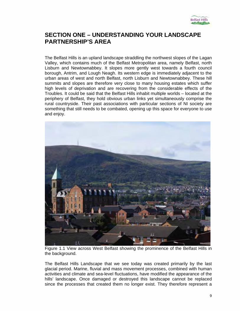
Landscape Types
Figure 1.3 Mapping of landscape types across the Belfast Hills area.

15
Context Landscape Character Areas The Belfast Hills Landscape Partnership Scheme will operate within the Belfast Hills Partnership Area which includes sections of 4 definite and different Landscape Character Areas (LCA) which are part of a series of 126 Landscape Character Areas for Northern Ireland. This overall Landscape Character Assessment was undertaken by Environment and Heritage Service in 2000 and covers the whole of Northern Ireland. Information for each LCA includes defining the landscape character, information on the geodiversity and defining some of the biodiversity characteristics for each LCA. The main Landscape Character Areas are as follows:
LCA 111 Divis Summits LCA 112 Belfast Basalt Escarpment LCA 110 Derrykillultagh LCA 114 Three and Six Mile Water River Valleys
The boundaries and locations of the landscape character areas are indicated in figure 1.4.

16
Figure 1.4 Landscape Character Areas as defined by NIEA
17
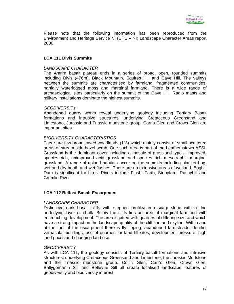
Please note that the following information has been reproduced from the Environment and Heritage Service NI (EHS – NI) Landscape Character Areas report 2000. LCA 111 Divis Summits LANDSCAPE CHARACTER The Antrim basalt plateau ends in a series of broad, open, rounded summits including Divis (476m), Black Mountain, Squires Hill and Cave Hill. The valleys between the summits are characterised by farmland, fragmented communities, partially waterlogged moss and marginal farmland. There is a wide range of archaeological sites particularly on the summit of the Cave Hill. Radio masts and military installations dominate the highest summits. GEODIVERSITY Abandoned quarry works reveal underlying geology including Tertiary Basalt formations and intrusive structures, underlying Cretaceous Greensand and Limestone, Jurassic and Triassic mudstone group. Carr’s Glen and Crows Glen are important sites. BIODIVERSITY CHARACTERISTICS There are few broadleaved woodlands (1%) which mainly consist of small scattered areas of stream-side hazel scrub. One such area is part of the Leathemstown ASSI. Grassland is the dominant cover including a mosaic of grassland type – improved, species rich, unimproved acid grassland and species rich mesotrophic marginal grassland. A range of upland habitats occur on the summits including blanket bog, wet and dry heath and wet flushes. There are no extensive areas of wetland. Boghill Dam is significant for birds. Rivers include Flush, Forth, Stonyford, Rushyhill and Crumlin River. LCA 112 Belfast Basalt Escarpment LANDSCAPE CHARACTER Distinctive dark basalt cliffs with stepped profile/steep scarp slope with a thin underlying layer of chalk. Below the cliffs lies an area of marginal farmland with encroaching development. The area is pitted with quarries of differing size and which have a strong impact on the landscape quality of the cliff line and skyline. Within and at the foot of the escarpment there is fly tipping, abandoned farmsteads, derelict vernacular buildings, use of quarries for land fill sites, development pressure, high land prices and changing land use. GEODIVERSITY As with LCA 111, the geology consists of Tertiary basalt formations and intrusive structures, underlying Cretaceous Greensand and Limestone, the Jurassic Mudstone and the Triassic mudstone group. Collin Glen, Carr’s Glen, Crows Glen, Ballygomartin Sill and Bellevue Sill all create localised landscape features of geodiversity and biodiversity interest.
18
BIODIVERSITY CHARACTERISTICS Deciduous woodland and scrub occur along the base of the slope and in incised river valleys. Where the limestone outcrops there is evidence of more species diversity and importance. There is a good range of grassland types where farmed land is less improved and falling into dereliction. There is shrub and heath on the fringes of the upland heath habitats. LCA 110 Derrykillultagh LANDSCAPE CHARACTER This landscape character area is set behind the summits and plateau of the hills where the landscape falls gently toward Lough Neagh. It is characterised by rounded hills and shallow slopes. Gorse and Holly typically occur in the hedgerows of the small farms and land holdings. The slopes are divided by narrow glens. The Derrykillultagh area Includes part of upper Lagan Valley. GEODIVERSITY Triassic sandstones and siltstones exist. Lagan Valley is a deglacial complex of note. BIODIVERSITY CHARACTERISTICS Woodland occupies less than 2% of the LCA. Here there is a variety of woodland types including Alder/ Ash woodlands. The wet woodland around Stonyford Reservoir is of note. Grassland is the main land cover – mainly improved but with pockets of unimproved meadows. There are wetlands and lakes – more significant areas of wetland include industrial ponds / reservoirs. LCA 114 Three and Six Mile River Valleys LANDSCAPE CHARACTER These notable river valleys lie to the north of the main area of the Belfast Hills but embrace the important landscape feature Carnmoney Hill – an outlier of the Belfast Hills. There is a traditional settlement pattern with a contemporary overlay of new build, industrial areas and landfill sites. Electricity pylons are prominent on the local skyline and there is increased pressure to develop the remaining countryside of Carnmoney Hill. GEODIVERSITY Significant features include Triassic sandstones and siltstones. The Glas Na Bradan ESCR, Six Mile Water Glaciofluvial complex. Earth Science Sites – Ballypalady / Carnmoney Plug, Craig Hill. BIODIVERSITY CHARACTERISTICS Woodland occupies less than 3% of this LCA, with a variety of types. Important areas include Carmoney Hill. Grassland is the predominant land cover and includes pockets of species rich mesotrophic grassland, improved pasture and rough grassland. Wetlands and lakes include key riparian habitat associated with major rivers – Six Mile Water and Three Mile Water. In addition there are industrial reservoirs and associated wet grassland and marginal vegetation.

19
Landscape condition and sensitivity to change DIVIS SUMMITS The landscape of the Divis Summits is generally in poor condition, particularly on the summits and in areas where there has been a history of mineral extraction. There is much evidence of hedgerow removal and the character of the roads, which were fringed with hedgerows on the lower slopes of the plateau, has been eroded by a combination of neglect and ongoing minor road improvements, largely to accommodate the lorries transporting minerals. Much of the farmland is in a partially abandoned condition and there is much evidence of fly-tipping and derelict farmsteads. The basalt summits and steep escarpment slopes are particularly sensitive to change, as they form the backdrop to the urban areas of Lisburn and Belfast and because they are relatively exposed. The quarry sites are often in extremely prominent locations and their restoration should be considered a priority. Hazelwood Area of Scientific Interest (ASI) occurs within this character area, forming a particularly sensitive part of the landscape. Priorities for restoration include: the restoration of abandoned quarry sites; retaining the character of minor roads; the control of fly-tipping and the removal of existing tips and scattered dumping on derelict sites; restoring the landscape on the edges of active quarry sites, particularly at entrances and permanent boundaries where there are often steep, odd-shaped bunds and abandoned plant; limiting routes for mineral lorries to help conserve narrow roads and remaining hedgerow trees from further erosion by heavy vehicles; planting new hedgerow trees and the encouragement of natural regeneration. BELFAST BASALT ESCARPMENT Belfast Basalt Escarpment LCA is sensitive to change due to its prominence and is generally in a rather degraded state with neglect, loss of field boundaries and fly tipping. Restoration of abandoned quarry workings will improve the visual appearance and landscape condition of the escarpment. Quarries in prominent positions are particularly important. Management of degraded hedgerows and replanting along post and wire boundaries will strengthen landscape patterns and enhance the condition of the landscape. Management and replanting of the remaining deciduous woodland on the lower slopes of the escarpment will ensure that these slopes remain wooded, creating recreational opportunities for residents of Belfast and enhancing the setting of the city. DERRYKILLULTAGH Derrykillultagh has lost character through the dereliction, and at times insensitive replacement, of traditional buildings, the removal of field boundaries to make large fields, ribbon development, the loss of wooded glens and road realignment. Priorities for retaining landscape character include the replanting of hedgerows and trees at realigned junctions and homestead entrances, the conservation of existing hedgerows, further tree planting within hedgerows and woodland, and copse planting on waste sites and on marginal farmlands. THREE AND SIX MILE WATER VALLEYS The landscape condition of this area is generally poor due to the incomplete hedgerow network and the decline of mature trees. Built development is quite open and incoherent, leading to a rather degraded visual character in some areas. The extent of built development in this area has a significant impact and continued hedgerow loss will result in a greater sensitivity to landscape change. Woodland

20
planting could substantially reduce the sensitivity of the landscape to large-scale development. Priorities for retaining and enhancing landscape character include woodland planting and hedgerow retention and restoration. The Belfast Hills landscape areas are dramatic and important for their own sake as well as an attractive backdrop to the city and its residents and visitors. Landscapes are generally degraded and highly impacted, showing the pressure of low returns in farming, of insensitive development, and of industries such as quarrying and waste management. Telecommunications masts dominate the upland landscapes, with few summits free from structures.

21
Detailed look at the Belfast Hills Landscape and History The NIEA landscape character assessment above was at a coarse scale, in order to define further the quality of the landscapes and to create a dialogue on change. A more detailed landscape assessment and research into historic information was carried out and is provided below. The Visibility and Quality of key views are rated. Visibility ratings relate to how clear the view is from its location and the number of people it is visible to. For example, if the view is clearly visible to most of the population of Belfast it would score 10, while a view that is obstructed by trees or a hedge in the rural countryside would score 1. Quality ratings relate to the aesthetic quality, with a maximum score of 10 and the presence of aerials, pylons and netting reducing the score.
22
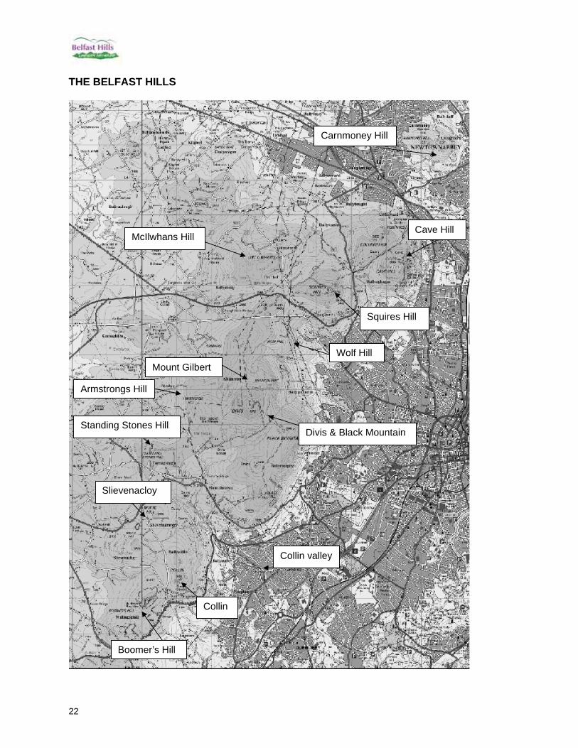
THE BELFAST HILLS
Standing Stones Hill
Wolf Hill
McIlwhans Hill
Divis & Black Mountain
Squires Hill
Cave Hill
Carnmoney Hill
Slievenacloy
Boomer’s Hill
Collin
Collin valley
Mount Gilbert
Armstrongs Hill

23
CARNMONEY HILL 1. Carnmoney Hill This is the most northerly hill within the Belfast Hills Partnership Operational Boundary and is one of the great landmarks in the borough of Newtownabbey. Carnmoney takes its name from Cairn Monadh which is thought to mean ‘the cairn on the boggy mountain’, a burial cairn that originally stood on the summit of Carnmoney Hill. 1.1 Position, Height Carnmoney Hill has two summits, one 207m high (J336832) and the other 231m high (J332832), making it the lowest of the Belfast Hills. In geological terms it is a ‘volcanic plug’ and can be easily seen from the M2 and M5. Carnmoney Hill is entirely surrounded by urban development, with various roads and housing estates encroaching onto the lower slopes of the hill itself. Two main ‘A’ roads surround the hill, namely the Doagh Road, which runs north to south along its eastern edge, and the O’Neill Road on the southern edge of the hill. 1.2 LCA & Description Carnmoney Hill is entirely within the Three & Six Mile Water Valley Landscape Character Area (figure 1.1). It is also designated an Area of High Scenic Value. The hill is characterised on its eastern side by woodland, and this section is owned by Newtownabbey Borough Council and managed by the Woodland Trust who have planted thousands of new trees on the site. On the southern end of the hill is a large cemetery which is surrounded by trees and scrub. The greatest part of the hill, including its uppermost slopes, consists of hedged agricultural fields. The occurrence of agricultural fields above woodland is unusual, with most of the hills in the Belfast Hills only having agricultural fields in the lower slopes, then scrub/trees, then upland heath at the top. This can be explained by Carnmoney Hill’s steep eastern slope and flat top. There is a large landfill site at the northern edge of the hill (Ballyduff landfill), however this has very little landscape impact due to a large hedge and tree line in front of the entrance to the site. There are the remains of disused quarries across the site, but they are associated with vegetation and are largely undefined in landscape terms. The one discernable quarry is behind the cemetery, although this too is well covered with vegetation. There is a mobile phone mast at the top of the hill above the tree line.
24
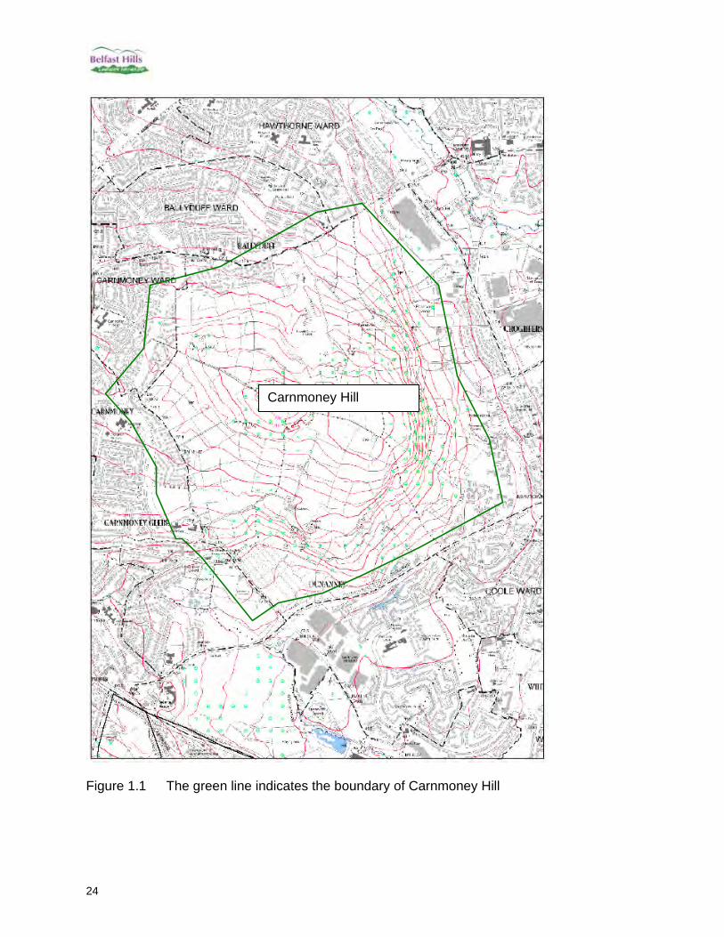
Figure 1.1 The green line indicates the boundary of Carnmoney Hill
Carnmoney Hill

25
Key Views Photo 1.0 Eastern view from Harbour Estate showing proximity of housing estate, woodland and fields on upper slopes. VISIBILITY 8 QUALITY 8
Photo 1.1 South-eastern view from Knockenagh Avenue – woodland dominant VISIBILITY 5 QUALITY 8

26
South-western. VISIBILITY 7 QUALITY 7 Photo 1.2 View from Belfast Zoo – hedged fields dominant above the lower wooded area which was once a working quarry. Aerial is visible on the skyline.
Photo 1.3 From the O’Neill Rd, just off Antrim Rd – closer view showing the scrub and small amount of heath on the summit.

27
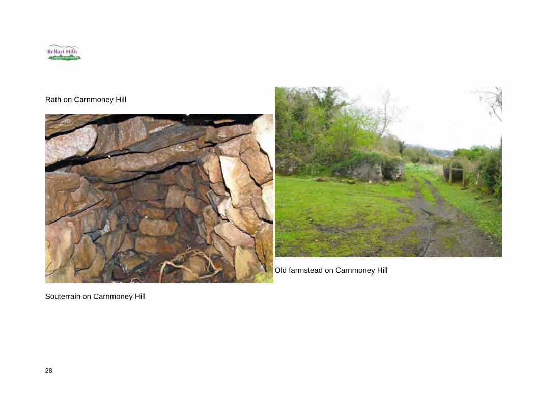
Other Landscape Features – Built Heritage & History In archaeological terms, the hill is important not just for the burial cairn on the summit, but also for the rath or hill fort called Dunanney and associated satellite Raths. There are also substantial remains of 18th to 19th Century farming and quarrying with limekilns, old farm houses and laneways present. Signs of human habitation, such as a souterain have been found there, dating back 3500 years. There is a need to preserve, restore and interpret this site’s rich heritage. This need is reflected by plans outlined in section 5 in the Built Heritage Surveys and Restoration Works project.
Lime kiln on Carnmoney Hill just off O’Neill Road
28
Rath on Carnmoney Hill
Souterrain on Carnmoney Hill
Old farmstead on Carnmoney Hill

29
CAVE HILL 2. Cave Hill Cave Hill is located north of Squire’s Hill and south of Carnmoney Hill. The Cave Hill site encompasses an area known as Collinward, creating the appearance of two summits on the hill. It is one of the most recognised and iconic views of the Belfast Hills due to its famous cliff face which can be seen from across Belfast. 2.1 Position, Height At its highest point Cave Hill is 368m high (J324797), while Collinward’s highest point is 360m (J318803). Together they cover an area of approximately 5km2. The western edge of the hill is skirted by the Upper Hightown Road, the northern edge by the Hightown Road and the eastern edge by the Antrim Road. Dense housing is found surrounding the hill on all but the western edges. 2.2 LCA & Description About 80% of the Cave Hill is designated an Area of High Scenic Value. This excludes Belfast Zoo and the western section of Collinward which contains the Hightown landfill site. The hill is separated into three different Landscape Character Areas, namely the Three and Six Mile Water Valleys LCA (northern most part of the hill), the Belfast Basalt Escarpment (eastern and southern strip along the hill) and the Divis Summits (the main central section of the hill). See figure 2.1. The hill is characterised by woodland/parkland along the eastern and southern strip of the hill, which is seen from across the city of Belfast. The upper reaches of the hill is upland and scrub, with the landfill dominating on the western side, while on the northern slopes agricultural hedged fields are found. Collinward has an aerial near its summit.
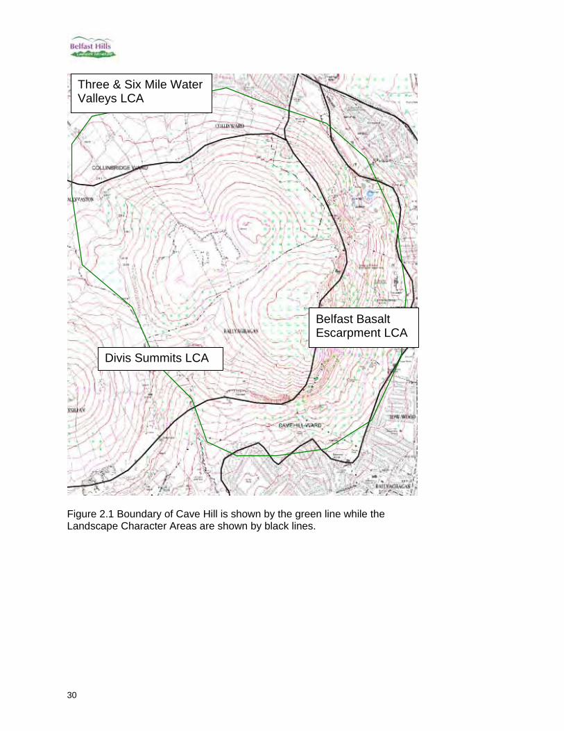
30
Figure 2.1 Boundary of Cave Hill is shown by the green line while the Landscape Character Areas are shown by black lines.
Belfast Basalt Escarpment LCA
Divis Summits LCA
Three & Six Mile Water Valleys LCA
31
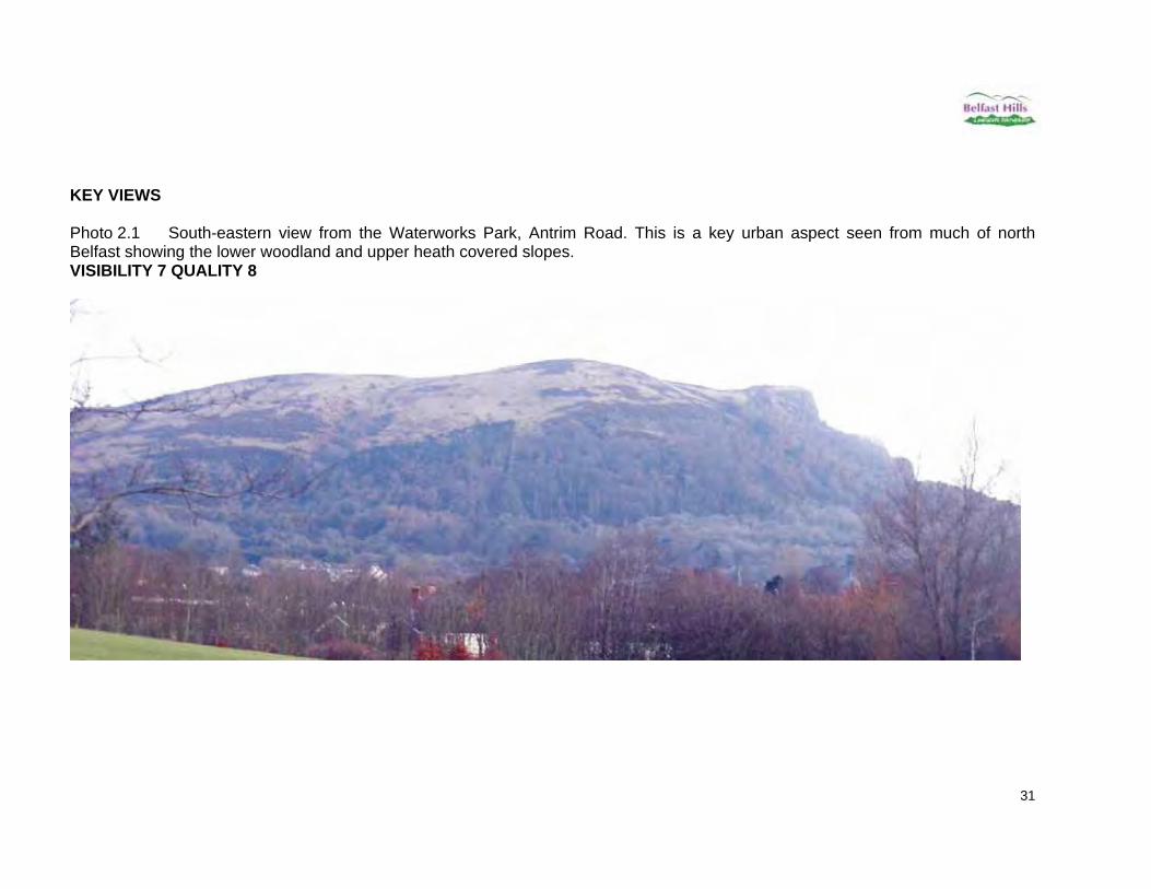
KEY VIEWS Photo 2.1 South-eastern view from the Waterworks Park, Antrim Road. This is a key urban aspect seen from much of north Belfast showing the lower woodland and upper heath covered slopes. VISIBILITY 7 QUALITY 8
32
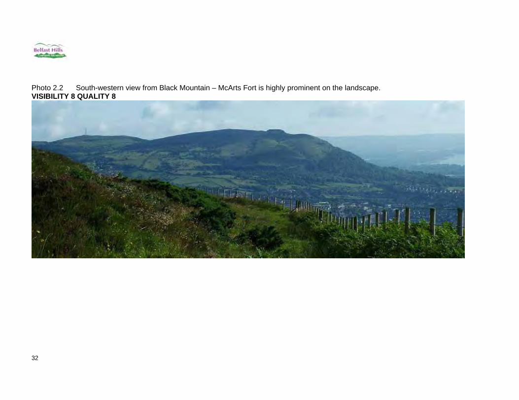
Photo 2.2 South-western view from Black Mountain – McArts Fort is highly prominent on the landscape. VISIBILITY 8 QUALITY 8

33
Photo 2.3 North-eastern view taken from Carnmoney Hill. Collinward can be clearly seen on the right. VISIBILITY 6 QUALITY 6

34
Other Landscape Features – Built Heritage & History The Cave Hill is steeped in history. The site was formerly known as Ben Madigan, probably after a local chieftain who died in 855 AD. McArts Fort is probably named after Art O'Neill, a sixteenth century chieftain of the family who held the land around Cave Hill. In 1603 this land was granted by King James 1 to Arthur Chichester, later the Earl of Donegall. McArts Fort has an older name, Lios Tulach Ard, the fort of the high mound.
McArts Fort from the Antrim Road
The caves from Cave Hill Country Park
35
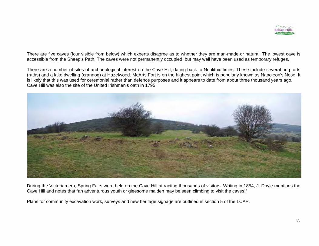
There are five caves (four visible from below) which experts disagree as to whether they are man-made or natural. The lowest cave is accessible from the Sheep's Path. The caves were not permanently occupied, but may well have been used as temporary refuges. There are a number of sites of archaeological interest on the Cave Hill, dating back to Neolithic times. These include several ring forts (raths) and a lake dwelling (crannog) at Hazelwood. McArts Fort is on the highest point which is popularly known as Napoleon's Nose. It is likely that this was used for ceremonial rather than defence purposes and it appears to date from about three thousand years ago. Cave Hill was also the site of the United Irishmen’s oath in 1795.
During the Victorian era, Spring Fairs were held on the Cave Hill attracting thousands of visitors. Writing in 1854, J. Doyle mentions the Cave Hill and notes that “an adventurous youth or gleesome maiden may be seen climbing to visit the caves!” Plans for community excavation work, surveys and new heritage signage are outlined in section 5 of the LCAP.

36
MCILWHANS 3. McIlwhans It is thought that the name refers to the local family name of McElhone. This hill is situated west of Squires hill. 3.1 Position, Height At its highest point McIlwhans hill is 340m high (J287796) and covers an area of approximately 2.5 km2. It is edged to the north and east by the Flush Road, to the West by the Aughnabrack Road and to the South by the Ballyutoag Road. 3.2 LCA & Description McIlwhans hill is entirely in the Divis Summits Landscape Character Area (figure 3.1). The upper slopes of the hill are open upland heath, surrounded by lower slopes consisting of hedged fields of improved grassland. To the north east of the hill there is a large active quarry called the Hightown/Tarmac North quarry.
Figure 3.1 Boundary of McIlwhans is indicated by the green line.
Divis Summits

37
Key Views Photo 3.1 Northern view from Aughnabrack Road. This photograph shows the active agricultural use of the fields on the lower slopes of McIlwhans hill, with strong hedged field boundaries and numerous mature trees. The upland heath on the hill top can also be seen. VISIBILITY 3 QUALITY 9
Photo 3.2 Eastern view from the Flush Road. This view of the hill is dominated by the pylon and the cables associated with it. A tarmac road can be seen which provides access to a Water Service station, also visible on the horizon. VISIBILITY 4 QUALITY 4

38
Photo 3.3 Southern view from the Ballyhill Road. The southern slopes are very agricultural in appearance with very few hedged fields. Some conifer trees have been planted on the lower slope. VISIBILITY 5 QUALITY 6
Photo 3.4 Western view from the Aughnabrack Road. Due to the high hedges and mature trees it is difficult to obtain a clear view of McIlwhans hill from the west. The upland slopes are interrupted only by a hedge line and some small plantations of trees. VISIBILITY 3 QUALITY 8
39
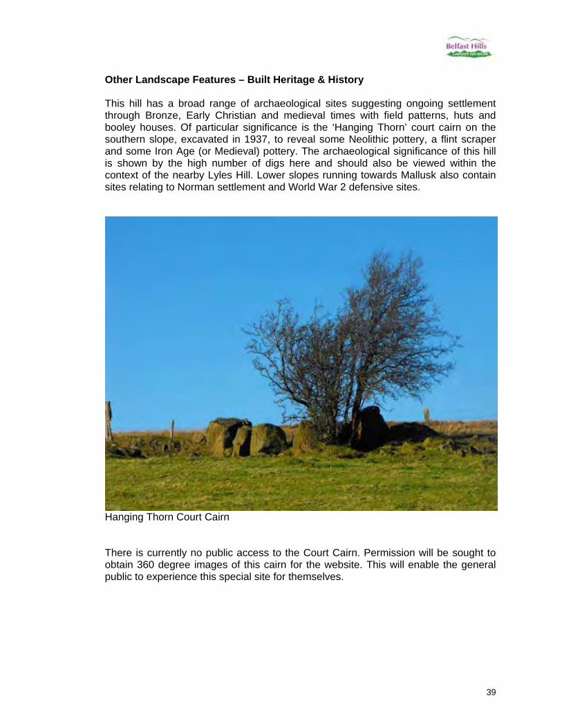
Other Landscape Features – Built Heritage & History This hill has a broad range of archaeological sites suggesting ongoing settlement through Bronze, Early Christian and medieval times with field patterns, huts and booley houses. Of particular significance is the ‘Hanging Thorn’ court cairn on the southern slope, excavated in 1937, to reveal some Neolithic pottery, a flint scraper and some Iron Age (or Medieval) pottery. The archaeological significance of this hill is shown by the high number of digs here and should also be viewed within the context of the nearby Lyles Hill. Lower slopes running towards Mallusk also contain sites relating to Norman settlement and World War 2 defensive sites.
Hanging Thorn Court Cairn There is currently no public access to the Court Cairn. Permission will be sought to obtain 360 degree images of this cairn for the website. This will enable the general public to experience this special site for themselves.
40
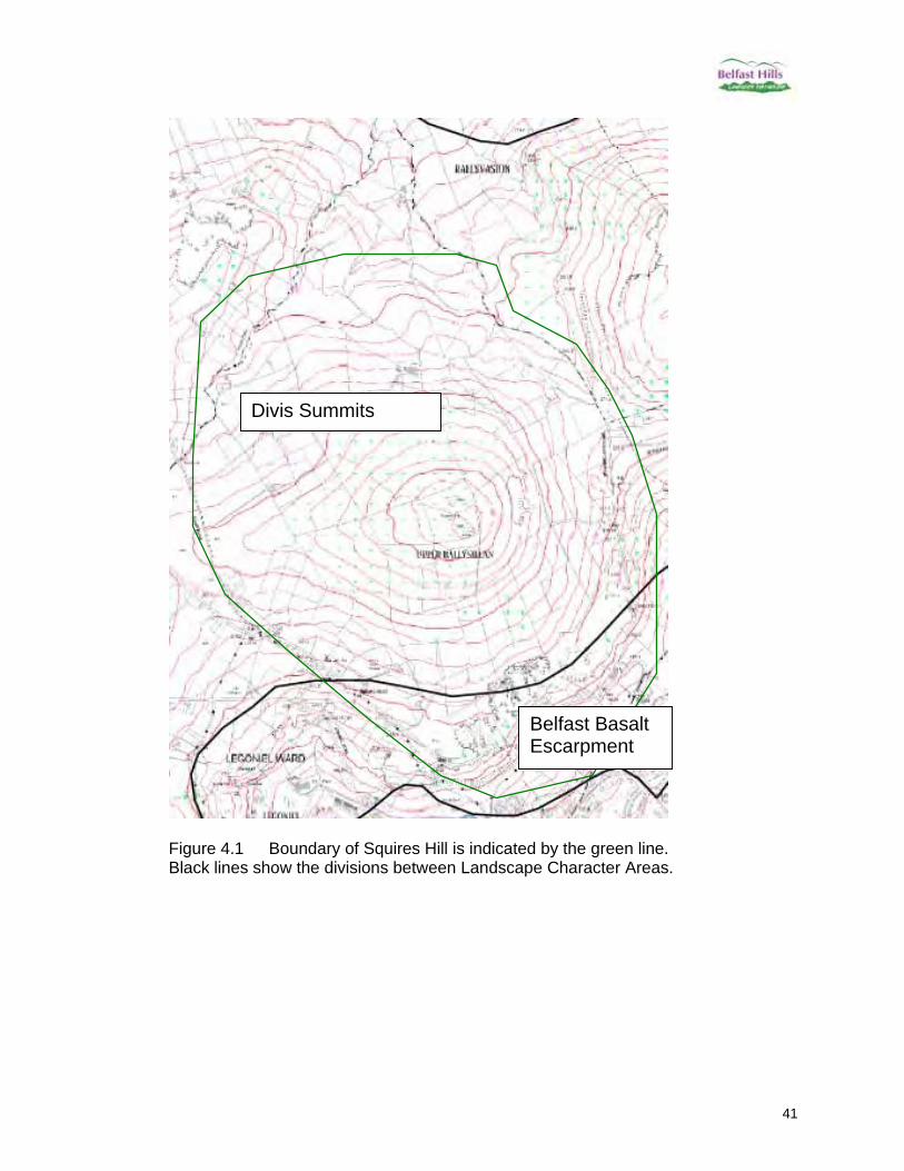
SQUIRES HILL 4. Squires Hill This hill is located north of Wolf Hill and south west of Cave Hill and overlooks the Ballysillan area of Belfast. There is some dispute over its name which alludes to past ownership of the hill. The name probably refers to Lord Donegall, “the squire”, and is linked with the Old Park area below in terms of hunting grounds. 4.1 Position, Height Reaching 375 metres at its height (J302789), Squires Hill covers an area roughly 2km2 with a single summit tapering down on all sides. It is edged on the eastern, southern and western sides by roads, namely the Upper Hightown Road, the Ballyutoag Road and the Flush Road. 4.2 LCA & Description Over 80% of Squires Hill is within the Area of High Scenic Value. Only a small section of the northern end of the hill has been excluded, this may be due to the fact that it is not visible from the city. Approximately 90% of the hill is within the Divis Summits LCA, with the remaining 10% on the edges of the western slope categorized as being part of the Belfast Basalt Escarpment LCA, see figure 4.1. The most distinctive feature on this hill is the two masts, one of which is approximately three times the height of the other. These are accessed via a concrete lane off the Flush road. On the eastern slope there is a disused limestone quarry still visible in the landscape. Scrub, particularly gorse, is encroaching from the south and spreads along the southern edges. A small quarry is also present on the North Eastern side of the hill. The hill is mostly upland with heath, while the lower edges are large agricultural hedged fields.
41
Figure 4.1 Boundary of Squires Hill is indicated by the green line. Black lines show the divisions between Landscape Character Areas.
Divis Summits
Belfast Basalt Escarpment

42
Key Views Photo 4.1 South-eastern view from Ballysillan Leisure Centre – showing high levels of scrub growing on the hill slopes. This is a key urban aspect seen from much of north Belfast. VISIBILITY 8 QUALITY 6
Photo 4.2 South-western view from Divis Mountain – showing the very visible mast along with the field patterns and scrub. VISIBILITY 6 QUALITY 7

43
Photo 4.3 North-eastern view from Cave Hill – clearly shows scar on landscape from old quarry along with the mast on the summit. The succession of green fields to rough open grassland and scrub can also be seen. VISIBILITY 6 QUALITY 5
Photo 4.4 North-western view from Sentry Hill – houses and large buildings dominate the landscape. VISIBILITY 5 QUALITY 4

44
Other Landscape Features – Built Heritage & History The NIEA website shows that on the western edge of Squires Hill (point 1) there are the remains of a small arms range, while on the north western side there is an AP* site circular crop mark (point 18). Neither of these are visually dominant landscape features.
There are various other points shown around the edges of Squires Hill, these represent various quarries & lime kilns (points 25, 26, 27), a cashel (point 6), a court tomb (point 11), a settlement site (point 17) and a Neolithic occupation site (point 14). This information will be included in project 2.1. * AP is a site identified by Aerial Photography and so is an Archaeological Probability.

45
WOLF HILL 5. Wolf Hill So named, as the last wolf in Northern Ireland was reportedly killed here in the 1760s. Wolf Hill is lower than its neighbours – Squires Hill to the north and Divis Mountain to the south – and so can be difficult to identify from a distance. 5.1 Position, Height Due to its gentle slopes it can be hard to define the exact boundary of Wolf Hill. For the purposes of this exercise the area shown in figure 8.1 as Wolf Hill is bounded by the Ballyhill Road to the North and by a small stream to the south. 5.2 LCA & Description Wolf Hill is entirely in the Divis Summits Landscape Character Area (figure 5.1). The eastern slopes of the hill are gentle and are used for grazing and silage. The north of the hill has been quarried in the past, but is currently unused. The western slopes are upland heath.
Figure 5.1 Boundary of Wolf Hill is indicated by the green line. Black lines show the divisions between Landscape Character Areas.
Divis Summits

46
Key Views Photo 5.1 Northern view from Ballyhill Road. This view point of Wolf Hill shows its gentle sloping sides and upland heath. This view is interrupted only by some wooden electricity poles and a farmstead. VISIBILITY 4 QUALITY 9
Photo 5.2 Eastern view from Legoniel. This photograph again illustrates the gentle slopes. The Eastern lower slopes are enclosed agricultural fields, while the upper section is upland heath. VISIBILITY 5 QUALITY 9
47
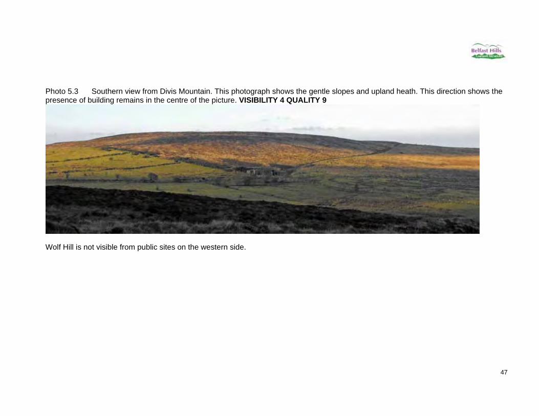
Photo 5.3 Southern view from Divis Mountain. This photograph shows the gentle slopes and upland heath. This direction shows the presence of building remains in the centre of the picture. VISIBILITY 4 QUALITY 9
Wolf Hill is not visible from public sites on the western side.
48
Other Landscape Features – Built Heritage & History Its lower appearance means that Wolf Hill is a convenient passage through the hills to Antrim, Glenavy and beyond, which explains its wealth of interesting archaeological sites such as:
a megalithic tomb called Giant’s Grave which is no longer present (ANT 060:016 and ANT 060:017)
a second megalithic tomb on an Eastern spur of Wolf Hill in reasonable upland pasture, in an area otherwise damp & disagreeable for agriculture. The remains of this tomb could not be located. It was described in PSAMNI (1940) as 2 well matched uprights 3ft high & 4'6" apart with another upright 7ft away & 2 displaced slabs nearby. (ANT 060:018)
an “old cave” on the slopes down to Legoniel, likely to have been a souterrain (ANT 060:019)
This hill was also known for a time in the 1800s as Clements Hill, owned by the Clements family of Legoniel. With the Crow Glen marking the southern boundary and feeding the Forth River, this is an important feeder for the flax, corn and beetling mill industrial sites along the Forth and Legoniel areas, powered by a network of mill races and dams. The Wolfhill Centre has a number of old photographs on display showing the 19th and early 20th century mill communities of the district. There were also some lime quarries and kilns on these lower slopes.

49
DIVIS & BLACK MOUNTAIN 6. Divis & Black Mountain Divis and Black Mountain are located at the centre of the Belfast Hills, to the south of Wolf Hill and to the north of Collin mountain. Divis mountain is the highest of the Belfast Hills and dominates the surrounding landscape. On its foot-slopes are a number of smaller summits which although not visible on the Belfast skyline should still be noted; namely Armstrongs Hill and Mount Gilbert. Neighbouring Divis is Black Mountain which has three summits along its ridge line. 6.1 Position, Height The Summit of Divis is 478m high (J282755), while Mount Gilbert to the north (J286762) is 350m high and Armstrongs Hill to the west (J268756) is 380m high. The highest of the Black Mountain summits is the most northern at 390m high (J293749), then 366m high (J283738) and 360m high (J285730) as you head southwards. Together they cover an area of 9km2. Dense housing is found to the eastern side of the Black Mountain. 6.2 LCA & Description The Black Mountain section is designated an Area of High Scenic Value, while the Divis Mountain slopes are excluded. The upper summits of Divis and Black Mountain are all within the Landscape Character Area called Divis Summits, while the lower slopes of Black Mountain are designated as Belfast Basalt Escarpment. See figure 6.1. This group of hills is characterised by upland heath summits which have associated large aerials. Along the eastern edges of Black Mountain is scrub, with some of the very lowest slopes comprising grassland with hedges. The southern section of Black Mountain is quarried and an exposed cliff face now dominates the view of the mountain from South Belfast. This strong visual impact makes restoration/visual mitigation works on the Black Mountain Quarry site of prime importance. Tree and wild flower planting at Black Mountain Quarry, in association with the quarry manager, is planned for year one as part of the LPS.

50
Figure 6.1 Boundary of Divis and Black Mountain is indicated by the green line. Black lines show the divisions between Landscape Character Areas
Divis Summits
Belfast Basalt Escarpment

51
Key Views: Divis Photo 6.1 Southern view from Glenside Road. This picture clearly shows conifer plantations at the base of Divis mountain. Just above this are housing, then enclosed fields and finally the heath covered mountain slopes. The aerials at the top of the mountain are also evident. VISIBILITY 7, QUALITY 8
Photo 6.2 Snow-scape scene showing the same southern views of Divis.

52
Photo 6.3 Eastern view from Twadell Ave. Over the tops of houses, Divis can be seen on the left. Mount Gilbert can also be seen on the right of the photograph, almost merging with the slope of Divis. On the lower slopes mature scrub are present. Pylons and aerial masts are also visible. VISIBILITY 6 QUALITY 7
Photo 6.4 Northern view from Cave Hill looking towards Divis. From this location the lower field patterns are evident, leading onto scrub (predominantly gorse), then open heathland mountain slopes. Aerial masts are also visible. VISIBILITY 7 QUALITY 8

53
Photo 6.5 South-western view from Divis Road – Divis can be clearly seen to the right of the picture along with the aerials. To the left is Armstrongs Hill. A number of wooden electricity poles can also be seen in the foreground. VISIBILITY 6 QUALITY 8
54
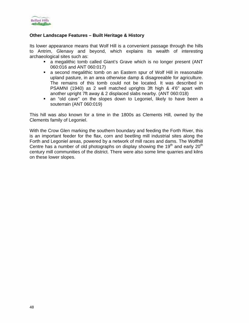
Key Views: Black Mountain Photo 6.6 Northern view of Black Mountain as seen from Cave Hill. This picture shows the high density housing in the foreground, beyond which are agricultural fields, followed by scrub and then open heathland. Aerials are visible. VISIBILITY 8 QUALITY 8
55
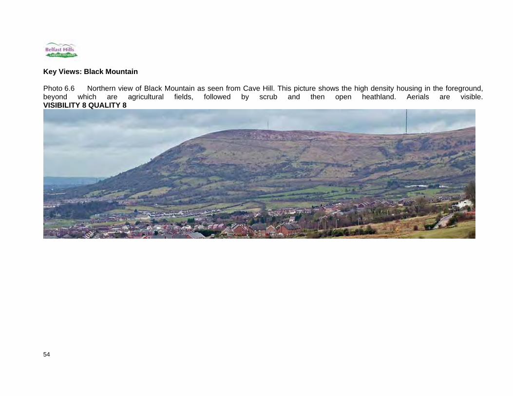
Photo 6.7 Eastern view from the Monagh Bypass. The bypass with its lamp posts dominates this view. The base of the slopes is enclosed agricultural fields, above which is a high level of scrub. Heath topped upper slopes are visible on the right hand side of this photograph. VISIBILITY 8 QUALITY 6
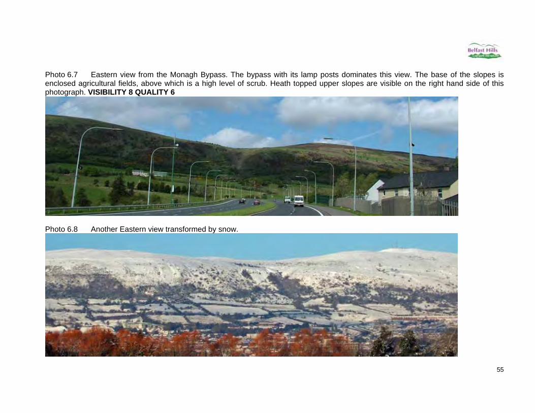
Photo 6.8 Another Eastern view transformed by snow.

56
Photo 6.9 South Western view from Ballycollin. This photograph shows the whole Black Mountain ridge line which is visually interrupted by the aerials. The extent of the quarrying of Black Mountain can also be seen. Glenside Community Woodland with its conifers can be seen in the foreground to the left, above which is the village of Hannahstown. The heath covered upper slopes may also be seen. VISIBILITY 5 QUALITY 7
57
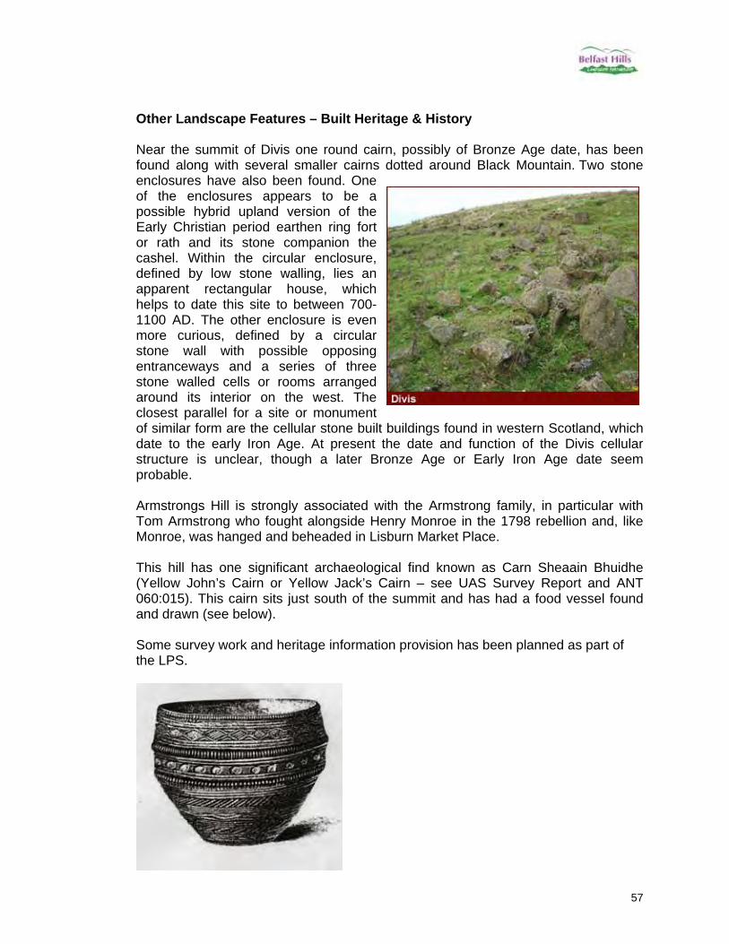
Other Landscape Features – Built Heritage & History Near the summit of Divis one round cairn, possibly of Bronze Age date, has been found along with several smaller cairns dotted around Black Mountain. Two stone enclosures have also been found. One of the enclosures appears to be a possible hybrid upland version of the Early Christian period earthen ring fort or rath and its stone companion the cashel. Within the circular enclosure, defined by low stone walling, lies an apparent rectangular house, which helps to date this site to between 700-1100 AD. The other enclosure is even more curious, defined by a circular stone wall with possible opposing entranceways and a series of three stone walled cells or rooms arranged around its interior on the west. The closest parallel for a site or monument of similar form are the cellular stone built buildings found in western Scotland, which date to the early Iron Age. At present the date and function of the Divis cellular structure is unclear, though a later Bronze Age or Early Iron Age date seem probable. Armstrongs Hill is strongly associated with the Armstrong family, in particular with Tom Armstrong who fought alongside Henry Monroe in the 1798 rebellion and, like Monroe, was hanged and beheaded in Lisburn Market Place. This hill has one significant archaeological find known as Carn Sheaain Bhuidhe (Yellow John’s Cairn or Yellow Jack’s Cairn – see UAS Survey Report and ANT 060:015). This cairn sits just south of the summit and has had a food vessel found and drawn (see below). Some survey work and heritage information provision has been planned as part of the LPS.

58
STANDING STONES HILL 7. Standing Stones Standing Stones Hill is situated south west of Divis Mountain and, as the name suggests, has the remains of standing stones on its summit. 7.1 Position, Height The summit of Standing Stones Hill is 320m high (J253743). The hill covers an area of approximately 1.5km2. The hill is bounded by a number of roads, namely the Divis Road to the North and East, the Tornaroy Road to the South and Budore Road to the West. 7.2 LCA & Description This hill falls entirely under the Divis Summits Landscape Character Area designation (figure 7.1). The upper slopes are characterised by open rough grassland, while the lower slopes are hedged fields of “improved” grassland, used for grazing. South west on the hill is a site that has previously been quarried but is currently unused.

59
Figure 7.1 Boundary of Standing Stones Hill is indicated by the green line. NB quarry shown as a body of water in the above map, but has been in filled so water no longer present.
Divis Summits

60
Key Views Photo 7.1 Northern view from Divis Road. The presence of rush and rough grassland are visible in the foreground. More agricultural fields and lines of trees may be seen on the upper slopes. VISIBILITY 7 QUALITY 7
Photo 7.2 Eastern view from Divis car park. This picture illustrates the gentle sloping sides of Standing Stones Hill, making its presence difficult to discern. A number of wooden telegraph poles are dominant in the foreground. VISIBILITY 8 QUALITY 6

61
Photo 7.3 Southern view from Tornaroy Road. This photograph shows the assortment of housing and associated industrial outbuildings with various scrap collections. A mixture of agricultural grassland, rough grassland and scrub are present. VISIBILITY 9 QUALITY 3
Photo 7.4 Western view from Budore Road. On the gentle slopes agricultural grassland is mixed with reeds. Mature trees may also be seen on the horizon. VISIBILITY 7 QUALITY 8

62
Other Landscape Features – Built Heritage & History As the name suggests, Standing Stones Hill is rich in historical associations with three standing stones (ANT 060:014) present near the summit just behind the quarry. These are in a poor state of preservation. There are a large number of raths, mounds and souterrains lower down the slopes to the west of the hill and the Budore Road. There are plans to locate a wind farm on Standing Stones Hill, and planning permission for a wind monitoring pole has been granted. If wind levels recorded indicate that a wind farm would be economically viable, a planning application will inevitably follow. This, and other planning applications in the hills, will be dealt with within the LPS through the proposed Planning Issues Network. Through this network, local residents and visitors to the area will be alerted to the existence of the planning application and encourage them to submit their concerns/views to Planning Service. The Partnership Board will also make submissions to Planning Service.

63
SLIEVENACLOY 8. Slievenacloy Slievenacloy lies west of Boomer’s Hill and south of Collin Mountain and Ridge. Its name derives from the hill of the stone. 8.1 Position and Height This is one of the lower western summits in the Belfast Hills area, rising to 305 metres at J248716. For the purposes of this assessment it is bound to the south by the Stonyford stream, to the east by the Ballycolin Road, to the north by the Hannahstown Road and to the west by the Rushyhill Road. It should be noted that only the southern slopes are present within the Belfast Hills Operational Area and the assessment will therefore concentrate primarily on these. 8.2 LCA & Description The eastern section of Slievenacloy lies within the Area of High Scenic Value. It is similarly evenly split with its western section in the Divis Summits LCA and the eastern in the Belfast Basalt Escarpment LCA (figure 8.1). Its relatively modest height and the lack of substantial valleys between it and its neighbouring hills, e.g. Colin Mountain and Ridge, minimizes its impact on the general landscape – but it does have some important features. Virtually all of Slievenacloy is within the Slievenacloy Area of Special Scientific Interest (ASSI), designated for its high quality grassland and upland heath habitats. This is evident in its landscape of rough grassland and rush pasture on its gentle slopes and hollows with its summit topped by short heath. It does have some old hedgerows and patches of mature trees around abandoned farmhouses which both have a clear and positive landscape impact. The Flowbog Road also has a significant section of hedge and single trees. Abandoned farming is also evident in the patchwork of invasive hawthorn scrub, although this is being removed by the present managers, the Ulster Wildlife Trust.

64
Figure 8.1 Boundary of Slievenacloy is indicated by the green line. Black lines show the divisions between Landscape Character Areas.
Belfast Basalt Escarpment Divis Summits

65
Key Views Southern – The hill is dominated by relatively uniform rough pasture. This means that any stands of trees, field scrub or hedges can dominate and that old banks and field patterns are visible (Photo 8.1 below). VISIBILITY 3 QUALITY 7 Photo 8.1 Old field patterns
Photo 8.2 Southeast slopes

66
Eastern – Photo 8.3 again shows the importance of the tree stands and road and field hedges set against the uniform rough pasture. The electricity pylons running parallel to the Ballycolin Road are clearly visible and do have an impact within this landscape. In 8.4, the new access roads within the UWT site are visible to the right. These have had further hedges planted on both sides to soften this. VISIBILITY 3 QUALITY 7 Photo 8.3 View from Ballycolin Road
Photo 8.4 View from Collin, further back and higher than 8.3
67
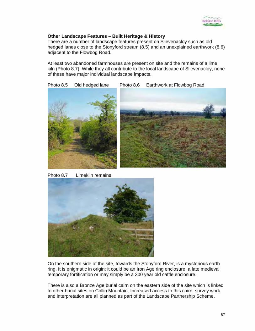
Other Landscape Features – Built Heritage & History There are a number of landscape features present on Slievenacloy such as old hedged lanes close to the Stonyford stream (8.5) and an unexplained earthwork (8.6) adjacent to the Flowbog Road. At least two abandoned farmhouses are present on site and the remains of a lime kiln (Photo 8.7). While they all contribute to the local landscape of Slievenacloy, none of these have major individual landscape impacts. Photo 8.5 Old hedged lane Photo 8.6 Earthwork at Flowbog Road
Photo 8.7 Limekiln remains
On the southern side of the site, towards the Stonyford River, is a mysterious earth ring. It is enigmatic in origin; it could be an Iron Age ring enclosure, a late medieval temporary fortification or may simply be a 300 year old cattle enclosure. There is also a Bronze Age burial cairn on the eastern side of the site which is linked to other burial sites on Collin Mountain. Increased access to this cairn, survey work and interpretation are all planned as part of the Landscape Partnership Scheme.

68
COLLIN MOUNTAIN AND RIDGE 9. Collin Mountain and Ridge Collin Mountain is the dominant hill in the southern part of the Belfast Hills area. There are a number of Collin hills and mountains in the region, suggesting that Collin refers simply to a big mountain, although other theories concerning its name abound. It rises in a classic conical shape as seen from much of the Lagan Valley. Running back in a north western direction is a high ridge forming the southern edge of the Collin Valley area. We will call this the Collin Ridge for the purposes of this document. Collin Mountain summit was heavily wooded up until the Second World War. 9.1 Position, Height Collin Mountain is an important part of the prominent escarpment edge of north Lisburn and Belfast. It rises to 328 metres (J261706) while Collin Ridge remains at 270-300 metres for roughly two kilometres until it ends at White Mountain (305 metres, J254724). The area to be described here is bounded by Colinglen Road to the east and south, Ballycolin Road to the west, Hannahstown / Upper Springfield Road to the northwest and the Hannahstown Hill Road to the northeast. The reason for including the ground up to the Hannahstown Hill Road is to keep the upper Collin Valley intact as a single landscape unit within this section (figure 9.1). 9.2 LCA & Description All of Collin Mountain and Ridge lies within the Area of High Scenic Value and the Belfast Basalt Escarpment LCA (figure 9.1). A history of quarrying, farming and woodland management linked with its variety in geology, altitude, rivers, streams and topography, gives this area a highly varied and complex landscape. Its landscape types therefore vary from broadleaf woodland valley to enclosed fields on the lower slopes and on to quarries, conifer plantations, upland heath and rough pasture.

69
Figure 9.1 Boundary of Collin Mountain and Ridge is indicated by the green line. Black lines show the divisions between Landscape Character Areas.
Belfast Basalt Escarpment
70
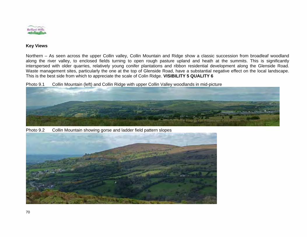
Key Views Northern – As seen across the upper Collin valley, Collin Mountain and Ridge show a classic succession from broadleaf woodland along the river valley, to enclosed fields turning to open rough pasture upland and heath at the summits. This is significantly interspersed with older quarries, relatively young conifer plantations and ribbon residential development along the Glenside Road. Waste management sites, particularly the one at the top of Glenside Road, have a substantial negative effect on the local landscape. This is the best side from which to appreciate the scale of Colin Ridge. VISIBILITY 5 QUALITY 6 Photo 9.1 Collin Mountain (left) and Collin Ridge with upper Collin Valley woodlands in mid-picture
Photo 9.2 Collin Mountain showing gorse and ladder field pattern slopes

71
Photo 9.3 Mid-section of Collin Ridge showing higher basalt quarries and lower limestone quarry, also succession from upland heath, rough grazing to woods.

72
Southeast – Collin Mountain is highly visible from much of south and west Belfast and much of north Lisburn. Key attributes are the close urban areas and hamlet around Groganstown / lower Ballycolin Road to the southern slope, the ladder pattern of enclosed fields on the lower slopes (Photo 9.6), the quarrying and waste management sites on the middle slope and the variable summit landscape due to the gorse and scrub pockets. Also note the electricity pylons along the urban edge. VISIBILITY 8 QUALITY 6 Photo 9.4 Collin from Lagmore Avenue
Photo 9.5 Collin from Barnfield Road
Photo 9.6 Collin from Pond Park Road

73
Southwest – This is primarily the view from Slievenacloy which shows a ribbon of improved fields along the partially hedged Ballycolin Road and a more uniform summit of Collin Mountain containing little of the scrub and gorse of its eastern side. One abandoned quarry just above the Ballycolin Road is visible (left in photo 9.8). VISIBILITY 3 QUALITY 7 Photo 9.7 Part of Collin Ridge and Collin Mountain from Slievenacloy
Photo 9.8 Collin Mountain from Slievenacloy
Photo 9.9 Collin Ridge and Mountain from Stonyford stream at Slievenacloy
74
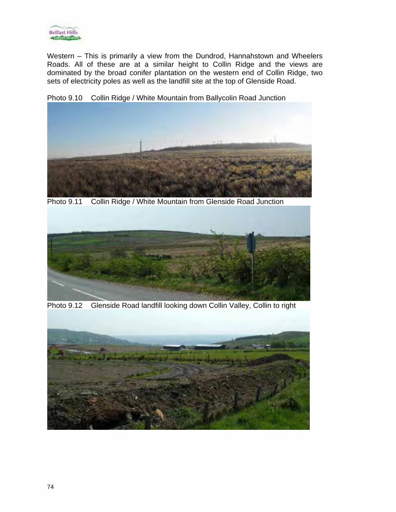
Western – This is primarily a view from the Dundrod, Hannahstown and Wheelers Roads. All of these are at a similar height to Collin Ridge and the views are dominated by the broad conifer plantation on the western end of Collin Ridge, two sets of electricity poles as well as the landfill site at the top of Glenside Road. Photo 9.10 Collin Ridge / White Mountain from Ballycolin Road Junction
Photo 9.11 Collin Ridge / White Mountain from Glenside Road Junction
Photo 9.12 Glenside Road landfill looking down Collin Valley, Collin to right
75
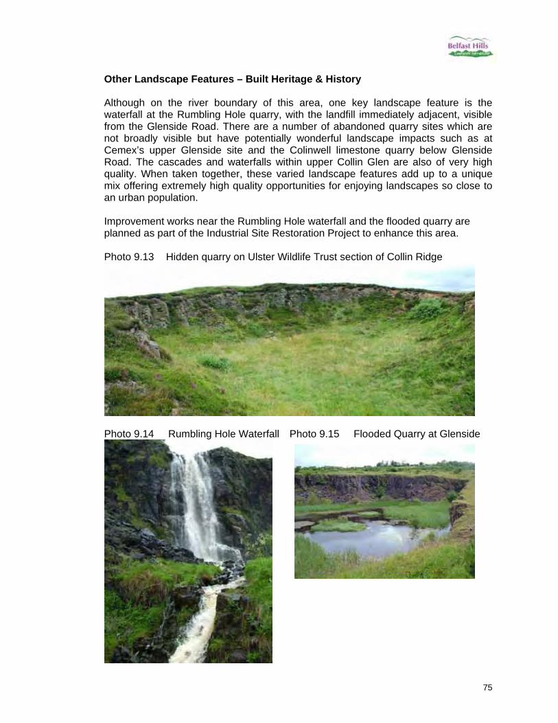
Other Landscape Features – Built Heritage & History Although on the river boundary of this area, one key landscape feature is the waterfall at the Rumbling Hole quarry, with the landfill immediately adjacent, visible from the Glenside Road. There are a number of abandoned quarry sites which are not broadly visible but have potentially wonderful landscape impacts such as at Cemex’s upper Glenside site and the Colinwell limestone quarry below Glenside Road. The cascades and waterfalls within upper Collin Glen are also of very high quality. When taken together, these varied landscape features add up to a unique mix offering extremely high quality opportunities for enjoying landscapes so close to an urban population. Improvement works near the Rumbling Hole waterfall and the flooded quarry are planned as part of the Industrial Site Restoration Project to enhance this area. Photo 9.13 Hidden quarry on Ulster Wildlife Trust section of Collin Ridge
Photo 9.14 Rumbling Hole Waterfall Photo 9.15 Flooded Quarry at Glenside

76
BOOMER’S HILL 10. Boomer’s Hill This is our most southerly hill within the operational boundary. Its name is evidence of the 18th century Huguenot population within Lisburn (Boomer is a common local Lisburn name derived from Baulmer). 10.1 Position, Height Reaching over 300 metres at its height (J253700), Boomer’s Hill runs for roughly two kilometres (from J240690 to J257702) with its main summits being to the northeast, tapering down gentle slopes to the southwest. It is skirted by the Colinglen / Mullaghglass Road southeast, becoming the Stoneyford Road southwest, the Stonyford River and Flowbog Road to the northwest and the Ballycolin Road to the northeast. 10.2 LCA & Description The south-eastern slopes of Boomer’s Hill, facing the Lagan Valley, are within the Area of High Scenic Value. The north-eastern section of Boomer’s Hill lies in the Belfast Basalt Escarpment LCA while the south-western is within Divis Summits (figure 10.1). There is some logic to this in that it does form the south end of the main escarpment line which continues north along Black Mountain and Cave Hill, while its south-western portion resembles the lower western hills of Slievenacloy and Standing Stones Hill. Boomer’s Hill is one of the lower hills with moderate slopes, an exception being some of the central parts of the south-eastern slope. It is characterised by enclosed fields along its southern and eastern slopes, three major quarry and waste sites at Aughrim, Mullaghglass and McCourts, and unenclosed uplands in the rest. There is regular ribbon development along the Colinglen / Mullaghglass / Stoneyford Roads. A substantial plantation of conifers (Aughrim Plantation) is present on the south-eastern slope, including larch which has a highly visible impact in winter. Two communication masts are present on the summit, one being much more dominant.
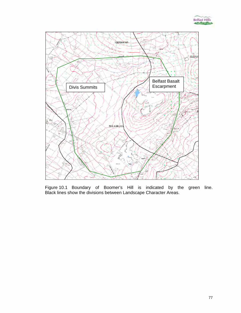
77
Figure 10.1 Boundary of Boomer’s Hill is indicated by the green line. Black lines show the divisions between Landscape Character Areas.
Divis Summits Belfast Basalt Escarpment

78
Key Views South-eastern – This is a key urban aspect seen from much of southwest Belfast and northwest Lisburn. Dominated by the conifer plantation, masts and the quarry face of McCourt’s. The lower slopes are covered by enclosed fields including one particularly large upper field tight against the plantation. The ribbon development along the Colinglen Road is highly visible, including the Meeting House (centre of photo 10.1 to left of pylon). VISIBILITY 8 QUALITY 6 Photo 10.1 View From bottom of Lagmore Avenue
Photo 10.2 From Barnfield Road

79
South-western – Less well seen as the hill slopes down to the south west. Visible from the main Pond Park Road and Pond Park Road East, which is a country lane. It is clear from this aspect why the hill was split into two Landscape Character Areas, with the semi-improved grassland on the southern slope (left in 10.3 below) providing a marked change in the landscape. The conifer plantations and masts still dominate but the higher upland summit is now just visible above the larch. The netting structures of Mullaghglass are visible from some sections of Pond Park Road. VISIBILITY 5 QUALITY 5 Photo 10.3 View from Pond Park Road
Photo 10.4 From Pond Park Road East

80
North-western – Substantially dominated by the recent netting at Aughrim Landfill site. A few mature trees on upper slopes with the lower slopes consisting of upland grasslands and hedge remnants of once enclosed fields with lazy bed patterns running down to the Stonyford stream. Lower fields along the stream are visibly more improved. VISIBILITY 4 QUALITY 3 Photo 10.5 Northern End of Aughrim Site Photo 10.6 South end of Aughrim site

81
Photo 10.7 Aughrim site (prior to netting) and south-western section of Boomer’s Hill from Slievenacloy
North-eastern – This view is primarily from the Ballycolin Road and Collin looking on to the heavily industrialised side of the Aughrim site. Most views of this are dominated by the quarry and the landfill netting can also be seen from as far away as Divis and Black Mountain. Also note the electricity pylons running along the Ballycolin Road. VISIBILITY 3 QUALITY 2 Photo 10.8 View from Ulster Wildlife Trust section of Collin Ridge (taken July 2006)
There may be opportunities to liaise with the owners of Aughrim quarry to encourage restoration of the site using wild flowers sourced locally in the hills through the Industrial Site Restoration Project.
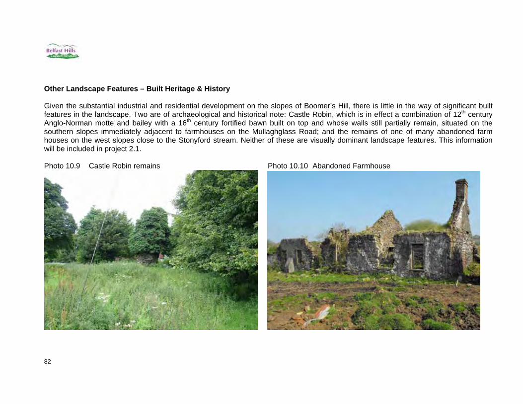
82
Other Landscape Features – Built Heritage & History Given the substantial industrial and residential development on the slopes of Boomer’s Hill, there is little in the way of significant built features in the landscape. Two are of archaeological and historical note: Castle Robin, which is in effect a combination of 12th century Anglo-Norman motte and bailey with a 16th century fortified bawn built on top and whose walls still partially remain, situated on the southern slopes immediately adjacent to farmhouses on the Mullaghglass Road; and the remains of one of many abandoned farm houses on the west slopes close to the Stonyford stream. Neither of these are visually dominant landscape features. This information will be included in project 2.1. Photo 10.9 Castle Robin remains Photo 10.10 Abandoned Farmhouse

83
MAIN ISSUES / THREATS WEAKENING LANDSCAPE CHARACTER AND PUBLIC USAGE The following is a summary of the main threats which affect the sites previously described. These threats and landscape needs are translated into priority projects later in the document.
Under grazing & abandonment Over grazing Poor quality hedges and banks which may result in future loss Inappropriate/excessive number of additional masts, structures etc Bracken and scrub encroachment Visual quality of landfill and quarry sites Invasive species Fires Lack of paths Erosion of existing paths Conflict of user groups, e.g.
walkers v mountain bikers/scramblers
Illegal waste dumping and fly tipping
Anti social behaviour, e.g. littering, drug and drink taking, dog fouling
Personal safety and car safety
Lack of info regarding user numbers and user needs/views
Aerial on Collinward NEEDS OF THE LANDSCAPE AND HOW TO ADDRESS THESE NEEDS Appropriate grazing levels to preserve rich grasslands and traditional farmland
landscape. Some areas in the Belfast Hills are obviously poached from over grazing, while on others, the grass has become rank from under grazing. Without being too prescriptive, a balance needs to be achieved between these extremes. Address by engaging with landowners and encouraging farmers to consider the impact of grazing levels. The Landscape Partnership Scheme will enable an Outreach Officer to be employed who will actively work with the farmers in the Belfast Hills, using grant schemes (project 1.4) as a positive means of engaging with them and opening up dialogue regarding issues such as grazing levels. The LPS Committee has a representative from the local farming community who will be utilised to help make connections and build positive relationships.

84
New hedges and improvement works to existing gappy hedgerows as field boundaries are not only important from a landscape perspective but are also essential homes and corridors for wildlife. Address by planting new hedges, coppicing and inter planting gappy hedges, rebuilding of old walls to preserve field boundary patterns. The Landscape Partnership Scheme will offer small grants to landowners in the Belfast Hills (project 1.4) which can be used by landowners to plant new hedges and restore old existing gappy hedges. It is hoped that this will motivate landowners to improve hedges on their land.
There are some roads that have obviously suffered greater hedgerow degradation than others due to high levels of HGVs, e.g. the Ballycollin Road. It may be possible to target specific areas to provide maximum impact.
For the landscape to be unobstructed by numerous masts on hill tops.
Address by ensuring that additional masts, structures etc are duly considered in terms of landscape impact prior to installation by responding to planning applications and encouraging the local community to express their thoughts (positive or negative). A planning issues network programme is planned as part of the Landscape Partnership Scheme (project 2.9). This will be a liaison project to establish recognised communication links between a wider range of community groups and planning advice and assistance bodies. Any planning applications relevant to a particular community group in the hills is identified and the outreach officer will make contact with that group, to inform them of the application and encourage them to make a response if they have any concerns or to make a response through BHP Board. Additional structures and masts in the hills will be a primary issue.
The need to remove bracken and scrub. Address by removing bracken and scrub before they have opportunity to encroach into fields. As part of the Landscape Partnership Scheme, an outreach officer will work with local farmers and landowners and can encourage these landowners to remove bracken and scrub on their land. Volunteers could also be utilised to assist in this task if the landowner permits it (project 4.11).
Visibility of landfill and quarry sites. Address by appropriate planting and restoration plans. We have been working with the Quarry Products Association NI (QPANI) who are represented on the LPS Committee and have facilitated meetings with quarry managers. There is a need to raise basic awareness of the impact their site can have on the surrounding areas, so the need to place buildings, spoil piles etc sensitively on site.

85
Through the Landscape Partnership Schemes Industrial Site Restoration Scheme (project 1.1), some planting of native tree species around the base of industrial sites could help lessen their visibility. This will depend on the suitability of the site for tree planting and the co-operation of site owners.
Invasive species mapping and removal to prevent these invasive plants taking over sites and negatively impacting on local biodiversity and visitor enjoyment.
This will be carried out through the Invasive Species removal project planned as part of the Landscape Partnership Scheme (project 1.5).
Mapping of fires to gain a better understanding of impact of fires on the habitat. Education of young people to encourage positive use of the hills instead of antisocial behaviour. It is planned that the Landscape Partnership Scheme will address these via its wildfire mapping project and through its education programmes with schools (project 1.2 and 4.11).
Building of new access paths to help meet demand and where possible connect
sites together.
As part of the Landscape Partnership Scheme, various new paths have been planned, generally fulfilling public demand as expressed by worn ‘desire lines’ showing where people currently walk even though there is no path. These desire lines have in many places become very mucky and eroded, often resulting in people walking to the side of these tracks so making them wider and impacting on surrounding habitats over time. New access is currently being negotiated and if successful will result in new paths being created to link sites, so providing long distance walking opportunities (project 3.1).
Investment into upgrading existing paths to enable people of all abilities to access
the hills. An audit of path conditions revealed that a number of paths in the hills were badly eroded (again with people walking to the sides of paths making them wider and damaging surrounding habitats), so even paths which were advertised as being suitable for access to all were in such bad condition that they could not be used by wheelchair users. The Landscape Partnership Scheme will enable these issues to be addressed (project 3.1).
Encourage walkers and mountain bikers to use different parts of the hill to avoid
overlap and conflict. The Cave Hill Country Park is commonly used for Mountain biking. Belfast City Council, who owns the land, officially do not allow bikes in the park, but to date have not been able to enforce this. As downhill biking has become faster there have been more complaints from the general public walking in the park regarding the presence of these bikes. It may be possible that a different site can be identified through a recreational study carried out as part of the Landscape Partnership Scheme which would be more suitable for mountain bikers, so
86
encouraging them away from public sites which are designed for walkers only (project 3.2). The co-operation of Belfast City Council regarding how best to tackle this issue is important, however we must recognise that this is a long term problem and any solutions will also need to be long term.
Illegal waste dumping and fly tipping is an ongoing problem throughout the Belfast Hills. Education of local communities about the importance of the Belfast Hills, particularly for biodiversity and the negative impact of illegal dumping will be part of the role of the Outreach Officer who will be employed by the Belfast Hills Landscape Partnership Scheme (projects 4.9 & 4.10).
There is a certain amount of anti social behaviour that takes place in the Belfast
Hills, e.g. littering, drug and drink taking, dog fouling, scrambling. Increasing use of such areas by recreational users may help push out the anti social elements from the public sites. There is also a role for education and closer working with the PSNI which could be undertaken by the Outreach Officer who will be employed by the Belfast Hills Landscape Partnership Scheme (projects 3.2 & 4.11).
Personal safety and car safety are often concerns listed by potential users of the
Belfast Hills. However, statistically, incident levels are very low and the more people who make positive use of the Belfast Hills the less likely such incidents are. Education of people regarding such statistics is required. Presence of volunteer wardens on sites and in car parks may also help alleviate people’s fears. A volunteer warden scheme will be set up as part of the Landscape Partnership Scheme (projects 4.4 and 4.11).
Information regarding user numbers and user needs/views to be collected and
made readily available. This will be carried out as part of the Landscape Partnership Scheme through installation of people counters on sites and through using volunteer wardens to conduct surveys on sites regarding site facilities (project 3.5). This information can be used by site managers to make appropriate improvements on sites.
FORCES FOR CHANGE AND OPPORTUNITIES FOR RESTORING AND STRENGTHENING IT Landowners: Various landowners own different sections of the Belfast Hills and therefore their management decisions (generally influenced by factors such as staffing levels, budget constraints) are the greatest force for change. It is important therefore to engage with the landowners to ensure that appropriate restoration and strengthening of the sites is undertaken. The potential offer of match funding from the Landscape Partnership Scheme will hopefully encourage landowners to consider positive management works that they would not otherwise consider undertaking. Programme 1: Conservation of Built and Natural Features and Programme 3: Access and Learning will help support landowners undertake various improvement works on their sites. Industrial site managers: With regard to the various quarry and landfill sites, forces of change will largely be due to decisions by Planning Service and NIEA regarding approved quarry/landfill licence and restoration plans. There may be an opportunity for the Landscape Partnership Scheme, through project 1.1, to approach the owners

87
of such industrial sites to discuss appropriate tree planting or other works that go beyond the restoration plans or result in them occurring many years before they have to. This could minimise visual impact, perhaps leading to discussions regarding public access once restoration of inactive sections of the quarry/landfill are completed. The local lobby groups: such as the Cave Hill Conservation Campaign, Black Mountain Conservation Campaign and Glen Road Environment Action Team. The Belfast Hills Partnership works closely with these groups and may be able to work together to tackle issues such as invasive species removal, fire mapping, bracken bashing etc on the hills. Engagement of local communities will occur through all programmes, but specifically through programme 2 Community Participation. Planning Issues network: Responding to planning applications for housing and other developments in the hills through the Planning Issues Network through project 2.9 will encourage appropriate development, and hopefully prevent the creep of housing up the slopes of the Belfast Hills. Engagement and Education: Enhancing peoples knowledge and appreciation of the rich heritage in the hills through events, community digs and restoration of a couple of sites will strengthen the perceived value of heritage and result in greater pressure on landowners to look after remaining sites and allow access to these sites. It is planned that this will occur through implementation of Programme 4 of the LPS, Heritage Skills and Training.

88
Belfast Hills Historical Background The Belfast Hills are a great example of how people who lived, farmed, hunted and died many centuries ago can leave their marks on the landscape. The hills are dotted with clues about how we lived in the times when the site of present day Belfast was little more than marsh and swamp. The prehistoric period (7000-1000 BC) The Early Mesolithic Period in Ireland is dated to 7000-6000BC, followed by the Late Mesolithic Period, which is dated to 6000-4000BC, distinguished by a variation in the flint tool assemblage and production techniques. Mesolithic people were Stone Age hunters, fishers and gatherers, living on the coastline and along rivers, but with no knowledge of farming. They used flint and other stones to manufacture sharp tools (Anderson 1991, 35-8); their settlements can now be identified by locating scatters of discarded stone tools and the debris from their manufacture, generally discovered when fields are ploughed. The earliest upstanding remains within the Belfast Hills date from the Neolithic period. The Neolithic (or New Stone Age) period represents the arrival and establishment of agriculture as the principal form of economic subsistence. Over successive generations, farmers either moved slowly across Europe or had influenced local hunter-gathering populations to adopt the new economy (Mallory & McNeill 1991, 29). During the Neolithic and Early Bronze Age (c.3500-c.1500 BC) a characteristic feature of farming communities in Ireland and over much of Western Europe, was the practice of collective burial in stone tombs, now known as 'megalithic tombs' (Twohig, 1990). In Ireland, four main types of megalithic tomb have been identified and termed as court tombs, portal tombs, passage tombs and wedge tombs. There are three examples of tombs in the Belfast Hills. Firstly, on the summit of Wolf Hill close to a disused quarry, are megalithic remains named the "Giant's Grave" (there is no visible indication of the remains). Secondly, at Legoniel, a tomb was described in PSAMNI (1940) as 2 well matched uprights 3’ high & 4'6" apart with another upright 7’away and 2 displaced slabs nearby (the remains of this tomb are no longer visible). Lastly, a tomb at Ballyutoag was partly excavated in 1937 revealing some Neolithic pottery, a flint scraper and some Iron Age pottery. The early medieval period (AD 400-1169) The early medieval period was a time of profound internal social and economic change in Ireland. The medieval period attracted settlement on the lower reaches of the River Lagan forming the original core of the City of Belfast. Agricultural practices demanded clearance of forested slopes of the Belfast Hills land to enable human sustainability. The first farmers to develop permanent farmsteads utilised the presence of flint contained within the Belfast Hills. Evidence of early quarry sites and settlement locations are found in various forms on the hills. The dominant site types associated with this period include ring forts, souterrains and enclosures. There are numerous examples of early medieval monuments located within the Belfast Hills. Many of these features date from the Early Christian period (400-799 AD).

89
Ballyaghagan Rath Ring forts are undoubtedly the most widespread and characteristic archaeological field monument in the Irish countryside. They are usually known by the names ráthor lios and consist of a circular or roughly circular area enclosed by an earthen bank formed of material thrown up from a concentric fosse (or ditch) on its outside. Archaeological excavation has shown that the majority of ring forts were enclosed farmsteads, which acted as a defence against natural predators like wolves, as well as against the cattle raids. Souterrains (underground chambers) are often found in association with ring forts. The introduction and establishment of Christianity during this period is attested to in the archaeological record by the presence of church sites, associated places for Christian burial and holy wells. The late medieval period (AD 1169-1600) The arrival and conquest of large parts of Ireland by the Anglo-Normans in the late-12th / early 13th century marks a watershed in the political history of Ireland. The remains of castles built by the Anglo-Normans at this time survive in the form of mottes. The feudalisation of Gaelic-Irish society c.1000 AD, demarcated by the apparent abandonment of ring forts in the period around the turn of the millennium and the very low numbers of newly-built ring forts in the early centuries of the second millennium AD, involved the new divisions of land of which the modern town land is the descendant. Medieval Ireland was a heavily encastellated land. Leask (1951) estimated that 3,000 castles (including earth-and-timber castles and late semi-fortified houses) were built in Ireland between the late 1100s and the 1600s. Almost all the extant Anglo-Norman stone buildings of anon-ecclesiastical nature in Ireland appear to have been equipped for defending or were parts of larger complexes, which were so equipped (O’Keeffe 2000). There is one example of a 17th century castle within the Belfast Hills. The rectangular hall or hall-house was the preferred form of castle residence in later 13th century Ireland, and it may have been an influential form in the evolution of tower-houses, despite its comparatively low height. Tower houses were built in the fifteenth and

90
sixteenth centuries as lordly residences by both Gaelic and Old English (Norman) families. The post-medieval period (AD 1600-Present) The sixteenth century was a turbulent time in Irish political matters. A new order of Irish lordships emerged as previous English settlements were almost eliminated. During the later sixteenth century the Irish lords came into bitter conflict with England when the Tudor kings and queens, particularly Elizabeth I, were determined to assert English control tightly over Ireland. The resulting wars dating from the 1560s to 1603 bring this unsettled period to an end. The eighteenth and nineteenth centuries were also a time for an upturn in industrial growth in Ireland and this is demonstrated by the industrial archaeological sites located within the study area. One of the most distinctive traits of Ulster is the range and variety of industrial activities that developed in the post-medieval period. Flax milling was the dominant industry within the Belfast Hills. During the eighteenth century, linen manufacture in Ireland was a home-based industry, with women spinning yarn on spinning wheels while the weaving was undertaken by men. By the end of the eighteenth century, linen accounted for about half of Ireland’s total exports. During the nineteenth century, watermills and wet-spinning were introduced resulting in mass production of linen. As a consequence, the domestic industry declined. Beetling was the final stage in the manufacture of linen. This process involved relentlessly pounding the material with heavy wooden hammers for up to ten hours. This gave the damask cloth its characteristic smoothness and sheen.
Between the eighteenth and early nineteenth centuries, traditional water-powered mills for processing corn were replaced by steam-powered machines, thus increasing production. Owing to the damp Irish climate, corn, as well as other grains, had to be dried in a kiln in order to reduce the moisture content and subsequently facilitate the milling process.

91
92
Management information The designations relating to the Belfast Hills area are:
ASSI – Area of special scientific interest AoHSV – Area of High Scenic Value SLNCI – Site of Local Conservation Interest BMA Green Belt – Belfast Metropolitan Area Green Belt LNR - Local Nature Reserve Registered Historic Monuments
Further information about these various designations and associated management strategies are provided below.

93
Area of special scientific interest (ASSI)
Figure 1.5 An Area of Special Scientific Interest (ASSI) is located in the southern end of the Belfast Hills. It incorporates the Local Nature Reserve, Slievenacloy, which is owned and managed by the Ulster Wildlife Trust and is open to the general public to enjoy. The Ulster Wildlife Trust has drawn up a management plan of works to be carried out at Slievenacloy. The primary objective stated for management is to maintain the range of habitats at favourable conservation status, largely through grazing levels. This plan acknowledges that “Slievenacloy is not a reserve in isolation. The Belfast Hills, in which the reserves lie, are a growing area for conservation. Strong links are already established with other landowners and managers within the hills and managing the whole area as a Living Landscape is becoming increasingly important”.
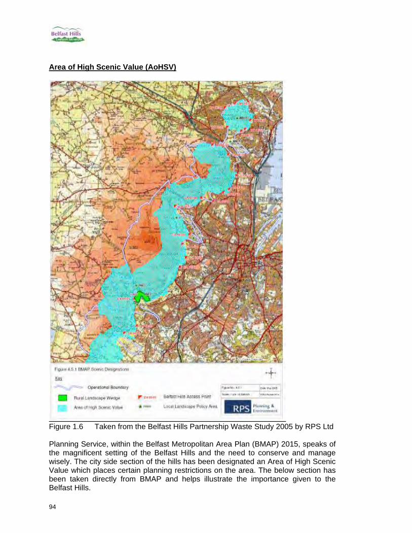
94
Area of High Scenic Value (AoHSV)
Figure 1.6 Taken from the Belfast Hills Partnership Waste Study 2005 by RPS Ltd Planning Service, within the Belfast Metropolitan Area Plan (BMAP) 2015, speaks of the magnificent setting of the Belfast Hills and the need to conserve and manage wisely. The city side section of the hills has been designated an Area of High Scenic Value which places certain planning restrictions on the area. The below section has been taken directly from BMAP and helps illustrate the importance given to the Belfast Hills.
95
Belfast Metropolitan Area Plan 2015 Strategic Plan Framework: Countryside and Coast Areas of High Scenic Value The diversity of landscapes in the Plan Area combine to provide a unique resource of significant environmental quality. The Metropolitan Urban Area enjoys a magnificent natural setting situated at the head of Belfast Lough, between the edge of the Antrim Plateau and the Castlereagh and Holywood Hills, with the River Lagan flowing through the Cities of Belfast and Lisburn. The Regional Development Strategy (RDS) recognises the importance of protecting the setting of the Metropolitan Area in a number of Strategic Planning Guidelines and measures that aim to: • conserve the natural environment (SPG–ENV 1) by:
protecting and encouraging appreciation of the Region’s landscapes, one element of which is to promote the conservation and wise management of the Belfast Hills and the regional resource value of the Antrim, Holywood and Castlereagh Hills, which provide the setting for the Metropolitan Area (ENV 1.1);
• enhance the role of the city of Belfast by protecting and enhancing the magnificent setting of the ‘City of the Hills’ (BMA 1.1); and
• enhance the quality of the urban environment by protecting the Areas of High Scenic Value around the Metropolitan Area and to keep hill slopes free from urban development (BMA 2.3).
Areas of High Scenic Value (AOHSV) are designated to protect the setting of the Metropolitan Urban Area and other areas of particular landscape merit. Policy COU 7 Areas of High Scenic Value Planning permission will not be granted to development proposals that would adversely affect the quality, character and features of interest in Areas of High Scenic Value. Proposals for mineral working and waste disposal will not be acceptable. A Landscape Analysis must accompany development proposals in these areas to indicate the likely effects of the proposal on the landscape. The Belfast Hills The Regional Development Strategy (RDS) contains Strategic Planning Guidelines and measures for the Belfast Hills as follows: the need to conserve the natural environment (SPG-ENV 1) by: protecting, enhancing and encouraging an appreciation of the region’s landscapes, one element of which is to promote the conservation and wise management of the Belfast Hills and consider ways of conserving the regional resource value of the other Antrim, Holywood and Castlereagh Hills which provide the setting for the Metropolitan Area (ENV 1.4). Policy COU 11 Belfast Hills Access Points At designated pedestrian access points, situated along the boundary of the Belfast Hills Partnership Area, development of limited access and small-scale interpretation/visitor facilities will be permitted where all of the following criteria are met: the proposal only relates to facilities that improve access to the Belfast Hills e.g., small scale car parking, signage, and new pedestrian path ways, and that provide for
96
visitor/ interpretative uses such as nature trails, picnic sites and environmental improvement works; the proposal is small-scale in nature and achieves maximum integration with the landscape, with special regard being given to siting, mass, shape and design; and there is no adverse impact on the quality or character of the landscape within the Belfast Hills. The ‘Belfast Hills’ make a particularly important contribution to the setting of the Metropolitan Area, and extend for over 10 miles from Lisburn, through Belfast to Carnmoney Hill in Newtownabbey. They are regarded as one of Northern Ireland’s finest assets, and include a variety of landscapes, ranging from the pastoral farmland of the western slopes to the dramatic cliffs of Cavehill on the eastern side, together with the open expanses of the upland moors. The ‘Hills’ are of significant amenity value providing a green backdrop to the Metropolitan Urban Area and their immediate proximity to the large population of the Belfast area has added to their attraction as a recreational resource. It is important that the promotion of the recreational value of the Belfast Basalt Escarpment and Carnmoney Hill is subject to the protection of the integrity of landscape character and scenic quality. There are only a limited number of formal access points at Cavehill Country Park and Colin Glen Linear Park and minor public open spaces at Forth River Glen and Carrs Glen. These form the basis for securing wider access to ‘the hills’ and it is recognised that there is a need to improve accessibility, particularly for pedestrians. In order to promote ‘the Hills’ as a recreational resource for the BMA, a number of access points are identified in the relevant District Proposals which will provide legible links to the hills and maximise their potential for countryside recreation. Details of each access points are provided in the Countryside Assessment Technical Supplement.
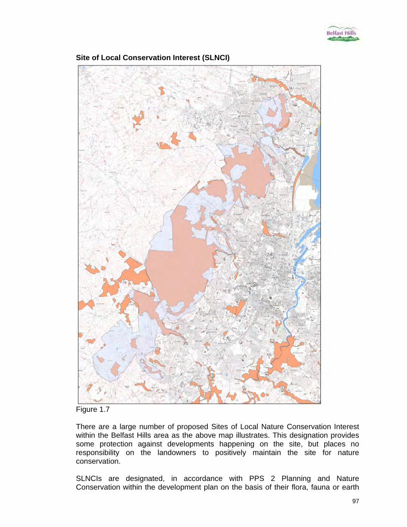
97
Site of Local Conservation Interest (SLNCI)
Figure 1.7 There are a large number of proposed Sites of Local Nature Conservation Interest within the Belfast Hills area as the above map illustrates. This designation provides some protection against developments happening on the site, but places no responsibility on the landowners to positively maintain the site for nature conservation. SLNCIs are designated, in accordance with PPS 2 Planning and Nature Conservation within the development plan on the basis of their flora, fauna or earth

98
science interest. PPS 2 states that “sites of potential local nature conservation importance may come to light when countryside assessments are being prepared (as part of the development plan process). The importance of such sites will be carefully evaluated. If it is confirmed that a particular site is of local nature conservation importance, it will be formally identified as such in the development plan. Where such sites are identified, plans will set out planning policies which will apply to development proposals on those sites”. SLNCIs are, therefore, equivalent to any other zoning made within a development plan and are not attributed any greater protection through additional statutory legislation. The designation of proposed SLNCIs is open to objection within the development plan process once a draft Plan has been issued. A total of 50 proposed SLNCIs are designated within (or in close proximity to) the study area. Belfast Metropolitan Area (BMA) Green Belt Apart from small portions within the BMA Development Limit, the entire Belfast Hills area is located within the BMA Green Belt as set by Designation COU 1 BMA Green Belt. The Plan states that “within the context of the RDS, the Rural Strategy, the Northern Ireland Landscape Assessment 2000 and analysis of existing and potential development pressure, the Department considers Green Belt designation to be justified”. Furthermore, “the Department considers that it is appropriate and necessary to maintain strict planning control in rural areas where development pressure is intense.” The Plan notes that within the BMA Green Belt, the Belfast Hills landscape is “particularly sensitive” as a result of its location and development pressures. Local Nature Reserves (LNR) There are four Local Nature Reserves within the Belfast Hills. These are: Ballyaghagan Meadows – an area of upland meadow on Cave Hill with notable
grassland flora. Managed by Belfast City Council. Hazelwood – an area of mixed deciduous and conifer woodland with hazel
dominant in the lower slopes. A varied ground flora including goldilocks buttercup and wood vetch, this site is also designated an ASI. Managed by Belfast City Council.
Slievenacloy – an area of species rich grassland and upland heath in Lisburn City
Council area. Managed by the Ulster Wildlife Trust. Carnmoney Hill – an area of woodland in the Newtownabbey Borough Council
area. Managed by the Woodland Trust. All these sites have management plans drawn up by the various landowners and are managed by the respective owners with nature conservation as a primary goal.

99
Although the Belfast Hills have a range of designations with varying land management responsibilities and goals, they have no overall designation, which has resulted in a lack of an overall management strategy for the hills. Historic Monuments The following scheduled monuments lie within the BHP operational area. 1. McArts Promontory Fort on Cave Hill, 2. Ballyaghagan Round Cairn 3. Ballyaghagan Kidney-shaped Enclosure 4. Ballyaghagan Cashel 5. Dunanney Church Site 6. Dunanney Rath 7. Dunanney Raised Rath 8. Greencastle Fortification (site of) and settlements 9. Ballymurphy Platform Rath 10. Slievenacloy Glacial erratic – Sibs Stone 11. Slievenacloy Enclosure 12. Castle Robin - Mullaghglass Motte and Bailey with remains of castle 13. Ballyrobin Rath 14. Ballygomartin Rath (x2) 15. Ballygomartin Standing Stone 16. Ballyutoag Court Tomb 17. Budore Rath pair 18. Budore Rath 19. Budore Rath Complex Scheduling provides statutory protection for an historic monument, normally in private ownership, but does not imply any right of access to the public. Scheduling is intended to preserve a proportion of monuments of each type. Of the scheduled sites above only McArts Fort and Ballyaghagan has secure public access. Information on scheduled monuments and their special interest can be accessed by the general public by appointment in the Sites and Monuments Database at Hills Street Belfast. Information on a proportion of scheduled monuments is also accessible via the internet on www.ni-environment.gov.uk or from the Archaeological Data Service. Other Sites of historic importance but which are not scheduled include: 1. Dunnaney associated sites – soutterains, cave, cropmarks and rath 2. Cloughfern rath 3. Ballyduff, Dunanney, Carnmoney and Glebe – cairns 4. Church site at Carnmoney/Glebe and Urn burial, crop marks and possible
medieval settlement 5. Drumnaoraogh Fort 6. Ballyaghagan Mound 7. Ballygolan crannog – Hazelwood 8. Ballyvaston site of medieval chapel and site of castle 9. Ballyvaston prehistoric settlement 10. Ballyvaghan mound 11. Greencastle enclosure

100
12. Ballyvaghan rath and soutterain 13. Old Park enclosures 14. Upper Ballysillan Neolithic occupation site 15. Legoniel – sites of megalithic tombs 16. Legoniel soutterain 17. Divis glacial erratics 18. Altigarron/Divis remains of round cairn 19. Ballymurphy platform raths 20. Ballymurphy flint sites 21. Tornaroy mound 22. Divis enclosure 23. Englishtown rath site 24. Ballycollin well and bathhouse 25. Ballycollin cairn and standing stones 26. Ballycollin round cairn 27. Poleglass platform rath 28. Aghalislone mound 29. Lagmore platform rath and enclosure 30. Aghalislone megalith and barrow Most of these sites are in private ownership and are not accessible to the public except by special permission. This is only a selection of sites, which are numerous. There is a particular concentration of sites at Budore, on Divis and on the Cave Hill. There is little information easily available on the built heritage of the Belfast Hills and few or no sites have any signage or access. On Divis and the Black Mountain, approximately 200 archaeological features have been identified since purchase by the National Trust, resulting in the site being mooted as a proposed Area of Special Archaeological Importance. It is likely that the surrounding hills also have similar archaeological significance, but simply have not yet been surveyed in any detail. Two of the Belfast Hills Partnership’s main aims which relate to heritage are: To protect, conserve and maintain, and to assist in and promote the protection conservation and maintenance of ancient sites, monuments, buildings and artefacts of historical, architectural or constructional interest or merit in the Belfast Hills. To encourage and assist farmers, landowners and members of the public in their understanding of, and practical action in support of, the natural and built heritage of the Belfast Hills and to promote the adoption and furthering of sustainable agricultural policies and practices whereby the conditions and quality of life of those living and farming there may be improved and the quality of the natural and built heritage maintained and enhanced for the benefit of all.