
SECTION 8 – MANAGEMENT PRACTICES – RECOMMENDED PROJECTS ... · SECTION 8 – MANAGEMENT...
42
Antelope Creek Watershed Basin Management Plan Section 8 - Management Practices – Recommended Projects/Programs 8-1 SECTION 8 – MANAGEMENT PRACTICES – RECOMMENDED PROJECTS/PROGRAMS Introduction 8.1. During the development of this Basin Plan, Antelope Creek has been studied, monitored, and modeled to determine pollutant sources, quantify source loadings, and evaluate loading reduction strategies for targeted pollutants. One of the goals of the Basin Plan is to identify possible pollution control strategies to help achieve water quality goals for Antelope Creek. Implementation of control strategies can be through both Capital Improvement Program (CIP) Projects (structural projects) and Non-Capital Programs (non-structural programs). As outlined in SECTION 5 - WATER QUALITY MONITORING, E. coli is the primary pollutant of concern for Antelope Creek. Projects and programs that reduce E. coli are likely to lower other pollutants of concern. Pollutant sources contributing to bacteria in Antelope Creek do not appear to be point sources, such as illicit discharges, malfunctioning sanitary sewer lines, or runoff directly contributed by a single property. Therefore there is no single repair or structural project at a point source for achieving goals listed in the TMDL for E. coli. Bacteria in Antelope Creek appear to originate from diffuse sources across the entire watershed. Based upon conclusions drawn in SECTION 6 - POLLUTION SOURCES AND CONTROL STRATEGIES, which were dependent upon WinSLAMM and water quality monitoring results, the use of structural BMPs to reduce E. coli loading in Antelope Creek to the regulatory levels for a recreational stream would be extremely costly. In addition, Antelope Creek has little open space available for large scale structural solutions. Retrofitting of existing streets, parking lots, and other infrastructure can also be complicated by utilities in the right-of-way. Due to these circumstances, structural BMPs described in this section are intended to reduce pollutant loading to Antelope Creek, as well as serve as demonstration projects for public outreach and education. SECTION 7 - BMP SITE INVENTORY, describes the methodology for selecting structural BMP sites throughout the watershed that are most appropriate to limiting pollutant loading across a variety of land uses. Site selection weighed heavily on publicly owned property with a high potential for educational opportunities. This section identifies structural BMP projects for sites recommended in SECTION 7 - BMP SITE INVENTORY. As mentioned within Section 7, projects recommended for private property would only be implemented with willing landowners. The City and LPSNRD may be available for partnering opportunities for water quality projects on private land. This section also outlines the recommended pollution reduction strategies to improve water quality for Antelope Creek based upon the findings listed in all previous sections. Strategies include both site specific structural projects for incorporation into the CIP, as well as non-structural programmatic actions to be administered throughout the watershed. Structural projects – These projects are intended to focus on load reduction goals for specific types of land uses within localized areas. Non-structural programs – These programs are basin wide recommendations and encourage property owners to adopt management solutions to reduce non-point pollutant loads. The implementation strategy described later in SECTION 10 - IMPLEMENTATION includes several of the structural projects and a non-structural program listed in this section and includes a priority sub-basin for project implementation over the first 5-year period. Programs and projects listed in the implementation strategy are actions above and beyond actions listed in the current City’s MS4 permit. Implementation strategies provided in this plan are specific to address nonpoint source impairments documented in the 2007 TMDL for Antelope Creek. An adaptive management approach has been proposed in order to allow the City and LPSNRD an opportunity to evaluate programs and projects as they are implemented. This approach will allow the City and LPSNRD an opportunity to make changes to future projects and programs listed in the Basin Plan during the 5-year plan review. The plan review will include an evaluation of what has been completed thus far, how effective it was, and what the next actions might be to further improve water quality. Evaluation criteria used to determine project and program effectiveness, as well as water quality monitoring criteria, are outlined later in SECTION 10 - IMPLEMENTATION. Pollutant sources contributing to bacteria in Antelope Creek do not appear to be point sources, such as illicit discharges, malfunctioning sanitary sewer lines, or runoff directly contributing by a single property.
Transcript of SECTION 8 – MANAGEMENT PRACTICES – RECOMMENDED PROJECTS ... · SECTION 8 – MANAGEMENT...

Antelope Creek Watershed Basin Management Plan Section 8 - Management Practices – Recommended Projects/Programs
8-1
SECTION 8 – MANAGEMENT PRACTICES – RECOMMENDED PROJECTS/PROGRAMS
Introduction8.1.
During the development of this Basin Plan, Antelope Creek has been studied, monitored, and modeled to determinepollutant sources, quantify source loadings, and evaluate loading reduction strategies for targeted pollutants. One ofthe goals of the Basin Plan is to identify possible pollution control strategies to help achieve water quality goals forAntelope Creek. Implementation of control strategies can be through both Capital Improvement Program (CIP)Projects (structural projects) and Non-Capital Programs (non-structural programs).
As outlined in SECTION 5 - WATER QUALITY MONITORING,E. coli is the primary pollutant of concern for Antelope Creek.Projects and programs that reduce E. coli are likely to lowerother pollutants of concern. Pollutant sources contributing tobacteria in Antelope Creek do not appear to be point sources,such as illicit discharges, malfunctioning sanitary sewer lines, orrunoff directly contributed by a single property. Therefore thereis no single repair or structural project at a point source forachieving goals listed in the TMDL for E. coli.
Bacteria in Antelope Creek appear to originate from diffuse sources across the entire watershed. Based uponconclusions drawn in SECTION 6 - POLLUTION SOURCES AND CONTROL STRATEGIES, which were dependentupon WinSLAMM and water quality monitoring results, the use of structural BMPs to reduce E. coli loading inAntelope Creek to the regulatory levels for a recreational stream would be extremely costly. In addition, AntelopeCreek has little open space available for large scale structural solutions. Retrofitting of existing streets, parking lots,and other infrastructure can also be complicated by utilities in the right-of-way. Due to these circumstances,structural BMPs described in this section are intended to reduce pollutant loading to Antelope Creek, as well asserve as demonstration projects for public outreach and education.
SECTION 7 - BMP SITE INVENTORY, describes the methodology for selecting structural BMP sites throughout thewatershed that are most appropriate to limiting pollutant loading across a variety of land uses. Site selection weighedheavily on publicly owned property with a high potential for educational opportunities. This section identifiesstructural BMP projects for sites recommended in SECTION 7 - BMP SITE INVENTORY. As mentioned withinSection 7, projects recommended for private property would only be implemented with willing landowners. The Cityand LPSNRD may be available for partnering opportunities for water quality projects on private land.
This section also outlines the recommended pollution reduction strategies to improve water quality for AntelopeCreek based upon the findings listed in all previous sections. Strategies include both site specific structural projectsfor incorporation into the CIP, as well as non-structural programmatic actions to be administered throughout thewatershed.
� Structural projects – These projects are intended to focus on load reduction goals for specific types ofland uses within localized areas.
� Non-structural programs – These programs are basin wide recommendations and encourage propertyowners to adopt management solutions to reduce non-point pollutant loads.
The implementation strategy described later in SECTION 10 - IMPLEMENTATION includes several of the structuralprojects and a non-structural program listed in this section and includes a priority sub-basin for projectimplementation over the first 5-year period. Programs and projects listed in the implementation strategy are actionsabove and beyond actions listed in the current City’s MS4 permit. Implementation strategies provided in this plan arespecific to address nonpoint source impairments documented in the 2007 TMDL for Antelope Creek.
An adaptive management approach has been proposed in order to allow the City and LPSNRD an opportunity toevaluate programs and projects as they are implemented. This approach will allow the City and LPSNRD anopportunity to make changes to future projects and programs listed in the Basin Plan during the 5-year plan review.The plan review will include an evaluation of what has been completed thus far, how effective it was, and what thenext actions might be to further improve water quality. Evaluation criteria used to determine project and programeffectiveness, as well as water quality monitoring criteria, are outlined later in SECTION 10 - IMPLEMENTATION.
Pollutant sources contributing tobacteria in Antelope Creek do not appear
to be point sources, such as illicitdischarges, malfunctioning sanitary
sewer lines, or runoff directlycontributing by a single property.

Antelope Creek Watershed Basin Management Plan Section 8 - Management Practices – Recommended Projects/Programs
8-2
Project and Program Selection Overview8.2.
Several non-structural based program recommendations are noted and include the expansion of 11 existingprograms or activities, and the addition of nine new programs or activities. These recommendations are listed basedupon the potential for removing bacteria and other pollutants. Non-structural recommendations are programmaticand are not ranked through a formalized prioritization process similar to the structural recommendations.
The effectiveness of non-structural BMPs will rely heavily on the capability of the City, LPSNRD and otherstakeholders to provide information, education, financial incentives, and cost sharing opportunities to propertyowners on each non-structural strategy. Non-structural solutions also include recommendations for policy changes,ordinances, and incorporation of water quality features into flood control structures. Table 8-1 below displays boththe new and expanded program recommendations, each of which is detailed later in this section.
Table 8-1. Non-structural RecommendationsNon-structural Recommendations
Expansion of Existing Programs New Programs
Sanitary Sewer Line Inspection Program Rooftop Disconnection Incentive ProgramDry Weather Storm Drainage Screening Program Operation and Maintenance Plan for Sediment
RemovalPet Waste Ordinances/Disposal Cans Paired Watershed StudyTargeted Rain Garden Program for Antelope Creek Antelope Creek Water Quality PartnershipTargeted Rain Barrel Program for Antelope Creek Urban Wildlife ManagementLong Grass Maintenance Area Expansion Urban Soil Quality RestorationLow/No-phosphorus Fertilizers Program --Lincoln Children’s Zoo Water Quality ManagementPlan
--
Snow and Ice Management Strategies --LPSNRD Cost-share Program --Quantitative Microbial Risk Assessment (QMRA) --
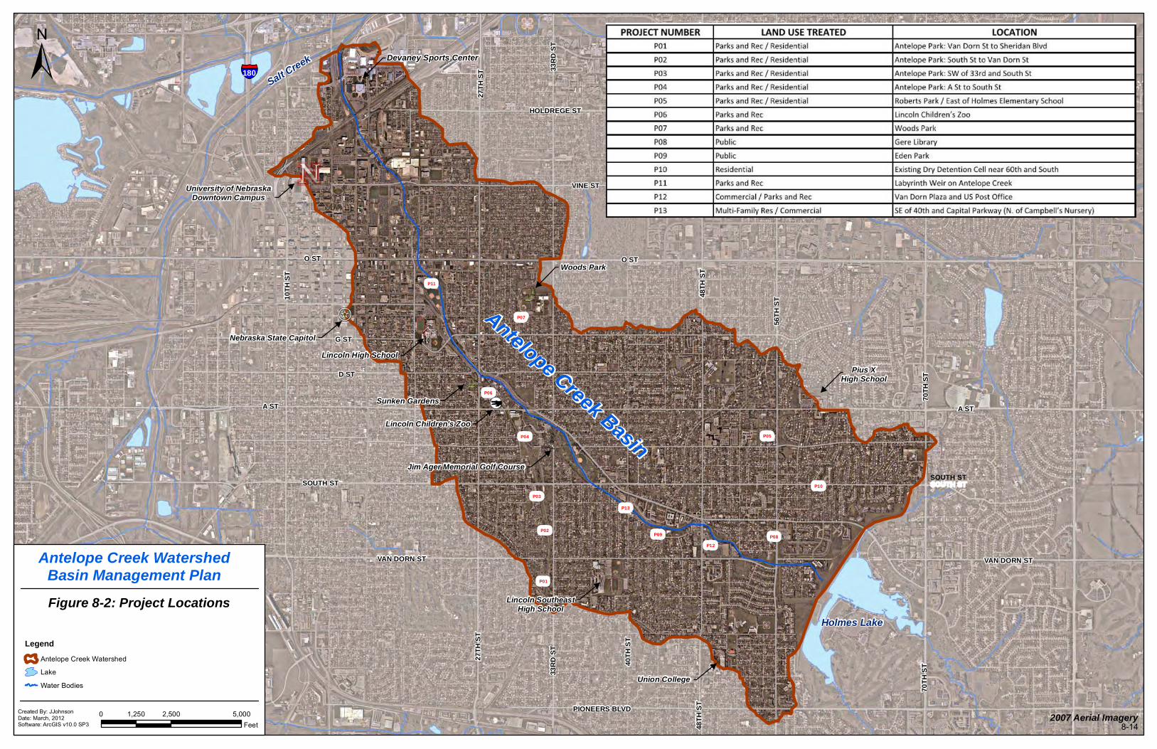
This plan also details 13 demonstration projects for consideration by the City and LPSNRD to implement throughoutthe upper portion of the Antelope Creek Watershed. Due to the considerable cost associated with structural controls,the number of projects was limited. Projects selected were placed in sites that were screened through the processoutlined in SECTION 7 - BMP SITE INVENTORY. Locations include both publicly owned property and privateproperty on varying land uses, and will allow for opportunities to provide education and outreach to Lincoln residents.
Projects listed below in Table 8-2 are further detailed in Section 8.4 including a project number, ownership, projectsummary, maintenance, monitoring, estimated project cost, and water quality benefits. A map of recommendedconceptual improvements is also included for each location. For the purpose of incorporating these BMPs into theCity’s CIP, each project was prioritized using the Prioritization Methodology Report for Watershed Master PlanningProjects established by the City and last revised December 2006. Details on the prioritization process, and a rankingof each project, are provided in Section 8.4.1.
Table 8-2. Proposed Structural Demonstration Projects
Structural Project RecommendationsProjectNumber Location Description
P01 Antelope Park: Van Dorn St to SheridanBlvd
Channel and Wetland Enhancements
P02 Antelope Park: South St to Van Dorn St Channel EnhancementsP03 Antelope Park: SW of 33rd and South St Bioretention AreasP04 Antelope Park: A Street to South Street Modify parking lot, address erosion in
meandering channel

Antelope Creek Watershed Basin Management Plan Section 8 - Management Practices – Recommended Projects/Programs
8-3
Structural Project RecommendationsProjectNumber Location Description
P05 Roberts Park/East of Holmes ElementarySchool
Offline bioretention areas, inline channelberms
P06 Lincoln Children’s Zoo Green roof, permeable pavement,bioretention
P07 Woods Park Separators, bioretention areasP08 Gere Library Separator and bioretention areaP09 Eden Park Curb-cut bioretentionP10 Existing Dry Detention Basin near 60th and
SouthModify Existing Dry Detention Basin
P11 Labyrinth Weir on Antelope Creek Water quality improvements at weirP12 Van Dorn Plaza and US Post Office Bioretention AreasP13 SE of 40th and Capital Parkway (N. of
Campbell’s Nursery)Separator, bioretention areas in openspace north of Antelope Creek
Non-Structural/Programmatic Recommendations8.3.
Non-structural programs are defined as stormwater BMPs that focus on management of pollutants at their source byminimizing exposure to runoff, rather than treating runoff in structural BMPs. For example, using Low/No-phosphorus fertilizer would reduce the potential pollutant source, phosphorus, without requiring any type of structuralpractice, such as construction of a bioretention area or wet-detention pond. Because bacteria are difficult to reduce oncewithin the water column, reduction at the source becomes moreimportant, and is anticipated to be a more effective removalstrategy when compared to structural BMPs. In order for non-structural BMPs to be successful in limiting pollutant loading toAntelope Creek, a strong information and education effort isneeded to help in changing current property owner practices inthe Antelope Creek watershed.
Several activities recommended include the installation of small scale structural practices (such as rain gardens), butwould be planned and implemented through programs offered to residents and property owners. Therefore, thesesmall scale structural activities would be part of a non-structural program action for the purpose of this Basin Plan.
8.3.1 Expansion of Existing Programs
The following are existing programs available through either the City or LPSNRD that are recommended to beexpanded and restructured to target property owners and residences in the Antelope Creek watershed.Recommendations have not been prioritized, but are generally listed in order of importance to meet Basin Plan goalslisted in SECTION 1 - INTRODUCTION AND PURPOSE.
Sanitary Sewer Line Inspection Program
The Collection and Sanitary Engineering sections within the City of Lincoln Wastewater System are responsible forcleaning, inspecting, and repairing the City’s sanitary sewer system. The City currently has a preventativemaintenance program that involves internal inspection of sanitary sewers using a T.V. camera. This camera ismounted on a device similar to a small sled which is pulled by an electric winch through the sanitary sewer andviewed by inspection personnel above ground. Sewer defects are recorded for future reference and repair. The Cityannually inspects approximately 120 miles of sanitary sewer lines. This type of program is essential to ensuring thatpoint sources for E. coli are identified and removed within watersheds.
Recommendation #1: Target programs to inspect sanitary sewer lines in the Antelope Creek Basin Area using theT.V. camera in order to support efforts towards meeting the 2007 TMDL goals, specifically for E. coli bacteria.Inspections in this area can provide information on the condition of the sewer lines and changes in observed inflows,
Because bacteria are difficult to reduceonce within the water column, reductionat the source becomes more important,and is anticipated to be a more effective
removal strategy when compared tostructural BMPs.

Antelope Creek Watershed Basin Management Plan Section 8 - Management Practices – Recommended Projects/Programs
8-4
and deposition of materials that could be contributing to water quality degradation. Most defects or identifiedproblems are recommended to be considered a priority repair.
Dry Weather Storm Drainage Screening Program
Dry weather storm drain screening includes locating flows in storm drains during periods in which precipitation hasnot occurred for a given amount of time. Screening activities may or may not include sampling. During low flowperiods, pollutants tend to be more concentrated and are more identifiable. Therefore, sampling dry weather flowscan provide valuable information for identifying illicit discharges from illegal connections, leaks in sanitary sewerlines, and domestic water supply lines. Indicators such as color, turbidity, and odor can be simple indicators as tonon-stormwater runoff. Tracking the source of the flows can further delineate the origin, and also the potentialdischarge location. Following established programs and manuals such as the Illicit Discharge Detection andElimination guidance manual by USEPA can aid in developing a dry weather screening program.
Water quality sampling completed in 2010 and 2011 indicated that dry weather flows from outfalls into AntelopeCreek did not appear to be a significant contributor towards increased E. coli levels.
Recommendation #2: To monitor changing conditions in the watershed that could potentially contribute to pollutantloadings in Antelope Creek, establish a dry weather screening sampling protocol for the Antelope Creek Basin anddevelop a work plan to annually monitor Antelope Creek and specified major outfalls or tributaries that discharge tothe creek.
Dry weather flows could be sampled for TSS, E. coli, phosphorus, nitrogen, and other analytes of interest. Theanalyte set can be adjusted for the specific watershed to limit sampling to those analytes that are mostrepresentative of watershed specific conditions.
Pet Waste Ordinances/Disposal Cans
An inventory of pet waste cans on the trail along Antelope Creek was completed inSeptember 2011. Only one pet waste container was visibly located at Holmes LakeDam. Several signs encouraging pet waste pickup were located along the trail and otherareas of the watershed. Some signs were noted as missing. In addition, severalresidents and trail users were observed not picking up after their pets.
Recommendation #3: To support efforts towards meeting the 2007 TMDL goals,specifically for E. coli bacteria, install and maintain several pet waste containers alongparks and recreational areas in the Antelope Creek watershed. Signs explaining theimportance of picking up pet waste at each container would likely increase usage of thecontainers. Assistance from local partners to help with maintenance of pet wastecontainers, such as neighborhood associations, might be considered.
Recommendation #4: To increase compliance with existing pet waste ordinances notifyresidents through bill stuffers, letters, news articles, and other means, about the waterquality benefits of picking up pet waste and the potential enforcement actions availableto the City for those not complying with local pet waste ordinances.
Targeted Rain Garden Program for Antelope Creek
The City of Lincoln’s Watershed Management Division launched a 50-50 cost-share program for Lincoln propertyowners in September 2010 to focus on installation of residential rain gardens. Each qualifying property owner waseligible to be reimbursed up to $1,000 for rain garden expenses. Reimbursement included the cost of soilamendments (compost and sand), plants, drain tile, equipment rentals, and work performed by an approvedlandscape professional.
Recommendation #5: To motivate residents and property owners in the Basin Plan area to install residential raingardens, continue the existing city-wide program. Consider raising the city portion of the cost-share incentive in thisarea, and partner with LPSNRD to use the existing Water Quality BMP Cost-Share program as a contributor ofmatching funds. Consider recognition of individuals or groups that participate in the program.
Targeted Rain Barrel Program for Antelope Creek Watershed
The City has been proactive in encouraging residents to install rain barrels on their properties to encourage reuse ofstormwater. The City offers Build-Your-Own Rain Barrel Classes and workshops, provides instructions for property
Picture 17:Enforcement of petwaste ordinances is
key to reducing E. coli

Antelope Creek Watershed Basin Management Plan Section 8 - Management Practices – Recommended Projects/Programs
8-5
owners to construct their own rain barrels, and has sponsored an artistic rain barrel program at the LincolnChildren’s Zoo.
Recommendation #6: To encourage stormwater reuse and enhance public education in Antelope Creek, targetresidents and property owners for an expansion of the existing rain barrel program. Continue to provideopportunities for cost-share. Neighborhood associations and community organizations may be partners foreducation and outreach opportunities to expand the program. Consider recognition of individuals or groups thatparticipate in the program.
Long Grass Maintenance Area Expansion
The Parks Division of Lincoln Parks and Recreation provides maintenance and upkeep of 128 miles of trails and 125recreational areas covering 5,200 acres in Lincoln. Since 2007, the Parks Division has been increasing the extent oflong grass maintenance areas. In many cases long grass areas include native species which have naturallyreplaced turf grasses over time. The Parks Division targets lakes, ponds, creeks, streams, and drainage ways toinclude buffer zones to improve water quality and reduce erosion. The buffer zone is typically 30 feet wide but mayvary due to steepness, severity of erosion, and management goals (City Parks and Recreation Department).
Recommendation #7: To increase filtration of pollutants, promote shall sheet flow, and discourage geese gathering,establish native grass species using over seeding or re-seeding in long grass areas in the Antelope Creekwatershed. In addition, expand buffer zones to all applicable drainage ways, along Antelope Creek park areas, andthroughout Jim Ager Golf Course.
Low/No-phosphorus Fertilizers Program
Most soil in the Lincoln area naturally contains enough phosphorus to support a healthy lawn (Interlinc, 2011). For asmall fee, property owners can perform a soil test to see if lawns need additional phosphorus. If not, Low/No-phosphorus fertilizers can be used and are available through most local retailers. The City has encouraged the useof Low/No-phosphorus fertilizers upstream of Holmes Lake as part of the Holmes Lake Watershed Planimplementation in 2004. The City provided property ownersinformation on which vendors supplied Low/No-phosphorusfertilizers, and also conducted a program which made limitedamounts of Low/No-phosphorus fertilizer available to residents ofthe Holmes Lake Watershed.
Recommendation #8: To support efforts that limit nutrient loading to Antelope Creek, begin using no-phosphorusfertilizers where applicable on all City property in the Antelope Creek watershed. Establish a Low/No-phosphorusfertilizer program that will encourage residents, property owners, and lawn care providers to use Low/No-phosphorus fertilizers in the Antelope Creek watershed. Provide education and outreach on how nutrients in fertilizercan negatively affect Antelope Creek by contributing to excessive algae growth.
Recommendation #9: Support residents and property owners by making soil testing available for a low cost, orconsidering offering soil testing for no cost in the Antelope Creek watershed.
Lincoln Children’s Zoo
The Lincoln Children’s Zoo (Zoo) is a non-profit organization that hasbeen in operation for almost 50 years at a site located within landowned by the City Parks Department. The Zoo has been proactive inwater quality management and serves as one of the community’slargest environmental education providers. The Zoo currently does nothave a water quality management plan, however, water quality BMPshave been installed with the intention of installing more in the future asrecommended in this section.
Recommendation #10: To support existing water quality efforts at theZoo, encourage and support the Zoo with the establishment of a waterquality management plan to outline goals and objectives for waterquality management, define and expand existing controls to reduce E.coli reaching the creek, display zoo drainage patterns, provide a list ofpotential water quality projects, and identify potential funding sourcesfor these projects. The water quality plan would list current and futureBMPs and insure the excellent maintenance practices at the Zoo continue.
Most soil in the Lincoln area naturallycontains enough phosphorus to support
a healthy lawn.
Picture 18: Lincoln Children's Zoo
Antelope Creek Watershed Basin Management Plan Section 8 - Management Practices – Recommended Projects/Programs
8-6
Snow and Ice Management
The City of Lincoln currently has five locations used to stockpile snow, none of which are located in the AntelopeCreek watershed.
Recommendation #11: Continue to avoid piling snow in the Antelope Creek Watershed. The City’s snow removalmanagement strategies might consider orienting snow dump sites such that snowmelt is directed through anappropriate BMP before entering a waterway. Practice guidelines established within the Urban Drainage and FloodControl District Manual (UDFCD), Volume 3 or comparable manual, would be a great resource for the City.
LPSNRD Cost-share Program
The LPSNRD has created a dedicated Water Quality BMP Cost-Share program to assist landowners with theimplementation of BMPs aimed at improving the quality of surface waters within the District. Installing properly sizedand designed practices to promote infiltration, such as bioretention areas and pervious pavers, are some of thepractices that may be eligible for this program. For selected projects, LPSNRD may fund up to 50% of total projectcosts, to a maximum of $10,000.
Recommendation #12: To increase opportunities for residents and property owners to install BMPs, use matchingfunds from the existing LPSNRD cost-share program and higher total maximum cost-share for projects located in theAntelope Creek watershed. Expand eligible practices for new programs listed in this plan, such as the Urban SoilQuality Restoration program.
8.3.2 New Programs
The following are new programs or actions recommended for the City and LPSNRD to consider in order to supportefforts to improve water quality in Antelope Creek.
Urban Wildlife Management
As previously documented, bird droppings appear to be a significant source of E. coli in Antelope Creek. As a result,EA conducted a bridge survey November 2010. The surveyrevealed that several of the 29 bridges and overpasses werelacking structure to reduce or discourage bird nesting andperching. Bridges with “I” beam construction, as seen in Figure8-1, had the most droppings and evidence of bird activity,primarily pigeons.
Recommendation #13: To support efforts towards meeting the 2007 TMDL goals, specifically for E. coli bacteria,retrofit older bridges and overpasses crossing Antelope Creek to modify habitat to reduce feeding, watering,roosting, and nesting sites for birds. In general, all bridges constructed in association with the Antelope Valleyproject were built with bird control in mind. Future bridges or overpasses over Antelope Creek should be designed ina manner that reduces habitat suitable for nesting and perching of pigeons and other birds. Other visible perchingsites, such as light posts, could be considered for placing mechanisms to discourage perching.
Reduction of bird activity on Antelope Creek would be an immediate step towards reducing loadings of bacteria toAntelope Creek. University of Nebraska–Lincoln’s (UNL’s) School of Natural Resources nuisance wildlife programsis one local resource that might be able to provide technical assistance such as a study to determine effectivenessof controls on bridges in Antelope Creek.
Recommendation #14: To support efforts towards meeting the 2007 TMDL goals, specifically for E. coli bacteria,limit activities of other animals near Antelope Creek. Practices could be coordinated with UNL through the InternetCenter for Wildlife Damage Management, as well as UNL’s Cooperative Extension Division and/or Wildlife DamageControl staff at the School of Natural Resources. A wildlife assessment study to determine the types of speciespresent in the watershed would provide direction on other activities that would limit habitat of nuisance species thatmay be contributing to the pollutant load in Antelope Creek.
Rooftop and Parking Lot Disconnection Incentive Programs
Throughout the Basin Plan area, several businesses and homes were noted as having downspouts moving waterdirectly from a rooftop to an impervious surface where stormwater runoff travels untreated directly into AntelopeCreek. Based upon analysis in WinSLAMM, for clay loam soils which are present through most of Lincoln,disconnecting the roof downspouts in most residential areas is expected to result in annual reductions of roof runoffby about 80%. This would increase to approximately 90% and 95% for areas having silty and sandy soils,
Reduction of bird activity on AntelopeCreek would be an immediate step
towards reducing loadings of bacteria toAntelope Creek.

Antelope Creek Watershed Basin Management Plan Section 8 - Management Practices – Recommended Projects/Programs
8-7
respectively. Parking lots and other impervious areas such as sidewalks can be disconnected by not allowing runoffduring frequent events. This can be obtained by pervious pavement systems.
Recommendation #15: To support efforts to limit the quantity of stormwater and pollutant loading, encourageproperty owners and residents to disconnect runoff from impervious surfaces. Disconnections can be low-costsolutions that if implemented over a large area could have a strong impact on pollutant reduction to AntelopeCreek.
Establish an incentive program for property owners in AntelopeCreek to disconnect downspouts and roof drains from spillingonto impervious surfaces. Support the program with aconsiderable educational campaign using bill stuffers,billboards, press releases, social media, news articles,information on the City and LPSNRD’s website, and othermeans. Disconnection of rooftop runoff on properties whereadequate vegetative cover is available is important.
Recommendation #16: To support efforts to limit the quantity ofstormwater and limit pollutant loading, identify locations in theBasin Plan area where parking lot drainage to storm draininlets could be disconnected. Directing flow of stormwater fromparking lots onto vegetated surfaces, swales, rain gardens, orother BMPs, could have a considerable positive impact onwater quality. Converting impervious areas to pervious areasusing pervious pavement systems can have similar effects.Work with property owners to encourage disconnection ofparking lots and other large impervious surfaces from the storm drain system.
Operation and Maintenance Plan for Sediment Removal
Sediment has been shown to be a potential source and/or growth media for bacteria in streams. Sediments tend toaccumulate nutrients and bacteria from inflows, as well as direct deposition from urban wildlife population. Sedimentin Antelope Creek may contribute to elevated levels of bacteria(E. coli) in the water column. In addition, sedimentaccumulation above the labyrinth weir and in the concretechannel in Union Plaza, negatively affect water quality andaesthetics. The City and LPSNRD have mechanically removedsediment from the labyrinth weir and Union Plaza in the past.
Recommendation #17: Support actions throughestablishment of an Operation and Maintenance Plan thatcan regularly remove sediment accumulation from AntelopeCreek. Sediment removal from the stream has the potential tolower the overall bacteria loading in the stream, have apositive effect on water quality, and improve aesthetics.Consider both mechanical and hydraulic alternatives forsediment removal, including coordination with the US ArmyCorps of Engineers to provide occasional flushing flows.
Picture 19: Parking lot and down spoutdisconnections are low cost alternatives forreducing pollutant loads to Antelope Creek
Picture 20: Sedimentation upstream of thelabyrinth weir

Antelope Creek Watershed Basin Management Plan Section 8 - Management Practices – Recommended Projects/Programs
8-8
This page left intentionally blank

UVB29UVB28UVB27UVB26
UVB25UVB24UVB23
UVB22
UVB21
UVB20UVB19UVB18
UVB17
UVB16
UVB15
UVB14
UVB13
UVB12
UVB11UVB10UVB09UVB08
UVB07
UVB06
UVB05UVB04
UVB03
UVB02
UVB01
Antelope Creek Basin
University of NebraskaDowntown Campus
±
27TH
ST
33R
D S
T
48TH
ST
56TH
ST
70TH
ST
HOLDREGE ST
VINE ST
O STO ST
10TH
ST
VAN DORN ST
PIONEERS BLVD
G ST
D ST
A ST
27TH
ST
48TH
ST
Holmes Lake
Salt Creek
§̈¦180
Devaney Sports Center
Lincoln Children's Zoo
Lincoln SoutheastHigh School
Jim Ager Memorial Golf Course
Sunken Gardens
Lincoln High School
Woods Park
Union College
Pius XHigh School
Nebraska State Capitol
Antelope Creek WatershedBasin Management PlanFigure 8-1: Bridge Locations
0 2,500 5,0001,250Feet
Created By: JJohnsonDate: March, 2012Software: ArcGIS v10.0 SP3
Legend
Antelope Creek Basin Boundary
Lake
SOUTH ST
A ST
33R
D S
T
40TH
ST
70TH
ST
VAN DORN ST
SOUTH ST
2007 Aerial Imagery8-�
Bridges
Water Bodies
[]

Antelope Creek Watershed Basin Management Plan Section 8 - Management Practices – Recommended Projects/Programs
8-10
Paired Watershed Study
A paired watershed study would allow the City and LPSNRD to collect information on the effectiveness of certainBMPs in Lincoln. Information from a paired watershed study could assist in determining the resources necessaryto implement non-structural and small scale structural BMPs in a residential setting.
Recommendation #18: To support data collection efforts regarding efficiency of both structural and non-structuralBMPs to remove pollutants, establish a paired watershed study. Monitor the effectiveness of small scale structuraland non-structural BMPs in a residential land use. This study would allow water quality to be monitored in acontrolled area where no structural or non-structural BMPs would be implemented. Water quality would bemonitored in an adjacent watershed of similar size, where several small scale structural and non-structural BMPswould be implemented. The following criteria are recommended when selecting paired watersheds:
� Overall similar size� Comparable topography, land use, and proximity to each other� Accessible monitoring location� Defined boundaries� Utility obstructions avoidance for sampling access� Controlled sampling location� Suspected pollutants and their sources
The following non-structural BMPs are recommended for implementation as part of a paired watershed study:
� Rain gardens� Rain barrels� Bioretention� Rooftop disconnections from impervious surfaces� Use of Low/No-phosphorus fertilizers� Frequent pet-waste pick-up� Sweeping of fertilizers from impervious surfaces� Street sweeping/washing� Debris/litter removal
Data collected prior to the study would include at a minimum the following:
� Percentage of impervious surface� Inventory of direct connections� Identification of pollutant sources (number of pets, wildlife inventory)� Existing number of structural or non-structural BMPs currently in place� Area of fertilized turf
Selection of the watershed to receive non-structural controls relies heavily on the willingness of property owners toimplement the recommended non-structural BMPs. If landowner willingness to participate is low in a watershed, itwould be recommended to use the non-structural controls on the control area and move treatment options to theadjacent watershed. The following protocol is recommended for conducting water quality monitoring for the pairedwatershed study:
A large amount of sampling events will need to be scheduled in order to provide a high confidence on any findings orconclusions, and could include up to a minimum of 50 samples over 2 years (Pitt, 2012). Each event should produceflow through the sampling location (manhole). If a rain event is intermittent, but provides adequate flows and 6 hourspass between runoff events, a second sampling can be completed as a valid event. Sampling should not occurunless all data requirements and flow conditions are met for both watersheds. Flow should be sampled for TSS, E.coli, phosphorus, and nitrogen in all watershed sampling events. Other watershed specific analytes should be addedbased on known conditions or specific watershed data needs. In addition to chemical and biological parameters, flowestimates should be made as well as precipitation frequency, duration and rainfall amounts, weather conditions

Antelope Creek Watershed Basin Management Plan Section 8 - Management Practices – Recommended Projects/Programs
8-11
(temperature, wind, cloud cover, etc.), and unusual watershed activity (maintenance and repairs or streets or utilities,street closing, special activities).
Antelope Creek Water Quality Partnership
In addition to the City and LPSNRD, several important stakeholders are located in the Antelope Creek watershed,including the University of Nebraska – Lincoln; which encompasses a majority of the land at the lower end of thewatershed. In addition, the newly established Nebraska Innovation Campus (NIC), a public/private research andtechnology development center, is being constructed north of UNL’s City Campus at the site of the former NebraskaState Fairgrounds. Several other businesses have property adjacent to the creek and new opportunities forbusinesses are available due to completion of the Antelope Valley Project, which greatly reduced the 100-yearfloodplain of Antelope Creek. Stormwater management decisions made by these stakeholders during newconstruction and redevelopment activities can impact the water quality of Antelope Creek. Incorporation of waterquality BMPs into the planned activities of stakeholders can have tremendous water quality benefits.
Recommendation #20: To have an active stakeholder group available to support decisions with potential to improvewater quality in Antelope Creek, the City and NRD are encouraged to establish a formal partnership between theCity, LPSNRD, UNL, Nebraska Innovation Campus (NIC) and local businesses to encourage use of BMPs in theAntelope Creek watershed. This partnership would support implementation of projects and programs in this BasinPlan as well as encourage local stakeholders and interested residents, property owners, and developers to utilizestormwater controls as part of any planned development or redevelopment activity.
Urban Soil Quality Restoration1
Healthy soils have tremendous capacity for infiltrating and storing water and also have active microbial life that willbreak down and utilize many pollutants moving in urban non-point source runoff. Directing stormwater flows ontolandscapes with good soil quality reduces the volume of runoff that is generated. Soil quality restoration involvesseveral steps including: reducing compaction, increasing pore space, improving organic matter content, and re-establishment of soil dwelling populations (microbes, worms, insects, etc.).
Recommendation #21: To support individual activities by property owners and residents to improve water quality,establish a new Urban Soil Quality Restoration Program. This newly established program would have incentives forresidents and property owners in the Antelope Creek area to improve soil quality or work to ensure soil quality ismaintained during re-development activities. Through information and education, property owners could learn aboutthe importance of soil quality for treatment of stormwater.
Quantitative Microbial Risk Assessment2
Quantitative Microbial Risk Assessment (QMRA) is used to investigate sites that are believed to be predominatelyimpacted by non-human sources of bacteria. While human sources of fecal contamination pose similar health risksregardless of location, the differences in predicted human health risks from recreational water exposure to non-human fecal contamination are dependent on local characteristics that will vary from site-to-site. This assessmentcan assist in developing equivalent site-specific criteria to account for local scale, non-human sources. QMRA canbe initiated for the following reasons:
� To assess the potential for human risk associated with exposure to a known pathogen� To determine critical points for control, such as watershed protection measures� To determine specific treatment processes to reduce, remove, or inactivate various pathogens� To predict the consequences of various management options for reducing risk� To determine appropriate criteria (regulatory) levels that will protect individuals and/or populations to a
specified risk level or range and support changes to the existing TMDL� To identify and prioritize research needs� To assist in interpretation of epidemiological investigations
1 Information summarized from the Iowa Stormwater Management Manual, Version 3; October 20092 http://water.epa.gov – Recreational Water Quality Criteria, December 2011

Antelope Creek Watershed Basin Management Plan Section 8 - Management Practices – Recommended Projects/Programs
8-12
Recommendation #22: To increase knowledge on the specific types of bacteria present in Antelope Creek, andfurther understand the risk associated with those types, conduct a QMRA for the Antelope Creek watershed. AQMRA might be considered in the event that bacteria levels do not decline after Phase One implementation.
Structural Project Recommendations8.4.
Projects outlined below include a variety of structural improvements recommended basin-wide to be implementedover time as a starting point for reducing pollutant levels to acceptable levels. At this time, there are no singlefinancially feasible alternatives to reducing levels of E. coli in Antelope Creek to acceptable levels. Therefore,several small scale demonstration projects are detailed across varying land uses.
As mentioned above, these projects have been sited mostly on public property where opportunities for publicoutreach and education of stormwater BMPs can occur. Some sites, such as the Lincoln Children’s Zoo andAntelope Park, have several individual projects in one area. Another project, at the labyrinth weir, was included inthe recommended project list in order to improve aesthetics along Antelope Creek and improve the quality of waterin Union Plaza.
Project benefits will vary depending upon the location but are mostly focused on reduction of E. coli, nutrients(phosphorus), and total suspended solids (TSS) to Antelope Creek. Each project description includes the following:
� Project name and general location� Property owner� Purpose for site being selected� Project summary� Maintenance requirements� Installation cost� Water quality benefits/pollutant load reduction summary
8.4.1 Prioritization Methodology
The City of Lincoln has an existing mechanism to prioritize potential capital improvement projects (CIP) listed inmaster plans (JEO, 2006). This prioritization methodology is intended to provide a flexible tool that can be used as ascreening mechanism by City staff when selecting projects to be constructed. The ranking system was specificallydeveloped for CIP projects proposed as part of the on-going watershed master planning efforts. The prioritizationmethodology can be applied to master plan projects encompassing a wide range of stormwater management goalsincluding: flood control, floodplain management, stream stability, water quality, and public health and safety.
The City of Lincoln’s past watershed master planning projects have primarily focused on flood control and drainageimprovements, but the criteria are also flexible and represent projects with a primary focus on water quality.Therefore, wholesale changes to the existing prioritization categories were not necessary or desired. The projectteam used the existing criteria from 2006 to prioritize projects listed in this plan.
From using the site screening process outlined in SECTION 7 - BMP SITE INVENTORY, a total of 32 sites wereconsidered. From these 32 sites, a total of 10 were selected for projects and prioritized using criteria summarizedbelow. Prioritization worksheets are included in Appendix D. Criteria include the following:
Flooding Impacts – This category identifies the impact of floodwater encroachment on structures, public or privateproperty, parking lots, public utilities or other infrastructure. The flooding potential can be identified throughhydrologic and hydraulic analysis, study of topographic maps, field investigation, and recorded historical problems.
As previously discussed in SECTION 3 - WATERSHED INVENTORY, the majority of the Basin Plan area has hadsignificant improvements to provide greater flood control throughout the entire watershed. Stormwater BMPsidentified in this plan are not intended to provide significant flood benefits. However, potential impacts on floodingresulting from a project, such as infiltration or temporary storage of floodwaters, were considered as part of thisprioritization category.
Water Quality – This category identifies the impacts of impaired water quality. The water quality benefits brokendown in this category reflect the types of projects developed during watershed master planning efforts. This categoryis further divided according to the perceived scope of the project benefits, with greater emphasis placed uponprojects with broad-based impacts.

Antelope Creek Watershed Basin Management Plan Section 8 - Management Practices – Recommended Projects/Programs
8-13
Based upon goals as written in the 2007 TMDL, strong considerations were given to BMPs that reduce E. coliloading to Antelope Creek. In addition to E. coli, BMPs that limited loading of nutrients, sediment, oils and greasewere also considered. Consideration was also given for projects that affect overall aesthetics of Antelope Creek.
Stream Stability – This category identifies the impacts of channel erosion and the transport and undermining of soilby stream flow or overland flow. Channel erosion can threaten structures, property, infrastructure, streams, andother natural resources. Channel erosion can also impact water quality through the transportation of sediment. Thestream stability and erosion threat may be identified through visual observation, not strictly fluvial geomorphicassessment. This category is further divided according to the nature of the erosion, such as aggressive channeldown cutting as compared to gradual channel widening.
The majority of Antelope Creek’s stream banks are stabilized. In addition, a significant portion of the stream channelconsists of hard armor. Consideration was given to how each proposed BMP may alter the stability of drainage waysand existing controls placed in Antelope Creek, such as removal of existing concrete liners in water ways andreplacement with BMPs.
Safety Factor – This category identifies project benefits that decrease the potential threat to public health andsafety. The potential for loss of life or bodily injury may include individuals trapped in structures during flooding orvehicles being swept away by floodwater. Erosion near bike paths, sidewalks, and roads can also be a hazard. Asafety factor is generally associated with projects addressing structural or non-structural flooding hazard reduction.
Miscellaneous Factors – This category identifies various other miscellaneous factors and additional considerationsthat have not been addressed in the previous categories. Examples used for Basin Plan prioritization includedlocation, coincident with adjacent properties, and development status. Prioritization scoring of miscellaneous factorsincluded consideration for public property and projects being sited within the city limits.
Additional Considerations – The additional considerations category allows issues not covered by the primarycategories to be scored. For the purposes of the Basin Plan, how each project addressed the TMDL, along withpublic education opportunities, was considered.
Table 8-3 below displays the recommended structural BMPs listed by priority, based on the 2006 master planprioritization analysis, including conceptual design and cost projections. Prioritization ranking worksheets have beencompleted and are included in Appendix D. Figure 8-2 displays the location of each project in the Basin Plan area.
Table 8-3. Project Prioritization RankingProject ID Location Ranking Points Project Cost
P11 Labyrinth Weir on Antelope Creek 370 $625,000P06 Lincoln Children’s Zoo 300 $425,000P03 Antelope Park: SW of 33rd and South St 260 $125,000P02 Antelope Park: South St to Van Dorn St 240 $125,000P01 Antelope Park: Van Dorn St to Sheridan Blvd 200 $125,000P04 Antelope Park: A Street to South Street 180 $250,000P05 Roberts Park/East of Holmes Elementary School 180 $375,000P07 Woods Park 160 $250,000P09 Eden Park 160 $45,000P13 SE of 40th and Capital Parkway (N. of Campbell’s Nursery) 140 $125,000P08 Gere Library 130 $95,000P12 Van Dorn Plaza and US Post Office 130 $65,000P10 Existing Dry Detention Cell near 60th and South 125 $45,000
-- TOTAL $2,675,000
P03
P01
P06
P02
P11
P07
P05
P08
P04
P09
P13
P12
P10
Antelope Creek Basin
University of NebraskaDowntown Campus
±
27TH
ST 33
RD
ST
48TH
ST
56TH
ST
70TH
ST
HOLDREGE ST
VINE ST
O STO ST
10TH
ST
VAN DORN ST
PIONEERS BLVD
G ST
D ST
A ST
27TH
ST
48TH
ST
Holmes Lake
Salt Creek
§̈¦180
Devaney Sports Center
Lincoln Children's Zoo
Lincoln SoutheastHigh School
Jim Ager Memorial Golf Course
Sunken Gardens
Lincoln High School
Woods Park
Union College
Pius XHigh School
Nebraska State Capitol
Antelope Creek WatershedBasin Management Plan
Figure 8-2: Project Locations
0 2,500 5,0001,250Feet
Created By: JJohnsonDate: March, 2012Software: ArcGIS v10.0 SP3
Legend
Antelope Creek Watershed
Lake
Water Bodies
[]
SOUTH ST
A ST
33R
D S
T
40TH
ST
70TH
ST
VAN DORN ST
SOUTH ST
2007 Aerial Imagery8-14

Antelope Creek Watershed Basin Management Plan Section 8 - Management Practices – Recommended Projects/Programs
8-15
8.4.2 Project Descriptions
The cost estimates for the proposed projects are based on quantities and costs that have been developed from pastprojects. Site slopes, location, space, anticipated flows, and many other parameters were included in the conceptuallayout of the following projects. General sizes, depths, and other essential characteristics were proposed so thatconceptual total project costs could be developed. Project cost estimates do not include maintenance, and areconceptual costs. The designs presented are at the conceptual stage and do not include topographic surveys,geotechnical investigations, flow analysis, digital terrain modeling, wetland delineations, etc. Because of theseunknown parameters, these projects are anticipated to change and adapt as they are designed and constructed.
Pollutant load removal estimates have been established based upon available information in WinSLAMM andmanufacture’s specifications. Load reduction estimates were calculated for each project through desktop review ofland uses within each project sub-basin, estimated flow patterns through each BMP, and drainage area. The percentreduction given for each project is the reduction expected at the outfall of each site.
Hydrodynamic separators were not modeled within WinSLAMM. The removal efficiency of these BMPs variesdepending on the unit type that is used, level of maintenance performed, and the target sediment particle size. Largeunderground vaults offer no stormwater quality benefit and no pretreatment if not combined with other BMPs such asbioretention areas. However, these types of BMPs do remove large debris and sand/grit from runoff.
Maintenance costs were not included in the total project costs. Maintenance efforts are generalized as Low,Medium, and High based on existing similar projects within Lincoln. Low maintenance typically refers to projectsthan require plant removal, minor sediment removal, and mulching. High maintenance typically refers to sites thatrequire regular frequent maintenance for sediment or trash removal, as well as plant removal and mulching.
Project AC-P01: Antelope Park: Channel and Wetland Enhancements from Van Dorn to Sheridan Boulevard
This project is located west of 33rd Street from Sheridan Boulevard to Van Dorn Street as shown in Figure 8-3.The area contains 1,300 feet of the un-named tributary to Antelope Creek, as well as open spaces which capturestormwater runoff from the surroundingresidential areas and streets. The sub-watershed for this project is approximately 60acres in size. Flow within the sub-watershed isgenerally in a northern direction.
Ownership:
All property is owned by the City of Lincoln,which includes Antelope Park.
Site Selection:
This site was selected for the followingreasons:
� All property is owned by the City ofLincoln
� Available land for BMP installation� Large treatable area� Located in the priority Antelope Park
sub-basin
Project Summary:
� Reshape the un-named tributary to provide at least 1 foot of depth, and roughly 4 to 5 feet in width alongits entire length. Improvement of a few outlet structures discharging to the tributary is also included tobetter dissipate energy and improve flow dynamics. Areas adjacent to the tributary should be included inthe City’s Long Grass program, where possible, with signage.
Picture 21: The existing stream channel at AC-P01

Antelope Creek Watershed Basin Management Plan Section 8 - Management Practices – Recommended Projects/Programs
8-16
� Install inline berms perpendicular tothe flow approximately every 100 feetas shown in Figure 8-3. The inlineberms will produce small bioretentionareas within the channel, decreasingflow velocities, promote infiltration intosoils, and further stabilizing thestream. Berms are generally 6 inchesabove the channel flowline, andinclude an area of roughly 100 squarefeet upstream of the berm with 2 to 3feet of engineered soil.
� Improve the existing wetland byenlarging the area, increasingvegetation, or adjusting the sitehydraulics.
� Install a large bioretention area at oneof the outfalls as shown in Figure 8-3.This bioretention area is approximately 2,000 to 3,000 square feet, 0.5 to 1.0 feet deep, and includes 2 to3 feet of engineered soil along with an overflow that is directed to the tributary.
� Implement pet waste pick-up, and place pet waste containers and signage along the walking trail adjacentto the un-named tributary.
Maintenance:
Post-project maintenance efforts are anticipated to be moderate and may include: cleanout of debris; cleanout ofsediment or replacing of soils within wetland; vegetation control; inspections for erosion or standing water problemsand maintenance of pet waste containers.
Estimated Total Project Cost: $100,000-$150,000
Water Quality Benefits:
Reshaping the tributary and installing the berms will aid in stabilizing the channel, promote infiltration, and reducethe loading of sediment, nutrients, and E. coli to Antelope Creek. Allowing the stormwater runoff to flow through abroader channel reduces the volume of runoff by enabling infiltration over a greater area, while also reducingvelocities and erosion. Improvements made to outfalls into the tributary are intended to reduce future erosion. Areasalong the stream included in the City’s Long Grass program will decrease operation and maintenance costs to theCity, and the amount of sediment transported off-site. The enhanced wetland, as well as the engineered soil withineach berm area and bioretention area, will aid in reducing the volume of runoff by infiltration; further reducing theamount of sediment, nutrients, and E. coli being transported off-site. Pet waste pick-up, containers, and signage willhave direct impacts on reducing the levels of E. coli located within this project’s drainage area.
While some of these structural BMPs work to minimize pollutants from being carried off-site or treat pollutants byplant uptake and natural mechanisms, some simply reduce the volume of water by infiltration. A reduction in thevolume of stormwater runoff directly reduces each pollutant load being carried to Antelope Creek. Table 8-4summarizes the current pollutant load, as well as the anticipated load reduction based on the structural BMPs to beimplemented within this site. These loads are largely based upon WinSLAMM, and were adjusted to account for avariety of site specific measures.
Table 8-4. Annual Pollutant Load Reduction Estimates for AC-P01
Pollutant Pollutant Load AnticipatedLoad Reduction
PercentReduction
TSS 10,990 lbs 2,500-3,000 lbs 23-27%Phosphorus 25 lbs 0-4 lbs 0-16%E. coli 2.5 x 10¹³ 1-5 x 10¹² counts 4-20%
Picture 22: This existing wetland could be enhanced inAntelope Park

Antelope Creek Watershed Basin Management Plan Section 8 - Management Practices – Recommended Projects/Programs
8-17
Figure 8-3. Antelope Park Channel and Wetland Enhancements from Van Dorn to Sheridan Boulevard
Antelope Creek Watershed Basin Management Plan Section 8 - Management Practices – Recommended Projects/Programs
8-18
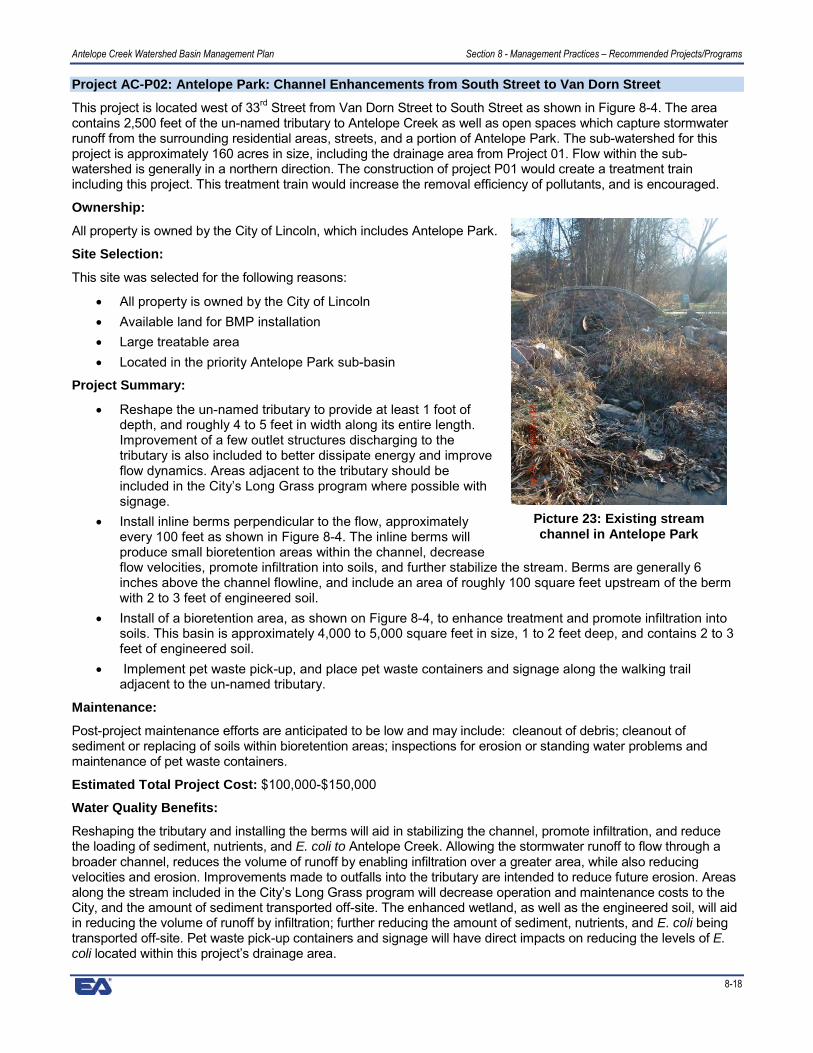
Project AC-P02: Antelope Park: Channel Enhancements from South Street to Van Dorn Street
This project is located west of 33rd Street from Van Dorn Street to South Street as shown in Figure 8-4. The areacontains 2,500 feet of the un-named tributary to Antelope Creek as well as open spaces which capture stormwaterrunoff from the surrounding residential areas, streets, and a portion of Antelope Park. The sub-watershed for thisproject is approximately 160 acres in size, including the drainage area from Project 01. Flow within the sub-watershed is generally in a northern direction. The construction of project P01 would create a treatment trainincluding this project. This treatment train would increase the removal efficiency of pollutants, and is encouraged.
Ownership:
All property is owned by the City of Lincoln, which includes Antelope Park.
Site Selection:
This site was selected for the following reasons:
� All property is owned by the City of Lincoln� Available land for BMP installation� Large treatable area� Located in the priority Antelope Park sub-basin
Project Summary:
� Reshape the un-named tributary to provide at least 1 foot ofdepth, and roughly 4 to 5 feet in width along its entire length.Improvement of a few outlet structures discharging to thetributary is also included to better dissipate energy and improveflow dynamics. Areas adjacent to the tributary should beincluded in the City’s Long Grass program where possible withsignage.
� Install inline berms perpendicular to the flow, approximatelyevery 100 feet as shown in Figure 8-4. The inline berms willproduce small bioretention areas within the channel, decreaseflow velocities, promote infiltration into soils, and further stabilize the stream. Berms are generally 6inches above the channel flowline, and include an area of roughly 100 square feet upstream of the bermwith 2 to 3 feet of engineered soil.
� Install of a bioretention area, as shown on Figure 8-4, to enhance treatment and promote infiltration intosoils. This basin is approximately 4,000 to 5,000 square feet in size, 1 to 2 feet deep, and contains 2 to 3feet of engineered soil.
� Implement pet waste pick-up, and place pet waste containers and signage along the walking trailadjacent to the un-named tributary.
Maintenance:
Post-project maintenance efforts are anticipated to be low and may include: cleanout of debris; cleanout ofsediment or replacing of soils within bioretention areas; inspections for erosion or standing water problems andmaintenance of pet waste containers.
Estimated Total Project Cost: $100,000-$150,000
Water Quality Benefits:
Reshaping the tributary and installing the berms will aid in stabilizing the channel, promote infiltration, and reducethe loading of sediment, nutrients, and E. coli to Antelope Creek. Allowing the stormwater runoff to flow through abroader channel, reduces the volume of runoff by enabling infiltration over a greater area, while also reducingvelocities and erosion. Improvements made to outfalls into the tributary are intended to reduce future erosion. Areasalong the stream included in the City’s Long Grass program will decrease operation and maintenance costs to theCity, and the amount of sediment transported off-site. The enhanced wetland, as well as the engineered soil, will aidin reducing the volume of runoff by infiltration; further reducing the amount of sediment, nutrients, and E. coli beingtransported off-site. Pet waste pick-up containers and signage will have direct impacts on reducing the levels of E.coli located within this project’s drainage area.
Picture 23: Existing streamchannel in Antelope Park

Antelope Creek Watershed Basin Management Plan Section 8 - Management Practices – Recommended Projects/Programs
8-19
While some of these structural BMPs work to minimize pollutants from being carried off-site, or treat pollutants byplant uptake and natural mechanisms, some simply reduce the volume of water by infiltration. A reduction in thevolume of stormwater runoff directly reduces each pollutant load being carried to Antelope Creek. Table 8-5summarizes the current pollutant load, as well as the anticipated load reduction based on the structural BMPs to beimplemented within this site. These loads are largely based upon WinSLAMM, and were adjusted to account for avariety of site specific measures.
Table 8-5. Annual Pollutant Load Reduction Estimates for AC-P02
Pollutant Pollutant Load Anticipated LoadReduction
PercentReduction
TSS 22,500 lbs 6,000-7,000 lbs 27-31%Phosphorus 59 lbs 10-15 lbs 17-25%
E. coli 6.6 x 10¹³ counts 1-3 x 10¹³ counts 15-45%
Figure 8-4. Channel Enhancements from South Street to Van Dorn Street

Antelope Creek Watershed Basin Management Plan Section 8 - Management Practices – Recommended Projects/Programs
8-20
Project AC-P03: Antelope Park: Bioretention Areas SW of 33rd and South St
This project is located southwest of 33rd and South Street as shown in Figure 8-5. The sub-watershed for thisproject is approximately 185 acres in size, and includes the drainage area from Projects 01 and 02. The land useconsists primarily of residential development and a portion of Antelope Park. Flow within the sub-watershed isgenerally in a northern direction. The construction of projects P01 and P02 would create a treatment trainincluding this project. This treatment train would increase the removal efficiency of pollutants, and is encouraged.
Ownership:
All property is owned by the City of Lincoln; including Antelope Park.
Site Selection:
This site was selected for the followingreasons:
� All property is owned by the City ofLincoln
� Available land for BMP installation� Large treatable area� Located in the priority Antelope Park
sub-basin� Provides additional treatment to runoff
from other BMPs
Project Summary:
� Install a bioretention area upstream ofthe inlet to the main tributary toenhance treatment and promoteinfiltration into soils. This basin isapproximately 5,000 to 6,000 squarefeet in size, and includes 2 to 3 feet ofengineered soil.
� Modifications to the inlet are also included as part of this project, and involve installing a unit that willallow 0.5 to 1.0 feet of water to be impounded, while still allowing the area to fully drain after apredetermined length of time.
� Install a smaller bioretention area to the west of the above mentioned bioretention area. This smaller areais approximately 2,000 to 2,500 square feet, 0.5 to 1.0 feet deep, and contains 2 to 3 feet of engineeredsoil. An overflow pipe is included, and is intended to direct overflows into the larger bioretention area.
� Modifications to the existing inlet to the west, as shown on Figure 8-5, will allow the stormwater runoff toflow into the small bioretention area. Large runoff events should still be allowed to bypass and flowstraight into the existing inlet.
Maintenance:
Post-project maintenance efforts are anticipated to be low and may include: cleanout of debris from the basinoutlet; cleanout of sediment from bio-retention area; eventual replacement of soils in bio-retention area; androutine inspections for erosion or standing water problems.
Estimated Total Project Cost: $100,000-$150,000
Water Quality Benefits:
Installing bioretention areas will promote infiltration, reduce runoff, and reduce the loading of sediment, nutrients,and E. coli to Antelope Creek. A reduction in the volume of stormwater runoff directly reduces each pollutant loadbeing carried to Antelope Creek. The bioretention areas will also help to slow stormwater runoff, which will aid in theprevention of future erosion downstream. Table 8-6 summarizes the current pollutant load, as well as the anticipatedload reduction based on the structural BMPs to be implemented within this site. The pollutant load reduction
Picture 24: 33rd and South detention structure

Antelope Creek Watershed Basin Management Plan Section 8 - Management Practices – Recommended Projects/Programs
8-21
estimates do not take into account the effectiveness of BMPs upstream of this project. These loads are largelybased upon WinSLAMM, and were adjusted to account for a variety of site specific measures.
Table 8-6. Annual Pollutant Load Reduction Estimates for AC-P03
Pollutant Pollutant Load Anticipated LoadReduction
Percent Reduction
TSS 19,300 lbs 6500-7500lbs 34-39%Phosphorus 63 lbs 10-15 lbs 16-24%E. coli 7.9 x 10¹³ counts 1-4 x 10¹³ counts 13-51%
Figure 8-5. Bioretention Areas SW of 33rd and South St

Antelope Creek Watershed Basin Management Plan Section 8 - Management Practices – Recommended Projects/Programs
8-22
Project AC-P04: Antelope Park: A Street to South Street
This project is located south and southwest of the Auld Pavilion within Antelope Park. Two locations are includedwithin this project, and include the meandering channel to the southwest, and the approximately 2 acre parking lotto the south. The sub-watershed for this project includes a portion of the parking lot, Antelope Park, and 9 acresof residential land use. Flow within the sub-watershed is generally in a western direction.
Ownership:
All property is owned by the City of Lincoln, which includes Antelope Park.
Site Selection:
This site was selected for the following reasons:
� All property is owned by the City of Lincoln� Available land for BMP installation� Large treatable area� Located in the priority Antelope Park sub-basin
Project Summary:
� Some locations of the meandering channel are showing signs of erosion.Stream stability improvements along this reach would reduce furtherchannel erosion. In addition, a flow dissipation device installed at theoutlet just north of South Street will aid in reducing erosion within themeandering channel
� Installation of a curb cut along the west side of the parking lot will allow runoff to drain into thebioretention area. Plugging the existing storm drain inlet on the west side will allow all runoff to flowthrough the bioretention area.
� Constructing a bioretention area west of the south parking lot is recommended, as shown in Figure 8-6.This bioretention area is approximately 13,000 to 15,000 square feet, 1 to 2 feet deep, and contains 2 to 3feet of engineered soil. An overflow pipe is included, and is intended to direct overflows into the tributary.
� Construct a bioretention area east of 29th and Washington as shown in Figure 8-6. This bioretention areais approximately 13,000 to 15,000 square feet, 1 to 2feet deep, and contains 2 to 3 feet of engineered soil.Small berms approximately 0.05 to 1.0 feet above theflowline are included to allow a small amount of water tobe impounded to infiltrate.
Maintenance:
Post-project maintenance efforts are anticipated to be low andmay include: cleanout of sediment or replacement of soils withinbioretention areas; inspections for erosion or standing waterproblems; and mulch removal and replacement.
Estimated Total Project Cost: $225,000-$275,000
Water Quality Benefits:
The flow dissipation device, as well as the stream stabilityimprovements, will help to stabilize the meandering channel andoutfall, and reduce the transport of sediment to Antelope Creek.Re-directing the stormwater runoff from the parking lot to the bioretention area will reduce the volume of stormwaterreaching Antelope Creek. Installing bioretention areas will promote infiltration, reduce runoff, and reduce the loadingof sediment, nutrients, and E. coli to Antelope Creek. A reduction in the volume of stormwater runoff directly reduceseach pollutant load being carried to Antelope Creek. The bioretention areas will also help to slow stormwater runoff;aiding in the prevention of future erosion downstream. Table 8-7 summarizes the current pollutant load, as well asthe anticipated load reduction based on the structural BMPs to be implemented within this site. These loads arelargely based upon WinSLAMM, and were adjusted to account for a variety of site specific measures.
Picture 25: The parkinglot south of Auld couldbe disconnected from
the storm drain
Picture 26: Potential area for a bioswale nearAuld Pavilion

Antelope Creek Watershed Basin Management Plan Section 8 - Management Practices – Recommended Projects/Programs
8-23
Table 8-7. Annual Pollutant Load Reduction Estimates for AC-P04
Pollutant Pollutant Load Anticipated LoadReduction
Percent Reduction
TSS 4820 lbs 1000-1100 lbs 21-23%Phosphorus 8 lbs 0-2 lbs 0-25%E. coli 5.3 x 10¹² counts 1-3 x 10¹² counts 19-57%
Figure 8-6. Antelope Park: A Street to South Street

Antelope Creek Watershed Basin Management Plan Section 8 - Management Practices – Recommended Projects/Programs
8-24
Project AC-P05: Roberts Park/East of Holmes Elementary School
This project is located southwest of 56th and A Street, illustrated in Figure 8-7. Two channel reaches have beenselected for improvements, both in open green space east of Holmes Elementary School at 52nd and SumnerStreet. The sub-watershed for this project is approximately 80 acres in size; the land use consists primarily ofresidential development and a portion of Holmes Elementary School. Flow within the sub-watershed is generallyin a southwesterly direction.
Ownership:
All property is owned by the City of Lincoln, which includesRoberts Park and a large green space east of HolmesElementary School.
Site Selection:
This site was selected for the following reasons:
� All property is owned by the City of Lincoln� Available land for BMP installation� Large treatable area
Project Summary:
� Replace the concrete channel with a grass swale asillustrated in Figure 8-7. Concrete lining at the streetcrossing shall remain in place to retain the integrity ofthe structure. Permanent erosion control should be installed in place of concrete channel.
� Install berms perpendicular to the channels as shown in Figure 8-7. Inline berms will produce bioretentionareas in the channel; decrease flow velocities and promote infiltration into soils. Berms shall include apipe at flowline elevation to convey low flows, and concrete weir structures to convey higher flows. Weirsshall generally be 8-12 inches above channel flow line.
� Offline bioretention areas as shown in Figure 8-7 are also included. Total size of the bioretention areas isapproximately 16,000 to 18,000 square feet in size. Each bioretention area is approximately 8-12 inchesin depth with 2 to 3 feet of engineered soil to promote infiltration.
� Modify the inlet to the downstream 42-inch culvert to aid soil infiltration.
Maintenance:
Post-project maintenance efforts are anticipated to be moderate and may include: cleanout of debris; cleanout ofsediment or replacement of soils within bioretention areas; inspections for erosion or standing water problems;and mulch removal and replacement.
Estimated Total Project Cost: $350,000-$400,000
Water Quality Benefits:
Installing the bioretention areas will promote infiltration, reduce runoff, and reduce the loading of sediment,nutrients, and E. coli to Antelope Creek. A reduction in the volume of stormwater runoff directly reduces eachpollutant load being carried to Antelope Creek. The bioretention areas will also help to slow stormwater runoff,which will aid in the prevention of future erosion downstream. Table 8-8 summarizes the current pollutant load, aswell as the anticipated load reduction based on the structural BMPs to be implemented within this site. Theseloads are largely based upon WinSLAMM, and were adjusted to account for a variety of site specific measures.
Table 8-8. Annual Pollutant Load Reduction Estimates for AC-P05Pollutant Pollutant Load Anticipated Load Reduction Percent Reduction
TSS 20,470 lbs 5000-6000 lbs 24-29%Phosphorus 39 lbs 5-10 lbs 13-26%E. coli 3.1 x 10¹³ counts 5-10 x 1012 counts 16-32%
Picture 27: Roberts Park

Antelope Creek Watershed Basin Management Plan Section 8 - Management Practices – Recommended Projects/Programs
8-25
Figure 8-7. Roberts Park

Antelope Creek Watershed Basin Management Plan Section 8 - Management Practices – Recommended Projects/Programs
8-26
Project AC-P06: Lincoln Children’s Zoo
This project is located southeast of 27th and Capitol Parkway, illustrated in Figure 8-8. The sub-watershed for thisproject is approximately 14 acres in size, consisting of park and zoo areas. Flow within the sub-watershed isgenerally in a northerly direction. The Zoo is a non-profit organization, and leases property from the City Parksand Recreation.
Ownership:
The project lies on two public parcels owned bythe City of Lincoln; including Antelope Park.
Site Selection:
This site was selected for the followingreasons:
� High public education potential� Available land for BMP installation� High pollutant load� Located in the priority Antelope Park
sub-basin
Project Summary:
� Construct bioretention areas as shownin Figure 8-8. Total size of thebioretention areas is approximately4,500 to 5,000 square feet. Eachbioretention area is approximately 1.0to 1.5 feet deep, with 2 to 3 feet of engineered soil. Overflows within each should have large eventsdirected to nearby storm drain inlets. Curbs should be cut, and downspouts directed where possible toallow runoff from nearby parking areas and rooftops to be captured.
� Installation of a green roof on the building shown in Figure 8-8 is an integral part of this project. Manydifferent components can be included within a green roof. A general cost per square foot of roof was usedto estimate the cost. The estimated project cost must be updated based upon the needs of the Zoo.
� Install a permeable paver system in the bike rack area. The system should capture stormwater fallingdirectly on it and infiltrate into the soils below.
� Disconnect as many downspouts as possible throughout the zoo grounds, and direct them onto nearbygreen spaces. Some downspouts may be directed into a cistern to harvest the rainwater for later use (notincluded in total project cost).
Maintenance:
Post-project maintenance efforts are anticipated to be moderate and may include: cleanout of debris; cleanout ofsediment or replacement of soils within bioretention areas; inspections for erosion or standing water problems;mulch removal and replacement; and occasional cleaning of the permeable paver system.
Estimated Total Project Cost: $400,000-$450,000
Water Quality Benefits:
Green roofs reduce runoff rates and volumes, reduce heat island effect, may provide energy savings, and mayalso extend the lifespan of the roof. Although green roofs provide an aesthetically pleasing space and reducestormwater runoff, the effects of a single roof on a small number of roofs on overall water quality are minimal.Permeable pavement systems are used to promote volume reduction, provide treatment and slow release ofstormwater runoff, and reduce a site’s effective imperviousness. Installing the bioretention areas will create largeareas that promote infiltration, reduce runoff, and reduce the loading of sediment, nutrients, and E. coli toAntelope Creek. The bioretention areas will also help to slow stormwater runoff; aiding in the prevention of futureerosion downstream. Disconnecting downspouts and redirecting them to green areas helps promote infiltrationwhile reducing the volume of stormwater runoff. A reduction in the volume of stormwater runoff directly reduceseach pollutant load being carried to Antelope Creek. Table 8-9 summarizes the current pollutant load, as well as
Picture 28: The zoo already has several water quality BMPsincluding this rain garden

Antelope Creek Watershed Basin Management Plan Section 8 - Management Practices – Recommended Projects/Programs
8-27
the anticipated load reduction based on the structural BMPs to be implemented within this site. These loads arelargely based upon WinSLAMM, and were adjusted to account for a variety of site specific measures.
Table 8-9. Annual Pollutant Load Reduction Estimates for AC-P06
Pollutant Pollutant Load Anticipated Load Reduction Percent ReductionTSS 12,240 lbs 2000-2500 lbs 16-20%Phosphorus 16 lbs 0-5 lbs 0-31%E. coli 5.0 x 10¹² counts 3-7 x 10¹¹ counts 6-14%
Figure 8-8. Lincoln Children's Zoo

Antelope Creek Watershed Basin Management Plan Section 8 - Management Practices – Recommended Projects/Programs
8-28
Project AC-P07: Woods Park
This project is located west of 33rd and J Street at Woods Park, and is illustrated in Figure 8-9. The sub-watershedfor this project is approximately 2 acres in size. The land use consists of residential development, park space andrecreational facilities. Flow within the sub-watershed is generally in a westerly direction.
Ownership:
All property is owned by the City of Lincoln, which consists ofWoods Park.
Site Selection:
This site was selected for the following reasons:
� All property is owned by the City of Lincoln� Available land for BMP installation� High pollutant load
Project Summary:
� Install hydrodynamic separators near parking areasas shown in Figure 8-9. Flow from the parking areasshould be directed into the units. Outflow from unitsshould be either directed back into the stormdrainage system or nearby bioretention areas. Gritchambers can be substituted for hydrodynamic separators where only sediment and gravel are ofconcern.
� Construct bioretention areas as shown in Figure 8-9. Total size of the bioretention areas is approximately2,000 square feet. Each bioretention area is approximately 1.0 to 1.5 feet deep, with 2 to 3 feet ofengineered soil. Overflows within a bioretention cell should carry large rainfall events to nearby stormdrains. Curbs should be cut, and inlets modified where possible to allow runoff from nearby parking areasand rooftops to be captured.
Maintenance:
Post-project maintenance efforts are anticipated to be high and may include: cleanout of debris; cleanout ofsediment or replacement of soils within bioretention areas; inspections for erosion or standing water problems;mulch removal and replacement; and removal of sediment and debris from hydrodynamic separators.
Estimated Total Project Cost: $225,000-$275,000
Water Quality Benefits:
Use of hydrodynamic separators can reduce the overall pollutant loading to Antelope Creek by capturing floatabledebris, oils, grease, sediment, and gravel. The units should always be located in areas accessible formaintenance. Installing the bioretention areas will promote infiltration, reduce runoff, and reduce the loading ofsediment, nutrients, and E. coli to Antelope Creek. The bioretention areas will also help to slow stormwater runoff;aiding in the prevention of future erosion downstream. Disconnecting impervious areas and redirecting them togreen areas helps promote infiltration while reducing the volume of stormwater runoff. A reduction in the volumeof stormwater runoff directly reduces each pollutant load being carried to Antelope Creek. Table 8-10 summarizesthe current pollutant load, as well as the anticipated load reduction based on the structural BMPs to beimplemented within this site. These loads are largely based upon WinSLAMM, and were adjusted to account for avariety of site specific measures.
Table 8-10. Annual Pollutant Load Reduction Estimates for AC-P07
Pollutant Pollutant Load Anticipated Load Reduction Percent ReductionTSS 2,980 lbs 2,000-2,500 lbs 67-84%Phosphorus 4 lbs 0-0.5 lbs 0-13%E. coli 7.4 x 10¹¹ counts 1-4 x 10¹¹ counts 14-54%
Picture 29: Woods Park is another publicallyowned location with great potential to install
BMPs

Antelope Creek Watershed Basin Management Plan Section 8 - Management Practices – Recommended Projects/Programs
8-29
Figure 8-9. Woods Park

Antelope Creek Watershed Basin Management Plan Section 8 - Management Practices – Recommended Projects/Programs
8-30
Project AC-P08: Gere Library
This project is located southeast of 56th and Myrtle Street. The sub-watershed for this project includes theadjacent parking areas to the east; less than 3 acres in size. Flow within the sub-watershed is generally in awesterly direction.
Ownership:
The project lies on a public parcel owned bythe City of Lincoln.
Site Selection:
This site was selected for the followingreasons:
� High public education potential� High pollutant load� Available land for BMP installation
Project Summary:
� Install a hydrodynamic separator nearparking lot as shown in Figure 8-10.Flow from the parking lot should bedirected into the unit. Outflow from unit should be directed back into the storm drainage system. A gritchamber can be substituted for the hydrodynamic separator where only sediment and gravel are ofconcern.
� Construct a bioretention area as shown in Figure 8-10. The bioretention area is approximately 2,000 to2,500 square feet and approximately 1.0 to 1.5 feet deep with 2 to 3 feet of engineered soil. Overflowsshould have large events directed to nearby storm drain inlets. Curbs should be cut, or inlets modifiedwhere possible to allow runoff from nearby parking areas and rooftops to be captured.
Maintenance:
Post-project maintenance efforts are anticipated to be high and may include: cleanout of sediment or replacementof soils within bioretention areas, inspections for erosion or standing water problems, and removal of sedimentand debris from hydrodynamic separators.
Estimated Total Project Cost:
$75,000-$115,000
Water Quality Benefits:
Use of hydrodynamic separators can reduce the overall pollutant loading to Antelope Creek by capturing floatabledebris, oils, grease, sediment, and gravel. The units should always be located in areas accessible formaintenance. Installing the bioretention areas will promote infiltration, reduce runoff, and reduce the loading ofsediment, nutrients, and E. coli to Antelope Creek. The bioretention area will also help to slow stormwater runoff,which will aid in the prevention of future erosion downstream. Disconnecting impervious areas and redirectingthem to green areas helps promote infiltration while reducing the volume of stormwater runoff. A reduction in thevolume of stormwater runoff directly reduces each pollutant load being carried to Antelope Creek. Table 8-11summarizes the current pollutant load, as well as the anticipated load reduction based on the structural BMPs tobe implemented within this site. These loads are largely based upon WinSLAMM, and were adjusted to accountfor a variety of site specific measures.
Table 8-11. Annual Pollutant Load Reduction Estimates for AC-P08
Pollutant Pollutant Load Anticipated Load Reduction Percent ReductionTSS 5,100 lbs 4000-4500 lbs 78-88%Phosphorus 6 lbs 0-1 lbs 0-17%E. coli 1.3 x 10¹² counts 1-5 x 10¹¹ counts 8-38%
Picture 30: Gere Library already has native vegetation

Antelope Creek Watershed Basin Management Plan Section 8 - Management Practices – Recommended Projects/Programs
8-31
Figure 8-10. Gere Library

Antelope Creek Watershed Basin Management Plan Section 8 - Management Practices – Recommended Projects/Programs
8-32
Project AC-P09: Eden Park
This project is located north of 44th and Antelope Creek Road. The sub-watershed for this project is confined tothe parking lot and areas immediately adjacent; less than 2 acres in size. The land use consists of parking areasand green space. Flow within the sub-watershed is generally in a northerly direction.
Ownership:
All property is owned by the City of Lincoln, and consists oflocations within Eden Park.
Site Selection:
This site was selected for the following reasons:
� All property is owned by the City of Lincoln� Ease of retrofit� Topography
Project Summary:
� Installation of curb cuts along the north side of theparking lot to allow runoff to drain into abioretention area.
� Construct a bioretention area as shown in Figure8-11. Total size of the bioretention area is approximately 1,000 to 1,200 square feet. The bioretentionarea is approximately 1.0 to 1.5 feet deep, with 2 to 3 feet of engineered soil. Overflows within abioretention cell should carry large rainfall events to nearby storm drains.
Maintenance:
Post-project maintenance efforts are anticipated to be low and may include: cleanout of sediment within thebioretention area; inspections for erosion or standing water problems; and mulch removal and replacement.
Estimated Total Project Cost: $40,000-$50,000
Water Quality Benefits:
Curb cuts allow stormwater from the parking lot to discharge into the bioretention area designed to treat pollutantscarried in the water. The bioretention area will promote infiltration, reduce runoff, and reduce the loading ofsediment, nutrients, and E. coli to Antelope Creek. The bioretention area will also help to slow stormwater runoff,which will aid in the prevention of future erosion downstream. Disconnecting impervious areas and redirectingthem to green areas helps promote infiltration while reducing the volume of stormwater runoff. A reduction in thevolume of stormwater runoff directly reduces each pollutant load being carried to Antelope Creek. Table 8-12summarizes the current pollutant load, as well as the anticipated load reduction based on the structural BMPs tobe implemented within this site. These loads are largely based upon WinSLAMM, and were adjusted to accountfor a variety of site specific measures.
Table 8-12. Annual Pollutant Load Reduction Estimates for AC-P09
Pollutant Pollutant Load Anticipated Load Reduction Percent ReductionTSS 3,400 lbs 600-700 lbs 18-21%Phosphorus 4 lbs 0-0.5 lbs 0-13%E. coli 8.5 x 10¹¹ counts 1-4 x 10¹¹ counts 12-47%
Picture 31: A direct impervious connection fromEden Park parking lot to Antelope Creek

Antelope Creek Watershed Basin Management Plan Section 8 - Management Practices – Recommended Projects/Programs
8-33
Figure 8-11. Eden Park

Antelope Creek Watershed Basin Management Plan Section 8 - Management Practices – Recommended Projects/Programs
8-34
Project AC-P10: Extended Detention Cell Near 60th and South
This potential retrofit project is located north of 60th and South Street, illustrated in Figure 8-12. The sub-watershed for this project is approximately 3 acres in size and consists entirely of residential development. Flowwithin the sub-watershed is generally in a southwesterly direction.
Ownership:
The project lies on a private parcel owned by a building association.
Site Selection:
This site was selected for the following reasons:
� Ease of retrofit� High pollutant load� Available land for BMP installation
Project Summary:
� Modify the lining of the existing extended detention basin to enhance infiltration into soils. This can beaccomplished by replacing approximately 1,500 to 2,000 square feet with 2 to 3 feet of engineered soil topromote infiltration, and planting deep rooted vegetation to aid soil aeration.
� Modifications to the basin outlet were also included as part of this project to aid in retaining runoff toinfiltration and sediment deposition.
Maintenance:
Post-project maintenance efforts are anticipated to be low and may include: cleanout of sediment or replacementof soils within bioretention areas, and inspections for erosion or standing water problems.
Estimated Total Project Cost: $40,000-$50,000
Water Quality Benefits:
Modifying the existing detention basin will promote infiltration, reduce runoff, and reduce the loading of sediment,nutrients, and E. coli to Antelope Creek. The detention basin will also help to slow stormwater runoff; aiding in theprevention of future erosion downstream. A reduction in the volume of stormwater runoff directly reduces theloading of sediment, nutrients, and E. coli to Antelope Creek. Table 8-13 summarizes the current pollutant load,as well as the anticipated load reduction based on the structural BMPs to be implemented within this site. Theseloads are largely based upon WinSLAMM, and were adjusted to account for a variety of site specific measures.
Table 8-13. Annual Pollutant Load Reduction Estimates for AC-P10
Pollutant Pollutant Load Anticipated Load Reduction Percent ReductionTSS 370 lbs 100-150 lbs 27-41%Phosphorus 1 lbs 0-0.1 lbs 0-10%E. coli 1.5 x 10¹² counts 1-5 x 10¹¹ counts 7-33%
Picture 32: Existing dry detention cell at 60th and South looking north

Antelope Creek Watershed Basin Management Plan Section 8 - Management Practices – Recommended Projects/Programs
8-35
Figure 8-12. Extended Detention Cell near 60th and South

Antelope Creek Watershed Basin Management Plan Section 8 - Management Practices – Recommended Projects/Programs
8-36
Project AC-P11: Labyrinth Weir on Antelope Creek
This project is located south of N Street, west of 24th Street and is illustrated in Figure 8-13. The watershed(downstream of and not including Holmes Lake) for this project is approximately 3,900 acres in size; the land useis wide ranging, including residential development, commercial development, schools, park space andrecreational facilities. Flow within the sub-watershed is generally in a northwest direction.
Ownership:
All property is owned by the City of Lincoln.
Site Selection:
This site was selected for the followingreasons:
� All property is owned by the City ofLincoln
� Large treatable area� High pollutant load
Project Summary:
� Construct an inline concrete weir alongAntelope Creek, approximately 250feet upstream of the labyrinth weirsouthwest of 24th and N Street. Thisweir would increase the water surfacearea, therefore increasing the amountof sunlight exposed to the water andreducing the amount of E. coli within Antelope Creek.
� Excavate upstream of the new weir to provide an inline wet pond that is approximately 300 feet long, and4 to 5 feet deep. The sides of this wet pond should be stabilized with sheet pile, gabion, or concrete. Thisinline wet pond will create an area for TSS to drop out of the water column and provide an area for easyremoval of the captured sediment.
� Remove the existing concrete channel and articulated concrete block lining upstream of the labyrinthweir. Removal would allow the creation of a green space that would provide storage routing capacityduring high flows, as well as increase aesthetics.
� Construct a low-flow concrete channel downstream of the new weir. A concrete apron should be placed atthe base of the new concrete weir and extended to the outlet of the two stormwater outfalls located justdownstream of the new weir. The low flow channel should be constructed to direct base flows toward thesluice gate located in the labyrinth weir. The channel should also be designed with a stub wall so that ifthe sluice gate is closed or under moderate flows, portions of the flow can be directed to the existingenclosed conduit. During high flows, the green space could potentially fill up and spill over the labyrinthweir.
� Construction of this project will require coordination with the US Army Corps of Engineers.
Maintenance:
Post-project maintenance efforts are anticipated to be moderate and may include: cleanout of sediment within thewet pond upstream of the new weir, and inspections for erosion or standing water problems.
Estimated Total Project Cost: $600,000-$650,000
Water Quality Benefits:
The wet pond is intended to capture large amounts sediment and gravel. A portion of the overall phosphorus loadis expected to be bound to the sediment. By placing these types of structures in an area accessible tomaintenance crews, the overall phosphorus and sediment load within Antelope Creek can reduced. The new weirwould increase the water surface area during base flows, therefore increasing the amount of sunlight exposed tothe water and reducing the amount of E. coli within Antelope Creek. The new concrete channel and green spacewill both increase aesthetics and flow through the Labyrinth Weir. Table 8-14 summarizes the current pollutant
Picture 33: Looking north towards the labyrinth weir

Antelope Creek Watershed Basin Management Plan Section 8 - Management Practices – Recommended Projects/Programs
8-37
load, as well as the anticipated load reduction based on the structural BMPs to be implemented within this site.These loads are largely based upon WinSLAMM, and were adjusted to account for a variety of site specificmeasures.
Table 8-14. Annual Pollutant Load Reduction Estimates for AC-P11
Pollutant Pollutant Load Anticipated Load Reduction Percent ReductionTSS 998,000 lbs 50,000-100,000 lbs 5-10%Phosphorus 1,900 lbs 500-600 lbs 26-32%E. coli 1.5 x 10¹⁵ counts 1-5 x 10¹⁴ counts 6-33%
Figure 8-13. Labyrinth Weir on Antelope Creek
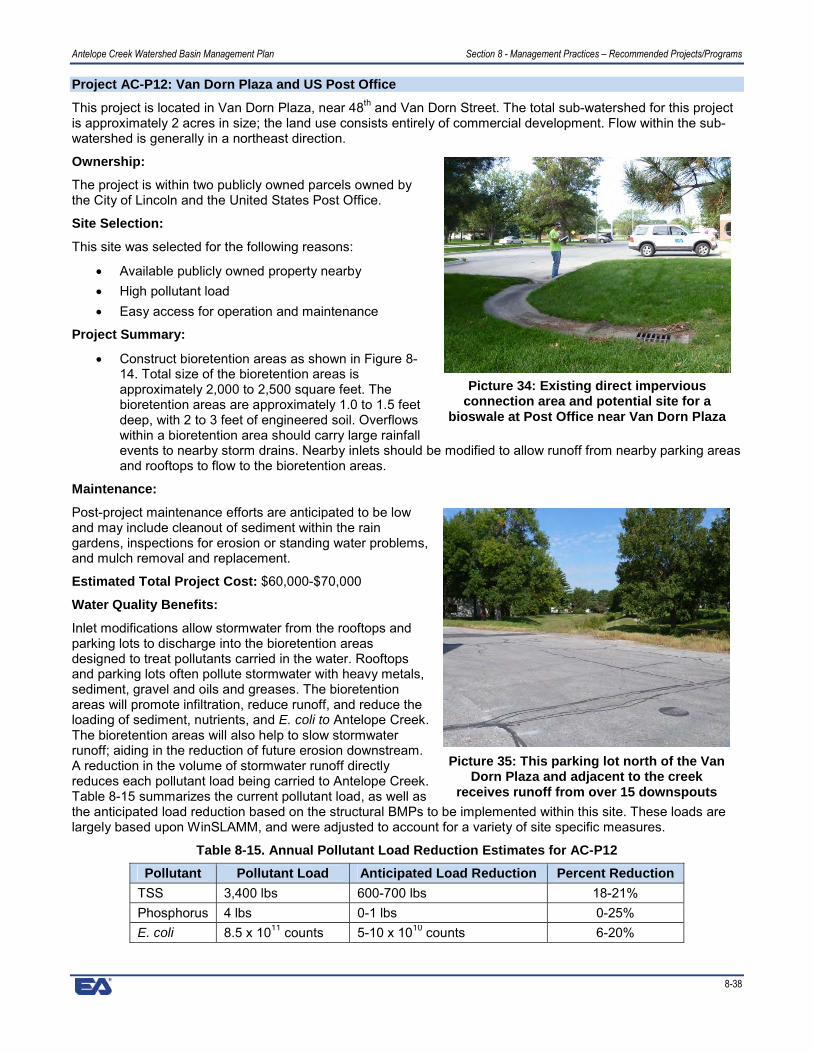
Antelope Creek Watershed Basin Management Plan Section 8 - Management Practices – Recommended Projects/Programs
8-38
Project AC-P12: Van Dorn Plaza and US Post Office
This project is located in Van Dorn Plaza, near 48th and Van Dorn Street. The total sub-watershed for this projectis approximately 2 acres in size; the land use consists entirely of commercial development. Flow within the sub-watershed is generally in a northeast direction.
Ownership:
The project is within two publicly owned parcels owned bythe City of Lincoln and the United States Post Office.
Site Selection:
This site was selected for the following reasons:
� Available publicly owned property nearby� High pollutant load� Easy access for operation and maintenance
Project Summary:
� Construct bioretention areas as shown in Figure 8-14. Total size of the bioretention areas isapproximately 2,000 to 2,500 square feet. Thebioretention areas are approximately 1.0 to 1.5 feetdeep, with 2 to 3 feet of engineered soil. Overflowswithin a bioretention area should carry large rainfallevents to nearby storm drains. Nearby inlets should be modified to allow runoff from nearby parking areasand rooftops to flow to the bioretention areas.
Maintenance:
Post-project maintenance efforts are anticipated to be lowand may include cleanout of sediment within the raingardens, inspections for erosion or standing water problems,and mulch removal and replacement.
Estimated Total Project Cost: $60,000-$70,000
Water Quality Benefits:
Inlet modifications allow stormwater from the rooftops andparking lots to discharge into the bioretention areasdesigned to treat pollutants carried in the water. Rooftopsand parking lots often pollute stormwater with heavy metals,sediment, gravel and oils and greases. The bioretentionareas will promote infiltration, reduce runoff, and reduce theloading of sediment, nutrients, and E. coli to Antelope Creek.The bioretention areas will also help to slow stormwaterrunoff; aiding in the reduction of future erosion downstream.A reduction in the volume of stormwater runoff directlyreduces each pollutant load being carried to Antelope Creek.Table 8-15 summarizes the current pollutant load, as well asthe anticipated load reduction based on the structural BMPs to be implemented within this site. These loads arelargely based upon WinSLAMM, and were adjusted to account for a variety of site specific measures.
Table 8-15. Annual Pollutant Load Reduction Estimates for AC-P12
Pollutant Pollutant Load Anticipated Load Reduction Percent ReductionTSS 3,400 lbs 600-700 lbs 18-21%Phosphorus 4 lbs 0-1 lbs 0-25%E. coli 8.5 x 10¹¹ counts 5-10 x 1010 counts 6-20%
Picture 34: Existing direct imperviousconnection area and potential site for a
bioswale at Post Office near Van Dorn Plaza
Picture 35: This parking lot north of the VanDorn Plaza and adjacent to the creek
receives runoff from over 15 downspouts

Antelope Creek Watershed Basin Management Plan Section 8 - Management Practices – Recommended Projects/Programs
8-39
Figure 8-14. Van Dorn Plaza and U.S. Post Office

Antelope Creek Watershed Basin Management Plan Section 8 - Management Practices – Recommended Projects/Programs
8-40
Project AC-P13: SE of 40th and Capital Parkway (N. of Campbell’s Nursery)
This project is located southwest of 40th and Normal Boulevard. The sub-watershed for this project is confined tothe parking areas immediately north; less than 3 acres in size. The land use consists of parking areas andresidential development. Flow within the sub-watershed is generally in a northwesterly direction.
Ownership:
The project lies on a private parcel owned by a multi-familyresidential complex. Projects shown on private property arerecommendations for the land owner to pursue. City or otheragencies may be available for partnership or fundingassistance.
Site Selection:
This site was selected for the following reasons:
� Available publicly owned property nearby� High pollutant load� Easy access for operation and maintenance
Project Summary:
� Install a hydrodynamic separator near the parking lot,as shown in Figure 8-15. Flow from the parking lotshould be directed into the unit. Outflow from unitshould be directed back into the storm drainage system. Grit chambers can be substituted forhydrodynamic separators where only sediment and gravel are of concern.
� Construct bioretention areas as shown in Figure 8-15. Total size of the bioretention areas isapproximately 3,000 to 3,500 square feet. The bioretention area is approximately 1.0 to 1.5 feet deep,with 2 to 3 feet of engineered soil. Overflows within a bioretention area should carry large rainfall eventsto nearby storm drains. Curbs should be cut, or inlets modified where possible to allow runoff from nearbyparking areas and rooftops to be captured.
Maintenance:
Post-project maintenance efforts are anticipated to be high and may include: cleanout of debris; cleanout ofsediment or replacement of soils within bioretention areas; inspections for erosion or standing water problems;mulch removal and replacement and removal of sediment and debris from hydrodynamic separators.
Estimated Total Project Cost: $100,000-$150,000
Water Quality Benefits:
Use of hydrodynamic separators can reduce the overall pollutant loading to Antelope Creek by capturing floatabledebris, oils, grease, sediment, and gravel. The units should always be located in areas accessible formaintenance. Installing the bioretention areas will promote infiltration, reduce runoff, and reduce the loading ofsediment, nutrients, and E. coli to Antelope Creek. The bioretention areas will also help to slow stormwater runoff,which will aid in the reduction of future erosion downstream. Disconnecting impervious areas and redirecting themto green areas helps promote infiltration while reducing the volume of stormwater runoff. A reduction in thevolume of stormwater runoff directly reduces each pollutant load being carried to Antelope Creek. Table 8-16summarizes the current pollutant load, as well as the anticipated load reduction based on the structural BMPs tobe implemented within this site. These loads are largely based upon WinSLAMM, and were adjusted to accountfor a variety of site specific measures.
Table 8-16. Annual Pollutant Load Reduction Estimates for AC-P13Pollutant Pollutant Load Anticipated Load Reduction Percent Reduction
TSS 5,100 lbs 4000-4500 lbs 78-88%Phosphorus 6 lbs 1-2 lbs 17-33%E. coli 1.3 x 10¹² counts 1-5 x 10¹¹ counts 8-38%
Picture 36: This parking lot drains directlyinto Antelope Creek near 40th Street and
south of Capital Parkway

Antelope Creek Watershed Basin Management Plan Section 8 - Management Practices – Recommended Projects/Programs
8-41
Figure 8-15. SE of 40th and Capital Parkway

Antelope Creek Watershed Basin Management Plan Section 8 - Management Practices – Recommended Projects/Programs
8-42
This page left intentionally blank


![Recommended Practices for Selection and Use of Packaging ... Recommended... · Recommended Practices for Selection and Use of Packaging Systems for Sterilization [Clinical] Originally](https://static.fdocuments.in/doc/165x107/5fc006e41a10927217221452/recommended-practices-for-selection-and-use-of-packaging-recommended-recommended.jpg)