SECTION 6.0 ASSESSMENT OF POTENTIAL EFFECTS OF THE ...
231
SECTION 6.0 ASSESSMENT OF POTENTIAL EFFECTS OF THE PROPOSED MARATHON PGM-Cu PROJECT
Transcript of SECTION 6.0 ASSESSMENT OF POTENTIAL EFFECTS OF THE ...

SECTION 6.0
ASSESSMENT OF POTENTIAL EFFECTS OF THE PROPOSED
MARATHON PGM-Cu PROJECT

MARATHON PGM-Cu PROJECT Environmental Impact Statement – Main Report
June 2012 6.1
6.0 ASSESSMENT OF POTENTIAL IMPACTS OF THE PROPOSED MARATHON PGM-Cu PROJECT
6.1 Assessment Framework
6.1.1 Effects Predictions
Conceptually, the assessment of potential effects for the Project comprised the following steps:
definition of Project-environment interactions; assessment of potential effects resulting from Project-environment interactions; identification of mitigation (or in some cases compensation) measures; determination of residual effects; and, determination of the significance of residual effects.
6.1.1.1 VECs and Project-Environment Interactions
For an environmental interaction to occur there needs to be a source, or a project activity, a valid connection or pathway from the source to the environment and a component of the environment that could be affected. Interactions between the Project and the environment are defined by representative VECs. The potential interactions between Project activities and the environment that could result in biophysical or socio-economic effects are summarized in Tables 6.1-1 and 6.1-2.

MARATHON PGM-Cu PROJECT Environmental Impact Statement – Main Report
June 2012 6.2
Table 6.1-1: Potential Project-environment interactions for biophysical VECs
Physical Environment Vegetation Wildlife Species at Risk Aquatic Resources
Activity
Air
Qu
alit
y
Dus
tfal
l
Clim
ate
Cha
nge
Noi
se
Sur
face
Wat
er Q
ualit
y
Sur
face
Wat
er Q
uant
ity
Gro
und
wat
er
Qu
ality
Gro
und
wat
er
Qu
antit
y
Sed
imen
t Qua
lity
Ter
rain
and
Soi
l
For
est
Co
ver
Non
-for
est
Cov
er
Reg
iona
lly R
are
Spe
cies
Pro
vinc
ially
Rar
e S
peci
es
Pro
tect
ed S
peci
es
Fur
bea
rers
Moo
se
Gre
y W
olf
Bla
ck B
ear
Mig
rato
ry B
irds
Woo
dlan
d C
arib
ou
Littl
e br
own
myo
tis /
no
rthe
rnm
yotis
Can
ada
War
bler
Rus
t B
lack
bird
Bal
d E
agle
Oliv
e-si
ded
Fly
catc
her
Com
mon
nig
htha
wk
Whi
p-po
or-w
ill
Per
egrin
e F
alco
n
Lake
Stu
rgeo
n
Fis
h H
abita
t
Ben
thic
Inve
rteb
rate
s
Rec
reat
iona
l Fis
herie
s
Com
mer
cial
Fis
herie
s
Sit
e P
rep
ara
tio
n/C
on
str
uc
tio
n
Clearing, grubbing and stripping of vegetation, topsoil and other organic material
● ● ● ● ● ● ● ● ● ● ● ● ● ● ● ● ● ● ● ● ● ● ●
Grading with topsoil ● ● Drilling and blasting to develop the open pits and plant site area
● ● ●
Excavating and pre-stripping to remove mine rock and overburden
● ● ● ●
Preparation of construction surfaces and installation of temporary construction facilities
● ● ● ●
Site preparation for waste management ● ● ● Construction of administration buildings, storage buildings, other ancillary structures and site services such as parking lots, area fencing, security systems
● ● ● ●
Construction of explosives factory and magazine facilities
● ● ● ●
Construction of tailings containment dams ● ● ● ● Management of surface water and groundwater on the site, including seepage and run-off
● ● ● ● ● ● ● ● ●
Maintenance and management of mine rock stockpiles, overburden, PSMF
● ● ● ● ● ● ● ● ● ● ●
Construction of water management facilities and drainage works
● ● ● ● ● ● ● ● ● ● ● ●
Dewatering of natural water bodies in the project area
● ● ● ● ● ● ● ● ●
Construction of new mine site access and haul roads including any water crossings, and water body shoreline works or undertakings
● ● ● ● ● ● ● ● ● ● ● ● ● ● ● ● ● ● ● ● ● ● ● ● ● ● ● ● ● ● ● ●
Upgrading of the existing mine access road(s) and entrance(s) to the project area including any water crossings and water body shoreline works or undertakings
● ● ● ● ● ● ● ● ● ● ● ● ● ● ● ● ● ● ● ● ● ● ● ● ● ● ● ● ● ● ● ●
Construction of a 115kV electrical transmission line within a new right-of-way from the existing sub-station on Highway 626 to the mine site
● ●
Aggregate sources and amounts Management of waste ● ● ● Any works or undertakings associated with upgrading a rail load-out facility for mine concentrate
● ● ● ● ● ● ● ● ● ● ● ● ● ● ● ● ● ● ● ● ● ● ●
Operating vehicles ● ● ● Hiring and Management of Workforce Taxes, contracts and purchases

MARATHON PGM-Cu PROJECT Environmental Impact Statement – Main Report
June 2012 6.3
Op
era
tio
ns
Drilling, blasting, loading of mine rock from the pit to mine rock storage areas and the ore to the crusher
● ● ● ● ● ● ● ● ● ● ● ● ● ● ● ● ● ● ● ● ● ● ● ● ● ● ● ● ● ● ● ●
Operation of explosives factory and magazine facilities
●
Handling, transportation, use and disposal of explosives
●
Transportation of crushed run-of-mine material
●
Transportation of mill feed (ore) to the grinding section of the processing facility
●
Mill processing ● ● ● ● ● ● ● ● ● ● ● ● ● ● ● ● ● ● ● ● ● ● ● ● ● ● ● ● ● ● ● ● Transportation of filtered concentrate ● Management and maintenance of the entire mine waste stream, including but not limited to process solids and mine rock
● ● ● ● ● ● ● ● ● ● ● ● ● ● ● ● ● ● ● ● ● ● ● ● ● ● ● ● ● ● ●
Decommissioning of the temporary process water pond (proposed during mine operations), including removal or breaching of dams
● ● ● ● ● ● ● ● ● ● ●
Dewatering activities (e.g. open pit) ● ● ● ● ● ● ●Management of surface water and groundwater on the site; including seepage, run-off, mill process water and storm water
● ● ● ● ● ● ● ●
Management of surface water on site during dam removal or breaching;
● ● ● ● ● ● ● ●
Management of domestic waste from the mine site
●
Management of hazardous waste ● ● Operating vehicles ● ● ● Hiring and Management of Workforce Taxes, contracts and purchases

MARATHON PGM-Cu PROJECT Environmental Impact Statement – Main Report
June 2012 6.4
Dec
om
mis
sio
nin
g a
nd
Clo
sure
Installation of barriers around the pit perimeters
● ● ● ● ● ● ● ●
Management of inputs from groundwater and surface water run-off into pits
● ● ● ●
Decommissioning, dismantling and/or disposal of equipment
● ● ●
Demolition/removal of surface buildings and associated infrastructure and disposal of resulting rubble
● ● ● ●
Decommissioning/removal of explosives factory and magazine facilities;
● ● ● ●
Removal of power lines and electrical equipment
● ●
Decommissioning of the potable water and sewage treatment systems (e.g., settling ponds associated with mine rock storage, roads and plant site)
● ● ● ● ●
Maintenance and management of mine rock stockpiles and PSMF
● ● ● ● ● ● ● ● ● ● ● ● ● ● ● ● ● ● ● ● ● ● ● ● ● ●
Following removal of infrastructure, soil, groundwater, and surface water testing for residual contamination, and disposal of contaminated soils and treatment of groundwater and surface water, as required
● ● ● ● ● ●
Reclamation and restoration of landscape (including water bodies) to productive capacity including management and monitoring
● ● ● ● ● ● ● ● ● ● ● ● ● ● ● ● ● ● ●
Management of flooded pits to protect groundwater and surface water quality during flooding and pit overflow
● ● ● ● ●
Operating vehicles ● ● ● Hiring and management of workforce Taxes, contracts and purchases

MARATHON PGM-Cu PROJECT Environmental Impact Statement – Main Report
June 2012 6.5
Table 6.1-2: Project-environment interactions for socio-economic, land and resource uses, physical and cultural heritage and Aboriginal considerations
Social Factors Economic Factors Land and Resource Uses Physical and
Cultural Heritage
Aboriginal Considerations
Activity
Dem
ogra
phic
s
Hou
sing
Edu
catio
n an
d T
rain
ing
Infr
astr
uctu
re
Com
mun
ity S
ervi
ces
Hea
lth a
nd E
mer
genc
y S
ervi
ces
Tra
ffic
Hum
an H
ealth
Em
ploy
men
t and
Inco
me
Gov
ernm
ent
Rev
enue
Eco
nom
ic a
nd B
usin
ess
Dev
elop
men
t
Rec
reat
ion/
To
uris
m
For
estr
y
Agr
icul
ture
Com
mer
cial
Dev
elop
men
t
Nav
igab
le W
ater
s
Arc
haeo
logy
Bui
lt an
d C
ultu
ral H
erita
ge
Abo
rigin
al a
nd T
reat
y R
ight
s
Tra
ditio
nal L
and
Use
s (in
cl.
coun
try
food
s)
Pre
pond
era
nce
of
Tra
ditio
nal D
ieta
ry H
abits
PR
FN
Tra
plin
e
Abo
rigin
al H
erita
ge
Res
ourc
es
Arc
haeo
logi
cal R
esou
rces
Abo
rigin
al F
ishe
ries
Sit
e P
rep
ara
tio
n/C
on
str
uc
tio
n
Clearing, grubbing and stripping of vegetation, topsoil and other organic material
● ● ● ● ● ● ● ●
Grading with topsoil ● ● ● ● ● ● ● Drilling and blasting to develop the open pits and plant site area
● ● ● ●
Excavating and pre-stripping to remove mine rock and overburden
● ● ● ●
Preparation of construction surfaces and installation of temporary construction facilities
● ● ●
Site preparation for waste management
● ● ● ●
Construction of administration buildings, storage buildings, other ancillary structures and site services such as parking lots, area fencing, security systems
● ● ●
construction of explosives factory and magazine facilities
● ● ●
Construction of tailings containment dams
● ● ●
Management of surface water and groundwater on the site, including seepage and run-off
● ● ● ●
Maintenance and management of mine rock stockpiles, overburden, PSMF
● ● ●
Construction of water management facilities and drainage works (including but not
● ● ●

MARATHON PGM-Cu PROJECT Environmental Impact Statement – Main Report
June 2012 6.6
limited to pipelines, dewatering facilities, stormwater management, polishing ponds, and sediment control ponds and mine process water reservoirs) Dewatering of natural water bodies in the project area
● ● ● ●
Construction of new mine site access and haul roads including any water crossings, and water body shoreline works or undertakings
● ● ● ● ●
Upgrading of the existing mine access road(s) and entrance(s) to the project area including any water crossings and water body shoreline works or undertakings
● ● ● ● ●
Construction of a 115kV electrical transmission line within a new right-of-way from the existing sub-station on Highway 626 to the mine site
● ● ● ●
Aggregate sources and amounts
● ● ●
Management of waste ● ● ● Any works or undertakings associated with upgrading a rail load-out facility for mine concentrate
● ● ●
Operating vehicles ● ● ● ● ● Hiring and Management of Workforce
● ● ● ● ● ●
Taxes, contracts and purchases
● ● ●
Op
era
tio
ns
Drilling, blasting, loading of mine rock from the pit to mine rock storage areas and the ore to the crusher
● ● ●
Operation of explosives factory and magazine facilities
● ● ●
Handling, transportation, use and disposal of explosives
● ● ●
Transportation of ● ● ●

MARATHON PGM-Cu PROJECT Environmental Impact Statement – Main Report
June 2012 6.7
crushed run-of-mine material Transportation of mill feed (ore) to the grinding section of the processing facility
● ● ●
Mill processing ● ● ● Transportation of filtered concentrate
● ● ● ● ●
Management and maintenance of the entire mine waste stream, including but not limited to, process solids, and mine rock
● ● ● ●
Decommissioning of the temporary process water pond (proposed during mine operations), including removal or breaching of dams
● ● ●
Dewatering activities (e.g. open pit)
● ● ●
Management of surface water and groundwater on the site; including seepage, run-off, mill process water and storm water
● ● ●
Management of surface water on site during dam removal or breaching;
● ● ●
Management of domestic waste from the workers camp
● ● ● ●
Management of hazardous waste
● ● ● ● ●
Environmental safety procedures
● ● ● ●
Operating vehicles ● ● ● ● ● Hiring and Management of Workforce
● ● ● ● ● ● ● ● ●
Taxes, contracts and purchases
● ● ●
Dec
om
mis
sio
nin
g a
nd
Clo
sure
Installation of barriers around the pit perimeters
● ● ● ● ●
Management of inputs from groundwater and surface water run-off into pits
● ● ●
Decommissioning, dismantling and/or disposal of equipment
● ● ●
Demolition/removal of surface buildings and associated infrastructure and disposal of resulting rubble
● ● ●
Decommissioning/rem ● ● ●

MARATHON PGM-Cu PROJECT Environmental Impact Statement – Main Report
June 2012 6.8
oval of explosives factory and magazine facilities; Removal of power lines and electrical equipment
● ● ●
Decommissioning of the potable water and sewage treatment systems (e.g., settling ponds associated with mine rock storage, roads and plant site)
● ● ●
Maintenance and management of mine rock stockpiles and TIAs (including runoff and seepage)
● ● ●
Following removal of infrastructure, soil, groundwater, and surface water testing for residual contamination, and disposal of contaminated soils and treatment of groundwater and surface water, as required
● ● ● ●
Reclamation and restoration of landscape (including water bodies) to productive capacity including management and monitoring
● ● ● ● ● ● ● ● ● ●
Management of flooded pits to protect groundwater and surface water quality during flooding and pit overflow
● ● ●
Operating vehicles ● ● ● ● ● Hiring and management of workforce
● ● ● ● ● ● ● ●
Taxes, contracts and purchases
● ● ●

MARATHON PGM-Cu PROJECT Environmental Impact Statement – Main Report
June 2012 6.9
6.1.1.2 Assessment of Potential Effects
A screening assessment was used to determine which interactions are likely in the absence of mitigation to result in measurable effects for those specific Project activities that have been identified as having plausible interactions with VECs. In this context, measurable is defined as a change in an assessment endpoint that can be readily discerned beyond background or existing conditions or an assessment criteria value. Only those Project works that are likely to result in measurable effects were advanced for consideration for mitigation, including compensation, which is a form of mitigation.
Identification of Constituents of Potential Concern and Pathways Analysis 6.1.1.2.1
Implementation of all Project phases will result in releases to air and releases to water. These releases have the potential to influence the quality of environmental media, as well as biota (individuals, populations, communities) and therefore must be considered within the effects assessment framework.
For the purposes of the assessment of the potential effects as the result of releases to air the following constituents of potential concern (COPCs) were considered:
COPC (air) Rationale
NOx A criteria air contaminant
SOx A criteria air contaminant
CO A criteria air contaminant
Dustfall Fugitive dust emissions from the site identified as a potential concern
PM10 A criteria air contaminant
PM2.5 A criteria air contaminant
TSP A criteria air contaminant
GHG For the assessment of contributions to regional and national GHG emissions
The tool used to assess Project-related air releases was AERMOD, a steady-state plume model approved for use in dispersion modeling in Ontario that incorporates air dispersion based on planetary boundary layer turbulence structure and scaling concepts, including treatment of both surface and elevated sources, and both simple and complex terrain (TGCL, 2012b).
For the purposes of the assessment of the potential effects as the result of releases to water the following COPCs were considered:
COPC (water) Rationale
Aluminum Site specific parameter
Ammonia Site specific parameter
Arsenic A deleterious substance as defined by MMER Schedule 4
Cadmium Site specific parameter
Cobalt Site specific parameter
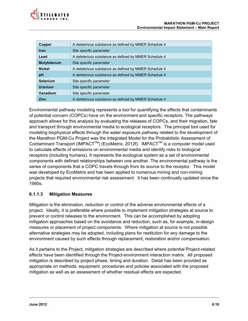
MARATHON PGM-Cu PROJECT Environmental Impact Statement – Main Report
June 2012 6.10
Copper A deleterious substance as defined by MMER Schedule 4
Iron Site specific parameter
Lead A deleterious substance as defined by MMER Schedule 4
Molybdenum Site specific parameter
Nickel A deleterious substance as defined by MMER Schedule 4
pH A deleterious substance as defined by MMER Schedule 4
Selenium Site specific parameter
Uranium Site specific parameter
Vanadium Site specific parameter
Zinc A deleterious substance as defined by MMER Schedule 4
Environmental pathway modeling represents a tool for quantifying the effects that contaminants of potential concern (COPCs) have on the environment and specific receptors. The pathways approach allows for this analysis by evaluating the releases of COPCs, and their migration, fate and transport through environmental media to ecological receptors. The principal tool used for modeling biophysical effects through the water exposure pathway related to the development of the Marathon PGM-Cu Project was the Integrated Model for the Probabilistic Assessment of Contaminant Transport (IMPACTTM) (EcoMetrix, 2012f). IMPACTTM is a computer model used to calculate effects of emissions on environmental media and identify risks to biological receptors (including humans). It represents the ecological system as a set of environmental components with defined relationships between one another. The environmental pathway is the series of components that a COPC travels through from its source to the receptor. This model was developed by EcoMetrix and has been applied to numerous mining and non-mining projects that required environmental risk assessment. It has been continually updated since the 1990s.
6.1.1.3 Mitigation Measures
Mitigation is the elimination, reduction or control of the adverse environmental effects of a project. Ideally, it is preferable where possible to implement mitigation strategies at source to prevent or control releases to the environment. This can be accomplished by adopting mitigation approaches based on the avoidance and reduction, such as, for example, in-design measures or placement of project components. Where mitigation at source is not possible alternative strategies may be adopted, including plans for restitution for any damage to the environment caused by such effects through replacement, restoration and/or compensation.
As it pertains to the Project, mitigation strategies are described where potential Project-related effects have been identified through the Project-environment interaction matrix. All proposed mitigation is described by project phase, timing and duration. Detail has been provided as appropriate on methods, equipment, procedures and policies associated with the proposed mitigation as well as an assessment of whether residual effects are expected.

MARATHON PGM-Cu PROJECT Environmental Impact Statement – Main Report
June 2012 6.11
6.1.1.4 Compensation
For specific VECs, where adverse residual effects are anticipated and are unavoidable (that is, effects cannot be fully mitigated), some federal and provincial legislation allows for (or requires) the implementation of compensation measures. The choice of compensation measures may be made in cooperation with stakeholders (e.g., public, local community members), Aboriginal peoples and relevant government authorities.
An example of a compensation-based approach relates to Section 35(2) of the Fisheries Act (Canada) and the potential for the development of the Project to create a HADD (harmful alteration, disruption, or destruction of fish habitat). In the instance where a potential HADD cannot be fully mitigated and it has been deemed that the HADD should be authorized, compensation for the HADD is provided. Once an agreement relating to compensation has been reached, the authorization for the HADD can be granted.
Consistent with the federal government’s policy for the management of fish habitat (DFO, 1986), Section 35 of the Fisheries Act focusses on the protection of fisheries. Therefore, the decision as to whether a HADD is created (and also the extent of a HADD for which compensation is required) is a determination of whether or not the potentially affected fish habitat directly or indirectly supports - or has the potential to support - a commercial, recreational or subsistence fishery. Although it is not necessary that a fishery be active, there should be a reasonable expectation for a potential fishery.
Specific aspects of the potential creation of a HADD as the result of the implementation of the Project and compensation needs are considered in Section 6.2.4.5 of this report.
6.1.1.5 Determination of the Significance of Residual Effects
Residual effects are those non-trivial effects identified through the effects assessment process for which no effective mitigation measures are available, or alternatively for which mitigation or compensation does not largely or entirely alleviate an identified effect. Where a residual effect is predicted it was advanced in the effects assessment process to the determination of significance phase.
Consideration of the significance of an adverse environmental effect is integral to an environmental assessment under both the CEA Act and OEA Act. The following factors were considered as appropriate to determine significance:
magnitude of effect; spatial extent of effect; duration of effect; frequency (or probability) of effect; reversibility of effect; ecological importance; and, societal (including Aboriginal) value.

MARATHON PGM-Cu PROJECT Environmental Impact Statement – Main Report
June 2012 6.12
Societal and ecological value were considered by SCI based on input and feedback it received regarding the Project from the public, local community members, government and Aboriginal peoples, as well as the experience of the study team.
Table 6.1-3 provides a summary of the manner in which, and the context within which, residual effects predicted by the assessment and their significance were characterized for each of the aforementioned factors. The characterization used the following conceptual effects rating criteria consistent with the EIS guidelines:
MINIMAL = Potential effect may result in a slight decline in a resource or VEC or indicator in the study area during construction, operation and closure, but the resource should return to baseline levels;
LOW = Potential effect may result in a slight decline in a resource or VEC or indicator in the study area during the life of the Project;
MEDIUM = Potential effect could result in a decline in a resource within the study area to lower than baseline, but stable, level in a study area after Project closure and into the foreseeable future; and,
HIGH = Potential effect could threaten sustainability of the resource or VEC or indicator within the Project study area and should be considered a management concern.

MARATHON PGM-Cu PROJECT Environmental Impact Statement – Main Report
June 2012 6.13
Table 6.1-3: Criteria for the Characterization of Residual Effects and their Significance in the Assessment Process
Effects Rating Criteria
Assessment Factor Minimal Low Medium High
Magnitude Effect slightly exceeds baseline conditions; however, is less than reference criteria or guideline values.
Effect exceeds baseline conditions; however, is less than reference criteria or guideline values.
Effect will likely exceed reference criteria or guideline values but has limited effect on ecological function.
Effect will likely exceed reference criteria or guideline values and may cause a loss of ecological function.
Spatial extent Effect limited to site study area.
Effect limited to site study area or immediate surroundings.
Effect limited to local study area. Effect extends into the regional study area.
Duration The effect is limited to a one-time event.
Effect is limited to short term events. (a few years or less).
Effect is limited to operational and/decommissioning project phases. (years to decades).
Effect extends beyond the decommissioning phase. (centuries).
Frequency/Probability Conditions or phenomena causing the effect rarely occur.
Conditions or phenomena causing the effect are unlikely to occur.
Conditions or phenomena causing the effect may occur on one or more occasions over the project life.
Conditions or phenomena causing the effect occur at regular and frequent intervals.
Reversibility Effect ceases immediately once source or stressor is removed.
Effect ceases once source or stressor is removed.
Effect persists for some time after source or stressor is removed.
Effect is not readily reversible.
Ecological importance The resource/VEC/indicator being affected is very common and abundant within the local study area.
The resource/VEC/indicator being affected is common and abundant within the local study area.
The resource/VEC/indicator being affected is less common and of limited abundance within the local area but abundant in the regional study area.
The resource/VEC/indicator being affected is recognized as being a threatened or a rare or endangered species.
Societal (including Aboriginal)
value
The resource/VEC/indicator has no value from a societal context
The resource/VEC/indicator has limited value from a societal context
The resource/VEC/indicator has moderate value from a societal context.
The resource/VEC/indicator has high value from a societal context.

MARATHON PGM-Cu PROJECT Environmental Impact Statement – Main Report
June 2012 6.14
6.1.2 Cumulative Effects Assessment
According to Section 16(1) of CEAA, cumulative environmental effects are defined as effects “that are likely to result from the project in combination with other projects or activities that have been or will be carried out”. Cumulative effects occur as the result of interactions of the potential residual effects of the Marathon PGM-Cu Project with the likely effects caused by other projects or activities off-site, including existing, certain and reasonably foreseeable projects.
For the purposes of the current assessment, cumulative effects associated with the Project may result if:
implementation of the Project would cause residual adverse effects on the environment, taking into account the application of technically and economically feasible mitigation measures; and/or,
the same environmental components are affected by other existing, certain or reasonably foreseeable future projects or activities.
The framework by which any potential cumulative effects associated with the Project have been assessed is provided by the CEA Agency (CEA Agency, 1999). The cumulative effects assessment for the Marathon PGM-Cu Project is provided in Section 6.6 of this report.
6.1.3 Summary of the Effects Assessment
For all VECs that were assessed, Table 6.1-4 provides a summary of the following information:
the Project’s effects; mitigation and compensation measures; potential residual effects; the significance of residual effects in consideration of a variety of assessment factors;
and, whether a significant adverse environmental effect on a VEC is expected as the result of
the implementation of the Project.

MARATHON PGM-Cu PROJECT Environmental Impact Statement – Main Report
June 2012 6.15
Table 6.1-4: Summary of the results of the effects assessment of the Marathon PGM-Cu Project VEC Potential Effect(s) Mitigation / Compensation Residual Effect Significance of Residual Effect(s) Overall Significance
Magnitude Spatial Extent Frequency / Probability
Duration Reversibility Ecological / Societal Value
Air quality (including dustfall)
Project activities may result in occasional short-term exceedances of some air quality guidelines and limits, but not at the nearest sensitive receptor locations. Project activities will likely generate fugitive dust mainly from overburden and mine rock stockpiles, open pit mining activities, and road dust from vehicle transport.
Source control to reduce air emissions. In-design mitigation measures to suppress dust will reduce the likelihood of effect. Dust suppression activities, such as water sprays, on unpaved roads and ore stockpiles, in addition to regular road surface maintenance and implementation of speed limits.
Predicted 1-hour NOx, 24-hour PM10, and CO2, exceed some air quality guidelines/limits along the east side of the Project boundary but not at the nearest sensitive receptor locations., and NOx exceeds the AAQC but not the Federal Reference Level along Peninsula Road during concentrate transport (if that transport option is chosen) although for sources that do not require permitting in Ontario. Residual adverse effect assessed for significance. No residual adverse effects associated with dustfall.
Most exceedances associated with motor vehicle engines. Emissions will be transient in nature and of short duration = medium
Exceedances limited to Project boundary and do not extend to receptor locations = minimal
Exceedances occur during worst-case scenario = minimal
Short-term duration, but over the life of the Project = medium
Emissions will cease at mine closure = minimal
Adverse effect involves human health = low
No Significant Adverse Effect Some air quality limits/guidelines will be exceeded but associated with motor vehicle emissions and not mine related. Effect limited to site study area and immediate vicinity, is short term, and is reversible
Ambient Light Levels
Project activities will result in increased light levels on-site which would be potentially visible from off the mine site
Design mitigation (directional lighting, mounting lights as low as possible) will significantly reduce the likelihood of the effect
No residual adverse effects. - - - - - - No Significant Adverse Effect
Climate change GHG emissions from combustion emissions have a negligible contribution to provincial and national CO2 emissions and the associated phenomenon of climate change. There is no likely effect.
No mitigation required. No residual adverse effects. - - - - - - No Significant Adverse Effect
Acoustic environment
Some measurable increases to existing noise levels (>5 dB) are predicted at one receptor location along transportation route to rail load-out facility, if this concentrate transport option is chosen but noise levels are below noise limits.
The acoustic modeling included noise source control measures such as mufflers on concentrate transport trucks. Scheduling of concentrate delivery trucks to certain times of the day could also be considered should noise levels result in complaints at the seniors’ residence or other locations.
In the instance that the rail load-out facility in Marathon is selected as the preferred concentrate transported option the predicted increase in noise levels along the concentrate transport may be perceptible to some at a seniors’ residence in the Town of Marathon if Route 2 is selected; though no exceedance of OMOE noise standards is expected.
Is below noise limits = minimal
Limited to site study area = minimal
Effect will occur regularly = medium
Short-term duration (during night shift), but over the life of the Project = medium
Effect is reversible at closure = minimal
Adverse effect not expected to affect human health = minimal
No Significant Adverse Effect Effect limited to site study area, short term, and reversible
Surface water quality
No likely adverse effects. No mitigation required, although SCI will treat water released from the PSMF and drainage from the MRSA as necessary to protect water quality in Hare Lake and Pic River, respectively
No residual adverse effects. - - - - - - No Significant Adverse Effect
Surface water quantity
Mean, peak, and low flows in Stream 6 will decrease substantially during operations.
No mitigation during operations planned, but the natural drainage area of Stream 6 will be restored at closure.
Residual effect anticipated on Stream 6 drainage.
Approximately half of the Stream 6 watershed area will be diverted = high
Limited to Stream 6 = minimal
Occurs once, but effect is long-lasting, until natural drainage in Stream 6 is restored = medium
Loss occurs early in the Project and extends to end of operations = medium
Drainage to Stream 6 will be restored = minimal
Limited local recreational/Aboriginal fishery for Steelhead = medium
No Significant Adverse Effect Effect is limited to Stream 6 and effect is reversible at closure when drainage will be restored.
During operation of the Project, there will likely
No mitigation during operation planned, but
Residual effect anticipated on Streams 2 and 3 drainages
The Stream 2 and 3 watersheds will be
Limited to the Stream 2 and
Occurs once, but effect is long-
Loss occurs early in the Project and
Drainage to Streams 2 and 3 will
No recreational or Aboriginal fishery =
No Significant Adverse Effect

MARATHON PGM-Cu PROJECT Environmental Impact Statement – Main Report
June 2012 6.16
be a decrease in mean monthly, peak, and low flows in Streams 2 and 3, as a result in decrease in drainage area and water management; the majority of the water that naturally drains the system will continue to drain to the Pic River.
drainage in Stream 2 and 3 will be restored at closure.
diverted until after mine closure = high
Stream 3 watersheds which comprise a fraction of the Pic River watershed to which they report = minimal
lasting, until natural drainage in Streams 2 and 3 is restored = medium
extends to end of operations = medium
be restored = minimal
minimal Effect is limited to Streams 2 and 3 and effect is reversible at closure when drainage will be restored.
Groundwater quality Over long-term seepage from PSMF and MRSA will report to surface water features but no effect on surface water is predicted. Groundwater is not used as a resource on or near the mine site.
No mitigation required. Groundwater monitoring will assess accuracy of EA predictions and need for management.
No residual adverse effects. - - - - - - No Significant Adverse Effect
Groundwater quantity
Only minor changes in groundwater flow predicted.
No mitigation required. No residual adverse effects. - - - - - - No Significant Adverse Effect
Lake / stream sediments
No change in sediment quality predicted
No mitigation required. No residual adverse effects. - - - - - - No Significant Adverse Effect
Terrain and Soil Approximately 3.7 million m3 of overburden will be removed for site preparation and construction – no net loss since material will be used for reclamation purposes. Potential erosion and slide risk of overburden stockpiles and the MRSA; however design features will ensure terrain (slope) stability is maintained over the long term.
Terrain stability will be managed to minimize erosion and slide risks. This is inherent in the design of the overburden stockpiles and MRSA.
No residual adverse effects. - - - - - - No Significant Adverse Effect
Forest cover Approximately 612 ha of forest cover (predominantly white birch -80% and black spruce -15.3%) will be removed for site development Land clearing and general disturbance may increase the potential for the introduction of non-native plant species to previously unaffected areas Potential for dusting on forest cover near Project Site.
Footprint will be optimized to minimize forest clearing, selective clearing along transmission corridor, re-vegetation at closure. Prevention of invasive species through invasive species awareness and control program, isolating sensitive areas until native vegetation established, etc. In design mitigation measures associated with dust creation (e.g., suppressants) as well as limiting vehicle traffic to previously disturbed areas will mitigate dusting.
Only 411 ha will have the potential to be reforested for a total of 200 ha permanently lost forest. Residual adverse effect assessed for significance. No residual adverse effects. No residual adverse effects.
The amount of forest habitat removed represents <1% of the Big Pic Forest = minimal
Forest cover loss limited to site study area = minimal
Occurs once, but effect is long-lasting = medium
Loss occurs early in the Project and extends beyond the decommissioning phase = high
130 ha of forest cover will be permanently lost = high
The forest cover (mainly white birch) is common in the local and regional study areas = low
No Significant Adverse Effect The forested area of the Project site represents a negligible portion (<1%) of the Big Pic Forest. 70% of the forest cleared for site infrastructure will be replanted resulting in a net loss of 200 ha of forest. This is not significant.
Non-forest cover Approximately 16 ha of thicket swamp (mainly
Footprint will be optimized to minimize loss of wetlands,
Minimal net loss of non-forest vegetation (18 ha). Residual
Minimal removal of non-forest
Non-forest vegetation loss
Occurs once, but effect is long-lasting
Loss occurs early in the Project and
X ha of non-forest vegetation will be
The non-forest vegetation is common
No Significant Adverse Effect

MARATHON PGM-Cu PROJECT Environmental Impact Statement – Main Report
June 2012 6.17
alder thickets), 1.4 ha of shore fen and meadow marsh, and 0.6 ha of rock barrens will be removed for site development Potential for the introduction of non-native plant species to previously unaffected areas
rock barren, etc. Buffers maintained around important features. Non-forest communities are common locally and regionally and can be used for reclamation. Prevention of invasive species through invasive species awareness and control program, isolating sensitive areas until native vegetation established, etc.
adverse effect assessed for significance. No residual adverse effects.
vegetation = minimal
limited to site study area = minimal
= medium extends beyond the decommissioning phase = high
permanently lost = high
in the local and regional study areas = low
Removal of non-forest vegetation limited to site study area, partially reversible through reclamation, and low ecological importance since common in local and regional study area.
Provincially and Regionally rare veg. species
Removal of some regionally rare (Algal Pondweed) and provincially rare (Broad-lipped Twayblade, Common Ragweed, Oake’s Pondweed, Northern St. Johnswort and Marsh Speedwall) species for mine infrastructure and transmission line construction. Potential for the introduction of non-native plant species to previously unaffected areas Potential for dusting on remaining regionally rare species.
Footprint will be optimized and selective re-vegetation at closure. Prevention of invasive species through invasive species awareness and control program, isolating sensitive areas until native vegetation established, etc. In design mitigation measures associated with dust creation (e.g., suppressants) as well as limiting vehicle traffic to previously disturbed areas will mitigate dusting.
A limited number of rare plants will be permanently lost within the Project footprint. Residual adverse effect assessed for significance. No residual adverse effects. No residual adverse effects.
Minimal removal of rare plants = minimal
Loss of rare plants limited to site study area = minimal
Occurs once, but effect is long-lasting = medium
Loss occurs early in the Project and extends beyond the decommissioning phase = high
Increased number of rare plants used for reclamation may result in net gain of rare species = low
Some rare plants identified, but no plants species in the study area are Endangered, Threatened or Special Concern = medium
No Significant Adverse Effect Removal of rare plants limited to site study area and will be selective, partially reversible through reclamation with increased number of rare plants.
Protected veg. species
No protected vegetation species identified in the area
No mitigation required. No residual adverse effects. - - - - - - -
Furbearers Removal of forest cover will alter/remove some wildlife habitat for furbearers (e.g., marten, fisher) Sensory disturbance (noise, dust,) from mine activities Low potential for collision with mine infrastructure, and vehicles
Footprint will be optimized. Site reclamation will restore some of the habitat. Noise mitigation, and dust suppression activities will be sufficient to mitigate. Vehicle collisions predicted to be minimal due to enforced speed limits on roads.
Alter/remove habitat for furbearers. Residual adverse effect assessed for significance. No residual adverse effects. No residual adverse effects.
Minimal habitat loss for furbearers and habitat surrounding the Project is similar and should be suitable for the displaced furbearers = minimal
Loss of habitat limited to site study area = minimal
Occurs one or more times, but effect is long-lasting = medium
Loss occurs early in the Project and is limited to the phases of the Project = medium
Loss of habitat is reversible during site reclamation. Furbearers should return to the site = low
Furbearers are common in the local and regional study areas = low
No Significant Adverse Effect Loss of habitat and wildlife population will be limited to the site study area; furbearers are mobile and will return once Project ceases, and reversible through reclamation and habitat restoration.
Moose Clearing may change moose movement behavior. Initial migration out during site preparation and construction, but return to site area after period of
Limit footprint of disturbed areas.
Clearing may disturb moose movement behavior. Residual adverse effect assessed for significance.
Study area does not appear to provide high quality moose habitat and generally poor winter habitat. Not many moose will be
Loss of habitat limited to site study area = minimal
Occurs one or more times, but effect is long-lasting = medium
Loss occurs early in the Project and is limited to the phases of the Project = medium
Loss of habitat is reversible during site reclamation. Moose should return to the site to the extent that they exist now on-site =
Moose population in nearby WMUs are above the WMU targets but within the ranges outlined in the Cervid Ecological Framework = low
No Significant Adverse Effect Loss of habitat and wildlife population will be limited to the site study area; moose

MARATHON PGM-Cu PROJECT Environmental Impact Statement – Main Report
June 2012 6.18
human, noise, habituation. Potential vehicle collisions
Speed limits on roads to minimize/eliminate collisions.
No residual adverse effects.
affected = minimal low are mobile and will return once Project ceases, and reversible through reclamation and habitat restoration.
Grey Wolf Grey wolf will shadow major prey species such as moose and deer. If moose emigrate from the site then grey wolf will follow. At closure increased areas of grassland will create increased white-tailed deer habitat and potentially higher wolf numbers.
Limit footprint of disturbed areas.
Over time, increased white-tailed deer populations and therefore a potential increase in wolf populations. Residual adverse effect assessed for significance.
Study area does not appear to provide high quality moose habitat; therefore limited wolf population. Not many wolves will be affected = minimal
Loss of habitat limited to site study area = minimal
Occurs one or more times, but effect is long-lasting = medium
Loss occurs early in the Project and is limited to the phases of the Project = medium
Loss of habitat is reversible during site reclamation. Moose should return to the site to the extent that they exist now on-site; therefore wolves will return = low
Wolves are common in the local and regional study areas = low
No Significant Adverse Effect Loss of habitat and wildlife population will be limited to the site study area; wolves are mobile and will return once Project ceases, and reversible through reclamation and habitat restoration.
Black Bear Initial migration out during site preparation and construction, but return to site area after period of human, noise, habituation.
Limit footprint of disturbed areas. Establish wildlife policy to minimize human interaction with wildlife and decrease potential for habituation.
Increased seasonal use of the site by black bear depending on the state of the succession of the reclaimed areas. Residual adverse effect assessed for significance.
Study area does not appear to provide above average bear habitat. Not many bears will be affected = minimal
Loss of habitat limited to site study area = minimal
Occurs one or more times, but effect is long-lasting = medium
Loss occurs early in the Project and is limited to the phases of the Project = medium
Loss of habitat is reversible during site reclamation. New grassland habitat may increase the seasonal use of those areas by black bear = low
Bear density in the study site are likely comparable to those in the surrounding landscape = low
No Significant Adverse Effect Loss of habitat and wildlife population will be limited to the site study area; bears are mobile and will return once Project ceases, and reversible through reclamation and habitat restoration.
Migratory Birds Removal of forest cover, wetlands, and lake habitat for mine infrastructure, proposed roads and transmission lines will contribute to forest fragmentation and may have negative effects on forest interior bird species (temporary habitat loss for 1600 pairs of songbirds), and may interact and could cause loss of nests and young due to land clearing with transmission line and mine infrastructure. Conversely, edge adapted birds may benefit from the habitat alteration.
Where practical, clearing of vegetation will be avoided during bird nesting season. If clearing in nesting season occurs pre-clearing surveys to be completed and nest sites plus buffer zone to be marked as exclusion areas. Transmission line will be designed to minimize collisions, limit the use of guy wires, and where practical, mark the line to increase visibility and avoid collisions.
Some habitat loss for migratory birds. Residual adverse effect assessed for significance.
Site is not within any major migration flyway according to baseline studies and therefore collisions with mine infrastructure and the transmission line should not have a large effect on the bird populations outside of the site study area = minimal
Loss of habitat limited to site study area = minimal
Occurs one or more times, but effect is long-lasting = medium
Loss occurs early in the Project and is limited to the phases of the Project = medium
Loss of habitat is reversible during site reclamation = low
Similar habitat and therefore bird population exist throughout the undisturbed local and regional study area = low
No Significant Adverse Effect Loss of habitat and wildlife population will be limited to the site study area; birds are mobile and will return once Project ceases, and reversible through reclamation and habitat restoration.
Woodland Caribou Loss in potential connectivity between declining populations of woodland caribou in the Neys and Pukaskwa protected areas and loss of small lichen-rich areas on bedrock that could potentially serve as caribou winter and refuge habitat (though there are no known records of this
Establish mine and infrastructure to minimize ecological footprint. Keep intact as much existing forest as possible along the southern portion of the property to maintain potential linkages between landscapes to the east and west of the property. In concert with OMNR
Loss in potential connectivity between declining populations of woodland caribou in the Neys and Pukaskwa protected areas. Residual adverse effects assessed for significance. Loss of small lichen-rich areas on bedrock that could potentially serve as caribou winter/refuge habitat (though there are no known records of this use on the site)
Lack of historic observations of caribou on the site and the abundance of other cervid and predators within the site area, makes woodland caribou loss of connectivity minimal = minimal
Loss of connectivity limited to site study area and immediate surroundings = low
Occurs one or more times, but effect is long-lasting but there is high level of uncertainty= medium
Loss occurs early in the Project and is limited to the phases of the Project = medium
Loss of connectivity is reversible during site reclamation = low
No evidence that woodland caribou use this corridor but of high value= medium No evidence that
No Significant Adverse Effect The abundance of other cervid and predators within the site study area and lack of historic observations makes use of the site as a transportation corridor for woodland caribou

MARATHON PGM-Cu PROJECT Environmental Impact Statement – Main Report
June 2012 6.19
use on the site) develop a mitigation strategy Loss of potential winter and refuge habitat is minor = minimal
Loss of potential winter and refuge habitat limited to areas that have been characterized as disturbed or are in close proximity to disturbed areas = low
The effect is long lasting but there is a high level of uncertainty.= medium
Loss occurs early in the Project and is limited to the phases of the Project = medium
Loss of habitat is reversible during site reclamation = low
woodland caribou use this habitat but of high value= medium
unlikely however the possibility cannot be eliminated. There are ample ways for caribou to by-pass or traverse the site and any loss of potential connectivity is reversible at decommissioning.
Little brown myotis / northern myotis
No bats presently inhabit the site.
No mitigation required. No residual adverse effects. - - - - - - No Significant Adverse Effect
Canada Warbler Nesting habitat removal (mature hardwood dominated forest) for Canada Warblers.
Limit footprint of disturbed areas.
Some habitat loss for Canada Warbler. Residual adverse effect assessed for significance.
Approximately 20 birds will be affected, and habitat adjacent to project site is suitable for birds = minimal
Loss of habitat (approximately 600 ha) limited to site study area = minimal
Occurs one or more times, but effect is long-lasting = medium
Loss occurs early in the Project and is limited to the phases of the Project = medium
Loss of habitat is reversible during site reclamation, but will take many years to regenerate = medium
Similar habitat and therefore bird population exist throughout the undisturbed local and regional study area = low
No Significant Adverse Effect Limited to site study area, habitat loss partially reversible through reclamation but will take time, similar habitat in close proximity.
Rusty blackbird Development of the mine will result in the loss of the only known nesting habitat (1.4 ha) of Rusty Blackbird in the study area on a small pond
Limit footprint of disturbed areas.
Some habitat loss for Rusty blackbird. Residual adverse effect assessed for significance.
1.4 ha of habitat expected to be removed but shouldn’t affect population = minimal
Loss of habitat limited to site study area = minimal
Occurs one or more times, but effect is long-lasting = medium
Loss occurs early in the Project and is limited to the phases of the Project = medium
Loss of habitat is permanent, but should not result in population loss and can adapt to habitat disturbance = high
Other small lakes and ponds within the project footprint where the species was not observed, but which constitute potential nesting habitat = minimal
No Significant Adverse Effect Limited to site study area, habitat loss permanent, but negligible amount compared to similar habitat in close proximity, and will not affect population
Bald eagle No bald eagles presently inhabit the site. The nearest known nest is about 11 km north of the study area.
No mitigation required. No residual adverse effects. - - - - - - No Significant Adverse Effect
Olive-sided Flycatcher
None observed on-site (one pair observed in local study area), but potential nesting habitat (1.4 ha) will be removed for mine development.
Limit footprint of disturbed areas.
Some habitat loss for Olive-sided Flycatcher. Residual adverse effect assessed for significance.
1.4 ha of habitat expected to be removed but shouldn’t affect population = minimal
Loss of habitat limited to site study area = minimal
Occurs one or more times, but effect is long-lasting = medium
Loss occurs early in the Project and is limited to the phases of the Project = medium
Loss of habitat is permanent, but should not result in population loss and can adapt to habitat disturbance = high
Other small lakes and ponds within the project footprint where the species was not observed, but which constitute potential nesting habitat = minimal
No Significant Adverse Effect Limited to site study area, habitat loss permanent, but negligible amount compared to similar habitat in close proximity, and will not affect population
Common nighthawk None observed on-site, but potential habitat (<2 ha) will be removed for mine development
Limit footprint of disturbed areas.
Some potential habitat loss for Common nighthawk. Residual adverse effect assessed for significance.
Less than 2 ha of habitat to be removed but shouldn’t affect population = minimal
Loss of habitat limited to site study area = minimal
Occurs one or more times, but effect is long-lasting = medium
Loss occurs early in the Project and is limited to the phases of the Project = medium
Loss of habitat is reversible during site reclamation. New grassland habitat may provide foraging and nesting habitat for Common nighthawk, can adapt to disturbed habitats = minimal
Open rock barren is common in site and local study area = minimal
No Significant Adverse Effect Limited to site study area, habitat loss reversible through reclamation, similar habitat in close proximity.
Whip-poor-will Whip-poor-will are not expected to inhabit the study area.
No mitigation required. No residual adverse effects. - - - - - - No Significant Adverse Effect
Peregrine Falcon No Peregrine Falcon presently inhabit the site. There are no potential nesting cliffs within about
No mitigation required. No residual adverse effects. - - - - - - No Significant Adverse Effect

MARATHON PGM-Cu PROJECT Environmental Impact Statement – Main Report
June 2012 6.20
3 km of the footprint and no known nests within 8 km
Lake Sturgeon Design of collection ponds and treatment plants will be such that water quantity and quality does not exceed water quality guidelines and not impact the Pic River Lake Sturgeon population. There is no likely effect.
No mitigation required. No residual adverse effects. - - - - - - No Significant Adverse Effect
Fish Habitat Creation of HADD equivalent to 9.4 ha, of which 1.8 ha is fish frequented
Fish habitat compensation for approximately 10 ha will be provided – a net gain.
No residual adverse effects. - - - - - - No Significant Adverse Effect
Recreational Fishery Minor effect regarding convenience for public access to Bamoos Lake, Return potential temporary loss of limited local Steelhead fishery in Stream 6
No mitigation proposed – is still accessible by other areas. Return mitigation is addressed via Fish Habitat Compensation Strategy. No further mitigation required.
No residual adverse effects. - - - - - - No Significant Adverse Effect
Commercial Fishery Guided access to Claw Lake to be provided by SCI for baitfish collections.
Guided access to be provided.
No residual adverse effects. - - - - - - No Significant Adverse Effect
Aboriginal Fishery Potential temporary loss of limited local Steelhead fishery in Stream 6. No other loss of Aboriginal fishery values.
Mitigation for Stream 6 is addressed via Fish Habitat Compensation Strategy. Guided access to Bamoos Lake trail to be provided to Aboriginal peoples.
No residual adverse effects. - - - - - - No Significant Adverse Effect
Benthic invertebrates
Loss of some benthic invertebrate communities
Loss will be minimized/offset incidentally by habitat compensation provided for HADD
No residual adverse effects. - - - - - - No Significant Adverse Effect
Demographics Influx of people has potential for both positive and negative effects
To mitigate potential negative effects SCI will facilitate rational work force, encourage former workers to return to area, provide employee accommodations in Accommodations Complex are locally owned SCI motels, support commuting from local communities.
No residual adverse effects. - - - - - - No Significant Adverse Effect
Housing Increase in demand and cost during site preparation and construction and operations. Reduced demand and prices at mine closure.
No mitigation required. Facilitating national workforce, providing employee accommodations, supporting commuting from the local communities and recruiting employees from local communities.
No residual adverse effects. Reduced demand for housing at closure and downward pressure on home prices.
Low
Low
Medium
Low
Low
Medium
No Significant Adverse Effect
Education and Training
No likely adverse effects. Opportunities for youth, Aboriginal peoples and skilled workers is a positive effect.
No mitigation required. No residual adverse effects. - - - - - - No Significant Adverse Effect
Infrastructure No likely adverse effects. No mitigation required. No residual adverse effects. - - - - - - No Significant

MARATHON PGM-Cu PROJECT Environmental Impact Statement – Main Report
June 2012 6.21
Adverse Effect
Community services Increased demand during site preparation and construction and operations. Reduced demand during closure.
SCI to provide support to fund key community services and organizations and fitness and recreation programs for workers. SCI to maintain ongoing communications with local residents regarding Project schedule.
Reduced demand at closure. Low Low Medium Low Low Medium No Significant Adverse Effect
Health and Emergency services
Greater demand on emergency services, particularly fire protection services
SCI to provide level of health and on-site emergency response and SCI will co-ordinate its emergency response with the Town of Marathon. SCI to maintain ongoing communications with local residents and government regarding Project schedule.
Reduced demand at closure. Low Low Medium Low Low Medium No Significant Adverse Effect
Traffic Reduced demand during closure. Greater vehicular traffic especially at Highway 17, Peninsula Road, and Camp 19 Road intersection, resulting in time delays and potential vehicle and pedestrian collisions. Increased traffic in the Town.
Entrance to Camp 19 Road will be improved by widening the road and increasing the turning radii from Highway 17. These improvements will provide adequate accommodation to the anticipated truck traffic accessing the site during all phases of the Project. Additional signage will improve road safety, especially in the Town of Marathon. SCI to encourage carpooling and will provide bus service. Shift changes and concentrate transport to be scheduled in consultation with the Town of Marathon
No residual adverse effects. - - - - - - No Significant Adverse Effect
Human health Residual effect at Project boundary for air quality but no risk to human health noted
No mitigation required. No residual adverse effects. - - - - - - No Significant Adverse Effect
Employment and Income
No likely adverse effects. Positive effects with respect to employment levels and employment income
No mitigation required. No residual adverse effects. Effects to employment and employment income are positive
- - - - - - No Significant Adverse Effect
Government Revenue
No likely adverse effects. Government incomes will be positively affected by the Project.
No mitigation required. No residual adverse effects. Government incomes will be positively affected by the Project.
- - - - - - No Significant Adverse Effect
Economic and business development
No likely adverse effects. Economic and business opportunities to be positively affected by the Project.
No mitigation required. No residual adverse effects. Economic and business opportunities to be positively affected by the Project.
- - - - - - No Significant Adverse Effect
Recreation/Tourism No likely adverse effects. No mitigation required. No residual adverse effects. - - - - - - No Significant Adverse Effect
Forestry The Project site will need to be cleared for mine development. This may
Timber harvest value will be maintained so there will be no loss of value. Portion of site
No residual adverse effects. - - - - - - No Significant Adverse Effect

MARATHON PGM-Cu PROJECT Environmental Impact Statement – Main Report
June 2012 6.22
affect forestry values and targets identified for the Big Pic Forest Management Unit.
to be cleared comprises a small fraction of the Forest Management Unit as a whole.
Agriculture No likely adverse effects. No mitigation required. No residual adverse effects. - - - - - - No Significant Adverse Effect
Commercial Development
No likely adverse effects. No mitigation required. No residual adverse effects. - - - - - - No Significant Adverse Effect
Navigable waters Several water courses and water bodies that are defined as “navigable” will be impacted.
Limit footprint of disturbed areas.
Several water courses and water bodies that are defined as “navigable” will be impacted; NWPA authorization required. Residual adverse effect assessed for significance.
9 waterbodies and a number of watercourses will be affected, but all minor = minimal
Navigable water loss limited to site study area = minimal
Occurs once, but effect is long-lasting = high
Loss occurs early in the Project and extends beyond the decommissioning phase = high
Not reversible = high
Impacted waters have low societal value and economic benefit when compared to benefits of mine development = low
No Significant Adverse Effect Limited to site study area, but not reversible, low societal value, low economic benefit when compared to benefits of mine development
Archaeology No likely adverse effects. No mitigation required. No residual adverse effects. - - - - - - No significant adverse effect
Built and Cultural Heritage
No likely adverse effects. No mitigation required. No residual adverse effects. - - - - - - No significant adverse effect
Aboriginal land and resource uses for traditional purposes including country foods
Restricted access and land disturbance in the SSA for traditional pursuits
Limit footprint of the mine. Development of a guided site access protocol. SCI to seek input from Aboriginal peoples regarding mien closure concepts and reclamation priorities.
Traditional pursuits negatively affected in the SSA.
Is reported as an area of extensive use = high
Effect is limited to the site study area, = minimal
This effect will occur. = high
Effect will last into the decommissioning phase = medium
effect is reversible = low
Animals hunted and trapped of low ecological importance are very locally and regional abundant = minimal Based on SCI’s understanding of the perspective of Aboriginal peoples who place a high value on these activities = high
No significant Adverse Effect SCI believes it will be able to accommodate non-mitigatable effects through continued engagement.
Aboriginal Archaeological Resources
No likely adverse effects. No mitigation required. No residual adverse effects. - - - - - - No significant adverse effect
Aboriginal Heritage Resources
No likely adverse effects. No mitigation required. No residual adverse effects. - - - - - - No significant Adverse Effect SCI believes it will be able to accommodate non-mitigatable effects thru commitment engagement
PRFN Community Trapline
Restricted access and land disturbance in the SSA which is in the trapline area
Limiting the footprint of the mine. Development of a guided access protocol. SCI to seek input from Aboriginal peoples on mine site closure concepts and reclamation priorities.
Use of the community trapline negatively affected in the SSA.
Is reported as an area of extensive use = high
Effect is limited to the site study area, = minimal
This effect will occur. = high
Effect will last into the decommissioning phase = medium
effect is reversible = low
Animals hunted and trapped of low ecological importance are very locally and regional abundant = minimal Based on SCI’s understanding of the perspective of Aboriginal peoples who place a high value on these activities = high
No significant Adverse Effect SCI believes it will be able to accommodate non-mitigatable effects through continued engagement.

MARATHON PGM-Cu PROJECT Environmental Impact Statement – Main Report
June 2012 6.23
6.2 Assessment of Effects
6.2.1 Atmospheric Environment
6.2.1.1 Assessment Context
This section provides an overview of the potential effects during each phase of the Project on the atmospheric environment. The main VECs assessed were air quality and dustfall, greenhouse gases, and changes in ambient light levels. The potential interaction of the Project and these VECs is presented in Table 6.2-1.
6.2.1.1.1.1 Air Quality and Dustfall
The principal air quality parameters that could be affected by the site preparation and construction, operation, decommissioning and closure phases of the mine are:
Suspended particulate matter (PM10, PM2.5, and TSP); Metals (in particulate matter); and Products of combustion (NOx, SO2, CO, and CO2).
PM10 refers to inhalable particulate matter, PM2.5 refers to respirable particulate matter, and TSP refers to particulate matter with an aerodynamic diameter less than 44 µm. Particulate matter may also contain metals at a mine site. Dustfall is a measure of total deposition of particulate, including wet deposition (material removed from the environment by precipitation) and dry deposition (material that settles naturally); however, only dry deposition is accounted for in this air quality assessment.
Table 6.2-1 presents a source emissions inventory for the Project site, and identifies the emission source and operating period. Emissions factors used to estimate emissions from each source type are provided in TGCL (2012b). Emissions during decommissioning will be similar to emissions during site preparation and construction.
Table 6.2-1: Summary of Emissions Sources for all Phases of the Project
Source Type Description COPCs Emitted
PM
(TS
P, P
M10
, PM
2.5)
Met
als
Co
mb
us
tio
n
(NO
x, C
O, C
O2,
SO
2)
Sit
e P
rep
ara
tio
n Blasting Blasting in open pit and along main access road
Drilling Drilling in open pit and along main access road
Harvester Felling, de-limbing and bucking trees
Skidder Removing trees from cut site
Forwarder Moving cut trees to pick up site

MARATHON PGM-Cu PROJECT Environmental Impact Statement – Main Report
June 2012 6.24
Chipper Chipping tree limbs and slash
Roads Fugitive emissions of PM from unpaved roads and
combustion emissions from vehicle exhaust
Co
ns
tru
cti
on
Blasting Blasting in open pit and along main access road
Drilling Drilling in open pit and along main access road
Harvester Felling, de-limbing and bucking trees
Skidder Removing trees from cut site
Forwarder Moving cut trees to pick up site
Chipper Chipping tree limbs and slash
Crushing Mobile Crusher
Concrete Concrete batch plant
Material Handling Fugitive emissions from material handling activities
Power Use of diesel generators for power
Roads Fugitive emissions of PM and metals from unpaved
roads; combustion emissions from vehicle exhaust
Op
era
tio
n
Blasting Blasting in open pit and along main access road
Drilling Drilling in open pit and along main access road
Mucking Mucking in pits
Loading/
Unloading
Loading/Unloading of Ore and waste rock
Crushing Primary, Secondary and Mobile Crushers
Material Handling Fugitive emissions from material handling activities
Storage Piles Wind erosion of PM from storage piles and tailings
areas.
Reagent Storage
Tanks
Fugitive releases of gases from the storage tanks
Fuel Storage
Tanks
Fugitive releases of gases from the storage tanks
Comfort Heating Use of propane heaters for comfort heating in the
buildings
Assay Lab Emissions from Crushing, Furnaces and Atomic
Absorption
Power Use of diesel generators for emergency power
Roads Fugitive emissions of PM from unpaved roads;
combustion emissions from vehicle exhaust
Mathematical models are widely used to support the assessment of air quality effects. They provide the only viable means to estimate change under a wide range of meteorological conditions especially when the infrastructure being evaluated has not yet been built. As noted above air quality emissions were modeled using the U.S. Environmental Protection Agency’s AERMOD air dispersion model to predict change in air quality in the SSA during each phase at four receptor locations in the local study area (see Figure 5.2-1):
the Property boundary (claims and leased area);

MARATHON PGM-Cu PROJECT Environmental Impact Statement – Main Report
June 2012 6.25
May’s Gifts (west of the airport); south Hare Lake cottage; and north Hare Lake cottage.
The LSA for the air assessment is defined as the claim boundary as shown in Figure 2.4-2.
The model utilizes estimated worst-case emission rates for each COPC, background air quality estimates, local terrain data, and regional meteorological data. The MOE provided custom meteorological data, consolidating data from Marathon Airport, Sudbury, and Geraldton. This model is an approved dispersion model for contaminant discharge under the Ontario Ministry of the Environment O.Reg 419/05. The spatial boundaries for the Project selected for modeling encompasses an area approximately 8.3 km wide and 11 km long and includes the area where the majority of air quality effects from the Project are expected to occur. The assessment references air quality and air quality standards based on averaging times (e.g., 1-hour, 24-hour or annual). Averaging the predicted air quality over the duration of exposure (e.g., 1-hour, 24-hour or annual) accounts for variability resulting from changing wind directions.
Point of impingement concentrations of criteria air contaminants (CAC) - (SO2, NOx, CO, PM10, PM2.5, and TSP), products of combustion, and metals were compared where applicable against Schedule 3 air standards in O. Reg 419/05, National Ambient Air Quality Objectives (NAAQOs), and Ontario’s Ambient Air Quality Criteria (AAQC). NAAQOs prescribe targets for air quality, measured at the relevant receptor, and are targets for focusing air quality management strategies and plans. AAQC are most commonly used in the environmental assessment process as reference criteria for evaluation, and are most applicable for comparison purposes. AAQC are desirable effect-based concentrations in air with variable averaging periods. The O. Reg 419/05 standards are used for permitting of stationary sources in Ontario; however, since vehicle emissions are included in the assessment, comparison against AAQC is more appropriate. For parameters without AAQCs, concentrations were compared against NAAQOs and/or Ontario Jurisdictional Screening Levels (JSLs).
Site Preparation and Construction 6.2.1.1.2
During site preparation and construction particulate matter and dustfall will be generated at the Project site through various processes such as but limited to: site clearing and construction activities, drilling and blasting, motor vehicle exhaust, and fugitive emissions such as wind erosion of overburden storage piles and movement of mobile equipment along unpaved roads. Products of combustion (NOx, SO2, CO, CO2) emissions will be generated during various activities. Project-related emissions of NOx will be produced from combustion sources such as vehicle traffic, construction equipment exhaust, and blasting and diesel power generation. Project-related SO2 emissions will be produced through the combustion of sulphur-containing fuels in on-site vehicles, heavy equipment and diesel power generating equipment. The use of low sulphur fuels throughout all phases of the Project will be encouraged to minimize SO2 emissions. Emissions of CO will be generated from the incomplete combustion of fuel from vehicles and heavy equipment, detonation of blasting compounds and diesel power generation.

MARATHON PGM-Cu PROJECT Environmental Impact Statement – Main Report
June 2012 6.26
CO2 will be emitted from combustion-related sources such as mobile equipment and passenger vehicles, as well as emissions from the continuous-duty diesel generator associated with the mobile crusher.
Site preparation and construction activities will result in a measurable change in air quality compared to background levels, as shown in Table 6.2-2. During site preparation, the highest CAC concentrations are predicted to occur along the east claim boundary. During construction, the highest predicted CAC concentrations are predicted to occur along the southern mine claim boundary near the airport and along Peninsula Road.
During site preparation and construction activities predicted CAC concentrations are below AACQ at the Property boundary and sensitive receptor locations in the LSA, with the exception of 1-hour NOx during site preparation and construction and 24-hour PM10 during site preparation at the Property boundary. The highest NOx concentration along the east property boundary for a 1 hr averaging period is predicted to be above the AAQC but below the federal maximum tolerable criterion of 1,000 μg /m3. During site preparation NOx emissions are from transient emissions of mobile equipment and vehicles along the road in the vicinity of the MRSA as well as the proximity of the road to the east mine claim boundary. During construction NOx emissions are generated by vehicular traffic and operation of diesel generators at the mobile crusher, concrete plant and mine site. It is important to note that emissions of NOx during site preparation and construction will be transient in nature and of short duration.
During site preparation, the maximum 24-hour PM10 of 35 μg/m3 is expected to exceed the 24-hour NAAQO of 25 μg/m3, but not the provincial AAQC of 50 μg/m3 and its occurrence is considered transient in nature and associated with fugitive particulate matter generated from site preparation activities. The predicted CAC concentrations are highest along the Property boundary (claim boundary), and decrease as distance from the source increases. For most of the CACs, the concentrations decrease to approximately background levels at the modeled receptor locations at Hare Lake (north and south) and May’s Gifts on Highway 17.
During site preparation and construction, the predicted concentration of metals in particulate matter was below Ontario Jurisdictional Screening Levels (JSLs), where AAQCs did not exist.
Concentrations of all combustion-related parameters were below applicable provincial criteria along the property boundary and at the identified closest sensitive receptors.

MARATHON PGM-Cu PROJECT Environmental Impact Statement – Main Report
June 2012 6.27
Table 6.2-2: Summary of Predicted Criteria Air Contaminants Concentrations during Site Preparation and Construction
Parametere
TSP PM10 PM2.5 Dustfall NOx SO2 CO
Averaging Period (hr) 24 24 24 30 days Annual 1 24 1 24 0.5 1 8
Standard 120b 25c-
50a
15c-30a 7a g/m2 4.6a
g/m2
400a-
1000d
200a 690a 275a 6000c 36,200a 15,700 a
Background 35-48 12.8-
14.6
1-5 0.33-
1.44
- - 33.2 - 3.25 - - 0.83
(24hr)
Site Preparation
Project Site 30 35 3 1.53 0.76 685 139 304 15 640 527 240
May's Gifts 3.02 4.39 0.09 0.04 0.02 39 3 47 3 81 67 19
Hare Lake (South) 1.47 2.11 0.07 0.01 0.005 21 2 19 1.29 49 40 10
Hare Lake (North) 1.5 2.12 0.05 0.01 0.005 15 1 17 1.28 32 27 9
Construction
Project Site 14.1 23.4 5.5 1.05 0.52 770 6 499 60 1,210 997 454
May's Gifts 4.6 7.6 1.6 0.19 0.09 210 2 184 20 215 177 51
Hare Lake (South) 1.6 3.1 0.7 0.05 0.03 85 1 83 7.9 94 77 26
Hare Lake (North) 2 3.6 0.8 0.06 0.03 73 1 66 8.4 76 63 31
Notes: a. Ontario Ambient Air Quality Criteria b. Ontario Regulation 419/05 made under the Environmental Protection Act c. National Ambient Air Quality Objectives d. Federal Reference Levels e. Concentrations are highest concentration predicted. All results shown in micrograms per cubic metre (ug/m3), unless otherwise stated.

MARATHON PGM-Cu PROJECT Environmental Impact Statement – Main Report
June 2012 6.28
Operations 6.2.1.1.3
During operations, particulate matter and dustfall will be generated at the Project site through various activities, but not limited to: drilling, blasting, and loading mine rock, mill processing, motor vehicle exhaust, diesel generator combustion, propane heating equipment combustion, and fugitive emissions (i.e. TSP, PM10, PM2.5 and metals) such as wind erosion of storage piles and movement of mobile equipment along unpaved roads. Fugitive emissions from the PSMF will be low since the material will be wet. Similar to the site preparation and construction phase, NOx will originate from combustion sources such as vehicle traffic, mining equipment exhaust, blasting and diesel power generation. Project-related SO2 emissions will be produced through the combustion of sulphur-containing fuels in on-site vehicles, heavy equipment and diesel power generating equipment. Emissions of CO will be generated from the incomplete combustion of fuel from vehicles and heavy equipment, detonation of blasting compounds and diesel power generation.
Modeling results include standard dust suppression activities, such as water sprays on unpaved roads and ore stockpiles, in addition to regular road surface maintenance and implementation of speed limits.
Operation activities will result in a measurable change in air quality compared to background levels (Table 6.2-3). During operation, the highest CAC concentrations are predicted to occur at around Year 6 of mine life along the east claim boundary. During operation activities predicted CAC concentrations are below AAQC limits at the Project boundary and receptor locations in the LSA, with the exception of NOx at the Property boundary.
During all years of operation, 1-hour NOx concentrations are predicted to remain below federal reference criteria; but are expected to exceed the 1-hour AAQC of 400 μg/m3. These elevated concentrations are predicted to occur along the east property boundary for all years of mine life for a one-hour averaging period. These transient concentrations are related to the worst-case scenario modeled and are associated with engine emissions from mobile equipment and passenger vehicles, including buses and concentrate trucks. The CAC concentrations are highest along the Project boundary (claim boundary), and decrease with distance from the source. For most of the CACs, the concentrations decrease to approximately background levels at receptor locations at Hare Lake (north and south) in the LSA. All predicted 24-hour averaging NOx results were below provincial and federal criteria. Concentrations of TSP, PM10, and PM2.5 are predicted to be well below applicable criteria. If concentrate is transported to an off-site processing facility via a rail load-out facility in Marathon, NOx emissions (1-hr averaging) associated with concentrate haul trucks are predicted to exceed provincial standards but will be below the Federal reference criterion of 1,000 μg /m3.
The predicted concentration of metals in particulate matter was below applicable provincial criteria along the property boundary and at the identified sensitive receptors in the LSA.
Predicted worst case concentrations of CO2 at the east property boundary were above JSL criteria. During year 3 of operation, the predicted CO2 was elevated at 162,596 μg/m3 (0.5 hour

MARATHON PGM-Cu PROJECT Environmental Impact Statement – Main Report
June 2012 6.29
average) and 55,000 μg/m3 (24 hour average) compared to a JSL of 63,000 μg/m3 (0.5 hour average) and 21,000 μg/m3 (24 hour average). The CO2 emissions are related, for the most part, to combustion emissions from mobile equipment and passenger vehicles, as well as emissions from the diesel generator associated with the mobile crusher.

MARATHON PGM-Cu PROJECT Environmental Impact Statement – Main Report
June 2012 6.30
Table 6.2-3: Summary of Predicted Criteria Air Contaminants Concentrations during Operation
Parametere
TSP PM10 PM2.5 Dustfall NOx SO2 CO
Averaging Period (hr) 24 24 24 30 days Annual 1 24 1 24 0.5 1 8
Standard 120b 25c-50a 15c-30a 7a g/m2 4.6a g/m2 400a-
1000d
200a 690a 275a 6000c 36,200a 15,700 a
Background 35-48 12.8-
14.6
1-5 0.33-1.44 - - 33.2 - 3.25 - - 0.83
(24hr)
Operation - Year 3
Project Site 27 10 3.34 1.05 0.52 583 131 558 159 965 795 309
Peninsula Road 31 9 4.62 1.42 0.71 683 157 305 18 772 636 300
May's Gifts 5 2 0.66 0.17 0.08 206 21 240 21 291 240 60
Hare Lake (South) 3 1 0.32 0.05 0.02 84 9 100 9 115 95 30
Hare Lake (North) 2 1 0.32 0.06 0.03 91 9 105 10 137 113 31
Operation - Year 6
Project Site 18 10 3.60 1.76 0.87 646 148 644 181 1111 915 356
Peninsula Road 27 7 3.44 1.54 0.77 682 157 207 18 772 636 300
May's Gifts 5 2 0.70 0.16 0.08 160 18 109 16 177 145 41
Hare Lake (South) 3 1 0.34 0.05 0.03 92 8 110 10 128 106 32
Hare Lake (North) 3 1 0.41 0.06 0.03 99 10 117 11 153 126 34
Operation - Year 11
Project Site 20 10 3.25 1.01 0.50 661 118 311 46 1109 913 355
Peninsula Road 27 7 4.59 1.52 0.76 738 156 105 17 771 635 299

MARATHON PGM-Cu PROJECT Environmental Impact Statement – Main Report
June 2012 6.31
May's Gifts 6 3 0.73 0.21 0.1 225 12 60 8 163 135 36
Hare Lake (South) 5 2 0.52 0.05 0.03 44 4 41 3 45 38 14
Hare Lake (North) 4 2 0.47 0.07 0.04 72 7 35 4 58 48 14
Notes: a. Ontario Ambient Air Quality Criteria b. Ontario Regulation 419/05 made under the Environmental Protection Act c. National Ambient Air Quality Objectives d. Federal Reference Levels e. Concentrations are highest concentration predicted. All results shown in micrograms per cubic metre (ug/m3), unless otherwise stated.

MARATHON PGM-Cu PROJECT Environmental Impact Statement – Main Report
June 2012 6.32
Decommissioning and Closure 6.2.1.1.4
During decommissioning and closure, fugitive dust emissions will result from dismantling and decommissioning activities. At closure, all exposed dust sources will be vegetated and progressive reclamation will be used wherever practicable to better control dust emissions from overburden, mine rock and process solid areas.
Project-related emissions of SO2, NOx, and CO from vehicles and machinery will be similar to the site preparation and construction phase.
Greenhouse Gases 6.2.1.1.5
Greenhouse Gases (GHGs) are considered as a large-scale global environmental concern rather than a local airshed impact. The Project has been designed according to industry standards and best operating practices to minimize the potential for the emission of GHGs to the extent reasonably practical. GHG emissions from combustion are currently best minimized through efficient combustion practices. No practical methods of capturing and sequestering GHGs from combustion emissions currently exist.
Ontario Regulation 452/09, (Greenhouse Gas Emissions Reporting Regulation, O. Reg 452/09) made under the Environmental Protection Act, requires that facilities subject to the regulation calculate and report GHG emissions annually if the minimum reporting threshold limit is exceeded. Total GHG emissions are normally reported as carbon dioxide equivalents (CO2e), calculated by multiplying the emission rate of each substance (CO2, CH4 and N2O) by its global warming potential (GWP) relative to CO2.
Site Preparation and Construction
During the site preparation phase of the Project, GHGs will be emitted from site clearing, grubbing and stripping activities. No burning of vegetative debris is proposed. During construction, GHGs will be emitted from operation of motor vehicles, mining and construction equipment and from on-site diesel generators.
As shown in Table 6.2-4, the total estimated GHG contribution from site preparation is 8,790 MT/yr CO2e (or 0.0088 million metricT/yr), which is negligible when compared to the provincial and federal CO2e emission rates of 190 million metricT/yr (0.0046%) and 734 million metricT/yr (0.0012%), respectively.
The total estimated GHG emissions during construction is 130,149 metricT/yr, primarily comprised of vehicle emissions on roads (48,484 metricT/yr), emissions from construction equipment (49,725 metricT/yr) and emissions from the diesel generators (27,073 metricT/yr). The total GHG emission rate during construction is small in comparison to provincial and federal CO2e emissions of 190 million metricT/yr (0.068%) and 734 million metricT/yr (0.018%), respectively.

MARATHON PGM-Cu PROJECT Environmental Impact Statement – Main Report
June 2012 6.33

MARATHON PGM-Cu PROJECT Environmental Impact Statement – Main Report
June 2012 6.34
Table 6.2-4: Estimated Greenhouse Gas Emissions during All Phases of the Project
CO2e emissions1(metricT/yr) Activity Site
Preparation Construction Operation Decommissioning
and Closure
Clearing, Grubbing, Stripping & Grading
4,279 - - -
Drilling and Blasting 895 4,868 29,646 -
Mobile Equipment 3,117 44,947 137,849 -
Emissions from vehicles on the Roads
499 3,537 3,480 10,922
Mine Equipment - 49,725 - -
Diesel Generators - 27,073 - -
Indirect Electricity Use - - 35,040 1,909
Emergency Generator - - 11 -
Mill Site - - - 4,023
Mine Site - - - 6,576
Total 8,790 130,149 206,026 23,430
Operations
During operation of the Project, the major contributor to GHG emissions will be combustion emissions from motor vehicles, mining and construction equipment. An indirect source of greenhouse gases associated with the Project is the purchase of electricity from the provincial power grid, which is in part generated using low-sulphur coal. The relative amount of power on the grid derived from coal will likely decrease in the coming years as new renewable energy sources in the area come on-line, even more so if the Government of Ontario moves forward with plans to close all currently operational coal-fired generating stations. Emissions associated with off-site energy were based on an estimated electricity consumption of 15.9 GWh/month.
As shown in Table 6.2-4, the average annual GHG emissions from the operation of the mine was estimated at 206,026 metricT/yr CO2e . These are considered minor compared to provincial and federal annual GHG CO2e emission rates (0.1% and 0.03%, respectively).
The annual emission rate of CO2e for power production in Ontario in 2008 was 34 million metricT/yr (Environment Canada, 2010). Project-related power requirements are expected to be on the order of 0.03 million metricT/yr CO2e obtained from the grid, which is less than 0.1% of the total annual CO2e emission rate for electricity and heat generation in Ontario.
Decommissioning and Closure
During decommissioning and closure, the operation of motor vehicles, mining and construction equipment will be the largest sources of GHG emissions. The direct GHG emissions from the decommissioning phase (23,430 average annual metricT CO2e) are small in comparison with Canadian and Ontario annual GHG and CO2e emission rates (0.0032% of 734 million metricT and 0.012% of 190 million metricT, respectively).

MARATHON PGM-Cu PROJECT Environmental Impact Statement – Main Report
June 2012 6.35
Ambient Light Levels 6.2.1.1.6
Since the Project site is located in an undeveloped area north of Highway 17, ambient light levels will increase to facilitate the development of the site, primarily for the purposes of creating a safe work environment. Increased light levels already exist at the Marathon airport located in close proximity to the Project site. The changes in light levels from the Project will be most notable during the site preparation and construction phases and particularly during operations as work over these periods will proceed on a 24-hour per day basis. Artificial lighting levels associated with decommissioning and closure are expected to be similar to site preparation and construction during the first 2 to 3 years following cessation of operations but would be nominal thereafter.
The Occupational Health and Safety Act (Ontario) specifies that lighting of a work place is to be appropriate to the task workers are undertaking. Specific lighting requirements will be determined during the detailed design phase of the Project so as to be consistent with the requirements of the Act and the regulations thereunder. Lights on the mine site will not be visible from the Town of Marathon in the LSA as there is no direct line of sight. Lights from portions of the mine site (the west side PSMF) may be visible from the highway but the area surrounding the SSA is heavily wooded. This forest habitat combined with the changes in elevation seen across the site suggest that any effect would be limited in spatial extent.
It is unlikely that there would be non-trivial effects on wildlife associated with changes in ambient light levels SSA. Others have reported the potential ecological effects of increased ambient light levels that largely pertain to potential changes in wildlife behavior. For example, artificial light sources are known to both attract and repel specific species (Longcore and Rich, 2004), can increase the incidence of bird mortality through strikes (Jones and Francis, 2003) and can change photosensitive biorhythms (Miller, 2006). These are generally not considered to be of concern for the Project as lighting will be restricted to developed areas of the site where wildlife activity is likely to be minimal.
6.2.1.2 Summary of Predicted/Potential Atmospheric Effects
The following predicted/potential effects on the atmospheric environment are associated with the Project:
Air Quality o Fugitive dust emissions will occur during site preparation, construction, and
operation of the Project. Fugitive dust will mainly result from overburden and mine rock stockpiles, open pit mining activities, and road dust from vehicle use.
o During site preparation and construction activities CAC concentrations will remain below federal and provincial reference standards at the Project boundary and sensitive receptor locations in the LSA, with the exception of 1-hour NOx during site preparation and construction and 24-hour PM10 during construction at the Project boundary. During site preparation and construction the maximum 1-hour NOx is predicted to exceed the AAQC but not the federal maximum tolerable criterion of 1,000 μg /m3 at the Property boundary. During site

MARATHON PGM-Cu PROJECT Environmental Impact Statement – Main Report
June 2012 6.36
preparation, the maximum 24-hour PM10 of 35 μg/m3 is expected to exceed the 24-hour NAAQO of 25 μg/m3, but not the provincial AAQC of 50 μg/m3.
o Predicted air quality meets all criteria at the nearest sensitive receptors on Hare Lake and Highway 17.
o During all years of operation, the maximum 1-hour NOx at the Project boundary is predicted to exceed the 1-hour AAQC of 400 μg/m3, but not the federal maximum tolerable criterion of 1,000 μg /m3.
o If concentrate is transported to an off-site processing facility via a rail load-out facility in Marathon, NOx emissions (1-hr averaging) associated with concentrate haul trucks are predicted to exceed provincial standards but will be below the Federal maximum tolerable criterion of 1,000 μg /m3.
o During year 3 of operation, the predicted CO2 at the Project boundary of 162,596 μg/m3 (0.5 hour average) and 55,000 μg/m3 (24 hour average) is expected to exceed its JSL of 63,000 μg/m3 (0.5 hour average) and 21,000 μg/m3 (24 hour average).
Ambient Light Levels o During site preparation and construction and operations there will be increased
ambient light levels in the SSA. 6.2.1.3 Mitigation of Potential/Predicted Atmospheric Effects
Air Quality 6.2.1.3.1
To mitigate emissions of fugitive dust (TSP, PM10, PM2.5) and associated metals on the atmospheric environment, SCI will adopt standard operating procedures for control of dust generation. Dust emissions will be mitigated by implementing standard dust suppression activities, such as water sprays, on unpaved roads and ore stockpiles, in addition to regular road surface maintenance and implementation of speed limits. Dust suppression activities will be carried out in accordance with a Dust Management Plan that will be prepared and implemented for the site. During operation, concentrate loading into trucks will be completed in a covered environment. In addition, posted speed limits on site roads will help minimize entrainment of road dust during vehicle travel. SCI will maintain all site roads in good condition, with regular inspections and timely repairs to minimize the silt loading on roads.
Fugitive emissions from aggregate storage piles and the exposed beach of the PSMF will be mitigated by minimizing the amount of beach exposed and by the use of wetting techniques on storage pile surfaces and the PSMF (during summer months). Snow cover over the winter months is expected to provide some mitigation for dusting. In addition, the live ore stockpile at the secondary crusher will be housed within a dome beneath a skirted stacker conveyor designed to eliminate the potential for fugitive dust from wind erosion and conveyor drops.
During decommissioning and closure, all exposed dust sources will be vegetated and progressive reclamation will be used wherever practicable to better control dust emissions from overburden, mine rock and tailings stockpiles.

MARATHON PGM-Cu PROJECT Environmental Impact Statement – Main Report
June 2012 6.37
Predicted SO2 emissions during all phases of the Project meet Ontario standards. As best practice, nonetheless SO2 emissions from diesel consumption associated with heavy equipment operations will be controlled through the preferential use of low sulphur diesel, through use of equipment meeting Transport Canada off-road emission requirements, and through effective equipment maintenance. Mitigation of combustion emissions from vehicle exhaust will be accomplished through the purchase of vehicles and equipment that meet US EPA Tier 2 or better emissions standards and through proper vehicle maintenance.
Even though GHG emissions are predicted to be minor SCI has implemented or will implement measures to reduce fuel and power consumption for the Project such as:
designing the processing plant to reduce power consumption as practical; development of the proposed transmission line to replace the on-site diesel generated
power as quickly as is possible; development of a compact site to reduce transportation needs and fuel consumption; use of larger, more fuel efficient trucks for material transport; and maintaining site equipment and vehicles in good working order.
Ambient Light Levels 6.2.1.3.2
The Occupational Health and Safety Act specifies that lighting of a work place is to be appropriate to the task being undertaken. SCI will comply with the Act and its regulations in order to maintain a safe work place but will implement specific mitigation strategies to minimize potential light emissions, such as:
shielded fixtures to reduce glare and light levels; and, fixtures will be affixed on poles or buildings at the lowest possible height.
These measures should be sufficient to reduce artificial light levels to the extent that no non-trivial residual effect is predicted.
6.2.1.4 Residual Effects
Residential effects on air quality have been identified in the SSA. Predicted NOx - 1-hour averaging - exceeds the AAQC but not the Federal Reference Level during all Project phases, and CO2 will occasionally exceed the JSL at parts of the Property boundary. Predicted NOx - 1-hour averaging - also exceeds the AAQC but not the Federal Reference Level during operations along Peninsula Road during concentrate transport to the proposed potential rail load-out facility. PM10 is predicted to exceed the national short-term standard, but not the provincial one during site preparation. These predicted effects were advanced to the assessment of significance stage.

MARATHON PGM-Cu PROJECT Environmental Impact Statement – Main Report
June 2012 6.38
6.2.1.5 Significance of Residual Effects
The significance of identified residual effects for the atmospheric environment is summarized in Table 6.1-4. The significance was ranked from “minimal” to “high” in terms of magnitude, spatial extent, frequency, duration, reversibility, and ecological/societal value for the residual effect(s) identified.
The residual effects associated with air quality were assessed to be “not significant”: PM10.will likely occasionally exceed the Federal Reference Level at the air quality assessment project site, but not the AAQC. 1-hour NOx will likely occasionally exceed the AAQC but not the Federal Reference Level at the Property boundary (as defined by the claim and lease boundaries), and along Peninsula Road if concentrate is hauled via truck to the proposed rail load-out facility. CO2 will likely occasionally exceed the JSL at the Project boundary. These exceedances are mainly associated with emissions from motor vehicle engines. These vehicle emissions will be transient in nature and of short duration. The effect is limited in spatial extent and will be reversible at the end of the Project life.
6.2.2 Acoustic Environment
6.2.2.1 Assessment Context
This section provides an overview of the potential effects during each phase of the Project on the acoustic environment. The potential interaction of the Project activities with the acoustic environment is presented in Table 6.2-1. The potential effects of Project-related noise levels on wildlife are discussed in Section 6.2.7. Predicted noise levels are first assessed against OMOE guidelines.
Baseline characterization of noise levels indicates the noise environment at the Project site is classified as Class 3 – a rural area dominated by natural sounds. The noise environment along the Highway 17 transportation corridor is classified as Class 2 – an area with Class 1 and Class 3 qualities where low sound levels exist as early as 7:00pm. For a Class 2 area, the MOE guideline limits for stationary noise sources at the closest receptor are 50 dBA during the daytime, and 45 dBA at night (after 7:00pm) (OMOE, 1995). For a Class 3 area, the MOE guideline limits at the closest receptor (permanent or seasonal dwelling) are 45 A-weighted decibels (45 dBA) during the daytime, and 40 dBA at night (after 7:00pm) (OMOE, 1995). For a transportation corridor, the OMOE has guidelines for road traffic noise levels from 7:00am to 11:00pm of 55 dBA at sensitive receptors (OMOE, 1997).
A noise assessment was conducted for the Project that considered noise sensitive receptors (NSRs) in four focus areas, as described below (see Figure 5.3-1):
Project site (SSA): The nearest known NSR is a residence and commercial development (May’s Gifts) located on the north side of Hwy 17 approximately 3.4 km southwest of the closest proposed open pit and processing building. Other nearby NSRs include two cottages on the north and south ends of Hare Lake;

MARATHON PGM-Cu PROJECT Environmental Impact Statement – Main Report
June 2012 6.39
Hwy 17 transportation corridor (LSA): NSR include, in addition to May’s Gifts, three motels in the Town of Marathon - the Travelodge Hotel, the Peninsula Inn and the Wayfare Inn;
Town of Marathon transportation corridors (LSA): Peninsula Road is the main arterial road, which is bordered by institutional, commercial, enterprise, light industrial, heavy industrial, rural and residential zones. Peninsula Road would be used for either proposed concentrate transport route and is currently the significant urban background noise source. NSRs include churches, motels, residences, hospital, and a library; and,
Rail Load-out Facility (LSA): There are two proposed locations for the rail load-out facility. The closest NSR for both proposed locations include the Kingdom Hall church and the Harbour Inn.
The NSRs nearest to the Project site are the north Hare Lake cottage, south Hare Lake cottage, Peninsula Inn, Travelodge Hotel, Wayfare Inn and May’s Gifts. To identify noise effects at the NSRs, the predicted sound levels were compared to provincial noise standards for stationary sources established by the Ontario MOE, the baseline noise conditions as established in the Baseline Noise Report, and traffic noise guidelines published by the Ontario MOE.
6.2.2.2 Site Preparation and Construction
Noise is expected to be generated on the Project site during site preparation and construction activities. Site preparation and construction equipment and machines, clearing, drilling and blasting activities will especially contribute to noise in the SSA. The forested area will be cleared and lumber with economic value was assumed to be hauled off site via transport trucks, increasing traffic and noise. Drilling and blasting are required to prepare and construct the access road to the site.
As shown in Table 6.2-5, during site preparation and construction, sound levels arising from equipment and activities associated with the Project are not expected to cause noise effects at the six NSRs in the LSA, since the predicted maximum hourly sound levels are below the relevant OMOE standards. The predicted Leq(1) (equivalent continuous noise level averaged over a 1 hour period) are based on worst case scenarios for each phase, which occurs after 7:00 pm when background ambient noise is at its lowest.
As shown in Table 6.2-6, during site preparation and construction, sound levels arising from increased traffic along the Highway 17 transportation corridor are expected to cause negligible effects at the six NSRs. Sound levels are expected to increase by only 0.1 dB above baseline levels. An increase of 5 dB would indicate the need to consider mitigation as recommended in the MTO’s traffic noise guidelines. An incremental change of less than 5 dB is commonly accepted as an incremental change that is imperceptible to the human ear.
Worker health and safety related noise issues are addressed in TGCL (2011e). Although construction noise can be of high magnitude, it is often for a short duration.

MARATHON PGM-Cu PROJECT Environmental Impact Statement – Main Report
June 2012 6.40
Table 6.2-5: Predicted Sound Levels at Noise Sensitive Receptors from Project Activities
Highest Predicted Hourly Leq(1) (dBA) Noise Standard1
(dBA) Location Site
Preparation
Construction Operation
(Year 3)
Operation
(Year 6)
Operation
(Year 11)
May’s Gifts 36.7 36.5 41.0 41.0 41.2 45
Wayfare Inn 36.9 38.5 41.2 41.3 42.1 45
Peninsula
Inn
36.5 38.4 41.5 41.5 41.8 45
Travelodge 39.0 41.6 43.1 43.1 43.1 45.4
North Hare
Lake
Cottage
25.5 31.8 34.4 34.2 34.2 41.9
South Hare
Lake
Cottage
23.6 26.0 33.2 32.7 32.6 41.9
1. Noise standard is from MOE noise guidelines, with the exception of when baseline measurement exceeded
guideline – baseline measurement was used.
Table 6.2-6: Predicted Sound Levels at Noise Sensitive Receptors from Highway 17 Traffic
Highest Predicted Daytime Leq(16) (dBA)
Noise Standard1
(dBA) Location Construction Operation (All
Years) May’s Gifts 55.6 55.6 55.5 Wayfare Inn 55.9 55.8 55.8 Peninsula Inn 57.9 57.8 57.8 Travelodge 57.3 57.2 57.2 North Hare Lake Cottage 5.5 4.4 55 South Hare Lake Cottage 12.3 8.8 55
1. Noise standard is from MOE LU 131 Traffic Limit, with the exception of when baseline measurement exceeded
guideline – baseline measurement was used.
6.2.2.3 Operations
During operations noise is generated by both indoor and outdoor sources. Most of the noise generated on-site will be from drilling and blasting of mine rock, stationary equipment at the mill site, loading concentrate, mine rock and ore onto trucks and transporting the concentrate, mine rock and ore.
The noise model assessed the operations phase during years 3, 6 and 11 to represent varying production capacities as well as altering terrain elevations as the open pit elevations decrease and the storage area elevations (PSMF, MRSA) increase.

MARATHON PGM-Cu PROJECT Environmental Impact Statement – Main Report
June 2012 6.41
As shown in Table 6.2-5, during all years of operation, sound levels arising from equipment and activities associated with the Project are not expected to cause noise impacts at the six NSRs, since the predicted maximum hourly sound levels are below the relevant OMOE standards.
As shown in Table 6.2-6, during operation, sound levels arising from increased traffic along the Highway 17 transportation corridor is expected to remain at baseline noise levels.
Increased sound levels will occur along the route to the proposed rail load-out facility in the LSA. Two possible facility locations are included in the assessment, each with a different transportation route. One proposed concentrate transport route (Route #1) follows Peninsula Road and Marina Drive and the second (Route #2) follows Peninsula Road, Stevens Avenue and Winton Street. For Route #1, increased noise levels will not be noticeable at NSRs in the LSA. The predicted traffic noise Leq(16) is 52.2 dBA at Kingdom Hall church which is below the MOE standard of 55 dBA, and an increase of 1.9 dB from baseline. For Route #2, the predicted traffic noise Leq(16) is 51.8 dBA at Stevens Avenue Seniors’ Centre in the LSA which is below the MOE standard of 55 dBA; however, the magnitude of increase of 5.3 dB from baseline may be noticeable to some since it is marginally greater than 5 dB.
Operation of the rail load-out facility (either location) is not expected to cause noise effects to the NSRs. For both options, the predicted noise levels at the closest NSRs (Kingdom Hall and Harbour Inn) are below the MOE standard of 45 dBA.
Increased noise levels during operation have the potential to affect wildlife and human receptors, in the case of human receptors during transportation of concentrate to the rail load-out facility in Marathon if that transport option is chosen. The potential effects are assessed under the wildlife and human health sections, respectively.
6.2.2.4 Decommissioning and Site Closure
Most noise during decommissioning and site closure will result from dismantling structures and equipment. Noise levels are expected to be similar to the site preparation and construction phase and will be of short duration.
6.2.2.5 Summary of Predicted/Potential Acoustic Effects
The following predicted/potential effects on the acoustic environment are associated with the Project:
During site preparation and construction, sound levels arising from increased traffic along the Highway 17 transportation corridor are expected to increase by only 0.1 dB above baseline levels. Predicted sound levels at the six NSRs in the LSA are well within MOE standards.
Predicted noise levels along Route #2 (Peninsula Road, Stevens Avenue and Winton Street) to the rail load-out facility, indicate an increase by 5.3 dB from baseline specifically at Stevens Avenue Seniors’ Centre in the LSA. The noise level will be below

MARATHON PGM-Cu PROJECT Environmental Impact Statement – Main Report
June 2012 6.42
the MOE standard of 55 dBA; however, the increase of marginally more than 5 dB may be perceptible.
6.2.2.6 Mitigation of Adverse Effects
The acoustic modeling included noise source control measures such as mufflers on concentrate transport trucks. Scheduling of concentrate delivery trucks to certain times of the day could also be considered should noise levels result in complaints at the seniors’ residence or other locations.
6.2.2.7 Residual Effects
In the instance that the rail load-out facility in Marathon is selected as the preferred concentrate transported option the predicted increase in noise levels along the concentrate transport may be perceptible at a seniors’ residence in the Town of Marathon if Route 2 is selected; though no exceedance of OMOE noise standards is expected.
6.2.2.8 Significance of Residual Effects
The residual effect associated with increased noise levels was assessed to be not significant. The predicted increase in noise levels at the Marathon seniors’ residence from concentrate delivery trucks should Route 2 be selected although potentially perceptible is well within OMOE standards.
6.2.3 Water Quality and Quantity
6.2.3.1 Assessment Context
This section provides an overview of the potential effects during each phase of the Project on water quality and quantity. The VECs assessed included surface water flow, surface water quality, groundwater flow, groundwater quality, and sediment quality and benthos. The potential interactions of the Project and these VECs is presented in Table 6.1-1.
6.2.3.2 Surface Water Flow
Baseline surface water hydrology is discussed in Section 5.4.1. There are a total of 8 watersheds that drain the Project site, six to the Pic River and two to Lake Superior directly. Baseline flow data indicate that peak flows typically occur in May and are due to either snowmelt or a combination of snowmelt and rainfall. Annual low flows can either occur in late winter (i.e., February and March) or in September and October.
The Project has the potential to affect hydrologic flow regimes (e.g., mean, peak, and low flow) in the Hare Creek watershed downstream of Hare Lake, Stream 6, and in four sub-watersheds where mine facilities will be physically located. The effect on hydrologic flow regime in the Hare Creek and Stream 6 watersheds is anticipated to be temporary with the flow regime returning to baseline conditions on mine closure and decommissioning.

MARATHON PGM-Cu PROJECT Environmental Impact Statement – Main Report
June 2012 6.43
The potential effects on flow at existing watercourse crossings, for surface and groundwater interactions, and erosion and channel morphology were also assessed.
Site Preparation and Construction 6.2.3.2.1
The mill and mine site area surface water runoff during construction and operations will be diverted towards the pit complex area and subsequently pumped to the PSMF. The PSMF is the central collection and management area for pit surface water runoff and groundwater seepage, mine and mill site surface water runoff, and reclaim/process water.
Storm water and subsequent seepage from the MRSA will be collected in four catch basins at the drainages east of the mine rock stockpile, adjacent to the Pic River. These catch basins will be constructed prior to mine rock placement.
The final effluent discharge line running from the treatment plant at the PSMF will be placed within the spillway on route to Hare Lake. There will be on-line flow meters and water quality monitoring equipment in the treatment plant that will be connected to the central process control. No effluent discharge from the PSMF to the environment is projected during Year 1 of mine life.
The watersheds affected by the Project and respective potential effects as it pertains to surface water diversions in the site preparation and construction phase are the same as those that will be affected during operations.
Operations 6.2.3.2.2
With respect to local study area watersheds, summarized in Table 6.2-7 are Project facilities and the watersheds in which they are located. The local watersheds in which the footprint of the Project facilities represent a substantive proportion of the drainage area and include 102 (Stream 2), 103 (Stream 3), 106 (Stream 6), 107, and 108. The surface water flow regime in these sub-basins will be affected either temporarily or permanently by the Project due to a combination of drainage area and land use changes.

MARATHON PGM-Cu PROJECT Environmental Impact Statement – Main Report
June 2012 6.44
Table 6.2-7: Project Facilities and Study Area Sub-Basins
Note: Refer to Figure 1.4-10 for the location of watersheds and Project facilities.
A small part of the PSMF perimeter will be located in Watershed 105 (e.g., Hare Creek), however, this represents less than 1% of the drainage area of that watershed, which is anticipated to have negligible effect on the surface water flow regime. Effluent from the PSMF will be discharged to Hare Lake. Increased flows in the Hare Creek watershed will occur during periods of PSMF discharge as the water that is discharged does not naturally report to this subwatershed. PSMF discharge is likely to mimic the natural hydrograph of the system so the changes to the Hare Creek subwatershed flow regime will largely be restricted to changes in flow magnitude and not flow distribution.
As discussed below, no effect from the Project is anticipated on the surface water flow regime of the Pic River.
Stream 1 Watershed
With respect to the Stream 1 watershed (i.e., 101), Project infrastructure will be located in the headwater areas as will a small part of the PSMF. The effect on the surface water flow regime is anticipated to be minor. A decrease in mean monthly and return period peak flows in the range of 5 to 10 percent is projected. With respect to peak flows, the percent change decreases with an increasing return period. This is attributed to an approximately 7% decrease in drainage area due to construction of the PSMF and mine site. Under baseline conditions, the drainage area to the Pic River is approximately 435 hectares ha and will decrease by approximately 30 ha to 405 ha with development of the Project drainage area.
Local
Watershed
Reference
Water Body
Drainage
Area
(ha)
Project Facilities
101 Stream 1 435 part of PSMF, site road and pipeline infrastructure, new
access road
102 Stream 2 347 satellite pits, MRSA, site road and pipeline infrastructure
103 Stream 3 211 primary pit, MRSA, site road and pipeline infrastructure
104 Claw Lake 339 -
105 Hare Creek 4,833 small part of PSMF perimeter, hydro transmission line, effluent
pipeline
106 Stream 6 1,098 PSMF, site road and pipeline infrastructure, effluent pipeline
107 - 49 MRSA
108 - 53 MRSA

MARATHON PGM-Cu PROJECT Environmental Impact Statement – Main Report
June 2012 6.45
There is the potential for a slightly more rapid, or flashy, hydrologic response during clearing and construction of project infrastructure (e.g., access and haul roads, and pipelines) in the upper areas of this watershed.
MRSA and Pit Watersheds
Substantive land use changes will occur in watersheds 102 (Stream 2), 103 (Stream 3), 107, and 108 associated with the Project. These changes will result primarily from pit construction and placement of mine rock in the MRSA. During operation of the Project, due to placement of mine rock and pit construction, drainage will be collected and managed. The effect will be a decrease in mean monthly, peak, and low flows in these watersheds, specifically streams 2 and 3, as a result in decrease in drainage area and water management.
Claw Lake Watershed
No changes in hydrologic flow regime or peak flows are anticipated in this watershed. A portion of the Project hydro transmission line is proposed to cross the sub-basin headwater area; however, the affected area represents less than 1 percent of the drainage area and this is not expected to have a measurable hydrologic effect.
Hare Creek Watershed
Mean flows are projected to increase in Hare Creek during operations, but return to normal after mine closure and decommissioning. The projected increases will vary during the life of the project and will be dependent on the volume of effluent discharged to the environment from the PSMF. Effluent discharge to Hare Lake is projected to start in Year 2 and continue through Year 12 of mine life. The monthly effluent discharges will vary from 0 to 248,000 m3 per month. Typically, effluent will be discharged from April through November with the amount discharged subject to site requirements for water management (e.g., PSMF water levels, annual precipitation, mill reclaim). Based on the above, mean monthly flow in Hare Creek will potentially increase in the range of 0 to 16.7%, with the mean increase over the mine life and from April through November of approximately 8.2%.
During operations, peak flows have the potential to increase in Hare Creek in the order of 1 to 10% downstream of Hare Lake. This increase is based on the conservative assumption of peak design discharge to the environment of 1,000 m3/h being coincident with the natural peak flow conditions and no effect of storage in Hare Lake on peak flow. However, it is anticipated in practice that peak flow increases will be less than 1% due to the effect of lake storage.
There are two existing watercourse crossings in the Hare Creek watershed that potentially could be affected by the Project: Hare Creek at Highway 17 and Hare Creek at Canadian Pacific Rail Line. Review of hydraulic capacity of these crossings indicate that both crossings have sufficient flow capacity to accommodate the potential flow increases.

MARATHON PGM-Cu PROJECT Environmental Impact Statement – Main Report
June 2012 6.46
Hare Lake is situated to the west of the Project and could be considered a medium-sized lake (EcoMetrix, 2012a). There is public access to Hare Lake via a dirt road from Highway #17 and there are two private cabins on the lake.
The maximum depth of Hare Lake is approximately 29 meters (m) and surface area approximately 57 (ha). It has an approximate water volume of 9,685,000 cubic meters (m3). Hare Lake receives inflows from Bamoos Creek and Stream 5, at the eastern end of the lake, as well as from an unnamed creek originating from a group of lakes approximately two kilometers (km) to the north. Hare Lake discharges to Hare Creek at the western end, which subsequently drains to Lake Superior approximately 3 km downstream.
It is proposed to discharge excess water from the PSMF to Hare Lake during mine operations. Generally process water to support the mill will be provided by recycling water from the PSMF; however, excess water would be discharged to Hare Lake. Discharge would potentially start in the second year of mine life and continue through to closure. The natural hydrologic regime in the watershed draining to Hare Lake is not anticipated to be affected by development of the Project, as there will be no material drainage area or land use changes in that watershed. From a hydrologic perspective, with effluent discharge to Hare Lake, there is the potential to affect lake water level variation.
It is anticipated that the effect on Hare Lake levels will be a net decrease in the frequency of low lake levels during mine operation. Excess PSMF water discharge is not expected to either increase the frequency of high water levels or increase the high water level in the lake.
No effect is anticipated on shoreline erosion as the majority of the lake shoreline is either rocky or comprised of steep rock outcrops. This is particularly the case along the southeastern and northeastern shores of the lake. There are no significant banks or bluffs of sandy or silty material that would be susceptible to erosion with a change in the variation of lake levels.
In particularly dry (drought) years, it may be necessary to supplement the process water supply in the mill with water from Hare Lake. Alternatively in rare instances where water flow is too low in the Hare Lake system it could be necessary to obtain supplemental process water from the Pic River. A provincial permit to take water will be obtained for such taking. The water taking permit process under the Ontario Water Resources Act is designed to ensure there are no adverse effects from the water taking. Any water taking that occurs would be restricted to less than 5% of the Hare Lake inflow or 5% of the flow of Pic River.
Stream 6 Watershed
With respect to the Stream 6 watershed, mean, peak, and low flows are estimated to decrease substantially during the operational phase of the Project. This effect is due to construction of the PSMF in the upper areas of the watershed. During the operational phase the drainage in this area will be managed by the Project and not discharged to Stream 6.
MARATHON PGM-Cu PROJECT Environmental Impact Statement – Main Report
June 2012 6.47
Pic River Watershed
No effects from the Project are anticipated on the surface water flow regime of the Pic River. This is due to the very small size of sub-basins which Project facilities are located relative to the overall Pic River watershed, as well as the location of the Project in the downstream area of the watershed near the outlet to Lake Superior. The drainage area of the sub-basins that drain to the Pic River and will have project facilities located represents only approximate 0.03% of total Pic River drainage area.
Decommissioning and Closure 6.2.3.2.3
At mine closure and decommissioning, surface runoff from the PSMF will be directed back to the natural drainage route (i.e., to Stream 6), effluent will cease being discharged to Hare Lake and the Hare Creek subwatershed, the pits will be allowed to flood (as applicable) and the subwatersheds associated with the MRSA will drain to the main pit and to the Pic River.
Overflow from the pits will overtime eventually discharge to the Pic River through Streams 2 and 3, unless re-routed.
At mine closure and decommissioning the MRSA catch basins will be dewatered and removed, assuming stormwater and seepage quality from the MRSA meets provincial and federal criteria. Accumulated sediment in the catch basins will be excavated and transferred either to Cell 1 or a Satellite Pit for storage. The catch basin embankments will be breached and contoured to suit the surrounding topography. The catch basin and embankment areas will be re-graded and seeded and the original drainage patterns and stream beds will be restored.
As noted in relation to the operations phase, there are five existing road and rail line watercourse crossings that could be affected by the Project: Stream 1 at Camp 19 Road, Hare Creek at Highway 17, Hare Creek at Canadian Pacific Rail Line, Stream 6 at Highway 17, and Stream 6 at Canadian Pacific Rail Line. The Stream 1 and Hare Creek crossings should not be affected by Project closure as flows in these subwatersheds are anticipated to return to baseline conditions.
Following mine closure and decommissioning, peak flows will have the potential to increase in Stream 6 in the order of 5 to 7% at Highway 17 and 2 to 3% near the outlet to Lake Superior. These increases are relative to baseline conditions and will result from an increase in drainage area associated with construction of the PSMF. On closure and decommissioning, drainage from the PSMF will be directed to Stream 6. Review of hydraulic capacity of the Stream 6 watercourse crossings at Highway 17 and the Canadian Pacific Rail Line indicates that there is more than sufficient flow capacity to accommodate the potential flow increases.
Summary of Predicted/Potential Surface Water Quantity Effects 6.2.3.2.4
The following predicted/potential effects on surface water quantity are associated with the Project:
MARATHON PGM-Cu PROJECT Environmental Impact Statement – Main Report
June 2012 6.48
Mean, peak, and low flows in Stream 6 will decrease substantially during operations, since drainage in this area will be managed by the Project and not discharged to Stream 6; and
During operation of the Project, there will likely be a decrease in mean monthly, peak, and low flows in Streams 2 and 3, as a result in decrease in drainage area and water management; however, the majority of the water that naturally drains the system will continue to drain to the Pic River.
Mitigation of Adverse Effects 6.2.3.2.5
No mitigation is planned during operations, but restoration of natural drainage will occur at the end of mine life.
Residual Effects 6.2.3.2.6
A residual effect on Stream 6 and Streams 2 and 3 surface water flow is anticipated during operation of the mine.
Significance of Residual Effects 6.2.3.2.7
The significance of identified residual effects for surface water quantity is summarized in Table 6.1-4. The significance was ranked from “minimal” to “high” in terms of magnitude, spatial extent, frequency, duration, reversibility, and ecological/societal value for the residual effect(s) identified.
The residual effects identified on surface water quantity were assessed to be not significant. Although flows in Stream 6 will decrease substantially throughout the operations phase, this effect is reversible during decommissioning and closure, when natural discharge to Stream 6 will be restored. The water in Streams 2 and 3 represents a very small fraction of the water in the Pic River, therefore the effect is negligible.
6.2.3.3 Surface Water Quality
Baseline monitoring studies measured water quality for conventional parameters such as temperature, pH, turbidity, suspended solids, conductivity as well as trace metals such as aluminum, arsenic, cadmium, cobalt, copper, iron, molybdenum, nickel, lead, selenium, uranium, vanadium, zinc, and other COPCs such as ammonia.
Hare Lake
Baseline surface water quality monitoring studies of the Hare Lake and stream 6 drainage system indicate that water quality is considered pristine for most water quality parameters. For most parameters baseline concentrations (75th percentile) were below the PWQO and Council of Minister of the Environment (CCME, 2006) water quality guidelines for the protection of aquatic life, with the exception of aluminum, and iron with concentrations exceeding the PWQO.

MARATHON PGM-Cu PROJECT Environmental Impact Statement – Main Report
June 2012 6.49
Both aluminum and iron are naturally occurring major elements that are associated with rock forming minerals, including clay particles and are often elevated even in pristine environments. A number of parameters such as uranium and lead had detection limits at the same concentration as the PWQO; therefore, the 75th percentile of the detection limits was used as the baseline.
The PWQO and CCME guidelines are set at a level of water quality which is intended to be protective of all forms of aquatic life and all aspects of the aquatic life cycles during indefinite exposure to the water. For conservatism, the lowest of the PWQO or CCME guidelines were used to compare against the 75th percentile of the baseline value. In the case where natural background water quality does not meet the lowest of PWQO or CCME, the benchmark selected is the 75th percentile of the background value.
The selected assessment benchmarks for relevant water quality parameters in Hare Lake are shown in Table 6.2-8 below. The list of COPCs was developed based on EcoMetrix (2012e).
To demonstrate that the selected benchmark is protective of the environment, a risk assessment model (IMPACT TM) was used and simulated with water concentration at the benchmark level. For the risk assessment, a hazard quotient (HQ) less than 1 is considered protective of aquatic and terrestrial species. For all aquatic and terrestrial species and for all COPCs the benchmark was protective of the environment with HQs well below one (EcoMetrix, 2012f).
Table 6.2-8: Assessment Benchmarks for Water Quality in Hare Lake
COPC 75th Percentile of Background (mg/L)
PWQO (mg/L) CCME (mg/L)
Selected Benchmark (mg/L)
Al 0.14 0.075 0.1 0.14
As 0.001 0.005 0.005 0.005
Cd 0.00009 0.00010 0.000006 0.00009
Co 0.0005 0.0009 - 0.0009
Cu 0.001 0.005 0.002 0.002
Fe 1.0 0.3 0.3 1.0
Mo 0.001 0.040 0.073 0.040
Ni 0.002 0.025 0.025 0.025
Pb 0.001 0.001 0.001 0.001
Se 0.0004 0.1000 0.0010 0.001
U 0.005 0.005 0.015 0.005
V 0.001 0.006 - 0.006
Zn 0.0068 0.02 0.03 0.02

MARATHON PGM-Cu PROJECT Environmental Impact Statement – Main Report
June 2012 6.50
Ammonia (unionized)a
0.0007 0.020 0.019 0.019
a. Ammonia is expressed as un-ionized ammonia and can be converted to total ammonia concentration using site-specific pH and temperature conditions.
Pic River
The method for determining the assessment benchmark for water quality in the Pic River was the same as for Hare Lake. The lowest of the PWQO or CCME guidelines was used to compare against the 75th percentile of baseline water concentrations. Where the 75th percentile met the guideline, the lowest of the PWQO or CCME guideline was selected as the assessment benchmark. Where the 75th percentile exceeded the lowest of the PWQO/CCME guideline, the 75th percentile of baseline was selected as the assessment benchmark. The assessment benchmarks for relevant water quality parameters in the Pic River are shown in Table 6.2-9 below
Table 6.2-9: Assessment Benchmarks for Water Quality in Pic River
COPC 75th Percentile of Background (mg/L)
PWQO (mg/L) CCME (mg/L)
Selected Benchmark (mg/L)
Al 0.040 0.075 0.1 0.075
As 0.0010 0.005 0.005 0.005
Cd 0.00009 0.00010 0.000041 0.00009
Co 0.001225 0.0009 - 0.001225
Cu 0.0038 0.005 0.00289 0.0038
Fe 2.7 0.3 0.3 2.7
Mo 0.001 0.040 0.073 0.040
Ni 0.0047 0.025 0.11 0.025
Pb 0.001275 0.001 0.00429 0.001275
Se 0.0004 0.1000 0.0010 0.0010
U 0.005 0.005 0.015 0.005
V 0.00475 0.006 - 0.006
Zn 0.009425 0.02 0.03 0.02
Ammonia (unionized)a
0.0005 0.020 0.019 0.019
a. Ammonia is expressed as un-ionized ammonia and can be converted to total ammonia concentration using site-specific pH and temperature conditions.
Site Preparation and Construction 6.2.3.3.1
The mill and mine site area runoff during construction and operations will be diverted towards the pits. The PSMF is the central collection and management area for the pit run off and

MARATHON PGM-Cu PROJECT Environmental Impact Statement – Main Report
June 2012 6.51
seepage, mine and mill site run off and reclaim/process water. Storm water and subsequent seepage from the MRSA will be collected in four catch basins at the drainages east of the mine rock stockpile. These catch basins will be constructed as needed to facilitate management of drainage related to mine rock storage.
The final effluent discharge line running from the treatment plant at the PSMF will be placed within the spillway on route to Hare Lake. There will be flow meters on the line and water quality monitoring equipment in the treatment plant that are both connected to central process control.
No exceedances of water quality benchmarks in Hare Lake or the Pic River are expected as a result of site preparation and construction activities. The primary potential water quality issue associated with this phase of the Project is the mobilization of suspended material into natural surface water features as the result of land clearing activities. This is readily mitigatable by the implementation of standard sediment control practices (see Section 6.2.3.3.5)
Operations 6.2.3.3.2
Based on the mine conceptual design used in this analysis, it is expected that there will be minimal discharge to the environment (Hare Lake) during normal operations and increased discharge at the end of operations when the pond levels are maintained at lower elevations.
Potential environmental effects to the Hare Lake system include possible water quality changes due to mine operation and effluent discharge. The monthly average flow and average return period were used to assess the water quality in Hare Lake. The facility will not be discharging effluent to the environment during extreme low flow scenarios as water will be needed for operations.
Potential water quality changes were assessed from contaminant loadings associated with effluent discharge to Hare Lake (from the PSMF), and seepage/runoff to Hare Lake and the Pic River (from the MRSA). It should be noted that the PSMF will be managed primarily as a closed loop for most of the year, with relatively small volumes of excess water to discharge to the environment at different times of the year. It was not possible to derive a reliable source term estimate for ammonia. The potential source term associated with blasting residues could report to the PSMF in water from pit de-watering or to the MRSA on mine rock could not be estimated accurately as consideration of explosives types for use in pit excavation is ongoing. SCI has committed to building water treatment plants at both the PSMF and MRSA which will be capable of treating for ammonia, if required, to be protective of receiving water quality.
The amount of water discharged from the PSMF will mimic the natural hydrograph of the system. That is, the seasonal distribution of flow in the system will not change; rather, the magnitude of flow may change in response to PSMF discharge. As shown in Figure 6.2-1, if untreated effluent is discharged to Hare Lake, the resulting concentrations are predicted to be well below the benchmark for all COPCs during the operations phase of the Project (EcoMetrix, 2012f). The predicted concentrations of COPCs such as copper, cobalt, selenium and sulphate

MARATHON PGM-Cu PROJECT Environmental Impact Statement – Main Report
June 2012 6.52
in water will fluctuate above background, but will remain below the assessment benchmarks. Notwithstanding, provision for treatment of discharge water from the PSMF has been incorporated into the mine conceptual design.
The water from the base of the MRSA will be collected and discharged to Pic River, if required. If untreated seepage or runoff is discharged to the Pic River the resulting (7 day low flow condition expected to occur once in 20 years) concentrations are predicted to be well below the benchmark (Figure 6.2-2). Under the 7Q20 low flow condition and under the monthly average condition there are no predicted exceedances of benchmarks in the Pic River during all phases of the Project (EcoMetrix, 2012f). The predicted water quality in the Pic River in either scenario was indistinguishable from background. Notwithstanding, provision for treatment of drainage from the MRSA has been incorporated into the mine conceptual design.

MARATHON PGM-Cu PROJECT Environmental Impact Statement – Main Report
June 2012 6.53
Figure 6.2-1: Expected Water Quality in Hare Lake (S11)

MARATHON PGM-Cu PROJECT Environmental Impact Statement – Main Report
June 2012 6.54
Figure 6.2-2: Expected Water Quality in the Pic River

MARATHON PGM-Cu PROJECT Environmental Impact Statement – Main Report
June 2012 6.55
Decommissioning and Closure 6.2.3.3.3
At closure, when stormwater and seepage quality from the MRSA have been shown to meet applicable criteria the catch basins will be dewatered and removed. Accumulated sediment in the catch basins will be excavated and transferred to Cell 1 or a Satellite Pit for storage. The catch basin embankments will be breached and contoured to suit the surrounding topography. The basin and embankment areas will be re-graded and seeded and the existing stream beds will be restored. No exceedances of water quality benchmarks in the Pic River are expected during decommissioning and closure.
After mine closure the natural flow regime of the Stream 6 subwatershed will be restored. The PSMF will be re-vegetated and natural stream channels and ponds will be created to collect surface runoff and direct it to the southwest where an outlet structure will be created to link the upper part of the watershed (which is the PSMF) and the lower part of the watershed which drains into Lake Superior. It is expected that the runoff water quality will be similar to existing baseline conditions once the natural flow regime in the Stream 6 subwatershed has been restored. (EcoMetrix, 2012f)
Summary of Predicted/Potential Surface Water Quality Impacts 6.2.3.3.4
No adverse effects on surface water quality are predicted for any phase of the Project.
Mitigation of Adverse Effects 6.2.3.3.5
Although the results of analysis show that treatment of the discharge water from the PSMF or runoff from the MRSA may not be necessary, the provision for treatment for both as required has been accounted for in the conceptual mine design.
Residual Effects 6.2.3.3.6
As the Project is not expected to result in adverse effects on water quality (without or with treatment if required), no residual adverse effects are predicted and therefore none were carried forward to the assessment of significance.
Significance of Residual Effects 6.2.3.3.7
No residual adverse effects were identified; therefore, the significance of residual effects was not assessed.
6.2.3.4 Hydrogeology
Groundwater Flow 6.2.3.4.1
Site Preparation and Construction

MARATHON PGM-Cu PROJECT Environmental Impact Statement – Main Report
June 2012 6.56
The effects on groundwater flow were not assessed during site preparation and construction and are expected to be negligible because there will be minimal interaction between the Project and groundwater.
Operations
Groundwater flow was quantitatively assessed for the Project site during operations and through closure (TGCL, 2012f). Groundwater quantity and flow will mainly be affected during dewatering (waterbodies and the open pits) and re-flooding after operations. The groundwater flow system at the Project site (SSA) is controlled by the steep topography (TGCL, 2012a; Calder, 2012a). Groundwater levels roughly follow surface elevations and the groundwater flow is dominated by shallow and relatively short flow lines that start in upland recharge areas and discharge in local water courses in the valleys. Therefore, any groundwater flow effects will be local in extent.
The hydrology of the study area can be subdivided into three drainage areas. The majority of the study area drains east via a series of small creeks to the Pic River. This area includes the open pits, plant site, MRSA, and a small portion of cell #1 of the PSMF. The northwest portion of the study area, including cell #2 of the PSMF, drains west to Hare Lake. The southwest portion of the study area including most of cell #1 of the PSMF drains southwest towards Lake Superior via two small streams. All surface water drainage ultimately discharges to Lake Superior.
A numerical groundwater flow model - MODFLOW – was used to quantify the hydrogeological conditions at the Project site (TGCL, 2012f). The model simulated the effects of the open pits, MRSA, and PSMF on the groundwater flow regime.
MODFLOW was used to model the progression of groundwater level changes as the open pits developed over time, including after 3, 6, and 11 years of operation. Drawdown of groundwater levels around the open pits remain in close proximity to the pit perimeter walls and will not extend beyond the sub-watershed or to the Pic River. Baseflow to creeks and streams in the near vicinity of the pits will be reduced or eliminated during operations. These streams may be affected by other mining activities as well, such as the development of the MRSA. Overall the change in groundwater discharge to the Pic River is predicted to be negligible.
Predicted groundwater inflows to the pit are shown in Table 6.2-10 below.
Table 6.2-10: Groundwater Inflow to Pits
Year Discharge (m3/day) 3 1,330 6 1,237
11 1,322
The large grain size typical of mine rock ensures that the MRSA is sufficiently permeable to allow water to drain freely through the pile so that the water table will remain within the natural

MARATHON PGM-Cu PROJECT Environmental Impact Statement – Main Report
June 2012 6.57
ground below the rock pile. The model results showed that groundwater below the MRSA ultimately reports to the main pit and to the Pic River. The model provided conservative estimates of the groundwater flow rates to the pit and the Pic River.
Groundwater below Cell 2 of the PSMF reports to local streams on the west perimeter that discharge to Hare Lake and to the south toward Stream 6. Groundwater below Cell 1 will report west to Stream 6 with a small proportion of seepage migrating to the east to join the Pic River after closure.
Decommissioning and Closure
After closure the water level in the primary pit1 will rise after the dewatering system has been turned off. As a result, the groundwater elevations adjacent to the pit will also rebound until the elevation of the water in the pit reaches its final elevation. The primary pit is predicted to fill to capacity approximately 40 years after dewatering ceases primarily as a result of surface water inflows though groundwater inflows will also contribute. The primary pit will be a location of groundwater discharge, similar to other surface water bodies in the general area and consistent with the conceptual model of the site. The primary pit is located in the Pic River watershed and the presence of the flooded pits is not anticipated to alter regional groundwater flow or baseflow to the Pic River.
Groundwater Quality 6.2.3.4.1
The main VEC that can be affected by groundwater quality is surface water quality downgradient of potential mine source areas. The estimated loadings from potential sources were therefore used to calculate concentrations of COPCs in surface waterbodies downgradient of source areas.
Groundwater at the site plays a role in the hydrologic cycle as a conduit for flow from upland recharge areas to lowland discharge zones to provide baseflow to local streams and ponds on the site. In this manner, groundwater represents a pathway for COPCs from potential source areas or mine components to the surface water receiving environment. Therefore, groundwater was assessed in terms of the potential to affect concentrations of COPCs in surface water. The assessment of effects in surface water was quite conservative in that the loadings or transport of the mass of COPCs from potential sources such as the MRSA and the PSMF were assumed to be transferred through groundwater as would occur in a pipe with no effects for the travel times or any possibility for attenuation or reduction in mass transport rates that are typically observed in groundwater flow systems. The mass loading rates in drainage at the base of the MRSA and seepage from the PSMF were assumed to be transported to the surface waters indicated by the groundwater modeling results from the MODFLOW simulations at the site (TGCL, 2012f). 1 Three of the four proposed satellite pits will be filled with process solids and/or mine rock and subsequently reclaimed as terrestrial habitat with surface drainage features. The fourth satellite pit will be partially back-filled and turned into aquatic habitat as part of fisheries habitat compensation works. The primary concern from a pit filling perspective relates to the primary pit.

MARATHON PGM-Cu PROJECT Environmental Impact Statement – Main Report
June 2012 6.58
Site Preparation and Construction
There will be no potential sources that can affect water quality during construction and therefore no effects to groundwater quality or to downstream water quality from interaction with groundwater are expected.
Operations
During operations, there will be potential sources that may affect groundwater quality, including the MRSA and the PSMF. The inputs from those potential sources will be relatively minor in the first years of mining and will evolve to maximum potential loadings as the facilities reach capacity at the end of the operation. Therefore, rather than assess the groundwater effects during operations, the overall effects were assessed assuming maximum potential loading by assuming that the MRSA and the PSMF were at full capacity at the end of the operations and into the closure phase. The results of this analysis are summarized under “Decommissioning and Closure”.
Decommissioning and Closure
The water quality in drainage from the MRSA was assessed by EcoMetrix (2012f). The concentrations of COPCs combined with the estimated flow, represented by infiltration into the rock pile, represents the loadings of COPCs that were assumed to migrate from the base of the rock pile to the groundwater zone below the pile. These loadings were assumed to report to either the Pic River and to the main pit in proportions that were indicated by the MODFLOW modeling results. The magnitudes of the loadings of COPCs from the MRSA are related to the inventory of rock in the facility. Therefore, the maximum potential loadings from the MRSA, that occur when the facility is at capacity at the end of the operation, were used to predict the changes to concentrations in the Pic River.
Similarly, potential COPC loadings from the PSMF were evaluated by EcoMetrix (2012f). Estimated groundwater flow to the various sub-watersheds surrounding the PSMF was taken from the MODFLOW modeling results (TGCL, 2012f?). The loadings to each sub-watershed were then estimated from the concentrations and flow rates and applied to the appropriate waterbodies downstream to assess the effects on concentrations in the receiving waters.
The assessment found no measurable effects to Hare Lake or to the Pic River as a result of groundwater inputs affected by potential sources on the Project site. The effects on concentrations of COPCs in the Pic River as a result of loadings from the MRSA were undistinguishable from baseline concentrations. Therefore no effects from groundwater quality were assumed or are anticipated. Similarly, at the PSMF, seepage was predicted to have no measurable effects on the concentrations on COPCs in Hare Lake. The seepage from the PSMF that reports to Stream 6 was predicted to have no effects on surface water quality. The seepage from the PSMF that reports to Stream 1 was predicted to have no effects on surface water concentrations in the Pic River.

MARATHON PGM-Cu PROJECT Environmental Impact Statement – Main Report
June 2012 6.59
Likely effects on VECs
No effects on water quality are anticipated and therefore no effects on VECs are expected.
Mitigation of Adverse Effects
No mitigation is required because no effects are expected.
Residual effects
No residual effects to groundwater quality are anticipated.
Significance of Residual Effects
No residual effects were identified; therefore, the significance of residual effects was not assessed.
6.2.3.5 Sediment Quality and Benthos
Baseline characterization of sediment quality and benthic invertebrate community structure was completed in waterbodies and watercourses across the Project site, as well as in areas downstream of the Project site. A summary of the baseline information is provided in Section 5.4.4 and detailed baseline information is provided by EcoMetrix (2012a), Golder (2009a) and NAR (2007).
Changes in sediment quality could occur as the result of transport of solids to watercourses or waterbodies through erosion in work-related areas and the subsequent deposition of the solids on top of existing sediments, also potentially affecting the benthic invertebrate community.
Site Preparation and Construction 6.2.3.5.1
The site preparation and construction phase will result in the clearing of land in the SSA, including existing aquatic habitat, to facilitate the development of mine-related infrastructure, such as the open pits, PSMF, MRSA and road network. For the purposes of the assessment herein, it is assumed that direct and indirect footprint-related effects occur largely in this phase of the Project. Indirect loss results from reduced flow in surface water features due to surface water management and diversion (see Section 6.2.3.1).
The loss of aquatic habitat in the SSA during the development of site-related infrastructure will result in the loss of the benthic invertebrate communities associated with that habitat. It is estimated that a total of about 9.5 ha of aquatic habitat2 will be affected by the Project. Benthic invertebrates in the LSA may also be negatively affected by the deposition of suspended solids mobilized to surface waters through erosion in work-related areas. In this case the mechanism of effect is the covering of the bottom habitat with the new solids.
2 Specific details pertaining to aquatic habitat loss are discussed in Section 6.2.4.

MARATHON PGM-Cu PROJECT Environmental Impact Statement – Main Report
June 2012 6.60
Operations 6.2.3.5.2
As described above, it is assumed that the physical effect to aquatic habitats that may occur as the result of land clearing and surface water management will largely be associated with site preparation and construction.
Potential effects on sediment quality and benthic invertebrates during operations may also occur as a result of releases of water from the site. The two primary water-related releases from the site are the PSMF discharge to Hare Lake and MRSA drainage to the Pic River.
In the case of Hare Lake, sediment quality could be affected as the result of PSMF effluent being discharged into a depositional environment. Partitioning of COPCs to the sediments is a natural process in depositional habitats and is a function of the partition coefficient Kd (the partitioning of a COPC between the solid and aqueous phases at equilibrium). Benthic invertebrates in Hare Lake could be affected by changes in sediment quality. Published effect levels (i.e., levels of COPCs that could adversely affect benthic invertebrates) are provided by the OMOE Provincial Sediment Quality Guidelines (Government of Ontario, 2008). Benthic invertebrates can also be exposed to surface water depending on the life history traits and therefore it is also appropriate to use the PWQOs (OMOEE, 1999), or alternatively CCME surface water quality objectives (WQO) (CCME, 2006) to assess potential effects.
Based on the water quality modeling, the predicted concentration during operations of all COPCs in surface water will be below the appropriate water quality benchmarks (EcoMetrix, 2012f). As such, sediment quality and resident benthic invertebrates in Hare Lake are not predicted to be adversely affected by COPCs discharged during operations.
In the case of MRSA drainage to the Pic River, sediment quality will not be affected as the habitat in the vicinity of the discharge (LSA) and for some distance downstream is not depositional and sediments comprise unconsolidated sands that are subject to erosion. Partitioning of COPCs to the sediments would not occur to a measurable extent in this environment. In the Pic River therefore, it is appropriate to use the PWQOs (OMOEE, 1999), or alternatively CCME WQO (CCME, 2006) to assess potential effects on benthic invertebrates. Since no water quality benchmark exceedances are expected for any of the COPCs (EcoMetrix, 2012f) it can be concluded that benthic invertebrates will not be affected in the Pic River during operations.
Decommissioning and Site Closure 6.2.3.5.3
Decommissioning and site closure activities, such as demolition and reclamation (installation of soil covers, regarding land features), may result in the transport of solids to watercourses or waterbodies through erosion in work-related areas and the subsequent deposition of the solids over existing sediments. This has the potential to affect sediment quality and benthic invertebrate communities.

MARATHON PGM-Cu PROJECT Environmental Impact Statement – Main Report
June 2012 6.61
Adverse effects on sediment quality or the benthic invertebrate community as a result of water discharge from the site either to the Pic River or through Stream 6, once its natural flow regime from the closed PSMF has been restored, are unlikely. In the case of the Pic River, since no sediment quality or benthic invertebrate effects were predicted for the operations phase of the Project it can be reasonably assumed no effects would be seen during the decommissioning and site closure phase as the quality of water draining the MRSA is anticipated to initially be stable and improve over the long-term. The PSMF will be covered and revegetated post closure so water draining the area into Stream 6 is expected to be similar to background conditions. No sediment quality changes or effects on the benthic community related to sediment quality changes or impaired water quality are anticipated.
Summary of Predicted/Potential Sediment Quality and Benthic Invertebrates Impacts 6.2.3.5.4
The following are the predicted/potential effects on the sediment quality and benthic invertebrates in relation to the Project:
During site preparation and construction, loss of benthic invertebrate communities in the SSA in areas where aquatic habitat loss (approximately 9.5 ha) will occur; and,
Covering of the local benthic invertebrate community as the result of losses of solids to surface watercourses and waterbodies through erosion in work areas over the LOM (mainly associated with construction and demolition activities).
No effects on sediment quality or benthic invertebrates are anticipated in Hare Lake due to the discharge water release from the PSMF or in the Pic River due to drainage from the MRSA.
Mitigation of Adverse Effects 6.2.3.5.5
Minimizing the potential loss of aquatic habitat, and by extension the benthic invertebrate communities therein, was a primary consideration of the mine design process. The updated conceptual mine plan reflects this process, in that all reasonable attempts were made to reduce the level of interaction between aquatic habitat features and Project infrastructure. The current mine plan reflects about a 30% reduction in direct footprint related impacts from initial conceptual designs.
Losses of aquatic habitat, and again by extension the benthic invertebrate communities therein, will also be mitigated through fish habitat compensation works that will be required under the Fisheries Act. A more detailed discussion of fish habitat compensation is provided below in Section 6.2.4 and EcoMetrix (2012g).
Solids losses to surface watercourses and waterbodies will be minimized by employing readily implementable best management practices for erosion control, such as:
isolating disturbed areas with sediment curtains or similar structures; maintaining appropriate work area setbacks from surface water features; grading and/or covering surfaces to reduce erosion potential,

MARATHON PGM-Cu PROJECT Environmental Impact Statement – Main Report
June 2012 6.62
controlling run-off from erosion-sensitive features; and providing settling ponds or basins in which solids can be collected.
These practices at work locations around the Project site should effectively mitigate the potential for adverse effects to sediment quality and benthic invertebrates.
Residual Effects 6.2.3.5.6
It is expected that the mitigation strategies should be sufficient to effectively mitigate the potential effects on sediment quality and the loss of benthic invertebrate communities such that no residual effects are predicted. Residual effects were, therefore, not carried forward to the assessment of significance.
Significance of Residual Effects 6.2.3.5.7
No residual effects were identified; therefore, the significance of residual effects was not assessed.
6.2.4 Fish and Fish Habitat
6.2.4.1 Assessment Context
This section provides an overview of the potential effects during each phase of the Project on fish and fish habitat. The main VECs assessed were fish habitat, recreational fisheries, commercial fisheries and Aboriginal fisheries. Indicators associated with commercial fisheries include commercial bait fish operations and/or commercial food fish operations. Indicators associated with Aboriginal and recreational fisheries include fish species such as Lake Trout, Brook Trout, Northern Pike, Yellow Perch and migratory salmonids that may be exploited for Aboriginal and recreational purposes in the study area. The potential interaction of these VECs with Project activities is presented in Table 6.1-1.
Baseline characterization of fish and fish habitat was completed in waterbodies and watercourses across the Project site, as well as in areas downstream of the Project site. A summary of the baseline information is provided in Section 5.4.5 and detailed baseline information is provided by EcoMetrix (2012a), Golder (2009a) and NAR (2007).
There are six primary subwatersheds that drain the Project site, four of which drain to the Pic River. Waterbodies and watercourses in the interior of the Project site include small streams, ponds and lakes, many of which are maintained by active or inactive beaver dams, or debris jams. The interior of the Project site (SSA) is isolated from both the Pic River and Lake Superior by steep relief (i.e., topography) and therefore much of this area is fishless. In the instances where fish do occur the community is generally limited to small-bodied or forage fish.
The Pic River watershed tributaries in the immediate vicinity of the Project site afford limited nursery and potentially spawning habitats within their lowest reaches for migratory (e.g.,

MARATHON PGM-Cu PROJECT Environmental Impact Statement – Main Report
June 2012 6.63
Rainbow Trout, Chinook Salmon), as well as resident (e.g., Brook Trout, Slimy Sculpin) species. The fish community of the Pic River is diverse, with a variety of coolwater and coldwater fish species reported including Lake Sturgeon and Walleye. Lake Sturgeon move extensively up and down the Pic River during spawning migration and utilize the lower river for foraging.
Lake Superior tributaries include the Bamoos Lake – Hare Lake corridor and the Stream 6 subwatershed. Bamoos Lake supports a diverse coldwater community, including Lake Trout, Brook Trout and Cisco. The Hare Lake fish community is comprised primarily of coolwater species, including Northern Pike and Yellow Perch. The Hare Lake outlet creek, below the Highway No. 17 crossing, supports a coldwater fish community and affords spawning and nursery habitats for both migratory and resident salmonids. Within its lowest reaches, below a cascade barrier, Stream 6 provides a limited amount of nursery habitat and some spawning habitat for coldwater migratory species from Lake Superior. The upper reaches of Stream 6 are largely fishless with some areas having Brook Stickleback.
Recreational fisheries of potential relevance to the Project site are found in Bamoos Lake, Hare Lake and the lower reaches of its outlet creek, as well as in Lake Superior (near shore area) and the Pic River. A limited recreational fishery for Rainbow Trout (steelhead) also occurs in the lower reach of Stream 6, as a limited number of fish can migrate into the stream during high freshet flows.
Reported use for fishing by Aboriginal peoples is also largely focused on Bamoos Lake, Hare Lake and the lower reaches of its outlet creek, as well as Lake Superior (near shore area) and the Pic River and the near shore area of Lake Superior.
There is no commercial food fishery in study area lakes, or in the near shore area of Lake Superior in the vicinity of the streams draining the Project site. A commercial bait fish license holder does collect forage fish periodically at a single location in the LSA (L19 or Claw Lake).
The Project will interact both directly and indirectly with fish and fish habitat during all Project phases. Direct interactions relate to those associated with the Project footprint. Indirect interactions relate to Project activities and potential water management needs that may direct water away from existing surface water features and thereby reduce flows (and available habitat), as well as water discharged or released from the site (PSMF and MRSA) into receiving environments. Fish and fish habitat may also be affected by the release of solids into surface water features via erosion around disturbed and/or developed areas.
Potential interactions and effects on VECs are discussed below for each of the mine phases. Potential Project related effects on fish habitat in particular are discussed in detail by EcoMetrix (2012g).
Site Preparation and Construction
The site preparation and construction phase will result in the clearing of land, including existing aquatic habitat, to facilitate the development of mine-related infrastructure, such as the open

MARATHON PGM-Cu PROJECT Environmental Impact Statement – Main Report
June 2012 6.64
pits, PSMF, MRSA and road network. For the purposes of the assessment, it is assumed that the full complement of footprint related effects are realized in this phase of the Project, even though some will likely not occur until early in the operations phase as site construction is completed. Direct footprint effects include the loss of aquatic habitat as it is supplanted to accommodate mine infrastructure. Indirect footprint effects specifically refer to reduced flow in surface water features due to surface water diversion and or management.
The road network will also require the development of road crossings (culverts) at two locations in Stream 1. Other crossings on minor ephemeral, drainage features will also be necessary. These crossings, and in particular the two crossings in Stream 1, may disrupt fish habitat either directly or through the potential to impair fish passage or water conveyance.
Activities that result in disturbing the ground surface around surface water features may result in the erosion and subsequent transport of sediment loads into surface waters. The suspended sediment load can harm fish directly (e.g., via gill fouling or via adversely affecting water quality), or can harm fish habitat by covering the aquatic environment with deposits of fine-grained material. This type of effect may occur anywhere where site development and construction activities occur in relative proximity to surface water features.
Fish Habitat
The development of the Project site will result in the harmful alteration, disruption or destruction (HADD) of fish habitat as defined by Fisheries and Oceans Canada (DFO, 2008). The HADD has been determined to involve approximately 9.4 ha of “fish habitat”, of which about 80% (or 7.0 ha) is however not actually frequented by fish. The total amount of required compensation associated with the HADD that will result from the development (and subsequent operation) of the site has been estimated to be 1.8 ha.
The HADD is associated with, and has accounted for, both direct and indirect effects. The direct (or footprint) effects include several small waterbodies and associated connecting channels that will be within the footprint of mine-related infrastructure (pits, MRSA, PSMF) in the SSA. The indirect effects are associated with reduced flows that will result from the realignment of Project site subwatersheds, due to both water management needs and the development of site infrastructure. The HADD is largely confined to the Streams 2, 3 and 6 subwatersheds.
Compensation for the HADD will be required under Section 35(2) of the Fisheries Act and Section 27.1 of MMER. Compensation is specifically related to fish-frequented areas of the Stream 6 subwatershed that will be incorporated into the PSMF and fish-frequented areas of the Stream 2 and 3 subwatersheds that will be incorporated into the MRSA.
A detailed accounting of the HADD, and compensation requirements associated with the HADD, are provided in EcoMetrix (2012g).

MARATHON PGM-Cu PROJECT Environmental Impact Statement – Main Report
June 2012 6.65
Culverts will be installed in two places in the Stream 1 watershed, both of which could potentially affect fish habitat through the loss of ecological function in terms of water conveyance or fish passage.
Work activities such as land clearing and the stockpiling of material (e.g., overburden) could occur in relative close proximity to surface water features. There is the possibility that these activities could result in the mobilization of suspended matter.
Recreational Fisheries
There is no recreational fishery in the SSA.
The limited recreational steelhead fishery that may be present in the lower end of the Stream 6 subwatershed will likely be affected by the reduced flows during the mine operating period. The upper half of the Stream 6 subwatershed will be diverted via the PSMF to Hare Lake during operations, effectively reducing the Stream 6 subwatershed by 50%. It is assumed that this level of reduction in watershed area will reduce flows in Stream 6 such that habitat is lost and the whole of Stream 6 (both the upper part that will be part of the PSMF and the lower part, which will have reduced flows) have accordingly been accounted for in the HADD determination. The limited fishery in the Stream 6 subwatershed does not contribute in a significant way to the fishery in Lake Superior.
There is no recreational fishery in the lower ends of the Streams 2 and 3 subwatersheds, though these areas do provide some nursery habitat and Stream 2 likely provides some spawning habitat for species including migratory salmonids. The relative importance of these two stream reaches to the recreational fishery in the Pic River is low. Together they comprise only about 0.1% of the total Pic River watershed drainage area and Stream 3 in particular often runs dry during annual low flow periods.
Bamoos Lake, a local destination for Lake Trout and Brook Trout, has been removed from the Project footprint in the updated conceptual mine design as a result of First Nations and public input; though its current normal access will be temporarily affected for the general public. The trail leading to Bamoos Lake is most conveniently accessed from the main site access road, which will have guided access during operations for Aboriginal peoples. The current most convenient access is by the Camp 19 Road which travels north through the proposed Project site ending about 750 m south east of Bamoos Lake. There is a trail that goes to Bamoos Lake from that point that can be traversed with an all-terrain vehicle or by hiking. Bamoos Lake will still be accessible from Hare Lake by hiking or alternatively by snow machine in the winter. As discussed below in relation to mitigation, SCI will also permit continued guided access to the Bamoos Lake trail to Aboriginal peoples.
Commercial Fisheries
A commercial baitfish license holder is known to access the site at Claw Lake (L19) from time-to-time. The Project will not affect the lake directly but general access to Claw Lake will be

MARATHON PGM-Cu PROJECT Environmental Impact Statement – Main Report
June 2012 6.66
restricted during mine life, beginning with site preparation and construction. Special arrangements are contemplated for the baitfish license holder as discussed below.
The PRFN have a commercial fishing license for Lake Superior but it will not be affected by the Project.
Aboriginal Fisheries
There is no Aboriginal fishery in the SSA. Aboriginal use of Pic River, the Bamoos Lake-Hare Lake-Hare Creek corridor and the lower end of Stream 6 for fishing has however been reported. No Project-related effects on Aboriginal fisheries in these areas are anticipated. As described above, access to Bamoos Lake will be temporarily affected but the lake will continue to be accessible by means other than the site access road, and as discussed below specific arrangements to permit continued access for Aboriginal peoples will be arranged.
Operations
The primary potential fisheries-related concern related to the operations phase of the Project is surface water discharge from the site into local receiving waters. During operations excess water from the PSMF will be discharged to Hare Lake. MRSA drainage will ultimately report to the Pic River.
Fish Habitat
No effects to fish habitat beyond those already discussed above under site preparation and construction are envisioned. Water quality discharges to surface water are assessed in section 6.2.3.3.
Recreational Fisheries
There is no recreational fishery in the SSA.
The recreational fisheries associated with Hare Lake (and areas downstream) and the Pic River, including the various sport fish identified as indicators, will not be affected by the Project. Water quality in Hare Lake (and areas downstream) and the Pic River is not expected to exceed relevant standards for the protection of aquatic life.
During operations, access to Bamoos Lake via the site access road and the trail at the end of the road will be curtailed as described above in relation to site preparation and construction but guided access will be provided for Aboriginal peoples. The potential effect on the recreational fisheries described above for the Stream 2, 3 and 6 subwatersheds will be the same for the operations phase as for the site preparation and construction phases.
Commercial Fisheries

MARATHON PGM-Cu PROJECT Environmental Impact Statement – Main Report
June 2012 6.67
The PRFN have a commercial fishing license for Lake Superior, which will not be affected by operation of the Project.
As described above, a commercial baitfish license holder is known to access the site, and in particular Claw Lake (L19) from time-to-time. The Project will not affect the lake directly but general current access to Claw Lake will be restricted during mine life.
Aboriginal Fisheries
The Aboriginal fisheries associated with Bamoos Lake, Hare Lake (and areas downstream), and the Pic River, including the various sport fish identified as indicators, should not be affected by the Project. Bamoos has been removed from the Project footprint. Year round access will remain possible and special arrangements will be made in that regard for Aboriginal peoples. Water quality in Hare Lake (and areas downstream) and the Pic River is not predicted to exceed relevant PWQO (or CCME) levels. The potential effects on the Aboriginal fishery described above for the Stream 2, 3 and 6 subwatersheds are the same for the operations phase as for the site preparation and construction phases.
Decommissioning and Site Closure
Decommissioning and closure activities will include the removal of mine infrastructure such as buildings, power lines and roads, the re-grading of surface landscape features and the subsequent reclamation of previously disturbed areas. The mobilization of sediments into waterbodies or watercourses could result from any of these activities.
To the extent possible natural surface water drainage patterns will be restored after mine closure. The PSMF will be reclaimed (covered and revegetated) and surface water features created to restore the natural drainage patterns in the Stream 6 subwatershed. Water draining the reclaimed PSMF will be of similar quality to background conditions across the Project site. Portions of the MRSA will be reclaimed and surfaces re-graded as necessary to improve drainage. The natural surface water drainages for Streams 2 and 3 will be restored once it has been demonstrated that water quality would be protective of aquatic biota therein.
Fish Habitat
No adverse effects on fish habitat are anticipated during mine decommissioning and closure. Most of the fish habitat compensation works proposed to mitigate the HADD created during site preparation and construction would be implemented after mine closure and therefore a net benefit to fish habitat would in fact occur during this stage (see Section 6.2.4.3).
Water quality will not be affected by the Project discharges to the extent that fish habitat will be affected. The ability to control water leaving the site will be maintained after closure to confirm that there are no effects on aquatic biota.
Recreational Fishery

MARATHON PGM-Cu PROJECT Environmental Impact Statement – Main Report
June 2012 6.68
Restoration of natural surface water drainage patterns in combination with fish habitat compensation works, (see Section 6.2.4.3) will restore the function of the lower reaches of Streams 2, 3 and 6.
Current road access to the trail leading to Bamoos Lake could be restored once the mine is closed and general access to the site has also been restored. Site end-use including restoration of current road access to the trail to Bamoos will be determined through consultation with FNs, government, the public and local stakeholders.
Commercial Fishery
The PRFN have a commercial fishing license for Lake Superior, which will not be affected by the closure and decommissioning of the Project.
Whether direct road access to Claw Lake (L19) will be maintained after mine closure will be determined by the extent to which site roads are left in place or are decommissioned and will be determined through consultation with FNs, government, the public and other stakeholders.
Aboriginal Fishery
The Aboriginal fishery should not be adversely affected during mine closure.
6.2.4.2 Summary of Predicted/Potential Effects on Fish and Fish Habitat
The following predicted/potential effects on the fish and fish habitat are associated with the Project:
the creation of a HADD equivalent to approximately 9.4 ha of potential fish habitat, of which 1.8 ha is fish frequented;
installation of culverts and stream crossings, in particular in the Stream 1 subwatershed which may disrupt fish habitat either directly or through the potential to impair fish passage or water conveyance; and
the potential mobilization of solids into local surface water courses at work areas in the vicinity of surface water features.
In addition, without mitigation there would be restricted access for a commercial bait fish license holder to a water body that is used from time-to-time as a bait fish source and temporary reduced access to a location (Bamoos Lake) that is utilized for recreational and Aboriginal fishery purposes.
6.2.4.3 Mitigation of Predicted/Potential Effects on Fish and Fish Habitat
The primary means of mitigation of the HADD that will be created by the development of the Project is the implementation of fish habitat compensation work in consultation with the Department of Fisheries and Oceans and other stakeholders. It has been determined that a HADD of 9.4 ha will be created by the Project, for which 1.8 ha of compensation will be required

MARATHON PGM-Cu PROJECT Environmental Impact Statement – Main Report
June 2012 6.69
(EcoMetrix 2012g)3. A strategy for fish habitat compensation works at the site has been developed and is detailed by EcoMetrix (2012g). The strategy provides for a variety of compensation opportunities on and around the site and includes creating new habitat, enhancing existing habitat, including the establishment of fish in existing waterbodies and watercourses that have determined to be fishless, and protecting important habitat for species at risk (Lake Sturgeon). In total, the strategy offers approximately 10 ha of fish habitat compensation, thereby providing approximately a 5:1 multiplier on compensation that is required. The compensation strategy will be vetted through the EA process and by direct public consultation, with the notion of developing a final compensation plan in consultation with DFO taking into account the input received. The compensation plan will fully identify the compensation option selected, the timetable for implementation and the means by which the success of the works that are implemented will be measured.
The installation of culverts and road crossings have been identified as potentially affecting fish habitat, though these effects should be fully mitigated through design and best management practices. Culvert design, installation and maintenance will follow and conform to appropriate DFO and MNR operational statements, guidance and protocols. Important considerations include:
sizing the culverts to ensure conveyance of water under high flow conditions; maintaining fish passage under low flow conditions; and embedding the culverts to allow the creation of natural substrates.
The potential effects of sediment losses to surface water features due to erosion and subsequent effect on fish habitat can be fully mitigated by implementing best management practices and following and conforming to appropriate DFO and MNR operational statements, guidance and protocols for working around water. Important considerations include for example:
avoiding where possible or maintaining setbacks from sensitive features where necessary;
isolating work areas via temporary berms; providing for the collection of drainage from disturbed areas in channels and settling
basins; and the restoration of disturbed areas as soon as is practical following disturbance.
General access to Claw Lake will be restricted once site preparation begins and will continue until general public access to the site is restored. Because Claw Lake will not be affected by the mining operation SCI will however provide guided, controlled access to Claw Lake to the bait fish license holder at times when access is deemed safe. In this instance, and given the
3 Compensation will be required under both Section 35(2) of the Fisheries Act and Section 27.1 of the Metal Mining Effluent Regulations. This latter requirement is specifically related to the inclusion of fish frequented waters within the PSMF and MRSA. Details associated with the requirements for compensation under the Fisheries Act and MMER are provided in EcoMetrix, 2012g).

MARATHON PGM-Cu PROJECT Environmental Impact Statement – Main Report
June 2012 6.70
apparent infrequent visits to the lake for the purposes of collecting bait fish that are made currently, this level of mitigation should eliminate any potential adverse effect for the license holder.
Access to Bamoos Lake for the purpose of a recreational fishery will still be possible, if somewhat less convenient, during mine operations. SCI will provide guided access to the Bamoos Lake trail for Aboriginal peoples until general access to the site is restored. .
6.2.4.4 Residual Effects
Based on the implementation of the mitigation measures described above, including fish habitat compensation works, no residual effects on fish and fish habitat are anticipated.
6.2.4.5 Significance of Residual Effects
No residual effects were identified; therefore, the significance of residual effects was not assessed.
6.2.5 Terrain and Soils
6.2.5.1 Assessment Context
This section provides an overview of the potential effects on terrain and soils during each phase of the Project. The potential interaction of the Project and these VECs is presented in Table 6.2-1. Project activities may affect terrain and soil mainly during site preparation and construction, and the decommissioning and closure phases of the Project.
Site Preparation and Construction 6.2.5.1.1
During site preparation and construction, top soils and overburden will be removed to clear and excavate the Project site (SSA). The soils baseline assessment (EcoMetrix, 2012b) estimated that approximately 3.71 Mm3 (million meters cubed) of overburden would be available to be used in the development of Project infrastructure and for reclamation purposes, as outlined in Table 6.2-11. Of this volume, approximately 39% would be obtained from the PSMF site, 35% from the primary open pit, 19% from the satellite pits, and the remaining 8% from the mill site. The land will be required for the operations buildings, core infrastructure, process solids management and mine rock management. Graded material will be stored temporarily in one of the previously cleared areas. If suitable for reuse in the short-term, the excavated materials will be used during construction for site infrastructure. If not suitable for reuse in the short-term, due to permeability or high moisture content, the materials may be placed in an overburden stockpile for reclamation purposes. Since soils are not considered acid generating (EcoMetrix, 2012b) they would be suitable for stockpiling on site during all phases of the Project and can be used as reclamation material without concern for effects on water quality.
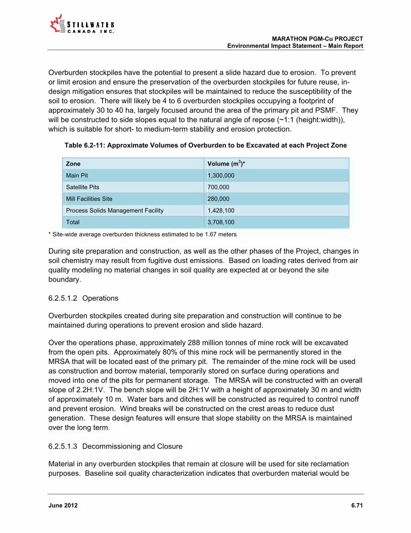
MARATHON PGM-Cu PROJECT Environmental Impact Statement – Main Report
June 2012 6.71
Overburden stockpiles have the potential to present a slide hazard due to erosion. To prevent or limit erosion and ensure the preservation of the overburden stockpiles for future reuse, in-design mitigation ensures that stockpiles will be maintained to reduce the susceptibility of the soil to erosion. There will likely be 4 to 6 overburden stockpiles occupying a footprint of approximately 30 to 40 ha, largely focused around the area of the primary pit and PSMF. They will be constructed to side slopes equal to the natural angle of repose (~1:1 (height:width)), which is suitable for short- to medium-term stability and erosion protection.
Table 6.2-11: Approximate Volumes of Overburden to be Excavated at each Project Zone
Zone Volume (m3)*
Main Pit 1,300,000
Satellite Pits 700,000
Mill Facilities Site 280,000
Process Solids Management Facility 1,428,100
Total 3,708,100
* Site-wide average overburden thickness estimated to be 1.67 meters
During site preparation and construction, as well as the other phases of the Project, changes in soil chemistry may result from fugitive dust emissions. Based on loading rates derived from air quality modeling no material changes in soil quality are expected at or beyond the site boundary.
Operations 6.2.5.1.2
Overburden stockpiles created during site preparation and construction will continue to be maintained during operations to prevent erosion and slide hazard.
Over the operations phase, approximately 288 million tonnes of mine rock will be excavated from the open pits. Approximately 80% of this mine rock will be permanently stored in the MRSA that will be located east of the primary pit. The remainder of the mine rock will be used as construction and borrow material, temporarily stored on surface during operations and moved into one of the pits for permanent storage. The MRSA will be constructed with an overall slope of 2.2H:1V. The bench slope will be 2H:1V with a height of approximately 30 m and width of approximately 10 m. Water bars and ditches will be constructed as required to control runoff and prevent erosion. Wind breaks will be constructed on the crest areas to reduce dust generation. These design features will ensure that slope stability on the MRSA is maintained over the long term.
Decommissioning and Closure 6.2.5.1.3
Material in any overburden stockpiles that remain at closure will be used for site reclamation purposes. Baseline soil quality characterization indicates that overburden material would be
MARATHON PGM-Cu PROJECT Environmental Impact Statement – Main Report
June 2012 6.72
suitable for reclamation purposes (EcoMetrix, 2012b). This includes acid-base accounting and metal leaching data that indicate that soils do not have the potential to adversely affect water quality.
As discussed in the Project Description (Section 1.4), reclamation of the MRSA will be proactive. Horizontal surfaces will be covered with overburden and/or topsoil and subsequently revegetated using native seed. Once it has been demonstrated that water draining the MRSA meets all applicable regulatory requirements the water collection system will be dismantled and natural flows will be returned to the four subwatersheds draining the MRSA.
6.2.5.2 Summary of Predicted/Potential Effects on Terrain and Soils
No adverse effects on terrain and soils are predicted in relation to the Project. Terrain as stability will be managed to minimize erosion and slide risks. Soils and overburden material that is excavated to allow site development will be used for site reclamation purposes, as well as construction material, and no significant net loss of soils is expected. Soil quality is not expected to change at or beyond the Project site boundary as a result of the Project.
6.2.5.3 Mitigation of Adverse Effects
No additional mitigation measures beyond those that are inherent in the mine design are required as no adverse effects have been identified.
6.2.5.4 Residual Effects
As the Project is not expected to result in adverse effects on terrain and soils, no residual effects are predicted and therefore none are carried forward to the assessment of significance.
6.2.5.5 Significance of Residual Effects
No residual effects were identified; therefore, the significance of residual effects was not assessed.
6.2.6 Vegetation
6.2.6.1 Assessment Context
This section provides an overview of the potential effects during each phase of the Project on the vegetation community. The Project site is over 90% forested with the remainder of the site comprised of barren rock, wetland, water and developed lands (Figure 5.6-2). The VECs assessed included forest cover, non-forest cover (including rock barrens and wetlands), regionally and provincially rare species and protected species. The potential interaction of the Project with these VECs is presented in Table 6.1-1. Note that the effect of mine development on plants used for traditional purposes is separately discussed in Section 6.2.10 of this report.

MARATHON PGM-Cu PROJECT Environmental Impact Statement – Main Report
June 2012 6.73
The Project will interact with the vegetation communities during all mine phases, particularly during land clearing activities.
From a spatial perspective the potential effects on the vegetation community are generally limited to the SSA (i.e., the area that is disturbed to accommodate the development of the site). Effects as the result of dusting could extend to the LSA.
Site Preparation and Construction 6.2.6.1.1
The activity that will most directly interact with all vegetation VECs is the removal of the vegetative layer and topsoil through clearing, grubbing and stripping to accommodate the development of mine related infrastructure during the site preparation and construction phase. The approximate total spatial area that will be disturbed during the LOM is 640 ha, with the majority being cleared during site preparation and construction. For assessment purposes the effects of land clearing during all phases are discussed in this section. The breakdown of the areas that fall within the footprint of specific elements of the mine development are shown in Table 6.2-12.
Table 6.2-12: Estimated land clearing requirements for Project-related infrastructure during site
preparation and construction (excluding roads and other linear features)
Project Infrastructure Approximate Area to be Cleared (ha)
Open Pits 120
MRSA 201
PSMF 291
Miscellaneous 30
Forest Cover
Forest cover within the SSA Project site is dominated by birch with smaller proportions of black spruce and balsam (Figure 5.6-2). The surface area corresponding to forest cover that will be disturbed by land clearing during site preparation and construction is about 612 ha, of which 80% (513 ha) is white birch dominated mixed-wood forest and approximately 15.3% (98 ha) is black spruce forest.
The trees might also be affected as the result of dusting from areas that have been cleared and/or machinery and vehicles working in or along areas that have been cleared. The primary mechanisms for dust particles to affect vegetation have been identified by others (Pyatt and Haywood, 1989; McCune, 1991; Walker and Everett, 1991; Farmer, 1993). The effects can be physical related to swamping or coverage, or chemical causing toxicity. Potential effects associated with dusting on forest cover during site preparation and construction are more likely to be physical in nature at the Marathon PGM-Cu site, as the chemical nature of the overburden material in areas that are to be cleared is benign (EcoMetrix, 2012b; 2012e). Further, any

MARATHON PGM-Cu PROJECT Environmental Impact Statement – Main Report
June 2012 6.74
effects are likely to be limited to the immediate vicinity of any cleared areas as fugitive dust emissions are generally predicted to be low (TGCL, 2012b).
The disturbance of the SSA during site preparation may also increase the potential for the introduction of non-native plant species to previously unaffected areas. A number of non-native species were identified during baseline studies (Northern Bioscience, 2012a). Given that the majority of the SSA and surrounding LSA is dominated by trees, potential effects (if any) in this regard would likely manifest as encroachment of non-native species into the margins between forest cover and newly disturbed areas. Propagation of non-native species into disturbed habitats may occur by the movement of machinery, equipment and vehicles along transportation corridors.
Non-Forest Cover (Including Rock Barrens and Wetlands)
Some wetland areas and rock barrens will be affected during site preparation and construction. The area affected largely centers on alder thickets (ES 44) associated with the Stream 6 subwatershed where the PSMF will be developed. Approximately 16 ha of thicket swamp comprised mostly of alder will be affected by the footprint, all from the development of the PSMF. A small amount (i.e., 1.4 ha) of shore fen and meadow marsh will be affected by development of the MRSA and the mill.
Some rock barren vegetation (0.6 ha) will also be cleared during site preparation and construction, largely in the vicinity of the mill site.
Rare Species
According to baseline work, a limited number of observations of regionally and provincially rare plants occur within the SSA. Figure 6.2-3 and 6.2-4 show the occurrences of these two classifications of rare plants and their locations in relation to the Project footprint.
Additional species are in reasonable proximity to areas of the site that will be disturbed during site preparation and construction and therefore also could be affected by dusting and/or encroachment by non-native species.

MARATHON PGM-Cu PROJECT Environmental Impact Statement – Main Report
June 2012 6.75
Figure 6.2-3: Map of the Project Area showing Regionally Rare Plant Locations

MARATHON PGM-Cu PROJECT Environmental Impact Statement – Main Report
June 2012 6.76
Figure 6.2-4: Map of the Project Area showing Cliff and Provincially Rare Plant Locations

MARATHON PGM-Cu PROJECT Environmental Impact Statement – Main Report
June 2012 6.77
Protected Species
There are no known occurrences of habitats or plant species listed as Endangered, Threatened or Special Concern within the Big Pic Forest (Northern Bioscience, 2012a). Accordingly, there is no interaction between the Project and protected vegetation.
Operations 6.2.6.1.2
Land clearing will also occur during the operations phase as mine-related infrastructure is completed.
Forest Cover
During the operations phase, fugitive dust released through continued land clearing, mining (drilling, blasting) and the movement of machinery and vehicles associated with these activities will interact with remaining forest cover. Potential effects from dusting during this phase would be the same as those described above for site preparation and construction.
The potential effects of encroachment of non-native species during operations would be the same as those described above for site preparation and construction.
Non-Forest Cover (Including Rock Barrens and Wetlands)
No direct footprint related effects are anticipated during the operations phase of the mine. Any direct disturbance related to rock barren and wetland vegetation identified by ecosite classification is associated with the site preparation and construction phase. No incremental increase in the disturbance footprint is expected during operations.
Decommissioning and Closure 6.2.6.1.3
At the cessation of operations the mine site reclamation and revegetation of previously disturbed areas would intensify. It is estimated that a total of approximately 400 ha of land will be actively reclaimed to establish a vegetative cover during the first five years of closure. Reclaimed areas will include the PSMF, about 20% of the MRSA, the satellite pits that have been utilized for mine rock and/or process solids storage and linear corridors that are not required to support remaining site activities. Subsequent to this active phase of revegetation natural processes of revegetation and plant succession will occur. Any active revegetation will include the use of native species. Grass and herb species may be used for the purposes of revegetation though other alternatives, such as establishing forest cover (e.g., an even-aged conifer dominated forest to provide potential caribou refuge habitat) will be considered during detailed closure planning in the context of potential long term end uses for the Project site. It may also be feasible to introduce native rare plants to the site during reclamation activities to produce a net benefit to these species on a regional and/or provincial scale.

MARATHON PGM-Cu PROJECT Environmental Impact Statement – Main Report
June 2012 6.78
6.2.6.2 Summary of Predicted Vegetation Effects
The following potential effects on the vegetation are associated with the Project:
Direct loss of vegetative cover due to the development of the footprint of mine related infrastructure through site preparation and construction and operations at the SSA scale including a total of approximately 513 ha of white birch dominated mixed-wood forest and approximately 98 ha of black spruce forest, 0.6 ha of rock barren vegetation, and 17.4 ha of wetland vegetation;
Physical disturbance of vegetation as the result of dusting through site preparation and construction and operations, and likely to a lesser extent during the early period of the closure phase;
Potential encroachment of non-native species into new areas at the SSA scale in areas where land has been disturbed for infrastructure development;
Displacement of regionally and provincially rare plant species.
6.2.6.3 Mitigation of Adverse Effects
The location of the site infrastructure and size of the footprint has been optimized as the conceptual mine design has evolved to minimize the potential effects on the environment.
Standard construction best practices will be used during the site preparation and construction phase to reduce the potential negative interactions with the environment. Disturbance to the vegetation communities will generally be limited to the areas necessary for the development in the SSA (641 ha). Mitigation measures associated with dust creation during all phases include the use of suppressants/water to reduce dust creation and limiting vehicle traffic to previously disturbed and necessary areas only.
The transmission line will be constructed mostly through previously disturbed areas (i.e., PSMF). A number of mitigative measures will be used to reduce the effect of the line construction on the vegetation community in the length of the corridor that will not be disturbed for other purposes:
Vegetated buffer zones will remain around watercourses, lower vegetation and brush left in place, larger trees harvested, width of buffer will vary depending on slope;
No grading or stripping will occur in corridor; Leaving natural vegetation buffers between the line and sensitive habitats; Stabilizing disturbed soil to assist vegetation regrowth and to control erosion; and Hand-clearing vegetation at sensitive stream crossings and within erosion control zones
to minimize soil disturbance;
The loss of vegetation from topsoil removal is reversible over the long-term, with the implementation of a reclamation plan that includes soil salvage and stockpiling prior to construction. Progressive reclamation, commencing as early in the site development process as practicable, will be undertaken where possible to ensure the early re-establishment of

MARATHON PGM-Cu PROJECT Environmental Impact Statement – Main Report
June 2012 6.79
vegetation. Overburden will be spread over the mine rock stockpile benches and then seeded with grasses. Halfway through the mine life, process solids and some types of mine rock will be directed to the satellite pits for storage. At that point reclamation can begin on the dried surfaces of the PSMF.
Following closure, approximately 291 ha of PSMF and 120 ha of the mine rock benches will be covered with topsoil and seeded with grasses. Buildings will be removed and disturbed surfaces covered with topsoil and seeded. Once the satellite pits are filled they will be capped with appropriate material.
Preventing the initial establishment of invasive plants is the most effective method for control (Clark, 2003; Polster, 2005). Specific mitigative measures that will be implemented at the mine include:
implementing an invasive species awareness and control program; isolating sensitive areas until adequate native vegetation is established through
reclamation; maintaining a healthy, non-invasive, vegetative cover wherever possible on site; managing areas with exposed soil to prevent the establishment of unwanted vegetation
in disturbed/high traffic areas; evaluating the quality control of reclamation seed mixes to ensure seed mixes are of
high quality; and progressive reclamation of disturbed lands.
The transmission line corridor will be seeded with the minimum amount of brushing undertaken to decrease disturbance. After construction, in combination with the invasive species mitigation mentioned above the minimum brushing should decrease disturbance and therefore decrease the effect of the transmission line corridor.
6.2.6.4 Residual Effects
Implementation of the aforementioned mitigation measures should greatly limit the residual effects to the SSA. Approximately 612 ha of forest cover will be removed to accommodate the Project footprint, of which approximately 411 ha will have the potential to be reforested (via direct plantings during reclamation or via natural processes over time). The net result will be a permanent loss of approximately 200 ha of forest.
Despite mitigation and site planning, some provincially and regionally rare plants within the Project footprint will likely be removed. This residual effect may be reduced by using these same species or other rare plants for reclamation during the decommissioning and closure planning.
These residual effects were advanced to the assessment of significance stage.

MARATHON PGM-Cu PROJECT Environmental Impact Statement – Main Report
June 2012 6.80
6.2.6.5 Significance of Residual Effects
The significance of identified residual effects for vegetation is summarized in Table 6.1-4. The significance was ranked from “minimal” to “high” in terms of magnitude, spatial extent, frequency, duration, reversibility, and ecological/societal value for the residual effect(s) identified.
The residual effects identified on forest cover, non-forest vegetation, and provincially and regionally rare plant species were assessed to be not significant. Removal of forest cover (primarily white birch), non-forest vegetation (e.g., thicket swamp, treed fen habitat, shore fen, meadow marsh, etc.), and some rare plants (e.g., Algal Pondweed, Broad-lipped Twayblade, Common Ragweed, etc.) will occur to make room for site infrastructure; however, care will be taken to minimize the footprint and use previously disturbed areas where possible. The loss of vegetation will be limited to the Site Study Area. This loss will occur mainly during the site preparation and construction phase and will extend beyond the decommissioning and closure phase. This adverse effect on loss of vegetation is partially reversible through site reclamation. Over two-thirds of the forested area will be replanted (approximately 411 ha) during site reclamation. The net loss of 200 ha of forest cover is not judged to be of particular significance given the abundant, similar forest cover found on a regional basis. Replacement forest could include more natural, even-aged conifers as noted above to provide potential caribou refuge habitat. Site reclamation will use native plants, and could also include the use of provincially and regionally rare plant species that occur on-site.
6.2.7 Wildlife
6.2.7.1 Assessment Context
This section provides an overview of the potential effects on wildlife during each phase of the Project. The VECs assessed were furbearers, moose, grey wolf, black bear and migratory birds. The potential interaction of the Project with these VECs is presented in Table 6.1-1. Species at Risk are addressed separately in section 6.2.8.
The Project has the potential to interact with wildlife during site preparation/construction, operations, and decommissioning and closure. The potential effects on wildlife are generally limited to the Site and Local Study Areas, spatially.
6.2.7.2 Site Preparation and Construction
The activity with the greatest potential interaction with all wildlife VECs is the removal of forest cover and associated vegetation for Project development during the site preparation and construction phase. This includes the development of infrastructure (i.e., roads, mill site, transmission line) and major components (i.e., pits, MRSA, PSMF). Construction of the mine will result in initial loss of 612 ha of forest cover. About 410 ha or 70% of the disturbed area will be reclaimed during and after the active life of the mine. Clearing of the Project footprint will remove or alter wildlife habitat. Noise and dust created by machinery used for site preparation

MARATHON PGM-Cu PROJECT Environmental Impact Statement – Main Report
June 2012 6.81
and construction activities may provide a disturbance to wildlife. Noise will likely disturb wildlife more than dust. In terms of noise disturbance, an increase in 3 dB to 10 dB corresponds to a 30% to 90% reduction in alerting distances (maximum distance at which a signal can be heard by an animal) for wildlife (Barber et al, 2010). The predicted noise levels in the SSA may decrease alerting distances in wildlife and particularly birds; however, noise during construction would be of relatively short duration and is not expected to greatly affect wildlife.
Collisions between vehicles and mammals may occur during site preparation and construction. Generally, the collision with mine infrastructure, vehicles and the transmission line (birds), will be minimal and will not affect the local or regional populations. Some fencing will be required during the site preparation and construction phase to prevent public access to the site and isolate potential hazardous areas. Fences constructed during the initial phase of the project will not be extensive and hence should not materially inhibit the movement of wildlife.
Furbearers
Furbearers including American marten, beaver, red fox and lynx inhabit the Project site. Approximately 1/3 and 1/10, respectively of the Site Study Ares is covered by traplines TR022 and TR023, respectively. The land clearing activities and associated noise and dust will initially displace some furbearers within the site study area as well as the local study area. According to trapping records provided by OMNR, American marten, beaver and red fox were the most common species harvested on these traplines and therefore are the most likely affected species (pers. comm., Brad Allison, OMNR, Thunder Bay).
According to a beaver lodge survey in 2009 there were 12 active lodges within the site area. The footprint of the development will directly affect two of these lodges, one by new road construction and one by the development of the PSMF. The remaining 10 lodges are not directly within the footprint; however, there will likely be a site-wide effect through the removal of food sources during forest removal and disturbance associated with the noise and other human activity during the site preparation and construction phase.
American marten distribution within the Project site will be affected by forest removal. American marten rely on forested habitat and therefore will be displaced to areas with less fragmented habitat. Removal of the vegetative layer aside from the trees will also eliminate habitat for the American marten’s main prey items (i.e., voles).
Red fox are more tolerant of habitat fragmentation compared to beaver and marten. Initial displacement of red fox will occur as a result of the stripping and grubbing and noise disturbances. However, the displacement and change in distribution of red fox throughout the SSA will likely be less pronounced than for the other two heavily trapped furbearers. Red fox may in fact be attracted to areas of human activity in search of food. Strict waste management practices should limit this interaction.
Displacement of all furbearers to areas outside of the footprint will occur throughout the site area with displacement into the LSA. However, the SSA does not generally represent unique
MARATHON PGM-Cu PROJECT Environmental Impact Statement – Main Report
June 2012 6.82
habitat. Habitat surrounding the Project is similar and should be suitable for the displaced furbearers.
Collisions of vehicles have the potential to affect all wildlife on the Project. There is generally a low potential for an effect from vehicle collisions with furbearers. Potential collisions with beaver will be greatly limited to the early summer when juveniles are attempting to look for new territory. The potential for interactions between vehicles and marten are limited because marten typically avoid roadways and open habitat and remain within forested habitats (Hawley, 1957). Species such as red fox that are more active along man made corridors (i.e., roads) have a higher potential for collision. However, overall collisions should be minimal and should not affect wildlife population beyond the Site Study Area.
Moose
The population of moose in the wildlife management units (WMU) straddling the study area are above the specific WMU targets but within the ranges outlined in the Cervid Ecological Framework. Assuming a density of 0.332 moose/km2 (the density of Moose in WMU 22A; Northern BioScience, 2012c), the Project Site (SSA) footprint provides habitat for less than one moose. The study area does not appear to represent high quality moose habitat and generally provides poor winter habitat. Clearing of forested areas along waterways and corridors may change moose movement behaviour. Low numbers of moose that inhabit the study site will be displaced as a result of the loss of forest habitat and the associated noise and air quality changes. Moose avoidance behaviour during periods of human activity has been reported in numerous studies (Morgantini, 1984; Horesji, 1979; Rudd and Irwin, 1985). Increased movement corridors created during construction could result in increased predation on moose by wolves and black bears during the construction phase and also following decommissioning.
According to OMNR data there is a high potential moose aquatic feeding habitat south of Bamoos Lake. This area lays outside the footprint of the proposed mine (SSA) and should not be affected by the project. There is also the potential for vehicles collision, but this is judged to be minimal given the low number of moose signs observed on the site.
Grey Wolf
Wolf signs were observed within the SSA during the wildlife baseline studies. Overall wolf numbers are reported to have increased regionally (Patterson and de Almeida, 2011). At a predicted wolf density of 13.3 wolves per 1,000 km2 (Northern BioScience, 2012c) the SSA provides habitat for a small number of wolves (less than one). Displacement of any wolves will follow that of the prey species such as moose and white-tailed deer in response to habitat loss and alterations on the study site. The temporal and spatial scale of this wolf displacement will be similar to that of moose such that it will likely last throughout the site preparation and construction phases and will be limited to the local study area. Wolves are known to travel corridors such as road and transmission lines increasing the potential for vehicle collision. Collision rate with wolves are generally low and wolves typically avoid areas of disturbance. Wolves will feed opportunistically on road-kill, especially large ungulates, if necessary.

MARATHON PGM-Cu PROJECT Environmental Impact Statement – Main Report
June 2012 6.83
Protocols to remove any dead animals from site roadways in a timely fashion should reduce potential wolf-human interactions. This practice combined with best waste management practices should decrease odours that may attract wolves to the site.
Black Bear
The SSA does not appear to represent above average habitat for black bear. The removal of the forested area (i.e., 612 ha) will remove some suitable bear habitat. Displacement of bears during the site preparation phase will occur due to habitat loss and the noise and dust associated with land clearing and infrastructure construction. The effect of this phase will be short-term (i.e., 2 to 3 years) and may extend into the LSA but should not affect the regional bear population. Vehicle collisions with bears are not predicted to cause a substantial negative effect on the local population. Black bear can easily become habituated to human food sources and therefore the potential for direct contact with humans is possible. A wildlife interaction policy for employees and an effective waste management practices should reduce the negative effects on bears during site preparation and construction.
Migratory Birds
Habitat removal will affect bird species at the SSA scale during construction. Proposed roads and transmission lines will contribute to forest fragmentation and may have negative effects on forest interior bird species. Conversely, edge adapted birds may benefit from the habitat alteration. Eight small lakes/ponds and 1.4 ha of open shoreline wetland habitat occur in the footprint - this will potentially affect the number of waterfowl present in the SSA. Wetland and lake habitat in the footprint will be lost permanently. However, this loss of habitat is isolated in the SSA and similar habitat exists throughout the undisturbed LSA and RSA.
There is potential for collision between birds with mine infrastructure and electrocution from the transmission line. The rate of collisions will be higher in fall and spring during migration. Flocking species will have a higher potential to be affected than solitary bird species. Also more susceptible to electrocution are raptors and songbirds because they tend to use hydro poles as perches (Bevanger, 1998). However, the site is not within any major migration flyway according to baseline studies and therefore collisions with mine infrastructure and the transmission line should not have a significant effect on the bird populations outside of the SSA (Northern Bioscience, 2012b).
Land clearing activities during the nesting season could cause the loss of migratory bird nests and young. Mitigation techniques described below will reduce this loss.
6.2.7.3 Operations
The operations phase of the mine has the potential to interact with wildlife on the SSA through avoidance and subsequent habitualization. During operations wildlife may be affected by noise disturbances and collisions between vehicles and wildlife and birds and the transmission line

MARATHON PGM-Cu PROJECT Environmental Impact Statement – Main Report
June 2012 6.84
and buildings. The final potential interaction is the direct contact and eventual habitualization of some wildlife to the presence of humans.
Furbearers
The majority of furbearers will have been displaced through habitat alteration and removal. Some of those species, namely red fox and beaver, may become accustomed to human activity and move back to the periphery of the site. With respect to beaver the operational activities will generally be isolated from the watercourses they inhabit and therefore they may continue to use portions of the Project site in close proximity to the operational activities.
Species such as marten and fisher that rely on forested habitat may colonize some remaining forested habitats in the SSA after becoming accustomed to increased human activity. As noted above, Marten and fisher typically prefer continuous tracks of forest so the recolonization by these species may be minimal. However, new edge habitat created may increase numbers of certain prey species throughout the disturbed area. Red fox are generally a more adaptable species in that they inhabit a wider range of habitats and are often found in close proximity to areas of human activity. Potential interactions with workers and red fox could increase fox mortality around the mill and mine site in response to their habituation to humans. Minimizing available food sources for red fox through proper waste management practices will decrease the attractiveness of the mill and mine sites to foxes as a food source.
Collisions between mine vehicles and furbearers are discussed within the site preparation and construction phase above. Implementation of a wildlife policy relating to interactions between wildlife and humans and a vehicle speed policy will help decrease the negative potential interactions with furbearers.
Moose
After the initial site preparation and construction phase some fragmented patches of forest will remain within the SSA. The majority of the site that has been cleared for operations will no longer be suitable moose habitat. A small patch of new productive moose habitat may be created along the 750 m transmission line corridor, as browse (shrubby vegetation) increases after removal of trees in the area.
Some suitable habitat will continue to exist in the northwest portion of the site study area. If moose habituate to human activity they may continue to use this area located away from the majority of the mine activities. Additionally, vegetation that moose browse on will thrive along the edges of disturbed areas. Transient moose may wander through the site but generally the distribution of moose will remain unchanged within the SSA and LSA as result of the mine. During operations the potential effects on moose will be low in magnitude and limited to the LSA.
Grey Wolf

MARATHON PGM-Cu PROJECT Environmental Impact Statement – Main Report
June 2012 6.85
Grey wolf distribution and density within the SSA and LSA will be affected by prey availability. If moose become habituated to human activities associated with operations and migrate back towards the mine, wolves may follow. Noise disturbance may also affect wolves during operation but should not have an effect beyond the LSA. As noted above in the site preparation and construction phase assessment, removal of any animals killed on mine road by vehicle collisions will also help minimize wolf presence. Implementation of a wildlife policy should limit the number of human interactions with wolves.
Black Bear
Similar to other large wildlife species (i.e., moose, grey wolf) black bear may become habituated to the presence of human activity within the SSA and LSA. Black bears are habitat generalists occurring in forest areas with substantial amounts of disturbed or second growth forests. Vegetation disturbance during the site preparation and construction phase may affect bears in a positive manner by increasing blueberries and other food. However, the noise created by the operation may likely act as a deterrent to bears within the majority of the site area. Black bear can easily become habituated to human food sources and therefore the potential for direct contact with humans is possible. A wildlife interaction policy for employees and an effective waste management practices should reduce the negative effects on bears during the operational phase.
Migratory Birds
Migratory birds may be affected by similar activities during the operations phase as outlined in the site preparation and construction phase. These include collisions with buildings at the mill site, the transmission line and vehicles. Similar to other wildlife there will continue to be some avoidance of the SSA by species intolerant of disturbance in their habitat (i.e., forest interior species). Some species may continue to avoid the SSA regardless of suitable habitat availability due to increased noise compared to baseline. Potential increases in populations of edge habitat species and species that thrive with human interaction (i.e., gray jay, crows) may occur during the operational phase. Overall, there will be little if any potential effects on the migratory bird populations outside of the SSA.
6.2.7.4 Decommissioning and Closure
When the operational life of the mine concludes, all non-essential mine and mill facilities will be demolished or decommissioned. At decommissioning and closure the revegetation of the PSMF and MRSA will be underway to the maximum extent feasible. During the first years of decommissioning the interaction between the Project and wildlife will be similar to the site preparation and construction phase. There will be fugitive dust as well as noise from heavy machinery and light vehicles. After the operational phase adaptable local wildlife will likely have become habituated creating the potential for interactions between vehicles and wildlife and direct contact between workers and wildlife.

MARATHON PGM-Cu PROJECT Environmental Impact Statement – Main Report
June 2012 6.86
After decommissioning, closure should positively affect wildlife. There will be the initial creation of approximately 411 ha of grassland type habitat split between the PSMF (291 ha) and MRSA (120 ha). Also as part of the closure plan there will be stream and associated meadow habitat created from the east side of the PSMF flowing through the capped satellite pit complex.
Potential interaction between safety fencing and wildlife in the former pit area of the site may occur at closure. The pit area will be encircled to ensure public safety which may minimally affect the movement of certain wildlife temporarily. As closure progresses and the site is reclaimed by vegetation there will be recolonization by expanding “natural” habitat on the site and potential increases in the occurrence of species that prefer grassland type habitat.
Site roads are estimated to be decommissioned to the extent possible and reclaimed as wildlife habitat. This mitigates the possibility of increased hunting and/or trapping pressure on furbearers, moose and other wildlife species due to increased access to previously inaccessible locations.
Furbearers
During decommissioning of the Project there will be no additional negative effects on furbearers. Furbearers that inhabit the Project site at this time will likely have adjusted to human activity and associated noise disturbances. Closure activities including revegetation of the PSMF and MRSA may potentially increase the presence of certain furbearers in response to potential increases in prey inhabiting these grassland habitats. Red fox and weasels and other species that prey on small mammal species may become more prevalent within the project site. Forest dwellers such as marten and fisher likely will not be affected by the closure plan in the near term. In the long term as vegetative succession proceeds throughout the Project site, forest inhabiting species may immigrate back to the site, dependent on available habitat. The effects of the decommissioning and closure on furbearers should be limited to the SSA and LSA with the effects being positive in near term and neutral in the long term.
Moose
During decommissioning the effects on moose will be the same as those outlined in the previous two phases. Noise and dust disturbance from machinery engaged in the decommissioning activities such as building demolition may cause avoidance behaviour in the short term. However, by decommissioning, moose in the area are likely to be habituated and therefore their distribution within the SSA and LSA will not likely change as a result of these activities.
At closure the rate of revegetation on reclaimed areas will determine the rate that moose migrate back into areas of the Project they did not use during operations. The MRSA and PSMF will likely be revegetated with grasses initially to stabilize the soils, but as succession continues and forested areas begin to expand, early successional tree species such as willow and aspen may provide increased moose browse in the near term compared to baseline. The constructed stream through the satellite complexes may also provide aquatic plant species

MARATHON PGM-Cu PROJECT Environmental Impact Statement – Main Report
June 2012 6.87
preferred by moose. The effect of closure on the moose population in the SSA and LSA is likely positive in the long-term.
Grey Wolf
As discussed in previous phases the grey wolf population and distribution within the Project Site and SSA and LSA will be greatly affected by the prey populations. If more moose move into the area in response to improved habitat during closure then potentially more wolves may follows. Grasses used for revegetation may create habitat more suitable for white-tailed deer, rather than moose, also potentially increasing wolf numbers in the LSA. However, deer populations may be limited by winter conditions rather than food availability. Proceeding through the closure phase as road and areas of operations are reclaimed by vegetation, easily travelled corridors for predators will be minimized potentially changing wolf distribution in the local area and decreasing predation rates. The potential and magnitude of the effect of decommissioning and closure on grey wolf are indirect and tied to the effect on prey species.
Black Bear
Bears that inhabit the periphery of the Project site during operations are likely to remain throughout the decommissioning phase. By decommissioning, local bears will be habituated to human activity. Activities of demolition are not likely to change the distribution or density of bears within the project.
Proceeding to closure, increased bear density is possible. Decreases in human activity may allow “non-habituated” bears to inhabit the site. Also initial creation of 411 ha of grassland could be a good spring food source for bears. The disturbance of the mine activity during operations will have fragmented the forest and potentially increased its habitat value for bears. As revegetation occurs, if successional plants such as blueberry increase this may also increase the seasonal use of the site by bears. The magnitude of the effects of this phase on black bear will be positive and limited to the LSA.
Migratory Birds
During decommissioning all large buildings and unnecessary transmission lines will be removed. This will have a positive effect by decreasing the hazards associated with collisions for all bird species. Noise disturbance may affect some migratory birds in the SSA; however, the SSA is not a major migratory flyway and therefore the effects during decommissioning will be small.
At closure there is potential for positive changes for migratory birds within the site and local study areas. Revegetation with appropriate native grasses will create increased habitat for bird species such as American Kestrel and Savannah Sparrow. (Northern Bioscience, 2012b). In the longer term as revegetation continues and succession leads to trees species replacing grasses more forest dwelling species will use the site. Until trees recolonize the site to recreate continuous tracts of forest, interior forest preferring birds will continue to be scarce. A decrease

MARATHON PGM-Cu PROJECT Environmental Impact Statement – Main Report
June 2012 6.88
in human activity and influence on the site will benefit species that avoid such areas although there is a potential for a decrease in species and individuals that have become habituated to humans and have used buildings and site infrastructure for nesting and feeding locations. Potential interactions are not predicted to extend past the LSA and will be positive in both the near and long term.
6.2.7.5 Summary of Predicted/Potential Wildlife Impacts
The following predicted/potential effects on wildlife are associated with the Project:
site clearing during site preparation and construction will decrease the habitat available for forest interior dwelling species of migratory birds as well as furbearers such as marten and fisher.
Land clearing activities without mitigation during the nesting season could cause the loss of migratory bird nests and young;
initially wildlife will avoid and emigrate out of the site and local areas in response to human activity and created noise disturbances, but return after a period of habituation.
proposed roads and transmission lines (16.5 km) will contribute to forest fragmentation and may have negative effects on forest interior bird species, while conversely edge habitat adapted species may benefit;
increased risk of electrocution of birds resulting from the transmission lines throughout the site and potential increased mortality from collision with large buildings;
a total of eight small lakes/ponds and 1.4 ha of open shoreline habitat will be removed. This equates to habitat for eight to 16 pairs of ducks. At the population level there are many similar waterbodies within the site study area and therefore the effect on water bird populations should be minimal;
the project will result in the temporary habitat loss for about songbirds. The habitat being removed is common along the north shore of Lake;
moose density may decrease during the initial phase of the mine development. During operation moose may migrate back to the site once they become accustomed to increased background noise and human activity. At closure moose populations will likely be similar to baseline levels;
grey wolf density and distribution will shadow these of major prey species such as moose and deer. If moose migrate from the site then grey wolf will follow. At closure increased areas of grassland will create increased white-tailed deer habitat and potentially higher wolf numbers. Changes in wolf density and distribution will only extend to the local area and overall population effects will be minimal;
black bear will be displaced from the project site in response to increased human activity during the initial phase. Habituation to human activity may permit bears to inhabit areas of the site throughout the operational phase. Implementation of the wildlife policy on the site should minimize the habituation of bears to human food sources during operation; and,
at closure, initial grassland habitat in the PSMF and MRSA may increase the seasonal use of those areas by black bear. Continuing vegetation succession may lead to higher

MARATHON PGM-Cu PROJECT Environmental Impact Statement – Main Report
June 2012 6.89
densities of other plant species such as blueberries that may also increase bear densities on a seasonal basis.
6.2.7.6 Mitigation of Adverse Effects
During construction of the transmission line the following mitigation measures will be implemented to minimize the effect of this component of the project on wildlife:
where practical, clearing of vegetation will be avoided during bird nesting season. If clearing activities are completed during nesting season a nest survey will occur in advance of clearing with any nest sites (including a suitable buffer) delineated as an exclusion zone until the young have left the nest;
the transmission line will be designed to minimize potential collisions especially near lakes (e.g., use of line markers to increase visibility); and,
limit the use of guy wires that represent another potential collision hazard.
The following are the general mitigation strategies proposed and employed to decrease potential negative effects on wildlife:
reclamation plans will aim to restore forest habitat; speed limits on roads to minimize collisions; decommission roads by seeding with selected mixtures of grasses and shrubs to provide
diverse habitat; stabilizing disturbed soil to assist vegetation regrowth and to control erosion; removing road kill from access and interior mine site roads to protect raptors and
scavengers who might feed on the road kill; establishing a wildlife policy to minimize human interaction with wildlife and decrease the
potential for habituation, including strict waste management protocols to limit human food sources for wildlife;
removing transmission lines and structures of potential collision from the site when they become unnecessary; and,
designing the site infrastructure to minimize the area of the disturbed footprint therefore reducing habitat alteration with special attention paid to sensitive habitats (i.e., water crossings).
6.2.7.7 Residual Effects
A total of 612 ha of forested habitat, as well as a relatively small amount of wildlife habitat associated with aquatic features will be removed, though some of these habitats will be recreated following mine closure and/or will re-develop naturally over the long-term. This will for a period of time affect the distribution and density of forest dwelling migratory birds in the SSA, as well as furbearers such as fisher, beaver and marten.
Residual effects are expected to be generally reversible following the implementation of the mine decommissioning plan. Grassland species such as Savannah Sparrow and American

MARATHON PGM-Cu PROJECT Environmental Impact Statement – Main Report
June 2012 6.90
Kestrel, presently rare or absent in the project footprint, are likely to increase on restored lands (e.g., Galligan et al.; 2006, Peters, 1984). Succession of these lands to shrub-dominated communities will probably support a bird community similar to an early successional cutover and include such species as Lincoln's Sparrow, Common Yellowthroat, Mourning Warbler, and Chestnut-sided Warbler (Harris and Foster, 2008). Succession to forest will follow, but the timing and final forest condition is difficult to predict.
There is potential for increased seasonal use of the site by black bear depending on the state of the succession of the reclaimed areas.
6.2.7.8 Significance of Residual Effects
The significance of identified residual effects for wildlife is summarized in Table 6.1-4. The significance was ranked from “minimal” to “high” in terms of magnitude, spatial extent, frequency, duration, reversibility and ecological/societal value for the residual effect(s) identified.
The residual effects identified on furbearers, moose, grey wolf, black bear, and migratory birds in the SSA were assessed to be not significant. Removal of forest cover and other vegetation will affect wildlife habitat and cause some wildlife to leave the site in search of alternatives. Ample similar suitable habitat generally exists in the LSA; therefore, material displacement will be minimal. This loss will occur mainly during the site preparation and construction phases and extend throughout the life of the Project for some wildlife. The identified adverse residual effects on wildlife should be reversible. After decommissioning and closure, site reclamation will restore habitat for furbearers and migratory birds, although regeneration of mature deciduous or mixed forest will probably require several decades following site remediation. Moose, grey wolves, and black bears may return to the site earlier, especially if human habituation occurs. Post-closure, initial grassland habitat in the PSMF and MRSA may increase the seasonal use of those areas by black bear. Continuing vegetation succession may lead to higher densities of other plant species such as blueberries that may also increase bear densities on a seasonal basis.
6.2.8 Species at Risk
6.2.8.1 Assessment Context
This section provides an overview of the potential effects during each phase of the Project on species at risk. This includes three mammal species, seven bird species and one fish species. The species at risk that were considered were woodland caribou, little brown myotis, Northern myotis, Canada warbler, rusty blackbird, bald eagle, olive-sided flycatcher, common nighthawk, whip-poor-will, peregrine falcon and Lake Sturgeon. The potential interaction of the Project with these VECs is presented in Table 6.1-1.
The Project has the potential to interact with the species at risk during site preparation and construction, operations and decommissioning and closure. The potential effects on the wildlife

MARATHON PGM-Cu PROJECT Environmental Impact Statement – Main Report
June 2012 6.91
community are generally limited to the site and SSA and LSA. The effects on each species at risk are discussed individually below for all phases of the project.
Woodland Caribou
Potential effects on woodland caribou were assessed by Northern Bioscience (2012c). The Marathon PGM-Cu Project site has no documented historic or current use by woodland caribou as indicated by OMNR records, surveys conducted during the present study, and traditional ecological knowledge provided to Stillwater for this EIS. The Project is expected to have minimal impact on caribou habitat. There is no known calving or nursery habitat near the Project; the two islands on Bamoos Lake to the north of the Project are unsuitable primarily due to their small size and proximity to the mainland. There is no preferred winter habitat on the project site due to the low abundance of mature, conifer-dominated forests as well as other landscape attributes. Although atypical, it is possible that caribou could use small, lichen-rich openings on some of the bedrock hills near the Project, but there is no evidence of past or current use. Approximately 360 ha of potential caribou refuge habitat is within 500 m of the Project, of which 88 ha overlaps the proposed pits, rock stockpile, or PSMF. However, all but 12 ha of potential refuge habitat is in what is considered by OMNR and Environment Canada models as disturbed habitat (i.e., within the existing 500 m of existing disturbance). The potential refuge habitat found in scattered patches on the site, mainly near the highway and Pic River, and the abundance of predators and alternate prey on the site further reduces its suitability for use by woodland caribou. Refuge habitat is abundant elsewhere in the adjacent “coastal” and “discontinuous” ranges. The vast majority of the Project site is already considered disturbed by OMNR’s range assessment protocol; the proposed project would add approximately 258 ha of new disturbance. This represents 0.07% of additional disturbance on a range-wide basis.
OMNR has expressed some concern that the Project may impede connectivity between caribou now or in the future within the coastal range and between the coastal range and caribou ranges farther north. There is no evidence that caribou moved through the Marathon PGM-Cu Project site in the past, nor any evidence of recent passage through the site. Northern Bioscience concluded that the project is unlikely to impede movement of caribou in any meaningful way, given their very low and declining numbers and high mobility, the relatively undisturbed landscape immediately north of the Project site, and the various options that will remain for caribou to traverse or bypass the site (Northern Bioscience, 2012c). Nonetheless, the possibility is acknowledged.
Little Brown Myotis and Northern Myotis
Bats forage using echolocation and there is a potential that bat feeding behaviour could be disrupted by noise and dust. Buildings on the mill site may act as roosting areas which are not currently available on the SSA. At closure there may be a potential increase in foraging associated with reclaimed areas.
Both of these species are known to occur near the SSA (Hatch Energy, 2008) but there are no hibernacula (caves and abandoned mines) on the Project site. Effects on the bat species by the

MARATHON PGM-Cu PROJECT Environmental Impact Statement – Main Report
June 2012 6.92
mine development is likely to be negligible as a review of existing data indicated that no significant bat habitat is present on the site.
Canada Warbler
The Project boundary encompasses over 600 ha of Canada Warbler nesting habitat (mature hardwood dominated forest) (Northern Bioscience, 2012b). Displaced birds are likely to move to the abundant habitat adjacent to the LSA. Birch dominated forest is abundant along the north shore of Lake Superior, making up 80% of the LSA. The mature hardwood forest habitat that will be removed is common in the local and regional environment, and located in close proximity to proposed disturbed areas. There may be noise disturbance and habitat fragmentation that could extend to the LSA. Regeneration of Canada Warbler habitat (mature deciduous or mixed forest) on site will probably require several decades following decommissioning.
Rusty Blackbird
Development of the mine will result in the loss of the only known nesting habitat of Rusty Blackbird in the study area on a small pond. A total of 1.4 ha of nesting habitat (open shoreline wetland) occurs in the SSA (Northern BioScience, 2012b). Over 50 similar lakes and ponds and 56 ha of meadow marsh and shore fen occur in the LSA; however and probably occur at similar density along much of the landscape north of Lake Superior. Noise disturbance could influence three other small lakes within 200 m of the footprint boundary. There are seven other small lakes and ponds within the SSA where the species was not observed, but which constitute potential nesting habitat. Displaced birds may move to other small lakes and ponds in the LSA. Rusty Blackbird is somewhat tolerant of human disturbance and will nest in wetlands and riparian areas surrounded by cutovers as well as treatment ponds in forested areas (COSEWIC, 2006). Although a permanent loss of about 1.4 ha of habitat is expected, little or no impacts to Rusty Blackbird populations are expected from the proposed development given their low density in the SSA, the availability of alternative nesting habitat in close proximity to the disturbed area, and the species' apparent ability to adapt to disturbed habitats.
Bald Eagle
The proposed Project is expected to have no effects on Bald Eagles. The nearest known nest is about 11 km north of the study area. Winter foraging habitat such as open water of lakes or rivers, garbage dumps, or other sources of food are rare or absent at the site and local area scale.
Olive-sided Flycatcher
Olive-sided Flycatcher was observed once during the bird surveys, outside of the SSA. There are eight small lakes and ponds within the Project footprint that represent potential habitat but no individuals were observed there. Open shoreline wetland associated with these lakes covers 1.4 ha. As noted in the Rusty Blackbird assessment, over 50 similar lakes and ponds and 56 ha of shoreline wetland occur in the LSA. Breeding Bird Survey and Breeding Bird Atlas data

MARATHON PGM-Cu PROJECT Environmental Impact Statement – Main Report
June 2012 6.93
suggest that it is an uncommon nesting species in the area. The species is somewhat tolerant of human disturbance and nests in early successional forest, where snags are present and edge habitat (COSEWIC, 2007a) and may be able to use the edges of the footprint after site closure.
Although a permanent loss of habitat is expected, little or no effects on Olive-sided Flycatcher populations are expected from the proposed development given their low density in the LSA, the availability of alternative nesting habitat in close proximity to the disturbed area, and the species' apparent ability to adapt to disturbed habitats. The creation of edge habitat may at least partially offset the loss of pond and lake habitat. Human presence, noise, and vehicular traffic may displace or alter the behaviour of Olive-sided Flycatchers nesting in the site and local study area during site preparation and construction, operation and decommissioning. Birds may become habituated to relatively constant background noise near the main access roads and the mine site and the impacts of disturbance will diminish and at closure additional habitat will be created incidentally with proposed fish habitat compensation measures.
Common Nighthawk
Common Nighthawk is not known to occur in the Project footprint, but potential habitat is present and it was considered a probable breeder in the area. Small patches of nesting habitat, consisting of open rocky woodland is present on the crests of hills throughout the SSA with the most extensive areas of barren rock about 1 km north and west of the Project footprint within the local area (Northern Bioscience, 2012b). The amount of potential habitat within the site footprint is probably less than 2 ha. The loss of this potential habitat could be offset by a gain in foraging and nesting habitat on reclaimed land as forest is replaced by open grassland and young successional habitat. This species is able to adapt to disturbed habitats and frequently nests in cutovers, gravel pits, and on rooftops. The creation of clearings and corridors for the proposed Project could in fact have an overall positive effect for this species.
Whip-poor-will
Whip-poor-will is not known to occur in the Project footprint. The nearest records were from 90 km east of the Project site and 175 west of the Project site, with an unconfirmed report 40 km northeast of the Project site. The Project site is not ideal habitat for Whip-poor-will who prefer rock or sand barrens with scattered trees, savannahs, old burns, and open conifer plantations. Overall, Whip-poor-will is unlikely to occur in the Project footprint given the lack of records within at least 40 km and its position at the edge of the species' range.
Peregrine Falcon
The proposed Project is expected to have no effects on Peregrine Falcon. There are no potential nesting cliffs within about 3 km of the Project footprint and no known nests within 8 km. Open foraging habitat such as shorelines of large lakes, fields, and large wetlands are rare or absent in the study area.
Lake Sturgeon

MARATHON PGM-Cu PROJECT Environmental Impact Statement – Main Report
June 2012 6.94
The Pic River is one of 12 Lake Superior tributaries that support Lake Sturgeon spawning. A key foraging area was identified in the Pic River approximately 2 km downstream of the Stream 1 confluence, downstream of the Project (Eccelstone, 2011). Water in the Pic River has a high sediment load. Activities associated with Project construction activities mitigated by erosion controls will not negatively affect water quality or sturgeon. A treatment plant along the east side of the MRSA will collect and treat MRSA runoff as needed.
6.2.8.2 Summary of Predicted/Potential Impacts on Species at Risk
The following predicted/potential effects on species at risk are associated with the Project:
some potential impedance to connectivity between declining populations of woodland caribou in the Neys Provincial Park and Pukaskwa National Park;
loss of some potential winter/refuge habitat for woodland caribou on the site; there will be a loss of Canada Warbler nesting habitat. Displaced birds will likely move
to the abundant habitat adjacent to the local study area; although a permanent loss of about 1.4 ha of habitat is expected, little or no effects to
Rusty Blackbird and Olive-sided Flycatcher populations are expected from the proposed development given their low density in the study area, the availability of alternative nesting habitat in close proximity to the disturbed area, and the species' apparent ability to adapt to disturbed habitats; and,
approximately 2 ha of potential habitat for Common Nighthawk could be affected by the Project footprint, although Common Nighthawk are not known to occur on the Project site. This species is able to adapt to disturbed habitats and frequently nests in cutovers, gravel pits, and on rooftops. The creation of clearings and corridors for the proposed Project could have an overall positive effect for this species.
6.2.8.3 Mitigation of Adverse Effects
The mitigation measures to decrease the potential effects on wildlife as discussed above are also applicable to species at risk. Additional mitigation that applies specifically to the above species at risk is also provided below:
Woodland Caribou
Although there is no documented use of the Property by caribou, the development, operation, and decommissioning of the Stillwater's Marathon PGM-Cu Project could potentially have impacts on caribou including:
winter habitat; refuge habitat; and connectivity.
Mitigation measures are proposed to minimize the potential impacts to caribou and their potential habitat.

MARATHON PGM-Cu PROJECT Environmental Impact Statement – Main Report
June 2012 6.95
Site Design and Management
The layout of the mine and associated infrastructure i.e., roads, transmission line, process solids management facility has been designed to minimize its ecological footprint as much as possible. In particular, as much existing forest as possible along the southern portion of the Property will be left intact in order to maintain potential linkages between landscapes to the east and west of the Stillwater Project property. This will maximize the potential for use as a movement corridor by caribou between areas to the east and west. Stillwater will also preserve the small amount of winter/refuge (especially winter) habitat on the Property where possible, and work to consolidate this into larger tracts over time that could potentially provide more suitable future winter habitat.
Other site management practices have been incorporated in the design that may benefit caribou such as:
at closure site control (e.g. fencing/barriers) where necessary to prevent caribou access to the primary pit or other potentially dangerous locations or infrastructure; and.
appropriate speed limits will be posted and enforced on-site to prevent collisions with any caribou potentially passing through the site.
Habitat Management
On-Site
In addition to on-site mitigation, if the scale of potential impact warrants it, mitigation/compensation measures could also be applied off-site within the adjacent Coastal or Discontinuous Range, since these measures would benefit coastal caribou that might potentially use the Project site and increase the probability of their persistence of caribou in the adjacent ranges. The type, location, and scale of mitigation/compensation conducted should be appropriate to the anticipated scale of potential impacts.
Appropriate vegetation management techniques during operation and after closure will be used to minimize possible impacts on potential caribou refuge habitat, winter habitat, and connectivity. The objective of mitigation measures is to maintain and/or restore native vegetation communities that existed on site prior to development. The Stillwater Project Property is part of the commercial forest on the Big Pic forest and habitat management after decommissioning will be dependent upon government direction and the closure planning in consultation with public and Aboriginal peoples.
It may be decided through consultation that final rehabilitation of the sites may focus on maximizing the potential for even-aged conifer forest, particularly jack pine and black spruce. Where appropriate, restoration with jack pine and black spruce would return the forest to a more natural condition that existed on-site prior to fire suppression activities during the 20th century. Restoring the conifer component would potentially benefit caribou by providing winter or refuge habitat on low productivity sites such as bedrock-dominated uplands.

MARATHON PGM-Cu PROJECT Environmental Impact Statement – Main Report
June 2012 6.96
Other on-site habitat management may include:
during operations, herbicide applications could be used on recently cleared sites, right-of-ways, and transmission lines to minimize browse for moose and deer
non-native herbaceous/graminoid seed mixes may be used to for short-term erosion control during operations and initial decommissioning if suitable native seed mixes are not available commercially, but final rehabilitation of the sites will focus on restoring natural communities.
rehabilitation of the linear features (e.g., roads, transmission corridor) to conifer-dominated forest after decommissioning to benefit caribou.
based on the proposed closure plan, mine rock storage area will be rehabilitated as much as possible; the rocky, well-drained, shallow soils may be suitable for jack pine and lichen communities.
stockpiled overburden will be spread out over portions of the mine rock storage area and revegetation will be undertaken using a combination of hydro-seeding, seeding, and hand planting of native shrub/tree seedlings. These areas will serve as propagule sources for colonization of the remainder of the mine rock stockpile over time.
in addition to conventional mine rock stockpile revegetation programs, the feasibility of restoring Cladina lichen communities on portions of the rock stockpile will be investigated, with the intent of providing potential winter habitat for woodland caribou.
the process solids management facility will be revegetated with wetland areas and a channel draining south west connecting to Stream 6; and,
the open pit will eventually flood and become a lake in approximately 40 years.
Off-Site
Off-site mitigation is a legitimate measure to enhance connectivity of the site with other areas of the Coastal Range more clearly used or that may be used by woodland caribou. Enhancement of caribou habitat elsewhere in the Coastal Range can also help to compensate losses of potential caribou habitat on site that cannot be fully mitigated, such as the loss of forest in what will become the open pit and will eventually become a lake after closure. One of nine measures Darby and Duquette recommended back in 1986 to help maintain Ontario caribou was to “discourage moose and deer populations from increasing in or adjacent to caribou range. Application of herbicides to cutovers may do this while encouraging conifer regeneration.” This recommendation is still relevant today and is echoed in the Ontario Caribou Conservation Plan (CCP; OMNR 2009a).
The current forest management plans that overlap the Coastal Range have specific objectives for maintaining or enhancing conifer component to benefit caribou. However, despite best intentions, FMP objectives are not always met and there will be considerable challenges in achieving targets in the coastal zone over the course of the plan due to:
limited funds for silviculture in the trust fund due to limited harvest; low levels of harvest due to closure of Marathon mill, idling of Terrace Bay mill; high volumes of unmerchantable hardwood;

MARATHON PGM-Cu PROJECT Environmental Impact Statement – Main Report
June 2012 6.97
poor harvest volumes; the fragmented nature of the forest; large amount of inoperable terrain (bypass); high road building costs; and reduced herbicide usage due to public concern / FSC certification.
Only about a third of the area targeted provincially for regeneration was prepared and/or subsequently tended by the forest management companies from 2004/05 to 2008/09 (Auditor General, 2011). The 2009 independent forest audit for the Big Pic Forest (Arbex, 2009) noted declining harvest levels on the forest and found inadequate tending practices that were leading to reductions in growth, yield, and stand densities for conifer.
Elsewhere within the coastal range there are opportunities that benefit caribou such as:
harvesting to defragment blocks that are not deferred; road building to access stands that would not otherwise be harvested; and enhanced silviculture such as fill-in planting, aerial spray, manual release of competition
(brushsaw), and pre-commercial thinning, to reduce hardwood browse and return even-aged conifer.
The type, scale, timing, and location of off-site habitat management as a means of mitigation would be conducted in discussion with the OMNR and Sustainable Forest License holder, and would be consistent with current Forest Management Plan direction and silvicultural ground rules. An administrative or minor amendment to a Forest Management Plan could potentially be used as the mechanism for administering off-site habitat mitigation. Habitat mitigation could potentially have both short-term and long-term benefits, corresponding to short term impacts of the active mine and long term potential impacts after closure. For example, “clean-up” harvest of fragmented blocks or aerial spraying on past cutblocks that had ineffective release treatment in the past would potentially provide habitat benefits within the projected 11 year lifespan of the mine, whereas other habitat management might not yield benefits until forest stands mature (i.e., decades).
Linear Corridor Decommissioning
On-Site
Linear corridors such as roads, hydroelectric rights-of-way, seismic lines, and pipelines have a negative association with woodland caribou persistence (Environment Canada 2011; Vors et al., 2007). OMNR’s 2009 CCP recognizes the potential impact that roads can have on caribou through increased predation, and is committed to developing policy to manage road densities (thresholds) of roads and other linear features (e.g., maximum km of roads per 100 km2). Linear disturbance thresholds have not yet been developed for the Coastal Range, but there is a relatively high density of roads, transmission corridors, and other linear features in much of the Coastal Range west of Pukaskwa National Park. Where possible, linear corridors will be decommissioned on site after closure, include the power transmission line and access roads

MARATHON PGM-Cu PROJECT Environmental Impact Statement – Main Report
June 2012 6.98
that are no longer needed. These decommissioned corridors can be restored to native vegetation, preferably conifer-dominated forest where site conditions permit.
Off-Site
As described above, off-site mitigation is a legitimate measure to enhance connectivity of the Project site with other areas of the Coastal Range that may be used by woodland caribou. The current forest management plans that overlap the coastal range have specific objectives for decommissioning roads to benefit caribou. The Project could potentially support the decommissioning of targeted linear features in the adjacent coastal range, particularly if enhanced caribou monitoring suggests that these efforts would benefit caribou that could potentially use or pass through the Property.
Alternate Prey Management
Densities of moose in the WMUs overlapping the coastal range near the Project are greater than what Bergerud (2007) predicted are sustainable for long-term persistence of caribou. Alternate prey control is identified as a high priority in the proposed national recovery strategy for woodland caribou (Environment Canada, 2011b). Alternate prey management within or adjacent to ranges where boreal caribou local populations are declining is identified in Environment Canada (2011b) as a strategy to reduce other prey populations (e.g., moose, deer, beaver) that attract predators and/or function as resource competitors, to allow for the growth of boreal caribou populations (e.g., minimize human-caused range extensions of alternate prey). OMNR’s Caribou Conservation Plan also recognizes the role that predators and alternate prey have on caribou population dynamics. For example, increased deer harvest through expanded seasons is identified as a mechanism to help slow deer range expansion within the area of caribou distribution.
Alternate prey control is also consistent with guiding principles of OMNR’s Cervid Ecological Framework such as:
Adaptive management; Using enabling and flexible approach to allow for local management decisions to
address local circumstances and needs; Integration management of cervid populations and habitat; and, Risk based approach to species management e.g., the species with the highest risk may
be given management priority over those of lower risk in a given area.
Maintaining low moose and white-tailed deer on and adjacent to the Property by hunting is a potential measure, within the limits of public/worker safety and operational constraints. Potential partnership with adjacent Aboriginal communities and a wider approach to alternate prey management in the adjacent coastal range on traditional land use areas could be considered in collaboration with OMNR. Habitat management (e.g., increasing conifer) to benefit caribou may indirectly reduce alternate prey by decreasing habitat suitability for moose, deer and beaver.

MARATHON PGM-Cu PROJECT Environmental Impact Statement – Main Report
June 2012 6.99
Whether Aboriginal peoples who prefer to hunt moose support measures to decrease moose populations is unknown.
In the case of the proposed Project, there should be a temporary reduction in beaver numbers during operations on the Marathon PGM-Cu Project property. In particular OMNR partnership with and support of Aboriginal communities and local trappers to target beavers to a greater extent could be pursued.
Translocation
The feasibility of translocating woodland caribou to Pukaskwa National Park to bolster any remaining surviving caribou is currently being assessed by Parks Canada (Allen et al. 2010; Parks Canada, 2011). OMNR’s CCP has committed to a review of the feasibility of caribou translocations (OMNR, 2009a). Michipicoten Island would be the likely donor population since the population is between 400 and 650 individuals and growing. In addition, the animals on Michipicoten are descendants of caribou translocated from the Slate Islands and of a bull that wandered to the island in 1982 (Bergerud, 1989), so are genetically similar to the caribou in Pukaskwa National Park. Translocations have often been unsuccessful, and appear to only have prospect for success in limited situations (Bergerud and Mercer, 1989). Predator control of some sort may be required if the translocation is to achieve even moderate success (Euler, 2010). Translocation of animals to Pukaskwa with the financial support of SCI and other stakeholders could potentially mitigate any potential negative demographic or genetic effects of the Project on impedance of caribou movement.
Public Education
Additional signage especially on Highway 17 or at the start of major secondary roads used for hunting might be useful in increasing public awareness of woodland caribou in the coastal range and mitigating accidental mortality from hunting and/or collisions.
Monitoring
Monitoring is appropriate to evaluation the effectiveness of mitigation measures for potential impacts of the Project on woodland caribou. While many earlier studies on the impacts of development on caribou focused on shorter term impacts relatively near the infrastructure, longer term studies of wider geographic and temporal scale are required to assess longer term population level impacts (Vistnes and Nellemann, 2007).
While monitoring is routinely conducted on-sites for development projects, an enhanced monitoring program that goes beyond the Project site may be warranted, particularly given that there is no documented caribou use of the Property. Support by SCI for telemetry of woodland caribou in the adjacent Coastal Range and Discontinuous Range could help:
determine the number caribou existing on the mainland west of Pukaskwa National Park and potentially trends in abundance;

MARATHON PGM-Cu PROJECT Environmental Impact Statement – Main Report
June 2012 6.100
identify habitat use patterns that lead to a better description of “atypical” caribou winter and refuge habitat in the Coastal Range, which would in turn help evaluate potential winter and refuge habitat on the Project site;
provide a better understanding of how woodland caribou use and move through the Coastal Range, including the Project site;
help determine if caribou use the hypothetical “Neys-Killala Corridor” or other linkages to continuous ranges to the north;
identify critical habitat that may require protection from development; and, determine the most appropriate location for any off-site habitat mitigation measures and
help assess their effectiveness.
Other Species at Risk Mitigation
Habitat reclamation during the closure phase of the project will target the creation/replacement of preferred habitat for Rusty Blackbird, Olive-sided Flycatcher and Common Nighthawk.
Design of collection ponds and provision for a treatment plant will ensure that the quality of water released to the Pic River does not exceed any water quality benchmarks and therefore not affect the Pic River Lake Sturgeon population.
6.2.8.4 Residual Effects
Woodland Caribou
There is a great deal of uncertainty regarding the potential impacts on caribou and their habitat due to limited data available on caribou and caribou habitat within the Coastal Range in general, and absence of movement and habitat use data for the Project site in particular. Dispersal rates between remnant populations east and west of the study area are unknown, but probably very low given the small population sizes and presence of existing dispersal barriers (highways, railroads, and other human activity). Nonetheless, given the lack of documented use of the Project site by caribou and the very small population size in the mainland Coastal Range (estimated at less than 25 animals), it is Northern Biosciences opinion that:
The response of individual caribou (as opposed to habitat) to disturbance during the construction and operations phase of the Project is unknown, but expected to be insignificant, given the absence of documented use of the Project site by caribou. Potential disturbance to individuals would occur during construction and operations phase of the mine and would likely be negligible after decommissioning (c. 15 years).
Potential residual effects on connectivity are expected to be negligible on north-south movement, and minimal on movement within the Coastal Range. Potential disturbance to individuals would occur during construction and operations phase of the mine and would likely be negligible after decommissioning. Existing mature forest cover suitable for corridor habitat remains to the north and south of the project site. If caribou dispersing between Pukaskwa to the Neys were to deflect north of the Project site, the potential increase in travel distance is minimal given the high mobility of caribou.

MARATHON PGM-Cu PROJECT Environmental Impact Statement – Main Report
June 2012 6.101
No residual effects on calving/nursery habitat are anticipated since these habitats are not known to exist on the Property.
Potential residual effects on potential refuge habitat are expected to be negligible and primarily during the construction and active phase of the mine life. Mitigation will be conducted after closure to reestablish or enhance caribou habitat as a means of reducing potential effects.
Potential residual effects on winter habitat are not expected to be significant, and would primarily during the construction and active phase of the mine life. Mitigation will be conducted after closure to reestablish or enhance potential caribou habitat as a means of reducing potential effects.
Other Species
There is an expected residual effect of potential habitat loss and consequently a reduced local population of Canada Warbler, Rusty Blackbird, Olive-sided Flycatcher, and Common Nighthawk.
6.2.8.5 Significance of Residual Effects
The significance of identified residual effects for species at risk is summarized in Table 6.1-4. The significance was ranked from “minimal” to “high” in terms of magnitude, spatial extent, frequency, duration, reversibility, and ecological/societal value for the residual effect(s) identified.
The overall assessed significance levels of the potential residual effects of the Project on Canada Warbler, Rusty blackbird, Olive-sided Flycatcher, and Common nighthawk in the site study area were assessed as not significant. Effects on the Rusty blackbird, Olive-sided Flycatcher, and Common nighthawk are unlikely since no individuals have been observed in the site study area. Suitable habitat for these species exists on-site. However, any loss in habitat would be of low significance since similar habitat is located in close proximity, and therefore, the overall populations of those species should not be affected. Canada Warblers have been observed on-site; however, habitat loss would be limited to the Project site and is reversible over time through reclamation. The overall significance of this residual effect is judged to be low, since there are similar habitat and bird populations throughout the undisturbed local and regional study areas. Loss and degradation of wintering habitat are believed to be the primary factors contributing to Canada Warbler decline (COSEWIC, 2008) therefore the mine development effect is likely minimal.
With respect to woodland caribou, no significant adverse effects are predicted however, it cannot be clearly demonstrated that the Project will have no effect, even taking into account the various on-site measures discussed above. There are opportunities to ensure overall benefit for woodland caribou in the Coastal Range by supporting additional off-site measures including enhanced monitoring that would not otherwise be conducted. Support for enhanced silviculture, road decommissioning, and other measures in habitats elsewhere in the range that caribou are known to use, coupled with additional monitoring and research, could more than compensate for

MARATHON PGM-Cu PROJECT Environmental Impact Statement – Main Report
June 2012 6.102
any losses of potential caribou habitat on the Project site, and any potential interference with caribou connectivity.
6.2.9 Socio-economics, Culture and Human Health
This section provides an overview of the potential effects of the Project on the socio-economic environment, cultural environment and human health. The detailed assessment of environmental effects relating to social and economic factors is presented in Stantec (2012). The spatial boundaries for the socio-economic assessment encompasses the Project site and communities within approximately 100 km of the Project site, which was determined to be the approximate limiting distance an individual would travel to commute to work at the site. The following communities are included within this radius: Marathon; Terrace Bay; Manitouwadge; Schreiber; White River; Pic River First Nation; Pic Mobert First Nation; and Pays Plat First Nation. A more regional perspective on the socio-economic perspective considers the corridor between Wawa and Thunder Bay. At this spatial scale potential Project interactions would likely be economically-based and focused on commercial activities that could service the needs of the proposed development.
The VECs assessed were representative of social factors, economic factors, cultural factors, human health, resource use, and navigable waters. The potential interaction of the Project with these VECs is presented in Table 6.1-1. The Project has the potential to interact with these VECs during each Project phase.
6.2.9.1 Social Factors
The main indicators used to assess potential effects during each phase of the Project on the social environment are population demographics, housing, education and training, infrastructure, community services, health services, emergency services, and traffic.
Site Preparation and Construction 6.2.9.1.1
Population Demographics
It is expected that approximately 1200 person years of employment will be created for the construction phase of the Project and that the majority of the workers involved during this phase will be short term (i.e., working on a rotational basis) and likely will not result in permanent additions to the population of local communities and the region. However, as current or former residents of the region recently displaced by developments in the forest sector may have suitable skills for employment in the Project during construction, it is likely that some of these workers (in some cases with families) will decide either to remain and take a construction job, or return to Marathon or to other local communities for a construction job.
The decline in economic activity experienced in the Northwestern Ontario region, particularly in the forest sector, has been described in the Socioeconomic baseline report. This decline has resulted in a substantial population loss, particularly of young workers. As noted above, the

MARATHON PGM-Cu PROJECT Environmental Impact Statement – Main Report
June 2012 6.103
permanent or temporary closures of pulp mills and other forest sector operations in Marathon, Manitouwadge, White River, and Terrace Bay have contributed to significant job and resultant population losses. The population in the community of Schreiber has also experienced population decline over the years, as result of conditions in the forest sector and declines in employment in transportation (Canadian Pacific Railway has historically been a major employer in the community). There has been some increase in the population of the reserve communities of Pic River and Pic Mobert North, while there has been population decrease in Pic Mobert South and Pays Plat, between 2006 and 2011.
As noted above, communities in the region have been experiencing significant population decline (e.g., the population of Marathon decreased from 4,416 to 3,353 residents between 1991 and 2011), and the losses in some age groups (e.g., children/youth, young workers – 5-14 and 25-44 age brackets) have been particularly dramatic. Therefore, any gains in population as a result of the ability of local residents to take up jobs directly or indirectly with the Project that may contribute to reversing this negative demographic trend will represent a positive effect of the Project. Population gains made during the construction phase may be unbalanced from the perspective of gender (i.e., male: female ratio) due to the majority of workers being males, and may be of relatively short duration, but in a context of general population decline represent a positive effect.
Housing
An accommodations complex for housing workers and management during the construction phase will be ready to accommodate project construction workers. Workers building the accommodations complex will be easily accommodated in rooms in hotels/motels and rental units, including the three existing motels which will be owned by SCI.
As the Project site is located approximately 10 km to the North of the Town of Marathon, it should be expected that demand for housing and short-term accommodations – particularly during the construction phase – will be manifest primarily in Marathon. Other communities where housing and accommodations may be available (e.g., Terrace Bay, Schreiber, Manitouwadge, and White River) are located at greater distances – i.e., in excess of 70 km – from the Project site. Some workers, particularly those intending to remain in the area in the long term, may choose to commute from those communities. However, during the construction phase, it can be expected that high demand for housing and accommodation will affect primarily the community of Marathon.
Estimates presented in the Socioeconomic Baseline Report suggest that the vacancy rate for owned dwellings in Marathon was below 2 percent in 2011 – with less than 20 residential units listed in the Multiple Listing Service (MLS) website operated by the Canadian Real Estate Association. A number of fully serviced lots were available for purchase, and additional lots would become available in an approved subdivision development. The vacancy rate for possible rental units (unoccupied private dwellings) was estimated to be in excess of 10 percent. Census data suggest that monthly payments for rented and owner-occupied dwellings have been stable (with some decreases) over the past decade. There are approximately a total of 177 hotel and

MARATHON PGM-Cu PROJECT Environmental Impact Statement – Main Report
June 2012 6.104
motel rooms in Marathon, including the three motels owned by SCI, which have a total of 80 rooms.
Given the estimated availability of housing and temporary accommodations in Marathon, it is likely that the demand created by the Project (due to the expected size of the workforce) during the construction phase will result in some inflation of short term housing costs.
Education and Training
Increased demand for education services is only likely to occur during the construction phase if some workers relocate to local communities with their families. As noted in the Socioeconomic Baseline Report (gck, 2012a), information supplied by school board officials suggests that the elementary and secondary schools in both Marathon and Terrace Bay are operating well below capacity (in most cases, below 50 per cent of current capacity) and would therefore be capable of accommodating even significant increases in enrolment. Any increases in demand for school enrolments that do occur during the construction phase will have no noticeable effect or create any strain on the school system.
The Project’s demand for suitably qualified workers in the construction phase may result in new training or retraining opportunities for young and/or Aboriginal workers – or for workers displaced by reduced activity in the forest sector, who have remained in the project area.
There are institutions in the region which offer relevant training for careers in the trades, administration, and also mining. These include the satellite campus of Confederation College in Marathon, as well as other institutions in Thunder Bay and Sault Sainte Marie. The Project may offer scholarships or support for apprenticeships or other training opportunities for local – particularly Aboriginal – workers.
Infrastructure
Demand for community infrastructure (e.g., water, sewage) will increase considerably due to the presence of the Project and up to 400 workers at any one time, during the construction phase. Based on information presented in the Socioeconomic Baseline Report, community infrastructure capacity is considerably higher than that required to meet current demand (or projected demand in the absence of the Project) – therefore, the Project is not likely to create a significant strain on such infrastructure during the construction phase.
The property identified for purchase to construct the Accommodation Complex has water/waste water infrastructure to the lot but a connection to the complex is required once the building construction is complete. The potable water infrastructure system in Marathon was designed for a population of approximately 5,500. The community’s wastewater treatment plant is presently operating at approximately 25 percent of its design capacity. There is a landfill site within the municipal boundaries of Marathon, which is operating close to capacity; the municipality is currently applying to extend the boundaries of the existing landfill site and to designate a new site as a regional landfill site.

MARATHON PGM-Cu PROJECT Environmental Impact Statement – Main Report
June 2012 6.105
The construction phase of the Project is not likely to create strain on potable water or wastewater treatment infrastructure since it is operating at 25% of its designed capacity. The landfill site is planned for closure and is not prepared to accommodate any increases in usage.
Community Services
Given the short term nature of a temporary workforce engaged on a rotational basis, it is not expected that construction phase workers will make significant use of local community services. Communities such as Marathon and Terrace Bay offer a wide variety of community services, and – given recent population decline – these are generally not operating at capacity. Services that are provided on a user-fee basis, or where a minimum number of participants/recipients are required to guarantee funding or continuation of programs, may benefit from increased demand.
Changes in demand for community services are largely based on population growth – therefore, the extent to which workers choose to relocate to local communities during various phases of the Project will influence the extent to which demand for community services will change. Notwithstanding this, temporary residents (i.e., workers present in the local communities only during the construction phase) may also require access to certain types of services.
Social services, such as housing assistance or personal counseling, may be in higher demand due to the presence of the Project. Demand for services such as education may increase if some construction workers choose to relocate, with families, to local communities for the construction phase. These possible increases in demand are likely to be modest, and therefore not likely to present a significant strain on services.
Increased demand for education services is only likely to occur during the construction phase if some workers relocate to local communities with their families. As noted in the Socioeconomic Baseline Report, information supplied by school board officials suggests that the elementary and secondary schools in both Marathon and Terrace Bay are operating well below capacity (in most cases, below 50 per cent of current capacity) and would therefore be capable of accommodating even significant increases in enrolment. Any increases in demand for school enrolments that do occur during the construction phase will have no noticeable effect or create any strain on the school system.
During off-work hours, workers engaged in the construction phase of the Project may choose to utilize some of the sport and leisure amenities available in local communities. In Marathon and Terrace Bay there are golf courses, hiking trails, various sports fields or courts, as well as cross-country skiing and snowmobiling trails (which are maintained by local clubs). Marathon has the only indoor swimming pool between Thunder Bay and Sault Ste-Marie. There are also gyms, as well as indoor facilities for hockey and curling. The presence of the Project may result in increase in demand for some of these amenities. However, as the population of local communities has been in decline, it is unlikely that use of these facilities by Project personnel will create any significant strains. Furthermore, Project workers’ involvement in some of the local clubs may contribute to the continuation of some of the existing services or amenities.

MARATHON PGM-Cu PROJECT Environmental Impact Statement – Main Report
June 2012 6.106
Health Services
Project workers engaged in construction may occasionally require the services provided in local medical facilities. Workplace injuries or illnesses may occur during construction work and injured or sick workers may need to attend local clinics. It is likely that for any long-term treatments workers will continue to use the services of family physicians or specialists located in or near to their home communities.
There will be a first aid station at the project site as well as health facilities in local communities that provide a range of medical services. In both Marathon and Terrace Bay, there are 25-bed hospitals as well as clinics. Tertiary care is provided at a regional hospital in Thunder Bay. Air ambulance service is available.
As is the case with other services, losses of population in recent years have resulted in reductions in the numbers of clients/patients in medical clinics and a modest increase in demand will likely not cause a significant strain on the system. Nevertheless, the number of workers to be engaged during construction – and likely requiring services in Marathon rather than elsewhere in the region – is considerable relative to the size of the local population and the number of beds and doctors available. In the event of an emergency (e.g., vehicle or construction accident) it is possible that medical services in the local community will be stressed.
The possibility of emergency situations requiring medical treatment for Project personnel implies that certain events may cause strain on local health services; under normal circumstances, any increases in demand due to the Project are likely to be modest and possible to accommodate.
Emergency services
It is planned to have a fire-fighting pumper truck and a foam suppression unit on site during construction. The project will have a trained (ERT) Emergency Rescue Team on-site; in addition the town of Marathon has agreed to supplement emergency services from the Marathon Fire Services and the Emergency Medical Services of Marathon. The presence of the Project and its workforce could result in higher demand for services such as fire protection and ambulance services. The increased demand for such services during an emergency situation may be considerable and have the potential to stress local services.
The Marathon Fire Department is comprised of volunteer members and provides a variety of services – ranging from structural and wild land fire-fighting to vehicle extrication and water and ice rescue – for a relatively large area around Marathon. The local Emergency Medical Services fleet of the District of Thunder Bay has 45 vehicles spread across the district, with 7 paramedics on staff at the base in Marathon – which serves Marathon as well as neighbouring communities, provincial parks, highways, and the Hemlo mine. The Marathon detachment of the Ontario Provincial Police (OPP) is comprised of three full-time officers, who are responsible for approximately 150 km of the TransCanada Highway.

MARATHON PGM-Cu PROJECT Environmental Impact Statement – Main Report
June 2012 6.107
Police detachments in the region are typically responsible for policing large geographical areas. Therefore, the presence of as many as 400 workers during the construction phase of the Project may create a strain on policing services – although with limited frequency and low probability.
Traffic
The Construction Phase of the Project is expected to contribute to an increase in road traffic volume (90 passenger vehicles for day shift; 60 passenger vehicles for night shift; 6 tractor trailer loads / 12 hr. day shift (even split between Highway 17 east and west)) in the vicinity of the Project site. These vehicle movements will affect primarily Peninsula/Camp 19 Road and Highway 17, but an increase in traffic can also be expected throughout the Town of Marathon.
The traffic study conducted by Engineering Northwest Ltd. (ENL, 2012) focuses on the intersection of Highway 17 and Camp 19/Peninsula Road, and examines effects to operational integrity.
The effect on traffic volume will be negative, but of low magnitude, and local in extent. The projected increases in traffic volume will not be significant or result in unacceptable reductions in levels of service (‘A’ or ‘B’ levels of service), and will not require significant improvements in road infrastructure. Traffic exiting Peninsula Road and Camp 19 Road will operate at LOS B – minor street approach begins to notice absence of available gaps. Overall, the Highway 17, Peninsula Road, and Camp 19 Road intersection during the site preparation and construction phase will remain at LOS A – little or no conflicting traffic for minor street approach, with an average total delay of less than 10 seconds per vehicle.
Operations 6.2.9.1.2
Population Demographic
It is expected that approximately 365 permanent positions will be created for the operations phase of the Project, and some of the positions will likely be filled by current or former residents of local communities and the region. It is possible that some workers (in some cases with families) will decide to relocate to Marathon or to other local communities. It is therefore expected that the Project will result in a net influx of population; conservative estimates suggest that approximately 35 per cent of the workers in the operations phase of the Project will be from – or returning to – the region.
As noted above, the permanent or temporary closures of pulp mills and other forest sector operations in the region have contributed to significant population losses. Communities in the region have been experiencing significant population decline in recent years, with the most significant losses affecting the younger segments of the population. Therefore, any gains in population that may contribute to reversing this negative demographic trend will represent a positive effect of the Project.
Housing

MARATHON PGM-Cu PROJECT Environmental Impact Statement – Main Report
June 2012 6.108
It is planned that an employee accommodation complex with approximately 250 rooms will be constructed within the Town of Marathon, reducing or eliminating the need for rotational workers to utilize rooms in hotels/motels and rental units during the operations phase. This development will result in a significant reduction in the demand for rental housing and motel/hotel accommodations during the operations phase.
As the positions to be filled in the operations phase of the Project are of a more ‘permanent’ nature than those available during site preparation and construction, it is likely that some workers will choose to relocate (in some cases, with families) to the Town of Marathon or to other local communities – e.g., Terrace Bay, which offers a range of community services and amenities. Other communities located at greater distances from the Project site (e.g., Schreiber, Manitouwadge, and White River) may also provide settlement opportunities for some workers who may choose to commute from those communities. As during the construction phase, it can be expected that increased demand for housing and accommodation will primarily affect the community of Marathon.
Estimates presented in the Socioeconomic Baseline Report suggest that the vacancy rate for owned dwellings in Marathon was below 2 per cent in 2011 – with less than 20 residential units listed in the MLS website operated by the Canadian Real Estate Association. It is understood that 20 fully serviced lots are available immediately for purchase, and that an additional 80 lots could become available in an approved subdivision development. It is likely, therefore, that some workers who choose to relocate to Marathon for work in the operations phase of the Project will be able to purchase or build homes in the community. However, the availability of housing may not be sufficient to meet the demand created by the Project and resulting increased economic activity in the short term (although supply will likely increase as the new subdivision is developed) – as result, some workers may choose to relocate to other communities; the vacancy rate in Terrace Bay is higher than in Marathon, and house prices comparable.
There are approximately 177 hotel and motel rooms in Marathon (including 3 motels about to be acquired by SCI) and these may provide sufficient capacity for visitors or temporary workers and contractors once the employee accommodation complex has been constructed. During the operations phase, assuming normal conditions, the number of hotel/motel rooms available should be expected to satisfy demand. Any constraints created for sectors such as tourism due to the high demand of hotel and motel rooms during construction should be expected to diminish considerably as Project workers move to the accommodations complex.
It is likely that the demand for housing created by the Project during the construction phase and continuing into the operations phase will result in increases in housing costs and possible shortages (however, house prices and rents should be expected to stabilize during the operations phase).
Education and Training

MARATHON PGM-Cu PROJECT Environmental Impact Statement – Main Report
June 2012 6.109
The Project’s demand for suitably qualified workers for the operations phase in particular may result in new training or retraining opportunities for young and/or Aboriginal workers, and for workers recently made redundant due to reduced activity in the forest sector.
There are institutions in the region which offer relevant training for careers in the trades, administration, and mining. These include the satellite campus of Confederation College in Marathon, as well as other institutions in Thunder Bay and Sault Ste. Marie. The Project will provide onsite training opportunities during the later construction phase and the operational phase of the project. It is anticipated that some local – particularly Aboriginal – workers will be attracted to these opportunities. To the extent that the Project will generate employment opportunities, and require specialized personnel for the operations phase, opportunities for training or retraining (whether sponsored directly by the Project or not) should be expected to emerge. This will create opportunities for workers to diversify their skills and enhance their employability.
Infrastructure
Demand for community infrastructure (e.g., water, sewage) will increase considerably during the construction phase, and continue into the operations phase of the Project. As capacity of local infrastructure is considerably higher than that required to meet current demand (or projected demand in the absence of the Project), it can be expected that generally there will not be a significant strain on infrastructure in the operations phase. The landfill site in the Town of Marathon is operating near capacity but there are plans to extend the site and to eventual establish a new regional disposal site. A non-hazardous disposal area is proposed within the process solids management facility to accept non-hazardous waste from the mine site. The Town of Marathon has indicated it has capacity for the refuse generated from the motels and Accommodation Complex.
Community Services
As the workforce engaged for the operations phase of the Project is not likely to be as ‘short term’ as many of the workers employed in the construction phase, it can be expected that use of local community services will increase during the operations phase. As stated above, communities such as Marathon and Terrace Bay offer a wide variety of community services and, due to population decline, these are generally not operating at capacity.
Demand for community services is based on population. Some population growth can be expected to occur in local communities in the operations phase as some workers (possibly in the range of 100 to 150 workers, some with families) relocate to the area. Demand for a wider range services (e.g., social support, family, recreational and religious) is therefore likely to increase.
With the relocation of workers and their families to Marathon and other communities, demand for education services is expected to increase. These possible increases in demand are likely to be more significant than any increases experienced during the construction phase;

MARATHON PGM-Cu PROJECT Environmental Impact Statement – Main Report
June 2012 6.110
notwithstanding this, the school enrolment and capacity estimates presented in the Socioeconomic Baseline Report (gck, 2011) suggest that schools (both elementary and secondary) in these communities will be able to absorb increases in enrolment without strain on the school system.
The sport and leisure amenities available in local communities should be expected to absorb increases in demand/usage, although the indoor swimming pool in Marathon is the only one in the region and may become more heavily used as workers and families choose to utilize the facility. Amenities such as groomed cross-country skiing and snowmobiling trails, which are maintained by local clubs, may benefit from an increase in the number of users.
Health Services
Project workers, whether permanently residing in local communities or residing in the employee housing complex, will occasionally require access to health services during the operations phase of the Project. In addition, some workers and their families are likely to relocate to communities such as Marathon, Terrace Bay, and others. It is therefore very likely that there will be increases in demand for health services during the operations phase of the Project.
As noted above, losses of population in recent years have resulted in reductions in the numbers of clients/patients in health clinics – although the elderly population has been increasing. Given the number of physicians and nurses employed in local hospitals and clinics, presented in the Socioeconomic Baseline Study, health services should be expected to absorb the increase in demand resulting from the population growth projected for the operations phase. Nevertheless, emergency situations (however unlikely), involving a significant number of workers could result in a strain (albeit temporary) on local medical services.
Emergency Services
As with the construction phase of the Project, it is expected that during operations there will be additional demand for services such as fire protection and ambulance services in addition to the firefighting pumper truck and the foam suppression unit that will be on site. The project will have a trained (ERT) Emergency Rescue Team on site; in addition the Town of Marathon has agreed to supplement of emergency services from the Marathon Fire Services and the Emergency Medical Services of Marathon.
The Marathon Fire Department is comprised of volunteer members and services a relatively large geographical area. The local Emergency Medical Services has vehicles and 7 paramedics on staff at the base in Marathon – which serves Marathon as well as neighbouring communities, provincial parks, highways, and the Hemlo mine. The Marathon detachment of the Ontario Provincial Police (OPP) is comprised of three full-time officers, who are responsible for approximately 150 km of the TransCanada Highway.

MARATHON PGM-Cu PROJECT Environmental Impact Statement – Main Report
June 2012 6.111
Police detachments in the region are typically responsible for policing large geographical areas. Therefore, the presence of approximately 365 workers during this phase of the Project may create a strain on policing services – although with limited frequency.
Traffic
The Project is expected to contribute to an increase in road traffic volume (60 passenger vehicles entering the site for each of the day and night shifts; 25 vehicles entering the site for office staff shift; 50 tractor trailer truckloads per day of concentrate product with a haul route consisting of the crossing of Highway 17 to Peninsula Road and then to a rail link in the Town of Marathon, haul time from 7 a.m. to 11 p.m. each day; 8 tractor trailer truckloads per day of concentrate hauled to a smelter/refinery in Quebec via Hwy 17 and Hwy 101; 6 tractor trailer loads of supplies) in the vicinity of the Project site. These vehicle movements will affect primarily Peninsula/Camp 19 Road and Highway 17, but an increase in traffic can also be expected throughout the Town of Marathon.
The traffic study conducted by Engineering Northwest Ltd. (ENL, 2012) focused on the intersection of Highway 17 and Camp 19/Peninsula Road, and examines effects to operational integrity.
The effect on traffic volume will be negative, but of low magnitude, and local in extent. The projected increases in traffic volume will not be significant or result in unacceptable reductions in levels of service (‘A’ or ‘B’ levels of service), and will not require significant improvements in road infrastructure.
Increased traffic in the Town of Marathon will occur during shift change, when employees are travelling to and from work, and during transport of concentrate from the Project site to the rail load-out facility in Marathon, if this facility becomes the preferred choice for concentrate transportation. Increased traffic volume will likely cause delays and could result in safety issues related to collisions with other vehicles and pedestrians. To mitigate safety issues with added traffic, shift changes will occur at times that do not coincide with work and school release, with ideal timing in the later evening. With more of the workforce being local, increased traffic during shift changes will be observed within the community as employees travel from the mine to their homes.
Decommissioning and Closure 6.2.9.1.3
Population Demographics
The impacts and benefits associated with the decommissioning and closure phase of the Project have a commencement date for which residents can prepare. The decommissioning and closure phase of the mine will require a workforce of approximately 100 individuals for one year following closure of the mine. The effect on population demographics during this phase is loss of employment and business opportunities and the potential migration of individuals away from the Project area.

MARATHON PGM-Cu PROJECT Environmental Impact Statement – Main Report
June 2012 6.112
If former employees find employment in the area, they may not need to relocate. Current anticipated opportunities include mining potential in the McFaulds Lake area (Ring of Fire) of the James Bay Lowlands and Osisko’s Hammond Reef interests. There would also be potential opportunities for fly-in/fly-out in Canada that could be a source of employment for employees wanting to remain with their families in the Marathon area.
Housing
The decommissioning and closure phase of the Project has the potential to result in former employees relocating elsewhere for work, resulting in a relatively acute population drop in the Project area. A drop in population could result in a surplus of houses on the market, causing a sharp decrease in house value. The accommodations complex will negate the need to construct an abundance of new housing developments and therefore, a surplus of houses should not immediately appear on the market after the closure phase of the Project. If gainful employment is found through other opportunities (e.g., proposed mining developments and forest sector initiatives), the population and housing market could remain constant.
Reduced demand for housing can result in increased affordability – however, reductions in house prices can have detrimental effects for those wishing to re-sell (and relocate – possibly as result of mine closure).
Education and Training
If additional teachers and support staff are hired during other phases of the project, they might need to find alternate employment due to decrease in enrolment from people moving away from the area. If gainful employment of former mine workers is found through other opportunities, the staffing level in schools could remain constant.
Infrastructure
The decommissioning and closure phase of the Project is not forecasted to have any significant impacts on the infrastructure in the area.
Community Services
While this development implies that there will not be strain placed on community services, reductions in demand (and in some cases, user fees) may result in the cancellation of certain services.
Health and Emergency Services
Reductions in demand for health or emergency services resulting from potential migration of employees and their families away from the Project area may result in downsizing of certain services.
Traffic

MARATHON PGM-Cu PROJECT Environmental Impact Statement – Main Report
June 2012 6.113
Traffic during the decommissioning and closure phase of the Project will be lower than during other phases of the Project. The workforce requires approximately 100 individuals and these workers will be comprised of a combination of people that relocated during the Operations phase and individuals that are part of the rotational workforce that would be accommodated in the Accommodations Complex, or other housing. Traffic resulting from the decommissioning and closure phase of the Project is not forecasted to have any significant adverse effects on current service levels of local roads.
Summary of Predicted/Potential Social Effects 6.2.9.1.4
The following likely effects on the social environment are associated with the Project in the absence of mitigation:
upward pressure on house prices and residential rents, reduction in supply and potentially affordability of local housing, and increased demand for hotel/motel accommodations. These effects will be felt during the site preparation and construction and operations phases of the Project;
reduced demand for housing and downward pressure on home prices during mine closure;
increased demand for community services during the site preparation and construction and operations phases of the Project. Conversely, a reduced demand at mine closure for community services may see some program cancellation;
increased demand for health services during the site preparation and construction and operations phases of the Project. Conversely, a reduced demand at mine closure for health services may see some downsizing;
increased demand for emergency services during the site preparation and construction and operations phases of the Project. Conversely, a reduced demand at mine closure for emergency services may see some downsizing; and,
increased traffic volumes associated with the Hwy 17-Peninsula Road intersection and in the Town of Marathon during the site preparation and construction and operations phases of the Project.
there will be a population influx into Marathon and possibly some of the surrounding communities resulting from workers moving to the area;
there is the potential that workers moving into the local communities will become part of and/or support local community groups and therefore contribute to them;
there will be increased training opportunities during the site preparation and construction and operations phases of the Project for youth and Aboriginal peoples, as well as opportunities for skilled workers to further hone and/or diversify their skills to enhance their employability;
Measures to mitigate adverse effects are considered in the following section.
Mitigation of Predicted/Potential Social Effects 6.2.9.1.5
MARATHON PGM-Cu PROJECT Environmental Impact Statement – Main Report
June 2012 6.114
As it pertains to local demographics increased population in the area is seen as a positive effect. To deal with the influx of workers associated with the site preparation and construction phase mitigation strategies include facilitating rotational work arrangements, encouraging former residents to return to the area and providing employee accommodations through company owned accommodations and local motels. During the operations phase SCI will encourage operations employees and families to gradually settle in local communities, support commuting from local communities and recruit employees from the existing populations in local communities.
In relation to housing, proposed mitigation strategies to deal with the increased housing demand associated with the site preparation and construction phase are the same as those described above. SCI will facilitate rotational work arrangements, encourage former residents of the area to return to seek work opportunities and provide employee accommodations through company owned accommodations and local motels. During operations in consideration of upward pressure on house prices and residential rents and a reduction in housing supply and potentially affordability SCI will use an Accommodations Complex to house Project workers. Additional capacity for workers will be provided in SCI-owned motels in Marathon.
Opportunities for training as the result of the implementation of the Project are seen as a positive effect. SCI will enhance this effect by encouraging and supporting initiatives to train local youth, Aboriginal peoples and displaced forestry sector workers for employment in the Project.
SCI will proactively engage with municipal authorities to coordinate planning of infrastructure development or upgrades that may be needed to ensure that they do not negatively affect the local communities.
To relieve the potential stress of the Project on community services during site preparation and construction and operations SCI will provide support to fund key community services or organizations and provide fitness and recreational programs for workers within the existing facilities. During the closure phase some of the community services or organizations that received support or some of the programs that were implemented earlier in the Project’s life may be cancelled. To help to ease this transition, SCI will maintain ongoing communication with local residents of Project developments and timetables.
To relieve the potential stress of the Project on health and emergency services SCI will provide its employees with some level of health services. There will be on-site emergency service infrastructure such as fire-fighting equipment. SCI will co-ordinate its Emergency Preparedness Plan with the Town of Marathon emergency services department.
As it pertains to mitigating potential effects associated with increased traffic during site preparation and construction and operations SCI will encourage car-pooling by its workers and provide bus transport to the Project site and require all project drivers and employees to observe speed limits and take safety precautions. In addition SCI will conduct scheduling shift changes as consultation with the Town of Marathon at off peak traffic hours and schedule

MARATHON PGM-Cu PROJECT Environmental Impact Statement – Main Report
June 2012 6.115
concentrate truck transport off the Project site so they do not coincide with school bus pick-up and drop-off times.
Residual Effects 6.2.9.1.6
Planned mitigation measures should be sufficient to prevent the majority of the potential negative effects from occurring on the social environment. The following potential residual effects on the social environment were identified:
during mine closure and thereafter, there will be reduced demand for housing and downward pressure on home prices; and
during mine closure and thereafter, there will be reduced demand for community, health, and emergency services.
Significance of Residual Effects 6.2.9.1.7
The significance of identified residual effects for the social environment is summarized in Table 6.1-4.
Overall, the residual effect associated with reduction in demand for housing, downward pressure on home prices, and reduction in community, health, and emergency services during mine closure is assessed as “not significant”. The magnitude of the effect is low and the spatial extent is limited to the local study area. The duration of this effect is considered permanent and it is probable that this effect will occur in the absence of other projects such as the Ring of Fire. However, this is a planned phase of the Project that SCI can help to mitigate. SCI will maintain ongoing communication with the local communities to inform residents of project developments, to help ease any potential adverse effects.
6.2.9.2 Economic Factors
The VECs used to assess potential effects during each phase of the Project on economic factors were employment and income, government revenues, and economic and business development.
The economic effects of the Project were estimated using an income-expenditure approach, which takes an injection of expenditures into an economy and estimates its ultimate effect on output via successive rounds of consumption and saving as the income circulates. Each time a dollar is spent in the local economy, a portion is spent and a portion is saved and subsequent portions that are spent continue to have an effect that ultimately is a multiple of the original expenditure – hence the term “multiplier effect”. The results of the analysis including its assumptions are provided in detail in Stantec (2012) and are summarized by project phase in the following subsections.
Site Preparation and Construction 6.2.9.2.1

MARATHON PGM-Cu PROJECT Environmental Impact Statement – Main Report
June 2012 6.116
The estimated economic impact of the site preparation and construction phase is as follows:
Total Disbursements in 2012 dollars (Direct & Indirect Expenditures) $426,368,904 o Direct (Wages and salaries of project) $128,842,600 o Indirect (Supplies, equipment, materials, etc…) $297,526,304
Economic Impact (Total of Direct & Indirect & Induced) in 2012 dollars
o Based on a multiplier of 1.5 $601,180,155 o Based on a multiplier of 2.0 $801,573,539
Direct Employment (Person-years) 1,200 Total Employment (Direct, indirect & Induced Person-years)
o Based on a multiplier of 1.5 2,725 o Based on a multiplier of 2.0 4,473
Government Revenue (2012 dollars)
o Federal Based on a multiplier of 1.5 $78,153,420 Based on a multiplier of 2.0 $104,204,560
o Provincial Based on a multiplier of 1.5 $84,165,222 Based on a multiplier of 2.0 $112,220,296
o Municipal Based on a multiplier of 1.5 $18,035,405 Based on a multiplier of 2.0 $24,047,206
Employment and Income
It is estimated that the Project will generate approximately 1200 person years of employment in the construction phase. In addition to the direct creation of these positions, the Project will have indirect and induced employment effects in local communities and in the region.
As noted above in recent years, unfavourable economic conditions in the forestry sector have resulted in the closure of mills and job losses throughout the region (Thunder Bay District) and elsewhere in the province of Ontario. Employment creation, and increased economic activity, is therefore a highly valued positive effect of the Project – and creates the possibility for many residents of local communities to remain in the region, or for others to return.
The closure of the pulp mill operated by Marathon Pulp Inc. in 2009 resulted in job losses for more than 250 workers. Other pulp mills in the region have also closed in recent years. Employment generated by the Project may effectively ‘replace’ some of the jobs lost in the forest sector.
Employment and business opportunities generated by the Project will result in higher incomes for some residents of local communities. It is expected that average annual salaries paid by the Project during construction will be in the $70,000 - $100,000 range. Higher earnings create the

MARATHON PGM-Cu PROJECT Environmental Impact Statement – Main Report
June 2012 6.117
opportunity to contribute to improvements in living standards for some individuals and families as these create the ability for individuals to retire debt and potentially to invest in better housing and save for children’s education or for retirement purposes.
Increases in labour income, if accrued to residents of local communities or the region, contribute to general economic activity. Local businesses are likely to experience increases in revenue, and are able to hire workers (who will also contribute through spending), and so on. Multiplier effects of the Project are discussed in the economic effects section of this report.
Government Revenues
The Project will be subject to taxation and will result in increased revenue for the municipal, provincial, and federal levels of government. During the construction phase, it is estimated that total federal government tax revenues in 2012 dollars will range from 78.2 to 104.2 million dollars; provincial revenues from 84.2 to 112.2 million dollars; and municipal government revenues from 18.0 to 24.0 million dollars. Tax revenue from the Project may create the opportunity for the Town of Marathon to invest in improvements in infrastructure, land development, or services.
Revenues from the Project are a positive economic benefit in communities where major industrial employers (Marathon Pulp Inc., Terrace Bay Pulp Inc.) have either permanently or temporarily ceased operations and population numbers have been in decline, resulting in an erosion of the tax base,.
Economic and Business Development
The Project will generate opportunities for local and regional businesses to supply goods and services – both to the Project directly or indirectly due to the presence of workers and contractors in the local area and region.
Increased economic activity in a region that has experienced economic decline is a highly valued economic benefit, as it may result in new economic opportunities for displaced workers or local businesses facing challenges. Businesses that are able to supply goods or services to the Project (e.g., construction supplies, fuel, equipment, vehicle servicing, accommodation, catering) may be particularly well positioned to benefit from the presence of the Project.
Operations 6.2.9.2.2
The estimated economic impact of the operations phase is as follows:
Total Disbursements in 2012 dollars (Direct & Indirect Expenditures) $638,167,950 o Direct (Wages and salaries of project) $109,374,000 o Indirect (Supplies, equipment, materials, etc…) $528,793,950
Economic Impact (Total of Direct & Indirect & Induced) in 2012 dollars

MARATHON PGM-Cu PROJECT Environmental Impact Statement – Main Report
June 2012 6.118
o Based on a multiplier of 1.5 $899,816,809 o Based on a multiplier of 2.0 $1,199,755,746
Direct Employment (Person-years) 888 Total Employment (Direct, indirect & Induced Person-years)
o Based on a multiplier of 1.5 3,005 o Based on a multiplier of 2.0 5,432
Government Revenue (2012 dollars)
o Federal Based on a multiplier of 1.5 $116,976,185 Based on a multiplier of 2.0 $155,968,247
o Provincial Based on a multiplier of 1.5 $125,974,353 Based on a multiplier of 2.0 $167,965,804
o Municipal Based on a multiplier of 1.5 $26,994,504 Based on a multiplier of 2.0 $35,992,672
Employment and Income
The Project is expected to employ approximately 365 persons in the operations phase. In addition to the direct creation of these positions, the Project will have indirect and induced employment effects in local communities and in the region.
As noted above, unfavourable economic conditions in the forestry sector leading to the closure of mills and other operations have resulted in job losses throughout the region. The creation of mining sector positions creates the possibility for many residents of local communities to remain in the region, and for others to return. This is a positive effect of the project development, particularly if a significant proportion of the positions in the mine are filled by workers who reside in (or wish to return to) the region.
Employment and business opportunities generated by the Project will result in higher incomes for some residents of local communities. It is expected that average annual salaries paid by the Project during operations will be in the $70,000 to 100,000 range. Higher earnings in turn may contribute to improvements in living standards for some individuals and families as these create the ability to invest in better housing and save for children’s education or for retirement purposes.
Increases in labour income accruing to residents of local communities or the region, contribute to general economic activity and thus contribute to the buoyancy of other sectors of the economy. Local businesses experience increases in revenue, and are able to grow and to hire more workers (who will also contribute through spending), and so on.
Government Revenues

MARATHON PGM-Cu PROJECT Environmental Impact Statement – Main Report
June 2012 6.119
The Project will be subject to production royalties, to taxation and will result in increased revenue for the municipal, provincial, and federal levels of government. It is estimated that federal revenues will range in total from 117.0 to 156.0 million dollars; provincial from 126.0 to 168.0 million dollars; and municipal from 27.0 to 36.0 million dollars.
Tax revenue from the Project represents a significant contribution to the local tax base and may create opportunities for governments to invest in improvements in infrastructure, land development, or services. Therefore, tax revenues from the Project are an economic benefit.
Economic and Business Development
The Project will generate opportunities for local and regional businesses to supply goods and services – both to the Project directly or indirectly due to the presence of workers and contractors in the local area and region.
Prospective suppliers of goods and services for the Project may need to become informed of product requirements (both quantities and quality specifications) in order to meet the relevant procurement criteria. Businesses that are able to supply goods or services to the Project (e.g., construction supplies, fuel, equipment, vehicle servicing, accommodation, catering) will benefit from the presence of the Project. The company is committed to ensure, as much as is reasonable and feasible, that all local businesses and Aboriginal communities will have a fair opportunity to supply the project and operation with goods and services.
Decommissioning and Closure 6.2.9.2.3
The estimated economic impact of the closure phase is as follows:
Total Disbursements in 2012 dollars (Direct & Indirect Expenditures) $17,758,563 o Direct (Wages and salaries of project) $2,468,563 o Indirect (Supplies, equipment, materials, etc…) $15,290,000
Economic Impact (Total of Direct & Indirect & Induced) in 2012 dollars
o Based on a multiplier of 1.5 $25,039,574 o Based on a multiplier of 2.0 $33,386,099
Direct Employment (Person-years) 40 Total Employment (Direct, indirect & Induced Person-years)
o Based on a multiplier of 1.5 95 o Based on a multiplier of 2.0 159
Government Revenue (2012 dollars)
o Federal Based on a multiplier of 1.5 $3,255,145 Based on a multiplier of 2.0 $4,340,193
o Provincial

MARATHON PGM-Cu PROJECT Environmental Impact Statement – Main Report
June 2012 6.120
Based on a multiplier of 1.5 $3,505,540 Based on a multiplier of 2.0 $4,674,054
o Municipal Based on a multiplier of 1.5 $751,187 Based on a multiplier of 2.0 $1,001,583
Employment and Income
The most active portion of the closure phase is expected to last approximately one year, during which some 100 workers may remain employed by the Project.
Loss of jobs has a multitude of effects in a resource-based economy such as that of Northwestern Ontario. The general trend of the economy of the region has been one of decline, and closure by a significant employer will have important consequences for the economy and population of the region. In the absence of employment opportunities, young members of the local communities tend to relocate elsewhere.
Strategies for economic diversification and development will have to be adopted by municipal and regional governments; in addition, worker retraining and transition strategies must be developed.
Government Revenues
Closure of the mine will result in a reduction in government revenue. For this phase, federal revenues will range from 3.3 to 4.3 million dollars; provincial from 3.5 to 4.7 million; and local from 751 thousand to 1.0 million dollars.
The loss of revenue implies that governments may not be able to continue to invest in improvements/upgrades or maintenance of some of the community infrastructure.
Economic and Business Development
The majority of economic and business development activities are forecasted to occur during the site preparation and construction and operation phases of the Project. There is the potential for additional economic and business development projects to address the specific needs of the Closure phase.
Summary of Predicted/Potential Economic Effects 6.2.9.2.4
The Project is not expected to result in adverse effects on the economic environment, though Project-related economic benefits have a finite life-span. The likely positive effects of the Project on the economic factor VECs include:
increased direct, indirect and induced employment opportunities during all Project phases;
increased labour incomes in local communities;

MARATHON PGM-Cu PROJECT Environmental Impact Statement – Main Report
June 2012 6.121
increased in economic and business opportunities particularly in the site preparation and construction and operations phases; and,
increased absolute government revenues (taxes, royalties) for all levels of government during all Project phases.
As indicated above, Project-related economic benefits have a finite life-span so consideration of potentially adverse effects is warranted specifically:
reduction in levels of employment at mine closure; and, reduction in government revenues at mine closure.
Measures to mitigate potential effects are considered in the following section.
Mitigation of Predicted/Potential Economic Effects 6.2.9.2.5
For positive effects no mitigation is necessary but measures to enhance positive effects can be implemented. As it pertains to employment, SCI will encourage the training and recruitment of local and regional (including Aboriginal) workers both within its own workforce and within the workforce of its contractors. As it relates to economic and business opportunities SCI will encourage the purchase of goods and services that are competitively priced from local and regional (including Aboriginal) suppliers.
To help its workforce transition into other opportunities SCI will implement employment transition programs that enable workers to identify opportunities to use their transferable skills and seek other employment. In addition, SCI will maintain ongoing communication to inform local residents of project developments and timetables.
Residual Effects 6.2.9.2.6
Planned mitigation measures will be sufficient to prevent the majority of the likely adverse effects from occurring on the economic environment. The following residual adverse effects on the economic environment were identified:
at mine closure and thereafter, there will be a reduction in levels of employment at the mine;
at mine closure and thereafter, there will be a reduction in government revenues from the mine.
Significance of Residual Effects 6.2.9.2.7
The significance of identified the residual effect for the economic environment is summarized in Table 6.1-4.
Overall, the residual effect associated with reduction in employment levels and government revenues during mine closure is assessed as “not significant”. With respect to employment, the

MARATHON PGM-Cu PROJECT Environmental Impact Statement – Main Report
June 2012 6.122
magnitude of the effect is low to medium and the spatial extent is limited to mainly to the local study area and extends slightly to the regional study area. The duration of this effect is considered permanent and it is highly probable that this effect will occur. However, this is a planned phase of the Project that SCI as well as the employees can foresee and take steps to mitigate. The same is true for the Town of Marathon. SCI will implement employment transition programs that enable workers to identify opportunities to use their transferrable skills and seek other employment.
Current anticipated opportunities include mining potential in the McFaulds Lake area (Ring of Fire) of the James Bay Lowlands and Osisko’s Hammond Reef Interests. These future employment opportunities may more than offset potential negative effects to the population as a result of Project closure. These developments also offer the potential to stabilize and increase overall government revenues, although likely not for the Town of Marathon. .
6.2.9.3 Effects on Resource Uses
The indicators used to assess potential effects during each phase of the Project on resource uses are recreation and tourism, forestry, agriculture, and commercial development.
Tourism and Recreation
According to the Marathon Tourism Action Committee (2006), one of the top reasons for visiting Marathon includes visiting friends and family. The main goal of the Marathon Tourism Action Committee is to increase tourism in Marathon. The local population increase associated with the site preparation and construction and operations phase of the Project will likely have a positive effect on the tourism industry, by increasing the number of people visiting Marathon. This is likely especially true during operations when a portion of the mine work force has moved into the local area and their families will be more fully integrated into the surrounding communities. These people, visiting friends and family are more likely participate in local/regional recreational activities than the rotational component of the workforce. Local/regional recreational activities are generally focused on the outdoors and there are many options for camping and hiking such as Craig’s Pit Provincial Nature Reserve Park, Red Sucker Point Provincial Park, Neys Provincial Park and Pukaskwa National Park.
Regionally hunting and fishing are important recreational activities. Based on SCI’s understanding based on communications with local hunters the Project site (Site Study Area) does not attract substantial local non-Aboriginal hunting interest. Extensive Aboriginal hunting and trapping in the area is however reported by PRFN in particular and is discussed in Section 6.2.11. Hunting pressure may increase somewhat regionally as the result of the influx of the mine workforce but it is not expected that the incremental increase in hunting activity would be substantial.
The Project site does not have a recreational fishery per se but the Local Study Area includes local fishing destinations, including Bamoos Lake, Hare Lake (and Hare Creek), the lower end of Stream 6 and the Pic River. Access to Bamoos Lake for the general public as it currently

MARATHON PGM-Cu PROJECT Environmental Impact Statement – Main Report
June 2012 6.123
exists will be affected. Access to the Bamoos Lake trail from the Camp 19 Road will be restricted by the development of the mine until such time as general site access is restored. Bamoos Lake will however remain accessible via other existing albeit less convenient routes including hiking or snow mobile in winter. SCI will provide access to the Bamoos Lake trail for Aboriginal fishers. Recreational fishing in Hare Lake (or Hare Creek) will not be affected. Hare Lake will receive PSMF effluent but the water quality assessment (see Section 6.2.3) predicts that water quality will be protective of the resident fish community. Local recreational fishing in the lower end of Stream 6 reportedly targets Steelhead, which run in small numbers up the stream in the spring high water to a barrier falls downstream of Hwy 17. Flow reductions as the result of the diversion of the upper part of the watershed for the construction/operation of the PSMF will affect this local fishery to the extent that it may not support a Steelhead run years where there are low spring water levels. The recreational fishery in the Pic River will not be affected by the Project. Local fishing pressure may increase as the result of the influx of the mine workforce but it is not expected that the incremental increase in fishing activity would be substantial. The Aboriginal fishery is discussed in Section 6.2.11.
A snowmobile trail from the Town of Marathon goes along the Camp 19 Road and crosses the Pic River, connecting with a trail that heads northeast. Access along that portion of the Camp 19 Road and to the Pic River crossing will not be affected by the Project.
Forestry
The Project site is located within the Big Pic Forest Management Unit, which is dominated by mixed-wood sites. The Big Pic Forest includes 643,990 ha of Crown land east and north of Lake Superior and is generally north, south and west of the community of Manitouwadge. It includes the communities of Marathon, Heron Bay, Caramat and Hillsport, as well as the Pic River First Nation at Heron Bay. The Project’s development footprint encompasses an area of approximately 641 ha, or about 0.1% of the total area of the Unit.
According to the Big Pic Forest Management Plan, the harvesting of approximately 63,335 ha of forest is planned within the unit over the period 2007 through 2017. The available harvest area is predicted to decrease by 20,000 ha until 2047, and thereafter increase to current harvest levels
Forest Resource Inventory data indicate that a large portion of the land needed for Project development consists of steep terrain where "... the degree of incline is dangerous for equipment operation and presents a potential for erosion", and a Protection Forest Reserve which "… contain features that pose a significant operational challenge or risk in terms of forest management and site protection…" (OMNR, 2009c). Considering the rough topography of the site as identified in the Forest Resource Inventory, the land needed for Project development is not ideal for forest development. As such this area will not likely be targeted for future harvest and market of wood fibres.
SCI may be required to obtain a forestry license from MNR to clear the trees. To the extent possible, clearing and wood utilization will follow the requirements contained in the Big Pic

MARATHON PGM-Cu PROJECT Environmental Impact Statement – Main Report
June 2012 6.124
Forest Management Plan. According to the Plan, all harvested wood is to be utilized. Economic conditions in the forest sector from closure or idling of many pulp and paper mills in Northern Ontario, such as Marathon Pulp Inc., have reduced the demand for wood fibre. As such it may be difficult to find a commercial market for the harvested wood from the Project site. Other markets will be explored and some of the wood may be used for firewood for the general public. Un-merchantable wood, as defined by the Crown Forest Sustainability Act, may be left scattered throughout the harvested area to serve as coarse woody debris. Clearing will not impact other commercial land uses, as there are currently no commercial land uses on the Project site.
Although it is difficult to estimate the value of the forest resources, clearing the Project site for the purposes of the development of the mine would likely not significantly impact the forest industry in the area as a whole nor the commercial value of the forestry resource of the Big Pic Forest Management Unit in particular, given the small area of operable land.
During decommissioning and closure the site will be reclaimed to permit future use by resident biota and for traditional land-use activities. Specific future use of the site will be determined through a consultative process with the public, local stakeholders, and First Nation communities in the area.
Agriculture
There are no agricultural land uses within close proximity to, or overlapping with, the Project site and therefore there are no anticipated effects to other agricultural interests.
Commercial Development
In the area where the mine will be developed, there are no conflicting mining related leases or claims that would be negatively affected by the Project. The other primary commercial land use possible on the site is forestry as discussed above.
Summary of Predicted/Potential Resource Use Effects 6.2.9.3.1
The following potential/predicted effects on resource use are associated with the Project:
a portion of the Project site will need to be cleared for mine development. This may affect future forestry values and targets identified for the Big Pic Forest Management Unit although no harvesting is planned on the Project site through 2017. SCI will salvage and market or offer merchantable timber removed during development to local forestry companies, Aboriginal groups and/or local residents so that the forestry resource value is maintained;
access for the general public to the Bamoos Lake trail in its current configuration will be altered during operation of the Project. Access to the Bamoos Lake trail for Aboriginal peoples will be maintained;

MARATHON PGM-Cu PROJECT Environmental Impact Statement – Main Report
June 2012 6.125
the local Steelhead fishery in lower Stream 6 will be negatively affected by flow reductions as the result of the diversion of the upper part of the watershed for the construction of the PSMF; and,
increase in local tourism attraction use.
Mitigation of Predicted/Potential Resource Use Effects 6.2.9.3.2
As it pertains to site clearing and related forest value, SCI will salvage and market or offer merchantable timber removed during development to local forestry companies, Aboriginal peoples and/or local residents so that any forestry resource value that the site has is maintained.
The limit on access to the Bamoos Lake trail to the general public is considered a minor inconvenience for the public as there are alternative routes into the lake at present. SCI will develop a protocol so that Aboriginal peoples can maintain the current access level to the Bamoos Lake trail.
The effects on the local Steelhead fishery have been accounted for in the HADD determination and the overall fish habitat compensation strategy that has been developed (see Section 6.2.4).
No mitigation is needed for the expected increase in local tourist activity as the Project is seen as having a positive effect if anything on tourism.
Residual Effects 6.2.9.3.3
No residual effects are expected.
Significance of Residual Effects 6.2.9.3.4
The significance of residual effects not assessed as no residual adverse effects were identified.
6.2.9.4 Navigable Waters
Assessment Context 6.2.9.4.1
This section provides an overview of the potential effects during each phase of the Project development on the navigable waters. The potential interaction of this VEC with Project activities is presented in Table 6.1-2.
From a temporal perspective, the interaction between the Project and navigable water will largely be limited to the site preparation and construction phase and the effect will be irreversible. From a spatial perspective the potential effects on the navigable waters are limited to the Site Study Area. Overall there are approximately 7.02 ha of navigable waters in the form of lentic waterbodies that will be removed and 12.16 km of minor navigable water as defined in the Navigable Waters Protection Act that will be removed. Details associated with the potential impacts of the Project on navigable waters are provided by EcoMetrix (2012i).

MARATHON PGM-Cu PROJECT Environmental Impact Statement – Main Report
June 2012 6.126
Site Preparation and Construction
During the site preparation and construction phase of the mine, waterbodies L9, L10, L11 and L16 and associated connecting watercourses will be removed as part of the open pit development. Satellite Pit 1 and 2 will result in the removal of L14 as well as a portion of a stream 2 tributary, a portion of the L5 eastern outlet and the L14 inlet stream. Development of the MRSA will result in the removal of L12, L13, L13a and associated watercourses. These water courses include connecting channels between these waterbodies and also the L10/L11 outlet stream, a Pic River tributary, L16 outlet, a portion of a Stream 2 tributary and a portion of Stream 3. The Stream 6 main stem and associated ponds waterbodies L24 and L26 and the L24 and L26 outlet streams will be affected as part of the PSMF development.
These waterbodies and watercourses will no longer exist or will not have sufficient flow to permit any navigation. None of the navigable waters to be removed are known to be used regularly either for recreational or commercial navigation purposes.
The navigability of any identified water travel routes or major water bodies such as the Pic River, Bamoos Lake and Hare will not be affected by the Project.
Operations
Waterbodies and watercourses removed during the initial phase of the mine development will no longer exist from that point forward. During operation there is not expected to be any additional effects from the Project on navigable waters.
Decommissioning and Closure
Removal of navigable waters as described above will be permanent. During decommissioning and closure there will be no substantial increase in navigable waters, though fish habitat compensation works will create some navigable waters as defined by the NWPA.
Summary of Predicted/Potential Effects to Navigable Waters 6.2.9.4.2
Removal of 7.4 ha of lentic navigable waters (i.e., L9, L10, L11, L12, L13, L13a, L16, L24 and L26)
Removal of 0.06 ha of the L24 ponded outlet stream classified as navigable waters; and, Removal of approximately 11.3 km of minor navigable watercourses within the stream 1,
2, 3 and 6.
Mitigation of Predicted/Potential Effects to Navigable Waters 6.2.9.4.3
Minimizing the potential loss of aquatic habitat, and by extension navigable waters, was a primary consideration of the mine design process. The current mine plan reflects this process, in that all reasonable attempts were made to minimize on the level of interaction between

MARATHON PGM-Cu PROJECT Environmental Impact Statement – Main Report
June 2012 6.127
navigable waters and Project infrastructure. The current mine plan reflects about a 30% reduction in direct footprint related impacts from previous design iterations.
Residual Effects 6.2.9.4.4
There will be the permanent removal of nine waterbodies totaling 7.02 ha and a number of sections of minor navigable watercourses totaling 12.16 km.
Significance of Residual Effects 6.2.9.4.5
The loss of the navigable waters as described above are limited in geographical extent to the site study area. The changes are deemed to be of minimal societal value as the waters that will be rendered non-navigable do not appear to provide or contribute to navigable corridors in a meaningful way. Moreover, given the nature (size) of the waterbodies and watercourses of concern, and their relative inaccessibility, none would be considered a preferred destination for recreational activity such as boating, canoeing and/or kayaking. Overall the residual effects of the Project as it pertains to navigable waters are assessed as “not significant”..
6.2.9.5 Human Health
Assessment Context 6.2.9.5.1
The human health VEC has been assessed within the context of the following indicators: air quality; noise; and surface water and groundwater. The COPCs that are relevant to environmental media are discussed in the subsections below.
Air Quality
During all phases of the Project atmospheric emissions of suspended particulate matter (PM10, PM2.5, and TSP), sulphur and nitrogen oxides (SO2 and NOx), carbon monoxide (CO), and dustfall will occur. As discussed in Section 6.2.2, modeling showed that with the exception of NOx and PM10 all values are expected to remain below their respective ambient air quality criteria, at the Project boundary. During site preparation and construction the maximum 1-hour NOx is expected to exceed the AAQC but not the federal maximum tolerable criterion of 1,000 μg /m3 at the Property boundary. During site preparation and construction the maximum 24-hour PM10 of 36 μg /m3 is expected to exceed its 24-hour NAAQC of 25 μg /m3 but not the provincial AAQC of 50 μg /m3 at the Property boundary. During all years of operation, the maximum 1-hour NOx at the Property boundary, as well as along Peninsula Road if concentrate is handled at the rail load-out facility in Marathon, is expected to exceed the 1-hour AAQC of 400 μg/m3, but not the federal maximum tolerable criterion of 1,000 μg /m3. The predicted concentrations are related to combustion emissions from vehicles and heavy equipment during the operational phase, and vehicles, heavy equipment and diesel generators during the site preparation and construction phases of the mine. These emissions will be transient in nature and of short duration and are therefore not considered a human health risk. Moreover,

MARATHON PGM-Cu PROJECT Environmental Impact Statement – Main Report
June 2012 6.128
predicted air quality at the three closest sensitive receptors on Hare Lake and on Highway 17 meet applicable regulatory criteria.
As discussed in the Air Quality Impact Report (TGCL, 2012b), concentrations of metals associated with particulates are expected to be below federal and provincial criteria. Concentration of various PAHs and VOCs associated with combustion were estimated to be generally low and below provincial criteria; therefore no associated human health related risks are expected.
Noise
Current noise levels in the vicinity of the Project site are typical of a rural setting, dominated by natural sounds. Current noise levels at the intersection of Highway 17 are higher, characteristic of an urban hum. As discussed in Section 6.2.3, a noise assessment was carried out to assess noise levels at noise sensitive receptors at the Project site, along Highway 17 transportation corridor, along the Town of Marathon transportation corridor, and at the rail load-out facility.
During all phases of the Project, noise from the Project site is predicted to be well within OMOE standards at the NSRs closest to the Project site – north Hare Lake cottage, south Hare Lake cottage, Peninsula Inn, Travelodge Hotel, Wayfare Inn and May’s Gifts.
If the rail load-out facility for concentrate transport is deemed to be the preferred option, noise levels are expected to increase by 5.3 dB from baseline, specifically at Stevens Avenue Seniors’ Centre, which may be perceptible to some. However these noise level remain below the OMOE standard of 55 dBA; therefore, no adverse effects from noise on human health are expected.
Surface Water and Groundwater
During all phases of the Project there will be discharges of COPCs to surface water. Excess water from the PSMF and drainage from the MRSA will report to Hare Lake and the Pic River, respectively. As outlined elsewhere in this EIS surface water quality in Hare Lake and the Pic River will meet applicable surface water quality objectives for the protection of aquatic life. These objectives are generally considered to be protective of human health as they are more stringent than the Ontario Drinking Water Standards; therefore, surface water quality was not considered to be a human health risk.
Groundwater in the Town of Marathon is used for potable purposes. The Town of Marathon Official Plan shows that an area to the south of the Project site is designated as a Groundwater Protection Zone. The Groundwater Protection Zone is not hydraulically connected to the shallow groundwater at the Project site and therefore there is no potential for the Project site to impact the Town’s drinking water supply. Groundwater at the Project site plays a role in the hydrologic cycle as a conduit for flow from upland recharge areas to lowland discharge zones to provide baseflow to local streams and ponds on the site. In this manner, groundwater represents a potential pathway for COPCs from potential source areas or mine components to the surface water receiving environment. Mass loading rates at the base of the MRSA and the PSMF were

MARATHON PGM-Cu PROJECT Environmental Impact Statement – Main Report
June 2012 6.129
conservatively assumed to be transported to the surface waters without attenuation. Even under these circumstances surface water quality was predicted not to be adversely affected. (EcoMetrix, 2012e). The Project was therefore concluded not to represent a human health risk in relation to groundwater.
Summary of Potential/Predicted Effects on Humans 6.2.9.5.2
Air quality and noise impacts were not assessed to present a human health risk. Surface water quality including groundwater flow to surface water are predicted to meet OMOE standards. .
Mitigation of Potential/Predicted Effects on Humans 6.2.9.5.3
The mitigation strategies associated with potential risks to human health are described elsewhere in the EIS, under the relevant environmental components.
Residual Effects 6.2.9.5.4
No residual effects are expected.
Significance of Residual Effects 6.2.9.5.5
Overall the residual effects of the Project as it pertains to human health are therefore assessed as “not significant”.
6.2.10 Physical and Cultural Heritage Resources
6.2.10.1 Assessment Context
The VECs used to assess potential effects during each phase of the Project on non-Aboriginal physical and cultural heritage resources are archaeology, and built heritage and cultural heritage landscapes. Non-Aboriginal physical and cultural heritage resources could be impacted as the result of land disturbance associated with the development of the Project site during any phase and therefore potential effects would largely be limited to the LSA.
As described in Section 5.10, Stage I and II Archaeology Assessments were conducted for the Project site and surrounding region (Woodland Heritage Services, 2008; Ross Archaeological Research Services, 2009). The Stage I Assessment indicated that there are four registered sites within the general vicinity of the Project area but no sites on the portion of the Project site where there will be land disturbances. The results of the Stage II Assessment concluded that there are no areas of unique cultural significance in the Project site interior, Pic River, and Angler Creek-Lake Superior corridor. For the Bamoos Lake-Hare Lake-Lake Superior corridor, the only area in which evidence of use of the area by early inhabitants was found was a low lying shoreline area on the north side of Hare Lake about midway down the lake. A number of cobbles of Hudson Lowland Chert, a single retouched chert flake and two pieces of fossilized coral were found along the sandy beach front. Based on this find it was postulated that the area

MARATHON PGM-Cu PROJECT Environmental Impact Statement – Main Report
June 2012 6.130
was possibly used as a seasonal, inland base for a small group of people (Ross Archaeological Research Services, 2009).
Archaeology 6.2.10.1.1
Based on work completed on and around the site, it can be concluded that there are no archaeological features of significance on the Project site. The site preparation, construction, operation, and decommissioning and closure phases of the Project will be well removed from any area of archaeological significance; therefore, archaeological resources will not be affected by the Project.
Built Heritage and Cultural Heritage Landscapes 6.2.10.1.2
No built heritage or cultural heritage landscape features of significance have been identified on the Project site. The site preparation, construction, operation, and decommissioning and closure phases of the Project will be well removed from any area of cultural significance; therefore, built heritage and cultural heritage landscapes will not be affected by the Project.
6.2.10.2 Summary of Predicted/Potential Resource Use Effects
The Project is not expected to result in adverse effects on physical and cultural heritage resources.
6.2.10.3 Mitigation of Predicted/Potential Resource Use Effects
No mitigation is required as no adverse effects were identified.
Although no adverse effects have been identified, SCI will put into place a work protocol for the protection of built heritage and cultural heritage landscape features. All employees engaged in activities that have the potential to unearth such feature will receive training related to this protocol. The protocol provides means of identification and recovery of potentially deeply buried artifacts or enigmatic local site areas not typically identified in Stage I or Stage II assessments.
Should built heritage and cultural heritage landscape features be identified, all work in the vicinity of the discovery will be suspended immediately and the Ministry of Tourism, Culture and Sport as well as representatives of Aboriginal peoples will be contacted. Work would not resume until a qualified person can determine the significance of the discovery. In the instance that human remains are identified, all work in the vicinity of the discovery will be suspended immediately and notification will be made to the Ontario Provincial Police, or local police, who will conduct a site investigation and contact the district coroner. Notification will also be made to the Ministry of Tourism, Culture and Sport and the Registrar of Cemeteries, Ministry of Consumer and Commercial Relations as well as representatives of Aboriginal peoples.

MARATHON PGM-Cu PROJECT Environmental Impact Statement – Main Report
June 2012 6.131
As part of its routine response to the identification of built heritage and cultural heritage landscape features, SCI will also notify its stakeholders and local Aboriginal communities of interest, as appropriate, given the nature of any discovery that is made.
6.2.10.4 Residual Effects
As the Project is not expected to result in adverse effects on physical and cultural heritage resources, no residual effects are predicted and therefore none are carried forward to the assessment of significance.
6.2.10.5 Significance of Residual Effects
The significance of residual effects was not assessed as no residual effects were identified.
6.2.11 Aboriginal Considerations
6.2.11.1 Assessment Context
This section considers the potential effects of the Project on various Aboriginal VECs. The assessment is presented on a VEC-by-VEC basis as potential effects related to the Project are generally similar for each Project phase. The VECs used to assess potential effects of the Project on Aboriginal considerations were:
Aboriginal and treaty rights; traditional land and resource uses (including country foods); preponderance of traditional dietary habits; Aboriginal heritage resources; and Aboriginal archaeological resources.
As it concerns traditional land and resources the following indicators were considered to assess potential effects: animal harvesting; plant harvesting; fish harvesting; timber harvesting and country foods (for food purposes, cultural purposes, medicinal purposes). As it concerns Aboriginal heritage resources the following indicators were used to assess potential effects: spiritual sites (e.g., ceremonial sites, death sites, burial sites, sacred areas, toponyms); and, trade and travel routes. The PRFN community trapline is considered as VEC separately.
6.2.11.2 Aboriginal and Treaty Rights
As indicated in Section 5.11.3 the PRFN assert exclusive title to a territory in which the Project site is located. An application seeking a court declaration to this effect was initiated in Ontario Superior Court in 2004. The Robinson-Superior Treaty confers hunting and fishing rights on its signatories. PMFN, PPFN and the RSIMN assert these treaty rights based on lands within a traditional area that includes the Project site.

MARATHON PGM-Cu PROJECT Environmental Impact Statement – Main Report
June 2012 6.132
6.2.11.3 Traditional Land and Resource Uses
Traditional land and resources uses that are reported by PRFN to occur or could occur in the SSA and LSA include animal harvesting; plant harvesting; fish harvesting, timber harvesting and country foods. Rather than attempting to characterize potential effects on a plant-by-plant or animal-by-animals basis “country foods” can be considered as a term to be representative of a range of plant and animal species that are foraged for food, cultural or medicinal purposes.The PRFN community trapline is considered separately below.
Based on information provided to SCI largely by the PRFN, animal harvesting and plant harvesting are the primary traditional land and resources uses that occur within the Site Study Area. The PRFN report that extensive country food collections occur in the SSA and LSA. Animal and plant harvesting activities will be restricted within the SSA over the life of the Project until such time as the site has been reclaimed and is deemed safe for public access. As explained above there is no fishery within the Site Study Area. Timber harvesting could occur in the Site Study Area but has not been explicitly identified as a current use.
Animal, plant, fish and timber harvesting activities are also reported to occur in the LSA. Continued access to the LSA for these purposes will not be affected by the Project. .
The potential effects of the Project as it pertains to country foods go beyond the act of foraging itself. As described in Section 5.11.5 country foods are reported to play an important role in the economic, social, cultural and spiritual lives of the PRFN. From an economic standpoint, restriction of foraging activity at the Site Study Area scale will negatively affect the income of those that forage there, as well as the economic benefits that accrue to the community as a whole, including the contribution that the country foods collected in the SSA make to the PRFN community’s sense of food security. Restriction of foraging activity at the Site Study Area scale will negatively affect the cultural benefits that are accrued to those who engage in these activities, and the community as a whole to the extent that foraging helps to establish and maintain the Ojibway cultural identity.
6.2.11.4 Preponderance of Traditional Dietary Habits
The PRFN report a high preponderance of traditional dietary habits in their community. The PRFN report that the SSA and LSA contribute meaningfully to their traditional diet. Restricted access to the LSA therefore has the potential to negatively affect traditional dietary habits.
6.2.11.5 PRFN Community Trapline
The Site Study Area and some of the Local Study Area are located within the PRFN’s registered community trapline area. Access to the SSA for the purposes of trapping, may be restricted by the development of the Project.
Changes in land features in the SSA associated with the development of site infrastructure such as the pits, the MRSA and the PSMF will impact the distribution of furbearing animals within the

MARATHON PGM-Cu PROJECT Environmental Impact Statement – Main Report
June 2012 6.133
SSA both in the short-term (site preparation and construction and operations phases) and in the longer term (closure phase). Significant portions of the habitats that will be disturbed to accommodate the development of the mine will be restored through reclamation. Given time trapline users should be able to re-establish their traplines in the SSA. The PRFN report that developing an understanding of a landscape for the purpose of trapping is a process that can take a number of years. The trapline in the LSA (TR023) may experience some increase in furbearer harvest as a result of displacement in the SSA.
6.2.11.6 Aboriginal Heritage Resources
Spiritual Sites 6.2.11.6.1
Aboriginal peoples place a general spiritual significance on all land and as such SCI acknowledges the potential effects of the development of the Project in this context. Based on information provided to SCI there are no specific locations identified as having unique spiritual significance that fall within the Site Study Area. A ceremonial site and a toponym are identified within the Local Study Area but access to these locations is not envisaged to be affected by the Project.
Habitation Sites 6.2.11.6.2
Based on information provided to SCI there are no known habitation sites that occur in the Site Study Area. Habitation sites have been identified in the Local Study Area but they are in areas to which access will not be restricted by the development or implementation of the Project.
Travel Routes 6.2.11.6.3
The primary travel route that will be affected by the development of the mine is the Camp 19 Road. As indicated previously (Section 5.11.4.6), the Camp 19 Road is one of the few north-south corridors that provide direct access to the interior of the PRFN’s asserted traditional lands and it is therefore deemed to be of importance by them. While use of the segment of the Camp 19 Road that provides access to the Pic River will not be restricted, access to areas farther north along the Camp 19 Road as well as the area south of Bamoos Lake will have guided access for Aboriginal peoples during mine operations to ensure safety. Travel on or access to any other water or road way will not be affected.
6.2.11.7 Aboriginal Archaeological Resources
No archaeological sites were identified by Stage 1 and Stage 2 archaeological investigations undertaken at the Project site on behalf of SCI (Woodland Heritage Services Ltd., 2008; Ross Archaeological Research Associates, 2009). As such, no known Aboriginal archaeological resources will be affected by the Project. There is the possibility that chance archaeological finds could be uncovered during development of the site and/or site-related infrastructure. A protocol to deal with chance finds will be developed and is described briefly below under Section 6.211.9 (Mitigation of Potential Effects on Aboriginal Considerations).

MARATHON PGM-Cu PROJECT Environmental Impact Statement – Main Report
June 2012 6.134
6.2.11.8 Summary of Potential/Predicted Effects on Aboriginal Considerations
The potential/predicted effects of the Project on Aboriginal considerations are:
Aboriginal restrictions on traditional land uses including animal and plant harvesting and country food collection in the SSA, though SCI will continue to provide Aboriginal peoples guided access to some locations in the SSA that are safe to access, as well as access to the LSA;
the loss of the contribution that the country foods collected in the SSA make to the traditional diet of the PRFN; and,
restricted access to parts of the PRFN trapline that fall within the SSA.
Generally the effects identified are limited to the SSA and would extend from time the site preparation and construction phase begins to the time at which it is deemed safe for the general public to access the site following decommissioning. Effects related to country food gathering and use of the PRFN community trapline could extend into the closure phase for a somewhat longer period as the reclamation process takes hold and plant and animals communities re-distribute themselves in the landscape.
6.2.11.9 Mitigation of Potential Effects on Aboriginal Considerations
A primary mitigation strategy used by SCI for the potential effects identified above involved reduction of the extent to which it is necessary to disturb land to accommodate the mining operation.
To the extent possible, given the limitations related to siting key mine infrastructure, SCI has accommodated the input it has received in this regard. In practice, this has meant reducing the footprint of the development to limit the spatial extent of those areas that will be affected by the mine. The footprint of the current mine design represents about a 30% decrease relative to the footprint of the design provided in the initial Project Description (EcoMetrix and TGCL, 2010). Many of the changes reflected in the updated conceptual mine design (see Section 1.4.3) were made in response to comments received by Aboriginal peoples and/or communities including:
the removal of Bamoos Lake as a process solids storage option; the re-routing of the site access road away from its current route, which is in close
proximity to the Pic River; the removal of the portion of the MRSA that was west of the primary pit (the “west mine
rock storage area); and, the removal of the process water pond from the PSMF to reduce its overall footprint.
Minimization of site access restriction is also proposed to mitigate the impact of the Project on PRFN and other Aboriginal people during the operating life of the mine. SCI will provide Aboriginal peoples safe access to areas of the SSA that are outside of the primary areas of mining activity. This includes developing a protocol for use of the initial portion of the Camp 19 Road from which there is access to the Pic River. Though no restrictions are envisaged for this

MARATHON PGM-Cu PROJECT Environmental Impact Statement – Main Report
June 2012 6.135
section of road per se, mine-related traffic on this section of road is a concern from a public safety point of view. SCI will work with local Aboriginal peoples (as well as other local users) to develop a procedure that will ensure continued safe use of the road to access locations of interest that do not fall within the mine’s direct zone of influence. Additionally, continued access to Bamoos Lake has specifically been identified by the PRFN as a priority for them. SCI will provide PRFN a safe access route that provides them a similar level of access to the trail to Bamoos as currently exists. Continued access to areas outside the relatively small footprint of the mine pits and infrastructure should significantly mitigate the potential effect of the Project to the PRFN specifically and to other Aboriginal peoples.
Another Aboriginal mitigation strategy is related to mine decommissioning and closure. Some engagement with Aboriginal peoples over conceptual closure planning strategies has occurred within the context of the EA process. Further Closure Plan-specific engagement is planned and will be an integral part of the closure planning process. The conceptual closure plan for the mine presented in summary fashion in this EIS and in more detail in supporting documentation to this EIS (TGCL, 2012d) has been provided in a conceptual draft form only. Prior to acceptance of the closure plan, which is required prior to the commencement of construction, SCI will consult with Aboriginal peoples and in particular the PRFN to discuss the concepts developed for closure and seek further information, opinion and guidance. It is assumed that these consultations will include discussions of potential end uses for the site, and more specifically how, the site can be reclaimed to support land and resource uses envisioned by Aboriginal peoples and other stakeholders. This could include for example: incorporating plants used for traditional purposes (country foods, ceremonial plants) into site revegetation plans; enhancing reclaimed areas to provide preferential habitat for particular wildlife species; and/or, various other uses.
Although no adverse effects have been identified on Aboriginal archaeological resources, SCI will establish a standard operating procedure (SOP) for their protection to address the chance finds. Briefly, all employees engaged in activities that have the potential to unearth such features will receive training related to this SOP. The SOP provides for the potential for recovery of artifacts from deeply buried or enigmatic local sites not typically identified in Stage I or Stage II assessments and/or alternatively chance finds. Should Aboriginal archaeological resources be identified all work in the vicinity of the discovery would be suspended immediately and Ministry of Tourism, Culture and Sport and Aboriginal representatives contacted. Work would not resume until a qualified person can determine the significance of the discovery. In the instance that human remains are identified, all work in the vicinity of the discovery would be suspended immediately and notification would be made to the Ontario Provincial Police, or local police, who will conduct a site investigation and contact the district coroner. Notification will also be made to the Aboriginal representatives, the Ministry of Tourism, Culture and Sport and the Registrar of Cemeteries, Ministry of Consumer and Commercial Relations.
Finally, SCI has initiated continued discussions with the PRFN on additional mitigation strategies that could be implemented to further reduce the potential effects of the Project.

MARATHON PGM-Cu PROJECT Environmental Impact Statement – Main Report
June 2012 6.136
6.2.11.10 Residual Effects on Aboriginal Considerations
Though the mitigation strategies described above are anticipated to substantially reduce the magnitude of potential effects to PRFN and other Aboriginal peoples that would otherwise result from the Project some residual effects can be predicted. These include:
restriction of the use of the SSA for traditional pursuits, namely animal foraging and country food collection;
loss of the portion of the PRFN community trapline that coincides with the SSA; and, loss of the contribution that the country foods make to the traditional diet of Aboriginal
peoples (in particular the PRFN) resulting from restricted access to the SSA.
Each of these effects was advanced to the assessment of significance.
6.2.11.11 Significance of Residual Effects on Aboriginal Considerations
The evaluation of the significance of predicted residual effects on Aboriginal considerations is summarized in Table 6.1-4.
All of the residual effects predicted are related to the same issue – that is, the development of the mine requires the disturbance of and/or restricted access to SSA from the beginning of the site preparation and construction phase until such time following the cessation of operations as the site is deemed safe for access. In this sense therefore each of the effects is rated similarly in terms of the significance rating criteria. In each case the effects were rated “minimal” for spatial extent as the predicted effects will be limited to the site study area. Each of the effects was rated “medium” for duration because the predicted effects are limited to the operational and decommissioning phases. Each of the effects was rated “high” in terms of probability because if the Project moves forward the effects are certain to occur. As it pertains to reversibility the effects were rated “medium”, as although the effects should generally be reversible it will take some time after the mine has closed for the reclamation process in the SSA to take hold to the extent the future end uses such as hunting and trapping are again supported in the SSA. The societal importance of the predicted residual effects to the affected Aboriginal communities and peoples, and in particular the PRFN, is rated as “high”.
SCI believes it has through the various mitigation measures described above been able to greatly minimize the potential effects of the Project on PRFN and other Aboriginal peoples. Discussions are ongoing with PRFN on additional potential mitigation strategies, as well as a concerning potential benefits arrangements for non-mitigatable impacts and to recognize and accommodate traditional land use and asserted rights. SCI is optimistic that it will be able to conclude appropriate benefits arrangements with PRFN and other local First Nations. Discussions on potential benefits agreements have also been initiated with other First Nations.
While, as noted above, consultation on additional possible mitigation and benefits agreements is ongoing, the Project has not been determined at this time to be likely to have a significant

MARATHON PGM-Cu PROJECT Environmental Impact Statement – Main Report
June 2012 6.137
adverse effect on Aboriginal interests and considerations, including specifically those of the PRFN.

MARATHON PGM-Cu PROJECT Environmental Impact Statement – Main Report
June 2012 6.138
6.3 Accidents and Malfunctions
6.3.1 Scope of the Assessment of Accidents and Malfunctions
Accidents and malfunctions that have the potential to adversely affect the environment could occur during any phase of the Project. With this in mind, SCI has considered all mine development phases in its assessment. Potential accidents and malfunctions that may occur in connection with the Project were identified based on: experience with other, similar projects; internal (i.e., Project Team) risk assessment discussions; the EIS Guidelines; and, comments received from Aboriginal and public consultation sessions. For each accident and malfunction scenario identified consideration was given to:
its nature, mechanism and magnitude; its probability4 (high, medium, low, remote); its consequence(s); mitigation (i.e., design, management, safeguards, capabilities, resources and equipment
available to safely respond to a scenario); and, contingency and emergency response procedures.
Mine design is a key factor related to containment and control of potential accidents and malfunctions that could occur on the mine site. SCI has integrated the concepts of containment and control from the onset of the conceptual mine design process with a view to attempting to ensure that any accidental or incidental release that may occur will not result in significant environmental consequences. Generally, where a high or medium probability on-site accident or malfunction scenario has been identified the associated release will be contained within an enclosed structure or alternatively a developed part of the mine site. Consideration has also been given to containment and control for low probability events. Materials that are released will be controlled via the use of sumps and/or drains for example in the case of enclosed structures, and via the use of natural topography or man-made structures such as berms or collection ponds in the case of the developed part of the mine site.
6.3.2 Accident and Malfunction Scenarios
The following potential accident and malfunction scenarios have been assessed in this EIS:
fuel release during transport to the site; fuel release from on-site storage facilities; fuel release during on-site dispensing; propane handling incident; concentrate haul incident;
4 High probability events are those that have been deemed as likely to occur during mine life. Medium probability events are those that may occur during mine life. Low probability events are those that that have been deemed as unlikely to occur but their occurrence cannot be reasonably disregarded. Remote probability events are those that have been deemed as highly unlikely to occur during mine life.

MARATHON PGM-Cu PROJECT Environmental Impact Statement – Main Report
June 2012 6.139
concentrate load-out incident; chemical incident during transport to the site; chemical incident within mine-related facilities; controlled release of water to the environment from the PSMF; controlled release of water to the environment from the MRSA; PSMF pipeline or process water pipeline incident; water treatment plant incident; unanticipated seepage from the PSMF; unanticipated drainage from the MRSA; Project-related fires; pit slope failure; MRSA slope failure; PSMF structural failure explosives accident; and, premature closure of the mine.
The nature, mechanism, magnitude and probability of each of the assessed scenarios, as well as potential environmental issues, mitigation strategies and response procedures, are summarized in Table 6.3-1.
6.3.2.1 Fuel Release during Transport
Nature, Mechanism and Magnitude 6.3.2.1.1
Fuel will be transported to the Project site by tanker truck from a supplier located to the west of the Project site (likely Thunder Bay), along the Hwy 17 and subsequently on the site access road.
The main type of fuel used during all mine phases will be off-road (dyed) diesel. During the site preparation and construction phase diesel fuel will be used to power generators for electricity production (until such time as the site’s electrical power distribution network is connected to the provincial grid), as well as heavy equipment. During the operations and closure phases, diesel fuel will be primarily for the operation of heavy equipment. It is anticipated that annual diesel fuel consumption will be in the range of 27 to 29 million L.
Gasoline will also be used on site during all Project phases to power vehicles and light duty equipment. Gasoline usage is expected to be not more than 120,000 to 135,000 L per year.
Typical tanker trucks carry in the range of 34,000 to 63,000 L. Based on the estimated average annual fuel consumption and average delivery tanker size it is expected that there will be approximately 450 to 850 fuel deliveries made to the site annually.
A fuel release during transport could happen as the result of collisions, accidents related to poor weather conditions, or other mishaps. Given the transport route, a release to ground is generally a more likely scenario than a release reaching a watercourse or waterbody, though

MARATHON PGM-Cu PROJECT Environmental Impact Statement – Main Report
June 2012 6.140
the latter could have more negative environmental consequences and would be more difficult to contain. A loss of a full tank of fuel is unlikely as tanker trucks are generally compartmentalized, such that if there was to be an accident only a portion of the load would be lost. A full load would only be lost as the result of a catastrophic incident.
Probability 6.3.2.1.2
SCI characterizes the probability of a fuel release during transport as low. Fuel is transported safely throughout the region and across Canada on a daily basis. Only properly licensed companies will be permitted to transport fuel (as well as other hazardous materials) to the Project site and all drivers will have appropriate licensing and training.
Potential Environmental Issues 6.3.2.1.3
A fuel incident from a truck travelling to the site involving a release to ground would introduce contaminants to the soil (or snow in winter). Some of the free product would volatilize but most would bind strongly to soil particles, especially in the instance where the soils have a high organic content. In all likelihood the spatial extent of the contamination would be limited to the immediate vicinity of the release. There could be toxicity to soil dwelling invertebrates and vegetation.
If the accident occurred near or at a water crossing the fuel could enter the watercourse or waterbody either directly or indirectly. Some of the free product would volatilize but most of it would remain either in the water column or would partition to the sediments. Petroleum hydrocarbons do not readily mix with water so there is the potential, given certain conditions, for the release to travel a relatively long distance if it is not contained. Petroleum hydrocarbons are toxic to aquatic life (benthic invertebrates, fish) at relatively low concentrations.
Direct Mitigation 6.3.2.1.4
As indicated above, fuel will only be delivered to the site by companies that have the appropriate licensing with drivers that are similarly licensed and have received appropriate training. All drivers will be required to have training in incident response and management, as well as a means of communicating with the Project site, their depot and local/regional authorities. Moreover, SCI will only contract fuel delivery services to the mine site with vendors with active service agreements with regionally-based MOE licensed emergency incident response contractors.
SCI will post and monitor speed limits along the site access road. SCI will follow up with contractors on any reports it receives of transport trucks travelling at excessive speeds (i.e., in excess of posted limits or in excess of “safe” limits given specific road conditions) anywhere along the transport route.
Response Procedures 6.3.2.1.5

MARATHON PGM-Cu PROJECT Environmental Impact Statement – Main Report
June 2012 6.141
All fuel will be transported to the site by licensed third-party contractors operating under their own emergency procedures. These contractors will be responsible for first-level response and reporting. As discussed in the fuel release from on-site storage facilities scenario (Section 6.3.2.2), SCI will also have on-site incident response capability.
6.3.2.2 Fuel Release from On-site Storage Facilities
Nature, Mechanism and Magnitude 6.3.2.2.1
Fuel will be stored on site in the so-called “fuel farm” in bulk tanks, which will be located on the east side of mill site. The fuel farm will have sufficient capacity to provide appropriate inventory without re-supply, in the event of supply disruptions. For the site preparation and construction phase contingency for 225,000 L of storage is therefore required. For the operations phase contingency for a total of 500,000 L of storage in the appropriate number of tanks has been assumed. For the closure phase contingency for 75,000 L of storage is required. Temporary storage tanks (or “day tanks”) will be located at strategic locations on site to support mining activities. These tanks will store volumes in the range of 75,000 L.
A fuel release in the on-site storage area could occur as the result of a malfunction in the fuel transfer process and/or human error. An accident resulting from a vehicular collision is not envisioned as storage areas will be provided with collision protection. Without any consideration of mitigation, it has been estimated that the maximum amount of fuel that could be accidentally released within an on-site storage facility or area is roughly equal to the amount of fuel stored in a single tank. The maximum storage tank size that will be used in the on-site fuel farm is 200,000 L
Probability 6.3.2.2.2
SCI assesses the probability of a fuel release at an on-site storage facility as medium, as fuel handling will be a daily activity. The frequency at which fuel will be handled increases the probability that a release could occur.
Potential Environmental Issues 6.3.2.2.3
The main fuel storage area is a built-up area, and has been located to be isolated from watercourses and waterbodies and other sensitive environmental features (see Figure 1.4-2). Similarly, any areas used for day tanks will have been previously cleared to facilitate site development and will be isolated from sensitive features. The risk of a major environmental event associated with a fuel release in a designated fuel storage area is judged to be very low, due to the mitigation procedures discussed below under “Direct Mitigation”. Nevertheless, there is still the potential for the contamination of land in the storage area, as well as of the land in the directly adjacent the fuel storage area.
Direct Mitigation 6.3.2.2.4

MARATHON PGM-Cu PROJECT Environmental Impact Statement – Main Report
June 2012 6.142
As indicated, all fuel storage equipment will comply with applicable legislation, including the Technical Standards and Safety Act (2000), and will be constructed to recognized industry standards.
All fuel storage equipment will comply with applicable legislation, including the Technical Standards and Safety Act (2000), and the applicable regulations thereunder, which are intended in part to ensure safe operation of such facilities, and will be constructed to recognized industry standards. Storage tanks will be provided with physical protection to guard against possible vehicular collisions. Operational procedures proposed to minimize the potential for accidents or malfunctions at the fuel storage area include:
daily inspections of fuel tanks and associated infrastructure; weekly inventory calculations; and, fuel tanks not to be filled above 90% of capacity to allow for expansion.
The primary fuel storage area will be isolated from watercourses and waterbodies and other sensitive environmental features, lessening the probability that an unplanned release would result in a significant negative environmental outcome. A minimum setback of 100 m from these features will be respected. Storage tanks will be afforded secondary containment or will be of a double-walled design to limit the amount of fuel that could be released. The storage area will include lined aprons and will be fitted with catchments to contain any fuel that might inadvertently be released.
Day tank areas will also be isolated from watercourses and waterbodies and other sensitive environmental features and the same 100 m setback will be respected. The day tanks will also have secondary containment.
Response Procedures 6.3.2.2.5
SCI will maintain containment and clean-up supplies in a state of readiness at the mine site. Emergency response procedures for a fuel release within an on-site fuel storgae area will be set out in the EPP. The goals of the emergency response plan, relative to potential fuel releases, will be to:
assess health and safety risks; isolate sources of ignition; stop release; notify appropriate authorities (municipal, provincial and federal authorities); contain release; and restore the environment.
Briefly, the response to a fuel release in the on-storage area will include the following. Assuming it is safe to do so, potential ignition sources will be removed and the release will be stopped or slowed. The appropriate authorities will be notified. During winter, frozen ground and snow will act to absorb and contain any release. Countermeasures during the winter could

MARATHON PGM-Cu PROJECT Environmental Impact Statement – Main Report
June 2012 6.143
include such things as establishment of a collection berm downslope if the release is spreading, use of absorbent materials, and buckets or pumps. If the release occurs on ice, snow berms (possibly lined with plastic) can be created to minimize the spread, and avoid any cracks in the ice. A release on land that is not frozen will be stopped and prevented from contacting water (berming with earth, trenching or otherwise placing a barrier to stop or at least slow movement of the released fuel) if possible. Once the release is stopped, the fuel and other contaminated materials will be collected and stored in containers until proper disposal is possible. If a release enters a watercourse or waterbody either directly or indirectly, best efforts will be made to contain the released fuel using floating booms and/or absorbent pads depending on the magnitude of the release until mobilization of a proper response is possible. Released fuel, contaminated soil and snow will be collected and managed in accordance with regulatory requirements. Following the release an incident report and other documentation will be prepared as required. The report will include a plan for restoration activities if required.
SCI will also retain the services of a third-party environmental response and remediation contractor, who would be available to respond promptly to a release upon request.
6.3.2.3 Fuel Release during On-site Dispensing
Nature, Mechanism and Magnitude 6.3.2.3.1
Fuel will be dispensed at the fuel farm via fixed pumping equipment (e.g., a pump island). Fuel will also be dispensed outside the fuel farm at day tank storage locations via pumping equipment, as well as by fuel trucks for the sake of both practicality and efficiency. Dispensing via fuel trucks largely concerns heavy equipment, which would be routinely re-fueled in close proximity to where it is used. Heavy equipment as envisioned for the Project would have fuel capacity in the range of 2,900 to 3,900 L. The portable fuel dispensing equipment used for re-fueling would have capacity in the range of 40,000 L.
A fuel release in an on-site dispensing area could occur as the result of a malfunction in the fuel transfer process and/or human error. Without any consideration of mitigation, the maximum amount of fuel that could be accidentally released during dispensing outside the fuel storage facility would be equal to the amount of fuel stored within the fuel dispensing equipment.
Probability 6.3.2.3.2
SCI assesses the probability of a fuel release of this nature as medium as fuel dispensing will be a daily activity. The frequency at which fuel will be dispensing increases the probability that a release could occur.
Potential Environmental Issues 6.3.2.3.3
In the most plausible accidental release scenario there would be the potential for the contamination of the land in the immediate vicinity of the dispensing location. Areas of mine-related activity in which dispensing might occur (e.g., in or near pits) will be built-up, and as

MARATHON PGM-Cu PROJECT Environmental Impact Statement – Main Report
June 2012 6.144
such would have been previously cleared to facilitate site development. The likely consequence of an accidental release would therefore involve the contamination of the soil. The probability of other more significant environmental consequences is limited; as discussed below dispensing areas will be set back from sensitive environmental features.
Direct Mitigation 6.3.2.3.4
All fuel dispensing equipment will comply with applicable legislation, including the Technical Standards and Safety Act (2000), and the applicable regulations thereunder. The TSSA includes provision for automatic shut-off valves for all dispensing equipment.
Safe operating procedures will be in place and all staff involved will have appropriate training. Operational procedures relevant to dispensing locations that are likely to mitigate the probability of a release during dispensing include the following:
a fuelling procedure will be posted at all dispensing stations, and on mobile dispensing equipment;
constant attendance during fuelling will be required; and, daily inspection procedures of dispensing areas and equipment including hoses and
couplers.
Fuel dispensed outside the fuel storage facility via portable dispensing equipment will occur at locations that provide a minimum 50 m setback from environmentally sensitive features and/or will be within contained features (e.g., the open pits).
The main fuel dispensing location, near the primary crusher, will have lined compacted gravel or concrete containment pads with drive-on facilities capable of capturing minor releases during fuelling. Standard operating procedures, as summarized above, will also serve to reduce the quantity of fuel that would likely be released during on-site dispensing.
Response Procedures 6.3.2.3.5
SCI will maintain containment and clean-up supplies in a state of readiness at the mine site. Emergency response procedures related to a release of fuel during on-site dispensing will be set out in the EPP. The procedures will be similar to those described above for the fuel release during on-site storage scenario.
SCI will also retain the services of a third-party environmental response and remediation contractor, who would be available to respond promptly to a release upon request.
6.3.2.4 Propane Handling Incident
Nature, Mechanism and Magnitude 6.3.2.4.1

MARATHON PGM-Cu PROJECT Environmental Impact Statement – Main Report
June 2012 6.145
The most likely propane accident that could occur on-site is associated with “pull away”; that is, when for unknown reasons the operator delivering propane pulls away the filling truck with the hose still connected. In this scenario, the propane leakage from the storage tank or from the delivery truck could ignite if an ignition source was present.
Probability 6.3.2.4.2
SCI assesses the probability of a propane incident of this nature as low. Propane handling and storage is tightly regulated in Ontario and nationally. Adherence to the appropriate regulations mitigates the probability of a propane incident occurring at the Project site.
Potential Environmental Issues 6.3.2.4.3
A propane handling incident could result in a fire, which is more likely to be associated with worker health and safety, rather than environmental, issues. Potential environmental impacts however in the event of a fire include localized terrestrial habitat loss and short-term air quality effects.
Direct Mitigation 6.3.2.4.4
All relevant regulatory legislation and standards relating to propane handling, in particular the TSS Act and its regulations will be adhered to. This includes the Propane Storage and Handling Regulation (Ontario Reg. 211/01), which prescribes safety requirements for the storage and handling of propane, and sets out licensing requirements for operators. It also incorporates, by reference, the standards contained in the Propane Storage and Handling Code of the Canadian Standards Association (CSA). The Code, known to the industry as CSA B.149.2-05, sets out detailed specifications for propane equipment, safety measures at propane facilities, and how far facilities must be from adjoining property. The Fuel Industry Certificates Regulation (Ontario Reg. 215/01) prescribes requirements for various types of certifications and licenses for people who handle various gases, including propane, and work on equipment used in the related industries.
Only licensed suppliers will be able to provide delivery to the site. All drivers will be expected to have appropriate licensing and have received appropriate training. Strict filling operations procedures will be posted at the propane storage area and SCI will strictly enforce these filling procedures.
Response Procedures 6.3.2.4.5
Emergency response procedures will be established in the EPP, consistent with federal and provincial requirements. Depending on incident, notification would be provided to relevant regulatory authorities, local aboriginal and communities. Briefly, in the event of a propane handling incident the first concern will be to ensure that all mine-related personnel are evacuated from the area. All personnel will be evacuated to a minimum safe distance

MARATHON PGM-Cu PROJECT Environmental Impact Statement – Main Report
June 2012 6.146
equivalent to the “1 psi overpressure distance”; that is, the distance at which the increase in air pressure caused by an explosion has dropped to 1 psi and where hazards are expected to be minor (US EPA, 2009). Concurrently, any possible ignition sources will be removed from the area any on-site, as well as off-site emergency response resources will be mobilized, as identified in the EPP.
6.3.2.5 Concentrate Haul Incident
Nature, Mechanism and Magnitude 6.3.2.5.1
Concentrate will be moved via truck from the mill site to a concentrate rail load-out facility at an existing rail siding location within the Town of Marathon or most probably east along Highway 17 to a remote processing facility. The in-Town transport route follows the site access road, crosses Hwy 17, and subsequently follows Peninsula Road and a couple of minor side streets to the proposed facility. The total distance travelled would be approximately 10 km, about half of which is paved. The rail transport distance from there would depend on the location of the processing facility. Transportation of concentrate to a remote processing facility by road would result in concentrate being moved over a distance of possibly hundreds of kilometres over provincial highways depending upon the destination.
The concentrate haul trucks have a capacity of in the range of 50 tonnes. If the final mine product is only PGM and copper concentrates then approximately eight truck loads of concentrate per day will be moved. More trucks would be involved in the event that an iron concentrate is also produced.
A concentrate incident during transport could happen as the result of collisions, accidents related to poor weather conditions, or other mishaps. As much as a full truck load of concentrate could be released, with the most plausible result being a loss to ground.
Probability 6.3.2.5.2
Overall, SCI assesses the probability of a concentrate incident during transport as low. Material such as concentrate is routinely transported by truck safely throughout the region and across Canada.
Potential Environmental Issues 6.3.2.5.3
The most likely scenario for a concentrate haul truck incident includes a haul truck going off the road and releasing a portion of its load to the ground (soil, or snow in winter). In this instance, any potential environmental concerns related to the accident would be limited to the immediate vicinity of the loss. Concentrate is a non-hazardous, non-volatile solid, sand-like material. Concentrate has limited mobility in the environment and its constituents have low solubility.
Direct Mitigation 6.3.2.5.4

MARATHON PGM-Cu PROJECT Environmental Impact Statement – Main Report
June 2012 6.147
SCI will retain properly licensed trucking contractors for any long distance transport of concentrate. Concentrate haul truck drivers will have appropriate licensing and training.
SCI will post and monitor speed limits along the site access road. SCI will follow up with contractors/employees on any reports it receives of haul trucks travelling at excessive speeds (i.e., in excess of posted limits or in excess of “safe” limits given specific road conditions) through the Town of Marathon.
Trucks will have soft covers to prevent normal dusting during transport; the covers will partially prevent losses from the storage bed in the event that the truck goes off the road. Trucks will be required to carry appropriate incident response equipment and supplies, as well as a means of communicating with the Project site and their dispatch as appropriate.
Response Procedures 6.3.2.5.5
In the event that concentrate is transported to off-site processing facilities by a third-party contractor, the contractor will be operating under their own emergency procedures. The contractor will be responsible for first-level spill response and reporting.
In the event that SCI transports concentrate to the rail load-out facility in Marathon, emergency response procedures related to a concentrate haul release will be set out in the EPP. Whether the concentrate spill occurs to soil or snow, clean-up will be relatively straightforward. Briefly, the concentrate would be scooped up and transferred to containers for subsequent disposal. If concentrate enters water, best efforts would be made to contain the material through the use of booms or other appropriate equipment until it can be removed. Appropriate remediation activities would occur following clean-up to restore any affected area.
6.3.2.6 Concentrate Load-out Incident
Nature, Mechanism and Magnitude 6.3.2.6.1
Concentrate loading into trucks will occur at the mine site in preparation for transport to a remote third-party processing facility. At the mine site truck loading will occur within a confined and enclosed space at the concentrator building.
Concentrate loading may also occur at the proposed rail load-out facility in the Town of Marathon if the road/rail transport option is selected. At the rail load-out facility concentrate will be loaded into rail cars within the confines of a binhouse.
In both load-out scenarios (mine load-out and rail load-out), concentrate may be released to the floor of the load out facility as the result of malfunctioning equipment, human error or other mishaps. Any loss of concentrate that does occur will be confined to the inside of the load-out facility.
Probability 6.3.2.6.2

MARATHON PGM-Cu PROJECT Environmental Impact Statement – Main Report
June 2012 6.148
SCI assesses the probability of a release inside the building during concentrate load-out either at the mine or at the proposed rail load-out facility as medium to high.
Potential Environmental Issues 6.3.2.6.3
There is no likely mechanism whereby a concentrate release during load-out will reach the environment in any appreciable quantity, since activities will be performed inside the load-out buildings. The concentrate is a solid, sand-like material and not a liquid. Any release of concentrate that does occur during load-out will be confined to the inside of the load-out facility. Therefore no scenario is envisaged where there is the potential for a significant environmental issue associated with this scenario.
Direct Mitigation 6.3.2.6.4
Design features for load-out facilities mitigate the possibility of a concentrate release resulting in an environmental concern. As described above, load-out will occur within contained structures that have dust control systems.
Personnel that are involved in concentrate handling will receive appropriate training relating to load-out procedures and these procedures will be posted in appropriate locations. Training of personnel that handle concentrate is rigorous. Concentrate is the economic product of the mining and milling process and it is therefore handled with extreme care.
As a final step of the load-out procedures, trucks or rail cars leaving the load-out facility will be inspected to ensure that no concentrate leaves the facility on their outer surface.
Any concentrate spilled inside the load-out facility will be readily recovered by operating personnel, as described below.
Response Procedures 6.3.2.6.5
The clean-up associated with any loss of concentrate within the confines of a load-out facility at the mine or at the rail siding will be straightforward. The concentrate would be scooped up and transferred into holding bins, trucks or rail cars as is appropriate to the circumstance.
6.3.2.7 Chemical Incident during Transport
Nature, Mechanism and Magnitude 6.3.2.7.1
The severity of a release of any chemicals being transported to the mine site would depend on several factors, including the nature of the material, the location, the time of year and the volume. The largest amounts of chemicals transported to the site will be the mill reagents, which will arrive at the facility in both dry and liquid form. A full transport truck will carry as much as 40 tonnes of mill reagents. Smaller amounts of water treatment plant chemicals in

MARATHON PGM-Cu PROJECT Environmental Impact Statement – Main Report
June 2012 6.149
both dry and liquid form and even lesser amounts of assay lab chemicals will also delivered to the facility. Deliveries of chemicals to the site will occur multiple times during a typical week.
Because the potential scenarios are so varied, no attempt to define a single event has been made; rather, a more conceptual approach to the evaluation of a chemical release during transport to site has been taken.
Probability 6.3.2.7.2
SCI assesses the probability of a chemical release during transport as low. Chemicals are transported on a daily basis safely throughout the region and across Canada.
All transportation of chemicals will be by licensed and qualified third-party transporters. SCI will require contractors to adhere to applicable legislation and handling procedures.
Potential Environmental Issues 6.3.2.7.3
The potential environmental issues surrounding a chemical release during transport to the site would, as highlighted above, depend on the nature of the material, the location of the release, the time of year and the volume of material released. A worst-case event likely from a quantity perspective involves the loss of a full transport truck load of mill reagents.
Direct Mitigation 6.3.2.7.4
As indicated above, chemicals will only be delivered to the site by transportation contractors with appropriate licensing. Drivers will be similarly licensed and will have received appropriate training. All drivers will be required to have training in spill response and management, as well as a means of communicating with the Project site, their depot and local/regional authorities. Moreover, SCI will only contract chemical delivery services to the mine site with vendors that have service agreements with regionally-based, MOE licensed emergency spill response contractors.
Response Procedures 6.3.2.7.5
As indicated above, licensed third-party transporters operating under their own emergency procedures will be responsible for first-level spill response and reporting. SCI will also have on-site incident response capability.
6.3.2.8 Chemical Release within the Mine Site
Nature, Mechanism and Magnitude 6.3.2.8.1
A chemical spill within a mine-related facility or on the mine site during local transport between facilities could occur as the result of malfunctioning equipment, human error or other mishaps.

MARATHON PGM-Cu PROJECT Environmental Impact Statement – Main Report
June 2012 6.150
Chemicals that pose a potential risk to the environment, including mill reagents and processing chemicals, effluent treatment plant reagents, lubricants, glycol and cleaning solvents will be stored and used within contained areas (buildings). These areas (buildings or facilities) will have sealed floors and/or drains and/or sumps. The drains and/or sumps will collect spilled material and transfer it to retrieval or storage locations (e.g., collection tanks). The design process will incorporate the spill storage capacity necessary to contain the volume of spilled material.
A release during local transport between mine-related facilities could result in chemicals going to ground. Mill reagents would represent the highest volume chemicals that would be transported between facilities at the mine site. Individual reagent totes hold approximately 1,000 L. Chemicals going to ground on the mine site are most likely to do so in developed areas in the vicinity of buildings, as this is where they will be used and stored.
Probability 6.3.2.8.2
SCI assesses the probability of a chemical spill within the confines of an on-site building as high. The probability of a chemical spill on the mine site during local transport is characterized as medium, based on the frequency with which chemicals will be handled outside of enclosed structures.
Potential Environmental Issues 6.3.2.8.3
No environmental issues are envisioned as the result of a chemical spill within a mine-related facility, as the facilities that the chemicals will be stored and used in will have sealed floors and/or sumps and/or drains. The sumps and/or drains will transfer the spilled material to retrieval or storage locations (e.g., collection tanks) that will be of sufficient capacity to contain the volume of spilled material.
A chemical spill occurring during on-site transport is similarly not envisaged as having the potential to cause significant environmental issues. Transportation will only occur within developed areas of the mine site; therefore, releases to ground that happen will only affect previously disturbed areas. Moreover, based on the conceptual mine design the releases will be contained within drainage catchments.
Direct Mitigation 6.3.2.8.4
The potential environmental consequences of a chemical release within a mine-related facility will be mitigated through facility design, as described above.
To mitigate the potential environmental consequences of a chemical release outside a mine facility during local transport, building-to-building or facility-to-facility routes will be established to ensure that chemicals are moved only within built-up areas of the site. The routes will be established in consideration of appropriate setbacks (50 m) to environmentally sensitive areas.

MARATHON PGM-Cu PROJECT Environmental Impact Statement – Main Report
June 2012 6.151
All staff handling chemicals will have appropriate training as to their storage, handling and use (e.g., WHMIS). All chemicals used at the site will have a Material Safety Data Sheet (MSDS). MSDSs will also be used in the training programs conducted by the health and safety department personnel.
Response Procedures 6.3.2.8.5
Response procedures will be set out in the EPP. The procedures will include strategies consistent with the MSDS information for the specific chemical in question.
Overall, the response procedures for a chemical release will be similar to those described above for an on-site fuel release and will comprise the following activities:
assessing health and safety risks; isolating sources of ignition; stopping the release; notifying appropriate authorities (municipal, provincial and federal authorities); containing the release; and restoring the environment.
Where a release occurs in a mine facility, along with the activities listed above, the release is directed to a collection tank, by building design. From the collection tank the released material will be disposed of in accordance with any applicable regulatory requirement. Where a release goes to ground outside a facility, along with the activities listed above, the most likely course of action would include collecting the material and any affected ground and subsequently disposing of it in accordance with any applicable regulatory requirement.
SCI will also retain the services of a third-party environmental response and remediation contractor, who would be available to respond promptly to a release upon request.
6.3.2.9 Controlled Release of Water to the Environment from the PSMF
Nature, Mechanism and Magnitude 6.3.2.9.1
As part of the on-site water management plan, contact water including pit water, drainage from the mill site, natural drainage from the PSMF and water derived from the process solids slurry will be collected and managed in the PSMF. This water will be recycled for use in the mill, with any excess water discharged to the environment in a controlled manner following treatment (as necessary). The PSMF will at all times have sufficient freeboard to store operational water needs plus volumes derived from natural run-off and snow-melt, the PSMF Environmental Design Storm (EDS; that is, the Timmins Storm Event which is equivalent to a volume of water greater than 1 in 1,000 year 24 hour event) and wave run-up related to the 1 in 1,000 year wind event. Additional storage will also be provided so as to manage the Inflow Design Flood (IDF) (1 in 10,000 year 24 hour event); however, this storage is only temporary to allow for the rise in water level while the IDF is passed to the environment in a controlled fashion via a spillway.

MARATHON PGM-Cu PROJECT Environmental Impact Statement – Main Report
June 2012 6.152
Under the circumstance described above (i.e., the IDF in combination with spring run-off, the EDS and the wave run-up event) a controlled release of water from the PSMF to Hare Lake would occur. It would be anticipated that approximately 1 M m3 of water from the PSMF would flow through the spillway over a 24 to 48 hour period and subsequently to Hare Lake. The probability of such an event is discussed below.
Probability 6.3.2.9.2
SCI assesses the probability of such a controlled release of water to the environment from the PSMF as remote given the projected operational life of the mine. The IDF alone is a 1 in 10,000 year event. When the probabilities of the other events that are necessary to trigger such a release are considered, the potential for the controlled release scenario to occur is considered highly unlikely.
Potential Environmental Issues 6.3.2.9.3
Water quality associated with such a controlled release, as well as water quality in the downstream aquatic receiving environment (Hare Lake, Hare Creek) has been estimated and is provided in EcoMetrix (2012f). No exceedances of acute effects thresholds are predicted in the untreated PSMF overflow and therefore no acute toxicity is anticipated in the aquatic receiving environment aquatic receptors (fish, benthic invertebrates). Concentrations of some COPCs in the PSMF overflow may exceed PWQO levels, which may translate into marginal, short-term exceedances of PWQOs for these COPCs. PWQOs represent concentrations at which effects could potentially be manifested in biota over a long term exposure scenario (weeks, months). Exceedences of PWQOs of the magnitude that may be observed and in consideration of the likely duration of a controlled water release resulting from the IDS would not negatively affect aquatic biota. The assimilative capacity of the receiving environment during such a storm event would also increase reducing the concentration of the COPCs.There may be some limited swamping of bottom habitats with settled suspended material associated with the release, but this effect will be limited to the vicinity of the spillway.
A controlled release of water from the PSMF does not threaten the Town of Marathon or a local First Nation’s potable water supply.
Direct Mitigation 6.3.2.9.4
Because of the PSMF design, controlled releases of the sort described herein are only predicted to occur in highly unlikely circumstances. The specific design of the PSMF provides capacity to store volumes of water associated with the Timmins Storm Event, as well as wave run-up for the 1,000 year wind event. As described above, given the relatively short mine life of the Project, the probability of having to convey water to the environment in a controlled release from the PSMF is remote.
Response Procedures 6.3.2.9.5
MARATHON PGM-Cu PROJECT Environmental Impact Statement – Main Report
June 2012 6.153
Response procedures associated with a controlled release of water from the PSMF during the IDF will be set out in the EPP. The response plan would largely focus on monitoring the event. Water elevation measurements made in the PSMF would be used in association with the duration of the release to estimate the total amount of water released. Water quality samples would be collected at frequent intervals at the PSMF spillway and in the receiving environment and analyzed for a suite of parameters including metals, pH and TSS, among others. An incident report would be prepared for review with relevant regulatory authorities and aboriginal groups summarizing the data collected during the event, commenting on the potential consequences to the downstream receiving environment.
6.3.2.10 Controlled Release of Water to the Environment from the MRSA
Nature, Mechanism and Magnitude 6.3.2.10.1
Contact water draining from the MRSA will be collected via a series of collection and settling ponds. The settling ponds will be designed to manage water volumes derived from natural run-off and snow-melt and the MRSA EDS (1 in 25 year, 24 hour event) simultaneously. Water in excess of the MRSA EDS in the instance where the MRSA EDS occurred during the spring melt would be discharged in a controlled fashion via spillways associated with each of the settling ponds to the Pic River. It is estimated that up to 260,000 m3 of water from the settling ponds would be discharged over a 24 to 48 hour period to Pic River during such an event.
Probability 6.3.2.10.2
SCI assesses the probability of a controlled release of water to the environment from the MRSA as low, considering the individual probabilities of the events that would need to occur to trigger the release. That is, an event exceeding the 1 in 25 year, 24 hour event would have to occur during the highest period of the spring melt.
Potential Environmental Issues 6.3.2.10.3
Water quality associated with such a controlled release, as well as water quality in the downstream aquatic receiving environment (Pic River) has been estimated and is provided in EcoMetrix (2012e, 2012f). No exceedances of acute effects thresholds are predicted in the untreated PSMF overflow and therefore no acute toxicity is anticipated in the aquatic receiving environment aquatic receptors (fish, benthic invertebrates). Concentrations of some COPCs in the MRSA overflow may exceed PWQO levels, which may translate into marginal, short-term exceedances of PWQOs for these COPCs. PWQOs represent concentrations at which effects could be manifested in biota over a long term exposure scenario (weeks, months). Exceedences of PWQOs of the magnitude that may be observed during the controlled water release resulting from an event exceeding the MRSA EDS occurring concurrently with the spring run-off period and in consideration of the duration of the release that is envisaged would not negatively affect aquatic biota. The assimilative capacity of the receiving environment during such as storm event would also increase reducing the concentration of the COPCs.There

MARATHON PGM-Cu PROJECT Environmental Impact Statement – Main Report
June 2012 6.154
may be some limited swamping of bottom habitats with settled suspended material associated with the release, but this effect will be limited to the vicinity of the spillways.
A controlled release of water from the MRSA does not threaten the Town of Marathon or a local First Nation’s potable water supply.
Direct MitigationGiven the MRSA design, controlled releases of the sort described 6.3.2.10.4herein have been assessed to be of low probability. The conceptual design of the MRSA provides capacity to store volumes of water associated with the MRSA EDS, were it to occur concurrently with the spring run-off period. It is only an event in excess of the MRSA EDS occurring in conjunction with the highest period of spring melt that would give rise to this event as noted above.
Response Procedures 6.3.2.10.5
Response procedures associated with a controlled release of water from the MRSA during the IDF will be set out in the EPP. The response plan would largely focus on monitoring the event. Flow measurements would be made in the PSMF in association with the duration of the release to estimate the total amount of water released. Water quality samples would be collected at frequent intervals at the MRSA spillways and in the receiving environment and analyzed for a suite of parameters including metals, pH and TSS, among others. An incident report would be prepared for review with relevant regulatory authorities and aboriginal groups summarizing the data collected during the event, commenting on the potential consequences to the downstream receiving environment.
6.3.2.11 PSMF and/or Reclaim Water Pipeline Failure
Nature, Mechanism and Magnitude 6.3.2.11.1
Process solids will be transported as slurry from the mill site to the PSMF in two streams, Type 1 and Type 2 material. Reclaim water will be returned to the mill from the PSMF to support ore processing. Both Type 1 and Type 2 material, as well as reclaim water will be transported using HDPE and/or carbon steel pipelines. The length of the pipelines will vary depending on the location where the solids are being deposited to (PSMF, satellite pits) or where the process water is being reclaimed from (PSMF, satellite pits). The distance from the mill to the satellite pits ranges from a few hundred metres to just over 1 km. The distance from the mill to the east side of the PSMF is approximately 3 km, and to the west side of the PSMF is approximately 5 km.
A PSMF or reclaim water pipeline failure could occur as the result of a mechanical failure or a rupture due to a severe impact.
The release scenario considered herein for the PSMF pipeline is based on a complete rupture, a pumping rate of about 1,700 m3 of slurry per hour and release duration of one hour. A flow detection system on the pipeline should ensure that any potential release would be limited to

MARATHON PGM-Cu PROJECT Environmental Impact Statement – Main Report
June 2012 6.155
less than one hour. An incident lasting one hour would result in the release of approximately 2,000 tonnes of process solids slurry to the environment. At a planned average solids content of 45% in the slurry, this translates into about 600 m3 of solids at a settled density of 1.48 tonnes/m3 and 1,100 m3 of liquid. Neither of the Type 1 or the Type 2 pipelines will cross an existing water-course. The most likely scenario would see the process solids released to ground and be contained within the mine site, though some of the liquid fraction of the slurry may report to a surface water feature.
The release scenario considered herein for the reclaim water line would result in the release of approximately 1,120 m3 of water to the environment. The scenario is based on a complete pipeline rupture, a pumping rate based on a mill throughput of 22,000 tonnes per day and release duration of one hour. As described above, a flow detection system on the pipeline should ensure that any potential release would be limited to less than one hour. The most likely scenario would see the reclaim water released to ground and flow into the pits or PSMF, although some may report to a surface water feature.
The PSMF and reclaim pipelines will be placed around the PSMF along the inside of the road bed closest to the PSMF interior so that in the event of mechanical failure or rupture the discharge will flow into the PSMF. The sub-watersheds around the pits naturally slope towards the pits. Pipelines running between the mill and pits will be placed so that in the event of mechanical failure or rupture, the discharge will flow into one of the satellite pits or primary pit. Local catch basins will be included in areas where the pipe alignment does not drain to the PSMF, satellite pits or primary pit.
Probability 6.3.2.11.2
SCI characterizes the probability of a PSMF or reclaim water pipeline failure as low. The pipelines will be designed to the appropriate pressure ratings and thicknesses in consideration of expected slurry velocities and pressures. The pipelines will be routed adjacent to the PSMF access road for ease of construction and operation, and to facilitate visual inspection.
Potential Environmental Issues 6.3.2.11.3
A pipeline failure would affect the area in the immediate vicinity of the failure, spreading from its release point outwards. The spatial extent of any effect would be directly related to the amount of material released and the topography of the area in which the release occurred. Generally, the more material released the bigger the area that would be impacted. The slurry, and in particular the liquid component of the slurry, or reclaim water would flow naturally to areas of low relief.
Owing to the nature of the local and deposit geology the metal levels in the solid fraction of the Type 1 material slurry (see EcoMetrix, 2012e) would not be so high as to be a concern from a toxicological point of view. Moreover, these metals would generally not be considered to be bioavailable.

MARATHON PGM-Cu PROJECT Environmental Impact Statement – Main Report
June 2012 6.156
The Type 2 material slurry would have higher metal levels, as the sulphides that have not gone to the concentrate would be concentrated in this stream purposefully. Again this material is not of significant concern from a toxicological perspective as the metals in it would not be bioavailable.
The metal levels in the liquid fraction of the process solids slurry or the reclaim water would be relatively low (well below acute toxicity thresholds), as this liquid is essentially mill process water (see EcoMetrix, 2012e, 2012f).
Direct Mitigation 6.3.2.11.4
Proper design will reduce the risk of pipeline failure, and will take into consideration increased pressures generated by the elevation rise to the PSMF dam crests during later stages of mine operations.
Beyond the design and location features described above, additional mitigation will be provided to lessen the potential severity of a pipeline-related release. The pipelines will be routed away from existing water courses and any man-made surface water drainage features to reduce the probability of a release going to water. Where pipes are not within a contained drainage areas or close to surface water features, emergency containment berms (or similar) will be positioned at appropriate locations along the route to prevent any released solids or water from entering natural or man-made drainage features in the event of a line breach, or leak, and to allow drainage of the line to facilitate repairs, if needed.
The pipelines will be positioned along the crest of the PSMF dams to the extent practicable such that if there were to be a major pipeline failure, drainage would be to inside of the PSMF. The active pipelines will be inspected on a regular basis.
To ensure a rapid response to major leaks or pipeline breaks, a detection system will be installed in the lines, with appropriate monitoring.
Response Procedures 6.3.2.11.5
Response procedures associated with a pipeline failure will be set out in the EPP. Briefly, on identification of a significant PSMF and reclaim water line leak or rupture, the line will be shut down. Inspections would then be carried out to determine the reason for the flow or pressure loss, and the problem remedied as appropriate. Any process solids or water released on the ground would be cleaned up as soon as practicable. In the case of a release of process solids, the material would be trucked to the PSMF for disposal. Should emergency catchment ponds receive the process solids slurry, the released materials would be collected and trucked to the PSMF for final disposal.
6.3.2.12 Water Treatment Plant (WTP) Incident
Nature, Mechanism and Magnitude 6.3.2.12.1

MARATHON PGM-Cu PROJECT Environmental Impact Statement – Main Report
June 2012 6.157
Water treatment plants will be designed and installed on the west and east sides of the Project site to manage the quality of water discharged to Hare Lake from the PSMF and to the Pic River from the MRSA, respectively. Water quality modeling indicates that under “normal” conditions the water treatment plants will not be required to protect water quality in their respective receiving environments (i.e., Hare Lake and Pic River) (EcoMetrix, 2012f). The plants will be operated to ensure that the specified discharge quality limits set in the ECA issued by the MOE for the system are not exceeded. The treatment plants at the PSMF and MRSA will have design capacities of 1,000 m3/hr and 800 m3/hr, respectively.
Possible causes of a water treatment plant system failure could include:
chemical feed failure; mechanical failure (agitator, pump); instrumentation error; and, operator error.
The assumed maximum potential accidental upset scenario from either facility would comprise a release of up to six hours. A longer upset is not envisaged as manual checks of water quality parameters at the WTP will occur at least every six hours. In the event of a discrepancy between the manual readings and the readings provided by the remote instruments, the WTP operator has the ability to shut the treatment plant down. If the plants were operating at design capacity, a release of 6,000 m3 of water would be directed to Hare Lake and 4,800 m3 of water would be directed to Pic River over a maximum 6 hour period. Depending on the nature of the treatment plant failure, and consequently the stage of treatment achieved, the water released could exceed applicable quality limits during that time.
Probability 6.3.2.12.2
SCI assesses the probability of a water treatment plant incident of the nature described above as low. Both design and operational safeguards as described below will be implemented to ensure that this is the case.
Potential Environmental Issues 6.3.2.12.3
In the event of a treatment plant incident, partially treated or untreated water would be released either into Hare Lake or the Pic River. A release in either scenario is anticipated to be of relatively short-term duration and the partially treated or untreated water would be rapidly diluted in the receiving environment.
It is anticipated that the quality of the water released to either receiving environment would be similar to that described for the controlled release of water from the PSMF (see Section 6.3.2.9) or from the MRSA (see Section 6.3.2.10). No exceedances of acute effects thresholds are predicted (see EcoMetrix, 2012e, 2012f) and therefore no acute toxicity is anticipated in the aquatic receiving environment aquatic receptors (fish, benthic invertebrates). Short-term exceedances of PWQOs would not negatively affect aquatic biota. In the event that water was
MARATHON PGM-Cu PROJECT Environmental Impact Statement – Main Report
June 2012 6.158
released from a treatment plant that was of poorer quality than that described above and exceeded acute thresholds, it is unlikely that acute toxicity would be seen in the receiving environment. This is the case because of rapid dilution in the receiving environment and the relatively short duration of the event.
An accidental release associated with a treatment plant failure would not threaten the Town of Marathon or a local First Nation’s potable water supply.
Direct Mitigation 6.3.2.12.4
From a design perspective, use of appropriate control technologies and the selection of appropriate materials for construction of the process equipment will limit the probability of a plant failure. Redundancy in monitoring equipment will be built into the remote monitoring system to provide early detection of water treatment plant failure. The remote operators will have the ability to shut the treatment plant down in the event of a discrepancy in the monitoring equipment. From an operations perspective, the plant will be monitored both by the on-site operator remotely at the mine services complex to provide redundancy. All staff involved in WTP operations will have appropriate expertise and site-specific training. The WTP operator will take regular manual readings of key operational measures to confirm that the electronic controls are accurate. During the day manual readings will be taken every three hours and overnight manual readings will be taken every six hours. An equipment maintenance program will be developed and implemented to ensure that all equipment is in proper working condition.
Response Procedures 6.3.2.12.5
The response procedure associated with a treatment plant failure will be set out in the EPP. The procedure will focus on halting the flow of water from the plant to the environment, identifying the issues(s) associated with the failure and subsequently rectifying the issue(s) so that the plant can be brought back on-line. The procedure will also require appropriate government agencies, local authorities and aboriginal groups to be contacted promptly. Both in-plant and in-field monitoring of the release to measure its potential influence in the receiving environment will be completed. Water quality samples would be collected analyzed for a suite of parameters including metals, pH and TSS, among others. An incident report would be prepared for review with relevant regulatory authorities and aboriginal groups summarizing the cause of the failure, the steps taken to rectify the issue(s) and any consequences to the downstream receiving environment.
6.3.2.13 Unanticipated Seepage from the PSMF
Nature, Mechanism and Magnitude 6.3.2.13.1
Predicted seepage rates, seepage quality and consequently seepage loading rates from the PSMF dams have been estimated based on PSMF design features, field monitoring data, laboratory test work, geochemical test work, modeling, experience with similar mine sites,

MARATHON PGM-Cu PROJECT Environmental Impact Statement – Main Report
June 2012 6.159
literature data, and professional judgment. This information has been used to predict potential seepage-related impacts on water quality.
Unanticipated seepage (volume or quality) from the PSMF could occur if the seepage predictions are in error. It has been assumed for the purposes of this accident and malfunction analysis that seepage has been underestimated in terms of both quantity and quality. Though it is not practical to provide a quantitative prediction of the underestimate it is assumed that the change in seepage is sufficient enough to require some form of management to protect downstream water quality. Seepage from the PSMF would be most likely to report to the surface water environment as groundwater discharge to the Stream 6 subwatershed.
Probability 6.3.2.13.2
SCI characterizes the probability of having unanticipated seepage (i.e., having underestimated the seepage) from the PSMF as low, both in terms of quantity and quality. An appropriate degree of conservatism has been incorporated into each of the individual components of the overall seepage quantity (see TGCL, 2012c; Knight Piesold, 2012) and quality (EcoMetrix, 2012e, 2012f) estimates; as such the overall predicted seepage estimates are inherently conservative. Seepage estimates account for migration of all water from the facility, including as the result of potential defects in the liner system.
Potential Environmental Issues 6.3.2.13.3
Owing to the nature of the groundwater flow in the study area, seepage from the PSMF dams is likely to report to the Stream 6 subwatershed.
Increased seepage quantity by itself would not negatively affect aquatic habitat in the Stream 6 subwatershed.
Increased seepage loadings or concentrations could however negatively influence water quality in surface waters and thereby potentially harm aquatic life. There is a natural barrier waterfall in Stream 6 between Hwy 17 and Lake Superior. Upstream of the falls the fish community comprises stickleback. Downstream of the falls there is limited nursery habitat for lake species, as well as limited spawning habitat immediate below the falls for Steelhead. The habitat there is characterized as limited because of unsuitable substrate (the stream cuts through a large sand/clay lens) and summer-time water temperatures exceed coldwater fish preference ranges.
Direct Mitigation 6.3.2.13.4
Seepage from the PSMF will be limited by PSMF design-related factors. The interior of the dams will be lined with HDPE keyed into bedrock via a concrete plinth. Removal of overburden and higher permeability bedrock, placement of slush grout on the prepared bedrock surface and/or injection grouting of deeper permeable bedrock zones will be completed as determined by more detailed examination of site conditions to further reduce solute migration out of the facility.

MARATHON PGM-Cu PROJECT Environmental Impact Statement – Main Report
June 2012 6.160
The PSMF will be progressively rehabilitated via revegetation through mine operations and at mine closure. This strategy will limit infiltration of precipitation into the stored solids and therefore decrease the net seepage potential from the facility.
Further, PSMF dam seepage will be monitored through existing groundwater wells and with newly installed wells once the facility is constructed and in operation. Monitoring will continue into the closure phase. Monitoring of groundwater quality and quantity will be performed according to the approved groundwater monitoring program for the PSMF, which will include a series of wells along the outside of the facility. The program will also include direct inspection of the outside face of the dam for seeps that could be a result of a puncture in the liner.
Response Procedures 6.3.2.13.5
As described above, the more significant seepage issue associated with the PSMF is one of quality rather than of quantity. If seepage quality from the PSMF was to become problematic this issue would likely surface during the closure phase of the Project. The groundwater monitoring program developed during the approvals process in consultation with the appropriate government agencies and local Aboriginal groups will include a conceptual seepage management plan. The plan will outline contingency strategy(s), such as additional monitoring, additional investigation and/or aggressive mitigation systems (e.g., perimeter ditching; a pump-back system), as well as the circumstances in which the strategies might be implemented.
6.3.2.14 Unanticipated Drainage Quality Issues from the MRSA
Nature, Mechanism and Magnitude 6.3.2.14.1
Type 2 mine rock will be segregated in the pits, with the intent of managing and storing it over the long term separate from the MRSA. Type 2 mine rock has been determined to be PAG (see EcoMetrix, 2012e) and therefore has been designated for special management to protect water quality.
Segregation will be achieved through grade control as determined in the on-site Assay Lab. Ore and mine rock blasted from the pits will be defined in-situ as ore-grade material, Type 1 mine rock or Type 2 mine rock. Although SCI is committed to ensuring there is a robust segregation process in place, there will inevitably be some minor mixing of the two rock types. As a result some Type 2 mine rock will be placed in the MRSA. Loadings calculations (EcoMetrix, 2012e) and water quality modeling (EcoMetrix, 2012f) completed for the MRSA have assumed that 10% of the Type 2 mine rock will end up in the MRSA. In the “accident scenario” considered herein it is assumed that significantly more than 10% of the total amount of Type 2 material will end up in the MRSA. In that scenario, the loadings generated from the MRSA would exceed EIS predictions.
Probability 6.3.2.14.2

MARATHON PGM-Cu PROJECT Environmental Impact Statement – Main Report
June 2012 6.161
SCI characterizes the probability of this scenario as low. Grade control and the segregation of mine rock types in the pits are the keys to ensuring that this potential scenario does not occur. SCI will employ a robust segregation process that will include several layers of quality control both in the Assay Lab and in the pits. A comprehensive grade control program will be developed for this purpose.
The ability to segregate Type 2 from Type 1 mine rock is aided by SCI’s understanding of sulphur distribution in the deposit and host material. Sulphur is not widely distributed through the host material, rather it is found in discrete locations. This pattern and its understanding will simplify the segregation.
Potential Environmental Issues 6.3.2.14.3
If COPC loadings from the MRSA are significantly higher than predicted due to greater amounts of Type 2 material being placed in the MRSA than has been assumed, water collected from the MRSA can be treated in the WTP prior to discharge to the Pic River. In this scenario water would be collected and treated prior to discharge as long as was necessary, including into the closure phase, to protect water quality in the Pic River.
A controlled release of water from the MRSA to the environment in this scenario could occur under the circumstances described above in Section 6.3.2.10. If the EDS occurred during the height of spring run-off, overflow from the collection basins would be released directly to the Pic River without treatment. COPC concentrations in MRSA drainage in this situation would be relatively low, even with a greater amount of Type 2 material in the MRSA, given that the events leading to a controlled release would be the result of a high water volume incident. Flows would also be relatively high in the Pic River and therefore the overflow from the collection basins would be provided further dilution upon its discharge. No adverse effects on aquatic biota are therefore probable in such a controlled release scenario.
Direct Mitigation 6.3.2.14.4
The primary form of direct mitigation is ability of SCI to properly control the segregation of ore-grade material, Type 1 mine rock and Type 2 mine rock, as described above. Further, SCI will collect and treat the drainage from the MRSA as long as is necessary to protect water quality in the Pic River.
Response Procedures 6.3.2.14.5
MRSA drainage will be monitored both in the short- and long-terms to assess the validity of EA predictions. If drainage from the MRSA was to become problematic this issue is most likely to occur during the latter portions of mine life or post-closure, as the volume of rock placed in the MRSA increases relative to the amount of water that drains the four subcatchments in which the MRSA is located. In this instance the existing drainage management plan would be reviewed and revised as appropriate in consultation with the appropriate government agencies and local
MARATHON PGM-Cu PROJECT Environmental Impact Statement – Main Report
June 2012 6.162
aboriginal groups. The revised plan will determine the most appropriate management strategy(s) for managing the drainage from the MRSA. The most obvious approach is the continued collection of the MRSA drainage post-closure and its subsequent treatment for as long as it was necessary to protect surface water quality in the Pic River.
6.3.2.15 Project-related Fires
Nature, Mechanism and Magnitude 6.3.2.15.1
A fire could occur on or around the Project site as the result of various causes. The most probable scenario includes a fire in a building, or a fire associated with fixed or mobile mine-related equipment (e.g., conveyors, trucks). A major fire at the site could cause localized property damage and operations interruptions. Given the planned clearing associated with the development of the mine infrastructure, it is anticipated that the site itself will act as a fire-break and on-site fires would be localized and contained on-site.
Probability 6.3.2.15.2
SCI characterizes the probability of having a fire on-site at some point during mine life as medium to high.
Potential Environmental Issues 6.3.2.15.3
Potential environmental impacts associated with a fire would include localized terrestrial habitat loss and short-term air quality effects.
Direct Mitigation 6.3.2.15.4
A fire detection and alarm system will be installed in the main control room of the mill site, with a backup system in the security control room. The mill site area will be protected by a fire loop system that will supply fire protection water to the sprinkler, standpipe, and fire hydrant systems. Firefighting systems will also be available for protection against oil and fuel fires, where water is not suitable as a fire suppressant. In addition, the critical electrical equipment rooms will be protected with a carbon dioxide or equivalent fire suppression system. The entire fire protection system for the project will be designed on the basis of the applicable National Fire Protection Association (NFPA) codes.
Remote buildings (e.g., ammonium nitrate storage, explosives plant) will be equipped with portable extinguishers as required. A fire pumper truck will be present at the site and equipped with a foam generation system for use as required. Additional firefighting capacity will be provided by the Town of Marathon Emergency Services Department.
The diesel fuel tank farm will be designed to meet Class II fluids storage requirements as per NFPA Codes.

MARATHON PGM-Cu PROJECT Environmental Impact Statement – Main Report
June 2012 6.163
Regular fire drills will occur to ensure that all workers and regular suppliers are familiar with fire prevention procedures as dictated within the EPP.
The site itself will act as a fire break to limit spreading into the surrounding environment.
Response Procedures 6.3.2.15.5
Response procedures associated with a Project site fire will be set out in the EPP. Briefly, in the case of a fire, evacuation of personnel from the affected area will be the first priority. Priorities for fire response will be to protect human health, to protect project facilities, and to ensure that the fire does not spread to the surrounding environment. The Town of Marathon fire response personnel will be engaged as required.
6.3.2.16 Pit Slope Failure
Nature, Mechanism and Magnitude 6.3.2.16.1
A catastrophic collapse of a pit wall would cause the pit perimeter to enlarge rapidly, and pose a safety hazard to workers, and potentially the immediately surrounding environment. Improperly designed and/or operated pits could result in a catastrophic collapse. Open pits generally are not subject to the catastrophic release of rock pressures such as rock bursts.
Probability 6.3.2.16.2
Overall, SCI assesses the probability of a pit slope failure as low, primarily as a result of the pit design process. Extensive investigation has been directed at pit slope design due to the need to (1) protect worker safety; and, (2) optimize pit slopes to minimize the amount of overburden and mine rock production for both cost control and Project footprint considerations (see Golder, 2007). Slope stability analysis assumed fully saturated conditions, with the phreatic water surface coincident with the excavated surface. Any exposed overburden will be revegetated as soon as practical to assist with slope stability and erosion resistance, once the maximum pit extent is reached.
The open pit design provides for:
minimum safety factors of 1.2:1 on pit walls; bench heights of approximately 12 m; and, use of safety berms.
Ramp widths will be maintained at approximately 30 m with maximum grades of 10%. Interramp design slope angles in rock will be maintained at a maximum of 55 degrees. Slopes with weathered bedrock will be maintained at slope angles no steeper than the design allows, in consideration of rock conditions and characteristics.
Potential Environmental Issues 6.3.2.16.3
MARATHON PGM-Cu PROJECT Environmental Impact Statement – Main Report
June 2012 6.164
Failure of the pit wall (bedrock) could lead to the expansion of the pit perimeter. No particularly sensitive environmental features (such as a naturally flowing stream or waterbody) are within the immediate vicinity of the primary or satellite pits and therefore the potential environmental effects associated with a pit wall failure would be minimal. The most salient concerns as it relates to a pit wall failure are worker health and safety. This would be especially true if the pit wall on east side of the primary pit failed towards the end of mine life. If the pit wall failure resulted in a perimeter expansion to the east, rock from the MRSA could be mobilized into the pit.
Direct Mitigation 6.3.2.16.4
Beyond design considerations, SCI will monitor pit wall stability continuously during pit excavation, under the supervision of qualified geotechnical engineers. If deemed necessary, surface monitors will be installed at strategic locations to monitor any ground movement.
Response Procedures 6.3.2.16.5
Response procedures associated with a pit slope failure will be set out in the EPP. In the unlikely event of a pit slope failure mining would immediately cease until such time as it was deemed safe to continue. The Ministry of Labour would be notified promptly.
6.3.2.17 MRSA slope failure
Nature, Mechanism and Magnitude 6.3.2.17.1
The MRSA will be constructed with overall slope angles in the order of 2.2H:1V. Individual bench slopes will be approximately 2.0H:1V, as required by the Ontario Mining Act. Given the size of the material that will be placed in the MRSA, the proposed slope angles actually exceed the natural angle of repose. The proposed design therefore inherently provides a high degree of stability. In addition, the majority of the volume of the mine rock in the MRSA is located within a north-south trending valley (Figure 6.3-1). This configuration provides further stability specifically as it pertains to a large-scale movement of mine rock to the east or west.
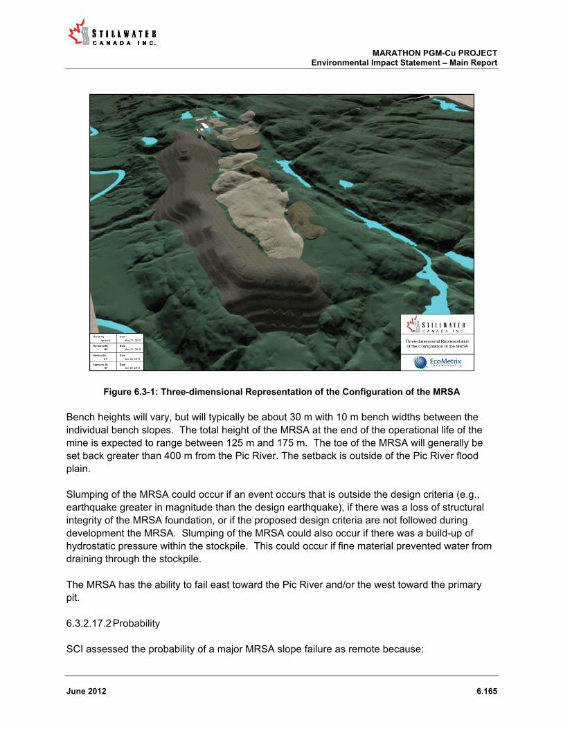
MARATHON PGM-Cu PROJECT Environmental Impact Statement – Main Report
June 2012 6.165
Figure 6.3-1: Three-dimensional Representation of the Configuration of the MRSA
Bench heights will vary, but will typically be about 30 m with 10 m bench widths between the individual bench slopes. The total height of the MRSA at the end of the operational life of the mine is expected to range between 125 m and 175 m. The toe of the MRSA will generally be set back greater than 400 m from the Pic River. The setback is outside of the Pic River flood plain.
Slumping of the MRSA could occur if an event occurs that is outside the design criteria (e.g., earthquake greater in magnitude than the design earthquake), if there was a loss of structural integrity of the MRSA foundation, or if the proposed design criteria are not followed during development the MRSA. Slumping of the MRSA could also occur if there was a build-up of hydrostatic pressure within the stockpile. This could occur if fine material prevented water from draining through the stockpile.
The MRSA has the ability to fail east toward the Pic River and/or the west toward the primary pit.
Probability 6.3.2.17.2
SCI assessed the probability of a major MRSA slope failure as remote because:
MARATHON PGM-Cu PROJECT Environmental Impact Statement – Main Report
June 2012 6.166
the MRSA has been designed to exceed design specifications as it relates to permanent rock storage associated with applicable regulations (Ontario Mining Act);
the foundation will be established on bedrock or suitably competent overburden to accommodate the facility as proposed, and where unsuitable material is encountered it will be removed;
The slope designs proposed will be achieved by completing regular as-built slope and stability surveys throughout mine life. Where deviations from the proposed design are noted during surveys a plan would be developed and implemented to address the issue; and,
the build-up of hydrostatic pressure to any degree is highly unlikely because of the size of the material that will go into the MRSA, as well as because the material is considered “fresh” (i.e., not weathered) from a geological point of view.
Minor slumping at the individual bench scale is a more likely occurrence but still considered a relatively low probability event.
Potential Environmental Issues 6.3.2.17.3
Any larger scale movement of material is unlikely to extend beyond the MRSA collection ponds but it is possible there may be some minor disturbance of terrestrial and/or aquatic habitat (Stream 2 and Stream 3) in the Pic River flood plain. Based on the MRSA design, the area that would be affected is anticipated to be relatively small. The MRSA slope angle is such that larger scale movements of rock are highly improbable. Large scale movement of rock from the MRSA would not reach the Pic River, as the MRSA has been designed to include a 400m offset from the Pic River that is sufficient to prevent such an occurrence. It is possible that individual rocks that could be mobilized as the result of the slope failure could gain enough momentum to reach the river, but the environmental consequences of such an isolated event would be limited.
A minor slope failure would likely involve slumping at the individual bench scale. In this instance the movement of the rock would be contained within the boundaries of the MRSA. Some reshaping of the stockpile could be required, but no environmental concerns are anticipated.
Direct Mitigation 6.3.2.17.4
As indicated above, design and design safeguards including the location of the MRSA are the primary mitigation for an MRSA slope failure.
Response Procedures 6.3.2.17.5
Response procedures associated with a MRSA slope failure will be set out in the EPP and would follow the general procedures outlined below.
In the event of minor slumping on an individual bench, deposition of mine rock in that area would cease immediately and site personnel would be dispatched to the location to conduct an inspection from a safe vantage point. A remediation plan would be developed and implemented

MARATHON PGM-Cu PROJECT Environmental Impact Statement – Main Report
June 2012 6.167
in consultation with MNDM and MOL. The plan will determine the most appropriate management strategy(s) for addressing the minor slumping in consideration of ensuring overall long-term bench and rock pile integrity. The plan would likely include the steps necessary to re-shape and stabilize the area where the slumping occurred.
In the unlikely event that a major rock pile failure should occur, deposition of mine rock in that area would cease immediately. Site personnel would be dispatched to the location to conduct a safety and a preliminary damage assessment. Appropriate government agency personnel and local aboriginal groups would be contacted. In the short-term steps would be taken to ensure structural integrity of the area and any immediate potential threats to the environment would be contained as quickly as possible. The medium and longer term plan for the slope failure area would be developed and implemented in concert with government agencies and other stakeholders as appropriate to determine an appropriate course of action. Such actions could include one or more of: no action; clean-up of any debris; restore or otherwise reconfigure the MRSA; and/or, restore any damaged habitat.
6.3.2.18 PSMF Slope Failure
Nature, Mechanism and Magnitude 6.3.2.18.1
The PSMF embankments will be constructed with upstream and downstream slopes of approximately 2.0H:1V and a final crest width of 8.0 m. The final embankment heights will be between 33 m and 77 m with foundation widths of between 140 m and 316 m. The embankments will be founded on competent bedrock and constructed with zoned rock fill and a geomembrane on the upstream slope. The embankments will include specific rock fill zones with finer material towards the upstream portion of the embankment and coarser material towards the downstream portion of embankment. The zoned construction will result in an embankment that is not susceptible to internal erosion or piping and resistant to downstream erosion if over-topping was to occur (see Knight and Piesold, 2012).
In a worst-case scenario, a slope failure would result in the partial breach of a PSMF embankment5. A partial PSMF slope failure could result if an event occurred that was outside the facility’s design criteria, such as for example the application of a prolonged force (e.g., geostatic pressure of water behind a dam or hydrostatic pressure within the dam) or a sudden force (e.g., seismic pressure of an earthquake) larger than accounted for in the design. Depending on where the PSMF slope failure occurred, some process water and process solids could be released to ground and possibly solids released to an existing water course. A partial failure could also result if the design criteria were not followed during the development of the facility.
A partial slope failure could lead to a release to the west from Cells 1 and 2 and to the south and east from Cell 1 of the PSMF. For each of these potential scenarios, the release due to a 5 A complete breach of a PSMF embankment is implausible due to the embankment design, construction materials, foundation conditions, process solids deposition plan and large freeboard requirements included in the operating criteria and is therefore not considered in this EIS (Knight Piesold, 2012)

MARATHON PGM-Cu PROJECT Environmental Impact Statement – Main Report
June 2012 6.168
slope failure is assumed to include the process water pond and the upper process solids surface. The maximum water volumes in Cells 1 and 2 during operations would be approximately 4.3 million m3 and 2.0 million m3, respectively. If the upper 0.5 m of process solids were drawn out of the facility with the water during the failure, the process solids volume released from Cell 1 and 2 would be approximately 0.2 million m3 and 0.9 million m3, respectively.
Probability 6.3.2.18.2
SCI assesses the probability of a partial PSMF slope failure as remote. Suitably conservative design criteria have been utilized in the design (see Knight Piesold, 2012; Section 1.4, Section 6.2.12.3.13). The primary mitigation strategies associated with prevention of a PSMF slope failure are the conservative design and design safeguards that have been incorporated. The PSMF embankments have been designed in consideration of specific severe flood (IDF) and earthquake criteria (maximum credible earthquake, MCE), to meet and exceed the requirements of the Lakes and Rivers Improvement Act (LRI Act) and its associated regulations, and the Canadian Dam Safety Guidelines (CDA, 2007).
Specifically, the conceptual design for the PSMF embankments provides for the construction of massive rockfill structures that exceed the prescribed short-term, long-term and pseudo-static minimum factor of safety stability requirements of 1.3, 1.5 and 1.0, respectively. The conceptual design provides for the following factor of safety ranges: short term 1.30 to 1.93, long term 1.50 to 2.29 and pseudo-static 1.01 to 1.99. To ensure that required factors of safety are maintained, the PSMF dam raises will be completed under the supervision of a qualified geotechnical engineer. To further minimize the risk of dam failure, the operating PSMF will be constructed with spillways and additional freeboard capable of passing the peak flow of the IDF during all PSMF development stages. Should conditions develop such that stormwater inflows to the PSMF exceed the design capacity of the storage cells, water will be conveyed to Hare Lake preventing overtopping of the dams from occurring (Knight Piesold, 2012).
As noted above, the PSMF dam raises will be completed under the supervision of qualified geotechnical engineers. Geotechnical engineers will be required to complete regular as-built slope and stability surveys throughout mine life. Where deviations from the proposed design are noted during surveys, a plan would be developed and implemented in consultation with government agencies as appropriate to address the issue.
Potential Environmental Issues 6.3.2.18.3
A partial breach of a PSMF embankment could cause a release of water and process solids into the surrounding environment. In a worst-case scenario, the breach could involve a portion of a cell’s contained solids and virtually all of the associated ponded water being released to the environment. It is important to note that this scenario would only be possible during mine operations, as post-closure there will be no ponded water adjacent to the PSMF dams. A post-closure failure would result in the displacement only of contained process solids, whose

MARATHON PGM-Cu PROJECT Environmental Impact Statement – Main Report
June 2012 6.169
spreading would be limited in its spatial extent because the solids are dry and not associated with a concurrent release of water.
A dam failure in Cell 2 during operations would result in the loss of containment of solid phase material, which would cover previously undisturbed terrestrial habitat. Depending on the location and size of the breach, water associated with the process solids could drain into a tributary of Hare Lake or to Stream 6. In either case, based on predicted process water chemistry the release would not result in acute toxicity to aquatic biota in downstream receiving environments. It is possible that the fine particulate load associated with the liquid phase of the release could be considerable, and the settling of this fine material could result in smothering of bottom habitats. The habitats in both the Hare Lake tributary and Stream 6 are depositional in nature so it is assumed that much of the fine particulate load would partition to stream sediments and not be transported to more downstream environments.
Similarly, a dam breach in Cell 1 would result in the loss of containment of solid phase material, which would cover previously undisturbed terrestrial habitat. Depending on the location and size of the breach, water associated with the process solids could drain into a tributary of Shack Lake. As described above, no acute toxicity is expected to be associated with such a release, but some smothering of bottom habitats due to the fine particulate load could be expected.
The potential environmental consequences of a partial dam failure following closure are much more limited in scope and scale. After the cessation of operations all standing water will be pumped from the PSMF. The long-term plan is to have no ponded water against any of the embankments. If a partial breach was to occur following closure, it would result in the slumping of relatively dry process solids over the outside face of an embankment. The spatial extent of any effects would be limited to the natural angle of repose of that material.
Direct Mitigation 6.3.2.18.4
As described above, the primary mitigation strategies associated with prevention of a PSMF slope failure are the rigorous design and design safeguards incorporated into the proposed design. Also as described above, dam construction will include technical oversight and implementation of quality assurance and quality control programs by qualified geotechnical engineers.
An Operations, Maintenance and Surveillance Manual (OM&S; or an equivalent document) will be prepared for the PSMF and employed to confirm that the facilities are operated consistent with the design principles. Application of the OM&S manual, along with annual reviews of the facility by a qualified review engineer, will mitigate the risk of conditions occurring that could lead to PSMF slope failure.
Dam safety inspections will be required following closure in accordance with the proposed closure plan. These safety inspections would be an early warning sign in the unlikely event that stability issues were to arise following closure. No free standing water will be left behind dams at closure.
MARATHON PGM-Cu PROJECT Environmental Impact Statement – Main Report
June 2012 6.170
In addition, the milling process itself affords some level of environmental protection. The milling process will operate at a high pH, and therefore metals will be precipitated out of solution in the mill and will be incorporated into the solid phase of the process solids slurry prior to its discharge to the PSMF. As a result, if there ever was to be a dam breach, the release of the liquid phase of the slurry would have a limited potential to produce adverse downstream acute toxicological effects. Further, metals associated with process solids solid phase are not readily bioavailable and therefore the release of the solid phase would have limited potential to produce adverse toxicological effects in the terrestrial environment.
Response Procedures 6.3.2.18.5
Emergency response procedures will be contained in the EPP. Briefly, in the unlikely event of a PSMF dam failure during operations, process solids deposition to that area would cease, and site personnel would be dispatched to the location to conduct a safety and preliminary damage assessment. Government agency personnel, local aboriginal groups and communities would be contacted promptly. SCI will retain the services of a third-party environmental response and remediation contractor, who would be available to respond promptly to a partial PSMF failure upon request. In the short-term, steps would be taken to restore safe working conditions in the area. Response personnel and equipment would be dispatched to contain any potential threats to the environment and to any damaged areas as appropriate. The medium and longer term plan for the dam failure area and any damaged areas off-site would be developed in concert with government agencies and other stakeholders as appropriate.
If a slope failure was to occur during the closure phase a similar course of action would be taken. That is, once the failure was identified the short-term goal would be to contain the loss to mitigate any ongoing environmental threats or damage to adjacent off-site areas. The medium to long-term goal would be developed in concert with government agencies and other stakeholders as appropriate.
6.3.2.19 Explosives Accident
Nature, Mechanism and Magnitude 6.3.2.19.1
Explosives will be transported to site and managed on site in accordance with all appropriate legislative requirements. A dedicated explosives manufacturing plant and an ammonium nitrate storage area will be established to the south of the mill site, off the main access road. The manufacturing plant will be operated by a licensed third-party contractor. Explosives and detonation magazines will be located to the north of the PSMF.
The Project will utilize a range of explosives as the primary blasting agent in the open pits including ANFO, emulsion and an ANFO-emulsion blend. During the pre-strip and construction phases and potentially for pre-shear in the pits, several different packaged explosives may be utilized depending on the applications. These packaged explosives could include some of the following or an equivalent: a prilled ammonium nitrate/fuel oil explosive mixture suitable for use in dry borehole conditions; a nitroglycerin-based dynamite formulated to use in smaller drill

MARATHON PGM-Cu PROJECT Environmental Impact Statement – Main Report
June 2012 6.171
holes; or, a water resistant, packaged emulsion explosive sized for use in a variety of drill hole sizes and production requirements. All explosives used on site will require some form of detonation ranging from an electric or nonelectric detonator, cast boosters and potentially detonator cord. Most detonators are manufactured from a blend of PETN (Pentaerythritol tetranitrate) and TNT (Trinitrotoluene).
An explosives accident could occur as the result of improper handling, faulty equipment, improper blast notification and/or guarding practices, or because of an overuse of blasting agent producing abnormal amounts of fly rock. The most probable accident scenario would involve bodily harm or damage to mine-related infrastructure, rather than a negative environmental outcome.
Probability 6.3.2.19.2
SCI characterizes the probability of an explosives accident as low. SCI believes that by following the regulatory requirements, and ensuring that proper blasting procedures are followed, explosives and blasting operations will be well managed at the Project site and accidents will be avoided.
Potential Environmental Issues 6.3.2.19.3
As indicated, the most probable explosives accident scenarios are more related to worker health and safety issues or damage to mine-related infrastructure, rather than environmental impact concerns. No direct damage to the environment beyond the immediate blast zone would be anticipated.
Direct Mitigation 6.3.2.19.4
As indicated above, the primary mitigation strategies that will be employed at the Project site to reduce the probability of an explosives accident occurring include the hiring of a qualified contractor, adhering to regulatory requirements, and ensuring that proper blasting procedures are followed. SCI will ensure that:
all companies transporting explosives materials to the Project site will be required to comply with the requirements of the Explosives Regulatory Division of NRCan and the Transportation of Dangerous Goods Directorate of Transport Canada;
SCI will use a licensed third-party contractor to operate the explosives manufacturing plant;
all personnel who handle explosives will have appropriate training and all other individuals will be restricted from access; and,
a standard operating procedure for blasting, describing all proposed blasting operations at the site, will be developed.
In addition, SCI will itself, or will require third-party contractors, as applicable to:
MARATHON PGM-Cu PROJECT Environmental Impact Statement – Main Report
June 2012 6.172
develop procedures to prevent, or otherwise minimize and/or manage, releases during storage, transfer and manufacturing operations, improper guarding or blast notification practices;
suitably protect above ground fuel tanks used in the explosives manufacturing process in accordance with Subsection 4.3.7 of the National Fire Code of Canada (2005); and,
prepare a written EPP in accordance with CAN/CSA-Z731-95 and communicate the plan to local and regional authorities (e.g., emergency service providers) as appropriate.
Response Procedures 6.3.2.19.5
As indicated above, an EPP will be developed in accordance with CAN/CSA-Z731-95. The EPP will clearly identify by name or position, those individuals who are to carry into effect the plan in the event of an explosives accident and a description of their roles and responsibilities. The EPP will include provisions for quick plan activation, notification to first responders and affected parties, rapid assessment of path and impacts (i.e., assess the situation and identify critical objectives regarding life, property and the environment), adequate resource mobilization, and reporting activities.
6.3.2.20 Premature Closure of the Mine
Nature, Mechanism and Magnitude 6.3.2.20.1
Mine development could conceivably be arrested at any development stage.
Premature closing of the site potentially could occur under one of two circumstances. First, activity at the site could be suspended due to a change (decrease) in mineral prices resulting in the Project becoming no longer economically feasible. Secondly, activity at the site could be suspended due to corporate insolvency.
In the event of premature closure during the site preparation and construction phases, it is assumed that some land clearing activities (timber harvesting, overburden stripping) would have taken place, the site access road upgrades and new road network would be in progress and some level of site infrastructure (both temporary and permanent) development would be in progress. In addition, the construction work force accommodation facility in the Town of Marathon would have been constructed and would possibly be in use. It is also possible that construction of the concentrate storage and transfer facility in the Town of Marathon would have begun, though it is likely that this facility would be developed late in the construction cycle as it would not be needed until the mill began to produce concentrate.
In the event of premature closure during the operations phase, it is assumed that the mine site would be fully built-out with all infrastructure in place to support mining, milling and related support activities. The extent to which some site infrastructure would be developed (e.g., PSMF dams raised and PSMF filled, MRSA filled, pits excavated) would depend upon the year in which premature closure occurred. The work force housing facility in the Town of Marathon

MARATHON PGM-Cu PROJECT Environmental Impact Statement – Main Report
June 2012 6.173
would have been constructed and would be in use. The concentrate storage and transfer facility in the Town of Marathon would be fully built-out and operational.
In the event of premature closure during the closure phase it is assumed that some decommissioning of the mine site consistent with Closure Plan would have occurred. The extent to which decommissioning activities would have progressed would depend upon the timing of the premature closure of the site.
Probability 6.3.2.20.2
SCI characterizes the probability of premature closing of the mine during any of the mine life phases as low to remote. The characterization of the closure as low is given in consideration of a negative change in the economic feasibility of the Project; whereas, the characterization of remote is given in consideration of potential corporate insolvency.
Based on the analysis of the economic feasibility of the Project carried out to date, SCI does not foresee economic conditions related to mine development changing to the extent to which the Project would be suspended or abandoned. Moreover, it is unlikely that SCI (or its parent company or corporate partner) would become insolvent and abandon the Project. Mitsubishi Corp. recently purchased a 25% interest in SCI. The business arrangement provides further financial stability to the Project and further lessens the probability of the Project being abandoned due to corporate insolvency.
Potential Environmental Issues 6.3.2.20.3
Accidents or malfunctions as a result of premature closing during any phase of mine life might result in a loss of control of the equipment or material on site, and/or a loss of control of the overall management of the site.
Potential environmental issues associated with the premature closing of the site during site preparation and construction could include many different scenarios based on the progress of this phase of development. The most likely scenarios would be local in nature and relatively minor in scope (e.g., a machine fuel release to ground).
The most significant potential environmental issues associated with the premature closing of the site during operations would be the loss of control of an operations-related emission, be it a release to water (e.g., drainage from the MRSA; discharge from PSMF) or a release to air. The magnitude of potential environmental impact would depend on the magnitude of the emission and duration over which the emission was uncontrolled.
The primary issue associated with premature closing of the site during the closure phase is related to the progress of closure activities, or more precisely which reclamation and remediation activities would not yet have been implemented.

MARATHON PGM-Cu PROJECT Environmental Impact Statement – Main Report
June 2012 6.174
Direct Mitigation 6.3.2.20.4
The primary means of mitigation associated with the premature closing of the site during any mine phase is the Project Closure Plan and the financial assurance that is required to be submitted based on the costs associated with implementing the plan. In Ontario, mining projects can only proceed following the submission and acceptance of a Closure Plan, as well as the associated financial assurance, by OMNDM. This ensures that even in the instance where the mine operator becomes insolvent, the site can be properly decommissioned.
Response Procedures 6.3.2.20.5
Response procedures associated with the premature closing of the mine will be incorporated into the EPP. Conceptually, the response could involve, among other things:
inventorying all of the materials, chemicals and equipment on site and developing plans to deal with them as appropriate or as required by legislation;
implementing activities so as to ensure ongoing control of materials, chemicals and equipment on site, as well as the overall management of the site (including site access).ensuring that mill mine and mill related activities were wound down in a controlled fashion, so as to limit the chance of an uncontrolled contaminant release to the environment;
providing contingencies for limiting site access, as well for overall site management; facilitating the efficient and timely transfer of care and control of the site to a third-party
who would then with the aid of the deposited financial assurance continue to implement the appropriate decommissioning and reclamation activities.
In the event that the closure was deemed permanent, implementation of the Closure Plan, or relevant remaining elements thereof, would occur. Reclamation and remediation activities would be executed as defined therein and as appropriate given the actual level of site development at that time.

MARATHON PGM-Cu PROJECT Environmental Impact Statement – Main Report
June 2012 6.175
Table 6.3-1: Summary of potential environmental issues, mitigation and response procedures associated with the accident and malfunction scenarios identified for the Marathon PGM-Cu Project EIS Accident and Malfunction Scenario Probability Potential Environmental Issues Design and Direct Mitigation Response Procedures
Fuel release during transport
A release (diesel or gasoline) could result from a
collision or another accident.
Most likely scenario is a fuel release to ground, though
a release to a watercourse or waterbody is possible.
Tanker design suggests that a partial release is more
likely than a full release, with the exception of a
catastrophic incident. Tanker capacity is in the range
of 34,000 L to 63,000.
Low Loss of fuel (diesel, gasoline) to ground and possibly to water
Contamination of terrestrial habitat in the immediate area of
release with toxicity to soil dwelling invertebrates and local
vegetation
Contamination of aquatic habitat (water, sediments) with
toxicity to aquatic biota (fish, benthic invertebrates)
Only licensed companies permitted to deliver to site
Third- party contractors will be required to have active
service agreements with licensed release response
contractors
All drivers to have appropriate training, including release
response training
All trucks to have appropriate communications capabilities
Speed limits posted and monitored on site access road and
SCI to follow-up with any reports of excess speed
Third--party contractors will operate under their own
emergency procedures and will be responsible for
first-level release response and reporting
Fuel release from on–site storage facilities
A release from storage facility could result from
vehicular collisions, malfunctioning equipment or
human error.
Most likely scenario for a release is during the fuel
transfer process with the release going to ground.
The maximum theoretical release would be one full
storage tank volume.
Medium The probability of potential environmental issues is low, as fuel
storage locations are in built-up areas and are isolated from
sensitive features
A loss of containment could result in the contamination of land
in the storage area and the immediate vicinity
Minimum setbacks of 100 m from sensitive environmental
features to be maintained
Fuel storage equipment to comply with applicable legislative
requirements
Tanks to have secondary containment and/or will be double-
walled and collision protection
Main fuel farm to have lined aprons and collection
catchments
Release response equipment to be maintained on site
Detailed operational procedures will be posted at all storage
facilities
Emergency response procedures will be set out in the
EPP
Consistent with provincial emergency planning
requirements the goals of the emergency response
plan, relative to potential fuel releases, will be to:
o assess health and safety risks;
o isolate sources of ignition;
o stop leak;
o notify appropriate authorities (municipal,
provincial and federal authorities);
o contain release; and,
o restore the environment.
Required documentation will be prepared.
SCI will retain a third-party release response
contractor to aid in response
Fuel release during on–site dispensing
A release could result from an equipment malfunction
during dispensing or via human error.
Most likely scenario involves a minor release during
refueling with the release going to ground.
The maximum theoretical release would be the full
volume of fuel carried by the dispensing equipment but
a probable event volume would be much less.
Medium The probability of potential environmental issues is low, as on-
site dispensing will occur in built-up areas and not in the
immediate vicinity of sensitive features
A loss of containment could result in the contamination of
adjacent land
Fuel dispensing equipment to comply with applicable
legislative requirements
Minimum setbacks of 50 m from sensitive environmental
features to be maintained for portable dispensing equipment
Release response equipment to be maintained on site
Detailed operational procedures will be developed and
provided to relevant employees
Emergency response procedures will be set out in the
EPP
Consistent with provincial emergency planning
requirements the goals of the emergency response
plan, relative to potential fuel releases, will be to:
o assess health and safety risks;
o isolate sources of ignition;
o stop leak;
o notify appropriate authorities (municipal,
provincial and federal authorities);
o contain release; and
o restore the environment.
SCI will retain a third- party release response
contractor to aid in response
Propane Handling Incident
The most common propane accident that could
occur on-site is associated with “pull away”
Propane leakage from the storage tank or from
the delivery truck could ignite if an ignition source
was present.
Low A propane handling incident could result in a fire, which is
more likely to be associated with worker health and safety
issues, rather than an environmental one.
Potential environmental impacts would include localized
terrestrial habitat loss and short-term air quality effects.
Propane handling and storage is tightly regulated and as
such adherence to the appropriate regulations both in terms
of transport and storage and handling mitigates the
probability of a propane incident occurring
Only licensed suppliers will be able to provide delivery to the
site
Emergency response procedures will be set out in the
EPP
All personnel will be evacuated to a minimum safe
distance
Any possible ignition sources will be removed from the
area any on-site
Off-site emergency response resources will be
mobilized, as identified in the EPP
Concentrate haul incident
A concentrate release along the haul route could result
Low Concentrate loss will smother the ground in the immediate
vicinity of the release (both the loss and its subsequent clean-
Drivers to have appropriate licensing and training, including
release response
In case where third-party contractors are used they will
operate under their own emergency procedures and

MARATHON PGM-Cu PROJECT Environmental Impact Statement – Main Report
June 2012 6.176
from a collision or another accident.
Most likely scenario involves a haul truck going off the
road and concentrate being released to ground.
As much as a full load could be released.
up will disturb the release area) Trucks will have covers
Trucks will have means of communicating with their own
dispatch and the Project site
Speed limits posted and monitored on site access road and
SCI to follow-up with any reports of excess speed
SCI to have response capacity on site
will be responsible for first-level release response and
reporting
In case where SCI is responsible for transport
response procedures to be developed as part of the
EPP as part of the EMS.
Concentrate load-out release
A concentrate release during load out at the mine site
or alternatively at the proposed concentrate handling
facility in Marathon could occur as the result equipment
malfunction or human error
Medium to High None envisaged – any loss would occur within an enclosed
and contained area
Load-out facility design makes a release to the environment
implausible
Concentrate handling procedures to be defined
Personnel to have appropriate training, including release
response
Trucks and rail cars to be inspected to ensure no
concentrate leaves facility outside of containment
Response procedures to be developed as part of the
concentrate handling procedures
Chemical Release during transport
The severity of a release would depend on several
factors, including the nature of the material, the
location, the time of year and the volume
Largest volume event related to transport of mill
process chemicals
Low The potential environmental issues surrounding a chemical
release during transport to the site would depend on the
nature of the material, the location of the release, the time of
year and the volume of material released
Only licensed companies permitted to deliver to site
Third-party contractors will be required to have active service
agreements with licensed release response contractors
All drivers to have appropriate training, including release
response training
All trucks to have appropriate communications capabilities
Speed limits posted and monitored on site access road and
SCI to follow-up with any reports of excess speed
SCI to have response capacity on site
Third-party contractors will operate under their own
emergency procedures and will be responsible for
first-level release response and reporting
Chemical release within mine site
A chemical release in a mine facility (building) could
occur as the result of malfunctioning equipment,
human error or some other mishap.
A chemical release could occur in a contained structure
or building.
A chemical releases could occur outside of a contained
structure or building
High (within a confined
facility)
Medium (outside a
confined facility)
No potential for significant environmental issues envisaged
Releases within contained facilities will not reach the
environment
Releases outside of contained facilities are most likely to occur
in developed or built-up parts of the site that themselves are
within contained drainage areas
Building or structure design to include sealed floors and
sumps or drains to contain any material released to ground
Local on-site transport routes to be established with
consideration of appropriate set backs from sensitive
features
All chemicals to be stored and handled as appropriate
according to MSDS information
All personnel handling chemicals will have appropriate
training (e.g., WHMIS)
Emergency response procedures will be set out in the
EPP, consistent with MSDS information
Consistent with provincial emergency planning
requirements the goals of the emergency response
plan, relative to potential fuel releases, will be to:
o assess health and safety risks;
o isolate sources of ignition;
o stop release;
o notify appropriate authorities (municipal,
provincial and federal authorities);
o contain release; and
o restore the environment.
SCI will retain a third-party release response
contractor to aid in response
Controlled release of water to the environment from the
PSMF
The PSMF is designed to convey a controlled release
of water (untreated process water and run-off) from the
PSMF over a spillway to Hare Lake for the Inflow
Design Flood condition (1 in 10,000 year 24 hour
event)
Approximately 1 M m3 of water could be discharged
over 1 to 2 days
Remote No acute toxicity to aquatic biota expected based on predicted
water quality
Certain metals may be above chronic threshold effect levels
but only for a relatively short period of time therefore no
chronic effects anticipated
The settling of suspended solids associated with the release
may cause limited swamping of bottom habitats in proximity of
spillway
PSMF design - the conditions precipitating a controlled
release from the PSMF have extremely low probability and
are highly unlikely to occur over the life of the mine
Response procedures to be developed as part of the
EPP, largely focusing on event monitoring
An incident report would be prepared for review
with relevant regulatory authorities and aboriginal
groups
Controlled release of water to the environment from the
MRSA
The MRSA is designed to convey a controlled release
of water (untreated run-off) from the MRSA to the Pic
River in the event that the MRSA EDS occurred during
the height of the spring run-off
Low No acute toxicity to aquatic biota expected based on predicted
water quality
Certain metals may be above chronic threshold effect levels
but only for a relatively short period of time therefore no
chronic effects anticipated
The settling of suspended solids associated with the release
MRSA design - the conditions precipitating a controlled
release from the PSMF have low probability and are highly
unlikely to occur over the life of the mine
Response procedures to be developed as part of the
EPP, largely focusing on event monitoring
An incident report would be prepared for review
with relevant regulatory authorities and aboriginal
groups
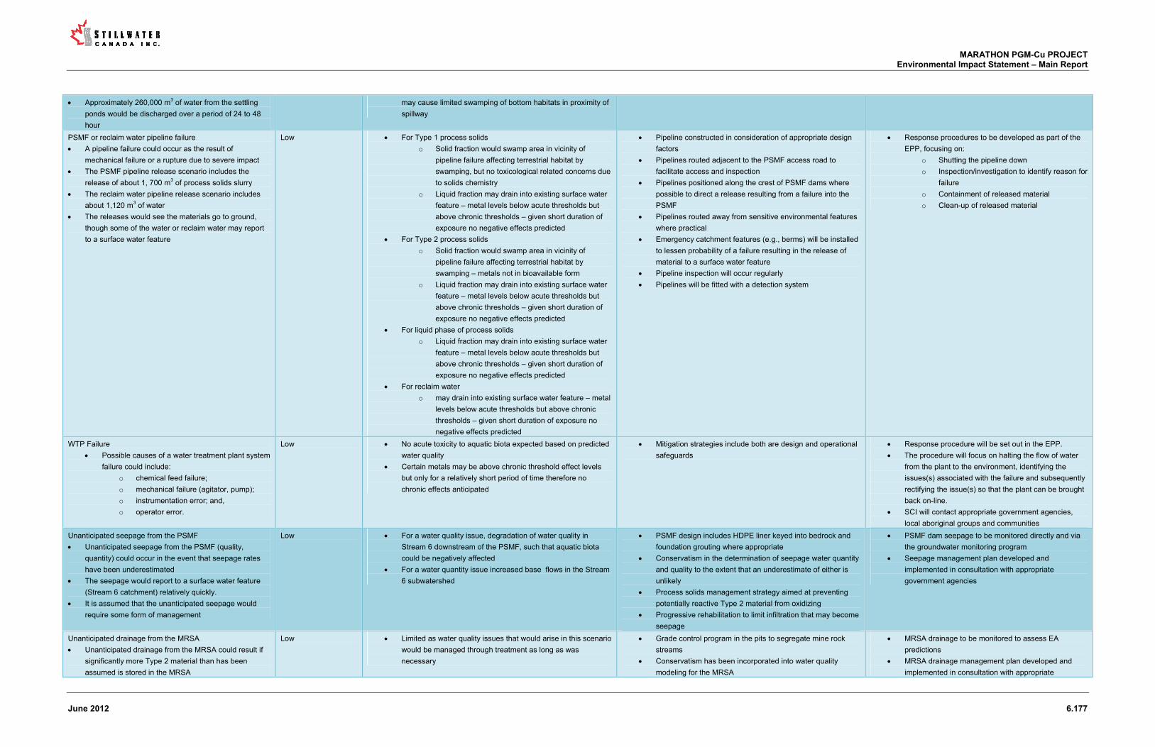
MARATHON PGM-Cu PROJECT Environmental Impact Statement – Main Report
June 2012 6.177
Approximately 260,000 m3 of water from the settling
ponds would be discharged over a period of 24 to 48
hour
may cause limited swamping of bottom habitats in proximity of
spillway
PSMF or reclaim water pipeline failure
A pipeline failure could occur as the result of
mechanical failure or a rupture due to severe impact
The PSMF pipeline release scenario includes the
release of about 1, 700 m3 of process solids slurry
The reclaim water pipeline release scenario includes
about 1,120 m3 of water
The releases would see the materials go to ground,
though some of the water or reclaim water may report
to a surface water feature
Low For Type 1 process solids
o Solid fraction would swamp area in vicinity of
pipeline failure affecting terrestrial habitat by
swamping, but no toxicological related concerns due
to solids chemistry
o Liquid fraction may drain into existing surface water
feature – metal levels below acute thresholds but
above chronic thresholds – given short duration of
exposure no negative effects predicted
For Type 2 process solids
o Solid fraction would swamp area in vicinity of
pipeline failure affecting terrestrial habitat by
swamping – metals not in bioavailable form
o Liquid fraction may drain into existing surface water
feature – metal levels below acute thresholds but
above chronic thresholds – given short duration of
exposure no negative effects predicted
For liquid phase of process solids
o Liquid fraction may drain into existing surface water
feature – metal levels below acute thresholds but
above chronic thresholds – given short duration of
exposure no negative effects predicted
For reclaim water
o may drain into existing surface water feature – metal
levels below acute thresholds but above chronic
thresholds – given short duration of exposure no
negative effects predicted
Pipeline constructed in consideration of appropriate design
factors
Pipelines routed adjacent to the PSMF access road to
facilitate access and inspection
Pipelines positioned along the crest of PSMF dams where
possible to direct a release resulting from a failure into the
PSMF
Pipelines routed away from sensitive environmental features
where practical
Emergency catchment features (e.g., berms) will be installed
to lessen probability of a failure resulting in the release of
material to a surface water feature
Pipeline inspection will occur regularly
Pipelines will be fitted with a detection system
Response procedures to be developed as part of the
EPP, focusing on:
o Shutting the pipeline down
o Inspection/investigation to identify reason for
failure
o Containment of released material
o Clean-up of released material
WTP Failure
Possible causes of a water treatment plant system
failure could include:
o chemical feed failure;
o mechanical failure (agitator, pump);
o instrumentation error; and,
o operator error.
Low No acute toxicity to aquatic biota expected based on predicted
water quality
Certain metals may be above chronic threshold effect levels
but only for a relatively short period of time therefore no
chronic effects anticipated
Mitigation strategies include both are design and operational
safeguards
Response procedure will be set out in the EPP.
The procedure will focus on halting the flow of water
from the plant to the environment, identifying the
issues(s) associated with the failure and subsequently
rectifying the issue(s) so that the plant can be brought
back on-line.
SCI will contact appropriate government agencies,
local aboriginal groups and communities
Unanticipated seepage from the PSMF
Unanticipated seepage from the PSMF (quality,
quantity) could occur in the event that seepage rates
have been underestimated
The seepage would report to a surface water feature
(Stream 6 catchment) relatively quickly.
It is assumed that the unanticipated seepage would
require some form of management
Low For a water quality issue, degradation of water quality in
Stream 6 downstream of the PSMF, such that aquatic biota
could be negatively affected
For a water quantity issue increased base flows in the Stream
6 subwatershed
PSMF design includes HDPE liner keyed into bedrock and
foundation grouting where appropriate
Conservatism in the determination of seepage water quantity
and quality to the extent that an underestimate of either is
unlikely
Process solids management strategy aimed at preventing
potentially reactive Type 2 material from oxidizing
Progressive rehabilitation to limit infiltration that may become
seepage
PSMF dam seepage to be monitored directly and via
the groundwater monitoring program
Seepage management plan developed and
implemented in consultation with appropriate
government agencies
Unanticipated drainage from the MRSA
Unanticipated drainage from the MRSA could result if
significantly more Type 2 material than has been
assumed is stored in the MRSA
Low Limited as water quality issues that would arise in this scenario
would be managed through treatment as long as was
necessary
Grade control program in the pits to segregate mine rock
streams
Conservatism has been incorporated into water quality
modeling for the MRSA
MRSA drainage to be monitored to assess EA
predictions
MRSA drainage management plan developed and
implemented in consultation with appropriate

MARATHON PGM-Cu PROJECT Environmental Impact Statement – Main Report
June 2012 6.178
The mine plan includes the collection of waters draining the
MRSA and treating them if necessary to protect water quality
in the Pic River over the long term
government agencies
Project-related fires
A fire at the Project site could result from a variety of
causes
The most likely scenario for a fire involves an isolated
fire in a Project-related building or structure.
Medium to
High
Local habitat loss through burning and short-term air quality
concerns
Fire detection and alarm system, with back-up
Co-ordination with local emergency response services
Fire protection system to be designed consistent with
applicable codes and regulations
Remote buildings equipped with portable extinguishers
Pumper truck on-site and equipped with a foam generation
system
Regular fire drills
The site itself will act as a fire break to limit spreading
beyond the site
Response procedures to be developed as part of the
EPP with co-ordination with local emergency response
services, focusing on:
o Protecting worker safety
o Protecting Project facilities
o Ensuring that the fire doesn’t spread
o Protecting the surrounding environment
Pit slope failure
A pit slope failure could result from improper design or
operation of the pits
A slope failure could result in the expansion of the pit
perimeter and the loss of some terrestrial habitat
Low Loss of some terrestrial habitat and features due to expansion
of pit perimeter
Pit design and operations optimized for slope stability with
appropriately conservative safety factors
Pit wall stability to be monitored during excavation
Surface monitors installed as appropriate to monitor ground
movement
Response procedures to be developed as part of the
EPP
MRSA slope failure
Slumping of the MRSA to the east or to the west could
occur as the result of not adhering to the proposed
design, an event occurring outside the limits of the
proposed design, the loss of structural integrity in the
foundation, or the build-up of hydrostatic pressure
The most likely accident scenario involves slumping at
the individual bench scale, rather than the rock pile as
a whole
Remote (for a large
scale event)
Low (for minor bench-
isolated slumping)
A minor slope failure (at the bench scale) would be contained
within the MRSA and there are no environmental concerns
A major slope failure would likely be contained within the
MRSA drainage collection basins but could possibly result in
some localized habitat disturbance in Pic River flood plain
No large scale movement of material into the Pic River
envisaged
Design and design safeguards including:
o Incorporation of appropriate safety factors
o Adequate setback from the Pic River
Response procedures to be developed as part of the
EPP including:
o Cessation of mine rock disposal in the
affected area
o Preliminary safety and damage inspection
o Ensure structural integrity and contain
immediate threats to the environment (short
term)
o Develop medium and long term action plan
as appropriate in consultation with
appropriate regulatory agencies
o Government agency personnel, local
aboriginal groups and communities
would be notified
PSMF slope failure
A PSMF slope or dam failure could result from a loss of
structural integrity of a dam (or portion of a dam) cause
by either prolonged or sudden force acting on the dam.
A failure or partial failure in Cell 2 would release
process solids to the west, whereas a failure or partial
failure of Cell 1 would release process solids to the
south, east or west
Remote Cell 2 failure
o Loss of containment of solid fraction resulting in
swampy of previously undisturbed terrestrial habitat
o Liquid fraction could drain to Hare Lake tributary or
Stream 6 negatively affecting water quality
o COPC levels below acute thresholds but may be
above chronic thresholds – no toxicity related effects
are likely given the duration over which release to
water would occur
o Settling of solids transported with liquid fraction as
suspended particulates would settle in local water
courses smothering bottom habitat and potentially
negatively affecting sediment chemistry
Cell 1 failure
o Loss of containment of solid fraction resulting in
swampy of previously undisturbed terrestrial habitat
o Liquid fraction could drain to Shack Lake tributary
negatively affecting water quality
Suitably conservative design and design safeguards
including:
o Design exceeds dam safety guideline
requirements
o Dam raises will be completed under the
supervision of qualified persons
o Spillway design to allow controlled release of the
IDF during all development stages
o There will be no free standing water behind dam
structures at closure
o Dam safety inspections will occur over the long
term
Milling process is at high pH therefore the levels of pH-
sensitive metals will be relatively low in the liquid fraction of
the process solids
Response procedures to be developed as part of the
EPP including:
o Cessation of process solids deposition in the
affected area
o Preliminary safety and damage inspection
o Ensure structural integrity and contain
immediate threats to the environment (short
term)
o Develop medium and long term action plan
as appropriate
o Government agency personnel, local
aboriginal groups and communities
would be notified
SCI will retain a third-party release response
contractor to aid in response

MARATHON PGM-Cu PROJECT Environmental Impact Statement – Main Report
June 2012 6.179
o COPC levels below acute thresholds but may be
above chronic thresholds – no toxicity related effects
are likely given the duration over which release to
water would occur
o Settling of solids transported with liquid fraction as
suspended particulates would settle in local water
courses smothering bottom habitat and potentially
negatively affecting sediment chemistry
Explosives accident
An explosives accident could result from improper
handling of explosive materials, faulty equipment,
improper blast notification and or guarding practices or
because of an overuse of blasting agent producing
abnormal amounts of fly rock
The most likely accident scenario would involve bodily
harm or building damage rather than significant
environmental impacts.
Low Direct damage limited to the blast zone
Primary concerns related to an explosives accident are worker
health and safety related)
Follow appropriate regulatory requirements
Employ a licensed third-party contractor to operate the
manufacturing plant
Follow good housekeeping practices
Develop explosives storage and handling and blasting
procedures and train personnel
Provide suitable protect for above ground fuel tanks used in
the explosives manufacturing process in accordance with
Subsection 4.3.7 of the National Fire Code of Canada (2005)
Communication of EPP with appropriate local and regional
authorities
Response procedures to be developed as part of the
EPP
EPP will be consistent with CAN/CSA-Z731-95
Premature closure of the mine
Premature closure of the mine could occur during any
mine life phase
Environmental concerns would be related to the loss of
control of material and/or equipment on the site or a
loss of control of the management of the site as a
whole
Low (due to changes
in Project economics)
Remote (due to
corporate insolvency)
A variety of specific events could occur resulting in
environmental issues; conceptually the concern is related to
loss of control of material and equipment on site and/or a loss
of control of overall management of the site
Most likely scenarios would be local in nature and minor in
scope
A robust economic analysis of the Project provides
confidence that the Project will remain economically feasible
over its projected life
The risk of corporate insolvency is remote as Project risks
are shared
The Site Closure Plan (and the actions outlined therein), and
the final assurance associated with the Closure Plan
Response procedures to be developed as part of the
of the EMS and conceptually to include:
o Inventorying all materials, chemicals and
equipment on site and developing
appropriate control plans
o Implementing activities so as to maintain
control of materials, chemicals and
equipment on site, as well as overall site
management
o Implementation of Closure Plan activities (if
closure deemed permanent)

MARATHON PGM-Cu PROJECT Environmental Impact Statement – Main Report
June 2012 6.180
6.4 Effects of the Environment on the Project
The effects of the environment on the Project have been evaluated in terms of climate change, extreme weather conditions, forest fires, and seismic activity.
6.4.1 Climate Change
6.4.1.1 General Observations
Studies reported by EC (2000), the International Panel on Climate Change (IPCC) (2007) and NRCan (2007), indicate that climate change could result in impacts, specifically for Ontario, over the next 100 years. These changes are categorized and described in summary form as follows:
Temperature - higher maximum temperatures, greater frequency of hot days, higher average seasonal temperatures, increased minimum temperatures, fewer cold days and frost days;
Precipitation - decreased total amount of precipitation, greater frequency of higher intensity precipitation events;
Lake Superior - surface water temperature increase, water level decrease; Surface waters – lower base flows, increased temperature; Groundwater – decreased flow; Soil Conditions – decreased soil moisture levels; and, Vegetation and Wildlife – general retreat of cold adapted species north, advance of
warm adapted species north.
6.4.1.2 Predictions for the Marathon Area
While past climate trends have traditionally been used to provide guidance to the future, reliance is shifting to global climate models (GCM), which incorporate accepted understandings of climate mechanisms and standardized scenarios reflecting potential human development in the future. The third generation Coupled Global Climate Model (CGCM3) obtained from the Canadian Centre for Climate Modeling and Analysis (CCCma) was used for climate change projections (temperature and precipitation) for Northwestern Ontario. A limitation of all GCMs is that they do not incorporate the effects of important local climate controls, such as the Great Lakes. For this and other reasons, considerable uncertainty still exists about the application of GCM results on a regional scale.
Greenhouse gas emissions and the potential effects of climate change on the Project are reported in EcoMetrix (2012h) and are summarized below.
Climate change projections, specifically for temperature and precipitation, for the Project site were estimated using the third generation Coupled Global Climate Model (CGCM3) obtained from the Canadian Centre for Climate Modeling and Analysis (CCCma) under the following International Panel on Climate Change greenhouse gas emissions scenarios (IPCC, 2007):

MARATHON PGM-Cu PROJECT Environmental Impact Statement – Main Report
June 2012 6.181
A1B Scenario – The A1B scenario describes a future with rapid economic growth, low population growth, and the rapid introduction of new and more efficient technologies. Major underlying themes are convergence among regions, capacity building, and increased cultural and social interactions, with a substantial reduction in regional differences in per capita income. The A1B scenario assumes a balanced emphasis on all energy sources. Greenhouse gas emissions are moderate under this scenario (IPCC, 2007).
A2 Scenario – The A2 scenario describes a very heterogeneous world. The underlying theme is self-reliance and preservation of local identities. Fertility patterns across regions converge very slowly, which results in high population growth. Economic development is primarily regionally oriented and per capita economic growth and technological changes are more fragmented and slower than in other scenarios (IPCC, 2007). Greenhouse gas emissions are highest under this scenario.
B1 Scenario – The B1 scenario describes a convergent world with the same low population growth as in the A1 scenario, but with rapid changes in economic structures toward a service and information economy, with reductions in material intensity, and the introduction of clean and resource-efficient technologies. The emphasis is on global solutions to economic, social, and environmental sustainability, including improved equity, but without additional climate initiatives. Greenhouse gas emissions are lowest under this scenario.
Temperature and precipitation projections were estimated for two consecutive 30 year time periods: 2011 to 2040; and 2041 to 2070. The first time period includes the period in which essentially all mine-related activities would be completed, assuming an 18 to 24 month period for site preparation and construction, and 11.5 year operations window and time for all decommissioning and reclamation activities to be completed. The second time period projects farther out in time following site reclamation.
The temperature and precipitation predictions for each scenario for each time period are shown in Table 6.4-1. Overall the Marathon area is predicted to be on average somewhat warmer and on average experience slightly less precipitation. The scenarios predict a positive change in temperature of between 0.38 °C and 1.34 °C and a positive temperature change of between 0.82 °C and 1.50 °C over the periods 2011 to 2040 and 2041 to 2070, respectively. The scenarios predict a decrease in precipitation of between 1.5 and 9.5% and 1.5 and 6% over the periods 2011 to 2040 and 2041 to 2070, respectively.
Table 6.4-1: Projected Changes in Temperature and Precipitation at Project Site
Scenario A1B Scenario A2 Scenario B1
Mean Temperature Change
2011-2040 +0.38 +1.29 +1.34

MARATHON PGM-Cu PROJECT Environmental Impact Statement – Main Report
June 2012 6.182
2041-2070 +1.50 +1.50 +0.82
Precipitation Change
2011-2040 -0.04 -0.25 -0.03
2041-2070 -0.04 -0.11 -0.16
Notes: Baseline Average Temperature is 2.12 C, based on 30-year averages (1981-2010) for Wawa.
Baseline Average Precipitation is 2.64 mm/d, based on 30-year averages (1981-2010) for Wawa.
6.4.1.3 Potential Effects of Climate Change on the Project
An initial screening of the schedule for Project phases indicated that the site preparation and construction and operations phases would not likely be affected by climate change in a meaningful way given that the relatively short time period over which these phases are planned. Operational water balances for the milling operation were run for both dry and drought like conditions to assess the possible effects of the reduced availability of water on the Project (Knight Piesold, 2012). The water balance analyses indicate that the PSMF has sufficient storage capacity and water management strategies are available such that the milling operation can be supported even under drought conditions. Though the water balance analyses weren’t completed for the specific purpose of assessing drier conditions under the predicted climate change scenarios, the analyses do provide a level of confidence that the Project will not be adversely affected if the local climate was to become warmer and drier on an accelerated basis.
The climate change predictions do suggest that the Marathon area will potentially be warmer and drier during the closure phase. In recognition of this, the future climate of the area will be factored into the decision-making and detailed design processes for site closure and reclamation, among the myriad of other factors that will be considered. The nature of the climate conditions post-closure will factor into the success of the reclamation measures that are implemented. For example, over the long-term vegetation that is more suited to drier conditions that currently exist or are drought-adapted may be a more suitable reclamation option.
6.4.2 Extreme Weather
6.4.2.1 Precipitation
Extreme weather or weather-related events and their current frequency are summarized in Section 5.2.2.2. Based on this information and in consideration of the results of the climate change discussion above (also see EcoMetrix, 2012h), flooding from storms and snowmelt is the most likely extreme weather-related condition that may potentially impact the Project site. Looking forward therefore, the primary concern related to extreme weather on the Project site concerns the management of water, specifically from a quantity perspective.

MARATHON PGM-Cu PROJECT Environmental Impact Statement – Main Report
June 2012 6.183
The incidence of extreme weather events and variation in weather is expected to increase in Ontario (Colombo et al., 1998). Climate change modeling completed in support of this EIS concurred with this expectation, projecting that the severe precipitation events may occur more often than they currently do, though the total amount of precipitation that falls in a given year is likely to be marginally less (EcoMetrix, 2012h). In practice greater intensity storm events means that greater quantities of precipitation-related run-off will have to be managed over shorter time-periods.
In the case of the PSMF and MRSA the environmental risks associated with having to manage increased run-off volumes over shorter durations have been mitigated by the nature of their designs (see Sections 1.4.3.4.4, 1.4.3.4.5, 6.3.2.9, 6.3.2.10). For the PSMF, it will at all times have sufficient freeboard to store operational water needs plus volumes derived from natural run-off and snow-melt, the PSMF Environmental Design Storm (EDS; that is, the Timmins Storm Event which is equivalent to a volume of water greater than 1 in 1,000 year 24 hour event) and wave run-up related to the 1 in 1,000 year wind event. Additional storage will also be provided so as to manage the Inflow Design Flood (IDF) (1 in 10,000 year 24 hour event); however, this storage is only temporary to allow for the rise in water level while the IDF is passed to environment in a controlled fashion via a spillway. The MRSA settling ponds will be designed to manage water volumes derived from natural run-off and snow-melt and the MRSA EDS (1 in 25 year, 24 hour event) simultaneously. The volume of water in excess of the MRSA EDS in the instance where the MRSA EDS occurred during the spring melt would be discharged to the environment in controlled fashion via spillways associated with each of the settling ponds to the Pic River.
Management of higher run-off volumes associated with greater intensity events will also need to be considered, among various other design factors, within the context of the detailed design process for water management infrastructure, such as the stormwater collection system and culverts, as well as stream channels and aquatic habitat that will be developed as part of fish habitat compensation measures.
6.4.2.2 Wind
High-velocity winds could damage buildings and/or power lines and/or create large waves in the PSMF. Mitigations for these possible occurrences include:
designing and constructing buildings and power lines in consideration of appropriate standards in recognition of site conditions; and,
incorporating storage capacity in the PSMF design to contain wave run-up associated with the 1 in 1,000 year wind event and developing wind breaks on the PSMF surface in areas where the process solids have dried to lessen the likelihood of fugitive dust emissions resulting from string winds.

MARATHON PGM-Cu PROJECT Environmental Impact Statement – Main Report
June 2012 6.184
6.4.3 Forest Fires
Canada experiences more than 8,000 reported wildfires annually, burning approximately 2.5 million hectares of forest. Figure 6.4-1 shows forest fires greater than 200 hectares, from 1980 to 2003, in the area around the Project as reported by NRCan’s Wildland Fire Information System. Figure 6.4-2 shows forest fires in the Marathon area for the period 1920 to 2005 as provided by OMNR (pers. comm., R. Wheldon, OMNR Nipigon District). The NRCan data indicate that the general area in which the Project site is found is susceptible to forest fires, though according to these records a fire of greater than 200 hectares has not been recorded within approximately 75 km of the Project site in the last 30 years. The MNR data show two relatively large fires (greater than 500 hectares) occurred in the immediate vicinity of the Town of Marathon in 1932 and 1935. Three other fires occurred in the area in that same general time period near Heron Bay (1937), to the west of the Project site southwest of Geordie Lake (1936) and to the northeast of the Project site north of Lorna Lake. A fire occurred at Neys Lake in 1922. There are no records of a fire on the Project site for the period of record provided.
A major fire at the site could cause property damage and the interruption of operation. Given the planned clearing associated with the development of the mine infrastructure, it is anticipated that the site itself will act as a fire-break and that this may limit the extent to which a large scale fire would result in extensive on-site damage.
SCI will develop a response procedure within its Emergency Preparedness Plan that considers a large-scale forest fire in the vicinity of the Project site. In the event of such a fire SCI would work closely with local and regional emergency services personnel to ensure the safety of it workers and the site. The level of on-site response would depend on the level of perceived risk to site personnel and infrastructure. In a worst case scenario, the mine operations could have to be shut down temporarily. There will be fire-fighting capacity on the Project site but this capacity is geared towards dealing with smaller scale on-site fires, and not a large-scale, regional forest fire.
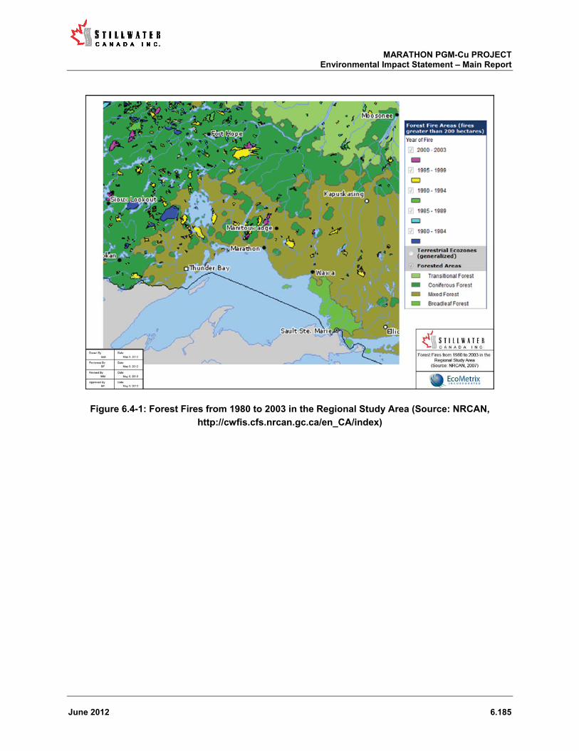
MARATHON PGM-Cu PROJECT Environmental Impact Statement – Main Report
June 2012 6.185
Figure 6.4-1: Forest Fires from 1980 to 2003 in the Regional Study Area (Source: NRCAN,
http://cwfis.cfs.nrcan.gc.ca/en_CA/index)

MARATHON PGM-Cu PROJECT Environmental Impact Statement – Main Report
June 2012 6.186
Figure 6.4-2: Forest Fires from 1920 to 2005 in the Regional Study Area (Source: pers. comm., Ray
Wheldon, OMNR, Nipigon District2012)
6.4.4 Seismic Activity
The Geologic Survey of Canada identifies the Project area as being within a region of relatively low seismicity (NRCan, 2011; see Figure 5.1-6). From 1970 to 1999, on average, Northern Ontario experienced only one or two earthquakes of magnitude 2.5 or greater (NRCan, 2011). There are no significant geological faults in the area.
The primary concerns from a seismic event perspective would be the failure of a man-made structure on the Project site, such as the failure of the MRSA slope or a failure of a PSMF embankment6. The damage potential of an earthquake is determined by how the ground moves (the peak ground acceleration) and how the buildings within the affected region are constructed. The conceptual design of both the MRSA and PSMF has considered, as a minimum, the peak ground acceleration corresponding to the 1 in 2,475 year event as required by the Lakes and Rivers Improvement Act (LRI Act) and its associated regulations, and the Canadian Dam Safety Guidelines (CDA, 2007).
6 A slope failure of the MRSA and the embankment failure at the PSMF have been considered within Section 6.3 (Accidents and Malfunctions) of this EIS.

MARATHON PGM-Cu PROJECT Environmental Impact Statement – Main Report
June 2012 6.187
The MRSA will be constructed with overall slope angles in the order of 2.2H:1V. Individual bench slopes will be approximately 2.0H:1V. Given the size of the material that will be placed in the MRSA the proposed slope angles actually exceed the natural angle of repose. The proposed conceptual design therefore inherently provides a high degree of stability. In addition, the majority of the volume of the mine rock in the MRSA is located within a north-south trending valley. This configuration provides further stability specifically as it pertains to a large-scale movement of mine rock to the east or west.
The conceptual design for the PSMF embankments provides for the construction of massive rockfill structures that exceed the prescribed short-term, long-term and pseudo-static minimum factor of safety stability requirements of 1.3, 1.5 and 1.0, respectively. The conceptual design provides for the following factor of safety ranges: short term 1.30 to 1.93, long term 1.50 to 2.29 and pseudo-static 1.01 to 1.99.
SCI is committed to adhering to the conceptual slope designs proposed for both the MRSA and PSMF. This will be achieved by completing regular as-built slope and stability surveys during construction and throughout mine life. In the instance that any deviations from the proposed design are noted a plan would be developed and implemented in consultation with government agencies as appropriate to address the issue.
Based on the above, SCI judges the probability of an environmental issue arising as the result of a seismic event as highly unlikely.
6.5 Capacity of Renewable Resources
This section describes the effect of the Project on the capacity of renewable resources to meet the needs of the present and those of the future, to the extent that these resources would no longer be sustainable. Renewable resources are discussed below in terms of atmospheric resources, surface water resources, groundwater resources, aquatic resources and terrestrial resources. Resources particular to Aboriginal peoples are discussed in Section 6.2.11.
The physical renewable resources assessed in this EIS were the atmospheric environment, surface water and groundwater. For the biotic environment the following were assessed: aquatic resources including fish and fish habitat; and terrestrial resources including vegetation; and wildlife.
After consideration of the Project’s design, management practices that would be employed and Project-specific mitigations developed where needed, the determination for all renewable resources is that the Project is not likely to result in significant adverse effects. A brief discussion of the renewable resources considered above in the context in which they were assessed in described below.

MARATHON PGM-Cu PROJECT Environmental Impact Statement – Main Report
June 2012 6.188
6.5.1 Atmospheric Resources
The atmosphere is a renewable resource and its quality can be affected by Project-related releases. Some exceedances of ambient air quality standards are predicted at the Property boundary, particularly during site preparation and construction, but the exceedances are transient in nature and do not threaten air quality as a resource in the vicinity of the Project site.
6.5.2 Surface Water Resources
Surface water is considered a renewable resource and can be affected by surface water quality and quantity. All site runoff from roads, plant site and other disturbed and developed areas will be collected through a series of collection ditches and storage ponds (up to the design storm event). Surplus water from the PSMF and drainage from the HRSA are not predicted to adversely affect water quality in Hare Lake and Pic River, respectively.
Water will be released from the Project site on a schedule that is consistent with the natural hydrograph of the drainages to which the discharge is directed to the extent possible in order to maintain flows and fish habitat in the downstream waterbodies during all seasons. Subwatersheds that are affected by water management and/or diversion associated with the development of the site make up only small fractions of the larger watersheds to which they report. Any planned diversions pose no threat to the overall condition of these larger watersheds, and natural drainage patterns will be restored to the extent possible following mine closure.
6.5.3 Groundwater Resources
Groundwater in the overburden and shallow bedrock is considered a renewable resource and can be affected by groundwater quality and transport. Groundwater flow on the Project site mirrors site topography, recharging at higher elevations and discharging at lower elevations (wetlands, streams, rivers and lakes), and generally follows surface water flow paths.
Groundwater on and around the site is not characterized as a resource per se as it is not exploited for that purpose; rather groundwater is transport pathway that contributes to surface waters. Solute transport in groundwater from the PSMF and from the MRSA is not predicted to negatively affect the surface water features.
6.5.4 Aquatic Resources
Aquatic resources are considered in terms of fish and fish habitat. The Project site is drained by a total of six subwatersheds, four of which drain to the Pic River; whereas, the remaining two drain directly to Lake Superior. The interior of the Project site is isolated from both the Pic River and Lake Superior by steep relief (i.e., topography) and therefore much of this area is fishless. In the instances where fish do occur the community is limited to small-bodied (forage) fish.

MARATHON PGM-Cu PROJECT Environmental Impact Statement – Main Report
June 2012 6.189
As discussed in Section 6.2.3.3, since all water discharged from the Project site is predicted to not adversely affect its receiving environment, no adverse effect is anticipated to fish in Hare Lake and the Pic River as the result of water quality issues. The Project is not predicted to affect the health or viability of commercial, recreational or Aboriginal fisheries. Proposed fish habitat compensation works that have been recommended (see Section 6.2.4.3) adequately address the HADD that is created by the Project.
6.5.5 Terrestrial Resources
Terrestrial resources are considered in terms of vegetation.
During site preparation and construction, land clearing will result in loss of mainly white birch; however, as discussed in Section 6.2.9.3, most of the Project site is not considered by the Big Pic Forest Management Plan as a harvestable resource. Therefore, clearing the land of white birch will not likely adversely affect renewable resources. During site closure and decommissioning, the Project site will be progressively reclaimed and revegetated with native plant species.
6.6 Cumulative Effects Analysis
6.6.1.1 Assessment Context
Section 16(1) of CEAA and the Guidelines require the consideration of cumulative environmental effects of the proposed project. Cumulative environmental effects are defined as effects “that are likely to result from the project in combination with other projects or activities that have been or will be carried out” (CEA Agency, 1999). The Cumulative Effects Assessment Practitioners Guide (CEA Agency, 1999) notes that the identification of residual effects allows for cumulative effects to be assessed since only those project-environment interactions that result in residual effects can lead to a cumulative effect. The Guide suggests that a cumulative effects assessment for a project under regulatory review should accomplish the following:
Determine if the project will have an effect on a VEC; If such an effect can be demonstrated, determine if the incremental effect acts
cumulatively with effects of other projects, either past, existing or future; and, Determine if the effect of the project, in combination with the other effects, may cause a
significant change now or in the future in the characteristics of the VEC after the application of mitigation for that project.
In the case of the Marathon PGM Project, consistent with the definition in the EIS Guidelines, cumulative effects, associated with the Project, may result if:
implementation of the Project would cause residual adverse effects on the environment, taking into account the application of technically and economically feasible mitigation measures; and,

MARATHON PGM-Cu PROJECT Environmental Impact Statement – Main Report
June 2012 6.190
the same environmental components are affected by other past, present or reasonably foreseeable future projects or activities.
The EIS guidelines also specify that the components of the environment that will not be affected by the Project or will be affected positively by the Project can be omitted from the cumulative effects assessment; therefore, this assessment focuses on the residual effects to VECs previously identified in the effects assessment.
The overall method for assessment of adverse cumulative effects is shown in Figure 6.6-1 below.

MARATHON PGM-Cu PROJECT Environmental Impact Statement – Main Report
June 2012 6.191
Figure 6.6-1: Cumulative Effects Assessment Method
This cumulative effects assessment does not consider the effects of malfunction or accident scenarios because they are hypothetical and generally have a low probability of occurrence. This is consistent with the Practitioners Guide which acknowledges that such events are “rare” and should be considered “unique scenarios.
Consistent with the EIS guidelines, the steps for the cumulative effects assessment were as follows:
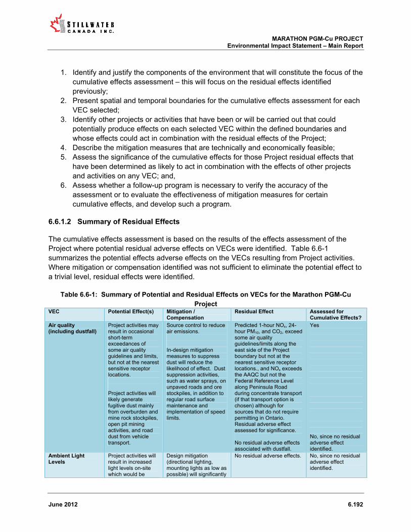
MARATHON PGM-Cu PROJECT Environmental Impact Statement – Main Report
June 2012 6.192
1. Identify and justify the components of the environment that will constitute the focus of the cumulative effects assessment – this will focus on the residual effects identified previously;
2. Present spatial and temporal boundaries for the cumulative effects assessment for each VEC selected;
3. Identify other projects or activities that have been or will be carried out that could potentially produce effects on each selected VEC within the defined boundaries and whose effects could act in combination with the residual effects of the Project;
4. Describe the mitigation measures that are technically and economically feasible; 5. Assess the significance of the cumulative effects for those Project residual effects that
have been determined as likely to act in combination with the effects of other projects and activities on any VEC; and,
6. Assess whether a follow-up program is necessary to verify the accuracy of the assessment or to evaluate the effectiveness of mitigation measures for certain cumulative effects, and develop such a program.
6.6.1.2 Summary of Residual Effects
The cumulative effects assessment is based on the results of the effects assessment of the Project where potential residual adverse effects on VECs were identified. Table 6.6-1 summarizes the potential effects adverse effects on the VECs resulting from Project activities. Where mitigation or compensation identified was not sufficient to eliminate the potential effect to a trivial level, residual effects were identified.
Table 6.6-1: Summary of Potential and Residual Effects on VECs for the Marathon PGM-Cu
Project VEC Potential Effect(s) Mitigation /
Compensation Residual Effect Assessed for
Cumulative Effects?
Air quality (including dustfall)
Project activities may result in occasional short-term exceedances of some air quality guidelines and limits, but not at the nearest sensitive receptor locations. Project activities will likely generate fugitive dust mainly from overburden and mine rock stockpiles, open pit mining activities, and road dust from vehicle transport.
Source control to reduce air emissions. In-design mitigation measures to suppress dust will reduce the likelihood of effect. Dust suppression activities, such as water sprays, on unpaved roads and ore stockpiles, in addition to regular road surface maintenance and implementation of speed limits.
Predicted 1-hour NOx, 24-hour PM10, and CO2, exceed some air quality guidelines/limits along the east side of the Project boundary but not at the nearest sensitive receptor locations., and NOx exceeds the AAQC but not the Federal Reference Level along Peninsula Road during concentrate transport (if that transport option is chosen) although for sources that do not require permitting in Ontario. Residual adverse effect assessed for significance. No residual adverse effects associated with dustfall.
Yes No, since no residual adverse effect identified.
Ambient Light Levels
Project activities will result in increased light levels on-site which would be
Design mitigation (directional lighting, mounting lights as low as possible) will significantly
No residual adverse effects. No, since no residual adverse effect identified.
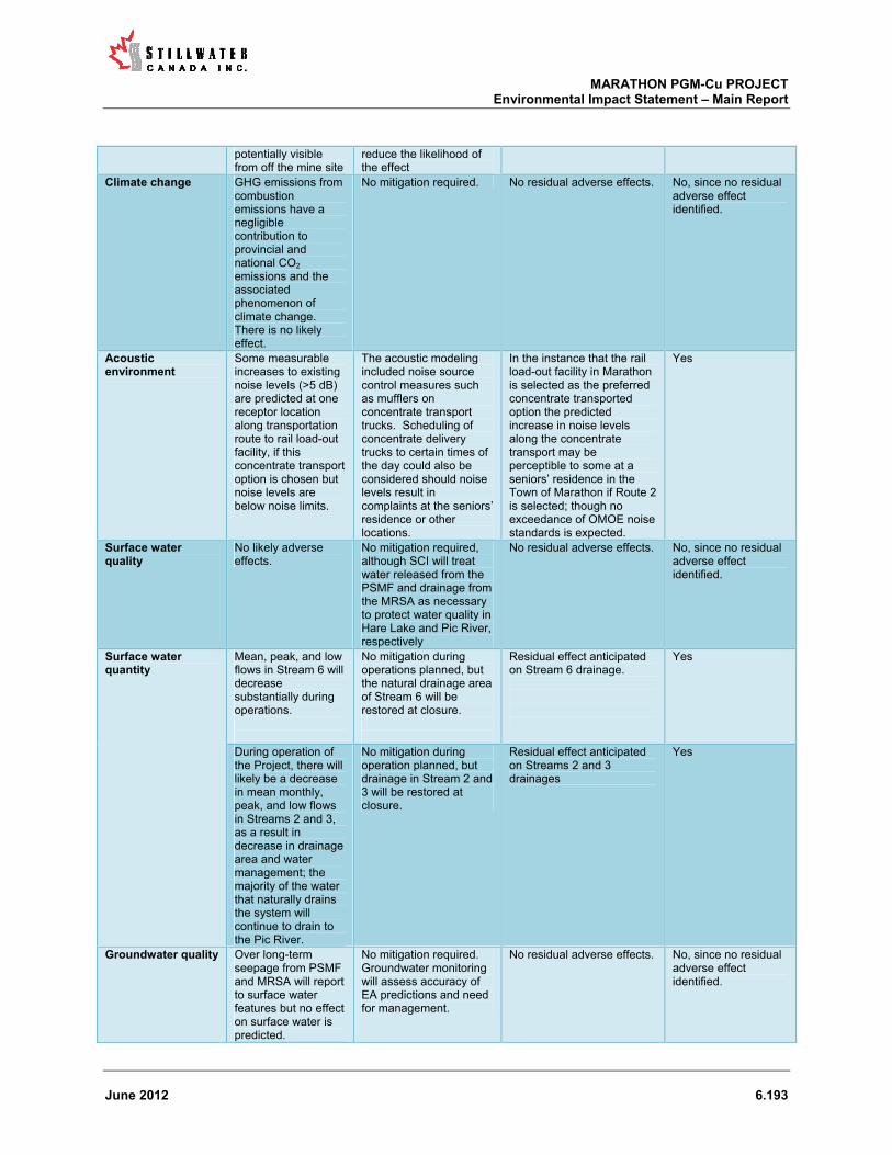
MARATHON PGM-Cu PROJECT Environmental Impact Statement – Main Report
June 2012 6.193
potentially visible from off the mine site
reduce the likelihood of the effect
Climate change GHG emissions from combustion emissions have a negligible contribution to provincial and national CO2 emissions and the associated phenomenon of climate change. There is no likely effect.
No mitigation required. No residual adverse effects. No, since no residual adverse effect identified.
Acoustic environment
Some measurable increases to existing noise levels (>5 dB) are predicted at one receptor location along transportation route to rail load-out facility, if this concentrate transport option is chosen but noise levels are below noise limits.
The acoustic modeling included noise source control measures such as mufflers on concentrate transport trucks. Scheduling of concentrate delivery trucks to certain times of the day could also be considered should noise levels result in complaints at the seniors’ residence or other locations.
In the instance that the rail load-out facility in Marathon is selected as the preferred concentrate transported option the predicted increase in noise levels along the concentrate transport may be perceptible to some at a seniors’ residence in the Town of Marathon if Route 2 is selected; though no exceedance of OMOE noise standards is expected.
Yes
Surface water quality
No likely adverse effects.
No mitigation required, although SCI will treat water released from the PSMF and drainage from the MRSA as necessary to protect water quality in Hare Lake and Pic River, respectively
No residual adverse effects. No, since no residual adverse effect identified.
Surface water quantity
Mean, peak, and low flows in Stream 6 will decrease substantially during operations.
No mitigation during operations planned, but the natural drainage area of Stream 6 will be restored at closure.
Residual effect anticipated on Stream 6 drainage.
Yes
During operation of the Project, there will likely be a decrease in mean monthly, peak, and low flows in Streams 2 and 3, as a result in decrease in drainage area and water management; the majority of the water that naturally drains the system will continue to drain to the Pic River.
No mitigation during operation planned, but drainage in Stream 2 and 3 will be restored at closure.
Residual effect anticipated on Streams 2 and 3 drainages
Yes
Groundwater quality Over long-term seepage from PSMF and MRSA will report to surface water features but no effect on surface water is predicted.
No mitigation required. Groundwater monitoring will assess accuracy of EA predictions and need for management.
No residual adverse effects. No, since no residual adverse effect identified.

MARATHON PGM-Cu PROJECT Environmental Impact Statement – Main Report
June 2012 6.194
Groundwater is not used as a resource on or near the mine site.
Groundwater quantity
Only minor changes in groundwater flow predicted.
No mitigation required. No residual adverse effects. No, since no residual adverse effect identified.
Lake / stream sediments
No change in sediment quality predicted
No mitigation required. No residual adverse effects. No, since no residual adverse effect identified.
Terrain and Soil Approximately 3.7 million m3 of overburden will be removed for site preparation and construction – no net loss since material will be used for reclamation purposes. Potential erosion and slide risk of overburden stockpiles and the MRSA; however design features will ensure terrain (slope) stability is maintained over the long term.
Terrain stability will be managed to minimize erosion and slide risks. This is inherent in the design of the overburden stockpiles and MRSA.
No residual adverse effects. No, since no residual adverse effect identified.
Forest cover Approximately 612 ha of forest cover (predominantly white birch -80% and black spruce -15.3%) will be removed for site development Land clearing and general disturbance may increase the potential for the introduction of non-native plant species to previously unaffected areas Potential for dusting on forest cover near Project Site.
Footprint will be optimized to minimize forest clearing, selective clearing along transmission corridor, re-vegetation at closure. Prevention of invasive species through invasive species awareness and control program, isolating sensitive areas until native vegetation established, etc. In design mitigation measures associated with dust creation (e.g., suppressants) as well as limiting vehicle traffic to previously disturbed areas will mitigate dusting.
Only 411 ha will have the potential to be reforested for a total of 200 ha permanently lost forest. Residual adverse effect assessed for significance. No residual adverse effects. No residual adverse effects.
Yes No, since no residual adverse effect identified. No, since no residual adverse effect identified.
Non-forest cover Approximately 16 ha of thicket swamp (mainly alder thickets), 1.4 ha of shore fen and meadow marsh, and 0.6 ha of rock barrens will be removed for site development
Footprint will be optimized to minimize loss of wetlands, rock barren, etc. Buffers maintained around important features. Non-forest communities are common locally and regionally and can be used for reclamation.
Minimal net loss of non-forest vegetation (18 ha). Residual adverse effect assessed for significance.
Yes

MARATHON PGM-Cu PROJECT Environmental Impact Statement – Main Report
June 2012 6.195
Potential for the introduction of non-native plant species to previously unaffected areas
Prevention of invasive species through invasive species awareness and control program, isolating sensitive areas until native vegetation established, etc.
No residual adverse effects. No, since no residual adverse effect identified.
Provincially and Regionally rare veg. species
Removal of some regionally rare (Algal Pondweed) and provincially rare (Broad-lipped Twayblade, Common Ragweed, Oake’s Pondweed, Northern St. Johnswort and Marsh Speedwall) species for mine infrastructure and transmission line construction. Potential for the introduction of non-native plant species to previously unaffected areas Potential for dusting on remaining regionally rare species.
Footprint will be optimized and selective re-vegetation at closure. Prevention of invasive species through invasive species awareness and control program, isolating sensitive areas until native vegetation established, etc. In design mitigation measures associated with dust creation (e.g., suppressants) as well as limiting vehicle traffic to previously disturbed areas will mitigate dusting.
A limited number of rare plants will be permanently lost within the Project footprint. Residual adverse effect assessed for significance. No residual adverse effects. No residual adverse effects.
Yes No, since no residual adverse effect identified. No, since no residual adverse effect identified.
Protected veg. species
No protected vegetation species identified in the area
No mitigation required. No residual adverse effects. No, since no residual adverse effect identified.
Furbearers Removal of forest cover will alter/remove some wildlife habitat for furbearers (e.g., marten, fisher) Sensory disturbance (noise, dust,) from mine activities Low potential for collision with mine infrastructure, and vehicles
Footprint will be optimized. Site reclamation will restore some of the habitat. Noise mitigation, and dust suppression activities will be sufficient to mitigate. Vehicle collisions predicted to be minimal due to enforced speed limits on roads.
Alter/remove habitat for furbearers. Residual adverse effect assessed for significance. No residual adverse effects. No residual adverse effects.
Yes No, since no residual adverse effect identified. No, since no residual adverse effect identified.
Moose Clearing may change moose movement behavior. Initial migration out during site preparation and construction, but return to site area after period of
Limit footprint of disturbed areas.
Clearing may disturb moose movement behavior. Residual adverse effect assessed for significance.
Yes

MARATHON PGM-Cu PROJECT Environmental Impact Statement – Main Report
June 2012 6.196
human, noise, habituation. Potential vehicle collisions
Speed limits on roads to minimize/eliminate collisions.
No residual adverse effects.
No, since no residual adverse effect identified.
Grey Wolf Grey wolf will shadow major prey species such as moose and deer. If moose emigrate from the site then grey wolf will follow. At closure increased areas of grassland will create increased white-tailed deer habitat and potentially higher wolf numbers.
Limit footprint of disturbed areas.
Over time, increased white-tailed deer populations and therefore a potential increase in wolf populations. Residual adverse effect assessed for significance.
Yes
Black Bear Initial migration out during site preparation and construction, but return to site area after period of human, noise, habituation.
Limit footprint of disturbed areas. Establish wildlife policy to minimize human interaction with wildlife and decrease potential for habituation.
Increased seasonal use of the site by black bear depending on the state of the succession of the reclaimed areas. Residual adverse effect assessed for significance.
Yes
Migratory Birds Removal of forest cover, wetlands, and lake habitat for mine infrastructure, proposed roads and transmission lines will contribute to forest fragmentation and may have negative effects on forest interior bird species (temporary habitat loss for 1600 pairs of songbirds), and may interact and could cause loss of nests and young due to land clearing with transmission line and mine infrastructure. Conversely, edge adapted birds may benefit from the habitat alteration.
Where practical, clearing of vegetation will be avoided during bird nesting season. If clearing in nesting season occurs pre-clearing surveys to be completed and nest sites plus buffer zone to be marked as exclusion areas. Transmission line will be designed to minimize collisions, limit the use of guy wires, and where practical, mark the line to increase visibility and avoid collisions.
Some habitat loss for migratory birds. Residual adverse effect assessed for significance.
Yes
Woodland Caribou Loss in potential connectivity between declining populations of woodland caribou in the Neys and Pukaskwa protected areas and loss of small lichen-rich areas on bedrock that could potentially serve as caribou winter and refuge habitat (though there are no known records of this use
Establish mine and infrastructure to minimize ecological footprint. Keep intact as much existing forest as possible along the southern portion of the property to maintain potential linkages between landscapes to the east and west of the property. In concert with OMNR develop a mitigation
Loss in potential connectivity between declining populations of woodland caribou in the Neys and Pukaskwa protected areas. Residual adverse effects assessed for significance. Loss of small lichen-rich areas on bedrock that could potentially serve as caribou winter/refuge habitat (though there are no known records of this use on the
Yes Yes

MARATHON PGM-Cu PROJECT Environmental Impact Statement – Main Report
June 2012 6.197
on the site) strategy site)
Little brown myotis / northern myotis
No bats presently inhabit the site.
No mitigation required. No residual adverse effects. No, since no residual adverse effect identified.
Canada Warbler Nesting habitat removal (mature hardwood dominated forest) for Canada Warblers.
Limit footprint of disturbed areas.
Some habitat loss for Canada Warbler. Residual adverse effect assessed for significance.
Yes
Rusty blackbird Development of the mine will result in the loss of the only known nesting habitat (1.4 ha) of Rusty Blackbird in the study area on a small pond
Limit footprint of disturbed areas.
Some habitat loss for Rusty blackbird. Residual adverse effect assessed for significance.
Yes
Bald eagle No bald eagles presently inhabit the site. The nearest known nest is about 11 km north of the study area.
No mitigation required. No residual adverse effects. No, since no residual adverse effect identified.
Olive-sided Flycatcher
None observed on-site (one pair observed in local study area), but potential nesting habitat (1.4 ha) will be removed for mine development.
Limit footprint of disturbed areas.
Some habitat loss for Olive-sided Flycatcher. Residual adverse effect assessed for significance.
Yes
Common nighthawk None observed on-site, but potential habitat (<2 ha) will be removed for mine development
Limit footprint of disturbed areas.
Some potential habitat loss for Common nighthawk. Residual adverse effect assessed for significance.
Yes
Whip-poor-will Whip-poor-will are not expected to inhabit the study area.
No mitigation required. No residual adverse effects. No, since no residual adverse effect identified.
Peregrine Falcon No Peregrine Falcon presently inhabit the site. There are no potential nesting cliffs within about 3 km of the footprint and no known nests within 8 km
No mitigation required. No residual adverse effects. No, since no residual adverse effect identified.
Lake Sturgeon Design of collection ponds and treatment plants will be such that water quantity and quality does not exceed water quality guidelines and not impact the Pic River Lake Sturgeon population. There is no likely effect.
No mitigation required. No residual adverse effects. No, since no residual adverse effect identified.
Fish Habitat Creation of HADD equivalent to 9.4 ha, of which 1.8 ha is fish frequented
Fish habitat compensation for approximately 10 ha will be provided – a net gain.
No residual adverse effects. No, since no residual adverse effect identified.

MARATHON PGM-Cu PROJECT Environmental Impact Statement – Main Report
June 2012 6.198
Recreational Fishery
Minor effect regarding convenience for public access to Bamoos Lake, Return potential temporary loss of limited local Steelhead fishery in Stream 6
No mitigation proposed – is still accessible by other areas. Return mitigation is addressed via Fish Habitat Compensation Strategy. No further mitigation required.
No residual adverse effects. No, since no residual adverse effect identified.
Commercial Fishery Guided access to Claw Lake to be provided by SCI for baitfish collections.
Guided access to be provided.
No residual adverse effects. No, since no residual adverse effect identified.
Aboriginal Fishery Potential temporary loss of limited local Steelhead fishery in Stream 6. No other loss of Aboriginal fishery values.
Mitigation for Stream 6 is addressed via Fish Habitat Compensation Strategy. Guided access to Bamoos Lake trail to be provided to Aboriginal peoples.
No residual adverse effects. No, since no residual adverse effect identified.
Benthic invertebrates
Loss of some benthic invertebrate communities
Loss will be minimized/offset incidentally by habitat compensation provided for HADD
No residual adverse effects. No, since no residual adverse effect identified.
Demographics Influx of people has potential for both positive and negative effects
To mitigate potential negative effects SCI will facilitate rational work force, encourage former workers to return to area, provide employee accommodations in Accommodations Complex are locally owned SCI motels, support commuting from local communities.
No residual adverse effects. No, since no residual adverse effect identified.
Housing Increase in demand and cost during site preparation and construction and operations. Reduced demand and prices at mine closure.
No mitigation required. Facilitating national workforce, providing employee accommodations, supporting commuting from the local communities and recruiting employees from local communities.
No residual adverse effects. Reduced demand for housing at closure and downward pressure on home prices.
No, since no residual adverse effect identified. Yes
Education and Training
No likely adverse effects. Opportunities for youth, Aboriginal peoples and skilled workers is a positive effect.
No mitigation required. No residual adverse effects. No, since no residual adverse effect identified.
Infrastructure No likely adverse effects.
No mitigation required. No residual adverse effects. No, since no residual adverse effect identified.
Community services
Increased demand during site preparation and
SCI to provide support to fund key community services and
Reduced demand at closure.
Yes

MARATHON PGM-Cu PROJECT Environmental Impact Statement – Main Report
June 2012 6.199
construction and operations. Reduced demand during closure.
organizations and fitness and recreation programs for workers. SCI to maintain ongoing communications with local residents regarding Project schedule.
Health and Emergency services
Greater demand on emergency services, particularly fire protection services
SCI to provide level of health and on-site emergency response and SCI will co-ordinate its emergency response with the Town of Marathon. SCI to maintain ongoing communications with local residents and government regarding Project schedule.
Reduced demand at closure.
Yes
Traffic Reduced demand during closure. Greater vehicular traffic especially at Highway 17, Peninsula Road, and Camp 19 Road intersection, resulting in time delays and potential vehicle and pedestrian collisions. Increased traffic in the Town.
Entrance to Camp 19 Road will be improved by widening the road and increasing the turning radii from Highway 17. These improvements will provide adequate accommodation to the anticipated truck traffic accessing the site during all phases of the Project. Additional signage will improve road safety, especially in the Town of Marathon. SCI to encourage carpooling and will provide bus service. Shift changes and concentrate transport to be scheduled in consultation with the Town of Marathon
No residual adverse effects. No, since no residual adverse effect identified.
Human health Residual effect at Project boundary for air quality but no risk to human health noted
No mitigation required. No residual adverse effects. No, since no residual adverse effect identified.
Employment and Income
No likely adverse effects. Positive effects with respect to employment levels and employment income
No mitigation required. No residual adverse effects. Effects to employment and employment income are positive
No, since no residual adverse effect identified.
Government Revenue
No likely adverse effects. Government incomes will be positively affected by the Project.
No mitigation required. No residual adverse effects. Government incomes will be positively affected by the Project.
No, since no residual adverse effect identified.
Economic and business development
No likely adverse effects. Economic and business opportunities to be positively affected by
No mitigation required. No residual adverse effects. Economic and business opportunities to be positively affected by the Project.
No, since no residual adverse effect identified.

MARATHON PGM-Cu PROJECT Environmental Impact Statement – Main Report
June 2012 6.200
Based on the results of Table 6.6-1 residual adverse effects of the proposed Marathon PGM-Cu Project were identified in the physical, vegetation, wildlife, species at risk, land and resource use, social, and Aboriginal considerations components/sub-components of the environment.
The VECs in the environmental components identified as having potential residual effects from the Marathon PGM-Cu Project therefore carried forward for the cumulative effects assessment
the Project. Recreation/Tourism No likely adverse
effects. No mitigation required. No residual adverse effects. No, since no residual
adverse effect identified.
Forestry The Project site will need to be cleared for mine development. This may affect forestry values and targets identified for the Big Pic Forest Management Unit.
Timber harvest value will be maintained so there will be no loss of value. Portion of site to be cleared comprises a small fraction of the Forest Management Unit as a whole.
No residual adverse effects. No, since no residual adverse effect identified.
Agriculture No likely adverse effects.
No mitigation required. No residual adverse effects. No, since no residual adverse effect identified.
Commercial Development
No likely adverse effects.
No mitigation required. No residual adverse effects. No, since no residual adverse effect identified.
Navigable waters Several water courses and water bodies that are defined as “navigable” will be impacted.
Limit footprint of disturbed areas.
Several water courses and water bodies that are defined as “navigable” will be impacted; NWPA authorization required. Residual adverse effect assessed for significance.
Yes
Archaeology No likely adverse effects.
No mitigation required. No residual adverse effects. No, since no residual adverse effect identified.
Built and Cultural Heritage
No likely adverse effects.
No mitigation required. No residual adverse effects. No, since no residual adverse effect identified.
Aboriginal land and resource uses for traditional purposes including country foods
Restricted access and land disturbance in the SSA for traditional pursuits
Limit footprint of the mine. Development of a guided site access protocol. SCI to seek input from Aboriginal peoples regarding mien closure concepts and reclamation priorities.
Traditional pursuits negatively affected in the SSA.
Yes
Aboriginal Archaeological Resources
No likely adverse effects.
No mitigation required. No residual adverse effects. No, since no residual adverse effect identified.
Aboriginal Heritage Resources
No likely adverse effects.
No mitigation required. No residual adverse effects. No, since no residual adverse effect identified.
PRFN Community Trapline
Restricted access and land disturbance in the SSA which is in the trapline area
Limiting the footprint of the mine. Development of a guided access protocol. SCI to seek input from Aboriginal peoples on mine site closure concepts and reclamation priorities.
Use of the community trapline negatively affected in the SSA.
Yes

MARATHON PGM-Cu PROJECT Environmental Impact Statement – Main Report
June 2012 6.201
were: air quality, surface water quantity, forest cover, non-forest cover, provincially and regionally rare vegetation species, furbearers, moose, grey wolf, woodland caribou, Canada warbler, rusty blackbird, olive-sided flycatcher, common nighthawk, housing, community, emergency, and health services, navigable waters, and a number of Aboriginal considerations, as shown in Table 6.6-2.
Table 6.6-2: Summary of Environmental Components and Associated VECs Assessed for
Cumulative Effects
Environmental
Component
VEC Residual Adverse Effect
Physical
Environment
Air quality 1-hour NOx, 24-hour PM10, and CO2, may periodically exceed some air
quality criteria at the Project boundary during construction.
Acoustic
environment
Possible perceptible noise to some at a seniors’ residence in the Town of
Marathon if Route 2 is selected for concentrate transport.
Surface water
quantity
Residual effect anticipated on Streams 2, 3, and 6 drainage.
Vegetation Forest cover A total of 201 ha permanently lost forest.
Non-forest cover Minimal net loss of non-forest vegetation (18 ha).
Provincially and
Regionally rare veg.
species
A limited number of rare plants will be permanently lost within the Project
footprint.
Wildlife Furbearers Alteration/removal of habitat for furbearers.
Moose Clearing and mine activities may disturb moose movement behavior.
Grey Wolf Over time, increased white-tailed deer populations and therefore a
potential increase in wolf populations.
Black Bear Increased seasonal use of the site by black bear depending on the state of
the succession of the reclaimed areas.
Migratory Birds Some habitat loss for migratory birds.
Species at Risk Woodland Caribou Impact on potential connectivity between woodland caribou in the Neys
and Pukaskwa protected areas. Some loss of potential winter/refuge
habitat on site.
Canada Warbler Some habitat loss.
Rusty blackbird Some habitat loss.
Olive-sided
Flycatcher
Some habitat loss.
Common nighthawk Some potential habitat loss.
Social Factors Housing Reduced demand for housing at closure and downward pressure on home
prices.
Community, health,
and emergency
services
Reduced demand for community, health, and emergency services at
closure.

MARATHON PGM-Cu PROJECT Environmental Impact Statement – Main Report
June 2012 6.202
Land and Resource
Use
Navigable waters Several minor water courses and water bodies that are defined as
“navigable” will be impacted.
Aboriginal
Considerations
Aboriginal land and
resource uses for
traditional purposes
including country
foods
Traditional pursuits negatively affected in the SSA.
PRFN trapline Use of the community trapline negatively affected in the SSA.
6.6.1.3 Spatial and Temporal Boundaries
The identification of other projects and activities focused on the RSA. Generally, this spatial boundary was limited to projects within 100 km of the Marathon PGM-Cu Project site, which is the spatial boundary of the socio-economic environment. For the assessment of potential cumulative effects on caribou connectivity, the spatial boundary was defined separately, as projects falling within the Lake Superior Coastal Range as well as potential corridors for movement of animals between the coastal range (in which the Project site sits) and the caribou ranges to the north (both continuous and discontinuous).
The temporal boundaries used were existing, certain, and reasonably foreseeable projects that overlap with the anticipated life of the mine (from approximately 2013 to 2073) from site preparation and construction, operations, through site decommissioning and closure.
6.6.1.4 Other Projects and Activities Considered in the Assessment and Potential Effects
Any assessment of baseline conditions includes environmental effects of past and existing projects. The CEA Agency Reference Guide for Addressing Cumulative Effects (CEA Agency, 1994) acknowledges that any environmental assessment which examines “baseline environmental conditions, which include the … environmental effects of past and existing projects and activities”, already addresses cumulative environmental effects to some extent. Therefore, this assessment primarily focuses on the potential of existing and reasonably foreseeable projects and activities to contribute to cumulative environmental effects.
The CEA Agency’s Operational Policy Statement indicates that a cumulative effects assessment needs to only consider future projects which are ‘certain’ or ‘reasonably foreseeable’. As recommended in the Practitioners Guide, projects and activities are considered to be ‘certain’ if they have been approved for development; have been announced by the proponent and/or regulatory agencies; or are currently under review for approval. As recommended in the Practitioners Guide, projects and activities are considered “reasonably foreseeable” if they are identified in an approved development plan, or are directly associated with the project under review, but conditional on that project’s approval or are directly or indirectly associated with the proposed project under review and might proceed after/assuming the project is approved.
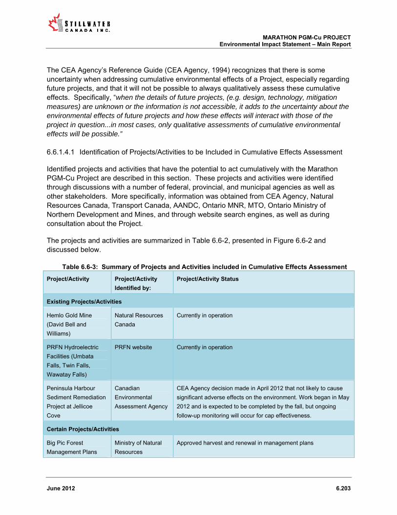
MARATHON PGM-Cu PROJECT Environmental Impact Statement – Main Report
June 2012 6.203
The CEA Agency’s Reference Guide (CEA Agency, 1994) recognizes that there is some uncertainty when addressing cumulative environmental effects of a Project, especially regarding future projects, and that it will not be possible to always qualitatively assess these cumulative effects. Specifically, “when the details of future projects, (e.g. design, technology, mitigation measures) are unknown or the information is not accessible, it adds to the uncertainty about the environmental effects of future projects and how these effects will interact with those of the project in question...in most cases, only qualitative assessments of cumulative environmental effects will be possible.”
Identification of Projects/Activities to be Included in Cumulative Effects Assessment 6.6.1.4.1
Identified projects and activities that have the potential to act cumulatively with the Marathon PGM-Cu Project are described in this section. These projects and activities were identified through discussions with a number of federal, provincial, and municipal agencies as well as other stakeholders. More specifically, information was obtained from CEA Agency, Natural Resources Canada, Transport Canada, AANDC, Ontario MNR, MTO, Ontario Ministry of Northern Development and Mines, and through website search engines, as well as during consultation about the Project.
The projects and activities are summarized in Table 6.6-2, presented in Figure 6.6-2 and discussed below.
Table 6.6-3: Summary of Projects and Activities included in Cumulative Effects Assessment
Project/Activity Project/Activity
Identified by:
Project/Activity Status
Existing Projects/Activities
Hemlo Gold Mine
(David Bell and
Williams)
Natural Resources
Canada
Currently in operation
PRFN Hydroelectric
Facilities (Umbata
Falls, Twin Falls,
Wawatay Falls)
PRFN website Currently in operation
Peninsula Harbour
Sediment Remediation
Project at Jellicoe
Cove
Canadian
Environmental
Assessment Agency
CEA Agency decision made in April 2012 that not likely to cause
significant adverse effects on the environment. Work began in May
2012 and is expected to be completed by the fall, but ongoing
follow-up monitoring will occur for cap effectiveness.
Certain Projects/Activities
Big Pic Forest
Management Plans
Ministry of Natural
Resources
Approved harvest and renewal in management plans

MARATHON PGM-Cu PROJECT Environmental Impact Statement – Main Report
June 2012 6.204
Bridge Repair (Little
Pic River Bridge at
Highway 17)
Ministry of
Transportation
Contract approved by Ministry of Transportation
Bridge Alteration
(Black River at
Highway 17)
Ministry of
Transportation
Contract approved by Ministry of Transportation
Highway 17
resurfacing 0.6 km
west of Peninsula
Road (Marathon)
westerly - 27.5 km
Ministry of
Transportation
Part of planned program for 2014
Pic Mobert Gitchi
Animki Hydroelectric
Facility
Pic Mobert website In construction phase
Reasonably Foreseeable Projects/Activities
Mining Exploration
(e.g., Bermuda, Mishi,
Sugar Zone) –
approximately 23
active claims within
100 km of the
Marathon site
Ministry of Northern
Development and
Mines and Ministry
of Natural Resources
Assumed to be planning for exploration. Currently, there is not
enough information on Geordie Lake to support the project moving
forward; therefore, Geordie Lake was considered a hypothetical
project/activity and not included in the assessment.
Pulp Mill Landfill None Ontario’s Environmental Review Tribunal agreed in 2011 to multi-
party cleanup including closing the open landfill.
Town of Marathon
Regional Waste
Management Site
Canadian
Environmental
Assessment Agency
Notice of Commencement of EA Process in 2008.
Pic River First Nations
Hydroelectric Facilities
at Manitou Falls and
High Falls
Canadian
Environmental
Assessment Agency
Notice of Commencement of EA Process in 2010.
PRFN Lower Lake
Hydroelectric Project
(Aguasabon River)
Canadian
Environmental
Assessment Agency
Notice of Commencement of EA Process in 2007, but currently on
hold.
Pic River First Nation
Well Development
Project
Aboriginal Affairs
and Northern
Development
Canada
Notice of Commencement of EA Process in 2008, but currently on
hold due to well contamination identified.

MARATHON PGM-Cu PROJECT Environmental Impact Statement – Main Report
June 2012 6.205
Superior Shores Wind
Farm
PRFN website In research phase
Coldwell Wind Energy
Project
Ministry of Natural
Resources
Under development phase (not construction)
East-West Tie
Transmission Line
Ministry of Natural
Resources
Process initiated and in process of selecting a developer.
The Ontario MNR also identified the following potential projects:
quarry proposal approximately 15 hectares, south of Hare Lake between Hwy 17 and the transmission line;
Bell communication towers in the area of Three Finger Lake, Sweede Creek, Mink Harbour/Hwy 11, and Deadhorse Road/Hwy 11; and
potential MTO aggregate pit.
Research was undertaken to find information on these projects. Since no additional information on these projects was found, they were considered hypothetical and as such were not included in the cumulative effects assessment.
The former Marathon Pulp Inc. site is currently owned by Tembec which is looking to sell the property likely for industrial redevelopment. There is currently no confirmed purchaser or asset disposition schedule; therefore this project is considered hypothetical and no included in the cumulative effects assessment.

MARATHON PGM-Cu PROJECT Environmental Impact Statement – Main Report
June 2012 6.206
Figure 6.6-2: Existing, Certain, and Reasonably Foreseeable Projects within the Spatial Boundary of the Cumulative Effects Assessment

MARATHON PGM-Cu PROJECT Environmental Impact Statement – Main Report
June 2012 6.207
Description of Existing Projects/Activities 6.6.1.4.2
Hemlo Gold Camp
The Hemlo Gold Camp, comprising the David Bell (open pit) and Williams (open pit and underground facilities) mines, owned and operated by Barrick Gold Corporation are currently operational and located approximately 30 km southeast of the Project. Surface water discharge from this mine enters the Pic River via the Black River the mouth of which is located on the east bank of the Pic River, approximately 18 km downstream of the Marathon Project. A feasibility study is underway to expand the open pit and extend the mine life by up to 10 years.
Peninsula Harbour Sediment Remediation Project
The Peninsula Harbour Sediment Remediation Project at Jellicoe Cove was approved in April 2012. The remediation project will cover contaminated sediments in Jellicoe Cove, Peninsula Harbour in Lake Superior, Ontario with 15 to 20 cm of clean sand over a total area of 25.6 ha. The cap area includes approximately 204,000 m2 of area with elevated sediment mercury and PCB concentrations. The results of the screening assessment identified the need to implement mitigation measures to address potential effects to fish and/or their habitat, invertebrates and/or their habitat, air quality, noise levels, seabed/benthic communities, and water quality; however no significant residual adverse effects are expected after mitigation measures are implemented.
The anticipated duration of Project activities is approximately two and one half months, given a construction schedule of 24 hours/day and up to seven (7) days/week. Work began in May 2012 and is expected to be completed by the fall. Monitoring for cap effectiveness will take place periodically over the next 20 years. The overall timeline for the follow-up program of cap effectiveness is April 1, 2013 to March 30, 2022.
PRFN Hydroelectric Facilities (Umbata Falls, Twin Falls, Wawatay Falls)
Currently, PRFN owns and operates three hydroelectric facilities: Umbata Falls, Twin Falls, and Wawatay Falls. Umbata Falls, a 23 MW facility, was commissioned in early November 2008, located on the White River, approximately 30 km southeast of the Marathon PGM-Cu Project site. Twin Falls, a 4.9 MW facility, was commissioned in 2000, but PRFN did not assume full ownership of the facility until 2009. Twin Falls is located on the Kagiano River, approximately 50 km north of the Marathon PGM-Cu Project site. Wawatay, a 13.5 MW facility, was commissioned in 1992, located on the Black River, approximately 65 km north of the Marathon PGM-Cu Project site.
Description of Certain Projects/Activities 6.6.1.4.3
Big Pic Forest Management Plan

MARATHON PGM-Cu PROJECT Environmental Impact Statement – Main Report
June 2012 6.208
The Marathon PGM-Cu Project falls within the Big Pic Forest Management Area. The forest management plan outlines the planned harvest from 2007 to 2017 for the Big Pic unit.
Highway 17 Improvements
According to the MTO, Highway 17 resurfacing improvements are planned in 2014 from 0.6 km west of Peninsula Road westerly 27.5 km. Bridge rehabilitation over the Big Pic River east of Marathon and bridge replacement over the Black River east of Marathon is also planned over the next five years. Specifically, bridge repair of the Little Pic River Bridge is expected to occur from April 2012 to November 2013. Black River bridge alteration is expected to have begun in August 2011 and be completed by September 2012.
Pic Mobert Hydroelectric Facility
Pic Mobert First Nation is involved in hydroelectric generation and is working on the Gitchi Animki (Big Thunder) Hydroelectric Project located on the White River approximately 50 km south of the Town of White River. The project consists of two developments located on the White River:
Gitchi Animki Bezhig (Upper Site), an approximate 8.9 MW site that will ultimately replace the Ministry of Natural Resources (MNR) existing regulating dam that manages lake levels and flood risks on White Lake;
Gitchi Animki Niizh (Lower Site), an approximate 10.0 MW site located approximately 16 km south of the Gitchi Animki Bezhig.
It will generate approximately 95 GWh of electricity annually to support approximately 12,000 homes. The project is currently under construction and is expected to be functional by 2013.
Description of Reasonably Foreseeable Projects/Activities 6.6.1.4.4
Mining Exploration
There are a number of mining exploration properties within a 100 km radius of the Project, which may give rise to exploration activities in the next 5 to 10 years. Bermuda and Geordie Lake are two exploration sites within SCI’s current claim boundary. The Bermuda site has the potential for copper and platinum resources, and the Geordie Lake site has the potential for palladium and copper. Sugar Zone, owned by Harte Gold Corporation, has the potential for gold resources and is located approximately 100 km east of the Project site. Mishi, owned by Wesdome Gold Mines Ltd. also has the potential for gold resources and is located approximately 100 km southeast of the Project site. The Ministry of Northern Development and Mines and Ministry of Natural Resources identified 74 active claims held by numerous companies in the Thunder Bay South District: Eastern Section (Thunder Bay east to White River and from Lake Superior shoreline north to Lake Nipigon. Approximately 21 of these claims fall within 100 km of the Marathon PGM-Cu Project site.

MARATHON PGM-Cu PROJECT Environmental Impact Statement – Main Report
June 2012 6.209
Pulp Mill Landfill
There is a closed pulp mill landfill along the Camp 19 Road, about 1 km east of the Hwy 17 intersection. The landfill contents are principally hog fuel boiler and wood ash. The landfill was the former property of Marathon Pulp Inc. (MPI). MPI fell into bankruptcy in 2009. The courts have since determined that the landfill is the responsibility of Tembec Industries. The landfill covers an area of approximately 2 ha. The site is to be closed out (and remediated as needed) but no timetable for this has been set.
Regional Waste Management Site
The Town of Marathon is in the process of developing a regional waste management site. A new disposal site about 64 km (by road) northwest of the town is currently in the midst of the provincial review process. The site encompasses 77 ha and will receive solid non-hazardous domestic and industrial wastes from the town and surrounding area and provide an environmentally sound and safe regional waste disposal site. At expected fill rates the site will receive wastes for about 35 years.
PRFN Hydroelectric Facilities
The PRFN is proposing to construct hydroelectric facilities at Manitou Falls and High Falls, located on the Pic River approximately 70 and 85 km upstream from Lake Superior (50 and 65 km north of the Marathon PGM-Cu Project site), respectively. The facility at Manitou Falls would have a generating capacity of 2.8 MW and would consist of an overflow weir with an intake canal leading to the powerhouse, located on the east side of the river, adjacent to the downstream end of the falls. The facility at High Falls would have a generating capacity of 3.2 MW and would consist of a short overflow weir with two sluices and an adjacent intake structure at the head of the falls, with a penstock leading to the powerhouse at the base of the falls. The facilities will convey power from their switchyards to an interconnection point on the existing 48-kV distribution line running from the Twin Falls GS on the Kagiano River south of the proposed facilities. Since 2012, this project has been undergoing a federal environmental assessment screening process.
The PRFN is also proposing to construct a hydroelectric facility at the Aguasabon River, approximately 16 km north of Terrace Bay. The project is currently on hold. It is a joint venture partnership with the Pays Plat First Nation and contemplates construction of a 6 to 9 MW run-of-river hydroelectric facility. The proposed site will consist of a concrete dam/weir/sluiceway approximately 13m high with a crest 35m long. This facility will create 15 to 20 m of additional head and utilize Lower Lake and upstream reaches of the Aguasabon River for pondage capabilities.
PRFN Well Development Project
The PRFN is proposing a Well Development Project to repair and expand their existing well field to meet present and future water demands of the community. This project is located within the
MARATHON PGM-Cu PROJECT Environmental Impact Statement – Main Report
June 2012 6.210
flood plain of the Pic River, approximately 200 meters from both the Pic River and Lake Superior. This project is currently undergoing an environmental assessment under AANDC. This project has not been completed as of yet, as during initial site investigation, contamination was encountered. This discovery of contamination led to another project to further investigate the source of the contamination.
Superior Shores Wind Farm
The Superior Shores Wind Farm is a joint venture between the PRFN and Innergex of Quebec. This 24 MW wind energy project will be located approximately 12 km southeast of the Marathon PGM-Cu Project and is eligible for Ontario's feed-in tariff program, which provides guaranteed long-term contracts at premium prices under Ontario's Green Energy Act. Monitoring of wind resources on Superior Shores has begun and at least a year’s worth of wind testing has been completed. Information on the current status of this project was not available.
Coldwell Wind Energy Project
Brookfield Power Wind has received approval to build the Coldwell Wind Energy Project situated approximately 20 km northwest of Marathon and approximately 10 km northwest of the Project site. The wind energy project as described would have a total capacity of up to 100 MW utilizing 66 wind turbine generators (WTGs) each with a generating capacity of 1.5 MW. A total of 42 km of internal access roads would be constructed, and a quarry will be required, supplying the need for aggregate in the construction of both roads and WTG foundations. The wind energy project will also include transformers at the base of each tower, a 34.5-kV collector system, and a transformer substation to step up the voltage and allow connection to an existing 230-kV transmission line. According to the environmental assessment, construction was supposed to commence in Fall 2009; however, this has not happened to date. The timeline for this project is dependent on the East-West Tie transmission line expansion, discussed below.
East-West Tie Transmission Line Expansion
The Ontario Energy Board (OEB) has initiated a process to select a transmission company to develop the East-West Tie transmission line consisting of a 230kV double circuit line from Thunder Bay to Wawa with continuous carrying capacity of 466 MVA. As of January 2012, the Ontario Energy Board is planning for a target in-service date 2017 for the East-West line, and it is expected to have a 50 year life-span; however, a developer has not yet been selected. This new line, in conjunction with the existing line, will provide total eastbound and westbound capabilities in the East-West corridor on the order of 650 MW. Construction of the new line will include upgrading the existing transformer stations in Wawa, Marathon, and Lakehead. The new line will be switched at Marathon TS, which is where the existing East-West Tie is switched.
Screening of Projects and Activities 6.6.1.4.5

MARATHON PGM-Cu PROJECT Environmental Impact Statement – Main Report
June 2012 6.211
Other projects or activities can act cumulatively with the Marathon PGM-Cu Project if they result in the same type of environmental effect, occur at the same time and affect the same geographic location (space). This section considers the potential cumulative effects of other identified projects and activities to determine whether their effects overlap in type of effect, time, and space with the residual adverse effects of the Marathon PGM-Cu Project. Only projects that overlap in all three categories (type of effect, time, and space) are carried forward for the assessment of cumulative effects. The results of the screening are summarized in Table 6.6-4.
Identification of Projects with Similar Effects
Air Quality
The Marathon PGM-Cu Project identified a residual effect associated with occasional short-term exceedances of a few ambient air quality criteria at the Property boundary during construction and operations. Specifically 1-hour NOx, 24-hour PM10, and CO2, are associated with vehicle emissions and are expected to be transient and of short duration. Predicted air quality at the three nearest sensitive receptors (the two seasonal cottages on Hare Lake and Mays Gifts) however, meets regulatory standards.
The only identified projects that are likely to have air quality effects are the Highway 17 Improvements Projects (bridge repair, bridge alteration, and highway resurfacing).
Acoustic Environment
The Marathon PGM-Cu Project identified a residual effect associated with increased noise levels along the concentrate transport route (Route 2), that may be perceptible to some at the seniors’ residence in the Town of Marathon. However, no exceedance of Ontario MOE noise standards is expected.
The projects that are likely to have effects on the acoustic environment include:
Hemlo Gold Mine; Highway 17 bridge repair; Highway 17 resurfacing; Mining exploration; Superior Shores Wind Farm; and Coldwell Wind Energy Project.
Surface Water Quantity
The Marathon PGM-Cu Project identified a residual effect associated with reduction in mean, peak, and low flows in Streams 2, 3, and 6 during operations. This effect is due to construction of the MRSA and the PSMF in the upper areas of the watershed.
The projects that are likely to have effects on surface water quantity include:

MARATHON PGM-Cu PROJECT Environmental Impact Statement – Main Report
June 2012 6.212
Existing PRFN Hydroelectric Facilities (Umbata Falls, Twin Falls, and Wawatay Falls); Certain PRFN Hydroelectric Facilities (Manitou Falls and High Falls); Reasonably foreseeable PRFN Hydroelectric Facilities (Aguasabon River); and Pic Mobert Gitchi Animki Hydroelectric Facility.
Vegetation
The Marathon PGM-Cu Project assessment identified a residual effect associated with loss of forest cover, loss of non-forest cover, and some loss of provincially and regionally rare vegetation species. Specifically, there will be a net loss of approximately 200 ha of forest cover, 18 ha of non-forest vegetation, and a limited number of rare plants will be lost within the Project footprint.
Throughout the RSA the typical forest habitat is similar to the Project site - a mixed forest characterized by stands of white birch, black spruce, white spruce, and balsam fir. Drier sites may have pure stands of jack pine or mixtures of jack pine, white birch, and trembling aspen (Environment Canada, 2005). The following projects/activities may have effects on vegetation (mainly forest cover):
Hemlo Gold Mine; Big Pic Forest Management Plan; Mining exploration activities; Existing PRFN Hydroelectric Facilities (Umbata Falls, Twin Falls, and Wawatay Falls); Certain PRFN Hydroelectric Facilities (Manitou Falls and High Falls); Reasonably foreseeable PRFN Hydroelectric Facilities (Aguasabon River); Pic Mobert Gitchi Animki Hydroelectric Facility; Superior Shores Wind Farm; Coldwell Wind Energy Project; and East-West Tie Transmission Line.
The PRFN Well Development Project will be an upgrade of the existing wells. It is anticipated that any additional disturbance to vegetation would be minimal; therefore no overlap in effects on vegetation between the well development project and the Marathon PGM-Cu Project have been identified.
Wildlife
The Marathon PGM-Cu Project assessment identified residual effects associated with loss of habitat for furbearers and migratory birds. Clearing and mine operations may disturb moose movement behavior, and result in changes in wolf and black bear use of the site. Some furbearers (e.g., American marten) and the black bear prefer forested habitat.
The following projects/activities may have effects on wildlife:
Hemlo Gold Mine;

MARATHON PGM-Cu PROJECT Environmental Impact Statement – Main Report
June 2012 6.213
Mining exploration activities; Big Pic Forest Management Plan; Existing PRFN Hydroelectric Facilities (Umbata Falls, Twin Falls, and Wawatay Falls); Certain PRFN Hydroelectric Facilities (Manitou Falls and High Falls); Reasonably foreseeable PRFN Hydroelectric Facilities (Aguasabon River); Pic Mobert Gitchi Animki Hydroelectric Facility; Superior Shores Wind Farm; Coldwell Wind Energy Project (specifically effects on birds); and East-West Tie Transmission Line.
Species at Risk
The Marathon PGM-Cu Project assessment identified residual effects associated with loss of habitat for four species of birds (Canada warbler, rusty blackbird, olive-sided flycatcher, and common nighthawk). The following projects/activities may have effects on the bird species identified:
Hemlo Gold Mine; Mining exploration activities; Big Pic Forest Management Plan; Existing PRFN Hydroelectric Facilities (Umbata Falls, Twin Falls, and Wawatay Falls); Certain PRFN Hydroelectric Facilities (Manitou Falls and High Falls); Reasonably foreseeable PRFN Hydroelectric Facilities (Aguasabon River); Pic Mobert Gitchi Animki Hydroelectric Facility; Superior Shores Wind Farm; Coldwell Wind Energy Project; and East-West Tie Transmission Line.
A potential residual effect was also identified for woodland caribou in terms of impact on potential connectivity between declining populations of woodland caribou in the Neys and Pukaskwa protected areas and the loss of some potential winter/refuge habitat on the Project site. The following projects/activities may have effects specifically on woodland caribou connectivity in the Lake Superior Coastal Range:
Mining exploration activities; Big Pic Forest Management Plan; Existing PRFN Hydroelectric Facilities (Umbata Falls); Certain PRFN Hydroelectric Facilities (Manitou Falls and High Falls); Superior Shores Wind Farm; Coldwell Wind Energy Project; and East-West Tie Transmission Line.
Hemlo Gold Mine and the other hydroelectric facilities are outside of the Lake Superior Coastal Range.

MARATHON PGM-Cu PROJECT Environmental Impact Statement – Main Report
June 2012 6.214
Land and Resource Use
The Marathon PGM-Cu Project identified residual effects associated with navigable waters. Several minor water courses and water bodies that are defined as “navigable” will be affected (i.e., drained). The projects anticipated to have potential effects on navigable waters are the hydroelectric facilities including:
Existing PRFN Hydroelectric Facilities (Umbata Falls, Twin Falls, and Wawatay Falls); Certain PRFN Hydroelectric Facilities (Manitou Falls and High Falls); Reasonably Foreseeable PRFN Hydroelectric Facilities (Aguasabon River); and Pic Mobert Gitchi Animki Hydroelectric Facility;
Social Factors
The Marathon PGM-Cu Project identified residual effects associated with the closure phase on the social environment. There will likely be reduced demand for housing and downward pressure on home prices at closure. In addition there will likely be reduced demand for community, health, and emergency services at closure. The projects and activities identified as existing, certain, and reasonably foreseeable are likely to help mitigate these adverse effects on housing and services identified for the Marathon PGM-Cu Project. As such social factors were considered further in the cumulative effects assessment.
Aboriginal Considerations
The Marathon PGM-Cu Project assessment identified residual effects on various Aboriginal considerations. All of the residual effects are related to the same fact – the development of the mine requires the disturbance of and/or restricted access to the SSA from the beginning of the site preparation and construction phase until cessation of operations. As such, cumulative effects on Aboriginal VECs are discussed under the general Aboriginal considerations environmental component. The following projects/activities are likely to have effects on Aboriginal considerations:
Hemlo Gold Mine; Mining exploration activities; Big Pic Forest Management Plan; Superior Shores Wind Farm; Coldwell Wind Energy Project; and Town of Marathon regional waste management site.
The PRFN and Pic Mobert hydroelectric facilities are unlikely to adversely affect Aboriginal interests.
Identification of Projects with Similar Timelines

MARATHON PGM-Cu PROJECT Environmental Impact Statement – Main Report
June 2012 6.215
It is necessary to determine if the projects and activities that overlap in type of effect could also act cumulatively with the Marathon PGM-Cu Project in time. Figure 6.6-3 shows the timeline for existing, certain, and reasonably foreseeable projects within that spatial boundary. The Marathon PGM-Cu Project consists of three phases:
site preparation and construction; operations; and decommissioning and closure.
It has been assumed for the purpose of this assessment that the site preparation and construction phase will start in 2013 and last for approximately 18 to 24 months. The operations phase will then commence and continue for approximately 12 years, followed by a 45 year decommissioning and closure phase. It is clear from the figure that the majority of the other identified projects overlap with some phase of the Marathon PGM-Cu Project.
The PRFN Lower Lake Hydroelectric Project (Aguasabon River) and Coldwell Wind Energy Project are currently on hold. Although no timeline has been set, it was assumed that these projects will occur over the life of the Marathon PGM-Cu Project; therefore, they have been carried forward in the cumulative effects assessment. Additionally, some of the Highway 17 improvement projects such as bridge repairs may already be complete by the time site preparation and construction of the Marathon PGM-Cu Project begins, assuming both projects stay on-schedule; however Highway 17 improvements have still been retained for the cumulative effects assessment.
Identification of Effects that Overlap Spatially
It is necessary to determine whether those effects that overlap in type of effect and time could also act cumulatively with the potential effects of the Marathon PGM-Cu Project spatially. Completion of this screening step provides a short list of other projects and activities with effects that overall have the potential to act cumulatively with the residual adverse effects of the Marathon PGM-Cu Project.
Air Quality
The potential residual effect on air quality resulting from the Marathon PGM-Cu Project would be limited to the Project site and the immediate area. Air quality effects from bridge repairs at Black River bridge and Little Pic bridge would not overlap spatially with the air quality effects from the Marathon PGM-Cu Project. Highway 17 resurfacing at Peninsula Road and east of Marathon is adjacent to the Project site could overlap spatially with the air quality effects from the Marathon PGM-Cu Project.
Acoustic Environment
The potential residual effect associated with increased noise levels is limited to the concentrate transport route (Route 2), specifically the seniors’ residence on Stevens Street in the Town of

MARATHON PGM-Cu PROJECT Environmental Impact Statement – Main Report
June 2012 6.216
Marathon (see TGCL, 2012c). Increased noise levels are expected from the Hemlo Gold Mine, Highway 17 bridge repair, Highway 17 resurfacing, mining exploration, Superior Shores Wind Farm; and the Coldwell Wind Energy Project; however increased noise levels from these projects would not be audible at the seniors’ residence. As such there is no anticipated spatial overlap with the effect on the acoustic environment from the Marathon PGM-Cu Project.
Surface Water Quantity
The residual effect on surface water quantity from the Marathon PGM-Cu Project is limited to reduction in mean, peak, and low flows in Streams 2, 3, and 6. Streams 2 and 3 discharge to the Pic River. Stream 6 discharges into Lake Superior at Sturdee Cove. The effect on surface water quantity from all existing, certain, and reasonably foreseeable PRFN Hydroelectric Facilities is limited to the Pic River, Kagiano River, Black River, White River, and Aguasabon River. The effect on surface water quantity from the Pic Mobert Gitchi Animki Hydroelectric Facility is limited to the White River.
The existing flow in Stream 2 that discharges to the Pic River ranges from 0.002 m3/s to 0.1554 m3/s. The existing flow in Stream 3 that discharges to the Pic River ranges from 0.0045 m3/s to 0.0824 m3/s. The existing monthly mean flow in the Pic River is 52.1 m3/s. Based on this data, the water contribution of Streams 2 and 3 to the Pic River is negligible. Any reduction in flow in Streams 2 and 3 resulting from Marathon PGM-Cu Project will have no effect on the flow in the Pic River. As such there is no anticipated spatial overlap with the effect on surface water quantity from the Marathon PGM-Cu Project; therefore, potential cumulative effects on surface water quantity were not considered further.
Vegetation
The residual effect associated with loss of forest cover, loss of non-forest cover, and some loss of provincially and regionally rare vegetation species is limited to the Project site; however loss of similar vegetation will occur for projects within the spatial boundaries of the cumulative effects assessment. Therefore, loss of vegetation type associated with the following projects may overlap spatially with the effects of the Marathon PGM-Cu Project:
Hemlo Gold Mine; Big Pic Forest Management Plan; Mining exploration activities; Existing PRFN Hydroelectric Facilities (Umbata Falls, Twin Falls, and Wawatay Falls); Certain PRFN Hydroelectric Facilities (Manitou Falls and High Falls); Reasonably foreseeable PRFN Hydroelectric Facilities (Aguasabon River); Pic Mobert Gitchi Animki Hydroelectric Facility; Superior Shores Wind Farm; Coldwell Wind Energy Project; and construction of parts of the East-West Tie Transmission Line.
Wildlife

MARATHON PGM-Cu PROJECT Environmental Impact Statement – Main Report
June 2012 6.217
The residual effect associated with loss of habitat for some wildlife and changes in wildlife behaviour is directly connected to loss of vegetation. Wildlife effects from the Marathon PGM-Cu Project may overlap spatially for the following projects:
Hemlo Gold Mine; Mining exploration activities; Big Pic Forest Management Plan; Existing PRFN Hydroelectric Facilities (Umbata Falls, Twin Falls, and Wawatay Falls); Certain PRFN Hydroelectric Facilities (Manitou Falls and High Falls); Reasonably Foreseeable PRFN Hydroelectric Facilities (Aguasabon River); Pic Mobert Gitchi Animki Hydroelectric Facility; Superior Shores Wind Farm; Coldwell Wind Energy Project; and parts of East-West Tie Transmission Line.
Species at Risk
The residual effect associated with loss of habitat for four species of birds (Canada warbler, rusty blackbird, olive-sided flycatcher, and common nighthawk) may overlap spatially for the same projects discussed under wildlife.
A residual effect was also identified for woodland caribou in terms of impact on potential connectivity between woodland caribou in the Neys and Pukaskwa protected areas.
Much of the coastal range west of Pukaskwa N.P. has mining claims providing a spatial overlap of effects on the coastal range with the Marathon PGM-Cu Project. The existing PRFN hydroelectric facility at Umbata Falls is in the coastal range. The planned PRFN Hydroelectric facilities at Manitou Falls and High Falls are outside the coastal range, however, access roads and transmission lines will likely go through the coastal range. Additionally, the East-West Tie Transmission Line may run through the coastal range. Planned harvests in the Big Pic Forest Management Plan exist within the coastal range. The two planned wind energy projects – Coldwell Wind Energy Project and Superior Shores Wind Farm are planned within the coastal range.
Land and Resource Use
The residual effect associated with navigable waters is limited to the Marathon PGM-Cu Project site and will not overlap spatially with any potentially navigable waters affected by construction of the PRFN and Pic Mobert hydroelectric facilities; therefore, potential cumulative effects on surface water quantity were not considered further.
Aboriginal Considerations

MARATHON PGM-Cu PROJECT Environmental Impact Statement – Main Report
June 2012 6.218
The residual effect associated with restriction of Project site access for traditional purposes may overlap spatially with wider treaty, traditional use and claim rights of Aboriginal peoples for the following projects:
Hemlo Gold Mine; Mining exploration activities; Big Pic Forest Management Plan; Superior Shores Wind Farm; Coldwell Wind Energy Project; and Town of Marathon regional waste management site.
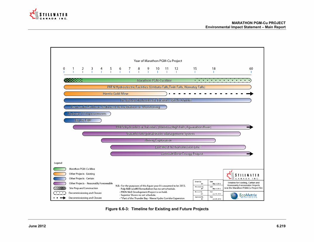
MARATHON PGM-Cu PROJECT Environmental Impact Statement – Main Report
June 2012 6.219
Figure 6.6-3: Timeline for Existing and Future Projects

MARATHON PGM-Cu PROJECT Environmental Impact Statement – Main Report
June 2012 6.220
Table 6.6-4: Summary of Potential Effects that May Overlap in Type of Effect, Time or Space
Air
quality
Acoustic
environment
Surface
water
quantity
Vegetation Wildlife Species at
Risk -
Birds
Species at
Risk –
Woodland
Caribou
Social
Factors
Land and
Resource
Use
Aboriginal
Considerations
Existing Projects/Activities
Hemlo Gold Mine (David Bell
and Williams)
●□ ●□▲ ●□▲ ●□▲ ●□▲
PRFN Hydroelectric Facilities
(Umbata Falls, Twin Falls,
Wawatay Falls
●□ ●□▲ ●□▲ ●□▲ ●□▲1 ●□
Peninsula Harbour Sediment
Remediation Project at Jellicoe
Cove
Certain Projects/Activities
Big Pic Forest Management
Plan
●□▲ ●□▲ ●□▲ ●□▲ ●□▲
Highway 17 Resurfacing ●□▲ ●□
Highway 17 Bridge Repair ●□ ●□
Pic Mobert Gitchi Animki
Hydroelectric Facility
●□ ●□▲ ●□▲ ●□▲ ●□
Reasonably Foreseeable
Projects/Activities
Mining Exploration ●□ ●□▲ ●□▲ ●□▲ ●□▲ ●□▲
Pulp Mill Landfill
Town of Marathon Regional
Waste Management Site
●□▲
Pic River First Nations ●□ ●□▲ ●□▲ ●□▲ ●□▲ ●□

MARATHON PGM-Cu PROJECT Environmental Impact Statement – Main Report
June 2012 6.221
Hydroelectric Facilities at
Manitou Falls and High Falls
Pic River First Nations Lower
Lake Hydroelectric Project
(Aguasabon River)
●□ ●□▲ ●□▲ ●□▲ ●□
Pic River First Nation Well
Development Project
Superior Shores Wind Farm ●□ ●□▲ ●□▲ ●□▲ ●□▲ ●□▲
Coldwell Wind Energy Project ●□ ●□▲ ●□▲ ●□▲ ●□▲ ●□▲
East-West Tie Transmission
Line
●□▲ ●□▲ ●□▲ ●□▲
● Potential overlapping environmental effect with other projects/activities.
□ Potential overlapping timeline of effect with other projects/activities.
▲Potential overlapping of effect spatially with other projects/activities
1. Only Umbata Falls overlaps with the Marathon PGM-Cu Project

MARATHON PGM-Cu PROJECT Environmental Impact Statement – Main Report
June 2012 6.222
6.6.1.5 Assessment of Cumulative Effects
Based on the screening assessment described in the previous section and summarized in Table 6.6-4, the following VECs and projects were assessed for cumulative effects with the Marathon PGM-Cu Project:
Air quality (Highway 17 resurfacing); Vegetation (Hemlo Gold Mine, Big Pic Forest Management Plan, mining exploration, all
PRFN Hydroelectric Facilities, Pic Mobert Hydroelectric Facility, Superior Shores Wind Farm, Coldwell Wind Energy Project, and East-West Tie transmission line);
Wildlife (Hemlo Gold Mine, Big Pic Forest Management Plan, mining exploration, all PRFN Hydroelectric Facilities, Pic Mobert Hydroelectric Facility, Superior Shores Wind Farm, Coldwell Wind Energy Project, and East-West Tie transmission line);
Species at Risk; and o Birds (same as wildlife) o Woodland Caribou (Big Pic Forest Management Plan, mining exploration, PRFN
Hydroelectric Facilities (Umbata Falls, Manitou and High Falls), Superior Shores Wind Farm, Coldwell Wind Energy Project, and East-West Tie transmission line);
Aboriginal Considerations (Hemlo Gold Mine, mining exploration, Big Pic Forest Management Plan, Superior Shores Wind Farm, Coldwell Wind Energy Project, and Town of Marathon Regional Waste Management Site)
Air Quality
Some potential residual effects on localized air quality from the Marathon PGM-Cu Project were identified mainly as a result of emissions of particulate matter and combustion products during the site preparation and construction phase. Atmospheric emissions of particulate matter and combustion products from Highway 17 resurfacing, planned from 2012 to 2017, have the potential to overlap with the air quality effects from the Marathon PGM-Cu Project; however this is not likely to result in a cumulative adverse effect as any exceedances of ambient air quality standards will be short-term and localized. The air quality assessment for the Marathon PGM-Cu Project identified potential short-term exceedances of air quality criteria for NOx (exceedance of provincial but not federal criteria) and PM10 (exceedance of federal but not provincial criteria) at portions of the Property boundary, mainly during site preparation and construction. At the closest sensitive receptor location on the highway, however, (May’s Gifts) ambient air quality criteria are not predicted to be exceeded during all phases of the Project. As such, any atmospheric emissions are predicted to be localized to the vicinity of the Property boundary and will be transient in nature. Cumulative adverse impacts from Highway 17 resurfacing in the vicinity of the Project are unlikely given the probable short duration of the activity and the compliant ambient air quality otherwise predicted at May’s Gifts.
Vegetation

MARATHON PGM-Cu PROJECT Environmental Impact Statement – Main Report
June 2012 6.223
The Marathon PGM-Cu Project will result in a net loss of primarily forest cover (mainly white birch), non-forest cover (wetlands and rock barren), and some individual rare plants; however, the overall loss of vegetation will be minimized through site reclamation. Overall, 201 ha of forest cover and 18 ha of non-forest vegetation will be permanently lost. There may be a net gain in number of rare plants through site reclamation, based on actively planting rare plants.
Hemlo Gold Mine resulted in some loss of vegetation for mine construction and infrastructure. Any potential expansion will result in some additional loss of vegetation although this is likely to be minimal and within the disturbed footprint of the mine. Mining exploration activities, forest harvesting according to the forest management plan, PRFN Hydroelectric Facilities, Pic Mobert Hydroelectric Facilities, Superior Shores Wind Farm, and Coldwell Wind Energy Project will also result in some loss of vegetation; however this is not likely to result in a cumulative effect as the loss of vegetation will be minimal. Specifically, the Coldwell Wind Energy Project EIS identified a residual effect associated with permanent loss and alteration of 183 ha of terrestrial habitat/vegetation cover and temporary loss of 5 ha of vegetation cover, which is on a similar scale as the loss of vegetation expected from the Marathon PGM-Cu Project (Hatch Energy, 2008).
It is unknown at this point how much land will need to be cleared for the construction of the East-West Tie transmission line, but since the transmission line will follow much of the existing line and make use of the existing transfer stations in Marathon, Wawa, and Lakehead, the area that will need to be cleared is likely to be minimal. At this point, it is unknown what level of activity will occur with respect to the identified mining exploration projects. If mining exploration does occur the area that will be disturbed is expected to be minimal, especially if access to the sites is obtained through helicopters and not development of road infrastructure, which would be expected.
Overall, the loss of vegetation is partially reversible for all projects through site reclamation, and there is abundant similar forest cover found on a regional basis.
Wildlife
Some disturbance to wildlife or wildlife habitat is likely to result from the Marathon PGM-Cu Project. The residual effects identified on furbearers, moose, grey wolf, black bear, and migratory birds from the Marathon PGM-Cu Project were assessed as not significant. Removal of forest cover and other vegetation will affect wildlife habitat and cause some wildlife to leave the site in search for alternatives. Furbearers and black bear prefer forest habitat, moose prefer forested areas along waterways and corridors, and wolves follow prey species such as moose. For most wildlife, similar suitable habitat exists in the local study area; therefore, displacement will be minimal. The identified adverse effects on wildlife are reversible. After decommissioning and closure, site reclamation will restore habitat for furbearers and migratory birds. Moose, grey wolves, and black bears may return to the site earlier, if human habituation occurs.

MARATHON PGM-Cu PROJECT Environmental Impact Statement – Main Report
June 2012 6.224
Wildlife disturbance and habitat displacement likely resulted from the Hemlo Gold Mine and may result from forest harvesting, future mining exploration projects, existing PRFN Hydroelectric Facilities, construction of new PRFN Hydroelectric Facilities, Pic Mobert Hydroelectric Facility, Superior Shores Wind Farm, Coldwell Wind Energy Project, and the East-West Tie transmission line.
As outlined in the previous section for vegetation, the expected effects from the clearing associated with these projects are expected to be minimal; therefore wildlife and wildlife habitat disturbance are expected to be minimal. Particularly with respect to mining exploration, after mining exploration ceases, habitats will be restored and wildlife will return to the areas unless the projects proceed to mines, which is not reasonably foreseeable at this time. It is anticipated that the East-West Tie transmission line will twin the existing line; therefore the effects on wildlife and wildlife habitat are expected to be minimal
Wildlife and wildlife habitat disturbance to all of the identified VECs from the PRFN hydroelectric facilities will likely only occur during the construction phase of the project; therefore should not result in a cumulative effect with the Marathon PGM-Cu Project.
The anticipated operating life of the existing Hemlo Gold Mine is an additional ten years; after which the site will likely be reclaimed and any wildlife and wildlife habitat disturbance will cease.
The Coldwell Wind Energy Project has the potential to affect migratory birds; however, the Environmental Screening Report (Hatch Energy, 2008) indicated that the wind project is not along a major migratory route for passerines. Additionally, the wind project will result in bird fatalities due to collisions. The number of bird strikes resulting from the Marathon PGM-Cu Project will be minimal. The wind project is expected to result in bird strikes that are lower than the average of 2.3 bird fatalities/turbine/yr for most wind power facilities in North America (Hatch Energy, 2008). This assessment can be applied to the Superior Shores Wind Farm.
Overall, wildlife displacement and habitat disturbance from the relevant existing, certain, and reasonably foreseeable projects/activities from all identified wildlife VECs are not expected to act cumulatively with the wildlife effects identified for the Marathon PGM-Cu Project.
Species at Risk
Birds
The Marathon PGM-Cu Project will result in removal of some nesting habitat for four species of birds that have been identified as species at risk. As outlined in the discussion on vegetation, the expected effects from the clearing associated with the mining exploration projects, forest harvesting, hydroelectric facilities, and the East-West Tie transmission line are expected to be minimal; therefore birds and bird nesting habitat disturbance are expected to be minimal. Bird kills associated with the Coldwell Wind Energy Project and Superior Shores Wind Farm are discussed under wildlife.

MARATHON PGM-Cu PROJECT Environmental Impact Statement – Main Report
June 2012 6.225
Woodland Caribou
The Marathon PGM-Cu Project site is located within the Lake Superior Coastal Range. An objective of the MNR caribou conservation strategy is to maintain caribou connectivity between the coastal range and the area north of this 10-km wide strip along the coast with the Upper Lake Superior Uplands linkage.
The Marathon PGM-Cu Project site has no documented historic or current use by woodland caribou as indicated by OMNR records, surveys conducted during the present study, and traditional ecological knowledge provided to Stillwater for this EIS. The Project is expected to have little or no effect on caribou habitat. There is no known calving or nursery habitat near the Project; the two islands on Bamoos Lake to the north of the Project are unsuitable primarily due to their small size and proximity to the mainland. There is no preferred winter habitat on the project site due to the low abundance of mature, conifer-dominated forests as well as other landscape attributes. Although atypical, it is possible that caribou could use small, lichen-rich openings on some of the bedrock hills near the Project, but there is no evidence of past or current use.
Approximately 360 ha of potential caribou refuge habitat is within 500 m of the Project; however, all but 12 ha of potential refuge habitat is in what is considered by OMNR and Environment Canada models as disturbed habitat (i.e., within the existing 500 m of existing disturbance). The potential refuge habitat found in scattered patches on the site, mainly near the highway and Pic River, and the abundance of predators and alternate prey on the site further reduces its suitability for use by woodland caribou. Refuge habitat is abundant elsewhere in the adjacent “coastal” and “discontinuous” ranges.
The vast majority of the Project site is already considered disturbed; the proposed Marathon PGM-Cu Project. Approximately 27% of the Lake Superior Coastal Range and 68% of the discontinuous range (Lake Superior Uplands Linkage) is already classified as disturbed by OMNR’s range assessment protocol (Northern Bioscience, 2012c). The Marathon PGM-Cu Project will likely add approximately 258 ha of new disturbance or 0.07% of additional disturbance to the coastal range. Mining exploration, some of the PRFN Hydroelectric Facilities, the East-West Tie Transmission Line, and the wind projects may potentially add to the disturbance.
Many of the mining exploration projects fall within the coastal range west of Pukaskwa National Park. Disturbance can occur from exploration mainly through clearing of trails, stripping down to bedrock, and drilling; therefore, there is potential for cumulative effects in this portion of the coastal range, as shown in Figure 6.6-4. The planned PRFN Hydroelectric facilities are outside the coastal range, however, access roads and transmission lines will likely go through the coastal range. The existing PRFN hydroelectric facility at Umbata Falls is within the coastal range. Additionally, the East-West Tie Transmission Line may potentially run through the coastal range.

MARATHON PGM-Cu PROJECT Environmental Impact Statement – Main Report
June 2012 6.226
Planned forest harvesting according to the Big Pic Forest Management Plan could also act cumulatively with effects on woodland caribou connectivity. Although there are deferral zones within the coastal zone, there are areas of planned harvest within the coastal range (see Figure 8 in Northern Bioscience, 2012c) that may negatively affect persistence of caribou, particularly if regenerating cutovers increase moose, and ultimately wolf densities. Woodland caribou could avoid these cleared areas due to predation, potentially affecting connectivity through the coastal range.
Figure 6.6-4: Mining Claims in Coastal and Discontinuous Range West of Pukaskwa National Park
Environment Canada (2011b) estimated the probability that the current range will support a self-sustaining population of boreal caribou based on integrated probability assignments using population trend and size, and level of disturbance associated with anthropogenic activities and fire. Environment Canada’s analysis of the Coastal Range (which includes Michipicoten Island, the Slates Islands, Pukaskwa and adjacent mainland shoreline and islands) found that current range conditions are likely to maintain a self-sustaining population over time. OMNR has adopted a similar strategy for evaluating cumulative effects on woodland caribou ranges. The

MARATHON PGM-Cu PROJECT Environmental Impact Statement – Main Report
June 2012 6.227
results of these assessments will "evaluate range quality in terms of thresholds, probability of persistence, and habitat composition and structure" (OMNR 2009a).
OMNR has not yet conducted a detailed integrated range assessment for the Lake Superior Coastal Range, but a preliminary range assessment is available.
Building upon GIS layers from OMNR’s preliminary range assessment, Northern Bioscience (2012c) calculated the coastal range to be 27% disturbed (i.e., within 500 m of existing natural or anthropogenic disturbance). Existing projects detailed in 6.6.1.4.1 are included in the 500 m disturbance buffer as are the projects within the coastal range that are considered “certain”. The exact location of many “reasonably foreseeable” projects within the coastal range is unknown at this stage, but it is likely that most would largely fall within existing disturbed areas (based on a 500 m buffer) where existing infrastructure is located. Future projects, including “reasonably foreseeable” ones, will be subjected to OMNR’s screening tool (currently under development) for assessing proposed developments within the caribou range to ensure they do not exceed disturbance thresholds that are considered sustainable.
Based on Environment Canada’s model for caribou critical habitat, a caribou population on a landscape with 27% disturbance is likely to be self-sustaining, assuming an estimated population of approximately 500 caribou within the coastal range. This scenario may be somewhat optimistic, since the only occupied area in the coastal range is essentially Pukaskwa National Park and west; Michipicoten Island (15 km offshore) is effectively a separate population (and has the greatest number of caribou). The actual proportion of disturbed habitat for the western half of the Lake Superior Coastal Range (including Pukaskwa and areas west) is 35%; ranges with >45% disturbance are not considered self-sustaining (Environment Canada, 2011). Given the heightened concern regarding woodland caribou additional disturbance to coastal woodland caribou habitat was carried forward to the assessment of significance of residual cumulative effects.
Aboriginal Considerations
The development of the Project requires the disturbance of and/or restricted access to SSA from the beginning of the site preparation and construction phase until such time following the cessation of operations as the site is deemed safe for access. SCI will continue to facilitate access by Aboriginal peoples to the perimeter of the SSA and to the LSA during operation of the mine.
According to Carruthers (2008), the Marathon PGM-Cu Project, some mining exploration activities, the Coldwell Wind Energy Project, and some planned harvest according to the Big Pic Forest Management Plan will occur within the PRFN exclusive and/or joint claim area. This could result in a cumulative effect on traditional land use within this area. Carruthers stated that PRFN is interested in improved consultation activities with project proponents to arrive at

MARATHON PGM-Cu PROJECT Environmental Impact Statement – Main Report
June 2012 6.228
suitable agreements. Carruthers (2008) does note the pro-active consultation of some organizations such as Brookfield Power, and SCI (formerly Marathon PGM).
Mining exploration activities, construction of the Town of Marathon Regional Waste Management System, the Superior Shores Wind Farm, and Coldwell Wind Energy Project may result in some loss of access to those sites for traditional pursuits such as hunting, trapping, and collection of country foods. Considering the high level of importance PRFN attaches to traditional land and resource uses, lack of access to these other sites could result in a cumulative effect with the Marathon PGM-Cu Project. However, the anticipated footprint for mining exploration activities, the Town of Marathon Regional Waste Management System and the wind projects are small compared to the traditional lands of the Aboriginal groups, particularly PRFN. Additionally, site access limitations for mining exploration projects will generally be for a minimal timeframe. The anticipated operating life of the existing Hemlo Gold Mine is an additional ten years; after which the site will likely be reclaimed and any site access restrictions will cease.
Planned harvest through the Big Pic Forest Management Plan could affect use of those areas for traditional purposes such as hunting, trapping, and collection of country foods. This could act cumulatively with the Marathon PGM-Cu Project.
Overall, other projects and activities within the RSA could result in a cumulative effect on Aboriginal considerations with the Marathon PGM-Cu Project; therefore, this cumulative effect was carried forward to the assessment of significance of residual cumulative effects.
6.6.1.6 Mitigation Measures of Cumulative Effects
As a result of this cumulative effects analysis, two residual cumulative adverse effects were carried forward to the assessment of significance of residual cumulative effects:
Additional disturbance to coastal woodland caribou habitat may contribute to decreasing connectivity and decreasing the self-sustainability of the coastal woodland caribou population; and,
Development of the Marathon PGM-Cu Project in conjunction with other existing, planned and reasonably foreseeable projects in the area may disturb and/or restrict access for Aboriginal groups for traditional purposes.
Measures to minimize the potential impact of the Project on Woodland Caribou could include habitat management, linear disturbance management, alternate prey management, translocation, and monitoring, as discussed in Northern Bioscience (2012c). The appropriate contribution of Stillwater to these measures will be determined in consultation with government and possibly others during the environmental assessment and permitting process.
SCI has engaged Aboriginal peoples directly to understand their concerns and identify important features and uses of the landscape. These engagement activities were undertaken in a variety

MARATHON PGM-Cu PROJECT Environmental Impact Statement – Main Report
June 2012 6.229
of forums including among other things presentations to Aboriginal communities, meetings with Chiefs and Council and meetings with smaller groups such as the Joint Consultation Committee in the case of the PRFN. The full range of engagement activities undertaken with Aboriginal peoples is summarized in Section 4.0 of this EIS. These engagement activities resulted in an appropriate 30% reduction in the footprint of the mine. To mitigate the impact of site access restrictions, SCI will work with the PRFN and other interested Aboriginal peoples to develop a protocol to provide continued access to areas of the Project site that are outside of the primary areas of mining activity during operation of the mine. As noted in Section 6.2.11.11, SCI is optimistic it will be able to conclude appropriate benefit arrangements with PRFN and other local First Nations, and ongoing consultation has been planned on other potential mitigation measures.
6.6.1.7 Assessment of Significance of Residual Cumulative Effects
The significance of residual adverse cumulative effects has been assessed according to the same criteria identified for the assessment of significance of residual effects for the Project.
Woodland Caribou
Northern Bioscience, as noted above, has calculated coastal range disturbance to be 27% using OMNR GIS information. This calculation includes future "certain" projects. As also noted above, it is reasonable to assume that at least some of the "reasonably foreseeable" projects identified above will be constructed within areas of existing disturbance. The SCI Project will, as further noted above, only add an additional .07% of additional disturbance to the coastal range. Onsite and possibly offsite mitigation and enhancement options for woodland caribou in relation to the Project are discussed earlier in this section. Northern Bioscience has therefore concluded that the cumulative effect of the Project together with other certain and reasonably foreseeable projects in the coastal range will not have a significant residual adverse effect on woodland caribou in the coastal range.
Aboriginal Considerations
The residual effect of the Project on Aboriginal considerations is primarily the disturbance of, and restrictions on access to, the Project site during operation of the mine. The effect has been partially mitigated by reduction in the footprint of the mine and will be further mitigated by provision of access for Aboriginal peoples to the traditional lands beyond the perimeter of the SSA. Access will be restored for the Marathon PGM-Cu Project after site reclamation, and most traditional uses of the Project site should be able to be re-established over time.
SCI is in discussion with affected First Nations on potential benefits arrangements and consultation on additional possible mitigation measures is planned.
The access restrictions and mitigation arrangements in place for the other identified project and activities in the LSA whose residual effects may act cumulatively with the Project are not known

MARATHON PGM-Cu PROJECT Environmental Impact Statement – Main Report
June 2012 6.230
and are typically confidential. However, it is believed that various mitigation, benefits and/or joint venture agreements are in place for some of these projects with affected First Nations. Spatially, the total area occupied by these projects and activities is low, in comparison to, for example, the total exclusive and joint title area claimed by the PRFN or the area covered by the Robinson-Superior Treaty. No basis has been identified to conclude that there will be a significant adverse cumulative impact on the interest of any First Nation or Aboriginal community from the Project together with the other current and planned project and activities in the RSA.
6.6.1.8 Follow-up Program
Follow-up monitoring is proposed as per Section 7.3 to confirm adverse effects do not occur and that planned in-design mitigation measures are effective. No additional follow-up monitoring is required based on the results of the assessment of cumulative effects.