Section 6 Health and Safety - Cupertino
41
INTRODUCTION The City of Cupertino will be a safe, pro- gressive and balanced community, where resi- dents can live and businesses thrive in a pro- tected and secure environment. The purpose of the Health and Safety Element is to identify and evaluate hazards in the community and to protect it from the risks associated with these hazards. To ensure the protection of the com- munity, the Health and Safety Element sets forth goals, policies, and strategies addressing the potential risks associated with these haz- ards. Implementation of these goals, policies and strategies will prevent or minimize inju- ries to life and damages to property. Cupertino will maintain a high level of preparedness to protect the community from risks to life, property and the envi- ronment associated with both natural and human-caused disasters. Natural hazards are earthquakes, floods, wildfires and landslides. Human-caused hazards are usually the result of carelessness, e.g., urban fires, failures of inappropriately designed structures or long term exposure to excessive noise. Cupertino will provide effective and efficient fire ser- vices to protect the community from both wild and urban fires. It will provide paramedic services and life-safety aid to victims of cata- strophic events. Cupertino will also provide health services to promote the well being of the community, police and crime prevention services to ensure the safety of the communi- ty and Emergency Services disaster planning and training to enhance our ability to respond to disasters. 6-1 City of Cupertino General Plan Section 6 Health and Safety CONTENTS 6-1 Introduction 6-2 Geologic and Seismic Hazards 6-9 Fire Hazards 6-17 Crime and Police Services 6-19 Hazardous Materials 6-20 Electromagnetic Fields (EMF) 6-20 Hazardous Waste 6-22 Disaster Planning 6-25 Flood Hazards 6-30 Noise Pollution Health and Safety Housing Land Use / Community Design Circulation Environmental Resources/ Sustainability
Transcript of Section 6 Health and Safety - Cupertino

INTRODUCTION
The City of Cupertino will be a safe, pro-gressive and balanced community, where resi-dents can live and businesses thrive in a pro-tected and secure environment. The purpose of the Health and Safety Element is to identify and evaluate hazards in the community and to protect it from the risks associated with these hazards. To ensure the protection of the com-munity, the Health and Safety Element sets forth goals, policies, and strategies addressing the potential risks associated with these haz-ards. Implementation of these goals, policies and strategies will prevent or minimize inju-ries to life and damages to property.
Cupertino will maintain a high level of preparedness to protect the community from risks to life, property and the envi-ronment associated with both natural and human-caused disasters. Natural hazards are earthquakes, floods, wildfires and landslides. Human-caused hazards are usually the result of carelessness, e.g., urban fires, failures of inappropriately designed structures or long term exposure to excessive noise. Cupertino will provide effective and efficient fire ser-vices to protect the community from both wild and urban fires. It will provide paramedic services and life-safety aid to victims of cata-strophic events. Cupertino will also provide health services to promote the well being of the community, police and crime prevention services to ensure the safety of the communi-ty and Emergency Services disaster planning and training to enhance our ability to respond to disasters.
6-1
City of Cupertino General Plan
Section 6
Health and Safety
CONTENTS
6-1 Introduction
6-2 Geologic and Seismic Hazards
6-9 Fire Hazards
6-17 Crime and Police Services
6-19 Hazardous Materials
6-20 Electromagnetic Fields (EMF)
6-20 Hazardous Waste
6-22 Disaster Planning
6-25 Flood Hazards
6-30 Noise Pollution
Circulation Healthand Safety
Land Use /Community
Design
HousingEnvironmental
Resources/Sustainability
Healthand Safety
HousingLand Use /
CommunityDesign
CirculationEnvironmental
Resources/Sustainability
EnvironmentalResources/
Sustainability
Housing
Healthand Safety
CirculationLand Use /
CommunityDesign
Healthand Safety
CirculationHousing
Land Use /Community
Design
EnvironmentalResources/
Sustainability
Healthand Safety
Land Use /Community
Design
EnvironmentalResources/
Sustainability
Circulation
Housing
6-2 Health & Safety
City of Cupertino General Plan
GEOLOGIC AND SEISMIC HAZARDS
Cupertino is located in the seismically active San Francisco Bay region, which hosts several active earthquake faults. It is impor-tant for the community to be prepared for all emergencies. A well-prepared community is better equipped to cope with any eventual-ity. Cupertino will use all the available chan-nels of communication to keep the commu-nity apprised of the potential risks related to geologic and/or seismic activity.
One of the longest and most active faults in the world, the San Andreas fault, crosses the western portion of Cupertino’s planning area. In addition, two other faults that are closely associated with the San Andreas fault, the Sargent-Berrocal and Monta Vista-Shannon fault systems, cross the west portion of the City. These faults manifest a variety of displacement styles. Movement on the San Andreas fault is predominantly right-later-al strike-slip, where the earth ruptures in a horizontal fashion, with the opposite sides
of the fault moving to the right with respect to each other. Movement on the Sargent-Berrocal and Monta Vista-Shannon faults is more variable in style. Both of these faults are characterized by “thrust” faulting, where a significant amount of vertical “up-down (so called dip-slip) displacement occurs on an inclined plane, and one side of the fault is elevated (i.e., thrust over) the other side. Figure 6-A below illustrates the above-men-tioned behavior of the various faults.
The primary geologic hazards within Cupertino are landslides and seismic impacts related to local active fault traces. Seismically induced ground shaking, surface fault rupture and various forms of earthquake-triggered ground failure are anticipated within the City during large earthquakes. These geo-logic hazards present potential impacts to property and public safety. Six identified cat-egories of Geologic Hazards within the City are presented in Table 6-A and are briefly explained. For a more detailed explanation see the Technical Appendix.
HorizontallyShifted Block
Horizontal Offsetof the Ground Surface
A. San Andreas Fault B. Sargent - Berrocal Fault
Fault Type: Right Lateral (Strike-Slip) Fault
Displacement: Horizontal
Fault Type: Thrust (Dip-Slip) FaultDisplacement: Vertical
Vertically Elevated Block
Figure 6-A. Diagrams Exhibiting Faults Within the Cupertino Planning Area Characterized By Horizontal (A) and Vertical (B) Displacements.†

6-3Geologic and Seismic Hazards
City of Cupertino General Plan
Following the 1983 Coalinga and 1994 Northridge earthquakes, earth scien-tists became increasingly aware of earth-quakes generated by faults not previously observed at the earth’s surface. These types of faults are appropriately called “blind faults,” and they represent a type of thrust fault that does not rupture completely to the surface. Even though the locations of “blind faults” may not be known with certainty, they are clearly associated with certain types of geo-logic environments. It is possible that one or more blind faults may be associated with the Monta Vista-Shannon fault system, but sig-nificant seismic data collection and analysis
would be needed to determine the extent of risk (if any) that “blind faults” may represent within the City.
Table 6-A. Explanations: Geologic and Seismic Hazards Map of the City of Cupertino Planning Area.
Zone Description
(F)– Fault Rupture Area of potential surface fault rupture hazard within 300 feet east and 600 feet west of the Monta Vista and Berrocal faults, and within 600 feet of the San Andreas fault.
(S)– Slope Instability Area includes all recognized landslide deposits, and steep walls of Stevens Creek canyon, with a moderate to high landslide potential under static or seismic conditions. Area also reflects the mapped zone of potential earthquake-induced landsliding prepared by the California Geological Survey (2002)
(H)– Hillside Area contains moderate to steep slope conditions not included in the above categories, with an undetermined potential for slope instability.
(L)– Liquefaction / Area where local geological, geotechnical and groundwater Inundation conditions indicate a potential for liquifaction under seismic condi-
tions. Much of this area also has the potential for periodic flood inunda-tion. The Liquifaction/Inundation Zone is stippled where covered by an overlaying Fault Zone.
(V)– Valley Area includes all relatively level valley floor terrain not included in the above categories with relatively low levels of geologic hazard risk.

6-4 Health & Safety
City of Cupertino General Plan
FOO
THIL
L B
LVD
STEL
LIN
G R
D
De
AN
ZA
BLV
D
HOMESTEAD ROAD
WO
LFE
RD
STEVENS CREEK BLVD
BLA
NEY
AV
E
MIL
LER
AV
E
BOLLINGER RD
McCLELLANROAD
RAINBOW DRIVE
BU
BB
RO
AD
PROSPECT RD
85
280
TAN
TAU
AVE
Stevens CreekReservoir
SantaClara
County
SantaCruz County
Legend
Sunnyvale
Santa Clara
San Jose
Saratoga
0 1000
0 500
3000
0 0.5 1 Mile
1000
Feet
Meters
Los Altos
Fault Rupture
Slope Instability
Hillside
Inundation / Liquefaction
Valley Floor
Known Fault
Inferred Fault
Concealed Fault
Urban Service Area Boundary
Boundary Agreement Line
See Table 6-A fora description of the Hazard Zones.
Hazard Zones:
Fault
San Andreas Fault
Be
rroca
l
Fault
Monta V
ista
F
F
F
F
F
F
H
L
L
L
LL
L
L
L
H
H
H
V
V
V
VV
S
S
Figure 6-B. Geologic and Seismic Hazards
Figure 6-B generally depicts the loca-tion of the various known faults and hazard zones within the Cupertino planning area.
Table 6-B provides estimates of the recurrence intervals of maximum earth-quakes expected for faults that would likely affect the Cupertino area. The recurrence interval on the San Andreas fault, which last
ruptured in 1906, is about 220 years. Data pertaining to the recurrence intervals of large earthquakes on the Sargent-Berrocal and the Monta Vista-Shannon fault systems are less constrained. However, each year that passes without a major earthquake means that an earthquake is more likely to occur within any future year.
Geologic and Seismic Hazards

6-5Geologic and Seismic Hazards
City of Cupertino General Plan
GoaA
Reduced Risks associated with GeoloGic and seismic hazaRds
The following policies will be imple-mented during the development review pro-cess, as regulating new development offers the greatest rewards in risk reduction. While it is difficult to improve existing develop-ment, it is much easier to locate and design new buildings to achieve this goal.
Policy 6-1: Seismic/Geologic Review Process
Evaluate new development proposals within mapped potential hazard zones using a formal seismic/geologic review process. Use Table 6-D of this Hazards Analysis to determine the level of review required.
Strategies
1. Acceptable Level of Risk. Encourage developers to consult with design pro-fessionals regarding performance-based design to achieve levels of safety that exceed the Uniform Building Code. The design criteria should be the maxi-mum credible earthquake for that site. Hazardous materials use and storage facilities should aim for the highest level of seismic resistance.
2. Geotechnical and Structural Analysis. Require all developers to provide geo-technical analyses per the requirements of the California Seismic Hazards Mapping Act and the California Environmental Quality Act. In addition, require any site with a slope exceeding 10% to reference the Landslide Hazard Potential Zone maps of the State of California.
Table 6-B. Maximum Earthquake Magnitudes and Recurrence Intervals.
Distance Maximum Maximum Est. Recurrence from Historic Probable Interval of Causative De Anza/SCB Moment Moment Max. Prob. Faults Intersection Magnitude Magnitude Earthquake
San 5.5 Miles 7.9 7.9 220 Years Andreas
San HaywardAndreas (South) 10 Miles 7.0 7.0 236 YearsSystem Calaveras (Central) 14 Miles 6.2 7.0 374 Years
Sargent- 3.5 Miles 3.7 – 5.0 6.8 330 YearsSargent- Berrocal BerrocalSystem Monta 2 Miles 2.0 – 3.0 6.8 2400 Years Vista – Shannon

6-6 Health & Safety
City of Cupertino General Plan
3. Earthquake-Resistant Design Tech-niques. Encourage new earthquake-resistant design techniques in the design and structural engineering of buildings.
4. Residential Construction Standards Upgrade. Review construction stan-dards for residences to reduce earth-quake damage. Examples include addi-tional bracing for garage openings of two-story and split-level homes and increased first story bracing in multiple-family residences over parking garages. Encourage property owners to upgrade standards in these situations.
5. Current Building Code. Require that any residential facility that is being increased more than 50% in price, or more than 50% in size, conform to the building code then in existence throughout the entire structure. Owners of residential build-ings with known structural defects, such as un-reinforced garage openings, “Soft first story” construction, unbolted foun-dations, or inadequate sheer walls are encouraged to take steps to remedy the problem and bring their buildings up to the current building code.
6. Geotechnical Review Procedure. Adopt a geotechnical review procedure that incorporates these concerns into the development review process.
It may not be practical to improve sev-eral types of buildings to incorporate revised earthquake safety standards. Fortunately, most buildings in Cupertino have been con-structed in recent years and were designed under a building code that includes compo-nents and designs that resist ground shaking.
Still, structures identified as “critical facilities” should be re-evaluated, especially those in the high-hazard zones. Many seis-mic safety evaluations have been completed. Cupertino’s schools complied with the Field Act at the time they were built. The State Department of Transportation (DOT) has a priority program to reinforce all freeways. Route 85 was built under current seismic resis-tance standards, and the De Anza overcrossing was redesigned to current standards when it was widened. DOTis reviewing other freeway over-crossings to determine if they need addi-tional work. A City mandate to evaluate the structural integrity of all non-critical public or private buildings is not economically viable, but City government should educate residents, employers, and business owners to protect their property and reduce risk of injury.
Acceptable Level of Risk
Land use and building design standards must relate to the degree of geologic and seis-mic hazards in the zone in which a proposed project would be built so that an acceptable level of risk can be assigned. City Planning staff will work with developers to ensure that all CEQA requirements are met, and to encourage performance based design to exceed life safety only, and to seek to achieve con-tinuing functionality of critical infrastructure and facilities where hazardous materials and hazardous wastes are used or stored.

6-7Geologic and Seismic Hazards
City of Cupertino General Plan
Table 6-C. Acceptable Exposure to Risk Related to Various Land Uses.
Land uses and structural types are arranged below according to the level of exposure to acceptable risk appropri-ate to each group; the lowest level of exposure to acceptable risk should be allowed for Group 1 and the highest level of exposure to acceptable risk for Group 7.
Acceptable Land Use Extra Project Cost To Exposure Group Reduce Risk To To Risk Acceptable Level
EXTREMELY Group 1 VULNERABLE STRUCTURES (nuclear As required for maximumLOW reactors, large dams, plants manufact- attainable safety uring/ storing hazardous materials)
Group 2 VITAL PUBLIC UTILITIES, (electrical Design as needed to remain transmission interties/substantions, functional after max. prob. regional water pipelines, treatment earthquake on local faults plants, gas mains)
Group 3 COMMUNICATION/TRANSPORTATION 5% to 25% of project cost (airports, telephones, bridges, freeways, evac. routes)
SMALL WATER RETENTION Design as needed to remain STRUCTURES functional after max. prob. earthquake on local faults
EMERGENCY CENTERS (hospitals, fire/police stations, post-earthquake aide stations, schools, City Hall and Service Center, De Anza College)
Group 4 INVOLUNTARY OCCUPANCY FACILITIES (schools, prisons, convalescent and nursing homes)
HIGH OCCUPANCY BUILDINGS (theaters, hotels, large office/apartment bldgs.)
MODERATELY Group 5 PUBLIC UTILITIES, (electrical feeder 5% to 25% of project costLOW routes, water supply turnout lines, sewage lines) Design to minimize injury, loss of FACILITIES IMPORTANT TO LOCAL life during maximum probable ECONOMY earthquake on local faults; need not design to remain functional
ORDINARY Group 6 MINOR TRANSPORTATION (arterials 2% of project cost; to 10%RISK LEVEL and parkways) project cost in extreme cases LOW-MODERATE OCCUPANCY BUILDINGS (small apartment bldgs., single-fam. resid., motels, small commercial/office bldgs.)
Group 7 VERY LOW OCCUPANCY BUILDINGS Design to resist minor earthquakes (warehouses, farm structures) w/o damage; resist mod. Earthquakes w/o struc. damage,with some non- struct. damage; resist major OPEN SPACE & RECREATION AREAS earthquake (max. prob. on local (farm land, landfills, wildlife areas) faults) w/o collapse, allowing some struc. & non-struc. damage

6-8 Health & Safety
City of Cupertino General Plan
Table 6-D shows a policy position on the amount of technical evaluation needed to ensure that hazards in new develop-ments are reduced to an acceptable level of risk based on land use. Critical facilities in Cupertino’s planning area should be evalu-ated and modified structurally to withstand a maximum earthquake.
The State of California and its local governments have developed a variety of building codes to prevent loss of life in the maximum, credible earthquake. It is the policy of the City of Cupertino to endorse performance based design of all structures to
encourage functionality after the maximum, credible earthquake. While every earth-quake is unique, and the specific shaking intensity at a given site cannot be exactly predicted, facilities that relate to the provi-sion of essential health and safety services should be designed and built to achieve post-earthquake functionality.
Policy 6-2: Public Education on Seismic Safety
Reinforce the existing public educa-tion program to help residents reduce earthquake hazards.
Table 6-D. Technical Investigations Required based on Acceptable Risk.
Land Use Activity Hazard Zone Map Symbol
F S H L V Evaluation Required Evaluation Required
Groups 1 to 4 UBC UBC Soils Soils Geology Seismic Hazard Seismic Hazard
Groups 5 to 7 UBC UBC Soils Soils Geology
Descriptions of Technical Evaluations:
UBC 1997 (or latest City adopted) Edition, Uniform Building Code
Soils Soils and foundation investigation to determine ability of local soil conditions to sup-port structures
Geology Determine subsidence potential, faulting hazard, slope stability (See Geologic Hazards Map for additional detail)
Seismic Hazard Detailed Soils/Structural evaluation to certify adequacy of normal UBC earthquake regulations or to recommend more stringent measures

6-9Fire Hazards
City of Cupertino General Plan
Strategies
1. Covenant on Seismic Risk. Require developers to record a covenant to tell future residents in high-risk areas about the risk and inform them that more infor-mation is in City Hall records. This is in addition to the State requirement that information on the geological report is recorded on the face of subdivision maps.
2. Emergency Preparedness. Publish and promote emergency preparedness activi-ties and drills. Use the Cupertino Scene and website to provide safety tips that may include identifying and correcting household hazards, knowing how and when to turn off utilities, helping fam-ily members protect themselves during and after an earthquake, recommending neighborhood preparation activities, and advising residents to maintain an emer-gency supply kit containing first-aid sup-plies, food, drinking water and battery operated radios and flashlights.
3. Neighborhood Response Groups. Encourage participation in Community Emergency Response Team (CERT) training. Train neighborhood groups to care for themselves during disasters. Assist in neighborhood drills.
4. Dependent Populations. Actively coop-erate with State agencies that oversee facilities for vulnerable populations, to ensure that such facilities conform to all health and safety requirements, includ-ing emergency planning, training, exer-cises and employee education.
5. Foreign Language Emergency Informa-tion. Obtain translated emergency pre-paredness materials and make them available to appropriate foreign language populations.
FIRE HAZARDS
The City of Cupertino endeavors to provide its citizens with fire and emergency services of the highest standards. This makes Cupertino an attractive and safe place in which to live and do business.
Cupertino’s geographical boundaries extend from the lower foothills of the Santa Cruz Mountain Range at its westerly limits to the urbanized valley floor at its northerly, easterly and southerly limits. For this rea-son, Cupertino is exposed to hazards from both wild and urban fires. These two types of fire hazards have their own unique char-acteristics and present different fire-fighting problems. Wild fires are a threat to residents living in the rural areas of the foothills. If not contained, wild fires can have a devastating effect on a community, causing injuries and consuming vegetation and structures in their path. Urban fires pose other problems. They may include fires in high–rise buildings, mul-tiple residential structures, or fires in com-mercial and industrial buildings where highly flammable and toxic materials may be stored.
Fire fighting and emergency medi-cal services are provided to the City of Cupertino by the Santa Clara County Fire
Santa Clara County Fire Station, Stevens Creek Boulevard

Department (SCCFD) (formerly known as the Santa Clara County Central Fire Protection District). The Santa Clara County Fire Department is a full service department, which provides similar services to seven other west valley cities and adjacent County areas. Mutual aid agreements with the neighboring jurisdictions augment the SCCFD’s fire response capabilities, and the City of Cupertino is a beneficiary of these expanded capabilities.
In addition to fire protection, the SCCFD also conducts fire prevention inspec-tions and educational programs, including those on Community Emergency Response Team (CERT) training, cardio-pulmonary resuscitation (CPR) and first aid certifica-tion
Cupertino’s growth over the next 20 years will be accommodated within Cupertino’s existing urban service area, and there will not be a need to expand the exist-ing service area. This new growth, however, may generate greater demands on the exist-ing fire services. A needs assessment may have to be conducted by the SCCFD to determine the ability to continue to provide the same level of service.
The City’s and the SCCFD’S common goal is to maintain a high level of service. One of the most important measurements in the level of service is response time. Response time is critical for life safety and for minimiz-ing property damage. It is the policy of the SCCFD to respond to 90% of emergency calls in under five minutes.
A radius of one and one-half miles is considered to be the ideal service area for a fire station. However, this is not necessarily an absolute standard because there could be conditions that may affect the radius of the
service area, e.g., an area developed with large number of commercial and industrial build-ings may require a service area of only three quarters of a mile radius, while for a rural environment of single-family and two-family houses a service area of three to four miles, or more, may be acceptable. Figure 6-C, Fire Service Area Boundaries Map shows the dis-tances from the three SCCFD fire stations.
The map illustrates that the major por-tion of the community is within a one and one-half mile radius from a fire station. These distances determine potential response time; however, sometimes response time may be affected by traffic congestion and other prob-lems.
One of the major goals of fire service is to reduce response time, but this goal may sometimes conflict with City policies, e. g., the City’s policy of discouraging commute traffic from driving through neighborhoods may delay response time by making it diffi-cult for fire equipment to use direct routes. The use of private security systems, such as electronically operated entry gates, for planned residential communities may also delay response time. The use of these secu-rity measures must be looked at carefully.
An increase in calls for fire service and traffic congestion can also erode the Fire Department’s critical response time. To compensate, the Fire Department may need to adjust and/or expand staff and equipment in areas of high service demand and continue its program for placing emergency traffic pre-emption controls at key traffic signals.
Potential Fire Hazards
FiRe hazaRds in the Foothills and mountains
People who live in the foothills and
6-10 Health & Safety
City of Cupertino General Plan

mountains of Cupertino’s planning area are most at risk from fire. The City is not direct-ly involved in fire fighting in the mountains, but fire safety in the Montebello Ridge and Stevens Canyon area is of extreme importance to Cupertino. Major fires in this area could harm the Stevens Creek watershed by increas-ing flooding potential, silting up streambeds and reducing recreational opportunities.
The vegetative cover, the degree of slope and critically dry weather conditions are the three natural factors the California
Division of Forestry uses to classify the severity of potential fires in the foothills. Development in the foothills is typically low density and scattered throughout the area, making fire protection difficult. The degree of hazard to life and property in these areas is affected not only by the fire itself but also by other factors, such as, access roads for firefighting and evacuation, the available strength of fire fighting force, the availability of water to fight the fire and the effectiveness of building codes and inspection of develop-ments in the fire hazards areas.
6-11Fire Hazards
City of Cupertino General Plan
FOO
THIL
L B
LVD
STEL
LIN
G R
D
De
AN
ZA
BLV
D
HOMESTEAD ROAD
WO
LFE
RD
STEVENS CREEK BLVD
BLA
NEY
AV
E
MIL
LER
AV
E
BOLLINGER RD
McCLELLAN ROAD
RAINBOW DRIVE
BU
BB
RO
AD
PROSPECT ROAD
85
280
TAN
TAU
AVE
Stevens CreekReservoir
SevenSpringsFire Station
CupertinoFire Station
Monta VistaFire Station
3/4 Mile Service Area
1-1/2 Miles Service Area
2 Miles Service Area
City Boundary
Urban Service Area Boundary
Sphere of Influence
Boundary Agreement Line
Unincorporated Areas
Legend
Sunnyvale
Santa Clara
San Jose
Saratoga
0 1000
0 500
2000 3000
0 0.5 1 Mile
1000
Feet
Meters
Los Altos
Figure 6-E. Fire Service Area Boundaries.
Fire Service

There are about 16 square miles of land in the mountains of the Cupertino plan-ning area. Any increase in density raises the exposure to fire risks. In 1992, all properties above the 10% slope line were categorized as Hazardous Fire Areas, i.e., land that is cov-ered with grass, brush or forest, and which is also difficult to access. Structures within this area are required to have fire retardant (Class A) roofing, and property owners are required to continuously clear any brush away from their structures. Such structures are also required to have sprinklers. If a fire were to start in this area, it would be abnormally dif-ficult to suppress.
Most of the mountainous land is owned by either the Midpeninsula Regional Open Space District or the Santa Clara County Parks System. When the parks are fully active, many people could be exposed to fire risk.
B
al BeFFicient and eFFective FiRe and emeR-Gency seRvices to pRotect the community FRom hazaRds associated with wild and
uRBan FiRes
Policy 6-3: Wild Fire Prevention Efforts
Coordinate wild fire prevention efforts with adjacent jurisdictions.
Policy 6-4: County Fire Hazard Reduction
Encourage the County to put into effect the fire reduction policies of the County Public Safety Element.
Policy 6-5: Fuel Management to Reduce Fire Hazard
Encourage the Midpeninsula Open Space District and the County Parks Department to continue efforts in fuel management to reduce fire hazards.
Policy 6-6: Green Fire Breaks
Encourage the Midpeninsula Open Space District to consider “green” fire break uses for open space lands.
FiRe hazaRds in the uRBanized valley FlooR
Most people who live and work in the urbanized areas of Cupertino are not exposed to a high risk of fire. The City is served by a well-managed fire protection service as well as a fire prevention program. Buildings in the City are relatively new and there is a strong code enforcement program, an adequate water supply and a well-maintained delivery system. However, there are some geographi-cal areas in the City to which more atten-tion could be directed to reduce potential fire hazards. In urban areas the most serious concern is fires in high-rise, multiple-family dwellings and commercial and industrial structures containing highly combustible or toxic materials.
GoaC
l cFiRe pReventive measuRes that minimize the loss oF liFe and pRopeRty
Policy 6-7: Early Project Review
Involve the Fire Department in the early design stage of all projects requiring public review to assure Fire Department input and modifications as needed.
6-12 Health & Safety
City of Cupertino General Plan

Policy 6-8: Commercial and Industrial Fire Protection Guidelines
Coordinate with the Fire Department to develop new guidelines for fire pro-tection for commercial and industrial land uses.
Policy 6-9: Fire Prevention and Emergency Preparedness
Promote fire prevention and emergen-cy preparedness through city-initiated public education programs, through the government television channel, the Internet and the Cupertino Scene.
Policy 6-10: Multi-Story Buildings Fire Risks
Recognize that multi-story buildings of any land use type increase risks of fire. Ensure that adequate fire protection is built into the design and require on-site fire suppression materials and equipment to ensure the safety of the community.
Policy 6-11: Residential Fire Sprinklers Ordinance
Consider adopting a residential fire sprinkler ordinance. This will reduce fire flow requirements.
Policy 6-12: Smoke Detectors
Require smoke detectors in all new residential units, and in all residential units at time of sale or rental, in con-formance with State law. Continue to Use the Cupertino Scene to publicize fire hazards correction methods.
Policy 6-13: Wood Shake Roof Abatement
Adopt an aggressive wood shake roof abatement program to require that
any roof that is 25% or more replaced must use fire retardant materials for all replacement shakes. Wood shake roofs have been outlawed in California because of their likelihood to catch fire from external sources, such as burn-ing embers from chimneys. The law already requires fire resistant shakes on any roof that is 50% or more repaired or replaced.
BuildinG codes, FiRe codes and otheR ReGulations
To minimize potential fire hazards, the City of Cupertino regulates building construc-tion and site planning through the Uniform Fire Code and the Uniform Building Code. Cupertino’s large commercial and industrial buildings are designed with substantial areas of open space around them to preclude the spread of fire. The City also requires auto-matic sprinklers and fire detection systems to further reduce risks.
In addition, the City and the Fire Department periodically inspect commercial and industrial buildings for compliance with the applicable codes. Single-family homes do not require inspection, but smoke alarms are required in all new homes constructed in the City. The City also supports the retrofitting of existing homes with smoke detectors
Under the Uniform Fire Code, unde-veloped or sparsely developed areas pos-sessing characteristics for potentially high fire risk may be designated hazardous fire areas. In such areas, the Code regulates building materials, planting material and clearances between structures and plant-ing material. The County Fire Marshal and the Fire Department regulate activities in the fire hazard area, and have the authority to deny access to the public to any area if
6-13Fire Hazards
City of Cupertino General Plan

they determine it is in the interest of pub-lic safety. They also administer the Weed Abatement and Brush Clearance Ordinance in the hazardous fire areas. The purpose of this Ordinance is to minimize the potential of transference of brush fires and to reduce the potential accidental fires.
The City of Cupertino has a good safety record in terms of fire protection and a mini-mum of fire losses. This record is reflected in the City’s excellent fire insurance rating of Class 2 (Class 1 is considered a perfect rating). This low level of risk is the com-bined result of the high proportion of new
construction which meets current Uniform Building Code standards, and efficient fire protection service.
Constraints to Firefighting
access Roads
Access is a critical component of fire safety. Fire fighting equipment must be able to reach the location of the fire as quickly as possible. Likewise, viable means must be
provided for residents and visitors alike to escape the dangers of a fire.
Public road access is severely limited in the hillside rural areas. Emergency access roads run through private property and these property owners are asked to act indepen-dently or collectively to maintain fire access roads. Fire equipment needs roads that are passable, have less than 16% grade, a mini-mum turning radius of 42 feet and sufficient space to turn around.
Santa Clara County lists the Montebello Road/Stevens Canyon area as the fourth highest risk in the County. The road link-ing Montebello and the Palo Alto Sphere of Influence to the bottom of Stevens Canyon has been improved to acceptable standards as a fire access road. A fire trail extends from Skyline Boulevard on Charcoal Road to Stevens Canyon.
Road accessibility in the lower foothills is easier. The City requires that all-emergen-cy roads be constructed with an all weather surface. It also requires a private emergency access connection between public streets within Lindy Canyon and Regnart Canyon. However, private roads are less likely to meet the access standards. Private roads are not required to be constructed to City standards and, therefore, are usually built to lesser stan-dards than public roads. Moreover, there are no long–term guarantees that they will be maintained.
Dead end roads are risky, especially those long dead end roads that give access to many portions of Regnart Road and Stevens Canyon areas. For this reason, alternate access routes are provided via private emergency access routes.
6-14 Health & Safety
City of Cupertino General Plan

GoD
an all weatheR emeRGency Road system to seRve the RuRal aReas
Policy 6-14: Roadway Design
Involve the Fire Department in the design of public roadways for review and comments. Attempt to ensure that roadways have frequent median breaks for timely access to properties.
Policy 6-15: Dead-End Street Access
Allow public use of private roadways during an emergency for hillside sub-divisions that have dead-end public streets longer than 1,000 feet or find a secondary means of access.
Policy 6-16: Hillside Access Routes
Require new hillside development to have frequent grade breaks in access routes to ensure a timely response from fire personnel.
Policy 6-17: Hillside Road Upgrades
Require new hillside development to upgrade existing access roads to meet Fire Code and City standards.
access to Residential developments
Fire and other emergency personnel may be impeded if there are vehicular elec-tronic security gates on residential develop-ments. Therefore, vehicular electronic secu-rity gates should be discouraged unless they comply with the General Plan and receive a fence exception. All vehicular electronic security gates should meet the require-ments of the emergency service agencies, and attempts should be made to standardize access.
Policy 6-18: Private Residential Electronic Security Gates
Discourage the use of private residen-tial electronic security gates that act as a barrier to emergency personnel.
Strategies
1. Fence Exception: Require a fence exception for electronic security gates.
2. Access to Gates. Where electronic security gates are allowed, require the installation of an approved key switch.
Water Availability
Assuring water availability to the more remote areas in and around Cupertino is important to achieving a safe community.
wateR supply on monteBello RidGe and stevens canyon
Presently, there are no water systems serving the Montebello Road and upper Stevens Canyon area, with the exception of Stevens Creek itself. Because there is no water service to these areas, the County requires that each homesite be served by its own individual 10,000-gallon tank and that a sprinkler system be installed. Theoretically, it is possible to have a jointly owned and operated water storage system to reduce the required amount of on-site storage of water for each individual property, provided an adequate water main distribution system to serve all homes sharing the joint facility is in place. However, the maintenance and oper-ation costs of such a system could impose an economic burden on the homeowners if there were not enough properties within the system to make the individual share for defraying the costs reasonable. Former pri-vate systems in the area proved to be unsuc-
6-15Fire Hazards
City of Cupertino General Plan
See Chapter 16.28 of the Cupertino Municipal Code

cessful and were ultimately annexed to the major water providers in the area.
wateR supply FoR Foothill ReGions within the uRBan seRvice aRea
All development in the Urban Service Area must be served by a water system that complies with City standards for household and firefighting use.
Presently, a few developed areas, such as lots in the upper reach of Regnart Canyon and a few areas in Inspiration Heights, do not have an adequate water system. However, in the long-term, these areas may receive a better supply of water for fighting fires, as the water system is extended to serve new development in the area and the water providers in the area expand their service area to serve new growth in the area.
GoalE
eavailaBle wateR seRvice in the hillside
and canyon aReas
Policy-6-19: Extension of Water Service
Encourage the water companies to extend water service into the hillside and canyon areas.
Policy 6-20: Growth Cooperation
Encourage cooperation between water utility companies and the Fire Department in order to keep water sys-tems in pace with growth and firefight-ing service needs.
Policy 6-21: Fire Fighting Upgrades Needs
Encourage utilities to consider Fire Department firefighting needs when upgrading water systems.
wateR supply FoR Foothill ReGions
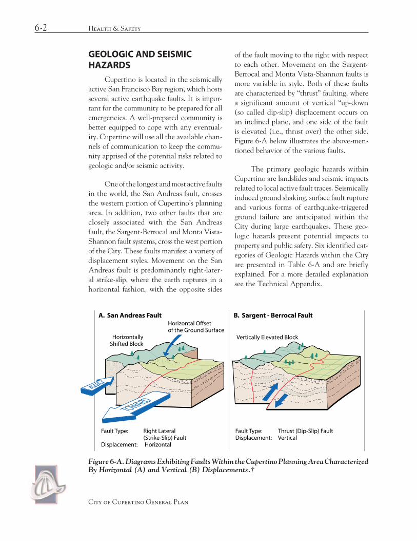
Accessibility and availability to an adequate supply of water is extremely impor-tant in firefighting. The City of Cupertino is served by two water retailers, which also serve the foothill areas: the San Jose Water Company, which leased the Cupertino Municipal Water System and annexed the Reglin Mutual Water System, and the California Water Company (see Figure 6-D). Together these two systems have adequate water lines and distribution systems to meet the fire flow needs. However, although they meet the present needs, neither private water system is required to maintain an adequate fire flow under their agreements with the City and fire agencies.
The City of Cupertino has taken a num-ber of steps to combat fire hazards. It adopted the current State Fire Code, and declared most of the Santa Cruz Mountain range as hazardous fire areas. It has also adopted the following preventive measures: 1) An early review process with the Fire Department and the City is conducted to incorporate fire pre-vention methods. 2) the City reviews build-ing plans and requires use of fire resistant materials. 3) The City also coordinates with and encourages the County of Santa Clara to uphold the weed abatement program.
6-16 Health & Safety
City of Cupertino General Plan
6-17Crime and Police Services
City of Cupertino General Plan
Water Service
FOO
THIL
L B
LVD
STEL
LIN
G R
D
De
AN
ZA
BLV
D
HOMESTEAD ROAD
WO
LFE
RD
STEVENS CREEK BLVD
BLA
NEY
AV
E
MIL
LER
AV
E
BOLLINGER RD
McCLELLANROAD
RAINBOW DRIVE
BU
BB
RO
AD
PROSPECT ROAD
85
280
TAN
TAU
AVE
Stevens CreekReservoir
Water Company Service Areas
City Boundary
Urban Service Area Boundary
Sphere of Influence
Boundary Agreement Line
Unincorporated Areas
Legend
Sunnyvale
Santa Clara
San Jose
Saratoga
0 1000
0 500
2000 3000
0 0.5 1 Mile
1000
Feet
Meters
Los Altos
San Jose Water Company
California WaterCupertino Municipal Water System(Leased to San Jose Water Company)
Figure 6-D. Water Service Areas.
Policy 6-22: Residential Fire Sprinklers
Require fire sprinklers in new residen-tial construction located in hillside areas and flag lots.
CRIME AND POLICE SERVICES
The sociological climate of a commu-nity is of extreme importance to its viabil-ity as a desirable place to live and work. Residents must be able to carry out their routine activities and enjoy the communi-ty’s assets in an environment free of worries about their well being. Businesses must also

feel comfortable and secure in the conduct of their activities and ensured that their investments are protected.
The City’s commitment to public safety encompasses two broad areas of responsibili-ties: 1) to provide public safety services and the planning necessary for the prevention of crime, and 2) to plan for a safe environment in which the public is not exposed to unnec-essary risks to life an property. Cupertino has a very low crime rate, which can be partially attributed to project design techniques and active community involvement. However, changes in future development patterns and an increase in both employment and hous-ing opportunities may affect public safety. An expansion in the retail sector may increase opportunities for thefts and other related criminal activities. An increase in growth may also result in additional vehicular traffic, which increases the risk of automobile acci-dents. These future changes may reflect a need for additional public safety services.
The City recognizes the sociological and psychological effects of the physical envi-ronment on human behavior and conducts pre-hearing review meetings for all new proj-ects. This occurs early in the planning process and involves the Santa Clara County Sheriff Department, commenting on safety issues. In addition to this early involvement in the plan-ning process, the Santa Clara County Sheriff Department provides Cupertino with a full spectrum of police services, which include: police patrol services, criminal investigation, traffic enforcement, accident investigation and tactical teams.
Park Design
Neighborhood and Community Parks provide open space and recreational oppor-
tunities for Cupertino’s families. Open space offers a respite from the busy urban environ-ment and present opportunities for people to engage in physical recreational activities. However, parks must safe to be enjoyed. Families must be free of worry about the well being of both adults and children who use the facilities.
Future parks will be designed by using the principles of “defensible space.” They will be easily accessible from streets, where feasible, to allow neighbors and the police maximum visibility into the park from the peripheral areas. They will also take into consideration design techniques to minimize potential vandalism and crime.
Residential Design for Defensible Space
Cupertino’s General Plan stresses protec-tion of visual privacy. This could conflict with the concept of “defensible space,” if privacy design techniques isolate households enough so that people feel they are losing private and semi-private spaces in residential develop-ments. Design can also be used to create social cohesion, important not only for a planned residential community, but in single-family detached homes as well. Cupertino actively supports a Neighborhood Watch Program that offers advice on crime prevention and encour-ages neighborhood cohesiveness.
Non-Residential Design for Defensible Space
Using design techniques to prevent crime in non-residential districts is more prevalent than in residential areas. The key is to design buildings to ease police patrol and help community surveillance. Decisions on
6-18 Health & Safety
City of Cupertino General Plan

crime prevention involve tradeoffs between aesthetics and the ease of access for patrol vehicles, as well as tradeoffs between privacy and acoustical protection between commer-cial properties and adjacent homes.
Commercial office and industrial proper-ties designed with interior garden courts, with private fenced patios and isolated entrances, have more burglaries and robberies than those that are highly visible. Masonry barriers, earth mounds and landscaping beds are typically used to isolate parking lot noise in commer-cial operations. The County Sheriff’s Office believes that these solutions do not increase burglary in adjoining homes.
Goal F
FhiGh quality police seRvices that main-tain the community’s cRime Rate low and
ensuRe a hiGh level oF puBlic saFety
Policy 6-23: Neighborhood Awareness Programs
Support the Neighborhood Watch Program and others intended to help neighborhoods prevent crime through social interaction.
Policy 6-24: Public Perimeter Roads for Parks
Encircle neighborhood parks with a public road to provide visual accessibil-ity whenever possible.
Policy 6-25: Crime Prevention in Building Design
Consider the relationship between building design and crime prevention in reviewing all developments.
Policy 6-26: Fiscal Impacts
Recognize fiscal impacts to the County Sheriff and City of Cupertino when approving various land use mixes.
Policy 6-27: Pre-hearing Review
Continue to request County Sheriff review and comment on development applications for security measures.
HAZARDOUS MATERIALS
Hazardous materials pose a danger to public health and safety. They encompass a broad range of substances, including mate-rials that are toxic, flammable, explosive or corrosive. Yet these materials are recognized as an integral part of society, used to produce manufactured goods that contribute to our economic well being and quality of life.
Hazardous materials are used in manu-facturing processes in Santa Clara County and are also part of our everyday life in the form of household chemicals, such as pesticides, motor oil, cleaners and paints. The use, storage and disposal of hazardous materials, includ-ing management of contaminated soils and groundwater are regulated by federal, state and local laws and regulations. The transportation, distribution, storage and disposal of hazardous materials is of great concern to Cupertino. The City has adopted a Hazardous Materials Ordinance that regulates the storage of these materials in solid and liquid form. The City’s Toxic Gas Ordinance regulates the storage of these materials that are in gaseous form.
6-19Hazardous Materials
City of Cupertino General Plan

ELECTROMAGNETIC FIELDS (EMF)
Over the past 20 years, concern has been expressed about the potential effects associated with electromagnetic fields from such sources as transmission lines, electrical facilities, antennae and appliances.
A number of studies have been con-ducted to determine potential links between EMF levels and their effects on health. Many of these studies have been controversial and inconclusive, and experts have not agreed on a definitive answer, although many in the international community now consider EMF to be a possible human carcinogen, relat-ing exposure to elevated magnetic fields to a small increase in the risk of childhood leuke-mia. Although the potential effects of EMF on health have not been conclusively dem-onstrated, it is recommended that the plan-ning review process be expanded to include a review of potential EMF sources to ensure that their effects, if any, could not impact resi-dential developments or child care facilities.
Goal G
GpRotection FRom the Risks associated with hazaRdous mateRials and exposuRe
to electRomaGnetic Fields
Policy 6-28: Hazardous Materials Storage and Disposal
Require the proper storage and disposal of hazardous materials to prevent leak-age, potential explosions, fire or the release of harmful fumes.
Policy 6-29: Proximity of Residents to Hazardous Materials
Assess future residents’ exposure to hazardous materials when new residen-tial development of childcare facilities are proposed in existing industrial and manufacturing areas. Do not allow resi-dential development if such hazardous conditions cannot be mitigated to an acceptable level of risk.
Policy 6-30: Electromagnetic Fields
Consider potential hazards from Electromagnetic Fields in the project review process.
HAZARDOUS WASTE
In the past, the managing of hazardous waste has relied heavily upon land disposal of untreated hazardous wastes. This approach sometimes led to the contamination of both soil and groundwater and is now prohibited. Since 1990, State law has required that haz-ardous waste must be properly disposed of in approved hazardous waste treatment or disposal facilities. To accomplish this, new treatment methods and facilities had to be developed and approved to pre-treat hazard-ous waste before its final disposal
6-20 Health & Safetyˇ
City of Cupertino General Plan

6-21Hazardous Wasteˇ
City of Cupertino General Plan
FOO
THIL
L B
LVD
STEL
LIN
G R
D
De
AN
ZA
BLV
D
HOMESTEAD ROAD
WO
LFE
RD
STEVENS CREEK BLVD
BLA
NEY
AV
E
MIL
LER
AV
E
BOLLINGER RD
McCLELLANROAD
RAINBOW DRIVE
BU
BB
RO
AD
PROSPECT ROAD
85
280
TAN
TAU
AVE
Stevens CreekReservoir
Potential Sites
City Boundary
Urban Service Area Boundary
Sphere of Influence
Boundary Agreement Line
Unincorporated Areas
Legend
SunnyvaleLos Altos
Santa Clara
San Jose
Saratoga
0 1000
0 500
2000 3000
0 0.5 1Mile
1000
Feet
Meters
Potential Sites
Figure 6-E. Generalized Location of Potential Hazardous Waste Management Sites.
Under authority of the 1986 “Tanner” Bill (AB2948), Cupertino, along with 13 other cities, joined the County to jointly develop a comprehensive and coordinat-ed planning approach to hazardous waste disposal. The County’s Hazardous Waste Management Plan (CoHWMP) was endorsed by the Cupertino City Council in 1990.
The CoHWMP directed the County to work with the cities to develop a program to provide residents and small businesses the opportunity to properly dispose of hazardous waste. In 1990, the County and the cities creat-ed a county-wide Household Hazardous Waste Program, in which Cupertino participates.
Policy 6-31: Alternative Products
Encourage residents and businesses to use non- and less-hazardous prod-ucts, especially less toxic pest control products, to slow the generation of new hazardous waste requiring disposal through the county-wide program.
Policy 6-32: Household Hazardous Wastes
Support and help fund the County-wide Household Hazardous Waste Program, to provide residential and small business communities the opportunity to prop-erly dispose of hazardous waste.

Strategy
Educational Materials. Publish educa-tional materials about the program in the Cupertino Scene, website and in brochures that are distributed through-out the community.
Policy 6-33: Hazardous Waste Dumping
Inform the residential and business communities about the illegality and danger of dumping hazardous material and waste in the storm drain system or in creeks.
Strategy
Code Enforcement. Enforce illegal dumping through code enforcement personnel.
The City is required to identify general-ized locations where hazardous waste manage-ment facilities could be placed. Figure 6-G on page 32 describes these generalized industrial locations, but does not necessarily ensure that any particular treatment/disposal facility could be placed in the locations consistent with sit-ing criteria in the County or City HWMP.
Facilities that could typically be placed on sites of the scale available in Cupertino would generally emphasize reclamation or recy-cling of waste products. However, other TSD (Transfer, Storage or Disposal) facilities could include equipment for stabilization of liquid or gaseous contaminants prior to ultimate disposal outside the City, facilities for reduction or oxi-dation of compound materials from temporary to permanent storage containers.
There are no sites in Cupertino suitable to the development of a residuals repository facility, due to the large-scale site requirements and region-serving nature of such facilities.
DISASTER PLANNING
Disaster Planning is a continuous cycle of preparation, response, recovery and miti-gation. Emergency Management attempts to incorporate these ideas into each of its func-tional elements: emergency planning, coor-dination, training and public education.
State law requires that cities prepare an emergency plan to respond to natural or human-caused disasters that threaten the lives, property or environment of the com-munity. The Cupertino Emergency Plan establishes an organizational framework to enable the City to manage its emergency response activities and to coordinate with county, state and federal agencies.
GoaJ
l J a hiGh level oF emeRGency pReaRed-ness to cope with Both natuRal oR
human-caused disasteRs
Policy 6-34: Promote Emergency Preparedness
Distribute multi-hazard emergency preparedness information for all threats identified in the emergency plan. Information will be provided through Cardio-Pulmonary Resuscitation (CPR), First Aid and Community Emergency Response Team (CERT) training, lectures and seminars on emergency preparedness, publica-tion of monthly safety articles in the Cupertino Scene, posting of informa-tion on the Emergency Preparedness website and coordination of video and printed information at the library.
6-22 Health & Safety
City of Cupertino General Plan

The Cupertino Emergency Plan
The City’s Emergency Plan has been prepared in accordance with the National Incident Management System (NIMS) and is used in conjunction with the State Emergency Plan, the Santa Clara Operational Area Interim Agreement, Santa Clara County Emergency Plan, as well as plans and SOPs of contract agencies and special dis-tricts.” Within this system, the City Manager is the Director of Emergency Services when a local emergency exists. Support personnel such as City Staff, representatives from Public Safety, special districts and volunteer groups are trained to perform specific functions in the Emergency Operations Center. These functions include Management, Operations, Logistics, Planning/Intelligence and Finance.
There are two parts to the Emergency Plan. The first part includes legal require-ments and program explanations. The sec-ond part addresses the functional responsi-bilities and checklists of the representatives of the Emergency Operations Center. The plan is reviewed annually and tested through annual disaster drills.
City Employees as Disaster Service Workers
During emergencies, all City employ-ees are designated Disaster Service Workers, under Section 3100 of the California Government Code, and are required to remain at work as long as they are needed. To help prepare for this additional respon-sibility, all employees receive training in personal and home preparedness, First Aid, CPR, NIMS and Terrorism Awareness. The City provides opportunities for employees to purchase discount preparedness supplies and offers additional free disaster train-
ing through the Community Emergency Response Team program.
Policy 6-35: Emergency Service Training Program
Train employees in disaster prepared-ness, first aid and CPR.
Strategy
Conduct Exercises. Conduct exercises regularly to update employee training.
Volunteers as Disaster Service Workers
Under the Emergency Preparedness Plan volunteer groups play an important role by providing specific services. The City is part of a countywide volunteer services plan. The Emergency Services staff is working with the Volunteer Center of Silicon Valley to devel-op a plan for coordinating and deploying volunteers. Pre-disaster volunteers, such as NIMS and CARES members, have received appropriate training and equipment to rap-idly augment professional disaster workers. Unregistered and untrained volunteers may be assigned under the supervision of city staff as needed during a disaster.
6-23Disaster Planning
City of Cupertino General Plan

Policy 6-36: Responsibilities of Volunteer Groups
Clearly define responsibilities of volun-teer groups during a local emergency.
Strategies
1. Community Groups. Develop pre-disaster agreements with appropriate community groups to provide specified post-disaster assistance, through the Emergency Services Coordinator and with the advice of the City Attorney.
2. American Red Cross. Implement the American Red Cross agreements under the direction of the Director of Emergency Services (City Manager) during a disaster. The American Red Cross is the Congressionally mandated mass care and shelter provider in the United States. The Santa Clara Valley Chapter of the American Red Cross has existing agreements with all secondary school districts in the county for the use of their facilities as mass care and shel-ter facilities during any locally declared disaster.
3. Shelter Providers. Prepare an agree-ment with designated shelter sites to provide space for emergency supply containers.
Amateur Radio Operators
Cupertino Amateur Radio Emergency Service (CARES) coordinates extensive city-wide communications capability and connects neighbors, public safety, special districts, City and County Departments. CARES is a volunteer organization and space is provided for their operating equip-ment in the City EOC and alternate EOC.
Policy 6-37: Amateur Radio Operators
Continue to support training and cooperation between the City and Cupertino Amateur Radio Emergency Service (CARES) to prepare for emer-gency communications needs.
Emergency Operations Center
The Emergency Operations Center (EOC) is located on the lower floor of City Hall. It is designed to be fully func-tional within 30 minutes of activation. Capabilities include emergency backup power, computer network, internet access and telephone and radio communications to City and County sites. Additional commu-nication support is provided by volunteers from Cupertino Amateur Radio Emergency Service (CARES). The alternate Emergency Operations Center is located at the Service Center on Mary Avenue.
Policy 6-38: Emergency Operations Center
Train identified city employees on their functions/responsibilities in the EOC.
Community Preparedness
Keep the community well informed and prepared on how to cope with cata-strophic events.
Policy 6-39: Emergency Public Information
Develop and maintain an Emergency Public Information program to be used during emergency situations.
6-24 Health & Safety
City of Cupertino General Plan

Strategies
1. Communication Methods. Use the local TV channel, the Internet and other communication methods to trans-mit information to the citizenry.
2. Public Information Office. Activate the Public Information Office either in the emergency Operations Center or in City Hall as quickly as possible.
Policy 6-40: Community Preparedness
Support the CERT program to ensure the development of neighbor-hood based emergency preparedness throughout the City. Encourage coop-eration with CERTs in other cities.
Accessibility to Medical Facilities
An earthquake of significant magni-tude could temporarily isolate Cupertino from major full-service hospitals (Figure 6-F). City personnel, paramedics and local physicians will have to administer first aid until access to the major full-service hospi-tals is reestablished.
Policy 6-41: Disaster Medical Response
Coordinate with local emergency clinics to provide disaster medical response. Coordinate with the CERTs throughout the City to ensure that they are prepared to provide medical care at the neighborhood level.
Strategy:
Memorandum of Understanding. Develop a Memorandum of Under-standing with local emergency clincs.
FLOOD HAZARDS
Floods are surface hydrological hazards that can have a significant, and sometimes, long lasting effect on a community. They can cause substantial property damage, and sometimes loss of life. Nationally, annual losses from floods generally exceed losses from other natural disasters.
Floods can originate from various sources: heavy rainstorms, landslides and/or dam failure. Regardless of their source, their impacts on a community can be devastat-ing. Precautionary measures must be taken and preventive measures must be in place to prevent and/or minimize potential damages related to floods.
GoaK
l kpRotection FRom Risks associated with Floods
Policy 6-42: Evacuation Map
Prepare and update periodically an evacuation map for the flood hazard areas and distribute it to the general public.
Policy 6-43. Flood Insurance Map Rates
Ensure that FEMA Flood Insurance Rate Maps are developed for the City of Cupertino.
Flood Hazards from Rainstorms
Rain related floods are seasonal. They are the most common type of floods, and usually occur during those periods of extend-ed heavy rainfall. One of the contributory conditions to flooding in the urban environ-
6-25Flood Hazards
City of Cupertino General Plan

ment is the reduced percolation potential of the land, caused by increased develop-ment and/or paving. During extended peri-ods of heavy rainfall the open/undeveloped lands are insufficient to absorb the rainfall and become saturated. Once the soils are saturated rainfall will sheet flow toward the lower elevations, seeking available outlets. If an adequate storm drainage system is not in place to dispose of the surface runoff, the end result of the excessive runoff will be floods.
Flood Hazards From Landslides
Landslides can generate floods by cre-ating water basins. In Cupertino a landslide could occur within a steep ravine at the fring-es of the foothills in the more mountainous terrain of the Urban Service Area boundary. In the event such a landslide were to occur in a ravine serving a relatively large watershed, the natural flow of water would be blocked off and water would collect behind the blockage created by the landslide. If appropriate spill-
ways are not provided to relieve the pressure being exerted on the blockage, it could col-lapse, causing large volumes of water to pre-cipitate down the ravine, causing injuries to people and/or damaging property. Landslides can also create floods by falling into a dam and/or reservoir displacing large volumes of water and spilling into the adjacent areas. Such landslides can also create seiches (the sloshing action within an enclosed or semi-enclosed body of water), which in turn can create large waves topping the dams and flooding downstream, causing property dam-age and injury to developments and residents downstream. Fortunately, the watersheds in this area are relatively small, so the risk of floods caused by landslides is minimal.
Flood Hazards From Dam Failure
Flooding resulting from dam failure is yet another hydrological hazard. The largest body of water within the area is the Stevens Creek Reservoir. Stevens Creek Dam meets current
6-26 Health & Safety
City of Cupertino General Plan
Figure 6-F. Areas Potentially Isolatable in a Seismic Emergency.
De
An
za B
lvd
Law
ren
ce
San
To
mas
Expwy
Alm
aden
Stevens Creek
Clinic
Blvd
Hw
y 85
Interstate280
CentralHwy
101
Exp
wy
Expw
y
Exp
wy
Foothill
Expwy
Hw
y
17
Interst
ate
880
LegendHospitals
PotentialBarriers
City of Cupertino

dam safety standards and the probability of its failure is minimal. Causes for dam failure are numerous. They include inadequate design, construction deficiencies and sometimes poor underlying foundation conditions.
Policy 6-44: Emergency Response to Dam Failure
Ensure that Cupertino is prepared to respond to a potential dam failure.
Strategy:
1. Emergency and Evacuation Plan. Maintain a dam emergency and evacu-ation plan.
2. Emergency Response to Dam Failure. Coordinate dam-related evacuation plans with the City of Sunnyvale to ensure that traffic management between the two cities facilitates life safety.
Multiple Occurrences
Floods whether related to rainstorms, landslides or dam failure are independent events, but could also occur simultaneously. For example, a landslide could occur during a flood caused by a heavy rainstorm as a result of the land becoming saturated, possibly weak-ening the structural integrity of the hillsides or causing displacement of a large amount of
stored water. And while the combination of rainstorm related flood and a landslide is not totally improbable, the likelihood of a seismic event that could rupture a dam also occurring at the same time is remote.
Infrastructure
With the exception of some the older areas of the planning area, such as Monta Vista, the City is served by a storm drainage system to accommodate a 10-year flood, and the City now requires that all new develop-ment adhere to this standard. In addition, the City proposes to upgrade the key parts of the older system through a long-term capital improvement program, including a project to specifically provide a storm drain system for the Monta Vista area.
The City has not studied in detail the carrying capacity of the existing system, but it is estimated that it could accommodate the runoff from a 10-year to a 40-year flood, although there would be some overflow that would run along the street gutters but ulti-mately dissipate into the major storm chan-nels and creeks able to accommodate a 100-year storm. Heavier storms may cause some flooding of yards, but flooding of buildings would be extremely unlikely. As previously mentioned, there are a few areas of the City, such as Old Monta Vista and older areas next to the foothills, that are not protected by a storm drainage system. These areas would be subjected to flooding, but it is difficult, if not impossible, to predict the location and extent of the effect of the flooding in these smaller isolated areas. The extent of prop-erty damage caused by flooding in these areas would be commensurate to the intensity of the flooding, but the risk of loss of life is vir-tually non-existent.
6-27Flood Hazards
City of Cupertino General Plan

Sediment deposits increase flood risks because they clog the drainage system as well as the natural percolation function of the streambeds, which replenish the underground water table. Sediment is caused by natural erosion as well as erosion induced by develop-ment, mostly in the hillsides. Removing sedi-ment from the drain lines is a major expense to the City. Preventive measures, such as the City’s Residential Hillside Ordinance require private hillside construction to install erosion control measures on all cut-and-fill slopes, including roadways, driveways, and house pads, help to minimize the problem.
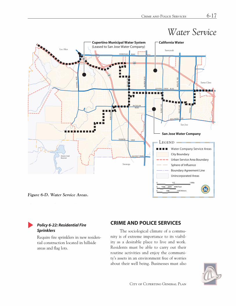
Most water-storage facilities shown in Figure 6-G are designed to withstand ground shaking. If the magnitude of ground shaking was not previously assessed or if the water facilities were designed before new stan-dards were developed, their structural integ-rity should be assessed. The City owns three tanks, but they are being leased to the San Jose Water Company. The San Jose Water Company is responsible for the maintenance and safety of the tanks. The City should work closely with the owners of other tanks and the San Jose Water Company to ensure that the structural integrity of all the tanks is main-tained in accordance with the latest seismic engineering standards and that an evaluation of the possible areas of flooding be conducted.
Acceptable Level of Risk
An acceptable level of risk is the chance one is willing to accept weighed against the probability of the occurrence of an event that may cause property loss or injury. It is a conscious decision that takes into account the cost/benefit ratio of risk reduction. Risk reduction is proportionally related to cost, the lower the risk, the greater the cost.
Flood risks within Cupertino and its planning area are relatively low. There are a number of water storage tanks existing in the hillside areas (see Figure 6-G) that have the potential to inflict property losses and inju-ries to residents of homes existing in their proximity in the event of failure. However, the probability of their failure is considered to be very low; consequently, they are con-sidered to be a minimal risk. The largest body of water within the area is the Stevens Creek Reservoir, and the probability of its failure is minimal. Figure 6-G depicts the extent of the inundation potential resulting from the failure of made-made water storage facilities.
Flood Plain
Stevens Creek and its streamside are among the natural elements that have the most influence on Cupertino’s character. The creek strongly defines the boundary between the urban and rural parts of the City, extends a note of unspoiled beauty into the heart of the developed valley floor and gives many residents and visitors a space for play, relaxation or study of the creek’s plant and animal life. Other creeks traversing the City are Permanente Creek, Regnart Creek and Calabazas Creek. These creeks collect surface runoff and channel it to the Bay. However, they also pose potential flooding risks should their levees be topped as a result of heavy runoff.
Land uses in the flood plain should allow the public access to the creek, but materials that would restrict the free flow of the creek waters or significantly disturb the riparian environment should be prohibited.
The Santa Clara Valley Water District and the City of Cupertino are actively involved in programs to minimize the risk of
6-28 Health & Safety
City of Cupertino General Plan

flooding. The City developed a flood plain land use policy for the non-urbanized flood plain of Stevens Creek south of Stevens Creek Boulevard. This ensures the preser-vation of the 100-year flood plain and the protection of the riparian corridor along this portion of Stevens Creek.
The City and the Water District developed a flood management program for the flood plain of Stevens Creek between Interstate 280 and Stevens Creek Boulevard. The strategy is to keep the natural environ-ment of Stevens Creek, although structural improvement may be necessary to protect properties from a 100-year flood. The major-ity of the people living in the Phar Lap Drive and Creston neighborhoods have a high flood risk, but they are partially covered by the Federal Flood Insurance Program.
The Santa Clara Water District has now completed the construction of the Calabazas Creek Project, which included the construction of a conduit across Interstate 280 to reduce the barrier effect created by the freeway itself that was built across the natural flood plain. The scope of the project also included improvements that should also minimize the flooding problems in the Miller Avenue area.
The watersheds in the Santa Cruz Mountain Range feed into four major stream-beds that cross the City: Permanente Creek, Stevens Creek, Regnart Creek, Calabazas Creek. Figure 6-H shows the streambed locations and the extent of a 100-year flood, which has a one percent chance of occurring during any given year. The 100-year flood is the standard design flood accepted by the City, the Santa Clara Valley Water District and federal agencies.
Policy 6-45: Existing Uses in the Flood Plain
Allow commercial and recreational uses that are now exclusively within the flood plain to remain in their pres-ent use or to be used for agriculture.
Policy 6-46: New Construction in Flood Plains
Adopt stringent land use, zoning and building code regulations limiting new construction in the already urbanized flood hazard areas recognized by the Federal Flood Insurance Administrator.
Strategies:
1. Finish Floor Level. Install the first floor finish level of all habitable space of new construction above the inunda-tion level of a projected 100-year flood.
2. Description of Flood Zone Regulation. Publish a description of flood zone reg-ulations and a map of potential flood hazard areas in the Cupertino Scene.
Policy 6-47: Dwellings in Natural Flood Plain
Regulate closely all types of habitable development in natural flood plains. This includes prohibiting fill materi-als and obstructions that may increase flood potential downstream or modify the natural riparian corridors.
Policy 6-48: Hillside Grading
Restrict the extent and timing of hill-side grading operation to April through October. Require performance bonds during the remaining time to guarantee the repair of any erosion damage. All graded slopes must be planted as soon as practical after grading is complete.
6-29Flood Hazards
City of Cupertino General Plan
6-30 Health & Safety
City of Cupertino General Plan
City Boundary
Urban Service Area Boundary
Sphere of Influence
Boundary Agreement Line
Unincorporated Areas
Legend
Sunnyvale
Los Altos
Santa Clara
San Jose
Saratoga
0 1000
0 500
2000 3000
0 0.5 1 Mile
1000
Feet
Meters
Flood Limit Line
Natural or Man-Made Water Course
Note: Flood inundation area for failureof Stevens Creek Reservoir is based uponmaximum 3700 acre feet storage capacity.
Stev
ens
Cre
ek
0 +30 Min.
Voss Ave. Pond8-10 Acre Feet
Cristo Rey Tank2 Mil. Gal.
Mercedes Tanks(2) 2 Mil. Gal.
12.2 Acre Feet4 Mil. Gal.
Reglin Canyon Tank0.16 Mil. Gal.
Reglin Heights Tank0.14 Mil. Gal.
Rainbows EndTank0.30 Mil. Gal.
Reglin Tanks20 Mil. Gal.
Stevens CreekReservoir3700 Acre Feet1 Bil. 200 Mil. Gal
0 +15 Min.
Mann Drive Tank1 Mil. Gal.
Proposed Tank61.3 Acre Feet
20 Mil. Gal.
FOO
THIL
L B
LVD
STEL
LIN
G R
D
De
AN
ZA
BLV
D
HOMESTEAD ROAD
WO
LFE
RD
STEVENS CREEK BLVD
BLA
NEY
AV
E
MIL
LER
AV
E
BOLLINGER RD
McCLELLANROAD
RAINBOW DRIVE
BU
BB
RO
AD
PROSPECT ROAD
85
280
TAN
TAU
AVE
Figure 6-G. Extent of Flooding as a Result of Failure of Man-Made Water Storage Facilities.
Policy 6-49: Stability of Existing Water Storage Facilities
Assure the structural integrity of water storage facilities.
Strategy
Coordination with other Agencies. Work closely with the San Jose Water Company and owners of other water storage facilities to develop and imple-ment a program to monitor the stabil-
ity of all existing water storage facilities and related improvements, such as: dis-tribution lines, connections and other system-components.
NOISE POLLUTION
Freedom from excessive noise is a major contributor to a high quality of life. This section gives a policy framework for guiding future land use and urban design decisions and
Facility Failures
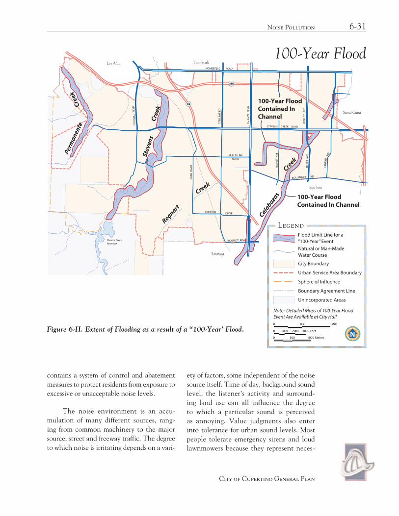
6-31Noise Pollution
City of Cupertino General Plan
FOO
THIL
L B
LVD
STEL
LIN
G R
D
De
AN
ZA
BLV
D
HOMESTEAD ROAD
WO
LFE
RD
STEVENS CREEK BLVD
BLA
NEY
AV
E
MIL
LER
AV
E
BOLLINGER RD
McCLELLANROAD
RAINBOW DRIVE
BU
BB
RO
AD
PROSPECT ROAD
85
280
TAN
TAU
AVE
Stevens CreekReservoir
City Boundary
Urban Service Area Boundary
Sphere of Influence
Boundary Agreement Line
Unincorporated Areas
Legend
SunnyvaleLos Altos
Santa Clara
San Jose
Saratoga
0 1000
0 500
2000 3000
0 0.5 1 Mile
1000
Feet
Meters
Flood Limit Line for a “100-Year” Event
Natural or Man-Made Water Course
Note: Detailed Maps of 100-Year Flood Event Are Available at City Hall
Calabaza
s
Creek
Creek
Regnart
100-Year FloodContained InChannel
100-Year FloodContained In Channel
Perm
anen
teCr
eek
Stev
ens
Cree
k
Figure 6-H. Extent of Flooding as a result of a “100-Year’ Flood.
contains a system of control and abatement measures to protect residents from exposure to excessive or unacceptable noise levels.
The noise environment is an accu-mulation of many different sources, rang-ing from common machinery to the major source, street and freeway traffic. The degree to which noise is irritating depends on a vari-
ety of factors, some independent of the noise source itself. Time of day, background sound level, the listener’s activity and surround-ing land use can all influence the degree to which a particular sound is perceived as annoying. Value judgments also enter into tolerance for urban sound levels. Most people tolerate emergency sirens and loud lawnmowers because they represent neces-
100-Year Flood

sary actions, public safety and neighborhood
upkeep. However, loud noises from cars with
defective or modified mufflers are usually
perceived as annoyances.
Overall noise levels seem to be increas-
ing despite efforts to identify and regulate
noise sources. An increasing population
density affects traffic on existing roads and
construction of new roads, e.g., I-85, which
opened since the past General Plan was pre-
pared in 1993, raised overall noise levels. It is
not possible to control all noise sources with-
in Cupertino, but some regulation is needed
to offset negative results of excessive noise.
Community Noise Fundamentals
A more comprehensive discussion of community noise is provided in the techni-cal appendix. This discussion addresses only the basic nomenclature and concepts neces-sary to understand the technical portions of this noise element.
Noise is unwanted sound, and is there-fore a subjective phenomenon that depends upon the listener’s attitude toward the sound. The three elements of community noise are noise level, noise spectrum and variation in noise level with time. Noise level is measured in decibels (dB). Every noise is composed of various frequencies that define the character
6-32 Health & Safety
City of Cupertino General Plan
Figure 6-I. Typical Sound Levels Measured in the Community, Industry, and Home.�

of the noise. Since human hearing is more sensitive to the higher speech frequencies, the A-weighted frequency network is applied, according to national and international stan-dards, to adjust the measured noise level to more closely relate to human perception of loudness.
Effective land use planning requires a means to assess various time-varying noise environments for their suitability for various land uses (e.g., housing, commercial, retail, industrial). Different noise environments have different time-varying characteristics; for instance a freeway may emit a fairly con-stant noise level for long periods while an airport may emit many short-term high level noise events punctuated by extended peri-ods of quiet. To provide a standard measure for community noise exposure the State of California has adopted the Community Noise Equivalent Level (CNEL) as the standard metric (21CAC5000), and is used in this noise element. The CNEL metric is a 24-hour energy average measure that penalizes eve-ning and nighttime noise, and provides a uni-form measure for various time-varying noise environments in a way that generally relates to community annoyance over noise.
Noise Contours
Noise contour maps are created for land use planning purposes. The contour maps give a visual representation of the noise environment in Cupertino. The noise contours are conservative, meaning that the contours are modeled with minimal noise attenuation by natural barriers, buildings, etc. The noise level measured at a specific location may be lower than what is shown on the noise contour map. The purpose of noise element contours is to identify a need for additional acoustical investigations.
Two sets of CNEL noise contours were created: present day conditions (Year 2000) and future conditions (Year 2020). The fol-lowing figures, 6-J and 6-K, represent Existing Year 2000 and Future Year 2020 noise con-tour maps, respectively. These contours indi-cate only a slight increase in noise levels.
Noise Monitoring
In order to characterize the noise envi-ronment in Cupertino, existing noise con-ditions in Cupertino were measured at six locations for a period of twenty-four hours. The following Table, 6-E, summarizes each measurement’s location and corresponding CNEL value.
6-33Noise Pollution
City of Cupertino General Plan
Table 6-E: Noise Monitoring Summary.
Location CNEL Value
Stevens Creek Blvd at Vallco Financial Ctr. 69 dB
Stevens Creek Blvd. East of De Anza Blvd. 72 dB
South Stelling at Tomki Ct. 73 dB
Stelling North of I-280 72 dB
Foothill Blvd. at Silver Oak Wy. 76 dB
Bollinger Rd. West of Miller Ave. 73 dB
Land Use Compatibility

6-34 Health & Safety
City of Cupertino General Plan
FOO
THIL
L B
LVD
STEL
LIN
G R
D
De
AN
ZA
BLV
D
HOMESTEAD ROAD
WO
LFE
RD
PRUNERIDG E AVE
STEVENS CREEK BLVD
BLA
NEY
AV
E
MIL
LER
AV
E
BOLLINGER RD
McCLELLAN
ROAD
RAINBOW DRIVE
BU
BB
RO
AD
PROSPECT ROAD
85
280
TAN
TAU
AVE
Stevens CreekReservoir
City Boundary
Urban Service Area Boundary
Sphere of Influence
Boundary Agreement Line
Unincorporated Areas
Legend
SunnyvaleLos Altos
Santa Clara
San Jose
Saratoga
70 dB
65 dB
60 dB
0 1000
0 500
2000 3000
0 0.5 1 Mile
1000
Feet
MetersFigure 6-J. 2000 Noise Contours.
Noise Contours – 2000
Many undesirable noise effects can be reduced or avoided if noise conditions are considered when assigning uses to specific land parcels. Noise cannot and should not be the primary factor considered in land use analysis, but the City should strive to match land uses to compatible noise levels.
Compatibility may be achieved by locating land use types outside of designated noise impact areas or by requiring modifica-tions including setbacks, sound walls, build-ing insulation or landscaping.
The Cupertino Municipal Code, Section 10, outlines the maximum noise lev-els on receiving properties based upon land use types.

6-35Noise Pollution
City of Cupertino General Plan
FOO
THIL
L B
LVD
STEL
LIN
G R
D
De
AN
ZA
BLV
D
HOMESTEAD ROAD
WO
LFE
RD
STEVENS CREEK BLVD
BLA
NEY
AV
E
MIL
LER
AV
E
BOLLINGER RD
McCLELLAN
ROAD
RAINBOW DRIVE
BU
BB
RO
AD
PROSPECT ROAD
85
280
TAN
TAU
AVE
Stevens CreekReservoir City Boundary
Urban Service Area Boundary
Sphere of Influence
Boundary Agreement Line
Unincorporated Areas
Legend
SunnyvaleLos Altos
Santa Clara
San Jose
Saratoga
70 dB
65 dB
60 dB
0 1000
0 500
2000 3000
0 0.5 1 Mile
1000
Feet
Meters
Noise Contours – 2020
Figure 6-K. 2020 Noise Contours.
Goal lLa compatiBle noise enviRonment FoR
existinG and FutuRe land uses
Policy 6-50: Land Use Decision Evaluation
Use the Land Use Compatibility for Community Noise Environments chart and the City Municipal Code to evalu-ate land use decisions.
Strategy
Noise Review of New Development. Review the proximity of new or signifi-cantly remodeled housing to the traffic noise corridor by using the noise contour map and review the results of previous noise standards to see if the standards can be complied with through conven-tional construction practices. If there is not enough information, the staff may ask the developer to provide an acousti-cal analysis along with the application.
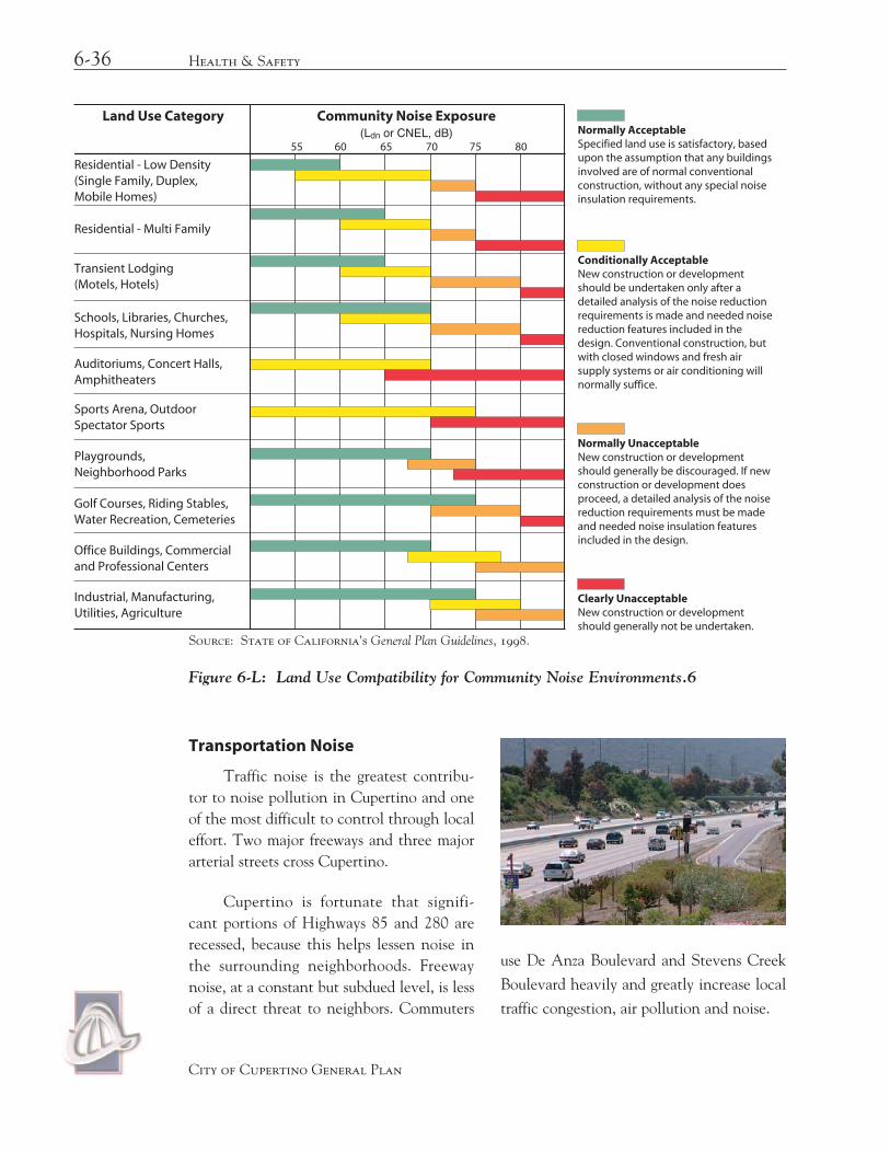
6-36 Health & Safety
City of Cupertino General Plan
Figure 6-L: Land Use Compatibility for Community Noise Environments.6
Community Noise ExposureLand Use Category(Ldn or CNEL, dB)
55 60 65 70 75 80
Residential - Multi Family
Transient Lodging(Motels, Hotels)
Schools, Libraries, Churches,Hospitals, Nursing Homes
Auditoriums, Concert Halls,Amphitheaters
Sports Arena, OutdoorSpectator Sports
Playgrounds,Neighborhood Parks
Golf Courses, Riding Stables,Water Recreation, Cemeteries
Office Buildings, Commercialand Professional Centers
Industrial, Manufacturing,Utilities, Agriculture
Residential - Low Density(Single Family, Duplex,Mobile Homes)
Normally AcceptableSpecified land use is satisfactory, based upon the assumption that any buildings involved are of normal conventional construction, without any special noise insulation requirements.
Conditionally AcceptableNew construction or development should be undertaken only after a detailed analysis of the noise reduction requirements is made and needed noise reduction features included in the design. Conventional construction, but with closed windows and fresh air supply systems or air conditioning will normally suffice.
Normally UnacceptableNew construction or development should generally be discouraged. If new construction or development does proceed, a detailed analysis of the noise reduction requirements must be made and needed noise insulation features included in the design.
Clearly UnacceptableNew construction or development should generally not be undertaken.
Source: State of California’s General Plan Guidelines, 1998.
Transportation Noise
Traffic noise is the greatest contribu-tor to noise pollution in Cupertino and one of the most difficult to control through local effort. Two major freeways and three major arterial streets cross Cupertino.
Cupertino is fortunate that signifi-cant portions of Highways 85 and 280 are recessed, because this helps lessen noise in the surrounding neighborhoods. Freeway noise, at a constant but subdued level, is less of a direct threat to neighbors. Commuters
use De Anza Boulevard and Stevens Creek
Boulevard heavily and greatly increase local
traffic congestion, air pollution and noise.

When the Municipal Code allowing maximum noise levels are compared to the existing noise levels (Figure 6-J—Existing (Year 2000) Noise Contours), the majority of locations are currently experiencing noise levels above the maximum allowable.
New development in these areas will be required to build and incorporate design strategies outlined in the policies of this doc-ument to meet the maximum allowed inter-nal and external noise levels.
Goal M
mReduced noise impact oF maJoR stReets and FReeways on cupeRtino Residents
Policy 6-51: Freeway Design and Neighborhood Noise
Ensure that roads and development along I-85 and I-280 are designed and improved in a way that minimizes neighborhood noise.
Policy 6-52: Stricter State Noise Laws
Support enactment of stricter state laws on noise emissions from new motor vehicles and enforce existing street laws on noise emissions.
Policy 6-53: Neighborhood Need Priority
Review the needs of residents for con-venience and safety and make them a priority over the convenient move-ment of commute or through traffic where practical.
Policy 6-54: Traffic Calming Solutions to Street Noise
Evaluate solutions to discourage through traffic in neighborhoods through modi-
fied street design. Examples include meandering streets, diverters, landscape islands and wide parking strips.
Strategy
Local Improvement. Modify street design to minimize noise impact to neighbors.
Train and Aircraft Noise
Trains and aircraft do not contribute much to noise in Cupertino. Aircraft flying into Moffett Field Naval Air Station are restricted to the northeastern corner of Cupertino, affect-ing some residents of the Rancho Rinconada neighborhood. Cupertino’s one railroad line passes through the Monta Vista neighborhood and connects with the Hanson Permanente Plant in the Western foothills. There is one train three times a week (2 trips - one in, one out), which occurs usually in the afternoon or early evening hours. Noise levels associated with the trains are approximately 85-90 deci-bels at a distance of 50 ft. from the track for a period of two minutes. There are no noise protection devices along the rail corridor, and if increases in rail activity occur, other mitigation may be required.
Truck Traffic
The most crucial example of traffic noise intrusion on the quality of neighborhood life is the effect of heavy-duty truck trips to and from the Hanson Permanente Cement Plant and Stevens Creek Quarry located in the west-ern foothills near Stevens Creek Boulevard and Foothill Boulevard. There are about 1,400 trips each working day, which generate noise levels up to 90 dB next to the road. When trucks speed up, slow down or use their high-powered brakes on the unusually steep road, the truck noise problem is worsened.
6-37Noise Pollution
City of Cupertino General Plan

Policy 6-55: Noise Improvement by Restricting Trucks
Work toward improving the noise environment along Foothill Boulevard and Stevens Creek Boulevard by restricting quarry truck traffic espe-cially during late evening and early morning hours. It is preferable that the restrictions be voluntary. Encourage alternative to truck transport, specifi-cally rail, when feasible.
A study prepared by profes sional acousti-cal engineering consultants suggested a series of measures to diminish noise for homes along the truck traffic cor ridor. Reducing truck travel and carrying out these measures could give some relief to the residents most severely affected.
Policy 6-56: Reduction of Noise from the Hanson Permanente Trucks
Work to carry out noise mitigation measures to diminish noise from the Hanson Permanente truck traffic for homes near Foothill and Stevens Creek Boulevards. These measures include regulation of truck speed and the volume of truck activity.
Strategy
Restrictions in the County’s Use Permit. Coordinate with the County to restrict the number of trucks, their speed and noise levels along Stevens Creek Boulevard, to the allowed in the Use Permit. Ensure that restrictions are monitored and enforced by the County.
Policy 6-57: Road Improvements to Reduce Truck Impacts
Consider road improvements, such as medians, landscaping and the addition of bicycle lanes to reduce quarry truck impacts.
Non-Transportation Noise Sources
Noises not generated by traffic are typically stationary and/or sporadic. They have a relatively minor effect compared to traffic noise, but noises such as permanent equipment (refrigeration or air conditioning units or other related pumps), barking dogs and rattling of garbage cans when people are trying to sleep can be annoying and disrup-tive. Complete regulation of these noises is unlikely, but the City can work to protect neighborhoods from excessive noise and require compliance with the noise standard during the evening and early morning, when ambient noise levels tend to be lower.
Short-term noise sources are also disrup-tive. Temporary activities such as construction can often last for several months and generate a substantial number of complaints. Some are unavoidable, but superior muffling devices for construction equipment can reduce noise from jackhammers, portable compressors and generators. City ordinances control the days and hours of construction operations. Policies are provided to limit noise levels. In several
6-38 Health & Safety
City of Cupertino General Plan
Quarry trucks on Foothill Boulevard
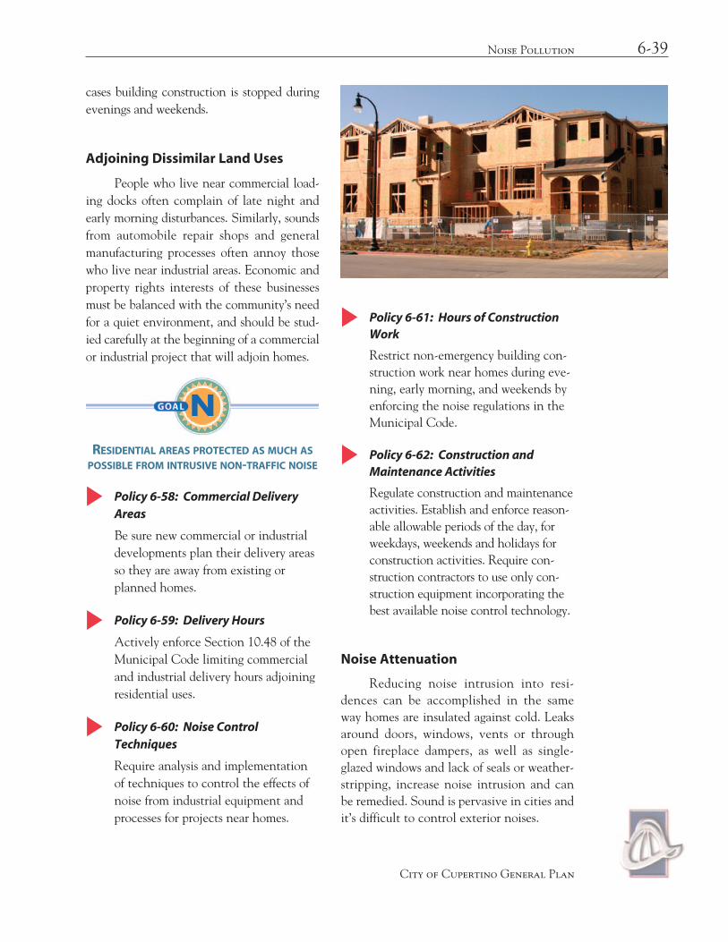
cases building construction is stopped during evenings and weekends.
Adjoining Dissimilar Land Uses
People who live near commercial load-ing docks often complain of late night and early morning disturbances. Similarly, sounds from automobile repair shops and general manufacturing processes often annoy those who live near industrial areas. Economic and property rights interests of these businesses must be balanced with the community’s need for a quiet environment, and should be stud-ied carefully at the beginning of a commercial or industrial project that will adjoin homes.
GoN
Residential aReas pRotected as much as possiBle FRom intRusive non-tRaFFic noise
Policy 6-58: Commercial Delivery Areas
Be sure new commercial or industrial developments plan their delivery areas so they are away from existing or planned homes.
Policy 6-59: Delivery Hours
Actively enforce Section 10.48 of the Municipal Code limiting commercial and industrial delivery hours adjoining residential uses.
Policy 6-60: Noise Control Techniques
Require analysis and implementation of techniques to control the effects of noise from industrial equipment and processes for projects near homes.
Policy 6-61: Hours of Construction Work
Restrict non-emergency building con-struction work near homes during eve-ning, early morning, and weekends by enforcing the noise regulations in the Municipal Code.
Policy 6-62: Construction and Maintenance Activities
Regulate construction and maintenance activities. Establish and enforce reason-able allowable periods of the day, for weekdays, weekends and holidays for construction activities. Require con-struction contractors to use only con-struction equipment incorporating the best available noise control technology.
Noise Attenuation
Reducing noise intrusion into resi-dences can be accomplished in the same way homes are insulated against cold. Leaks around doors, windows, vents or through open fireplace dampers, as well as single-glazed windows and lack of seals or weather-stripping, increase noise intrusion and can be remedied. Sound is pervasive in cities and it’s difficult to control exterior noises.
6-39Noise Pollution
City of Cupertino General Plan

Different noise control techniques can be used with varying degrees of success. Each site should be evaluated to find the best combina-tion of noise control devices. Here is a sum-mary of common techniques and their uses.
Barriers
Sound walls can reduce noise from 5 to 15 dB. Their effectiveness depends on the relative grade of the roadway, the distance of the listener from the centerline of the nearest road, placement and height of the sound wall in relation to the receptor line, the size and location of the area to be protected and the frequency of the noise source. The barrier is more successful with higher-pitched noise and is usually more effective when located close to the source or to the listener, assuming that both are below the top of the barrier.
Sound walls can be unattractive and can enclose or separate neighborhoods. Landscaping is a less expensive and effec-tive way to make the walls more attractive and will also reduce sound reflection from the walls. Evergreen and vines should be planted along the roadway side. Reflection can increase noise levels on the opposite side by as much as 5 dB.
Policy 6-63: Sound Wall Requirements
Exercise discretion in requiring sound walls to be sure that all other measures of noise control have been explored and that the sound wall blends with the neighborhood. Sound walls should be landscaped.
Landscaping and Setbacks
Landscaping and setbacks for small properties do not work well in reducing noise. Plants and trees are not dense enough to pre-vent airflow. Setbacks must be substantial to make a difference in noise. Noise attenuates about 3 dB for heavy traffic and about 6 dB for light traffic every time the setback from the centerline of the roadway is doubled.
Building and Site Design
Building and site design techniques can control noise effectively in new develop-ments or when existing buildings are modi-fied. Sensitive areas can be set back or buff-ered by buildings, parking or recreation areas. Homes can use rooms such as kitchens, bath-rooms and garages to buffer the more sensi-tive bedrooms and living rooms. Buildings should face solid walls onto the noise source and be sure that no vents or other air leaks face the noise source.
insulatinG BuildinGs FRom noise
Conventional building practices typi-cally achieve exterior-to-interior noise reductions from adjoining roadways of about 10 dB with open windows and 20 dB with closed windows. Considerably higher noise reduction is possible with specialized acousti-cal design and construction.
Table 6-F shows noise reduction from typical building types
Goal o
6-40 Health & Safety
City of Cupertino General Plan

OBuildinGs desiGned to diminish noise
Policy 6-64: Building Code Sections on Exterior Noise Intrusion
Require the City Building Department to enforce all sections of the California Building Code for exterior sound trans-mission control (Sec. 1208A.8.1).
Policy 6-65: Building Code Sections on Interior Noise
Encourage the City Building Department to enforce all sections of the California Building Code relating to interdwelling sound transmission control (Sec. 1208A.1.6).
Policy 6-66: Application of Policy 6-63 to New Single-family Homes
Consider applying the California Building Code requirements for exte-rior sound transmission control (Sec. 1208A.8.1) to construction of new single-family housing.
6-41Noise Pollution
City of Cupertino General Plan
Table 6-F. Approximate Exterior-to-Interior Noise Reduction Achieved by Structures.
Bldg. Type Window Condition Exterior-to-Interior Maximum Exterior Noise Reduction CNEL Value for 45 dB Interior CNEL Value
All Open 10 dB 55 dB
Light Frame Ordinary sash, closed 20 dB 65 dB
Masonry Single pane, closed 25 dB 70 dB
Masonry Sound-rated windows, closed 35 dB 80 dB