Section 5 Region wide Rules - Environment...
104
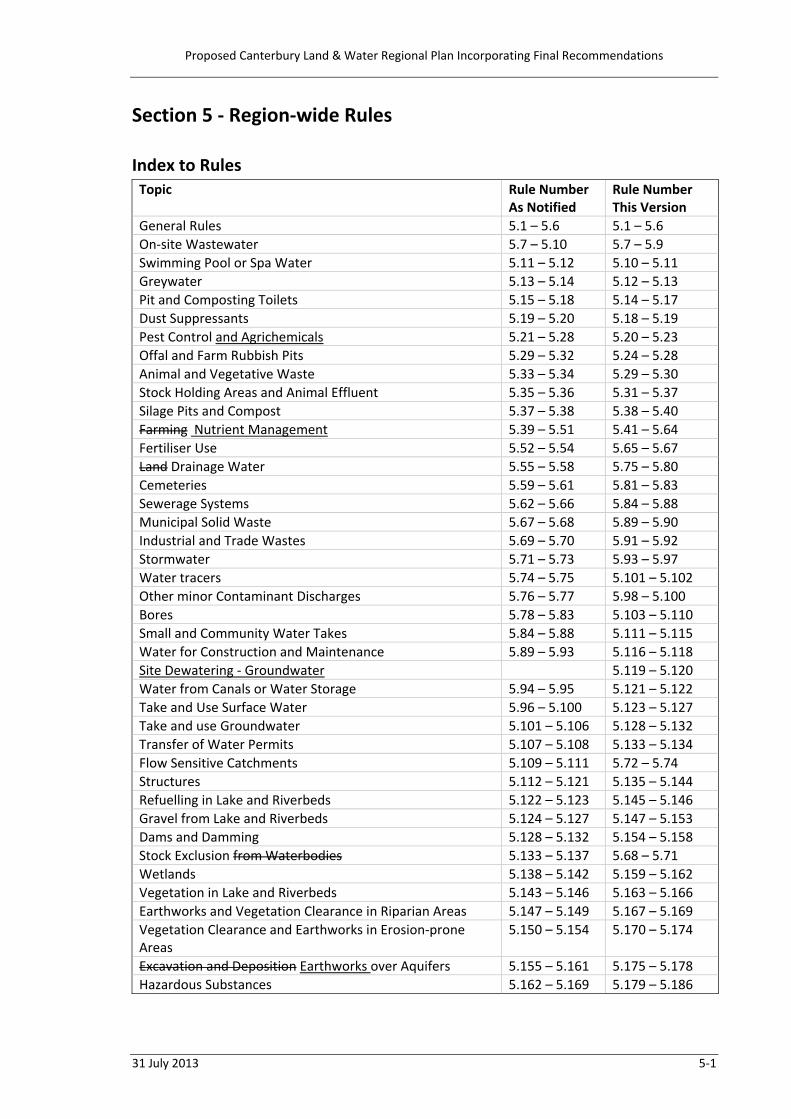
Proposed Canterbury Land & Water Regional Plan Incorporating Final Recommendations 31 July 2013 5‐1 Section 5 ‐ Region‐wide Rules Index to Rules Topic Rule Number As Notified Rule Number This Version General Rules 5.1 – 5.6 5.1 – 5.6 On‐site Wastewater 5.7 – 5.10 5.7 – 5.9 Swimming Pool or Spa Water 5.11 – 5.12 5.10 – 5.11 Greywater 5.13 – 5.14 5.12 – 5.13 Pit and Composting Toilets 5.15 – 5.18 5.14 – 5.17 Dust Suppressants 5.19 – 5.20 5.18 – 5.19 Pest Control and Agrichemicals 5.21 – 5.28 5.20 – 5.23 Offal and Farm Rubbish Pits 5.29 – 5.32 5.24 – 5.28 Animal and Vegetative Waste 5.33 – 5.34 5.29 – 5.30 Stock Holding Areas and Animal Effluent 5.35 – 5.36 5.31 – 5.37 Silage Pits and Compost 5.37 – 5.38 5.38 – 5.40 Farming Nutrient Management 5.39 – 5.51 5.41 – 5.64 Fertiliser Use 5.52 – 5.54 5.65 – 5.67 Land Drainage Water 5.55 – 5.58 5.75 – 5.80 Cemeteries 5.59 – 5.61 5.81 – 5.83 Sewerage Systems 5.62 – 5.66 5.84 – 5.88 Municipal Solid Waste 5.67 – 5.68 5.89 – 5.90 Industrial and Trade Wastes 5.69 – 5.70 5.91 – 5.92 Stormwater 5.71 – 5.73 5.93 – 5.97 Water tracers 5.74 – 5.75 5.101 – 5.102 Other minor Contaminant Discharges 5.76 – 5.77 5.98 – 5.100 Bores 5.78 – 5.83 5.103 – 5.110 Small and Community Water Takes 5.84 – 5.88 5.111 – 5.115 Water for Construction and Maintenance 5.89 – 5.93 5.116 – 5.118 Site Dewatering ‐ Groundwater 5.119 – 5.120 Water from Canals or Water Storage 5.94 – 5.95 5.121 – 5.122 Take and Use Surface Water 5.96 – 5.100 5.123 – 5.127 Take and use Groundwater 5.101 – 5.106 5.128 – 5.132 Transfer of Water Permits 5.107 – 5.108 5.133 – 5.134 Flow Sensitive Catchments 5.109 – 5.111 5.72 – 5.74 Structures 5.112 – 5.121 5.135 – 5.144 Refuelling in Lake and Riverbeds 5.122 – 5.123 5.145 – 5.146 Gravel from Lake and Riverbeds 5.124 – 5.127 5.147 – 5.153 Dams and Damming 5.128 – 5.132 5.154 – 5.158 Stock Exclusion from Waterbodies 5.133 – 5.137 5.68 – 5.71 Wetlands 5.138 – 5.142 5.159 – 5.162 Vegetation in Lake and Riverbeds 5.143 – 5.146 5.163 – 5.166 Earthworks and Vegetation Clearance in Riparian Areas 5.147 – 5.149 5.167 – 5.169 Vegetation Clearance and Earthworks in Erosion‐prone Areas 5.150 – 5.154 5.170 – 5.174 Excavation and Deposition Earthworks over Aquifers 5.155 – 5.161 5.175 – 5.178 Hazardous Substances 5.162 – 5.169 5.179 – 5.186
Transcript of Section 5 Region wide Rules - Environment...
Proposed Canterbury Land & Water Regional Plan Incorporating Final Recommendations
31 July 2013 5‐1
Section 5 ‐ Region‐wide Rules Index to Rules Topic Rule Number
As Notified Rule Number This Version
General Rules 5.1 – 5.6 5.1 – 5.6 On‐site Wastewater 5.7 – 5.10 5.7 – 5.9 Swimming Pool or Spa Water 5.11 – 5.12 5.10 – 5.11 Greywater 5.13 – 5.14 5.12 – 5.13 Pit and Composting Toilets 5.15 – 5.18 5.14 – 5.17 Dust Suppressants 5.19 – 5.20 5.18 – 5.19 Pest Control and Agrichemicals 5.21 – 5.28 5.20 – 5.23 Offal and Farm Rubbish Pits 5.29 – 5.32 5.24 – 5.28 Animal and Vegetative Waste 5.33 – 5.34 5.29 – 5.30 Stock Holding Areas and Animal Effluent 5.35 – 5.36 5.31 – 5.37 Silage Pits and Compost 5.37 – 5.38 5.38 – 5.40 Farming Nutrient Management 5.39 – 5.51 5.41 – 5.64 Fertiliser Use 5.52 – 5.54 5.65 – 5.67 Land Drainage Water 5.55 – 5.58 5.75 – 5.80 Cemeteries 5.59 – 5.61 5.81 – 5.83 Sewerage Systems 5.62 – 5.66 5.84 – 5.88 Municipal Solid Waste 5.67 – 5.68 5.89 – 5.90 Industrial and Trade Wastes 5.69 – 5.70 5.91 – 5.92 Stormwater 5.71 – 5.73 5.93 – 5.97 Water tracers 5.74 – 5.75 5.101 – 5.102 Other minor Contaminant Discharges 5.76 – 5.77 5.98 – 5.100 Bores 5.78 – 5.83 5.103 – 5.110 Small and Community Water Takes 5.84 – 5.88 5.111 – 5.115 Water for Construction and Maintenance 5.89 – 5.93 5.116 – 5.118 Site Dewatering ‐ Groundwater 5.119 – 5.120 Water from Canals or Water Storage 5.94 – 5.95 5.121 – 5.122 Take and Use Surface Water 5.96 – 5.100 5.123 – 5.127 Take and use Groundwater 5.101 – 5.106 5.128 – 5.132 Transfer of Water Permits 5.107 – 5.108 5.133 – 5.134 Flow Sensitive Catchments 5.109 – 5.111 5.72 – 5.74 Structures 5.112 – 5.121 5.135 – 5.144 Refuelling in Lake and Riverbeds 5.122 – 5.123 5.145 – 5.146 Gravel from Lake and Riverbeds 5.124 – 5.127 5.147 – 5.153 Dams and Damming 5.128 – 5.132 5.154 – 5.158 Stock Exclusion from Waterbodies 5.133 – 5.137 5.68 – 5.71 Wetlands 5.138 – 5.142 5.159 – 5.162 Vegetation in Lake and Riverbeds 5.143 – 5.146 5.163 – 5.166 Earthworks and Vegetation Clearance in Riparian Areas 5.147 – 5.149 5.167 – 5.169 Vegetation Clearance and Earthworks in Erosion‐prone Areas
5.150 – 5.154 5.170 – 5.174
Excavation and Deposition Earthworks over Aquifers 5.155 – 5.161 5.175 – 5.178 Hazardous Substances 5.162 – 5.169 5.179 – 5.186

Proposed Canterbury Land & Water Regional Plan Incorporating Final Recommendations
5‐2 31 July 2013
General Rules 5.1 Unless specifically stated to the contrary, any activity must comply with all the
relevant389 rules of Section 5 of this Plan, except in relation to Rule 5.5, which prevails in all situations.390
5.2 Unless specifically stated to the contrary, any rule on the same subject matter in the
relevant sub‐regional zones in Sections 6 to 15 of this Plan prevails over the relevant rule of Section 5, except in relation to Rule 5.5, which prevails in all situations.391
5.3 Notes and cross‐references are included for information purposes only and do not form
part of the rules and nor should they be considered a complete list. 5.4 For the avoidance of doubt,392 For any activity that is classified as a controlled activity or
a restricted discretionary activity, the CRC includes, within the matters to which control is reserved or discretion is restricted, the lapse period, the duration of the resource consent, the review of the conditions of a resource consent, the need for a bond or financial contributions, and the collection, recording, monitoring and provision of information concerning the exercise of a resource consent.
5.5 Any recovery activity that would otherwise contravene sections 9(2), 13(1), 14(2), s14(3)
or s15(1) of the RMA and is not listed as a permitted activity in this Plan is a restricted discretionary activity. The CRC will restrict discretion to the following matters: 1. The timing,393 duration and scale of the activity; and 2. The adequacy of the management plan prepared in respect of the activity, and in
particular, the identification of the effects and the proposed mitigation.; and 3. The extent to which the proposed activity is consistent with the objectives and
policies of this Plan.394
5.6 Any activity that is not a recovery activity that would otherwise contravene sections 13(1), 14(2), s14(3) or s15(1) of the RMA and is not listed as a permitted, controlled,395
389 263.26 Transpower 390 167.22 CRC 391 167.22 CRC 392 19.57 Ellesmere ISI 393 347.133 Fish & Game 394 347.138 Fish & Game 395 358.6 Ngā Rūnanga
Proposed Canterbury Land & Water Regional Plan Incorporating Final Recommendations
31 July 2013 5‐3
restricted discretionary, discretionary, non‐complying or prohibited activity in this Plan is a discretionary activity.
Note: In addition to the provisions of this Plan any activity may require authority under the relevant district plan or other legislation. 396
396 226.2 NZHPT

Proposed Canterbury Land & Water Regional Plan Incorporating Final Recommendations
5‐4 31 July 2013
On‐site Wastewater 5.7 The discharge of wastewater from an existing on‐site domestic397 wastewater treatment
system onto or into land in circumstances where a contaminant may enter water is a permitted activity, provided the following conditions are met: 1. The discharge was lawfully established prior to 1 November 2013; and 2. The treatment and disposal system has not been altered or modified from that
established at the time the system was constructed, other than through routine maintenance; and
3. The volume of the discharge has not been increased as a result of the addition of buildings, an alteration of an existing building, or a change in use of a building that is connected to the system; and
4. The treatment and disposal system is operated and maintained in accordance with the system's design specification for maintenance or, if there is no design specification for maintenance, Section 6.3 of New Zealand Standard AS/NZS 1547:2012 – On‐site Domestic Wastewater Management; and
5. The discharge is within the area marked “Septic tank Suitability – Area A” on the Planning Maps; and398
6. The discharge is not onto or into land: (a) where there is an available sewerage network; or (b) that is potentially contaminated399 (c) that is listed as an archaeological site; or (d) where the discharge would enter any surface water body; or (e) within 20 m of any surface water body or the Coastal Marine Area; or (f) within 50 m of a bore used for water abstraction; or (g) within a Group or Community Drinking‐water supply Protection Zonearea400
as set out in Schedule 1 of this Plan; or (h) where there is, at any time, less than 1 m of vertical separation between the
discharge point and groundwater; and401 7. The discharge does not result in wastewater being visible on the ground surface;
and 8. The discharge does not contain any hazardous substance.402
5.8 The discharge of wastewater from an existing on‐site domestic wastewater treatment
system onto or into land in circumstances where a contaminant may enter water that does not meet one or more of the conditions of Rule 5.7 is a restricted discretionary activity.
The CRC will restrict discretion to the following matters:
397 167.24 CRC 398 268.23 Waimate DC 399 99.55 The Fuel Companies 400 Cl 16 - Minor wording change to ensure consistency 401 243.1 ecoENG Limited 402 167.24 CRC

Proposed Canterbury Land & Water Regional Plan Incorporating Final Recommendations
31 July 2013 5‐5
1. The effect of not meeting the condition or conditions of Rule 5.7. 2. The extent to which the proposed activity is consistent with the objectives and
policies of this Plan relating to Ngāi Tahu values, human and animal health and drinking water quality.
Notification Pursuant to sections 95A and 95B of the RMA an application for resource consent under this rule
will be processed and considered without public or limited notification. Note that limited notification to affected order holders in terms of section 95F of the RMA will be
necessary, where relevant, under section 95B(3) of the RMA.403 5.89 The discharge of wastewater from a new, modified404 or upgraded on‐site domestic
wastewater treatment system onto or into land in circumstances where a contaminant may enter water is a permitted activity, provided the following conditions are met:
1. The discharge volume does not exceed 2 14 m3 per day week; and 405 2. The discharge is onto a site that is equal to or greater than 4 hectares in area;
andThe discharge is within the area marked “Septic tank Suitability – Area A”406 on the Planning Maps;
3. The discharge is not onto or into land: (a) where there is an available sewerage network; or (b) that is contaminated or407 potentially contaminated; or (c) listed as an archaeological site; or (d) where the discharge would enter any surface water body; or (e) within 20 m of any surface water body or the Coastal Marine Area; or (f) within 50 m of a bore used for water abstraction; or (g) within a Group or Community Drinking‐water supply Protection
Zonearea408 as set out in Schedule 1; or (h) where there is, at any time, less than 1 m of vertical separation between
the discharge point and groundwater; and 409 4. The treatment and disposal system is designed and installed in accordance
with Sections 5 and 6 of New Zealand Standard AS/NZS 1547:2012 – On‐site Domestic Wastewater Management; and
5. The treatment and disposal system is operated and maintained in accordance with the system’s design specification for maintenance or, if there is no design specification for maintenance, Section 6.3 of New Zealand Standard AS/NZS 1547:2012 – On‐site Domestic Wastewater Management; and
403 Replaced by Rule 5.9(a), 358.185 Ngā Rūnanga re. notification 404 243.1 ecoENG Limited 405 167.25 CRC 406 167.25 CRC 407 358.9 Ngā Rūnanga 408 Minor wording change to ensure consistency 409 243.1 ecoENG Limited
Proposed Canterbury Land & Water Regional Plan Incorporating Final Recommendations
5‐6 31 July 2013
6. The discharge does not result in wastewater being visible on the ground surface; and410
7. The discharge does not contain any hazardous substance.411 5.910 The discharge of wastewater from:
(a) an existing on‐site domestic wastewater treatment system onto or into land in circumstances where a contaminant may enter water that does not meet one or more of the conditions of Rule 5.7; or412
(b) a new, modified413 or upgraded on‐site domestic wastewater treatment system onto or into land in circumstances where a contaminant may enter water that does not meet one or more of the conditions of Rule 5.8
is a restricted discretionary activity.
The CRC will restrict discretion to the following matters: 1. The actual and potential environmental effects of not meeting the condition or
conditions of Rule 5.7 for an existing system; and414 2. The actual and potential direct and cumulative environmental415 effects of not
meeting the condition or conditions of Rule 5.8 for a new, modified or upgraded system; 416 and
3. The actual and potential environmental effects of the discharge on the quality and safety of human and animal drinking‐water.417
2. The extent to which the proposed activity is consistent with the objectives and policies of this Plan relating to Ngāi Tahu values, human and animal health and drinking water quality.418
Notification Pursuant to sections 95A and 95B of the RMA an application for resource consent under this rule will be processed and considered without public or limited notification. Note that limited notification to affected order holders in terms of section 95F of the RMA will be necessary, where relevant, under section 95B(3) of the RMA. 419
410 167.25 CRC 411 167.25 CRC 412 Originally from notified Rule 5.8 413 243.1 ecoENG Limited 414 Originally from notified Rule 5.8 415 RFBPS (Canty West Coast) (364), Fish & Game (347) 416 Originally from notified Rule 5.8 417 358.10 Ngā Rūnanga 418 347.138 Fish & Game 419 358.186 Ngā Rūnanga
Proposed Canterbury Land & Water Regional Plan Incorporating Final Recommendations
31 July 2013 5‐7
Swimming Pool or Spa Water 5.101 The discharge of swimming pool or spa pool water into water or onto or into land in
circumstances where a contaminant may enter water is a permitted activity, provided the following conditions are met: 1. The discharge of filter backwash water is only onto land, and the discharge does
not enter any surface waterbody or wetland, including via a stormwater system; and
2. For swimming pool or spa pool water discharges that do not contain filter backwash water, the discharge may be either onto land or into water, provided: (a) that for all discharges:
(i) there are no copper chemicals or flocculants, including aluminium salts, in the discharge and the concentration of sodium chloride (common salt) does not exceed 3500 grams420/m3; and
(ii) the swimming pool or spa pool has not been treated within the previous 14 days with a pool sanitizing agent containing chlorine, bromine, or BaquacilTM; and
(iii) the discharge does not result in water or contaminants flowing onto another site; and
(b) that for discharges to surface water: (i) the discharge is not within a Group or Community Drinking‐water
supply Protection Zonearea421 as set out in Schedule 1; and (ii) for discharges to a river, the rate of flow in the river, at the point of
discharge, is at least five times the rate of discharge.
5.112 The discharge of swimming pool or spa pool water into water or onto or into land in
circumstances where a contaminant may enter water that does not meet one or more of the conditions of Rule 5.10 is a restricted discretionary activity.
The CRC will restrict discretion to the following matter: 1. The actual and potential environmental422 effects of not meeting the condition or
conditions of Rule 5.10.
420 Cl 16 - Minor amendment - to ensure consistency with listed abbreviations 421 Cl 16 - Minor wording change to ensure consistency 422 358.14 Ngā Rūnanga

Proposed Canterbury Land & Water Regional Plan Incorporating Final Recommendations
5‐8 31 July 2013
Greywater 5.123 The discharge of greywater onto or into land in circumstances where a contaminant
may enter water is a permitted activity, provided the following conditions are met: 1. The discharge is only from a dwelling house and does not contain any waste from a
toilet or any hazardous substances; and 2. The discharge is from a system that is authorised for use under the Building Act
2004; and423 3. The application rate does not exceed 50 mm per day The discharge is:
(a) via a land application system located beneath the ground surface; and (b) as far as practicable, is evenly distributed and does not exceed an application
rate of 50 mm per day; and 424 4. The discharge does not result in greywater flowing, seeping, or ponding on the
surface of the ground for more than two hours; and 5. The system does not store greywater for more than 12 hours and incorporates a
proprietory proprietary425 filter prior to discharge; and 6. The discharge does not result in water or contaminants flowing onto another site;
and 7. The point of discharge is notwithin:
(a) within 20 m of a surface water body or the Coastal Marine Area; or (b) within 20 m of a bore used for water abstraction; or (c) to land that is contaminated or potentially contaminated; or where an
activity or industry, other than A8, listed in Schedule 3 has occurred or is occurring; or426
(d) to a site listed as an archaeological site; and 8. Where the discharge is located over an unconfined or semi‐confined aquifer and
the highest groundwater level is less than 2 m from the ground surface, there shall be at least 600 mm of soil or sand between the point of discharge and the seasonal high water table.427
5.134 The discharge of greywater onto or into land in circumstances where a contaminant
may enter water that does not meet one or more of the conditions of Rule 5.12 is a restricted discretionary activity.
The CRC will restrict discretion to the following matters: 1. The actual and potential environmental428 effects of not meeting the condition or
conditions of Rule 5.12; and 2. The actual and potential environmental effects of the discharge on the quality and
safety of human and animal drinking‐water.429 423 358.16Ngā Rūnanga, 243.5ecoENG Ltd 424 358.16Ngā Rūnanga, 243.5ecoENG Ltd 425 Cl 16 - Typographical error that needs correcting 426 Cl 16 - Minor amendments - to ensure consistency with other provisions and improved grammar 427 167.26 CRC and 358.16 Ngā Rūnanga 428 358.16 Ngā Rūnanga

Proposed Canterbury Land & Water Regional Plan Incorporating Final Recommendations
31 July 2013 5‐9
3. The extent to which the proposed activity is consistent with the objectives and policies of this Plan relating to Ngāi Tahu values, human and animal health and drinking water quality.430
429 358.16 Ngā Rūnanga 430 347.138 Fish & Game
Proposed Canterbury Land & Water Regional Plan Incorporating Final Recommendations
5‐10 31 July 2013
Pit and Composting Toilets 5.145 The discharge of untreated human excrement via a pit toilet onto or into land in
circumstances where a contaminant may enter water is a permitted activity, provided the following conditions are met: 1. When a pit toilet is filled to within 0.5 m of the original land surface, or is no longer
used, the content of the pit toilet is covered with at least 0.5 m of soil; and 2. Surface runoff does not enter a pit toilet; and 3. There is at least 600 mm of soil or sand between the point of discharge and the
highest known groundwater seasonal high water table431 level; and 4. The pit toilet is not:
(a) within 20 m of a surface water body, a bore used for water abstraction or the Coastal Marine Area; or
(b) within a Group or Community Drinking‐water supply Protection Zonearea432 as set out in Schedule 1; or
(c) within any area or zone identified in a proposed or operative district plan for residential, commercial or industrial purposes; or
(d) sited on unconsolidated gravels, coarse or medium sands, fissured rock or scree unless there is at least 600 mm of soil or sand placed in the base of the pit; or
(e) on a site listed as an archaeological site. 5.156 The discharge of untreated human excrement via a pit toilet onto or into land in
circumstances where a contaminant may enter water that does not meet one or more of the conditions in Rule 5.14 is a restricted discretionary activity.
The CRC will restrict discretion to the following matters: 1. The actual and potential433 environmental effects of not meeting the condition or
conditions of Rule 5.14. 2. The actual and potential environmental effects of the discharge on the quality and
safety of human and animal drinking‐water. 434 2. The extent to which the proposed activity is consistent with the objectives and
policies of this Plan relating to Ngāi Tahu values, human and animal health and drinking water quality. 435
5.167 The discharge of aerobically composted material from a composting toilet onto or into
land in circumstances where a contaminant may enter water is a permitted activity, provided the following conditions are met:
431 167.26 CRC 432 Minor wording change to ensure consistency 433 358.18 Ngā Rūnanga 434 358.10 Ngā Rūnanga 435 347.138 Fish & Game

Proposed Canterbury Land & Water Regional Plan Incorporating Final Recommendations
31 July 2013 5‐11
1. The material discharged has been subject to aerobic decomposition for at least 12 months from the last addition of raw excrement and is worked into the soil immediately following the discharge; and
2. The discharge is not onto or into land: (a) that is within 20 m of a surface water body, the Coastal Marine Area or a
bore used for water abstraction; or (b) that is within a Group or Community Drinking‐water supply Protection
Zonearea436 as set out in Schedule 1; or (c) that is used for growing food crops for human consumption; or (d) when there is water ponding or flowing on the land soil surface;437 or (e) that is listed as an archaeological site.
Note: The composting toilet system may also require approval for use under the Building Act 2004.
5.178 The discharge of aerobically composted material from a composting toilet onto or into
land in circumstances where a contaminant may enter water that does not meet one or more of the conditions in Rule 5.16 is a restricted discretionary activity.
The CRC will restrict discretion to the following matters: 1. The actual and potential environmental438 effects of not meeting the condition or
conditions of Rule 5.16; and 2. The actual and potential environmental effects of the discharge on the quality and
safety of human and animal drinking‐water.439 2. The extent to which the proposed activity is consistent with the objectives and
policies of this Plan relating to Ngāi Tahu values, human and animal health and drinking water quality. 440
436 Minor wording change to ensure consistency 437 Cl 16 - Minor amendment - consistent wording 438 358.20 Ngā Rūnanga 439 358.20 Ngā Rūnanga 440 347.138 Fish & Game

Proposed Canterbury Land & Water Regional Plan Incorporating Final Recommendations
5‐12 31 July 2013
Dust Suppressants 5.189 The discharge of oil as a dust suppressant onto or into land in circumstances where a
contaminant may enter water is a permitted activity provided the following conditions are met: 1. The discharge is only of vegetable oil, or of new light fuel or lubricating oil and is:
(a) applied in a manner that does not result in pooling or runoff, with a maximum application rate not exceeding 2 litres/m2 per day and 4 litres/m2 per annum; and
(b) not within 20 m of a surface water body, the Coastal Marine Area, a bore or soak‐hole.
5.1920 The discharge of oil as a dust suppressant onto or into land in circumstances where a
contaminant may enter water that does not meet one or more of the conditions in Rule 5.18 is a restricted discretionary activity.
The CRC will restrict discretion to the following matter: 1. The actual and potential environmental441 effects of not meeting the condition or
conditions of Rule 5.18.
441 358.23 Ngā Rūnanga

Proposed Canterbury Land & Water Regional Plan Incorporating Final Recommendations
31 July 2013 5‐13
Pest Control and Agrichemicals 5.201 The discharge of a vertebrate toxic agent via land‐based methods,442 onto or into land,
including the bed of a lake or river, in circumstances where a contaminant may enter water, or into water,443 is a permitted activity provided the following conditions are met: 1. The substance and the application technique or method444 is approved for use
under the Hazardous Substances and New Organisms Act 1996 and the use and discharge of the substance is in accordance with all conditions of the approval; and445
2. The discharge is not: (a) within 5 m of the wetted bed of a river, lake or artificial watercourse, a
wetland boundary or the Coastal Marine Area; or (b) within 20 m of a bore used for drinking water; or446 (c) within a Group or Community Drinking‐water supply Protection Zonearea447
as set out in Schedule 1. 5.212 The discharge of a vertebrate toxic agent via land‐based methods,448 onto or into land,
including the bed of a lake or river, in circumstances where a contaminant may enter water, or into water,449 that does not meet one or more of the conditions in Rule 5.20 is a discretionary activity.
5.23 The discharge of a vertebrate toxic agent from an aircraft, onto or into land, including the
bed of a lake or river, in circumstances where a contaminant may enter water, is a controlled activity provided the following conditions are met: 1. The substance and the application technique or method is approved for use under
the Hazardous Substances and New Organisms Act 1996; and 2. The discharge is not:
(a) within 20 m of the wetted bed of a river, lake or artificial watercourse that is more than 3 m wide, a wetland boundary or the Coastal Marine Area or within 20 m of a bore used fordrinking water; or
(b) within a group or community drinking water supply protection area as set out in Schedule 1.
The CRC reserves control over the following matters:
442 321.2 Fed Farmers (High Country and Temuka) 443 317.53 ANZCO Foods Ltd 444 120.145 DOC 445 120.145 DOC 446 DOC (120) (evidence in particular) 447 Minor wording change to ensure consistency 448 321.3 Fed Farmers (High Country and Temuka) 449 317.53 ANZCO Foods Ltd

Proposed Canterbury Land & Water Regional Plan Incorporating Final Recommendations
5‐14 31 July 2013
1. Measures to avoid, mitigate or remedy adverse effects on aquatic ecosystems and human or animal drinking water;
2. The provision of advice and information about the exercise of the consent to people and authorities in and adjacent to the application area; and
3. The adequacy of application methods, systems and management processes to prevent fugitive discharges and the recording of application areas.
Notification Pursuant to sections 95A and 95B of the RMA an application for resource consent under this rule will be processed and considered without public or limited notification.
Note that limited notification to affected order holders in terms of section 95F of the RMA will be necessary, where relevant, under section 95B(3) of the RMA. 450
5.24 The discharge of a vertebrate toxic agent from an aircraft, onto or into land, including the
bed of a lake or river, in circumstances where a contaminant may enter water, that does not meet one or more of the conditions in Rule 5.23 is a discretionary activity. 451
5.225 The discharge of an agrichemical, or agrichemical equipment or container washwater,
into or onto land, including the bed of a lake, river or artificial watercourse, in circumstances where a contaminant or water may enter water, or into a surface waterbody,452 is a permitted activity provided the following conditions are met: 1. The substance agrichemical and application technique or method453 is approved for
use under the Hazardous Substances and New Organisms Act 1996 and the use and discharge of the substance is in accordance with all conditions of the approval; and454
2. The discharge of the agrichemicals is undertaken in accordance with Section 5 and Appendices L and S of New Zealand Standard NZS 8409:2004 Management of Agrichemicals;455
3. No mixing or diluting of an agrichemical or rinsing or cleaning of containers or equipment takes place within: (a) 5 m of a surface water body, or a bore; or (b) in the bed of a river or lake, or within the Christchurch Groundwater
Protection Zone as shown on the Planning Maps, or a Group or Community Drinking‐water Protection Zone as set out in Schedule 1,456 unless:
450 321.5 Fed Farmers (High Country and Temuka) 451 321.6 Fed Farmers (High Country and Temuka) 452 358.26 Ngā Rūnanga 453 278.4 NZAAA (submission from Rule 5.25) 454 120.145 DOC 455 120.145 DOC 456 Originally Condition 6, Minor wording change to ensure consistency
Proposed Canterbury Land & Water Regional Plan Incorporating Final Recommendations
31 July 2013 5‐15
(i) the mixing or dilution takes place within a sealed, bunded system that will contain a volume of at least 110% of the largest spray tank to be filled; or
(ii) the mixing or dilution is for a hand‐held application technique or method; and
4. If the water used for mixing or dilution is being abstracted from a surface water body or groundwater, a backflow prevention system is in place to prevent the agrichemical from flowing back into the source water; and
5. For discharges direct to surface water, the discharge is not: (a) within a Group or Community Drinking‐water Protection Zone as set out in
Schedule 1; or457 (b) into a river or artificial watercourse within 250 m upstream or 100 m
downstream, or in a lake within 250 m, of any other surface water intake.458 5. Where the discharge is from an aircraft:
(a) the discharge is be carried out by a person who holds a GROWSAFE® Pilots’ Agrichemical Rating Certificate or an AIRCARETM Accreditation;
(b) the flight paths are recorded by an on‐board differential global positioning system and this record is kept for at least 12 months following the discharge and made available to the CRC upon request; and
(c) the discharge in the bed of a river in Hill and High Country areas does not occur between the first day of September and the last day of November in any year; and459
6. The discharge is not within a group or community drinking water supply protection area as set out in Schedule 1 or within 10 m of any bore used for drinking water supply.460
Note: See also the rules on vegetation clearance – 5.163 – 5.174.
5.236 The discharge of an agrichemical, or agrichemical equipment or container washwater,
into or onto land, including the bed of a lake, river or artificial watercourse,461 in circumstances where a contaminant or water may enter water, or into a surface waterbody,462 that does not meet one or more of the conditions of Rule 5.22 is a restricted463 discretionary activity.
The CRC will restrict discretion to the following matter: 5. The effect of not meeting the condition or conditions of Rule 5.25.464
457 Originally Condition 6 458 320.104 Fed Farmers (Combined Canty) submission from Rule 5.27 459 214.23 LINZ 460 Shifted to Condition 5(a) 461 Consequential amendment to deleting Rules 5.27 and 5.28 462 358.26 Ngā Rūnanga 463 Consequential amendment to deleting Rules 5.27 and 5.28 464 120.144 DOC
Proposed Canterbury Land & Water Regional Plan Incorporating Final Recommendations
5‐16 31 July 2013
Note: See also the rules on vegetation clearance – 5.163 – 5.174.
5.27 The discharge of diquat or glyphosate to a surface water body via land based methods is a
permitted activity provided the following conditions are met: 1. The discharge is carried out by a person who holds a current GROWSAFE® Registered
Chemical Applicator’s Certificate issued by the New Zealand Agrichemical Education Trust; and
2. The discharge is only incidental to the spraying of the bed or bank of a river, the bed of a lake, or an artificial watercourse, or a wetland, undertaken in accordance with Rule 5.25;
3. The discharge is not: (a) within a group or community drinking water supply protection area as set out
in Schedule 1; or (b) into a river or artificial watercourse within 250 m upstream or 100 m
downstream, or in a lake within 250 m, of any other surface water intake.
Note: See also the rules on vegetation clearance – 5.143– 5.154.465 5.28 The discharge of an agrichemical to a surface water body, that does not meet one or
more of the conditions in Rule 5.27 is a restricted discretionary activity.
The CRC will restrict its discretion to the following matters: 1. Measures to avoid, mitigate or remedy unintended adverse effects on aquatic
ecosystems (in addition to the intended removal of the flora or fauna by the application of the relevant agrichemical), and human or animal drinking water;
2. The provision of advice and information about the exercise of the consent to people and authorities in and adjacent to the application area; and
3. The adequacy of application methods, systems and management processes to prevent fugitive discharges and the recording of application areas.
4. The extent to which the proposed activity will prevent or compromise the attainment of the environmental outcomes sought by, or is inconsistent with, the objectives and policies of this Plan relating to human and animal drinking water quality.
Notification Pursuant to sections 95A and 95B of the RMA an application for resource consent under this rule will be processed and considered without public or limited notification. Note that limited notification to affected order holders in terms of section 95F of the RMA will be necessary , where relevant, under section 95B(3) of the RMA. 466
465 DOC (120)
Proposed Canterbury Land & Water Regional Plan Incorporating Final Recommendations
31 July 2013 5‐17
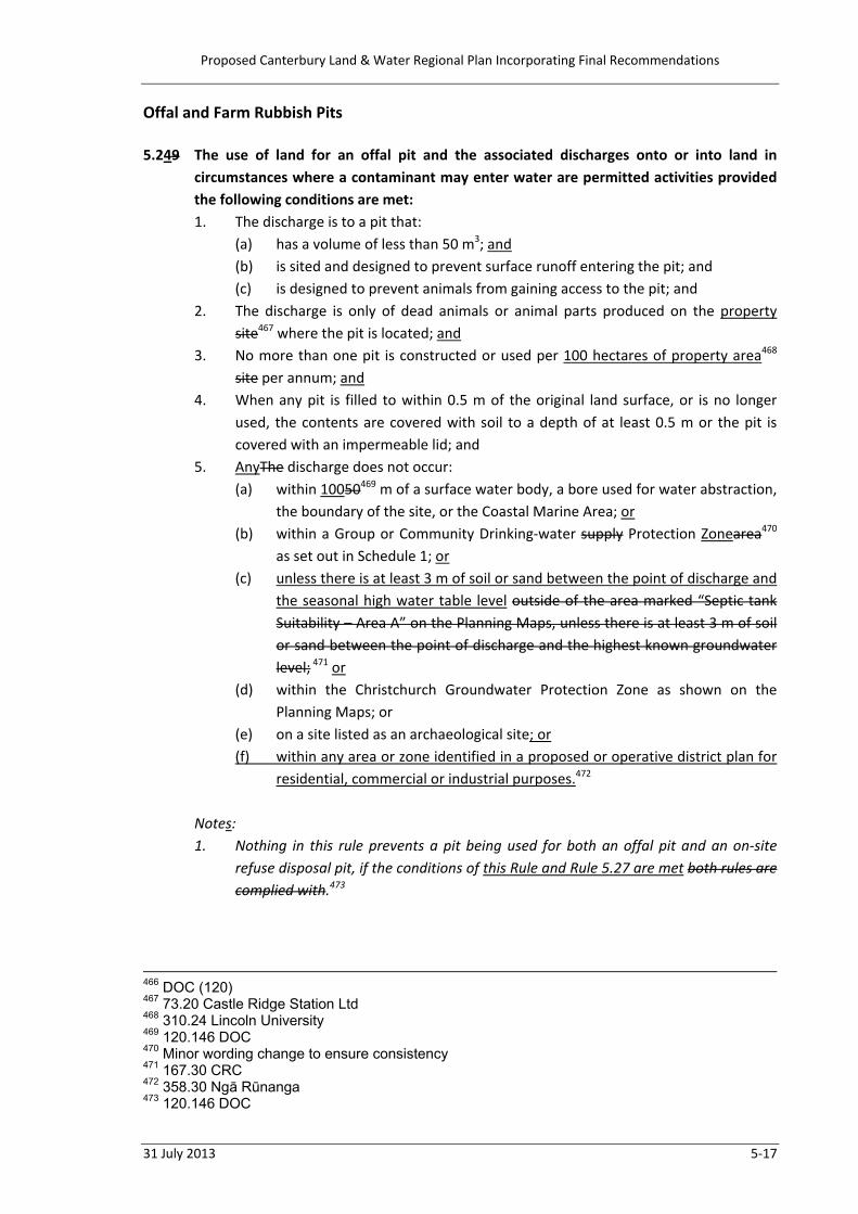
Offal and Farm Rubbish Pits 5.249 The use of land for an offal pit and the associated discharges onto or into land in
circumstances where a contaminant may enter water are permitted activities provided the following conditions are met: 1. The discharge is to a pit that:
(a) has a volume of less than 50 m3; and (b) is sited and designed to prevent surface runoff entering the pit; and (c) is designed to prevent animals from gaining access to the pit; and
2. The discharge is only of dead animals or animal parts produced on the property site467 where the pit is located; and
3. No more than one pit is constructed or used per 100 hectares of property area468 site per annum; and
4. When any pit is filled to within 0.5 m of the original land surface, or is no longer used, the contents are covered with soil to a depth of at least 0.5 m or the pit is covered with an impermeable lid; and
5. AnyThe discharge does not occur: (a) within 10050469 m of a surface water body, a bore used for water abstraction,
the boundary of the site, or the Coastal Marine Area; or (b) within a Group or Community Drinking‐water supply Protection Zonearea470
as set out in Schedule 1; or (c) unless there is at least 3 m of soil or sand between the point of discharge and
the seasonal high water table level outside of the area marked “Septic tank Suitability – Area A” on the Planning Maps, unless there is at least 3 m of soil or sand between the point of discharge and the highest known groundwater level; 471 or
(d) within the Christchurch Groundwater Protection Zone as shown on the Planning Maps; or
(e) on a site listed as an archaeological site; or (f) within any area or zone identified in a proposed or operative district plan for
residential, commercial or industrial purposes.472
Notes: 1. Nothing in this rule prevents a pit being used for both an offal pit and an on‐site
refuse disposal pit, if the conditions of this Rule and Rule 5.27 are met both rules are complied with.473
466 DOC (120) 467 73.20 Castle Ridge Station Ltd 468 310.24 Lincoln University 469 120.146 DOC 470 Minor wording change to ensure consistency 471 167.30 CRC 472 358.30 Ngā Rūnanga 473 120.146 DOC

Proposed Canterbury Land & Water Regional Plan Incorporating Final Recommendations
5‐18 31 July 2013
2. Archaeological sites are protected under the Historic Places Act 1993. There may also be additional provisions for historic heritage and earthworks in the relevant district plan.474
3. The discharge of carcasses and offal to land must not create a nuisance under the Health Act 1956. This means that the activity must not be offensive, likely to be injurious to health, spread disease, likely to harbour rats and other vermin, or give rise to the breeding of flies or other insects which are capable of transmitting disease.
4. If the discharge of carcasses and offal creates risks to human health it is appropriate to notify the Medical Officer of Health or Health Protection Officer for the area. Situations where this might be necessary include: (a) potential for microbial contamination of water supplies; (b) any infestations of vermin or other disease vectors; or (c) fallen stock left to decompose in the field where they die.475
5.25 Notwithstanding Rule 5.24, the use of land to bury a single dead animal and the
associated discharge onto or into land in circumstances where a contaminant may enter water are permitted activities provided the following conditions are met: 1. The dead animal cannot be disposed of in accordance with the conditions of Rule
5.24; and 2. The dead animal results from agricultural production on the same property; and 3. The dead animal is buried in a pit which does not contain any water, and is
immediately and completely covered by sufficient soil or plant material so as to prevent discharge of odour to air, or other nuisance; and
4. The burial location is not within any area or zone identified in a proposed or operative district plan for residential, commercial or industrial purposes; and
5. The burial site is at least 50 m from any: (a) surface water body; or (b) bore used for water abstraction; or (c) property boundary.476
5.2630 The use of land for an offal pit and the associated discharges onto or into land in
circumstances where a contaminant may enter water that does not meet one or more of the conditions in Rule 5.24 is a restricted discretionary activity where the following condition is met: 1. A Farm Environment Plan is prepared in accordance with Schedule 7 Part A.477 The CRC will restrict discretion to the following matters:
474 226.8 NZHPT 475 320.108 Fed Farmers (Combined Canty) 476 320.109 Fed Farmers (Combined Canty) 477 (318) Beef & Lamb
Proposed Canterbury Land & Water Regional Plan Incorporating Final Recommendations
31 July 2013 5‐19
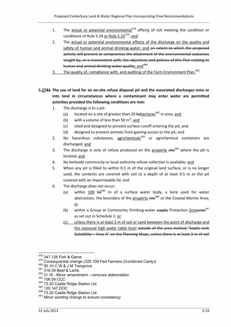
1. The actual or potential environmental478 effects of not meeting the condition or conditions of Rule 5.24 or Rule 5.25479; and
2. The actual or potential environmental effects of the discharge on the quality and safety of human and animal drinking‐water; and on extent to which the proposed activity will prevent or compromise the attainment of the environmental outcomes sought by, or is inconsistent with, the objectives and policies of this Plan relating to human and animal drinking water quality; and480
3. The quality of, compliance with, and auditing of the Farm Environment Plan.481 5.2731 The use of land for an on‐site refuse disposal pit and the associated discharges onto or
into land in circumstances where a contaminant may enter water are permitted activities provided the following conditions are met: 1. The discharge is to a pit:
(a) located on a site of greater than 20 hahectares482 in area; and (b) with a volume of less than 50 m3; and (c) sited and designed to prevent surface runoff entering the pit; and (d) designed to prevent animals from gaining access to the pit; and
2. No hazardous substances, agrichemicals483 or agrichemical containers are discharged; and
3. The discharge is only of refuse produced on the property site484 where the pit is located; and
4. No kerbside community or local authority refuse collection is available; and 5. When any pit is filled to within 0.5 m of the original land surface, or is no longer
used, the contents are covered with soil to a depth of at least 0.5 m or the pit covered with an impermeable lid; and
6. The discharge does not occur: (a) within 100 50485 m of a surface water body, a bore used for water
abstraction, the boundary of the property site486 or the Coastal Marine Area; or
(b) within a Group or Community Drinking‐water supply Protection Zonearea487 as set out in Schedule 1; or
(c) unless there is at least 3 m of soil or sand between the point of discharge and the seasonal high water table level outside of the area marked “Septic tank Suitability – Area A” on the Planning Maps, unless there is at least 3 m of soil
478 347.126 Fish & Game 479 Consequential change (320.109 Fed Farmers (Combined Canty)) 480 95.10 C W & J M Trengrove 481 318.39 Beef & Lamb 482 Cl 16 - Minor amendment – removes abbreviation 483 106.59 CCC 484 73.20 Castle Ridge Station Ltd 485 120.147 DOC 486 73.20 Castle Ridge Station Ltd 487 Minor wording change to ensure consistency

Proposed Canterbury Land & Water Regional Plan Incorporating Final Recommendations
5‐20 31 July 2013
or sand between the point of discharge and the highest known groundwater level; 488 or
(d) within the Christchurch Groundwater Protection Zone as shown on the Planning Maps: or
(e) on a site listed as an archaeological site; or (f) Within any area or zone identified in a proposed or operative district plan for
residential, commercial or industrial purposes.489
Notes: 1. Nothing in this rule prevents a pit being used for both an offal pit and an on‐
site refuse disposal pit, if the conditions of this Rule and Rule 5.29 are met both rules are complied with.490
2. Archaeological sites are protected under the Historic Places Act 1993. There may also be additional provisions for historic heritage and earthworks in the relevant district plan.491
5.2832 The use of land for an on‐site refuse disposal pit and the associated discharges onto or
into land in circumstances where a contaminant may enter water that does not meet one or more of the conditions in Rule 5.27 is a restricted discretionary activity where the following condition is met: 1. A Farm Environment Plan is prepared in accordance with Schedule 7 Part A.492 The CRC will restrict discretion to the following matters: 1. The actual or potential environmental493 effects of not meeting the condition or
conditions of Rule 5.27; and 2. The actual or potential environmental effects of the discharge on the quality and
safety of human and animal drinking‐water; and extent to which the proposed activity will prevent or compromise the attainment of the environmental outcomes sought by, or is inconsistent with, the objectives and policies of this Plan relating to human and animal drinking water quality. 494
3. The quality of, compliance with, and auditing of the Farm Environment Plan.495
488 167.30 CRC 489 358.32 Ngā Rūnanga 490 120.147 DOC 491 226.9 NZHPT 492 (318) Beef & Lamb 493 347.126 Fish & Game 494 95.10 C W & J M Trengrove 495 318.39 Beef and Lamb
Proposed Canterbury Land & Water Regional Plan Incorporating Final Recommendations
31 July 2013 5‐21
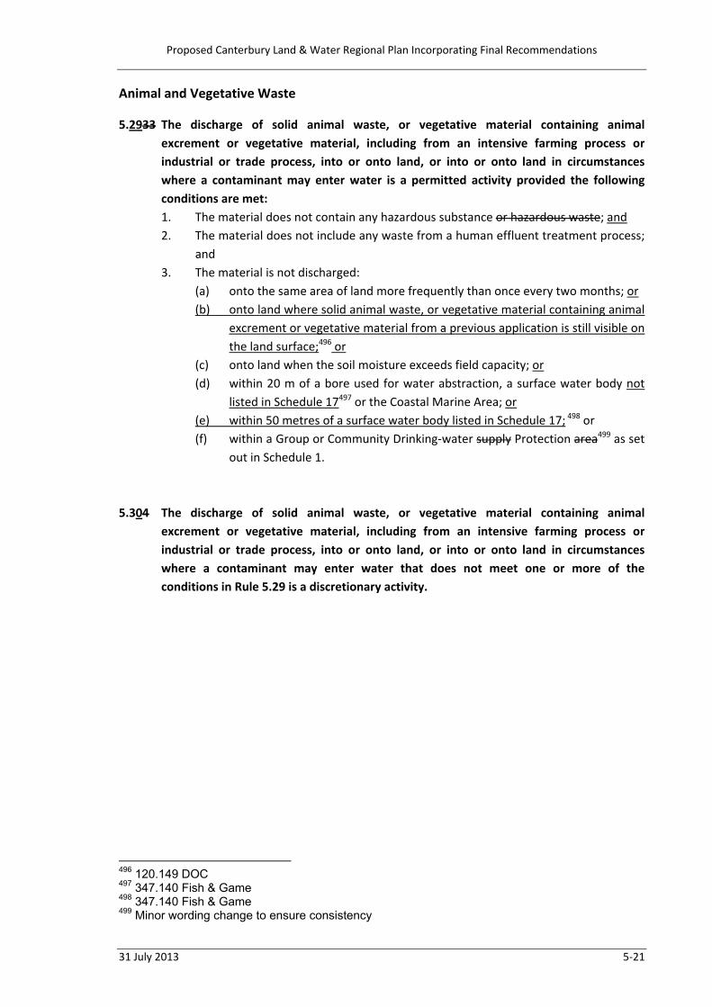
Animal and Vegetative Waste 5.2933 The discharge of solid animal waste, or vegetative material containing animal
excrement or vegetative material, including from an intensive farming process or industrial or trade process, into or onto land, or into or onto land in circumstances where a contaminant may enter water is a permitted activity provided the following conditions are met: 1. The material does not contain any hazardous substance or hazardous waste; and 2. The material does not include any waste from a human effluent treatment process;
and 3. The material is not discharged:
(a) onto the same area of land more frequently than once every two months; or (b) onto land where solid animal waste, or vegetative material containing animal
excrement or vegetative material from a previous application is still visible on the land surface;496 or
(c) onto land when the soil moisture exceeds field capacity; or (d) within 20 m of a bore used for water abstraction, a surface water body not
listed in Schedule 17497 or the Coastal Marine Area; or (e) within 50 metres of a surface water body listed in Schedule 17; 498 or (f) within a Group or Community Drinking‐water supply Protection area499 as set
out in Schedule 1. 5.304 The discharge of solid animal waste, or vegetative material containing animal
excrement or vegetative material, including from an intensive farming process or industrial or trade process, into or onto land, or into or onto land in circumstances where a contaminant may enter water that does not meet one or more of the conditions in Rule 5.29 is a discretionary activity.
496 120.149 DOC 497 347.140 Fish & Game 498 347.140 Fish & Game 499 Minor wording change to ensure consistency

Proposed Canterbury Land & Water Regional Plan Incorporating Final Recommendations
5‐22 31 July 2013
Stock Holding Areas and Animal Effluent 5.31 The use of land for a stock holding area is a permitted activity, provided the following
conditions are met: 1. The stock holding area is not within:
(a) 20 m of a surface water body, a bore used for water abstraction or the Coastal Marine Area; or
(b) a Group or Community Drinking‐water Protection Zone as set out in Schedule 1; and
2. All liquid animal effluent, washdown water or stormwater containing animal effluent is collected and disposed of to an animal effluent collection and storage system authorised under Rules 5.33 to 5.37; and
3. The base of any stock holding area located on land over an unconfined or semi‐confined aquifer shall be sealed such that seepage into land does not exceed one millimetre per day.
5.32 The use of land for a stock holding area that does not meet one or more of the
conditions of Rule 5.31 is a discretionary activity. 5.33 The use of land for the collection, storage and treatment of animal effluent is a
permitted activity, provided the following conditions are met: 1. The land used for the collection, storage and treatment of animal effluent is not:
(a) within 20 m of a surface water body (other than a wetland constructed primarily to treat animal effluent), a bore used for water abstraction or the Coastal Marine Area; or
(b) within 50 m of the boundary of the property; or (c) within a Group or Community Drinking‐water Protection Zone as set out in
Schedule 1; and 2. The collection, storage and treatment system is sealed, such that seepage into land
does not exceed one millimetre per day; and 3. The total volume of animal effluent stored on a property is no greater than 1,500
m3. 5.34 The use of land for the collection, storage and treatment of animal effluent that does
not meet one or more of the conditions of Rule 5.33 is a discretionary activity. 5.35 The discharge of animal effluent or water containing animal effluent and other
contaminants originating from a stock truck holding tank onto or into land where a contaminant may enter water is a permitted activity, provided the following conditions are met:
Proposed Canterbury Land & Water Regional Plan Incorporating Final Recommendations
31 July 2013 5‐23
1. The maximum volume discharged does not exceed 100 m3 per property in any 12 month period; and
2. The discharge of animal effluent or water containing animal effluent and other contaminants: (a) is not directly to, or within, 20 m of a surface water body (other than a
wetland constructed primarily to treat animal effluent); or (b) within 20 m of a bore used for water abstraction, the Coastal Marine Area, or
the boundary of the property. 5.36 The discharge of animal effluent or water containing animal effluent and other
contaminants originating from: (a) a stock holding area; or (b) a stock truck holding tank that does not meet one or more of the conditions of
Rule 5.35; onto or into land where a contaminant may enter water is a restricted discretionary activity, provided the following conditions are met: 1. The discharge of animal effluent or water containing animal effluent and other
contaminants: (a) is not directly to, or within, 20 m of a surface water body (other than a
wetland constructed primarily to treat animal effluent), a bore used for water abstraction or the Coastal Marine Area; and
(b) does not occur beyond the boundary of the property; and (c) is not within a Group or Community Drinking‐water Protection Zone as set
out in Schedule 1; and (d) has backflow prevention installed if the animal effluent or water containing
animal effluent is applied with irrigation water; and (e) is not to contaminated or potentially contaminated land; and
2. A Farm Environment Plan is prepared in accordance with Schedule 7 Part A. The CRC will restrict discretion to the following matters: 1. Measures to avoid, mitigate or remedy adverse effects on aquatic ecosystems and
human or animal drinking‐water; and 2. Effluent and water application rates and nutrient load; and 3. The effectiveness of methods to store effluent and application rates in times of
adverse weather conditions, including frozen or saturated soil, or in cases of equipment failure; and
4. The proximity of any discharge site to, and actual or potential effects on, any identified site of significant indigenous biodiversity on biodiversity; and
5. The adequacy of design, construction, systems and management processes to minimise fugitive discharges from the system, including, but not limited to, mitigation in case of equipment failure or breakage; and
6. The quality of, compliance with, and auditing of the Farm Environment Plan.
Proposed Canterbury Land & Water Regional Plan Incorporating Final Recommendations
5‐24 31 July 2013
5.37 The discharge of animal effluent or water containing animal effluent and other contaminants from a stock holding area into or onto land where a contaminant may enter water that does not meet one or more of the conditions of Rule 5.35 is a non‐complying activity.500
5.35 The use of land for a stock holding area, the use of land for the collection, storage and
treatment of animal effluent and the subsequent discharge of animal effluent or water containing animal effluent and other contaminants onto or into land where a contaminant may enter water is a restricted discretionary activity, provided the following conditions are met: 1. The stock holding area, collection, storage and treatment of animal effluent is not within:
(a) 20 m of a surface water body, a bore used for water abstraction or the Coastal Marine Area;
(b) a group or community drinking water supply protection area as set out in Schedule 1; and
2. The discharge of animal effluent or water containing animal effluent and other contaminants:
(c) is not directly to, or within, 20 m of a surface water body (other than a wetland constructed primarily to treat animal effluent), a bore used for water abstraction or the Coastal Marine Area;
(d) does not occur beyond the boundary of the site; (e) a group or community drinking water supply protection area as set out in Schedule
1 (f) has backflow prevention installed if the animal effluent or water containing animal
effluent is applied with irrigation water; and (g) is not to potentially contaminated land.
The CRC will restrict discretion to the following matters: 1. Measures to avoid, mitigate or remedy adverse effects on aquatic ecosystems and
human or animal drinking water; 2. Measures to store effluent and application rates; 3. Methods to store effluent and application rates in times of adverse weather
conditions, including frozen ground, or in cases of equipment failure; 4. The proximity of any discharge site to any identified site of significant indigenous
biodiversity; 5. The adequacy of design, construction, systems and management processes to
minimise fugitive discharges from the system, including, but not limited to, any design leakage from the stockholding and effluent storage areas, flow paths and mitigation in case of equipment failure or breakage;
500 Several submission points relied on, including 120.151 DOC, 320.116-120 Fed Farmers
(Combined Canty), and 318.39 Beef & Lamb NZ

Proposed Canterbury Land & Water Regional Plan Incorporating Final Recommendations
31 July 2013 5‐25
6. The extent to which the proposed activity is consistent with the objectives and policies of this Plan relating to Ngāi Tahu values, human and animal health and drinking water quality, including Policy 4.11.
5.36 The use of land for a stock holding area, the use of land for the collection, storage and
treatment of animal effluent and the subsequent discharge of animal effluent or water containing animal effluent and other contaminants into or onto land where a contaminant may enter water that does not meet one or more of the conditions of Rule 5.35 is a non‐complying activity. 501
501 Several submission points relied on, including 120.151 DOC, 320.116-120 Fed Farmers
(Combined Canty), and 318.39 Beef & Lamb NZ

Proposed Canterbury Land & Water Regional Plan Incorporating Final Recommendations
5‐26 31 July 2013
Silage Pits and Compost 5.38 The use of land for a silage pit or the stockpiling of decaying organic matter (including
compost) and any associated discharge into or onto land where a contaminant may enter water is a permitted activity provided the following conditions are met: 1. The volume of any silage pit or stockpile is less than 20 m3; and 2. Any liquid that drains from the stockpile does not enter a surface water body, other
than a wetland constructed primarily to treat animal effluent; and 3. Any decaying organic matter does not originate from an industrial or trade
process.502 5.3937 The use of land for a silage pit or the stockpiling of other fermenting or decaying organic
matter (including compost) not permitted by Rule 5.38503 and any associated discharge into or onto land where a contaminant may enter water is a permitted activity provided the following conditions are met: 1. The volume of any silage pit or stockpile is less than 20 m3; or 1. The volume of any silage pit or stockpile is greater than 20 m3 and is not sited:
(a) within 50 20504 m of a surface water body, the boundary of the property site,505 a bore or the Coastal Marine Area; or
(b) within a Group or Community Drinking‐water supply Protection Zonearea506 as set out in Schedule 1; or
(c) within the Christchurch Groundwater Protection Zone as shown on the Planning Maps; and
2. Any liquid that drains from the silage pit or stockpile does not enter a surface water body, other than a wetland constructed primarily to treat animal507 effluent; and
3. Any fermenting or508 decaying organic matter does not originate from an industrial or trade process.
5.4038 The use of land for a silage pit or the stockpiling of other fermenting or509 decaying
organic matter (including compost)510 and any associated discharge into or onto land where a contaminant may enter water, that does not meet one or more of the conditions in Rule 5.39 is a restricted discretionary activity where the following condition is met: 1. A Farm Environment Plan is prepared in accordance with Schedule 7 Part A.511 The CRC will restrict discretion to the following matters:
502 320.122 Fed Farmers (Combined Canty) 503 Consequential amendment (320.122 Fed Farmers (Combined Canty)) 504 347.145 Fish & Game 505 73.20 Castle Ridge Station Ltd 506 Minor wording change to ensure consistency 507 Cl 16 – Minor amendment – redundant word 508 Consequential amendment – included within “decaying” 509 Consequential amendment – included within “decaying” 510 Consequential amendment (320.122 Fed Farmers (Combined Canty)) 511 Beef & Lamb (318)
Proposed Canterbury Land & Water Regional Plan Incorporating Final Recommendations
31 July 2013 5‐27
1. The actual or potential environmental512 effects of not meeting the condition or conditions of Rule 5.38; and
2. The quality of, compliance with and auditing of the Farm Environment Plan.513 3. The extent to which the proposed activity will prevent or compromise the
attainment of the environmental outcomes sought by, or is inconsistent with, the objectives and policies of this Plan relating to water quality.514
Note: Rules 5.38 to 5.40 do not apply to the storage of baled and wrapped silage, whether stored in individual bales or a continuous tube.515
512 358.38 Ngā Rūnanga 513 364.41 RFBPS (Canty West Coast) 514 Consequential amendment 515 329.5 CJ & AM Allen
Proposed Canterbury Land & Water Regional Plan Incorporating Final Recommendations
5‐28 31 July 2013
Farming Nutrient Management516
Note: All other rules in this Plan that control discharges, including of nutrients, from farming activities to water or onto or into land in circumstances where nutrients may enter water also have to be complied with. Examples of such rules are Rules 5.29 and 5.30 relating to offal pits.
All Nutrient Allocation Zones 5.41 Notwithstanding any of Rules 5.41 to 5.43, the use of land for a farming activity is a
permitted activity, provided the following conditions are met: 1. the property is less than 5 hectares in area; or 2. The nitrogen loss calculation for the property does not exceed 10 kg per hectare
per annum and the property is not in a Lake Zone. 5.42 Where any property includes land in more than one Nutrient Allocation Zone, as shown
on the Planning Maps, the rules for each Nutrient Allocation Zone apply to the area of the property within that Zone.
Red Nutrient Allocation Zones 5.43 The use of land for a farming activity is a permitted activity, provided the following
conditions are met: 1. The nitrogen loss calculation for the property is greater than 10 kg per hectare per
annum but does not exceed 20 kg per hectare per annum; and 2. The nitrogen loss calculation for the property will not increase above the nitrogen
baseline. 5.44 Until the 1st of January 2017, the use of land for a farming activity is a permitted activity,
provided the following conditions are met: 1. The nitrogen loss calculation for the property is greater than 20 kg per hectare per
annum; and 2. The nitrogen loss calculation for the property will not increase above the nitrogen
baseline. 5.45 From the 1st of January 2017, the use of land for a farming activity is a restricted
discretionary activity, provided the following conditions are met: 1. The nitrogen loss calculation for the property is greater than 20 kg per hectare per
annum; and 516 320.124 Fed Farmers (Combined Canty)

Proposed Canterbury Land & Water Regional Plan Incorporating Final Recommendations
31 July 2013 5‐29
2. The nitrogen loss calculation for the property will not increase above the nitrogen baseline; and
3. A Farm Environment Plan is prepared in accordance with Schedule 7 Part A.
The CRC will restrict discretion to the following matters: 1. The quality of, compliance with and auditing of the Farm Environment Plan; and 2. The proposed management practices to avoid or minimise the discharge of
nitrogen, phosphorus, sediment and microbiological contaminants to water from the use of land; and
3. The potential benefits of the activity to the applicant, the community and the environment; and
4. The potential effects of the land use on surface and groundwater quality and sources of drinking‐water.
5.46 The use of land for a farming activity on a farming enterprise is a discretionary activity,
provided the following conditions are met: 1. A Farm Environment Plan is prepared in accordance with Schedule 7 Part A; and 2. The nitrogen loss calculation for the farming enterprise will not increase above the
nitrogen baseline; and 3. The properties comprising the farming enterprise are in the same surface water
catchment and Nutrient Allocation Zone, as shown on the Planning Maps. 5.47 The use of land for a farming activity that does not comply with condition 3 of Rule 5.45
or condition 1 or 3 of Rule 5.46 is a non‐complying activity. 5.48 The use of land for a farming activity that does not comply with condition 2 of Rule 5.43
or condition 2 of Rule 5.44 or condition 2 of Rule 5.45 or condition 2 of Rule 5.46 is a prohibited activity.
Lake Zones 5.49 The use of land for a farming activity is a controlled activity, provided the following
conditions are met: 1. The nitrogen loss calculation for the property does not exceed 10 kg per hectare
per annum; and 2. The nitrogen loss calculation for the property has not increased above the nitrogen
baseline; and 3. A Farm Environment Plan is prepared in accordance with Schedule 7 Part A.
The CRC reserves control to the following matters: 1. The quality of, compliance with and auditing of the Farm Environment Plan; and

Proposed Canterbury Land & Water Regional Plan Incorporating Final Recommendations
5‐30 31 July 2013
2. The proposed management practices to avoid or minimise the discharge of nitrogen, phosphorus, sediment and microbiological contaminants to water from the use of land.
5.50 The use of land for a farming activity is a restricted discretionary activity, provided the
following conditions are met: 1. The nitrogen loss calculation for the property is greater than 10 kg per hectare per
annum; and 2. The nitrogen loss calculation for the property has not increased above the nitrogen
baseline; and 3. A Farm Environment Plan is prepared in accordance with Schedule 7 Part A. The CRC will restrict discretion to the following matters: 1. The quality of, compliance with and auditing of the Farm Environment Plan; and 2. The proposed management practices to avoid or minimise the discharge of
nitrogen, phosphorus, sediment and microbiological contaminants to water from the use of land; and
3. The potential benefits of the activity to the applicant, the community and the environment; and
4. The potential effects of the land use on surface and groundwater quality and sources of drinking‐water.
5.51 The use of land for a farming activity that does not comply with condition 3 of Rule 5.49
or condition 3 of Rule 5.50 is a non‐complying activity. 5.52 The use of land for a farming activity that does not comply with condition 2 of Rule 5.49
or condition 2 of Rule 5.50 is a prohibited activity. Orange Nutrient Allocation Zones 5.53 The use of land for a farming activity is a permitted activity, provided the following
conditions are met: 1. The nitrogen loss calculation for the property does not exceed 20 kg per hectare
per annum and information is recorded in accordance with Schedule 7 Part D, and supplied to the Canterbury Regional Council upon request; or
2. The nitrogen loss calculation for the property exceeds 20 kg per hectare per annum and: (a) information is recorded in accordance with Schedule 7 Part D, and supplied
to the Canterbury Regional Council upon request; and (b) the property is less than 50 hectares in area; and
Proposed Canterbury Land & Water Regional Plan Incorporating Final Recommendations
31 July 2013 5‐31
(c) The nitrogen loss calculation for the property will not increase above the nitrogen baseline;
5.54 Until 1 January 2016, the use of land for a farming activity that does not comply with
Rule 5.53 is a permitted activity, provided the following condition is met: 1. The nitrogen loss calculation for the property will not increase above the nitrogen
baseline by more than 5 kg per hectare per annum. 5.55 From 1 January 2016, the use of land for a farming activity that does not comply with
Rule 5.53 is a restricted discretionary activity, provided the following conditions are met: 1. The nitrogen loss calculation for the property will not increase above the nitrogen
baseline by more than 5 kg per hectare per annum; and 2. A Farm Environment Plan is prepared in accordance with Schedule 7 Part A.
The CRC will restrict discretion to the following matters: 1. The quality of, compliance with and auditing of the Farm Environment Plan; and 2. The proposed management practices to avoid or minimise the discharge of
nitrogen, phosphorus, sediment and microbiological contaminants to water from the use of land; and
3. The potential benefits of the activity to the applicant, the community and the environment; and
4. The potential effects of the land use on surface and groundwater quality and sources of drinking‐water.
5.56 The use of land for a farming activity that does not comply with Rule 5.54 or 5.55 is a
discretionary activity. Green and Light Blue Nutrient Allocation Zones 5.57 The use of land for a farming activity is a permitted activity, provided the following
conditions are met: 1. The nitrogen loss calculation for the property does not exceed 20 kg per hectare
per annum and information is recorded in accordance with Schedule 7 Part D, and supplied to the Canterbury Regional Council upon request; or
2. The nitrogen loss calculation for the property is greater than 20 kg per hectare per annum and: (a) information is recorded in accordance with Schedule 7 Part D, and supplied
to the Canterbury Regional Council upon request; and (b) the property is less than 50 hectares in area; or
Proposed Canterbury Land & Water Regional Plan Incorporating Final Recommendations
5‐32 31 July 2013
(c) the nitrogen loss calculation for the property will not increase above the nitrogen baseline by more than 5 kg per hectare per annum;
5.58 The use of land for a farming activity that does not comply with Rule 5.57 is a restricted
discretionary activity, provided the following condition is met: 1. A Farm Environment Plan is prepared in accordance with Schedule 7 Part A.
The CRC will restrict discretion to the following matters: 1. The quality of, compliance with and auditing of the Farm Environment Plan; and 2. The proposed management practices to avoid or minimise the discharge of
nitrogen, phosphorus, sediment and microbiological contaminants to water from the use of land; and
3. The potential benefits of the activity to the applicant, the community and the environment; and
4. The potential effects of the land use on surface and groundwater quality and sources of drinking‐water.
5.59 The use of land for a farming activity on a property of greater than 5 hectares in area
that does not comply with Rule 5.58 is a non‐complying activity. Irrigation Schemes 5.60 Notwithstanding Rules 5.43 to 5.59, the use of land for a farming activity is a permitted
activity, provided the following conditions are met: 1. The property is irrigated with water from an irrigation scheme or a principal water
supplier, and the irrigation scheme or a principal water supplier holds a discharge consent under Rule 5.62 or the discharge is a permitted activity under Rule 5.61.
Note: If a property is irrigated with water from an irrigation scheme or principal water supplier that does not hold a discharge consent under Rule 5.62 or is not a permitted activity under Rule 5.61, then it is assessed under Rules 5.43 to 5.59.
5.61 Until 1 January 2017, the discharge of nutrients onto or into land in circumstances that
may result in a contaminant entering water that would otherwise contravene s15(1) of the RMA is a permitted activity, provided the following conditions are met: 1. There is an existing consent, held by an irrigation scheme or a principal water
supplier, that has conditions that specify the maximum amount or rate at which nutrients may be discharged to the subject land; and
2. The consent was granted prior to 11 August 2012.
Proposed Canterbury Land & Water Regional Plan Incorporating Final Recommendations
31 July 2013 5‐33
5.62 The discharge of nutrients onto or into land in circumstances that may result in a
contaminant entering water that would otherwise contravene s15(1) of the RMA is a discretionary activity, provided the following condition is met: 1. The applicant is an irrigation scheme or a principal water supplier, or the holder of
the discharge consent will be an irrigation scheme or a principal water supplier.
Notification Pursuant to sections 95A and 95B of the RMA an application for resource consent under this rule will be processed and considered without public or limited notification, provided that: 1. The nutrient loss is equal to or less than that currently authorised through
conditions on a water permit to take and use water; or 2. The nutrient loss is equal to or less than the aggregation of the nutrient baseline
across properties within the command area, calculated on a surface water catchment basis.
Note that limited notification to affected order holders in terms of section 95F of the RMA will be necessary , where relevant, under section 95B(3) of the RMA.
Note: If the applicant is not an irrigation scheme or a principal water supplier, or the holder of the discharge consent will not be an irrigation scheme or a principal water supplier, then the discharge is assessed under Rules 5.63 to 5.64.
Incidental Nutrient Discharges 5.63 The discharge of nutrients onto or into land in circumstances that may result in a
contaminant entering water that would otherwise contravene s15(1) of the RMA is a permitted activity, provided the following conditions are met: 1. The land use activity associated with the discharge is authorised under Rules 5.41 to
5.59; or 2. The land use activity associated with the discharge is authorised under Rules 10.1,
10.2, 11.1 or 11.1A of the Hurunui‐Waiau River Regional Plan. 5.64 The discharge of nutrients onto or into land in circumstances that may result in a
contaminant entering water that would otherwise contravene s15(1) of the RMA and does not meet condition 1 of Rules 5.62 or conditions 1 or 2 of 5.63 is a non‐complying activity.517
517 A range of submission points have been used to develop the above provisions. In particular,
the following submissions have been used to formulate the recommendations: Fish & Game (347), Beef & Lamb (318), Ngā Rūnanga (358), DOC (120), Fed Farmers (Combined Canty) (320), Fonterra (270), DairyNZ (315), and the Fertiliser Assn (239).
Proposed Canterbury Land & Water Regional Plan Incorporating Final Recommendations
5‐34 31 July 2013
5.39 Prior to 1 July 2017, the use of land for any farming activity existing at 11 August 2012
and outside of the Lake Zone shown on the Planning Maps, is a permitted activity if the following condition is met: 1. A record of the annual amount of nitrogen loss from the land, for the period from 1
July in one year to 30 June in the following year, calculated using the OVERSEERTM nutrient model, is kept and is provided to the CRC upon request.
5.40 Prior to 1 July 2017, the use of land for a farming activity existing at 11 August 2012 and
within the Lake Zone shown on the Planning Maps, is a permitted activity if the following conditions are met: 1. A record of the annual amount of nitrogen loss from the land, for the period from 1
July in one year to 30 June in the following year, calculated using the OVERSEERTM nutrient model;
2. A Farm Environment Plan is prepared and implemented in accordance with Schedule 7;
3. The Farm Environment Plan is externally audited each year for the first three years by a Farm Environment Plan Auditor. Following three consecutive years of full compliance, the audit shall occur once every three years; and
4. A record of the audit compliance grading and the average annual loss of nitrogen for the property is provided to the CRC by 31 August of that year.
5.41 The use of land for a farming activity that does not comply with one or more of the
conditions of Rules 5.39 or 5.40 is a restricted discretionary activity.
The CRC will restrict discretion to the following matters: 1. The proposed management practices to avoid or minimise the discharge of
nitrogen, phosphorus, sediment and microbiological contaminants to water from the use of land;
2. The potential effects of the land use on surface and groundwater quality, sources of drinking water;
3. The contribution of nutrients from the proposed activity to the nutrient allocation status of the management zone.
4. The extent to which the proposed activity will prevent or compromise the attainment of the environmental outcomes sought by, or is inconsistent with, the objectives and policies of this Plan relating to nutrient management and water quality.
Notification Pursuant to sections 95A and 95B of the RMA an application for resource consent under this rule will be processed and considered without public or limited notification.
Proposed Canterbury Land & Water Regional Plan Incorporating Final Recommendations
31 July 2013 5‐35
Note that limited notification to affected order holders in terms of section 95F of the RMA will be necessary where relevant, under section 95B(3) of the RMA.
5.42 Prior to 1 July 2017 the use of land for a change to an existing farming activity is a
permitted activity if the following conditions are met: 1. The land holder has been granted a water permit, or holds shares in an irrigation
company that has been granted a water permit, that authorises irrigation on the land and the land is subject to conditions that specify the maximum amount of nitrogen that may be leached;
2. The property is outside a Lake Zone as shown on the Planning Maps; 3. A record of the annual amount of nitrogen loss from the land, for the period from 1
July in one year to 30 June in the following year, calculated using the OVERSEERTM nutrient model;
4. A Farm Environment Plan is prepared and implemented in accordance with Schedule 7;
5. The Farm Environment Plan is externally audited each year for the first three years by an Farm Environment Plan Auditor. Following three consecutive years of full compliance, the audit shall occur once every three years; and
6. A record of the audit compliance grading and the average annual loss of nitrogen for the property is provided to the CRC by 31 August of that year.
5.43 Prior to 1 July 2017, the use of land for a change to an existing farming activity that does
not comply with Condition 1 in Rule 5.42 and is within an area coloured pale blue or green on the Planning Maps is a restricted discretionary activity.
The CRC will restrict the exercise of discretion to the following matters: 1. The proposed management practices to avoid or minimise the discharge of
nitrogen, phosphorus, sediment and microbiological contaminants to water from the use of land;
2. The potential effects of the land use on surface and groundwater quality, and sources of drinking water;
3. The contribution of nutrients from the proposed activity to the nutrient allocation status of the management zone.
4. The extent to which the proposed activity will prevent or compromise the attainment of the environmental outcomes sought by, or is inconsistent with, the objectives and policies of this Plan relating to nutrient management and water quality.
5.44 Prior to 1 July 2017, the use of land for a change to an existing farm activity that does not
comply with Condition 1 in Rule 5.42 and is within an area coloured orange on the Planning Maps is a discretionary activity.

Proposed Canterbury Land & Water Regional Plan Incorporating Final Recommendations
5‐36 31 July 2013
5.45 Prior to 1 July 2017, the use of land for a change to an existing farm activity that does not comply with Condition 1 in Rule 5.42 and is within an area coloured red or within a Lake Zone shown on the Planning Maps is a non‐complying activity.
5.46 From 1 July 2017, the use of land for any farming activity, is a permitted activity if the
following conditions are met: 1. The land is outside a Lake Zone shown on the Planning Maps; and 2. The average annual loss of nitrogen does not exceed the rate for the relevant
farming activity in Schedule 8; and 3. The annual average loss of nitrogen, averaged over three consecutive years is less
than 20 kilograms per hectare a record of the annual amount of nitrogen loss from the land, for the period from 1 July in one year to 30 June in the following year, calculated using the OVERSEERTM nutrient model, is kept and is provided to the CRC upon request; or
4. If the annual average loss of nitrogen, averaged over three consecutive periods from 1 July in one year to 30 June in the following year, is 20 kilograms per hectare or more: (a) a Farm Environment Plan is prepared and implemented in accordance with
Schedule 7; (b) the Farm Environment Plan is externally audited each year for the first three
years by an Farm Environment Plan Auditor. Following three consecutive years of full compliance, the audit shall occur once every three years; and
(c) a record of the audit compliance grading and the average annual loss of nitrogen for the property is be provided to the CRC by 31 August of that year.
5.47 From 1 July 2017, the use of land for any a farming activity that does not meet Condition 2 in Rule 5.46 or where there is no rate for the relevant farming activity specified in Schedule 8 and where the property is within an area coloured pale blue or green on the Planning Maps is a restricted discretionary activity.
The CRC will restrict the exercise of discretion to the following matters: 1. The proposed management practices to avoid or minimise the discharge of
nitrogen, phosphorus, sediment and microbiological contaminants to water from the use of land;
2. The potential effects of the land use on surface and groundwater quality, and sources of drinking water;
3. The contribution of nutrients from the proposed activity to the nutrient allocation status of the management zone.
4. The extent to which the proposed activity will prevent or compromise the attainment of the environmental outcomes sought by, or is inconsistent with, the objectives and policies of this Plan relating to nutrient management and water quality.

Proposed Canterbury Land & Water Regional Plan Incorporating Final Recommendations
31 July 2013 5‐37
5.48 From 1 July 2017, the use of land for any farming activity is a discretionary activity where either: a. The activity does not meet Condition 2 in Rule 5.46 or there is no rate for the
relevant farming activity specified in Schedule 8 and where the property is within an area coloured orange on the Planning Maps; or
b. The activity complies with Condition 2 but not Condition 1 in Rule 5.46; or c. The activity does not meet Condition 3 or 4, whichever is relevant, in Rule 5.46.
5.49 From 1 July 2017, the use of land for any a farming activity that does not meet Condition
2 in Rule 5.46 or where there is no rate for the relevant farming activity specified in Schedule 8 and where the property is within an area coloured red or within a Lake Zone shown on the Planning Maps is a non‐complying activity.
5.50 The discharge of nutrients onto or into land in circumstances that may result in a
contaminant entering water that would otherwise contravene s15(1) of the RMA is a permitted activity, provided the following condition is met: 1. The land use activity associated with the discharge is authorised under Rules 5.39 to
5.49.
5.51 The discharge of nutrients onto or into land in circumstances that may result in a contaminant entering water that would otherwise contravene s15(1) of the RMA and does not meet the condition in Rule 5.50 is a discretionary activity.
Proposed Canterbury Land & Water Regional Plan Incorporating Final Recommendations
5‐38 31 July 2013
Fertiliser Use 5.6552 The discharge of fertiliser onto or into land in circumstances where a contaminant may
enter water is a permitted activity provided the following conditions are met: 1. There is no fertiliser discharged when the soil moisture exceeds field capacity518
there is water ponding on the surface of the land; and 2. Where any permanently flowing river, lake, artificial watercourse or wetland has
riparian planting from which stock is excluded, fertiliser may be discharged up to the paddock‐side edge of the riparian planting, but not onto the riparian planting, except for fertiliser required to establish the planting; or519
3. Where any permanently flowing river, lake, artificial watercourse or wetland does not have riparian planting from which stock is excluded,520 fertiliser is not discharged directly into or within 10 m of the bed of a permanently flowing river, lake, artificial watercourse or within 10 m of a wetland boundary. or any identified significant indigenous biodiversity site521 unless the equipment used has a current Spreadmark Certificate, in which case the setback distance is reduced to 5m522
Notes: 1. The discharge of fertiliser may also be restricted by Rules 5.43 to 5.64. 2. If resource consent is held for the discharge of a substance that may also meet the
definition of fertiliser then no additional resource consent is required under Rules 5.66 or 5.67.523
5.6653 The discharge of fertiliser from an aircraft onto or into land in circumstances where a
contaminant may enter water and into any river is a permitted activity provided the following conditions are met: 1. There is no fertiliser discharged when the soil moisture exceeds field capacity 524
there is water ponding on the surface of the land; and 2. The equipment used has a current Spreadmark Certificate; 525 2. The discharge is be carried out by a person who holds a GROWSAFE® Pilots’
Agrichemical Rating Certificate or AIRCARETM Accreditation;526 3. Fertiliser is not discharged directly into or within 10 m of the bed of a permanently
flowing river or artificial watercourse that is more than 2m wide, any lake, or any wetland boundary or any significant indigenous biodiversity site identified in the relevant district plan;527 and
518 358.43 Ngā Rūnanga (submission from Rule 5.69) 519 19.93 Ellesmere ISI 520 347.148 Fish & Game 521 Provided for in Rule 5.53(3) 522 121.1 Talbot Agriculture 523 317.50 ANZCO Foods Ltd 524 358.43 Ngā Rūnanga (submission from Rule 5.69) 525 Consequential amendment (121.1 Talbot Agriculture) 526 Consequential amendment (121.1 Talbot Agriculture) 527 106.66 CCC Consequential
Proposed Canterbury Land & Water Regional Plan Incorporating Final Recommendations
31 July 2013 5‐39
4. The flight paths are recorded by an on‐board differential global positioning system and this record is kept for at least 12 months following the discharge and made available to the CRC upon request. 528
Note: The discharge of fertiliser may also be restricted by Rules 5.43 to 5.64.
5.67 The discharge of fertiliser onto land, or onto or into land in circumstances where a
contaminant may enter water that does not meet one or more of the conditions in Rule 5.65 or rule 5.66 is a restricted529 discretionary activity, provided the following condition is met: 1. A Farm Environment Plan is prepared in accordance with Schedule 7 Part A.
The CRC will restrict discretion to the following matters: 1. The actual or potential environmental effects of not meeting the condition or
conditions of Rules 5.65 or 5.66;530 and 2. The potential benefits of the activity to the applicant, the community and the
environment; and 3. The quality of, compliance with and auditing of the Farm Environment Plan.531
528 120 DOC (particularly evidence) 529 320.152 Fed Farmers (Combined Canty) 530 265.55 Ravensdown 531 364.41 RFBPS (Canty West Coast)
Proposed Canterbury Land & Water Regional Plan Incorporating Final Recommendations
5‐40 31 July 2013
Stock Exclusion 5.68 The use and disturbance of the bed (including the banks) of a lake, river or a wetland by
stock and any associated discharge to water is a permitted activity, provided the following conditions are met: 1. The use or disturbance of the bed (including the banks) of a lake, river or wetland
and any associated discharge to water is not categorised as a non‐complying activity under Rule 5.135 or a prohibited activity under Rule 5.136; and
2. The use or disturbance of the bed (including the banks) of a lake or river and any associated discharge to water is at a stock crossing point that is: (a) not more than 20 m wide; and (b) perpendicular to the direction of water flow, except where this is
impracticable owing to the natural contours of the riverbed or adjoining land; and
(c) aligns with a constructed track or raceway on either side of the crossing point; or
3. The use or disturbance of the bed (including the banks) of a lake or river and any associated discharge to water that is not at a permanent stock crossing point does not result in: (a) pugging or de‐vegetation that exposes bare earth in the bed (including the
banks) of a lake or river; or (b) a conspicuous change in colour or clarity of the water, outside the Mixing
Zone; or (c) cattle standing in any lake; and
4. The disturbance of a wetland does not result in a conspicuous change in colour or clarity of water, or pugging or de‐vegetation that exposes bare earth.
5.69 The use and disturbance of the bed (including the banks) of a lake, river or a wetland by
stock and any associated discharge to water that does not meet one or more of conditions 2 to 4 of Rule 5.133 and is not listed as a non‐complying activity under Rule 5.135 or a prohibited activity under Rule 5.136 is a discretionary activity.
5.70 Unless categorised as a prohibited activity under Rule 5.136, the use and disturbance of
the bed (including the banks) of a lake, a river that is greater than 1 m wide or 100 millimetres deep (under median flow conditions), or a wetland, by intensively farmed stock and any associated discharge to water is a non‐complying activity.
5.71 The use and disturbance of the bed (including the banks) of a lake or river by intensively
farmed stock and any associated discharge to water is a prohibited activity in the following areas: 1. In an inanga or salmon spawning site listed in Schedule 17; or 2. Within a Group or Community Drinking‐water Protection Zone as listed in Schedule
1; or

Proposed Canterbury Land & Water Regional Plan Incorporating Final Recommendations
31 July 2013 5‐41
3. Within 1000 m upstream, in the bed of a lake river, of a fresh water bathing site listed in Schedule 6; or
4. In the bed (including the banks) of a spring‐fed plains river, as shown on the Planning Maps. 532
5.133 The use and disturbance of the bed of a lake or river or a wetland by outdoor intensively
farmed livestock for temporary or permanent stocking or temporary access is a prohibited activity.
5.134 The use and disturbance of the bed of a lake or river or a wetland by cattle or farmed deer
for temporary or permanent stocking is a prohibited activity in the following areas: 1. In an inanga or salmon spawning site listed in Schedule 17; 2. Within 1000 m upstream of a group or community water supply intake as listed in
Schedule 1; 3. Within 1000 m upstream in the bed of a lake or flowing river of a fresh water bathing
site listed in Schedule 6; or 4. In a bed of a Spring‐fed plains river.
5.135 The use and disturbance of the bed of a lake, river or wetland for temporary or permanent
stocking or temporary access and any associated discharges is a permitted activity, provided the following conditions are met: 1. The use or disturbance is not a prohibited activity under Rules 5.133 or 5.134 2. The disturbance by livestock shall not, outside the Mixing Zone cause:
(a) a conspicuous change in colour or clarity of the water; (b) the concentration of Exherichia coli to exceed 550 E.coli per 100 millilitres;
3. The disturbance shall not result in the following effects being clearly visible in or on the bed, including the banks of a river or lake: (a) pugging or trampling of the land; or (b) areas of bare ground; and
4. The disturbance of a wetland shall not result in: (a) a conspicuous change in colour or clarity of the water; (b) any clearly visible pugging or trampling of land.
5.136 The use and disturbance of a bed of a lake, river or wetland for a permanent stock crossing
point and any associated discharges is a permitted activity, provided the following conditions are met: 1. The use or disturbance is not a prohibited activity under Rules 5.133 or 5.134; 2. The crossing point is not more than 20 m wide; 3. The crossing point is perpendicular to the direction of water flow, except where this
is impracticable owing to the natural contours of the riverbed or adjoining land; 4. The crossing point aligns with a constructed track or raceway on either side of the
crossing point; 5. The crossing point does not obstruct the passage of fish;
532 A range of submission points have been used to develop the above provisions. In particular,
the following submissions have been used to formulate the recommendations: Waihora Ellesmere Trust (244), Sth Rakaia Batch Owners (12), Fed Farmers (Combined Canty) (320) and Ellesmere ISI (19).

Proposed Canterbury Land & Water Regional Plan Incorporating Final Recommendations
5‐42 31 July 2013
6. The approaches to the crossing shall be located, constructed and maintained to ensure that the parts of the crossing approaching the area of the bed covered by water under low flow conditions are underlain by compacted gravel or some other material with an equivalent or better stability against erosion.
5.137 The use and disturbance of the bed of a lake or river or a wetland for temporary or
permanent stocking and any incidental discharges that does not comply with one or more of conditions 2 to 4 in Rule 5.135, and for a permanent stock crossing point that does not comply with one or more of conditions 2 to 6 in Rule 5.136, is a discretionary activity.
Proposed Canterbury Land & Water Regional Plan Incorporating Final Recommendations
31 July 2013 5‐43
Flow‐sensitive Catchments
Note: See Sub‐regional Sections 6 to 15 of this Plan for location‐specific requirements.
5.72109 The replanting after harvest of areas of plantation forest within any flow‐
sensitive catchment listed in Sections 6 to 15 is a permitted activity, provided the following conditions are met: 1. The total area of replanted forest does not exceed the area of forest and replanting
of the forest occurs in the same location, or the area as used for a rotation forestry operation, that existed at 1 November 2010; and
2. Any replanting occurs within five years of the removal of the previous forest cover. 5.73110 The planting of new areas of plantation forest within any flow‐sensitive
catchment listed in Sections 6 to 15 is a controlled permitted533 activity, provided the forest planting meets the following conditions: 1. Existing areas of exotic tall vegetation, other than plantation forest, that is greater
than 2 m tall and occupies more than 80% of the canopy cover and existed at 1 November 2010 may be planted in plantation forest; and
2. The total area of land planted in plantation forest, other than land planted pursuant to condition 1, does not exceed 2015% of the flow sensitive catchment or sub‐catchment listed in Section 6 to 15 total site area of a certificate of title that existed at 1 November 2010. 534
The CRC reserves control to the following matter: 1. The provision of information on the location, density and timing of planting. 535
5.74111 The replanting after harvest of areas of plantation forest that does not meet the
conditions of Rule 5.72 or the planting of new plantation forest that does not meet one or more of the conditions of Rule 5.73, within any flow‐sensitive catchment listed in Sections 6 to 15 is a restricted discretionary activity.
The CRC will restrict discretion to the following matters: 1. The impacts The actual or potential adverse environmental effects536 of forestry
planting on the surface water flows in the catchment, including water allocation status, minimum flow or flow regime, in‐stream values and authorised takes and use of the water;
533 273.4 Rayonier 534 30.28 Mr Robert Johnston 535 273.4 Rayonier 536 358.10 Ngā Rūnanga
Proposed Canterbury Land & Water Regional Plan Incorporating Final Recommendations
5‐44 31 July 2013
2. The impacts The actual or potential adverse environmental effects537 of forestry planting on groundwater recharge;
3. The benefits of the forestry for slope stability, erosion control, noxious plant control, water quality, carbon sequestration538 and biodiversity protection; and
4. The spacing and density, and species of the planting. ;and 5. The extent to which the proposed activity will prevent or compromise the
attainment of the environmental outcomes sought by, or is inconsistent with, the objectives and policies of this Plan. 539
537 358.10 Ngā Rūnanga 538 191.2 Dr William Rolleston 539 347.138 Fish & Game

Proposed Canterbury Land & Water Regional Plan Incorporating Final Recommendations
31 July 2013 5‐45
Land Drainage Water540 5.7555 The discharge of water that may contain contaminants from sub‐surface or surface
drains into an artificial watercourse, constructed wetland or into or onto land is a permitted activity provided the following conditions are met: 1. The discharge into an artificial watercourse or constructed wetland,541 beyond the
Mixing Zone as defined in Schedule 5, does not: (a) produce conspicuous oil or grease films, scums or foams, or floatable or
suspended materials; or (b) produce any conspicuous change in the colour or visual clarity; and
2. The discharge does not: (a) occur within a Group or Community Drinking‐water supply Protection
Zonearea542 as set out in Schedule 1; or (b) contain any hazardous substance or hazardous waste; 543 or (c) originate from or enter contaminated or544 potentially contaminated land.
5.7656 The discharge of water that may contain contaminants from sub‐surface or surface
drains into an artificial watercourse, constructed wetland or into or onto land that does not meet one or more of the conditions of Rule 5.75 is a discretionary activity.
5.7757 The discharge of water that may contain contaminants from sub‐surface or surface
drains into a river, lake or natural545 wetland is a permitted activity, provided the following conditions are met: 1. The discharge of land drainage water is only from a drainage system, the full spatial
extent of which existed at 3 July 2004; and 2. The concentration of:
(a) total suspended solids in the discharge does not exceed 50 grams546 /m3; and (b) un‐ionised hydrogen sulphide in the discharge does not exceed 0.005
grams547/m3; and 3. The discharge, beyond the Mixing Zone as defined in Schedule 5, does not:
(a) produce conspicuous oil or grease films, scums or foams, or floatable or suspended materials; or
(b) produce any conspicuous change in the colour or visual clarity; or (c) produce any emission of objectionable odour; and
4. The discharge does not: (a) occur within a Group or Community Drinking‐water supply Protection
Zonearea548 as set out in Schedule 1; or
540 Cl 16 - Minor amendment – better reflects content 541 245.52 Fulton Hogan, 282.34 Aggregate Group 542 Minor wording change to ensure consistency 543 Consequential amendment (95.11 C W & J M Trengrove) 544 Cl 16 - Minor wording change to ensure consistency 545 Consequential amendment (94.8 Waimakariri DC) 546 Cl 16 - Minor amendment – consistent use of abbreviation 547 Cl 16 - Minor amendment – consistent use of abbreviation

Proposed Canterbury Land & Water Regional Plan Incorporating Final Recommendations
5‐46 31 July 2013
(b) contain any hazardous substance or hazardous waste. 549 5.7858 The discharge of water that may contain contaminants from sub‐surface or surface
drains into a river, lake or natural550 wetland that does not meet the conditions of Rule 5.77 is a discretionary activity.
5.79 The discharge of contaminants and water from an artificial watercourse into an artificial
watercourse, constructed wetland or into or onto land is a permitted activity provided the following conditions are met: 1. The discharge results from the maintenance of artificial watercourses and
associated structures; and 2. The discharge is only of water, sediment, and vegetative matter originating from
within the banks of the artificial watercourse; and 3. If the discharge subsequently enters a river, lake or wetland, the discharge, beyond
the Mixing Zone as defined in Schedule 5, does not: (a) produce conspicuous oil or grease films, scums or foams, or floatable or
suspended materials; or (b) produce any conspicuous change in the colour or visual clarity; or (c) produce any emission of objectionable odour.551
5.80 The discharge of contaminants and water from an artificial watercourse into an artificial
watercourse, constructed wetland or into or onto land that does not meet the conditions of Rule 5.79 is a discretionary activity. 552
548 Minor wording change to ensure consistency 549 Cl 16 - Minor wording change to ensure consistency 550 Consequential amendment (94.8 Waimakariri DC) 551 221.88 Meridian 552 221.88 Meridian

Proposed Canterbury Land & Water Regional Plan Incorporating Final Recommendations
31 July 2013 5‐47
Cemeteries 5.8159 The use of land for an existing cemetery, and any ancillary discharge of contaminants
into or onto land in circumstances where a contaminant may enter water is a permitted activity.
5.8260 The use of land for a new cemetery or an extension to an existing cemetery, and any
ancillary discharge of contaminants into or onto land in circumstances where a contaminant or water may enter water, is a permitted activity, provided the following conditions are met: 1. Any new cemetery or an extension to an existing cemetery is not located:
(a) within 20 m of a surface water body or the Coastal Marine Area; or (b) within 50 m of a bore used for water abstraction; or (c) within a Group or Community Drinking‐water supply Protection Zonearea553
as set out in Schedule 1; or (d) where groundwater is less than 3 m below the ground surface; or (e) within the Christchurch Groundwater Protection Zone as shown on the
Planning Maps; 5.8361 The use of land for a cemetery, and any ancillary discharge of contaminants into or onto
land in circumstances where a contaminant or water may enter water, that does not meet one or more of the conditions in Rule 5.82 is a discretionary activity.
553 Minor wording change to ensure consistency

Proposed Canterbury Land & Water Regional Plan Incorporating Final Recommendations
5‐48 31 July 2013
Sewerage Systems 5.8462 The use of land for a community wastewater treatment system and the discharge of
sewage sludge, bio‐solids and treated sewage effluent from a community wastewater treatment system and the discharge of sewage sludge and bio‐solids from a domestic on‐site waste water treatment system into or onto land, or into or onto land in circumstances where a contaminant may enter water are discretionary activities.
5.8563 The use of land for a community wastewater treatment system and the discharge of
sewage sludge, bio‐solids and treated sewage effluent from a community wastewater treatment system and the discharge of sewage sludge and bio‐solids from an on‐site waste water treatment system into or onto land, or into or onto land in circumstances where a contaminant may enter water within a Group or Community Drinking‐water supply Protection Zonearea554 as set out in Schedule 1 is a prohibited activity.
5.8664 The discharge of treated sewage effluent into surface water or a natural wetland555 is a
non‐complying activity. 5.8765 The discharge of untreated sewage onto or into land in circumstances where a
contaminant may enter water or into surface water, a wetland or groundwater, as a result of a spill, overflow, or equipment failure, is a non‐complying activity.
5.8866 The discharge of untreated sewage onto or into land where a contaminant may enter
water or into a river, lake, artificial watercourse, wetland or groundwater, except as a result of a spill, overflow, or equipment failure, is a prohibited activity.
554 Minor wording change to ensure consistency 555 Consequential amendment (94.8 Waimakariri DC)
Proposed Canterbury Land & Water Regional Plan Incorporating Final Recommendations
31 July 2013 5‐49
Municipal Solid Waste 5.8967 The discharge of municipal solid waste or hazardous waste into or onto land, or into or
onto land in circumstances where a contaminant may enter water and is not categorised as a prohibited activity is a discretionary activity.
5.9068 The discharge of municipal solid waste into or onto land, or into or onto land in
circumstances where a contaminant may enter water, where the discharge is: (a) in the Christchurch Groundwater Protection Zone as shown on the Planning
Maps; or (b) in a Group or Community Drinking‐water supply Protection Zonearea556 as set out
in Schedule 1; is a prohibited activity.
556 Minor wording change to ensure consistency

Proposed Canterbury Land & Water Regional Plan Incorporating Final Recommendations
5‐50 31 July 2013
Industrial and Trade Wastes 5.9169 The discharge of any liquid waste557 or sludge waste558 from an industrial or trade
process, excluding sewage, into or onto land, or into or onto land in circumstances where a contaminant may enter water is a permitted activity provided the following conditions are met: 1. The volume of the discharge does not exceed 10 m3 per day; and 2. The discharge is at a rate not exceeding 5 mm per day; and 3. The discharge does not:
(a) contain any hazardous substance or hazardous waste; or (b) originate on potentially contaminated land; 559and
4. The discharge is not: (a) directly to a surface water body, or within 50 m of a surface water body, a
bore used for water abstraction, a dwelling house, school, community facility560 or the Coastal Marine Area; or
(b) within a Group or Community Drinking‐water supply Protection Zonearea561 as set out in Schedule 1; or
(c) within the Christchurch Groundwater Protection Zone as shown on the Planning Maps; or
(d) onto or into land over an unconfined or semi‐confined aquifer, where the land has less than 0.3 m depth of soil; or
(e) within any area or zone identified in a proposed or operative district plan for residential or commercial purposes; or
(f) within a Nutrient Allocation Zone identified as “At Risk” (Orange) or “Water Outcomes Not Met” (Red) an area coloured orange or red 562on the Planning Maps, unless the discharge contains no nitrogen or phosphorus, or otherwise cause a limit in Schedule 8 to be exceeded; or563
(g) onto or into contaminated or potentially contaminated land.564 5.9270 The discharge of any liquid waste565 or sludge waste566 from an industrial or trade
process, excluding sewage, into or onto land, or into or onto land in circumstances where a contaminant may enter water that does not meet one or more of the conditions in Rule 5.91 is a discretionary activity.
557 169.88 NZTA 558 169.88 NZTA 559 99.45 The Fuel Companies, 169.88 NZTA 560 358.43 Ngā Rūnanga 561 Minor wording change to ensure consistency 562 106.67 CCC 563 Consequential amendment (Fish & Game) 564 358.43 Ngā Rūnanga 565 169.90 NZTA 566 169.90 NZTA

Proposed Canterbury Land & Water Regional Plan Incorporating Final Recommendations
31 July 2013 5‐51
Stormwater 5.9371 The discharge of stormwater from a community or network utility operator
reticulated567 stormwater system onto or into land or into or onto land in circumstances where a contaminant may enter water, or into groundwater or a surface water body is a restricted discretionary activity provided the following conditions are met: 1. For a discharge that existed at 11 August 2012, an application for a discharge
permit is lodged prior to 30 June 2016; and568 2. A stormwater management plan is prepared to address the management of
stormwater in the catchment and is lodged with the application; and569 3. The discharge will not cause a limit in Schedule 8 to be exceeded. 570 The CRC will restrict discretion to the following matters: 1. The quality of, compliance with and monitoring of the571 stormwater management
plan prepared to address the management of stormwater in the catchment and matters set out in guidance documents prepared by the CRC, and its implementation; 572 and
2. The rate and volume of discharge and the changes to the flow regime of a river or artificial watercourse, flood frequency, including flooding of land or dwellings, erosion of river bank and channels; and
3. The cConcentration of contaminants and resulting actual and potential adverse environmental573 effects, including cumulative effects on the receiving water quality of surface and groundwater, aquatic ecosystems, Ngāi Tahu cultural values and other existing uses and users of the water, including takes and discharges; and
4. Measures to: (a) reduce the volume and concentration of contaminants in the discharge; and (b) ensure the volume and rate of discharge do not exceed:
(i) the capability of the soil and subsoil layers at the site to reduce contaminant concentrations in the discharge; and
(ii) the infiltration capacity of the soil and subsoil layers at the site; and (c) avoid the accumulation of toxic or persistent contaminants in the soil or
subsoil layers; and (d) minimise suspended sediment in stormwater from activities involving
earthworks; and 5. The potential benefits of the activity to the applicant, the community and the
environment; and574 6. The need for measures to protection of any human or animal575 drinking‐water
sources.
567 169.14 NZTA 568 86.19 Hurunui DC 569 Cl 16 – Minor amendment – revised rule structure enables greater certainty 570 Consequential amendment (Fish & Game) 571 Cl 16 – Minor amendment – revised rule structure enables greater certainty 572 Cl 16 – Minor amendment – revised rule structure enables greater certainty 573 358.10 Ngā Rūnanga 574 Cl 16 – Minor amendment – to use consistent wording
Proposed Canterbury Land & Water Regional Plan Incorporating Final Recommendations
5‐52 31 July 2013
5.94 The discharge of stormwater from a reticulated stormwater system onto or into land or
into or onto land in circumstances where a contaminant may enter water, or into groundwater or a surface water body that does not meet the conditions of Rule 5.93 is a non complying activity.576
5.9572 The discharge of stormwater into a river, lake, wetland or artificial watercourse or onto
or into land in circumstances where a contaminant may enter a river, lake or artificial watercourse water577 is a permitted activity provided the following conditions are met: 1. The discharge is into a reticulated community or network utility operator578
stormwater system; or 2. The discharge is not into a reticulated stormwater system, and579
(a) The discharge is not from, into or onto contaminated or580 potentially contaminated land; and
(b) The discharge is not into: (i) a water race, as defined in Section 5 of the Local Government Act
2002; (ii) a wetland, unless the wetland is part of a lawfully established
stormwater or wastewater treatment system; or (iii) a water body that is Natural State, unless the discharge was lawfully
established before 1 November 2013; and (c) The discharge does not result in an increase in the flow in the receiving water
body at the point of discharge of more than 1% of a flood event with an Annual Exceedance Probability AEP581 of 20% (one in five year event); and
(d) For a discharge of stormwater to surface water: 582 (d) The discharge meets the water quality standards in Schedule 5 after
reasonable mixing with the receiving waters, in accordance with Schedule 5; and
(e) The concentration of total suspended solids in the discharge shall not exceed: (i) 50 g/m3, where the discharge is to any spring‐fed river, Banks
Peninsula river, or to a lake; or (ii) 100 g/m3 where the discharge is to any other river or to an artificial
watercourse; and (f) The discharge to water is not within a Group or Community Drinking‐water
supply Protection Zonearea583 as set out in Schedule 1.
575 358.10 Ngā Rūnanga 576 358.44 Ngā Rūnanga 577 Cl 16 - Minor amendment – to ensure consistency 578 169.14 NZTA 579 167.36 CRC 580 Cl 16 - Minor amendment – to ensure consistency 581 Cl 16 - Minor amendment – to remove acronym 582 Consequential amendment from splitting Rule into two Rules 583 Minor wording change to ensure consistency

Proposed Canterbury Land & Water Regional Plan Incorporating Final Recommendations
31 July 2013 5‐53
(d) For a discharge of stormwater onto or into land: (a) the discharge does not cause stormwater from up to and including a 24 hour
duration 2% AEP rainfall event to enter any other property; (b) the discharge does not result in the ponding of stormwater on the ground for
more than 48 hours; (c) the discharge is located at least 1 m above the highest groundwater level
that can be reasonably inferred for the site at the time the discharge system is constructed;
(d) there is no overland flow resulting from the discharge to a surface water body unless via a treatment system or constructed wetland; and
(e) for a discharge from a roof, the discharge system is sealed to prevent the entry of any other contaminants; and584
5.9672 The discharge of stormwater onto or into land where contaminants may enter
groundwater585 is a permitted activity provided the following conditions are met: 1. The discharge is into a reticulated community or network utility operator586
stormwater system or 2. The discharge is not into a reticulated stormwater system, and587
(a) The discharge is not from, into or onto contaminated or588 potentially contaminated land;
(b) For aThe discharge of stormwater onto or into land: (i) the discharge does not cause stormwater from up to and including a 24
hour duration 2% Annual Exceedance ProbabilityAEP589 rainfall event to enter any other property; and
(ii) the discharge does not result in the ponding of stormwater on the ground for more than 48 hours, unless part of the stormwater treatment system; and590
(iii) the discharge is located at least 1 m above the seasonal high water table591 highest groundwater level that can be reasonably inferred for the site at the time the discharge system is constructed.
(b) The discharge is not into: (a)(i) a water race, as defined in Section 5 of the Local Government Act
2002;592 (b)(ii) a wetland, unless the wetland is part of a lawfully established
stormwater or wastewater treatment system; or (c)(iii) a water body that is Natural State, unless the discharge was lawfully
established before 1 November 2013;
584 106.70 CCC 585 Consequential amendment from splitting Rule into two Rules 586 169.14 NZTA 587 167.36 CRC 588 Cl 16 - Minor amendment – to ensure consistency 589 Cl 16 - Minor amendment – to remove acronym 590 106.70 CCC 591 167.26 CRC 592 169.91 NZTA
Proposed Canterbury Land & Water Regional Plan Incorporating Final Recommendations
5‐54 31 July 2013
4. The discharge does not result in an increase in the flow in the receiving water body at the point of discharge of more than 1% of a flood event with an AEP of 20% (one in five year event); (d) there is no overland flow resulting from the discharge to a surface
water body unless via a treatment system or constructed wetland; and (e) for a discharge from a roof, the discharge system is sealed to prevent
the entry of any other contaminants. and593 6. For a discharge of stormwater to surface water:
(a) The discharge meets the water quality standards in Schedule 5 after reasonable mixing with the receiving waters, in accordance with Schedule 5;
(b) the concentration of total suspended solids in the discharge shall not exceed: • 50 g/m3, where the discharge is to any spring‐fed river, Banks
Peninsula river, or to a lake; or • 100 g/m3 where the discharge is to any other river or to an
artificial watercourse; and (c) the discharge to water is not within a group or community drinking
water supply protection area as set out in Schedule 1.594 5.9773 The discharge of stormwater into a river, lake, wetland or artificial watercourse or onto
or into land in circumstances where a contaminant may enter water that does not meet one or more of the595 conditions of Rule 5.95 and Rule 5.96 is a noncomplying discretionary 596 activity.
593 89.48 Bowden Environmental 594 358.45 Ngā Rūnanga 595 Cl 16 – Minor amendment – to ensure consistency 596 283.5 Lyttelton Port Company
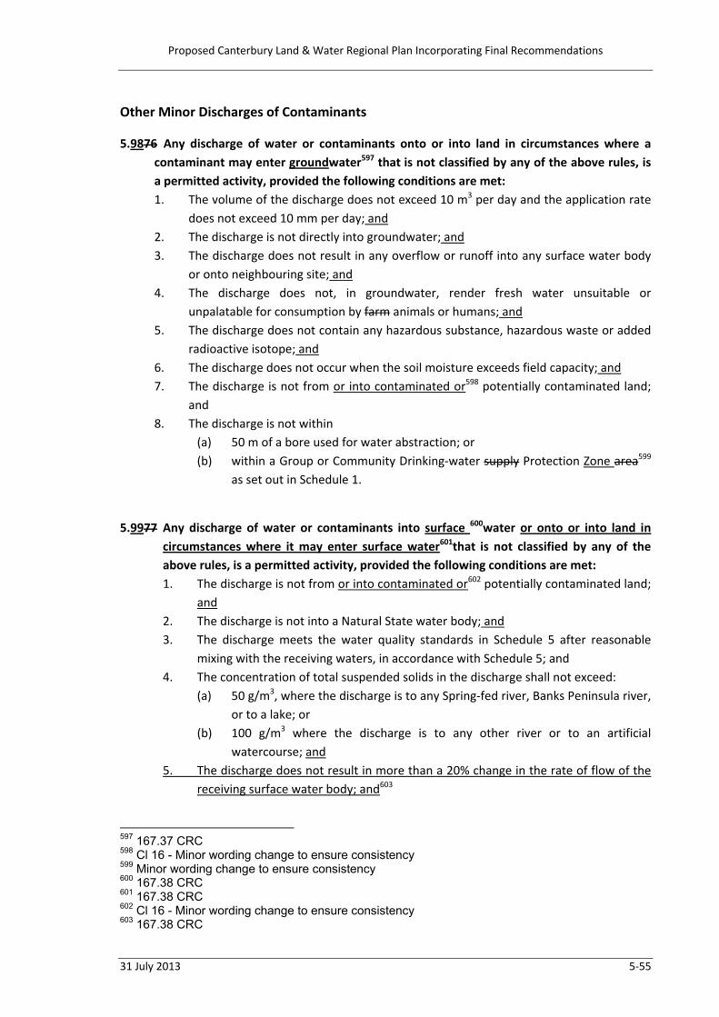
Proposed Canterbury Land & Water Regional Plan Incorporating Final Recommendations
31 July 2013 5‐55
Other Minor Discharges of Contaminants 5.9876 Any discharge of water or contaminants onto or into land in circumstances where a
contaminant may enter groundwater597 that is not classified by any of the above rules, is a permitted activity, provided the following conditions are met: 1. The volume of the discharge does not exceed 10 m3 per day and the application rate
does not exceed 10 mm per day; and 2. The discharge is not directly into groundwater; and 3. The discharge does not result in any overflow or runoff into any surface water body
or onto neighbouring site; and 4. The discharge does not, in groundwater, render fresh water unsuitable or
unpalatable for consumption by farm animals or humans; and 5. The discharge does not contain any hazardous substance, hazardous waste or added
radioactive isotope; and 6. The discharge does not occur when the soil moisture exceeds field capacity; and 7. The discharge is not from or into contaminated or598 potentially contaminated land;
and 8. The discharge is not within
(a) 50 m of a bore used for water abstraction; or (b) within a Group or Community Drinking‐water supply Protection Zone area599
as set out in Schedule 1. 5.9977 Any discharge of water or contaminants into surface 600water or onto or into land in
circumstances where it may enter surface water601that is not classified by any of the above rules, is a permitted activity, provided the following conditions are met: 1. The discharge is not from or into contaminated or602 potentially contaminated land;
and 2. The discharge is not into a Natural State water body; and 3. The discharge meets the water quality standards in Schedule 5 after reasonable
mixing with the receiving waters, in accordance with Schedule 5; and 4. The concentration of total suspended solids in the discharge shall not exceed:
(a) 50 g/m3, where the discharge is to any Spring‐fed river, Banks Peninsula river, or to a lake; or
(b) 100 g/m3 where the discharge is to any other river or to an artificial watercourse; and
5. The discharge does not result in more than a 20% change in the rate of flow of the receiving surface water body; and603
597 167.37 CRC 598 Cl 16 - Minor wording change to ensure consistency 599 Minor wording change to ensure consistency 600 167.38 CRC 601 167.38 CRC 602 Cl 16 - Minor wording change to ensure consistency 603 167.38 CRC

Proposed Canterbury Land & Water Regional Plan Incorporating Final Recommendations
5‐56 31 July 2013
6. The discharge does not contain any hazardous substance, hazardous waste or added radioactive isotope. 604
5.100 Any discharge that is not permitted by either Rule 5.98 or 5.99 and is not classified by any other rule in this Plan is a discretionary activity.605
604 Cl 16 – Minor amendment – ensures consistency with conditions of Rule 5.98 605 167.38 CRC
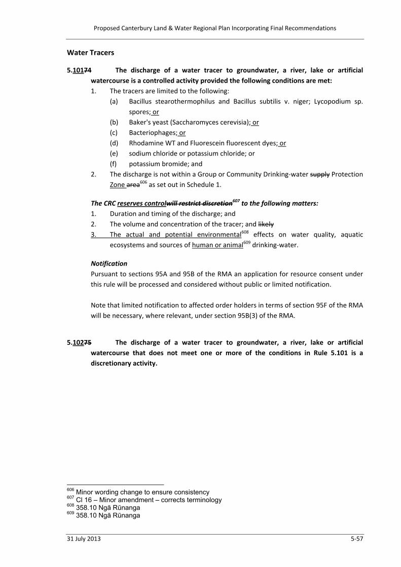
Proposed Canterbury Land & Water Regional Plan Incorporating Final Recommendations
31 July 2013 5‐57
Water Tracers 5.10174 The discharge of a water tracer to groundwater, a river, lake or artificial
watercourse is a controlled activity provided the following conditions are met: 1. The tracers are limited to the following:
(a) Bacillus stearothermophilus and Bacillus subtilis v. niger; Lycopodium sp. spores; or
(b) Baker's yeast (Saccharomyces cerevisia); or (c) Bacteriophages; or (d) Rhodamine WT and Fluorescein fluorescent dyes; or (e) sodium chloride or potassium chloride; or (f) potassium bromide; and
2. The discharge is not within a Group or Community Drinking‐water supply Protection Zone area606 as set out in Schedule 1.
The CRC reserves controlwill restrict discretion607 to the following matters: 1. Duration and timing of the discharge; and 2. The volume and concentration of the tracer; and likely 3. The actual and potential environmental608 effects on water quality, aquatic
ecosystems and sources of human or animal609 drinking‐water.
Notification Pursuant to sections 95A and 95B of the RMA an application for resource consent under this rule will be processed and considered without public or limited notification. Note that limited notification to affected order holders in terms of section 95F of the RMA will be necessary, where relevant, under section 95B(3) of the RMA.
5.10275 The discharge of a water tracer to groundwater, a river, lake or artificial
watercourse that does not meet one or more of the conditions in Rule 5.101 is a discretionary activity.
606 Minor wording change to ensure consistency 607 Cl 16 – Minor amendment – corrects terminology 608 358.10 Ngā Rūnanga 609 358.10 Ngā Rūnanga
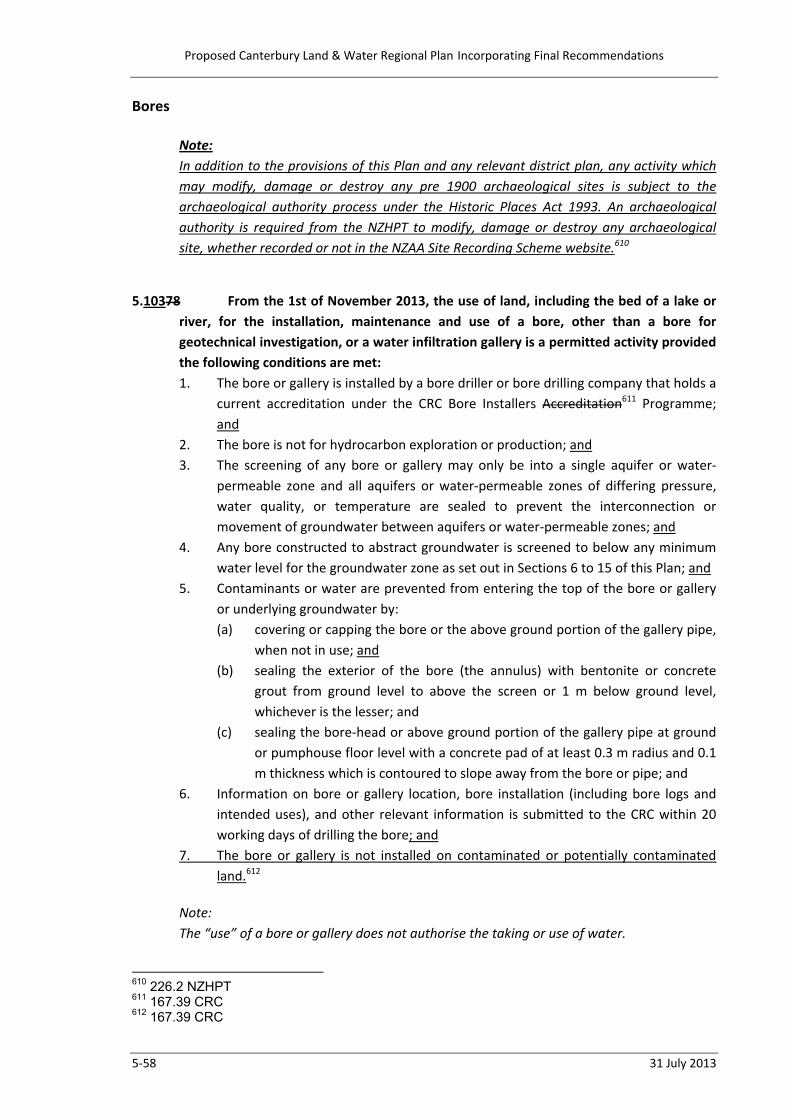
Proposed Canterbury Land & Water Regional Plan Incorporating Final Recommendations
5‐58 31 July 2013
Bores
Note: In addition to the provisions of this Plan and any relevant district plan, any activity which may modify, damage or destroy any pre 1900 archaeological sites is subject to the archaeological authority process under the Historic Places Act 1993. An archaeological authority is required from the NZHPT to modify, damage or destroy any archaeological site, whether recorded or not in the NZAA Site Recording Scheme website.610
5.10378 From the 1st of November 2013, the use of land, including the bed of a lake or
river, for the installation, maintenance and use of a bore, other than a bore for geotechnical investigation, or a water infiltration gallery is a permitted activity provided the following conditions are met: 1. The bore or gallery is installed by a bore driller or bore drilling company that holds a
current accreditation under the CRC Bore Installers Accreditation611 Programme; and
2. The bore is not for hydrocarbon exploration or production; and 3. The screening of any bore or gallery may only be into a single aquifer or water‐
permeable zone and all aquifers or water‐permeable zones of differing pressure, water quality, or temperature are sealed to prevent the interconnection or movement of groundwater between aquifers or water‐permeable zones; and
4. Any bore constructed to abstract groundwater is screened to below any minimum water level for the groundwater zone as set out in Sections 6 to 15 of this Plan; and
5. Contaminants or water are prevented from entering the top of the bore or gallery or underlying groundwater by: (a) covering or capping the bore or the above ground portion of the gallery pipe,
when not in use; and (b) sealing the exterior of the bore (the annulus) with bentonite or concrete
grout from ground level to above the screen or 1 m below ground level, whichever is the lesser; and
(c) sealing the bore‐head or above ground portion of the gallery pipe at ground or pumphouse floor level with a concrete pad of at least 0.3 m radius and 0.1 m thickness which is contoured to slope away from the bore or pipe; and
6. Information on bore or gallery location, bore installation (including bore logs and intended uses), and other relevant information is submitted to the CRC within 20 working days of drilling the bore; and
7. The bore or gallery is not installed on contaminated or potentially contaminated land.612
Note: The “use” of a bore or gallery does not authorise the taking or use of water.
610 226.2 NZHPT 611 167.39 CRC 612 167.39 CRC

Proposed Canterbury Land & Water Regional Plan Incorporating Final Recommendations
31 July 2013 5‐59
5.10479 From the 1st of November 2013, the use of land, including the bed of a lake or
river, for the installation, maintenance and use of a bore for geotechnical investigation or monitoring is a permitted activity provided the following conditions are met: 1. For any non‐permanent bore, it is decommissioned by filling with clean material
and compacted or sealed at the surface to prevent contaminants entering the bore; and
2. For any permanent bore, including monitoring bores, contaminants or water are prevented from entering the top of the bore or underlying groundwater by: (a) covering or capping the bore when not in use; and (b) sealing the exterior of the bore (the annulus) with bentonite or concrete
grout from ground level to above the screen or 1 m below ground level, whichever is the lesser; and
(c) sealing the bore‐head at ground or pumphouse floor level with a concrete pad of at least 0.3 m radius and 0.1 m thickness which is contoured to slope away from the bore or pipe; and
3. Information on bore or gallery613 location, bore installation (including bore logs and intended uses), and other relevant information is submitted to the CRC within 20 working days of drilling the bore.
5.10580 From the 1st of November 2013, the use of land, including the bed of a lake or
river, for the installation, maintenance and use of a bore or a water infiltration gallery that does not meet one or more of the conditions in Rule 5.103 or 5.104 is a discretionary activity.
Note: The “use” of a bore or gallery does not authorise the taking or use of water.
5.10681 The use of land, including the bed of a lake or river, for the installation,
maintenance and use of a bore for hydrocarbon exploration or production is a discretionary activity.
5.107 From the 1st of November 2013, the use of land, including the bed of a lake or river, for
the decommissioning of a bore, other than a bore for geotechnical investigation or a hydrocarbon bore is a permitted activity, provided the following conditions are met: 1. The bore is backfilled with inert material and sealed at the surface to prevent any
contaminants or surface water from entering the bore; and 2. Any bore intercepting groundwater is sealed to prevent the vertical movement of
groundwater between aquifers or water bearing layers within an aquifer and to permanently confine the groundwater to the aquifer or water bearing layer within an aquifer, in which it originally occurred. 614
613 169.95 NZTA 614 167.40 CRC

Proposed Canterbury Land & Water Regional Plan Incorporating Final Recommendations
5‐60 31 July 2013
5.108 From the 1st of November 2013, the use of land, including the bed of a lake or river, for
the decommissioning of a bore, other than a bore for geotechnical investigation or a hydrocarbon bore, that does not meet one or more of the conditions in Rule 5.107 is a discretionary activity.615
5.10982 The taking of water from groundwater for the purposes of carrying out bore
development or pumping tests and the associated use and discharge of that water is a permitted activity, provided the following conditions are met: 1. The take continues only for the time required to carry out bore development or a
pumping test and in any event, the taking does not exceed 120 hours within any 14 day period and total no more than 10 days in any consecutive 12 month period per bore; and
2. Any bore development or pumping test is carried out in accordance with Schedule 11; and
3. An assessment of interference effects, undertaken in accordance with Schedule 12, does not show that any community, group or private drinking‐water supply bore will be prevented from taking water; and
4. At the point and time of any discharge to surface water, the rate of flow in the river or artificial watercourse is at least five times the rate of the discharge.
5.11083 The taking of water from groundwater for the purposes of carrying out bore
development or pumping tests and the associated use and discharge of that water that does not meet one or more of the conditions in Rule 5.109 is a restricted discretionary activity.
The CRC will restrict discretion to the following matter: 1. The actual and potential adverse environmental616 effects of not meeting the
condition or conditions of Rule 5.109.
615 167.40 CRC 616 358.10 Ngā Rūnanga
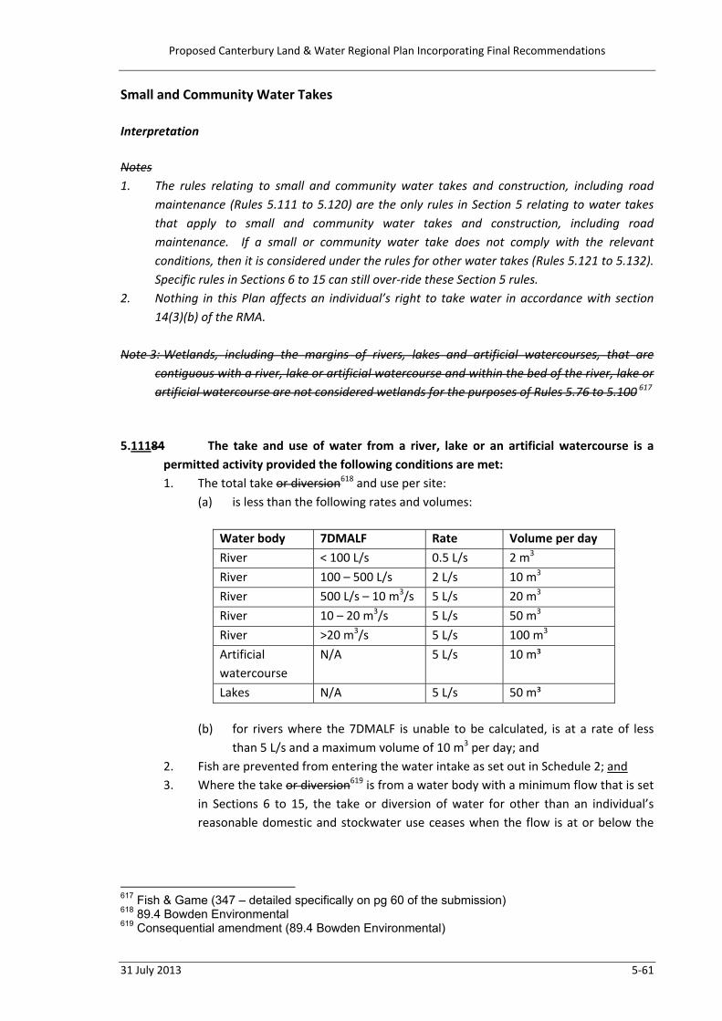
Proposed Canterbury Land & Water Regional Plan Incorporating Final Recommendations
31 July 2013 5‐61
Small and Community Water Takes Interpretation Notes 1. The rules relating to small and community water takes and construction, including road
maintenance (Rules 5.111 to 5.120) are the only rules in Section 5 relating to water takes that apply to small and community water takes and construction, including road maintenance. If a small or community water take does not comply with the relevant conditions, then it is considered under the rules for other water takes (Rules 5.121 to 5.132). Specific rules in Sections 6 to 15 can still over‐ride these Section 5 rules.
2. Nothing in this Plan affects an individual’s right to take water in accordance with section 14(3)(b) of the RMA.
Note 3: Wetlands, including the margins of rivers, lakes and artificial watercourses, that are
contiguous with a river, lake or artificial watercourse and within the bed of the river, lake or artificial watercourse are not considered wetlands for the purposes of Rules 5.76 to 5.100 617
5.11184 The take and use of water from a river, lake or an artificial watercourse is a
permitted activity provided the following conditions are met: 1. The total take or diversion618 and use per site:
(a) is less than the following rates and volumes:
Water body 7DMALF Rate Volume per day River < 100 L/s 0.5 L/s 2 m3 River 100 – 500 L/s 2 L/s 10 m3 River 500 L/s – 10 m3/s 5 L/s 20 m3 River 10 – 20 m3/s 5 L/s 50 m3 River >20 m3/s 5 L/s 100 m3 Artificial watercourse
N/A 5 L/s 10 m³
Lakes N/A 5 L/s 50 m³
(b) for rivers where the 7DMALF is unable to be calculated, is at a rate of less than 5 L/s and a maximum volume of 10 m3 per day; and
2. Fish are prevented from entering the water intake as set out in Schedule 2; and 3. Where the take or diversion619 is from a water body with a minimum flow that is set
in Sections 6 to 15, the take or diversion of water for other than an individual’s reasonable domestic and stockwater use ceases when the flow is at or below the
617 Fish & Game (347 – detailed specifically on pg 60 of the submission) 618 89.4 Bowden Environmental 619 Consequential amendment (89.4 Bowden Environmental)

Proposed Canterbury Land & Water Regional Plan Incorporating Final Recommendations
5‐62 31 July 2013
minimum flow for that water body, as published on measured by620 the Canterbury Regional Council website621;
4. The take is not from any river or part of a river that is subject to a Water Conservation Order; and
5. Where the take is from a water race,622 irrigation or hydro‐electricity canal or storage facility, the abstractor holds a current written agreement with the holder of the resource consents for the taking or diversion623 of water into the water race,624 canal or storage facility; and
6. The take is not from the Avon River/Ōtākaro or Heathcote River or a natural625 wetland or a hāpua.
5.11285 The take and use of water from any river or part of a river that is subject to a Water Conservation Order is a restricted discretionary activity provided the following conditions are met: 1. The take or diversion626 is at a rate of less than 5 L/s and a maximum volume of 100
m3 per day; and 2. Fish are prevented from entering the water intake as set out in Schedule 2; and 3. The take or diversion627 of water for other than an individual’s reasonable domestic
and stockwater use ceases when the flow is at or below the minimum flow for that water body as set out in the relevant Water Conservation Order.
The Canterbury Regional CouncilCRC628 will restrict discretion to the following matter: 1. The provisions of629 Whether the take, in combination with all other takes, complies
with the relevant Water Conservation Order.
5.11386 The taking and using of less than 5 L/s and 10 m3 per day of groundwater is a
permitted activity provided the following condition is complied with: 1. The bore, other than a sampling or monitoring bore, is located more than 20 m
from the site boundary where that adjoining site is in different ownership,630 or any surface water body.
5.11487 The taking and using of less than 5 L/s and 100 m3 per day of groundwater is a
permitted activity provided the following conditions are complied with: 1. The site is more than 20 ha in area; and
620 169.98 NZTA 621 169.98 NZTA 622 146.64 Ashburton DC 623 Consequential amendment (89.4 Bowden Environmental) 624 146.64 Ashburton DC 625 Consequential amendment (94.8 Waimakariri DC) 626 89.25 Bowden Environmental 627 89.25 Bowden Environmental 628 Cl 16 – Minor amendment – consistency with other rules 629 250.72 TrustPower 630 89.38 Bowden Environmental

Proposed Canterbury Land & Water Regional Plan Incorporating Final Recommendations
31 July 2013 5‐63
2. The bore is located more than 20 m from the site boundary where that adjoining site is in different ownership631 or any surface water body.
5.11588 The taking and using of water for a group or632 community water supply from
groundwater or surface water is a restricted discretionary activity provided the following condition is complied with: 1. A There is an operative633 Water Supply Strategy is submitted with the resource
consent application.
The CRC will restrict discretion to the following matters: 1. The reasonable demand for water, taking into account the size of the community or
group, the number of properties and stock that are to be supplied, the uses that are to be supplied and the potential growth in demand for water; and
2. The effectiveness and efficiency of the distribution network; and 3. The quality and adequacy of, compliance with and auditing of634 the Water Supply
Strategy; and 4. The actual and potential adverse635 effects on other water takes, including reliability
of supply; and 5. The potential benefits of the activity to the applicant, the community and the
environment; and Any beneficial effects from the use of the water; 636 6. Compliance with any relevant Water Conservation Order. 7. The extent to which the proposed activity is inconsistent with, the Strategic Policies
of this Plan. 637
Note: 1. If a small or community water take does not comply with the relevant conditions,
then it is considered under the rules for other water takes (Rules 5.116 to 5.132). Specific rules in Sections 6 to 15 can still over‐ride these Section 5 rules.
2. Nothing in this Plan affects an individual’s right to take water in accordance with section 14(3)(b) of the RMA.
631 89.39 Bowden Environmental 632 86.2 Hurunui DC 633 Cl 16 - Minor amendment - to ensure the rule functions effectively 634 Consequential to wider use of FEP’s 635 358.10 Ngā Rūnanga 636 Cl 16 – Minor amendment – to use consistent wording 637 347.138 Fish & Game

Proposed Canterbury Land & Water Regional Plan Incorporating Final Recommendations
5‐64 31 July 2013
Water for Construction and Maintenance 5.11689 The taking and using of water from a river, lake or an artificial watercourse for
infrastructure construction, maintenance and repair is a permitted activity, provided the following conditions are met: 1. The take and use does not exceed 15 L/s and 100 m3 per day; and 2. The take and use is for no longer than 2 months; and 3. The take does not at any time exceed 10% of the flow at the point of take; and 4. Where the take is from a water body with a minimum flow set in Sections 6 to 15,
the take or diversion ceases when the flow is at or below the minimum flow, as measured by published on638 the Canterbury Regional Council CRC website; 639 and
5. The take is not from a natural640 wetland; and 6. Fish are prevented from entering the water intake as set out in Schedule 2; and 7. Where the take is from an a water race641, irrigation or hydro‐electricity canal or
storage facility, the abstractor holds a current written agreement with the holder of the resource consents for the taking or diversion of water into the canal or storage facility; and
8. The take is not from any river or part of a river that is subject to a Water Conservation Order.
5.11790 The taking and using of water from any river or part of a river that is subject to a
Water Conservation Order, for infrastructure construction, maintenance and repair is a restricted discretionary activity. The CRC will restrict discretion to the following matters: 1. Whether the take, in combination with all other takes complies with The provisions
of642 the relevant Water Conservation Order; and 2. The location of the take, the actual and potential adverse environmental643 effects
on the immediate vicinity and the need for any restriction to prevent the flow from reducing to zero in this vicinity; and
5.11891 The taking and using of water from a river, lake or an artificial watercourse for
infrastructure construction, maintenance and repair, other than from any river or part of a river that is subject to a Water Conservation Order, that does not meet one or more of the conditions in Rule 5.116 is a discretionary activity.
638 169.98 NZTA 639 169.98 NZTA 640 Consequential amendment (94.8 Waimakariri DC) 641 146.68 Ashburton DC 642 250.75 TrustPower 643 358.10 Ngā Rūnanga

Proposed Canterbury Land & Water Regional Plan Incorporating Final Recommendations
31 July 2013 5‐65
Site Dewatering – Groundwater644 5.11992 The taking of water from groundwater for the purpose of de‐watering for
carrying out excavation, construction and geotechnical testing and the associated use and discharge of that water is a permitted activity, provided the following conditions are met: 1. The take continues only for the time required to carry out the work but not
exceeding 6 months; and 2. The discharge is not from, into or onto contaminated or potentially contaminated
land; and The abstraction is not from site where an activity or industry listed in Schedule 3 has occurred or is occurring645
3. The take does not lower the groundwater level more than 8 m below the ground level of the site or cause subsidence of any other site; and646
4. The take does not have a moderate, high or direct stream depletion effect on a surface water body, determined in accordance with Schedule 9, unless the abstracted groundwater is being discharged to the surface water body to which it is hydraulically connected; and
5. An assessment of interference effects, undertaken in accordance with Schedule 12, does not show that any community, group or private drinking‐water supply bore will be prevented from taking water; and
6. At the point and time of any discharge to surface water, the rate of flow in the river or artificial watercourse is at least five times the rate of the discharge; and
7. The concentration of suspended solids in any discharge to a surface water body does not exceed 50g/m³ 100 g/m³;647 and
8. The discharge is not within a Group or Community Drinking‐water supply Protection Zone area648 as set out in Schedule 1.
5.12093 The taking of water from groundwater for the purpose of de‐watering for
carrying out excavation, construction and geotechnical testing and the associated use and discharge of that water that does not meet one or more of the conditions in Rule 5.119 is a restricted discretionary activity.
The CRC will restrict discretion to the following matter: 1. The actual and potential environmental649 effects of not meeting the condition or
conditions of Rule 5.119.
644 Cl 16 – Minor amendment – additional heading to aid interpretation 645 167.43 CRC 646 Cl 16 – Needed to implement Policy 4.65 647 169.105 NZTA 648 Minor wording change to ensure consistency 649 358.10 Ngā Rūnanga

Proposed Canterbury Land & Water Regional Plan Incorporating Final Recommendations
5‐66 31 July 2013
Water from Canals or Water Storage 5.12194 The taking or use of water from irrigation or hydroelectric canals or water
storage facilities is a permitted activity, provided the following conditions are met: 1. For the taking of water from a water storage facility, the storage facility is not
within the bed of a river; and 2. The site owner or occupier has a written agreement with the owner or manager of
the irrigation or hydroelectric canal or water storage facility to take water from the artificial watercourse or water storage facility.
5.12295 The taking or use of water from irrigation or hydroelectric canals or water
storage facilities that does not meet one or more of the conditions in Rule 5.121, is a discretionary activity.

Proposed Canterbury Land & Water Regional Plan Incorporating Final Recommendations
31 July 2013 5‐67
Take and Use Surface Water
Note: See Sub‐regional Sections 6 to 15 of this Plan or existing catchment‐based Regional Plans for location‐specific requirements.
5.12396 The taking and use of surface water from a river or lake is a restricted
discretionary activity, provided the following conditions are met: 1. Unless the proposed take or diversion650 is the replacement of a lawfully
established activity affected by the provisions of Section 124‐124C651 of the RMA, the take, in addition to all existing resource consented takes, complies with any rate of take and seasonal or annual volume limits set in Sections 6 to 15 for that surface water body; and
2. Unless the proposed take is the replacement of a lawfully established take affected by the provisions of Section 124‐124C652 of the RMA, if no limits are set in Sections 6 to 15 for that surface water body, the take, both singularly and in addition to all existing resource consented takes meets a flow regime with a minimum flow of 50% of the 7‐day mean annual low flow (7DMALF) as calculated by the CRC and an allocation limit of 20% of the 7DMALF; and
3. The take is not from a natural653 wetland, hāpua or a high naturalness river that is listed in Sections 6 to 15.
The CRC will restrict discretion to the following matters: 1. The actual or potential adverse environmental654 Any effects on water quality,
including whether the activity, in combination with all other activities, will alter the water quality allocation status of the relevant catchment; and
2. Whether the amount of water to be taken and used is reasonable for the proposed use. In assessing reasonable use for irrigation purposes, the CRC will consider the matters set out in Schedule 10; and
3. For water used for irrigation, the management of water allocation and resulting nutrient discharges on individual farms; and
4. The potential effects on groundwater recharge where the groundwater allocation zone is fully or over allocated as set out in Sections 6 to 15; and
5. The availability and practicality of using alternative supplies of water; and 6. The effects the take or diversion 655has on any other authorised takes or diversions;
and 7. The potential to frustrate or prevent the attainment of the regional network for
water harvest, storage and distribution, shown on the Regional Concept diagram in Schedule 16; and
650 167.42 CRC 651 200.146 EDS 652 200.146 EDS 653 Consequential amendment (94.8 Waimakariri DC) 654 358.10 Ngā Rūnanga 655 167.42 CRC, 198.37 Irricon, 245.58 Fulton Hogan

Proposed Canterbury Land & Water Regional Plan Incorporating Final Recommendations
5‐68 31 July 2013
8. The reduction in the rate of take in times of low flow and restrictions to prevent the flow from reducing to zero as set out in policies to this Plan; and
9. Whether and how fish are prevented from entering the water intake; and 10. The provisions of Whether the take, in combination with all other takes, complies
with656 any relevant Water Conservation Order; and657 11. The proximity and actual or potential adverse environmental effects of water use
on any significant indigenous biodiversity; and658 12. Where the proposed take is the replacement of a lawfully established take affected
by the provisions of Section 124‐124C of the RMA and is from an over‐allocated surface water catchment, the reduction in the rate of take and volume limits to enable reduction of the over‐allocation.659
5.12497 The taking and use of surface water from a river or lake that does not meet
condition 2 or 3 in Rule 5.123 is a non‐complying activity. 5.12598 The taking and use of surface water from a river or lake that does not meet
condition 1 in Rule 5.123 is a prohibited activity. 5.12699 The non‐consumptive660 taking and use of water from a lake, river or artificial
watercourse and discharge of the same water to the same lake, river or artificial watercourse is a restricted discretionary activity, provided the following conditions are met: 1. Limits have been set for that surface water body in Sections 6 to 15 or the lake or
river is subject to a Water Conservation Order; and 2. The taking of water and subsequent discharge will have no effect on the limits set
for that water body in Sections 6 to 15 or the flow and allocation regime set out in the Water Conservation Order; and
3. The maximum distance from the point of take to the point of discharge is not more than 250 m; and
4. The take is not from a natural661 wetland, hāpua or a high naturalness lake or river that is listed in Sections 6 to 15.
The CRC will restrict discretion to the following matters: 1. Measures that will ensure any the limits are not affected; 2. Whether the amount of water to be taken is reasonable for the intended use; 3. The effects the take has on any other authorised takes or diversions; 662
656 Cl 16 - Minor amendment – improves certainty 657 250.78 TrustPower 658 167.48 CRC 659 Fish & Game – better alignment with the NPS and RPS 660 167.45 CRC 661 Consequential amendment (94.8 Waimakariri DC) 662 167.42 CRC

Proposed Canterbury Land & Water Regional Plan Incorporating Final Recommendations
31 July 2013 5‐69
4. The potential to frustrate or prevent the attainment of the regional network for water harvest, storage and distribution, shown on the Regional Concept diagram in Schedule 16;
5. The reduction in the rate of take in times of low flow and the need for any additional restrictions to prevent the flow from reducing to zero;
6. Whether and how fish are prevented from entering the water intake and/or discharge structure663; and
7. The actual or potential adverse environmental664 effects on aquatic ecosystems, in‐stream habitat, wetlands, dryland habitats665, sites of significance to Ngāi Tahu, amenity and recreational values in the area of the river subject to the diversion666 take667; and
8. The actual or potential adverse environmental668 effects of both the take or diversion and and any subsequent669 discharge on water quality.
5.127100 The non‐consumptive670 taking and use of water from a lake, river or artificial
watercourse and discharge of the same water to the same lake, river or artificial watercourse that does not meet one or more of the conditions in Rule 5.126 is a non‐complying activity.
663 347.156 Fish & Game 664 358.10 Ngā Rūnanga 665 120.194 DOC 666 167.42 CRC 667 245.55 Fulton Hogan 668 358.10 Ngā Rūnanga 669 245.55 Fulton Hogan 670 167.46 CRC

Proposed Canterbury Land & Water Regional Plan Incorporating Final Recommendations
5‐70 31 July 2013
Take and Use Groundwater Note: See Sub‐regional Sections 6 to 15 of this Plan or existing catchment‐based Regional Plans for location‐specific requirements.
5.128101 The taking and use of groundwater is a restricted discretionary activity, provided the following conditions are met: 1. The take is from within a Groundwater Allocation Zone on the Planning Maps; and 2. Unless the proposed take is the replacement of a lawfully established take affected
by the provisions of section 124‐124C671 of the RMA, for stream depleting groundwater takes, the take, in addition to all existing resource consented surface water takes, complies with the limits set in Sections 6 to 15 for that surface water body in accordance with Schedule 9; and
3. Unless the proposed take is the replacement of a lawfully established take affected by the provisions of section 124‐124C672 of the RMA, the seasonal or annual volume of the groundwater take, in addition to all existing resource consented takes, as determined by the method in Schedule 13673 does not exceed the limits for the relevant Groundwater Allocation Zone in Sections 6 to 15; and
4. The bore interference effects are acceptable, as set out in Schedule 12.
The CRC will restrict discretion to the following matters: 1. Whether the amount of water to be taken and used is reasonable for the proposed
use. In assessing reasonable use for irrigation purposes, the CRC will consider the matters set out in Schedule 10; and
2. The availability and practicality of using alternative supplies of water; and 3. The maximum rate of take, including the capacity of the bore or bore field to
achieve that rate, and the rate required to service674 any irrigation system; and 4. The actual or potential adverse environmental675 effects on surface water resources
if the groundwater take is within a surface water catchment where the surface water allocation limit, as set out in Sections 6 to 15 is fully or over allocated; and
5. The actual or potential adverse environmental676 effects the take has on any other authorised takes, including interference effects as set out in Schedule 12; and
6. For stream depleting groundwater takes, the matters of discretion under Rule 5.123, any reduction in the rate of take in times of low flow and restrictions to prevent the flow from reducing to zero as set out in policies to this Plan; 677 and
7. Whether salt‐water intrusion into the aquifer or landward movement of the salt water/fresh water interface is prevented. and
671 390.9 Canterbury Aoraki Conservation Board 672 390.9 Canterbury Aoraki Conservation Board 673 187.98 Synlait Milk Limited, 188.98 Synlait Farms Limited 674 182.10 HydroServices, 390.8 Canterbury Aoraki Conservation Board 675 358.10 Ngā Rūnanga 676 358.10 Ngā Rūnanga 677 390.8 Canterbury Aoraki Conservation Board
Proposed Canterbury Land & Water Regional Plan Incorporating Final Recommendations
31 July 2013 5‐71
8. The proximity and actual or potential adverse environmental effects of water use to any significant indigenous biodiversity; and678
9. The protection of groundwater sources, including the prevention of backflow of water or contaminants; and679
10. Where the proposed take is the replacement of a lawfully established take affected by the provisions of Section 124‐124C of the RMA and is from an over‐allocated groundwater allocation zone, the reduction in the rate of take and volume limits to enable reduction of the over‐allocation.680
5.102 The taking and use of groundwater where the point of abstraction is outside of a
Groundwater Allocation Zone on the Planning Maps is a non‐complying activity.681 5.129103 The taking and use of groundwater that does not meet one or more of
conditions 1 and 4 in Rule 5.128 is a non‐complying activity. 5.130104 The taking and use of groundwater that does not meet one or more of
conditions 2 and 3 in Rule 5.128 is a prohibited activity. 5.131105 The non‐consumptive taking and using of groundwater, including for heating or
cooling purposes, and the associated discharge to groundwater, is a permitted activity provided the following conditions are met: 1. The discharge of the groundwater is to the same aquifer or groundwater source as
the abstraction, and the discharge is within 50 m of the abstraction point; and 2. The use of the water is for non‐commercial domestic682 purposes; and 3. No contaminants, other than water of the same or different temperature, enter the
groundwater. 5.132106 The non‐consumptive taking and use of ground water and associated discharge
to groundwater of the same ground water to the same aquifer that does not meet one or more of the Conditions in Rule 5.131683 is a discretionary activity.
678 167.48 CRC 679 167.48 CRC 680 390.9 Canterbury Aoraki Conservation Board 681 89.02 Bowden Environmental 682 6.2 Central Heating New Zealand Ltd 683 167.47 CRC
Proposed Canterbury Land & Water Regional Plan Incorporating Final Recommendations
5‐72 31 July 2013
Transfer of Water Permits 5.133107 The temporary or permanent transfer, in whole or in part, (other than to the
new owner of the site to which the take and use of the water relates and where the location of the take and use of water does not change) of a water permit to take or use surface water or groundwater, is a restricted discretionary activity, provided the following conditions are met: 1. The reliability of supply for any other lawfully established water take is not reduced;
and 2. The seasonal or annual volume of take after the transfer is less than or equal to the
volume of take prior to the transfer, or if no seasonal or annual volume has been applied, a seasonal or annual volume is applied in accordance with Schedule 10; and
3. In the case of surface water, the point of take remains within the same surface water allocation zone and the take complies with the limits set in Sections 6 to 15; and
4. In the case of groundwater: (a) the point of take is within the same groundwater allocation zone; and (b) the bore interference effects as set out in Schedule 12 are acceptable; and (c) in addition for stream depleting groundwater takes:
(i) the transfer is within the same surface water allocation zone; and (ii) the take complies with the limits set in Sections 6 to 15; and, (iii) the stream depletion effect is no greater in the transferred location
than in the original location; and 5. In a catchment where the surface water and/or groundwater allocation limits set
out in Rule 5.123 or Sections 6 to 15 are exceeded any transferred water is surrendered in the following proportions: (a) 0% in the case of transferring surface water to an irrigation scheme or
principal water supplier684 which includes a storage component; and (b) 25% in the case of transferring surface water from down‐plains to up‐plains;
and (c) 25% in the case of transferring groundwater from up‐plains to down‐plains;
and (d) 50% in all other cases.
The CRC will restrict discretion to the following matters: 1. The nature of the transfer, whether short term, long term, partial or full, and the
apportioning of the maximum rate and seasonal or annual volume in the case of a partial transfer; and
2. The appropriateness of existing conditions, including conditions on minimum flow, seasonal or annual volume and other restrictions to mitigate effects; and
3. The reasonable need for the quantities of water sought, the intended use of the water and the ability of the applicant to abstract and use those quantities; and
4. The efficiency of the exercise of the resource consent; and 684 197.82 RDRML

Proposed Canterbury Land & Water Regional Plan Incorporating Final Recommendations
31 July 2013 5‐73
5. The reduction in the rate of take in times of low flow; and 6. The method of preventing fish from entering any water intake. Notification Pursuant to sections 95A and 95B of the RMA an application for resource consent under this rule will be processed and considered without public or limited notification. Note that limited notification to affected order holders in terms of section 95F of the RMA will be necessary, where relevant, under section 95B(3) of the RMA.
5.134108 The temporary or permanent transfer, in whole or in part, of a water permit to
take or use surface water or groundwater that does not meet one or more of the conditions of Rule 5.133 is a non‐complying activity.

Proposed Canterbury Land & Water Regional Plan Incorporating Final Recommendations
5‐74 31 July 2013
Structures
Note: For all activities in or near waterways, refer also to requirements and restrictions under the Canterbury Regional Council685 Flood Protection and Drainage Bylaw 20122013.686
5.112 Unless specified otherwise in Sections 6 to 15, wetlands, including the margins of rivers,
lakes and artificial watercourses, that are contiguous with a river, lake or artificial watercourse and within the bed of the river, lake or artificial watercourse are not considered wetlands for the purposes of Rules 5.139 to 5.142.687
5.135113 The placement, use, altering, reconstruction, maintenance or removal of pipes,
ducts, cables or wires over the bed of a lake or river, whether attached to a structure or not and associated support structures688 is a permitted activity, provided the following conditions are met: 1. The pipes, ducts, cables or wires and associated support structures689 run
perpendicular to the channel and690 do not prevent access to or over the bed or to lawfully established structures or defences against water, including flood protection works, or to flood control vegetation; and691
2. The activity is not undertaken in, on, or over the bed of any river or lake listed as a high naturalness waterbodylake or river692 in Sections 6 to 15, unless the pipes, ducts, cables or wires are attached to an existing structure; and
3. If the pipes, ducts, cables or wires are attached to an existing structure, they are attached above the soffit; and693
4. The pipes, ducts, cables or wires and associated support structures694 do not obstruct or alter navigation of the lake or river or reduce the flood carrying capacity of the waterway.695
5.136114 The drilling, tunnelling, or disturbance in or under the bed of a lake or river and
the installation, maintenance, or removal of pipes, ducts, cables or wires is a permitted activity, provided the following conditions are met: 1. The activity is not undertaken in, on, or under the bed of a lake listed as a high
naturalness lake in Sections 6 to 15 or in an inanga or salmon spawning site listed in Schedule 17696; and
685 Cl 16 - Minor amendment 686 Cl 16 - Minor amendment 687 106.73 CCC 688 127.14 Chorus & Telecom 689 Consequential change (127.14 Chorus & Telecom) 690 160.28 Timaru District Council 691 245.68 Fulton Hogan 692 Cl 16 – Minor amendment – consistent wording with Sections 6-15 693 221.82 Meridian 694 Consequential change (127.14 Chorus & Telecom) 695 221.82 Meridian 696 347.163 Fish & Game
Proposed Canterbury Land & Water Regional Plan Incorporating Final Recommendations
31 July 2013 5‐75
2. The activity does not involve the deposition of any substance, other than bed material, on the bed of a lake or river; and
3. The activity is undertaken at a distance greater than 10 m from any dam, weir, bridge, or network utility pole, pylon or flood protection vegetation, 150 m from any water level recorder, 50 m from any flood protection works or closer where there is evidence that permission has been obtained from the owner of the infrastructure or the works are being carried out by or on behalf of the owner697; and
4. Within 30 days of the completion of the activity the bed of the lake or river is returned to its original contour; and
5. Marker posts are erected for the lifetime of the pipes, ducts, cables or wires; and 6. The works do not occur in flowing water.
Note: The installation of a bore in the bed of a lake or river is controlled in Rule 5.103.
5.137115 The installation, alteration,698 extension, use, maintenance or removal of
bridges and culverts, including the erection or extension of the structure699 and the consequential deposition of substances on, in or under the bed of a lake or river, the excavation or other disturbance of the bed of a lake or river, and, in the case of culverts, the associated take, discharge or diversion of water is a permitted activity, provided the following conditions are met: 1. Any substance material700 deposited in, on, under or over the bed of a lake or river
in order to construct or maintain the structure is of inert materials of colour and material type that blends with the surrounding natural environment and does not contain or is not coated with any hazardous substance; and
2. The activity is undertaken at a distance greater than 10 m from any dam, weir, bridge, or network utility pole, pylon or flood protection vegetation, 150 m from any water level recorder, 50 m from any flood protection works or closer where there is evidence that permission has been obtained from the owner of the infrastructure or the works are being carried out by or on behalf of the owner701; and
3. The works do not occur in flowing water; and 4. Other than the maintenance of a structure, outside the spawning season, and the
use of a structure702 the activity is not undertaken in an inanga or salmon spawning site listed in Schedule 17; and
5. Upon completion of the activity: (a) any area of the bed of a lake or river which has been disturbed is returned to
as near as practicable to its original state; and
697 199.12 SCIRT 698 221.86 Meridian (submission on Rule 5.117) 699 358.64 Ngā Rūnanga 700 169.110 NZTA 701 125.30 Kaikoura DC 702 167.49 CRC

Proposed Canterbury Land & Water Regional Plan Incorporating Final Recommendations
5‐76 31 July 2013
(b) any excavated areas are left with battered slopes not steeper than 3:1 slope angle (3 horizontal to 1 vertical) and any flow channels disturbed during the activity are reinstated; and
6. For any permanent culvert: (a) the maximum length is 25 m; and (b) the maximum width of the river bed at the point of the crossing is 5 m; and (c) the culvert is installed so that the base of the culvert is below bed level to an
extent that a minimum of 25% of the internal width of the culvert is below the level of the bed of the river or lake or is covered with water at the estimated 7DMALF; and
(d) the culvert provides a 50% Annual Exceedance ProbabilityAEP703 flood flow capacity without increasing upstream water levels; and
(e) the location is not within any urban area or settlement; and 7. For any temporary culvert:
(a) the maximum width of the river bed at the point of the crossing is 5 m; and (b) the culvert is installed at a level no higher than bed level, and no lower than
100 mm below the level of the bed of the river or lake; and (c) the culvert is not placed in a water body managed for flood control or
drainage purposes unless written approval is obtained from the authority responsible for the waterbody704 it is undertaken by or on behalf of the CRC; and
(d) the culvert is not in place for more than four weeks; and 8. For any bridge:
(a) there are no piers within the bed; and (b) the bridge and the approaches are designed so that a 5% Annual
Exceedance ProbabilityAEP705 flood event does not cause any increase in upstream water levels; and
(c) the soffit (underside) of any bridge is higher than the top of the river bank, and at least 500 mm above the 5% AEP flood level; and
(d) the bridge abutments are constructed parallel to the flow; and 9. The works or structures do not prevent any existing fish passage.706
5.138116 The installation, maintenance, use and removal of defences against water flood protection works707, and including the associated deposition of substances on, in or under the bed of a lake or river and excavation associated diversions and discharges708 of sediment or other disturbance of the bed of a lake or river is a permitted activity, provided the following conditions are met:
703 Cl 16 - Minor amendment – removal of acronym 704 125.30 Kaikoura DC 705 Cl 16 - Minor amendment – removal of acronym 706 35.7 Eel Industry Assn 707 245.71 Fulton Hogan 708 167.50 CRC
Proposed Canterbury Land & Water Regional Plan Incorporating Final Recommendations
31 July 2013 5‐77
1. The activity does not prevent access in any way to lawfully established structures, including defences against water709flood protection works, or to flood control vegetation; and
2. Other than for the use of flood protection work 710the activity is not in, on, or under the bed of any river or lake listed as a high naturalness waterbodylake or river711 in Sections 6 to 15 or salmon and inanga spawning site listed in Schedule 17;712; and
3. The activity is undertaken by or on behalf of713 a local authority or a network utility operator in accordance with flood protection plan that has been certified by the CRC714 as being in accordance with the CRC’s River Engineering Section Quality and Environmental Management System Manual (March 2010) by the CRC;715and
4. The works or structures do not impede any existing fish passage.716
5.139117 The use and maintenance of structures, excluding dams, on, in or under the bed of a lake or river are permitted activities, provided the following conditions are met:For structures, excluding dams, lawfully established prior to the notification of this Plan, the use and maintenance of the structure is a permitted activity provided the following condition is met:717 1. The structures are lawfully established prior to notification of this Plan; and 2. Any substance material718 deposited in, on, under or over the bed in order to
maintain the structure is of inert materials of colour and material type that blends with the surrounding natural environment, is not contaminated with any hazardous substance; and and is not deposited into surface water.719
3. Any upgrading or minor alteration does not increase the footprint, height, or external envelope of the structure.720
5.140118 Notwithstanding any other rule in this Plan, temporary structures and
diversions associated with undertaking activities in Rules 5.135 to 5.140 or in relation to artificial watercourses721are permitted activities, provided the following conditions are met: 1. The diversion does not divert more than third of the width of the naturally flowing
or standing water body722
709 245.71 Fulton Hogan 710 245.71 Fulton Hogan 711 Cl16 – Minor amendment – consistent terminology with Sections 6 to 15 712 120.210 DOC 713 245.71 Fulton Hogan 714 Cl 16 - Minor amendment – improves certainty 715 245.71 Fulton Hogan 716 35.8 Eel Industry Assn 717 221.86 Meridian 718 197.85 RDRML 719 313.26 Kennaway Park 720 221.86 Meridian 721 167.51 CRC 722 167.51 CRC
Proposed Canterbury Land & Water Regional Plan Incorporating Final Recommendations
5‐78 31 July 2013
1. The activity is not undertaken in an inanga or salmon spawning site listed in Schedule 17; and
2. The temporary structure and723 diversion is in place for not more than 2 4724 weeks in any 12 month period.
5.141119 Temporary discharges to water or to land in circumstances where a
contaminant may enter water associated with undertaking activities in Rules 5.135 to 5.140 or in relation to artificial watercourses725 are permitted activities, provided the following conditions are met: 1. The discharge is only of sediment, organic material726 and water originating from
within the bed of the lake or river; and 2. The discharge is not undertaken in an inanga or salmon spawning site listed in
Schedule 17; and 3. The discharge is not for more than eight ten727 hours in any 24‐hour period, and not
more than 40 hours in total in any calendar month. 5.142120 The diversion of surface run‐off water caused by flooding is a permitted activity,
provided the following conditions are met: 1. The activity is undertaken by or on behalf of728 a local authority in accordance with
a flood protection plan that has been certified as being in accordance with the CRC’s River Engineering Section Quality and Environmental Management System Manual (March 2010) by the CRC.
5.143121 Any structure, excluding dams, but including any associated729 diversions and
discharges in the bed of a lake or river that does not comply with Rules 5.135 to 5.142 is a discretionary activity.
5.144 Where not classified by any other Rule in this plan, the diversion or discharge of water
and contaminants as a result of the excavation and disturbance of a river or lake bed, or the establishment of a structure or defence against water, is a discretionary activity.730
723 358.67 Ngā Rūnanga 724 306.17 NZ KiwiRail 725 167.52 CRC 726 313.28 Kennaway Park 727 245.73 Fulton Hogan 728 245.74 Fulton Hogan 729 256.44 Hunter Downs Irrigation 730 256.45 Hunter Downs Irrigation
Proposed Canterbury Land & Water Regional Plan Incorporating Final Recommendations
31 July 2013 5‐79
Refuelling in Lake and Riverbeds 5.145122 The refuelling of vehicles or equipment in the bed of a lake or river is a
permitted activity, provided the following conditions are met: 1. The refuelling of machinery does not take place over the wet bed of a river or lake,
or in any area where spills may enter surface water; and 2. All refuelling and bulk deliveries are directly supervised by the equipment operator;
and 3. All mobile plant is refuelled in a designated area, on an impermeable base away
from drains or watercourses and if not, drip trays are used; and 4. All non‐mobile plant has drip trays or other spill‐containment installed.
5.146123 The refuelling of vehicles or equipment in the bed of a lake or river that does not meet one or more of the conditions of Rule 5.145 is a discretionary activity.
Proposed Canterbury Land & Water Regional Plan Incorporating Final Recommendations
5‐80 31 July 2013
Gravel from Lake and Riverbeds
Notes: 1. For all activities in or near waterways, refer also to requirements and restrictions
under the Canterbury Regional Council731 Flood Protection and Drainage Bylaw 20122013.
2. In addition to the provisions of this Plan and any relevant district plan, any activity which may modify, damage or destroy any pre 1900 archaeological sites is subject to the archaeological authority process under the Historic Places Act 1993. An archaeological authority is required from the NZHPT to modify, damage or destroy any archaeological site, whether recorded or not in the NZAA Site Recording Scheme website. 732
5.147124 Sections 124A to 124C do not apply to resource consents to extract gravel from
the bed of a lake or rivers733 in Canterbury. 5.148125 The extraction of gravel from the bed of a lake or river734 including the
deposition of substances on the bed and excavation or other disturbance of the bed of a lake or river is a permitted activity, provided the following conditions are met: 1. The activity is not undertaken in, on, or under the bed of any river or lake listed as a
high naturalness waterbodylake or river735 in Sections 6 to 15; and 2. No part of the activity occurs within flowing water; and 3. The activity does not include the deposition of any substance, other than bed
material, on the bed; and 4. The volume excavated by any person or on behalf of any person, organisation or
corporation: (a) in the bed of any river or lake does not exceed 5 m3 in any 12 consecutive
months; or (b) between 1 February and 31 August, in the beds listed in Schedule 14, does
not exceed 5 m3 per month and not more than 10 m3 in any 12 consecutive months period; or
(c) between 1 February and 31 August, in the beds listed in Schedule 15, does not exceed 10 m3 per month and not more than 20 m3 in any 12 consecutive months period; and
5. Any excavated material (other than surplus or reject material) is removed from the bed within 10 days of the material being excavated; and
6. The activity is undertaken more than 50 m from any lawfully established dam, weir, culvert crossing, bridge, surface water intake plant or network utility pole or pylon, more than 150 m from any lawfully established water level recorder and more than
731 Minor amendment 732 226.2 NZHPT 733 167.53 CRC 734 167.53 CRC 735 Cl16 – Minor amendment – consistent terminology with Sections 6 to 15

Proposed Canterbury Land & Water Regional Plan Incorporating Final Recommendations
31 July 2013 5‐81
5 m of any existing flood control works defences against water736 unless they are the network utility operator responsible for the structure; and
7. The activity and any associated equipment, materials or debris does not obstruct or alter access to or the navigation of the lake or river; and
8. The activity does not include screening or any other processing of the gravel within the bed of the lake or river; and
9. The activity is not undertaken in an inanga or salmon spawning site listed in Schedule 17; and
10. Excavation shall not occur within 100 metres of birds which are nesting or rearing their young in the bed of the river.737
5.149126 The extraction of gravel, including the ancillary deposition of substances on the
bed and excavation or other disturbance of the bed that complies with all the conditions in Rule 5.148, except with respect to the volume limits in condition 4 of Rule 5.148,738 is a permitted activity, provided the following condition is met: 1. The extraction of gravel is undertaken by the CRC or persons acting under written
authority of the CRC. 5.150127 Any extraction of gravel from the bed of a lake or river where one or more of
the conditions for Rule 5.148 or 5.149 are not met is a discretionary activity. 5.151 Notwithstanding any other rule in this Plan, temporary structures and diversions
associated with undertaking activities in Rules 5.147 to 5.150 or in relation to artificial watercourses are permitted activities, provided the following conditions are met: 1. The activity is not undertaken in an inanga or salmon spawning site listed in
Schedule 17; and 2. The temporary structure and diversion is in place for not more than 4 weeks in any
12 month period. 5.152 Temporary discharges to water or to land in circumstances where a contaminant may
enter water associated with undertaking activities in Rules 5.147 to 5.150 or in relation to artificial watercourses are permitted activities, provided the following conditions are met: 1. The discharge is only of sediment, organic material and water originating from
within the bed of the lake or river; and 2. The discharge is not undertaken in an inanga or salmon spawning site listed in
Schedule 17; and 3. The discharge is not for more than ten hours in any 24‐hour period, and not more
than 40 hours in total in any calendar month.739
736 282.39 Aggregate Group 737 159.17 Orari River Protection Group (Inc) 738 Cl 16 - Minor amendment – to improve certainty 739 Rules split and repeated here to aid clarity

Proposed Canterbury Land & Water Regional Plan Incorporating Final Recommendations
5‐82 31 July 2013
5.153 Where not classified by any other Rule in this plan, the diversion or discharge of water
and contaminants as a result of the extraction of gravel from the bed of a lake or river including the deposition of substances on the bed and excavation or other disturbance of the bed of a lake or river, is a discretionary activity.740
740 Consequential change (256.45 Hunter Downs Irrigation)
Proposed Canterbury Land & Water Regional Plan Incorporating Final Recommendations
31 July 2013 5‐83
Dams and Damming 5.154128 The damming of water in the bed of a river and the constructing, using, altering,
maintaining and operating dam structures within the bed of a river, and the use of land to store water, including any associated damming or impounding741 of water outside the bed of a river or natural lake is a permitted activity, provided the following conditions are met: 1. For the damming or impounding742 of water outside the bed of a river or natural
lake: (a) the volume of water stored or impounded is less than 20,000 m3; or (b) the maximum depth of water is less than 3 m; and (c) if the volume of water impounded is greater than 1,000 m3, the design and
construction of the dam is certified by a Recognised Engineer chartered professional engineer (civil)743;and
(d) the land is not contaminated or potentially contaminated.744 2. For the damming of water in the bed of a river and the constructing, altering, using,
maintaining and operating of dam structures within the bed of a river: (a) The volume of water impounded is less than 5,000 m3; and (b) The maximum depth of water is less than 3 m; and (c) The dam does not impound the full flow of the river; and (d) Any existing passage of fish is not impeded; and (e) The damming of water does not cause water flow to fail to meet any limits in
Sections 6 to 15 or fall below the minimum flow for the surface water body if the water body is subject to a minimum flow as set out in Sections 6 to 15; and
(f) The dam is not located in a river listed as a high naturalness river in Sections 6 to 15 or in the mainstem of any river; and
(g) The damming does not prevent water being taken by any domestic or stock water supply, or reduce the reliability of supply of any existing legally authorised water take.
5.155129 The damming of water in the bed of a river and the constructing, using, altering,
maintaining and operating structures within the bed of a river, and the use of land to store water, including any associated impounding damming745 of water outside the bed of a river or natural lake that does not meet the conditions of Rule 5.154 is a discretionary activity, provided the following conditions are met: 1. The damming of water complies with the environmental flow and allocation limits
does not cause water flow to fail to meet any limits746 set in Sections 6 to 15; and
741 187.82 Synlait Farms Ltd 742 187.82 Synlait Farms Ltd 743 303.1 Valetta Irrigation Limited 744 167.55 CRC 745 187.82 Synlait Farms Ltd 746 250.83 TrustPower

Proposed Canterbury Land & Water Regional Plan Incorporating Final Recommendations
5‐84 31 July 2013
2. The Any new747 dam is not located in a river listed as an high naturalness waterbodylake or river748 in Sections 6 to 15 or in the mainstem of any river; and
3. The damming does not prevent water being taken by any domestic or stock water supply, or reduce the reliability of supply of any existing legally authorised water take.
5.156130 The damming of water in the bed of a river, including the associated
constructing, using, maintaining and operating structures within the bed of a river that does not comply with one or more of the conditions in Rule 5.155 is a non‐complying activity.
5.157131 The constructing of a new dam and the damming of water in the bed of a river
or lake that results in the natural operating regime or level of a natural lake being altered is a non‐complying activity.
5.158132 The use and maintenance of a structure in the bed of a river associated with
lawfully established dam hydroelectricity power scheme 749 that existed on 1 November 2013 is a controlled activity.
The CRC reserves control to the following matters: 1. The maintenance of, or improvement of, fish passage; and 2. The risk of and actual or potential adverse environmental effects750 of dam failure;
and 3. Whether and how fish are prevented from entering any intake structures; and 4. The passage of flood waters.
747 250.83 TrustPower 748 Cl16 – Minor amendment – consistent terminology with Sections 6 to 15 749 270.64 Fonterra, 221.34 Meridian 750 358.10 Ngā Rūnanga

Proposed Canterbury Land & Water Regional Plan Incorporating Final Recommendations
31 July 2013 5‐85
Wetlands 5.138 Unless specified otherwise in Sections 6 to 15, wetlands, including the margins of rivers,
lakes and artificial watercourses, that are contiguous with a river, lake or artificial watercourse and within the bed of the river, lake or artificial watercourse are not considered wetlands for the purposes of Rules 5.139 to 5.142.751
5.159139 The enhancing, restoring or creating of a wetland, including the associated
taking, use, damming752 or diversion of water from groundwater or surface water, and discharge of excess or overflow water from the wetland into surface water is a permitted activity if the following conditions are met: 1. The taking, use, damming753 or diversion of water is from within the site, and754 is at
a maximum rate of 5 L/s and 100 m3 per day; and 2. Fish passage is not restricted;755 2. The taking of water is non‐consumptive, is discharged back into the same
waterbody river756 and complies with any limits in Sections 6 to 15 of this Plan or any other Regional Plan for the relevant water body; and
3. The taking of water does not prevent water being taken by any domestic or stock water supply.
5.160140 The enhancing, restoring or creating of757 a wetland that does not comply with
one or more of the conditions in Rule 5.159 is a discretionary activity. 5.161141 Reducing the area of a natural758 wetland associated with the provision of
infrastructure for transport, electricity or water distribution or reticulation, including vegetation clearance and earthworks759 and the taking, use, damming or diversion (including draining) of water and the associated discharge of any water onto land or into a river, lake, artificial watercourse or wetland is a restricted discretionary activity.
The CRC will restrict discretion to the following matters: 1. The practicality of avoiding the natural760 wetland, including alternative routes or
methods; and 2. The ecological significance of the wetland, and the actual and761 potential for
adverse effects on the significant values of the wetland; and
751 200.156 EDS 752 169.119 NZTA 753 169.119 NZTA 754 169.119 NZTA 755 120.235 DOC 756 167.56 CRC 757 Cl 16 – minor amendment – improved grammar 758 Consequential amendment (94.8 Waimakariri DC) 759 221.97 Meridian 760 Consequential amendment (94.8 Waimakariri DC) 761 221.97 Meridian
Proposed Canterbury Land & Water Regional Plan Incorporating Final Recommendations
5‐86 31 July 2013
3. Any off‐setting of any actual and potential adverse762 effects through the enhancement or creation of additional wetland area; and
4. The magnitude of reduction in area of the wetland.763 5. The extent to which the proposed activity will prevent or compromise the
attainment of the environmental outcomes sought by, or is inconsistent with, the objectives and policies of this Plan. 764
5.162142 Reducing the area of a natural wetland765 by the taking, use, damming or
diversion (including draining) of water or other means, including vegetation clearance, cultivation,766 burning or earthworks, except as provided for in Rule 5.161 is a non‐complying activity.
762 358.10 Ngā Rūnanga 763 200.157 EDS 764 347.138 Fish & Game 765 Consequential amendment (94.8 Waimakariri DC) 766 167.57 CRC

Proposed Canterbury Land & Water Regional Plan Incorporating Final Recommendations
31 July 2013 5‐87
Vegetation in Lake and Riverbeds
Note: For all activities in or near waterways, refer also to requirements and restrictions under the Canterbury Regional Council767 Flood Protection and Drainage Bylaw 20122013.768
5.163143 The introduction or planting of any plant, or the removal and disturbance of
existing vegetation in, on or under the bed of a lake or river is a permitted activity, provided the following conditions are met: 1. The activity does not prevent access to lawfully established structures, including
flood protection works, or to flood control vegetation; and 2. No vegetation used for flood control or bank stabilisation is disturbed, removed,
damaged or destroyed except by or on behalf, or with the approval,769 of the person or agency responsible for maintaining that vegetation for flood control purposes; and
3. No woody vegetation is disposed of in, on, over or under the bed of a lake or river; and
4. Introduction or planting of vegetation in, on, or under the bed of any lake or river is not of a species listed in the Biosecurity NZ Register of Unwanted Organisms or the Canterbury Pest Management Strategy; and
5. Introduction or planting of vegetation in, on, or under the bed of any river or lake listed as a high naturalness waterbodylake or river770 in Sections 6 to 15 is only of indigenous plant species that naturally occur in the catchment; and
6. The disturbance, removal, damage or destroying of any plant or vegetation in, on, or under the bed of any river or lake listed as a high naturalness waterbodylake or river771 in Sections 6 to 15 is only of species772 non‐indigenous species; and
7. Except for clearance around utilities or existing structures, removal of a species listed in the Biosecurity NZ Register of Unwanted Organisms or the Canterbury Pest Management Strategy, or clearance for the purposes of maintaining existing fence lines, vehicle tracks, firebreaks, drains, ponds, dams or crossings,773 the activity does not occur in an inanga or salmon spawning site listed in Schedule 17; and
8. In a flood control rating district scheme area identified in Schedule 14774, the introduction or planting of any plant, is by or on behalf of the person or agency responsible for maintaining that vegetation for flood control purposes.
5.164144 The introduction or planting of any plant, or the removal and disturbance of
existing vegetation in, on or under the bed of a lake or river that does not comply with
767 Minor amendment 768 Minor amendment 769 221.98 Meridian 770 Cl16 – Minor amendment – consistent terminology with Sections 6 to 15 771 Cl16 – Minor amendment – consistent terminology with Sections 6 to 15 772 120.238 DOC 773 94.10 Waimakariri DC (consequential change) 774 167.58 CRC

Proposed Canterbury Land & Water Regional Plan Incorporating Final Recommendations
5‐88 31 July 2013
one or more of conditions 1, 3 or 5 to 7 of Rule 5.163 is a restricted discretionary activity.
The CRC will restrict discretion to the following matter: 1. The actual and potential adverse environmental775 effects of not meeting the
condition or conditions of Rule 5.163. 2. The extent to which the proposed activity will prevent or compromise the
attainment of the environmental outcomes sought by, or is inconsistent with, the objectives and policies of this Plan. 776
5.165145 The introduction or planting of any plant, or the removal and disturbance of
existing vegetation in, on or under the bed of a lake or river that does not comply with condition 2 of Rule 5.163 is a non‐complying activity.
5.166146 The introduction or planting of any plant, or the removal and disturbance of
existing vegetation in, on or under the bed of a lake or river that does not comply with condition 4 of Rule 5.163 is a prohibited activity.
775 358.10 Ngā Rūnanga 776 347.138 Fish & Game
Proposed Canterbury Land & Water Regional Plan Incorporating Final Recommendations
31 July 2013 5‐89
Earthworks and Vegetation Clearance in Riparian Areas
Note: In addition to the provisions of this Plan and any relevant district plan, any activity which may modify, damage or destroy any pre 1900 archaeological sites is subject to the archaeological authority process under the Historic Places Act 1993. An archaeological authority is required from the NZHPT to modify, damage or destroy any archaeological site, whether recorded or not in the NZAA Site Recording Scheme website. 777
5.167147 The use of land for vegetation clearance outside the bed of a river or lake or
adjacent to a natural778 wetland boundary but within: a. 10 m 20 m779 of the bed of a lake or river or a natural780 wetland boundary in Hill
and High Country land or land shown as High Soil Erosion Risk zoned LH2781 on the Planning Maps; or
b. 5 m 10 m782 of the bed of a lake or river or a natural783 wetland boundary in all other land not shown as High Soil Erosion Risk on the Planning Maps or defined as Hill and High Country in land zoned LH1784 on the Planning Maps;
is a permitted activity provided the following conditions are met: 1. The area of bare ground resulting from vegetation clearance does not exceed 10%
of the area within the relevant setback distance in any site at any time, except as a result of pest‐plant spraying785; and
2. The vegetation clearance is not on land above 900 m above sea level; and 3. The felling of trees, or any part of a tree, except where to ensure human safety it is
not practicable to do so, is away from any lake, river or wetland and no logs or tree trunks are dragged through or across the bed of a lake or a permanently flowing river, or a wetland; and
4. The vegetation clearance does not occur adjacent to786 within 1m of a significant spawning reach for salmon or an inanga spawning sitearea787 listed in Schedule 17; and
5. The vegetation is not flood or erosion control vegetation; and 6. Vegetation clearance associated with recovery activities or the establishment,
maintenance or repair of network utilities and fencing788 is not required to meet Conditions 1 and 2.
777 226.2 NZHPT 778 Consequential amendment (94.8 Waimakariri DC) 779 125.45 Kaikoura DC 780 Consequential amendment (94.8 Waimakariri DC) 781 167.99 CRC 782 125.45 Kaikoura DC 783 Consequential amendment (94.8 Waimakariri DC) 784 167.99 CRC 785 273.7 Rayonier 786 120.242 DOC 787 Cl 16 – Minor amendment – consistent terminology 788 Consequential amendment - because of the recommended change to the definition of
vegetation clearance, the inclusion of these terms is no longer appropriate.

Proposed Canterbury Land & Water Regional Plan Incorporating Final Recommendations
5‐90 31 July 2013
Note: Refer to the CRC’s Erosion and Sediment Control Guidelines for additional guidance on undertaking vegetation clearance activities.
5.168148 The use of land for earthworks or cultivation789 outside the bed of a river or lake
or adjacent to a natural790 wetland boundary but within: a. 10m 20 m791 of the bed of a lake or river or a natural792 wetland boundary in Hill
and High Country land and or land shown as High Soil Erosion Risk zoned LH2793 on the Planning Maps; or
b. 5 m 10 m794 of the bed of a lake or river or a natural795 wetland boundary in all other land not shown as High Soil Erosion Risk on the Planning Maps or defined as Hill and High Country land zoned LH1 on the Planning Maps; 796;
is a permitted activity provided the following conditions are met: 1. The extent of earthworks or cultivation797 within the relevant setback distances in
any property does not at any time exceed: (a) an area of 500 m2, or 10% of the area, whichever is the lesser; or (b) a volume of 10 m3 on Hill and High Country land and land zoned LH2798
shown as High Soil Erosion Risk on the Planning Maps; and 2. Any discharge of sediment associated with the activity into the water in a river,
lake, wetland or the Coastal Marine Area does not exceed 8 hours in any 24 hour period, and does not exceed 24 hours in total in any 6 month period; and
3. Any cultivation is across the contour of the land; 799 4. Any trenches excavated for infrastructure are back‐filled and compacted within 10
days of being excavated;800 3. The activity does not occur adjacent to within801 a significant spawning reach for
salmon or an inanga spawning area listed in Schedule 17; and 4. Any earthworks or cultivation is not within 5 m of any flood control structure; and 5. Earthworks associated with recovery activities or the establishment, maintenance
or repair of network utilities and fencing is not required to meet Conditions 1, or 2 or 4.802
789 Consequential amendment (16.35 Mr Ross Little) 790 Consequential amendment (94.8 Waimakariri DC) 791 125.45 Kaikoura DC 792 Consequential amendment (94.8 Waimakariri DC) 793 167.99 CRC 794 125.45 Kaikoura DC 795 Consequential amendment (94.8 Waimakariri DC) 796 167.61 CRC 797 Consequential amendment (16.35 Mr Ross Little) 798 167.99 CRC 799 Consequential amendment (16.35 Mr Ross Little) 800 106.78 CCC 801 120.242 DOC 802 199.14 SCIRT
Proposed Canterbury Land & Water Regional Plan Incorporating Final Recommendations
31 July 2013 5‐91
5.169149 Vegetation clearance and earthworks or cultivation803 outside the bed of a river or lake or adjacent to a wetland boundary but within: 1. 10 m 20 m804 of the bed of a lake or river or a natural805 wetland boundary in Hill
and High Country land and land shown as High Soil Erosion Risk zoned LH2806 on the Planning Maps; or
2. 5 m 10 m807 of the bed of a lake or river or a natural808 wetland boundary in all other land not shown as High Soil Erosion Risk on the Planning Maps or defined as Hill and High Country land zoned LH1 on the Planning Maps809;
that does not comply with the conditions in Rules 5.167 or 5.168 is a restricted discretionary activity.
The CRC will restrict its discretion to the following matters: 1. For forest harvesting, the harvesting method, location of haulage and log handling
areas, access tracks, and sediment control; and 2. The actual and potential for adverse environmental810 effects on soil quality or
slope stability; and 3. The actual and potential for adverse environmental811 effects on the quality of
water in rivers, lakes, wetlands or the sea; and 4. The actual and potential for adverse environmental812 effects on areas of natural
character, outstanding natural features or landscapes, areas of significant indigenous vegetation and significant habitats of indigenous fauna, mahinga kai areas or sites of importance to Tangata Whenua; and
5. The actual and potential for adverse environmental813 effects on the banks or bed of a water body or on its flood carrying capacity; and
6. The actual and potential for adverse environmental814 effects on transport networks, neighbouring properties or structures.
803 Consequential amendment (16.35 Mr Ross Little) 804 125.45 Kaikoura DC 805 Consequential amendment (94.8 Waimakariri DC) 806 167.99 CRC 807 125.45 Kaikoura DC 808 Consequential amendment (94.8 Waimakariri DC) 809 167.62 CRC 810 358.10 Ngā Rūnanga 811 358.10 Ngā Rūnanga 812 358.10 Ngā Rūnanga 813 358.10 Ngā Rūnanga 814 358.10 Ngā Rūnanga

Proposed Canterbury Land & Water Regional Plan Incorporating Final Recommendations
5‐92 31 July 2013
Vegetation Clearance and Earthworks in Erosion‐prone Areas 5.170150 Within the area shown as High Soil Erosion Risk on Area LH2 of815 the Planning
Maps and outside any riparian margin, the use of land for: (a) Cultivation or spraying of slopes less than 15° 25 degrees816; or (b) Cultivation or spraying on slopes greater than 15° 25 degrees817; provided the
total area sprayed or cultivated is less than 200 m2; or (c) Vegetation clearance of species listed in the Biosecurity NZ Register of Unwanted
Organisms or the Canterbury Pest Management Strategy;818 or (d) Hand clearance and spot spraying of vegetation; or (e) Silvicultural practices of release cutting, pruning or thinning to waste and
harvesting in accordance with the Environmental Code of Practice for Plantation Forestry (ECOP) 2007by suspension systems819; or
(f) Earthworks within a production forest undertaken in accordance with NZ Forest Road Engineering Manual (2012)820; or
(g) Maintenance of existing firebreaks, roads and tracks and, during a fire emergency, construction of new firebreaks and tracks; or
(h) Construction of walking tracks no more than 1.5 m wide; or (i) Maintenance of existing transport networks; or (j) Earthworks and vegetation clearance associated with the establishment, repair or
maintenance of pipelines, electricity lines, telecommunication lines and radio communication structures and fences; and or
(k) Other earthworks where: i. the volume is less than 10 m3 per site or per hectare (whichever is the
greater); and ii. the maximum depth of cut or fill is less than821 0.5 m;
is a permitted activity provided the following conditions are met: 1. Any cleared areas are stabilised and where it is not put to its final use shall be
revegetated within 6 months from the date of the commencement of the vegetation clearance or earthworks; and
2. Any cultivation is across the contour of the land; 3. When firebreaks, roads, or tracks are constructed or maintained the maximum
depth of cut or fill is 0.5 m; and or exotic forest harvesting is carried out, culverts and stormwater controls are installed and maintained to lead water via a channel into an existing watercourse822
4. the concentration of total suspended solids in the discharge shall not exceed: (a) 50 g/m3, where the discharge is to any Spring‐fed river, Banks Peninsula river,
or to a lake; or
815 167.99 CRC 816 16.33 Mr Ross Little 817 16.33 Mr Ross Little 818 214.54 LINZ 819 238.7 SRS New Zealand Limited 820 238.7 SRS New Zealand Limited 821 Cl 16 – Minor amendment - removal of redundant words 822 120.245 DOC
Proposed Canterbury Land & Water Regional Plan Incorporating Final Recommendations
31 July 2013 5‐93
(b) 100 g/m3 where the discharge is to any other river or to an artificial watercourse.
Note: Refer to the CRC’s Erosion and Sediment Control Guidelines for additional guidance on undertaking vegetation clearance activities.
5.171151 Within the area shown as High Soil Erosion Risk Area LH2823 on the Planning
Maps and outside any riparian margin, the use of land for vegetation clearance, cultivation and earthworks that does not comply with the conditions in Rules 5.170, or vegetation clearance, cultivation or earthwork activities not listed in Rule 170(a) to (k),824 is a restricted discretionary activity.
The CRC will restrict its discretion to the following matters: 1. The actual and potential for adverse environmental825 effects on soil quality or
slope stability; and 2. The actual and potential for adverse environmental826 effects on the quality of
water in rivers, lakes, wetlands or the sea; and 3. The actual and potential for adverse environmental827 effects on areas of natural
character, outstanding natural features or landscapes, areas of significant indigenous vegetation and significant habitats of indigenous fauna, mahinga kai areas or sites of importance to Tangata Whenua; and
4. The actual and potential for adverse environmental828 effects on a natural829 wetland or the banks or bed of a water body or on its flood carrying capacity; and
5. The actual and potential for adverse environmental830 effects on transport networks, neighbouring properties or structures; and
6. In addition, for forest harvesting, the harvesting method, location of haulage and log handling areas, access tracks, and sediment control.; and
7. The extent to which the proposed activity will prevent or compromise the attainment of the environmental outcomes sought by, or is inconsistent with, the objectives and policies of this Plan. 831
5.172152 Within the Hill and High Country, the use of land for the burning of vegetation is
a permitted activity provided the following conditions are met: 1. Burning does not occur within 5 m 20 m832 of the bed of a river where the wetted
bed is more than 2 m wide833 or lake or a natural834 wetland boundary where the wetland is more than 0.5 hectares in area;835 and
823 167.62 CRC 824 Cl 16 – minor amendment – activity status omitted for these activities 825 358.10 Ngā Rūnanga 826 358.10 Ngā Rūnanga 827 358.10 Ngā Rūnanga 828 358.10 Ngā Rūnanga 829 Consequential amendment (94.8 Waimakariri DC) 830 358.10 Ngā Rūnanga 831 347.138 Fish & Game
Proposed Canterbury Land & Water Regional Plan Incorporating Final Recommendations
5‐94 31 July 2013
2. Within an area to be burnt: (a) the extent of bare ground is less than 20%; and (b) the slope is less than 35 degreeso836; and (c) the land is less than 900 m above mean sea level; and
3. The person undertaking the burning has, at least twenty working days prior to commencing the burning, notified the CRC and provided location maps or aerial photographs of the sites to be burnt at a minimum scale of 1:50,000; and
4. The same area of land has not had the vegetation burnt within the preceding ten years; and
5. The burning is carried out between 1 June and 31 October; and 6. The burnt area is either:
(a) Spelled from grazing for a minimum of 6 months following burning; or (b) Sown with pasture seed within 6 months of burning; or (c) Planted with trees within one year of burning.
5.173153 Within the Hill and High Country, the use of land for the burning of vegetation
that is not a permitted activity under Rule 5.172 is a controlled activity provided the following condition are met: 1. The burning is not carried out between 15 December and 1 March; and 2. Burning does not occur within 5 10 m of the bed of a river where the wetted bed is
more than 2 m wide837, lake or natural838 wetland boundary where the wetland is more than 0.5 hectares in area;839 and
3. Within an area to be burnt: (a) the extent of bare ground is less than 20%; and (b) the slope is less than 35 degreeso840; and (c) the land is less than 900 m above mean sea level.
The CRC reserves control to the following matters: 1. The boundaries of the area to be burned so as to avoid or reduce any likely adverse
effects on water quantity and water quality and to conserve soil on land vulnerable to erosion; and
2. Post burn management measures, including requirements for spelling from grazing, and the quantity and type of seed and fertiliser to be applied, that will encourage restoration of suitable vegetation cover.
Notification
832 125.45 Kaikoura DC 833 16.31 Mr Ross Little 834 Consequential amendment (94.8 Waimakariri DC) 835 44.4 Maungatahi Farm Limited (submission on Rule 5.52) 836 167.64 CRC 837 16.31 Mr Ross Little 838 Consequential amendment (94.8 Waimakariri DC) 839 44.4 Maungatahi Farm Limited (submission on Rule 5.52) 840 167.64 CRC
Proposed Canterbury Land & Water Regional Plan Incorporating Final Recommendations
31 July 2013 5‐95
Pursuant to sections 95A and 95B of the RMA an application for resource consent under this rule will be processed and considered without public or limited notification. Note that limited notification to affected order holders in terms of section 95F of the RMA will be necessary, where relevant, under section 95B(3) of the RMA.
5.174154 Within the Hill and High Country, the use of land for the burning of vegetation
greater than 1 ha in area that is not provided for as a permitted activity under Rule 5.172 or as a controlled activity under Rule 5.173 is a discretionary activity.
Notes: The following matters are drawn to the attention of all persons burning vegetation in the Hill and High Country: 1. The burning in open air of any vegetation remains subject to the requirements of
the Forest and Rural Fires Act 1977, territorial bylaws841, and to any regional rules made under the RMA to control the discharge of contaminants to air.
2. A consent granted under the RMA does not discharge a person from liability for damage caused by the fire or liability for costs associated with the suppression of wildfires that may result from the controlled burning of vegetation.842.
3. Land occupiers wishing to burn vegetation may require further authorisations or agreements, including: (a) from the Department of Conservation; (b) from the Rural Fire Authority; (c) from Commissioner of Crown Lands for burning on Crown pastoral leasehold
land; (d) from Territorial Local Authorities as determined by rules in their District Plans;
and (e) from iwi or other organisations responsible for any functions impacting on
Sections 6, 7 and 8 of RMA
841 146.77 Ashburton DC 842 146.77 Ashburton DC

Proposed Canterbury Land & Water Regional Plan Incorporating Final Recommendations
5‐96 31 July 2013
Earthworks Excavation and Deposition843 over Aquifers
Note: In addition to the provisions of this Plan and any relevant district plan, any activity which may modify, damage or destroy any pre 1900 archaeological sites is subject to the archaeological authority process under the Historic Places Act 1993. An archaeological authority is required from the NZHPT to modify, damage or destroy any archaeological site, whether recorded or not in the NZAA Site Recording Scheme website. 844
5.175 The use of land to excavate material is a permitted activity, provided the following
conditions are met: 1. Over the Coastal Confined Gravel Aquifer System, as shown on the Planning Maps:
(a) there is more than 1 m of undisturbed material between the deepest part of the excavation and Aquifer 1; and
(b) if more than 100 m3 of material is excavated, the excavation does not occur within 50m of any surface waterbody; or
2. Over an unconfined or semi‐confined aquifer: (a) the volume of material excavated is less than 100 m3; or (b) the volume of material excavated is more than 100 m3 and:
(i) there is more than 1 m of undisturbed material between the deepest part of the excavation and the seasonal high water table level; and
(ii) the excavation does not occur within 50m of any surface waterbody.845 5.176 The use of land to excavate material that does not comply with one or more of the
conditions of Rule 5.155 is a restricted discretionary activity.
The CRC will restrict its discretion to the following matters: 1. The actual and potential adverse environmental effects on the quality of water in
aquifers, rivers, lakes, wetlands or the sea; and 2. Any need for remediation or long‐term treatment of the excavation; and 3. The protection of the confining layer and maintaining levels and groundwater
pressures in any confined aquifer, including any alternative methods or locations for the excavation; and
4. The management of any exposed groundwater.846 5.157 The use of land to excavate material in or above the Coastal Confined Gravel Aquifer
System is a permitted activity, provided the following conditions are met: 1. There is not less than 1 m of undisturbed material between the base of the
excavation and Aquifer 1; and
843 149.29 Institute for Plant & Food Research 844 226.2 NZHPT 845 167.27 CRC, 154.24 NZDF 846 245.80 Fulton Hogan

Proposed Canterbury Land & Water Regional Plan Incorporating Final Recommendations
31 July 2013 5‐97
2. The excavation does not occur within 50 m of the bed of a permanently or intermittently flowing river, a lake or a wetland boundary.
5.158 The use of land to excavate material in or above the Coastal Confined Gravel Aquifer
System that does not comply with condition 2 of Rule 5.157 is a discretionary activity. 5.159 The use of land to excavate material in or above the Coastal Confined Gravel Aquifer
System that does not comply with condition 1 of Rule 5.157 is a non‐complying activity.847
5.177160 The use of land for the deposition of more than 50 m3 of material in any
consecutive 12 month period onto land which is excavated to a depth in excess of 5 m below the natural land surface and is located over an unconfined or semi‐confined aquifer, where the seasonal high water table848 highest level of groundwater which can reasonably be expected to occur at the site is less than 5 30 m m below the deepest point in the excavationnatural land surface849 is a controlled activity, provided the following conditions are met: 1. The material is only cleanfill; and 2. The volume of vegetative matter in any cubic metre of material deposited does not
exceed 3%; and 3. The material is not be deposited into groundwater; and 4. Any cured asphalt deposited is be placed in the land at least 1 m above the highest
groundwater level expected at the site; and 5. The material is not deposited on land that is listed as an archaeological site; and850 6. A management plan isshall be851 prepared in accordance with Section 8.1 and
Appendix B of “A Guide to the Management of Cleanfills”, Ministry for the Environment, January 2002.
The CRC reserves control to the following matters: 1. The potential for adverse effects on the quality of water in aquifers, rivers, lakes,
wetlands or the sea and mitigation measures; and 2. The content and adequacy of the management plan prepared in accordance with
Section 8.1 and Appendix B of “A Guide to the Management of Cleanfills”, Ministry for the Environment, January 2002.852
5.178161 The use of land for the deposition of more than 50 m3 of material in any consecutive 12 month period onto land which is excavated to a depth in excess of 5 m
847 245.80 Fulton Hogan 848 167.28 CRC 849 245.182 Fulton Hogan 850 358.83 Ngā Rūnanga 851 Cl 16 – Minor amendment – improved grammar 852 150.38 Winstone Aggregates

Proposed Canterbury Land & Water Regional Plan Incorporating Final Recommendations
5‐98 31 July 2013
below the natural land surface and is located over an unconfined or semi‐confined aquifer, where the where the seasonal high water table853 highest level of groundwater which can reasonably be expected to occur at the site is less than 5 30 m below the deepest point in the excavationnatural land surface854 that does not comply with the conditions of Rule 5.160 is a restricted855 discretionary activity.
The CRC will restrict its discretion to the following matters: 1. The potential for adverse effects on the quality of water in aquifers, rivers, lakes,
wetlands or the sea and mitigation measures; and 2. The proportion of any material other than cleanfill and its potential to cause
contamination; and 3. The content and adequacy of the management plan prepared in accordance with
Section 8.1 and Appendix B of “A Guide to the Management of Cleanfills”, Ministry for the Environment, January 2002.856
Note: In addition to the provisions of this Plan and any relevant district plan, any activity which may modify, damage or destroy any pre 1900 archaeological sites is subject to the archaeological authority process under the Historic Places Act 1993. An archaeological authority is required from the NZHPT to modify, damage or destroy any archaeological site, whether recorded or not in the NZAA Site Recording Scheme website.857
853 167.28 CRC 854 245.182 Fulton Hogan 855 150.38 Winstone Aggregates 856 150.38 Winstone Aggregates 857 226.2 NZHPT

Proposed Canterbury Land & Water Regional Plan Incorporating Final Recommendations
31 July 2013 5‐99
Hazardous Substances 5.179162 The use of land for the storage in a portable container and use of a hazardous
substance listed in Part A of Schedule 4 is a permitted activity provided the following conditions are met: 1. The substance is approved under the Hazardous Substances and New Organisms
Act 1996 and the storage and use of the substance is in accordance with all conditions of the approval; and858
1. The aggregate quantity of specified hazardous substances stored on a site in one or more portable containers does not exceed 2,000 litres;
2. The container(s) are located in an area, or a structure, that will contain a leak or spill of the substance and will allow the spilled substance to be collected; and
3. Equipment that is suitable to absorb any leak or spill of the substance (a “spill kit”) is located with the container(s) at all times, along with instructions on how to use the spill kit; 859
2. The container(s) are not located within: (a) 20 m of a surface water body or a bore; and (b) a Group or Community Drinking‐water supply Protection Zonearea860 as set
out in Schedule 1.; and 5. The container(s) do not remain on a site for more than 90 days in any consecutive
12 month period. 861 5.180163 The use of land for the storage in a portable container and use of a hazardous
substance listed in Part A of Schedule 4 that does not meet one or more of the conditions in Rule 5.179 is a restricted discretionary activity.
The CRC will restrict discretion to the following matters: 1. Measures to avoid:
(a) the entry of the substances or associated contaminants into groundwater, surface water, supplies of drinking‐water and aquatic ecosystems; and
(b) any actual or potential adverse environmental862 effects on the current or future use of the water resource, as a result of leakage or spillage of the substance, or a release of the substance as a result of a natural event; and
2. Measures to prevent or contain spills or leaks, including site layout and drainage, waste management, emergency management and leak detection; and
3. Maintenance and monitoring of the storage or use system including containment measures.;and
4. The extent to which the proposed activity will prevent or compromise the attainment of the environmental outcomes sought by, or is inconsistent with, the
858 297.11 Blakely Pacific Limited, Christchurch 859 99.83 The Fuel Companies 860 Minor wording change to ensure consistency 861 99.83 The Fuel Companies 862 358.10 Ngā Rūnanga

Proposed Canterbury Land & Water Regional Plan Incorporating Final Recommendations
5‐100 31 July 2013
objectives and policies of this Plan relating to water quality and contaminated land. 863
5.181164 The use of land for the storage, other than in a portable container, and use of a
hazardous substance listed in Part A of Schedule 4 is a permitted activity provided the following conditions are met: 1. All hazardous substances on a site are stored and used in accordance with
requirements under the Hazardous Substances and New Organisms Act 1996. Evidence of compliance with these requirements shall be made available to the CRC upon request;
1. The substance is approved under the Hazardous Substances and New Organisms Act 1996 and the storage and use of the substance is in accordance with all conditions of the approval; and864
2. A current inventory of all hazardous substances on the site is maintained, and a copy of the inventory shall be made available to the CRC or emergency services on request; and
3. For hazardous substances stored or held on or over land, all areas or installations used to store or hold hazardous substances are inspected at least once per month or annually if the site is outside of any area or zone identified in a proposed or operative district plan for residential, commercial or industrial purposes and is unstaffed,865 and repaired or maintained if any defects are found that may compromise the containment of the hazardous substance; and
4. For hazardous substances stored or held in a container located in or under land:, stock reconciliation is undertaken: (a) for service stations storing or holding fuel:
If the stock reconciliation of product volumes stored in each container located in or under land at a service station shows a discrepancy of greater than 0.5% over three consecutive days or greater than a 1,000 litre loss in a single day, a Product Loss Investigation Procedure shall be implemented immediately. This procedure shall involve the following key steps: (i) Site Level check, including review of data and calculations and
reconciliation actions; (ii) Where the cause of concern has not been identified by (i), an
Engineering Check of the reconciliation equipment and observation wells;
(iii)Where the cause of concern has not been identified by (ii), a Container Test;
(iv) A copy of the procedure shall be kept on site at all times;866 (a) if there has been any physical loss of product identified by the above
procedure, then the Canterbury Regional Council CRC867 shall be notified 863 347.138 Fish & Game 864 99.85 The Fuel Companies 865 8.1 Chorus & Telecom 866 99.85 The Fuel Companies 867 Minor amendment

Proposed Canterbury Land & Water Regional Plan Incorporating Final Recommendations
31 July 2013 5‐101
within 2 working days unless the loss occurred from a container in any area listed in condition (5), in which case notification shall occur within868 24 hours of confirmation of the loss; and
(a) for all other sites storing any hazardous substances: Stock reconciliation is undertaken within 24 hours of a substance being delivered and thereafter on a fortnightly basis. If the stock reconciliation shows a discrepancy for the measurement period of more than 100 litres or 0.5%, whichever is the smaller, the CRC shall be notified within 2 working days unless the loss occurred from a container in any area listed in condition (5), in which case notification shall occur within 24 hours; and869
(b) records of stock reconciliations over the past three 12 months shall be made available to the CRC upon request. If requested, a copy of the stock reconciliation and the most recent certification of the container shall be provided to the CRC within five working days; and
5. For substances stored within a Group or Community Drinking‐water supply Protection area Zone870 as set out in Schedule 1: (a) all hazardous substances on a site are stored under cover in a facility which is
designed, constructed and managed to contain a leak or spill and allow the leaked or spilled substance to either be collected or lawfully disposed of; and
(b) spill kits to contain or absorb a spilled substance are located with the storage facility and use areas at all times and train staff to manage spilled substances;871 and
6. Except where the storage was lawfully established before 4 July 2004 and the maximum quantity stored has not increased since that date, or the storage relates to transformers and other equipment associated with electricity infrastructure,872 the substances shall not be stored within: (a) 20 m of a surface water body or a bore used for water abstraction; or (b) 250 m of a known active fault that has a recurrence period of less than 10,000
years, and the land is: (i) over an unconfined or semi‐confined aquifer; or (ii) within 50 m of a permanently or intermittently flowing river or a lake.
5.182165 The use of land for the storage, other than in a portable container, and use of a hazardous substance listed in Part A of Schedule 4 that does not meet one or more of the conditions in Rule 5.181 is a discretionary activity.
868 99.85 The Fuel Companies 869 99.85 The Fuel Companies 870 Minor wording change to ensure consistency 871 Cl 16 – Minor amendment – too uncertain for permitted activity conditions 872 221.103 Meridian
Proposed Canterbury Land & Water Regional Plan Incorporating Final Recommendations
5‐102 31 July 2013
5.183166 The use of land for the decommissioning of a container located on,873 in or under land that is or has been used to store a hazardous substance is a permitted activity provided the following condition is met: 1. The information listed in Part B of Schedule 4 is provided to the CRC at least one
week before the decommissioning is undertaken, except for item 12, which is to be provided within one month of completion of the report or plan for each phase of the investigation or remediation.
5.184167 The use of land for the decommissioning of a container located on,874 in or
under land that is or has been used to store a hazardous substance that does not meet one or more of the conditions in Rule 5.183 is a discretionary activity.
5.185168 The use of land for a site investigation to assess concentrations of hazardous
substances that may be present in the soil is a permitted activity provided the following conditions are met: 1. The site investigation is be undertaken in accordance with Contaminated Land
Management Guidelines No. 5: Site Investigation and Analysis of Soils (Ministry for the Environment, February 2004 2011)875 and reported on in accordance with Section 4 of the Contaminated Land Management Guidelines No. 1: Reporting on Contaminated Sites in New Zealand, (Ministry for the Environment, November 2003 2011)876; and
2. The person or organisation initiating the site investigation provides a copy of the report of the site investigation to the CRC within two months of the completion of the investigation.
5.186169 The use of land for a site investigation to assess concentrations of hazardous
substances that may be present in the soil that does not meet one or more of the conditions in Rule 5.169 is a restricted discretionary activity.
The CRC will restrict discretion to the following matters: 1. Measures to avoid the dispersal of the substances or associated contaminants onto
or into land, and877 into groundwater, surface water, supplies of drinking‐water and aquatic ecosystems; and
2. The actual and potential adverse environmental effects Any adverse effect878 on the current or future use of the land; and
3. The methodology of the investigation and the associated reporting.; and
873 167.70 CRC 874 167.70 CRC 875 167.71 CRC 876 167.72 CRC 877 167.72 CRC 878 Consequential amendment (Fish & Game (347))
Proposed Canterbury Land & Water Regional Plan Incorporating Final Recommendations
31 July 2013 5‐103
4. The extent to which the proposed activity will prevent or compromise the attainment of the environmental outcomes sought by, or is inconsistent with, the objectives and policies of this Plan. 879
879 347.138 Fish & Game