Section 4 Project Options · selecting the final project design (as described in Section 3 of this...
31
Section 4 Project Options
-
Upload
truonghuong -
Category
Documents
-
view
213 -
download
0
Transcript of Section 4 Project Options · selecting the final project design (as described in Section 3 of this...

Section 4
Project Options

Projek Mass Rapid Transit Laluan 2 : Sg. Buloh – Serdang - Putrajaya Detailed Environmental Impact Assessment
SECTION 4 : PROJECT OPTIONS
ERE Consulting Group 4-1 Issue1.0/ April 2015
4. SECTION 4 : PROJECT OPTIONS
4.1 INTRODUCTION
Various project options and design concepts were formulated and considered in
selecting the final project design (as described in Section 3 of this report). The
options varied according to the physical characteristics and requirements of each
route and location. The project options can be divided into:
• No-Project Option
• Alignment Options during the Feasibility Study Stage
• Alignment Options during the Preliminary Design
• Tunnelling vs Elevated Structure Options
The following sections explain how the SSP Line was planned and how the various
alignment options that were evaluated before arriving at the preferred alignment
(which has been described in Section 3 of this report).
4.2 NO PROJECT OPTION
The SSP Line is part of the three line KVMRT system, the first line (SBK Line) of
which is already under construction. The KVMRT is a crucial component of the
Greater KL/ Klang Valley Public Transport Master Plan (GKL/KV PTMP) (SPAD,
2011) that seeks an efficient, integrated and well-connected public transport system
for the Klang Valley. The GKL/KV PTMP has clearly stated that providing greater
accessibility and mobility for the people is a key driver not only in terms of economic
growth but also improving quality of life of the people.
The no-project option will not enable the Greater KL/Klang Valley to achieve a
40:60 modal split for public transport and its aspirations for efficient public
transportation network. Without substantial investments in urban rail, the traffic
congestion could continue to rise, causing billions of ringgit in terms of loss of
productivity, air pollution, health hazards and worsen the urban sprawl.
4.3 ALIGNMENT OPTIONS DURING THE FEASIBILITY STAGE
Numerous alignment options were considered for the SSP Line during the
Feasibility Study (SPAD, 2012). Various alignment options within a 5 km corridor
(Figure 4-1) from Sg. Buloh to Putrajaya were investigated.
The preferred alignment then was decided based on an evaluation of various
factors including :
• The route should improve connectivity to present and future major
developments and to areas that have potentially high ridership;

Projek Mass Rapid Transit Laluan 2 : Sg. Buloh – Serdang - Putrajaya Detailed Environmental Impact Assessment
SECTION 4 : PROJECT OPTIONS
ERE Consulting Group 4-2 Issue1.0/ April 2015
• The route must facilitate regeneration in areas such as the Batu Kentonmen
area, Tun Razak Exchange development and Jalan Cochrane
redevelopment.
• The route should provide connectivity to existing/ planned railway and public
transport systems including the KTM Komuter, LRT and monorail lines.
• The route should utilise highway land and other government reserves so as
to minimise private land take
• The social and environmental impacts should be kept to a minimum
After a preliminary alignment was identified based on travel demand forecasts and
ridership studies, substantial amount of investigations were focused on the
following areas (Figure 4-1) :
• Selayang Link line
• Jalan Ipoh
• Sentul to Kg Baru (Hospital KL Option)
• KLCC area
• Pasar Rakyat to Kg Pandan (Kampung Pandan Option)
• Kg Pandan to Plaza Phoenix (Pandan Cheras Option)
• Mines to Serdang (Mines Option)
• Putrajaya Spur line
The preferred alignment was proposed at the end of the Feasibility Study (2012)
(Figure 4-1). The alignment was still deemed tentative since detailed information
was still being sourced. The options and preferred alignment during the Feasibility
study were also discussed with stakeholders via workshops and meetings.
4.4 ALIGNMENT OPTIONS DURING THE PRELIMINARY DESIGN STAGE
After the feasibility study was completed, MRT Corp, together with the PDP and
SPAD, embarked on a thorough review of the alignment to ensure that the
proposed alignment is the most optimum. At this stage, with better data and site
specific information, the alignment was re-examined in greater detail. After the re-
examination, it was determined that the alignment at 8 stretches required further
analysis. These 8 stretches are :
Location 1 Damansara Damai to Kepong Sentral
Location 2 Jinjang to Batu
Location 3 Batu to Titiwangsa (North Portal)
Location 4 Titiwangsa
Location 5 Titiwangsa to TRX
Location 6 TRX to Serdang
Location 7 Kuchai Lama
Location 8 Serdang to Putrajaya

Projek Mass Rapid Transit Laluan 2 : Sg. Buloh – Serdang - Putrajaya Detailed Environmental Impact Assessment
SECTION 4 : PROJECT OPTIONS
ERE Consulting Group 4-3 Issue1.0/ April 2015
The alignment options and alternatives at these locations were assessed based on
various criteria (see section 4.4.1) to determine the most optimum alignment.
4.4.1 Alignment Options Evaluation Criteria
The alignment options were evaluated based on five key criteria (Table 4-1),
namely :
• Ridership
• Social & environmental impacts (Short term)
• Social & environmental impacts (Long term)
• Programme and Construction Risk
• Cost
The criteria (Table 4-1) and weightage were agreed during the Peers Review
Workshop with various stakeholders in April 2014.
Table 4-1 Alignment Selection Criteria
Criteria
Ridership
• Catchment spread (existing and likely redevelopment potential) served by proposed station
locations
• Complimenting existing railway corridors
• Interchange quality & quantity
• Accessibility for all users to stations & whole journey
• Performance – passenger comfort and journey time, service availability
• Population density
Social / Environment impacts – Short Term
• During construction - temporary land take, temporary business closures, settlement, noise and
air quality impacts, traffic, severance
• Safety to all parties and damage to local properties
Social / Environment impacts – Long Term
• Permanent social impacts positive or negative. Land acquisition, permanent relocation of
residents/business/social cost, any permanent traffic impacts, environmental impacts at portals,
vibration impacts in very sensitive areas
• Access to railway where supports more inclusivity & integration of communities
• Connectivity to public institutions (mosques, schools, hospital, etc)
• Integrated Development / Regeneration potential
• Visual, noise & air quality impact
• Impact on natural environment
Programme and Risk
• Implementation within the master programme
• Risk of programme delay – land acquisition, political, construction difficulties etc
Overall Cost
• CAPEX
• Land cost
• OPEX

Projek Mass Rapid Transit Laluan 2 : Sg. Buloh – Serdang - Putrajaya Detailed Environmental Impact Assessment
SECTION 4 : PROJECT OPTIONS
ERE Consulting Group 4-4 Issue1.0/ April 2015
A scoring system was used to enumerate the criteria for each of the alignment
evaluated. The scores were then added and analysed to determine the best
alignment option for each of the stretch studied. In certain cases where the
construction risks are too high, the option is assigned as “no go”. Similarly if an
option cannot be built within a sensible time frame, it too is assigned as “no go”.
4.4.2 Options for Location 1 : Damansara Damai to Kepong Sentral
Four alignment options (Table 4-2 and Figure 4-2) were analysed along the
Damansara Damai to Kepong Sentral stretch.
Option A (alignment proposed in the Feasibility study)
After the Damansara Damai station, Option A runs along Jalan Kuala Selangor, and
passes by Prima Damansara and Bandar Sri Damansara. The line then continues
along Jalan Kuala Selangor before crossing Jalan Kuala Selangor to the proposed
Bandar Menjalara Station near the PJU9 Sri Damansara residential area. The line
then continues along Selayang – Kepong Highway towards the proposed Kepong
Sentral Station.
Option B
Option B is similar to Option A until the proposed station at Bandar Menjalara. After
the station, the alignment swings slightly north near the PJU9 Sri Damansara
residential area. The line continues along Persiaran Dagang towards the proposed
Kepong Sentral Station.
Option C
Option C is similar to Option A and Option B except that it traverses the northern
side of the Jalan Kuala Selangor/Jalan Kepong.
Option D
Option D alignment follows Option C but turns north before the junction to Sri
Damansara going slightly into KTMB corridor and exiting into the industrial area
before crossing Persiaran Bukit Utama into the inner road at Persiaran Dagang.
After that, it follows the Option B alignment.

Projek Mass Rapid Transit Laluan 2 : Sg. Buloh – Serdang - Putrajaya Detailed Environmental Impact Assessment
SECTION 4 : PROJECT OPTIONS
ERE Consulting Group 4-5 Issue1.0/ April 2015
Table 4-2 Comparison of options from Damansara Damai to Kepong Sentral
Parameter Option A Option B Option C Option D
Length (km) 4.9 4.9 4.8 4.9
Cost Lowest Highest
Ridership 45,300 45,300 45,300 45,600
Social
impacts
Least number of
acquisitions
The highest
number of
buildings
potentially
affected.
Construction
risks
• Not feasible as
alignment runs at
the median of
Jalan Kuala
Selangor,
clashes with
DUKE extension
• Long span
across LDP/
MRR2 junction
• Require to partly
cover 300m of
monsoon drain
• Relocation 2 x
2.1km water
pipes
• Long span
across SYABAS
reservoir. Piers
within SYABAS
compound
• No major issue
Option A was deemed not constructable because of the DUKE extension. Option C
entails a major logistics challenge of relocating two large (1.85 diameter) water
mains over 2 km as well as a Hindu temple. Option D has very high social impacts
and may incur significant land acquisition and relocation of residential, offices and
industrial factories, and offers the least connectivity.
Option B was chosen as it has the lowest cost, manageable social impacts and the
construction risks are not significant.
4.4.3 Options for Location 2 : Jinjang to Batu
Three options along the Jinjang to Batu stretch (Table 4-3 and Figure 4-3) were
analysed :
Option A (alignment proposed in the Feasibility Study)
Option A offers a route along Jalan Kepong at the south of the existing flood
detention pond (Kolam Takungan Banjir Jinjang). After Jalan Kuching, the
alignment traverses along Jalan Ipoh.
Option B
Option B initially follows the same alignment as Option A. The alignment then
swings north and traverse along the existing detention pond after which it swings
south and runs parallel with the existing KTM line until the the Kampung Batu
KTMB Station. It then swings back south to traverse along Jalan Ipoh.

Projek Mass Rapid Transit Laluan 2 : Sg. Buloh – Serdang - Putrajaya Detailed Environmental Impact Assessment
SECTION 4 : PROJECT OPTIONS
ERE Consulting Group 4-6 Issue1.0/ April 2015
Option C
Option C offers a route to the north of Jalan Kepong where the alignment crosses
the existing detention pond. The alignment then swings south and follows the same
alignment as Option B.
Table 4-3 Comparison of options from Jinjang to Batu
Parameter Option A Option B Option C
Length (km) 2.7 3.0 2.9
Cost Lowest Highest
Ridership 97000 101300 99900
Social
impacts
Least number of
acquisitions
• 10 – 20 buildings
potentially affected
• good economic
regeneration potential,
due to the integration
with the Kampung
Batu KTMB Station
• 10– 20 buildings
potentially affected
• good economic
regeneration potential,
due to the integration
with the Kampung Batu
KTMB Station
Construction
risks
• Potential serious
obstruction to the
traffic and disturbance
to public due to
proximity to major
roads.
• Alignment & piers
within JPS compound
• TNB Pylons relocation
• Alignment & piers within
JPS compound
• TNB Pylons relocation
• On-going development
beside the pond
• Overlaps with u/ground
twin box culverts
Option A will face serious construction constraints along the major roads such as
Jalan Kepong and Jalan Ipoh. Option A is also not integrated with the Kampung
Batu KTMB Station and has the least redevelopment potential. Option C also faces
serious construction constraints, particularly with regards to the underground twin
box culverts which will require diversion during construction.
Option B has the highest ridership. Although Option B would affect 10-20 buildings,
the alignment is away from the main roads. There are no major construction risks.
Option B would have good economic regeneration potential, particularly due to the
integration with the Kampung Batu KTMB Station.
Therefore, Option B was chosen for this stretch.

Projek Mass Rapid Transit Laluan 2 : Sg. Buloh – Serdang - Putrajaya Detailed Environmental Impact Assessment
SECTION 4 : PROJECT OPTIONS
ERE Consulting Group 4-7 Issue1.0/ April 2015
4.4.4 Options for Location 3 : Batu to Titiwangsa
Four alignment options (Table 4-4 and Figure 4-4) were analysed along the Batu to
Titiwangsa stretch.
Option A - Kentonmen Alignment (alignment proposed in the Feasibility Study)
The alignment heads due east from Batu Station and generally runs alongside the
KTM tracks to the tunnelling section. The tunnel then swings under the KTM track
alignment to pass under DUKE, and continues to follow the KTM alignment for and
then turns south before the Sentul KTM Station.
The Sentul Station is located near the KTM Station and the alignment thereafter
moves on to the Jalan Ipoh and Titiwangsa.
Option B Jalan Ipoh Above DUKE
This alignment starts at Batu Station, and follows Jalan Ipoh before crossing over
the DUKE. The elevated Jalan Ipoh North Station is located south of DUKE.
Beyond this, the track starts to descend with the track level passing below ground
close to Jalan Merak. The tracks continue to descend in cut-and-cover tunnel until it
reaches a level of about 20m below ground level, suitable for a three-level station at
Sentul West.
Option C - Jalan Ipoh Under DUKE
This has the same horizontal alignment as Option B, and has the stations in the
same locations. However, the alignment starts to descend before the DUKE and is
at ground level as it crosses under it. It continues to descend to Jalan Ipoh North
Station where the track level is about 5m below ground. Beyond Jalan Ipoh Station,
the alignment continues to descend until it is deep enough for bored tunnelling. The
end of the bored tunnels will be less than a kilometer south of DUKE
Option D - Sungai Batu Alignment
The alignment starts at Batu Station, and follows Jalan Ipoh, with an elevated
station at Kentonmen. South of Kentonmen Station, the alignment runs alongside
Sungai Batu mainly as elevated tracks, but descends close to ground level on
approaching the DUKE. It is necessary for this alignment to run under DUKE to
allow the tracks to be in bored tunnels before they pass under Jalan Segambut.
From here, the alignment runs southwest, under Jalan Ipoh before following the
same route as Option A.

Projek Mass Rapid Transit Laluan 2 : Sg. Buloh – Serdang - Putrajaya Detailed Environmental Impact Assessment
SECTION 4 : PROJECT OPTIONS
ERE Consulting Group 4-8 Issue1.0/ April 2015
Table 4-4 Comparison of Options from Batu to Titiwangsa
Parameter Option A Option B Option C Option D
Length (km) 4.02 3.69 3.69 3.74
Cost Highest Lowest
Ridership 122,400 130,000 130,000 125,900
Social
impacts
• Substantial
number of
acquisition
• Facilitate the
development of
the Army Camp
Site.
• Substantial
number of
acquisitions
• Little opportunity
for urban
regeneration in
the area
• Substantial
number of
acquisitions
• Potential for
economic
regeneration
• Substantial
number of
acquisitions
• Potential for
economic
regeneration
Construction
risks
• Tunnelling under
the KTM tracks
for over 400m,
underpinning of
DUKE and TNB
pylon.
• need to raise the
transmission
lines at DUKE
Highway
• Complex traffic
management
• need transfer
structure to
support TNB
pylon.
• flood protection
during
construction.
Option A affects Kentonmen Army Camp and substantial number of acquisition,
which are mainly shoplots, a school, KTM Depot, and YTL site. The proposed
alignment will facilitate the implementation of the development of the Army Camp
Site. The other options affect large numbers of shop/commercial lots.
For Option B, the traffic management for the cut-and-cover works is expected to be
complex, and the TNB transmission lines will need to be raised. Traffic
management for Option C will be less complex. Option D, along Sungai Batu, have
some concerns about river reserves and flooding during construction.
Option C was chosen because of its lower cost, potential for economic
reconnaissance.
4.4.5 Options for Location 4 : Titiwangsa
Two alignment options (Table 4-5 and Figure 4-5) were analysed for the
Titiwangsa area.
Option A
Option A continues down Jalan Ipoh until the junction with Jalan Tun Razak, where
it passes under the MAA Building, swings to the east and runs south of, and broadly
parallel with, Jalan Tun Razak, crossing under Sg Gombak, until it reaches
Titiwangsa South Station.

Projek Mass Rapid Transit Laluan 2 : Sg. Buloh – Serdang - Putrajaya Detailed Environmental Impact Assessment
SECTION 4 : PROJECT OPTIONS
ERE Consulting Group 4-9 Issue1.0/ April 2015
Option B
Southeast of Sentul West Station, Option B swings eastwards, traverses the north
part of the new Sentul Police Station, runs under a stream (Sungai Untut) and two
five-storey buildings set back from Jalan Sentul, continues under Sungei Gombak,
then turns to run just north of the Ampang Line station to Titiwangsa North Station.
Table 4-5 Comparison of options for the Titiwangsa area
Parameter Option A (Titiwangsa south) Option B (Titiwangsa north)
Length (km) 1.2 1.0
Cost Slightly cheaper Slightly more expensive
Ridership 48,900 48,900
Social
impacts
Could potentially affect more than 20
commercial and residential buildings
Could potentially affect about 10
buildings. However, none of these
buildings need to be demolished.
Construction
risks
Tunnel passes close to the Dynasty
Hotel. A major concern is the flyover
carrying Jalan Tun Razak over Jalan
Ipoh. The bridge is a three-span
continuous structure and will therefore
be potentially sensitive to differential
settlement.
Requires the demolition and pile
removal for demolished buildings.
No major issues
Option A is expected to affect more than commercial and residential buildings.
Option A tunnels pass close to the Dynasty Hotel; however, a major concern was
the flyover carrying Jalan Tun Razak over Jalan Ipoh. The bridge is a three-span
continuous structure and will therefore be potentially sensitive to differential
settlement.
On the basis on social impacts and construction risks and the fact that Option B will
have a significantly improved interchange as it is closer to the LRT station – Option
B was chosen.
4.4.6 Options for Location 5 : Titiwangsa to Tun Razak Exchange
Three alignment options (Table 4-6 and Figure 4-6) were analysed for the
Titiwangsa to TRX.
Option A (Jalan Daud)
Option A traverses southerly from the Hospital KL station and continues under
Jalan Daud with a new Kg. Baru South Station located nearby the Kampung Baru
LRT Station. The alignment continues south-east, crossing under Sg. Klang, then
continuing under Jalan Mayang, then crossing under Jalan Ampang, with KLCC
Station located immediately to the south of it. From here, the alignment runs south-
east, down Jalan Binjai before turning to the east for the Conlay Station. The
alignment then continues slightly east under Jalan Bukit Bintang, and goes to TRX.

Projek Mass Rapid Transit Laluan 2 : Sg. Buloh – Serdang - Putrajaya Detailed Environmental Impact Assessment
SECTION 4 : PROJECT OPTIONS
ERE Consulting Group 4-10 Issue1.0/ April 2015
Option B (Kg Baru Central)
Alignment Option B has a station to the north of the hospital site, called General
Hospital North. From there, it runs southeast, avoiding the high-rise Hospital Staff
Quarters, crossing Jalan Raja Muda, with a station provided in the centre of
Kampung Baru. The alignment crosses Sg. Klang and skirts around the northeast
corner of Menara Park, curving back south to run west of Mayang Condo, thereafter
being similar to Option A.
Option C (Jalan Tun Razak)
This option has a station at General Hospital North. From there the tracks curve to
the south then to the east along Jalan Raja Muda where a station, Kg. Baru North,
is proposed. It continues east along Jalan Raja Muda, then curves southeast along
Jalan Tun Razak. The alignment then follows Jalan Tun Razak before turning
south, crossing a large development site, then under the Ampang Park Shopping
Centre, to KLCC East Station. The alignment continues due south under Jalan
Binjai , thereafter being similar to Option A.
Table 4-6 Comparison of options from Titiwangsa to TRX
Parameter Option A Option B Option C
Length (km) 5.18 4.83 5.14 km
Cost Most expensive Least expensive
Ridership 261,400 251,500 235,700
Social
impacts
• A large number of
residences will be
affected in Kg. Baru
• A large number of
residences will be
affected in Kg. Baru
• A large number of
businesses will be
affected in Ampang
Shopping Mall
Construction
risks
• Tunnelling under the
existing LRT tunnels.
• A major risk is need to
run the alignment under
the STAR development
site.
• Tunnelling under the
existing LRT tunnels.
• Tunnelling under the
existing LRT tunnels.
Options A and B have the greatest social impacts in terms of the number of houses
that will have to be acquired in Kg. Baru. Option C, on the other hand, has lesser
social impacts.
Although all Options will entail tunneling under the existing LRT tunnels, Option A
will require additional tunneling under a major development site where the
construction risks are deemed very high.
On the basis of the social impacts and construction risks, Option C was deemed
the best alignment for this stretch.

Projek Mass Rapid Transit Laluan 2 : Sg. Buloh – Serdang - Putrajaya Detailed Environmental Impact Assessment
SECTION 4 : PROJECT OPTIONS
ERE Consulting Group 4-11 Issue1.0/ April 2015
4.4.7 Options for Location 6 : Tun Razak Exchange (TRX) to Serdang
The stretch between TRX to Serdang offered many possibilities for connection –
centred around a western (Bandar Malaysia) or an eastern (Pandan) corridors. The
western corridor (Bandar Malaysia) offered the potential of connecting to the
proposed HSR and the proposed Bandar Malaysia development – hence expected
a higher future ridership. Pandan corridor has an existing dense population
catchment but with greater construction challenges and social impacts (Table 4-7
and Figure 4-7).
Option A (TRX – Pandan – Cheras – MINES – Serdang)
From the TRX Station, the line crosses below Jalan Tun Razak and SMART Tunnel
towards Pandan area and will surface before the Pandan Jaya LRT Station. The
elevated segment continues southeasterly towards Pandan Indah, Pandan Mewah,
Taman Bukit Teratai area. After Bukit Teratai area, the line will cut through the hills
and passes Taman Bukit Segar and Taman Cheras Hartamas towards Cheras
Sentral.
After Cheras Sentral, the line will continue further south towards Serdang and
passes several residential areas such as Taman Len Seng, Damai Perdana, Alam
Damai, Bukit Belimbing and MINES. After MINES, the line then crosses the Kuala
Lumpur Seremban Expressway towards Serdang and Seri Kembangan area where
Bukit Serdang Station is proposed within UPM area.
Option B (TRX – Shamelin Perkasa – Bandar Malaysia – Salak South –
Serdang)
From the TRX Station, the line crosses below Jalan Tun Razak and SMART Tunnel
and travels along Jalan Perkasa and will surface before Shamelin Perkasa. From
here onwards, the elevated alignment will run parallel to the existing Ampang LRT
Line and crosses the Kuala Lumpur - Seremban Highway before entering the
proposed Bandar Malaysia site or TUDM Sg Besi area. The line continues within
the Bandar Malaysia and travels southerly passing through Kuchai Lama, Bandar
Baru Sri Petaling and Sg Besi areas as it moves towards Serdang, Seri
Kembangan and UPM area.

Projek Mass Rapid Transit Laluan 2 : Sg. Buloh – Serdang - Putrajaya Detailed Environmental Impact Assessment
SECTION 4 : PROJECT OPTIONS
ERE Consulting Group 4-12 Issue1.0/ April 2015
Table 4-7 Comparison of options from TRX to Serdang
Parameter Option A Option B
Length (km) 21.5 17.9
(3.6 km shorter)
Cost Higher Lower
Ridership 198,000 217,000
Connectivity to HSR
Social
impacts
Higher number of acquisition (Affecting a forest reserve, cemetery and houses in Taman Len Seng)
Lower number of acquisition (Potentially affecting 2 temples and several blocks of government buildings)
Construction
risks
• Tunnelling under the SMART Tunnel • 2km of SCL tunnel • Total of 8 long span crossings • 3 TNB transmission lines affected
• Tunnelling under the SMART Tunnel • Total of 18 long span crossings • 2 TNB transmission lines affected
Option B has the benefits of connecting to the future HSR station and hence
reaching a larger catchment resulting in larger ridership. Social impacts are less for
Option B since the route affects less number of significant properties. Option 2
alignment also avoids impacting the forest reserve and cemetery, is shorter and
hence has a lower construction cost.
On the basis of the ridership, cost and social impact, Option B was deemed the
best alignment for this stretch.
a) Refinement of Option 2 (TRX – Chan Sow Lin – Bandar Malaysia –
South Portal)
Option B was further analyzsed for the stretch between TRX to the South Portal.
Several options (Table 4-8 and Figure 4-8) were considered for this stretch:
Option C
After TRX Station, the line will cross Jalan Tun Razak towards Royal Selangor Golf
Club (RSGC) and continue southeasterly to Shamelin Perkasa, Taman Maluri and
Miharja areas, running broadly parallel to the existing Ampang LRT Line. After the
proposed Miharja Station, the line will pass through the Chan Sow Lin industrial
area and crosses the Maju Expresway, BESRAYA Extension Expressway and
Kuala Lumpur – Sg Besi Highway towards the Bandar Malaysia North Station
located within the proposed Bandar Malaysia or current TUDM Sg Besi area. It
continues within the Bandar Malaysia area until the proposed South Portal area
near Taman Desa.

Projek Mass Rapid Transit Laluan 2 : Sg. Buloh – Serdang - Putrajaya Detailed Environmental Impact Assessment
SECTION 4 : PROJECT OPTIONS
ERE Consulting Group 4-13 Issue1.0/ April 2015
Option D
After the TRX Station, the underground segment will continue southerly towards the
Jalan Cochrane redevelopment area, passes near the PPR Laksamana apartments
towards the Fraser Business Park area, running almost parallel to the Kuala
Lumpur – Sg Besi Highway and crosses the BESRAYA Extension Expressway
before entering the Bandar Malaysia area. The line continues underground within
the Bandar Malaysia area until the proposed South Portal area near Taman Desa.
Option E
After TRX Station, the line continues toward the Cochrane redevelopment area but
swing rights, avoiding the redevelopment. It goes along the Jalan Kampung Pandan
and then the Maju Expressway, before coming to the Chan Sow Lin LRT Station.
The line continues underground within the Bandar Malaysia area until the proposed
South Portal area near Taman Desa.
Table 4-8 Comparison of options from TRX to South Portal
Parameter Option C Option D Option E
Length (km) 8.1 5.9 5.9
Cost Similar Similar Similar
Ridership 217,000 (TRX to Serdang) 204,000 (TRX to Serdang) 204,100 (TRX to Serdang)
Social
impacts
Affects temple near south
portal
Shorter length than option
2 resulting in reduced
journey time.
Shorter length than option
2 resulting in reduced
journey time.
Construction
risks
Tunneling underneath the
SMRT Tunnel
Tunneling under or over
line 1
Tunneling underneath the
SMRT Tunnel
Tunneling under or over
line 1
Tunneling underneath the
SMRT Tunnel
Tunneling under or over
line 1
Options D and E have a shorter length compared to Option C and as such reduce
the journey time. With options D and E there is a more direct connectivity between
KL city center (TRX, KLCC) and the future HSR station as there are less stations in-
between.
Compared to D, Option E has better connectivity to Chan Sow Lin station.
On the basis of improved journey time and connectivity, Option E was deemed the
best alignment for this stretch.

Projek Mass Rapid Transit Laluan 2 : Sg. Buloh – Serdang - Putrajaya Detailed Environmental Impact Assessment
SECTION 4 : PROJECT OPTIONS
ERE Consulting Group 4-14 Issue1.0/ April 2015
4.4.8 Options for Location 7 : Kuchai Lama
Three options were assessed for this stretch, from after the Desa Water Park to
Kampung Baru Salak Selatan (Table 4-9 and Figure 4-9).
Option A
After the oxidation pond, the line moves right to skirt the northern edge of the
industrial area and then joins Jalan Kuchai Lama. It then continues on towards
Kampung Baru Salak Selatan, first crossing Maju Expressway and then going along
the Sungai Besi Highway, passing Kampung Baru Salak Selatan on its right.
Option B
After the oxidation pond, the line continues south and goes through the industrial
area, before veering left to cross the Maju Expressway and then goes along the
Sungai Besi Highway, the same as Option A.
Option C
This option is similar to Option B, except that it continues straight southwards after
the oxidation pond, going close to the Kuala Lumpur-Seremban Expressway. After
passing through the industrial area, the line crosses the Maju Expressway and
passes through Kampung Baru Salak Selatan before joining the Sungai Besi
Highway.
Table 4-9 Comparison of options at Kuchai Lama
Parameter Option A Option B Option C
Length (km) 2.2 2.0 2.0
Cost Similar Similar Slightly lower
Ridership 10,200 10,000 9,500
Social impacts High Low Medium
Construction risks • 1 TNB transmission
line affected
• 3 long span crossings
• 1 TNB transmission
line affected
• 3 long span crossings
• 1 TNB transmission
line affected
• 3 long span crossings
Option A has the greatest social impacts due to acquisition of the Ajinomoto factory
which has been present in Kuchai Lama industrial area for several decades and
negative impact to the national economy if acquired (strategic foreign investor).
For Option C the station is located further away from catchment and main road,
resulting in the lowest ridership compared to Options A and B.
Option B was deemed the best alignment for this stretch on the basis of less social
impacts and good accessibility and station location to serve Kuchai Lama.

Projek Mass Rapid Transit Laluan 2 : Sg. Buloh – Serdang - Putrajaya Detailed Environmental Impact Assessment
SECTION 4 : PROJECT OPTIONS
ERE Consulting Group 4-15 Issue1.0/ April 2015
4.4.9 Options for Location 8 : Serdang to Putrajaya
Two corridors were assessed for this stretch, one along an eastern Putrajaya
corridor and the other along a western Putrajaya corridor (Figure 4-10). Although
the Feasibility Study has proposed the eastern corridor, it was decided to
investigate the western corridor option in greater detail during the preliminary
design/EIA stage due to the potential connectivity to the ERL and Putrajaya Sentral.
a) Option A: Eastern corridor
After the Seri Kembangan Industrial Area, the alignment travels southward and
passes areas such as UPM, UNITEN and IOI Resort. It ends in Presint 1 and
Presint 15 in Putrajaya. Three options were considered along this corridor, all
beginning at the UPM grounds near Serdang Raya. One option terminates at the
Alamanda Shopping Complex in Presint 1 while the two other options end in Presint
14 and Presint 15.
b) Option B: Western corridor
After the Seri Kembangan Industrial Area, the alignment travels southwest and
passes areas like Taman Universiti Indah, Taman Equine, Taman Putra Permai and
Bandar 16 Sierra. It then travels south into Cyberjaya and Putrajaya, passing by
areas like Presint 11, Presint 9, the Skypark development and Limkokwing
University before ending at Putrajaya Sentral.
Option B (Western corridor) was selected based on higher ridership potential and
integration with other public transport networks at Putrajaya Sentral.
c) Refinement of western corridor
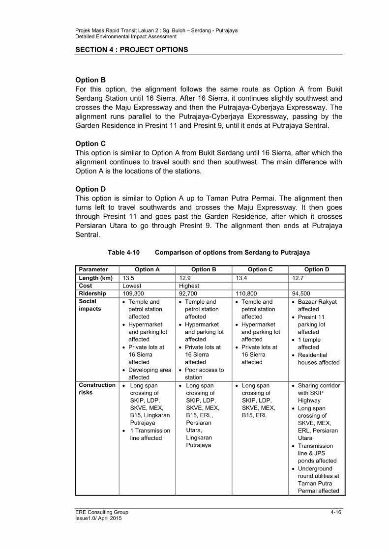
Four alignment options (Table 4-10 and Figure 4-11) were analysed along the
Serdang to Putrajaya stretch :
Option A
After the station near Bukit Serdang, the alignment travels west, traversing along
MARDI area, Jabatan Pertanian area, Taman Universiti Indah, Taman Equine
Pinggiran Putra and then along Jalan Putra Permai, passing Pusat Bandar Putra
Permai. After this, the line continues south along Persiaran Alpinia and Persiaran
Sierra Utama, passing through 16 Sierra. It then crosses the Maju Expressway and
goes into Cyberjaya. The line then continues south past the Skypark development
and then heads east past Limkokwing University, crossing the Putrajaya-Cyberjaya
Expressway and ends at Putrajaya Sentral.
Projek Mass Rapid Transit Laluan 2 : Sg. Buloh – Serdang - Putrajaya Detailed Environmental Impact Assessment
SECTION 4 : PROJECT OPTIONS
ERE Consulting Group 4-16 Issue1.0/ April 2015
Option B
For this option, the alignment follows the same route as Option A from Bukit
Serdang Station until 16 Sierra. After 16 Sierra, it continues slightly southwest and
crosses the Maju Expressway and then the Putrajaya-Cyberjaya Expressway. The
alignment runs parallel to the Putrajaya-Cyberjaya Expressway, passing by the
Garden Residence in Presint 11 and Presint 9, until it ends at Putrajaya Sentral.
Option C
This option is similar to Option A from Bukit Serdang until 16 Sierra, after which the
alignment continues to travel south and then southwest. The main difference with
Option A is the locations of the stations.
Option D
This option is similar to Option A up to Taman Putra Permai. The alignment then
turns left to travel southwards and crosses the Maju Expressway. It then goes
through Presint 11 and goes past the Garden Residence, after which it crosses
Persiaran Utara to go through Presint 9. The alignment then ends at Putrajaya
Sentral.
Table 4-10 Comparison of options from Serdang to Putrajaya
Parameter Option A Option B Option C Option D
Length (km) 13.5 12.9 13.4 12.7
Cost Lowest Highest
Ridership 109,300 92,700 110,800 94,500
Social
impacts
• Temple and
petrol station
affected
• Hypermarket
and parking lot
affected
• Private lots at
16 Sierra
affected
• Developing area
affected
• Temple and
petrol station
affected
• Hypermarket
and parking lot
affected
• Private lots at
16 Sierra
affected
• Poor access to
station
• Temple and
petrol station
affected
• Hypermarket
and parking lot
affected
• Private lots at
16 Sierra
affected
• Bazaar Rakyat
affected
• Presint 11
parking lot
affected
• 1 temple
affected
• Residential
houses affected
Construction
risks
• Long span
crossing of
SKIP, LDP,
SKVE, MEX,
B15, Lingkaran
Putrajaya
• 1 Transmission
line affected
• Long span
crossing of
SKIP, LDP,
SKVE, MEX,
B15, ERL,
Persiaran
Utara,
Lingkaran
Putrajaya
• Long span
crossing of
SKIP, LDP,
SKVE, MEX,
B15, ERL
• Sharing corridor
with SKIP
Highway
• Long span
crossing of
SKVE, MEX,
ERL, Persiaran
Utara
• Transmission
line & JPS
ponds affected
• Underground
round utilities at
Taman Putra
Permai affected
Projek Mass Rapid Transit Laluan 2 : Sg. Buloh – Serdang - Putrajaya Detailed Environmental Impact Assessment
SECTION 4 : PROJECT OPTIONS
ERE Consulting Group 4-17 Issue1.0/ April 2015
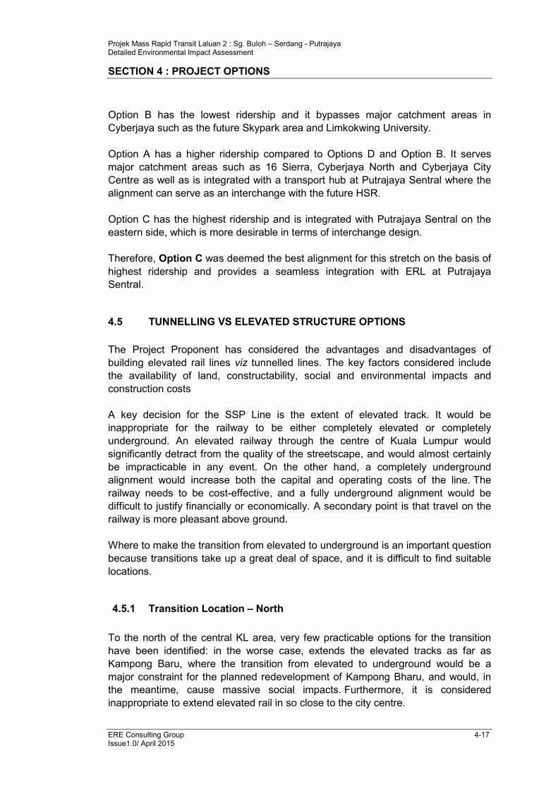
Option B has the lowest ridership and it bypasses major catchment areas in
Cyberjaya such as the future Skypark area and Limkokwing University.
Option A has a higher ridership compared to Options D and Option B. It serves
major catchment areas such as 16 Sierra, Cyberjaya North and Cyberjaya City
Centre as well as is integrated with a transport hub at Putrajaya Sentral where the
alignment can serve as an interchange with the future HSR.
Option C has the highest ridership and is integrated with Putrajaya Sentral on the
eastern side, which is more desirable in terms of interchange design.
Therefore, Option C was deemed the best alignment for this stretch on the basis of
highest ridership and provides a seamless integration with ERL at Putrajaya
Sentral.
4.5 TUNNELLING VS ELEVATED STRUCTURE OPTIONS
The Project Proponent has considered the advantages and disadvantages of
building elevated rail lines viz tunnelled lines. The key factors considered include
the availability of land, constructability, social and environmental impacts and
construction costs
A key decision for the SSP Line is the extent of elevated track. It would be
inappropriate for the railway to be either completely elevated or completely
underground. An elevated railway through the centre of Kuala Lumpur would
significantly detract from the quality of the streetscape, and would almost certainly
be impracticable in any event. On the other hand, a completely underground
alignment would increase both the capital and operating costs of the line. The
railway needs to be cost-effective, and a fully underground alignment would be
difficult to justify financially or economically. A secondary point is that travel on the
railway is more pleasant above ground.
Where to make the transition from elevated to underground is an important question
because transitions take up a great deal of space, and it is difficult to find suitable
locations.
4.5.1 Transition Location – North
To the north of the central KL area, very few practicable options for the transition
have been identified: in the worse case, extends the elevated tracks as far as
Kampong Baru, where the transition from elevated to underground would be a
major constraint for the planned redevelopment of Kampong Bharu, and would, in
the meantime, cause massive social impacts. Furthermore, it is considered
inappropriate to extend elevated rail in so close to the city centre.
Projek Mass Rapid Transit Laluan 2 : Sg. Buloh – Serdang - Putrajaya Detailed Environmental Impact Assessment
SECTION 4 : PROJECT OPTIONS
ERE Consulting Group 4-18 Issue1.0/ April 2015
At the other extreme, the transition could be on Jalan Kepong, west of Kampung
Batu Station. This would extend the underground by more than 3 km and the extra
costs involved are hard to justify.
The two remaining options for the transition ramp are:
• Parallel to the KTM Line at Kentonmen, adjacent to the Army Camp,
• Within Jalan Ipoh, with the portal approximately opposite Jalan Segambut.
The first option is relatively easy to justify as it is next to an existing railway. The
Jalan Ipoh option has an elevated alignment along this busy road for a distance of
2.5km before descending in the ramp down to underground. The only locations
where sufficient space has been identified to accommodate the ramp are on the
southbound carriageway of Jalan Ipoh, with the portal located either just to the
north or the south of the Jalan Segambut junction.
Based on these factors, Jalan Ipoh near Jalan Segambut was chosen as the
northern elevated – underground transition point.
4.5.2 Transition Location – South
A logical location for the transition south of the central KL area, the future Bandar
Malaysia and HSR Station is near Taman Desa area, south of the East–West Link
Expressway. The area is relatively clear site with some slip roads connecting East–
West Link Expressway, Kuala Lumpur – Seremban Highway and Desa Waterpark.
To the north of East–West Link Expressway, the underground alignment is
constrained by the clearance above the SMART tunnel and below the highway and
existing KTM and ERL Lines. After these constraints and south of East–West Link
Expressway, the alignment rises above ground in an open area adjacent to existing
slip roads to the highways. Two access roads to Dese Waterpark will be relocated
to avoid the alignment. The alignment continues to rise to connect to Kuchai Lama
which is an elevated station.
Based on these factors, Taman Desa area was chosen as the southern elevated –
underground transition point.

EJ 534 Klang Valley MRT\Drawings\DEIA\Fig 4-1.cdr
Feasibility Study Corridor and Alignment Optionsfor SSP Line
Figure 4-1
N
NOT TO SCALE
SBK LINECIRCLE LINE
SSP LINE
OPTION FOR SSP LINE
INTERCHANGE STATIONS
STUDY CORRIDOR FOR SSP LINE
DEPOT
LEGEND

EJ 534 Klang Valley MRT\Drawings\DEIA\Fig 4-2.cdr
Figure 4-2 Alignment Options for Damansara Damai to Kepong Sentral
Source : MMC Gamuda KVMRT
Option A (SPAD)
Option B
Option C
Option D
DC
B
A
(SPAD)

EJ 534 Klang Valley MRT\Drawings\DEIA\Fig 4-3.cdr
Figure 4-3
Source : MMC Gamuda KVMRT
Alignment Options for Jinjang to Batu
Kolam TakunganBanjir Jinjang
C
B
A (SPAD)

EJ 534 Klang Valley MRT\Drawings\DEIA\Fig 4-4.cdr
Figure 4-4 Alignment Options for Batu to Titiwangsa
Source : MMC Gamuda KVMRT
A
SPAD
B
C
D

EJ 534 Klang Valley MRT\Drawings\DEIA\Fig 4-5.cdr
Figure 4-5 Alignment Options for Titiwangsa
Source : MMC Gamuda KVMRT
Sg. G
om
bak
A
B

EJ 534 Klang Valley MRT\Drawings\DEIA\Fig 4-6.cdr
Figure 4-6 Alignment Options for Titiwangsa to TRX
Source : MMC Gamuda KVMRT
A
B
C
C
B
A

STATION 16
STATION 31
STATION 32
KLCC EAST
CONLAY
STATION 16
MIHARJA
BM NORTH
BM SOUTH
KUCHAI LAMA
BANDAR BARUSRI PETALING
SUNGAI BESI
SERDANGRAYA (N)
SERDANGRAYA (S)
BUKIT SERDANG
TAMANUNIVERSITI
STATION 31
STATION 32
STATION 16
STATION 31
STATION 32
KLCC EAST
CONLAY
STATION 16
MIHARJA
BM NORTH
BM SOUTH
KUCHAI LAMA
BANDAR BARUSRI PETALING
SUNGAI BESI
SERDANGRAYA (N)
SERDANGRAYA (S)
BUKIT SERDANG
TAMANUNIVERSITI
STATION 31
STATION 32
SHAMELINPERKASASHAMELINPERKASA
CHOW KIT
BANDARWAWASAN
KAMPUNGBARU
KUALA LUMPURCITY CENTRE
KUALALUMPUR
BUKITBINTANG PASAR
RAKYAT
IMBI
ROYAL SELANGORGOLF CLUB
TAMANMUHIBBAHSERI
KEMBANGANNEW
VILLAGE
SERDANGJAYA
PUSATPERDAGANGAN
SERIKEMBANGAN
TAMANSERI
SERDANG
KAWASANPERINDUSTRIAN
SERIKEMBANGAN
UPM
TAMANPINGGIRAN
PUTRA
PUSATBANDAR
PUTRA PERMAI
TAMANPUTRAPERMAI
TAMANEQUINE
TAMANUNIVERSITI
INDAH
UNIVERSITIPUTRA
MALAYSIA
KWONG TUNGCEMETERY
TAMANDESA
TAMANSRI PERMAISURI
TAMANSUNGAI BESI
KG. BARUSALAK SELATAN
DESA PETALING
SALAK SOUTHGARDEN
TAMANTASIK SELATAN
BANDAR BARUSRI PETALING
BUKIT JALILNATIONAL SPORT
COMPLEX
ROYALSELANGORTURF CLUB
BUKIT SUNGAIBESI FOREST
RESERVE
THE MINESGOLF AND COUNTRY
CLUB
TAMANSERDANG
RAYA
KUCHAILAMA
LE
BU
HR
AY
A M
AH
AM
ER
U
JALAN TUN RAZAK
BESRAYA
LE
BU
HR
AY
A M
AH
AM
ER
U
JALAN TUN RAZAK
BESRAYA
LEB
UH
RAYA
KU
ALA
LU
MPU
R -
PU
TRA
JAYA
LE
BU
HR
AYA
KU
ALA
LU
MP
UR
- S
ER
EM
BA
N
LE
BU
HR
AY
A K
UA
LA
LU
MP
UR
- SE
RE
MB
AN
HUBUNGAN TIMUR
JA
LA
N L
ING
KA
RA
N T
EN
GA
H 2
LEBUHRAYA
- BARAT
LEBUHRAYA CHERAS - KAJANG
LE
BU
HR
AY
A U
TA
RA
- SE
LA
TA
N
LE
BU
HR
AY
A S
G. B
ES
I
LEB
UH
RAYA
KU
ALA
LU
MPU
R -
PU
TRA
JAYA
LE
BU
HR
AYA
KU
ALA
LU
MP
UR
- S
ER
EM
BA
N
LE
BU
HR
AY
A K
UA
LA
LU
MP
UR
- SE
RE
MB
AN
HUBUNGAN TIMUR
JA
LA
N L
ING
KA
RA
N T
EN
GA
H 2
LEBUHRAYA
- BARAT
LEBUHRAYA CHERAS - KAJANG
LE
BU
HR
AY
A U
TA
RA
- SE
LA
TA
N
LE
BU
HR
AY
A S
G. B
ES
I
EJ 534 Klang Valley MRT\Drawings\DEIA\Fig 4-7.cdr
Alignment Options for TRX to SerdangFigure 4-7
Source : MMC Gamuda KVMRT
LEGEND
ALIGNMENT
UNDERGROUND
STATIONS
PARK AND RIDEP
OPTION AOPTION AOPTION BOPTION B
N
0 1km 2km
PANDANJAYA
STATION
PANDANUTAMA
STATIONPANDANMEWAHSTATION
TAMANBUKIT TERATAI
STATION
TAMANCHERAS HARTAMAS
STATION
TAMANCONNAUGHT
(PLAZA PHOENIX)STATION
ALAMDAMAI
STATION
DAMAIPERDANASTATION
BUKITBELIMBING
STATION
TAMANHARMONI INDAH
STATION
MINESSTATION
SERIKEMBANGAN
STATION
PANDANJAYA
STATION
PANDANUTAMA
STATIONPANDANMEWAHSTATION
TAMANBUKIT TERATAI
STATION
TAMANCHERAS HARTAMAS
STATION
TAMANCONNAUGHT
(PLAZA PHOENIX)STATION
ALAMDAMAI
STATION
DAMAIPERDANASTATION
BUKITBELIMBING
STATION
TAMANHARMONI INDAH
STATION
MINESSTATION
SERIKEMBANGAN
STATION
TUN RAZAKEXCHANGE (TRX)
STATION
TUN RAZAKEXCHANGE (TRX)
STATIONJALAN
PERKASASTATION
(PROVISIONAL)
JALANPERKASASTATION
(PROVISIONAL)

OPTION C
OPTION E
OPTION D
OPTION C
OPTION E
OPTION D
TRX(P. RAKYAT)
CHAN SOW LIN
BM NORTH
BM SOUTH
TRX(P. RAKYAT)
CHAN SOW LIN
BM NORTH
BM SOUTH
BUKITBINTANG PASAR
RAKYAT
IMBI
ROYAL SELANGORGOLF CLUB
KWONG TUNGCEMETERY
TAMANDESA
TAMANSRI PERMAISURI
TAMANSUNGAI BESI
KG. BARUSALAK SELATAN
KUCHAILAMA
BUKITBINTANG PASAR
RAKYAT
IMBI
ROYAL SELANGORGOLF CLUB
KWONG TUNGCEMETERY
TAMANDESA
TAMANSRI PERMAISURI
TAMANSUNGAI BESI
KG. BARUSALAK SELATAN
KUCHAILAMA
LEB
UH
RAYA
KU
ALA
LU
MPU
R -
PU
TRA
JAYA
LE
BU
HR
AYA
KU
ALA
LU
MP
UR
- S
ER
EM
BA
N
HUBUNGAN TIMUR
JA
LA
N L
ING
KA
RA
N T
EN
GA
H 2
LEBUHRAYA
LEB
UH
RAYA
KU
ALA
LU
MPU
R -
PU
TRA
JAYA
LE
BU
HR
AYA
KU
ALA
LU
MP
UR
- S
ER
EM
BA
N
HUBUNGAN TIMUR
JA
LA
N L
ING
KA
RA
N T
EN
GA
H 2
LEBUHRAYA
EJ 534 Klang Valley MRT\Drawings\DEIA\Fig 4-8.cdr
Figure 4-8 Alignment Options for TRX to South Portal
Source : MMC Gamuda KVMRT
N
0 0.5km 1km

OPTION A
OPTION B
OPTION C
OPTION A
OPTION B
OPTION C
KUCHAI LAMAKUCHAI LAMA
TAMANSUNGAI BESI
KG. BARUSALAK SELATAN
KUCHAILAMA
TAMANSUNGAI BESI
KG. BARUSALAK SELATAN
KUCHAILAMA
TAMANSALAK
SELATAN
TAMANNAGAEMAS
TAMANSALAK
SELATAN
TAMANNAGAEMAS
KuchaiIndustrial
Area
KuchaiIndustrial
Area
Desa Water ParkDesa Water Park
BESRAYABESRAYA
MA
JU E
XP
RE
SS
WAY
Jalan
Kuchai Lam
a
LE
BU
HR
AYA
KL - S
ER
EM
BA
N
MA
JU E
XP
RE
SS
WAY
Jalan
Kuchai Lam
a
LE
BU
HR
AYA
KL - S
ER
EM
BA
N
Source : MMC Gamuda KVMRT
EJ 534 Klang Valley MRT\Drawings\DEIA\Fig 4-9.cdr
Figure 4-9 Alignment Options for Kuchai Lama
N
0 0.25km 0.5km

OPTION A
OPTION B
OPTION C
OPTION A
OPTION B
OPTION C
KUCHAI LAMAKUCHAI LAMA
TAMANSUNGAI BESI
KG. BARUSALAK SELATAN
KUCHAILAMA
TAMANSUNGAI BESI
KG. BARUSALAK SELATAN
KUCHAILAMA
TAMANSALAK
SELATAN
TAMANNAGAEMAS
TAMANSALAK
SELATAN
TAMANNAGAEMAS
KuchaiIndustrial
Area
KuchaiIndustrial
Area
Desa Water ParkDesa Water Park
BESRAYABESRAYA
MA
JU E
XP
RE
SS
WAY
Jalan
Kuchai Lam
a
LE
BU
HR
AYA
KL - S
ER
EM
BA
N
MA
JU E
XP
RE
SS
WAY
Jalan
Kuchai Lam
a
LE
BU
HR
AYA
KL - S
ER
EM
BA
N
Source : MMC Gamuda KVMRT
EJ 534 Klang Valley MRT\Drawings\DEIA\Fig 4-9.cdr
Figure 4-9 Alignment Options for Kuchai Lama
N
0 0.25km 0.5km

UPMSTATION
UPMSTATION
HOSPITALSERDANGSTATION
HOSPITALSERDANGSTATION
IOISTATION
IOISTATION
PRESINT 14STATION
PRESINT 14STATION
ALAMANDASTATION
ALAMANDASTATION
SERIKEMBANGAN
BUKITSERDANG
TMN UNIVERSITI
EQUINE PARK
TMN PUTRAPERMAI
16 SIERRA
CYBERJAYANORTH
CYBERJAYACITY CENTRE
PUTRAJAYASENTRAL
SERIKEMBANGAN
BUKITSERDANG
TMN UNIVERSITI
EQUINE PARK
TMN PUTRAPERMAI
16 SIERRA
CYBERJAYANORTH
CYBERJAYACITY CENTRE
PUTRAJAYASENTRAL
WESTERNCORRIDORWESTERNCORRIDOR
EASTERNCORRIDOREASTERN
CORRIDOR
TAMANMUHIBBAH
SERIKEMBANGAN
NEWVILLAGE
SERDANGJAYA
PUSATPERDAGANGAN
SERIKEMBANGAN
TAMANSERI
SERDANG
SERDANGJAYA
KAWASANPERINDUSTRIAN
SERIKEMBANGAN
UPM
TAMANPINGGIRAN
PUTRA
PUSATBANDAR
PUTRA PERMAI
TAMANLESTARIPERMAI
TAMANPRIMA
TROPIKA
TAMANPUTRAPERMAI
TAMANEQUINE
TAMANUNIVERSITI
INDAH
TAMANSURIA
TROPIKA
PRECINT 11
PRECINT 9
PRECINT 8
PRECINT 7
GARDENRESIDENCE
16 SIERRA
SKYPARK
CYBERJAYA
D’ALPINA
UNIVERSITIPUTRA
MALAYSIA
TAMANMUHIBBAH
SERIKEMBANGAN
NEWVILLAGE
SERDANGJAYA
PUSATPERDAGANGAN
SERIKEMBANGAN
TAMANSERI
SERDANG
SERDANGJAYA
KAWASANPERINDUSTRIAN
SERIKEMBANGAN
UPM
TAMANPINGGIRAN
PUTRA
PUSATBANDAR
PUTRA PERMAI
TAMANLESTARIPERMAI
TAMANPRIMA
TROPIKA
TAMANPUTRAPERMAI
TAMANEQUINE
TAMANUNIVERSITI
INDAH
TAMANSURIA
TROPIKA
PRECINT 11
PRECINT 9
PRECINT 8
PRECINT 7
GARDENRESIDENCE
16 SIERRA
SKYPARK
CYBERJAYA
D’ALPINA
UNIVERSITIPUTRA
MALAYSIAL
EB
UH
RA
YA
UTA
RA
- SE
LA
TA
NL
EB
UH
RA
YA
UTA
RA
- SE
LA
TA
N
LEBUHRAYA LEMBAH KLANG SELATAN
LEBUHRAYA LEMBAH KLANG SELATAN
PERSIARAN UTARAPERSIARAN UTARA
N
0 1km 2km
Source : MMC Gamuda KVMRT
EJ 534 Klang Valley MRT\Drawings\DEIA\Fig 4-10.cdr
Figure 4-10Alignment Options for Serdang to Putrajaya
Eastern and Western Corridors
OPTION A
OPTION C
OPTION D
OPTION B
OPTION A
OPTION C
OPTION D
OPTION B
OPTION A
OPTION C
OPTION B
OPTION D
OPTION A
OPTION C
OPTION B
OPTION D

SERIKEMBANGAN
BUKITSERDANG
TMN UNIVERSITI
EQUINE PARK
TMN PUTRAPERMAI
16 SIERRA
CYBERJAYANORTH
CYBERJAYACITY CENTRE
PUTRAJAYASENTRAL
SERIKEMBANGAN
BUKITSERDANG
TMN UNIVERSITI
EQUINE PARK
TMN PUTRAPERMAI
16 SIERRA
CYBERJAYANORTH
CYBERJAYACITY CENTRE
PUTRAJAYASENTRAL
TAMANMUHIBBAH
SERIKEMBANGAN
NEWVILLAGE
SERDANGJAYA
PUSATPERDAGANGAN
SERIKEMBANGAN
TAMANSERI
SERDANG
SERDANGJAYA
UPM
TAMANPINGGIRAN
PUTRA
PUSATBANDAR
PUTRA PERMAI
TAMANLESTARIPERMAI
TAMANPRIMA
TROPIKA
TAMANPUTRAPERMAI
TAMANEQUINE
TAMANUNIVERSITI
INDAH
TAMANSURIA
TROPIKA
PRECINT 11
PRECINT 9
PRECINT 8
PRECINT 7
GARDENRESIDENCE
16 SIERRA
SKYPARK
CYBERJAYA
D’ALPINIA
TAMANMUHIBBAH
SERIKEMBANGAN
NEWVILLAGE
SERDANGJAYA
PUSATPERDAGANGAN
SERIKEMBANGAN
TAMANSERI
SERDANG
SERDANGJAYA
UPM
TAMANPINGGIRAN
PUTRA
PUSATBANDAR
PUTRA PERMAI
TAMANLESTARIPERMAI
TAMANPRIMA
TROPIKA
TAMANPUTRAPERMAI
TAMANEQUINE
TAMANUNIVERSITI
INDAH
TAMANSURIA
TROPIKA
PRECINT 11
PRECINT 9
PRECINT 8
PRECINT 7
GARDENRESIDENCE
16 SIERRA
SKYPARK
CYBERJAYA
D’ALPINIA LEBUHRAYA LEMBAH KLANG SELATAN
LEBUHRAYA LEMBAH KLANG SELATAN
PERSIARAN UTARAPERSIARAN UTARA
N
0 1km 2km
EJ 534 Klang Valley MRT\Drawings\DEIA\Fig 4-11.cdr
Source : MMC Gamuda KVMRT
Alignment Options for Serdang to PutrajayaWestern Corridor
Figure 4-11
OPTION A
OPTION C
OPTION B
OPTION D
OPTION A
OPTION C
OPTION B
OPTION D