SECTION 4 GENERAL PROVISIONS 4.0 APPLICATION OF GENERAL ...€¦ · Accessory buildings or...
117
SECTION 4 GENERAL PROVISIONS 4.0 APPLICATION OF GENERAL PROVISIONS No person shall erect or use any building or structure or use any land, or cause or permit any building or structure to be erected or used or cause or permit any land to be used in any zone within the City of London for lands affected by this By-Law except in conformity with the regulations specified by the applicable general provisions set out in all subsections of Section 4. (Z.-1-051390) 4.1 ACCESSORY USES 1) ACCESSORY USES PERMITTED IN ALL ZONES Where this By-Law permits a lot to be used or a building or structure to be erected or used for a purpose, that purpose shall include any building, structure or use accessory thereto, except that no home occupation, open storage or accessory dwelling unit shall be permitted in any zone other than a zone in which such a use is specifically listed as a permitted use. No accessory building, structure or use in an agricultural zone or a residential zone shall be used for human habitation, except where a dwelling unit is permitted as an accessory use or where the zone permits a bed and breakfast establishment, secondary farm dwelling, temporary garden suite or hotel. (Z.-1-051390) 2) LOT COVERAGE The total lot coverage of all accessory buildings or structures on a lot shall not exceed 10 percent (10%) of the lot area of the said lot. In agricultural zones the size of accessory buildings is limited to 25% of the size of the main farm dwelling excluding main farm buildings such as barns, greenhouses, stables and driving sheds. The percent coverage's of accessory buildings and structures are included in the percentage total coverage permitted on a lot. (Z.-1-051390) 3) HEIGHT RESTRICTIONS Notwithstanding the definition of height, the height of an accessory building shall be measured from the average finished grade to the upper most point of the building or structure and shall not exceed the following overall height : (Z.-1-97490) a) all Residential Zones, 4.0 metres (13.1 feet) except as provided in 4.1.4(b) where the height may be increased to 6.0 metres (19.7 feet); (Z.-1-97490) b) all Commercial, Agricultural and Institutional Zones, 6.0 metres (19.7 feet); (Z-1-051390) c) all other zones, 10.0 metres (32.8 feet). 4) LOT REQUIREMENTS OR LOCATION Accessory buildings or structures are permitted in the following locations: (Z.-1-051390) a) no accessory building or structure shall be permitted within a required front yard or the exterior side yard; (Z.-1-97490) b) when such accessory building or structure is located in an interior side yard or a rear yard, it shall be no closer than 0.6 metres (2.0 feet) to the side lot line and rear lot line. Where the height exceeds 4.0 metres (13.1 feet) but in no case more than 6 metres (19.7 feet), the side and rear lot line setback shall be increased by the difference in the height above 4.0 metres (13.1 feet); (Z.-1-97490)
Transcript of SECTION 4 GENERAL PROVISIONS 4.0 APPLICATION OF GENERAL ...€¦ · Accessory buildings or...
SECTION 4
GENERAL PROVISIONS 4.0 APPLICATION OF GENERAL PROVISIONS
No person shall erect or use any building or structure or use any land, or cause or permit any building or structure to be erected or used or cause or permit any land to be used in any zone within the City of London for lands affected by this By-Law except in conformity with the regulations specified by the applicable general provisions set out in all subsections of Section 4. (Z.-1-051390)
4.1 ACCESSORY USES
1) ACCESSORY USES PERMITTED IN ALL ZONES
Where this By-Law permits a lot to be used or a building or structure to be erected or used for a purpose, that purpose shall include any building, structure or use accessory thereto, except that no home occupation, open storage or accessory dwelling unit shall be permitted in any zone other than a zone in which such a use is specifically listed as a permitted use. No accessory building, structure or use in an agricultural zone or a residential zone shall be used for human habitation, except where a dwelling unit is permitted as an accessory use or where the zone permits a bed and breakfast establishment, secondary farm dwelling, temporary garden suite or hotel. (Z.-1-051390)
2) LOT COVERAGE
The total lot coverage of all accessory buildings or structures on a lot shall not exceed 10 percent (10%) of the lot area of the said lot. In agricultural zones the size of accessory buildings is limited to 25% of the size of the main farm dwelling excluding main farm buildings such as barns, greenhouses, stables and driving sheds. The percent coverage's of accessory buildings and structures are included in the percentage total coverage permitted on a lot. (Z.-1-051390)
3) HEIGHT RESTRICTIONS
Notwithstanding the definition of height, the height of an accessory building shall be measured from the average finished grade to the upper most point of the building or structure and shall not exceed the following overall height :
(Z.-1-97490)
a) all Residential Zones, 4.0 metres (13.1 feet) except as provided in 4.1.4(b) where the height may be increased to 6.0 metres (19.7 feet);
(Z.-1-97490) b) all Commercial, Agricultural and Institutional Zones, 6.0 metres (19.7
feet); (Z-1-051390) c) all other zones, 10.0 metres (32.8 feet). 4) LOT REQUIREMENTS OR LOCATION
Accessory buildings or structures are permitted in the following locations: (Z.-1-051390) a) no accessory building or structure shall be permitted within a required
front yard or the exterior side yard; (Z.-1-97490) b) when such accessory building or structure is located in an interior side
yard or a rear yard, it shall be no closer than 0.6 metres (2.0 feet) to the side lot line and rear lot line. Where the height exceeds 4.0 metres (13.1 feet) but in no case more than 6 metres (19.7 feet), the side and rear lot line setback shall be increased by the difference in the height above 4.0 metres (13.1 feet);
(Z.-1-97490)

c) when such accessory building or structure is within a non-residential zone
and is located in an interior side yard or a rear yard, it shall be no closer than 1.2 metres (3.9 feet) to the side lot line and rear lot line. Where such an accessory building or structure abuts a residential zone, the setback requirement shall be equal to one-half of the overall height of the structure but in no case less than 1.2 metres (3.9 feet) to the side lot line and rear lot line;
(Z.-1-97490) d) when such accessory building or structure is wholly or partly located in an
exterior side yard, or a rear yard abutting a street, the minimum setback shall not be less than the required front yard setback for the zone in which the lot is located;
(Z.-1-97490) e) when such an accessory building or structure is less than 10 square
metres (108 square feet) no yard setbacks shall be required provided the building or structure is located entirely in the rear yard, except as provided in 4.1.4(d); (Z.-1-97490)
f) when the accessory building or structure is a gatehouse, it may locate in
the front yard or the exterior side yard in an industrial zone; g) when the accessory building or structure is a satellite dish, it shall be
restricted to interior side yards or rear yards; h) swimming pools shall comply with the provisions of Subsection 4.25
(Swimming Pools) of this By-Law; i) air conditioning units and heat pumps shall comply with the provisions of
Subsection 4.27 . (Yard Encroachments Permitted) 5) PARKING STRUCTURES
Within this By-Law, a parking structure will be considered an accessory use but will not be subject to the general provisions subsections 4.1(2), (3) or (4), but rather, subject to the building regulations of the zone in which it is located.
6) Minor Motor Vehicle Service and Repair is permitted as an accessory and
incidental residential use in all residential zones that permit single, duplex, semi-detached, duplex, triplex, fourplex or converted dwellings excluding uses ancillary to an existing agricultural use, if all of the following conditions are met:
1. The vehicle being serviced or repaired must have a current valid ownership
permit issued to an occupant or a spouse, child or sibling of an occupant currently residing in the dwelling.
2. The minor motor vehicle service repair shall be conducted between the hours of 8:00 am to 8:00 pm. 3. No more than one vehicle may be serviced or repaired at the same time. 4. Minor motor vehicle service repair shall not occur for more than 6
consecutive calendar days. 5. Motor vehicle painting, except for minor touch-ups, is prohibited at all times. 6. Minor motor vehicle service repair as a commercial use is prohibited at all
times. (Z.-1-071653) 4.2 ACCESS REGULATIONS
No person shall hereafter erect any main building or structure on any lot in any zone unless such lot or an abutting lot held under the same ownership abuts an improved street or is a lot on a registered plan of subdivision. In the case of a parcel of land for which a Development Agreement, Subdivision Agreement and/or a Site Plan or any one of them has been approved and registered against title pursuant to Section 41 or Section 50 of the Planning Act, R.S.O. 1990, c. P.13, as amended from time to time, then the single parcel of land to which the Development Agreement and/or plan applies shall be deemed to be the lot for application of this Section, notwithstanding that part of the parcel may be in separate ownership; does not otherwise satisfy the definition of lot; or does not abut an improved street.
(Z.-1-94236) (O.M.B. File # R910387 - Appeal #9006-2 June 4, 1993)

4.3 BONUS ZONES
1) HERITAGE BUILDING DESIGNATION BONUS - FLOOR AREA AND DWELLING UNIT DENSITY BONUS:
For buildings and/or structures designated as historically significant by the City of London, under the Ontario Heritage Act, in consideration for their designation, the following regulations shall apply for:
Non Residential Uses: a) a 25 percent (25%) increase in the gross floor area of the existing building
and/or a 25 percent (25%) decrease in the required minimum parking for a permitted use on the lot or;
Residential Uses: b) for every 15 square metres of existing gross building floor area of a
designated building, 1 additional dwelling unit shall be permitted for a permitted use on the lot to a maximum increase of 25% of the dwelling units permitted in the zone.
The increase in gross floor area and/or dwelling units shall be permitted in
accordance with the regulations of the applicable zone. Where the proposed building is a mixture of residential and non-residential permitted uses, the bonus shall not exceed a combined total percentage of 25 percent (25%) increase in maximum number of dwelling units and non-residential floor area for the lot.
(Excluding 120 Kent Street - Z.-1-95316) 2) PUBLIC OPEN SPACE
For every 100.0 square metres (1,074 square feet) of public open space which is dedicated to the City (in excess of the required parkland dedication any undevelopable floodplain lands and Class 1,2, or 3 Wetlands), the density of the residential development may be increased by one unit per each 100.0 square metres (1,074 square feet) up to 25 percent (25%) of the total number of units that would otherwise be permitted by this by-Law.
(Excluding 120 Kent Street - Z.-1-95316) 3) DAY CARE FACILITIES
Where day care facilities are provided within commercial or mixed-use buildings of larger than 1858.0 square metres (20,000 square feet), the floor area devoted to the day care facilities shall not be included in the floor area ratio, the maximum gross or gross leasable floor area permitted, or in the calculation of the parking requirements for the building.
4) SITE SPECIFIC BONUS PROVISIONS
Notwithstanding the Density (D) and Height (H) zones which apply to a lot where a B (Bonus) zone also applies to the lot, the maximum permitted density and/or height and/or parking may be altered in accordance with the provisions set out below on having entered into a Development Agreement, with bonusing clauses, with the City of London. (Z-1-051390) The number following the letter "B" on the Zone Maps indicates the number of the applicable Bonus Zone provision set out below.
B-1
(Added by Z.-1-95315) (Deleted by Z.-1-98591)

B-2
i) The maximum permitted density may be increased to 325 units per hectare (132 units per acre) if the building design approved by Council, as contained in the bonusing clause of the development agreement, is built. The design is intended to be sympathetic, with regard to the design of the porch and the colour, to the heritage structure located to the south at 530 Ridout Street North.
(Z.-1-98590) B-3 435 Colborne Street i) The subject site is being bonused for enhanced urban design and
underground parking. The maximum number of units may be increased by thirteen (13) to a total of forty-three (43) if the building design as contained in the bonusing clauses of the development agreement, is built. The building design is identified through the elevations, site plan, and floor plans included in the development agreement. (Z.-1-051380) (Z.-1-071604)
B-4 484-500 Ridout Street North i) The maximum permitted density may be increased to 750 units per hectare
(303 units per acre) if the building design approved by Council, as contained in the bonusing clause of the development agreement, is built. The design is intended to be sympathetic to the existing streetscape and surrounding buildings. The design includes a "human scale" ground level and an upper level setback in addition to complementary colours and balcony treatments. The preferred site plan, landscape plan and building elevation are attached to the development agreement.
(Z.-1-051396) B-5 180 Mill Street
i) To ensure compatibility and a transition between high-rise development to
the east and lower scale development to the west, three design features are required to obtain bonus zoning. They include 1) an apartment building on the eastern portion of the site with a progressively lower height as it approaches Mill Street and 2) a row of street-orientated townhouse units along St. George Street and a retaining wall with a high quality “street friendly” design and 3) a high quality “street-friendly” treatment for the townhouses along Mill Street. The maximum permitted density and/or height may be increased with the approval of a design to the satisfaction of the City of London and on having entered into a Site Plan Agreement with the City of London. The cumulative impact of using this bonusing provision shall not result in a density greater than 250 units per hectare (100 units per acre) and a building height greater than 40 metres (131.2 feet). (Z.-1-061457)
B-6 305-325 Queens Avenue
i) A maximum height of 90 m (295 ft.) will be permitted on this site subject to the property owner entering into a development agreement which establishes a high quality of architectural design for this building. The location of the new structure will be identified on the future site plan and bonusing clauses will be inserted in the resultant development agreement to implement the bonusing provisions.
(Z.-1-061460)
B-7 59-73 King Street, 342-360 Ridout Street North and 68 York Street i) To implement Council's initiative to significantly increase the number of
new residential units in the Downtown and in return for the contribution of $100,000 towards public art to be installed on this site, transit-supportive design, enhanced landscaping, commercial uses at grade, the provision of some amount of underground parking, the integration of design features which reduce the visual massing of the building, articulate the base of the building to be sympathetic with surrounding building heights and create a quality pedestrian streetscape and positive contribution to the London skyline, as specified in the bonusing clauses in the development agreement, the maximum density allowed on this site may be increased from 350 units per hectare to 750 units per hectare and height from 90 metres to 95 metres.
(Z.-1-061557)
B-8 863, 867 and 869 Adelaide Street North, and on a portion of 859, 861, and 865 Adelaide Street North
The subject site is being bonused for enhanced urban design. The building design is identified through the elevations, site plan, and landscaping plan included in the development agreement, which includes one apartment building, 42 units, 3 storeys in height (maximum 10.0 metres), located along the northern boundary of the site, and one stacked townhouse development, 10 units, 2 storeys in height (maximum 8.0 metres), located along the western boundary of the site.
A design character statement has also been included in the development agreement to provide guidance to any minor changes that are made as these plans are finalized through the site plan process. The following regulations apply with the approved site plan: Permitted Uses: i) Apartments and Stacked Townhouses Lot Area (minimum): 6,000 square metres Lot Frontage (minimum): 15.0 metres Front Yard Setback (minimum): 7.0 metres Interior Side Yard – north (minimum): 3.0 metres Interior Side Yard – south (minimum): 9.0 metres Rear Yard Depth (minimum): 4.5 metres Landscaped Open Space (%) (minimum): 30% Lot Coverage (%) (maximum): 30% Height (maximum): 10.0 metres Density – units per hectare (maximum): 87 Parking: 1 space per unit The cumulative impact of using this bonusing provision shall not result in a density greater than 87 units per hectare (215 units per acre) and a building height greater than 10 metres (32.8 feet). (Z.-1-071641)
B-9 590 & 598 Beaverbrook Avenue
The subject site is being bonused for enhanced urban design. The building design is identified through the elevations, site plan, and landscaping plan included in the development agreement, which includes two apartment buildings, 72 units each (combined total of 144 units), and 5 storeys in height (maximum 16.0 metres), located along the southern boundary of the site. An underground parking deck will also be included in the final design. Design guidelines will be included in the development agreement to provide guidance to any minor changes that are made as these plans are finalized through the site plan process. The following regulations apply with the approved site plan: Permitted Uses: Apartments Lot Area (minimum): 1.0 hectares Lot Frontage (minimum): 70.0 metres Front Yard Setback (minimum): 6.0 metres Interior Side Yard – north (minimum): 13.0 metres (building); 4.5 metres (parking structure) Interior Side Yard – south (minimum): 6.0 metres Rear Yard Depth (minimum): 7.0 metres Landscaped Open Space (%) (minimum): 30% Lot Coverage (%) (maximum): 40% Height (maximum): 16.0 metres (or 5 stories, whichever is less) Density – units per hectare (maximum): 100 Parking: 1 space per unit The cumulative impact of using this bonusing provision shall not result in a density greater than 100 units per hectare (247 units per acre) and a building height greater than 16.0 metres. (Z.-1-071660)
B-10 725, 729 Dundas Street and 704, 738 King Street and 380, 382 Lyle Street
and 387, 389, 391 Hewitt Street Deleted by Z.-1-152397 B-11 570, 572, 576 & 580 Beaverbrook Avenue
The subject site is being bonused for enhanced urban design. The building design is identified through the elevations and site plan included in the development agreement, which includes four apartment buildings, 74 units each (combined total of 296 units), and 5 storeys in height (maximum 18.0 metres). Design guidelines will be included in the development agreement to provide guidance to any minor changes that are made as these plans are finalized through the site plan process. The following regulations apply with the approved site plan:
Permitted Uses: Apartments Lot Area (Minimum) 3.0 hectares Lot Frontage (Minimum) 65.0 metres Front Yard Setback (Minimum) 3.0 metres Interior Side Yard – North (Minimum) 3.0 metres
Interior Side Yard – South (Minimum): 7.0 metres Exterior Side Yard North (Minimum) 3.0 metres Rear Yard Depth (Minimum) 3.0 metres Landscaped Open Space (Minimum) 40% Lot Coverage (Maximum) 30% Height (Maximum) 18.0 metres (or 5 storeys, whichever is less) Density – units per hectare (Maximum) 82 Parking: 1 space per unit (Z.-1-091825)
B-12 726, 728, 732, 740, 742, 744, 746, 748 Dundas Street and 415 English Street
The subject site is being bonused for enhanced urban design, underground parking, green roof and the revitalization of the Old East Village. The building design is identified through the elevations and site plan included in the development agreement, which includes a mixed use building with 154 residential units and 9 commercial units.
The following regulations apply with the approved site plan: i) Density (Maximum) 483 units per hectare ii) Secure Bicycle Parking Spaces 30 (notwithstanding the (Minimum) requirements of Section 4.19 (16)) of this By-law iii) Front Yard Depth (Minimum) 3.0 metres above the first 12 metres of building Height iv) Setback of balcony 1.5 metres
projections from lot line (Minimum)
The cumulative impact of using this bonusing provision shall not result in a density greater than 483 units per hectare (1,194 units per acre). (Z.-1-091836) B-13 637 Dundas Street
The subject site is being bonused for enhanced urban design, landscaping and the promotion of transit usage and the revitalization of the Old East Village District. The required building design is identified through the elevations, site plan, and landscaping plan included in the development agreement, which includes one three storey commercial building with residential units above fronting Dundas Street and a senior apartment building 30m (maximum 9 storeys) in height fronting on Marshall Street with a total of 72 units (280 units/ha). The following regulations apply with the approved site plan: Height (maximum): 30.0 metres Density – units per hectare (maximum): 280 Parking: 15 spaces minimum Secure Bicycle Parking Spaces 0 spaces minimum Interior side yard setbacks to
9 storey senior apartment building: East: 7.5 metres West: 21 metres Dwelling units are permitted on the whole of the first floor including the frontage on Marshall Street, but excludes the Dundas Street frontage.
The cumulative impact of using this bonusing provision shall not result in a density greater than 280 units per hectare and a building height greater than 30.0 metres (100 feet). (Z.-1-101920)
B-14 1235, 1237, 1245, 1247, and 1253 Richmond Street The subject lands are being bonused for enhanced urban design including: Building orientation toward Richmond Street with parking area located to the rear; building elevations that have been divided into a series of modulated components and are defined by complementary changes in height, massing, and cladding materials; the division and articulation of the base, middle and cap of the building; a variation of building materials and the use of cornices that define the major changes in cladding materials on the elevations; the development of a paved and landscaped urban forecourt along Richmond Street; and, a main entrance area marked by an entry canopy, a change in cladding materials, and a 5-storey colonnade. The building design is identified through the elevations and site plan included in the development agreement, which includes a mixed use building with 311, two-bedroom residential units and 1 commercial unit. The following regulations apply with the approved site plan: i) Density 450 units per hectare (Maximum) ii) Number of Bedrooms per Dwelling Unit 2 bedrooms (Maximum) iii) Front Yard Depth from ultimate 4.4 metres road allowance (Minimum) iv) Rear yard depth 1.8 metres (Minimum) v) Interior side yard depth (north) 5.1 metres (Minimum) vi) Interior side yard depth (south) 2.1 metres (Minimum) vii) Landscaped open space 23% (Minimum) viii) Lot coverage 64% (Maximum) ix) Height 55 metres (Maximum) x) Off-street Parking 174 spaces (Minimum)
Notwithstanding these Zoning Regulations, the cumulative impact of this bonus zone shall not result in the creation of more than 311 residential dwelling units. (Z.-1-112002)
B-15 307 Fanshawe Park Road East
The subject site is being bonused for: 1. enhanced urban design features:
• The proposed project provides an appropriate built form height given its location along Fanshawe Park Road and the width of the Public Right-of-Way;
• Parking is located underground and/or behind the built form (not in the front setback), which provides a distinguishable built edge to the public realm;
• The project provides for a residential infill opportunity that creates an active frontage along Fanshawe Park Road by orienting building access and including gathering space along the Public Right-of-Way;
• Underground parking garage is to provide vehicle and bicycle parking along with garbage storage;
• The development retains the original building and incorporates it into the overall design by using design features and materials found in the surrounding neighbourhood. These include: pitched roofs; brick masonry and decorative wood elements;
• The proposal is organised around a common open space, with landscaping, that provides residents of the site opportunities to socialise;
• Maintaining the existing trees along the western boundary of the site; • The proposed built form and its massing transitions with the topography
of the site; • Mitigation of the building mass through:
. variation of height 2 storey and three storey sections
. includes a flat roof which decrease height associated with a pitched roof
. moderation of facades with vertical banding and store piers
. variation of building material
. introduction of vegetation and screening on third storey
. terracing of end units (wedding cake form)
and the following services and matters:
2. a centralized courtyard which provides a common open space that is functional for passive recreational use;
3. 54% landscaped open space; 4. 42 underground parking spaces; and 5. 0.0m front yard setback to allow for a pedestrian accessibility ramp.
The building design will be in accordance with the elevations sections, and site plan attached as Appendix “B” of this By-law, which includes one apartment building, 16 units, 3 storeys in height (maximum 13.0 metres), and a converted dwelling with two units.
The following regulations apply with the approved site plan:
Permitted Uses: Apartment and a converted two unit
dwelling Lot Area (minimum): 5,651 square metres Lot Frontage (minimum): 53.3 metres Front Yard Setback (minimum): 0.0 metres
Interior Side Yard – east (minimum): 7.2 metres to the converted dwelling Interior Side Yard- east (minimum): 9.8 metres to the apartment building Interior Side Yard – west (minimum): 7.1 metres to the stairwell Interior Side Yard- west (minimum): 9.7m to the apartment building Rear Yard Depth (minimum): 9.5 metres Landscaped Open Space (%) (minimum): 54% Lot Coverage (%) (maximum): 32% Height (maximum): 13.0 metres Density – units per hectare (maximum): 32 Parking: 42 underground spaces and 5
surface spaces Secure Bicycle Parking 15 Minimum
The cumulative impact of using this bonusing provision shall result in a density not greater than 32 units per hectare (79 units per acre) and a building height not greater than 13 metres (42.6 feet). (Z.-1-112013)
B-16 909 Southdale Road West and 3045 Pomeroy Lane
The increase in height and density to the zoning of the subject lands shall be permitted in return for enhanced urban design elements and urban design features that consist of: • Constructing two apartment buildings that are “L” shaped in plan, with
terraced profiles that will achieve a maximum height of 50.5m and contain a maximum of 434 dwelling units;
• The two apartment buildings shall be constructed in a mirror image with one apartment building located at the northeast corner of the subject lands with the two building faces constructed parallel to Southdale Road West and Pomeroy Lane and the other building located at the northwest corner of the subject lands with the two building faces constructed parallel to Southdale Road West and the westerly rear lot line in order to frame public realm;
• Defining the base, middle, and top of the apartment buildings: o with the base consisting of the portion of the façade between the
ground floor and the third and fourth floors and using architectural stone and cornice lines to define the base;
o with the middle consisting of the portion of the façade between the top of the base to the fourteenth floor and using coloured concrete and cornice lines to define the middle; and,
o with the top consisting of the portion of the façade above the fourteenth floor and using coloured concrete differentiated from the middle, floorplate setbacks and a roof form profile to define the top;
• Addressing the intersection of Southdale Road and Pomeroy Lane with the concentration of massing and architectural treatment of the eastern apartment building to naturally direct the user to the primary entrances;
• Introducing of trees and vegetation along the street frontage to improve the pedestrian experience along this section of Southdale Road;
• Designing and constructing an attractive, curb free paved and landscaped forecourt using unit pavers between the north facade and the Southdale Road West and the east façade and Pomeroy Lane to create an appealing interface between the buildings and the abutting roads;
• Designing the parking structure elevations to complement the architectural details and materials used in the elevations of the base of the two residential apartment buildings to create visual consistency between the apartment buildings and parking structure;
• Constructing of a 1.8m high solid board privacy fence along the southern property line to provide a visual barrier between the parking structure and the rear yards of the abutting single detached residential lots to the south; and,
• Planting a dense row of coniferous trees between the privacy fence and the parking structure to augment the visual barrier between the parking structure and the rear yards of the abutting single detached residential lots to the south.
The building design is identified through the elevations, site plan, and landscaping plan included in the development agreement.
The following regulations apply with the approved site plan:
i) Height 50.5 metres (Maximum) (165.7 feet) ii) Density 207 units per hectare (Maximum) (83 units per acre) iii) Interior side yard depth (south) 35.0 metres from main building 114.8 feet) (Minimum)
iv) Rear yard depth 18.1 metres (Minimum) (59.4 feet) v) Lot coverage 40.5% (Maximum) (Z.-1-122088)
B-17 1461 Huron Street.
The subject site is being bonused for providing:
1. an affordable apartment building 13m (maximum 3 storeys) in
height with a total of 25 units (81 units/ha); and
2. enhanced urban design including the following: • site the building in general alignment with property lines and
prevailing setbacks of adjacent buildings; • provide landscaping which: • incorporates a hard surface forecourt with fixed seating that
defines the building’s main entrance and corner lot location; • integrates stone salvaged from the demolished place of worship; • defines private outdoor amenity areas with hard surfaced terraces
and fence-wall privacy screens for all at-grade residential units; • minimizes the need for extensive watering; • provide a building which: • clearly expresses a base, middle, and top (roof) on all elevations,
predominantly using masonry materials; • uses variations in massing, materials, scaling and architectural
features to identify the north façade and entrance as the front of the building and the south façade and entrance as a service egress; and employs ample glazing to distinguish stairwell forms from the residential units and maximize visibility for security purposes.
The cumulative impact of using this bonusing provision shall not result in a density greater than 81 units per hectare. (Z.-1-122096)
B-18 To complement the urban design features in the Council direction given to the
Site Plan Approval Authority, the subject site is being bonused for: • Enhanced urban design features; • A built form (apartment building) and smaller dwelling unit size that
promotes intrinsically affordable housing; • The provision of parking spaces within the building; • The use of sustainable design features; and • The provision of the main entry access at grade for universal accessibility.
The development shall be in accordance with the site concept and renderings attached as Schedule “A” of this By-law and as further addressed or modified below, which includes one new apartment building with a maximum of 33 dwelling units, a maximum height of 15 metres, and a maximum density for the site of 256 units per hectare including the existing building, and shall specifically incorporate the following:
Site
• The building is perpendicular to the street allowing views through the site between Hope Street and Princess Avenue.
• A landscaped forecourt in front of the building between the front (south) façade and Princess Avenue.
• The closure of the Hope Street vehicular access while allowing for access to the site for pedestrians.
• The parking area between Hope Street and Princess Avenue is to be treated as a shared vehicular/pedestrian space.
• Green design elements.

Building • The four storey height of the building stepping down to two storeys at
Hope Street. • The use of similar design and cladding materials as the existing building
on the site and in the surrounding neighbourhood, including brick, pilasters, flat arches topped with keystone details, and quoin corners to complement the existing building.
• The provision of the pedestrian entrance on Princess Avenue in the centre of the front face of the new building.
• Transparent glazing of doors and windows wherever possible, or in the case of the parking garage, open metalwork.
The use of cornice lines where the building steps back, where the materials and/or colours change between the third and fourth storeys, and at the roofline.
• Provision of residents’ common areas and amenities on the main level of the building.
• Placement of a minimum of 30% of the required parking for the site within the apartment building and away from public view.
• Facilities for waste, recyclables and compostibles (where City programs exist) incorporated within the building.
• The extension of the red brick to the top of the building in the central section of the front façade of the building.
• Elimination of the narrow door beside the double door on the rear (north) façade of the building.
• Green design elements.
Nothwithstanding anything in the By-law to the contrary including Section 4.28, the following regulations apply to any new building within the approved site plan:
Front Yard Depth (minimum) 6.7 metres (22.0 feet) West Interior Side Yard Depth (minimum) 5.5 metres (18.1 feet) Rear Yard Depth (minimum) 5.0 metres (16.5 feet) Parking spaces (minimum) 0.6 spaces per unit
All other regulations of the Residential R8 (R8-4) Zone apply. (Z.-1-122150) s) B-19 t) B-20 u) B-21 B-22 the lands located on Wellington Street on the east side, between South Street and the Thames River
The subject site is being bonused to facilitate a development design which includes a 26 storey (94m tall) mixed use building on the southeast corner of Wellington Street and South Street with 19 storeys of residential apartment use, 6 storeys, 4,650m2 gross floor area of medical/dental, clinic and independent health facility use and 929m2 of ground floor commercial retail which shall be implemented through a development agreement as described in Appendix “E” attached to the Staff Report dated June 20, 2013 in return for the provision of the following services facilities and matters:
• underground parking spaces;
• placement of the building at the corner of Wellington and South Streets, with the design at its skyline to provide visual signals that both define and distinguish the Gateway area, and building facades using a composition of high quality materials including glass, metal panel, and stone veneer in proportions that, with minor variations at the City’s discretion, match the elevations shown in Schedule “1”, so the architecture of the building itself creates the Gateway;
• utilization of a non-residential podium base with multiple step-backs, and above it a residential point tower, to have regard for the impact of the proposed development on year-round sunlight conditions on adjacent properties and streets and to ensure the form and design of the new development complements the river valley and parklands located adjacent to the site;
• orientation of the primary building and unit entrances into the ground floor commercial spaces so that they face and open onto the Wellington street frontage in order to provide for the enhancement of the pedestrian environment;

• a green roof atop the building podium portions to support innovative and
environmentally sensitive development;
• two publicly accessible pedestrian connections through the site, one from Wellington Street and one from South Street to the public open space bordering the Thames River to minimize the obstruction of views of natural features and to provide for improved access to riverside public open space supplementary to any parkland dedication requirements; and,
• landscaping enhancements including financial contribution therefor that are above City standards, of the abutting South Street and Wellington Street road allowances, to achieve high quality landscaping and the creation of an attractive street edge at this strategic Gateway location, to provide for Green Streets as detailed in the SoHo Community Improvement Plan, for suitable locations to accommodate the planting of street trees, and to encourage aesthetically attractive residential developments through the enhanced provision of landscaped open space.
The following regulations apply with the approved site plan: Lot Area (minimum): 0.47ha Lot Frontage (minimum): 50m Front Yard Setback (maximum): 1.0m Exterior Side Yard – (maximum): 1.0m from the future Bus Rapid Transit road widening Lot Coverage (%) (maximum): 78% Height (maximum): 94.0m Density – units per hectare (maximum): 354 Parking: 510 Bicycle Parking 36 Rear and Interior Side Yard Setbacks 0.0m (minimum) The cumulative impact of using this bonusing provision shall result in a density not greater than 354 units per hectare and a building height not greater than 94 metres. (Z.-1-132208)
B-23 Lands within the area, bounded by Waterloo Street on the east, South Street on the north, the limit of the Open Space designation to the south, and the limit of the Main Street Commercial Corridor designation on Wellington Street to the west excluding the lands municipally known as 293 and 299 South Street.
The subject site is being bonused to facilitate a development design which includes an 18-storey (67m tall) residential building on the southwest corner of Waterloo Street and South Street with 78 retirement lodges and 130 nursing home care units, 65 stacked townhouse dwelling units (15m tall) along South Street with a maximum of 1000m2 of convenience commercial uses which include Convenience stores, Convenience service establishments, Financial institutions, Personal service establishments, Bake shops, Commercial schools, Florist shops, and Restaurants, at ground level without a drive through and a place of worship use which shall be implemented through a development agreement as described in Appendix “E” attached to the Staff Report dated June 20, 2013 in return for the provision of the following services facilities and matters:
• secured bicycle parking spaces and temporary bicycle parking spaces for a total of 150 bicycle parking spaces;
• orientation of buildings to the street so that all principal facades of all units face the street and include active building elements such as primary entrances, porches, canopies and windows in order to provide for the enhancement of the pedestrian environment;
• utilization of a podium base with multiple step-backs and a residential point tower above on the building abutting the northeast corner so as to have regard for the impact of the proposed development on year-round sunlight conditions on adjacent properties and streets and to ensure the form and design of the new
development complements the river valley and parklands located adjacent to the site;
• building facades using a composition of high quality materials including glass, metal panel, and stone veneer in proportions that, with minor variations at the City’s discretion, match the elevations shown in Schedule “2”, and townhouse facades that vary in their projection and recession along South Street so that they do not appear as one solid plane, so as to ensure a high standard of design for buildings to be constructed in this prominent location at the perimeter of the Downtown, near the edge of the river valley;
• a green roof atop the parking structure and building podium portions to support innovative and environmentally sensitive development;
• a publicly accessible pedestrian and sight line connection through the site from South Street to the public open space bordering the Thames River to minimize the obstruction of views of natural features and to provide for improved access to riverside public open space supplementary to any parkland dedication requirements;
• provision of enhanced landscaped open space at street level and along the Thames Valley corridor to support the provision of common open space that is functional for active or passive recreational use; and,
• landscaping enhancements including financial contribution therefor that are above City standards, of the abutting South Street and Waterloo Street road allowances, to provide for Green Streets as detailed in the SoHo Community Improvement Plan, for suitable locations to accommodate the planting of street trees, and to encourage aesthetically attractive residential developments through the enhanced provision of landscaped open space.
The following regulations apply with the approved site plan: Lot Area (minimum): 0.87ha Lot Frontage (minimum): 118m Front Yard Setback (minimum): 1.0m Exterior Side Yard (minimum): 1.0m Lot Coverage (%) (maximum): 46% Height (maximum): 67.0m Density – units per hectare (maximum): 275 Parking: 232 Bicycle Parking 150 (secure) The cumulative impact of using this bonusing provision shall result in a density not greater than 275 units per hectare and a building height not greater than 67 metres. (Z.-1-132209)
B-24 1057 Richmond Street, 1059 Richmond Street, 1061 Richmond Street
Increased residential density, up to a total of 9 dwelling units within the existing building at 1061 Richmond Street, will be permitted by this bonus zone in return for heritage preservation by designating 1061 Richmond Street, under Section 29(1) of the Ontario Heritage Act, and also in return for enhanced landscaping and site design, by constructing a masonry wall, of no more than 1 metre (3.28 ft) in height, matching the materials and architectural character of the existing building located at 1061 Richmond Street, to provide for screening and the creation of a built street edge along the majority of the Richmond Street frontage and by allowing for no vehicular access to the site from the municipal laneway adjacent to the west. Site design will be in accordance with the conceptual site plan shown in the bonusing clause of any development agreement for this site.
a) Permitted Uses:
i) Dwelling units in existing place of worship.
b) Regulations

i) Number of Dwelling Units 9 units (Maximum)
ii) Number of bedrooms per dwelling unit 3 (Maximum)
iii) Parking Area Setback from east lot line 6.0m (19.7 feet) (Minimum)
iv) Parking Area Setback from west and south lot line 1.5m (4.9 feet) (Minimum)
v) Parking for Dwelling Units 1.2 spaces per (Minimum) dwelling unit
vi) Landscape Open Space 30% (Minimum)
vii) Density 50 units per hectare (Maximum)
viii) The parking area shall be located south of the southernmost portion of the existing place of worship building;
ix) No part of the yard located to the west of the existing place of worship building at 1061 Richmond Street shall be used for any purpose other than landscaped open space;
x) Permitted uses are confined to the existing place of worship building at 1061 Richmond Street on the date of the passing of the By-law. (Z.-1-132252 OMB Decision November 26, 2013)
B-25 100 Fullarton Street and 475 Talbot Street
This bonus zone is intended to facilitate a development design which includes a 33-storey (108.15m tall) mixed-use apartment building; with a podium base accommodating commercial/retail space on the ground floor and a mix of structured parking, residential, and/or office space above the ground floor; which shall be implemented through a development agreement in return for the provision of the following services, facilities and matters:
• A point-tower building design which, with minor variations at the City’s discretion (such variations may include the extension of the podium northward), matches the Site Plan, Elevations, Sections and Renderings shown in Schedule “1” attached to this amending by-law, and includes an architecturally differentiated base, middle and top: • With the base consisting of the portion of the façades between the ground
floor and the top of the 6th floor with a maximum height of six (6) storeys; positioned at the front and exterior lot lines at the corner of Talbot Street and Fullarton Street; incorporating architectural detail which creates a prominence on the Talbot/Fullarton Street corner; including retail uses at street level abutting the Fullarton and Talbot Street frontages, with a minimum ceiling height of 3.6 metres and transparent glazing of at least 2.5 metres in height, for 60% or more of the frontages; with entrances to each retail unit provided, where possible, directly to the street, flush with the sidewalk grade; including permanent canopies or architectural elements projecting above pedestrian entrances at street level; and a mix of structured parking, residential, and/or office space above the ground floor; with any above-grade structured parking being screened with a variation in materials and colours;
• With the middle portion consisting of the portion of the façades between the top of the base and the top of the 32nd floor; clad primarily in glass window-wall panels, and employing balcony design which creates articulation and variation in the facades; includes variation in the massing of the tower through building step-backs; with a combination of vegetated green roof and outdoor amenity space incorporated into the building step-

backs and terraces; • With the top consisting of the portion of the façades above the top of the
32nd floor; employing building step-backs on the 33rd floor to provide for outdoor terraces; employing further step-backs above the 33rd floor to articulate the top of the building; using attractive materials and architectural design to screen all mechanical elements located above the 33rd floor; using high-quality building materials and incorporating decorative lighting elements to create an aesthetically pleasing cap;
• 2-levels of below grade parking (minimum 65 spaces); • Locating waste and recycling facilities within the proposed building
screened from views of adjacent properties; • Providing barrier-free access to all floors (to the extent feasible to
facilitate access and use); and, • The provision of public art.
The following regulations apply within the bonus zone:
i) Height 110.0 metres
(Maximum)
ii) Density 1,155 units per hectare (Maximum)
iii) All Yard Setbacks 0.0 metres
(Minimum) (From existing road allowance) (Z.-1-142269) B-26 670 Garibaldi Avenue
This bonus zone is intended to facilitate a development design which includes a 6-storey (21 metre) apartment building with underground parking and a total of 138 units, which shall be implemented through a development agreement in return for the provision of the following services, facilities and matters:
• A 6-storey apartment building design that is aesthetically pleasing, functional and pedestrian supportive which, with minor variations at the City’s discretion matches the conceptual plan shown in Schedule “1” of the amending By-law, and includes: • Exterior construction materials including brick facade and articulation as
shown in Schedule “1”. • Minimum of One (1) level of below grade parking with a minimum of 100
vehicular parking spaces. • Berm and dense landscaping along the Garibaldi Avenue frontage, south of the
location of the Civic Space, to maximize privacy between the proposed parking area on the subject lands and the abutting residential properties to the west.
• Minimal yard depths from the apartment building to Adelaide Street North to allow the maximum achievable yard depth possible from the apartment building to Garibaldi Avenue.
• Pedestrian connections from the subject property to the abutting commercial lands, existing sidewalks and future municipal pathway.
• Dedication of a portion of land, with an area of approximately 500 square metres, to be used as a Civic Space abutting the pedestrian pathway with a frontage on Garibaldi Avenue. The total land area of this Civic Space may be in combination with the lands at 660 Garibaldi Avenue.
• The Civic Space shall be improved to the satisfaction of the Managing Director, Planning and City Planner at no cost to the City of London prior to its dedication.
The following regulations apply within the bonus zone:
i) Density 99 units per
hectare (Maximum)
ii) Height 21 metres
(Maximum) (Z.-1-142290)
B-27 545 Fanshawe Park Road West The increase in height and density to the zoning of the subject lands shall be permitted in return for enhanced urban design elements consisting of 2 residential apartment buildings and a podium base which is generally in keeping with the illustrations attached as Schedule "1" of the amending by-law, which shall be implemented through a development agreement in return for the provision of the following services, facilities, and matters:
• A development design which includes two point tower forms with a common podium in the form of two-storey townhouses comprised of: o a maximum of 235 residential dwelling units within the two point
tower forms (Tower A: 115 units; Tower B: 120 units); o a maximum of 15 residential dwelling units within the two-storey
townhouses (Tower A: 7 units; Tower B: 8 units); • Building orientation toward the Fanshawe Park Road West corriodor; • Building elevations that have been divided into a series of modulated
components that are defined by complementary changes in articulation and cladding materials;
• A variation of building materials and the use of cornices that define the major changes in cladding materials on the elevations;
• The inclusion of a base, middle and cap with a base consisting of a two-storey townhouse form, a middle that consists of 14-storeys above the base for Tower ‘A’ and 13-storeys above the base for Tower ‘B’, and a one-storey cap above the middle;
• A mix of underground and surface parking spaces that are located in the rear yard;
• Enhanced landscaping features including a centralized park feature and an outdoor amenity area integrating the existing open space setting;
• Ground floor and second floor private amenity space; and, • Rooftop patios
c) Regulations
i) Building Height 60 meters
(Maximum)
ii) Number of Dwelling Units 250 units (Maximum)
iii) Density 246 units per hectare (Maximum)
iv) Front Yard Setback 5.0 meters (16.4 feet) (Minimum)
v) Interior Side Yard Setback (East) 12.4 meters (40.8 feet) (Minimum)
vi) Interior Side Yard Setback (West) 9.2 meters (30.2 feet) (Minimum)
vii) Rear Yard Setback 9.5 meters (31.2 feet)
(Z.-1-142294)
B-27 96 Ridout Street South
This bonus zone is intended to facilitate a development design which includes a 22-storey (72m tall) residential apartment building; with a 3-storey podium base accommodating eight apartment units and structured parking; with the street-facing podium facades designed to appear as stacked townhouses; and up to 183 residential apartment units in the apartment tower from floors 4 to 22; which shall be implemented through a development agreement in return for the provision of the following services, facilities and matters: • A building design which, with minor variations at the discretion of the
Managing Director, Planning and City Planner, matches the Site Plan, Roof Top Terrace Plan, and Elevation Drawings shown in Schedule “1” of the
amending by-law, and includes an architecturally differentiated base, middle and top:
• With the base consisting of the portion of the façades between the ground floor and the top of the 3rd floor; positioned toward the front lot line along Ridout Street, generally in line with the established street wall; incorporating architectural detail which creates a prominence on the Ridout Street frontage; including apartment units which appear as “stacked townhouses” along the street-facing facade; with entrances to each “stacked townhouse” unit provided directly to the street; including architectural elements projecting above pedestrian entrances at street level; and above-grade structured parking which is screened with a variation in materials and colours; with specific architectural detail provided to pronounce the primary building entrance along the northern building facade to accentuate the entrance;
• With the middle portion consisting of the portion of the façades between the top of the base and the top of the 20th floor; including two separate columns of glazed window-wall on both the north and south facades, and, one column on both the east and west facades; employing balcony design which creates articulation and variation in the facades; includes substantial tower step-backs at the 4th floor; with an outdoor terrace on the 4th floor which includes a combination of soft landscaping, passive amenity space, communal gardens, and vegetated green roofing;
• With the top consisting of the portion of the façades above the top of the 20th floor; employing building step-backs on the 21st floor to provide for outdoor terraces; employing further step-backs above the 21st floor to articulate the top of the building; using window-wall columns to break up the visual massing of the facades; using attractive materials and architectural details to screen all mechanical elements located above the 22nd floor; using high-quality building materials and incorporating decorative lighting elements to create an aesthetically pleasing cap;
• Locating waste and recycling facilities within the proposed building screened from views of adjacent properties; and
• Providing barrier-free access to all floors (to the extent feasible to facilitate access and use);
The following regulations apply within the bonus zone:
iii) Height 73.0 metres (239.5 feet) (Maximum)
iv) Density 322 units (130 units (Maximum) per hectare per acre) v) Front Yard Setback 5.5 metres (18.0 feet) For Podium Component of Building (Minimum) vi) Front Yard Setback 10.9 metres (35.8 feet) For Tower Component of Building (Minimum) v) South Interior Yard Setback 4.6 metres (15.1 feet) (Minimum)
vi) North Interior Yard Setback 6.4 metres (21.0 feet) for Podium Component of Building
(Minimum)
vii) North Interior Yard Setback 19.2 metres (63.0 feet) for Tower Component of Building
(Minimum)
viii) Landscaped Open Space (%) 17.0 (Minimum)
ix) Lot Coverage (%) 56.0 (Maximum)
(Z.-1-142316)
B-28 Number not used
B-29 21 Central Avenue and 585 & 581 Waterloo Street
This bonus zone is intended to facilitate a development design which includes a 6-storey (20m tall) residential apartment building with a maximum of 35 residential apartment units and underground parking and shall be implemented through a development agreement in return for the provision of the following services, facilities and matters: • A building design which, with minor variations at the discretion of the
Managing Director, Planning and City Planner, is generally consistent with the Site Plan and Illustrations shown in Schedule “1” of the amending by-law, and includes an architecturally differentiated base, middle and top:
• With the base consisting of the portion of the facades between the ground
floor and the top of the 3rd floor; positioned at, or near, the front and exterior lot lines along Waterloo Street and Central Avenue, generally in line with the established street wall; incorporating architectural detail which creates a prominence at the corner of Waterloo Street and Central Avenue; including apartment units which appear as “townhouses” spanning the length of both the Waterloo Street and Central Avenue street-facing facades; with individual entrances to each “townhouse” unit provided directly to the street; including architectural elements or canopies projecting above pedestrian entrances at street level; including patios and/or amenity space in front of each “townhouse” unit; with specific architectural detail provided to pronounce the primary building entrance along the northern building façade and accentuate the entrance;
• With the middle portion consisting of the portion of the facades between
the top of the base and the top of the 4th floor; including building step-backs at the 4th floor with outdoor terraces provided which may include a combination of soft landscaping, passive amenity space, and vegetated green roofing;
• With the top consisting of the portion of the facades above the top of the
4th floor; employing building step-backs on the 5th floor to provide for outdoor terraces; incorporating an internal communal amenity space with the exterior facades comprised of primarily transparent glazing in order to provide for views into and out of the building to animate the upper floors of the building; using attractive materials and architectural details to screen all mechanical elements located above the 6th floor;
• Locating waste and recycling facilities within the proposed building
screened from views of adjacent properties and the public realm; • Locating all parking facilities below grade within the proposed building
screened from views of adjacent properties and the public realm; • Providing barrier-free access to all floors (to the extent feasible to
facilitate access and use); • Reclamation of suitable building materials such as windows, doors,
mouldings, columns, bricks, etc. for potential reuse in the new building on the site or as replacement components for other buildings in the neighbourhood which require repair and restoration over time is required.
The following regulations apply within the bonus zone: a) Permitted Uses:
Apartment Buildings
b) Regulations:
i) Lot Area 1,600m2 (0.4 ac.)

(Min.)
ii) Lot Frontage 40m (131 ft.) (Min.)
iii) Front Yard Depth 0.0m (0 ft.) (Min.) (From existing road
allowance)
iv) Interior Side Yard 9.3m (30.5 ft.) (Min.)
v) Exterior Side Yard Depth 0.0m (0 ft.) (Min.) (From existing road
allowance)
vi) Rear Yard Depth 0.0m (0 ft.) (Min.)
vii) Landscaped Open Space 25% (Min.)
viii) Lot Coverage 55% (Max.)
ix) Height 20m (66 ft.) (Max.)
x) Density 210 Units Per Hectare (Max.)
(Z.-1-14234) B- 30 2118 Richmond Street The subject site is being bonused for:
• Enhanced urban design features; • Underground parking and related additional open space; and, • The planting of nine mature shade trees (minimum diameter at
breast height (dbh) of 11 cm) as part of the landscaping plan between the south building face and Sunningdale Road East.
The development shall be in accordance with the site concept and elevations attached as Schedule “1” of the amending By-law which includes an apartment building with a maximum height of 33 metres with eight, three-storey townhouses integrated into the base of the building adjacent to Sunningdale Road East, for a total maximum of 107 units (123 units per hectare). The apartment building component of the structure shall be restricted to the north portion of the property, thereby locating the maximum intensity away from the single detached dwellings within the residential neighbourhood south of Sunningdale Road East. The development shall specifically incorporate the following key components:
Building • a building design which, with minor variations at the discretion of the Managing
Director, Planning and City Planner, matches the site concept and elevation drawings shown in Schedule “1” of the amending By-law;
• the proposed building has an “L” shaped configuration with townhouses located along the Sunningdale Road East frontage and the apartment building portion located along the Richmond Street frontage;
• the building is located in close proximity to the Richmond Street property line and as close as possible to the Sunningdale Road East property line given the setback for the oil pipeline and the need to provide a landscaped amenity area between the building and the street;
• the townhouses facing Sunningdale Road East include individual accesses from each townhouse unit directly out the landscaped open space located along Sunningdale Road East;

• individual entrances to the apartments are located on the ground floor of the apartment building adjacent to Richmond Street and function as front doors rather than patio doors;
• the main entrance into the apartment building is located on the west façade facing Richmond Street;
• The building includes a differentiated base, middle and top: o with the base consisting of the portion of the façade between the ground
floor and the top of the third floor; design elements from the three storey townhouses being carried through the first three floors of the apartment building.
o with the middle consisting of the portion of the façade between the top of the base and the 8th floor, including material changes, large windows and balconies, and a column of windows following the width of the lobby.
o with the top consisting of the portion of the façade above the top of the 8th floor, including the southern portion of the top of the building as a window wall set back on the 9th floor and set back further on the 10th floor.
Site
• Landscape plans include a minimum of nine mature trees with a minimum dbh of 11 cm between the building face and the south property line in order to reduce the visual impact of the new building on the single detached dwellings located on the south side of Sunningdale Road East;
• All parking is located behind and below the building; • A limited amount of parking in the rear of the building in order to accommodate a
landscaped amenity area.
Notwithstanding anything in the By-law to the contrary the following regulations shall apply:
i) Lot Area 0.8 hectares (1.98 acres)
(minimum) ii) Lot Frontage 60.0 metres (196.8 feet)
(minimum) iii) Front Yard Depth (Sunningdale Road East) 16.0 metres (52.5 feet)
(minimum) iv) Exterior Side Yard Depth 8.2 metres (26.9 feet)
(minimum) v) Rear Yard Depth 8.7 metres (28.8 feet)
(minimum) vi) Interior Side Yard Depth 1.2 metres (3.9 feet) metres
(minimum) (9.8 feet) of main building height or fraction thereof, but in no case less than 4.5 metres (14.8 feet) 6.0 metres (19.7 feet) plus 1.0 metres (3.3 feet) per 1.0 metre (3.3 feet) in height for all portions of a building above 6.0 metres (19.7 feet) in height where the subject site abuts lands zoned Residential R1 or Residential R2
vii) Landscaped Open Space (minimum) 55 % viii) Coverage (maximum) 30% ix) Height (maximum) 33.0 metres (108.3 feet) x) Density (maximum) 123 units per hectare (Z.-1-142350) B-31 (By-law under appeal) B-32 – 690, 696, 698, 700 King Street, 372 Lyle Street, 701, 729 Dundas Street
The subject site is being bonused for enhanced urban design, underground parking, the promotion of transit usage and the revitalization of the Old East District. This bonus zone is intended to facilitate a development design which includes the maintaining of 2 existing apartment buildings (21-storeys and 24-storys) municipally known as 700 King
Street and approved through a previous Zoning By-law amendment, and a 21-storey apartment building located at the southwest corner of the subject site which shall be implemented through a development agreement in return for the provision of the following services, facilities and matters: A building design for a 21-storey apartment building, located at the southwest corner of the site which, with minor variations at the discretion of the Managing Director, Planning and City Planner, matches the Elevation Drawings shown in attached Schedule “1” of the amending by-law, and be constructed with: a 3-storey podium base accommodating residential units which have direct pedestrian access to the City sidewalk along Lyle Street; canopies used to differentiate and identify these individual unit access points at the ground level; an additional setback on the south elevation above the 9th storey to provide a break in the elevation, reducing the scale of the overall building, and creating a positive pedestrian interface along King Street and is consistent in massing with the existing apartment buildings directly to the east; the northern elevation includes balcony overhangs, changes in materials and colours and includes three columns of windows to help break up long flat elevations. The following regulations apply with the bonus zone: Height (maximum): 80.0 metres (262.5 feet) Density (maximum): 600 units per ha (243 units per acre) Parking (minimum): 555 spaces Secure Bicycle Parking spaces 280 spaces (minimum) Front Yard and Exterior Side Yard 4.5 metres (14.8 feet) (maximum) Setbacks from King Street and 0.0 metres Hewitt Street (minimum) Balcony Encroachment in all yards 1.5 metres (4.9 feet) provided the projection
is no closer than 1.5 metres (4.9 feet) to the lot line.
Dwelling units are permitted on the whole of the first floor including the frontage on King Street, Lyle Street and Hewitt Street, but not including Dundas Street frontage. The cumulative impact of using this bonusing provision shall not result in a density greater than 600 units per hectare (243 units per acre) and a building height greater than 80.0 metres (262.5 feet).
(Z.-1-152397)
B-33 505-511 Talbot Street and 94 Dufferin Avenue This bonus zone is intended to facilitate a development design which includes a 29-storey (97m tall) building with a maximum density of 990 units per ha and three levels of underground parking and shall be implemented through a development agreement in return for the provision of the following services, facilities and matters:
1. A building design which, with minor variations at the discretion of the Managing Director, Planning and City Planner, is consistent with the Site Plan and Illustrations shown in attached Schedule “1” of the amending by-law.
2. Architectural Continuity with Heritage Designated Property
The massing and site-specific design of the development provide for continuity and harmony in architectural style with the heritage designated place of worship abutting the subject property to the north, achieved by:
a. Establishing a building podium height consistent with the height of the
roof peak of the place of worship; b. Using the height of the place of worship’s peaked Talbot Street main
entrance and its building setback distance from the street as datum lines for the canopy height over the building’s main residential entrances and the building’s setback from Talbot Street;
c. Setting back the building’s podium approximately 5.3m from the northern lot line and 13m from the easterly lot line, to provide space between the new structure and the heritage place of worship and to provide new light into the windows of the place of worship’s south façade and apse;
d. Establishing a new heritage courtyard within the space created by (c) above, to provide a common open space that is functional for active and/or passive recreational use. This space will be landscaped, include seating, and will include interpretive signage relating to the heritage attributes and history of the buildings that are currently located on the site;
e. Using light brick masonry on the podium of the building that is compatible with the place of worship exterior cladding and other nearby buildings;
f. Employing a street façade design for the podium that incorporates brick material in discrete units to echo the rhythm of the building massing that currently exists along Talbot Street;
g. Salvaging and reclaiming significant architectural artefacts and building materials from the existing buildings on the subject site, for incorporation into the new building’s interior and/or exterior; some of these materials may be incorporated into the heritage courtyard.
3. High Design Standards
The site-specific building design to be constructed in this prominent Downtown location, promoted by: Podium Features
a. A podium height which is equal to, or lesser, than the height of the peak of the adjacent heritage place of worship;
b. Podium design sympathetic to the heritage context of the streetscape, as described above;
c. Generous floor-to-ceiling heights on the ground floor, with interior spaces visible through window walls from outdoors, with overhead projecting canopies lining the pedestrian-oriented street wall frontages;
d. Abundant use of brick and clear class materials; e. Prominence of the Dufferin Ave-Talbot Street corner, expressed through
the use of entrances, clear glazing and architecturally integrated canopies;
f. Recessed vehicular entrances located well away from the street corner and using driveway materials that continue the sidewalk treatment and character;
g. Punctuation of the upper storey podium walls with windows clad with frosted glass, allowing for the internal illumination of the parking garage and providing nighttime lighting on the street and a glow that offers a sense of occupancy.
Tower Features
a. Step-back of the tower, from the podium, to the greatest extent possible on the street facing facades, given the limitations of the small lot size. This step-back is expressed in the regulations of the by-law;
b. A point-tower form with tower floor-plate perimeter dimensions being relatively equal;
c. Mitigation of building mass with a high proportion of glass materials and a relatively low proportion of exposed concrete or similar materials; the use of transparent curtain glass wall, running in vertical bands on each façade of the tower. Use of clear glass balcony barriers;
d. Further mitigation of building mass by varying and articulating the plane of all facades.
Building Cap Features
a. A visually interesting building top and distinguishable cap of a design quality that will contribute positively to London’s skyline;
b. The use of building step-back at the top storey, with mechanical penthouse completely concealed in the building’s top storey;
c. Significant amounts of clear glazing, and planned lighting features for the building cap.
4. Site Landscaping/Public Realm
Landscaping used to enhance the appearance of building setback and yard areas by: a. Continuous planting in the at-grade green space west of the building; b. Raised concrete planters along Talbot Street and Dufferin Avenue, to
define the interface of the subject site and the public right of way and to function as informal seating, as approved by the City through the site plan process;
c. Shade trees in the raised concrete planters; d. Widened sidewalks and the incorporation of non-asphalt materials and
paving patterns in driveways and drop-off areas as approved by the City through the site plan process;
e. The heritage courtyard feature, as described above.
5. Underground Parking
a. Three levels of underground parking to allow for a podium building height that is not greater than the height of the heritage designated place of worship to the north;
b. Provision of dedicated, sheltered and secure bicycle parking.
6. Sustainability Features
a. Provision of a green roof on portions of both the podium and the tower roofs;
b. Provision of sustainability features incorporated into the building that will be equivalent to a LEED gold standard, to the satisfaction of the City Planner.
7. Public Art Contribution 8.
a. The contribution of funding for public art in the amount of 1% of the overall project construction value, up to a total of $250,000.
b. Such public art will be established through a process that is consistent with the City’s public art policy as applicable, to the satisfaction of the Manager of Culture and the City Planner, and ensuring input from the developer.
The following regulations apply within the bonus zone:
b) Regulations:
i) Density: 990 units per hectare (Maximum) ii) Height 97 metres (Maximum) iii) Bicycle Parking 0.4 spaces per residential unit (Minimum) iv) Residential Component of Buildings N/A v) Setback of tower portion of building from lot lines (minimum):
a. 4.5 m setback from the northerly property line; b. 3 m setback from the easterly property line; c. 0.7 m setback from the southerly property line; d. 4.5 m setback from the westerly property line.
(Z.-1-152416) B-34 356 Dundas Street This bonus zone is intended to facilitate a development design which includes a 6-storey residential apartment building with a maximum of 69 residential apartment units at an increased density up to 558 units per hectare, front yard setback of 0 metres and a minimum rear yard depth of 1.5 metres in return for the provision of the following services, facilities and matters which are described in greater detail in the recommended by-law: A building design which, with minor variations at the discretion of the Managing Director, Planning and City Planner, is consistent with the Site Plan and Illustrations shown in

attached Schedule “1” of the amending by-law, except where the below criteria require more specific detail than shown in Schedule “1”, and includes the following:
i. A 6-storey building design which responds to the existing built form on the abutting lands to the east and west of the subject site. This includes continuing the datum line established by the existing built form to the west of the site and a height and massing which is compatible with the West Woodfield Heritage Conservation District abutting the subject site immediately to the north. The building itself hall maintain a “U” shaped building footprint with the creation of a common outdoor landscaped area located within the interior portion of the “U”.
ii. Other specific features include a minimum front building façade height on the
ground-floor of 3.65 metres (12 feet) across the entire length of the building frontage to establish the building “base” and a glass canopy located above the principal front building entrance extending approximately one-third the length of the building façade. There shall also be a horizontal cornice line located above the glass canopy which visually separates the ground-floor front façade and the upper building storeys and distinguishes the “middle” of the building from the ground-floor “base”. A masonry building material such as brick or block will be used on the façade of the base while avoiding the use of field stone or similar material.
iii. The use of brick on the exterior façade on the “middle” of the building extending
the entire length of the front building elevation between floors 2-4 (inclusive) beginning above the cornice line and the inclusion of decorative moulding between floors 4 and 5 to create visual interest and distinguish the “top” of the building from the “middle”.
iv. Alternative window treatments shall be used to provide an enhanced appearance. The use of clear vision glass in all of the building’s openings on the entire building frontage between floors 2-6 (inclusive) will be required. The use of spandrel glass panels will be avoided. Clear vision glass will be required in all of the transom windows on the base of the building and where the windows are associated with internal facilities/rooms that promote active uses.
v. A minimum of three glass Juliette balconies per floor between floors 2-5
(inclusive) and the inclusion of decorative moulding and decorative bracket detail at the top of the 6th floor to cap the “top” of the building.
The following regulations apply with the bonus zone: Density (maximum): 558 units per hectare (222 units per acre)
Front Yard Setback 0 metres (0 feet) (minimum) Rear Yard Setback 1.5 metres (4.92 feet) (maximum)
(Z.-1-152424) B-35 89 York Street
This bonus zone is intended to facilitate a 10 storey mixed-use development design which includes commercial and retail floorspace, and 18 residential units, with a density of 754 units per hectare, in return for the provision of the following services, facilities and matters:
1. A building design which, with minor variations at the discretion of the Managing
Director, Planning and City Planner, is consistent with the Site Plan and elevations shown in attached Schedule “1”, except where the below criteria require more specific detail than shown in attached Schedule “1” of the amending by-law.
2. A high quality of building design, including the following:
i. Abundant use of transparent glazing on the ground and second floors; ii. A high proportion of glass materials and natural stone and a relatively low
proportion of exposed concrete or similar materials; iii. Provision of an outdoor area on the second storey in the form of a patio or
terrace which faces the street to provide: articulation of the front façade,
shelter for the ground floor entry, and activation of the street edge along York Street;
iv. Parking provided by a mechanical parking system to be located on the third storey (spanning a maximum of 1.5 storeys in height).
v. Inclusion of floor to ceiling translucent glazing on the third storey to screen the parking level which may be backlit or have graphics etched on or placed behind, to provide a visibly interesting and artistic treatment, and animation of the street edge;
vi. All parking spaces provided are to be accessible parking spaces; vii. The use of solar panels on the 10th floor roof; viii. Sustainable development features including green roof treatments on the
fifth and tenth levels; and ix. The visually interesting angled and stepped back building cap that will
contribute positively to the Downtown London skyline;
3. The following regulations apply within the bonus zone:
i. Density 754 units per hectare (Maximum): (305 units per acre)
ii. Height 44.3 metres
(Maximum): (145.3 feet)
iii. Residential Portion Setback 0 metres (Minimum): (0 feet)
iv. Notwithstanding Section 4.19, the parking provided by the mechanical stacked parking system shall be exempt from the size requirements of Section 4.19 2) Dimensions of Parking Spaces, and no access aisles are required as per Sections 4.19 2.1) Access Aisles, and 4.19 6) (j) Access Aisles for Parking Spaces with Disabilities of the Z.-1 Zoning By-law. (Z.-1-162446)
B-36 50 King Street (Z.-1-162447)
This bonus zone is intended to facilitate a development design which includes a mixed-use apartment building with a maximum height of 95 metres (28-storeys) and a maximum density of 750 units per hectare, which shall be implemented through a development agreement in return for the facilities, services and matters outlined in the site-specific “Bonusing Criteria” attached hereto as Schedule “1” to the amending by-law.
The following regulations apply within the bonus zone:
a) Regulations: i) Density 750 units per hectare
(Max.) ii) Height 95 metres (Max.) iii) Setback for residential 0 metres
component of building (Min.)
B-37 455 Clarence Street
This bonus zone is intended to facilitate a development design which includes a 32-storey mixed-use apartment building with a maximum of 182 residential apartment units and 700m2 of retail space on the ground floor. The apartment will exist at a density up to 1180 units per hectare, height of 105 metres, and a setback of 4.5 metres for any residential use above 15 metres in return for the provision of the following services, facilities and matters: A building design which, with minor variations at the discretion of the Managing Director, Planning and City Planner, is consistent with the Site Plan and Illustrations shown in attached Schedule “1” of the amending by-law, except where the below criteria require more specific detail than shown in attached Schedule “1”, and includes the following:
i) A podium design which is sensitive to, and responds to, the surrounding heritage
features and implements the design criteria of the Downtown Heritage Conservation District.
ii) A high quality of building design, including the following design elements:
Podium
i. The use of stone veneer and granite, similar to the materials used on the historic office building across the street.
ii. Generous double height transparent windows at the base of the podium along Clarence Street in order to activate the street frontage.
iii. A projecting glass canopy along the length of the podium, along the Clarence Street frontage, in order to provide weather protection to pedestrians.
iv. Large bay windows with transparent glass above the main floor to help soften and break up the stone veneer walls while providing light into the parking garage and animating the upper levels of the podium.
Mid-Block Connection
i. A covered pedestrian alley, along the south property line, with active storefronts in order to implement the “laneways connection” transformational project found in Our Move Forward: London’s Downtown Plan.
Tower
i. A point tower form with the massing of the building mitigated by a high proportion of glass materials and a relatively low proportion of panels or similar materials.
ii. A variation of material colours in order to add interest and break up blank wall sections.
iii. Continuous window wall within groupings of vertical window sections accented by a colour and projecting (roughly 1ft) in order to provide a unique architectural element to the building and break up the large flat portion of wall on the Clarence Street façade.
iv. A visually interesting building cap that will contribute positively to the Downtown London skyline.
Streetscape
i. High quality design and landscaping, within the City Boulevard as required to achieve the goals of the Downtown Master Plan.
Public Art
i. The provision of public art, to be administered in accordance with the City of London Are Policy in the amount of 1% of construction value up to $250,000
The following regulations apply with the bonus zone:
i) Density 1180 units per hectare (Maximum) (475 units per acre)
ii) Height 105 metres
(Maximum) (335 feet) iii) Podium Height 19.5 metres (Maximum) iv) Residential Component
The required setback for the residential portion of Building of the building shall be a minimum of 4.5 metres (14.76 feet) for any portion above 15 metres (49.2 feet).
v) Parking 0 parking spaces (minimum)
(Z.-1-162488)
B-38 100 Fullarton Street, 475-501 Talbot Street and 93-95 Dufferin Avenue
This bonus zone is intended to facilitate a development design which includes three new mixed-use apartment buildings ranging from 9 to 38 storeys (max. 129m tall) in height, with a maximum density of 1200 units per hectare across the overall site. It is intended that the proposed development will occur in a phased manner over time with Phase One including a 9-storey (39m) building with 92 residential units and 610m2 of commercial space, with Phase Two including a 38-storey (128.85m) building with 349 residential units and 660m2 of commercial space, and Phase Three including a 29-storey (101.5m) building with 262 residential units and 660m2 of commercial space. The proposed development shall be implemented through one or more agreements in return for the provision of the following services, facilities and matters:
1. A building design which, with minor variations at the discretion of the Managing Director,
Planning and City Planner, is consistent with the Site Plan and Illustrations attached as Schedule "1" to the amending by-law (variations may include, but are not limited to, the reduction of above-grade structured parking in lieu of additional underground parking and/or the reduction of the total number of parking spaces and variations in the proposed unit types).
2. High Design Standards Specifically, the building design referred to in Clause 1 above, and shown in the various illustrations contained in attached Schedule "1" of the amending by-law, is being bonused for the following features which serve to support the City's objectives of promoting a high standard of design for buildings constructed in prominent locations such as the Downtown, as outlined in Chapter 11 of the Official Plan and the Downtown Design Guidelines: Overall Design Features
a. A modern architectural design that utilizes vision glass and spandrel glass (window-wall) as the primary form of cladding, contains a low proportion of exposed concrete, and uses clear glass balcony barriers, all of which serve to mitigate the overall visual building mass and provide a light and refined appearance in the city skyline.
Podium Design
a. Incorporates architectural details that creates a prominent and distinctive base including ceramic panels skirting the face of the second and third floor terraces.
b. A ground floor ceiling height that is appropriate for a range of commercial
uses, with the façade comprised primarily of floor-to-ceiling vision glazing for views into and out of the building contributing to an animated streetscape.
c. Separate and direct exterior entrances to commercial uses on the ground floor to animate the pedestrian realm from the city sidewalk. d. Permanent architecturally integrated canopies above the first floor to
architecturally differentiate the building base and provide overhead protection from natural elements.
Tower Design
a. Point tower forms with floor-plates no greater than 1,000m2. b. Clad primarily in vision glass and spandrel glass (window-wall) panels. c. Includes horizontal projecting balconies and vertical precast end panels to
create articulation and variation in the massing of the facades.
Building Caps a. A visually interesting building top and distinguishable cap of a design
quality that will contribute positively to London's skyline. b. The use of building step-backs and variation in massing to define the
building cap with mechanical elements completely concealed within the overall architectural design of the top of the buildings.
3. Heritage Conservation (93-95 Dufferin Avenue)

The significant attributes of the built heritage resource located at 93 and 95 Dufferin Avenue shall be conserved in the following manner: a. The designation of heritage attributes (generally associated with the northerly and westerly facades) of the original building under Part IV of the Ontario Heritage Act. b. The complete retention, in-situ, of 93-95 Dufferin until such time as partial removal is necessary to facilitate Phase 3 of the proposed redevelopment. c. The incorporation of significant heritage attributes of the original building, including the northern and western facades in situ, into the overall design of Phase 3 of the new development as is depicted in attached Schedule "1" to the amending by-law. 4. Heritage Commemoration - Camden Terrace (479-489 Talbot Street) a. The documentation and appropriate storage of original materials including brick and exterior masonry work to retain their integrity. b. The construction of a commemorative monument which interprets a range of the significant heritage attributes of the Camden Terrace front facade in the manner documented in the January 4, 2016 "Heritage Overview Report" prepared by Stantec Consulting Ltd. and further described in the accompanying August 19, 2016 "Commemoration Overview" letter and shown in attached Schedule "1" to the amending by-law, and which generally includes the following features:
i. Multi-structure residential row house proportions including six buildings enclosed within three sections, with each containing two terrace residences with mirrored facades;
ii. With the individual row house sections containing the same proportion of bay windows, doors and upper-storey windows as the original structures.
iii. A uniformed setback from the public sidewalk. iv. A uniformed eaves line. v. The use of original building materials salvaged during the
demolition of Camden Terrace including stone lintels and original yellow (London) brick.
vi. Other details such as pilasters, drip course, and cornice frieze, high transforms above front entry doors, and half-elliptical lintels on upper storeys.
c. The provision of plaques, interpretive signage and/or other commemorative items which relate to the heritage attributes of the site and includes the following subject matter: site history with an emphasis on 19th century character of the Talbot Street Corridor; the origins and construction of Camden Terrace; and, details regarding the deconstruction and reconstruction of the commemorative monument (facade replication). d. The provision of clear glazing along the length of the Talbot Street building façade which is east of the commemorative monument so as to maintain public views to the monument in perpetuity. 5. Urban Plaza/Forecourt a. The provision of a publically accessible urban plaza/forecourt along the Talbot Street frontage which is generally located in the vicinity of the primary entrance to the Talbot Street building (Phase 1), east of the commemorative monument as shown in attached Schedule "1" to the amending by-law. b. The provision of two-storey vision glass panels along portions of the Talbot Street building facade that front the urban plaza/forecourt to maintain views to active ground floor uses and the commemorative monument. 6. Parking Strategy

a. A minimum of 3 levels of underground parking for Phase 1 and a minimum of 4 levels of underground parking for subsequent phases. b. Any necessary above grade structured parking is to be located to rear of the proposed building(s) and screened from the street by commercial and/or residential uses.

7. Site Landscaping/Public Realm Landscaping used to enhance the appearance of building setback and yard areas by: a. A continuous row of planting along the western lot line of the property currently known as 93 Dufferin Avenue. b. Raised concrete planters along Talbot Street and Dufferin Avenue and Fullarton Street, to define the interface of the subject site and the public right of way and to function as informal seating, as approved by the City through the site plan process. c. Shade trees in the raised concrete planters. d. The incorporation of non-asphalt materials and paving patterns into pedestrian sidewalks and pathways adjacent to the proposed buildings as approved by the City through the site plan process. 8. Public Art Contribution a. The contribution of funding for public art in the amount of $250,000 to be provided during the site plan approval process for Phase One.
b. Such public art will be established through a process that is consistent with the City's public art policy as applicable, to the satisfaction of the Manager of Culture and The City Planner, and ensuring input from the developer.
The following special regulations apply within the bonus zone:
a) Regulations: i) Density: 1200 units per hectare (Max.) ii) Height: 129 metres (Max.) iii) Setback for Residential 0 metres Component of Buildings: (Min.)
(Z.-1-162518)
B-39 545 Fanshawe Park Road West The increase in height and density to the zoning of the subject lands shall be permitted in return for enhanced urban design elements described below consisting of 2 residential apartment buildings and a podium base which is generally in keeping with the Site Plan attached as Schedule 1 to the amending by-law and Architectural Elevations attached as Schedule 2 to the amending by-law, which shall be implemented through a development agreement in return for the provision of the following services, facilities, and matters:
i. Supporting the preservation of natural areas; ii. Supporting the provision of common open space that is functional for active or passive
recreational use; iii. Supporting the provision of, and improved access to, public open space supplementary
to any parkland dedication; iv. The inclusion of arbors/pergolas and seating areas along the planned pedestrian trail in
the large outdoor amenity area planned for the northwest quadrant of the site, with this trail being connected to the existing trail located along the stormwater management pond to the north of the site;
v. The inclusion of green roof features in order to reduce the building’s heating and cooling requirements, and reduce the heat island effect;
vi. The inclusion of “hardscape” forecourts on either side of the main driveway in front of the entrances into the apartment buildings leading to one of the entrances of the planned pedestrian trail in the Open Space lands on the north portion of the site;
vii. The preservation of the view corridor to the Open Space lands on the north portion of the

site by way of the main driveway from Fanshawe Park Road West; viii. A building design that provides for a positive interface with Fanshawe Park Road West
by including: • Extensive landscaping along the Fanshawe Park Road West frontage to create a
more pleasant and engaging experience for pedestrians; • Definition to the base, middle and top of the buildings with the base consisting of
an articulated two storey brick section that extends beyond the main south elevation of the tower acting as a partial podium for the tower above, the middle consisting of a 15 storey tower above the base for Tower “A” and a 14storey tower above the base for tower “B”, and a top consisting of architectural features that will create a dynamic skyline;
• Individual ground floor unit entrances with access to Fanshawe Park Road West by way of a landscaped court yard;
• Tower elevations that have been divided into a series of modulated components that are defined by complimentary changes in articulation. These components have been defined by the use of architectural walls that protrude beyond the main building wall and return at the top of the tower;
• The inclusion of a variety of window sizes and types in order to add visual interest and further break up the massing of the building; and,
• Underground parking for the majority of the required parking with a limited amount of at-grade parking spaces located behind the buildings away from the street edge.
a) Regulations i) Front Yard Depth 0.0 meters (0.0 feet)
(Minimum)
ii) Rear Yard Depth 4.0 metres (13 feet) (Minimum) to an OS4 Zone
iii) Interior Side Yard Depth (East) 12.0 meters (39 feet) (Minimum)
iv) Interior Side Yard Depth (West) 9 meters (29 feet) (Minimum)
v) Landscaped Open Space (%) 29% (Minimum)
vi) Lot Coverage (%) 64% (Maximum)
vii) Height Tower “A” 62 metres (203 ft.) (Maximum) Tower “B” 65 metres (213 ft.) viii) Density (units per hectare) 281
(Maximum)
ix) Off-street Parking 327 parking spots (Minimum) (Z.-1-172546) B-40 801 Sarnia Road The development shall be in accordance with the site concept and elevations attached as Schedule “1” of this By-law which includes an apartment building with a maximum height of 16 metres with total maximum of 72 units (96 units per hectare). The development shall specifically incorporate the following services, facilities and matters: Building
• a building design which, with minor variations at the discretion of the Managing Director, Planning and City Planner, matches the site concept and elevation drawings shown in Schedule “1”;
• The building includes a differentiated base, middle and top;

• Individual entrances to the apartments are located on the ground floor of the apartment building adjacent to Sarnia Road and function as front doors rather than patio doors
• Ground floor amenity spaces are to be designed as open courtyards extending wider than the balconies above and into the front setback;
Site • Provide glass or metal railings, or masonry walls to delineate the individual
courtyards from the public realm. • Railings are not to exceed 1m in height and masonry walls are not to exceed
0.9m in height in order to maintain visibility. • Incorporate low landscaping to frame amenity areas. • Direct walkway access from the front doors to the public sidewalk will be
provided. • Enhanced landscaping within the future public pathway corridor which includes
additional plantings and public sitting areas; • Enhanced entrance feature along Sarnia Road which includes the use of
differencing paving materials, vegetation and public sitting areas: and • All parking is to be located behind the building or enhanced screening.
Notwithstanding anything in the By-law to the contrary the following regulations shall apply:
vi) Front Yard Depth 4.0 metres (13.1 feet)
(minimum)
vii) Rear Yard Setback to Open Space 13 metres (42.6 feet) (OS1) Zone (minimum)
viii) Height 16 metres (52.4 feet) (maximum)
iv) Density 96 units per hectare (maximum) (72 dwelling units) v) Parking 1 space per dwelling unit (minimum)
(Z.-1-172553)
B-41 515 Richmond Street
The increase in height and density to the zoning of the subject lands shall be permitted in return for the enhanced urban design elements described below consisting of a residential point-tower, pedestrian plaza and forecourt which, with minor variations at the discretion of the Managing Director, Planning and City Planner, is in keeping with the architectural elevations, site plan and renderings included as Schedule 1 of the amending by-law, and shall be implemented through a development agreement in return for the provision of the following services, facilities, and matters: Base Features:
a. A base height equal to two stories, including floor to ceiling vision glass on the east façade and wrapping around partially to the south and north facades.
b. 60% vision glass on the south, east and north facades, including a secondary entrance
on the south façade facing the storefronts of the adjacent commercial building. c. Seven architectural stainless steel columns to the east and south of the building
supporting the residential floors above. d. A large canopy supported by steel columns, extending towards the street on a slight
angle with lighting integrated on the underside.
e. An enclosed corridor attaching the main building to the parking structure, including alternating resident storage areas and vision glass into the corridor.
Tower Features:
a. A point tower form with a tower floor-plate maximum of 700 square metres. b. 60% (linear) vision glass on residential floors. c. Fully wrap-around balconies on floors 3 through 28, alternating every 4th or 5th floor
between the following: i. wood finish metal panel on the underside and visible portions of the balcony, paired with
tainted glass and a coordinated colour for metal portions of the railing; balconies rotated on a slight angle ( 3 degrees) from the angle of the building.
ii. Light grey finish metal panel on the underside and visible portions of the balcony, paired
with clear glass and a coordinated colour for metal portions of the railing; balconies rotated on the opposite angle of above.
d. Light grey finish metal panel balconies wrapping two separate portions of the building on
floors 29 through 32, with wood finish metal panel balconies wrapping the north east corner with a higher portion of vision glass and a taller roof height and cap.
e. A mechanical penthouse fully enclosed and clad in materials complimentary to the
building.
Pedestrian Plaza and Forecourt:
a. A pedestrian-only plaza located in the setback from Richmond Street, delineated from the public sidewalk by fixed, architectural planters with integrated seating.
b. A decorative pavement pattern extending across the east entry plaza and into the linear
plaza on the south side of the building.
b) Regulation[s]
i) Height 101 metres (332 ft.) (maximum))
ii) Density 342 units per hectare
(maximum) (845 units per acre)
iii) Front Yard Depth 4.5 (15 ft.) (maximum) (Z.-1-172581)
B-42 420 Fanshawe Park Road East
The Bonus Zone shall be implemented through a development agreement to provide for an apartment building of 14.6m (48 ft) with an increased density up to 100 units per hectare in return for the provision of the following services, facilities and matters which are described in greater detail in the proposed by-law:
i. A high quality development which substantively implements the site plan
and elevations attached as Appendix “1” to the amending by-law, with minor revisions at the discretion of the Managing Director of Planning and City Planner;
ii. A contemporary building design with a mix and articulation of building materials including brick, metal panels, concrete, wood veneer and vision and spandrel glass;
iii. The provision of individual entrances to ground floor units on the south façade, with operable and lockable front doors, pedestrian scale features such as lighting and weather protection, and private amenity areas designed as courtyards enclosed with a combination of planters and decorative fencing;
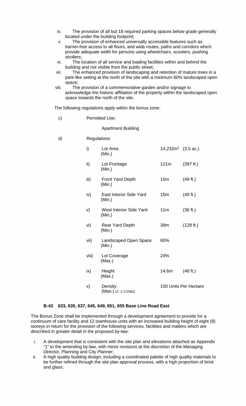
iv. The provision of all but 18 required parking spaces below grade generally located under the building footprint;
v. The provision of enhanced universally accessible features such as barrier-free access to all floors, and wide routes, paths and corridors which provide adequate width for persons using wheelchairs, scooters, pushing strollers;
vi. The location of all service and loading facilities within and behind the building and not visible from the public street;
vii. The enhanced provision of landscaping and retention of mature trees in a park-like setting at the north of the site with a minimum 60% landscaped open space;
viii. The provision of a commemorative garden and/or signage to acknowledge the historic affiliation of the property within the landscaped open space towards the north of the site.
The following regulations apply within the bonus zone:
c) Permitted Use:
Apartment Building
d) Regulations:
i) Lot Area 14,232m2 (3.5 ac.)
(Min.)
ii) Lot Frontage 121m (397 ft.) (Min.)
iii) Front Yard Depth 15m (49 ft.) (Min.)
iv) East Interior Side Yard 15m (49 ft.)
(Min.)
v) West Interior Side Yard 11m (36 ft.) (Min.)
vi) Rear Yard Depth 39m (128 ft.)
(Min.)
vii) Landscaped Open Space 60% (Min.)
viii) Lot Coverage 24% (Max.)
ix) Height 14.6m (48 ft.) (Max.)
x) Density 100 Units Per Hectare (Max.) (Z.-1-172582)
B-43 633, 635, 637, 645, 649, 651, 655 Base Line Road East The Bonus Zone shall be implemented through a development agreement to provide for a continuum of care facility and 12 townhouse units with an increased building height of eight (8) storeys in return for the provision of the following services, facilities and matters which are described in greater detail in the proposed by-law:
i. A development that is consistent with the site plan and elevations attached as Appendix
“1” to the amending by-law, with minor revisions at the discretion of the Managing Director, Planning and City Planner;
ii. A high quality building design, including a coordinated palette of high quality materials to be further refined through the site plan approval process, with a high proportion of brick and glass;

iii. A significant stepback above the two (2) storey podium along Base Line Road East to provide a pedestrian scale that is in keeping with the character of the buildings to the north;
iv. The provision of active ground floor uses and access to the front terrace located at grade along Base Line Road East;
v. A building design that breaks up the building horizontally and vertically through articulation, architectural details and an appropriate proportion and rhythm of windows and balconies;
vi. The provision of one level of underground parking; vii. The provision of enhanced universal accessibility of all common open spaces, including
exterior landscaped amenities, as well as barrier-free bathrooms in all independent seniors living suites ;
viii. The use of low impact development (LID) features including the bioswale environmentally sensitive stormwater management; and Enhanced landscaped open space including an outdoor amenity area on the west portion of the site including enhanced landscaping of the bioswale and native plant palate to provide pollinator species habitat.
The following regulations apply within the bonus zone:
a) Permitted Uses:
Continuum-of-Care Facility Cluster Townhouse Dwellings
b) Regulations:
i) Lot Area 12,120m2 (130,459 sq. ft.)
(Minimum)
ii) Lot Frontage 129m (423 ft.) (Minimum)
iii) Front Yard Depth 6m (19 ft.)
(Minimum)
iv) Landscaped Open Space 34% (Minimum)
v) Lot Coverage 36%
(Maximum)
vi) Density 68 Units Per Hectare (Maximum)
Regulations - Continuum of Care Facility:
i) Height 38.5m (126 ft.) (Maximum) ii) East Interior Side Yard 13.5m (42 ft.) (Minimum) iii) West Interior Side Yard 32m (104 ft.) (Minimum) iv) Rear Yard Depth 20m (66 ft.) (Minimum) Regulations – Cluster Townhouse: i) Height 12m (39 ft.) (Maximum) ii) East Interior Side Yard 4m (13 ft.) (Minimum) iii) West Interior Side Yard 4m (13 ft.) (Minimum)
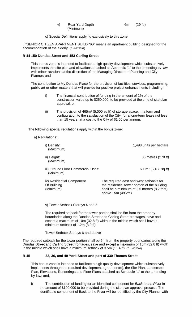
iv) Rear Yard Depth 6m (19 ft.) (Minimum)
c) Special Definitions applying exclusively to this zone:
i) “SENIOR CITIZEN APARTMENT BUILDING” means an apartment building designed for the accommodation of the elderly. (Z.-1-172591) B-44 150 Dundas Street and 153 Carling Street
This bonus zone is intended to facilitate a high quality development which substantively implements the site plan and elevations attached as Appendix “1” to the amending by-law, with minor revisions at the discretion of the Managing Director of Planning and City Planner; and The contribution to My Dundas Place for the provision of facilities, services, programming, public art or other matters that will provide for positive project enhancements including:
i) The financial contribution of funding in the amount of 1% of the
construction value up to $250,000, to be provided at the time of site plan approval, or
ii) The provision of 465m² (5,000 sq ft) of storage space, in a form and configuration to the satisfaction of the City, for a long-term lease not less than 15 years, at a cost to the City of $1.00 per annum.
The following special regulations apply within the bonus zone:
a) Regulations:
i) Density: 1,498 units per hectare (Maximum) ii) Height: 85 metres (278 ft) (Maximum) iii) Ground Floor Commercial Uses: 600m² (6,458 sq ft) (Minimum) iv) Residential Component The required east and west setbacks for Of Building the residential tower portion of the building (Minimum) shall be a minimum of 2.5 metres (8.2 feet) above 15m (49.2m) v) Tower Setback Storeys 4 and 5 The required setback for the tower portion shall be 5m from the property boundaries along the Dundas Street and Carling Street frontages, save and except a maximum of 10m (32.8 ft) width in the middle which shall have a minimum setback of 1.2m (3.9 ft)
Tower Setback Storeys 6 and above
The required setback for the tower portion shall be 5m from the property boundaries along the Dundas Street and Carling Street frontages, save and except a maximum of 10m (32.8 ft) width in the middle which shall have a minimum setback of 3.5m (11.4 ft). (Z.-1-172601) B-45 32, 36, and 40 York Street and part of 330 Thames Street
This bonus zone is intended to facilitate a high quality development which substantively implements through the required development agreement(s), the Site Plan, Landscape Plan, Elevations, Renderings and Floor Plans attached as Schedule “1” to the amending by-law; and, i) The contribution of funding for an identified component for Back to the River in
the amount of $100,000 to be provided during the site plan approval process. The identifiable component of Back to the River will be identified by the City Planner with

input from the applicant.
The following special regulations apply within the bonus zone upon the execution and registration of the required development agreement(s):
c) Regulations:
xi) Density: 414 units per hectare (maximum)
xii) Setback for Residential 1.0 metres (3.3 ft.) north Component of Buildings: 2.5 metres (8.2 ft.) east (minimum) 2.0 metres (6.5 ft.) south
8.0 metres (26.2 ft.) west
xiii) Parking (underground) 108 spaces (minimum) (Z.-1-172610)
B-46 32, 36, and 40 York Street
This bonus zone is intended to facilitate a high quality development which substantively implements through the required development agreement(s), the Site Plan, Landscape Plan, Elevations, Renderings and Floor Plans attached as Schedule “2” to the amending by-law; and, i) The contribution of funding for an identified component for the Back to the River
project in the amount of $150,000 to be provided during the site plan approval process. The identifiable component of Back to the River will be identified by the City Planner with input from the applicant.
ii) The contribution of funding for the Downtown Heritage Conservation District in the amount of $100,000 to be provided during the site plan approval process.
The following special regulations apply within the bonus zone upon the execution and registration of the required development agreement(s):
a) Regulations:
i) Density: 534 units per hectare (maximum)
ii) Setback for Residential 13 metres (42.6 ft.) north Component of Buildings: 2.5 metres (8.2 ft.) east (minimum) 8.5 metres (27.9 ft.) south
6.0 metres (19.7 ft.) west
iii) Parking (underground) 101 spaces (minimum) (Z.-1-172610) B-47 661 and 667 Talbot Street The Bonus Zone shall be implemented through a development agreement to facilitate the development of a high quality, multi-storey residential apartment building, with an increased building height of up to sixteen (16) storeys (49.5m) and a maximum of 236 dwelling units (403 units per hectare), which substantively implements the Site Plan, Elevations, and Renderings attached as Schedule “1” to the amending by-law; and, i) The provision of two levels of underground parking. The following special regulations apply within the bonus zone upon the execution and registration of the required development agreement(s):

a) Regulations:
i) Density 403 units per hectare (maximum) (163 units per acre)
ii) Height 49.5 metres (162 feet) (maximum) iii) Front Yard Setback 2.5 metres (8.2 feet) (minimum) iv) Rear Yard Setback 0 metres (0 feet) (minimum) v) North Interior Side Yard Setback 16 metres (52 feet) (minimum) vi) South Interior Side Yard Setback 10 metres (32 feet) (minimum) vii) A 2.5 metre stepback after the first 4-storeys in height on the
portion of the building fronting Talbot Street to a maximum of 7-storeys in height before an additional 9.5m stepback is required before 16-storeys (49.5m) of building height is permitted.
viii) Parking 171 parking spaces (minimum) ix) Lot Coverage 42% Landscaped Open Space 23%”
B-48 329 and 331 Richmond Street
The Bonus Zone shall be implemented through a development agreement to facilitate the development of a high quality, multi-use building, a total of 36 dwelling units and density of 556 units per hectare, which substantively implements the Site Plan and Elevations attached as Schedule “1” to the amending by-law.
The following special regulations apply within the bonus zone upon the execution and registration of the required development agreement(s):
a) Regulations:
i) Density 556 units per hectare (maximum) (226 units per acre)
ii) Height 27 metres (88.58 feet)
(maximum)
iii) Parking 0 parking spaces (minimum)
iv) Front/Exterior Side Yard 0 metres (0 feet)
(minimum)
v) Stepback after 4th storey 2 metres (6.56 feet) at 331 Richmond Street (Minimum)
vi) Stepback after 5th storey 2 metres (6.56 feet) at 329 Richmond Street
(Minimum) (Z.-1-182632) B-49 250, 268, 270, and 272 Springbank Drive
The Bonus Zone shall be implemented through a development agreement to provide for a development that is consistent with the site plan and elevations attached as Appendix “1”, in return for the provision of the following services, facilities and matters:
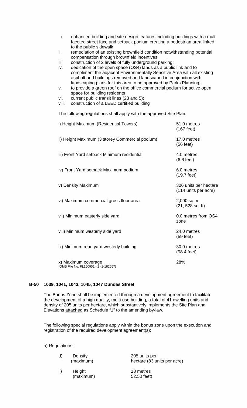
i. enhanced building and site design features including buildings with a multI
faceted street face and setback podium creating a pedestrian area linked to the public sidewalk.
ii. remediation of an existing brownfield condition notwithstanding potential compensation through brownfield incentives; iii. construction of 2 levels of fully underground parking; iv. dedication of the open space (OS4) lands as a public link and to
compliment the adjacent Environmentally Sensitive Area with all existing asphalt and buildings removed and landscaped in conjunction with landscaping plans for this area to be approved by Parks Planning;
v. to provide a green roof on the office commercial podium for active open space for building residents vi. current public transit lines (23 and 5); viii. construction of a LEED certified building The following regulations shall apply with the approved Site Plan: i) Height Maximum (Residential Towers) 51.0 metres (167 feet) ii) Height Maximum (3 storey Commercial podium) 17.0 metres (56 feet) iii) Front Yard setback Minimum residential 4.0 metres (6.6 feet) iv) Front Yard setback Maximum podium 6.0 metres (19.7 feet) v) Density Maximum 306 units per hectare (114 units per acre) vi) Maximum commercial gross floor area 2,000 sq. m (21, 528 sq. ft) vii) Minimum easterly side yard 0.0 metres from OS4 zone viii) Minimum westerly side yard 24.0 metres (59 feet) ix) Minimum read yard westerly building 30.0 metres (98.4 feet) x) Maximum coverage 28% (OMB File No. PL160951 - Z.-1-182657) B-50 1039, 1041, 1043, 1045, 1047 Dundas Street
The Bonus Zone shall be implemented through a development agreement to facilitate the development of a high quality, multi-use building, a total of 41 dwelling units and density of 205 units per hectare, which substantively implements the Site Plan and Elevations attached as Schedule “1” to the amending by-law.
The following special regulations apply within the bonus zone upon the execution and registration of the required development agreement(s):
a) Regulations:
d) Density 205 units per (maximum) hectare (83 units per acre)
ii) Height 18 metres (maximum) 52.50 feet)

iii) Parking 22 Parking Spaces (minimum)
iv) Bedrooms 1 per unit (maximum)
iv) Dwelling units are permitted on the whole of the first floor.(Z.-1-182664) B-51 391 South Street
This bonus zone is intended to facilitate a high quality development which substantively implements through the required development agreement(s), the Site Plan, Renderings and Concept Landscape Plan, attached as Schedule “1” and Schedule “2” to the amending by-law; and
i) Conservation, retention and adaptive re-use of the existing heritage
designated Colborne Building; ii) Provision of the publicly accessible courtyard and public art within the
courtyard iii) Provision of two levels of underground parking
The following special regulations apply within the bonus zone upon the execution and registration of the required development agreement(s):
a) Regulations:
i) Density: 705 units per hectare Maximum ii) Frontage: 98m (328 ft) Minimum iii) Lot Area: 9,000m² (9,687 sq ft) Minimum ix) Front, Interior, Exterior and Rear Setbacks: 0m (0ft)
Minimum
x) Height: 80 metres (262 ft) Maximum
xi) Tower floor plate above 9th Storey 800m² Maximum xii) Parking total for all uses: 360 spaces
Minimum
B-52 147-149 Wellington Street and 253-257 Grey Street
The Bonus Zone shall be implemented through a development agreement to facilitate the development of a high quality apartment building with a maximum of 18 storeys, 246 dwelling units and density of 560 units per hectare, which substantively implements the Site Plan and Elevations attached as Schedule “1” to the amending by-law; and
i) Transit Station
The financial contribution of funding to the future Transit Station at
Wellington Street and Grey Street in the amount of $200,000, for the provision of public art or other station enhancements to be provided at the time of site plan approval or construction of the station, whichever occurs first.

ii) Provision of Affordable Housing The provision of 10 affordable housing units, established by agreement at 95% of average market rent for a period of 20 years. An agreement shall be entered into with the Corporation of the City of London, to secure those units for this 20 year term.
iii) 2 levels of underground parking
iv) The construction of a civic space provided at the main pedestrian entrance
to the building and enhanced landscaping along Wellington Street, consistent with the conceptual site plan and renderings shown in Schedule 1 of the amending by-law.
The following special regulations apply within the bonus zone upon the execution and registration of the required development agreement(s):
a) Regulations:
vii) Density 560 units per hectare (Maximum): (226 units per acre)
viii) Height 63 metres (Maximum): (206.7 feet) ix) Parking 197 Parking Spaces (Minimum): x) Interior Side Yard Depth 1.6 metres (5.25ft)
(Minimum): for floors 1-4
xi) Interior Side Yard Depth 6.0 metres (19.7ft) (Minimum): for floors 5-8
xii) Interior Side Yard Depth 11.5 metres (37.7ft)
(Minimum): for floors 9-18 xiii) Lot Coverage 31% xiv) Dwelling units are permitted on the first floor.
(Z.-1-182701) B-53 131 King Street
The Bonus Zone shall be enabled through one or more agreements to facilitate the development of a high quality residential apartment building, with a maximum of 30-storeys, 266 dwelling units and density of 931 units per hectare, which substantively implements the Site Plan and Elevations attached as Schedule “1” to the amending by-law; and
v) Public Parking
The provision of 41 publicly accessible parking spaces on level 1 of the underground parking facility and accessed from York Street. An agreement shall be entered into between the Corporation of the City of London and the property owner to facilitate this requirement.
vi) Design Feature
As depicted in the elevations shown in Schedule “1” to the amending By-law a design feature will be located over the main vehicular access off of King Street. The details for this feature, including design, appearance and materials, will be determined in consultation with Staff through the site plan approvals process.

vii) Public Art
The financial contribution of funding to a future public art project within the Downtown Area in the amount of 1% of the construction value up to a maximum of $250,000, to be provided at the time of site plan approval.
viii) 3 levels of underground parking ix) Publicly accessible civic space located at the York Street entrance.
The following special regulations apply within the bonus zone upon the execution and registration of the required development agreement(s): a) Regulations:
i) Density 931 uph
ii) Height 102 metres (Maximum): (334.6 feet)
iii) Residential Component 1.2 metres Easterly Side Yard (Minimum):
iv) Residential Component 1.5 metres Westerly Side Yard (Minimum):
v) Residential Component 1.3 metres Northerly Side Yard (Minimum):
B-54 809 Dundas Street
The Bonus Zone shall be enabled through one or more agreements to facilitate the development of a high quality apartment building with a maximum of 24 storeys, 480 dwelling units and density of 710 units per hectare, which substantively implements the Site Plan and Elevations attached as Schedule “1” and Schedule “2” to the amending by-law; and
i) Provision of one level of underground parking ii) Provision of Affordable Housing
The provision of 25 affordable housing units, established by agreement at 95% of average market rent for a period of 25 years. An agreement shall be entered into with the Corporation of the City of London, to secure said affordable housing units for the 25 year term.
The following special regulations apply within the bonus zone:
a) Regulations:
i) For the purpose of this by-law the front lot line shall be deemed to
be Dundas Street ii) Density: 710 units per hectare (Maximum): iii) Height: 82 metres (Maximum): (269 ft) iv) Front Stepback of Tower 11 metres above the Third Storey (36 ft) (Minimum): v) Individual Tower floor 1,060m² plate above 3rd Storey (11,409 sq ft) (Maximum):
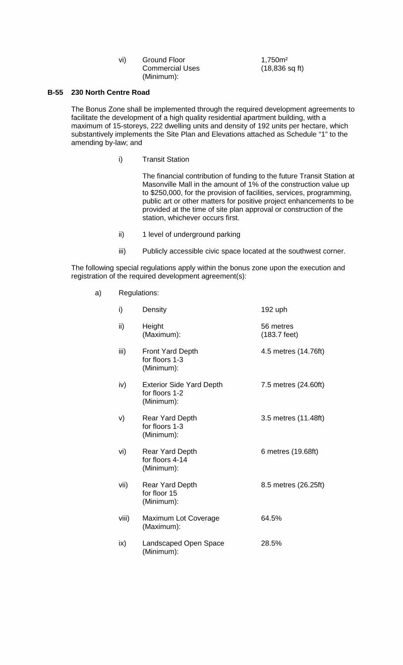
vi) Ground Floor 1,750m² Commercial Uses (18,836 sq ft) (Minimum):
B-55 230 North Centre Road
The Bonus Zone shall be implemented through the required development agreements to facilitate the development of a high quality residential apartment building, with a maximum of 15-storeys, 222 dwelling units and density of 192 units per hectare, which substantively implements the Site Plan and Elevations attached as Schedule “1” to the amending by-law; and
i) Transit Station The financial contribution of funding to the future Transit Station at
Masonville Mall in the amount of 1% of the construction value up to $250,000, for the provision of facilities, services, programming, public art or other matters for positive project enhancements to be provided at the time of site plan approval or construction of the station, whichever occurs first.
ii) 1 level of underground parking iii) Publicly accessible civic space located at the southwest corner.
The following special regulations apply within the bonus zone upon the execution and registration of the required development agreement(s):
a) Regulations:
i) Density 192 uph ii) Height 56 metres (Maximum): (183.7 feet) iii) Front Yard Depth 4.5 metres (14.76ft) for floors 1-3 (Minimum): iv) Exterior Side Yard Depth 7.5 metres (24.60ft) for floors 1-2 (Minimum): v) Rear Yard Depth 3.5 metres (11.48ft) for floors 1-3 (Minimum): vi) Rear Yard Depth 6 metres (19.68ft) for floors 4-14 (Minimum): vii) Rear Yard Depth 8.5 metres (26.25ft) for floor 15 (Minimum): viii) Maximum Lot Coverage 64.5% (Maximum): ix) Landscaped Open Space 28.5% (Minimum):
B-56 3080 Bostwick Road (Site 1)
The Bonus Zone shall be enabled through one or more agreements to facilitate the development of a high quality apartment building with a maximum of 21 storeys, 372 dwelling units and density of 262 units per hectare, which is generally in accordance with the Site Plan and Elevations attached as Schedule “1” and Schedule “2” to the amending by-law, except where described in more detail below or in the Urban Design Guidelines for the High Density Residential designated lands within the Bostwick Neighbourhood; and
1) Contribution of $25,000 towards creating a skate park on the Community
Centre lands; 2) Provision of 20% accessible apartment units; 3) Large caliper boulevard tree planting with a minimum 100mm caliper and
a minimum distance of 10m between tree planting for the extent of the site frontage for Southdale Road West, Bostwick Road, and both sides of Street A;
4) Provision of one accessible electric vehicle charging station located on
the Community Centre lands or in a publicly accessible location on Site 1; 5) Provision of two publicly accessible vehicle share facilities/spaces; 6) Provision of ten publicly accessible bicycle share facilities; 7) The following provisions shall be delivered as part of the first
development phased of either Site 1 or Site 5 at the time of the development agreement:
i) Dedication of 0.64ha of park land identified as Block 4 in the draft plan of subdivision 39T-18502 to the City of London, above and beyond (in excess of) the full standard dedication required by by-law CP-9 for parkland or cash-in-lieu for both Sites 1 and 5; and other proposals on Sites 2, 3 and 6;
ii) Provision of a pavilion and lighting within the dedicated park land, or the commensurate financial equivalent for the features as a identified in by-law C.P.-1496-244, to the City’s discretion;
iii) Provision of a pedestrian bridge from the park land across the Thornicroft Drain to the Bostwick Community Centre, or the commensurate financial equivalent for the feature as a identified in by-law C.P.-1496-244, to the City’s discretion;
The following special regulations apply within the bonus zone:
a) Regulations:
i) Density 262 units per hectare (Maximum): ii) Height 77 metres (Maximum): (252 ft) iii) Exterior Side Yard Setback 0.3m (Minimum): (0.98 ft) iv) Rear Yard Setback 20m (Minimum): (65.6 ft) v) Interior Side Yard Setback 14m (Minimum): (45.9 ft) vi) Lot Coverage 38% vii) Parking Total for All Uses 725 spaces
B-57 3080 Bostwick Road (Site 5)
The Bonus Zone shall be enabled through one or more agreements to facilitate the development of a three storey (13.5m (44 ft)) mixed office and commercial building and one 17 storey (68m (223ft)) tower, with an increased density up to 209 units, which is generally in accordance with the Site Plan and Elevations attached as Schedule “1” and Schedule “2” to the amending by-law, except where described in more detail below or in the Urban Design Guidelines for the High Density Residential designated lands within the Bostwick Neighbourhood; and
1) Contribution of $25,000 towards creating a skate park on the Bostwick
Community Centre lands; 2) Provision of 20% accessible apartment units; 3) Large caliper boulevard tree planting with a minimum 100mm caliper and a
minimum distance of 10m between tree planting for the extent of the site frontage for Southdale Road West, and both sides of Street B;
4) Provision of one accessible electric vehicle charging station located on the
Bostwick Community Centre lands or in a publicly accessible location on Site 5; 5) Provision of two publicly accessible vehicle share facilities/spaces; 6) Provision of ten publicly accessible bicycle share facilities; 7) The following provisions shall be delivered as part of the first development
phased of either Site 1 or Site 5 at the time of the development agreement: a. Dedication of 0.64ha of park land identified as Block 4 in the draft plan of
subdivision 39T-18502 to the City of London, above and beyond (in excess of) the full standard dedication required by by-law CP-9 for parkland or cash-in-lieu for both Sites 1 and 5; and other proposals on Sites 2, 3 and 6;
b. Provision of a pavilion and lighting within the dedicated park land, or the commensurate financial equivalent for the features as a identified in by-law C.P.-1496-244, to the City’s discretion;
c. Provision of a pedestrian bridge from the park land across the Thornicroft Drain to the Bostwick Community Centre, or the commensurate financial equivalent for the feature as an identified in by-law C.P.-1496-244, to the City’s discretion.
The following special regulations apply within the bonus zone:
a) Regulations:
vii) Density 209 units per hectare (Maximum): viii) Height 68 metres (Maximum): (223 ft) ix) Exterior Side Yard Setback 3.5 metres (Minimum): (11 ft) x) Rear Yard Setback 5 metres (Minimum): (16 ft) xi) Interior Side Yard Setback 15 metres (Minimum): (42 ft) xii) Number of dwelling units 208 (Maximum): xiii) Parking Total for All Uses 472 spaces
(Z.-1-182713)
B-58 440 Clarke Road
The Bonus Zone shall be enabled through one or more agreements to facilitate the development of a high quality residential apartment building, with a maximum of 4-storeys, 65 dwelling units and density of 95 units per hectare, which substantively implements the Site Plan and Elevations attached as Schedule “1” to the amending by-law and the provision of affordable housing in the form of 65 dwelling units (95 units per hectare), consisting of one and two bedroom units. The following special regulations apply within the bonus zone upon the execution and registration of the required development agreement(s):
a) Permitted Uses:
i) Apartment Building;
b) Regulations:
i) Density 95 uph
ii) Height 18 metres (maximum): (59 feet)
iii) Parking 65 spaces
(Z.-1-192730)
B-59 462, 468, 470, 472 Springbank Drive
The B-59 Zone shall be implemented through the required development agreements to facilitate the development of a high quality residential apartment building, with a maximum of 9-storeys with 186 dwelling units which substantively implements the Site Plan and Elevations attached as Schedule “1” to the amending by-law; and
i) Provision of Affordable Housing
10% of the total unit count (rounded up to the nearest unit), above the 150 unit per hectare threshold, to a maximum of 8 units, shall be allocated for affordable housing units (1 bedroom units) established by agreement at 95% of average market rent for a period of 25 years. An agreement shall be entered into with the Corporation of the City of London, to secure those units for this 25 year term.
ii) 1 level of underground parking
The following special regulations apply within the bonus zone upon the execution and registration of the required development agreement(s):
a) Additional Permitted Uses:
i) Bake shops; ii) Brewing on Premises Establishment; iii) Clinics; iv) Commercial schools; v) Convenience business service establishments; vi) Convenience service establishments; vii) Convenience stores; viii) Day care centres; ix) Financial institutions; x) Florist shops; xi) Food stores; xii) Medical/dental offices;
xiii) Offices; xiv) Personal service establishments; xv) Pharmacies; xvi) Retail Stores; xvii) Restaurants, eat-in; xviii) Restaurants, take-out; xix) Studios;
b) Regulations:
i) Density 265 uph
(107.25 units per acre) ii) Height 32 metres
(Maximum): (105 feet)
iii) Front Yard Depth 2.5 metres (Minimum): (8.2 feet)
iv) Rear Yard Depth 7.0 metres (Minimum): (23 feet)
v) Westerly Interior 5.5 metres
Side Yard Depth (18 feet) (Minimum):
vi) Easterly Interior 12.1 metres
Side Yard Depth (39.70 feet) (Minimum):
vii) Residential Parking 1 space per unit
(Minimum): viii) Commercial Parking 17 spaces
(Minimum): ix) No drive-through will be permitted for any of the additional
permitted uses. x) The permitted commercial uses will only be permitted on the
first floor of an apartment building. xi) The maximum gross floor area for specific individual uses
shall be as follows:
a) Commercial schools 300 m2 and Pharmacies (3,229 sq. ft.)
b) Restaurants - eat-in 300 m2 and take-out (1,616 sq. ft.) c) Food stores 500 m2 (5,382 sq. ft.) d) All other permitted uses 400 m2 (4,305 sq. ft.) (Z.-1-192748)

B-60 3087 White Oak Road
This bonus zone is intended to facilitate a high quality development which substantively implements through the required development agreement(s), the Site Plan, Elevations and Concept Landscape Plan, attached as Schedule “1” to the amending by-law; and
i) Enhanced landscaping along White Oak Road with wrought
iron (or similar) fencing and provision of a pedestrian pathway from Petty Road to White Oak Road;
The following special regulations apply within the bonus zone upon the execution and registration of the required development agreement(s):
a) Regulations:
i) For the purpose of this by-law the front lot line shall be interpreted as Petty Road
ii) Front Yard Depth 3m (9.8ft)
(Minimum): iii) Density 79 units per hectare
(Maximum): iv) Height four storeys 16m (52.5 ft)
(Maximum): (Z.-1-192756)
B-61 475 Edgevalley Road
The Bonus Zone shall be enabled through one or more agreements to facilitate the development of three (3) low-rise apartment buildings, with a maximum of four (4) storeys (Building A = 16m), five (5) storeys (Building B= 18m) and six (6) storeys (Building C = 22m), a total of 147 dwelling units (Building A = 39 dwelling units; Building B = 49 dwelling units; Building C = 59 dwelling units), and a density of 100 units per hectare, Provision of Affordable Housing The provision of four (4) affordable rental housing units, established by agreement at 85% of the CMHC average market rent for a period of 15 years. An agreement shall be entered into with the Corporation of the City of London, to secure said affordable housing units for the 15 year term. The following special regulations apply within the bonus zone:
a) Regulations:
i) For the purpose of this by-law, the front lot line shall be
deemed to be Kilally Road. ii) Density: 100 units per hectare (Maximum): iii) Height of Building A Four (4) storeys
(Maximum): 16 metres (52.5 feet)
Height of Building B Five (5) storeys (Maximum): 18 metres (59.1 feet) Height of Building C Six (6) storeys
(Maximum): 22 metres (72.2 feet)
iv) Front Yard Setback
(Minimum): 2.0 metres (6.6 feet) (Maximum): 6.0 metres (19.7 feet)
v) Exterior Side Yard Depth - Edgevalley Road
(Minimum): 3.0 metres (9.8 feet) (Maximum): 7.0 metres (23.0 feet)
vi) Exterior Side Yard Depth - Agathos Street
(Minimum): 2.0 metres (6.6 feet) vii) Interior Side Yard Depth
(Minimum): 2.75 metres (9.1 feet) (Z.-1-192785) B-62 800, 805 and 810 Chelton Road The Bonus Zone shall be implemented through the required development
agreement(s) to facilitate the development of low to mid-rise apartment buildings up to a maximum of five (5) storeys and six (6) storeys which substantially implements the vision and principles of the Chelton Road Master Plan for 800, 805 and 810 Chelton Road attached as Schedule “1”, and site concept plans attached as Schedule “2” to the amending by-law; and,
i. Enhanced building and site design features including an active
street edge along Bradley Avenue, Chelton Road, and Meadowgate Boulevard;
ii. Dedication of public open space (OS5) lands; iii. Measures to enhance the Natural Heritage System including
substantial buffer planting with native vegetation to protect adjacent natural features;
iv. Large quantities of secure bicycle parking and cycling infrastructure including indoor and outdoor storage facilities, and a multi-use pathway internal to the site providing connections to surrounding public sidewalks and pedestrian trails; and,
v. Substantial tree planting of large caliper trees to be planted along the street frontage and outdoor amenity areas.
The following special regulations apply within the bonus zone upon the execution
and registration of the required development agreement(s):
a) Regulations:
805 Chelton Road
i) Height of Buildings A and D Five (5) storeys (Maximum): 18 metres
800 – 810 Chelton Road
i) Height of Buildings A and E Six (6) storeys
(Maximum): 22 metres
ii) Height of Buildings B and D Five (5) storeys (Maximum): 18 metres (Z.-1-192794)

B-63 1339 – 1347 Commissioners Road West
The Bonus Zone shall be implemented through one or more agreements to facilitate the development of a high quality residential apartment building, with a maximum height of 5 storeys, 34 dwelling units and a maximum density of 132 units per hectare, which substantively implements the Site Plan, Landscape Plan and Elevations attached as Schedule “1” to the amending by-law, provides for affordable housing in the form of 34 dwelling units (132 units per hectare), enhanced landscaped open space and underground parking. The affordable housing component shall consist of:
• a total of 3, two-bedroom affordable rental units (two of which, at
minimum, are to be accessible and located on the ground floor); • rents not exceeding 85% of the Average Market Rent (AMR) for the
London Census Metropolitan Area as determined by the CMHC at the time of building occupancy; and,
• the duration of affordability shall be set at 15 years from the point of initial occupancy of all 3 two-bedroom units.
The following special regulations apply within the bonus zone upon the execution and registration of the required development agreement(s):
a) Regulations:
i) Front Yard Depth 2.0 metres (6.56 ft.) (Mininum): ii) Interior Side Yard Depth (West) 2.2 metres (7.2 ft.)
(Minimum):
iii) Height 17.5 metres (57.41 ft.) (Maximum):
iv) Density 132 units per hectare (Maximum):
(Z.-1-192795)
B-65 1018 and 1028 Gainsborough Road The Bonus Zone shall be enabled through one or more agreements to
facilitate development of a residential apartment building, with a maximum height of 12 storeys, 182 dwelling units and a maximum density of 392 units per hectare, which generally implements in principle the site concept and elevation plans attached as Schedule “1” to the amending by-law, with further refinements to occur to the orientation of the apartment building and parking area through the site plan approval process, in return for the following facilities, services and matters:
• A total of 18 affordable rental apartment units consisting of 16, one
bedroom units and 2, two bedroom units to be provided and located within Building “B”;
• A minimum of 3, one-bedroom and 1, two-bedroom accessible units are to be provided and located within Building “B”;
• 4, one bedroom units and 2, two bedroom units shall not exceed 90% of the Average Market Rent (AMR) for the London Census Metropolitan Area as determined by CMHC at the time of building occupancy; and duration of affordability shall be set at 10 years from the point of initial occupancy; and,
• 12, one bedroom units shall not exceed 75% of the Average Market Rent (AMR) for the London Census Metropolitan Area as determined by CMHC at the time of building occupancy; and

duration of affordability shall be set at 20 years from the point of initial occupancy. (Z.-1-202816)
B-66 2300 Richmond Street
The Bonus Zone shall be implemented through one or more agreements to facilitate the development of two residential apartment buildings, with a maximum height of eight (8) storeys, and a maximum of 320 dwellings units, which substantively implements the Site Plan, Renderings and Elevations attached as Schedule “1” to the amending by-law, providing for:
• A site designed to appropriately accommodate the provision of the
City proposed Pedestrian Bridge to cross over Richmond Street; • The incorporation of urban design features into the building
elevations and overall site design to help create a gateway into the City;
• The provision and naturalization of a corridor linkage along the easterly property line; and
• A monetary contribution toward enhancements to the design and construction of the Pedestrian Bridge/Gateway feature.
The development shall specifically incorporate the following key components: • A building design which, with minor variations at the discretion of
the Director of Development Services, matches the site plan, renderings and elevation drawings shown in Schedule “1”;
• Buildings collectively forming a T-shaped configuration, located in staggered positions, perpendicular to the Richmond Street frontage and with at least 60 metres of building wall facing Richmond Street;
• Inclusion of underground parking, which may be partially exposed where grades necessitate, except in the southwesterly area where the underground parking requires plantings at grade level as part of a buffer function;
• A central drive aisle provided between the two apartment buildings, leading to a parking structure that provides underground parking integrated into the buildings;
• Provision for locating the City proposed pedestrian bridge crossing at Richmond Street;
• Site design that makes best efforts to maintain the existing “knoll” feature;
• A built form which includes a high standard of design, in accordance with the Urban Design policies (chapter 11) of the Official Plan, as well as the Placemaking Guidelines, as this site is located at a major entryway into the City;
• Include on the west, north and south facades articulation, generous amounts of glazing, and a variety of materials and colours to add interest to these facades;
• Building heights stepping down to 7 storeys at the rear of the buildings, and to 7 and then 6 storeys at the front of the buildings as per attached elevations;
• Design which breaks up the building horizontally by differentiating the top two or three floors of the building as per attached elevations;
• Design which breaks up the building vertically by articulating the façade as per attached elevations;
• Bird friendly design, snow removal control (no snow storage in the buffer or the ecological feature), lighting controls on parking lot and building lights so as to minimize shining into the natural area;
• A monitoring plan for the ecological buffers/features.
The following special regulations apply within the bonus zone upon the execution and registration of the required agreement(s);
i) Front Yard Depth 8.0 metres (Minimum): ii) Interior Side Yard Depth 2.0 metres for Main Buildings
(Minimum): iii) Interior Side Yard Depth 0.0 metres for Parking Structures
(Minimum): iv) Rear Yard Depth for 0.0 metres Parking Structures
(Minimum): v) Number of Dwelling Units 320 (Maximum): vi) Building Height 28.0 metres (Maximum): vii) Landscaped Open Space 28 percent (Minimum): (Z.-1-202833)
4.4 BUILDING ADDITIONS
Where the erection of one or more additional storeys is proposed on a building where the existing yards appurtenant to such building would not conform to the requirements of this By-Law subsequent to such erection, no such erection shall be permitted except where:
1) the addition is located so as to comply with the yard requirements of this by-law
at the level of the base of such addition; and, 2) the addition complies in all other respects with the provisions of this by-law.
Where a shipping container or trailer (both not exceeding 12.1 metres (40 feet) in length x 2.4 metres (8 feet) in width x 2.9 metres (9.5 feet) in height is to be used as the sole base of operations for a non-residential business, its installation shall be subject to all regulations of the underlying zone and to Site Plan Control.
Where a shipping container or trailer (not exceeding 12.1 metres (40 feet) in length x 2.4 metres (8 feet) in width x 2.9 metres (9.5 feet) in height is to be used as additional floor space (or permanent storage) to an existing establishment in any multi-family (3 or more units) or non-residential zone, the following regulations shall apply:
1) the location, floor area, setbacks and all other regulations of the underlying zone
shall apply; 2) it shall only be permitted in the rear yard; 3) the installation is subject to Site Plan Control(except for Agricultural uses which
are not subject to Site Plan Control); and, 4. no more than two (2) shipping containers or trailers not exceeding 6 metres (20
feet) in length x 2.4 metres (8 feet) in width x 2.6 metres (8.5 feet) in height; or one (1) shipping container or trailer not exceeding 12.1 metres (40 feet) in length x 2.4 metres (8 feet) in width x 2.9 metres (9.5 feet) in height shall be permitted per property.
Shipping containers (as permanent structures) shall be prohibited on any property
designated under Part IV or Part V of the Ontario Heritage Act. 4.5 TEMPORARY STRUCTURES
1) CONSTRUCTION USE
The following construction uses shall be permitted only so long as the same are necessary for construction work in progress which has neither been finished nor abandoned: construction camps, model home sales office, tool sheds, scaffolds, or any other building or structure incidental to and necessary for the construction work on the lot. No construction use, however, shall be located within the sight triangle of any lot.
2) SHIPPING CONTAINERS AND TRAILERS
Shipping Containers and Trailers may be used as temporary uses subject to the following regulations:
All Residential Zones
Time Period: Maximum of 2 months within a calendar year for the purposes of moving/relocating. Maximum of 4 months within a calendar year for the purposes of building renovation.
A maximum of two (2) (in total) shipping containers or trailers not exceeding 6 metres (20 feet) in length x 2.4 metres (8 feet) in width x 2.6 metres (8.5 feet) in height shall be permitted per property.
All Non Residential Zones
Time Period: Maximum of 4 months within a calendar year
Other Regulations: Yard setbacks as per the underlying zone. Gross Floor Area relating to the temporary use does not require additional on-site parking. A temporary reduction in the required parking may be permitted in association with the establishment of the temporary use.
No more than two (2) shipping containers or trailers not exceeding 6 metres (20 feet) in length x 2.4 metres (8 feet) in width x 2.6 metres (8.5 feet) in height; or one (1) shipping container or trailer not exceeding 12.1 metres (40 feet) in length x 2.4 metres (8 feet) in width x 2.9 metres (9.5 feet) in height shall be permitted per property.
3) MODEL HOMES
Model homes shall be permitted in all R1, R2, R3, R4, R5, and R6 (excluding apartment buildings) Zones subject to the following:
(a) the lands on which the model homes are to be constructed have received
draft plan approval under the Planning Act and the subdivision agreement has been executed;
(b) site servicing may be permitted for model homes in accordance with the
requirements of the Chief Building Official prior to the registration of the plan of subdivision;
(c) the number of model homes for any phase of a draft approved plan of
subdivision shall not exceed the lesser of ten (10) dwelling units or ten per cent (10%) of the total number of lots of the phase; and,
(d) the number of model homes for any draft approved plan of subdivision
shall not exceed the lesser of ten (10) dwelling units or ten per cent (10%) of the total number of lots.
4) FARM MARKET
A farm market, in which nothing may be sold or displayed except seasonal products from
the farm upon which the market is located, is permitted in an agricultural zone subject to a maximum size of 18.6m (200 sq.ft.), a maximum height of 3.6m (12 ft.) and a minimum front yard of 7.5m (25 ft.). (Z.-1-172583)
4.6 DWELLING UNITS 1) LOCATION WITHIN BASEMENT
A dwelling unit or part thereof is permitted in a basement provided the finished floor level of such basement is not below the level of any sanitary sewer servicing the building or structure in which such basement is located.
2) DWELLING UNIT AREA (MINIMUMS)
No dwelling unit shall be erected or used unless it has the following minimum gross floor area:
a) a dwelling unit constituting a single detached dwelling - 70.0 square
metres (753 sq. ft.) or as specified within a zone; b) converted dwelling unit - 25 square metres (269 square feet); (Z.-1-96417) c) any other dwelling unit - 37 square metres (398 square feet) for a
bachelor dwelling unit plus an additional 10.0 square metres (108 square feet) for each bedroom.
4.7 FOSTER HOMES
A foster home is permitted in all Residential Zones and in any dwelling unit in an Agricultural (AG) zone. (Z-1-051390)
4.8 GROUP HOMES
Notwithstanding any other provision of this By-law to the contrary, a Group Home Type 1 is permitted to occupy the whole of an individual dwelling unit, other than dwelling units located within areas designated as Agriculture in the Official Plan, including a single detached dwelling, a semi-detached dwelling, a duplex dwelling, and a triplex dwelling provided the total number of residents within the building structure does not exceed eight, The dwelling must have 20.0 square metres (216 sq. ft.) of gross floor area per person residing within the unit.
Group Homes Type 2 and Supervised Residences are permitted only within the zones where specified as a permitted use. In order to prevent concentrations of Group Home Type 2 uses within specific areas, and notwithstanding their being listed as a permitted use, a minimum separation between such facilities shall be 450.0 metres (1,476 ft.) measured in any one direction.(Z.-1-172602)
4.9 HEIGHT EXEMPTION
Any height limitations of this By-Law shall not apply to place of worship spires, belfries, cupolas, mechanical penthouses and domes which are not used for human occupancy; nor to chimneys, ventilators, skylights, water tanks, solar collectors, windmills, bulkheads, hydro, radio, television or microwave towers and antenna and similar features or necessary mechanical appurtenances or electrical supply facilities usually situated above the roof level; nor to any industrial apparatus such as silos, cracking towers, or conveyors; nor any main agricultural buildings or structures, such as barns, grain elevators and storage bins, grain dryers or windmills. Such features, however, shall be erected only to such height as is necessary to accomplish the purpose they are to serve. (Z.-1-051390)
4.10 HOME OCCUPATION
For home occupations the character of the dwelling as a private residence shall not change and a nuisance such as noise, fumes, dust, odour, traffic or parking shall not be created which would interfere with the enjoyment of the residential amenities of the neighbourhood. Home occupations are permitted in any dwelling unit within a single detached dwelling, semi-detached dwelling, duplex dwelling, converted dwelling, triplex dwelling, fourplex dwelling, townhouse dwelling and accessory farm dwellings subject to the following provisions:

(Z.-1-94293) (Z.-1-051390) 1) The home occupation shall be clearly ancillary to the use of the dwelling unit
and carried out by a resident of the unit. (O.M.B. File #R 910387 - Appeal #9002 June 4, 1993) 2) The floor area taken up by all home occupations shall be no more than 25
percent (25%) of the total floor area of the dwelling unit and shall be confined to one area and shall not exceed 28.0 square metres (301.4 square feet).
3) In no case shall any outdoor use or outdoor storage be permitted. (Z.-1-97466) 4) The home occupation shall not involve the use or employment within the
dwelling unit of more than one person who does not reside in the dwelling unit. The function of such non-resident person shall be restricted to a secretarial, accounting, clerical or support role.
5) The home occupation shall not involve the use of the premises as a base of operations for persons who are employed by or associated with the home occupation, nor shall the premises be used to assemble or rally such persons for transportation to a work site.
6) No more than five persons shall be present in the dwelling unit at any time, or
six persons in a provincially licensed Private Home Day Care located outside of the flood plain, to receive treatment, services or instructions. (Z.-1-162500)
7) No retail use of the dwelling unit shall be permitted as a home occupation. 8) No manufacturing, assembly or repair process shall be carried on except for
the fabrication of hand made articles of clothing, arts or crafts. 9) No institutional use of the dwelling unit shall be permitted as a home
occupation. 10) The use of a swimming pool shall not be permitted as a home occupation.
(O.M.B. File #R910387 - Appeal #9002 June 4, 1993) 11) No food preparation or food service shall be permitted as a home occupation.
12) No animal, corpse bacteria or virus shall be brought into the dwelling in connection with a home occupation.
a) Notwithstanding Subsection 4.10 (12), a dog and domestic cat grooming business is permitted as a home occupation, subject to the following: i) A maximum of three (3) dogs and two (2) domestic cats be allowed on the premises at any one time in conformity with the City of London Animal Control By-law (PH-3) and Dog Licensing and Control By-law (PH-4); ii) No veterinary services be provided on the premises; iii) No breeding, boarding or overnight accommodation of dogs or domestic cats for grooming be permitted on the premises; iv) Only dogs and domestic cats that are licensed or identified as per the City of London Animal Control By-law (PH-3) and Dog Licensing and Control By-law (PH-4), or dogs and domestic cats
that are legally licensed by any other municipality in the Province of Ontario, be allowed on the premises at any one time;
v) No dogs or domestic cats that are brought into the premises for grooming shall be permitted outside of the dwelling; and vi) All other provisions of Section 4- General Provisions, Subsection 4.10, Home Occupation, shall apply. (Z.-1-061498) 13) No additional commercial vehicles shall be permitted in connection with a home
occupation.
(Z.-1-97466) 14) No lodging shall be provided in the dwelling unit in connection with a home
occupation. 15) No delivery of materials to the dwelling unit shall be permitted from a vehicle
which has a registered gross weight exceeding 5 000 kilograms (11,023 pounds).
16) No additional outdoor mechanical equipment, other than that normally
associated with a residential use, shall be used, the operation of which would result in any undue noise, fumes, dust or odor escaping to any adjacent or neighbouring lot. (Z-1-051390)
17) The home occupation shall not require the creation of additional on-site parking
spaces, except in accordance with this By-law. (Z.-1-051390) 4.11 HOUSEHOLD SALES
No household sale shall be permitted except where a premises has a dwelling unit, and there shall not be more than two household sales per annum at one location and no such sale shall exceed two days in duration.
(Z.-1-97466) (Z.-1-93173) 4.12 LANDSCAPED OPEN SPACE
Landscaped open space shall be provided in accordance with the zone provisions set out herein for each zone and the following general provisions:
1) Any part of a lot which is not occupied by buildings, structures, parking areas,
loading spaces, driveways, excavations, agricultural uses or permitted outdoor storage areas shall be maintained as landscaped open space.
2) Except as otherwise specifically provided herein, no part of any required front
yard or required exterior side yard shall be used for any purpose other than landscaped open space.
3) Where landscaped open space of any kind, including a planting strip, is
required adjacent to any lot line or elsewhere on a lot, nothing in this By-Law shall apply to prevent such landscaped open space from being traversed by pedestrian walkways or permitted driveways.
4) No part of any driveway, parking area, loading space, stoop, roof-top terrace,
balcony, swimming pool or space enclosed within a building, other than a landscaped area located immediately above an underground parking area, shall be considered part of the landscaped open space on a lot.
4.13 LOADING SPACE REQUIREMENTS
1) LOADING SPACES REQUIRED
The owner or occupant of any lot, building or structure within any RSA, CSA, NSA, ASA, HS , RSC, AGC, RRC or any industrial zone used or erected for any purpose involving the receiving, shipping, loading or unloading of animals, goods, wares, merchandise or raw materials, shall provide and maintain, on the same lot, facilities comprising one or more loading spaces in accordance with the provisions of this Subsection. (Z.-1-051390)
2) LOADING SPACE REQUIREMENTS (MINIMUMS)
The number of loading spaces required on a lot shall be based on the total gross floor area of all the uses on the said lot for which loading spaces are required by Clause (1) of this Subsection, in accordance with the following:
a) less than 250.0 square metres (2,691 square feet) of total gross floor area - 0 loading spaces;
b) over 250.0 square metres (2,691 square feet) up to and including 2500.0
square metres (26,910 square feet) of gross floor area -1 loading space; c) over 2500.0 square metres (26,910 square feet) up to and including
7500.0 square metres (80,729 square feet) of gross floor area - 2 loading spaces;
d) over 7500.0 square metres (80,729 square feet) up to and including 14 000.0 square metres (150,695 square feet) of gross floor area -
3 loading spaces;
e) over 14 000.0 square metres (150,695 square feet) of gross floor area - 3 loading spaces plus 1 additional loading space for each 10 000.0 square metres (107,639 square feet) or part thereof of total gross floor area in excess of 14 000.0 square metres (150,695 square feet).
3) DIMENSIONS OF LOADING SPACES
A loading space required hereby shall have minimum dimensions of 3.6 metres (11.8 feet) by 20.0 metres (65.0 feet) and a minimum vertical clearance of 4.5 metres (15.0 feet) for Industrial Zones and 3.6 metres (11.8 feet) by 9.0 metres (30.0 feet) and a minimum vertical clearance of 4.25 metres (14.0 feet) for all other zones.
4) LOCATION OF LOADING SPACES
Required loading spaces shall be provided on the same lot occupied by the building or structure for which the said loading spaces are required within the side or rear yard and shall not form a part of any street or lane.
5) ACCESS TO LOADING SPACES
Access to loading spaces shall be provided by means of one or more unobstructed driveways which have a minimum unobstructed width of at least 3.6 metres (11.8 feet), regardless of the direction of traffic flow thereupon and provide sufficient space to permit the maneuvering of vehicles on the lot so as not to obstruct or otherwise cause a hazard on adjacent streets.
Vehicles may be permitted to manoeuvre into loading areas on Neptune Crescent, Sovereign Crescent, Sovereign Crescent between Gore Road and Trafalgar Street, and Tartan Drive between Sovereign Road and Neptune Crescent using the road allowance. (Z.-1-101963)
Vehicles may be permitted to manoeuvre into loading areas at 45 ArtisansCrescent using the Artisans Crescent road allowance. (Z.-1-122063) On roads identified as “secondary collector” or “local street” in the Zoning By-law, and where the existing premises are zoned to permit Industrial use(s) vehicles may be permitted to manoeuvre into loading areas using the road allowance where necessary. Where a new building is proposed, the development shall provide sufficient space for the manoeuvring of vehicles on the lot so as not to obstruct or otherwise cause a hazard on adjacent streets. (Z.-1-172594) On roads identified as “secondary collector” or “local street” in the Zoning By-law, and where the existing premises are zoned to permit Industrial use(s) vehicles may be permitted to manoeuvre into loading areas using the road allowance where necessary. Where a new building is proposed, the development shall provide sufficient space for the manoeuvring of vehicles on the lot so as not to obstruct or otherwise cause a hazard on adjacent streets. (Z.-1-172594)
4.14 LOTS REDUCED BY PUBLIC ACQUISITION
Where the area of a lot is reduced by means of an acquisition of part of the lot by any authority having power of expropriation, and where such acquisition causes the lot as reduced, or any building or structure existing lawfully on the lot on the date of such
acquisition, to have a lot area, lot frontage, lot coverage, parking, area of landscaped open space, setback, front yard depth, side yard depth or rear yard depth that does not conform to the requirements hereof for the zone in which such lot is located, then nothing in this By-Law shall apply to prevent the continued use of the lot as reduced as if no such acquisition had taken place, provided that:
1) no further change is made in the dimensions, area or any other characteristics of
the lot as reduced, subsequent to the date of such acquisition, that would increase the extent of the said non-conformity; and,
2) no building or structure or addition thereto is erected on the lot as reduced, subsequent to the date of such acquisition, except in accordance with all the provisions hereof for the zone in which such lot is located.
In the case of a road widening dedication, the land that will be dedicated shall be included in any calculation for the purpose of determining lot area, coverage, height, parking, landscaped open space, floor area, floor area ratio and density provided any building or structure is located wholly within the boundary of the land remaining after the dedication. (Z.-1-12101)
4.15 SERVICES REQUIREMENT
1) MUNICIPAL SANITARY FACILITIES
Notwithstanding any other provisions of this By-Law, including Section 4.15(2), Individual Sanitary Facilities, no land shall be used nor any buildings or structures erected or used unless, pursuant to an agreement made or condition imposed under Sections 41, 45, 50 or 53 of the Planning Act, R.S.O. 1990, c. P.13, or Section 50 of the Condominium Act, R.S.O. 1990, c. C.26, dealing with the provision of any of the municipal services as are set out in this By-Law, the municipal services to be provided are available to service the land, buildings or structures, as the case may be.
(Z.-1-94236) (Z-1-051390) 2) INDIVIDUAL SANITARY FACILITIES
Individual sanitary facilities are permitted for the erection or enlargement of any building or structure not serviced by municipal sanitary sewerage facilities within the Agricultural Class of Zones, the Rural Settlement Commercial (RRC) Zone, some Residential R1 Zone variations including R1-14 to R1-17 and Urban Reserve (UR) Zones or where the h-17 holding provision is applied. Issuance of a building permit shall be subject to the following provisions;
a) The applicable requirements for the wastewater treatment system can be
met and all approvals are obtained in writing from the authorities having jurisdiction; and,
b) If the quantity of effluent is projected to exceed 4500 litres per day, a
hydrological study is required to demonstrate that the system can operate satisfactorily on the site; and,
c) For lands within an Urban Reserve (UR) Zone, development of a new
dwelling unit shall also be subject to the following provision;
i) Municipal sanitary sewer service is not available within 150m of the property.
(Z.-1-051390) 4.16 EXISTING USES CONTINUED 1) Nothing in this By-law shall prevent the rebuilding or repair of a building or
structure lawfully used on the 26th day of June, 2005 for a purpose that, were it not for Section 1.3 (Non-Conforming Uses), is prohibited by this By-law, except where,
a) the dimensions of the building or structure are not increased and the
yards appurtenant thereto are not reduced except in accordance with the provisions of this By-law; and,
b) the building or structure is used for a use which is contained in the list of
permitted uses for the zone in which the building or structure is located. (Z.-1-051390) 2) Nothing in this By-law shall prevent an extension of or addition to a building or
structure lawfully used on the 26h day of June, 2005 for a purpose that, were it not for Section 1.3, is prohibited by the By-law, except where,
a) the extension or addition and any existing floor area devoted to the same
purpose complies with the regulations of this By-law, pertaining to the zone in which the use is located and any other applicable regulations of this By-law; and,
b) the minimum yard or setback required for the extension or addition shall
be equal to the minimum yard or setback prescribed in the regulations of this By-law; and,
c) the building or structure is used for a use which is contained in the list of
permitted uses for the zone in which the building or structure is located. (Z.-1-051390) 3) A lot which was vacant and could be separately conveyed in accordance with
the provisions of the Planning Act on the 26th day of June 2005 which has an area or frontage less than that required by the applicable regulations of this By-law is hereby deemed to be in conformity with those regulations if the area and frontage of that lot is not less than 80 percent of the minimum area and frontage otherwise required by the regulations. (Z-1-051390)
4) Where the development of any land is approved under Section 41 of the
Planning Act and, pursuant to a consent subsequently given under Section 53 of the Act or pursuant to an approval or exemption subsequently given under Section 50 of the Condominium Act, any part of the land is conveyed or otherwise dealt with, the regulations of this By-law are hereby deemed to apply to the land as a whole and to any building or structure thereon in the same manner and to the same extent as if the consent, approval or exemption was not given, so long as the land and any building or structure thereon are used and continue to be used for the purpose for which the development was approved.
(Z.-1-95377) 4.17 OPEN STORAGE 1) OPEN STORAGE REGULATIONS
Except as otherwise provided in Clause (2) of this Subsection, no open storage shall be permitted on any lot in any zone, except in accordance with the following provisions:
(Z.-1-051390) a) No open storage area shall be permitted in any front or exterior side
yard, except for the outside display and sales area for goods and materials that are in conjunction with a permitted commercial or industrial use.
b) No open storage area shall be visible from any street or from any
adjacent lot, where such adjacent lot is located in a zone other than a Commercial Zone or an Industrial Zone, and to this end any open storage area shall be screened, wherever necessary in order to comply with this provision, by a planting strip containing an opaque fence, wall or other opaque barrier not less than 2.0 metres (6.6 ft.) in height. (Z-1-051390)
c) Any open storage area shall be maintained as landscaped open space or provided and maintained with a stable surface, treated so as to prevent the raising of dust or loose particles and drained in accordance with the requirements of the Corporation.
d) Notwithstanding Paragraph (c) of this Clause, no open storage area shall
be considered part of any required landscaped open space. e) No parking spaces or loading spaces required by this By-Law shall be
used for open storage purposes.

2) SPECIAL EXCEPTIONS
Nothing in Clause (1) of this Subsection shall apply to prevent or otherwise restrict the use as an open storage area of any part of:
a) the front and/or exterior side yard of a lot containing an agricultural use
for a farm market for produce grown on the said lot or other open storage accessory to the agricultural use; or
(Z.-1-051390) b) a lot containing a single dwelling, for a special temporary sale, by auction
or otherwise, of personal possessions belonging to the occupant thereof. 4.18 OUTDOOR PATIO ASSOCIATED WITH A RESTAURANT OR TAVERN (Z.-1-051390)
Notwithstanding any other provisions of this By-Law, the following shall apply to an outdoor patio associated with a permitted restaurant:
1) CAPACITY
No outdoor patio shall accommodate more than 50 percent (50%) of the licenced capacity of the restaurant with which the patio is associated, or 50 persons, whichever is the greater.
2) LOCATION
a) No outdoor patio shall be permitted where any lot line adjoins lands which are in a residential zone class which is not in combination with another zone, or is separate therefrom by a lane.
b) Notwithstanding the provisions of Paragraph (a), where only the rear lot
line adjoins a residential zone class which is not in combination with another zone, or is separated therefrom by a lane, an outdoor patio shall be permitted in the front yard.
c) No outdoor patio shall be located above the elevation of the floor of the
first storey of the principal building where the lot adjoins a residential zone class which is not in combination with another zone, or is separated therefrom by a lane.
3) LIGHTING
Any outdoor lighting shall be directed toward or onto the patio area and away from adjoining properties and streets.
4) LOADING
Notwithstanding Subsection 4.13 (Loading Space Requirements), no loading space shall be required for an outdoor patio restaurant.
5) PARKING
Parking spaces shall be required for the gross floor area associated with the outdoor patio at the same ratio as for restaurants.
There is no parking requirement for those outdoor patios associated with an adjacent restaurant zoned Downtown Area (DA).
(Z.-1-97534) 4.19 PARKING
1) CALCULATION OF PARKING REQUIREMENTS
a) Where a part of a parking space is required in accordance with this By-Law, such part shall be considered one parking space for the purpose of calculating the total parking requirements for the said use.
b) Parking spaces required in accordance with this By-Law shall not include
any parking spaces used or intended to be used primarily for the storage or parking of vehicles for hire or gain, display or sale.
2) DIMENSIONS OF PARKING SPACES
a) A parking space required hereby shall have minimum dimensions of 2.7 metres by 5.5 metres, except as required for parking spaces for the use of persons with disabilities.
b) A Type ‘A’ parking space for the use of persons with disabilities shall be a minimum width of 3.4 metres by at least 5.5 metres in depth.
c) A Type ‘B’ standard parking space for the use of persons with disabilities shall be a minimum width of 2.4 metres by at least 5.5 metres in depth. (Z.-1-142353)
2.1) ACESS AISLES
Accessible aisles, that is, the space between parking spaces that allows persons with disabilities to get in and out of their vehicles, must be provided for all parking spaces for the use of persons with disabilities in off-street parking facilities. (Z.-1-142353)
3) LOCATION OF PARKING AREAS
With the exception of the Commercial Zones, all required parking spaces shall be provided on the same lot occupied by the building, structure or use for which such parking spaces are required, and shall not form a part of any street or lane. Within the Commercial Zones, the required parking spaces may be supplied within 150.0 metres (490 feet) of the main pedestrian access of the building, structure or use for which the parking spaces are required, provided a Site Plan Agreement is registered on title of the lands used for parking committing said parking spaces to the related commercial site.
4) YARDS WHERE PARKING AREAS PERMITTED a) No person shall use any land or cause or permit the use of any land
situated in any zone for the purpose of parking or storage of a vehicle in any front yard or exterior side yard.
b) No person shall use any land or cause or permit the use of any land
situated in any zone for the purposes of uncovered surface parking areas in any front yard or exterior side yard.
c) Notwithstanding the yard and setback provisions of this By-law to the
contrary, uncovered surface parking areas that conform to the provisions of Subsection 4.19(7) (Surface and Drainage of parking Areas and Driveways) of this By-law, shall be permitted in the yards or in the area between the required road allowance and the required setback as follows:
Zone Class Yard in Which Required Parking Area is Permitted Office, All yards provided that no part of any Commercial, parking area, other than a driveway, Institutional, is located closer than 3.0 metres Open Space, (9.8 feet) to any required road allowance, Recreational , except in the DA Zones, the BDC Agricultural, Zones or the OC Zones where parking Agricultural Commercial & shall not be permitted in the front yard. Rural Settlement Commercial Zone and any Zone Class not specified (Z-1-051390) Residential (a) The interior side yard and rear - R1, R2, R3, R4 yard, provided that no part of and R11 Zones. any parking area is located closer than 1.0

metres (3.3 feet) to any required road allowance andprovided that no part of any rear yard parking area shall be located closer than 3.0 metres (9.8 feet) from the rear lot line and 3.0 metres (9.8 feet) from any one side lot line except where access to a rear yard parking area is obtained by a lane in which case no part of any rear yard parking area shall be located closer than 3.0 metres (9.8 feet) from each side lot line; and. For the purposes of this By-law, where a Private Garage is an accessory use to a permitted use on a lot, such Private Garages shall be exempt from this regulation but shall comply with the provisions for accessory uses set out in Subsection 4.1, (Z.-1-122125, OMB Order PL121003, July 22, 2013) (z.-1-132233)
(b) Driveways in the front yard or driveways in
the exterior side yard. Residential Deleted by Z.-1-97552 - R5, R6, R7, R8, R9 and R10 Zones. Industrial All yards provided that no part of any
parking area, other than a driveway, is located closer than 1.0 metre (3.3 feet) to any required road allowance.
(Z.-1-95366) 5) PARKING STRUCTURES
Where a parking area located in a structure is accessory to a permitted use on a lot, then such structure shall not be considered an accessory building and shall conform to all the provisions for the zone as a main building.
6) ACCESS AND DRIVEWAYS TO PARKING AREAS AND SPACES
a) For single, semi-detached, duplex, or converted two unit dwellings, a parking area/private garage can only be accessed by driveways leading to all or a portion of a parking area/private garage which is provided from an improved street by means of one or more unobstructed driveways not less than 2.7 metre (8.8 feet) in width. For the purposes of this section, a driveway includes a walkway connected and parallel to a driveway and shall form part of the driveway leading to all or a portion of a parking area/private garage as part of the driveway widths.
Notwithstanding Section 4.19 (4), driveways and/or walkways connected to and parallel to a driveway may project no greater than 2.0 metres in the front yard of a single detached, semi-detached, duplex or converted two unit dwelling. That part of the required front yard not used for a driveway or walkway, or where permitted by this by-law, a parking area/space, shall be used exclusively for landscaped open space.
The driveway width shall be measured parallel to the said street at the street line. It shall be further provided that no lot shall have more than two driveways for the first 30.0 metres. (98.7 feet) of street line.
For agricultural uses, driveways to parking areas shall be provided from an improved street by means of one or more unobstructed driveways not less than 3.0m (9.8 ft.) in width and not more than 10.0 m (32.8 ft.) in width. The maximum number of driveways shall be not more than two driveways for the first 100m (328 ft.) of lot frontage plus one driveway for each additional 100m (300 ft.) of lot frontage thereafter. (Z.-1-142314)

b) For uses subject to site plan control, the driveway widths shall be
determined in the site plan approval process and agreement. For uses other than those described in Subsection 4.19(6)(a) and not subject to site plan approval, driveways and parking aisles shall have a minimum unobstructed width of 6.7 metres (21.9 feet) where two-way traffic is permitted and 3.0 metres (9.8 feet) where only one-way direction of traffic flow is permitted and is clearly indicated by signs, pavement markings or both but does not apply to stacked parking.(Z.-1-132179)
(Z.-1-95366) c) Each required parking space shall be readily accessible at all times for
the parking or removal of a vehicle and vehicular access to any such parking space shall not be impeded by any obstruction except as provided in Paragraph (d) of this Clause, except that this provision shall not apply to prevent the use as a parking space of any part of a driveway accessory to a single dwelling, semi-detached dwelling, duplex dwelling townhouse dwelling or stacked parking provided that no parking space shall obstruct access to a parking area on any other lot or of any other unit and for the use of stacked parking, to provide required parking, that the following shall be required:
ix) stacked parking be located wholly within a structure x) a development agreement be entered into which includes:
i. implementation of all mitigation measures recommended in a Traffic Impact Analysis which includes a functional parking study to the satisfaction of the City;
ii. implementation of all mitigation measures recommended in a noise and vibration study to the satisfaction of the City; and
iii. a qualified operator, certified by TSSA, in the operation of a stacked parking device be provided at all times. (Z.-1-132179)
d) Nothing in this By-Law shall prevent the obstruction of a driveway by a
gate, a temporary barrier stacked parking or similar obstruction used solely to restrict access to the said driveway and designed to be easily raised, swung aside or otherwise opened or removed when necessary to permit passage of a vehicle but does not include the use of any fee to remove these temporary barriers to any driveway or entrance required to access a required parking space excluding institutional uses and legally established commercial parking structures or lots. (Z.-1-132180)
e) Nothing in this Subsection shall apply to prevent the use of a right-of-way
as a means of obtaining access to a parking area, provided the said right-of-way has been specifically established for such purpose, or to prevent the establishment of abutting driveways or parking aisles along a common lot line.
f) No person shall use any land or cause or permit the use of any land
situated in any zone for the purposes of parking or storage of a vehicle or; for the purposes of uncovered surface parking areas or; for the purpose of access driveways, on any corner lot, within the triangular area bounded by the street lines and a line joining points on the street lines as defined in Section 4.24 (Sight Triangle) of this By-law. (Z.-1-95366)
g) Residential Garage Widths for Small Residential Lots
For single detached dwellings permitted in Residential Zones with a lot frontage of less than 12 metres (39.4 feet), the maximum residential garage width shall not exceed 53% of the lot frontage.
(Z.-1-00759)
h) Residential Driveway Widths for Residential Lots
(I) For a single detached, semi-detached, duplex or converted two unit dwelling, driveways and/or walkways connected to and parallel to a driveway cannot exceed:
i. for lots with a width of up to 12.0 metres: 50% of the required lot frontage to a maximum 6.0 metres, whichever is less;
ii. for lots with a width greater than 12.0 metres: 50% of the required lot frontage to a maximum of 8 metres, whichever is less
(II) Where more than one driveway leads to a parking area/private garage for a single detached, semi-detached, duplex or converted two-unit dwelling is provided, the combined total of all driveways shall not exceed the provision of 4.19 6) (h) (I).
(III) Notwithstanding Section 4.19 (4) and 4.19 (6) (I) (II) driveways and/or walkways connected to and parallel to a driveway may increase to the width of the private garage and/or the legal parking area of the residential property. In addition, a driveway and/or walkway connected to and parallel to a driveway may project into a front yard of a single detached, semi-detached, duplex or converted two unit dwelling, provided that the projection into the front yard is no greater than 2.0 metres. (Z.-1-142314)
i) Notwithstanding Section 4.19 b), street oriented townhouse dwellings in a
cluster form, the maximum driveway width leading to a parking area shall be no greater than 3 metres for a single car garage and no greater than 6m when leading to a two car garage. For freehold street townhouse dwellings, the maximum driveway width leading to a parking area shall be no greater that 50% of the lot frontage or a maximum of 6.0 metres, whichever is less and in no case shall it be less than 3m.” (Z.-1-142314)
j) Access aisles for parking spaces for persons with disabilities
Access aisles may be shared by two parking spaces for the use of persons with disabilities in an off-street parking facility and shall meet the following requirements: 1) They shall have a minimum width of 1,500 mm. 2) They shall extend the full length of the parking space.
They shall be marked with high tonal contrast diagonal lines, which discourages parking in them, where the surface is asphalt, concrete or some other hard surface. (Z.-1-142353)
7) SURFACE AND DRAINAGE OF PARKING AREAS AND DRIVEWAYS
a) All parking areas and driveways shall be provided and maintained with a stable surface, treated so as to prevent the raising of dust or loose particles, and including, but not so as to limit the generality of the foregoing, the following surface materials:
i) treated crushed stone or gravel; and, ii) any asphalt, concrete or other hard-surfaced material. b) All parking areas and driveways shall be drained so as to control the
pooling of surface water and prevent the flow of surface water onto adjacent lots.
8) ADDITION TO EXISTING USE
Where a building or structure has insufficient parking spaces on the date of passing of this By-Law to conform to the requirements herein, this By-Law shall not be interpreted to require that the deficiency be made up prior to the construction of any addition or a change of use provided, however, that any additional parking spaces required by this By-Law for such addition or change of use are provided in accordance with all provisions hereof respecting parking spaces and parking areas.
9) PARKING STANDARD AREAS
The City of London has been divided into Parking Standard Areas. The limit and location of Parking Standard Areas 1 and 2 are as shown on Schedule "B" to this By-Law. All remaining lands are within Parking Standard Area 3.
10) PARKING STANDARDS
Except as otherwise provided herein, the owner or occupant of any lot, building or structure used or erected for any of the purposes set forth in this Subsection, shall provide and maintain, for the sole use of the owner, occupant or other persons entering upon or making use of the said lot, building or structure from time to time, parking spaces in accordance with the provisions of this Subsection. Unless otherwise specified, the standards are expressed in one space per square metre of Gross Floor Area (GFA).
a) Parking Standard Area 1 parking requirements are as follows: i) Non-Residential Development
Within Parking Standard Area 1, parking shall be provided for all new non-residential development or redevelopment at one parking space per 45 square metres (484 square feet). Within Parking Standard Area 1, existing square metres of uses shall be subtracted from the total new or redeveloped square metres when calculating the required number of parking spaces. For the purpose of this Section, existing shall mean as of January 1,
1987. Notwithstanding this section, CLINIC, METHADONE and PHARMACY, METHADONE shall be calculated at the ratio provided for in Section 4.19. 10) b). (Z.-1-122090)
EXAMPLE APPLICATION OF SECTION 4.19 10) - PARKING STANDARD AREA 1
Existing site - 4000 square metres (43,056 square feet); redeveloped to 6000 square metres (64,583 square feet) - 2000 square metres (21,528 square feet) at one space per 45 square metres (484 square feet) equals 44 spaces required
For all lands zoned Downtown Area (DA) within Parking Standard Area 1, parking shall be provided for all new non- residential development or redevelopment at one parking space per 90 square metres (968 square feet). Within Parking Standard Area 1, existing square metres of uses shall be subtracted from the total new or redeveloped square metres when calculating the required number of parking spaces. For the purpose of this Section, existing shall mean as of June 3, 1991. (Z.-1-94271)
There is no requirement for additional parking for outdoor patios associated with adjacent restaurants. (Z.-1-97534)
ii) Residential Development
Parking Standard Area 1 provisions for residential development or redevelopment shall be as follows:
a) Single Detached
and Semi-Detached 2 per unit
b) Duplex, Triplex,
Townhouse and Apartment 1 per unit
c) Converted Dwelling or
Conversions of Existing Space to Residential Units
No additional parking required
d) Senior Citizen
Apartment Building 0.25 per unit
e) Handicapped Persons
Apartment Building 0.25 per unit

f) Lodging House 0.33 per unit
For all lands zoned Downtown Area (DA) within Parking Standard Area 1 there shall be no parking required for all existing and new residential development. (Z.-1-95343)
b) Parking Standard Areas 2 and 3 parking requirements are as follows:
Parking Standard Area 2 Parking Standard Area 3
Abattoir 1 per 20 m2
(215 sq ft) 1 per 20 m2
(215 sq ft)
Advanced Manufacturing Industrial Uses (Z.-1-172594)
1 per 200 m2
1 per 200m2
Advanced Manufacturing Educational Uses (Z.-1-172594)
1 per 200m2 1 per 200m2
Agricultural Service Establishment (Z.-1-051390)
1 per 65 m2
(700 sq. ft.) 1 per 65 m2
(700 sq. ft.)
Agricultural Supply Establishment
1 per 30 m2 (323 sq. ft.) for retail show room plus 1 per 200 m2
(2,153 sq. ft.) for wharehousing/wholesaling
Amusement Game Establishment
1 per 20 m2 (215 sq.ft.)
1 per 20 m2 (215 sq.ft.)
Animal Hospital/ Animal Clinic (Z.-1-051390)
1 per 45m2
(484 sq. ft.) 1 per 45m2
(484 sq. ft.)
Apartment Building 1 per unit 1.25 per unit
Apartment Hotel 1.25 per unit 1.25 per unit
Arena (No Seats) 1 per 35 m2 (376 Sq. ft.)
1 per 35 m2 (376 Sq. ft.)
Arena (with Seats) 1 per 8 seats 1 per 7 seats
Art Gallery
See - Gallery
Artisan Workshop (Z.-1-172561)
1 per 100m2 (1,076 sq ft) for processing/manufacturing, plus 1 per 25m2 (269 sq ft) for retail area/restaurant
1 per 100m2 (1,076 sq ft) for processing/manufacturing, plus 1 per 15m2 (161 sq ft) for retail area/restaurant
Assembly Hall 1 per 8 seats or 1 per 35 m2 (376 sq ft) whichever is greater
1 per 7 seats or 1 per 25 m2 (269 sq ft) whichever is greater
Auction Establishment
1 per 30 m2
(323 sq ft) 1 per 30 m2
(323 sq ft)
Auditorium
1 per 8 seats 1 per 6 seats (Z.-1-97532)
Automobile Body Shop
1 per 30 m2
(323 sq ft)
1 per 30 m2
(323 sq ft)
Automobile Rental Establishment
1 per 20 m2
(215 sq ft) 1 per 20 m2
(215 sq ft)
Parking Standard Area 2 Parking Standard Area 3
Automobile Repair Garage (Z.-1-93150)
1 per 10 m2
(108 sq ft) 1 per 10 m2
(108 sq ft)
Automobile Sales, Ancillary to Automobile Repair Garage (Z.-1-93150)
1 per automobile store, kept or displayed for sale
Automobile Sales & Service Establishment
1 per 30 m2
(323 sq ft)
1 per 30 m2
(323 sq ft)
Automobile Service Station
6 per bay 6 per bay
Automobile Supply Store
1 per 25 m2
(269 sq ft)
1 per 25 m2
(269 sq ft)
Bakery
1 per 100 m2
(1,076 sq ft)
1 per 100 m2
(1,076 sq ft)
Bake Shop
1 per 25 m2
(269 sq ft)
1 per 25 m2
(269 sq ft)
Bed and Breakfast Establishment (Z-1-051390)
1 per bedroom plus 2 spaces
Banquet Hall
See - Assembly Hall
Boarding House
See – Lodging House
Bowling Alley
See - Commercial Recreation Establishment
Brewing on Premises Establishment (Z.-1-95390)
1 per 40 m2
(430 sq ft) processing Area
1 per 40 m2
(430 sq ft) processing Area
Building or Contracting Establishment
See- Manufacturing Establishment
Building Supply Outlet
1 per 30 m2 (323 sq ft) for retail/showroom plus 1 per 200 m2
(2,153 sq ft) warehouse/wholesaling
Bulk Beverage Outlet
1 per 30 m2
(323 sq ft)
1 per 30 m2
(323 sq ft)
Bulk Sales Establishment (Z.-1-051390)
1 per 30 m2
(323 sq ft) 1 per 30 m2
(323 sq ft)
Business Service Establishment
1 per 50 m2
(538 sq ft) 1 per 50 m2
(538 sq ft)
Campground (Z.-1-051390)
N/A 2 spaces per camp site
Car Wash
3 spaces 3 spaces
Catalogue Store
See – retail store
Caterer's Establishment
1 per 200 m2
(2,153 sq ft)
1 per 100 m2
(1,076 sq ft)
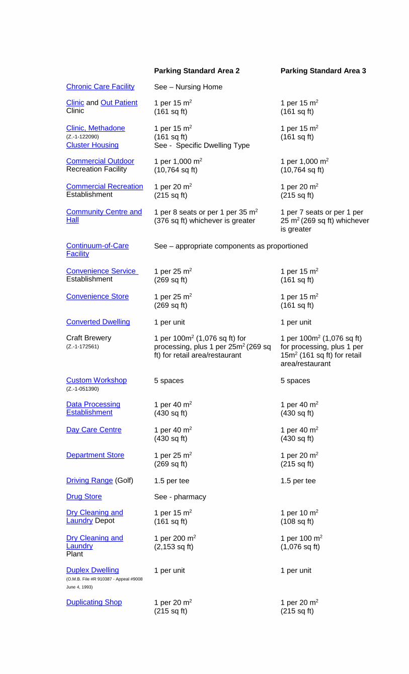
Parking Standard Area 2 Parking Standard Area 3
Chronic Care Facility
See – Nursing Home
Clinic and Out Patient Clinic
1 per 15 m2
(161 sq ft)
1 per 15 m2
(161 sq ft)
Clinic, Methadone (Z.-1-122090)
1 per 15 m2
(161 sq ft) 1 per 15 m2
(161 sq ft) Cluster Housing
See - Specific Dwelling Type
Commercial Outdoor Recreation Facility
1 per 1,000 m2
(10,764 sq ft)
1 per 1,000 m2
(10,764 sq ft)
Commercial Recreation Establishment
1 per 20 m2
(215 sq ft)
1 per 20 m2
(215 sq ft)
Community Centre and Hall
1 per 8 seats or per 1 per 35 m2
(376 sq ft) whichever is greater
1 per 7 seats or per 1 per 25 m2 (269 sq ft) whichever is greater
Continuum-of-Care Facility
See – appropriate components as proportioned
Convenience Service Establishment
1 per 25 m2
(269 sq ft)
1 per 15 m2
(161 sq ft)
Convenience Store
1 per 25 m2
(269 sq ft)
1 per 15 m2
(161 sq ft)
Converted Dwelling
1 per unit 1 per unit
Craft Brewery (Z.-1-172561)
1 per 100m2 (1,076 sq ft) for processing, plus 1 per 25m2 (269 sq ft) for retail area/restaurant
1 per 100m2 (1,076 sq ft) for processing, plus 1 per 15m2 (161 sq ft) for retail area/restaurant
Custom Workshop (Z.-1-051390)
5 spaces 5 spaces
Data Processing Establishment
1 per 40 m2
(430 sq ft)
1 per 40 m2
(430 sq ft)
Day Care Centre
1 per 40 m2
(430 sq ft)
1 per 40 m2
(430 sq ft)
Department Store
1 per 25 m2
(269 sq ft)
1 per 20 m2
(215 sq ft)
Driving Range (Golf)
1.5 per tee 1.5 per tee
Drug Store
See - pharmacy
Dry Cleaning and Laundry Depot
1 per 15 m2
(161 sq ft)
1 per 10 m2
(108 sq ft)
Dry Cleaning and Laundry Plant
1 per 200 m2
(2,153 sq ft)
1 per 100 m2
(1,076 sq ft)
Duplex Dwelling (O.M.B. File #R 910387 - Appeal #9008
June 4, 1993)
1 per unit 1 per unit
Duplicating Shop
1 per 20 m2
(215 sq ft)
1 per 20 m2
(215 sq ft)
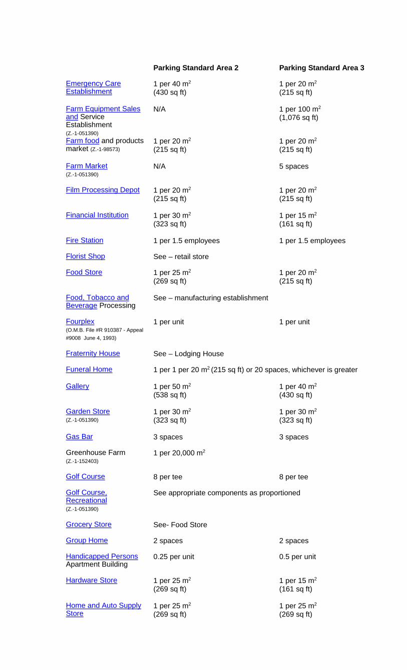
Parking Standard Area 2 Parking Standard Area 3
Emergency Care Establishment
1 per 40 m2
(430 sq ft)
1 per 20 m2
(215 sq ft)
Farm Equipment Sales and Service Establishment (Z.-1-051390)
N/A 1 per 100 m2
(1,076 sq ft)
Farm food and products market (Z.-1-98573)
1 per 20 m2
(215 sq ft)
1 per 20 m2
(215 sq ft)
Farm Market (Z.-1-051390)
N/A 5 spaces
Film Processing Depot
1 per 20 m2
(215 sq ft)
1 per 20 m2
(215 sq ft)
Financial Institution
1 per 30 m2
(323 sq ft)
1 per 15 m2
(161 sq ft)
Fire Station
1 per 1.5 employees 1 per 1.5 employees
Florist Shop
See – retail store
Food Store
1 per 25 m2
(269 sq ft)
1 per 20 m2
(215 sq ft)
Food, Tobacco and Beverage Processing
See – manufacturing establishment
Fourplex (O.M.B. File #R 910387 - Appeal #9008 June 4, 1993)
1 per unit 1 per unit
Fraternity House
See – Lodging House
Funeral Home
1 per 1 per 20 m2 (215 sq ft) or 20 spaces, whichever is greater
Gallery
1 per 50 m2
(538 sq ft)
1 per 40 m2
(430 sq ft)
Garden Store (Z.-1-051390)
1 per 30 m2
(323 sq ft)
1 per 30 m2
(323 sq ft)
Gas Bar
3 spaces 3 spaces
Greenhouse Farm (Z.-1-152403)
1 per 20,000 m2
Golf Course
8 per tee 8 per tee
Golf Course, Recreational (Z.-1-051390)
See appropriate components as proportioned
Grocery Store
See- Food Store
Group Home
2 spaces 2 spaces
Handicapped Persons Apartment Building
0.25 per unit 0.5 per unit
Hardware Store
1 per 25 m2
(269 sq ft)
1 per 15 m2
(161 sq ft)
Home and Auto Supply Store
1 per 25 m2
(269 sq ft) 1 per 25 m2
(269 sq ft)
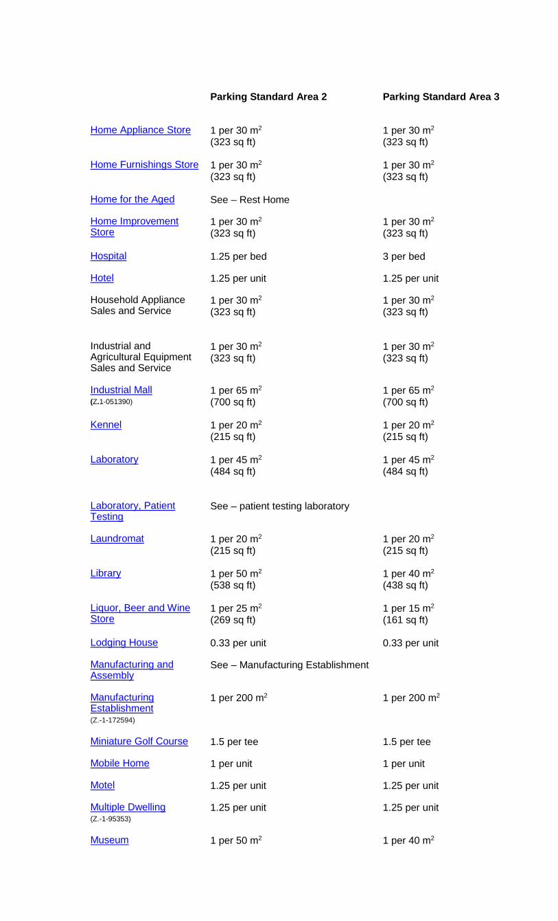
Parking Standard Area 2 Parking Standard Area 3
Home Appliance Store
1 per 30 m2
(323 sq ft)
1 per 30 m2
(323 sq ft)
Home Furnishings Store
1 per 30 m2
(323 sq ft)
1 per 30 m2
(323 sq ft)
Home for the Aged
See – Rest Home
Home Improvement Store
1 per 30 m2
(323 sq ft)
1 per 30 m2
(323 sq ft)
Hospital
1.25 per bed 3 per bed
Hotel
1.25 per unit 1.25 per unit
Household Appliance Sales and Service
1 per 30 m2
(323 sq ft)
1 per 30 m2
(323 sq ft)
Industrial and Agricultural Equipment Sales and Service
1 per 30 m2
(323 sq ft)
1 per 30 m2
(323 sq ft)
Industrial Mall (Z.1-051390)
1 per 65 m2
(700 sq ft)
1 per 65 m2
(700 sq ft)
Kennel
1 per 20 m2
(215 sq ft)
1 per 20 m2
(215 sq ft)
Laboratory
1 per 45 m2
(484 sq ft)
1 per 45 m2
(484 sq ft)
Laboratory, Patient Testing
See – patient testing laboratory
Laundromat
1 per 20 m2
(215 sq ft)
1 per 20 m2
(215 sq ft)
Library
1 per 50 m2
(538 sq ft)
1 per 40 m2
(438 sq ft)
Liquor, Beer and Wine Store
1 per 25 m2
(269 sq ft)
1 per 15 m2
(161 sq ft)
Lodging House
0.33 per unit 0.33 per unit
Manufacturing and Assembly
See – Manufacturing Establishment
Manufacturing Establishment (Z.-1-172594)
1 per 200 m2
1 per 200 m2
Miniature Golf Course
1.5 per tee 1.5 per tee
Mobile Home
1 per unit 1 per unit
Motel
1.25 per unit 1.25 per unit
Multiple Dwelling (Z.-1-95353)
1.25 per unit 1.25 per unit
Museum 1 per 50 m2 1 per 40 m2
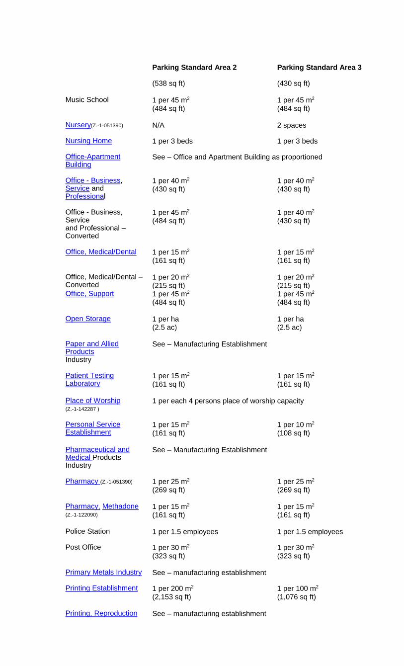
Parking Standard Area 2 Parking Standard Area 3
(538 sq ft)
(430 sq ft)
Music School
1 per 45 m2
(484 sq ft)
1 per 45 m2
(484 sq ft)
Nursery(Z.-1-051390)
N/A 2 spaces
Nursing Home
1 per 3 beds 1 per 3 beds
Office-Apartment Building
See – Office and Apartment Building as proportioned
Office - Business, Service and Professional
1 per 40 m2
(430 sq ft)
1 per 40 m2
(430 sq ft)
Office - Business, Service and Professional – Converted
1 per 45 m2
(484 sq ft)
1 per 40 m2
(430 sq ft)
Office, Medical/Dental
1 per 15 m2
(161 sq ft)
1 per 15 m2
(161 sq ft)
Office, Medical/Dental – Converted
1 per 20 m2
(215 sq ft) 1 per 20 m2
(215 sq ft) Office, Support
1 per 45 m2
(484 sq ft)
1 per 45 m2
(484 sq ft)
Open Storage
1 per ha (2.5 ac)
1 per ha (2.5 ac)
Paper and Allied Products Industry
See – Manufacturing Establishment
Patient Testing Laboratory
1 per 15 m2
(161 sq ft)
1 per 15 m2
(161 sq ft)
Place of Worship (Z.-1-142287 )
1 per each 4 persons place of worship capacity
Personal Service Establishment
1 per 15 m2
(161 sq ft)
1 per 10 m2
(108 sq ft)
Pharmaceutical and Medical Products Industry
See – Manufacturing Establishment
Pharmacy (Z.-1-051390)
1 per 25 m2
(269 sq ft)
1 per 25 m2
(269 sq ft)
Pharmacy, Methadone (Z.-1-122090)
1 per 15 m2
(161 sq ft)
1 per 15 m2
(161 sq ft)
Police Station
1 per 1.5 employees 1 per 1.5 employees
Post Office
1 per 30 m2
(323 sq ft)
1 per 30 m2
(323 sq ft)
Primary Metals Industry
See – manufacturing establishment
Printing Establishment
1 per 200 m2
(2,153 sq ft)
1 per 100 m2
(1,076 sq ft)
Printing, Reproduction See – manufacturing establishment

Parking Standard Area 2 Parking Standard Area 3
and Data Processing Industries Private Club
1 per 20 m2
(215 sq ft)
1 per 20 m2
(215 sq ft)
Private Outdoor Recreation Club
1 per 700m2 (7,535 sq ft) of lot area for the first 10 ha (25ac), plus 1 per 5000 m2 (53,820 sq ft) of lot area over 10 ha (25 ac)
Private Zoo (Z.-1-051390)
N/A 1 per 700 m2 (7535 sq ft) of lot area used as a private zoo
Processed Goods Industry
See – manufacturing establishment
Public Hall
See – Assembly hall
Public Recreation Facility
1 per 35 m2
(376 sq ft)
1 per 35 m2
(376 sq ft)
Public Use 1 per 45 m2
(484 sq ft)
1 per 45 m2
(484 sq ft)
Public Utility
See – Public Use
Racquet Facility
2 per court 2 per court
Raw Materials Processing
See – manufacturing establishment
Recreational Vehicle Sales and Service Establishment (Z.-1-051390)
1 per 20 m2 (215 sq ft) plus 1 per 10 vehicles on display
Repair and Rental Establishment
1 per 20 m2
(215 sq ft)
1 per 20 m2
(215 sq ft)
Research and Development Establishment
See- manufacturing establishment
Resource Extraction Operation
2 spaces 2 spaces
Restaurant (Z.-1-97532)
1 per 15 m2
(161 sq ft)
1 per 10 m2
(108 sq ft)
Restaurant, Eat-In and Outdoor Patio
See - Resaurant
Restaurant, Fast-Food, Drive-In, Take-Out
1 per 8 m2
(86 sq ft)
1 per 8 m2
(86 sq ft)
Rest Home
1 per 3 beds 1 per 3 beds
Restricted Manufacturing
See – Manufacturing Establishment
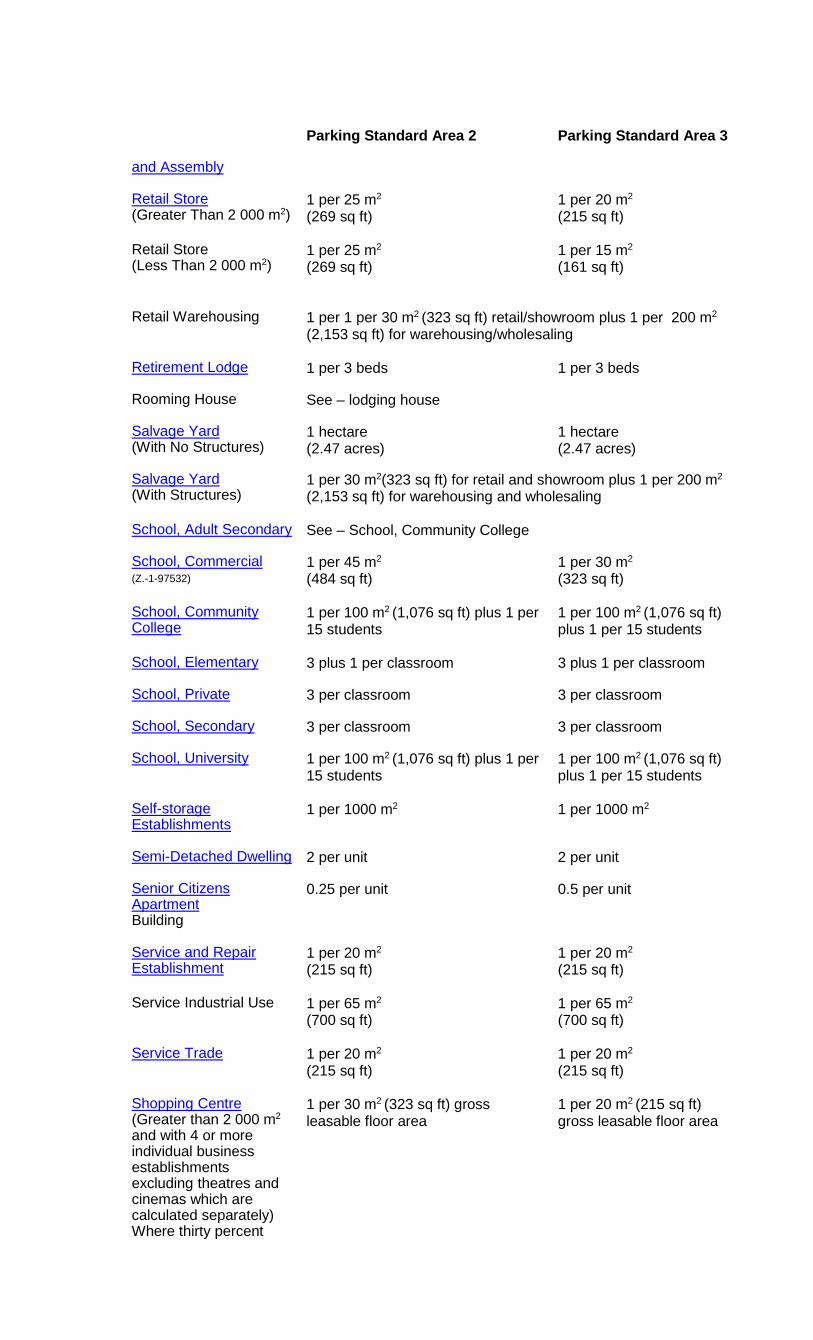
Parking Standard Area 2 Parking Standard Area 3
and Assembly Retail Store (Greater Than 2 000 m2)
1 per 25 m2
(269 sq ft)
1 per 20 m2
(215 sq ft)
Retail Store (Less Than 2 000 m2)
1 per 25 m2
(269 sq ft)
1 per 15 m2
(161 sq ft)
Retail Warehousing
1 per 1 per 30 m2 (323 sq ft) retail/showroom plus 1 per 200 m2
(2,153 sq ft) for warehousing/wholesaling
Retirement Lodge
1 per 3 beds 1 per 3 beds
Rooming House
See – lodging house
Salvage Yard (With No Structures)
1 hectare (2.47 acres)
1 hectare (2.47 acres)
Salvage Yard (With Structures)
1 per 30 m2(323 sq ft) for retail and showroom plus 1 per 200 m2
(2,153 sq ft) for warehousing and wholesaling
School, Adult Secondary
See – School, Community College
School, Commercial (Z.-1-97532)
1 per 45 m2
(484 sq ft)
1 per 30 m2
(323 sq ft)
School, Community College
1 per 100 m2 (1,076 sq ft) plus 1 per 15 students
1 per 100 m2 (1,076 sq ft) plus 1 per 15 students
School, Elementary
3 plus 1 per classroom 3 plus 1 per classroom
School, Private
3 per classroom 3 per classroom
School, Secondary
3 per classroom 3 per classroom
School, University
1 per 100 m2 (1,076 sq ft) plus 1 per 15 students
1 per 100 m2 (1,076 sq ft) plus 1 per 15 students
Self-storage Establishments
1 per 1000 m2
1 per 1000 m2
Semi-Detached Dwelling
2 per unit 2 per unit
Senior Citizens Apartment Building
0.25 per unit 0.5 per unit
Service and Repair Establishment
1 per 20 m2
(215 sq ft)
1 per 20 m2
(215 sq ft)
Service Industrial Use
1 per 65 m2
(700 sq ft)
1 per 65 m2
(700 sq ft)
Service Trade
1 per 20 m2
(215 sq ft)
1 per 20 m2
(215 sq ft)
Shopping Centre (Greater than 2 000 m2 and with 4 or more individual business establishments excluding theatres and cinemas which are calculated separately) Where thirty percent
1 per 30 m2 (323 sq ft) gross leasable floor area
1 per 20 m2 (215 sq ft) gross leasable floor area
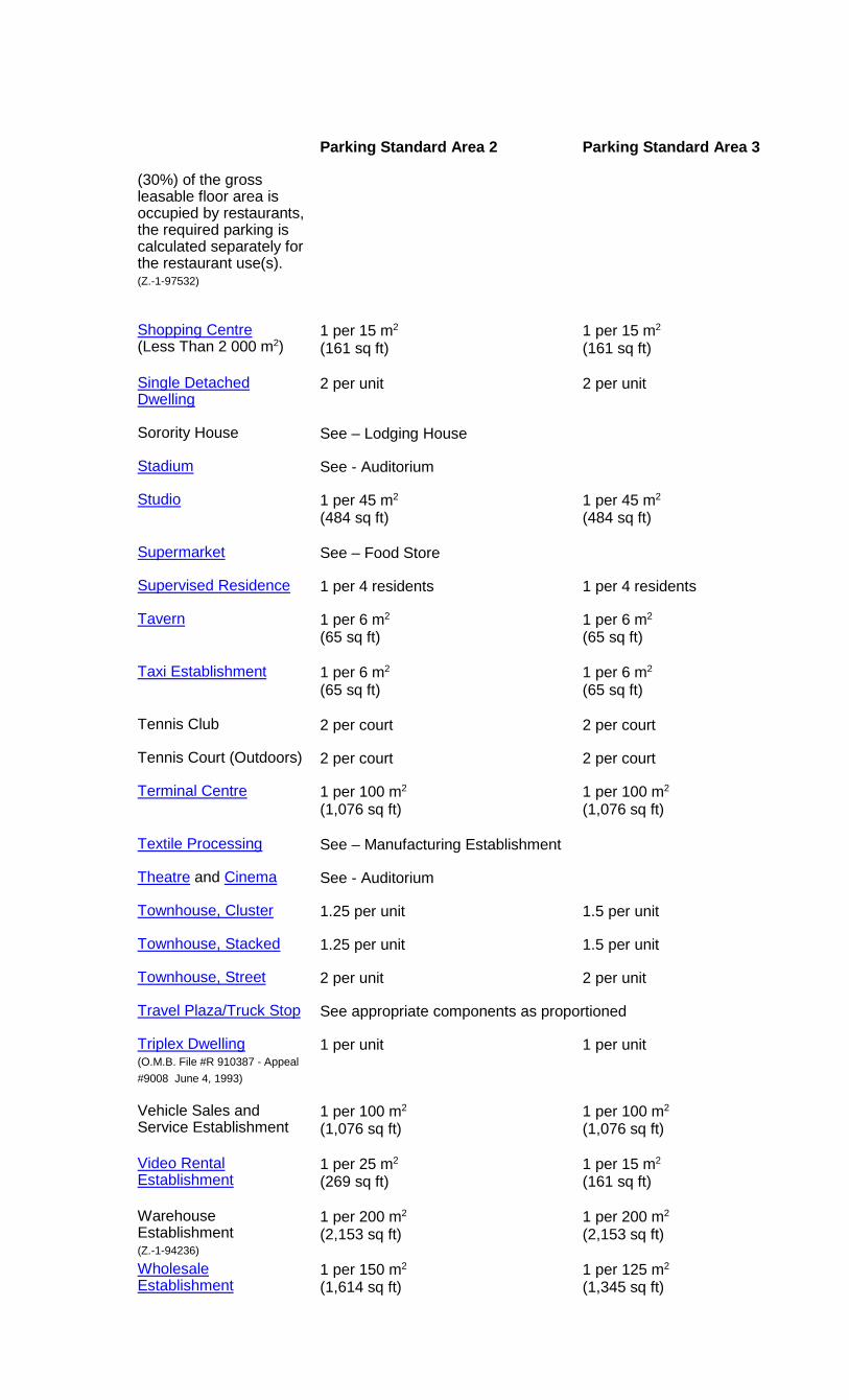
Parking Standard Area 2 Parking Standard Area 3
(30%) of the gross leasable floor area is occupied by restaurants, the required parking is calculated separately for the restaurant use(s). (Z.-1-97532) Shopping Centre (Less Than 2 000 m2)
1 per 15 m2
(161 sq ft)
1 per 15 m2
(161 sq ft)
Single Detached Dwelling
2 per unit 2 per unit
Sorority House
See – Lodging House
Stadium
See - Auditorium
Studio
1 per 45 m2
(484 sq ft)
1 per 45 m2
(484 sq ft)
Supermarket
See – Food Store
Supervised Residence
1 per 4 residents 1 per 4 residents
Tavern
1 per 6 m2
(65 sq ft)
1 per 6 m2
(65 sq ft)
Taxi Establishment
1 per 6 m2
(65 sq ft)
1 per 6 m2
(65 sq ft)
Tennis Club
2 per court 2 per court
Tennis Court (Outdoors)
2 per court 2 per court
Terminal Centre
1 per 100 m2
(1,076 sq ft)
1 per 100 m2
(1,076 sq ft)
Textile Processing
See – Manufacturing Establishment
Theatre and Cinema
See - Auditorium
Townhouse, Cluster
1.25 per unit 1.5 per unit
Townhouse, Stacked
1.25 per unit 1.5 per unit
Townhouse, Street
2 per unit 2 per unit
Travel Plaza/Truck Stop
See appropriate components as proportioned
Triplex Dwelling (O.M.B. File #R 910387 - Appeal #9008 June 4, 1993)
1 per unit 1 per unit
Vehicle Sales and Service Establishment
1 per 100 m2
(1,076 sq ft)
1 per 100 m2
(1,076 sq ft)
Video Rental Establishment
1 per 25 m2
(269 sq ft)
1 per 15 m2
(161 sq ft)
Warehouse Establishment (Z.-1-94236)
1 per 200 m2
(2,153 sq ft)
1 per 200 m2
(2,153 sq ft)
Wholesale Establishment
1 per 150 m2
(1,614 sq ft) 1 per 125 m2
(1,345 sq ft)

c) Accessible parking spaces Where parking spaces are required, in any development, accessible parking spaces shall be provided. Off street parking areas shall have a minimum number of accessible parking spaces as follows: i) One parking space for the use of persons with disabilities, which meets
the requirements of a Type A parking space, where there are 12 parking spaces or fewer; or
ii) Four per cent of the total number of parking spaces for the use of persons
with disabilities, where there are between 13 and 100 parking spaces in accordance with the following ratio, rounding up to the nearest whole number:
1. Where an even number of parking spaces for the use of
persons with disabilities are provided in accordance with the requirements of this paragraph, an equal number of parking spaces that meet the requirements of a Type A parking space and a Type B parking space must be provided; or
2. Where an odd number of parking spaces for the use of
persons with disabilities are provided in accordance with the requirements of this paragraph, the number of parking spaces must be divided equally between parking spaces that meet the requirements of a Type A parking space and a Type B parking space, but the additional parking space, the odd-numbered space, may be a Type B parking space; or
iii) One parking space for the use of persons with disabilities and an
additional three percent of parking spaces for the use of persons with disabilities, where there are between 101 and 200 parking spaces must be parking spaces for the use of persons with disabilities, calculated in accordance with the ratios set out in subparagraphs ii) 1 and 2), rounding up to the nearest whole number; or
iv) Two parking spaces for the use of persons with disabilities and an
additional two per cent of parking spaces for the use of persons with disabilities, where there are between 201 and 1,000 parking spaces must be parking spaces for the use of persons with disabilities in accordance with the ratio in subparagraphs ii) 1 and 2 rounding up to the nearest whole number; or
v) Eleven parking spaces for the use of persons with disabilities and an
additional one per cent of parking spaces for the use of persons with disabilities, where more than 1,000 parking spaces are provided must be parking spaces for the use of persons with disabilities in accordance with the ratio in subparagraphs ii) 1 and 2 rounding up to the nearest whole number; and
vi) The number of parking spaces for persons with disabilities shall be
included as part of the total parking required for the site. (Z.-1-142353) 11) OTHER PARKING REGULATIONS
a) Nothing in this By-Law shall prevent the erection of a shelter for use solely by parking attendants or security personnel in any part of a parking area, except within a sight triangle, provided such shelter is not more than 4.5 metres (14.8 feet) in height and has a floor area of not more than 5.0 square metres (53.8 square feet).
b) No recreational vehicle, trailer or boat shall be parked or stored on any
part of a lot in a Residential Zone, except for one recreational vehicle which:
i) is owned by the occupant of the said lot; and,
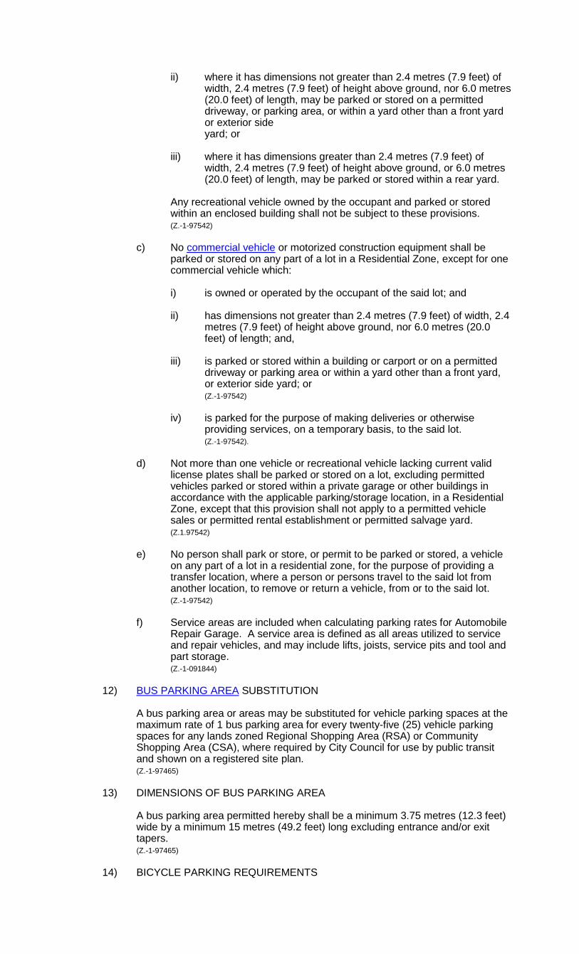
ii) where it has dimensions not greater than 2.4 metres (7.9 feet) of width, 2.4 metres (7.9 feet) of height above ground, nor 6.0 metres (20.0 feet) of length, may be parked or stored on a permitted driveway, or parking area, or within a yard other than a front yard or exterior side
yard; or iii) where it has dimensions greater than 2.4 metres (7.9 feet) of
width, 2.4 metres (7.9 feet) of height above ground, or 6.0 metres (20.0 feet) of length, may be parked or stored within a rear yard.
Any recreational vehicle owned by the occupant and parked or stored within an enclosed building shall not be subject to these provisions.
(Z.-1-97542) c) No commercial vehicle or motorized construction equipment shall be
parked or stored on any part of a lot in a Residential Zone, except for one commercial vehicle which:
i) is owned or operated by the occupant of the said lot; and ii) has dimensions not greater than 2.4 metres (7.9 feet) of width, 2.4
metres (7.9 feet) of height above ground, nor 6.0 metres (20.0 feet) of length; and,
iii) is parked or stored within a building or carport or on a permitted
driveway or parking area or within a yard other than a front yard, or exterior side yard; or
(Z.-1-97542) iv) is parked for the purpose of making deliveries or otherwise
providing services, on a temporary basis, to the said lot. (Z.-1-97542). d) Not more than one vehicle or recreational vehicle lacking current valid
license plates shall be parked or stored on a lot, excluding permitted vehicles parked or stored within a private garage or other buildings in accordance with the applicable parking/storage location, in a Residential Zone, except that this provision shall not apply to a permitted vehicle sales or permitted rental establishment or permitted salvage yard.
(Z.1.97542) e) No person shall park or store, or permit to be parked or stored, a vehicle
on any part of a lot in a residential zone, for the purpose of providing a transfer location, where a person or persons travel to the said lot from another location, to remove or return a vehicle, from or to the said lot.
(Z.-1-97542) f) Service areas are included when calculating parking rates for Automobile Repair Garage. A service area is defined as all areas utilized to service and repair vehicles, and may include lifts, joists, service pits and tool and part storage. (Z.-1-091844) 12) BUS PARKING AREA SUBSTITUTION
A bus parking area or areas may be substituted for vehicle parking spaces at the maximum rate of 1 bus parking area for every twenty-five (25) vehicle parking spaces for any lands zoned Regional Shopping Area (RSA) or Community Shopping Area (CSA), where required by City Council for use by public transit and shown on a registered site plan.
(Z.-1-97465) 13) DIMENSIONS OF BUS PARKING AREA
A bus parking area permitted hereby shall be a minimum 3.75 metres (12.3 feet) wide by a minimum 15 metres (49.2 feet) long excluding entrance and/or exit tapers.
(Z.-1-97465)
14) BICYCLE PARKING REQUIREMENTS
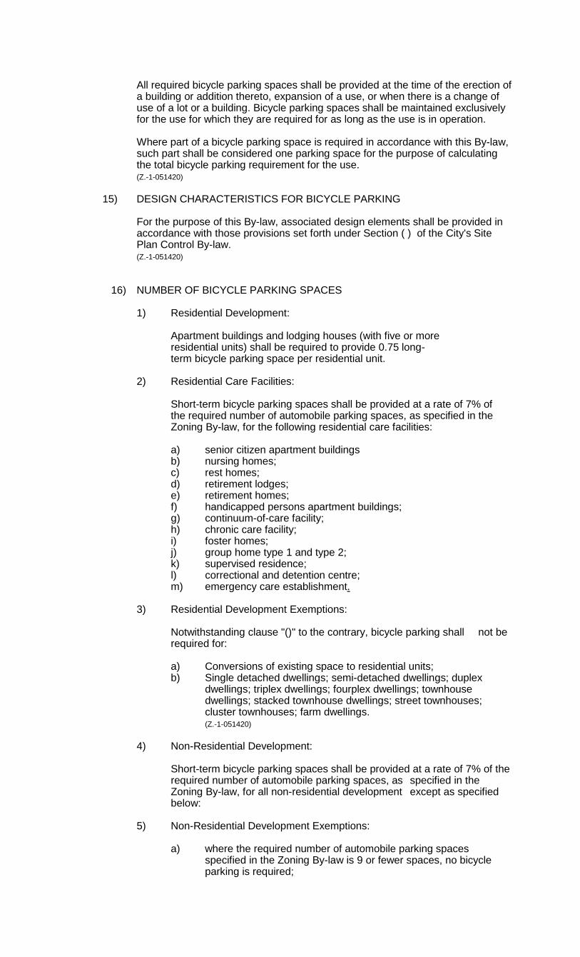
All required bicycle parking spaces shall be provided at the time of the erection of a building or addition thereto, expansion of a use, or when there is a change of use of a lot or a building. Bicycle parking spaces shall be maintained exclusively for the use for which they are required for as long as the use is in operation. Where part of a bicycle parking space is required in accordance with this By-law, such part shall be considered one parking space for the purpose of calculating the total bicycle parking requirement for the use. (Z.-1-051420)
15) DESIGN CHARACTERISTICS FOR BICYCLE PARKING For the purpose of this By-law, associated design elements shall be provided in accordance with those provisions set forth under Section ( ) of the City's Site Plan Control By-law. (Z.-1-051420)
16) NUMBER OF BICYCLE PARKING SPACES 1) Residential Development: Apartment buildings and lodging houses (with five or more residential units) shall be required to provide 0.75 long- term bicycle parking space per residential unit. 2) Residential Care Facilities: Short-term bicycle parking spaces shall be provided at a rate of 7% of the required number of automobile parking spaces, as specified in the Zoning By-law, for the following residential care facilities: a) senior citizen apartment buildings b) nursing homes; c) rest homes; d) retirement lodges; e) retirement homes; f) handicapped persons apartment buildings; g) continuum-of-care facility; h) chronic care facility; i) foster homes; j) group home type 1 and type 2; k) supervised residence; l) correctional and detention centre; m) emergency care establishment. 3) Residential Development Exemptions: Notwithstanding clause "()" to the contrary, bicycle parking shall not be required for: a) Conversions of existing space to residential units; b) Single detached dwellings; semi-detached dwellings; duplex dwellings; triplex dwellings; fourplex dwellings; townhouse
dwellings; stacked townhouse dwellings; street townhouses; cluster townhouses; farm dwellings. (Z.-1-051420) 4) Non-Residential Development: Short-term bicycle parking spaces shall be provided at a rate of 7% of the required number of automobile parking spaces, as specified in the Zoning By-law, for all non-residential development except as specified below: 5) Non-Residential Development Exemptions: a) where the required number of automobile parking spaces
specified in the Zoning By-law is 9 or fewer spaces, no bicycle parking is required;

b) No bicycle parking requirement applies for the following uses specified in the Zoning By-law:
Abattoir; aggregate reprocessing; aggregate storage area; agricultural service establishment; agricultural supply establishment; agricultural use; agricultural use, intensive; agricultural use, non-intensive; agriculturally related commercial use; agriculturally related industrial use; batching plant, asphalt; batching plant, concrete; channel composting facility; construction and demolition recycling facility; crushing plant; driving range; drive-through facility; farm; farm cluster; farm equipment sales and service; farm foods and products market; farm market; feedlot; forestry use; grain elevator; greenhouse, commercial; in-vessel composting facility; kennel; landing strip; livestock; livestock facilities; managed woodlot; manure storage facilities; pit; propane transfer facility; quarry; resource excavation; residential and other source recycling facility; resource extraction operation; salvage yard; specialized recycling facility; stockpiling; travel plaza/truck stop; truck stop; theatre, drive-in; wayside pit or wayside quarry; windrow composting facility. c) No bicycle parking requirement will apply to the conversion
of existing buildings for residential or non-residential uses in all Downtown Area 1 and 2 Zones. Major redevelopment
involving property consolidation and new construction is required to provide for bicycle parking facilities at the mandated standard.
d) No bicycle parking requirement will apply to the conversion
of existing buildings for residential or non-residential uses in all Business District Commercial 1 and 2 Zones. Major
redevelopment involving property consolidation and new construction is required to provide for bicycle parking facilities at the mandated standard.
e) For CLINIC, METHADONE or PHARMACY, METHADONE uses, notwithstanding any provisions of this by-law, the number of bicycle parking spaces provided shall be no less than 5 spaces.
6) Municipally-owned Parking lots and structures: Municipally-owned parking lots in the Downtown Area zones and defined
Business District Commercial Area zones shall provide for short-term bicycle parking facilities equal to 7% of the total vehicular parking spaces provide.
7) Bicycle Parking Incentives: Notwithstanding Section 4.19 of this By-law to the contrary, the required
number of motor vehicle parking spaces for non-residential uses may be reduced to provide for additional short or long-term bicycle parking spaces beyond those mandated by this by-law provided, however, the reduction in motor vehicle parking spaces shall not exceed 10% of the required motor vehicle parking spaces. Individual vehicular parking stalls shall be required to provide for a minimum of five bicycle parking spaces. This incentive shall not apply to CLNIC, METHADONE or PHARMACY, METHADONE uses.
(Z.-1-051420) (Z.-1-122090)
4.20 PUBLIC USES 1) PARKS, FACILITIES AND STREETS (Z-1-051390)
Nothing in this By-law shall apply to prevent or otherwise restrict the use of any land for a public park, a public street, a bicycle pathway, or a public memorial such as a monument, cenotaph or fountain.
(O.M.B. File #R910387 - Appeal #9006-2 June 4, 1993) (Z-1-051390) 2) UTILITIES
This By-Law permits the use of land or the use or erection of any building or structure in any zone for the purpose of the provision of essential services or utilities or drainage work by the City or The Hydro-Electric Commission of the City of London or of any telephone, telegraph, cable television or natural gas company, including any transportation or public utility owned, operated or franchised by or for the City or The Hydro-Electric Commission of the City of London, any department of the Federal or Provincial governments, including Ontario Hydro, or any Conservation Authority established by the Government of Ontario, provided that:
(Z.-1-94236) (Z.-1-051390)
a) such building or structure is designed and maintained in general harmony with the buildings and structures permitted within the zone in which it is located;
b) all buildings shall otherwise comply with the regulations of that zone; and c) there shall be no exterior storage of goods, materials or equipment in any
Residential Zone.
d) a minimum setback of 20m (65 ft) will be provided from the centre of a high pressure pipeline to the nearest wall of a building intended for human occupancy. (Z-1-051390)
3) MUNICIPAL DRAINS AND NATURAL WATERCOURSES
The following Municipal Drains and Natural Watercourses regulations will apply only to lands within the Agricultural and Urban Reserve zone variations and, within these zone variations, will apply to all lands including existing lots of record. No permanent buildings or structures shall be erected or used:
a) closer than 7.5m (25 ft.) from the top-of-bank of a municipal drain having the width of less than 4.5m (15 ft.) from top-of-bank to top- of-bank;
b) closer than 18.5m (61 ft.) from the top-of-bank of a municipal drain having a width of between 4.5m (15 ft.) and 7.5m (25 ft.) from top- of-bank to top- of-bank;
c) closer than 30.5m (100 ft.) from the top-of-bank of a municipal drain which is 7.5m (25 ft.) or more from top-of-bank to top-of-bank;
d) closer than 7.5m (25ft.) from the centre line of a municipal tile drain.
The regulations of the Drainage Act will continue to apply to all municipal drains and natural watercourses in all zone variations in the City.
(Z.-1-051390)(deleted and replaced by Z.-1-112031)
4.21 ROAD ALLOWANCE REQUIREMENTS - SPECIFIC ROADS
Notwithstanding any other provisions of this By-Law, yard requirements adjacent to the Arterial and Collector roads listed below shall be measured from the limit of the required or the existing road allowance, whichever is the greater.
STREET FROM TO STREET CLASSIFICATION
LIMIT OF ROAD ALLOWANCE MEASURED FROM CENTRE LINE
Street “A” 39T-03505 (Z.-1-051330)
Medway Park Drive East limit of Plan (39T-02503)
Secondary Collector
10.75m (35.3 ft)
Street “A” (39T-00512) (Z.-1-01869) (Deleted by Z.-1-102986)
Street “A” (39T-07503) (Z.-1-081703)
Cranbrook Road Colonel Talbot Road
Secondary Collector
10.75 m (35.3ft)
Street “A” (Z.-1-112006)
Blakie Road Street “C” Secondary Collector
13m (42.6 ft)
Street “A” (Z.-1-112006)
Street “C” Dingman Drive Primary Collector 10.75 m (35.3 ft)
Street “A” (Z.-1-112007)
Dingman Drive Street “C” Primary Collector 13 m (42.6 ft)
Street “A” (Z.-1-112007)
Street “C” Blakie Road Secondary Collector
10.75 m (35.3 ft)
Street “A” (39T-09502) (Z.-1-112020)
Commissioners Road East
Street “E” (39T-09502)
Primary Collector 14 m (45.9 ft) at Commissioners Road East tapering to 13m (42.6 ft) at Street “E”
Street “A” (39T-09502) (Z.-1-112020)
Street “E” Street “B” (39T-09502)
Primary Collector 10.75 m (35.3 ft)
Street “A” (Z.-1-122099)
Sunningdale Road Callingham Drive Secondary Collector
10.75 m (35 ft)
Street “A” (west of Crumlin Road and east of Veteran’s Memorial Parkway) (39T-09502)
North of Sovereign Road
South of Dundas Proposed Secondary Collector
10.75m (35.3 ft)
Aberdeen Drive North of Gore Road Tartan Drive Secondary Collector
10.75 m (35.3ft)
Adelaide Street South
Commissioners Road East
Thames River South Branch
Arterial 18 m (59.1 ft)
Adelaide Street North (Z.-1-132184)
Thames River South Branch
Hamilton Road Arterial 18 m (59.1 ft)
Hamilton Road Horton Street East Arterial 19.5 m (63.98 ft)
Horton Street East Dundas Street Arterial
As Existing
West Side Dundas Street
Queens Avenue Arterial 26.5 m (87 ft) @ Dundas Street

STREET FROM TO STREET CLASSIFICATION
LIMIT OF ROAD ALLOWANCE MEASURED FROM CENTRE LINE
tapering to 19.5 m (63.98 ft) @ Queens Avenue
East Side of Dundas Street
Queens Avenue Arterial As Existing @ Dundas St tapering to 19.5m (63.98 ft) @ Queens Avenue
Adelaide Street North (Z.-1-132184)
Queens Avenue Fanshawe Park Rd E
Arterial 19.5 m (63.98 ft)
Fanshawe Park Rd E
N. City Limits Arterial 18m (59.1 ft)
Adelaide Street South (Z.-1-94277)
Southdale Road Bradley Ave Arterial 18 m (59.1 ft)
Adelaide Street South (Z.-1-95277)
Bradley Ave Newbold Street Primary Collector As Existing
Admiral Dr (Z.-1-061546)
Trafalgar Street Veteran’s Memorial Parkway
Secondary Collector
10.75 m (35.3ft)
Albert Street Ridout Street N Talbot Street Secondary Collector
10.75 m (35.3 ft)
Aldersbrook gate Aldersbrook Road Fanshawe Park Road West
Secondary Collector
As Existing
Aldersbrook Road Sarnia Road Wonderland Road North
Secondary Collector
10.75 m (35.3 ft)
Ambelside Drive Western Road Ambelside Drive Secondary Collector
10.75 m (35.3 ft)
Andover Drive Southdale Road East
Commissioners Road West
Secondary Collector
10.75 m (35.3ft)
Angle St (Z.-1-132184)
Clarence St Richmond St Primary Collector As Existing
Ashland Avenue Brydges Street Dundas Street Secondary Collector
10.75 m (35.3 ft)
Atkinson Boulevard Trafalgar Street Whitehall Drive Secondary Collector
10.75 m (35.3 ft)
Street “B” (39T-09502) (Z.-1-112020)
Street “A” East Limit of Plan Primary Collector 10.75 m (35.3 ft)
Barclay Road Cranbrook Road Farnham Road Secondary Collector
10.75 m (35.3 ft)
Barker Street Oxford Street East Kipps Lane Secondary Collector
10.75 m (35.3 ft)
Base Line Road East
Wharncliffe Road Wellington Road Secondary Collector
10.75 m (35.3 ft)
Base Line Road East
Wellington Road Westminster Road Primary Collector
13 m (42.7 ft)
STREET FROM TO STREET CLASSIFICATION
LIMIT OF ROAD ALLOWANCE MEASURED FROM CENTRE LINE
Base Line Road West
Southcrest Drive Wharncliffe Road Secondary Collector
10.75 m (35.3 ft)
Bateman Trail (Z.-1-061452) (Z.-1-041270)
White Oak Road (south leg)
White Oak Road (north leg)
Secondary Collector
10.75 m (35.3 ft)
Beachwood Ave Commissioners Road West
Ridgewood Cres. Secondary Collector
10.75 m (35.3 ft)
Beaverbrook Ave. (Z.-1-02986)
Riverside Drive Oxford Street West Secondary Collector
10.75 m (35.3 ft)
Beaverbrook Avenue
Sarnia Road East limit of Plan Secondary Collector
10.75 m (35.3 ft)
Beaverbrook Avenue (Z.-1-061478)
Oak Crossing Road Westerly limit of plan 39T-06501
Secondary Collector
10.75 m (35.3 ft)
Beckwork Avenue Sanford Street Sorrel Road Secondary Collector
10.75 m (35.3 ft)
Belfield Street Huron St Kipps Lane Secondary Collector
10.75 m (35.3 ft)
Belmont Drive Notre Dame Drive
Whancliffe Road South
Secondary Collector
10.75 m (35.3 ft)
Bentley Drive Webster Street Sandford Street Secondary Collector
10.75 m (35.3 ft)
Berkshire Drive Teeple Terrace Springbank Drive Secondary Collector
10.75 m (35.3 ft)
Berryhill Drive (Z.-1-041203)
Elderberry Avenue Chambers Avenue Secondary Collector
10.75 m (35.3 ft)
Bessemer Road Exeter Road Newbold Street Primary Collector
13 m (42.7 ft)
Blackacres Blvd Dalmagerry Road Wonderland Road North
Secondary Collector
10.75 m (35.3 ft)
Blackfriars Street Whancliffe Road North
Ridout Street North Secondary Collector
10.75 m (35.3 ft)
Blackmaple Drive (Z.-1-02986)
Edgevalley Road Townsend Drive Secondary Collector
10.75 m (35.3 ft)
Blackwater Road (Z.-1-02986)
Grenfell Drive Sunningdale Road East
Secondary Collector
10.75 m (35.3 ft)
Blackwell Boulevard (Z.-1-051314)
Highbury Avenue East limit of plan 39T-01509
Secondary Collector
10.75 m (35.3 ft)
Blakie Road (Z.-1-112000)
West Limit of Plan 39T-06508
East Limit of Plan 39T-06508
Secondary Collector
10.75 m (35.3 ft)
Blakie Road (Z.-1-112006)
West Limit of Plan 39T-06504
East Limit of Plan 39T-06504
Secondary Collector
10.75 m (35.3 ft)
Blakie Road (Z.-1-112007)
White Oak Road Street “A” Primary Collector
13m (42.6 ft)

STREET FROM TO STREET CLASSIFICATION
LIMIT OF ROAD ALLOWANCE MEASURED FROM CENTRE LINE
Blakie Road (Z.-1-112007)
Street “A” Meg Drive Secondary Collector
10.75 m (35.3 ft)
Bluebell Road (Z.-1-1041203)
Skyline Avenue Sunningdale Road East
Secondary Collector
10.75 m (35.3 ft)
Bluegrass Drive Beaverbrook Avenue
West limit of plan Secondary Collector
10.75 m (35.3 ft)
Boler Road Southdale Road West
Sanatorium Road Arterial 18 m (59.1 ft)
Bostwick Road (Z.-1-051390)
Southdale Road West
Exeter Road Arterial 18 m (59.1 ft)
Bow Street Marconi Blvd Hudson Drive Secondary Collector
10.75 m (35.3 ft)
Bradish Road (Z.-1-051390)
Wellington Road South
Regan Bourne Arterial 18m (59.1 ft)
Bradley Avenue (Z.-1-051390)
Bostwick Road Eastern City Limits Arterial 18 m (59.1 ft)
Brady Drive (Z.-1-051390)
Bradish Road Webber Bourne Arterial 18 m (59.1 ft)
Bramwell Drive Riverside Drive 80.0 m N/E of Riverside Drive
Secondary Collector
10.75 m (35.3 ft)
Briarhill Avenue Huron Street Kipps Lane Secondary Collector
10.75 m (35.3 ft)
Bruce Street Wharncliffe Road South
Ridout Street Secondary Collector
10.75 m (35.3 ft)
Brunswick Avenue
Aldersbrook Road Healy Road Secondary Collector
10.75 m (35.3 ft)
Brydges Street Egerton Street Wavell Street Primary Collector 13 m (42.7 ft)
Byron Baseline Road (Z.-1-051390)
Westdel Bourne
Commissioners Road West
Arterial 18 m (59.1 ft)
Byron Baseline Road
Western City Limits Westdel Bourne Arterial 18 , (59.1 ft)
Street “C” (Z.-1-01911)
Street “A” North Limit of Street “C”
Secondary Collector
10.75 m (35.3 ft)
Street “C” (Z.-1-11007)
White Oak Road Street “A” Primary Collector
13 m (42.6 ft)
Street “C” (west of Veteran’s Memorial Parkway) (Z.-1-13224)
North of Tartan Drive
South of Trafalgar Street
Proposed Secondary Collector
10.75 m (35.3 ft)
Callingham Drive (Z.-1-122099)
Meadowlands Way East Limit of Plan 39T-11504
Secondary Collector
10.75 m (35.3 ft)
Campbell Street (Z.-1-051390)
Whancliffe Road South
Sunray Avenue Secondary Collector
10.75 m (35.3 ft)
STREET FROM TO STREET CLASSIFICATION
LIMIT OF ROAD ALLOWANCE MEASURED FROM CENTRE LINE
Capulet Lane Oxford Street West
Blythwood Road Secondary
Collector
10.75 m (35.3 ft)
Carfrae Crescent Thames River Grand Avenue Primary Collector 13 m (42.7 ft)
Castle Drive Royal Crescent Wavell Street Secondary Collector
10.75 m (35.3 ft)
Castlegrove Blvd Sarnia Road Sleightholme Avenue
Secondary Collector
10.75 m (35.3 ft)
Castleton Road (Z.-1-051390)
Roxburgh Road Dingman Drive Secondary Collector
10.75 m (35.3 ft)
Cedarhallow Blvd
Killarney Fanshawe Park Road East
Secondary Collector
10.75 m (35.3 ft)
Central Avenue Talbot Street Richmond Street Primary Collector 13 m (42.7 ft)
Central Avenue Richmond Street Adelaide Street North
Primary Collector As Existing
Central Avenue Adelaide Street North
Ontario Street Secondary Collector
10.75 m (35.3 ft)
Chalkstone Drive Exeter Road Jalna Blvd Secondary Collector
10.75 m (35.3 ft)
Chalkstone Drive (Z.-1-112000)
Exeter Road Blakie Road Secondary Collector
10.75 m (35.3 ft)
Chambers Avenue Nanette Drive Skyline Avenue Secondary Collector
10.75 m (35.3 ft)
Cheapside Street St George Street Richmond Street Secondary Collector
As Existing
Cheapside Street Richmond Street Clarke Road Primary Collector 13 m (42.7 ft)
Chelton Road (Z.-1-95310) (Z.-1-99716)
Commissioners Road East
Reardon Blvd Secondary Collector
As Existing
Chelton Road (deleted by Z.-1-041203)
Chelton Road (Z.-1-041203)
Reardon Blvd Meadowgate Blvd Secondary Collector
10.75 m (35.3 ft)
Cherryhill Blvd Oxford Street West Cherryhill Place Secondary Collector
As Existing
Cherryhill Circle (west) (Z.-1-00800)
Westfield Drive Cherryhill Blvd Secondary Collector
10.75 m (35.3 ft)
Cherryhill Place Cherryhill Blvd Platts Lane Secondary Collector
10.75 m (35.3 ft)
Cherrywood Trail Bluegrass Drive Sarnia Road Secondary Collector
10.75 m (35.3 ft)
Chiddington Avenue
Upper Queen Street Chiddington Gate Secondary Collector
10.75 m (35.3 ft)

STREET FROM TO STREET CLASSIFICATION
LIMIT OF ROAD ALLOWANCE MEASURED FROM CENTRE LINE
Chiddington Gate Chiddington Avenue
Wilkins Street Secondary Collector
10.75 m (35.3 ft)
Chippewa Drive Sanford Street Oakville Avenue Secondary Collector
10.75 m (35.3 ft)
Clarence Street (Z.-1-132184)
York Street Queens Avenue Primary Collector
11.6 m (38.1 ft)
Queens Avenue Dufferin Avenue Primary Collector As Existing
Dufferin Ave Angel St Primary Collector As Existing
Clarke Road (Z.-1-02986) (Z.-1-132184)
Hamilton Road VMP Extension Arterial 18 m (59.1 ft)
VMP Extension Fanshawe Park Rd E
Arterial
19.5 m (63.98ft)
Fanshawe Prk Rd E
North City Limits Arterial 18 m (59.1 ft)
Clarke Road (Z.-1-132224)
Veteran’s Memorial Parkway
200 m east of Veteran’s Memorial Parkway
Proposed Arterial 18 m (59.1 ft)
Clarke Road (Z.-1-132224)
Clarke Road Veteran’s Memorial Parkway
Proposed Arterial 18 m (59.1 ft)
Colborne Street South Street Huron Street Primary Collector As Existing
Colonel Talbot Road (Z.-1-051390)
Southdale Road West
South City Limits Arterial 18 m (59.1 ft)
Commissioners Road East (Z.-1-051390)
Wharncliffe Road East City Limits Arterial 18 m (59.1 ft)
Commissioners Road West (Z.-1-01933)
West City Limits 200 metres east of Springbank Drive
Arterial 18 m (59.1 ft)
Commissioners Road West (Z.-1-0933)
200 metres east of Springbank Drive
Cranbrook Road Arterial 10 m (32.8 ft)
Commissioners Road West (Z.-1-0933)
Cranbrook Road Wharncliffe Road South
Arterial 18 m (59.1 ft)
Coombs Avenue Trott Drive Sarnia Road Secondary Collector
10.75 m (35.3 ft)
Cook Road (Z.-1-051390)
Westminster Drive South City Limits Arterial 18 m (59.1 ft)
Corley Drive Windermere Road Ambelside Drive Secondary Collector
10.75 m (35.3 ft)
Coronation Drive Gainsborough Road North of South Carriage Road
Secondary Collector
10.75 m (35.3 ft)

STREET FROM TO STREET CLASSIFICATION
LIMIT OF ROAD ALLOWANCE MEASURED FROM CENTRE LINE
Cranbrook Road Commissioners Road West
Tillman Road Secondary Collector
10.75 m (35.3 ft)
Cranbrook Road (Z.-1-142255)
Tilman Road Longworth Road Secondary Collector
10.75m (35.3 ft)
Crumlin Road (Z.-1-09133)
Gore Road Oxford Street East Arterial 18 m (59.1 ft)
Crumlin Side Road (Z.-1-01887)
Oxford Street East Robin’s Hill Road Secondary Collector
10.75 m (35.3 ft)
Crumlin Road 200 m south of the CNR line
Gore Road Secondary Collector
10.75 m (35.3 ft)
Cuddy Blvd Page Street Oxford Street Secondary Collector
10.75 m (35.3 ft)
Street “D” (West of Veteran’s Memorial Parkway)
North of Scanlan Street
South of Gore Road Proposed Secondary Collector
10.75 m (35.3 ft)
Dalmagarry Road Fanshawe Park Road
Coronation Drive Secondary Collector
10.75 m (35.3 ft)
Darnley Blvd. (Z.-1-95310)
Jackson Road Lighthouse Drive Secondary Collector
17m (55.8 ft)
Darnley Blvd.
Lighthouse Drive Meadowgate Blvd Secondary Collector
10.75 m (35.3 ft)
Dearness Drive Bradley Avenue Southdale Road Secondary Collector
10.75 m (35.3 ft)
Decker Driver (Z.-1-051390)
West City Limits Wonderland Road South
Arterial 18 m (59.1 ft)
Deer Park Circle Valetta Street Juniper Street Secondary Collector
10.75 m (35.3 ft)
Denview Ave Sunningdale Road Werst
Silverfox Cres Secondary Collector
10.75 m (35.3 ft)
Derwent Road Fanshawe Park Road
Ambleside Drive Secondary Collector
As Existing
Deveron Crescent Pond Mills Road (North Intersection)
Pond Mills Road (south Intersection)
Secondary Collector
10.75 m (35.3 ft)
Deveron Crescent Pond Mills Road Commissioners Road East
Secondary Collector
10.75 m (35.3 ft)
Deveron Crescent Commissioners Road East
Pond Mills Road Secondary Collector
10.75 m (35.3 ft)
Dingman Drive (Z.-1-051390)
Wonderland Road South
East City Limits Arterial 18 m (59.1 ft)
Doon Drive Windermere Road Windermere Road Secondary Collector
10.75 m (35.3 ft)
Driver Lane (Z.-1-142254)
North of Dundas Auto Mall Avenue Secondary 10.75 m
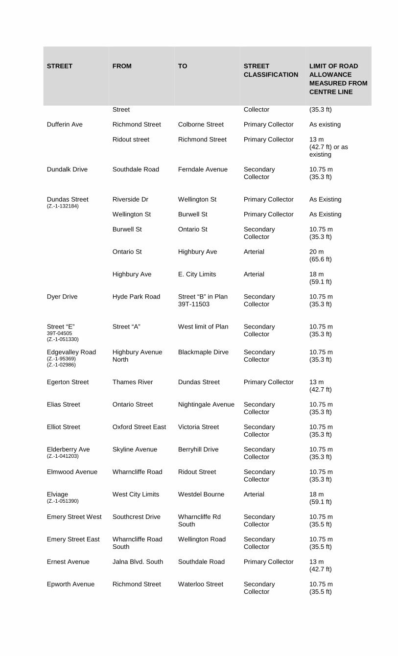
STREET FROM TO STREET CLASSIFICATION
LIMIT OF ROAD ALLOWANCE MEASURED FROM CENTRE LINE
Street Collector
(35.3 ft)
Dufferin Ave Richmond Street Colborne Street Primary Collector As existing
Ridout street Richmond Street Primary Collector 13 m (42.7 ft) or as existing
Dundalk Drive Southdale Road Ferndale Avenue Secondary Collector
10.75 m (35.3 ft)
Dundas Street (Z.-1-132184)
Riverside Dr Wellington St Primary Collector
As Existing
Wellington St Burwell St Primary Collector
As Existing
Burwell St Ontario St Secondary Collector
10.75 m (35.3 ft)
Ontario St Highbury Ave
Arterial 20 m (65.6 ft)
Highbury Ave E. City Limits Arterial 18 m (59.1 ft)
Dyer Drive
Hyde Park Road Street “B” in Plan 39T-11503
Secondary Collector
10.75 m (35.3 ft)
Street “E” 39T-04505 (Z.-1-051330)
Street “A” West limit of Plan Secondary Collector
10.75 m (35.3 ft)
Edgevalley Road (Z.-1-95369) (Z.-1-02986)
Highbury Avenue North
Blackmaple Dirve Secondary Collector
10.75 m (35.3 ft)
Egerton Street Thames River Dundas Street Primary Collector 13 m (42.7 ft)
Elias Street Ontario Street Nightingale Avenue
Secondary Collector
10.75 m (35.3 ft)
Elliot Street Oxford Street East Victoria Street Secondary Collector
10.75 m (35.3 ft)
Elderberry Ave (Z.-1-041203)
Skyline Avenue Berryhill Drive Secondary Collector
10.75 m (35.3 ft)
Elmwood Avenue Wharncliffe Road Ridout Street Secondary Collector
10.75 m (35.3 ft)
Elviage (Z.-1-051390)
West City Limits Westdel Bourne Arterial 18 m (59.1 ft)
Emery Street West Southcrest Drive Wharncliffe Rd South
Secondary Collector
10.75 m (35.5 ft)
Emery Street East Wharncliffe Road South
Wellington Road Secondary Collector
10.75 m (35.5 ft)
Ernest Avenue Jalna Blvd. South Southdale Road Primary Collector
13 m (42.7 ft)
Epworth Avenue Richmond Street Waterloo Street Secondary Collector
10.75 m (35.5 ft)

STREET FROM TO STREET CLASSIFICATION
LIMIT OF ROAD ALLOWANCE MEASURED FROM CENTRE LINE
Exeter Road (Z.-1-051390)
Bostwick Road Highway 401 Arterial 18 m (59.1 ft)
Street “F” (deleted by Z.-1-051389)
Fairview Avenue Weston Street Whetter Avenue Secondary Collector
10.75 m (35.5 ft)
Fanshawe Park Road (Z.-1-051390) (Z.-1-132184)
W.City Limits Wonderland Road N
Arterial 18 m (59.1 ft)
Wonderland Rd N Clarke Rd Arterial 19.5 m (63.98 ft)
Farnham Road Southdale Road West
Viscount Road Secondary Collector
10.75 m (35.5 ft)
Ferndale Avenue Wharncliffe Road Nixon Avenue Secondary Collector
10.75 m (35.5 ft)
First Street Dundas Street Oxford Street East Secondary Collector
10.75 m (35.5 ft)
Fitzwilliam Blvd (Z.-1-95369)
Manchestser Road Hyde Park Road Secondary Collector
As Existing
Florence Street Rectory Street Dundas Street Arterial 13 m (42.7 ft)
Foxwood Avenue Fanshawe Park Road West
Medway Park Secondary Collector
10.75 m (35.5 ft)
Frontenac Road Commissioners Road East
Deveron Crescent Secondary Collector
10.75 m (35.3 ft)
Fullerton Street Ridout Street Richmond Street Primary Collector
As Existing
Fuller Street McNay Street Highbury Avenue Secondary Collector
10.75 m (35.3 ft)
Street “G” (Z.-1-111993)
Sunningdale Road Quarrier Road Secondary Collector
10.75 m (35.3 ft)
Gainsborough Road West City Limits Wonderland Road North
Arterial 18 m (59.1 ft)
Gardenwood Drive Berkshire Drive Ridgewood Crescent
Secondary Collector
10.75 m (35.3 ft)
Gideon Drive (Z.-1-051390)
West City Limits Commissioners Road West
Arterial 18 m (59.1 ft)
Glanworth Drive (Z.-1-051390)
West City Limits East City Limits Arterial 18 m (59.1 ft)
Glengarry Ave Fanshawe Park Road
Glenora Drive Secondary Collector
10.75 m (35.3 ft)
Glenora Drive Adelaide Street North
Fanshawe Park Road
Secondary Collector
10.75 m (35.3 ft)
Glenroy Road Pond View Road Deveron Crescnet Secondary Collector
10.75 m (35.3 ft)

STREET FROM TO STREET CLASSIFICATION
LIMIT OF ROAD ALLOWANCE MEASURED FROM CENTRE LINE
Gore Road Hamilton Road East City Limits Arterial 18 m (59.1 ft)
Gough Avenue (Z.-1-041203)
Sunningdale Road East
North Wenige Drive Secondary Collector
10.75 m (35.3 ft)
Grand Avenue Ridout Street Wellington Road Secondary Collector
10.75 m (35.3 ft)
Green Valley Drive (Z.-1-051390)
Sise Road Highbury Avenue South
Primary Collector 13 m (42.7 ft)
Grenfell Drive (Z.-1-02986)
Adelaide Street North
Stackhouse Drive Secondary Collector
10.75 m (35.3 ft)
Grey Street 75 m East of Colborne Street
Adelaide Street North
Secondary Collector
10.75 m (35.3 ft)
Grey Street Wellington Street 75 m East of Colborne Street
Secondary Collector
10.75 m (35.3 ft)
Griffith Street Commissioners Road West
Boler Road Secondary Collector
10.75 m (35.3 ft)
Griffith Street
Boler Road Baseline Road Secondary Collector
10.75 m (35.3 ft)
Guildwood Blvd (Z.-1-02896)
Oxford Street West Prince Phillip Drive Secondary Collector
10.75 m (35.3 ft)
Guildwood Gate Oxford Street West Guildwood Blvd Secondary Collector
10.75 m (35.3 ft)
Hale Street Hamilton Road Dundas Street Secondary Collector
10.75 m (35.3 ft)
Hall’s Mill Road Commissioners Road West
Boler Road Primary Collector 10.75 m (35.3 ft)
Hamilton Road (Z.-1-132184)
Horton Street Adelaide St N Arterial 18 m (59.1 ft)
Hamilton Road (Z.-1-132184)
Adelaide St N Highbury Ave Arterial 19.5 m (63.98 ft)
Highbury Ave E. City Limits Arterial 18 m (59.1 ft)
Hamlyn Street (Z.-1-051390)
Wharncliffe Road South
Wonderland Road South
Secondary Collector
10.75 m (35.3 ft)
Harry White Drive (Z.-1-051390)
Wonderland Road South
Wellington Road South
Arterial 18 m (59.1 ft)
Hartson Road Aldergrove Crescent
Bramwell Drive Secondary Collector
10.75 m (35.3 ft)
Hartson Road Bramwell Drive Riverside Drive Secondary Collector
10.75 m (35.3 ft)
Hastings Drive Fanshawe Park Road East
Fanshawe Park Road East
Secondary Collector
10.75 m (35.3 ft)
Hastings Drive (Deleted by Z.-1-041203)
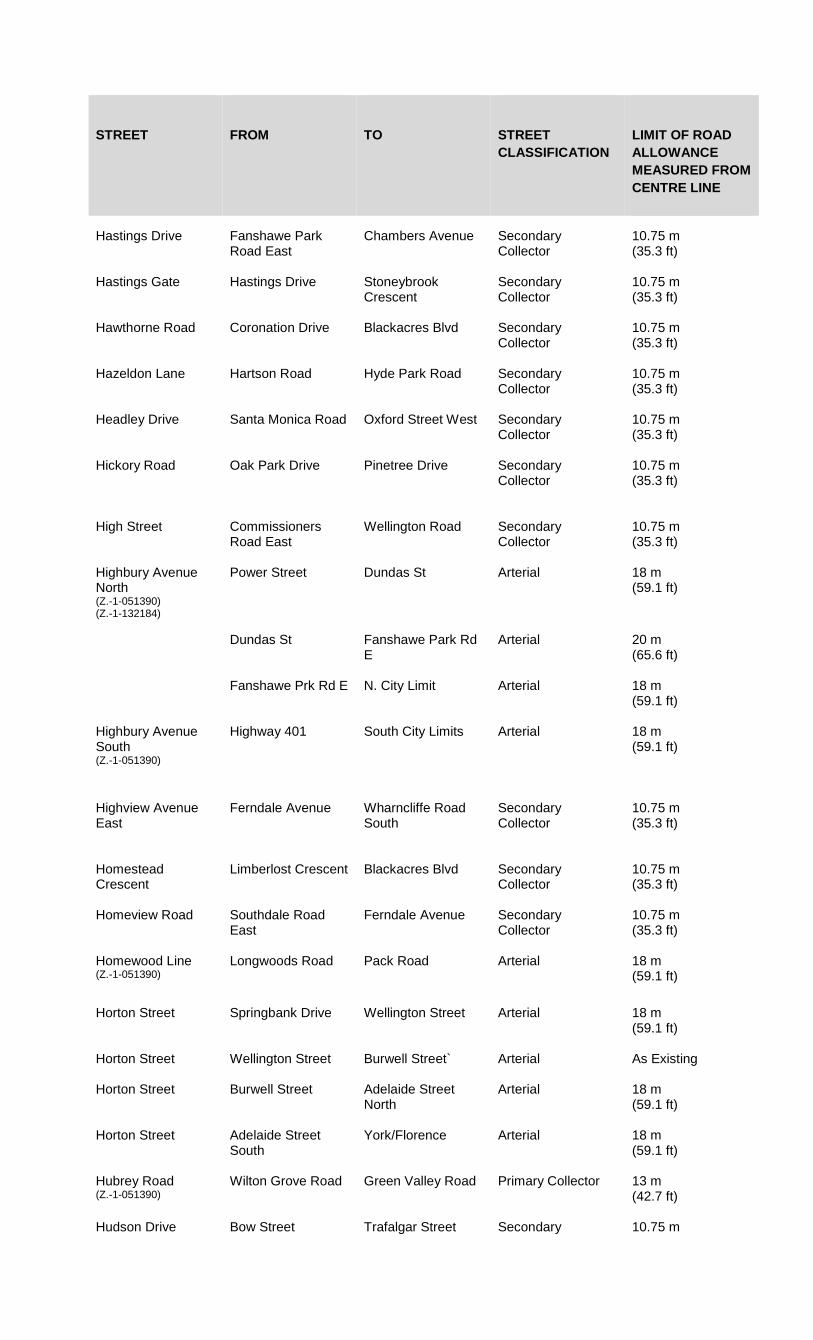
STREET FROM TO STREET CLASSIFICATION
LIMIT OF ROAD ALLOWANCE MEASURED FROM CENTRE LINE
Hastings Drive Fanshawe Park
Road East Chambers Avenue Secondary
Collector
10.75 m (35.3 ft)
Hastings Gate
Hastings Drive Stoneybrook Crescent
Secondary Collector
10.75 m (35.3 ft)
Hawthorne Road Coronation Drive Blackacres Blvd Secondary Collector
10.75 m (35.3 ft)
Hazeldon Lane Hartson Road Hyde Park Road Secondary Collector
10.75 m (35.3 ft)
Headley Drive Santa Monica Road Oxford Street West Secondary Collector
10.75 m (35.3 ft)
Hickory Road Oak Park Drive Pinetree Drive Secondary Collector
10.75 m (35.3 ft)
High Street Commissioners Road East
Wellington Road Secondary Collector
10.75 m (35.3 ft)
Highbury Avenue North (Z.-1-051390) (Z.-1-132184)
Power Street Dundas St Arterial 18 m (59.1 ft)
Dundas St Fanshawe Park Rd E
Arterial 20 m (65.6 ft)
Fanshawe Prk Rd E N. City Limit Arterial 18 m (59.1 ft)
Highbury Avenue South (Z.-1-051390)
Highway 401 South City Limits Arterial 18 m (59.1 ft)
Highview Avenue East
Ferndale Avenue Wharncliffe Road South
Secondary Collector
10.75 m (35.3 ft)
Homestead Crescent
Limberlost Crescent Blackacres Blvd Secondary Collector
10.75 m (35.3 ft)
Homeview Road Southdale Road East
Ferndale Avenue Secondary Collector
10.75 m (35.3 ft)
Homewood Line (Z.-1-051390)
Longwoods Road Pack Road Arterial 18 m (59.1 ft)
Horton Street Springbank Drive Wellington Street Arterial 18 m (59.1 ft)
Horton Street
Wellington Street Burwell Street` Arterial As Existing
Horton Street Burwell Street Adelaide Street North
Arterial 18 m (59.1 ft)
Horton Street Adelaide Street South
York/Florence Arterial 18 m (59.1 ft)
Hubrey Road (Z.-1-051390)
Wilton Grove Road Green Valley Road Primary Collector 13 m (42.7 ft)
Hudson Drive Bow Street Trafalgar Street Secondary 10.75 m

STREET FROM TO STREET CLASSIFICATION
LIMIT OF ROAD ALLOWANCE MEASURED FROM CENTRE LINE
Collector
(35.3 ft)
Hume Street Trafalgar Street Pine Street Secondary Collector
10.75 m (35.3 ft)
Hunt Club Drive Royal York Road Manchester Road Secondary Collector
10.75 m (35.3 ft)
Huntington Drive Chiddington Ave Commissioners Road East
Secondary Collector
10.75 m (35.3 ft)
Huron Street Richmond Street Maitland Street Primary Collector 13 m (42.7 ft)
Huron Street William Street Adelaide Street North
Primary Collector 13 m (42.7 ft)
Huron Street Adelaide Street North
Wager Road Arterial 18 m (59.1 ft)
Huron Street CN Rail Right of Way
Robin’s Hill Road Arterial 18 m (59.1 ft)
Hyde Park Road Riverside Drive Oxford Street West Primary Collector 13 m (42.7 ft)
Hyde Park Road Oxford Street West North City Limits Arterial 18 m (59.1 ft)
Street “A” Hyde Park Road Street B (Plan 39T-11503)
Secondary Collector
10.75 m (35.3 ft)
Street “I” (Z.-1-02986) Deleted by (Z.-1-041203)
Industrial Road Dundas Street 700.0 m North of Oxford Street East
Secondary Collector
10.75 m (35.3 ft)
Ironwood Road Deleted by Z.-1-041203
Ironwood Road (Z.-1-041203)
Wickerson Road Southerly limit of existing Road
Secondary Collector
10.75 m (35.3 ft)
Jackson Road (Z.-1-95310) (Z.-1-02986)
Commissioners Road East
Bradley Avenue Primary Collector As Existing
Jalna Blvd. West Ernest Avenue Southdale Road Secondary Collector
10.75 m (35.3 ft)
Jalna Blvd East Jalna Blvd West Meg Drive Secondary Collector
10.75 m (35.3 ft)
Jalna Blvd Ernest Avenue Meg Drive Primary Collector
13 m (42.7 ft)
James Street (Z.-1-051390)
Colonel Talbot Road
Main Street Secondary Collector
10.75 m (35.3 ft)
Jennifer Road Fanshawe Park Road
Hastings Drive Secondary Collector
As Existing
Jensen Road (Z.-1-95369)
Bentley Drive 30 m West of Stonehenge Road
Secondary Collector
As Existing

STREET FROM TO STREET CLASSIFICATION
LIMIT OF ROAD ALLOWANCE MEASURED FROM CENTRE LINE
Jensen Road Highbury Ave N 500.0 m E of Webster St
Secondary Collector
10.75 m (35.3 ft)
500.0 m E of Webster St
Bentley Dr Secondary Collector
10.75 m (35.3 ft)
Juniper St Dear Park Circle Oxford St W Secondary Collector
10.75 m (35.3 ft)
Street “K” 39T-02505 (Z.-1-041251)
Sunningdale Road West
Street “L” 39T-02505
Secondary Collector
10.75 m (35.3 ft)
Kains Road (Z.-1-00834) (deleted by Z.-1-051389)
Kains Road (Z.-1-051389)
Oxford Street West Westdel Bourne Primary Collector 13 m (42.7 ft)
Kains Road (Z.-1-061542)
Westdel Bourne South-west limit of 39T-05514
Secondary Collector
10.75 m (35.3 ft)
Kains Road (39T-17501) (Z.-1-172596)
North limit of plan Oxford Street W Secondary Collector
10.75 m (35.3 ft)
Kernohan Pkwy Ridgewood Cres.
Springbank Drive Secondary Collector
As Existing
Kerr Rd (Z.-1-051390)
Brady Dr Webber Bourne Arterial 18 m (59.1 ft)
Kilally Rd (Z.-1-071667)
Thames River Edgevalley Road Secondary Collector
10.75 m (35.3 ft)
Edgevalley Road (Z.-1-071667)
Highbury Ave
Primary Collector 18 m (59.1 ft)
Highbury Ave N (Z.-1-051390)
Clarke Rd Arterial 18 m (59.1 ft)
Kilally Rd Clarke Rd 200 m east of Clarke Road
Proposed Arterial 18 m (59.1 ft)
Killarney Road Highbury Avenue North
Cedarhallow Boulevard
Secondary Collector
10.75 m (35.3 ft)
King St (Z.-1-99631)
Thames River Wellington St Arterial 10 m (32.8 ft)
Wellington St Burwell St Arterial As Existing
Burwell St Ontario St
Arterial 13 m (42.7 ft)
King St (Ext) Ridout St N Riverside Dr Arterial 13 m (42.7 ft)
King Edward Ave Commissioners Road E
Thompson Rd Secondary Collector
10.75 m (35.3 ft)
Kingsway Ave Oakridge Dr Wonderland Rd N Secondary Collector
10.75 m (35.3 ft)
Kipps Lane Adelaide St N Briarhill Ave Secondary Collector
10.75 m (35.3 ft)
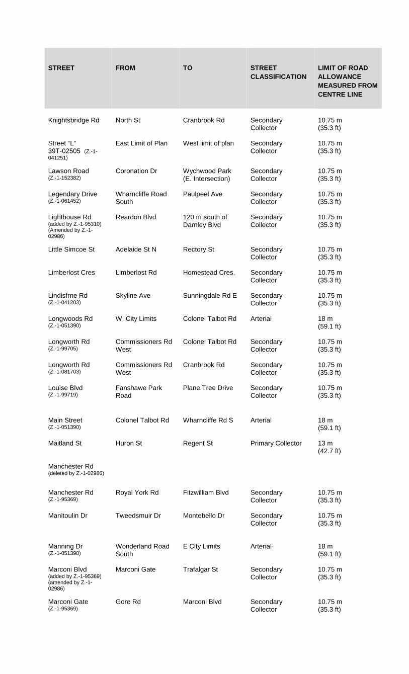
STREET FROM TO STREET CLASSIFICATION
LIMIT OF ROAD ALLOWANCE MEASURED FROM CENTRE LINE
Knightsbridge Rd
North St Cranbrook Rd Secondary Collector
10.75 m (35.3 ft)
Street “L” 39T-02505 (Z.-1-041251)
East Limit of Plan West limit of plan Secondary Collector
10.75 m (35.3 ft)
Lawson Road (Z.-1-152382)
Coronation Dr Wychwood Park (E. Intersection)
Secondary Collector
10.75 m (35.3 ft)
Legendary Drive (Z.-1-061452)
Wharncliffe Road South
Paulpeel Ave Secondary Collector
10.75 m (35.3 ft)
Lighthouse Rd (added by Z.-1-95310) (Amended by Z.-1-02986)
Reardon Blvd 120 m south of Darnley Blvd
Secondary Collector
10.75 m (35.3 ft)
Little Simcoe St
Adelaide St N Rectory St Secondary Collector
10.75 m (35.3 ft)
Limberlost Cres
Limberlost Rd Homestead Cres. Secondary Collector
10.75 m (35.3 ft)
Lindisfrne Rd (Z.-1-041203)
Skyline Ave Sunningdale Rd E Secondary Collector
10.75 m (35.3 ft)
Longwoods Rd (Z.-1-051390)
W. City Limits Colonel Talbot Rd Arterial 18 m (59.1 ft)
Longworth Rd (Z.-1-99705)
Commissioners Rd West
Colonel Talbot Rd
Secondary Collector
10.75 m (35.3 ft)
Longworth Rd (Z.-1-081703)
Commissioners Rd West
Cranbrook Rd Secondary Collector
10.75 m (35.3 ft)
Louise Blvd (Z.-1-99719)
Fanshawe Park Road
Plane Tree Drive Secondary Collector
10.75 m (35.3 ft)
Main Street (Z.-1-051390)
Colonel Talbot Rd Wharncliffe Rd S Arterial 18 m (59.1 ft)
Maitland St Huron St Regent St Primary Collector 13 m (42.7 ft)
Manchester Rd (deleted by Z.-1-02986)
Manchester Rd (Z.-1-95369)
Royal York Rd Fitzwilliam Blvd Secondary Collector
10.75 m (35.3 ft)
Manitoulin Dr Tweedsmuir Dr Montebello Dr Secondary Collector
10.75 m (35.3 ft)
Manning Dr (Z.-1-051390)
Wonderland Road South
E City Limits Arterial 18 m (59.1 ft)
Marconi Blvd (added by Z.-1-95369) (amended by Z.-1-02986)
Marconi Gate Trafalgar St Secondary Collector
10.75 m (35.3 ft)
Marconi Gate (Z.-1-95369)
Gore Rd Marconi Blvd Secondary Collector
10.75 m (35.3 ft)

STREET FROM TO STREET CLASSIFICATION
LIMIT OF ROAD ALLOWANCE MEASURED FROM CENTRE LINE
McGarrell Drive (Z.-1-99719) (Z.-1-01869) (Z.-1-02986)
Louise Blvd Limits of traffic circle at Pinnacle Parkway and McGarrell Pl
Secondary Collector
10.75 m (35.3 ft)
McGarrell Drive (Z.-1-041203)
Plane Tree Dr Louise Blvd Secondary Collector
10.75 m (35.3 ft)
McLean Dr Glenora Dr Fanshawe Park Rd Secondary Collector
10.75 m (35.3 ft)
McMaster Dr Farnham Rd Wonderland Rd S Secondary Collector
10.75 m (35.3 ft)
McNay St Oxford St E Fuller St Secondary Collector
10.75 m (35.3 ft)
Meg Dr Exeter Rd Jalna Blvd Primary Collector 13 m (42.7 ft)
Medway Park 39T-02505 (Z.-1-041251)
East limit of plan West limit of Plan Secondary Collector
10.75 m (35.3 ft)
Medway Park Drive (Z.-1-051330)
West limit of plan East limit of plan Secondary Collector
10.75 m (35.3 ft)
Melsandra Ave Briarhill Ave McNay St Secondary Collector
10.75 m (35.3 ft)
Merlin Cres Whitehall dr Wavell St Secondary Collector
10.75 m (35.3 ft)
Milestone Rd (deleted by Z.-1-01852)
Millbank Dr (N. Leg) Southdale Rd E (West Intersection)
Southdale Rd E (East Intersection)
Secondary Collector
10.75 m (35.3 ft)
Southdale Rd E Bradley Ave Secondary Collector
10.75 m (35.3 ft)
Montebello Dr Gore Rd Manitoulin Dr Secondary Collector
10.75 m (35.3 ft)
Mornington Ave Quebec St Oxford E Secondary Collector
10.75 m (35.3 ft)
Morrison Rd (Z.-1-051390)
Scotland Dr Wonderland Rd S Arterial 18m (59.1 ft)
Murray Rd (Z.-1-051390)
Sharon Rd Westdel Bourne Arterial 18m (59.1 ft)
Nanette Dr (deleted by Z.-1-041203)
Nanette Dr (Z.-1-041203)
Jennifer Rd Chambers Ave Secondary Collector
As Existing
Newbold St
Bessemer Rd Adelaide St S Primary Collector
13 m (42.7 ft)
Nicole Ave (Z.-1-041203)
South Wenige Dr Sunningdale Rd Secondary Collector
10.75 m (35.3 ft)
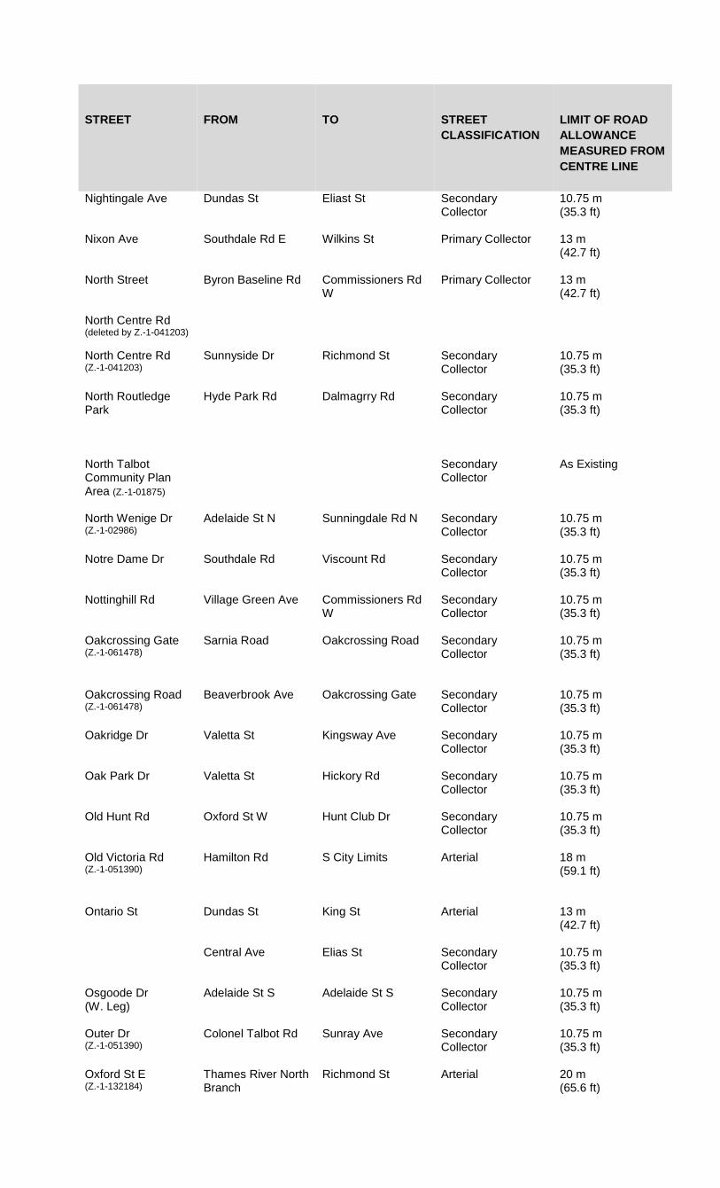
STREET FROM TO STREET CLASSIFICATION
LIMIT OF ROAD ALLOWANCE MEASURED FROM CENTRE LINE
Nightingale Ave Dundas St Eliast St Secondary Collector
10.75 m (35.3 ft)
Nixon Ave Southdale Rd E Wilkins St Primary Collector 13 m (42.7 ft)
North Street Byron Baseline Rd Commissioners Rd W
Primary Collector 13 m (42.7 ft)
North Centre Rd (deleted by Z.-1-041203)
North Centre Rd (Z.-1-041203)
Sunnyside Dr Richmond St Secondary Collector
10.75 m (35.3 ft)
North Routledge Park
Hyde Park Rd Dalmagrry Rd Secondary Collector
10.75 m (35.3 ft)
North Talbot Community Plan Area (Z.-1-01875)
Secondary Collector
As Existing
North Wenige Dr (Z.-1-02986)
Adelaide St N Sunningdale Rd N Secondary Collector
10.75 m (35.3 ft)
Notre Dame Dr Southdale Rd Viscount Rd Secondary Collector
10.75 m (35.3 ft)
Nottinghill Rd Village Green Ave Commissioners Rd W
Secondary Collector
10.75 m (35.3 ft)
Oakcrossing Gate (Z.-1-061478)
Sarnia Road Oakcrossing Road Secondary Collector
10.75 m (35.3 ft)
Oakcrossing Road (Z.-1-061478)
Beaverbrook Ave Oakcrossing Gate Secondary Collector
10.75 m (35.3 ft)
Oakridge Dr Valetta St Kingsway Ave Secondary Collector
10.75 m (35.3 ft)
Oak Park Dr Valetta St Hickory Rd Secondary Collector
10.75 m (35.3 ft)
Old Hunt Rd Oxford St W Hunt Club Dr Secondary Collector
10.75 m (35.3 ft)
Old Victoria Rd (Z.-1-051390)
Hamilton Rd S City Limits Arterial 18 m (59.1 ft)
Ontario St Dundas St King St Arterial 13 m (42.7 ft)
Central Ave Elias St Secondary Collector
10.75 m (35.3 ft)
Osgoode Dr (W. Leg)
Adelaide St S Adelaide St S Secondary Collector
10.75 m (35.3 ft)
Outer Dr (Z.-1-051390)
Colonel Talbot Rd Sunray Ave Secondary Collector
10.75 m (35.3 ft)
Oxford St E (Z.-1-132184)
Thames River North Branch
Richmond St Arterial 20 m (65.6 ft)
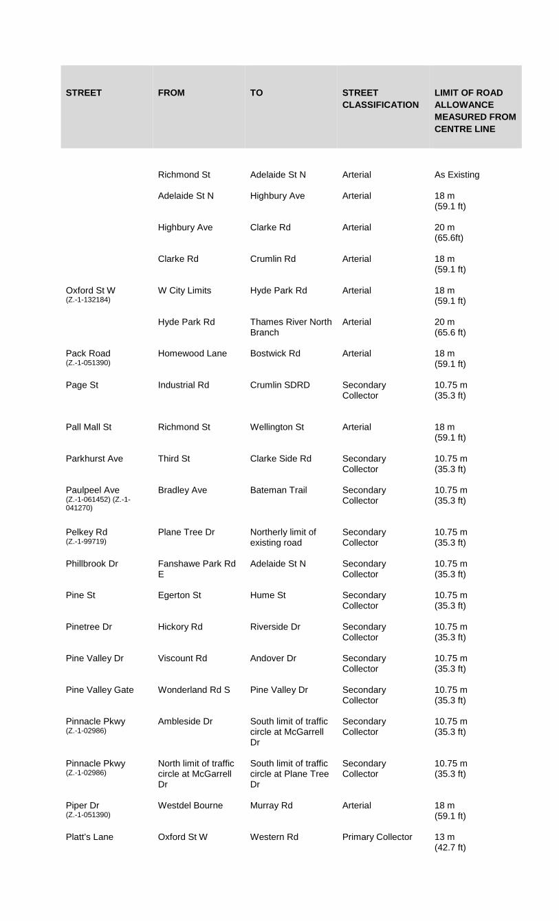
STREET FROM TO STREET CLASSIFICATION
LIMIT OF ROAD ALLOWANCE MEASURED FROM CENTRE LINE
Richmond St Adelaide St N Arterial As Existing
Adelaide St N Highbury Ave Arterial 18 m (59.1 ft)
Highbury Ave Clarke Rd Arterial 20 m (65.6ft)
Clarke Rd Crumlin Rd Arterial 18 m (59.1 ft)
Oxford St W (Z.-1-132184)
W City Limits Hyde Park Rd
Arterial 18 m (59.1 ft)
Hyde Park Rd Thames River North Branch
Arterial 20 m (65.6 ft)
Pack Road (Z.-1-051390)
Homewood Lane Bostwick Rd Arterial 18 m (59.1 ft)
Page St Industrial Rd Crumlin SDRD Secondary Collector
10.75 m (35.3 ft)
Pall Mall St Richmond St Wellington St Arterial 18 m (59.1 ft)
Parkhurst Ave Third St Clarke Side Rd Secondary Collector
10.75 m (35.3 ft)
Paulpeel Ave (Z.-1-061452) (Z.-1-041270)
Bradley Ave Bateman Trail Secondary Collector
10.75 m (35.3 ft)
Pelkey Rd (Z.-1-99719)
Plane Tree Dr Northerly limit of existing road
Secondary Collector
10.75 m (35.3 ft)
Phillbrook Dr Fanshawe Park Rd E
Adelaide St N Secondary Collector
10.75 m (35.3 ft)
Pine St Egerton St Hume St Secondary Collector
10.75 m (35.3 ft)
Pinetree Dr Hickory Rd Riverside Dr Secondary Collector
10.75 m (35.3 ft)
Pine Valley Dr Viscount Rd Andover Dr Secondary Collector
10.75 m (35.3 ft)
Pine Valley Gate Wonderland Rd S Pine Valley Dr Secondary Collector
10.75 m (35.3 ft)
Pinnacle Pkwy (Z.-1-02986)
Ambleside Dr South limit of traffic circle at McGarrell Dr
Secondary Collector
10.75 m (35.3 ft)
Pinnacle Pkwy (Z.-1-02986)
North limit of traffic circle at McGarrell Dr
South limit of traffic circle at Plane Tree Dr
Secondary Collector
10.75 m (35.3 ft)
Piper Dr (Z.-1-051390)
Westdel Bourne Murray Rd Arterial 18 m (59.1 ft)
Platt’s Lane Oxford St W Western Rd Primary Collector 13 m (42.7 ft)
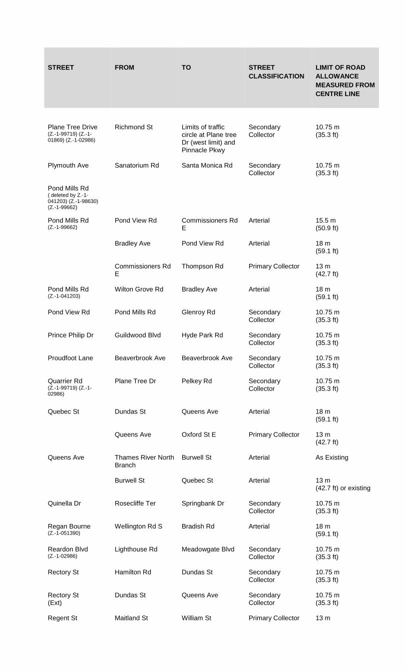
STREET FROM TO STREET CLASSIFICATION
LIMIT OF ROAD ALLOWANCE MEASURED FROM CENTRE LINE
Plane Tree Drive (Z.-1-99719) (Z.-1-01869) (Z.-1-02986)
Richmond St Limits of traffic circle at Plane tree Dr (west limit) and Pinnacle Pkwy
Secondary Collector
10.75 m (35.3 ft)
Plymouth Ave Sanatorium Rd Santa Monica Rd Secondary Collector
10.75 m (35.3 ft)
Pond Mills Rd ( deleted by Z.-1-041203) (Z.-1-98630) (Z.-1-99662)
Pond Mills Rd (Z.-1-99662)
Pond View Rd Commissioners Rd E
Arterial 15.5 m (50.9 ft)
Bradley Ave Pond View Rd Arterial 18 m (59.1 ft)
Commissioners Rd E
Thompson Rd Primary Collector 13 m (42.7 ft)
Pond Mills Rd (Z.-1-041203)
Wilton Grove Rd Bradley Ave Arterial 18 m (59.1 ft)
Pond View Rd Pond Mills Rd Glenroy Rd Secondary Collector
10.75 m (35.3 ft)
Prince Philip Dr Guildwood Blvd Hyde Park Rd Secondary Collector
10.75 m (35.3 ft)
Proudfoot Lane Beaverbrook Ave Beaverbrook Ave Secondary Collector
10.75 m (35.3 ft)
Quarrier Rd (Z.-1-99719) (Z.-1-02986)
Plane Tree Dr Pelkey Rd Secondary Collector
10.75 m (35.3 ft)
Quebec St Dundas St Queens Ave Arterial 18 m (59.1 ft)
Queens Ave Oxford St E Primary Collector
13 m (42.7 ft)
Queens Ave Thames River North Branch
Burwell St Arterial As Existing
Burwell St Quebec St Arterial 13 m (42.7 ft) or existing
Quinella Dr Rosecliffe Ter Springbank Dr Secondary Collector
10.75 m (35.3 ft)
Regan Bourne (Z.-1-051390)
Wellington Rd S Bradish Rd Arterial 18 m (59.1 ft)
Reardon Blvd (Z.-1-02986)
Lighthouse Rd Meadowgate Blvd Secondary Collector
10.75 m (35.3 ft)
Rectory St Hamilton Rd Dundas St Secondary Collector
10.75 m (35.3 ft)
Rectory St (Ext)
Dundas St Queens Ave Secondary Collector
10.75 m (35.3 ft)
Regent St Maitland St William St Primary Collector 13 m
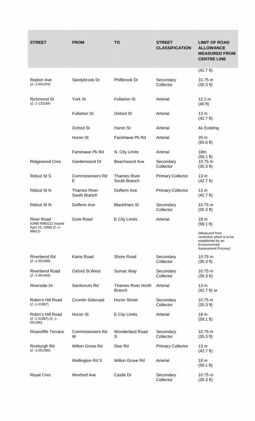
STREET FROM TO STREET CLASSIFICATION
LIMIT OF ROAD ALLOWANCE MEASURED FROM CENTRE LINE (42.7 ft)
Repton Ave (Z.-1-041203)
Sandybrook Dr Phillbrook Dr Secondary Collector
10.75 m (35.3 ft)
Richmond St (Z.-1-132184)
York St Fullarton St Arterial 12.2 m (40 ft)
Fullarton St Oxford St Arterial 13 m (42.7 ft)
Oxford St Huron St Arterial As Existing
Huron St Fanshawe Pk Rd Arterial 20 m (65.6 ft)
Fanshawe Pk Rd N. City Limits Arterial 18m (59.1 ft)
Ridgewood Cres Gardenwood Dr Beachwood Ave Secondary Collector
10.75 m (35.3 ft)
Ridout St S Commissioners Rd E
Thames River South Branch
Primary Collector 13 m (42.7 ft)
Ridout St N Thames River South Branch
Dufferin Ave Primary Collector 13 m (42.7 ft)
Ridout St N Dufferin Ave Blackfriars St Secondary Collector
10.75 m (35.3 ft)
River Road (OMB R980212 Issued April 15, 1999) (Z.-1-98612)
Gore Road E City Limits Arterial 18 m (59.1 ft) (Measured from centerline which is to be established by an Environmental Assessment Process)
Riverbend Rd (Z.-1-051389)
Kains Road Shore Road Secondary Collector
10.75 m (35.3 ft)
Riverbend Road (Z.-1-061483)
Oxford St West Sumac Way Secondary Collector
10.75 m (35.3 ft)
Riverside Dr Sanitorium Rd Thames River North Branch
Arterial 13 m (42.7 ft) or
Robin’s Hill Road (Z.-1-01887)
Crumlin Sideroad Huron Street Secondary Collector
10.75 m (35.3 ft)
Robin’s Hill Road (Z.-1-01887) (Z.-1-051390)
Huron St E City Limits Arterial 18 m (59.1 ft)
Rosecliffe Terrace Commissioners Rd W
Wonderland Road S
Secondary Collector
10.75 m (35.3 ft)
Roxburgh Rd (Z.-1-051390)
Wilton Grove Rd Sise Rd Primary Collector 13 m (42.7 ft)
Wellington Rd S Wilton Grove Rd Arterial 18 m (59.1 ft)
Royal Cres Wexford Ave Castle Dr Secondary Collector
10.75 m (35.3 ft)
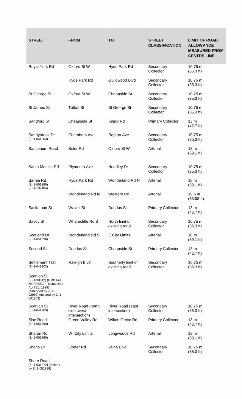
STREET FROM TO STREET CLASSIFICATION
LIMIT OF ROAD ALLOWANCE MEASURED FROM CENTRE LINE
Royal York Rd Oxford St W Hyde Park Rd Secondary Collector
10.75 m (35.3 ft)
Hyde Park Rd Guildwood Blvd Secondary Collector
10.75 m (35.3 ft)
St George St Oxford St W Cheapside St Secondary Collector
10.75 m (35.3 ft)
St James St Talbot St St George St Secondary Collector
10.75 m (35.3 ft)
Sandford St Cheapside St Kilally Rd Primary Collector 13 m (42.7 ft)
Sandybrook Dr (Z.-1-041203)
Chambers Ave Repton Ave Secondary Collector
10.75 m (35.3 ft)
Sanitorium Road Boler Rd Oxford St W Arterial 18 m (59.1 ft)
Santa Monica Rd Plymouth Ave Headley Dr Secondary Collector
10.75 m (35.3 ft)
Sarnia Rd (Z.-1-051390) (Z.-1-132184)
Hyde Park Rd Wonderland Rd N Arterial 18 m (59.1 ft)
Wonderland Rd N Western Rd Arterial 19.5 m (63.98 ft)
Saskatoon St Wavell St Dundas St Primary Collector 13 m (42.7 ft)
Savoy St Wharncliffe Rd S North limit of existing road
Secondary Collector
10.75 m (35.3 ft)
Scotland Dr (Z.-1-051390)
Wonderland Rd S E City Limits Arterial 18 m (59.1 ft)
Second St Dundas St Cheapside St Primary Collector 13 m (42.7 ft)
Settlement Trail (Z.-1-041203)
Raleigh Blvd Southerly limit of existing road
Secondary Collector
10.75 m (35.3 ft)
Scanlon St (Z.-1-98612) (OMB File No R98212 – Issue Date April 15, 1999) (amended by Z.-1-02986) (deleted by Z.-1-041203)
Scanlan St (Z.-1-041203)
River Road (north side, west intersection)
River Road (east intersection)
Secondary Collector
10.75 m (35.3 ft)
Sise Road (Z.-1-051390)
Green Valley Rd Wilton Grove Rd Primary Collector 13 m (42.7 ft)
Sharon Rd (Z.-1-051390)
W. City Limits Longwoods Rd Arterial 18 m (59.1 ft)
Sholto Dr Exeter Rd Jalna Blvd Secondary Collector
10.75 m (35.3 ft)
Shore Road (Z.-1-031072) (deleted by Z.-1-051389)
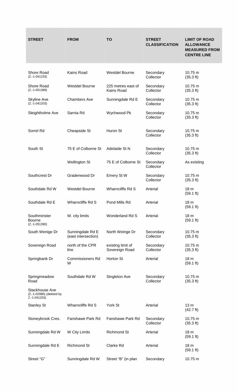
STREET FROM TO STREET CLASSIFICATION
LIMIT OF ROAD ALLOWANCE MEASURED FROM CENTRE LINE
Shore Road (Z.-1-041233)
Kains Road Westdel Bourne Secondary Collector
10.75 m (35.3 ft)
Shore Road (Z.-1-051389)
Westdel Bourne 225 metres east of Kains Road
Secondary Collector
10.75 m (35.3 ft)
Skyline Ave (Z.-1-041203)
Chambers Ave Sunningdale Rd E Secondary Collector
10.75 m (35.3 ft)
Sleightholme Ave Sarnia Rd Wychwood Pk Secondary Collector
10.75 m (35.3 ft)
Sorrel Rd Cheapside St Huron St Secondary Collector
10.75 m (35.3 ft)
South St 75 E of Colborne St Adelaide St N Secondary Collector
10.75 m (35.3 ft)
Wellington St 75 E of Colborne St Secondary Collector
As existing
Southcrest Dr Gradenwood Dr Emery St W Secondary Collector
10.75 m (35.3 ft)
Southdale Rd W Westdel Bourne Wharncilffe Rd S Arterial 18 m (59.1 ft)
Southdale Rd E Wharncliffe Rd S Pond Mills Rd Arterial 18 m (59.1 ft)
Southminster Bourne (Z.-1-051390)
W. city limits Wonderland Rd S Arterial 18 m (59.1 ft)
South Wenige Dr Sunningdale Rd E (east intersection)
North Weinge Dr Secondary Collector
10.75 m (35.3 ft)
Sovereign Road north of the CPR line
existing limit of Sovereign Road
Secondary Collector
10.75 m (35.3 ft)
Springbank Dr Commissioners Rd W
Horton St Arterial 18 m (59.1 ft)
Springmeadow Road
Southdale Rd W Singleton Ave Secondary Collector
10.75 m (35.3 ft)
Stackhouse Ave (Z.-1-02986) (deleted by Z.-1-041203)
Stanley St Wharncliffe Rd S York St Arterial 13 m (42.7 ft)
Stoneybrook Cres. Fanshawe Park Rd Fanshawe Park Rd Secondary Collector
10.75 m (35.3 ft)
Sunningdale Rd W W City Limits Richmond St Arterial 18 m (59.1 ft)
Sunningdale Rd E Richmond St Clarke Rd Arterial 18 m (59.1 ft)
Street “G” Sunningdale Rd W Street “B” (in plan Secondary 10.75 m

STREET FROM TO STREET CLASSIFICATION
LIMIT OF ROAD ALLOWANCE MEASURED FROM CENTRE LINE
39T-11503) Collector (35.3 ft)
Sunnyside Dr Richmond St Doon Dr Secondary Collector
10.75 m (35.3 ft)
Sunray Ave (Z.-1-051390)
Colonel Talbot Rd Outer Dr Secondary Collector
10.75 m (35.3 ft)
Talbot St York St Queens Ave Primary Collector 10.67 m (35 ft)
Queens Ave Fullarton Street Primary Collector 13 m (42.7 ft)
Fullarton Street Dufferin Ave Primary Collector As Existing
Dufferin Ave Oxford St W Primary Collectore 13 m (42.7 ft)
Oxford St W St James St Secondary Collector
10.75 m (35.3 ft)
Tartan Dr Aberdeen Drive Veterans Memorial Parkway
Secondary Collector
As Existing
Veterans Memorial Parkway (Z.-1-061546)
Neptune Cres. Secondary Collector
As Existing
Tartan Dr Railton Ave Veterans Memorial Parkway
Secondary Collector
As Existing
Tavistock Rd Village Green Ave Viscount Rd Secondary Collector
10.75 m (35.3 ft)
Taylor St Victoria St Huron St Secondary Collector
10.75 m (35.3 ft)
Tempo Rd (Z.-1-051390)
Colonel Talbot Rd Glanworth Dr Arterial 18 m (59.1 ft)
Thames St Dundas St Horton St Primary Collector 13 m (42.7 ft)
Third St Dundas St Cheapside St Secondary Collector
10.75 m (35.3 ft)
Thistlewood Dr (Z.-1-02986)
South Wenige Dr Blackwater Rd Secondary Collector
10.75 m (35.3 ft)
Thompson Rd Whetter Ave Thames River Primary Collector 13 m (42.7 ft)
Tillmann Rd (Z.-1-02986) (deleted by Z.-1-041203)
Tillman Rd (Z.-1-041203)
Cranbrook Road Southerly limit of existing road
Secondary Collector
10.75 m (35.3 ft)
Street “B” Tokala Trail North leg at the East limit of plan 39T-11503
Secondary Collector
10.75 m (35.3 ft)
Topping Lane Commissioners Rd W
Berkshire Dr Secondary Collector
10.75 m (35.3 ft)

STREET FROM TO STREET CLASSIFICATION
LIMIT OF ROAD ALLOWANCE MEASURED FROM CENTRE LINE
Townsend Dr (Z.-1-02986)
Blackmaple Drive Highbury Ave N Secondary Collector
10.75 m (35.3 ft)
Trafalgar St Hamilton Rd E City Limits Arterial 18 m (59.1 ft)
Trossack Ave Fanshawe Pk Rd Grenfell Dr Secondary Collector
10.75 m (35.3 ft)
Trott Dr Coombs Ave Platts Lane Secondary Collector
10.75 m (35.3 ft)
Tweedsmuir Ave Hale St Manitoulin Dr Secondary Collector
10.75 m (35.3 ft)
Upper Queen St Wilkins St Commissioners Rd E
Primary Collector 13 m (42.7 ft)
Valetta St Hyde Park Rd Oakridge Dr Secondary Collector
10.75 m (35.3 ft)
Vancouver St Trafalgar St Wavell St Secondary Collector
10.75 m (35.3 ft)
Veterans Memorial Parkway
Highway 401 River Road Freeway 37.5 m (123 ft)
Veterans Memorial Parkway
River Road Huron St Freeway 30 m (98.4 ft)
Veterans Memorial Parkway (Z.-1-13224)
Huron St Clarke Road Proposed Freeway 30 m (98.4 ft)
Veterans Memorial Parkway (Z.-1-132223)
Highway 401 Wilton Grove Road Freeway 30 m (98.4 ft)
Victoria St Taylor St Elliot St Secondary Collector
10.75 m (35.3 ft)
Village Green Ave Viscount Rd Tavistock Rd Secondary Collector
10.75 m (35.3 ft)
Viscount Rd Cranbrook Rd Commissioners Rd W
Primary Collector 13 m (42.7 ft)
Waterloo St (Z.-1-132184)
York St Dundas St Primary Collector As Existing
Dundas St Dufferin Ave Primary Collector
As Existing
Wavell St Brydges St Dundas St Primary Collector 13 m (42.7 ft)
Webber Bourne (Z.-1-051390)
Kerr Rd Highbury Ave Arterial 18m (59.1 ft)
Webster St Huron St Kilally Rd Secondary Collector
10.75 m (35.3 ft)
Webster St (Z.-1-061473)
Kilally Road Highbury Ave N Secondary Collector
10.75 m (35.3 ft)

STREET FROM TO STREET CLASSIFICATION
LIMIT OF ROAD ALLOWANCE MEASURED FROM CENTRE LINE
Wellington Rd (Z.-1-132184)
Thames River South Branch
Bradley Ave Arterial 20 m (65.6 ft)
Bradley Ave Hwy 401 Arterial 18 m (59.1 ft)
Wellington Rd S Hwy 401 S. City Limits Arterial 18 m (59.1 ft)
Wellington St (Z.-1-132184)
Thames River South Branch
York St Arterial 20 m (65.6 ft)
York St Pall Mall St Arterial As Existing
Westdel Bourne Oxford St W S. City Limits Arterial 18 m (59.1 ft)
Kains Rd (Z.-1-041233)
Oxford St W Primary Collector 18 m (59.1 ft)
Westfield Dr Beaverbrook Ave 137.5 East of Beaverbrook Ave
Secondary Collector
10.75 m (35.3 ft)
137.5 East of Beaverbrook Ave
Cherryhill Circle Secondary Collector
As Existing
Oxford St E Kenneth St Primary Collector As Existing
Western Rd (Z.-1-021036)
Wharncliffe Rd N Richmond St Arterial 15.5 m (50.9 ft)
Westminster Ave Base Line Rd Whetter Ave Primary Collector 13 m (42.7 ft)
Westminster Dr (Z.-1-051390)
W. City Limits E. City Limits Arterial 18 m (59.1 ft)
Weston St Wellington Rd Fairview Ave Secondary Collector
10.75 m (35.3 ft)
Wexford Ave Royal Cres Admiral Dr Secondary Collector
10.75 m (35.3 ft)
Wharncliffe Rd S (Z.-1-051390) (Z.-1-132184)
Main St Commissioners Rd Arterial 18 m (59.1 ft)
Wharncliffe Rd S (Z.-1-132184)
Commissioners Rd Riverview Ave Arterial 19.5 m (63.98 ft)
Riverview Ave Thames River Arterial 19.5 m (63.98 ft)
Wharncliffe Rd N Thames River Western Rd Arterial 18 m (59.1 ft)
Whetter Ave Wellington Rd Thompson Rd Secondary Collector
10.75 m (35.3 ft)
Whisperwood Ave Griffith St (w. intersection)
Griffith St (e intersection)
Secondary Collector
10.75 m (35.3 ft)
Whitehall Dr Atkinson Blvd Merlin Cres Secondary Collector
10.75 m (35.3 ft)
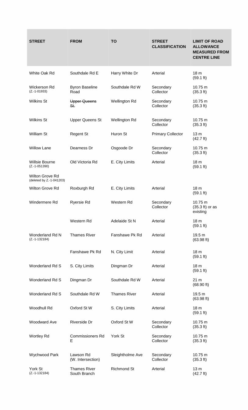
STREET FROM TO STREET CLASSIFICATION
LIMIT OF ROAD ALLOWANCE MEASURED FROM CENTRE LINE
White Oak Rd Southdale Rd E Harry White Dr Arterial 18 m (59.1 ft)
Wickerson Rd (Z.-1-01933)
Byron Baseline Road
Southdale Rd W Secondary Collector
10.75 m (35.3 ft)
Wilkins St Upper Queens St.
Wellington Rd Secondary Collector
10.75 m (35.3 ft)
Wilkins St Upper Queens St Wellington Rd Secondary Collector
10.75 m (35.3 ft)
William St Regent St Huron St Primary Collector 13 m (42.7 ft)
Willow Lane Dearness Dr Osgoode Dr Secondary Collector
10.75 m (35.3 ft)
Willsie Bourne (Z.-1-051390)
Old Victoria Rd E. City Limits Arterial 18 m (59.1 ft)
Wilton Grove Rd (deleted by Z.-1-041203)
Wilton Grove Rd Roxburgh Rd E. City Limits Arterial 18 m (59.1 ft)
Windermere Rd Ryersie Rd Western Rd Secondary Collector
10.75 m (35.3 ft) or as existing
Western Rd Adelaide St N Arterial 18 m (59.1 ft)
Wonderland Rd N (Z.-1-132184)
Thames River Fanshawe Pk Rd Arterial 19.5 m (63.98 ft)
Fanshawe Pk Rd N. City Limit Arterial 18 m (59.1 ft)
Wonderland Rd S
S. City Limits Dingman Dr Arterial 18 m (59.1 ft)
Wonderland Rd S Dingman Dr Southdale Rd W Arterial 21 m (68.90 ft)
Wonderland Rd S Southdale Rd W Thames River Arterial 19.5 m (63.98 ft)
Woodhull Rd Oxford St W S. City Limits Arterial 18 m (59.1 ft)
Woodward Ave Riverside Dr Oxford St W Secondary Collector
10.75 m (35.3 ft)
Wortley Rd Commissioners Rd E
York St Secondary Collector
10.75 m (35.3 ft)
Wychwood Park Lawson Rd (W. Intersection)
Sleightholme Ave Secondary Collector
10.75 m (35.3 ft)
York St (Z.-1-132184)
Thames River South Branch
Richmond St Arterial 13 m (42.7 ft)

STREET FROM TO STREET CLASSIFICATION
LIMIT OF ROAD ALLOWANCE MEASURED FROM CENTRE LINE
Richmond St Waterloo St Arterial 13 m (42.7 ft)
Waterloo St Rectory St Arterial 13 m (42.7 ft)
Street A Sunningdale Rd Richmond St Primary Collector 12.25 m (40 ft)
Street B Street C West limit of Plan 39T-04513
Secondary Collector
10.75 m (35.3 ft)
Street C Street A Street B Secondary Collector
10.75 m (35.3 ft)
(deleted and amended by Z.-1-091888) 4.21.1 Road Allowance Requirements at Intersections The required minimum right-of-way widths shown in Section 4.21 are the minimum requirements for sections of streets. Additional right-of-way on arterial streets of up to 24 m from the centre line of the street will be required within 150 m of an intersection. (Z.-1-132184) 4.21.2 Sight Triangle at Intersections The required minimum right-of-way width on any corner lot will include a triangular area bounded by the street lines and a line joining points on the street lines at a distance of no greater than 6 m. (Z.-1-132184)
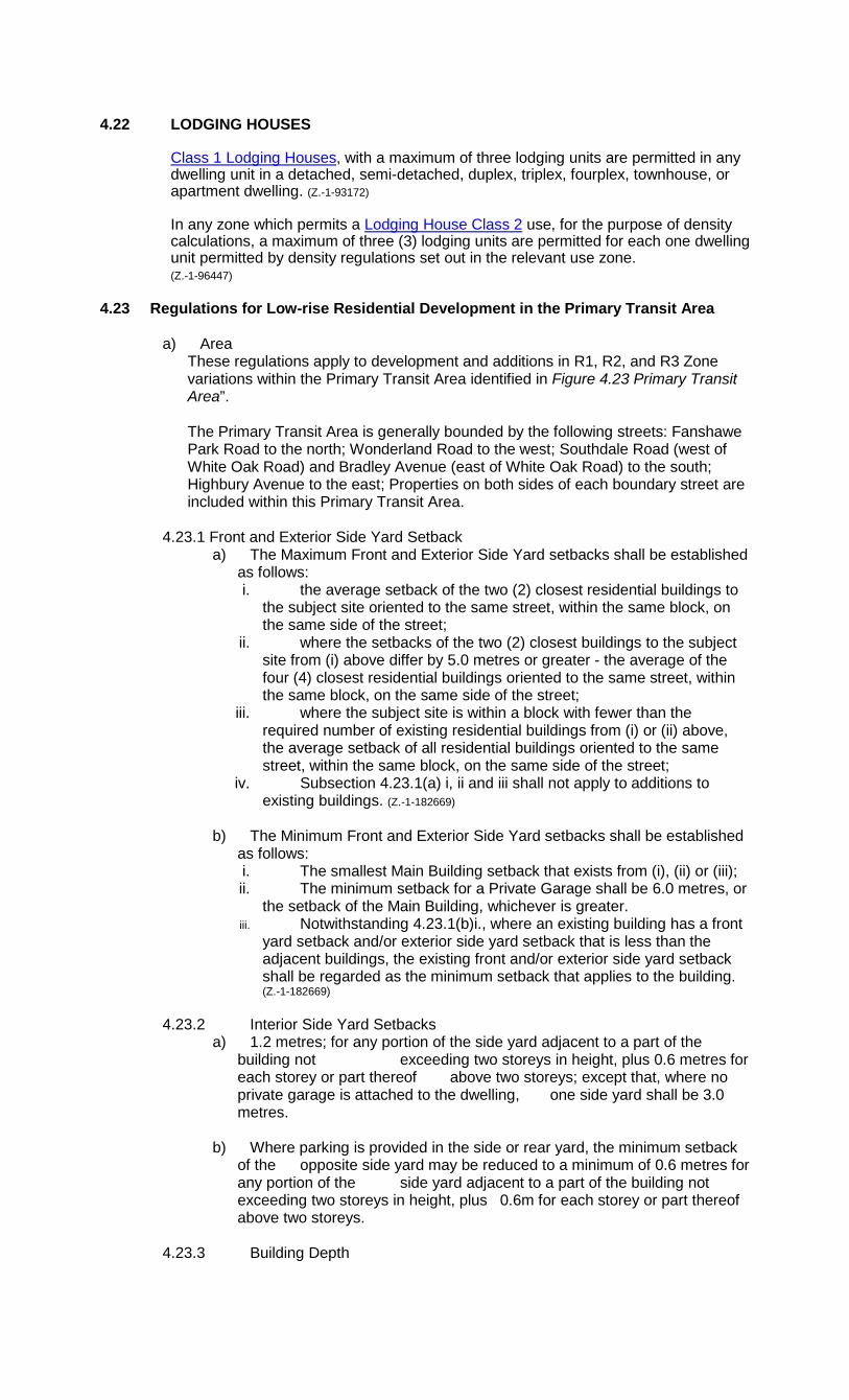
4.22 LODGING HOUSES
Class 1 Lodging Houses, with a maximum of three lodging units are permitted in any dwelling unit in a detached, semi-detached, duplex, triplex, fourplex, townhouse, or apartment dwelling. (Z.-1-93172)
In any zone which permits a Lodging House Class 2 use, for the purpose of density calculations, a maximum of three (3) lodging units are permitted for each one dwelling unit permitted by density regulations set out in the relevant use zone.
(Z.-1-96447) 4.23 Regulations for Low-rise Residential Development in the Primary Transit Area
a) Area
These regulations apply to development and additions in R1, R2, and R3 Zone variations within the Primary Transit Area identified in Figure 4.23 Primary Transit Area”. The Primary Transit Area is generally bounded by the following streets: Fanshawe Park Road to the north; Wonderland Road to the west; Southdale Road (west of White Oak Road) and Bradley Avenue (east of White Oak Road) to the south; Highbury Avenue to the east; Properties on both sides of each boundary street are included within this Primary Transit Area.
4.23.1 Front and Exterior Side Yard Setback
a) The Maximum Front and Exterior Side Yard setbacks shall be established as follows: i. the average setback of the two (2) closest residential buildings to
the subject site oriented to the same street, within the same block, on the same side of the street;
ii. where the setbacks of the two (2) closest buildings to the subject site from (i) above differ by 5.0 metres or greater - the average of the four (4) closest residential buildings oriented to the same street, within the same block, on the same side of the street;
iii. where the subject site is within a block with fewer than the required number of existing residential buildings from (i) or (ii) above, the average setback of all residential buildings oriented to the same street, within the same block, on the same side of the street;
iv. Subsection 4.23.1(a) i, ii and iii shall not apply to additions to existing buildings. (Z.-1-182669)
b) The Minimum Front and Exterior Side Yard setbacks shall be established
as follows: i. The smallest Main Building setback that exists from (i), (ii) or (iii); ii. The minimum setback for a Private Garage shall be 6.0 metres, or
the setback of the Main Building, whichever is greater. iii. Notwithstanding 4.23.1(b)i., where an existing building has a front
yard setback and/or exterior side yard setback that is less than the adjacent buildings, the existing front and/or exterior side yard setback shall be regarded as the minimum setback that applies to the building. (Z.-1-182669)
4.23.2 Interior Side Yard Setbacks
a) 1.2 metres; for any portion of the side yard adjacent to a part of the building not exceeding two storeys in height, plus 0.6 metres for each storey or part thereof above two storeys; except that, where no private garage is attached to the dwelling, one side yard shall be 3.0 metres.
b) Where parking is provided in the side or rear yard, the minimum setback of the opposite side yard may be reduced to a minimum of 0.6 metres for any portion of the side yard adjacent to a part of the building not exceeding two storeys in height, plus 0.6m for each storey or part thereof above two storeys.
4.23.3 Building Depth
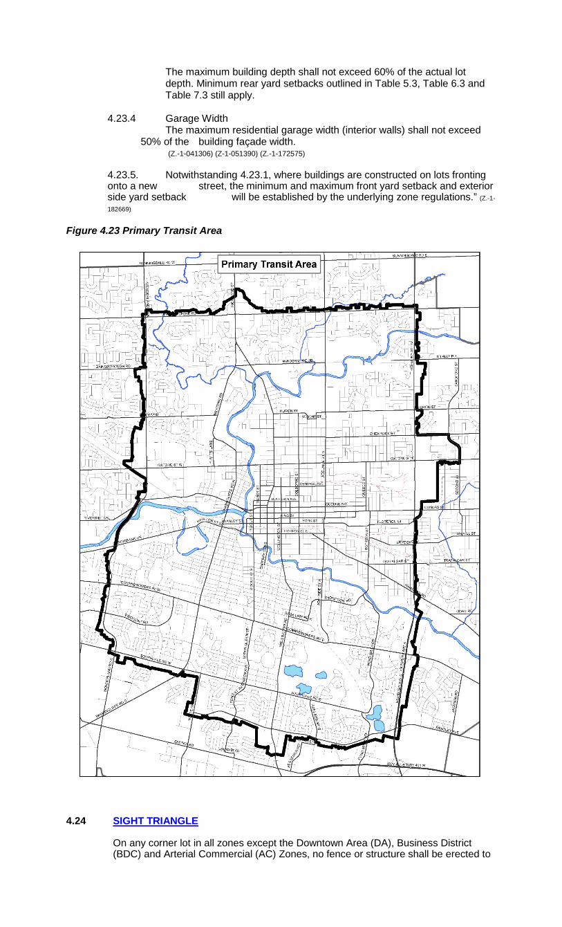
The maximum building depth shall not exceed 60% of the actual lot depth. Minimum rear yard setbacks outlined in Table 5.3, Table 6.3 and Table 7.3 still apply.
4.23.4 Garage Width
The maximum residential garage width (interior walls) shall not exceed 50% of the building façade width.
(Z.-1-041306) (Z-1-051390) (Z.-1-172575)
4.23.5. Notwithstanding 4.23.1, where buildings are constructed on lots fronting onto a new street, the minimum and maximum front yard setback and exterior side yard setback will be established by the underlying zone regulations.” (Z.-1-
182669) Figure 4.23 Primary Transit Area
4.24 SIGHT TRIANGLE
On any corner lot in all zones except the Downtown Area (DA), Business District (BDC) and Arterial Commercial (AC) Zones, no fence or structure shall be erected to
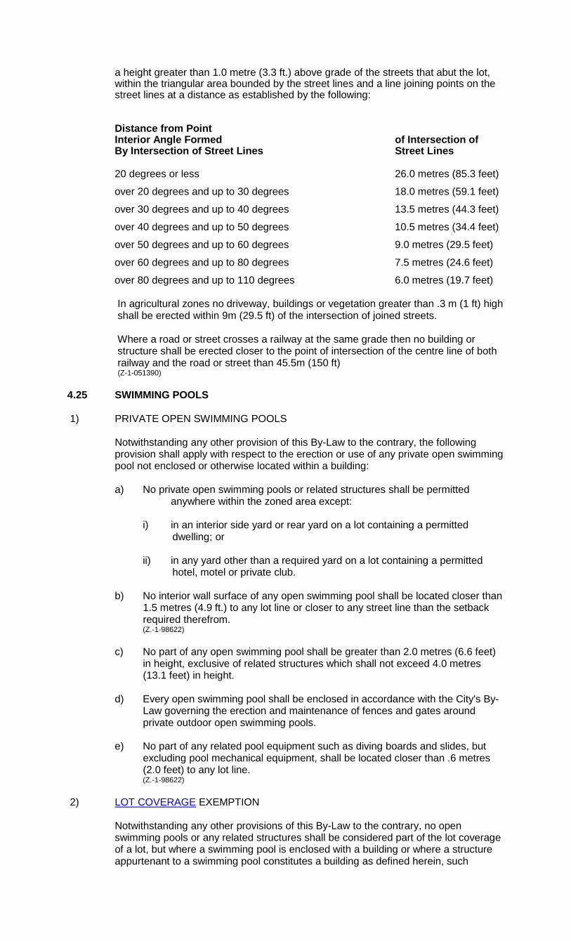
a height greater than 1.0 metre (3.3 ft.) above grade of the streets that abut the lot, within the triangular area bounded by the street lines and a line joining points on the street lines at a distance as established by the following:
Distance from Point Interior Angle Formed of Intersection of By Intersection of Street Lines Street Lines 20 degrees or less 26.0 metres (85.3 feet)
over 20 degrees and up to 30 degrees 18.0 metres (59.1 feet)
over 30 degrees and up to 40 degrees 13.5 metres (44.3 feet)
over 40 degrees and up to 50 degrees 10.5 metres (34.4 feet)
over 50 degrees and up to 60 degrees 9.0 metres (29.5 feet)
over 60 degrees and up to 80 degrees 7.5 metres (24.6 feet)
over 80 degrees and up to 110 degrees 6.0 metres (19.7 feet) In agricultural zones no driveway, buildings or vegetation greater than .3 m (1 ft) high
shall be erected within 9m (29.5 ft) of the intersection of joined streets. Where a road or street crosses a railway at the same grade then no building or
structure shall be erected closer to the point of intersection of the centre line of both railway and the road or street than 45.5m (150 ft)
(Z-1-051390) 4.25 SWIMMING POOLS 1) PRIVATE OPEN SWIMMING POOLS
Notwithstanding any other provision of this By-Law to the contrary, the following provision shall apply with respect to the erection or use of any private open swimming pool not enclosed or otherwise located within a building:
a) No private open swimming pools or related structures shall be permitted
anywhere within the zoned area except: i) in an interior side yard or rear yard on a lot containing a permitted
dwelling; or ii) in any yard other than a required yard on a lot containing a permitted
hotel, motel or private club. b) No interior wall surface of any open swimming pool shall be located closer than
1.5 metres (4.9 ft.) to any lot line or closer to any street line than the setback required therefrom.
(Z.-1-98622) c) No part of any open swimming pool shall be greater than 2.0 metres (6.6 feet)
in height, exclusive of related structures which shall not exceed 4.0 metres (13.1 feet) in height.
d) Every open swimming pool shall be enclosed in accordance with the City's By-
Law governing the erection and maintenance of fences and gates around private outdoor open swimming pools.
e) No part of any related pool equipment such as diving boards and slides, but
excluding pool mechanical equipment, shall be located closer than .6 metres (2.0 feet) to any lot line.
(Z.-1-98622) 2) LOT COVERAGE EXEMPTION
Notwithstanding any other provisions of this By-Law to the contrary, no open swimming pools or any related structures shall be considered part of the lot coverage of a lot, but where a swimming pool is enclosed with a building or where a structure appurtenant to a swimming pool constitutes a building as defined herein, such

building shall comply with any lot coverage requirements set out herein for the zone in which such building is located, but shall be exempt from the lot coverage requirements for accessory uses set out in Subsection 4.1 hereof.
3) INDOOR SWIMMING POOLS
Any swimming pool located within a building as defined herein shall comply with the provisions for accessory uses set out in Subsection 4.1 hereof, where such swimming pool is located within an accessory building, or with the zone requirements set out herein for the zone in which such swimming pool is located, where such swimming pool is located within a main building.

4.26 USES PERMITTED IN LISTED ZONES
Notwithstanding any other provisions of this By-Law, the following uses are permitted in the listed zones provided they can meet the specific provisions of this By-law:
Governing General Provisions Use Zones Permitted Section Accessory Uses, Buildings or Structures All Zones 4.1 Construction Uses All Zones 4.5 Foster Homes All residential and agricultural 4.7 (Z-1-051390) zones Group Homes Type 1 All residential zones 4.8 (Home Occupation reference deleted by Zoning By-law Z.-1-94293) Household Sales (deleted by Z.-1-97466) Private Home Day Care All R1, R2, R3, R4 and R5 4.10 Residential Zones, the Agricultural (AG) Zone and the OC1 and OC2 Zone variations (Z-1-051390) Public Uses All Zones See Section 2, (O.M.B. File #R 910387 - Appeal #9006-2 June 4, 1993) Definition for Public Uses Model Homes All R1,R2,R3,R4,R5 and 4.5 (Z.-1-95317) R6 (excluding apartment buildings) Zones. 4.27 YARD ENCROACHMENTS PERMITTED
In residential zones, institutional zones and in all zones which abut a residential zone, the following yard encroachments shall be permitted. In all other zones, there shall be no restrictions on the permitted encroachments.
Maximum Projection Yard In Which Permitted Into Required Projection is Yards Under Zone Structure Permitted Regulations (1) Steps, open, unenclosed All Unlimited
ramps for physically handicapped persons (2) Window sills, cornices All 0.5 metres (1.6 feet) pilasters, cantilevers, eaves, gutters and similar non-structural archi- tectural features (3) Fire escapes Side & Rear 1.5 metres (4.9 feet) (4) Bay windows, chimneys All 1.3 metres (4.3 feet)
and no closer to any corner of the building
than extent of
projection into yard. (5) Open or covered but All 3.0 metres (9.8 feet)
unenclosed decks or provided projection is porches not exceeding no closer than 1.2 metres one storey in height (3.9 feet) to lot line,
except that where the lot line abuts an OS4 or OS5 Zone the projection shall be no closer than 3.0 metres (9.8 feet) to the lot line.
(Z.-1-93196) (6) Balconies on apartment All 1.5 metres (4.9 feet) buildings provided the projection
is no closer than 3.0 metres (9.8 feet) to the
lot line. (7) Balconies on other Front & Rear 1.5 metres (4.9 feet) dwellings (8) Underground structure All Unlimited (parking, basements) (9) Heat pumps, air All 1.5 metres (4.9 feet) exchangers, air provided the projection conditioners and/or is no closer than 0.9 pool mechanical equipment metres (3.0 feet) to the (Z.-1-98622) lot line. 4.28 YARD REQUIREMENTS ADJACENT TO STREETS GREATER THAN 40.0
METRES
Notwithstanding the minimum yard requirements of this By-Law, with the exception of garages, where a lot fronts onto a street having a right-of-way width of at least 40.0 metres (131.0 feet), there shall be no front yard requirement, and where a lot flanks such a street there shall be no exterior yard requirement.
(Z.-1-97490) 4.29 YARD REQUIREMENTS, EXTERIOR SIDE YARD CONDITION
Notwithstanding the minimum exterior side yard requirements of this By-Law, when a corner lot is sited so that its rear lot line abuts an adjacent interior side yard, the exterior side yard shall be subject to the regulations of a front yard. When a corner lot is sited so that its rear lot line abuts an adjacent rear lot line, the exterior side yard shall be subject to the regulations of an interior side yard.
4.30 YARD REQUIREMENT, REAR YARD TO ARTERIAL ROAD
Notwithstanding the rear yard requirements of this By-Law, with the exception of accessory buildings or structures, where a rear yard abuts an Arterial Street as classified by Section 4.21 (Road Allowance Requirements - Specific Roads), the rear yard requirement shall be increased by 6.0 metres (19.68 feet) except where either a noise attenuation fence or wall is provided.
(Z.-1-97490)(Z.-1-97552) 4.31 ANCILLARY SALE OF AUTOMOBILES
Sales of automobiles ancillary to an automobile repair garage shall be limited to a maximum of six (6) automobiles being stored, kept or displayed for sale on the site at anytime.
(Z.-1-93150) 4.32 MINIMUM DISTANCE SEPARATION (MDS)
4.32 MINIMUM DISTANCE SEPARATION (MDS)
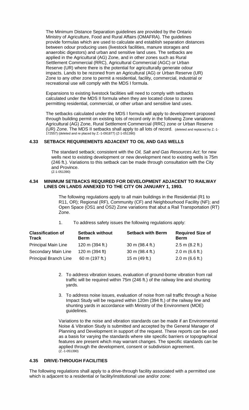
The Minimum Distance Separation guidelines are provided by the Ontario Ministry of Agriculture, Food and Rural Affairs (OMAFRA). The guidelines provide formulas which are used to calculate and establish separation distances between odour producing uses (livestock facilities, manure storages and anaerobic digestors) and urban and sensitive land uses. The setbacks are applied in the Agricultural (AG) Zone, and in other zones such as Rural Settlement Commercial (RRC), Agricultural Commercial (AGC) or Urban Reserve (UR) where there is the potential for agriculturally generate odour impacts. Lands to be rezoned from an Agricultural (AG) or Urban Reserve (UR) Zone to any other zone to permit a residential, facility, commercial, industrial or recreational use will comply with the MDS I formula.
Expansions to existing livestock facilities will need to comply with setbacks calculated under the MDS II formula when they are located close to zones permitting residential, commercial, or other urban and sensitive land uses.
The setbacks calculated under the MDS I formula will apply to development proposed through building permit on existing lots of record only in the following Zone variations: Agricultural (AG) Zone, Rural Settlement Commercial (RRC) zone or Urban Reserve (UR) Zone. The MDS II setbacks shall apply to all lots of record. (deleted and replaced by Z.-1-172557) (deleted and re placed by Z.-1-091877) (Z-1-051390)
4.33 SETBACK REQUIREMENTS ADJACENT TO OIL AND GAS WELLS
The standard setback; consistent with the Oil, Salt and Gas Resources Act; for new wells next to existing development or new development next to existing wells is 75m (246 ft.). Variations to this setback can be made through consultation with the City and Province. (Z-1-051390)
4.34 MINIMUM SETBACKS REQUIRED FOR DEVELOPMENT ADJACENT TO RAILWAY
LINES ON LANDS ANNEXED TO THE CITY ON JANUARY 1, 1993.
The following regulations apply to all main buildings in the Residential (R1 to R11, OR); Regional (RF), Community (CF) and Neighbourhood Facility (NF); and Open Space (OS1 and OS2) Zone variations that abut a Rail Transportation (RT) Zone.
1. To address safety issues the following regulations apply:
2. To address vibration issues, evaluation of ground-borne vibration from rail traffic will be required within 75m (246 ft.) of the railway line and shunting yards.
3. To address noise issues, evaluation of noise from rail traffic through a Noise
Impact Study will be required within 120m (394 ft.) of the railway line and shunting yards in accordance with Ministry of the Environment (MOE) guidelines.
Variations to the noise and vibration standards can be made if an Environmental Noise & Vibration Study is submitted and accepted by the General Manager of Planning and Development in support of the request. These reports can be used as a basis for varying the standards where site specific barriers or topographical features are present which may warrant changes. The specific standards can be applied through the development, consent or subdivision agreement. (Z.-1-051390)
4.35 DRIVE-THROUGH FACILITIES The following regulations shall apply to a drive-through facility associated with a permitted use which is adjacent to a residential or facility/institutional use and/or zone:
Classification of Track
Setback without Berm
Setback with Berm Required Size of Berm
Principal Main Line 120 m (394 ft.) 30 m (98.4 ft.) 2.5 m (8.2 ft.) Secondary Main Line 120 m (394 ft) 30 m (98.4 ft.) 2.0 m (6.6 ft.) Principal Branch Line 60 m (197 ft.) 15 m (49 ft.) 2.0 m (6.6 ft.)

1) SEPARATION DISTANCE - INTERIOR AND REAR YARD The minimum separation distance, measured from the edge of the drive-through lane or speaker location, whichever is closer, to the closest residential/facility/institutional use lot line and/or zone line shall be 30 metres. This setback may be reduced to 15 metres if a 2.4 metre high noise attenuation barrier is installed between the residential/facility/institutional use and the drive-through lane. Further reductions to the setback may be considered upon the City's review and acceptance of mitigation measures identified by a noise study prepared by a qualified noise consultant. A minimum 3 metre wide landscaped strip is required consisting of new and/or existing vegetation immediately adjacent to any noise barrier. 2) SETBACK FROM ULTIMATE ROAD ALLOWANCE The City's preferred location for drive-through facilities is in the rear and/or interior side yard. Drive-through facilities may only be permitted in the front and/or exterior side yard if there are no other design alternatives and/or to address safety considerations. If the drive-through facility is located in the front yard, a landscape plan and building elevation plan is required to illustrate a minimum 3 metre landscaped buffer between the edge of the drive-through lane and the ultimate road allowance all to the satisfaction of the Manager of Site Plan Control. 3) STACKING SPACES The number of stacking spaces required for uses with drive-through facilities are; Donut/Coffee Shop 15 spaces Fast food/Eat-in Restaurant 12 spaces Service station with convenience sales 9 spaces Financial institution/Automated Teller 4 spaces Uses that request a lower stacking lane capacity must submit a queuing study to the City to identify the stacking capacity required. A queuing study is also required when projected volumes are greater than or equal to 60 vehicles/hour. A minimum of 3 spaces or 16m, whichever is greater, is required between the road right-of-way and the entrance to the stacking lane. 4) PARKING SPACES Stacking lane spaces are included in the overall parking requirement for the site. (Z.-1-081795) 4.36 CLINIC, METHADONE AND PHARMACY, METHADONE Notwithstanding any other provision of this by-law, CLINIC, METHADONE or PHARMACY, METHADONE uses shall be permitted solely through amendment to this by-law.
CLINIC, METHADONE or PHARMACY, METHADONE uses shall not be permitted within 300.0 metres (984.3 ft.) of an elementary school, secondary school, municipal library, municipal arena, municipal pool, the Western Fairgrounds or the Boys and Girls Club. This measure shall be taken from property boundary to property boundary.”
CLINIC, METHADONE uses shall require a waiting room area of no less than 15% of the clinic’s total gross floor area. Z.-1-122090
4.37 SECONDARY DWELLING UNITS The provisions of this section shall apply to all secondary dwelling units, unless specified by type directly herein.
1) Permitted Zones
A Secondary Dwelling Unit shall be permitted within any zone in association with the
following uses: a) Single detached dwellings b) Semi-detached dwellings c) Street townhouse dwellings
Single detached dwellings, semi-detached dwellings or street townhouse dwellings containing a secondary dwelling unit on the date of the passing of this by-law, may continue to be used for that purpose if a building permit has been issued under sections 8 or 10 of the Building Code Act, 1992, S.O. 1992, c.23 permitting the erection, alteration, occupancy or use for the secondary dwelling unit, and if the secondary dwelling unit complies with the regulations of the Fire Protection and Prevention Act, 1997, S.O. 1997, c.4..
2) Number of Secondary Dwelling Units Per Lot
A maximum of one (1) secondary dwelling unit shall be permitted per lot; and in the case of a condominium, only one (1) secondary dwelling unit shall be permitted per condominium unit. For the purposes of this section, a condominium unit is considered a lot.
3) Location of Secondary Dwelling Units
A secondary dwelling unit shall not be permitted on a separate lot from the primary dwelling unit that it is accessory to. A secondary dwelling unit or part thereof shall not be permitted in a basement where the finished floor level of such basement is below the level of any sanitary sewer servicing the building or structure in which such basement is located. A secondary dwelling unit or part thereof shall not be permitted in a basement located in a flood plain as regulated by the Conservation Authority having jurisdiction for that area.
4) Location of Secondary Dwelling Units within Accessory Structures
A secondary dwelling unit may be permitted in an accessory structure on the same lot as the primary dwelling, but no more than one (1) secondary dwelling unit shall be permitted per lot. A secondary dwelling unit in an accessory structure shall be required to meet the regulations of the zone which apply to accessory structures. A secondary dwelling unit within an accessory structure may only be permitted in the rear yard or interior side yard.
5) Floor Area Requirements
No secondary dwelling unit shall be erected or used unless it has a minimum gross floor area of 25 square metres. The gross floor area of a secondary dwelling unit shall not be greater than 40% of the combined total gross floor area of the primary dwelling unit and the secondary dwelling unit. For the purposes of calculating gross floor area requirements for secondary dwelling units the following shall not be included: a) additions to dwelling units completed after the date of passage of this by-law;
and b) the gross floor area of accessory structures.
6) Number of Bedrooms
The secondary dwelling unit and primary dwelling unit together shall not exceed the total number of bedrooms permitted for the primary dwelling unit when the total number of bedrooms in the primary and secondary dwelling unit are combined.
7) Access to Secondary Dwelling Units

Exterior alterations to provide for entrance to the secondary dwelling unit within interior side yard and rear yard elevations of the primary dwelling unit may be permitted. A new additional driveway in association with a secondary dwelling unit is not permitted.
8) Secondary Dwelling Units in Accessory Structures
Exterior alterations to accessory structures to permit secondary dwelling units may be permitted.
9) Code Requirements
Secondary dwelling units shall be required to conform to all Ontario Building Code and Ontario Fire Code regulations. (Z.-1-172595)

FIGURE 4.36
(figure replaced by Z.-1-162503)