
Section 33 -...
27
MAP CREATED BY: Date: 11/7/2017 Topo Basemap - ESRI Online,Transmission Line - PSE Bellevue Renton CO AL C R EE K PK W Y Newcastle King County Lake Boren M a y C r e e k 1 2 3 4 5 6 7 8 9 10 11 12 Section 27 Section 33 Section 28 Section 34 Township 23 N Township 24 N NEWCASTLE CONDITIONAL USE PERMIT INDEX / CRITICAL AREAS REVIEW SOURCES: Zoning Residential: R1 Residential: R2 Commercial: C1 No data APPLICANT: Brad Strauch Puget Sound Energy P.O. Box 97034, Bellevue WA 98009-9734 (425) 456 - 2556 ACREAGE IN NEWCASTLE: 18 acres I 0 0.1 0.2 Mile
Transcript of Section 33 -...

MAP CREATED BY:
Date: 11/7/2017Topo Basemap - ESRI Online,Transmission Line - PSE
ST169 ST900
Bellevue
Renton COAL CREEK PKWY
NewcastleKing
County
LakeBoren
MayC ree k
1
2
3
4
5
6
7
8
9
10
11
12
Section 27
Section 33
Section 28
Section 34
Town
ship
23 N
Town
ship
24 N
NEWCASTLE
CONDITIONAL USE PERMIT INDEX /CRITICAL AREAS REVIEW
SOURCES:
ZoningResidential: R1Residential: R2Commercial: C1No data
APPLICANT:Brad StrauchPuget Sound EnergyP.O. Box 97034, Bellevue WA 98009-9734(425) 456 - 2556
ACREAGE IN NEWCASTLE: 18 acres
I 0 0.1 0.2Mile

B e l l e v u e
§̈¦405
ST900 Renton
N e w ca s t l e
8
8
8
8
!( D
!( D&-
&-
5/7C-2AC1
5/7C-2BC1
MB01Type N
128THAVE
SE
NEWCASTLE WAY
SE 69TH PL
1951810010
19518300501951830060 1951830070
1951830080
1951830090
1951830100
28240590502824059050
2824059080
2824059136
6073300320
60733003306073300340 6073300350 6073300360
C i t y o f B e l l e v u e
C i t y o f N e w c a s t l e
SITE PLAN
Da te: 11/7/2017
Path
: G:\P
rojec
ts\Wa
shing
ton\P
uget_
Soun
d_En
ergy_
0070
22\E
nerg
izeEa
stside
Mapb
ook_
1005
9878
\7.2_
WP\
Map_
Docs
\Land
use_
CUP\
Newc
astle
\Non
-Var
iance
\PSE
_New
castl
e_CU
P.mxd
Projec t Corrid or&- Prop osed Pole L oc a tion
!(DExisting Pole L oc a tion–To Be Rem ovedTra nsm ission L ine - Prop osedTra nsm ission L ine - Existing
#* Potentia l Stringing SiteRec om m end ed Ac c ess- Prop osed PoleOlym p ic U nd erground Pip eline (Ap p rox. L oc a tion)U nd erground Power U tility L ineU nd erground Wa ter & Wa stewa ter U tility L inePa rc el (See Ap p x. B)City Jurisd ic tion Bound a ry OPL V a ria nc e (Ea sem ents)
Strea mWetla ndWetla nd or Strea m BufferL a nd slid e Ha za rd L a nd slid e Ha za rd 50ft BufferSteep Slop eSteep Slop e 50ft BufferErosion Ha za rd
I
305+00
300+00
566
5/7SCA15
EAST 106FT/WEST 100FTSTA= EAST 302+65.71/WEST 301+63.71
HT= EAST 106FT/WEST 100FTEL E= EAST 410.71/WEST 415.21
400420440460480
360380
620
500520540560580600
400420440460480
360380
620
500520540560580600
Profile V iewStruc tureTra nsm ission L ineGround L ineMa jor Eleva tion GridMa jor Sta tion GridMinor Sta tion Grid
Sheet 1 of 12
BASED ON PSE ENGINEERINGDESIGN REVISION M (C2)
I 0 25 50Feet
1 inc h = 50 feet
MAP EXTENT
NEWCASTLESOU RCES: Roa d s a nd Pa rc els - King County(2015), Aeria l - King County (2015); Strea m s,Wetla nd s a nd Buffers, L a nd slid e Ha za rd a ndBuffers, a nd Steep Slop es a nd Buffers fromWa tershed Com p a ny (2017).For cartographic purposes only.Note: Underground utility lines are surveyed inthe vicinity of poles only.
5/7C-16A1
Prop osed Pole Num b erStruc ture Typ e (See Ap p x. A)Construc tion Sc ena rio Key(See Ap p x. A)
MATCHLINE - SHEET: 2
88

B e l l e v u e
§̈¦405
ST900 Renton
N e w ca s t l e
8
8
8
!( D!( D&-
&-
5/6C-2AC1
5/6C-2BC1
2064800020
2064800030
2064800080
2064800090 20648001002064800110
2064800120 2064800130
2824059050
2824059080
2824059080
2824059091
2824059144
60733002906073300300
60733003106073300320
Da te: 11/7/2017
Path
: G:\P
rojec
ts\Wa
shing
ton\P
uget_
Soun
d_En
ergy_
0070
22\E
nerg
izeEa
stside
Mapb
ook_
1005
9878
\7.2_
WP\
Map_
Docs
\Land
use_
CUP\
Newc
astle
\Non
-Var
iance
\PSE
_New
castl
e_CU
P.mxd
Pro ject Co rrido r&- Pro po sed Po le Lo ca tio n
!(DExistin g Po le Lo ca tio n –T o Be Rem o vedT ra n sm issio n Lin e - Pro po sedT ra n sm issio n Lin e - Existin g
#* Po ten tia l S trin gin g S iteReco m m en ded Access- Pro po sed Po leOlym pic Un dergro un d Pipelin e (Appro x. Lo ca tio n )Un dergro un d Po wer Utility Lin eUn dergro un d W a ter & W a stewa ter Utility Lin ePa rcel (S ee Appx. B)City Jurisdictio n Bo un da ry OPL Va ria n ce (Ea sem en ts)
S trea mW etla n dW etla n d o r S trea m BufferLa n dslide Ha za rd La n dslide Ha za rd 50ft BufferS teep S lo peS teep S lo pe 50ft BufferEro sio n Ha za rd
I
300+00
295+00
651574
5/6S CA15EAS T 095FT /W ES T 090FTS T A=295+99.63HT =95FT / 90FTELE= EAS T 414.04/W ES T 418.54
400420440460480
SITE PLAN360380
620
500520540560580600
400420440460480
360380
620
500520540560580600
Pro file ViewS tructureT ra n sm issio n Lin eGro un d Lin eMa jo r Eleva tio n GridMa jo r S ta tio n GridMin o r S ta tio n Grid
Sheet 2 of 12
BASED ON PSE ENGINEERINGDESIGN REVISION M (C2)
I 0 25 50Feet
1 in ch = 50 feet
MAP EX T ENT
NEWCASTLES OURCES : Ro a ds a n d Pa rcels - Kin g Co un ty(2015), Aeria l - Kin g Co un ty (2015); S trea m s,W etla n ds a n d Buffers, La n dslide Ha za rd a n dBuffers, a n d S teep S lo pes a n d Buffers fro mW a tershed Co m pa n y (2017).For cartographic purposes only.Note: Underground utility lines are surveyed inthe vicinity of poles only.
5/7C-16A1
Pro po sed Po le Num b erS tructure T ype (S ee Appx. A)Co n structio n S cen a rio Key(S ee Appx. A)
MATCHLINE - SHEET: 1
MATCHLINE - SHEET: 3

B e l l e v u e
§̈¦405
ST900 Renton
N e w ca s t l e
8 8
88
!( D !( D
!( D !( D&-&-
&-&-
5/4C-2AC1
5/4C-2BC1
5/5C-2AC1
5/5C-2BC1
MN01Type Ns
MN01Category III
127TH PL SE
SE 73RD PL
2064800030
2064800040 2064800050 20648000602064800070
2064801100 2064801110 2064801120 2064801130
2064801140
2064801150
2064801160
2064801170
2824059101 28240591593987700145
SITE PLAN
Da te: 11/7/2017
Path
: G:\P
rojec
ts\Wa
shing
ton\P
uget_
Soun
d_En
ergy_
0070
22\E
nerg
izeEa
stside
Mapb
ook_
1005
9878
\7.2_
WP\
Map_
Docs
\Land
use_
CUP\
Newc
astle
\Non
-Var
iance
\PSE
_New
castl
e_CU
P.mxd
Pro ject Co rrido r&- Pro po sed Po le Lo ca tio n
!(DExistin g Po le Lo ca tio n –T o Be Rem o vedT ra n sm issio n Lin e - Pro po sedT ra n sm issio n Lin e - Existin g
#* Po ten tia l S trin gin g S iteReco m m en ded Access- Pro po sed Po leOlym pic Un dergro un d Pipelin e (Appro x. Lo ca tio n )Un dergro un d Po wer Utility Lin eUn dergro un d W a ter & W a stewa ter Utility Lin ePa rcel (S ee Appx. B)City Jurisdictio n Bo un da ry OPL Va ria n ce (Ea sem en ts)
S trea mW etla n dW etla n d o r S trea m BufferLa n dslide Ha za rd La n dslide Ha za rd 50ft BufferS teep S lo peS teep S lo pe 50ft BufferEro sio n Ha za rd
I
290+00
285+00
577
5/5S CA15EAS T 90FT /W ES T 85FTS T A=290+25.51HT =EAS T 90FT / W ES T 85FTELE=EAS T 424.95/W ES T 429.45
5/4S CA15
EAS T 90FT /W ES T 85FTS T A=284+88.02HT =90FT / 85FTELE=EAS T 428.79ELE=W ES T 433.29
400420440460480
340360380
620
500520540560580600
Pro file ViewS tructureT ra n sm issio n Lin eGro un d Lin eMa jo r Eleva tio n GridMa jo r S ta tio n GridMin o r S ta tio n Grid
Sheet 3 of 12
BASED ON PSE ENGINEERINGDESIGN REVISION M (C2)
I 0 25 50Feet
1 in ch = 50 feet
MAP EX T ENT
NEWCASTLES OURCES : Ro a ds a n d Pa rcels - Kin g Co un ty(2015), Aeria l - Kin g Co un ty (2015); S trea m s,W etla n ds a n d Buffers, La n dslide Ha za rd a n dBuffers, a n d S teep S lo pes a n d Buffers fro mW a tershed Co m pa n y (2017).For cartographic purposes only.Note: Underground utility lines are surveyed inthe vicinity of poles only.
5/7C-16A1
Pro po sed Po le Num b erS tructure T ype (S ee Appx. A)Co n structio n S cen a rio Key(S ee Appx. A)
MA
TCH
LIN
E S
HE
ET:
2
MA
TCH
LIN
E S
HE
ET:
4

B e l l e v u e
§̈¦405
ST900 Renton
N e w ca s t l e
8
!( D !( D
!( D !( D
&-&-
&-&-
5/3C-2AC1
5/3C-2BC1
5/4C-2AC1
5/4C-2BC1
MN01Type Ns
MN01Category III
SE 7
6TH
PL
2064800960 2064800970
2064800980 2064801090
20648011002824059041
3987700145
3987700165
3987700175
6388910790
SITE PLAN
Da te: 11/7/2017
Path
: G:\P
rojec
ts\Wa
shing
ton\P
uget_
Soun
d_En
ergy_
0070
22\E
nerg
izeEa
stside
Mapb
ook_
1005
9878
\7.2_
WP\
Map_
Docs
\Land
use_
CUP\
Newc
astle
\Non
-Var
iance
\PSE
_New
castl
e_CU
P.mxd
Pro ject Co rrido r&- Pro po sed Po le Lo ca tio n
!(DExistin g Po le Lo ca tio n –T o Be Rem o vedT ra n sm issio n Lin e - Pro po sedT ra n sm issio n Lin e - Existin g
#* Po ten tia l S trin gin g S iteReco m m en ded Access- Pro po sed Po leOlym pic Un dergro un d Pipelin e (Appro x. Lo ca tio n )Un dergro un d Po wer Utility Lin eUn dergro un d W a ter & W a stewa ter Utility Lin ePa rcel (S ee Appx. B)City Jurisdictio n Bo un da ry OPL Va ria n ce (Ea sem en ts)
S trea mW etla n dW etla n d o r S trea m BufferLa n dslide Ha za rd La n dslide Ha za rd 50ft BufferS teep S lo peS teep S lo pe 50ft BufferEro sio n Ha za rd
I
285+00
5/4S CA15
EAS T 90FT /W ES T 85FTS T A=284+88.02HT =90FT / 85FTELE=EAS T 428.79ELE=W ES T 433.29
280+00
588
5/3S CA15EAS T 110FT /W ES T 105FTS T A=278+60.31HT =EAS T 110FT / W ES T 105FTELE= EAS T 446.62/W ES T 451.62
400420440460480
360380
500520540560580600620640
Pro file ViewS tructureT ra n sm issio n Lin eGro un d Lin eMa jo r Eleva tio n GridMa jo r S ta tio n GridMin o r S ta tio n Grid
Sheet 4 of 12
BASED ON PSE ENGINEERINGDESIGN REVISION M (C2)
I 0 25 50Feet
1 in ch = 50 feet
MAP EX T ENT
NEWCASTLES OURCES : Ro a ds a n d Pa rcels - Kin g Co un ty(2015), Aeria l - Kin g Co un ty (2015); S trea m s,W etla n ds a n d Buffers, La n dslide Ha za rd a n dBuffers, a n d S teep S lo pes a n d Buffers fro mW a tershed Co m pa n y (2017).For cartographic purposes only.Note: Underground utility lines are surveyed inthe vicinity of poles only.
5/7C-16A1
Pro po sed Po le Num b erS tructure T ype (S ee Appx. A)Co n structio n S cen a rio Key(S ee Appx. A)
MA
TCH
LIN
E S
HE
ET:
3
MA
TCH
LIN
E S
HE
ET:
5

B e l l e v u e
§̈¦405
ST900 Renton
N e w ca s t l e
8
!( D
!( D &-&-
5/2C-2AC1
5/2C-2BC1
SE 76TH PL
2824059018
2824059041
39877001756388900230
6388900240
6388900370
6388901430638890TR-C
6388910070 6388910280 6388910290
6388910300
6388910790
SITE PLAN
Da te: 11/7/2017
Path
: G:\P
rojec
ts\Wa
shing
ton\P
uget_
Soun
d_En
ergy_
0070
22\E
nerg
izeEa
stside
Mapb
ook_
1005
9878
\7.2_
WP\
Map_
Docs
\Land
use_
CUP\
Newc
astle
\Non
-Var
iance
\PSE
_New
castl
e_CU
P.mxd
Projec t Corrid or&- Prop osed Pole L oc a tion
!(DExisting Pole L oc a tion–To Be Rem ovedTra nsm ission L ine - Prop osedTra nsm ission L ine - Existing
#* Potentia l Stringing SiteRec om m end ed Ac c ess- Prop osed PoleOlym p ic U nd erground Pip eline (Ap p rox. L oc a tion)U nd erground Power U tility L ineU nd erground Wa ter & Wa stewa ter U tility L inePa rc el (See Ap p x. B)City Jurisd ic tion Bound a ry OPL V a ria nc e (Ea sem ents)
Strea mWetla ndWetla nd or Strea m BufferL a nd slid e Ha za rd L a nd slid e Ha za rd 50ft BufferSteep Slop eSteep Slop e 50ft BufferErosion Ha za rd
I
275+00
722
5/2SCA15EAST 102FT/WEST 95FTSTA=271+37.95HT=EAST 102FT / WEST 95FTEL E= EAST 527.55/ WEST 532.55
400420440460480500520540560580600620640660680700
Profile V iewStruc tureTra nsm ission L ineGround L ineMa jor Eleva tion GridMa jor Sta tion GridMinor Sta tion Grid
Sheet 5 of 12
BASED ON PSE ENGINEERINGDESIGN REVISION M (C2)
I 0 25 50Feet
1 inc h = 50 feet
MAP EXTENT
NEWCASTLESOU RCES: Roa d s a nd Pa rc els - King County(2015), Aeria l - King County (2015); Strea m s,Wetla nd s a nd Buffers, L a nd slid e Ha za rd a ndBuffers, a nd Steep Slop es a nd Buffers fromWa tershed Com p a ny (2017).For cartographic purposes only.Note: Underground utility lines are surveyed inthe vicinity of poles only.
5/7C-16A1
Prop osed Pole Num b erStruc ture Typ e (See Ap p x. A)Construc tion Sc ena rio Key(See Ap p x. A)
MA
TCH
LIN
E S
HE
ET:
4
MA
TCH
LIN
E S
HE
ET:
6
B e l l e v u e
§̈¦405
ST900 Renton
N e w ca s t l e
8 8
8
!( D
!( D&-&-
5/1C-2AC1
5/1C-2BC1
SE 80TH
WAY128TH LN SE
63889002406388900250
63889002606388900340
6388900350
6388900360
63889003706388900980
6388900990638890100063889010106388901020638890103063889010406388901050
6388901160 6388901170
638890TR-C
638890TR-D
638890TR-F
SITE PLAN
Date: 11/7/2017
Path
: G:\P
rojec
ts\Wa
shing
ton\P
uget_
Soun
d_En
ergy_
0070
22\E
nerg
izeEa
stside
Mapb
ook_
1005
9878
\7.2_
WP\
Map_
Docs
\Land
use_
CUP\
Newc
astle
\Non
-Var
iance
\PSE
_New
castl
e_CU
P.mxd
Pro jec t Co rrido r&- Pro p o sed Po le Lo c a tio n
!(DExisting Po le Lo c a tio n–T o Be Remo vedT ra nsmissio n Line - Pro p o sedT ra nsmissio n Line - Existing
#* Po tentia l Stringing SiteRec o mmended Ac c ess- Pro p o sed Po leOlymp ic U ndergro und Pip eline (Ap p ro x. Lo c a tio n)U ndergro und Po wer U tility LineU ndergro und W ater & W a stewater U tility LineParc el (See Ap p x. B)City Jurisdic tio n Bo undary OPL Varia nc e (Ea sements)
Strea mW etla ndW etla nd o r Stream BufferLa ndslide Ha za rd La ndslide Ha za rd 50ft BufferSteep Slo p eSteep Slo p e 50ft BufferEro sio n Ha zard
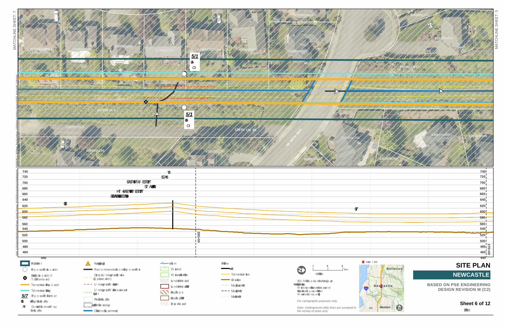
I
270+00
265+00
677
5/1SCA15
EAST 105FT /W EST 92FTSTA=264+60.47
HT =EAST 105FT / W EST 92FTELE= EAST 540.93/ W EST 549.93
625
440460480
740720
500520540560580600620640660680700
440460480
740720
500520540560580600620640660680700
Pro file ViewStructureT ra nsmissio n LineGro und LineMa jo r Elevatio n GridMa jo r Statio n GridMino r Statio n Grid
Sheet 6 of 12
BASED ON PSE ENGINEERINGDESIGN REVISION M (C2)
I 0 25 50Feet
1 inc h = 50 feet
MAP EX T ENT
NEWCASTLESOU RCES: Ro a ds a nd Parc els - K ing Co unty(2015), Aeria l - K ing Co unty (2015); Strea ms,W etla nds a nd Buffers, La ndslide Ha zard a ndBuffers, a nd Steep Slo p es a nd Buffers fro mW atershed Co mp a ny (2017).For cartographic purposes only.Note: Underground utility lines are surveyed inthe vicinity of poles only.
5/7C-16A1
Pro p o sed Po le Numb erStructure T yp e (See Ap p x. A)Co nstructio n Sc ena rio K ey(See Ap p x. A)
MA
TCH
LIN
E S
HE
ET:
5
MA
TCH
LIN
E S
HE
ET:
7

B e l l e v u e
§̈¦405
ST900 Renton
N e w ca s t l e
8 8
8
!( D!( D&-
&-
4/7C-2AC1
4/7C-2BC1
SE84
THST
128TH LN SE128TH LN SE
63889006806388900690 6388900700
63889007106388900720
6388900730
6388901050
6388901060638890107063889010806388901090
63889011006388901110
6388901120 6388901130
6388901140 6388901150
6388901160
6388901260
638890TR-D638890TR-E
638890TR-F
638890TR-G
SITE PLAN
Da te: 11/7/2017
Path
: G:\P
rojec
ts\Wa
shing
ton\P
uget_
Soun
d_En
ergy_
0070
22\E
nerg
izeEa
stside
Mapb
ook_
1005
9878
\7.2_
WP\
Map_
Docs
\Land
use_
CUP\
Newc
astle
\Non
-Var
iance
\PSE
_New
castl
e_CU
P.mxd
Pro ject Co rrido r&- Pro po sed Po le Lo ca tio n
!(DExistin g Po le Lo ca tio n –T o Be Rem o vedT ra n sm issio n Lin e - Pro po sedT ra n sm issio n Lin e - Existin g
#* Po ten tia l S trin gin g S iteReco m m en ded Access- Pro po sed Po leOlym pic Un dergro un d Pipelin e (Appro x. Lo ca tio n )Un dergro un d Po wer Utility Lin eUn dergro un d W a ter & W a stewa ter Utility Lin ePa rcel (S ee Appx. B)City Jurisdictio n Bo un da ry OPL Va ria n ce (Ea sem en ts)
S trea mW etla n dW etla n d o r S trea m BufferLa n dslide Ha za rd La n dslide Ha za rd 50ft BufferS teep S lo peS teep S lo pe 50ft BufferEro sio n Ha za rd
I
625651
260+00
255+00
4/7S CA15EAS T 105FT /W ES T 95FTS T A=258+35.58HT = EAS T 105FT / W ES T 95FTELE= EAS T 513.36/ W ES T 522.36
440460480
740720
500520540560580600620640660680700
460480
740720
500520540560580600620640660680700
Pro file ViewS tructureT ra n sm issio n Lin eGro un d Lin eMa jo r Eleva tio n GridMa jo r S ta tio n GridMin o r S ta tio n Grid
Sheet 7 of 12
BASED ON PSE ENGINEERINGDESIGN REVISION M (C2)
I 0 25 50Feet
1 in ch = 50 feet
MAP EX T ENT
NEWCASTLES OURCES : Ro a ds a n d Pa rcels - Kin g Co un ty(2015), Aeria l - Kin g Co un ty (2015); S trea m s,W etla n ds a n d Buffers, La n dslide Ha za rd a n dBuffers, a n d S teep S lo pes a n d Buffers fro mW a tershed Co m pa n y (2017).For cartographic purposes only.Note: Underground utility lines are surveyed inthe vicinity of poles only.
5/7C-16A1
Pro po sed Po le Num b erS tructure T ype (S ee Appx. A)Co n structio n S cen a rio Key(S ee Appx. A)
MA
TCH
LIN
E S
HE
ET:
6
MA
TCH
LIN
E S
HE
ET:
8
B e l l e v u e
§̈¦405
ST900 Renton
N e w ca s t l e
8
!( D
!( D&-
&-
4/6C-2AC1
4/6C-2BC1
129TH AVE SE
6388900610
6388900620 63889006306388900640 6388900650 6388900660
6388900670
638890074063889007506388900760638890077063889007806388900790
6388900800
6388900810
63889013406388901350
6388901360
6388901370
638890TR-G638890TR-H
SITE PLAN
Da te: 11/7/2017
Path
: G:\P
rojec
ts\Wa
shing
ton\P
uget_
Soun
d_En
ergy_
0070
22\E
nerg
izeEa
stside
Mapb
ook_
1005
9878
\7.2_
WP\
Map_
Docs
\Land
use_
CUP\
Newc
astle
\Non
-Var
iance
\PSE
_New
castl
e_CU
P.mxd
Pro ject Co rrido r&- Pro po sed Po le Lo ca tio n
!(DExistin g Po le Lo ca tio n –T o Be Rem o vedT ra n sm issio n Lin e - Pro po sedT ra n sm issio n Lin e - Existin g
#* Po ten tia l S trin gin g S iteReco m m en ded Access- Pro po sed Po leOlym pic Un dergro un d Pipelin e (Appro x. Lo ca tio n )Un dergro un d Po wer Utility Lin eUn dergro un d W a ter & W a stewa ter Utility Lin ePa rcel (S ee Appx. B)City Jurisdictio n Bo un da ry OPL Va ria n ce (Ea sem en ts)
S trea mW etla n dW etla n d o r S trea m BufferLa n dslide Ha za rd La n dslide Ha za rd 50ft BufferS teep S lo peS teep S lo pe 50ft BufferEro sio n Ha za rd
I
250+00
722
651
4/6S CA15
EAS T 105FT /W ES T 95FTS T A=EAS T 251+84.14 / W ES T 251+34.14
HT =105FT / 95FTELE= EAS T 494.10/ W ES T 498.6
420440460480500520540560580600620640660680700
420440460480500520540560580600620640660680700
Pro file ViewS tructureT ra n sm issio n Lin eGro un d Lin eMa jo r Eleva tio n GridMa jo r S ta tio n GridMin o r S ta tio n Grid
Sheet 8 of 12
BASED ON PSE ENGINEERINGDESIGN REVISION M (C2)
I 0 25 50Feet
1 in ch = 50 feet
MAP EX T ENT
NEWCASTLES OURCES : Ro a ds a n d Pa rcels - Kin g Co un ty(2015), Aeria l - Kin g Co un ty (2015); S trea m s,W etla n ds a n d Buffers, La n dslide Ha za rd a n dBuffers, a n d S teep S lo pes a n d Buffers fro mW a tershed Co m pa n y (2017).For cartographic purposes only.Note: Underground utility lines are surveyed inthe vicinity of poles only.
5/7C-16A1
Pro po sed Po le Num b erS tructure T ype (S ee Appx. A)Co n structio n S cen a rio Key(S ee Appx. A)
MA
TCH
LIN
E S
HE
ET:
7
MA
TCH
LIN
E S
HE
ET:
9

B e l l e v u e
§̈¦405
ST900 Renton
N e w ca s t l e
88
8
!( D
!( D&-
&-
4/5C-2AC1
4/5C-2BC1
SEMAY
CREE
KPA
RKDR
SE86TH
PL
22541000102254100020 2254100030
22541000402254100050
2254100060
2254100320
2254100380
3345100380
33451004276388900830
63889008406388900850
6388901360
6388901370
638890TR-H638890TR-I
SITE PLAN
Da te: 11/7/2017
Path
: G:\P
rojec
ts\Wa
shing
ton\P
uget_
Soun
d_En
ergy_
0070
22\E
nerg
izeEa
stside
Mapb
ook_
1005
9878
\7.2_
WP\
Map_
Docs
\Land
use_
CUP\
Newc
astle
\Non
-Var
iance
\PSE
_New
castl
e_CU
P.mxd
Pro ject Co rrido r&- Pro po sed Po le Lo ca tio n
!(DExistin g Po le Lo ca tio n –T o Be Rem o vedT ra n sm issio n Lin e - Pro po sedT ra n sm issio n Lin e - Existin g
#* Po ten tia l S trin gin g S iteReco m m en ded Access- Pro po sed Po leOlym pic Un dergro un d Pipelin e (Appro x. Lo ca tio n )Un dergro un d Po wer Utility Lin eUn dergro un d W a ter & W a stewa ter Utility Lin ePa rcel (S ee Appx. B)City Jurisdictio n Bo un da ry OPL Va ria n ce (Ea sem en ts)
S trea mW etla n dW etla n d o r S trea m BufferLa n dslide Ha za rd La n dslide Ha za rd 50ft BufferS teep S lo peS teep S lo pe 50ft BufferEro sio n Ha za rd
I
245+00
240+00
619
4/5S CA15
EAS T 97FT /W ES T 96FTS T A=EAS T 251+84.14 / W ES T 251+34.14
HT =EAS T 97FT / W ES T 96FTELE=456.99
400420440460480
340360380
320
500520540560580600620
400420440460480
340360380
320
500520540560580600
Pro file ViewS tructureT ra n sm issio n Lin eGro un d Lin eMa jo r Eleva tio n GridMa jo r S ta tio n GridMin o r S ta tio n Grid
Sheet 9 of 12
BASED ON PSE ENGINEERINGDESIGN REVISION M (C2)
I 0 25 50Feet
1 in ch = 50 feet
MAP EX T ENT
NEWCASTLES OURCES : Ro a ds a n d Pa rcels - Kin g Co un ty(2015), Aeria l - Kin g Co un ty (2015); S trea m s,W etla n ds a n d Buffers, La n dslide Ha za rd a n dBuffers, a n d S teep S lo pes a n d Buffers fro mW a tershed Co m pa n y (2017).For cartographic purposes only.Note: Underground utility lines are surveyed inthe vicinity of poles only.
5/7C-16A1
Pro po sed Po le Num b erS tructure T ype (S ee Appx. A)Co n structio n S cen a rio Key(S ee Appx. A)
MA
TCH
LIN
E S
HE
ET:
8
MA
TCH
LIN
E S
HE
ET:
10

B e l l e v u e
§̈¦405
ST900 Renton
N e w ca s t l e
8
8
!( D
!( D &-&-
4/4C-18AC1
4/4C-18BC1
MN02 (MayCreek)Type F
129TH AVE SE
SE MAY CREEK PARK DR
2254100320
3324059007
3324059014 334510038033451003803345100445
SITE PLAN
Da te: 11/7/2017
Path
: G:\P
rojec
ts\Wa
shing
ton\P
uget_
Soun
d_En
ergy_
0070
22\E
nerg
izeEa
stside
Mapb
ook_
1005
9878
\7.2_
WP\
Map_
Docs
\Land
use_
CUP\
Newc
astle
\Non
-Var
iance
\PSE
_New
castl
e_CU
P.mxd
Pro ject Co rrido r&- Pro po sed Po le Lo ca tio n
!(DExistin g Po le Lo ca tio n –T o Be Rem o vedT ra n sm issio n Lin e - Pro po sedT ra n sm issio n Lin e - Existin g
#* Po ten tia l S trin gin g S iteReco m m en ded Access- Pro po sed Po leOlym pic Un dergro un d Pipelin e (Appro x. Lo ca tio n )Un dergro un d Po wer Utility Lin eUn dergro un d W a ter & W a stewa ter Utility Lin ePa rcel (S ee Appx. B)City Jurisdictio n Bo un da ry OPL Va ria n ce (Ea sem en ts)
S trea mW etla n dW etla n d o r S trea m BufferLa n dslide Ha za rd La n dslide Ha za rd 50ft BufferS teep S lo peS teep S lo pe 50ft BufferEro sio n Ha za rd
I
235+00
982
4/4S CDE30
EAS T 101FT /W ES T 107FTS T A=238+61.44
HT = EAS T 101FT / W ES T 107FTELE=365.16
400420440460
340360380
320300280260
180200220240
400420440460
340360380
320300280260
180200220240
Pro file ViewS tructureT ra n sm issio n Lin eGro un d Lin eMa jo r Eleva tio n GridMa jo r S ta tio n GridMin o r S ta tio n Grid
Sheet 10 of 12
BASED ON PSE ENGINEERINGDESIGN REVISION M (C2)
I 0 25 50Feet
1 in ch = 50 feet
MAP EX T ENT
NEWCASTLES OURCES : Ro a ds a n d Pa rcels - Kin g Co un ty(2015), Aeria l - Kin g Co un ty (2015); S trea m s,W etla n ds a n d Buffers, La n dslide Ha za rd a n dBuffers, a n d S teep S lo pes a n d Buffers fro mW a tershed Co m pa n y (2017).For cartographic purposes only.Note: Underground utility lines are surveyed inthe vicinity of poles only.
5/7C-16A1
Pro po sed Po le Num b erS tructure T ype (S ee Appx. A)Co n structio n S cen a rio Key(S ee Appx. A)
MA
TCH
LIN
E S
HE
ET:
9
MA
TCH
LIN
E S
HE
ET:
11

B e l l e v u e
§̈¦405
ST900 Renton
N e w ca s t l e
8
8
8
!( D!( D
&-&-
4/3C-2AC1
4/3C-2BC1
#*
MN02Category III
3345100380
3345100445
3345100470 3345100472
3345100475
SITE PLAN
Da te: 11/7/2017
Path
: G:\P
rojec
ts\Wa
shing
ton\P
uget_
Soun
d_En
ergy_
0070
22\E
nerg
izeEa
stside
Mapb
ook_
1005
9878
\7.2_
WP\
Map_
Docs
\Land
use_
CUP\
Newc
astle
\Non
-Var
iance
\PSE
_New
castl
e_CU
P.mxd
Pro ject Co rrido r&- Pro po sed Po le Lo ca tio n
!(DExistin g Po le Lo ca tio n –T o Be Rem o vedT ra n sm issio n Lin e - Pro po sedT ra n sm issio n Lin e - Existin g
#* Po ten tia l S trin gin g S iteReco m m en ded Access- Pro po sed Po leOlym pic Un dergro un d Pipelin e (Appro x. Lo ca tio n )Un dergro un d Po wer Utility Lin eUn dergro un d W a ter & W a stewa ter Utility Lin ePa rcel (S ee Appx. B)City Jurisdictio n Bo un da ry OPL Va ria n ce (Ea sem en ts)
S trea mW etla n dW etla n d o r S trea m BufferLa n dslide Ha za rd La n dslide Ha za rd 50ft BufferS teep S lo peS teep S lo pe 50ft BufferEro sio n Ha za rd
I
230+00
225+00
692
4/3S CA15
EAS T 95FT /W ES T 92FTS T A=228+60.27
HT =EAS T 95FT / W ES T 92FTELE=318.99 400
420440460480
340360380
320300280260
200220240
400420440460480
340360380
320300280260
200220240
Pro file ViewS tructureT ra n sm issio n Lin eGro un d Lin eMa jo r Eleva tio n GridMa jo r S ta tio n GridMin o r S ta tio n Grid
Sheet 11 of 12
BASED ON PSE ENGINEERINGDESIGN REVISION M (C2)
I 0 25 50Feet
1 in ch = 50 feet
MAP EX T ENT
NEWCASTLES OURCES : Ro a ds a n d Pa rcels - Kin g Co un ty(2015), Aeria l - Kin g Co un ty (2015); S trea m s,W etla n ds a n d Buffers, La n dslide Ha za rd a n dBuffers, a n d S teep S lo pes a n d Buffers fro mW a tershed Co m pa n y (2017).For cartographic purposes only.Note: Underground utility lines are surveyed inthe vicinity of poles only.
5/7C-16A1
Pro po sed Po le Num b erS tructure T ype (S ee Appx. A)Co n structio n S cen a rio Key(S ee Appx. A)
MA
TCH
LIN
E S
HE
ET:
10
MA
TCH
LIN
E S
HE
ET:
12

B e l l e v u e
§̈¦405
ST900 Renton
N e w ca s t l e
8
8
!( D!( D&-
&-
4/2C-16AA1
4/2C-16BA1
SE95TH
WAY0423059142 3345100445
3345100450
3345100470
3345100475
7788000140
K in g
Co u
n ty
C i t y o f N e w c a s t l e
Cit y
of
R en t
o n
Date: 11/7/2017
Path
: G:\P
rojec
ts\Wa
shing
ton\P
uget_
Soun
d_En
ergy_
0070
22\E
nerg
izeEa
stside
Mapb
ook_
1005
9878
\7.2_
WP\
Map_
Docs
\Land
use_
CUP\
Newc
astle
\Non
-Var
iance
\PSE
_New
castl
e_CU
P.mxd
Pro jec t Co rrido r&- Pro p o sed Po le Lo c a tio n
!(DExisting Po le Lo c a tio n–T o Be Rem o vedT ransm issio n Line - Pro p o sedT ransm issio n Line - Existing
#* Po tentia l Stringing SiteRec o m m ended Ac c ess- Pro p o sed Po leOlym p ic U ndergro und Pip eline (Ap p ro x. Lo c a tio n)U ndergro und Po wer U tility LineU ndergro und W ater & W a stewater U tility LineParc el (See Ap p x. B)City Jurisdic tio n Bo undary OPL Varianc e (Ea sem ents)
Strea mW etla ndW etla nd o r Strea m BufferLandslide Ha za rd Landslide Ha za rd 50ft BufferSteep Slo p eSteep Slo p e 50ft BufferEro sio n Ha zard
I
220+00
831
4/2SCT 10EAST 100FT /W EST 100FTSTA=221+68.01HT = EAST 87FT / W EST 87FTELE=325.36
400420440460480
340360380
320300280
SITE PLAN
500520540560
400420440460480
340360380
320300280
500520540560
Pro file ViewStructureT ransm issio n LineGro und LineMa jo r Elevatio n GridMa jo r Statio n GridMino r Statio n Grid
Sheet 12 of 12
BASED ON PSE ENGINEERINGDESIGN REVISION M (C2)
I 0 25 50Feet
1 inc h = 50 feet
MAP EX T ENT
NEWCASTLESOU RCES: Ro a ds and Parc els - K ing Co unty(2015), Aeria l - K ing Co unty (2015); Strea m s,W etlands and Buffers, Landslide Ha zard andBuffers, and Steep Slo p es and Buffers fro mW a tershed Co m p a ny (2017).For cartographic purposes only.Note: Underground utility lines are surveyed inthe vicinity of poles only.
5/7C-16A1
Pro p o sed Po le Num b erStructure T yp e (See Ap p x. A)Co nstructio n Sc ena rio K ey(See Ap p x. A)
8
K i n g C o u n t y
MA
TCH
LIN
E S
HE
ET:
11

Structure Type Naming Convention DescriptionSCDE C-18 Single circuit deadendSCT C-16 Single circuit tangentSCA C-2 Single circuit angle*number after type in table denotes angle
STRUCTURE TYPES AND CONSTRUCTION SCENARIOS
Appendix A Date: 11/7/2017
BASED ON PSE ENGINEERING DESIGN REVISION M
NEWCASTLE

B e l l e v u e
§̈¦405
Renton
N e w c a s t l e
P P P P
P
P
P P
P
PPP
P
PP
PP
P
PP
P
P
P
P
P
P
!
D
D
8
8 8
8
!( D
!( D
5/7C-2AC1
5/7C-2BC1
NEWCASTLE WAY
APN: 19518300506927 128TH PL SE
APN: 282405905012821 NEWCASTLE WAY
AFN: 2536060APN: 2824059080
12833 NEWCASTLE WAY
AFN: 2536060APN: 2824059136
12828 NEWCASTLE WAY
OPL OPL OPLOPL OPL OPL
C it y
of
B el l
e vu e
C it y
of
Ne w
c as t
l e420418416414412410
418
416
412
410
408
416
414
410
418
416
418416
410
408
422
414
406
420
414
414
408
408
414
408
700
695
699
MB01Type N
DETAIL SHEET
Date : 11/6/2017
Path: G:\Projects\Washington\Puget_Sound_Energy_007022\EnergizeEastsideMapbook_10059878\7.2_WP\Map_Docs\Landuse_CUP\Newcastle\Non-Variance\PSE_Newcastle_DetailSheets.mxd
Legend
IPage 1 of 13
BASED ON PSE ENGINEERINGDESIGN REVISION M (C2)
NEWCASTLESOURCES: Road s and Parc e ls - King County(2015); Stre am s , W e tland s and Buffe rs fromW ate rs he d Com pany (2017); Contours fromPSE (2017).For cartographic purposes only.Note: Underground utility lines are surveyed inthe vicinity of poles only.
I 0 10 20Fe e t
1 inc h = 20 fe e t
M AP EXTENT
5/7C-16A1
Propos e d Pole Num b e rStructure Type (Se e Appx. A)Cons truction Sc e nario Ke y(Se e Appx. A)
Proje ct Corrid or
g-& Propos e d Pole Location
!(DExisting Pole Location–To Be Re m ove dTrans m is s ion Line - Propos e dTrans m is s ion Line - Existing
#* Pote ntial Stringing SiteCity Juris d iction Bound ary Parc e l (Se e Appx. B)OPL Eas e m e ntOlym pic Und e rground Pipe line (Approx. Location)
P Und e rground Powe r Utility LineW W ate r & W as te wate r Utility Line
Re c om m e nd e d Ac c e s s- Propos e d Pole
W e tlandW e tland or Stre am Buffe r2ft ContourSurve ye d Fe ature
Surve ye d Tre e s # (Se e Significant Tre e Inve ntory Tab le )
! Significant Tre e Re taine dE Significant Tre e Re m ove d
"
Tre e (Conife r)Tre e (De cid uous )Existing V e ge tationFe nc e (Existing)M anhole
nm!
!
[ [ [
Eas e m e ntExisting Road C/L
Existing H - Fram e Pole
PSE ENERGIZE EASTSIDE PROJECT
P

B e l l e v u e
§̈¦405
Renton
N e w c a s t l e
P P
PP
!
D
8
8
!( D!( D5/6
C-2AC1
5/6C-2BC1
APN: 20648001207302 127TH PL SE APN: 2064800130
12734 SE 73RD ST
APN: 282405905012821 NEWCASTLE WAY
AFN: 2536060APN: 2824059091
AFN: 2536060APN: 2824059144
12835 NEWCASTLE WAY
APN: 60733002907126 127TH PL SE
OPL OPL OPL
OPL OPL OPL
430
428
420
418
416
426
424426
424
422
424
422
414
412
410
426 422
414
410
412
410
408
406
412
406
430
424
412
406
408
741
743
DETAIL SHEET
Da te: 11/6/2017
Path: G:\Projects\Washington\Puget_Sound_Energy_007022\EnergizeEastsideMapbook_10059878\7.2_WP\Map_Docs\Landuse_CUP\Newcastle\Non-Variance\PSE_Newcastle_DetailSheets.mxd
Legend
IPage 2 of 13
BASED ON PSE ENGINEERINGDESIGN REVISION M (C2)
NEWCASTLESO U RCES: Roa d s a nd Pa rc els - King County(2015); Strea m s, Wetla nd s a nd Buffers fromWa tershed Com p a ny (2017); Contours fromPSE (2017).For cartographic purposes only.Note: Underground utility lines are surveyed inthe vicinity of poles only.
I 0 10 20Feet
1 inc h = 20 feet
MAP EXTENT
5/7C-16A1
Prop osed Pole Num b erStruc ture Typ e (See Ap p x. A)Construc tion Sc ena rio Key(See Ap p x. A)
Projec t Corrid or
g-& Prop osed Pole L oc a tion
!(DExisting Pole L oc a tion–To Be Rem ovedTra nsm ission L ine - Prop osedTra nsm ission L ine - Existing
#* Potentia l Stringing SiteCity Jurisd ic tion Bound a ry Pa rc el (See Ap p x. B)OPL Ea sem entO lym p ic U nd erground Pip eline (Ap p rox. L oc a tion)
P U nd erground Power U tility L ineW Wa ter & Wa stewa ter U tility L ine
Rec om m end ed Ac c ess- Prop osed Pole
Wetla ndWetla nd or Strea m Buffer2ft ContourSurveyed Fea ture
Surveyed Trees # (See Signific a nt Tree Inventory Ta b le)
! Signific a nt Tree Reta inedE Signific a nt Tree Rem oved
"
Tree (Conifer)Tree (Dec id uous)Existing V egeta tionFenc e (Existing)Ma nhole
nm!
!
[ [ [
Ea sem entExisting Roa d C/L
Existing H - Fra m e Pole
PSE ENERGIZE EASTSIDE PROJECT
PP

B e l l e v u e
§̈¦405
Renton
N e w c a s t l e
PP
P P!
D
D8 8
!( D!( D
5/5C-2AC1
5/5C-2BC1
SE 73RD PL
AFN: 2536060APN: 206480003012756 SE 73RD PL
AFN: 2536060APN: 20648000407358 127TH PL SE
AFN: 2536060APN: 20648000507348 127TH PL SE
AFN: 2536060APN: 20648000607340 127TH PL SE
AFN: 2536060APN: 20648000707334 127TH PL SE
AFN: 2536060APN: 206480115012743 SE 73RD PL
APN: 206480116012749 SE 73RD PL
OPL OPL OPL
OPL OPL OPL
420
418416414
432
428
438
436
430
426
424
422
412
436
422
974
970
DETAIL SHEET
Da te: 11/6/2017
Path: G:\Projects\Washington\Puget_Sound_Energy_007022\EnergizeEastsideMapbook_10059878\7.2_WP\Map_Docs\Landuse_CUP\Newcastle\Non-Variance\PSE_Newcastle_DetailSheets.mxd
Legend
IPage 3 of 13
BASED ON PSE ENGINEERINGDESIGN REVISION M (C2)
NEWCASTLESO U RCES: Roa d s a nd Pa rc els - King County(2015); Strea m s, Wetla nd s a nd Buffers fromWa tershed Com p a ny (2017); Contours fromPSE (2017).For cartographic purposes only.Note: Underground utility lines are surveyed inthe vicinity of poles only.
I 0 10 20Feet
1 inc h = 20 feet
MAP EXTENT
5/7C-16A1
Prop osed Pole Num b erStruc ture Typ e (See Ap p x. A)Construc tion Sc ena rio Key(See Ap p x. A)
Projec t Corrid or
g-& Prop osed Pole L oc a tion
!(DExisting Pole L oc a tion–To Be Rem ovedTra nsm ission L ine - Prop osedTra nsm ission L ine - Existing
#* Potentia l Stringing SiteCity Jurisd ic tion Bound a ry Pa rc el (See Ap p x. B)OPL Ea sem entO lym p ic U nd erground Pip eline (Ap p rox. L oc a tion)
P U nd erground Power U tility L ineW Wa ter & Wa stewa ter U tility L ine
Rec om m end ed Ac c ess- Prop osed Pole
Wetla ndWetla nd or Strea m Buffer2ft ContourSurveyed Fea ture
Surveyed Trees # (See Signific a nt Tree Inventory Ta b le)
! Signific a nt Tree Reta inedE Signific a nt Tree Rem oved
"
Tree (Conifer)Tree (Dec id uous)Existing V egeta tionFenc e (Existing)Ma nhole
nm!
!
[ [ [
Ea sem entExisting Roa d C/L
Existing H - Fra m e Pole
PSE ENERGIZE EASTSIDE PROJECT

B e l l e v u e
§̈¦405
Renton
N e w c a s t l e
W
P
P
P
P
8
!( D
!( D
5/4C-2AC1
5/4C-2BC1
APN: 20648011107412 127TH PL SE APN: 2064801120
7406 127TH PL SE
AFN: 25240572524058
APN: 3987700145
OPL OPL OPL
OPL OPL OPL
440
438
436
434
432
430
428
426424422420
446
444
442
440
438436
440
438
436
418
416
434
446 438 434
434
MN01Category
III
MN01Type Ns
DETAIL SHEET
Da te: 11/6/2017
Path: G:\Projects\Washington\Puget_Sound_Energy_007022\EnergizeEastsideMapbook_10059878\7.2_WP\Map_Docs\Landuse_CUP\Newcastle\Non-Variance\PSE_Newcastle_DetailSheets.mxd
Legend
IPage 4 of 13
BASED ON PSE ENGINEERINGDESIGN REVISION M (C2)
NEWCASTLESO U RCES: Roa d s a nd Pa rc els - King County(2015); Strea m s, Wetla nd s a nd Buffers fromWa tershed Com p a ny (2017); Contours fromPSE (2017).For cartographic purposes only.Note: Underground utility lines are surveyed inthe vicinity of poles only.
I 0 10 20Feet
1 inc h = 20 feet
MAP EXTENT
5/7C-16A1
Prop osed Pole Num b erStruc ture Typ e (See Ap p x. A)Construc tion Sc ena rio Key(See Ap p x. A)
Projec t Corrid or
g-& Prop osed Pole L oc a tion
!(DExisting Pole L oc a tion–To Be Rem ovedTra nsm ission L ine - Prop osedTra nsm ission L ine - Existing
#* Potentia l Stringing SiteCity Jurisd ic tion Bound a ry Pa rc el (See Ap p x. B)OPL Ea sem entO lym p ic U nd erground Pip eline (Ap p rox. L oc a tion)
P U nd erground Power U tility L ineW Wa ter & Wa stewa ter U tility L ine
Rec om m end ed Ac c ess- Prop osed Pole
Wetla ndWetla nd or Strea m Buffer2ft ContourSurveyed Fea ture
Surveyed Trees # (See Signific a nt Tree Inventory Ta b le)
! Signific a nt Tree Reta inedE Signific a nt Tree Rem oved
"
Tree (Conifer)Tree (Dec id uous)Existing V egeta tionFenc e (Existing)Ma nhole
nm!
!
[ [ [
Ea sem entExisting Roa d C/L
Existing H - Fra m e Pole
PSE ENERGIZE EASTSIDE PROJECT

B e l l e v u e
§̈¦405
Renton
N e w c a s t l e
D
8
8!( D
!( D5/3C-2AC1
5/3C-2BC1
SE 7
6TH
PL
AFN: 25240572524058
APN: 3987700145
AFN: 2521463APN: 398770016512831 SE 76TH PL
AFN: 2521463APN: 398770017512851 SE 76TH PL
OPLOPL OPL
OPL
OPLOPL
474
472470468
466
464
462
460
458456454452450
448
446
444
442
440
438
436
468
466
442
440438
436436
434
472 466
440
438
434
813
DETAIL SHEET
Da te: 11/6/2017
Path: G:\Projects\Washington\Puget_Sound_Energy_007022\EnergizeEastsideMapbook_10059878\7.2_WP\Map_Docs\Landuse_CUP\Newcastle\Non-Variance\PSE_Newcastle_DetailSheets.mxd
Legend
IPage 5 of 13
BASED ON PSE ENGINEERINGDESIGN REVISION M (C2)
NEWCASTLESO U RCES: Roa d s a nd Pa rc els - King County(2015); Strea m s, Wetla nd s a nd Buffers fromWa tershed Com p a ny (2017); Contours fromPSE (2017).For cartographic purposes only.Note: Underground utility lines are surveyed inthe vicinity of poles only.
I 0 10 20Feet
1 inc h = 20 feet
MAP EXTENT
5/7C-16A1
Prop osed Pole Num b erStruc ture Typ e (See Ap p x. A)Construc tion Sc ena rio Key(See Ap p x. A)
Projec t Corrid or
g-& Prop osed Pole L oc a tion
!(DExisting Pole L oc a tion–To Be Rem ovedTra nsm ission L ine - Prop osedTra nsm ission L ine - Existing
#* Potentia l Stringing SiteCity Jurisd ic tion Bound a ry Pa rc el (See Ap p x. B)OPL Ea sem entO lym p ic U nd erground Pip eline (Ap p rox. L oc a tion)
P U nd erground Power U tility L ineW Wa ter & Wa stewa ter U tility L ine
Rec om m end ed Ac c ess- Prop osed Pole
Wetla ndWetla nd or Strea m Buffer2ft ContourSurveyed Fea ture
Surveyed Trees # (See Signific a nt Tree Inventory Ta b le)
! Signific a nt Tree Reta inedE Signific a nt Tree Rem oved
"
Tree (Conifer)Tree (Dec id uous)Existing V egeta tionFenc e (Existing)Ma nhole
nm!
!
[ [ [
Ea sem entExisting Roa d C/L
Existing H - Fra m e Pole
PSE ENERGIZE EASTSIDE PROJECT

B e l l e v u e
§̈¦405
Renton
N e w c a s t l e
W W
P P
PP8
!( D
!( D
5/2C-2AC1
5/2C-2BC1
AFN: 2521463**APN: 63889002307906 129TH PL SE
AFN: 2523311APN: 63889002407903 129TH PL SE
AFN: 2523311APN: 6388900360
12814 SE 80TH WAY
AFN: 2521463APN: 6388901430
APN: 638890TR-C
AFN: 2521463APN: 6388910070
7901 127TH AVE SE
AFN: 2521463APN: 638891028012648 SE 78TH PL
OPL OPL OPL
OPL OPL OPL
562560558
556
554552550548546
544542
540
536
534
532
530
528
526
524
522
520
518
516
514
512
510
508
506
504
572570
568566
564562560558556554552
550
572570568566564562560
546
554
552
550
548
504
502
566
538
502574
576 574
520520
500
500
DETAIL SHEET
Da te: 11/6/2017
Path: G:\Projects\Washington\Puget_Sound_Energy_007022\EnergizeEastsideMapbook_10059878\7.2_WP\Map_Docs\Landuse_CUP\Newcastle\Non-Variance\PSE_Newcastle_DetailSheets.mxd
Legend
IPage 6 of 13
BASED ON PSE ENGINEERINGDESIGN REVISION M (C2)
NEWCASTLESO U RCES: Roa d s a nd Pa rc els - King County(2015); Strea m s, Wetla nd s a nd Buffers fromWa tershed Com p a ny (2017); Contours fromPSE (2017).For cartographic purposes only.Note: Underground utility lines are surveyed inthe vicinity of poles only.
I 0 10 20Feet
1 inc h = 20 feet
MAP EXTENT
5/7C-16A1
Prop osed Pole Num b erStruc ture Typ e (See Ap p x. A)Construc tion Sc ena rio Key(See Ap p x. A)
Projec t Corrid or
g-& Prop osed Pole L oc a tion
!(DExisting Pole L oc a tion–To Be Rem ovedTra nsm ission L ine - Prop osedTra nsm ission L ine - Existing
#* Potentia l Stringing SiteCity Jurisd ic tion Bound a ry Pa rc el (See Ap p x. B)OPL Ea sem entO lym p ic U nd erground Pip eline (Ap p rox. L oc a tion)
P U nd erground Power U tility L ineW Wa ter & Wa stewa ter U tility L ine
Rec om m end ed Ac c ess- Prop osed Pole
Wetla ndWetla nd or Strea m Buffer2ft ContourSurveyed Fea ture
Surveyed Trees # (See Signific a nt Tree Inventory Ta b le)
! Signific a nt Tree Reta inedE Signific a nt Tree Rem oved
"
Tree (Conifer)Tree (Dec id uous)Existing V egeta tionFenc e (Existing)Ma nhole
nm!
!
[ [ [
Ea sem entExisting Roa d C/L
Existing H - Fra m e Pole
PSE ENERGIZE EASTSIDE PROJECT

B e l l e v u e
§̈¦405
Renton
N e w c a s t l e
P P
PPP
D
DD
8
!( D
!( D
5/1C-2AC1
5/1C-2BC1
128TH LN SE
AFN: 2523311APN: 6388901000
8018 128TH AVE SEAFN: 2523311
APN: 6388901010 8028 128TH AVE SE
AFN: 2523311APN: 6388901020
8104 128TH AVE SEAFN: 2523311
APN: 63889010308114 128TH AVE SE
AFN: 2523311APN: 6388901040
8124 128TH AVE SE
APN: 638890TR-D
APN: 638890TR-F
OPL OPL OPL
OPL OPL OPL
562
560
558
556
554
550
548
546
544
542
540
538
536
534
532
530
528
526
524
548
546
544
540
546
540
536534
518
516
552
522
520
538
562
560
514
1060
12231224
DETAIL SHEET
Da te: 11/6/2017
Path: G:\Projects\Washington\Puget_Sound_Energy_007022\EnergizeEastsideMapbook_10059878\7.2_WP\Map_Docs\Landuse_CUP\Newcastle\Non-Variance\PSE_Newcastle_DetailSheets.mxd
Legend
IPage 7 of 13
BASED ON PSE ENGINEERINGDESIGN REVISION M (C2)
NEWCASTLESO U RCES: Roa d s a nd Pa rc els - King County(2015); Strea m s, Wetla nd s a nd Buffers fromWa tershed Com p a ny (2017); Contours fromPSE (2017).For cartographic purposes only.Note: Underground utility lines are surveyed inthe vicinity of poles only.
I 0 10 20Feet
1 inc h = 20 feet
MAP EXTENT
5/7C-16A1
Prop osed Pole Num b erStruc ture Typ e (See Ap p x. A)Construc tion Sc ena rio Key(See Ap p x. A)
Projec t Corrid or
g-& Prop osed Pole L oc a tion
!(DExisting Pole L oc a tion–To Be Rem ovedTra nsm ission L ine - Prop osedTra nsm ission L ine - Existing
#* Potentia l Stringing SiteCity Jurisd ic tion Bound a ry Pa rc el (See Ap p x. B)OPL Ea sem entO lym p ic U nd erground Pip eline (Ap p rox. L oc a tion)
P U nd erground Power U tility L ineW Wa ter & Wa stewa ter U tility L ine
Rec om m end ed Ac c ess- Prop osed Pole
Wetla ndWetla nd or Strea m Buffer2ft ContourSurveyed Fea ture
Surveyed Trees # (See Signific a nt Tree Inventory Ta b le)
! Signific a nt Tree Reta inedE Signific a nt Tree Rem oved
"
Tree (Conifer)Tree (Dec id uous)Existing V egeta tionFenc e (Existing)Ma nhole
nm!
!
[ [ [
Ea sem entExisting Roa d C/L
Existing H - Fra m e Pole
PSE ENERGIZE EASTSIDE PROJECT

B e l l e v u e
§̈¦405
Renton
N e w c a s t l e
PP
PP
88
!( D
!( D
4/7C-2AC1
4/7C-2BC1
SE84
THST
128TH LN SE
AFN: 2523311APN: 6388901080
8226 128TH AVE SEAFN: 2523311APN: 6388901090
8308 128TH AVE SEAFN: 2523311APN: 6388901100
8318 128TH AVE SE
AFN: 2523311APN: 6388901110
8328 128TH AVE SE
APN: 63889011408300 128TH LN SE
APN: 638890TR-E
APN: 638890TR-F
OPL OPL OPL
OPL
OPL OPL
534
532530
528
526
524
522520
518
516
514
512
510
508
504
538
534
532
530
536
534
528
526
520
516
506
536
514
510
540
524
522
518
502
DETAIL SHEET
Da te: 11/6/2017
Path: G:\Projects\Washington\Puget_Sound_Energy_007022\EnergizeEastsideMapbook_10059878\7.2_WP\Map_Docs\Landuse_CUP\Newcastle\Non-Variance\PSE_Newcastle_DetailSheets.mxd
Legend
IPage 8 of 13
BASED ON PSE ENGINEERINGDESIGN REVISION M (C2)
NEWCASTLESO U RCES: Roa d s a nd Pa rc els - King County(2015); Strea m s, Wetla nd s a nd Buffers fromWa tershed Com p a ny (2017); Contours fromPSE (2017).For cartographic purposes only.Note: Underground utility lines are surveyed inthe vicinity of poles only.
I 0 10 20Feet
1 inc h = 20 feet
MAP EXTENT
5/7C-16A1
Prop osed Pole Num b erStruc ture Typ e (See Ap p x. A)Construc tion Sc ena rio Key(See Ap p x. A)
Projec t Corrid or
g-& Prop osed Pole L oc a tion
!(DExisting Pole L oc a tion–To Be Rem ovedTra nsm ission L ine - Prop osedTra nsm ission L ine - Existing
#* Potentia l Stringing SiteCity Jurisd ic tion Bound a ry Pa rc el (See Ap p x. B)OPL Ea sem entO lym p ic U nd erground Pip eline (Ap p rox. L oc a tion)
P U nd erground Power U tility L ineW Wa ter & Wa stewa ter U tility L ine
Rec om m end ed Ac c ess- Prop osed Pole
Wetla ndWetla nd or Strea m Buffer2ft ContourSurveyed Fea ture
Surveyed Trees # (See Signific a nt Tree Inventory Ta b le)
! Signific a nt Tree Reta inedE Signific a nt Tree Rem oved
"
Tree (Conifer)Tree (Dec id uous)Existing V egeta tionFenc e (Existing)Ma nhole
nm!
!
[ [ [
Ea sem entExisting Roa d C/L
Existing H - Fra m e Pole
PSE ENERGIZE EASTSIDE PROJECT

B e l l e v u e
§̈¦405
Renton
N e w c a s t l e
PP
P P P
P PP
PPPP
D
!
!
D
8
!( D
!( D
4/6C-2AC1
4/6C-2BC1
AFN: 2522297APN: 6388900620
8452 128TH AVE SEAFN: 2522297
APN: 63889006308446 128TH AVE SE
AFN: 2522297APN: 6388900640
8440 128TH AVE SEAFN: 2522297
APN: 63889006508434 128TH AVE SE
AFN: 25222972523311
APN: 63889007508441 129TH AVE SE
AFN: 2522297APN: 6388900760
8449 129TH AVE SEAFN: 2522297
APN: 63889007708457 129TH AVE SE
AFN: 2522297APN: 6388900780
8505 129TH AVE SEAFN: 2522297
APN: 63889007908515 129TH AVE SE
APN: 638890TR-G
OPL OPL OPL
OPL OPL OPL
508
502
500
494
492
490
488
482
506
504
502506
504
506
504
506
504
498
496
486484
498
486
484
480
496
486
132013191428
1274
DETAIL SHEET
Da te: 11/6/2017
Path: G:\Projects\Washington\Puget_Sound_Energy_007022\EnergizeEastsideMapbook_10059878\7.2_WP\Map_Docs\Landuse_CUP\Newcastle\Non-Variance\PSE_Newcastle_DetailSheets.mxd
Legend
IPage 9 of 13
BASED ON PSE ENGINEERINGDESIGN REVISION M (C2)
NEWCASTLESO U RCES: Roa d s a nd Pa rc els - King County(2015); Strea m s, Wetla nd s a nd Buffers fromWa tershed Com p a ny (2017); Contours fromPSE (2017).For cartographic purposes only.Note: Underground utility lines are surveyed inthe vicinity of poles only.
I 0 10 20Feet
1 inc h = 20 feet
MAP EXTENT
5/7C-16A1
Prop osed Pole Num b erStruc ture Typ e (See Ap p x. A)Construc tion Sc ena rio Key(See Ap p x. A)
Projec t Corrid or
g-& Prop osed Pole L oc a tion
!(DExisting Pole L oc a tion–To Be Rem ovedTra nsm ission L ine - Prop osedTra nsm ission L ine - Existing
#* Potentia l Stringing SiteCity Jurisd ic tion Bound a ry Pa rc el (See Ap p x. B)OPL Ea sem entO lym p ic U nd erground Pip eline (Ap p rox. L oc a tion)
P U nd erground Power U tility L ineW Wa ter & Wa stewa ter U tility L ine
Rec om m end ed Ac c ess- Prop osed Pole
Wetla ndWetla nd or Strea m Buffer2ft ContourSurveyed Fea ture
Surveyed Trees # (See Signific a nt Tree Inventory Ta b le)
! Signific a nt Tree Reta inedE Signific a nt Tree Rem oved
"
Tree (Conifer)Tree (Dec id uous)Existing V egeta tionFenc e (Existing)Ma nhole
nm!
!
[ [ [
Ea sem entExisting Roa d C/L
Existing H - Fra m e Pole
PSE ENERGIZE EASTSIDE PROJECT
P

B e l l e v u e
§̈¦405
Renton
N e w c a s t l e
W
W
W
W
W PP
P
P P P
D
D
D
8
!( D
!( D
4/5C-2AC1
4/5C-2BC1APN: 2254100050
8811 129TH AVE SE
APN: 225410006012922 SE 88TH PL
AFN: 2524526APN: 2254100380
AFN: 25245262578320
APN: 334510042712636 SE MAY CREEK PARK DR
AFN: 2523311APN: 638890083012917 SE 86TH PL
AFN: 2523311APN: 63889008408605 129TH CT SE
AFN: 2523311APN: 63889008508613 129TH CT SE
APN: 638890TR-I
OPL OPL OPL
OPL
OPL
OPL
450448
446444
442440
438
436
432
430428
418
416
414
412472
470
454452
450
468
466
464
462
460
458
456
452
434
426
424
422
420
472
456
450 448
1429
14311432
DETAIL SHEET
Da te: 11/6/2017
Path: G:\Projects\Washington\Puget_Sound_Energy_007022\EnergizeEastsideMapbook_10059878\7.2_WP\Map_Docs\Landuse_CUP\Newcastle\Non-Variance\PSE_Newcastle_DetailSheets.mxd
Legend
IPage 10 of 13
BASED ON PSE ENGINEERINGDESIGN REVISION M (C2)
NEWCASTLESO U RCES: Roa d s a nd Pa rc els - King County(2015); Strea m s, Wetla nd s a nd Buffers fromWa tershed Com p a ny (2017); Contours fromPSE (2017).For cartographic purposes only.Note: Underground utility lines are surveyed inthe vicinity of poles only.
I 0 10 20Feet
1 inc h = 20 feet
MAP EXTENT
5/7C-16A1
Prop osed Pole Num b erStruc ture Typ e (See Ap p x. A)Construc tion Sc ena rio Key(See Ap p x. A)
Projec t Corrid or
g-& Prop osed Pole L oc a tion
!(DExisting Pole L oc a tion–To Be Rem ovedTra nsm ission L ine - Prop osedTra nsm ission L ine - Existing
#* Potentia l Stringing SiteCity Jurisd ic tion Bound a ry Pa rc el (See Ap p x. B)OPL Ea sem entO lym p ic U nd erground Pip eline (Ap p rox. L oc a tion)
P U nd erground Power U tility L ineW Wa ter & Wa stewa ter U tility L ine
Rec om m end ed Ac c ess- Prop osed Pole
Wetla ndWetla nd or Strea m Buffer2ft ContourSurveyed Fea ture
Surveyed Trees # (See Signific a nt Tree Inventory Ta b le)
! Signific a nt Tree Reta inedE Signific a nt Tree Rem oved
"
Tree (Conifer)Tree (Dec id uous)Existing V egeta tionFenc e (Existing)Ma nhole
nm!
!
[ [ [
Ea sem entExisting Roa d C/L
Existing H - Fra m e Pole
PSE ENERGIZE EASTSIDE PROJECT

B e l l e v u e
§̈¦405
Renton
N e w c a s t l e
P
P
8
8
!( D
!( D
4/4C-18AC1
4/4C-18BC1
SE MAY CREEK PARK
DR
APN: 22541000108843 129TH AVE SE
APN: 22541003208851 129TH AVE SE
AFN: 2524526APN: 2254100380
AFN: reserved in wdAPN: 3324059007
AFN: reserved in wdAPN: 3324059014 AFN: 2516326
reserved in wdAPN: 3345100380
OPL OPL
OPL OPL OPL
396
39439239038838638
4382380378376
372
370368366
364
362
360
358
356
354
352350348346
344342
340
338336334332330
370368
366364
362376374
328326
324
322
320
374
372
398
348
348
DETAIL SHEET
Date: 11/6/2017
Path: G:\Projects\Washington\Puget_Sound_Energy_007022\EnergizeEastsideMapbook_10059878\7.2_WP\Map_Docs\Landuse_CUP\Newcastle\Non-Variance\PSE_Newcastle_DetailSheets.mxd
Legend
IPage 11 of 13
BASED ON PSE ENGINEERINGDESIGN REVISION M (C2)
NEWCASTLESOU RCES: Ro a ds a nd Parc els - K ing Co unty(2015); Strea m s, Wetla nds a nd Buffers fro mWatershed Co m p a ny (2017); Co nto urs fro mPSE (2017).For cartographic purposes only.Note: Underground utility lines are surveyed inthe vicinity of poles only.
I 0 10 20Feet
1 inc h = 20 feet
MAP EX T EN T
5/7C-16A1
Pro p o sed Po le Num b erStructure T yp e (See Ap p x. A)Co nstructio n Sc ena rio K ey(See Ap p x. A)
Pro jec t Co rrido r
g-& Pro p o sed Po le Lo c a tio n
!(DExisting Po le Lo c a tio n–T o Be Rem o vedT ra nsm issio n Line - Pro p o sedT ra nsm issio n Line - Existing
#* Po tentia l Stringing SiteCity Jurisdic tio n Bo undary Parc el (See Ap p x. B)OPL Ea sem entOlym p ic U ndergro und Pip eline (Ap p ro x. Lo c a tio n)
P U ndergro und Po wer U tility LineW Water & Wa stewater U tility Line
Rec o m m ended Ac c ess- Pro p o sed Po le
Wetla ndWetla nd o r Strea m Buffer2ft Co nto urSurveyed Feature
Surveyed T rees # (See Signific a nt Tree Invento ry T a b le)
! Signific a nt T ree Reta inedE Signific a nt T ree Rem o ved
"
T ree (Co nifer)T ree (Dec iduo us)Existing Vegeta tio nFenc e (Existing)Ma nho le
nm!
!
[ [ [
Ea sem entExisting Ro a d C/L
Existing H - Fra m e Po le
PSE ENERGIZE EASTSIDE PROJECT
g

B e l l e v u e
§̈¦405
Renton
N e w c a s t l e
W
P
P
8
!( D!( D
4/3C-2AC1
4/3C-2BC1
AFN: 2516326reserved in wd
APN: 3345100380
AFN: 2514683reserved in wd
APN: 3345100445
APN: 3345100475
OPL OPL OPL
OPL
OPL OPL
312
310
308
304302
298
296
294292
288286
306
302300298296294292290288286284316
314
312
300
298
320
318
314
312
314290
304
296
320
320
316
300
296
318
DETAIL SHEET
Date: 11/6/2017
Path: G:\Projects\Washington\Puget_Sound_Energy_007022\EnergizeEastsideMapbook_10059878\7.2_WP\Map_Docs\Landuse_CUP\Newcastle\Non-Variance\PSE_Newcastle_DetailSheets.mxd
Legend
IPage 12 of 13
BASED ON PSE ENGINEERINGDESIGN REVISION M (C2)
NEWCASTLESOU RCES: Ro a ds a nd Parc els - K ing Co unty(2015); Strea m s, Wetla nds a nd Buffers fro mWatershed Co m p a ny (2017); Co nto urs fro mPSE (2017).For cartographic purposes only.Note: Underground utility lines are surveyed inthe vicinity of poles only.
I 0 10 20Feet
1 inc h = 20 feet
MAP EX T EN T
5/7C-16A1
Pro p o sed Po le Num b erStructure T yp e (See Ap p x. A)Co nstructio n Sc ena rio K ey(See Ap p x. A)
Pro jec t Co rrido r
g-& Pro p o sed Po le Lo c a tio n
!(DExisting Po le Lo c a tio n–T o Be Rem o vedT ra nsm issio n Line - Pro p o sedT ra nsm issio n Line - Existing
#* Po tentia l Stringing SiteCity Jurisdic tio n Bo undary Parc el (See Ap p x. B)OPL Ea sem entOlym p ic U ndergro und Pip eline (Ap p ro x. Lo c a tio n)
P U ndergro und Po wer U tility LineW Water & Wa stewater U tility Line
Rec o m m ended Ac c ess- Pro p o sed Po le
Wetla ndWetla nd o r Strea m Buffer2ft Co nto urSurveyed Feature
Surveyed T rees # (See Signific a nt Tree Invento ry T a b le)
! Signific a nt T ree Reta inedE Signific a nt T ree Rem o ved
"
T ree (Co nifer)T ree (Dec iduo us)Existing Vegeta tio nFenc e (Existing)Ma nho le
nm!
!
[ [ [
Ea sem entExisting Ro a d C/L
Existing H - Fra m e Po le
PSE ENERGIZE EASTSIDE PROJECT

B e l l e v u e
§̈¦405
Renton
N e w c a s t l e
P
P
8
8
8
!( D!( D
4/2C-16AA1
4/2C-16BA1
SE 95TH WAY
AFN: 2514683reserved in wd
APN: 3345100445
APN: 334510045012915 SE 95TH WAY
OPL OPL OPL
OPL OPL OPL
K i n g C o u n t yC i t y o f N e w c a s t l e
330
328
332
326
332
330
326
324
324
322
324
322324
322
330
322
DETAIL SHEET
Da te: 11/6/2017
Path: G:\Projects\Washington\Puget_Sound_Energy_007022\EnergizeEastsideMapbook_10059878\7.2_WP\Map_Docs\Landuse_CUP\Newcastle\Non-Variance\PSE_Newcastle_DetailSheets.mxd
Legend
IPage 13 of 13
BASED ON PSE ENGINEERINGDESIGN REVISION M (C2)
NEWCASTLESO U RCES: Roa d s a nd Pa rc els - King County(2015); Strea m s, Wetla nd s a nd Buffers fromWa tershed Com p a ny (2017); Contours fromPSE (2017).For cartographic purposes only.Note: Underground utility lines are surveyed inthe vicinity of poles only.
I 0 10 20Feet
1 inc h = 20 feet
MAP EXTENT
5/7C-16A1
Prop osed Pole Num b erStruc ture Typ e (See Ap p x. A)Construc tion Sc ena rio Key(See Ap p x. A)
Projec t Corrid or
g-& Prop osed Pole L oc a tion
!(DExisting Pole L oc a tion–To Be Rem ovedTra nsm ission L ine - Prop osedTra nsm ission L ine - Existing
#* Potentia l Stringing SiteCity Jurisd ic tion Bound a ry Pa rc el (See Ap p x. B)OPL Ea sem entO lym p ic U nd erground Pip eline (Ap p rox. L oc a tion)
P U nd erground Power U tility L ineW Wa ter & Wa stewa ter U tility L ine
Rec om m end ed Ac c ess- Prop osed Pole
Wetla ndWetla nd or Strea m Buffer2ft ContourSurveyed Fea ture
Surveyed Trees # (See Signific a nt Tree Inventory Ta b le)
! Signific a nt Tree Reta inedE Signific a nt Tree Rem oved
"
Tree (Conifer)Tree (Dec id uous)Existing V egeta tionFenc e (Existing)Ma nhole
nm!
!
[ [ [
Ea sem entExisting Roa d C/L
Existing H - Fra m e Pole
PSE ENERGIZE EASTSIDE PROJECT
Ki n
g C
ou
nt y
g