![Study of land subsidence around the city of Shirazscientiairanica.sharif.edu/article_2167_b3bb54f3fcf13e2c...tectonic subsidence, and etc. [2]. Land subsidence, as a serious crisis,](https://static.fdocuments.in/doc/165x107/5f81603bf7f7323e190f6f7c/study-of-land-subsidence-around-the-city-of-s-tectonic-subsidence-and-etc.jpg)
Section 3.13: LAND SUBSIDENCE AND EXPANSIVE SOILS · 2014 New York State Hazard Mitigation Plan...
14
2014 New York State Hazard Mitigation Plan Land Subsidence 3.13-1 Final Release Date January 4, 2014 Section 3.13: LAND SUBSIDENCE AND EXPANSIVE SOILS 2014 SHMP Updates Reformatted hazard information from Section 3.14 in the 2011 plan into new section Developed new section for Expansive Soils Researched and updated data related to occurrence, vulnerability and loss Reviewed local hazard mitigation plans and incorporated vulnerability and loss data 3.13.1 Land Subsidence and Expansive Soils Profile Hazard Definitions and Key Terms Land Subsidence and Expansive Soils Land Subsidence - Depressions, cracks, and sinkholes in the earth's surface which can threaten people and property. Subsidence depressions, which normally occur over many days to a few years, may damage structures with low strain tolerances such as dams, factories, nuclear reactors, and utility lines. The sudden collapse of the ground surface to form sinkholes, many yards wide and deep, within the span of a few minutes to a few hours poses immediate threat to life and property. Expansive Soils – Any soil that expands when wet and shrinks when dry is an expansive soil. Soils are tested using an accepted standard of measurement to determine swell potential. Expansive soils can exert pressures up to 15,000 lbs. per foot causing the breakdown of building foundations and structural integrity. Roadbeds may also be affected, and could lead to avalanche and collapse when cutting into mountains and hillsides. Characteristics Land Subsidence Land Subsidence is the sudden sinking or gradual downward settling of land with little or no horizontal motion, caused by a loss of subsurface support which may result from a number of natural and human caused occurrences including subsurface mining, the pumping of oil, or ground water. These events, depending on their location, can pose significant risks to health and safety, interruption to transportation, and other services.
Transcript of Section 3.13: LAND SUBSIDENCE AND EXPANSIVE SOILS · 2014 New York State Hazard Mitigation Plan...

2014 New York State Hazard Mitigation Plan Land Subsidence
3.13-1 Final Release Date January 4, 2014
Section 3.13: LAND SUBSIDENCE AND EXPANSIVE SOILS
2014 SHMP Updates
Reformatted hazard information from Section 3.14 in the 2011 plan into new section
Developed new section for Expansive Soils Researched and updated data related to occurrence, vulnerability and loss Reviewed local hazard mitigation plans and incorporated vulnerability and loss
data
3.13.1 Land Subsidence and Expansive Soils Profile
Hazard Definitions and Key Terms
Land Subsidence and Expansive Soils
Land Subsidence - Depressions, cracks, and sinkholes in the earth's surface which can threaten people and property. Subsidence depressions, which normally occur over many days to a few years, may damage structures with low strain tolerances such as dams, factories, nuclear reactors, and utility lines. The sudden collapse of the ground surface to form sinkholes, many yards wide and deep, within the span of a few minutes to a few hours poses immediate threat to life and property.
Expansive Soils – Any soil that expands when wet and shrinks when dry is an expansive soil. Soils are tested using an accepted standard of measurement to determine swell potential. Expansive soils can exert pressures up to 15,000 lbs. per foot causing the breakdown of building foundations and structural integrity. Roadbeds may also be affected, and could lead to avalanche and collapse when cutting into mountains and hillsides.
Characteristics Land Subsidence Land Subsidence is the sudden sinking or gradual downward settling of land with little or no horizontal motion, caused by a loss of subsurface support which may result from a number of natural and human caused occurrences including subsurface mining, the pumping of oil, or ground water. These events, depending on their location, can pose significant risks to health and safety, interruption to transportation, and other services.

2014 New York State Hazard Mitigation Plan Land Subsidence
3.13-2 Final Release Date January 4, 2014
Annually, landslides in the United States cause approximately $3.5 billion (year 2001 dollars) in damages and between 25 and 50 fatalities. Expansive Soils Expansive soils contain minerals such as “smectite” clays that are capable of absorbing water. When they absorb water they increase in volume. The more water they absorb the more their volume increases. Expansions of ten percent or more are not uncommon. This change in volume can exert enough force on a building or other structure to cause damage. Expansive soils will also shrink when they dry out. This shrinkage can remove support from buildings or other structures and result in damaging subsidence. Fissures in the soil can also develop. These fissures can facilitate the deep penetration of water when moist conditions or runoff occurs. This produces a cycle of shrinkage and swelling that places repetitive stress on structures. The volumetric changes associated with expansive soils comprise one of the most expensive of geologic hazards - resulting in approximately $300 million in damages to family homes in the U.S. annually1. Problems often associated with expansive soils include:
1. Foundation cracks 2. Heaving and cracking of floor slabs and walls 3. Jammed doors and windows 4. Ruptured pipelines 5. Heaving and cracking of sidewalks and roads 6. Damage to the upper floors of the building (when motion in the structure is
significant) Figure 3.13a: Impacts of expansive soils on buildings
Expansive soils are present throughout the world and are known in every US state. Every year they cause billions of dollars in damage. The American Society of Civil Engineers
1 New York Geological Survey

2014 New York State Hazard Mitigation Plan Land Subsidence
3.13-3 Final Release Date January 4, 2014
estimates that 1/4 of all homes in the United States have some damage caused by expansive soils. In a typical year in the United States they cause a greater financial loss to property owners than earthquakes, floods, hurricanes and tornadoes combined. Even though expansive soils cause enormous amounts of damage most people have never heard of them. This is because their damage is done slowly and cannot be attributed to a specific event. The damage done by expansive soils is then attributed to poor construction practices or a misconception that all buildings experience this type of damage as they age. Figure 3.13b illustrates soils that have contracted upon drying out.
Source: www.geology.com
The extent to which soil expansion is present in an area or site can be measured using the Soil Expansion Potential standard (ASTM D-4829). An “Expansion Index” associated with the standard provides a range of scores that are used to test soil and determine the extent of expansion. Table 3.13a: soils that have contracted upon drying out
Expansion Index Expansion Potential
0 to 20 Very Low 21 to 50 Low
51 to 90 Medium 91 to 130 High >130 Very High
Based on the expansion potential rating, mitigation may be required for building construction or repairs. As an example, the Uniform Building Code (UBC) mandates that “special [foundation] design consideration” be employed if the Expansion Index is 20 or

2014 New York State Hazard Mitigation Plan Land Subsidence
3.13-4 Final Release Date January 4, 2014
greater. The New York Residential Building Code (Section R403.1.8) addresses consideration of expansive soils. Construction dangers are reduced when engineers incorporate cement, or lime or other salts into expansive soils. These help to lessen the effects of expansion. Other methods of reducing expansive soil danger include replacing the top 3 to 4 feet of expansive soil with non-expansive soils or compacting existing expansive soil. Table 13b: Optimal Moisture and Maximum Dry Density Measurement for Types of Soil
Soil Type Description Opt. Moisture Max. Dry Density
lbs./ cu. Ft.
I Clay, Silty 15 110.4 II Silty, Sandy 14.6 108.8 III Silty, Clayey 14.7 110 IV Sand, Silty 10.8 122.3 V Sand (?) 13.8 115.7
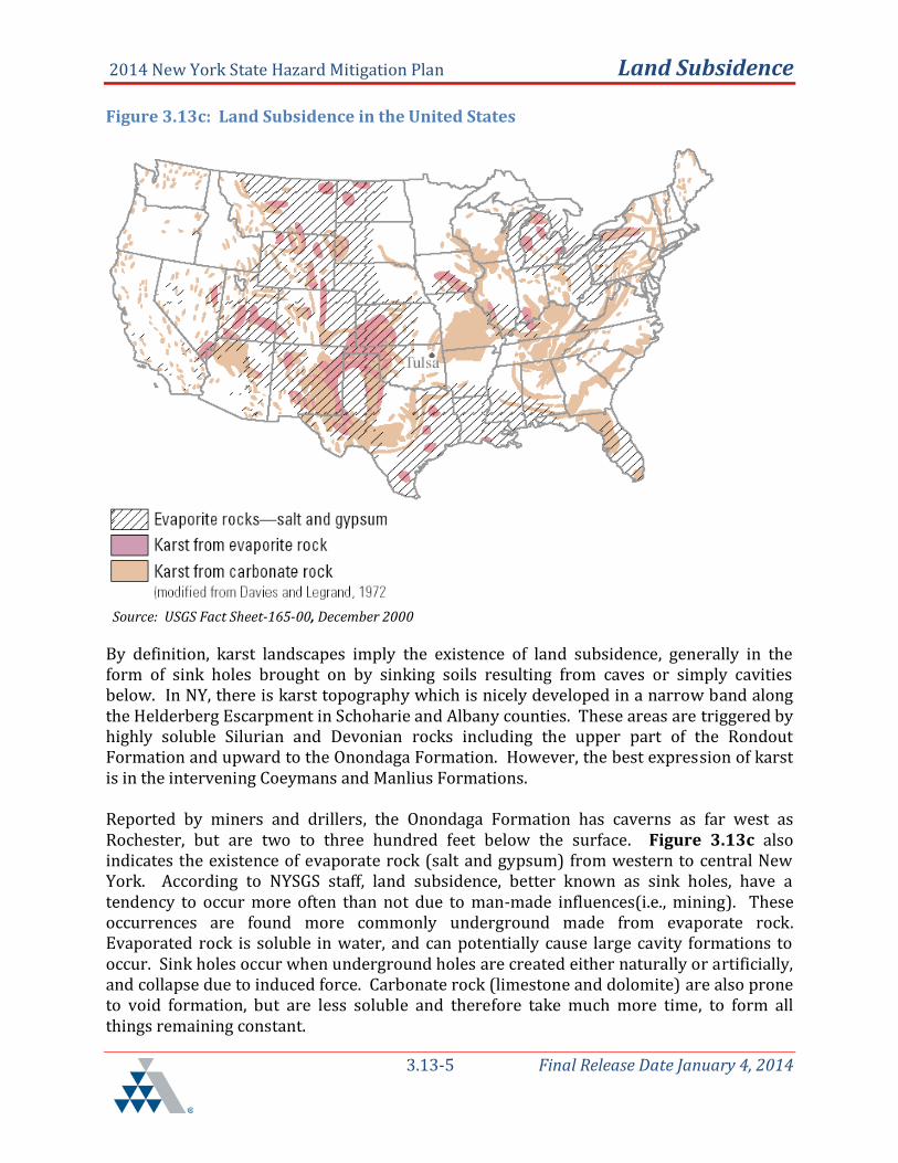
Location The potential for land subsidence exists across New York State (NYS). In fact, the U.S. Geological Survey (USGS) indicates that there is a national problem affecting an estimated 17,000 square miles in 45 States. As a general rule of thumb, land subsidence occurrence can be expected where it has occurred in the past. Scientific and historical land subsidence incidences, although sparse, exist in areas of the state that have potentially higher risk, such as those reported in the Town of Amherst between the 1980s and early 2000’s Land Subsidence Salt and gypsum underlie nearly 40 percent of the United States. According to the USGS website (http://water.usgs.gov/ogw/pubs/fs00165/), karst is found throughout the nation as illustrated in Figure 3.13c. Karst is the landscape of largely shaped dissolving action of water on carbonate bedrock (usually limestone, dolomite, or marble). Carbonate karst landscapes constitute about 40 percent of the United States east of Tulsa, Oklahoma.
2014 New York State Hazard Mitigation Plan Land Subsidence
3.13-5 Final Release Date January 4, 2014
Figure 3.13c: Land Subsidence in the United States
Source: USGS Fact Sheet-165-00, December 2000
By definition, karst landscapes imply the existence of land subsidence, generally in the form of sink holes brought on by sinking soils resulting from caves or simply cavities below. In NY, there is karst topography which is nicely developed in a narrow band along the Helderberg Escarpment in Schoharie and Albany counties. These areas are triggered by highly soluble Silurian and Devonian rocks including the upper part of the Rondout Formation and upward to the Onondaga Formation. However, the best expression of karst is in the intervening Coeymans and Manlius Formations.
Reported by miners and drillers, the Onondaga Formation has caverns as far west as Rochester, but are two to three hundred feet below the surface. Figure 3.13c also indicates the existence of evaporate rock (salt and gypsum) from western to central New York. According to NYSGS staff, land subsidence, better known as sink holes, have a tendency to occur more often than not due to man-made influences(i.e., mining). These occurrences are found more commonly underground made from evaporate rock. Evaporated rock is soluble in water, and can potentially cause large cavity formations to occur. Sink holes occur when underground holes are created either naturally or artificially, and collapse due to induced force. Carbonate rock (limestone and dolomite) are also prone to void formation, but are less soluble and therefore take much more time, to form all things remaining constant.

2014 New York State Hazard Mitigation Plan Land Subsidence
3.13-6 Final Release Date January 4, 2014
Collapses are relatively rare in NYS where regions of karst topography are found. The last reported occurrence was roughly fifteen years ago in the Cobleskill area. Included below in Figure 3-21d, the NYSGS has produced a higher resolution map titled “Mineral Resources of NY”. Although the map does not indicate karst landscape, the areas shaded in blue, do emulate the USGS map by showing the location of the varying rock types and minerals that are generally susceptible to natural land subsidence. Expansive Soils
The potential for expansive soils is linked to the type of soil as illustrated in Figure 3.13d
Figure 3.13d: Expansive Soils Map
Over 50 percent of these areas are underlain by soils with abundant clays of high
swelling potential. Less than 50 percent of these areas are underlain by soils with clays of high
swelling potential. Over 50 percent of these areas are underlain by soils with abundant clays of
slight to moderate swelling potential. Less than 50 percent of these areas are underlain by soils with abundant clays of
slight to moderate swelling potential. These areas are underlain by soils with little to no clays with swelling potential.
Data insufficient to indicate the clay content or the swelling potential of soils.

2014 New York State Hazard Mitigation Plan Land Subsidence
3.13-7 Final Release Date January 4, 2014
The map above is based upon "Swelling Clays Map of the Conterminous United States" by W. Olive, A. Chleborad, C. Frahme, J. Shlocker, R. Schneider and R. Schuster. It was published in 1989 as Map I-1940 in the USGS Miscellaneous Investigations Series. Land areas were assigned to map soil categories based upon the type of bedrock that exists beneath them as shown on a geologic map. In most areas, where soils are produced "in situ", this method of assignment was reasonable. However, some areas are underlain by soils which have been transported by wind, water or ice. The map soil categories would not apply for these locations. Based on the map above, the expansive characteristics of New York State’s soils are determined to be of two types, both fairly low for swelling potential:
Soil Type Region/Area
Less than 50% underlain by soils with clays of high swelling potential
Northeast – Adirondack Mountains Northwest- Lake Plains along the south shore of Lake Ontario
Areas underlain by soils with little to no clays with swelling potential.
All other areas of New York State

2014 New York State Hazard Mitigation Plan Land Subsidence
3.13-8 Final Release Date January 4, 2014
Figure 3.13e illustrates the mineral composition of the lands of New York State, which are considered in determining vulnerability to land subsidence. Figure 3.13e: Mineral Resources of New York
Previous Occurrences There are no federally declared disasters on record for landslides and expansive soils. According to New York State Geological Survey (NYSGS) staff, historical records including scientific study data for land subsidence in New York State is either sparse, not readily available, or does not exist in summary form. In fact, this year there has only been one reported occurrence which was in Smithtown, New York. On January 15, 2013, in which a water main broke creating a giant gaping sink hole that damaged a sport utility vehicle in Suffolk County. There were no injuries reported, no State of Emergency declared, and only 26 residences were without water for a few hours (Unknown source, 2013).

2014 New York State Hazard Mitigation Plan Land Subsidence
3.13-9 Final Release Date January 4, 2014
The following narrative excerpts are a description of previous occurrences of historical land subsidence events in NYS that demonstrate natural conditions. Beginning with the bank of Claverack Creek in 2006, in the Town of Greenport in Columbia County, and was declared a State of Emergency. Greenport, NY Subsidence – 2006 On February 2, 2006, New York State Emergency Management Region II was notified by the Columbia County Emergency Management Office that an approximately 675-foot section of the bank of Claverack Creek had subsided into the creek in the area of the Italian American Center in the Town of Greenport. The area of subsidence was estimated to be approximately 30 feet deep. No physical structures were damaged, but a quarter-mile of Bridge Street was closed due to the subsidence. The Town of Greenport, which surrounds the City of Hudson, declared a State of Emergency in response to the collapse. The Columbia County Emergency Operations Center (EOC) was activated to deal with the emergency. Representatives from Department of Public Works (DPW), power, water, emergency management, and law enforcement were called in, as were representatives from the NYS Departments of Transportation (DOT) and Environmental Conservation (DEC).
The DEC reported that the subsidence resulted in a damming of the creek which threatened the Route 66 Bridge, county jail, and water and sewer systems. The DEC thought the jail would have to be evacuated. Columbia County Emergency Management Office reported that the jail could remain functional for up to 12 hours if the water was shut off. This never came to pass. Within 24 hours, even though the accident site received over an inch of rain after the collapse, the agencies at the scene declared the situation stable and indicated there was no threat to adjacent properties. Minor damage occurred to recreational facilities and a 20-foot area of a wall collapsed near the Italian American Center. The only flooded area was a farm where the water ponded. The creek has taken a new natural flow and is presently flowing freely. The community has decided to let the creek flow in its new course and remove any trees that are in the way, and the county jail continues to function normally. Hydrogeologic Effects of Flooding in the Partially Collapsed Retsof Salt Mine, Livingston County, New York, February 14 -16, 1995 The Retsof Salt Mine in Livingston County, New York, is nearly 25 mi. southwest of Rochester, New York which is shown in Figure 3.13f. This mine has been in operation for 110 years and is about 1,100 ft. below land surface, and supplies road salt to 14 states in the Northeast. The mine is the largest salt mine in the Western Hemisphere and includes an underground area that is roughly the size of Manhattan (6,500 acres).

2014 New York State Hazard Mitigation Plan Land Subsidence
3.13-10 Final Release Date January 4, 2014
Figure 3.13f: Retsof Mine Collapse Study Area
An underground room at the southern end of the mine near Cuylerville collapsed on March 12, 1994, and an adjacent room collapsed in early April. Two large circular collapse features that are several hundred feet apart have developed at land surface above the two collapsed mine rooms. The northernmost feature, which is about 700 ft. in diameter, includes a central area about 200 ft. wide that has subsided about 20 to 30 ft. The southernmost feature, which is about 900 ft. in diameter, includes a central area that is about 700 ft. wide that has subsided about 70 ft. The subsidence resulted in the partial collapse of a DOT bridge and forced the closure of a section of State Route 20A.
During the formation of the collapse features, hydraulic connections formed between aquifers and the mine that had been previously isolated from each other by confining units. These new connections have provided routes for rapid migration of ground water downward to the mine level and since March 12, ground water draining from overlying aquifer systems has been progressively flooding the mine at inflow rates averaging about 18,000 gal/min. This aquifer drainage has caused inadequate water supplies in a number of local wells, and some wells have actually gone dry. The USGS has been working with the

2014 New York State Hazard Mitigation Plan Land Subsidence
3.13-11 Final Release Date January 4, 2014
Livingston County Department of Health since March 1994 to provide technical expertise in dealing with this situation. Evidence of expansive soils was identified in the Town of Amherst, which has over 1,000 homes with foundation problems as early as the 1970s when soil studies were done of areas planned for development. In early 2005, the Buffalo News reported that more than $2.2 million had been spent on foundation repairs since 1996, and residents also reported that at least another $2.5 million was needed for outstanding repairs. The U.S. Army Corps of Engineers completed a $500,000 study (released in May 2005) of the expansive soils for the area, which indicated that the clay soil found throughout north Amherst could have been causing a "dome" effect under some homes, pushing up the centers of basement floors and allowing the walls and edges of foundations to sink2. The study found that nearly 1,100 homes had been affected by foundation damage over the previous 20 year period, or about 3 percent of all Amherst homes, according to the preliminary report. But damage rates reportedly could have been 10 times greater in some affected neighborhoods, the study found. About 55 percent of the homes in the study had lateral damage, which causes basement walls to bow or buckle inward. The remaining 45 percent showed signs of sinking. Four types of pressure on basement walls were believed to be causing the damage, including pressures in expansive soils exerted by frost, soil weight, water in the soils, and soils that swell.
Probability of Future Land Subsidence and Expansive Soils Events
Given that land subsidence is a documented occurrence in New York State, it is certain that future land subsidence will occur. However, the sparse historical record of occurrences and the lack of comprehensive summarized and readily available scientific studies make it difficult to predict probability of future occurrence, only that it is likely.
According to the NYSGS regarding the likelihood of subsidence, “…new sink hole formation in the karst areas is rare, the last being 1989 (15 years ago) in a farmer's field….,” and “…subsidence occurring in areas that are already subsiding (expanding existing sink holes) are relatively common, occurring every few years….”
Additionally, the NYSGS staff explains that subsidence induced by mine collapse is a different story. Mine collapse and resulting subsidence can be sudden and unpredictable. An iron mine collapse in Mineville, Essex County (approximately 100 miles north of Albany) in April of 2004 is one of an indeterminate number of similar occurrences reported in the last few years. Similarly, the NYS Geologist reports there have been minor incidents of subsidence over the gypsum mines in western and central NY. Again, these occur largely in agricultural fields and are reportedly of the magnitude that can be filled with a couple of truckloads of dirt. Certainly, the subsidence at the Retsof salt mine collapse, as described in
2 U.S. Army Corps of Engineers Study of Sinking Homes in Amherst, NY, as reported by the Buffalo News,
2/10/2005
2014 New York State Hazard Mitigation Plan Land Subsidence
3.13-12 Final Release Date January 4, 2014
the abstract above, was a surprise but it demonstrates that a collapse of eleven or twelve feet, 1000 feet below the surface, can in fact “chimney” (propagate) all the way to the surface. However, this was the first such incident in 110 years of operation for that mine. Other than the incidence of expansive soils reported in the Town of Amherst in the past 20 years, the incidence and frequency of expansive soils events is largely limited to individual sites and structures.
In summary, it appears that the nature of all forms of land subsidence and expansive soils in New York makes it difficult to determine probability of future events (frequency). The fact that moderate to low land subsidence susceptibility exists (based on land area at risk), as shown on the USGA map figure 3-38, and land subsidence has occurred in the past, suggests that, although very infrequent, land subsidence will occur sooner or later.
Justification for Minimal Vulnerability/Loss Assessment
Land subsidence and expansive soils occurrences are typically localized in scale; and, while there have been documented land subsidence occurrences, the severity is not considered likely to cause a life safety threat to large populations. This hazard was ranked the lowest of all 15 hazards identified in the 2014 update of the SHMP with a HAZNY-Mitigation score of 12. Consequently, it is determined that there is not sufficient evidence that Land Subsidence and Expansive Soils has a high level of risk to justify further analysis for the 2014 Plan update, but it is recommended that local hazard mitigation plans for areas considering Land Subsidence and Expansive Soil preparedness measures in future plan updates. The information provided in the Risk Assessment sections below serves as guidance for impact and consequence analysis and local hazard mitigation planning.
3.13.2 Assessing Land Subsidence and Expansive Soils Vulnerability
by Jurisdiction
Based on previous occurrences and severity, impacts to population, property and economy are minimal for Land Subsidence and Expansive Soils. There is a slight potential for environmental impacts, but only in a very limited scale. There is little potential for economic impact beyond a localized area.
Review of 56 FEMA-approved local hazard mitigation plans reveals that Erie County identified mine collapse as a hazard; however, only eight counties specifically identified Land Subsidence or Expansive Soils as a hazard. Of the eight counties that identified land subsidence and expansive soils as a hazard only three counties actually ranked the hazard: one moderate and two as a low hazard.

2014 New York State Hazard Mitigation Plan Land Subsidence
3.13-13 Final Release Date January 4, 2014
Development in hazard prone areas The areas that have previous experienced subsidence are documented and development is unlikely to occur in these areas.
3.13.3 Assessing Land Subsidence and Expansive Soils Vulnerability of State Facilities
Based on previous occurrences and severity of impact, there are no significant state facilities considered to be vulnerable to subsidence or expansive soils.
3.13.4 Estimating Potential Losses by Jurisdiction Based on previous occurrences and severity of impact and review of FEMA-approved local hazard mitigation plans, there are no significant potential losses identified by jurisdictions.
3.13.5 Estimating Potential Losses of State Facilities Although research indicates a certain amount of land subsidence hazard in New York State, it also indicates very low risk to population and property. Additionally, the extremely localized and virtually unpredictable nature of land subsidence makes it nearly impossible to estimate potential loss. This said, with the exception of continuing to document land subsidence occurrence, this plan will not include the land subsidence hazard in further analysis or mitigation strategy development.

2014 New York State Hazard Mitigation Plan Land Subsidence
3.13-14 Final Release Date January 4, 2014
3.13.6 Data Limitations and Other Key Documents Contents of this section result from research and outreach including, but not limited to, the following sources:
United States Geological Survey (USGS – research and review information located on the web site, http://water.usgs.gov/ogw/pubs/fs00165/, including the following;
U.S. Geological Survey Subsidence Interest Group Conference, Edwards Air Force Base, Antelope Valley, California, November 18-19, 1992;
Abstracts and Summary edited by Keith R. Prince, Devin L. Galloway, and S.A. Leake, U.S. Geological Survey Open-File Report 94-532;
U.S. Geological Survey Open-File Report 94-532, SUMMARY OF TALKS, DISCUSSIONS, FIELD TRIP, AND OUTSTANDING ISSUES, Keith R. Prince (U.S. Geological Survey, Menlo Park, California);
U.S. Geological Survey Open-File Report 94-532, MUDBOILS IN THE TULLY VALLEY, ONONDAGA COUNTY, NEW YORK, William M. Kappel (U. S. Geological Survey, Ithaca, New York);
U.S. Geological Survey Subsidence Interest Group Conference, Proceedings of the Technical Meeting, Las Vegas, Nevada, February 4-16, 1995, edited by Keith R. Prince and S.A. Leake, U.S. Geological Survey Open-File Report 97-47;
U.S. Geological Survey Subsidence Interest Group Conference, Proceedings of the Technical Meeting, Las Vegas, Nevada, February 14–16, 1995, HISTORY OF THE SUBSIDENCE INTEREST GROUP, By Keith R. Prince;
Hydrogeologic effects of flooding in the partially collapsed Retsof Salt Mine, Livingston County, New York, by Dorothy H. Tepper, William M. Kappel, Todd S. Miller, and John H. Williams;
New York State Office of Emergency Management situation report archives for historical events.
Unknown. (2013, January 17). Smithtown, New York. January 20th, 2013. Retrieved August 19, 2013, from thesinkhole.org: http://thesinkhole.org/?s=New+York
Please note: data obtained from the Spatial Hazard Events and Losses Database for the United States (SHELDUS™) is a county-level hazard data set for the U.S. for 18 different natural hazard event types such thunderstorms, hurricanes, floods, and tornados. For each event the database includes the beginning date, location (county and state), property losses, crop losses, injuries, and fatalities that affected each county. The data derives from the national data source, National Climatic Data Center's monthly Storm Data publications. Using the latest release of SHELDUS™ 12.0, the database includes every loss causing and/or deadly event between 1960 through 1992 and from 1995 onward. Between 1993 and 1995, SHELDUS™ reflects only events that caused at least one fatality or more than $50,000 in property or crop damages.