SECTION 2 INTRODUCTION, BACKGROUND AND PURPOSE OF … · SECTION 2 INTRODUCTION, BACKGROUND AND...
9
11573B 2 - 1 Wright-Pierce SECTION 2 INTRODUCTION, BACKGROUND AND PURPOSE OF CSO MASTER PLAN 2.1 INTRODUCTION This Combined Sewer Overflow (CSO) Master Plan was prepared to meet the conditions set forth in Special Condition A, Paragraph 4 of the February 6, 2009 Maine Pollutant Discharge Elimination System (MEPDES) permit and Waste Discharge License (WDL) issued jointly to the City of South Portland (City), the Portland Water District (PWD) and the Town of Cape Elizabeth (Town) for the Ottawa Road CSO. Per the conditions of the permit, the permit holders must submit the CSO Master Plan by December 31, 2011 including an implementation schedule to abate or eliminate the CSO. 2.2 BACKGROUND When the Ottawa Road Pump Station was built in 1977, a combined sewer overflow was constructed (but not originally licensed) adjacent to the pump station with an outfall to the Atlantic Ocean via Danforth Cove 1 . Due to increased CSO activity because of record rainfalls in both 2005 and 2006, the CSO rose on MEDEP's priority list for elimination or abatement. MEDEP briefly considered including abatement or elimination as a condition of the MEPDES permit renewal for the East End Wastewater Treatment Facility in Portland; however this idea was discarded as the facility is unrelated to the Ottawa Road CSO. Additionally they considered issuing an administrative consent order, but PWD had already hired Wright-Pierce (W-P) to conduct an initial study of alternatives to eliminate or abate the CSO. Through this study, it was determined that, given the magnitude of the overflows during significant wet weather events, there is no easy way to eliminate the CSO, such as a capacity upgrade at the pump station or an on-site storage tank. As such, the final recommendation was to license the CSO through 1 It should be noted that the MEPDES permit refers to the cove as Danford Cove as this was the name referenced in the current edition of the Maine Atlas and Gazetteer© at the time. However; the correct name is Danforth Cove and that name will be used for purposes of this plan.
-
Upload
truongnguyet -
Category
Documents
-
view
220 -
download
0
Transcript of SECTION 2 INTRODUCTION, BACKGROUND AND PURPOSE OF … · SECTION 2 INTRODUCTION, BACKGROUND AND...
11573B 2 - 1 Wright-Pierce
SECTION 2
INTRODUCTION, BACKGROUND AND PURPOSE
OF CSO MASTER PLAN
2.1 INTRODUCTION
This Combined Sewer Overflow (CSO) Master Plan was prepared to meet the conditions set
forth in Special Condition A, Paragraph 4 of the February 6, 2009 Maine Pollutant Discharge
Elimination System (MEPDES) permit and Waste Discharge License (WDL) issued jointly to
the City of South Portland (City), the Portland Water District (PWD) and the Town of Cape
Elizabeth (Town) for the Ottawa Road CSO. Per the conditions of the permit, the permit holders
must submit the CSO Master Plan by December 31, 2011 including an implementation schedule
to abate or eliminate the CSO.
2.2 BACKGROUND
When the Ottawa Road Pump Station was built in 1977, a combined sewer overflow was
constructed (but not originally licensed) adjacent to the pump station with an outfall to the
Atlantic Ocean via Danforth Cove1. Due to increased CSO activity because of record rainfalls in
both 2005 and 2006, the CSO rose on MEDEP's priority list for elimination or abatement.
MEDEP briefly considered including abatement or elimination as a condition of the MEPDES
permit renewal for the East End Wastewater Treatment Facility in Portland; however this idea
was discarded as the facility is unrelated to the Ottawa Road CSO. Additionally they considered
issuing an administrative consent order, but PWD had already hired Wright-Pierce (W-P) to
conduct an initial study of alternatives to eliminate or abate the CSO. Through this study, it was
determined that, given the magnitude of the overflows during significant wet weather events,
there is no easy way to eliminate the CSO, such as a capacity upgrade at the pump station or an
on-site storage tank. As such, the final recommendation was to license the CSO through
1 It should be noted that the MEPDES permit refers to the cove as Danford Cove as this was the name referenced in the current edition of the Maine Atlas and Gazetteer© at the time. However; the correct name is Danforth Cove and that name will be used for purposes of this plan.
11573B 2 - 2 Wright-Pierce
MEDEP in order to eliminate the issue of non-compliance while a formal plan for mitigation was
developed.2 The CSO was licensed by MEDEP in 2009.
As the City, PWD and the Town all have a vested interest in the Ottawa Road Pump Station and
drainage area (see discussion of infrastructure ownership and operation below); negotiations
were required to determine who would be the permit licensee. Ultimately, a joint Maine
Pollutant Discharge Elimination System (MEPDES) Permit and a joint Maine Waste Discharge
License (WDL) were issued on February 6, 2009 to the City, PWD and the Town for the Ottawa
Road CSO.
2.2.1 Description of Existing Collection System and Pumping Station
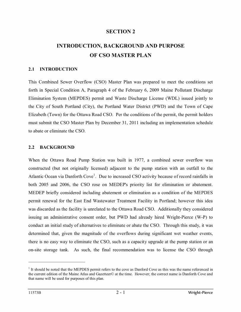
Situated in the northernmost part of Cape Elizabeth, the Ottawa Road Pump Station serves
northern Cape Elizabeth and a small section of the southeast corner of South Portland (refer to
Figure 2-1 at the end of this section for a map of the drainage area). Sewer users in this area are
characterized as primarily residential; although there are several commercial/municipal users as
well. In 1974, the City, PWD and the Town entered into an inter-municipal agreement that laid
the groundwork for accepting flows from the northern part of Cape Elizabeth into South
Portland's collection system and treatment facility. As part of this agreement, the City was
required to separate the combined sewer within their portion of the collection system that drains
to Ottawa Road Pump Station. The Town owns 1/13th of the wastewater treatment facility in
South Portland and pays for 1/13th of the annual operation and maintenance costs in addition to
the user charge based on flow. The Ottawa Road Pump Station as well as downstream
interceptors and pump stations are owned, operated and maintained by PWD. Collector sewers
that drain to the Ottawa Road Pump Station are owned, operated and maintained by the
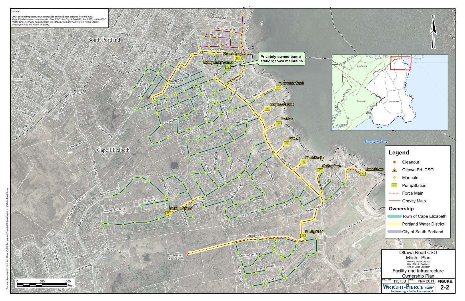
respective municipality (i.e. South Portland or Cape Elizabeth). Refer to Figure 2-2 at the end of
this section for a plan showing the Ottawa Road and Family Field Pump Station drainage areas
as well as the associated collector sewers and interceptors and a key of who owns what facilities.
2 Refer to Appendix B for a copy of the original technical memorandum issued summarizing the findings of the study as well as a follow-up memorandum addressing questions raised by the City's review of the original memorandum.

11573B 2 - 3 Wright-Pierce
The Ottawa Road Pump Station is provided with two centrifugal style pumps with a combined
capacity of approximately 310 gallons per minute. The station pumps to the Shore Road
interceptor which flows by gravity to the Family Field Pump Station. The Family Field Pump
Station pumps to the Trout Brook interceptor via the Mitchell Road collector sewer. A flow
metering station is located in South Portland to measure the wastewater flow rate from Cape
Elizabeth. The flow is then discharged into the South Portland collection system and is
eventually treated at the South Portland Water Pollution Control Facility (WPCF). Refer to
Figure 2-3 at the end of this section for a general location plan of the referenced facilities.
2.2.2 Summary of Historical Studies, I/I Reduction Projects or System Improvements
The following is a summary of projects and system improvements that have been completed in
an effort to reduce the inflow and infiltration into the Ottawa Road Pump Station drainage area.
1992: PWD hired T. Y. Lin International to evaluate several options to minimize dry
weather overflows and to increase station reliability. Due to the high capital costs and
infeasibility of several options, there was no immediate action taken to address the
recommendations. Further, it became unnecessary as approximately 200 linear feet of
cross-country sewer between Cliff Road and Woodland Road was replaced in the same
year and the dry weather overflow issue was eliminated.
1993: The City completed a survey of residences in the City in an effort to identify
sources of stormwater inflow from roof leaders, sump pumps, etc. Three homes in the
Ottawa Road drainage area were identified as having had sump pumps, fourteen had floor
drains and three has roof drains that were connected to the sewer.
2002: PWD installed the first permanent flow monitoring device and began reporting
CSO events.
2005: The Town hired OEST Associates, Inc. to complete a study of the Cape Elizabeth
collection system in order to provide a rehabilitation plan including prioritization of the

11573B 2 - 4 Wright-Pierce
recommended work.3 The following work within the Ottawa Road drainage area was
completed in response to recommendations provided in the report:
- 2007: Approximately 270 linear feet of cross-country sewer between Woodland Road
and Charles Road was relined.
- A design has been completed to replace approximately 700 linear feet of sewer and
manholes in Charles Street. Construction will be completed when funding is
available.
2010: In response to the findings and recommendations from smoke testing completed as
part of this CSO Master Plan, the City replaced a length of pipe in the cross-country line
that was crushed and capped a broken cleanout on Leighton Street. Refer to Section 7 for
more information on the smoke testing findings and recommendations.
2011: In response to findings and recommendations from smoke testing completed as part
of this CSO Master Plan, the City repaired several seals on old connections between
sewer and catch basins. Refer to Section 7 for more information on the smoke testing
findings and recommendations.
2.2.3 MEPDES Permit Requirements
As noted above, the MEPDES permit and Waste Discharge License for the Ottawa Road CSO
(MEPDES Permit #ME0102806/WDL #W009027-5T-A-N) was issued on February 6, 2009 for
a five year period. The highlights of this permit, as pertaining to this CSO Master Plan, are
summarized below:
Licensed for an unspecified quantity of excess combined sanitary sewer and storm water
during wet weather events
Requires license holders to submit a CSO Master Plan and an implementation schedule to
eliminate the discharge (if technically and financially feasible) on or before December 31,
2011
3 Cape Elizabeth Sanitary Sewer System Rehabilitation Plan; prepared by OEST Associates, Inc. for the Town of Cape Elizabeth; January 2005

11573B 2 - 5 Wright-Pierce
Requires license holders to measure and report CSO flow volumes and discharge events
annually
2.3 SUMMARY OF EPA/DEP CSO REGULATIONS AND GUIDELINES
Chapter 570 of the MEDEP Combined Sewer Overflow Abatement guidelines outlines the basis
by which a discharge from a combined overflow point within a sewerage system can be
permitted.4 In order for a CSO to be allowable by the Maine DEP Chapter 570 guidelines, the
discharge must meet the following conditions:
1. Discharge in excess of design capacity: The discharge consists of wastewater in excess
of design capacity of the sewerage system or treatment facilities.
2. Discharge not due to mechanical failure: The discharge is not the result of mechanical
failure, improper design or inadequate operation or maintenance.
3. CSO Master Plan: The licensee is actively developing or implementing a CSO Master
Plan in accordance with Chapter 570 guidelines, and as approved by the Department, or
the licensee has implemented the CSO Master Plan and a discharge occurs that is caused
by conditions exceeding those upon which the Plan is based.
The Ottawa Road CSO meets all of the above criteria for allowable overflows. In addition to the
above referenced requirements, the permit requires that the licensee implement and follow the
Nine Minimum Controls (NMCs) as approved by the EPA which became law in the year 2000.5
These minimum controls are set forth to reduce CSO activity and pollutant discharges while
long-range plans are being completed. The NMCs will be discussed further in Section 9 of this
Plan.
4 Chapter 570: Combined Sewer Overflow Abatement; Maine Department of Environmental Protection 5 Combined Sewer Overflows, Guidance for Nine Minimum Controls; EPA 832-B-95-003; May 1995
11573B 2 - 6 Wright-Pierce
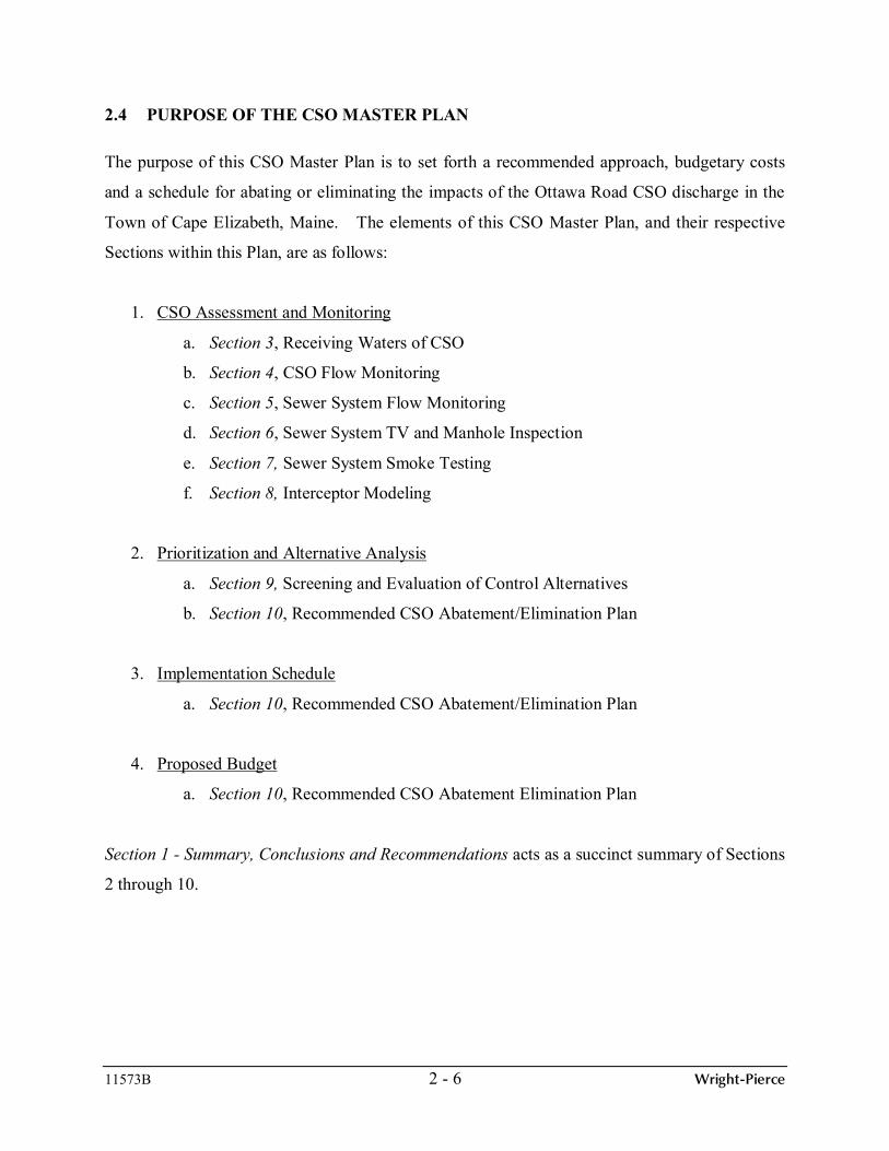
2.4 PURPOSE OF THE CSO MASTER PLAN
The purpose of this CSO Master Plan is to set forth a recommended approach, budgetary costs
and a schedule for abating or eliminating the impacts of the Ottawa Road CSO discharge in the
Town of Cape Elizabeth, Maine. The elements of this CSO Master Plan, and their respective
Sections within this Plan, are as follows:
1. CSO Assessment and Monitoring
a. Section 3, Receiving Waters of CSO
b. Section 4, CSO Flow Monitoring
c. Section 5, Sewer System Flow Monitoring
d. Section 6, Sewer System TV and Manhole Inspection
e. Section 7, Sewer System Smoke Testing
f. Section 8, Interceptor Modeling
2. Prioritization and Alternative Analysis
a. Section 9, Screening and Evaluation of Control Alternatives
b. Section 10, Recommended CSO Abatement/Elimination Plan
3. Implementation Schedule
a. Section 10, Recommended CSO Abatement/Elimination Plan
4. Proposed Budget
a. Section 10, Recommended CSO Abatement Elimination Plan
Section 1 - Summary, Conclusions and Recommendations acts as a succinct summary of Sections
2 through 10.

[Ú!
!!
!
!
! ! !
!!
!
! !
!!!
!
!
!
!!
!
!
!
!
! !
!
!
!
!
!
!
!
!
!
!!
!
!
!
!
!
!
!
!
!
!
!
!
!
!
!
!!
!
!
!
!
!
!
!!
!
!
!
!
!
!
!
!
!
!
!
!
!! !
!
!
! !
!
!
!
!
!! !
!
!!
[Ú!(
!(!(
!(
!(
!( !( !(
!(!(
!(
!(!(
!( !(
!(
!(
!(
!(
!(
!(
!(
!(
!(
!(
!(!(
!(
!(
!(
!(
!(
!(
!(
!(
!(
!(!(
!(
!(
!(
!(
!(
!(
!(
!(
!(
!(
!(
!(
!(
!(
!(
!(
!(
!(
!(
!(
!(
!(
!(
!(
!(
!(
!(
!(
!(
!(
!(
!(
!(
!(
!(
!(
!(
!(!(
!(
!(
!(
!( !(
!(
!(
!(
!(
!(
!(!(
!(
!(!(
#0
$1
Shore Rd
Woo
dlan
d Rd Ocean View Rd
Forest Rd
Cottage Farms Rd
Oakhurst Rd
Stonybrook Rd
Ston
e Dr
Preble St
Lindenwood Rd
Cragmoor Rd
Rocky Knoll RdBa
y Vi
ew R
d
Wood Rd
Ced
ar L
edge
Rd
Heatherstone Ln
St Albans Ln
Waverly Rd
Preble St
Cottage Rd
Ange
ll Ave
Elsm
ere A
ve Deak
e St
Pills
bury
St
Bay
RdCl
oyst
er R
d
Love
itt's
Fie
ld R
d
Gould St
Ledge Rd
Vict
ory A
ve Channel Rd
Pond Rd
Lowell St
Will
ard
St
Bluff Rd
Loveitt St
Woodb
ury S
t
Coolidge AveBo
yd R
d
Simonton St
Edge
wood
Rd
Brookside Ave
Philippis RdFrederick Rd
Crag
gmer
e Ave
Cliff
Ave
Lahave St
Ston
e Dr
Birch Rd
Woo
dlan
d Rd
0 500 1,000
Feet
¥Source:2001 Aerial Orthophotos provided by the Maine Office of GIS.Cape Elizabeth sewer data provided by PWD, AMEC, and theTown of Cape Elizabeth.*All other data provided by the City of South Portland.**Note: Only manholes and sewers in the Ottawa RoadPump Station Drainage Area are shown for clarity
Thur
sday
, Sep
tem
ber 2
2, 2
011
9:1
6:11
AM
W:\G
IS_D
evel
opm
ent\P
roje
cts\
ME
\Cap
eEliz
abet
h\11
573B
\Rpr
tFig
s\2-
1.m
xd
§̈¦95
§̈¦295
§̈¦95
Scarborough
Portland
South Portland
Cape Elizabeth
Westbrook
PROJ NO: DATE: FIGURE:
Ottawa Road CSOMaster Plan
Portland Water DistrictCity of South Portland
Town of Cape ElizabethOttawa Road Pump Station
Drainage Area11573B Nov 2011
2-1
Danforth Cove
South Portland
Cape Elizabeth
Legend$1 Cleanout
!( Manhole
[Ú Pump Station
Force Main
Gravity Main
#0 Ottawa Rd. CSO
OwnershipTown of Cape Elizabeth
Portland Water District
City of South Portland
To Family FieldPump Station
[Ú
[Ú
[Ú[Ú
[Ú
[Ú
[Ú
[Ú
[Ú
[Ú
[Ú
!!!!
!
!
!!!!
!
!!
!
!
!!!
!!
!!
!!!
!!
!!
!
!
!
!!
!
!!
!
!
!
!
!!!
!!!
!!
!
!!
!!
!
!
!
!!
!
!!
!!
!
!
!!
!
!
!!
!
! !
!
!
!
!!!
!!
!!
!
!
!
!!
!
!
!
! ! !
!!
!
! !
!!!
!
!
!
!!
!
!
!
!
! !
!
!
!
!
!
!
!
!
!
!!!
!
!
!
!
!
!
!
!
!
!
!
!
!
!
!!
!
!
!
!
!
!
!!
!
!
!
!
!
!
!
!
!
!
!
!
!
!
!
!! !
!
!
!
!
! !
!
!
!
!
!
!
!!
!
!
!
!
!
! !!!!
!!
!!!!
!!
!
!!!!
!!!
!!
!
!
!
!! ! !
!
!
!! !
!
!
!!
!!
!
!!
!!
!!
!
!
!
! !!
!! ! !
! !!
!!
!
!
!
!
!
!!!!
!
!
!!
!
!!
!!
!
!!
!!
!
!
!
!
!
!!! !
!!
!
!
!
!
!
!
!
!

[Ú
[Ú
%,
Shore Rd
Mitche ll Rd
Oakhurst Rd
Woo
dlan
d Rd
Old Fort Rd
Littlejohn Rd
Wood Rd
Ocean View Rd
Spur
win
k Av
Man
ter S
t
Ivie Rd
Forest Rd
Cheverus Rd
Surf Rd
Cottage Farms RdCliff
Av
Abaco Dr
Lydo
n Ln East
Robinhood Rd
Ottawa Rd
Locksl ey Rd
Charles Rd
Elmwood Rd
Thrasher Rd
Glen A
v
Rocky Hill Rd
Campion Rd
Stonybrook Rd
Cottag
e Ln
McAuley Rd
High Bluff RdLydon Ln
Blueberr
y Rd
Cape W
oods
Dr
Ston
e Dr
Preble St
Warren Av
Rosewood Dr
Southwell Rd
Linw
ood
St
Columbus Rd
Wat
erho
use
Rd
Sea View
Av
Bridle Path Wy
Lind
enw
ood
Rd
Ocean House Rd
Hamlin St
Rocky Knoll Rd
Brownstone Ln
Cragmoor Rd
Deep Brook Rd
Hemlock Hill Rd
Friar Ln
Woodcrest Rd
Bay
View
Rd
Deer Field Ln
Hermit Thrush Rd
South St
Old Farm Ln
Heatherstone Ln
St Albans Ln
Red O
ak D
r
Erie Rd
Waverly Rd
Elizabeth Rd
Ottawa Road
Family Field
Cottage Rd
Ocean St
Sawy
er S
t
Highland A
ve
Preble St
Pine S t
B St
C St
Mussey St
D St
Stillman St
A St
Ant
hoin
e St
Wat
erm
an D
r
Walnut St
Boothby Ave
Parrott St
Harriet St
Chase St
Q St
S Richland StPitt St
Deak
e St
Broadway
Pills
bury
St
Mitchell Rd
Scam
man
St
Hills
ide
Ave
Jordan Ave
Margaret St
Lowell St
Kaler Rd
Providence Ave
Oneil St Go
udy S
t
Ange
ll Ave
Will
ard
St
Cliffor
d St
Davis
St
Clemons St
Thompson St
E St
Elsm
ere A
ve
Simmons R
d
Willow St
Vincen t S t
Cobb St
Fessenden St
Market St
Everett Ave
Drew Rd
Third St
Clin
ton
St
Adelbert St
Flore
nce S
t
Bay
Rd
Marsh Rd
Sprague St
Haven Rd
Cloy
ster
Rd
Wild
Ros
e Ave
Plymouth R
d
Love
itt's
Fiel
d Rd
Sylva
n Rd
Day St
Bellair
e Rd
Marriner St
Stanley
St
Gould St
Lawrence St
Churchill Rd
Greeley St
Casco Bay Bridge
F St
Derby R
d
Sixth St
Vict
ory A
ve
Hinkle
y Dr
Fairl
awn
Ave
Spear Ave
Bayview Ave
Artubus Ave
Elmwood Ave
Ocean View Ave
Osborne Ave
Carroll St
Loveitt St
Henry St
Spurwink Ave
Edwards St
Cedar St
Hamilton St
Danforth Rd
Channel Rd
N Richland St
Belle
vue
Ave
Pond Rd
Taylor St
Pilgrim Rd
Vivian St
Bow
ers St
Bluff Rd
Erskine Dr
Whitworth Dr
Woo
dbur
y St
Cormier Rd
Arlington Rd
Baltimore Ave
Coolidge Ave
Stra
thm
ore
Rd
Alder St
Boyd
RdCrag
gmer
e Ave
Fern Ln
Harbor View Ave
Beaufort St
Beverly St
Somerset St
Edge
wood
Rd
Sterling Ave
Thom
as S
t
Barstow St
Larchwood Rd
Roger Rd
Brookside Ave
Brenton St
Anchor Rd
Ship Channel Rd
Cliff
Ave
Emery St
Park
side T
er
Mast LnLahave St
Ston
e Dr
Graffam Rd
Oakdale Ave
Unknown (priv
ate)
Birch Rd
Mt Vernon St
Willard Haven Rd
Glendale Rd Norman St
Char
lotte
Ave
Ocean St
Sawyer St
Sawy
er S
t
Walnut St Da
vis S
t
E St
E St
0 750 1,500Feet
¥
PROJ NO: DATE: FIGURE:
Ottawa Road CSOMaster PlanPortland Water DistrictCity of South Portland
Town of Cape Elizabeth
General Location Plan
2-311573B Nov 2011
Source:
2001 aerial orthophotos, town boundaries and road data obtained from ME GIS.Cape Elizabeth sewer data compiled from PWD, the City of South Portland, ME, and AMEC.*
Thur
sday
, Sep
tem
ber 2
2, 2
011
9:4
6:40
AM
W:\G
IS_D
evel
opm
ent\P
roje
cts\
ME
\Cap
eEliz
abet
h\11
573B
\Rpr
tFig
s\2-
3.m
xd
§̈¦95
§̈¦295
§̈¦95
Cape ElizabethScarborough
Portland
South Portland
Legend%, Metering Structure
[Ú PumpStation
So. Portland WWTF
South Portland
Cape Elizabeth
Danforth Cove