Seattle Children’s Livable Streets Initiative · Public Health Seattle & King County ... As part...
33
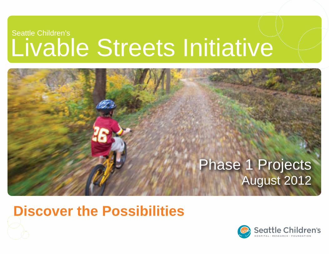
Livable Streets Initiative Seattle Children’s Discover the Possibilities Phase 1 Projects August 2012
Transcript of Seattle Children’s Livable Streets Initiative · Public Health Seattle & King County ... As part...
Livable Streets InitiativeSeattle Children’s
Discover the Possibilities
Phase 1 ProjectsAugust 2012
Seattle Children’s Livable Streets Initiative
For more information:http://construction.seattlechildrens.org/livablestreets/
Paulo Nunes-UenoDirector | TransportationSeattle Children’[email protected]
Thank you to our Community Co-SponsorsBicycle Alliance of WashingtonCascade Bicycle ClubFeet FirstHawthorne Hills Community CouncilITE UW Student ChapterLaurelhurst Community ClubLaurelhurst Elementary PTALaurelhurst Elementary Safe Routes to SchoolPublic Health Seattle & King CountySeattle Community Council FederationSeattle Department of TransportationSeattle Parks FoundationSierra Club - Cascade ChapterStreets for All SeattleSustainable Northeast SeattleTransportation Choices CoalitionTransportation NorthwestUndriving.orgView Ridge Community CouncilWedgwood Community Council
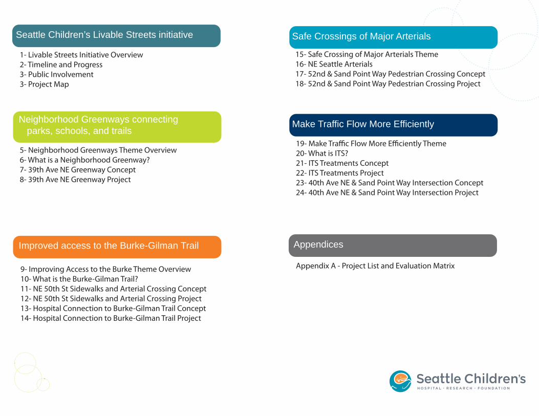
Seattle Children’s Livable Streets initiative
Neighborhood Greenways connectingparks, schools, and trails
Improved access to the Burke-Gilman Trail
Safe Crossings of Major Arterials
Make Traffic Flow More Efficiently
Appendices
1- Livable Streets Initiative Overview2- Timeline and Progress3- Public Involvement3- Project Map
5- Neighborhood Greenways Theme Overview6- What is a Neighborhood Greenway?7- 39th Ave NE Greenway Concept8- 39th Ave NE Greenway Project
9- Improving Access to the Burke Theme Overview10- What is the Burke-Gilman Trail?11- NE 50th St Sidewalks and Arterial Crossing Concept12- NE 50th St Sidewalks and Arterial Crossing Project13- Hospital Connection to Burke-Gilman Trail Concept14- Hospital Connection to Burke-Gilman Trail Project
15- Safe Crossing of Major Arterials Theme16- NE Seattle Arterials17- 52nd & Sand Point Way Pedestrian Crossing Concept18- 52nd & Sand Point Way Pedestrian Crossing Project
19- Make Traffic Flow More Efficiently Theme20- What is ITS?21- ITS Treatments Concept22- ITS Treatments Project23- 40th Ave NE & Sand Point Way Intersection Concept24- 40th Ave NE & Sand Point Way Intersection Project
Appendix A - Project List and Evaluation Matrix
1
Improved Access to the Burke-Gilman Trail
Safe Crossings of Major Arterials
Make Traffic Flow More Efficiently
As part of the Seattle Children’s Major Institution Master Plan, Children’s has committed to spend nearly $4 million on transportation improvements in NE Seattle. Improvements include:
Bike and pedestrian improvements, like better access to the Burke Gilman Trail and other ways to improve local streets so people of all ages and ability feel safe biking and walking
Intelligent Transportation Systems that use technology to give drivers more information
Corridor improvements that increase safety for all users
Seattle Children’s kicked off the Livable Streets Initiative in 2010 with the goal of working with our community to develop a package of projects to improve mobility, safety, and livability in NE Seattle.
In addition to the projects paid for directly by the LSI fund, the LSI Initiative includes several transportation improvement projects funded through the Children’s Hospital campus development. These projects include a new cycle-track on Sand Point Way adjacent to the hospital (see project LS-CT) and a new signalized intersection of 40th Ave NE and Sand Point Way (see project LS-8). A connection to the Burke-Gilman Trail across the Hartmann property (a Seattle Children’s-owned property across Sand Point Way from the hospital) is also planned.
Livable Streets Themes
BMP
LSWBOG
NPF
SPW
UATAS
PMP
The projects outlined in this booklet were identified through community input and collaboration with SDOT, and selected as most supportive of the Livable Streets themes. These proposals are consistent with goals, locations, corridors, and projects identified in existing plans and public processes, including:
University Area Transportation Action Strategy
Sand Point Way Pedestrian Study
Neighborhood Streets Fund proposals
Bicycle Master Plan
Pedestrian Master Plan
Bands of Green
Seattle Children’s Livable Streets Workshop
Seattle Children’s Livable Streets InitiativeOverview
Project Sources
•
•
•
Neighborhood Greenways ConnectingParks, Schools, and Trails
2
Project Selection Process
• Review of existing plans• University Area Transportation Action
Strategy• Sand Point Way Pedestrian Study• Neighborhood Project Fund• Seattle Bicycle Master Plan• Seattle Pedestrian Master Plan• Seattle Parks Foundation Bands of
Green plan• Community input
• November 13, 2010 Livable Streets Workshop
• Letters, emails, and other public comments
• Collaboration with Seattle Dept. of Transportation and consultant group
•
Develop Neighborhood Greenwaysto connect the Burke-Gilman Trailparks, and schoolsImproved access to and from the Burke-Gilman TrailSafe crossings of major arterial streets
•Begin initial review of projects for:• Feasibility• Cost• Schedule
•Continue to collect public comment at workshops and through website, email, and other channels
•
Construct projects in 2012and 2013
November 13 Livable Novemvv ber 13 Livavv bleStreets Initiative Open Streetstt Initiai tiv pe Opevv nHouse and Workshop
March 19 & April 30 Marcrr h 19 & Aprirr l ii 30 Community Meetings:
40ComCo
00thmmunityyt Meetinii ggs:omCo
00thtth/SPW Intersection and 44000 PWSP/S Intersrr ectitt on andLivable Streets Initiative
Review of existing plansf• University Area Transportation Action
Strategy
Identify possible projects
Initial project evaluation
Further reviewand community input
Final design and construction
Late 2010Early 2011
Mid-Late 20112012-2013
Finish design in 2012
June 23 LivableStreets Initiative
Open House
Public Events
Evaluated projects basedon these criteria:
Support for Livable Streets Initiativecentral themes:
•
• Located in NE Seattle
Community public input
•
3
Public Involvement
The Livable Streets Initiative has benefitted from significant public involvement at multiple points in the project development process. Open houses and public events were held to provide information and solicit ideas and comments. All told, hundreds of individual comments and suggestions were collected and used to shape the direction of the initiative.
Major public events:
November 13, 2010, Livable Streets Initiative Open House and Workshop, Gould Hall UW
March 19 & April 30, 2011, Community meetings: 40th/Sand Point Way Intersection and Livable Streets Initiative, Laurelhurst Elemen-tary and UW Center for Urban Horticulture
June 23, 2012, Livable Streets Initiative Open House
Interested riders and city officials tour potential project Interested riders and city officials tour potential project sites after the November 13 Open House and Workshopsites after the November 13 Open House and Workshop
A young cyclist gets A young cyclist gets fitted with a new helmetfitted with a new helmet
Participants learn about and discuss potential projects Participants learn about and discuss potential projects in the November 13 Open House and Workshopin the November 13 Open House and Workshop
4
Potential Livable Streets Projects Considered
1
1 1
1
1
12
4
5 6
8
7
10
School
Park
Burke-GilmanTrail
NeighborhoodGreenway
777777
First phase Livable Streets projects
Safe crossings of major arterials
Improved access to the Burke-Gilman Trail
Neighborhood Greenways connectingparks, schools, and trails
Project Themes
11111
88888
ITS
CT
9
3
5
Theme: Neighborhood Greenways Connecting Parks, Schools, and Trails
1
1 1 1 1
10
School
Park
Burke-GilmanTrail
NeighborhoodGreenway
11111111
The Seattle Children’s Livable Streets Initiative proposes to partner with the Seattle Department of Trans-portation and our neighbor-hood sponsors to build a Neighborhood Greenway on one of these corridors to connect the Burke-Gilman Trail, schools, parks, and other existing bicycle and walking facilities.
39th Ave NE was selected as the first neighborhood greenway in a future network that will achieve goals of improving mobility and safety for pedestrians and cyclists of all ages and abilities.
First phase Livable Streets Projects
6
What is a Neighborhood Greenway?
10
Neighborhood Greenways are residential streets improved to make all people feel comfortable walking, biking, or playing. Drivers can still pass through, but traffic moves at slower speeds. These traffic calming elements of Neighborhood Green-ways encourage people of all ages and abilities to spend time outdoors in their community. In addition, the design features can include planters that serve to provide natural stormwater drainage and greenscapes.
Photo: Payton Chung, Flickr
7
LS-1: 39th Ave NE Neighborhood Greenway
10
Proposed Improvements:Seattle Children’s Livable Streets Initiative envisions a network of Neighborhood Greenways in NE Seattle. These low-speed residential streets will be improved to make it more comfortable for people to walk and bicycle. A Neighborhood Greenway on 39th Ave NE would support key Livable Streets themes by connecting the Burke-Gilman Trail to residential neighborhoods, schools and parks. In fact, this street is already used by students at Thornton Creek Elementary for a weekly bike train to school.
Potential benefits of a Neighborhood Greenway for residents include:
• Reduce cut-through vehicle traffic• Reduce speeding• Improve safety for drivers, pedestrians, and cyclists• Keep traffic volume at or below today’s levels• Provide an inviting outdoor community space• Create an attractive walking and biking route for
people of all ages and abilities to get to schools, parks, and trails
Project Update:
Coming Summer
2012 to a street near
you!
BMPBOGLSW
11111111111
ConceptConceptThornton Creek El
8
LS-1: 39th Ave NE Neighborhood Greenway
NE 75th St
NE 77th St
NE 80th St
NE 70th St
NE 65th St
NE 60th St
NE 55th St
NE 50th St
35
th A
ve
NE
45
th A
ve
NE
Sand
poin
t Way
NE
Seattle
Children’s
Hospital
39
th A
ve
NE
Thornton CreekElementary
Atypical Non-Arterial Crossing
Burke Gilman Trail
NE 73rd St
N
S
W E
NE 67th St
NE 63rd St
NE 57th St
NE 52nd St
40
th A
ve
NE
NE 45th St
Typical Non-Arterial Crossing
NE 52nd St & 39th Ave NE Crossing
Typical Arterial Crossing
For more information, please contact:
206-615-0786
ProjectProjectThe City of Seattle will begin construction of the city’s second Neighborhood Greenway in Summer 2012. The improvements to 39th Ave NE will include arterial and non-arterial inter-section treatments and wayfinding signage.
9
School
Park
Burke-GilmanTrail
NeighborhoodGreenway
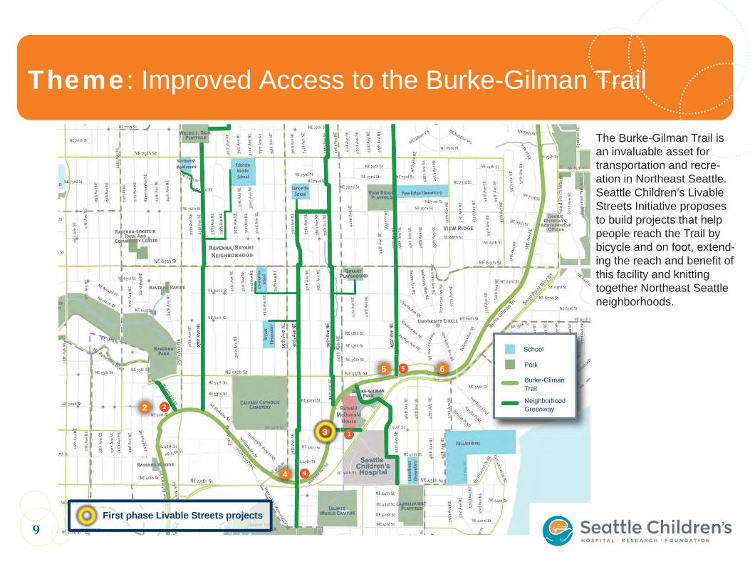
Theme: Improved Access to the Burke-Gilman Trail
10
The Burke-Gilman Trail is an invaluable asset for transportation and recre-ation in Northeast Seattle. Seattle Children’s Livable Streets Initiative proposes to build projects that help people reach the Trail by bicycle and on foot, extend-ing the reach and benefit of this facility and knitting together Northeast Seattle neighborhoods.
2
4
5 6
3
First phase Livable Streets projects
10
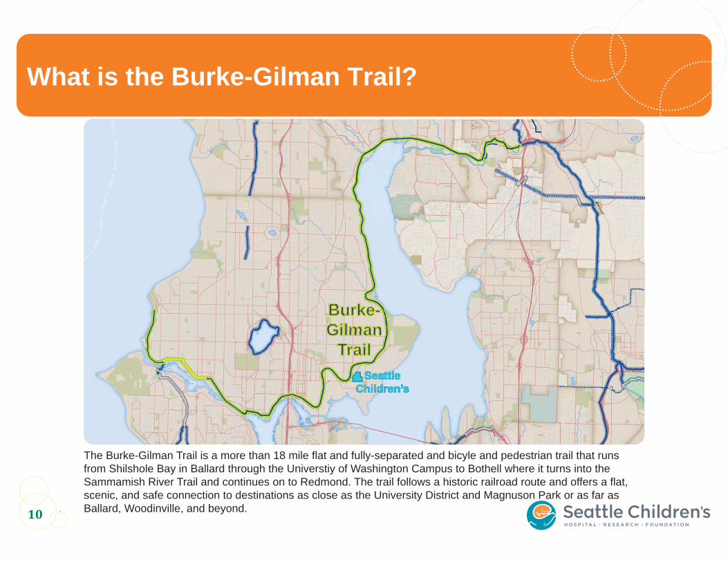
What is the Burke-Gilman Trail?
The Burke-Gilman Trail is a more than 18 mile flat and fully-separated and bicyle and pedestrian trail that runs from Shilshole Bay in Ballard through the Universtiy of Washington Campus to Bothell where it turns into the Sammamish River Trail and continues on to Redmond. The trail follows a historic railroad route and offers a flat, scenic, and safe connection to destinations as close as the University District and Magnuson Park or as far as Ballard, Woodinville, and beyond.
Burke-Burke-GilmanGilman
TrailTrailSeattleSeattle
Children’sChildren’s
Burke-Burke-GilmanGilman
TrailTrailSeattleSeattle
Children’sChildren’s
Burke-Burke-GilmanGilman
TrailTrailSeattleSeattle
Children’sChildren’s
11
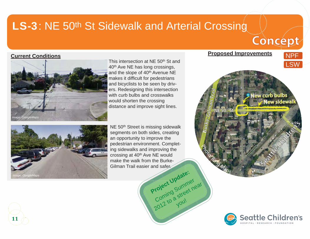
LS-3: NE 50th St Sidewalk and Arterial Crossing
10
NPFLSW
Image: GoogleMaps
NE 50th Street is missing sidewalk segments on both sides, creating an opportunity to improve the pedestrian environment. Complet-ing sidewalks and improving the crossing at 40th Ave NE would make the walk from the Burke-Gilman Trail easier and safer.
Photo:
This intersection at NE 50th St and 40th Ave NE has long crossings, and the slope of 40th Avenue NE makes it difficult for pedestrians and bicyclists to be seen by driv-ers. Redesigning this intersection with curb bulbs and crosswalks would shorten the crossing distance and improve sight lines.
Current Conditions
Image: GoogleMaps
Proposed Improvements
err
Project Update:
Coming Summer
2012 to a street near
you!
ConceptConcept
10
Seattle
Child
ren’s
Seattle
Child
ren’s
Bu
rke
-Gil
ma
n T
rail
Bu
rke
-Gil
ma
n T
rail
New curb bulbs
New sidewalk
10 NNNNN
NNNNeNeNNNNNNNPhoto: Bing Maps
NE 50NE 50thth StSt
12
LS-3: NE 50th St Sidewalk and Arterial Crossing
Photo:
Image: GoogleMaps
N
S
W E
For more information, please contact:
206-615-0786
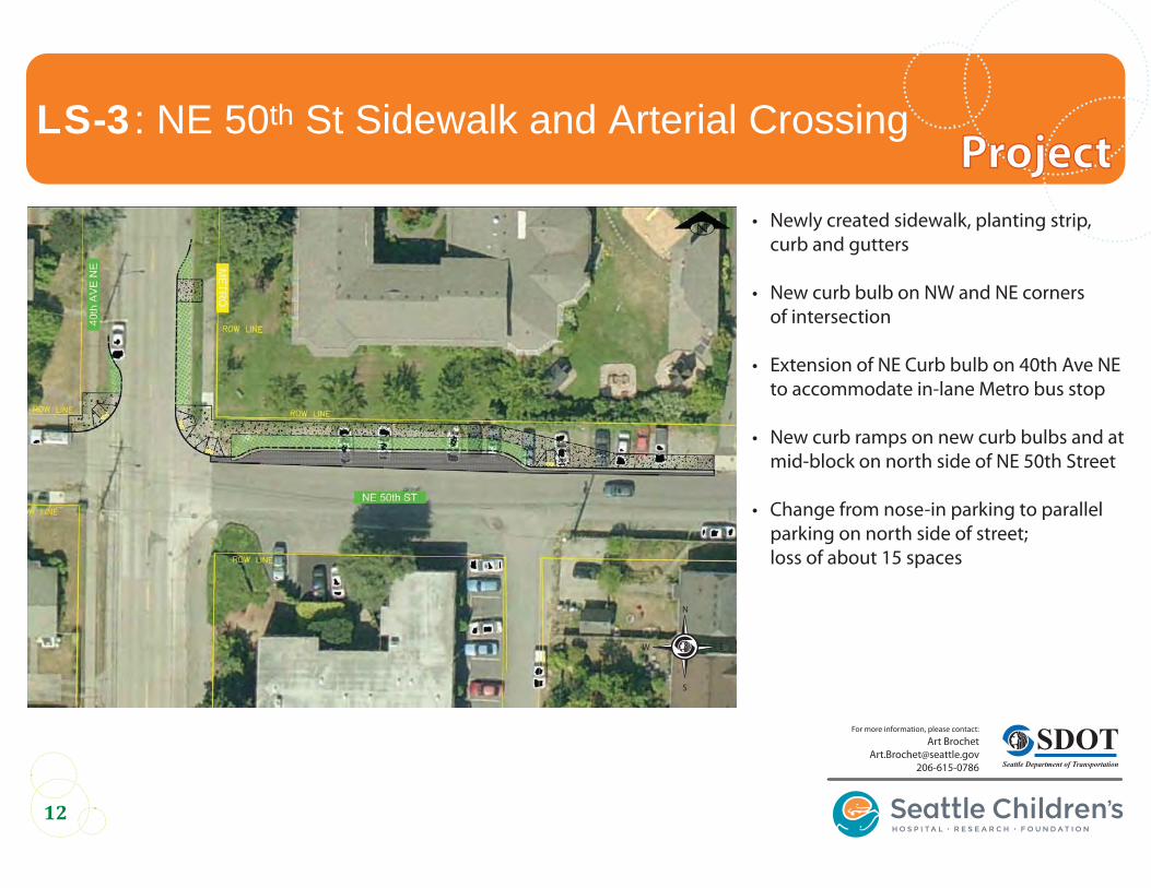
• Newly created sidewalk, planting strip, curb and gutters
• New curb bulb on NW and NE corners of intersection
• Extension of NE Curb bulb on 40th Ave NE to accommodate in-lane Metro bus stop • New curb ramps on new curb bulbs and at mid-block on north side of NE 50th Street
• Change from nose-in parking to parallel parking on north side of street; loss of about 15 spaces
ProjectProject
13
Photo:
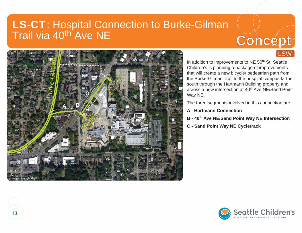
LS-CT: Hospital Connection to Burke-GilmanTrail via 40th Ave NE ConceptConcept
In addition to improvements to NE 50th St, Seattle Children’s is planning a package of improvements that will create a new bicycle/ pedestrian path from the Burke-Gilman Trail to the hospital campus farther south through the Hartmann Building property and across a new intersection at 40th Ave NE/Sand Point Way NE.
The three segments involved in this connection are:
A - Hartmann ConnectionB - 40th Ave NE/Sand Point Way NE IntersectionC - Sand Point Way NE Cycletrack
Image: GoogleMaps
Burk
e-G
ilman
Hospi
tal
Hospi
tal
Entra
nce
Entra
nce
A B
C
Hospi
tal
Hospi
tal
Entra
nce
Entra
nce
LSW
14
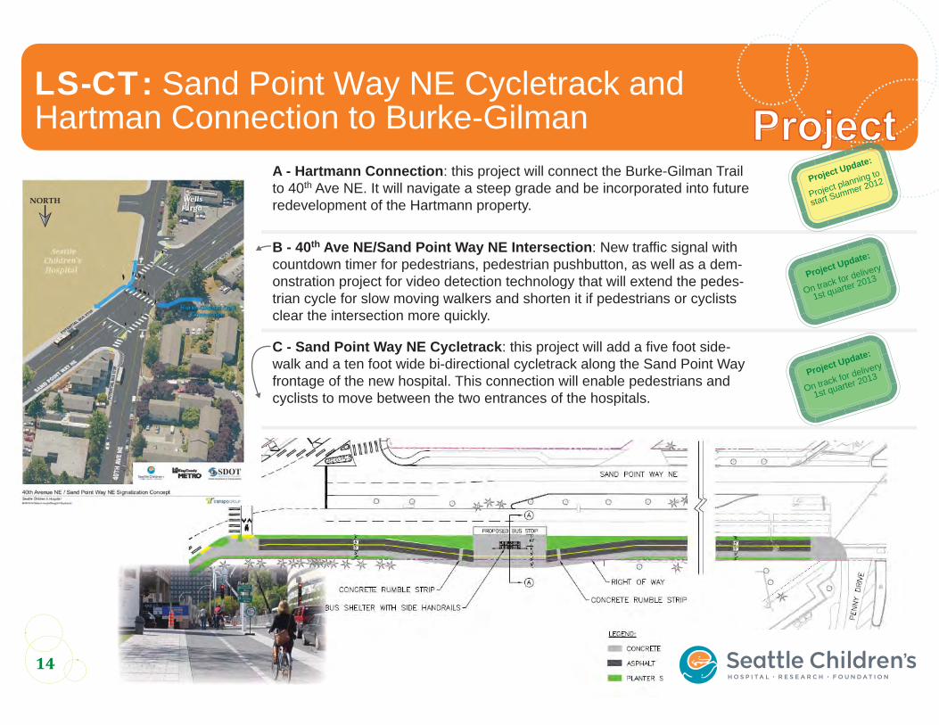
LS-CT: Sand Point Way NE Cycletrack andHartman Connection to Burke-Gilman Project
Image: GoogleMaps
Photo:
NORTH
Project Update:
Project planning to
start Summer 2012
Project Update:
On track for delivery
1st quarter 2013
Project Update:
On track for delivery
1st quarter 2013
A - Hartmann Connection: this project will connect the Burke-Gilman Trail to 40th Ave NE. It will navigate a steep grade and be incorporated into future redevelopment of the Hartmann property.
B - 40th Ave NE/Sand Point Way NE Intersection: New traffic signal with countdown timer for pedestrians, pedestrian pushbutton, as well as a dem-onstration project for video detection technology that will extend the pedes-trian cycle for slow moving walkers and shorten it if pedestrians or cyclists clear the intersection more quickly.
C - Sand Point Way NE Cycletrack: this project will add a five foot side-walk and a ten foot wide bi-directional cycletrack along the Sand Point Way frontage of the new hospital. This connection will enable pedestrians and cyclists to move between the two entrances of the hospitals.
15
8
School
Park
Burke-GilmanTrail
NeighborhoodGreenway
Theme: Safe Crossings of Major Arterials
10
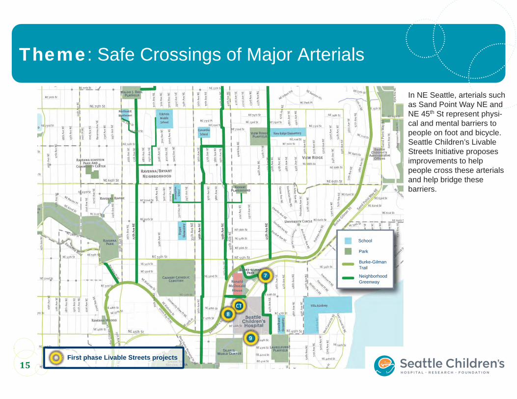
In NE Seattle, arterials such as Sand Point Way NE and NE 45th St represent physi-cal and mental barriers to people on foot and bicycle. Seattle Children’s Livable Streets Initiative proposes improvements to help people cross these arterials and help bridge these barriers.
9
7
CTCTCTTTTTTTTTTTTTTTTTTTTTTTTCCCCCCCCCCCCCCCCCCC88888888888888888
7777777
999999999
First phase Livable Streets projects
16
NE Seattle Arterials
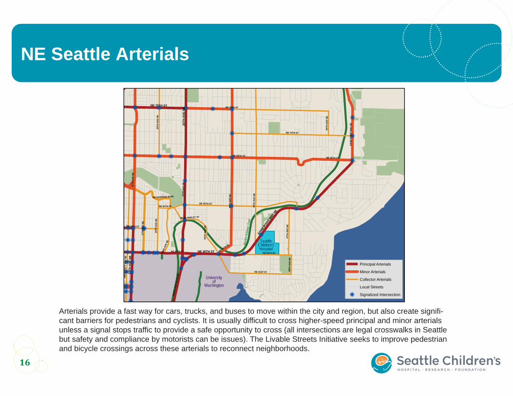
Arterials provide a fast way for cars, trucks, and buses to move within the city and region, but also create signifi-cant barriers for pedestrians and cyclists. It is usually difficult to cross higher-speed principal and minor arterials unless a signal stops traffic to provide a safe opportunity to cross (all intersections are legal crosswalks in Seattle but safety and compliance by motorists can be issues). The Livable Streets Initiative seeks to improve pedestrian and bicycle crossings across these arterials to reconnect neighborhoods.
r
r r r r r
r
r
r r r r r rr
r
r
r rr
r
rrr rr
rrrr
rrr rrrrr rr rrr
rr
rrr
rrrrrrr
r
r
NE 75TH ST
15TH
AVE
NE
25TH
AVE
NE
35TH
AVE
NE
40TH
AVE
NE
NE 55TH ST
NE 70TH ST
SAN
D P
OIN
T W
AY N
E
UN
IVER
SITY
WAY
NE
NE 41ST ST
20TH
AVE
NE
17TH
AVE
NE
NE 65TH ST
47TH
AVE
NE
22ND
AVE
NE
NE 50TH ST
MO
NTL
AK
E B
LVD
NE
NE 45TH ST
NE RAVENNA BLVD
55TH
AVE
NE
48TH
AVE
NE
NE BLAKELEY ST
NE 45TH PL
NE 54TH ST30
TH A
VE N
E
NE 65TH ST
NE 45TH ST
20TH
AVE
NE
25TH
AVE
NE
SAND P
OINT
WAY
NE
15TH
AVE
NE
NE 75TH ST
NE 45TH ST
Bur
ke-G
ilman
Tra
il
Principal Arterials
Minor Arterials
Collector Arterials
Local Streets
r Signalized Intersection
SeattleChildren’sHospital
University of
Washington
r
17
ConceptConceptLS-7: NE 52nd St & Sand Point Way NE Pedestrian Crossing Signal
SPWLSWUATAS
Photo: Cary Pillo
Photo:
Sand Point Way NE creates a barrier and safety issue in this part of the neighborhood. Currently people wishing to access parks, schools, and shopping on the other side of the arterial must cross four lanes of high-speed traffic with no signal or other crossing treatments. A center median provides a stopping point but is insufficient for a safe cross-ing.
A signal at NE 52nd St & Sand Point Way NE would help people walk and bike between the neigh-borhoods, the Burke-Gilman Trail, Laurelhurst Elementary, and the parks.
Current Conditions Proposed Improvements
Project Update:
WSDOT has approved
this project
SDOT working on funding
details
Photo: Bing Maps
New PedestrianCrossingNeCCrCCCCC o
NSF
18
ProjectProjectLS-7: NE 52nd St Sidewalk and Arterial Crossing
Photo: For more information, please contact:
206-615-0786
N
S
W
E
• New signal at intersection
• Longer left turn pockets for vehicles turning at NE 52nd St
• Traffic island on north side of intersection to be shifted north (or reduced in size)
• New pedestrian crossing signals
19
School
Park
Burke-GilmanTrail
NeighborhoodGreenway
Theme: Make Traffic Flow More Efficiently
10
In addition to an aggressive program to reduce vehicle travel to and from its campus, Children’s is investing in cutting-edge technology and new proj-ects to make traffic flow more efficiently through the major corridors that lead to the hospital.
ITS
8
First phase Livable Streets projects
20
What is ITS?
Intelligent Transportation Systems (ITS) are technologies and opera-tions strategies that improve the flow of traffic without the expense and disruption of expanding roadways. ITS technology can also be installed quickly, providing immediate results.
Arterial ITS treatments include elements like traffic data collectors, traffic cameras, variable message signs, ramp meters, signal synchro-nization, and traffic management centers.
Magnetometer
21
Photo:
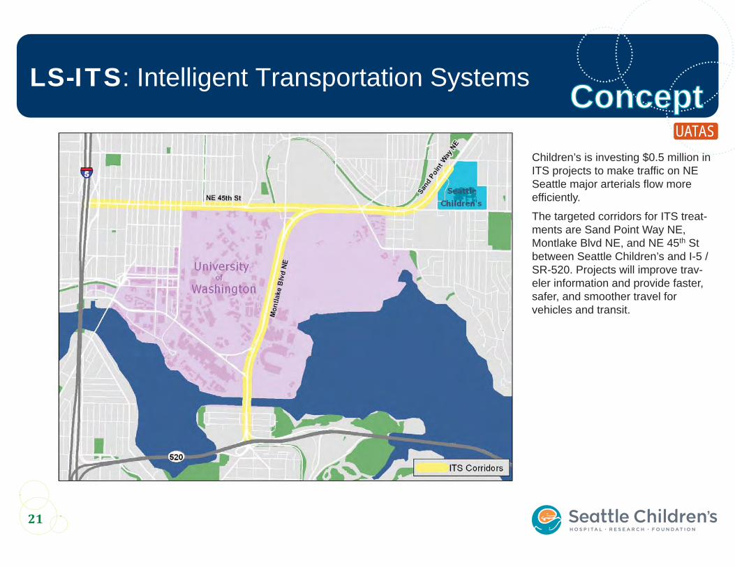
LS-ITS: Intelligent Transportation Systems ConceptConceptChildren’s is investing $0.5 million in ITS projects to make traffic on NE Seattle major arterials flow more efficiently.
The targeted corridors for ITS treat-ments are Sand Point Way NE, Montlake Blvd NE, and NE 45th St between Seattle Children’s and I-5 / SR-520. Projects will improve trav-eler information and provide faster, safer, and smoother travel for vehicles and transit.
UATAS
22
Photo:
LS-ITS: Intelligent Transportation Systems
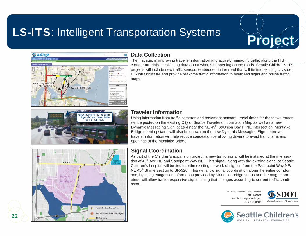
Traveler InformationUsing information from traffic cameras and pavement sensors, travel times for these two routes will be posted on the existing City of Seattle Travelers’ Information Map as well as a new Dynamic Messaging Sign located near the NE 45th St/Union Bay Pl NE intersection. Montlake Bridge opening status will also be shown on the new Dynamic Messaging Sign. Improved traveler information will help reduce congestion by allowing drivers to avoid traffic jams and openings of the Montlake Bridge
For more information, please contact:
206-615-0786
New congestion information
ooon on New traffic sensorsffic sensoaffiaaNew traN
The first step in improving traveller information and actively managing traffic along the ITS corridor arterials is collecting data about what is happening on the roads. Seattle Children’s ITS projects will include new traffic sensors embedded in the road that will tie into existing citywide ITS infrastructure and provide real-time traffic information to overhead signs and online traffic maps.
Data Collection
ProjectProject
As part of the Children’s expansion project, a new traffic signal will be installed at the intersec-tion of 40th Ave NE and Sandpoint Way NE. This signal, along with the existing signal at Seattle Children’s hospital will be tied into the existing network of signals from the Sandpoint Way NE/ NE 45th St intersection to SR-520. This will allow signal coordination along the entire corridor and, by using congestion information provided by Montlake bridge status and the magnetom-eters, will allow traffic-responsive signal timing that changes according to current traffic condi-tions.
Signal Coordination
New Dynamic Messaging Sign shows travel time
to I-5, SR-520
23
Photo:
LS-8: 40th Ave NE & Sand Point Way NE Intersection
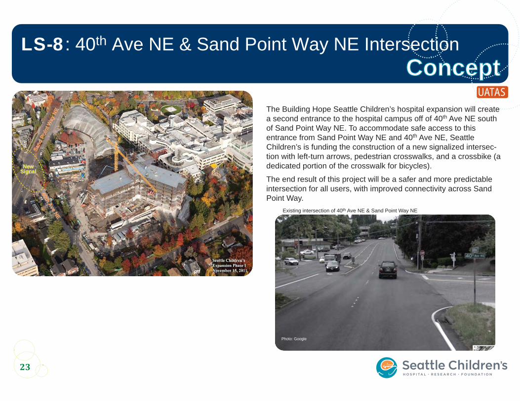
The Building Hope Seattle Children’s hospital expansion will create a second entrance to the hospital campus off of 40th Ave NE south of Sand Point Way NE. To accommodate safe access to this entrance from Sand Point Way NE and 40th Ave NE, Seattle Children’s is funding the construction of a new signalized intersec-tion with left-turn arrows, pedestrian crosswalks, and a crossbike (a dedicated portion of the crosswalk for bicycles).
The end result of this project will be a safer and more predictable intersection for all users, with improved connectivity across Sand Point Way.
ConceptConceptSa
nd P
oint
Way
NE
Sand
Poi
nt W
ay N
E
40th Ave NE
40th Ave NE
NewNewSignalSignal
Photo: Google
Existing intersection of 40th Ave NE & Sand Point Way NE
UATAS
NORTH
24
Photo:
LS-8: 40th Ave NE & Sand Point Way NE Intersection
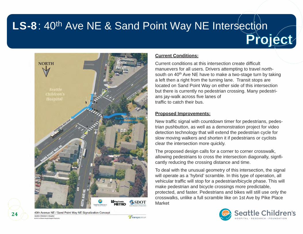
Current Conditions:Current conditions at this intersection create difficult manuevers for all users. Drivers attempting to travel north-south on 40th Ave NE have to make a two-stage turn by taking a left then a right from the turning lane. Transit stops are located on Sand Point Way on either side of this intersection but there is currently no pedestrian crossing. Many pedestri-ans jay-walk across five lanes of traffic to catch their bus.
Proposed Improvements:New traffic signal with countdown timer for pedestrians, pedes-trian pushbutton, as well as a demonstration project for video detection technology that will extend the pedestrian cycle for slow moving walkers and shorten it if pedestrians or cyclists clear the intersection more quickly.
The proposed design calls for a corner to corner crosswalk, allowing pedestrians to cross the intersection diagonally, signfi-cantly reducing the crossing distance and time.
To deal with the unusual geometry of this intersection, the signal will operate as a ‘hybrid’ scramble. In this type of operation, all vehicular traffic will stop for a pedestrian/bicycle phase. This will make pedestrian and bicycle crossings more predictable, protected, and faster. Pedestrians and bikes will still use only the crosswalks, unlike a full scramble like on 1st Ave by Pike Place Market
ProjectProject
Livable Streets InitiativeSeattle Children’s
Appendix A - Project List and Evaluation Matrix
$1.4
M M
itiga
tion
$2.0
M B
ike/
Ped
$0.5
M IT
S
LS W
orks
hop
Safe
art
eria
l cro
ssin
gs
Impr
oved
BG
T ac
cess
Park
s, s
choo
ls, B
GT
LS: T
otal
Sco
re
Leve
ragi
ng a
nd F
undi
ng
Pede
stria
n M
aste
r Pla
n
Bicy
cle
Mas
ter P
lan
Com
mun
ity S
uppo
rt
Conn
ectiv
ity
Dis
tanc
e
SDO
T: T
otal
Sco
re
Tota
l Sco
re w
ith L
S
1 a a SCH LS, Workshop39th Ave NE, BGT to NE 85th and north
Create a neighborhood green street and associated traffic calming on NE 39th St.
x 10 10 10 10 40 5 0 5 0 10 10 30 70
8 a aSPW Ped Study, SCH LS, Workshop
40th Ave NE & SPW New signal and crosswalks. Additional funds to come from SCH. $1,600,000 x 10 10 10 10 40 5 10 5 10 0 10 40 80 Tier 2 location/Tier 1 area.
7 a a SPW Ped Study, NSF, Workshop
SPW between NE 50th St & 47th Ave NE
Install pedestrian signal at 52nd Ave NE & Sand Point Way NE $250,000 x 10 10 10 10 40 5 10 5 10 0 10 40 80Tier 3 location/Tier 1 area (score is for NE 50th St intersection). Submitted for NSF but not selected
3 a a SCH LS, WorkshopBGT at NE 50th St: connection to SPW through 41st Ave NE
NE 50th at BGT: Improve ramp to BGT from west. NE 50th: Improve ROW. NE 50th St at 40th Ave NE: improve bike/ped crossing, restrict parking near intersection to improve sightlines.
x 10 5 10 10 35 5 10 5 0 10 10 40 75 Tier 2 location/Tier 1 area
CT a a
Sand Point Way NE between 40th Ave NE and Penny Dr
Build a cycletrack along the hospital's Sand Point Way NE frontage. $125,000 10 5 5 20
HT a a Hartman Connection to Burke through Hartman property $1,000,000 10 10 10 30
ITS a aSand Point Way, NE 45th St, Montlake Blvd NE
Build Intelligent Transportation System treatments to make travel more efficient on major arterials connecting Seattle Children's hospital to area freeways.
$500,000 x 5 5
9 a a WorkshopNE 45th St: between 42nd Ave NE and 47th Ave NE
On NE 45th St, add crosswalk, signal, and/or curb bulbs at 42nd Ave NE, 43rd, 45th, and at 46th or 47th at Laurelhurst Elementary, plus digital speed sign to slow cars.
x 10 10 5 5 30 0 0 0 10 10 10 30 60 Project designed and partially funded
a SCH LS, Workshop 37th Ave NECreate a neighborhood green street and associated traffic calming on NE 37th St.
x 10 10 10 10 40
a WorkshopNE Blakeley St at 27th Ave NE
Create a neighborhood green street and associated traffic calming on NE 27th St.
x 10 10 10 10 40
a Workshop, SCH LS 45th Ave NE & BGTCreate a neighborhood green street and associated traffic calming on 45th Ave NE.
x 10 10 10 10 40
a SCH LS, Workshop NE 36th StCreate a neighborhood green street and associated traffic calming on NE 36th St.
x 10 10 10 10 40
2 aUATAS-10, SCH LS, Workshop
Ravenna Ave and Pl NE/ NE 55th st Corridor
Reconfigure corridor to provide curbs, gutters, and sidewalks, and delineate street corners to improve safety.
$1,200,000 (curb, gutters,
sidewalks, street corners)
x 10 5 10 10 35 10 10 0 10 0 0 30 65Tier 3 location/Tier 1 area Partially funded through NSF
5 a Workshop, SCH LS 45th Ave NE Improve / create ADA access from 45th Ave NE to BGT and SPW. x 10 5 10 10 35
6 a
Community tour w/ SDOT staff, SCH LS, Workshop
BGT access near Princeton Bridge
Improve dirt trail, provide access ramp. Protect the native vegetation planted in the vicinity. (Comments received for and against)
$75,000 (to improve dirt trail)
x 5 5 10 10 30 5 10 5 10 10 10 50 80 Possible BMP $
4 aUATAS-21, SCH LS, Workshop
36th Ave NE/ BGTNew ramp connection between 36th Ave NE and NE 45th Street with BGT; wayfinding and signage improvements.
$82,000 x 10 0 10 10 30 5 10 10 10 10 5 50 80Switchback from trail to crosswalk on 45th. Tier 1 area.
WorkshopNE 65th St & Burke-Gilman Trail
Improve bicycle facilities on NE 65th St from the Burke-Gilman Trail to Magnuson Park x 10 0 10 10 30
Workshop 12th Ave NE Develop a green street on 12th Ave NE. x 10 10 5 5 30
Workshop27th Ave NE & NE Blakely St
Add a median refuge to the intersection of 27th Ave NE and NE Blakely St. x 10 10 5 5 30
Workshop27th Ave NE & Burke-Gilman Trail Improve access to the Burke-Gilman Trail from 27th Ave NE. x 10 5 10 5 30
WorkshopBurke-Gilman Trail & Union Bay Pl NE
Improve the safety at the intersection of the Burke-Gilman Trail and Union Bay Pl NE. x 10 5 10 5 30
Proj
ects
Iden
tifie
d fo
r 1st
Ph
ase
Fund
ing
Proj
ects
Iden
tifie
d fo
r Co
nstr
uctio
n
1
Source
LS Project #
Estimated Total CostDescriptionProject/Location
Funding SDOT CriteriaLS Criteria
Notes
Seattle Children's Livable Streets Initiative Phase 1 Projects - Appendix A - Project List and Evaluation Matrix Page A-2
$1.4
M M
itiga
tion
$2.0
M B
ike/
Ped
$0.5
M IT
S
LS W
orks
hop
Safe
art
eria
l cro
ssin
gs
Impr
oved
BG
T ac
cess
Park
s, s
choo
ls, B
GT
LS: T
otal
Sco
re
Leve
ragi
ng a
nd F
undi
ng
Pede
stria
n M
aste
r Pla
n
Bicy
cle
Mas
ter P
lan
Com
mun
ity S
uppo
rt
Conn
ectiv
ity
Dis
tanc
e
SDO
T: T
otal
Sco
re
Tota
l Sco
re w
ith L
S
Proj
ects
Iden
tifie
d fo
r 1st
Ph
ase
Fund
ing
Proj
ects
Iden
tifie
d fo
r Co
nstr
uctio
nSource
LS Project #
Estimated Total CostDescriptionProject/Location
Funding SDOT CriteriaLS Criteria
Notes
WorkshopBurke-Gilman Trail & Pend Oreille Rd
Add treatments to clarify the right-of-way between bicycles and cars at the intersection of the Burke-Gilman Trail and Pend Oreille Rd. x 10 10 5 5 30
WorkshopRavenna Pl NE & NE 55th St Add a roundabout at NE 55th and Ravenna Pl NE x 10 10 5 5 30
WorkshopSand Point Way NE & Penny Dr Add a pedestrian overpass to cross Sand Point Way NE at Penny Dr. x 10 10 5 5 30
DEIS, Workshop SPW at NE 50th St New signal and crosswalks at this intersection when warranted. $250,000 x 10 10 0 5 25 5 10 5 0 0 10 30 55 Tier 3 location/Tier 1 area
UATAS-22BGT / NE 47th St / U Village
Create new ped connections along the NE 47th St ROW and realign intersections along 25th Ave (incl new stairway).
$900,000 x 10 5 5 5 25 5 10 0 5 10 0 30 55Project could be phased. Tier 2 location/Tier 1 area.
BMPNE 65th St, NE Ravenna Blvd to Magnuson Park
Bike lane one side, Sharrow other (partial), Sharrows 2 sides (partial). $80,000 x 5 10 5 5 25 5 0 10 0 5 10 30 55Sharrows and bike lanes in the BMP will be installed over time - additional funding would speed installation
SCH LS NE 50th St, 35th NE to BGT Wayfinding and bicycle boulevard. x 10 5 10 0 25 5 0 5 0 10 10 30 55
Workshop35th Ave NE & NE 47th Ave
Make 35th Ave NE one-way southbound between NE 47th St and NE Blakely St. x 10 0 10 5 25
WorkshopBurke-Gilman Trail & NE 70th St
Add stop signs and clear directions needed for trail users and drivers at the intersection of the Burke-Gilman Trail and NE 70th St. x x 10 10 5 0 25
WorkshopBurke-Gilman Trail & NE 65th St
Improve safety at the intersection of the Burke-Gilman Trail and NE 65th St (sightlines, signage, speeds). x x 10 10 5 0 25
Workshop Burke-Gilman TrailImprove lighting on the Burke-Gilman Trail from NE 45th St east to 30th Ave NE. x 10 0 5 10 25
Workshop Burke-Gilman TrailLight the entire Burke-Gilman Trail from Magnuson Park to UW campus. x 10 0 5 10 25
WorkshopBurke-Gilman Trail & Hartmann Building
Build a connection from the Burke-Gilman Trail to 40th Ave NE through the Hartman property. x 10 0 10 5 25
WorkshopBurke-Gilman Trail & 40th Ave NE
Make the Burke-Gilman Trail's crossing of NE 40th St an elevated crosswalk. x 10 10 5 0 25
WorkshopBurke-Gilman Trail & Ivanhoe Pl NE
Pave access from the crosswalk across Sand Point Way NE at Ivanhoe Pl NE to the Burke-Gilman Trail. x 10 0 10 5 25
Workshop
Burke-Gilman Trail & Fiddler on the Tooth Parking Lot
Improve the grade for bikes to connect from the Burke-Gilman Trail to Sand Point Way NE and NE 45th St x 10 0 10 5 25
Workshop NE 45th Pl & NE Blakely StExtend the median on NE 45th Pl to prevent vehicles on NE Blakely St from crossing. x 10 5 5 5 25
WorkshopNE 45th St & Union Bay Pl NE
Redesign the 5-point intersection to address the high pedestrian use and make the intersection more attractive. x 10 10 5 0 25
WorkshopNE 50th St & Sand Point Way NE Reroute NE 50th St to intersect Sand Point Way at Penny Dr. x 10 10 5 0 25
Workshop NE 50th StAdd raised crosswalk at NE 50th St across NE Blakely to the Burke-Gilman Trail x 10 5 5 5 25
Workshop Ravenna Pl NEImprove bicycle access on Ravenna Blvd/Pl from NE 54th St to 15th Ave NE. x 10 5 5 5 25
Workshop Ravenna Pl NE Close Ravenna Pl to auto traffic. x 10 0 10 5 25
WorkshopUnion Bay Pl NE & 3200 block
Add pedestrian/bicycle connection from Union Bay Pl NE to University Village south of the Burke-Gilman Trail. x 10 10 5 0 25
SPW Ped Study SPW at NE 58th or 60th St Monitor for potential signal and crosswalk in the future. $250,000 x x 0 10 10 0 20 5 5 5 0 0 15 35 58th = 2/2, 59th = 2/2, 60th = 2/1
PMP SPW & NE 62nd St Crossing improvements. x 0 10 10 0 20 5 10 0 0 0 0 15 35Tier 1 location/ Tier 1 area. Evaluation needed by SDOT to determine specific improvement type
Seattle Children's Livable Streets Initiative Phase 1 Projects - Appendix A - Project List and Evaluation Matrix Page A-3
$1.4
M M
itiga
tion
$2.0
M B
ike/
Ped
$0.5
M IT
S
LS W
orks
hop
Safe
art
eria
l cro
ssin
gs
Impr
oved
BG
T ac
cess
Park
s, s
choo
ls, B
GT
LS: T
otal
Sco
re
Leve
ragi
ng a
nd F
undi
ng
Pede
stria
n M
aste
r Pla
n
Bicy
cle
Mas
ter P
lan
Com
mun
ity S
uppo
rt
Conn
ectiv
ity
Dis
tanc
e
SDO
T: T
otal
Sco
re
Tota
l Sco
re w
ith L
S
Proj
ects
Iden
tifie
d fo
r 1st
Ph
ase
Fund
ing
Proj
ects
Iden
tifie
d fo
r Co
nstr
uctio
nSource
LS Project #
Estimated Total CostDescriptionProject/Location
Funding SDOT CriteriaLS Criteria
Notes
PMP SPW & NE 63rd St Crossing improvements. x 0 10 10 0 20 5 10 0 0 0 0 15 35Tier 1 location/ Tier 1 area. Evaluation needed by SDOT to determine specific improvement type
SCH LS, Workshop NE 45th St and SPW Intersection improvements. x x 10 10 0 0 20 5 5 ? 0 ? 10 20 40Need more information about scope. Tier 3 location/Tier 2 area
PMPNE 41st St between Surber Dr NE & 41st Ave NE
Sidewalk. Workshop comment also requested bike lanes. x 10 0 5 5 20 5 10 0 0 5 5 25 45
PMPUnion Bay Pl NE between NE 45th St and 30th Ave NE
Sidewalk on both sides. x 10 0 5 5 20 5 10 0 0 10 0 25 45Have 60% design. Construction planned for 2012 or 2013
UATAS-28NE 45th St from 18th to 22nd Ave NE
Widen sidewalks and install landscaped ped refuge islands to improve ped capacity and safety.
$1,400,000 x 10 0 10 20 5 10 5 5 0 0 25 45Sidewalks on south side are being widened as part of NE 45th St Viaduct project
UATAS-11, Workshop
NE 45th Viaduct & BGTConstruct a pedestrian and bicycle trail connection between NE 45th St and BGT.
x 10 0 5 5 20 5 10 5 10 10 0 40 60
At 45th St Viaduct. Potential for staircase and gravel trail with lighting to reach BGT from 45th Viaduct. CPRS to provide updated costs. Tier 1 area.
Workshop15th Ave NW & NW 45th St Improve bike access to the Ballard Bridge x 10 0 10 0 20
Workshop37th Ave NE & NE Blakely St Add curb ramp at the intersection of 37th Ave NE and NE Blakely St. x 10 0 5 5 20
Workshop 40th Ave NE Downgrade 40th Ave NE from an arterial to slow traffic down. x 10 10 0 0 20
WorkshopBurke-Gilman Trail & 53rd Ave NE
Pave the gravel section connecting the Burke-Gilman Trail to Pullman Ave NE at 53rd Ave NE. x 10 0 10 0 20
Workshop Burke-Gilman TrailCreate a connection between the Burke-Gilman Trail and Windermere via the Center for Spiritual Living. x 10 0 10 0 20
WorkshopBurke-Gilman Trail & 5000 block (nr LL)
Improve safety at the curve in the Burke-Gilman Trail near the Autism Clinic at about NE 50th St. x 10 0 5 5 20
WorkshopBurke-Gilman Trail & Phinney Ave N
Add path lighting on the Burke-Gilman from the Fre-lard Fred Meyer to the Ship Canal Bridge. x 10 0 5 5 20
WorkshopMontlake Blvd NE & NE Pacific St
Add roundabout to the intersection of Montlake Blvd NE and NE Pacific St. x 10 10 0 0 20
Workshop Penny Drive Develop Penny Drive as a bike route to Laurelhurst. x 10 0 5 5 20Workshop Sand Point Way NE Lower speed limit to 30 mph. x 10 10 0 0 20
PMP U Village Dr & NE 45th St Crossing improvements x 5 10 0 0 15 5 10 0 0 0 0 15 30Tier 1 location/ Tier 1 area. Evaluation needed by SDOT to determine specific improvement type
PMPSPW between NE Windermere Rd and NE 58th St
Add sidewalk. x 10 0 0 5 15 0 10 0 0 10 0 20 35 Possible developer project?
PMP, WorkshopSPW between NE 58th St & 55th Ave NE
Add sidewalk. 10 0 0 5 15 0 10 0 0 10 0 20 35 Possible developer project?
PMP, WorkshopSPW NE between 55th Ave NE & NE 59th St
Add sidewalk on NW side. x 10 0 0 5 15 5 10 0 0 10 0 25 40Would extend recent NSF walkway project on SPW between Princeton and 50th
PMP, WorkshopSPW between NE 63rd St & NE 64th St
Add sidewalk. x 10 0 0 5 15 5 10 0 0 10 0 25 40
PMP, WorkshopSPW between NE 62nd & NE 63rd St
Add sidewalk. x 10 0 0 5 15 5 10 0 0 10 0 25 40
PMP, WorkshopSPW between NE 61st & NE 62nd St
Add sidewalk. x 10 0 0 5 15 5 10 0 0 10 0 25 40
BMP35th Ave NE, NE Blakely St to NE 65th St
Add sharrows on both sides. $20,000 x 5 0 10 0 15 5 0 10 0 5 10 30 45Sharrows and bike lanes in the BMP will be installed over time - additional funding would speed installation
Seattle Children's Livable Streets Initiative Phase 1 Projects - Appendix A - Project List and Evaluation Matrix Page A-4
$1.4
M M
itiga
tion
$2.0
M B
ike/
Ped
$0.5
M IT
S
LS W
orks
hop
Safe
art
eria
l cro
ssin
gs
Impr
oved
BG
T ac
cess
Park
s, s
choo
ls, B
GT
LS: T
otal
Sco
re
Leve
ragi
ng a
nd F
undi
ng
Pede
stria
n M
aste
r Pla
n
Bicy
cle
Mas
ter P
lan
Com
mun
ity S
uppo
rt
Conn
ectiv
ity
Dis
tanc
e
SDO
T: T
otal
Sco
re
Tota
l Sco
re w
ith L
S
Proj
ects
Iden
tifie
d fo
r 1st
Ph
ase
Fund
ing
Proj
ects
Iden
tifie
d fo
r Co
nstr
uctio
nSource
LS Project #
Estimated Total CostDescriptionProject/Location
Funding SDOT CriteriaLS Criteria
Notes
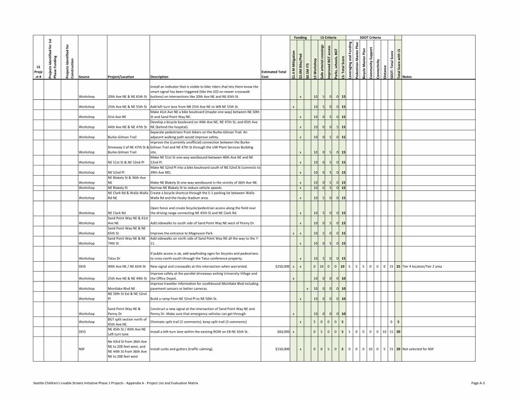
Workshop 20th Ave NE & NE 65th St
Install an indicator that is visible to bike riders that lets them know the smart signal has been triggered (like the LED on newer crosswalk buttons) on intersections like 20th Ave NE and NE 65th St. x 10 5 0 0 15
Workshop 25th Ave NE & NE 55th St Add left turn lane from NB 25th Ave NE to WB NE 55th St. x 10 5 0 0 15
Workshop 41st Ave NEMake 41st Ave NE a bike boulevard (maybe one-way) between NE 50th St and Sand Point Way NE. x 10 0 5 0 15
Workshop 44th Ave NE & NE 47th StDevelop a bicycle boulevard on 44th Ave NE, NE 47th St, and 45th Ave NE (behind the hospital). x 10 0 0 5 15
Workshop Burke-Gilman TrailSeparate pedestrians from bikers on the Burke-Gilman Trail. An adjacent walking path would improve safety. x 10 0 5 0 15
WorkshopDriveway S of NE 47th St & Burke-Gilman Trail
Improve the (currently unofficial) connection between the Burke-Gilman Trail and NE 47th St through the UW Plant Services Building site. x 10 0 5 0 15
Workshop NE 51st St & NE 52nd PlMake NE 51st St one-way westbound between 40th Ave NE and NE 52nd Pl. x 10 0 5 0 15
Workshop NE 52nd PlMake NE 52nd Pl into a bike boulevard south of NE 52nd St (connects to 39th Ave NE). x 10 0 5 0 15
WorkshopNE Blakely St & 36th Ave NE Make NE Blakely St one-way westbound in the vicinity of 36th Ave NE. x 10 0 5 0 15
Workshop NE Blakely St Narrow NE Blakely St to reduce vehicle speeds. x 10 0 5 0 15
WorkshopNE Clark Rd & Walla Walla Rd NE
Create a bicycle shortcut through the E-1 parking lot between Walla Walla Rd and the Husky Stadium area. x 10 5 0 0 15
Workshop NE Clark RdOpen fence and create bicycle/pedestrian access along the field near the driving range connecting NE 45th St and NE Clark Rd. x 10 5 0 0 15
WorkshopSand Point Way NE & 41st Ave NE Add sidewalks to south side of Sand Point Way NE west of Penny Dr. x 10 0 5 0 15
WorkshopSand Point Way NE & NE 65th St Improve the entrance to Magnuson Park. x x 10 5 0 0 15
WorkshopSand Point Way NE & NE 74th St
Add sidewalks on north side of Sand Point Way NE all the way to the 7-11. x 10 0 5 0 15
Workshop Talus DrIf public access is ok, add wayfinding signs for bicycles and pedestrians to cross north-south through the Talus conference property. x 10 5 0 0 15
DEIS 40th Ave NE / NE 65th St New signal and crosswalks at this intersection when warranted. $250,000 x x 0 10 0 0 10 5 5 5 0 0 0 15 25 Tier 4 location/Tier 2 area
Workshop 25th Ave NE & NE 49th StImprove safety at the parallel driveways exiting University Village and the Office Depot. x 10 0 0 0 10
Workshop Montlake Blvd NEImprove traveller information for southbound Montlake Blvd including pavement sensors or better cameras. x 10 0 0 0 10
WorkshopNE 50th St Ext & NE 52nd Pl Build a ramp from NE 52nd Pl to NE 50th St. x 10 0 0 0 10
WorkshopSand Point Way NE & Penny Dr
Construct a new signal at the intersection of Sand Point Way NE and Penny Dr. Make sure that emergency vehicles can get through. x 10 0 0 0 10
WorkshopBGT split section north of 45th Ave NE
Eliminate split trail (2 comments); keep split trail (3 comments) x 5 0 0 0 5 0 5
DEISNE 45th St / 40th Ave NE Left turn lane
Install a left-turn lane within the existing ROW on EB NE 45th St. $60,000 x 0 5 0 0 5 5 0 0 0 0 10 15 20
NSF
Ne 43rd St from 36th Ave NE to 200 feet west, and NE 44th St from 36th Ave NE to 200 feet west
Install curbs and gutters (traffic calming). $150,000 x 0 0 5 0 5 0 0 0 10 0 5 15 20 Not selected for NSF
Seattle Children's Livable Streets Initiative Phase 1 Projects - Appendix A - Project List and Evaluation Matrix Page A-5
$1.4
M M
itiga
tion
$2.0
M B
ike/
Ped
$0.5
M IT
S
LS W
orks
hop
Safe
art
eria
l cro
ssin
gs
Impr
oved
BG
T ac
cess
Park
s, s
choo
ls, B
GT
LS: T
otal
Sco
re
Leve
ragi
ng a
nd F
undi
ng
Pede
stria
n M
aste
r Pla
n
Bicy
cle
Mas
ter P
lan
Com
mun
ity S
uppo
rt
Conn
ectiv
ity
Dis
tanc
e
SDO
T: T
otal
Sco
re
Tota
l Sco
re w
ith L
S
Proj
ects
Iden
tifie
d fo
r 1st
Ph
ase
Fund
ing
Proj
ects
Iden
tifie
d fo
r Co
nstr
uctio
nSource
LS Project #
Estimated Total CostDescriptionProject/Location
Funding SDOT CriteriaLS Criteria
Notes
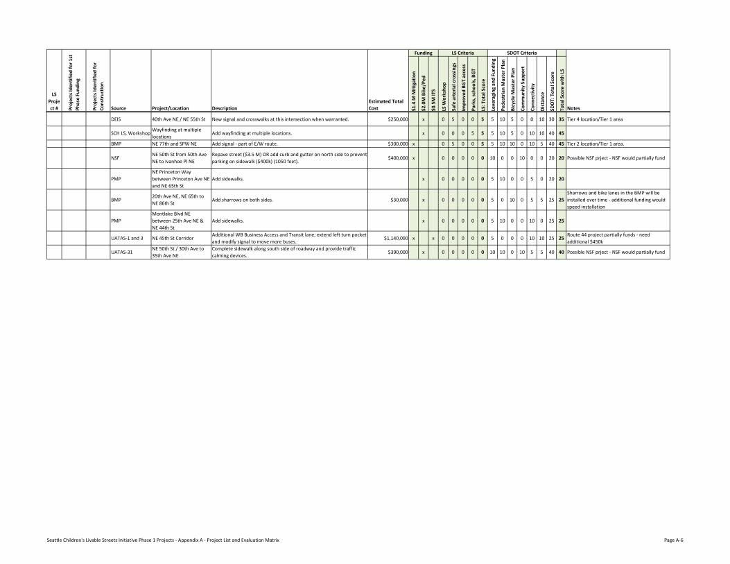
DEIS 40th Ave NE / NE 55th St New signal and crosswalks at this intersection when warranted. $250,000 x 0 5 0 0 5 5 10 5 0 0 10 30 35 Tier 4 location/Tier 1 area
SCH LS, WorkshopWayfinding at multiple locations
Add wayfinding at multiple locations. x 0 0 0 5 5 5 10 5 0 10 10 40 45
BMP NE 77th and SPW NE Add signal - part of E/W route. $300,000 x 0 5 0 0 5 5 10 10 0 10 5 40 45 Tier 2 location/Tier 1 area.
NSFNE 50th St from 50th Ave NE to Ivanhoe Pl NE
Repave street ($3.5 M) OR add curb and gutter on north side to prevent parking on sidewalk ($400k) (1050 feet).
$400,000 x 0 0 0 0 0 10 0 0 10 0 0 20 20 Possible NSF prject - NSF would partially fund
PMPNE Princeton Way between Princeton Ave NE and NE 65th St
Add sidewalks. x 0 0 0 0 0 5 10 0 0 5 0 20 20
BMP20th Ave NE, NE 65th to NE 86th St
Add sharrows on both sides. $30,000 x 0 0 0 0 0 5 0 10 0 5 5 25 25Sharrows and bike lanes in the BMP will be installed over time - additional funding would speed installation
PMPMontlake Blvd NE between 25th Ave NE & NE 44th St
Add sidewalks. x 0 0 0 0 0 5 10 0 0 10 0 25 25
UATAS-1 and 3 NE 45th St CorridorAdditional WB Business Access and Transit lane; extend left turn pocket and modify signal to move more buses.
$1,140,000 x x 0 0 0 0 0 5 0 0 0 10 10 25 25Route 44 project partially funds - need additional $450k
UATAS-31NE 50th St / 30th Ave to 35th Ave NE
Complete sidewalk along south side of roadway and provide traffic calming devices.
$390,000 x 0 0 0 0 0 10 10 0 10 5 5 40 40 Possible NSF prject - NSF would partially fund
Seattle Children's Livable Streets Initiative Phase 1 Projects - Appendix A - Project List and Evaluation Matrix Page A-6