Seasonal Movement Patterns of Walleye (Sander vitreus) in ...
36
Seasonal Movement Patterns of Walleye (Sander vitreus) in Muskegon River and Muskegon Lake, Michigan. by Jonathan R. Hanson A thesis submitted in partial fulfillment of the requirements for the degree of Master of Science School of Natural Resources and Environment The University of Michigan 2006 Thesis Committee: Professor Paul W. Webb, Chair Professor James S. Diana
Transcript of Seasonal Movement Patterns of Walleye (Sander vitreus) in ...
Seasonal Movement Patterns of Walleye (Sander vitreus) in Muskegon River and Muskegon Lake, Michigan.
by Jonathan R. Hanson
A thesis submitted in partial fulfillment of the requirements
for the degree of Master of Science
School of Natural Resources and Environment The University of Michigan
2006
Thesis Committee: Professor Paul W. Webb, Chair Professor James S. Diana


ii
Table of Contents
Page
Acknowledgements.......................................................................................iii
List of Figures............................................................................�................iv
List of Tables.................................................................................................v
Abstract..........................................................................................................1
Introduction................................................................................�����..3
Study Site�....................................................................................................4
Methods.................................................................................................��..5
Results...........................................................................................................11
Discussion.....................................................................................................15
Figures...................................................................................................��.21 Tables.............................................................................................................26
Literature Cited..............................................................................................28

iii
Acknowledgments
This study would not have been possible without the support of many people. I
wish to thank Dr. Jim Diana who initially guided me on this project and was an
invaluable source. I appreciate his advice and efforts to help me achieve. Additionally
I would like to thank Dr. Paul Webb for his flexible advising approach and comments
during the write-up process. Without their guidance and planning this thesis would not
have been possible.
Numerous individuals assisted with logistics in the field and in the lab, big thanks
to all of the student employees that assisted with field collection. I am tremendously
grateful to Christine Diana who spent countless hours tracking fish and chauffeuring me
around in the boat. I would also like to thank Damon Krueger for all of his assistance. I
sincerely appreciate the NOAA Lake Michigan Field Station in Muskegon for allowing us
to operate equipment and occasionally stay at their facility.
Lastly, I would like to thank my friends and family that have been vital to my own
success. Thanks to my parents Ken and Linda Hanson, and my sister Michelle, for
providing support and guidance along this journey. Finally, a special thanks to my wife,
Marcy for her endless support, patience, and always believing in me.

iv
List of Figures
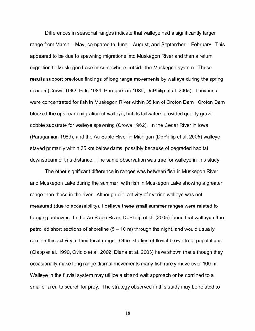
FIGURE 1. Map of Muskegon River Watershed from Croton Dam to Lake Michigan, showing sites of walleye release and locations of fixed receivers.
FIGURE 2. Map of Muskegon Lake showing telemetry listening stations used in 2004 and 2005.
FIGURE 3. Map of Muskegon Lake showing cells (300 x 300 m) with differing relative abundance (number of walleye / summer period) of tagged walleye during summer 2004 and 2005. FIGURE 4. Map of Muskegon River showing all locations of radio tagged walleye during March � May for 2004 and 2005. FIGURE 5. The percent of active and inactive intervals for walleye, from Muskegon Lake, during four diel periods. FIGURE 6. Relative frequency of walleye locations at various depths in Muskegon Lake at night and during the day.

v
List of Tables
TABLE 1. Summary information on walleye tracked in Muskegon Lake and Muskegon River. TABLE 2. Summary of combined catch-per-effort data for 2004 and 2005 from Muskegon River.

1
Abstract
Walleye (Sander vitreus) are known to travel long distances between
spawning, foraging and over wintering habitats. In the Muskegon system walleye have
the choice of moving between Muskegon River, Muskegon Lake and Lake Michigan
throughout the year. The purpose of this study was to determine the seasonal
movement of walleye in the Muskegon system.
In 2004 and 2005 a total of 15 walleye were implanted with radio transmitters and
5 with ultrasonic transmitters. During March, April, and May walleye were located in
Muskegon River, near Croton Dam, presumably to spawn. By June 10 of 12 fish
tracked had departed the river for Muskegon Lake or left the Muskegon system. In
June, July and August 85% (17/20) of tracked walleye inhabited Muskegon Lake or
were outside the Muskegon system. From September through February 6 of 7 tracked
fish were located in lacustrine habitat. I documented one walleye periodically traveling
between Muskegon Lake and Lake Michigan during November and December. Based
on movement results telemetry data were categorized into three time periods; spring,
which included pre- and post spawning periods (March � May), summer (June �
August), and winter (September � February).
Range (total distance displaced) of tagged walleye was greatest during spring
due to spawning migrations in Muskegon River. Spring range of all walleye varied from
3,467 to 150,900 m; summer range varied from 131 to 46,114 m; and winter range from
326 to 42,650 m. There were significant differences between spring and summer
ranges (p< 0.001) and between spring and winter ranges (p = 0.024), but not between

2
summer and winter ranges (p = 0.223). During summer, total range of fish inhabiting
Muskegon River was significantly different than those fish in Muskegon Lake. These
differences between Muskegon River and Lake are attributed to the energetic costs for
large walleye to search long distances for prey in flowing water versus searching for
prey in the lacustrine environment. Movement results from this study emphasize the
importance of the habitat connection within this system, and may also assist managers
in determining when and where to calculate population estimates.

3
Introduction
Long range movements of walleye (Sander vitreus) have been well documented
in rivers and lakes throughout the Midwest (Eschmeyer and Crowe 1955, Holt et al.
1977, Paragamian 1989, and DePhilip et al. 2005). Walleye movement patterns are
complex due to habitat needed for foraging, spawning, and overwintering. Most
telemetry studies focus on an area where walleye movement is constricted between two
dams (Paragamian 1989, DePhilip et al.2005,), to an inland lake, or have access to a
lake and river (Holt et al. 1977). The Muskegon watershed is unique in that the lower
75 km of Muskegon River, Muskegon Lake, and Lake Michigan are connected providing
fishes a large, diverse choice of habitats and free movement between them throughout
the year. Because this system consists of three distinct habitats, a better understanding
of walleye movement can lead to improved walleye management for the Muskegon
system.
Previous studies of walleye in the Muskegon River have focused on mark-
recapture methods and provided evidence for long range movement between spawning
locations (Eschmeyer and Crowe 1955, Crowe 1962). Eschmeyer and Crowe (1955)
tagged walleye in Muskegon River during the spring and noted fish traveled
considerable distances traveled between captures. The farthest of their recaptured fish
was found 282 kilometers away in northern Lake Michigan, and fourteen walleyes had
moved more than 161 kilometers between release and recapture. It is also known that
walleye from the eastern side of Lake Michigan and Muskegon Lake can be found in
Muskegon River during the spring spawning run (Crowe 1962).

4
Mark-recapture investigations cannot determine the behavior of a fish between
release and recapture. Telemetry can be used to determine the timing of fish
movement among habitat types, and the routes taken. Seasonal movement and
estimates of movement rates can be used to determine if mobile fish populations should
be managed as one or as discrete units (Schweigert and Schwarz 1993).
The purpose of this investigation was to conduct a telemetry study to determine the
movement patterns of walleye in the Lower Muskegon River system. Telemetry was
used to track the movement of fish between Muskegon River, Muskegon Lake, and
Lake Michigan. The specific objectives of this study were 1) to ascertain when walleye
inhabit Muskegon River, Muskegon Lake, or Lake Michigan, and 2) determine the
seasonal movement patterns of walleye in Muskegon River and Muskegon Lake.
Study Site
The Muskegon watershed is located on the western side of Michigan�s Lower
Peninsula. Muskegon River originates in Houghton and Higgins lakes in Roscommon
County and flows southwesterly for a distance of 365 km, entering Lake Michigan by
way of Muskegon Lake (Eschmeyer 1950). Croton Dam, 75 km from Muskegon Lake,
was the upper boundary of the study site. Land cover within the study area mainly
consists of agriculture and forest, with urban areas through the cities of Muskegon and
Newaygo.
The area from Croton Dam to 30 km downstream has higher gradient, more pool-
riffle transitions, and greater concentrations of gravel and pebble substrate types. This

5
section has a single channel with nearly no braiding. The lower half of the study site
consists of a silt-sand substrate with increased channel braiding and shallower depths.
Habitat is more uniform with fewer pool-riffle sequences. Muskegon River splits into the
North and South branches 4.6 km from the mouth, then empties into Muskegon Lake.
The average annual discharge of Muskegon River at Croton Dam is 51.9 m³/s.
Muskegon Lake is a 1,679 hectare drowned river mouth that was created
historically by fluctuating Lake Michigan water levels and the closing of a channel by
wind induced erosion of sand dunes. It is connected to Lake Michigan by a shipping
channel on its east side and also to Bear Lake by a channel on the north shore. The
maximum depth is 25.6 m with an average depth around 10 m. The majority of the lake
has silt or sand substrate. The littoral zone of the northern shore has gradual slopes,
whereas the southern shore is generally deeper and drops off more rapidly. Average
secchi depth during the spring and summer periods was 3 m ranging from 2.5 to 3.5 m.
The town of Muskegon and North Muskegon line the shore of the lake making most of
the adjacent land cover urbanized. Chemical companies, a paper mill and foundries are
also found within the immediate vicinity. The area has been identified by the
Environmental Protection Area (EPA) as an Area of Concern (EPA 2004).
Methods
Twenty walleye ranging from 401 to 725 mm total length were captured for
transmitter implantation using a DC electrofishing boat during 2004 and 2005. Ten
walleye were radio tagged during 2004; seven in April and June, in two locations in
6
Muskegon River and three captured and released on July 1 in Muskegon Lake (Table
1). In 2005 five walleye were radio tagged from Muskegon River, four during the first
week of April and one during the first week of June. An additional five walleye from
Muskegon Lake were implanted with ultrasonic tags, three during the last week of May
and two during the first week of July (Table 1; Figure 1). Fish were captured and then
released, immediately after surgery, near their capture site. Transmitters were
surgically implanted as described in Ross and Kleiner (1982). A net stretcher was
wrapped around the fish to restrain movement and a transmitter inserted with a trailing
antenna protruding. After surgery, 2 ml (50 mg/ml) of oxytetracycline was injected
through the incision. The procedure took less than ten minutes, and fish were held in a
live-well until swimming upright and showing signs of normal activity, and then released.
Sex was determined when possible by gonadal release.
Radio transmitters (Advanced Telemetry Systems, model F1840, Isanti,
Minnesota) weighed between 18-20 g and had a 25 cm trailing antenna. The life
expectancy of the battery was 180 to 339 days, and each transmitter emitted a signal
with a unique frequency between 150.000 � 150.999 MHz. Ultrasonic transmitters
(Sonotronics, model CT-82-2, Tucson, Arizona) weighed between 16 � 19 g, and had a
battery life expectancy of one year. Two types of radio receivers from Advanced
Telemetry Systems were used. A R2100 receiver with directional antenna was used to
actively track fish from shore or boat. Two fixed station R4500C receivers with
accompanying directional antennas were used to determine when fish passed between
Muskegon River and Muskegon Lake, or to Lake Michigan (Figure 1). One of these
receivers was placed on the main channel of Muskegon River 4.8 km from the lake.

7
This receiver was upstream before the channel splits into the North and South Branch.
The second R4500C was located on the channel connecting Muskegon Lake and Lake
Michigan. The R4500C receivers could not detect the sonic transmitters. An ultrasonic
receiver (Sonotronics USR-96) and hand-held directional hydrophone were used to
track fish implanted with ultrasonic tags. Walleye with ultrasonic tags were located from
April to August 2005. Walleye with radio tags were located from April 2004 to August
2005. Only eight walleye had working tags from November 2004 to January 2005, and
range could only be determined for four walleye. Two walleye during this time were
captured by anglers, therefore removing them from the sample, and lack of detections
for four other fish limited range calculations.
During the study walleye were tracked from boat and shore. Using ultrasonic,
and radio equipment in Muskegon Lake a systematic pattern was used to search for
fish. A course was set, east to west, through the middle of Muskegon Lake, and the
boat stopped at every 1 km until reaching the opposite shoreline. West of the Bear
Lake channel four additional listening stations were added, two north of the center line
course and two south of the center course. At each stopping point the boat motor was
turned off and the hydrophone slowly rotated 360° to search for fish in all directions
(Figure 2). Using this methodology all ultrasonic tagged fish were found. Detections
were limited for walleye tagged with radio transmitters, presumably due to depth
constraints on radio telemetry. During each tracking session, all areas were searched.
Upon detecting a signal at a listening station the fish was approached until signal
strength peaked, then repeated from another direction to get a precise location.
Locations were recorded on a map, using landmark features and GPS coordinates.

8
Water temperature, time, and water depth were recorded. Diel movement patterns for
numerous fish could be tracked during 12 and 24 hour periods by moving among
individual walleye, and pinpointing the location of each fish one to two times an hour.
Changes in signal strength or direction of a particular fish appeared to indicate active
movement. For these active fish, tracking was concentrated to record their movements.
To calculate areas most used by walleye a 300 by 300 m grid was overlain on
Muskegon Lake (Figure 3). From this, the number of walleye detections within each cell
were determined and classified by the number of times fish were located in that cell
from June � August 2004 and June - August 2005. Relative abundance of walleye was
determined by:
Number of walleye detections / 300 x 300 m quadrant Three month period
Areas containing 1 � 10 detections classified as present, 11 � 30 as low, 31 � 50
medium, and 51+ as high frequency of occurrence.
Muskegon River was searched by floating downstream until all known radio
tagged fish in the river were located. Once a radio tagged fish was located, the bearing
was followed until signal strength decreased, and then repeated from another direction
to establish a fix. Upon locating a fish its position was marked with a GPS, followed by
a more precise written description based on nearby landmarks. Water temperature,
time, and depth were noted. Locations and other data were later transferred to a Global
Information Systems (GIS) map.
Individual fish locations were used to calculate seasonal range and local range.
Seasonal range was defined as a cumulative distance between all walleye locations
9
within that season. Local range was defined as sites where walleye were located for at
least four days within a two week period. Two types of daily movements were
measured, displacement distance and diel activity. In both Muskegon River and
Muskegon Lake displacement was measured as the distance between daytime
locations, every 1 � 3 days in the summer and spring and three to five weeks in winter.
Displacement distance is not a measure of the total linear distance moved but a
minimum estimate of position change.
Diel activity was measured during summer 2005 in Muskegon Lake. Activity
levels were calculated for four periods of the day; at dawn, during the day, at dusk, and
during the night. Dawn was defined as one half hour before sunrise and one half hour
after sunrise. Dusk was defined as one half hour before sunset and one half hour after
sunset. Walleye activity during the day and night periods were monitored at least once
for each hour during the period. An individual fish was located during each period and
monitored for one hour. After finding a walleye the boat was anchored ~50 m from the
fish. At five minute intervals, for one hour, signal strength was monitored. Fish were
defined as active if the signal strength or direction changed between five minute
intervals. I calculated the percent of active intervals for each period.
Catch per effort (CPE) was measured to assist in determining the time of
migration for walleye moving out of Muskegon River. A sudden decrease of walleye in
the river, combined with the downstream movement from radio tagged fish indicated
that walleye were leaving the river for Muskegon Lake or Lake Michigan. Biweekly
boom-electrofishing of Muskegon River was conducted during the spring and summer in
2004 and 2005, with effort concentrated on capturing walleye. The boom

10
electroshocking boat (SR-18H; Smith-Root Inc.) ran on DC current and emitted around
170 volts. Total shocking time was one hour, immediately after sunrise. Movement of
walleye and accessibility to the river determined where sampling occurred. Various
areas from the mouth, to Croton dam, were sampled and these results combined to
attain a complete view of Muskegon River.
In 2004 temperature recording thermographs (Onset Computer Corp. 1998) were
placed in three pools used by walleye in August, and one thermograph in Muskegon
Lake. In March 2005 two thermographs were placed in Muskegon River, one at the
fixed receiver station in the lower river and the other 10 km from Croton dam. Two
other thermographs were deployed in Muskegon Lake, one in the east half of the lake
and the other in the west. Data from all thermographs within the river was limited
because of unknown persons prematurely removing them from the study sites during
mid August. Data was recovered from these four thermographs, and the 2004 lake
temperature logger. During 2005 two thermographs in Muskegon Lake and the
temperature logger near the river fixed receiver were not recovered.
Tracking data was graphed and visually analyzed in ArcGIS 9.1 (Environmental
Systems Research Institute) for migration and distribution patterns. Data analyses were
completed using SYSTAT 10 (SPSS Inc. 2000). A two-sample T test was used to
determine whether there were differences in migration distances between seasons.
Walleye catch per effort (CPE) in the river was evaluated by month using a two-way
analysis of variance (ANOVA) with a Bonferroni correction. Significance was set at α =
0.05 for all tests.

11
Results
During March and April in 2004 and 2005 walleye were located in Muskegon
River, primarily within 10 km of Croton Dam (Figure 4). Walleye were presumably
making spawning migrations and spawning during this time period in the river. Eight of
ten surviving walleye that were tagged during 2004 in Muskegon Lake and Muskegon
River migrated to the river during March and April in 2005.
As May progressed walleye began to migrate downstream out of Muskegon
River and into Muskegon Lake or out of the Muskegon system. Walleye often traveled
10 � 60 km downstream in the span of a few days and fixed receiver stations suggest
walleye made these migrations at night, with detections between 1900 and 0910. Ten
of twelve walleye that were tracked in the river during March and April departed the river
before June 1, while one fish resided in Muskegon River throughout the year and the
other until at least August 2005 (end of study period). Two of twelve fish left the
Muskegon system during April and May. All surviving fish (2/2) that were tagged in
Muskegon Lake during 2004, and found in the river in March and April 2005 returned to
Muskegon Lake before June 2005 (Table 1).
During June, July, and August few walleye were found in Muskegon River.
Eighty five percent (17/20) of tagged walleye were found in Muskegon Lake or had
moved out of the Muskegon system during this time period. All fish initially captured
and released in the river during April and May were not found past June in riverine
habitat. Walleye that inhabited Muskegon Lake during the summer exhibited a summer
range up to 5,830 m with most detections in the eastern half of the lake (Figure 3). Of
842 walleye locations, the majority were found near the northeast shore of Muskegon

12
Lake, but all fish were located at some time within the western half of the lake (Figure
3).
The three walleye that remained in Muskegon River during June, July, and
August 2004 were captured and tagged in the river on 24 June 2004 and 14 July 2004.
These fish stayed in the river within 35 km of Croton Dam from tagging date until
August. River-resident fish had small total ranges, less than 2,000 m, and up to three
local ranges were utilized.
In September, one walleye tagged in the river during June, migrated 70 km
downstream from Muskegon River, through Muskegon Lake and out of the Muskegon
system. In November, another walleye located in the river through the summer,
migrated downstream 43 km into Muskegon Lake, before being caught by an angler.
Only one walleye stayed year round in Muskegon River.
From September 2004 through February 2005 seven walleye were tracked. By
November 2004 two of the tagged walleye had been captured and kept by anglers, and
another left the Muskegon system and was not detected during this time period. Two of
three fish moved out of the river during this time, while all other fish stayed only in the
lacustrine habitat. Limited information was collected during this time period because of
depth constraints on radio telemetry in Muskegon Lake, although fixed sites continued
to record between lake movements. From October through February 86% (6/7) of
tagged fish occupied Muskegon Lake for at least three months. Walleye 4 made
periodic movements between Muskegon Lake and Lake Michigan during November and
December.

13
From these movement results telemetry data were categorized into three time
periods; spring, which included pre- and post spawning periods (March � May), summer
(June � August), and winter (September � February). These periods were chosen
based on fish behavior rather than solar seasons.
Seasonal range
Spring range of all walleye varied from 3,467 to 150,900 m; summer range varied
from 131 to 46,114 m; and winter range from 326 to 42,650 m. There were no
significant differences in mean ranges of fish between years, or among individual fish
within the summer period (p = 0.407) or spring period (p = 0.067).
There was a significant difference between the spring range of 14 walleye and
the summer range of 18 tagged fish for both 2004 and 2005 (p< 0.001). Significant
differences between spring (n = 14) and winter (n = 4) ranges were also documented (p
= 0.024), but not between summer (n = 18) and winter (n = 4) ranges (p = 0.223).
The mean summer range of fish inhabiting only Muskegon Lake during the
summer was similar between years; the same was true for average summer range of
fish in Muskegon River. However, there was a significant difference (p = 0.003)
between the range of fish only found in Muskegon Lake (n = 10) and those only found in
Muskegon River (n = 3), from June - August. Mean summer range of fish in Muskegon
Lake was 2,693 m and 639 m for fish in Muskegon River.
14
Muskegon River Abundance
CPE for walleye from Muskegon River decreased starting after April. Catch rate
was significantly different between May and June (p = 0.034) and May and July (p =
0.012) but not between June and July (p = 0.545). This pattern of abundance data
corresponds to a lack of radio tagged walleye (17/20) inhabiting the river after the spring
period. Few walleye were found in Muskegon River during the summer months of June,
July, and August. Combined abundance data for 2004 and 2005 indicate that most
walleye did not reside in the river for the duration of summer (Table 2).
Activity
During summer, in Muskegon River, the three fish that stayed here were never
observed actively moving between local ranges, but found in one area one day and then
suddenly in another area the next day. These summer river-resident walleye did not
move between sites more than five times during a summer period. Over the summer
temperature loggers did not record mean differences of more than one degree between
locations.
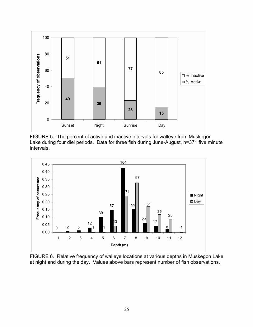
Walleye in Muskegon Lake were most commonly inactive (67% of the time)
during all periods of the day. Walleye activity peaked during the half hour before sunset
and half hour after sunset and then declined continually through the night to sunrise,
with minimum activity during the day (Figure 5). Day and sunrise activity was sporadic,
and often fish did not move for up to 12 hours. During the sunset and night periods,
walleye exhibited a variety of movement patterns from patrolling short sections parallel
to the shoreline, moving inshore and then back offshore, and random roaming.

15
At night walleye were found at depths ranging from 2 to 11 m. More than 40% of
the fish observations were at 7 m water depth and all ultrasonically implanted fish used
this depth most commonly. During the day, walleye occupied depths from 4 to 12 m,
with 33% of observations at 8 m. During the day walleye were located only fifteen times
in depths shallower than 7 m, and over 70% of the time fish were found in depths from 7
to 9 m (Figure 6). The mean daytime depth all walleye were found at was 8.3 m. The
mean night depth was 7.0 m.
Discussion
Walleye displayed complex seasonal movements that can be attributed to
spawning, over wintering, and foraging. Tagged walleye in this study were found in
Muskegon River during March, April and May to presumably spawn near Croton Dam.
During May, radio-tagged walleye migrated out of the river into lacustrine habitat, and
by June 10 of 12 walleye tagged during April and May had departed the river.
As walleye started to move downstream they often traveled distances from 10 to
60 km in a couple of days. I did not observe if fish continually swam downstream
without stopping or moved in increments. Fixed station data suggest that when walleye
were swimming long distances downstream they did so during low light conditions, and
during the night. Similar findings, of nighttime downstream walleye movement were
observed by DePhilip et al. (2005) in the AuSable River. They tracked one walleye�s
return to a reservoir, locating it eight times, from 2240 to 0400 in which it traveled 19.6
km in 5.25 hours. This walleye was observed continuously moving downstream.

16
During the end of the spring period, 10 of 12 tracked walleye left the river for
lacustrine habitat, and abundance data show that by June there were approximately half
as many walleye in the river compared to May. I expected more walleye to stay longer
in Muskegon River after spawning to rest and take advantage of available prey. From
March through June 2004, 307,104 salmonids were stocked all within 35 km of Croton
Dam (http://www.michigandnr.com/fishstock/). In a concurrent study Diana (2006)
examined growth and diets of walleye in Muskegon River and Muskegon Lake. She
concluded that walleye take advantage of densely stocked rainbow trout after spawning,
but shortly afterwards the movement of alewife into Muskegon Lake also provides a
strong forage base there. Similarly, abundant forage bases between the two habitats
allows for walleye to choose which habitat to occupy for foraging.
Although some fish were tagged and stayed in the river during the summer, a
large proportion of walleye entered, and then left Muskegon River in April and May.
This may indicate a learned behavior for walleye to enter the river, spawn, and then
return to the lake environment, an area they are more familiar with. Other studies have
shown genetic preferences of walleye for spawning and feeding areas (Jennings et al.
1996, Rasmussen et al. 2002, Palmer et al. 2005). The movement of walleye
completing their spawning cycle and leaving the river could be due to their familiarity
with that habitat for spawning and then the lacustrine habitat for feeding.
During the summer months of June, July, and August, 85% (17/20) of tagged
walleye inhabited either Muskegon Lake or were outside the Muskegon system. Three
fish stayed within the river during the summer. Abundance (CPE) data support
telemetry data that a significant number of walleye left Muskegon River between the

17
change of seasons from May to July. It is unclear if unfavorable conditions (ie.
temperature, forage, habitat) in the river push walleye out of the river, if prey abundance
declines over this time period, or if it is a heritable behavior for walleye to summer in
Muskegon Lake or Lake Michigan.
Habitat selection from September through February was similar to the summer
period, as all but one fish inhabited Muskegon Lake or was outside the Muskegon
system during this period. Two fish that spent the summer in the river migrated into
lacustrine habitat during winter. DePhilip et al. (2005) also noted that walleye in the Au
Sable River only over wintered in a reservoir located downstream from summer
locations. These sudden long range movements may indicate that winter conditions in
Muskegon River may be unsuitable for walleye during this time. A combination of cold
temperatures, low flows, lack of deep pools with low current velocity, and prey
availability may all contribute to these two walleye moving considerable distances to
over winter (Kitchell et al. 1977, Paragamian 1989). The one fish that stayed in
Muskegon River year round may indicate that a population of resident walleye inhabits
the river.
During October and November one fish was observed making periodic
movements between Muskegon Lake and Lake Michigan. These movements may be a
result of searching for optimal temperatures or high densities of prey. It is not known
where in Lake Michigan or how far this walleye traveled outside of Muskegon Lake.
The fish may have moved far from Muskegon before returning or may have stayed
within a few kilometers of the area.
18
Differences in seasonal ranges indicate that walleye had a significantly larger
range from March � May, compared to June � August, and September � February. This
appeared to be due to spawning migrations into Muskegon River and then a return
migration to Muskegon Lake or somewhere outside the Muskegon system. These
results support previous findings of long range movements by walleye during the spring
season (Crowe 1962, Pitlo 1984, Paragamian 1989, DePhilip et al. 2005). Locations
were concentrated for fish in Muskegon River within 35 km of Croton Dam. Croton Dam
blocked the upstream migration of walleye, but its tailwaters provided quality gravel-
cobble substrate for walleye spawning (Crowe 1962). In the Cedar River in Iowa
(Paragamian 1989), and the Au Sable River in Michigan (DePhilip et al. 2005) walleye
stayed primarily within 25 km below dams, possibly because of degraded habitat
downstream of this distance. The same observation was true for walleye in this study.
The other significant difference in ranges was between fish in Muskegon River
and Muskegon Lake during the summer, with fish in Muskegon Lake showing a greater
range than those in the river. Although diel activity of riverine walleye was not
measured (due to accessibility), I believe these small summer ranges were related to
foraging behavior. In the Au Sable River, DePhilip et al. (2005) found that walleye often
patrolled short sections of shoreline (5 � 10 m) through the night, and would usually
confine this activity to their local range. Other studies of fluvial brown trout populations
(Clapp et al. 1990, Ovidio et al. 2002, Diana et al. 2003) have shown that although they
occasionally make long range diurnal movements many fish rarely move over 100 m.
Walleye in the fluvial system may utilize a sit and wait approach or be confined to a
smaller area to search for prey. The strategy observed in this study may be related to

19
the energetic costs for large walleye to search long distances for prey in flowing water.
If walleye choose home sites that contain suitable habitat, high prey densities, and
preferred prey types their range can be decreased and foraging concentrated in a
smaller area.
Walleye in Muskegon Lake were largely inactive during daylight hours, often
remaining in a single location for periods up to 13 hours. From dawn to dusk walleye
were more active than during the day, yet the period where most activity was recorded
was during twilight. Other studies have examined walleye activity in lacustrine
environments and shown walleye are most active at night (Eschmeyer 1950, Rawson
1957, Holt et al. 1977). Since walleye are known to avoid light (Ryder 1977,
Paragamian 1989) it is not surprising that activity increased and the depth where
walleye were found decreased during dusk through dawn. I hypothesize that walleye in
Muskegon Lake actively searched for prey as soon as light conditions were favorable, at
sunset, and their activity decreased through the night either because of high foraging
success early in the night, or due to prey behavior and vulnerability during this time
(Moore and Moore 1976). Alewives, a known prey item of walleye in this system, are
particularly vulnerable to predation in low light conditions, especially during dusk and
dawn periods (Richkus 1974, Richkus and Winn 1979). Instead of using a sit and wait
approach, tagged walleye in Muskegon Lake actively moved to different areas within the
lake to forage.
The walleye in this study exhibited a seasonal pattern of inhabiting the river
during the spring (March � May), and then were primarily found in Muskegon Lake or
outside the Muskegon system for the rest of the year. The habitat connection between

20
Muskegon River, Muskegon Lake, and Lake Michigan provides a complex area for
walleye to move among. Protection of this connectivity for walleye to carry out their life
cycle is critical to sustain a walleye population in the Muskegon system. Knowledge of
walleye movement in this system can also aid fisheries managers in understanding
natural walleye population estimates. Estimates during the spring include walleye from
Muskegon Lake and Lake Michigan, whereas studies during the summer and winter
focus on the Muskegon system population.
21
FIGURE 1. Map of Muskegon River Watershed from Croton Dam to Lake Michigan, showing sites of walleye release and locations of fixed receivers.

22
FIGURE 2. Map of Muskegon Lake showing telemetry listening stations used in 2004 and 2005. The main east to west transect is shown by the solid line, with four additional listening stations north and south of the line.
23
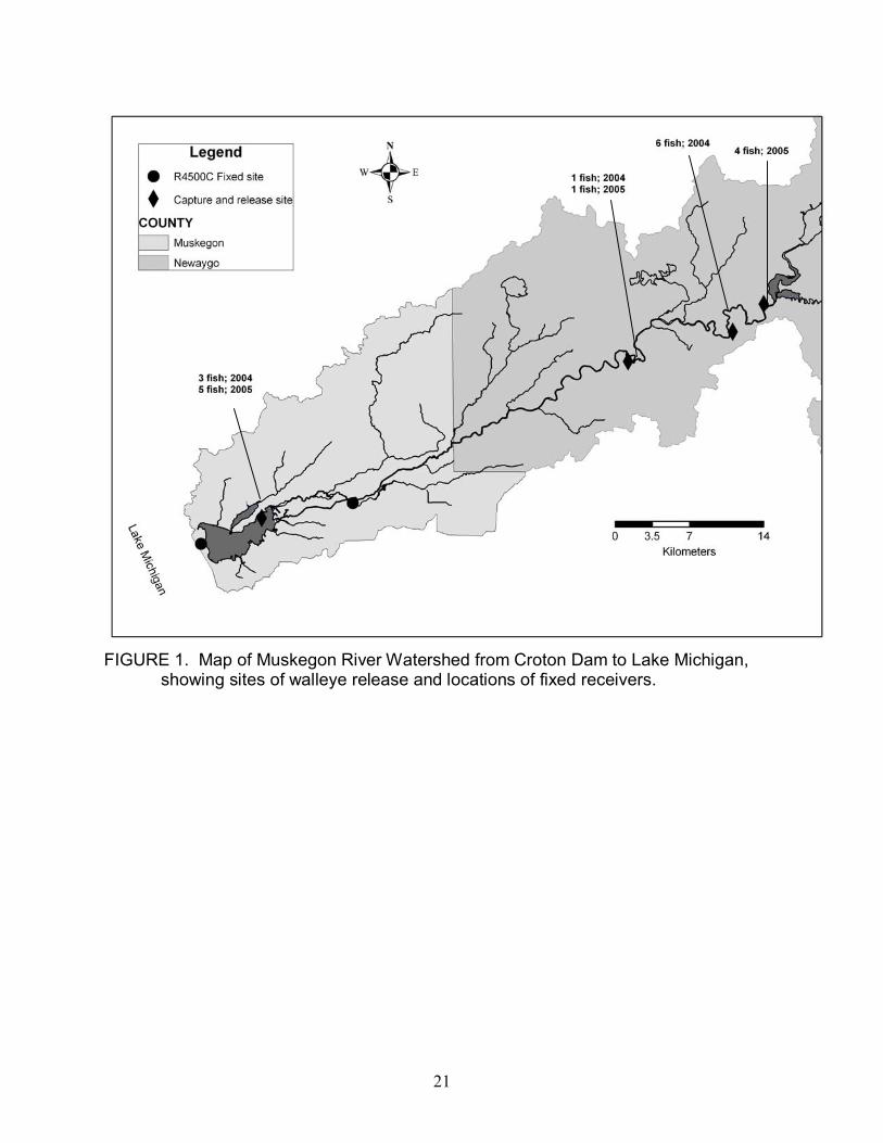
FIGURE 3. Map of Muskegon Lake showing cells (300 x 300 m) with differing relative abundances (number of walleye / summer period) of tagged walleye locations during summer 2004 and 2005.
24
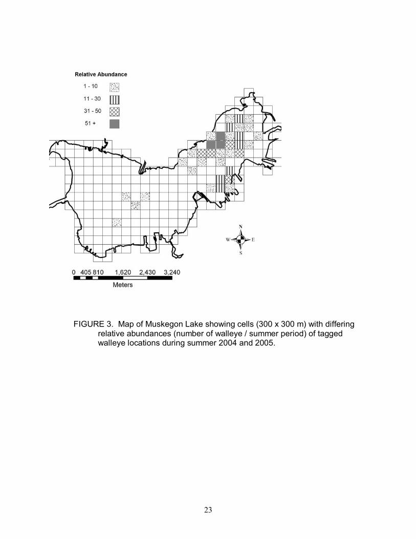
FIGURE 4. Map of Muskegon River showing all locations of radio tagged walleye during March � May for 2004 and 2005. Note the concentration of fish just below Croton Dam.
Croton Dam
25
4939
2315
5161
7785
0
20
40
60
80
100
Sunset Night Sunrise Day
Freq
uenc
y of
obs
erva
tions
% Inactive% Active
FIGURE 5. The percent of active and inactive intervals for walleye from Muskegon Lake during four diel periods. Data for three fish during June-August, n=371 five minute intervals.
164
0 2 512
39
57 59
2317
81 113
71
97
51
3525
10.00
0.05
0.10
0.15
0.20
0.25
0.30
0.35
0.40
0.45
1 2 3 4 5 6 7 8 9 10 11 12
Depth (m)
Freq
uenc
y of
occ
uren
ce
NightDay
FIGURE 6. Relative frequency of walleye locations at various depths in Muskegon Lake at night and during the day. Values above bars represent number of fish observations.

26
TABL
E 1.
Sum
mar
y in
form
atio
n on
wal
leye
trac
ked
in M
uske
gon
Lake
and
Mus
kego
n R
iver
. D
own
arro
w in
dica
tes
mov
emen
t fro
m
river
to M
uske
gon
Lake
, up
arro
w in
dica
tes
mov
emen
t fro
m M
uske
gon
Lake
to ri
ver,
hollo
w c
ircle
indi
cate
s fis
h le
avin
g th
e M
uske
gon
syst
em, a
nd s
olid
circ
le in
dica
tes
fish
retu
rnin
g to
Mus
kego
n La
ke fr
om o
utsi
de th
e sy
stem
. Ap
prox
imat
e tim
e of
mov
emen
t is
in
pare
nthe
ses.
Fi
sh
Num
ber
Sex
Tota
l Le
ngth
(m
m)
Wei
ght
(gm
) Ag
e (y
ears
) Ta
g Ty
pe
Loca
tion
Impl
ante
dD
ate
Im
plan
ted
Mov
emen
t Bet
wee
n
Riv
er a
nd L
ake
Dat
e La
st
Loca
ted
Last
Rec
orde
d Lo
catio
n N
umbe
r of
D
ays
Loca
ted
1 M
58
1 18
64
6 R
adio
R
iver
4/
29/0
4 ↓
(May
04)
, ↑ (M
ar 0
5),
↓ (M
ay 0
5)
5/19
/05
Lake
12
2 M
57
5 18
46
6 R
adio
R
iver
4/
29/0
4 ↓
(May
04)
, ↑ (M
ar 0
5),
↓ (M
ay 0
5)
6/15
/05
Lake
22
3 M
52
5 13
74
5 R
adio
R
iver
4/
29/0
4 ↓
(Jun
04)
, ↑ (M
ar 0
5),
↓ (A
pr 0
5)
4/27
/05
Lake
14
4 M
52
0 12
40
5 R
adio
R
iver
4/
29/0
4
↓ (M
ay 0
4), ○
(May
04)
, ●
(Dec
04)
↑(M
ar 0
5),
↓ (A
pr 0
5)
5/16
/05
Lake
Fix
ed S
ite
10
5 ?
401
2100
4
Rad
io
Riv
er
6/25
/04
Sta
yed
in ri
ver
8/3/
05
Riv
er
41
6 ?
568
2500
6
Rad
io
Riv
er
6/25
/04
↓ (S
ep 0
4), ↑
(Mar
05)
8/
3/05
R
iver
56
7
¹ ?
645
2800
7
Rad
io
Riv
er
7/14
/04
↓ (N
ov 0
4)
11/3
0/04
Lake
14
8
? 57
0 20
00
6 R
adio
La
ke
7/5/
04
↑ (M
ar 0
5), ↓
(Apr
05)
4/
11/0
5 La
ke
5 9
? 69
8 27
00
8 R
adio
La
ke
7/5/
04
↑ (M
ar 0
5), ↓
(May
05)
5/
26/0
5 La
ke
7 1
0 ²
? 64
5 28
00
8 R
adio
La
ke
7/5/
04
Sta
yed
in la
ke
12/1
8/04
Lake
5
11
F 71
0 54
00
8 R
adio
R
iver
4/
5/05
↓
(Apr
05)
4/
20/0
5 La
ke
11
12
F 72
5 60
00
8 R
adio
R
iver
4/
5/05
↓
(Apr
05)
, ○ (A
pr 0
5)
4/23
/05
Lake
Fix
ed S
ite
13
13
F 63
1 44
00
7 R
adio
R
iver
4/
5/05
↓
(Apr
05)
4/
11/0
5 La
ke
3 14
F
673
5300
8
Rad
io
Riv
er
4/5/
05
↓ (A
pr 0
5)
7/20
/05
Lake
16
15
?
534
1600
5
Rad
io
Riv
er
6/7/
05
↓ (J
un 0
5)
6/10
/05
Lake
5
16
? 66
0 27
00
8 U
ltras
onic
Lake
5/
31/0
5
8/1/
05
Lake
17
17
?
670
2650
8
Ultr
ason
icLa
ke
5/31
/05
6/
22/0
5 La
ke
4 18
?
681
3150
8
Ultr
ason
icLa
ke
5/31
/05
8/
2/05
La
ke
23
19
? 48
7 11
00
4 U
ltras
onic
Lake
7/
6/05
8/1/
05
Lake
10
20
?
580
2100
6
Ultr
ason
icLa
ke
7/6/
05
8/
2/05
La
ke
12
¹ Ang
ler c
aptu
red
on N
ovem
ber 3
0, 2
004
² Ang
ler c
aptu
red
on D
ecem
ber 1
8, 2
004

27
TABLE 2. Summary of combined catch-per-effort data for 2004 and 2005 from Muskegon River. Table includes sampling duration, total number of walleye captured, and catch-per-effort (CPE). Date Sampling Time (h) Number of Fish CPEMay 7.38 48 6.50June 9.35 28 2.99July 5.92 10 1.69

28
Literature Cited Clapp, D. F., R.D. Clark, and J. S. Diana. 1990. Range, activity, and habitat of large, free-ranging brown trout in a Michigan stream. Transactions of the American Fisheries Society 119:1022-1034. Crowe, W. R. 1962. Homing behavior in walleyes. Transactions of the American Fisheries Society 91:350-354. DePhilip, M. M., J. S. Diana, and D. Smith. 2005. Movement of walleye in an impounded reach of the Au Sable River, Michigan. Environmental Biology of Fishes 72:455-463. Diana, C.M. 2006. Prey utilization and somatic growth of walleye Sander vitreus in the Muskegon River and Muskegon Lake, Michigan. Master�s Thesis. University of Michigan, Ann Arbor. Diana, J. S., J.P. Hudson, and R.D. Clark, Jr. 2003. Movement patterns of large brown trout in the mainstream Au Sable River, Michigan. Transactions of the American Fisheries Society 133: 34-44. Environmental Protection Agency (EPA). 2004. Muskegon Lake area of concern. http://www.epa.gov/glnpo/aoc/msklake.html. March 2006. Eschmeyer, P. H. 1950. The life history of the walleye, Stizostedion vitreum vitreum, in Michigan. Michigan Department of Conservation Bulletin No. 3, Institute of Fisheries Research, Ann Arbor. Eschmeyer, P. H. and W. R. Crowe. 1955. The movement and recovery of tagged walleyes in Michigan, 1929-1953. Michigan Department of Conservation Miscellaneous Publication No. 8, Ann Arbor. Holt, C. S., G. S. Grant, G. P. Oberstar, C. O. Oakes, and D. W. Bradt. 1977. Movement of walleye (Stizostedion vitreum), in Lake Bemidji, Minnesota as determined by radio-biotelemetry. Transactions of the American Fisheries Society 106:163-169. Jennings, M. J., J. E. Claussen, and D. P. Philipp. 1996. Evidence of heritable preferences for spawning habitat between two walleye populations. Transactions of the American Fisheries Society 125: 978-982.
Kitchell, J.F., M.G. Johnson, C.K. Minns, K.H. Loftus, L. Greig, and C.H. Oliver. 1977. Percid habitat: the river analogy. Journal of the Fisheries Research Board of Canada 34:1936-1940.

29
Moore, J. W., and I.A. Moore. 1976. The basis of food selection in flounders, Platichthys flesus, in the Severn Estuary. Journal of Fish Biology 9:139-156. Ovidio, M., E. Baras, D. Goffaux, F. Giroux, and J. C. Philippart. 2002. Seasonal variations of activity pattern of brown trout (Salmo trutta) in a small stream, as determined by radiotelemetry. Hydrobiologia 470:195-202. Palmer, G.C., B.R. Murphy, and E.M. Hallerman. 2005. Movements of walleyes in Claytor Lake and the Upper New River, Virginia, indicate distinct lake and river populations. North American Journal of Fisheries Management 25:1448-1455. Paragamian, V. L. 1989. Seasonal habitat use by walleye in a warmwater river system, as determined by radiotelemetry. North American Journal of Fisheries Management 9:392-401. Pitlo, J., Jr. 1984. Wing and closing dam investigations. Iowa Conservation Commission, Federal Aid in Fish Restoration, Completion Report F-96-R, Des Moines. Rasmussen, P. W., D. M. Heisey, S. J. Gilbert, R. M. King, and S. W. Hewett. 2002. Estimating postspawning movement of walleyes among interconnected lakes of Northern Wisconsin. Transactions of the American Fisheries Society 131: 1020- 1032. Rawson, D. S. 1957. The life history and ecology of the yellow walleye, Stizostedion vitreum, in Lac LaRonge, Saskatchewan. Transactions of the American Fisheries Society 86: 15-37. Richkus, W. A. 1974. Factors influencing the seasonal and daily patterns of alewife (Alosa pseudoharengus) migration in a Rhode Island river. Journal of the Fisheries Research Board of Canada 31:1485-1497. Richkus, W. A. and H. E. Winn. 1979. Activity cycles of adult and juvenile alewives, Alosa pseudoharengus, recorded by two methods. Transactions of the American Fisheries Society 108:358-365. Ross, M. J. and C. F. Kleiner. 1982. Shielded-needle technique for surgically implanting radio frequency transmitters in fish. Progressive Fish Culturist 44:41- 43. Ryder, R. A. 1977. Effects of ambient light variations on behavior of yearling, subadult, and adult walleye (Stizostedion v. vitreum). Journal of the Fisheries Research Board of Canada 34:1481-1491.

30
Schweigert, J. F., and C. J. Schwarz. 1993. Estimating migration rates for Pacific herring (Clupea pallasi) using tag-recovery data. Canadian Journal of Fisheries and Aquatic Sciences 50:1530-1540. SPSS Inc. 2000. SYSTAT for Windows 10. Chicago, Illinois.