searchable PDF - Association for Mexican Cave Studies
156
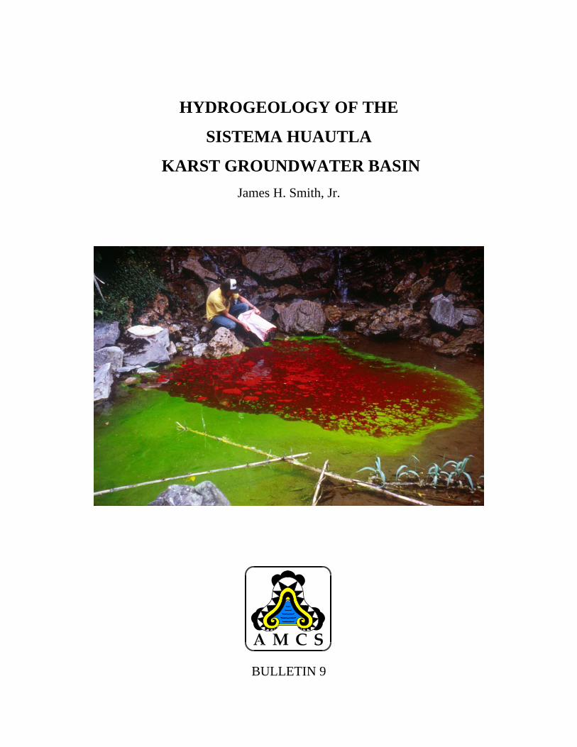
HYDROGEOLOGY OF THE SISTEMA HUAUTLA KARST GROUNDWATER BASIN James H. Smith, Jr. BULLETIN 9
Transcript of searchable PDF - Association for Mexican Cave Studies
HYDROGEOLOGY OF THE
SISTEMA HUAUTLA
KARST GROUNDWATER BASIN James H. Smith, Jr.
BULLETIN 9

HYDROGEOLOGY OF THESISTEMA HUAUTLA
KARST GROUNDWATER BASINJames H. Smith, Jr.
ASSOCIATION FOR MEXICAN CAVE STUDIESBULLETIN 9
2002

AMCS Bulletin 9
Cover photo: Andy Grubbs injects fluorescein dye into the San Andrés swallet.
Published 2002 by the
Association for Mexican Cave StudiesPO Box 7672Austin, Texas 78713www.amcs-pubs.org
The AMCS is a Project of the National Speleological Society.
Printed in the United States of America.

AMCS Bulletin 9
12 Foreword13 Abstract13 Acknowledgements
1 Introduction and study area15 1.0 Introduction16 1.1 Purpose16 1.2 Study area19 1.2.1 Physiography19 1.2.2 Climate20 1.3 Regional hydrology20 1.4 Caves of Huautla21 1.5 Cave exploration in the Huautla area21 1.5.1 Pre–Huautla Project24 1.5.2 Huautla Project cave explorations27 1.5.3 Sistema Huautla
2 Important ideas of karst hydrology29 2.0 Introduction29 2.1 Karst29 2.1.1 Classifications of karst30 2.2 Classical cave-development theories30 2.2.1 Vadose theories31 2.2.2 Deep-phreatic theories31 2.2.3 Shallow-phreatic theories31 2.3 Karst aquifers32 2.4 Modern cave-development theory32 2.4.1 Hydrologic models32 2.4.2 Cave development associated with base level33 2.4.3 Modern models of cave development35 2.4.4 Cave patterns35 2.4.5 Structural influence for cave and passage develop-
ment36 2.5 Karst processes
3 Stratigraphy of the study area37 3.0 Introduction37 3.1 Prio word37 3.2 Study area39 3.3 Paleogeography and stratigraphy39 3.4 Mesozoic stratigraphy43 3.4.1 Triassic system43 3.4.2 Jurassic system43 3.4.2.1 Lower Jurassic
CONTENTS
(continued)

AMCS Bulletin 9
43 3.4.2.2 Middle Jurassic43 3.4.2.3 Upper Jurassic44 3.4.3 Cretaceous system44 3.4.3.1 Tuxpanguillo Formation44 3.4.3.2 Capolucan Formation45 3.4.3.3 Orizaba Formation45 3.4.3.4 Maltrata Formation45 3.4.3.5 Guzmantla Formation45 3.4.3.6 Necoxtla Formation48 3.4.3.7 Atoyac Formation48 3.5 Quaternary system48 3.6 Stratigraphy of Sistema Huautla Karst Groundwater
Basin49 3.6.1 Western margin of the Sistema Huautla Karst
Groundwater Basin50 3.6.2 Stratigraphy east of the road from San Andrés to
Nuevo Progreso and north to Agua de Cerro50 3.6.3 Stratigraphy from San Miguel Huautepec to Río
Santo Domingo51 3.7 Conclusions
4 Structural geology53 4.0 Introduction53 4.1 Regional tectonic history56 4.2 Structures of the Sierra Mazateca56 4.2.1 Cerro Rabón thrust fault57 4.2.2 The Huautla–Santa Rosa fault57 4.2.3 Río Santo Domingo transcurrent fault60 4.2.4 Faults between the Huautla–Santa Rosa fault and
the Cuicateco fault60 4.2.4.1 Falla de Hierro60 4.2.4.2 Cuicateco fault60 4.2.5 Faults of the Sistema Huautla Karst Groundwater
Basin60 4.3 Prelminary geologic field investigations61 4.3.1 Lineament analysis62 4.3.2 Conclusions63 4.4 Geologic field mapping64 4.4.1 Structure64 4.4.2 Structures in the overthrust sheet of Huautla–Santa
Rosa fault64 4.4.3 San Agustín fault slice65 4.4.4 Río Iglesia fault65 4.4.5 Plan de Escoba fault66 4.4.6 Agua de Cerro anticline66 4.4.7 Agua de Cerro fault
CONTENTScontinued
4

AMCS Bulletin 9
66 4.4.8 La Grieta fault66 4.4.9 Structures found near El Camarón67 4.4.10 Minor structures67 4.5 Major structures found in Sistema Huautla67 4.5.1 Yellow-Bag Dome fault68 4.5.2 Loggerhead Hall fault71 4.5.3 Anthodite Hall thrust fault71 4.5.4 Sala Grande de Sierra Mazateca fault72 4.5.5 Fissure fault72 4.5.6 The Gorge fault73 4.5.7 Nita He fault73 4.5.8 Football Stadium fault73 4.5.9 Nanta Gorge fault74 4.6 Conclusions
5 Karst hudrology of the Sistema Huautla KarstGroundwater Basin
77 5.0 Introduction77 5.1 Previous work78 5.2 Preliminary investigations of springs80 5.3 Location of springs80 5.4 Peña Colorada Canyon82 5.5 Río Santo Domingo Canyon84 5.6 Front range of the Sierra Mazateca84 5.7 Dye-tracing Sistema Huautla84 5.8 Analysis of charcoal dye receptors87 5.9 Conclusions
6 Hydrologic flow patterns91 6.0 Introduction91 6.1 Methodology92 6.2 Sinking surface streams92 6.2.1 Cave swallets92 6.2.1.1 Río Iglesia94 6.2.1.2 Discussion97 6.2.1.3 Cueva de Agua Carlota
100 6.2.1.4 Discussion103 6.2.1.5 Sótano del Cangrejo103 6.2.1.6 Discussion103 6.2.2 Influent stream swallets103 6.2.2.1 San Andrés swallet104 6.2.2.2 Discussion107 6.2.2.3 Influent stream swallet #2
(continued)
CONTENTScontinued
5
AMCS Bulletin 9
107 6.3 Dye-tracing other tributary cave streams intoSistema Huautla
107 6.3.1 Nita He110 6.3.2 Discussion110 6.3.3 Nita Nashi110 6.3.4 Discussion110 6.4 Dye traces of stream sinks within Sistema Huautla115 6.4.1 Nita Zan115 6.4.2 Discussion115 6.4.3 Sótano de San Agustín Fissure dye trace115 6.4.4 Dye trace of Sótano de San Agustín’s 805 Sump115 6.4.5 Discussion115 6.5 Tributary stream caves117 6.5.1 Sótano de Agua de Carrizo117 6.5.2 Cueva del Zapato117 6.5.3 Nita Ka117 6.5.4 Nita Nido and Nita Ntau120 6.5.5 Cueva de Santa Cruz120 6.5.6 Cueva de San Agustín120 6.6 Conclusions
7 Geomorphology and speleogenesis of the SistemaHuautla Karst Goundwater Basin
123 7.0 Introduction123 7.1 Geomorphic evolution of the Sierra Juárez124 7.2 Paleo-fluvial evidence125 7.3 Karst development125 7.4 Allochthonous clastic cap rock125 7.5 Retreat of allochthonous clastic cap rock131 7.6 Cavern development theories131 7.7 Other caves developed in a similar hydrogeological
setting132 7.8 Speleogenesis132 7.8.1 Scenario I cave development132 7.8.2 Scenario II cave development133 7.8.3 Water table relative to cave development136 7.8.4 Protoconduit development138 7.8.5 Vadose passage development138 7.8.6 Phreatic segments138 7.8.7 Field evidence for phreatic passages141 7.8.8 Previous work relating cave levels to water table142 7.8.9 Base-level development of Sistema Huautla144 7.8.10 Evidence of vertical uplift144 7.9 Conclusion
147 References
CONTENTScontinued
6
AMCS Bulletin 9
16 1.1 Location map of study area17 1.2 Study area in Sierra Mazateca22 1.3 Plan view of Sistema Huautla23 1.4 Vertical profile of Sistema Huautla25 1.5 Caves of the Huautla area (foldout)26 1.6 Detail from figure 1.5 (foldout)
30 2.1 Three general models of cave development34 2.2 Development of drawdown and invasion vadose
caves34 2.3 Four-state model of speleogenesis35 2.4 Common patterns of solutional caves
38 3.1 Geologic provinces, Cuenca de Veracruz, SanAndrés Tuxtla, and Sierra Juárez
40 3.2 Stratigraphic column of the Sierra Juárez41 3.3 Geology map, Sierra Mazateca (foldout)46 3.4 Stratigraphy and structural geology from Coatepec,
Puebla, to Huautla de Jiménez, Oaxaca47 3.5 Stratigraphy and structure of the Sierra Mazateca49 3.6 Lithofacies map of San Agustín, Río Iglasia, San
Miguel, and La Providencia dolinas
54 4.1 Structural evolution of the Sierra Juárez55 4.2 Geologic cross-section of Sierra Juárez and Cuenca
de Veracruz58 4.3 Structural cross-section of Huautla de Jiménez to
Teotitlan del Camino59 4.4 Structural cross-section of Peña Blanca to Loma
Grande62 4.5 Major lineaments of the Huautla and Temascal
topographic maps63 4.6 Rose diagrams of faults, strikes, topographic
lineaments, and straight line segments of caves69 4.7 Structural geology of Sistama Huautla (foldout)74 4.8 Structural cross-section of Sierra Mazateca and
Sistema Huautla, 360 degree view75 4.9 Structural cross-section of Sierra Mazateca and
Sistema Huautla, 315 degree view
78 5.1 Sistema Huautla Karst Groundwater Basin studyarea
79 5.2 Legend for karst groundwater basin study area80 5.3 Reconnaissance route of the Sistema Huautla Karst
Groundwater Basin investigation
FIGURES
(continued)
7

AMCS Bulletin 9
81 5.4 Cave locations in the Peña Colorada and Río SantoDomingo canyons
87 5.5 Dye receptor location map85 5.6 Vertical profile of the Sótano de San Agustín dye
trace (foldout)88 5.7 Sótano de San Agustín dye trace88 5.8 Hypothesized karst groundwater basin boundary
92 6.1 Complex flow patterns in the caves of the SistemaHuautla Karst Groundwater Basin
93 6.2 Cave stream swallets and influent stream swallets93 6.3 Vertical profile of Sótano del Río Iglesia dye trace95 6.4 Sótano del Río Iglesia cave map (foldout)96 6.5 Cueva de Agua Carlota cave map (foldout)98 6.6 Dye receptor locations for Cueva de Agua Carlota
dye trace99 6.7 Dye-trace flow path of Cueva de Agua Carlota and
Sótano del Cangrejo101 6.8 Vertical profile of Cueva de Agua Carlota dye trace
(foldout)105 6.9 Plan view of San Andrés swallet dye trace (foldout)106 6.10 Vertical profile of the San Andrés swallet dye trace
(foldout)108 6.11 Caves not physically connected to Sistema Huautla109 6.12 Nita He cave map111 6.13 Hypothesized flow routes of Nita Zan, Nita He, and
Nita Nashi (foldout)112 6.14 Plan view of Nita Zan, Nita He, and Nita Nashi dye
trace (foldout)113 6.15 Vertical profile of Nita Zan, Nita He, and Nita Nashi
dye trace (foldout)116 6.16 Nita Ske and Sótano de Agua de Carrizo cave map118 6.17 Nita Ka cave map119 6.18 Nita Nido and Nita Ntau cave map121 6.19 Cueva de Santa Cruz cave map (foldout)122 6.20 Cueva de San Agustín cave map (foldout)
124 7.1 Generalized map of Veracruz basin and seismicstructure map of pre–Early Miocene unconformity
126 7.2 Fluvial drainage map of the Sierra Mazateca126 7.3 Hypothesized extent of the allochthonous clastic cap
rock129 7.4 The El Camarón klippe130 7.5 Evolution of a dolina in steeply dipping limestone
and relationship to cave entrances on ridge tops
FIGURES(continued)
8

AMCS Bulletin 9
133 7.6 Two hypotheses of speleogenesis for SistemaHuautla
134 7.7 Profile of Sistama Huautla, Cueva de Peña Colorada,and the Sistem Huautla Resurgence
134 7.8 Cueva de Peña Colorada profile cave map135 7.9 Evolution of Río Santo Domingo Canyon, slope
retreat of the cap rock, and development of conduits136 7.10 Sistema Cuicateco (Cheve) to Cueva de la Mano
profile139 7.11 Kijahe Xontjoa cave map (foldout)141 7.12 Nelfastle de Nieva cave map, showing tiers of
passage development
FIGURES(continued)
9
AMCS Bulletin 9
18 1.1 Deepest surveyed caves in the world19 1.2 Deepest dye traces in the world20 1.3 Cave entrances of Sistema Huautla21 1.4 Caves in the hypothesized karst groundwater basin
62 5.1 Temperature measurements of springs and streams along thePeña Colorada and Río Santo Domingo canyons
62 5.2 Estimated discharge of springs located during the 1994 PeñaColorada Expedition, base flow conditions
63 5.3 Discharge measurements of springs located during thewinter 1988 hydrologic field studies
93 6.1 Río Iglesia dye trace97 6.2 Cueva de Agua Carlota dye trace
103 6.3 Sótano del Congrejo dye trace103 6.4 San Andrés swallet dye trace107 6.5 Nita He dye trace110 6.6 Nita Nashi dye trace110 6.7 Nita Zan dye trace115 6.8 Dye trace of the Metro stream to the Lower Gorge
TABLES
10

AMCS Bulletin 9
51 3.1 Limestones and dolostones of the Orizaba Forma-tion
64 4.1 San Agustín fault slice, Peña Blanca fault65 4.2 Plan de Escoba fault.66 4.3 The El Camarón klippe68 4.4 Breccia in Fissure fault71 4.5 Loggerhead Hall fault72 4.6 Anthodite Hall thrust fault73 4.7 Sala Grande Sierra Mazateca fault74 4.8 Nita He fault in the entrance to Nita He
82 5.1 Peña Colorada and Río Santo Domingo canyons83 5.2 Placing a dye receptor in the first sump in Cueva de
Peña Colorada84 5.3 Río Santo Domingo and the Southern Resurgence89 5.4 The Western Resurgence on the south side of the
Río Santo Domingo89 5.5 Injecting fluorescein dye into the Upper Gorge,
Sótano de San Agustín
94 6.1 Injecting rhodamine WT dye into the swallet streamof Sótano del Río Iglesia
94 6.2 Surface stream sinking into entrance of Cueva deAgua Carlota
97 6.3 Injecting optical brightener dye into the streamswallet of Cueva de Agua Carlota
104 6.4 Injecting dye in the San Andrés swallet
127 7.1 The Río Iglesia dolina128 7.2 The San Miguel dolina128 7.3 The San Agustín dolina
PLATES(photographs)
11
AMCS Bulletin 9
FOREWORD TO THE AMCS BULLETIN
This Bulletin of the Association for Mexican CaveStudies contains a complete master’s thesis submittedin December 1994 to Western Kentucky University,under the supervision of Nicholas Crawford. The fulloriginal title was Hydrogeology of the Sistema HuautlaKarst Groundwater Basin, Sierra Mazateca, Oaxaca,Mexico. The AMCS appreciates the author’s permis-sion to publish it in this form.
The typed original was scanned and read by com-puter. The resulting text has been checked by twopeople. We apologize for any remaining errors. I havelightly edited the text, and the author has made a coupleof minor revisions. Reformatting has reduced the num-ber of pages from the original 338.
Additional cave discoveries in the Huautla areasince the thesis was written have been relatively mod-est. The cave behind the Agua Fría spring (section 5.5)has been explored (1) and the map published (2). Ex-tensive bolt climbing disclosed some new passage in
Cueva de San Agustín, and a new map has been pub-lished (3). An attempt to follow the water deeperinside Sótano de Río Iglesia was unsuccessful (3). TheSistema Huautla Resurgence, previously known as theSouthern Resurgence (section 5.9), has been dived toan underwater distance of 1059 meters, with a maxi-mum water depth of 65 meters. At the present end ofexploration there, the passage surfaces in two air-filleddomes, where no one has so far been able to get out ofthe water (1,3).
Bill Mixon, AMCS Editor, May 2002
1. Bill Stone. The 1995 Río Tuerto Expedition. AMCSActivities Newsletter 22 (May 1997), pp. 163–172.
2. Mexico News. AMCS Activities Newsletter 25 (May2002), p. 9.
3. Bev Shade and Bill Stone. 2001 InnerSpace Odys-sey Expedition. AMCS Activities Newsletter 25(May 2002), pp. 53–71.
12

AMCS Bulletin 9
Sistema Huautla, in 2002 the world’s seventhdeepest cave, at 1,475 meters, is one of the most com-plex vertical drainage systems in the world. The focus ofthis research was to study the geology, karst hydrology,and speleology of the Sistema Huautla cave system.Literature review and subsequent field mapping iden-tified the geologic formations and tectonic structuresthat Sistema Huautla and tributary caves are devel-oped within. Structural geology studies within theaquifer indicate that base-level conduits in the mappedportion of the aquifer are formed along a major nor-mal fault system called the Sistema Huautla Fault.Conduits in other sections of Sistema Huautla areformed along the strike and dip of steeply dippingbedding planes. The trend of the cave system isnorth-south along the strike of steeply dipping lime-stone beds and the Sistema Huautla Fault system.
The karst hydrology was studied by using non-toxic dyes to trace groundwater flow paths within theaquifer. The direction of groundwater flow in the karstgroundwater basin was determined by dye tracingSistema Huautla to its resurgence to the south. Addi-tional dye-trace studies established flow paths fromtributary caves to confluences deep within the cavesystem. The tributary caves Nita He and Nita Nashiwere determined to have 1,100-meter-deep flow pathsbefore intersecting the Scorpion Sump in SistemaHuautla.
The hydrologic boundaries of the karst ground-water basin were defined by mapping the structureand dye tracing. To the west, overthrusted non-carbonate rocks of the Huautla Santa Rosa Fault rep-resents the western structural and hydrologic bound-ary of the karst groundwater basin. The Agua de Cerro
Fault represents the eastern structural boundary of thegroundwater basin, as substantiated by dye tracing.The northern boundary is hypothesized to be a struc-tural boundary of the Plan de Escoba Fault.
The cave system was formed along the margin ofa retreating clastic cap rock during a period of sus-tained uplift beginning in the Miocene. The SierraMazateca was uplifted approximately 700 meters be-fore the cap rock overlying the limestone was removedby erosion, thus allowing the phreatic skeleton of theSistema Huautla dendritic vertical drainage system toreceive allogenic and autogenic recharge. Gradualdrawdown of the water table permitted a complex cavedevelopment scenario consisting of elements of theinvasion-vadose, drawdown-vadose, and phreatic-water-table theories. Most of the vertical extent of thecave system was developed under vadose conditionsnot associated with the regional water table as con-trolled by the Rio Santo Domingo. Drainage fromvadose shafts contribute recharge to base-level phreaticpassages. Base-level passages are controlled by thepotentiometric surface and lithology. Base-level con-duits in the northern part of the basin are perched onshale.
Phreatic passage development is not under theinfluence of exogenetic processes (ideal water tablecave development at the regional base level). Instead,phreatic loops with approximately 100 meters ofamplitude imply deep phreatic development. The hydrau-lic gradient of the phreatic portion of the groundwaterbasin is 3 to 5 percent. Eight kilometers from the ba-sin spring, phreatic passage development occurs 240meters above the present regional water table.
ABSTRACT
The author wishes to express his gratitude to allof the following: the Huautla cave explorers who gath-ered cave survey data on twenty-eight expeditions thatenabled development of the Sistema Huautla cavemap; Mark Minton for countless hours at the com-puter terminal; field assistants Don Coons, Bill Steele,Mason Estees, Lee Perry, Ed Holladay, and LauraCampbell; Bill Stone for detailed information on thePeña Colorada and Río Santo Domingo; AdreanaBankalti and Gary Napper for translations of profes-sional papers from Spaniosh to English; Nicholas C.Crawford, PhD, Director of the Center for Cave and
Karst Studies at Western Kentucky University, for di-recting my thesis, assistance in supplying equipmentfor the study, enduring the editing of this voluminouswork, and insightful suggestions; thesis committeemembers Chris Groves, PhD, Wayne Hoffman, PhD,and Kenneth W. Keuhn, PhD, for advice in improvingthe final product; to granting institutions the Explor-ers Club, Cave Research Foundation, Richmond AreaSpeleological Society, Dogwood City Grotto, andWestern Kentucky University; and finally to my wifeLaura Smith for her love and understanding duringthe many hours of writing and map drafting.
ACKNOWLEDGEMENTS
13


AMCS Bulletin 9 — Chapter 1
CHAPTER 1
INTRODUCTION AND STUDY AREA
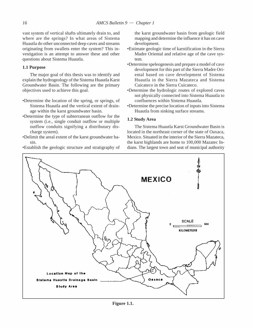
1.0 IntroductionIn 29 years American cave explorers have con-
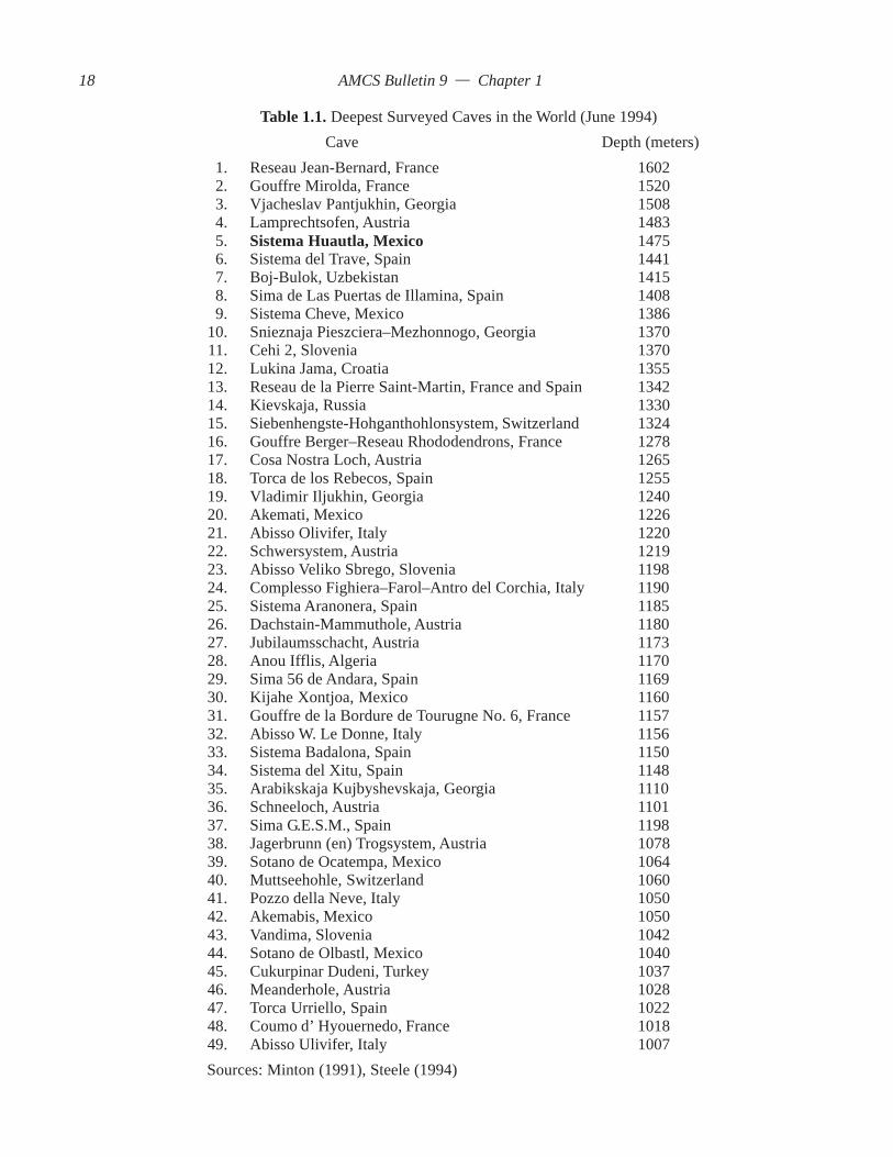
ducted 27 expeditions to the highland karst of theSierra Mazateca of Oaxaca, Mexico, to explore thecaves of the region (Figure 1.1). As a result of thiseffort, in different caves, more than 90 kilometers ofcave passages and 600 vertical shafts have been ex-plored and surveyed. Through exploration, separatevertical drainages have been integrated into a singlevertical drainage system 1,475 meters deep (Stone,1994). This drainage system is known as SistemaHuautla. It is currently the fifth deepest cave in theworld and the deepest cave in the Western Hemisphere.It is one of 46 caves over 1,000 meters deep (Table1.1) and one of 250 caves over 500 meters deep in theworld (Courbon et al., 1989).
Since the 1950s, caves with great vertical extenthave been pursued by both cave explorers and scien-tists. Cave explorers are mainly interested in explor-ing the limits of physical exploration in search of evergreater depths and penetration. In the case of the SierraMazateca, where some of the greatest depth potentialin the world exists, a world depth record is pursued.To be able to measure these great depths, accuratesurveys are conducted by cave explorers who in es-sence become amateur scientists. Scientists, on theother hand, attempt to explain physical processes thathave occurred. They have the desire and education toexpand the knowledge about the physical nature ofcaves by studying the interrelationships between ge-ology, hydrology, and speleogenesis. Apart from thecave surveys of cave explorers, little other work hasbeen accomplished with respect to karst hydrology inMexico in areas with great vertical relief. Hose (1981)detailed the structural geology and hydrology ofSistema Purificación in Tamaulipas, Mexico. SistemaPurificación is a vertical drainage system located inthe northern part of the Sierra Madre Oriental and has
over 1,000 meters of relief between recharge inputsand hypothesized spring resurgences. East of the SierraMadre Oriental, Fish (1977) conducted an exhaustivestudy detailing the hydrogeology of the Sierra de ElAbra. The Sierra de El Abra has a hydrologic relief ofapproximately 700 meters.
Basic investigations of deep caves often involvedrainage basin delineation and flow direction studies.Geologic field mapping and dye tracing of subsurfacestreams are the most commonly used tools to investi-gate the karst hydrogeology. Dye tracing is one of twoways to determine the direction of karst groundwaterflow. Some of the world’s deepest dye traces haveoccurred in Mexico, the former Soviet Union, France,Austria, Lebanon, and Spain (Table 1.2). Dye tracingallows a linear relationship between input and outputto be determined. The exact flow path geometry be-tween the input and recovery point is not established.
Physical exploration and survey are the only meth-ods by which a cave stream’s precise course can becharted. Exploration and survey are therefore valu-able scientific tools, because they often result in amodel that permits the major physical features of theaquifer to be visualized. Dye tracing can be used toimprove the quantitative model by defining the hy-drologic boundaries of the karst groundwater basin.
In the Sistema Huautla, 90 kilometers of activeand inactive paleo-conduits have been surveyed. Thishuge data base, which includes over ten thousand sur-vey stations, when reduced and plotted by computer,produces a precise spatial view of one of the world’smost complex vertical karst drainage systems.
Exploration and mapping of Sistema Huautla haveresulted in many important questions about the hy-drology, geology, speleogenesis, and geomorphologyof Sistema Huautla. How does the local structure andstratigraphy relate to cave development? What role,if any, does a retreating clastic cap rock play inkarstification and cave development? Where does this
15
AMCS Bulletin 9 — Chapter 1
vast system of vertical shafts ultimately drain to, andwhere are the springs? In what areas of SistemaHuautla do other unconnected deep caves and streamsoriginating from swallets enter the system? This in-vestigation is an attempt to answer these and otherquestions about Sistema Huautla.
1.1 PurposeThe major goal of this thesis was to identify and
explain the hydrogeology of the Sistema Huautla KarstGroundwater Basin. The following are the primaryobjectives used to achieve this goal.
•Determine the location of the spring, or springs, ofSistema Huautla and the vertical extent of drain-age within the karst groundwater basin.
•Determine the type of subterranean outflow for thesystem (i.e., single conduit outflow or multipleoutflow conduits signifying a distributary dis-charge system).
•Delimit the areal extent of the karst groundwater ba-sin.
•Establish the geologic structure and stratigraphy of
the karst groundwater basin from geologic fieldmapping and determine the influence it has on cavedevelopment.
•Estimate geologic time of karstification in the SierraMadre Oriental and relative age of the cave sys-tem.
•Determine speleogenesis and prepare a model of cavedevelopment for this part of the Sierra Madre Ori-ental based on cave development of SistemaHuautla in the Sierra Mazateca and SistemaCuicateco in the Sierra Cuicateco.
•Determine the hydrologic routes of explored cavesnot physically connected into Sistema Huautla toconfluences within Sistema Huautla.
•Determine the precise location of inputs into SistemaHuautla from sinking surface streams.
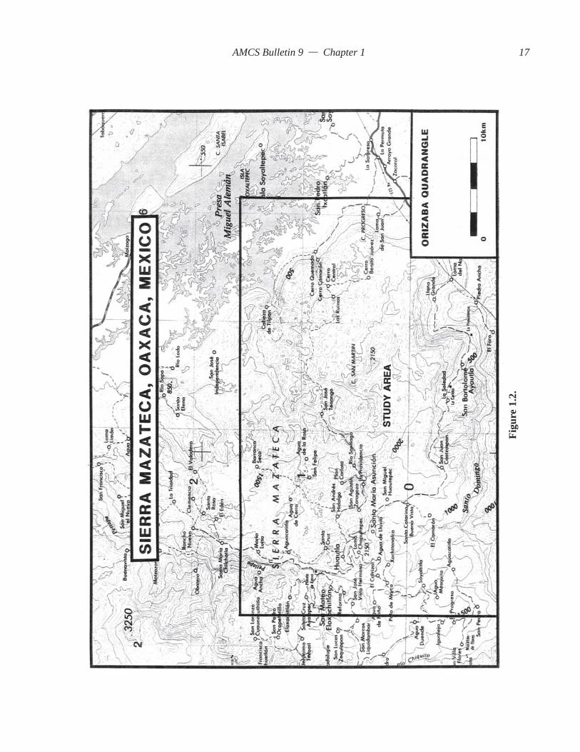
1.2 Study AreaThe Sistema Huautla Karst Groundwater Basin is
located in the northeast corner of the state of Oaxaca,Mexico. Situated in the interior of the Sierra Mazateca,the karst highlands are home to 100,000 Mazatec In-dians. The largest town and seat of municipal authority
Figure 1.1.
16
AMCS Bulletin 9 — Chapter 1
Figu
re 1
.2.
17
AMCS Bulletin 9 — Chapter 1
Table 1.1. Deepest Surveyed Caves in the World (June 1994)Cave Depth (meters)
1. Reseau Jean-Bernard, France 16022. Gouffre Mirolda, France 15203. Vjacheslav Pantjukhin, Georgia 15084. Lamprechtsofen, Austria 14835. Sistema Huautla, Mexico 14756. Sistema del Trave, Spain 14417. Boj-Bulok, Uzbekistan 14158. Sima de Las Puertas de Illamina, Spain 14089. Sistema Cheve, Mexico 1386
10. Snieznaja Pieszciera–Mezhonnogo, Georgia 137011. Cehi 2, Slovenia 137012. Lukina Jama, Croatia 135513. Reseau de la Pierre Saint-Martin, France and Spain 134214. Kievskaja, Russia 133015. Siebenhengste-Hohganthohlonsystem, Switzerland 132416. Gouffre Berger–Reseau Rhododendrons, France 127817. Cosa Nostra Loch, Austria 126518. Torca de los Rebecos, Spain 125519. Vladimir Iljukhin, Georgia 124020. Akemati, Mexico 122621. Abisso Olivifer, Italy 122022. Schwersystem, Austria 121923. Abisso Veliko Sbrego, Slovenia 119824. Complesso Fighiera–Farol–Antro del Corchia, Italy 119025. Sistema Aranonera, Spain 118526. Dachstain-Mammuthole, Austria 118027. Jubilaumsschacht, Austria 117328. Anou Ifflis, Algeria 117029. Sima 56 de Andara, Spain 116930. Kijahe Xontjoa, Mexico 116031. Gouffre de la Bordure de Tourugne No. 6, France 115732. Abisso W. Le Donne, Italy 115633. Sistema Badalona, Spain 115034. Sistema del Xitu, Spain 114835. Arabikskaja Kujbyshevskaja, Georgia 111036. Schneeloch, Austria 110137. Sima G.E.S.M., Spain 119838. Jagerbrunn (en) Trogsystem, Austria 107839. Sotano de Ocatempa, Mexico 106440. Muttseehohle, Switzerland 106041. Pozzo della Neve, Italy 105042. Akemabis, Mexico 105043. Vandima, Slovenia 104244. Sotano de Olbastl, Mexico 104045. Cukurpinar Dudeni, Turkey 103746. Meanderhole, Austria 102847. Torca Urriello, Spain 102248. Coumo d’ Hyouernedo, France 101849. Abisso Ulivifer, Italy 1007Sources: Minton (1991), Steele (1994)
18

AMCS Bulletin 9 — Chapter 1
in the region is Huautla de Jiménez, a highland city of10,000 inhabitants.
The Municipio of Huautla de Jiménez is located240 kilometers south of Mexico City, 150 kilometersnorth of the city of Oaxaca, and 179 kilometers westof Veracruz (Figure 1.2). Huautla is world famous foran ancient Mazatec Indian culture and its psychoac-tive mushroom religion that gained notoriety in the1960s with counter-culture groups. Historically, theywere one of the few Indian tribes to remain uncon-querable in their mountain setting. Archaeologistsfound that the caves of Huautla had an important func-tion in religious ceremonies and as burial caves. Theartifacts found in the caves establish that the highlandcommunities of Huautla were an important crossroadsof trade between the Gulf Coastal and Interior Basincivilizations (J. Steele, 1987).
More recently, the region has become world fa-mous for its deep caves. Huautla is also the namesakefor Sistema Huautla, a labyrinth consisting of 55.9kilometers of mapped cave passages (Stone, 1994). Itis also the name given to the karst groundwater basin.
1.2.1 PhysiographyViniegra (1965) defined and described the physi-
ographic provinces in the region of the Cuenca deVeracruz. The mountains south of Mexico City, situ-ated in the Neovolcanic Transverse Range, are anextension of the Sierra Madre Oriental and have beennamed the Sierra Madre Oriental del Sur. Ramos(1983) refers to the mountains west of the Cuenca deVeracruz as the Sierra Juárez subrange and geologicsubprovince of the Sierra Madre Oriental del Sur.Recent Mexican topographic maps of the Sierra MadreOriental del Sur have subdivided the mountain range
into a series of ranges extending from the NeovolcanicPlateau to the Isthmus of Tehuantepec. The study areais in the Sierra Mazateca, which is bordered to thenorth by the Sierra Zongolica, to the south by the SierraJuárez, to the west by the Tehuacán Valley, and to theeast by the Gulf Coastal Plain in the Cuenca deVeracruz.
1.2.2 ClimateThe Sierra Mazateca are the closest mountains to
the Gulf of Mexico and receive tremendous rainfallfrom orographic precipitation. Huautla is situated be-tween the arid western ranges and the wet front rangesof the Sierra Mazateca. Rainfall averages range from400 millimeters on the western side of the range to4.5 meters on the eastern flank of the Sierra Mazatecaat Cerro Rabón. Servicio Meteorológico Nacional hasmonitored precipitation in Huautla de Jiménez with24 years of continuous record. Isohyetal informationfrom the Orizaba 1:250,000 hydrology map indicatesthe mean annual rainfall in the study area is 2,661millimeters. The highest annual rainfall ever recordedin the area occurred in 1969 with measured precipita-tion of 3,872 millimeters. The lowest rainfall occurredduring 1959 with 1,869 millimeters. Located 10 kilo-meters east of Huautla de Jiménez (map distance) isTenango. Lower in elevation and located towards thewet gulf coastal lowlands, Tenango has a mean an-nual rainfall of 5,002 millimeters. The highest recordedrainfall was measured in 1960 at 6,536 millimetersand the lowest extreme was measured in 1967 at 3,052millimeters.
The Sistema Huautla Karst Groundwater Basin islocated between the two rainfall recording stations atHuautla and Tenango and their respective averages of
Table 1.2. Deepest Dye Traces in the WorldCave Depth (meters)
1. Sistema Cheve, Mexico 24501
2. Napra Cave, Russia 23452
3. V. V. Ilujukhina–Reproa, Arabika 23083
4. Ural’skaja-Macaj, Russia 18003
5. Gouffre de Pourtet–Bentia, France 16223
6. Lamprechtsofen, Austria 16003
7. Gouffre Touya de Lietfontaine des Fees, France 15983
8. Houet Faouar Dara-Antelias, Lebanon 15733
9. Laminako Ateak–Illamina, France and Spain 15383
10. Gouffre Des Trios Dents–Iscoo, France 15203
Sources: 1. Smith (1990 and 1991b).2. Caves and Caving, #47, p. 33, spring 1990.3. Courbon, et al. (1989).
19

AMCS Bulletin 9 — Chapter 1
2,661 and 5,002 millimeters. This range in rainfall,averaged over 10 kilometers of linear distance, revealsa steep precipitation gradient of 233 millimeters perkilometer.
Isotherms across the Sierra Mazateca range from16 degrees centigrade on the highest portion of theSierra Mazateca to the west to 24 degrees centigradeon the eastern escarpment. The mean annual tempera-ture for Huautla de Jiménez is 17.25 degrees centi-grade.
1.3 Regional HydrologyDischarge from the Sistema Huautla Karst
Groundwater Basin is a contributor to one of the mostsignificant southern Gulf drainage basins in Mexico,the Papaloapan Drainage Basin. Tamayo and West(1964) state that the Papaloapan drainage basin hasits origin in the Sierra Juárez. The headwaters aredrained by interior structural basins of Tehuacán andCuicatlán by the Río Salado and Río Tomellin andunite to form the Río Santo Domingo, which flowswest to east through a 1.5-kilometer-deep canyon inthe Sierra Madre Oriental of Oaxaca. Ultimately, theRío Santo Domingo empties into the Río Papaloapanin the Valle Nacional and discharges into Laguna deAlvarado in the Gulf of Mexico.
It was hypothesized that the Sistema HuautlaGroundwater Basin discharges into the Río SantoDomingo to the south of the drainage basin. South of
the Río Santo Domingo, the Sistema Cuicateco KarstGroundwater Basin was proven by a dye trace to alsodischarge into the Río Santo Domingo to the north(Smith, 1991(b)).
Three kilometers north of Huautla de Jiménez,several karst groundwater basins share a common di-vide with the Sistema Huautla Karst GroundwaterBasin. They are hypothesized to drain to the RíoPetlapa. The Río Petlapa drains to the northeast andflows into the Presa Miguel Alemán reservoir locatedalong the east side of the Sierra Mazateca front range.
1.4 Caves of HuautlaIt is appropriate at the onset of this thesis to de-
scribe the caves of the Huautla Plateau. Table 1.3 liststhe cave entrances of Sistema Huautla. The names thatappear under Sistema Huautla are entrances of tribu-tary stream caves that have been integrated by surveyinto Sistema Huautla (Figures 1.3 and 1.4). The nameof the entrance to the system is indicated on Table 1.3followed by the depth from that entrance to the deepestexplored point. Then the depth at which this entranceconnects with the main drainage cave, Sótano de SanAgustín, or into another tributary stream cave, is pro-vided. The overall depth of the cave system is 1,475meters from Nita Nanta to the bottom of Sótano deSan Agustín. Tributary streams flow into this dendriticvertical drainage system at various locations.
In all, there are 17 entrances to the system. The
Table 1.3. Cave Entrances of Sistema HuautlaEntrance Information
Sótano de San Agustín 859 meters deepLa Grieta 984 meters deep and connected to Sótano de San
Agustín at 720 metersNita Nanta 1,475 meters deep and connected to Sótano de San
Agustín at 1,098 metersLi Nita 1,242 meters deep and connected to Sótano de San
Agustín at 1,030 metersNita Sa 586 meters deep before connecting to Nita NantaNita Zan 216 meters deep before connecting to Nita SaBernardo’s Cave 647 meters deep before connecting to Nita NantaNita Ina 277 meters deep before connecting to Bernardo’s
CaveNita Lajao 73 meters deep before connecting to Li NitaNita Mazateca 146 meters deep before connecting to Nita SaNita Lata 95 meters deep before connecting to Nita Zan
20

AMCS Bulletin 9 — Chapter 1
previously mentioned cave entrances to SistemaHuautla are the major entrances. Next, there are anumber of major deep caves that are hypothesized tobe a part of Sistema Huautla hydrologic drainage sys-tem or enter the main hydrologic flow route at somepoint between Sistema Huautla and its springs. Toavoid confusion between these caves and the entrancesof Sistema Huautla, the caves and their depths arelisted in Table 1.4. The location and names of all ofthe caves in the Huautla area are indicated on Figures1.5 and 1.6.
1.5 Cave Exploration in the Huautla AreaThe first cave explorers in the Huautla area were
ancient Indians who migrated into the mountains be-fore the Classical Period, A.D. 200–900. It is not clearwhy they settled in this area, since the terrain is diffi-cult and the soil is poor for agriculture. Artifacts foundin Blade Cave are from the Classic Period betweenA.D. 200 and 900 and from the Early Post Classic Perioddated at A.D. 1250. The artifacts reveal that the use ofthe caves was ceremonial in nature, and they consti-tute the earliest record of the Mazateca culture (J.Steele, 1987). Man-made structures, terraces, andwalls of undetermined age are found in local cavesand indicate that they served a more utilitarian function
that is not clearly understood. It is thought that peoplemay have used caves as fortifications for temporaryrefuge from hostile neighbors. Because of the loca-tion of artifacts in remote and nearly inaccessiblereaches of the local caves, the ancient Indians musthave been daring and intrepid explorers. Another ex-ample of their audaciousness toward cave explorationis the evidence left in Vine Cave and Alter Cave. TheIndians were able to access cave entrances in themiddle of a 200-meter-high sheer cliff and build stonealters (Stone, 1984).
Cave exploration of modern times has taken on adifferent function, with the primary interests beingmore on sport and scientific research. Sport enthusi-asts are concerned with total exploration of the cave.The scientific aspects of cave exploration involve at-tempts to understand the hydrology and geology ofthe caves. The following sections highlight the sig-nificant contributions to the knowledge of the cavesof Huautla.
1.5.1 Pre–Huautla ProjectFrom 1964 to 1971 American and Canadian cave
explorers conducted eight expeditions and field tripsto the cloud-forest elevation, karst highlands of theSierra Mazateca, for the purpose of investigating the
Table 1.4. Caves in the Hypothesized Karst Groundwater BasinCave Information
Sótano de Agua de Carrizo 843 meters deep, including Nita Ske; only 6 metersfrom Scorpion Sump in Sótano de San Agustín;3,748 meters long
Nita Ske 258 meters deep before connection to Sótano deAgua de Carrizo; 728 meters long
Nita Ka 760 meters deep and 1,813 meters long; 80 verti-cal meters and 100 meters from connecting to theScorpion Sump of Sótano de San Agustín
Nita He 594 meters deep and 1,554 meters longNita Nashi 640 meters deep and 3,523 meters longNita Ntau 306 meters deep and 540 meters long; connects to
Nita Nido at the bottom of the caveNita Nido 309 meters deep and 755 meters long; connects to
Nita NtauCueva de San Agustín 478 meters deep and 1,426 meters longSótano del Río Iglesia 531 meters deep and 4,205 meters longCueva del Zapato 253 meters deep and 716 meters longCueva de Agua Carlota 504 meters deep and 4,400 meters long
21

AMCS Bulletin 9 — Chapter 1
Figu
re 1
.3. P
lan
view
of S
iste
ma
Hua
utla
. Sou
rce:
Sm
ith 1
988c
.
22

AMCS Bulletin 9 — Chapter 1
Figu
re 1
.4. V
ertic
al p
rofil
e of
Sis
tem
a H
uaut
la. S
ourc
e: S
mith
198
8c.
23
AMCS Bulletin 9 — Chapter 1
caves of the region.The Huautla karst area was discovered by locat-
ing karst features on 1:250,000 scale topographicmaps. In an effort to verify the discovery, the first ex-plorers ventured to Huautla de Jiménez in 1965 forthe purpose of finding high altitude karst with world-class vertical cave development potential. Many largecave entrances in huge dolinas were discovered(Russell, 1964 and 1965).
After the initial investigation of the Huautla area,a later expedition reported that the cave Sótano deSan Agustín was explored to a depth of approximately200 meters, with good leads remaining for furtherexploration. Maps were published showing locationsof caves, stream sinks, and dolinas (Fish, 1966; Fishand Russell, 1966).
In 1967, Sótano de San Agustín was explored to adepth of 447 meters. The cave continued, but explo-ration was discontinued due to a lack of rope (Fish,1967). During Christmas of 1967 Canadian caversreached the bottom of Sótano del Río Iglesia at –533meters for a Western Hemisphere depth record (Boon,1969; Drummond, 1968). They made observations aboutSótano del Río Iglesia with respect to the geomorphol-ogy and speleogenesis and concluded that the largestchambers were formed phreatically (Morris, 1968).
Cave explorations in Sótano de San Agustín dur-ing 1968 by American and Canadian cave explorersreached a depth of 620 meters at a sump, a new hemi-sphere depth record. However, there was doubt thatthe true bottom had been reached (Fish, 1970). CuevaSan Agustín, explored to –150 meters, was thought tobe a possible paleohydrologic link to Sótano de SanAgustín (Boon, 1969). Cueva de Agua Carlota wasexplored to –150 meters and a length of 1.4 kilometers.It was thought that there was little hope of extendingthe cave beyond a sump (Coward, 1971).
Cueva de San Agustín was revisited in 1970. Thecave was explored to a depth of –457 meters and endedin an enormous chamber of boulders. Cueva de SantaCruz, the northernmost cave of the area visited, wasexplored to –300 meters and ended in a sump (Finn,1971).
1.5.2 Huautla Project Cave ExplorationsAfter a five year moratorium of the Huautla cav-
ing area due to problems with the local Indians, anexpedition during the Christmas season of 1976marked the beginning of the Huautla Project. Morethan 21 expeditions were to return yearly for the next18 years.
It was believed in 1968 that Sótano de San Agustínhad not been fully explored. It was revisited in 1976,
and exploration was initiated from the deepest cave campin the Western Hemisphere at –520 meters. Explora-tion stopped at the top of a shaft at –760 meters, thussetting a new depth record. La Grieta was also revis-ited, and exploration stopped at the top of a 60-meter-deep shaft at –250 meters (Stone, 1977; Smith, 1977).
With many options for cave exploration in theHuautla area, Sótano de San Agustín was revisited inthe spring of 1977. Exploration was conducted fromCamp II, expanding the length and depth of the cave.It was realized during this exploration that manyinfeeding streams indicated many more vertical drain-age routes and thus the probability of higher entrances.Most of the cavers up to that time thought of eachcave as an individual stream system. Progress towardspushing San Agustín deeper was terminated by a sumpat –859 meters that resulted in a new depth record.Exploration strategy changed, and cave entranceshigher in elevation than Sótano de San Agustín wereexplored. The Huautla Project was formally organizedin the spring of 1977 (W. Steele, 1977(a), Smith, 1977).
New exploration in May of 1977 in the cave LaGrieta produced a 665-meter-deep cave and four kilo-meters of surveyed passage extending from Camp I at–280 meters (W. Steele, 1977(b)). During Christmasof 1977, exploration in La Grieta revealed a verticaldrainage route 760 meters deep and 10 kilometers long.Exploration of the lower conduits of La Grieta wasaccomplished from a ten-day camp at Camp II at –520meters (W. Steele, 1977(b); Smith, 1977). Australiancavers explored Sótano de Agua de Carrizo to –778meters, without a camp.
In the spring of 1978, a six-week-long expeditionto Sótano de Agua de Carrizo revealed the most com-plex vertical drainage system yet discovered in theSierra Mazateca. The cave was explored down threevertical shaft series to bottoms at 843, 841, 676 metersin depth. The cave was surveyed to a length of 3.5kilometers. A five-day camp at –347 meters continuedthe exploration after the deepest route was bottomedfrom surface-originated trips (Stone, 1978; Smith,1978).
During the spring of 1977, an expedition to Sótanode San Agustín to the –859 sump revealed that a div-ing expedition was required to explore the floodedconduit. The expedition was the first Explorers Clubsponsored Huautla Project expedition. Other discov-eries in Sótano de San Agustín included finding thelargest chamber in the Sierras. Anthodite Hall, whichis larger than the Astrodome, was discovered fromCamp III at –700 meters. Two additional camps, eachlasting eight days, were fielded from Camp II, andKinepak Canyon was discovered. Kinepak Canyon is
24


AMCS Bulletin 9 — Chapter 1
the hydrologic link to the ridge-top vertical drainagesof La Grieta and Sótano de Agua de Carrizo. La Grietaand Sótano de Aqua de Carrizo are separated by col-lapse only a few meters apart (Stone, 1979; Smith,1978).
1.5.3 Sistema HuautlaIn the spring of 1980, the Explorers Club–sponsored
Río Iglesia Expedition explored the highest entrancesof the Huautla area, Nita Nanta and Li Nita. NitaNanta, the highest ridgetop entrance, was explored to–520 meters and still continued at the end of the ex-pedition.
Li Nita was physically connected to Sótano de SanAgustín from Camp I at –620 meters during threecamps lasting seven, seven, and thirteen days. Theconnection formed a system collectively namedSistema Huautla 1,221 meters deep, the third deepestcave in the world (Stone, 1982; W. Steele, 1981; Smith,1980).
Stone (1982) wrote after the 1981 Expedition that“Nita Nanta is the most difficult cave in the System.”Nita Nanta was bottomed at –927 meters from CampI at –520 meters. The 927-meter route was to later becalled the historic route. Li Nita produced a new deepvertical shaft series to a depth of 920 meters. TheSótano de San Agustín sump was dove and the system’sdepth increased to 1,250 meters (Stone, 1982).
In 1982, a return trip to Nita Nanta yielded a newdeep vertical shaft series that was bottomed at –760meters, below the Football Stadium. The Football Sta-dium Chamber is the junction of several large water-falls entering from unseen heights. A paleo-passagewas explored to a constriction from which strong windblew (W. Steele, 1983).
During the spring of 1983, the Huautla Projectfielded two expeditions. Bill Stone and others dovethe Cueva de Peña Colorada, which had been discov-ered in May 1981, and found a large phreatic cavepassage. It was thought that Cueva de Peña Coloradawas a likely resurgence cave for Sistema Huautla, lo-cated 10 kilometers to the north (Stone, 1983(a) and1983(b)).
Meanwhile, exploration in the Huautla area con-tinued, and a connection of Nita Sa to Nita Nanta at–587 meters revealed a new deep tributary drainage sys-tem. Nita Nanta was explored beyond the terminus of1982 in the Football Stadium to –950 meters via theRat Tail File Series, a paleo-shaft series. Below theshaft series, a base-level stream was discovered(Smith, 1983).
During 1984, Nita Nanta was explored from a newentrance called Nita Zan, and Nanta was explored to
–1,080 meters to a sump from Camp II at –587 meters(Smith, 1984).
Also in the spring of 1984, Cueva de PeñaColorada was surveyed to a length of 7.8 kilometersand explored in a northerly direction towards SistemaHuautla for 3.5 kilometers, before progress was ter-minated at the limit of SCUBA diving technology, 150meters into sump VII at 50 meters depth (Stone, 1984).
In 1985, a connection between Sótano de SanAgustín and La Grieta was made at the end of KinepakCanyon from Camp II, –520 meters, on one of twoeight-day camps. The La Grieta–Sótano de SanAgustín connection was the second big connection intoSistema Huautla. The connection added 10 kilome-ters of length to Sistema Huautla (Smith, 1987).
The next expedition to Huautla was in 1987. ASCUBA dive between Nita Nanta and Sistema Huautlawas the third big connection into Sistema Huautla.The dive was supported from Camp IV at –600 metersin Sótano de San Agustín. Sistema Huautla becamethe fourth deepest cave in the world at 1,353 metersdeep (Smith and Steele, 1988).
In 1988, field work for this Master’s thesis wasconducted. From an eleven-day cave camp at –700meters in Sótano de San Agustín, high leads wereclimbed to access otherwise inaccessible passages.Dye traces were conducted to the karst groundwaterbasin’s spring and to confluences in Sistema Huautlain an attempt to integrate unconnected tributary caves.Nita Ka was explored to –758 meters (Smith, 1988(b)).
During the 1989 expedition, Nita Ka was revis-ited and explored to –760 meters. Other small caveswere explored in an attempt to find a way into LaGrieta’s Do Da Dome (Smith, 1991(c)).
In 1990, Cueva de Agua Carlota was explored to–504 meters and surveyed to a length of 4.4 kilome-ters. Dye tracing and groundwater chemistry studieswere also conducted in the area (Smith, 1991(a)).
The 1994 Sótano de San Agustín Expedition dovetwo sumps, 430 and 165 meters in length, and mapped3.5 kilometers of passage beyond the –859 sump ofSótano de San Agustín. The explorers bypassed sixsumps and extended the depth of Sistema Huautla to1,475 meters at Sump 9. The expedition extendedSistema Huautla due south 1.5 kilometers. It was re-ported that the passage zig-zagged NW-SW beforesump nine was reached. A major infeeding stream wasencountered with a greater discharge than any streampreviously known in Sistema Huautla (Stone, 1994).Cueva de Santa Cruz, explored to a depth of 312 metersand 1.44 kilometers long in 1970, was revisited in 1994to find that there was no possibility of extending thecave (Smith, 1994).
27


AMCS Bulletin 9 — Chapter 2
CHAPTER 2
IMPORTANT IDEAS OF KARST HYDROLOGY
2.0 IntroductionThe science of karst hydrogeology has greatly
advanced from the early days when karst philosophersattempted to explain the origin of caves and their de-velopment relative to the water table. Those ideas wereso provocative that some researchers even argued theexistence of a water table in karst landscapes. Mod-ern karst scientists recognize karst as being a productof geomorphic processes. The end result of theseprocesses is dependant on many natural physical pa-rameters. Because these physical parameters are sonumerous, many are a science unto themselves. Tofully investigate karst requires many scientific disci-plines, including mineralogy, structural geology,stratigraphy, geomorphology, hydrology, chemistry,cartography, meteorology, physics, mathematics, andengineering.
In order to understand how caves develop, karsthydrology, geology, and chemistry have become inter-dependent. It is the purpose in this chapter to acknowl-edge many of the significant ideas in the developmentof karst hydrogeology as a science that have a bearingon the development of ideas in this thesis.
The literature review addresses different types ofmodels for cave development (e.g., phreatic, vadose,artesian etc.), phases of cave development, types ofkarst aquifers, groundwater flow in flat and foldedlimestones, dissolution kinetics, and karstification(e.g., sinkhole development). A brief review is alsoprovided of the classical theories of cave development.These concepts provide a useful framework for un-derstanding the complex hydrogeology of the SistemaHuautla Karst Groundwater Basin.
2.1 KarstThe term karst is a German modification of the
original Slavic word kras, which was defined as ableak, waterless place. This was the descriptive term
to describe the Dinaric landscape east of Trieste, Italy,the site of classic karst investigations (Sweeting,1973).
The term karst can be used to describe both sur-face and subsurface geomorphology. Karst may bedefined as a terrain consisting generally of limestoneor dolomite, gypsum, calcareous sandstone, halite,anhydrite, quartzite, other igneous and metamorphicrocks in which the landscape has been shaped by cor-rosive processes of solution, resulting in karren, closeddepressions, dry valleys, influent drainage, subsurfacedrainage, caves, and point discharge (springs). Varia-tions of this definition are offered by Sweeting (1973),Jennings (1985), Milanovic (1981), and many others.Mylroie (1984) described karst landscapes as fluvialin origin, shaped by solubility that results from chemi-cal weathering and subsurface water flow.
2.1.1 Classifications of KarstKarst researchers have attempted to classify karst
according to morphology, structure, tectogeneticfactors, geography, and environment of deposition.European researchers classified karst according to geo-graphic and structural setting.
Cvijic (1925) provided a morphological classifi-cation of karst. He defined three types of karst,holokarst, merokarst, and transitional karst. Holokarst,or complete karst, is developed entirely in solublerocks and has solution features on the land surface aswell as underground. Merokarst, or incomplete karst,is a covered or mantled karst, soluble rocks that arecovered by thick residual soils and exhibit little evi-dence of solutional modification on the surface.Karstification is shallow and not well developed. Tran-sitional karst represents a landscape that has bothmantled karst and exposed karst. Transitional karst isfound in carbonates that are overlain or bordered byless soluble rocks. Underground solution features tendto be well developed.
29
AMCS Bulletin 9 — Chapter 2
Herak (1977) proposed a classification scheme forkarst terrains that involved a tectogenetic approach.He classified epi-orogenic karst and orogenic karst.
Komatina (1973) classified karst as either plat-form or geosyncline karst. His definition was basedon a broad structural interpretation of karst formed inflat-bedded carbonates, folded rocks, shear zones, orcompressional zones.
Herak, Bahun, and Magdelenic (1969) describedcontinental karst as being formed in three belts, lit-toral, central, and internal.
Other researchers have taken a close-up view ofkarst and associated features and attempted to clas-sify karst according to geomorphology, structure, li-thology, form, covering, function, etc. Bretz (1942)described cave features in relation to the water tableas either vadose or phreatic in origin. Powell (1970)interpreted caves in terms of geomorphic setting andlithology. Jennings (1971) classified karst asdammed-in and covered. He also classified caves asinflow and outflow. Quinlan (1978) expanded Jenningswork and divided karst into subsoil karst, mantledkarst, buried karst, and interstratal karst. Mylroie(1984) classified karst according to function (i.e.,surficial forms, interface forms, subsurface forms).Palmer (1984) provided a geomorphic interpretationof karst features with respect to their formation in thephreatic and vadose zones.
Day (1977) classified tropical karst in terms ofclasses of positive and negative landform units. Theseinclude Type I, terrain characterized by encloseddepressions of all types and subdued hills; Type II,terrain in which enclosed depressions and residual hillsattain approximately equal prominence; and Type III,terrain characterized by isolated residual hills sepa-rated by extensive near planar surfaces.
Sweeting (1973) classified caves as phreatic, va-dose, and vertical. Monroe (1970) developed a glos-sary of karst terminology including terminology usedin Europe and United States.
2.2 Classical Cave Development Theories
2.2.1 Vadose TheoriesThe first scientific ideas concerning cave genesis
were an attempt to explain the relationship of conduitand shaft development to the water table. Even thoughthey recognized the existence of cave streams, otherresearchers denied the existence of a water table inkarst and thought that caves were formed entirely inan air-filled environment (Figure 2.1).
At the turn of the century, Grund (1903) studiedkarst hydrology in Yugoslavia. He theorized that a karst
aquifer had two zones separated by a water table. Theupper zone was the zone of active groundwater move-ment. Water from the upper zone recharged the oceans.The water in the lower zone was stagnant. Waterflowed through sinkholes and formed caves enroute.His observations resulted in a model that demonstratedthat meteoric water invaded nonsaturated rocks to thewater table and then flowed laterally toward the seaduring seasonal fluctuations. He considered the watertable inactive or immobile (Sweeting, 1973).
Martel (1921), Katzer (1909), and Von Knebel(1906) denied the existence of a water table in karst.They stated that water simply flowed from the sur-face through sinkholes to cave passages to springs.Dwerryhouse (1907) and Martel (1921) suggested thatcaves large enough to be explored were formed largelyin the vadose zone (unsaturated zone) above the wa-ter table. At the interface where water first enters thesubsurface, its solvent capacity and velocity of floware at its optimum, enhancing passage enlargementby solution and mechanical corrasion. Mallot (1937)hypothesized that caves were formed by invadingstreams into the vadose zone.
Gardner (1935) thought that big caves wereformed on the updip side of surface valleys by vadosewater. Cave development was along bedding planesand trended down dip. He also advanced the idea that
Figure 2.1. Three general models of cave develop-ment: vadose theory, deep phreatic theory, and watertable cave theory. Source: Ford and Ewers 1978.
30

AMCS Bulletin 9 — Chapter 2
as down-cutting occurred, different passage levelswere formed by stream piracy. Woodward (1961)thought that cave development occurred by sinkingstreams and that cave development was a response torapid changes in base level. Pohl (1955) proposed thatvertical shaft development in caves occurred as a re-sult of the vertical transfer of water under air filledconditions in the vadose zone.
2.2.2 Deep Phreatic TheoriesW. Davis (1930) and Bretz (1942) believed in the
Deep Phreatic Theory and suggested that the “majorityof large caves and systems are developed at a randomdepth in the phreatic zone under permanent water filledconditions” (Figure 2.1). “When erosional processesaffect the topography to a point that the water table islowered then air and surface water may enter theevacuated conduits and modify the original conduitby corrosion”. They also stated that vertical shafts weredeveloped at great depth below the water table.
W. Davis (1930) believed that groundwater flowpaths in the phreatic zone are governed by Darcy’sLaw. Davis proposed a two-cycle theory for the de-velopment of caves. In the first cycle, caves developalong flow lines that curve deeply into the phreaticzone in the old age stage of the geomorphic cycle. Inthe second cycle, uplift allows meandering streams toerode into water-filled caves and drain them. He statedthat cave development is not related to surface drain-age.
Bretz (1942) developed the deep phreatic theoryfurther by adding a third stage of development. Hestated that conduits were filled by sediments transportedfrom streams meandering across the peneplain. Fur-ther uplift partially drained the sediments from the cave.
2.2.3 Shallow Phreatic TheorySwinnerton (1932) stated that Darcy’s law does
not apply in the limestone medium because the sys-tem is anisotropic and inhomogeneous. He furtherstated that cave development is proximate and paral-lel to the water table (Figure 2.1). Cave developmentpropagates from input to spring in a shallow phreaticmedium. In concert with his views of cave develop-ment, he hypothesized that vertical shaft developmentwas the result of stream capture and adjustment fromone cave level to another as a result of lowering thewater table.
Rhodes and Sinacori (1941) also supported theShallow Phreatic Theory. They contended that Darcy’slaw applies in the initial stage of cave developmentand maximum conduit enlargement occurs where smallflow paths converge at the spring. This type of conduit
development occurs along stream grade at the watertable and facilitates passage development from thespring headward. The interface of maximum cave pas-sage development is along and parallel to the watertable.
Thrailkill (1968) supported the idea that allphreatic flow in karst aquifers is proximate to the watertable. He proposed a different model from the viewsof W. Davis (1930), Swinnerton (1932) and Rhodesand Sinacori (1941). Thrailkill stated that under pre-scribed conditions, when input is either close to or farfrom a karst spring, the discharge is not significantlygreater from a shallow phreatic zone than from a deepphreatic zone.
2.3 Karst AquifersThere has been considerable debate among Euro-
pean karst hydrologists as to the existence of a watertable in alpine aquifers. Careful geochemical work byZötl (1961) has demonstrated that Alpine aquifers havewater tables. American, Canadian, and British re-searchers have all recognized the important influencethe water table has on cave development. Only afterthe scientific community began to agree in general onthe existence of a water table in karst could water-bearing rock in karst landscapes be considered anaquifer. Karst aquifers have been explained and mod-eled by Thrailkill (1968), White (1969, 1977), Smith,Atkinson, and Drew (1976), Ford and Ewers (1978),T. Atkinson and Smart (1981), Mylroie (1984), Smartand Hobbs (1986), and Quinlan et al. (1992).
White (1969, 1977) developed conceptual modelsfor carbonate aquifers based on hydrologic parametersof flow type and hydrologic control and gave examplesof each based on associated cave types. He identifiedthe main distinguishing characteristics of carbonateaquifers on the basis of structural complexity, arealextent, thickness, and conduit permeability. White(1969) also described karst aquifers as diffuse flow,free flow, and confined flow. Gunn (1985) argued thatfree-flow aquifers are the only true karstic aquifers.Schuster and White (1971, 1972) described ground-water flow discharging from a karst aquifer as diffuseflow and conduit (turbulent) flow.
Smith, Atkinson, and Drew (1976) stated that crys-talline limestones are markedly anisotropic, showingvery high values of permeability and hydraulic con-ductivity along joints, faults, and bedding planes withalmost no permeability and porosity within the undis-turbed rock. Limestone regions are dominated by bothdiffuse and conduit flow with regard to subterraneandrainage and the occurrence of one or the other aloneis uncommon.
31
AMCS Bulletin 9 — Chapter 2
Ford and Ewers (1978) describe cavern bearinglimestones as functioning initially as fractured aqui-fers, while Thrailkill (1968) described each cave as aseparate leaky aquifer.
Jakucs (1977) described recharge of karst aquifersin terms of allogenic and autogenic sources. Allogenicrecharge is water derived from noncarbonate rocks.Autogenic recharge is meteoric precipitation onto thekarst.
Gunn (1985) developed a conceptual model forfree-flow karst aquifers. His model described fourmodes of recharge to free-flow aquifers, diffuse auto-genic, concentrated autogenic, diffuse allogenic, andconcentrated allogenic, and six types of transfermechanisms for groundwater flow through the karstaquifer, overland flow, through-flow, subcutaneousflow, shaft flow, vadose flow, and vadose seepage.
Quinlan and Ewers (1985) described a third typeof groundwater flow, mixed flow, occurring betweendiffuse flow and conduit flow end members.
Smart and Hobbs (1986) developed a conceptualmodel of a karst aquifer, recognizing the independentvariables of recharge, storage, and flow. Quinlan etal. (1992) expanded the conceptual model of Smartand Hobbs by adding physical characteristics of a karstaquifer. He proposed to retire the terms conduit anddiffuse flow aquifers under the premise the terms onlydescribe flow type. They propose describing karstaquifers in terms of vulnerability. Quinlan et al. (1992)also maintained that dye tracer studies in many areasthat would be classified as nonkarst based on theirgeomorphological definition have proven otherwise,and they proposed a new definition for a karst aquiferfrom a hydrologic perspective. “A karst aquifer is anaquifer in which the flow of water is or can be appre-ciable through one or more of the following: joints,faults, bedding planes, and cavities, any or all of whichhave been enlarged by the dissolution of bedrock.”
2.4 Modern Cave Development TheoryModern cave development theorists critically re-
viewed the ideas of past researchers and changed theirapproach of classifying entire caves as vadose,phreatic, or deep phreatic. While these concepts areimportant, modern theorists began to recognize thehydrogeologic controlling variables in the formationof caves through field observations and careful mea-surement.
2.4.1 Hydrologic ModelsRhodes and Sinacori (1941) may be the first of
the modern theorists because they approached cave
development ideas from a hydrologic perspective.They were the first to advance the idea that conduitnetwork development occurs from the springheadward, while individual conduits form in the down-stream direction. The premise for their theory is thatconduit tributary systems advance headward as flowlines are intersected.
White and Longyear (1962) developed the ideathat groundwater flow becomes turbulent at criticalvelocity and that velocity is a function of pipe diam-eter and gradient. They calculated that turbulent flowthreshold occurred at a pipe diameter between 5 and10 millimeters. They advanced the idea that turbulentflow is critical to advancing dissolutional processes.
Thrailkill (1968) found that flow rates in pipes ofequal size throughout the network were the same whencalculated using both the Hagen Poiseuille andD’Arcy-Weisbach equations. He suggested thatgroundwater flow through an anisotropic media wouldproduce the same deeply curved flow lines as in ahomogenous isotropic aquifer. These flow lines wouldfollow the tortuous path of the joint bedding planenetwork.
Chorley and Kennedy (1971) defined caves as acascading system. The system is composed ofprotoconduits connected to cave system or spring. Asthe developing tubes intersect the main conduit thelocal flow field and hydraulic gradient are reoriented.
Ford and Ewers (1978) stated that the path ofconduit development is not rigidly controlled by cur-vilinear flow lines.
Ewers (1978) proposed a model for the develop-ment of broad-scale networks of groundwater flow insteeply dipping carbonate aquifers. He proposed thatbroad-scale networks draining over 100 km2 areformed by incorporating smaller networks that propa-gate from discrete input sources as distributary systems.Integration of the smaller networks proceeds headwardfrom the resurgence as determined by the hydro-geologic constraints. The direction and rate of growthof the smaller networks are determined by the aniso-tropic framework and geometry of the inputs andresurgences. The overall drainage pattern is controlledby these factors, as well as the existing boundary con-ditions. This model was based on electric analog, flowenvelope, and solution experiments.
2.4.2 Cave Development Associated with Base LevelKarst researchers have recognized a relationship
between passage development position or level withinlimestone aquifers and base levels. It has also beendemonstrated that passage levels may not be controlled
32

AMCS Bulletin 9 — Chapter 2
by base level, but instead by lithology.Davies (1960) hypothesized that there are four
stages of cave development: 1) Random solution atdepth to produce nonintegrated caves. 2) Integrationof tubes into mature conduits at the top of the zone ofsaturation during periods when the water table is con-stant with the direction of groundwater flow towardmajor valleys. 3) Deposition of clastic fill under al-ternating conditions of saturation and aeration.4) Relative uplift of caves above the zone of satura-tion with modification of passage by deposition ofspeleothems, erosion of fill material, and collapse.
White (1960) found that caves in the Appalachianswere formed primarily in the shallow phreatic andcontrolled by local base level. Caves formed relativeto base level are primarily horizontal and terminatedin the up-dip and down-dip directions.
Sweeting (1950), Krieg (1954, 1955), Droppa(1957), Davies (1957), White and White, (1974, 1983),Bögli (1966), Miotke and Palmer (1972), Ford andEwers (1978), Bögli (1980), and Palmer (1984), dem-onstrated that levels in caves could be correlated toriver terraces, signifying that paleo base levels werewhere passage development occurred, proximate tothe former water table.
Milanovic (1981) postulated that the base levelof erosion determines the ultimate direction of circu-lation for underground water in karst. Major erosionbase levels include deep river valleys and canyons forcontinental regions. Waltham (1970) demonstrated thatcave levels thought to be controlled by base level werein fact formed on top of perching beds above the wa-ter table. Smith and Crawford (1989) found thathorizontal development of cave passages is controlledby lithology and occurs well above present base lev-els in the Cumberland Plateau. Palmer (1987) provideda method for determining past base levels by deter-mining the relationship between vadose-phreatictransition points or “piezometric limit.”
It has been thought that cave levels or tiers formedin ideal water-table caves were a response toexogenetic processes such as the lowering of local baselevel by fluvial processes. These exogenetic sourcesare challenged by Worthington (1991), who favors anendogenetic model for the development of cave lev-els. The development of cave tiers is a function of theoriginal flow net within the aquifer and has little to dowith conduit development at the water table. In fact,most submerged conduits investigated were developed20 to 50 meters below the current base level or watertable.
2.4.3 Modern Models of Cave DevelopmentJennings (1985) concluded that the conditions for
cave development vary considerably with local relief,climate, and geology, and because these conditionsare not uniform globally, the traditional theories ofcave development may not apply to every hydrologickarst system. It is mutually agreed by most workers inkarst that caves can exhibit one or more characteris-tics from all three theories, vadose, deep phreatic, andshallow phreatic. Palmer (1984) recognized that con-duits may have polymodal development and concludedthat vadose and phreatic solution often occur simulta-neously along the same flow path.
Ford (1965, 1968, 1971), Ford and Ewers (1978),and Ewers (1978) developed cave models based ongeology, hydrology, and topography. Ford and Ewers(1978) contended there is no general model of cavesystem genesis applicable to every cave. Instead, thereare vadose caves, water table caves, and phreatic cavesthat may have been formed under the partial influence ofone or more of the classical theories. For example,vadose caves may develop in a previously establishedphreatic system.
Caves developed with great vertical relief are usu-ally multiphase in development. A multiphase systemconsists of vadose streams contributing recharge tophreatic streams. As a mountain range uplifts or baselevel lowers by erosion, fossil phreatic levels may befound above an existing water table, indicating oldbase-level passage development deep within a verti-cal cave dominated by vadose shaft development.
White (1988) stated that folded or faulted rocksin areas of high relief often contain conduit systemsof great complexity. Conduits often develop under highhydrostatic heads. Ford et al. (1983) identified dryphreatic lift tubes in Castleguard Cave, Canada. Smith(1991b) observed dry lift tubes 1,000 meters abovebase level springs in the Sierra Cuicateco, Mexico.Stone (1984) noted the presence of phreatic lift tubesin Cueva de Peña Colorada that were isolated fromthe main hydrologic flow path. These conduits becameactive as overflow routes during high flow.
Ford and Ewers (1978) described two types ofvadose cave development, drawdown vadose and in-vasion vadose (Figure 2.2). A drawdown vadose caveis one that is developed initially from phreatic con-duits that are drained by lowering of the water table.Further conduit enlargement occurs entirely in thevadose zone. Features of initial phreatic conduit de-velopment are preserved in ceilings of conduits. Aninvasion vadose cave is also formed from an initial
33

AMCS Bulletin 9 — Chapter 2
phreatic conduit, but is enlarged by invading streamsthat flow from noncarbonate rocks through conduitsand shafts well above an established water table. Thistype of vadose development is common in mountainregions of the world, where great vertical relief existsbetween input and output.
Ford (1977) developed the four-state model todistinguish between phreatic and water table caves(Figure 2.3). The premise for his model was based ondifferent states of fissure frequency. In state 1,bathyphreatic, the fissure frequency is low and thegroundwater moves preferentially along a single fis-sure. Deep preferential flow occurs to depths hundredsof meters below the water table. Nacimiento Mante,Mexico, is an example (Fish, 1977). A state 2, phreaticcave with multiple loops occurs when there is a sig-nificantly higher fissure frequency, as in thin-beddedlimestones and joint swarms. Tops of loops define thestable position of the water table. State 3 caves, witha mixture of shorter shallower loops and quasi-horizontal canal passages, are a third higher state offissure frequency, with greatly diminished groundwa-ter circulation. Passages propagate along strike or inbedding planes. In state 4, fissure frequency is so highor resistance is so low that ideal water-table caves areformed. Ideal water-table caves receive all runoff, andthe potentiometric surface is lowered into them.
Ford and Ewers (1978) proposed scenarios of cavedevelopment for vadose, phreatic, pocket, and arte-sian caves.
Howard (1964) described the caves of the Black
Hills as artesian in origin. Palmer and Palmer (1989)agreed with Howard that the Black Hills are artesian,but also suggested that rising thermal waters may havehad an influence on speleogenesis. Ford (1989) pro-posed a very different mode of genesis for the cavesof the Black Hills (Jewel and Wind Caves) suggestingthat they were formed from deep phreatic circulation.
Renault (1967–1968) and Ford and Ewers (1978)proposed a second stage of phreatic loop developmentcalled paragenesis. As sediment is deposited on thefloor of the phreatic loop, solution of the ceiling oc-curs as insoluble mantle retards solution of the floor.When the floor becomes covered by sediment, theconduit enlarges in cross sectional area above the sedi-ment, and flow velocities decrease, since hydrostatichead has not changed. A balance is developed betweencross section of the paragenetic passage and sedimentload.
Worthington (1991) proposed a model for the de-velopment of conduits in structurally influenced flowfields within a karst aquifer and their response to
Figure 2.2. Development of drawdown and invasionvadose caves. The Gouffre Berger, France, is mostlya drawdown vadose cave. Epos Chasm, Greece, andSpluga della Preta, Italy, are examples of invasion va-dose cave. Source: Ford and Williams 1989.
Figure 2.3. Four-state model of speleogenesis. Source:Ford 1977.
34

AMCS Bulletin 9 — Chapter 2
lowering of the water table. The model describes flowat any time in the life of the aquifer and predicts thespatial occurrence of low and high discharge-variabil-ity springs, of low and high sulfate springs, low andhigh temperature springs, and of low and high Coeffi-cient of Variation of Hardness springs. The model isbased on nine principles: 1) Locus of cave conduitsbelow the water table is primarily a function of aquiferlength and stratal dip. 2) Phreatic conditions describea single loop below the water table at the time offormation. 3) A synchronous tier of active conduits isactive for a time span that ranges between 3×10⁵–107
years. 4) Active conduits are mostly flooded. 5) As baselevel lowers, the first conduits that appear act as theinput and output end of the aquifer. 6) A flow fielddevelops below existing conduits. 7) Flooded conduitsmay exist in the vadose zone well above the watertable. 8) Spacing between tiers is equal. 9) The flowfield beneath existing conduits is laminar, and hassmaller discharge variation, higher temperatures, andhigher sulfate loads than existing conduits.
2.4.4 Cave PatternsPalmer (1991) discussed the origin of basic cave
patterns. He classified caves as branchwork, network,anastomotic, ramiform and spongework (Figure 2.4).Palmer stated the following: cave morphology is con-trolled by location, and extent; a cave’s over-all trendis controlled by distribution of soluble rocks and rechargeand discharge points; the passage pattern depends onthe mode of groundwater recharge; and the orienta-tion of individual passages is controlled by geologicstructure, distribution of vadose and phreatic flow, andgeomorphic history. Basic cave patterns may only bedetermined by physical exploration and cave survey.
2.4.5 Structural Influence for Cave and PassageDevelopmentIt has been realized that structure has some in-
fluence on the hydrology of most karst aquifers andconsequently on cave development. Caves are formedin both flat-lying limestones, inclined strata, and rockunits that have been intensely folded. The orientationsof passages and patterns of cave development are con-trolled by the attitude of beds, permeability alongbedding planes, jointing, and faults. Cave develop-ment is a response to the influences of the localhydrogeology. Patterns of mapped caves can be re-lated to the structural style of a region or to specificstructures. When considering different segments of acave, the development of individual cave passages maybe influenced by different types of structure andchanges in lithology. The influences of structure on
Figure 2.4. Common patterns of solutional caves.Source: Palmer 1991.
cave development have been well documented byDavies (1960), Waltham (1970), Palmer (1975),Powell (1976), Kastning (1977), Smith and Crawford(1989), Palmer (1991) and others.
Ford (1971) has shown that groundwater flow andconsequently passage development in steeply dippingbeds is parallel to the strike of bedding. Passage de-velopment occurs along steeply dipping beds andforms slanting passages, dip tubes, and phreatic loops.On the other hand, in flat-lying, poorly jointed lime-stones, cave passages are developed along beddingplanes (Ewers, 1969). The dominant morphology con-sists of braided tubes developing headward towardgroundwater basin boundaries.
Davies (1960) found that most passage develop-ment of caves formed in folded limestones is not faultcontrolled but instead is influenced by joint control.Deike (1960) and Howard (1964) described cave de-velopment along or across synclines and the influenceof jointing. Palmer (1972) investigated OnesquethawCave and determined that only 20 percent of the cavewas formed along faults and joints, while the remain-ing 80 percent was formed along bedding planes alonga strike dominated flow path.
Hose (1981) determined that the controlling fac-tors for the hydrology of 904-meter-deep SistemaPurificación, Mexico, are structure, stratigraphy andlithology. She stated that the most important elementsfor cave development are folds and fractures formed
35

AMCS Bulletin 9 — Chapter 2
near the axial hinge surfaces. Some cave passageswere formed in the troughs of synclines.
2.5 Karst ProcessesAs cave science advanced, researchers became
aware that the speleogenesis of caves is complexand process dependent. Cave development is definedby the hydrogeologic conditions at the time of initialdevelopment and subsequent dynamic geologic con-ditions, plus the complex dissolution kinetics of lime-stone dissolution.
Kaye (1957) recognized that caves are formed bydissolutional processes of a weak acid with calciumcarbonate and suggested that as the velocity of fluidflow increases the rate of solution increases under dif-fuse flow conditions. It is important to note that thiscondition is not true for turbulent flow conditions.Karst processes have been explained in detail bySweeting (1973), Bögli (1980), Jennings (1985), White(1988), Ford and Williams (1989), and Dreybrodt (1988).
Nearly all cave formation is thought to be domi-nated by a carbonate dissolution chemistry consisting
of weak acids formed by the hydration of atmosphericand soil carbon dioxide (Roques 1962, 1964 in Fordand Williams, 1989). Dissolution of carbonate rockshas been explained by White (1977), Plummer et al.(1978, 1979), Palmer (1981, 1984), and Dreybrodt(1981, 1988). Carbonate dissolution processes appearto be the most dominant corrosive process for the de-velopment of caves, but some special cases for cavedevelopment are unique and dependent on very dif-ferent chemistry.
The development of some caves in Iowa, Wyoming,and New Mexico has been attributed to dissolutionby weak sulfuric acid (Durov, 1956; Morehouse, 1968;D. Davis, 1980; Hill, 1981, 1987; and Egemeier, 1973,1981). Hill and Egemeier hypothesized that caves ofthe Guadalupe Mountains (Carlsbad Cavern andLechuguilla Cave in New Mexico) were formed byhydrogen sulfide rising from the oil fields of the Per-mian Basin forming sulfuric acid. Other workers havesuggested that sulfuric acid was derived from waterreacting with pyrite and sulfates in the rock.
36
AMCS Bulletin 9 — Chapter 3
CHAPTER 3
STRATIGRAPHY OF THE STUDY AREA
3.0 IntroductionTo study the complex hydrology of the Sistema
Huautla Karst Groundwater Basin, it is first neces-sary to understand the geology of the area, especiallythe stratigraphy. Stratigraphic controls and structuralgeology play an integral part in understanding cavedevelopment and hydrologic flow patterns in theSistema Huautla Karst Groundwater Basin.
Upon investigating the available geological litera-ture for this region, it was found that much of thespecific literature of the study area is in PetróleosMexicana (PEMEX) files and therefore inaccessible. Theprevious work that was available was integrated withobservations in the field to arrive at conclusions con-cerning the stratigraphy of the study area.
3.1 Prior WorkThe first geological field investigation of the Si-
erra Juárez, including the Huautla de Jiménez area,concluded that the surface rocks are Cretaceouslimestones overlaid by allochthonous clastics of theJurassic (Mena and Maldonado, 1959).
Echanove (1963) described the stratigraphy andstructure from Teotitlán del Camino to Huautla deJiménez. Viniegra (1965), in a very detailed study,described the stratigraphic relationships and paleon-tology of the rock units in the Sierra Madre Orientaldel Sur and Cuenca de Veracruz. In a later work,Viniegra (1966) provided a paleogeographic and struc-tural geology survey of the Sierra Juárez GeologicSubprovince that serves as the most comprehensiveinterpretation to date. This work included the Huautlade Jiménez karst. Complex structures and stratigraphyof the Cordoba Platform buried beneath the foothillsof the Sierra Madre Oriental and their relationship tocomplex structures of the Tertiary age Veracruz Basinwere described by Mossman and Viniegra (1976).Seismic and borehole studies in the Veracruz Basindetermined that Miocene conglomerates originated
from Cretaceous carbonates and clastics of the ancientPapaloapan Drainage Basin (Helu et al., 1977).
Moreno (1980), in a master’s thesis, described thestratigraphy and structure of the proposed SistemaHuautla Karst Groundwater Basin from Huautla deJiménez, east to Río Santiago, and south to the RíoSanto Domingo. The geologic investigation definedrelationships between overthrusted Jurassic flysch andCretaceous rocks.
Charleston (1980) studied the stratigraphy andtectonics of the Río Santo Domingo area and definedthe age of allochthonous rocks of the Cuicateco Com-plex. Ramos (1983) attempted to standardize the no-menclature of rock units of the Sierra Madre Orientalthat provide a general stratigraphic column for theSierra Madre Oriental del Sur. Ramirez (1991) de-scribed the stratigraphy and geologic history of thePegaso asbestos deposit located south of the Río SantoDomingo at Concepción Pápalo, Cuicatlán, Oaxaca.
3.2 Study AreaThe Sistema Huautla Karst Groundwater Basin is
situated within the Sierra Juárez Geologic Subpro-vince, a part of the Cuenca de Veracruz GeologicProvince (Ramos, 1983). The Sierra Juárez consistsof homogeneous rock units that are dominated by car-bonate rocks of the Cordoba Platform. While a largeportion of the Cordoba Platform is exposed in theSierra Juárez, the rest is buried beneath Tertiary sedi-ments of the Veracruz Basin (Alvarado, 1976).
The geologic subprovince was originally definedas a part of the Southern Sierra Madre GeologicProvince (Eardley, 1951). This definition of thesubprovince was based on corresponding geomorpho-logic and regional structural features. The most recentdefinition of the geologic province is based on homo-geneous rock units (Ramos, 1983).
The Sierra Juárez Geologic Subprovince encom-passes that portion of the Sierra Madre Oriental delSur south of the Trans Neovolcanic Belt, the area west
37

AMCS Bulletin 9 — Chapter 3
Figure 3.1. Geologic provinces, Cuenca de Veracruz, SanAndrés Tuxtla, and Sierra Juárez. Source: Ramos 1983.
38
AMCS Bulletin 9 — Chapter 3
of Cordoba, the area east of Tehuacán, and themountainous area north of the Isthmus of Tehuan-tepec (Figure 3.1). The subprovince includes thesubranges Sierra Zongolica, Sierra Mazateca, and Si-erra Juárez.
3.3 Paleogeography and StratigraphyThe Sistema Huautla Karst Aquifer is developed
within carbonate rocks of the Mesozoic System. Me-sozoic miogeoclinal sediments were deposited in anelongate trough on the east side of the ancient OaxacanPeninsula (Viniegra, 1966). The Oaxacan Peninsulaor Oaxacan Terrain (McCabe et al., 1988) consists ofPrecambrian basement rocks of granulite metamorphicfacies owing their provenance to the Grenville Prov-ince of North America (Fries et al., 1962; Gutierrez,1981).
During the Early Mesozoic, the landmass of theOaxacan Peninsula was irregularly shaped, having anorientation north to south. The eastern perimeter andshoreline extended from Tuxtepec, Oaxaca, to the westalong the present-day Río Santo Domingo and to thenorth along the western edge of the Tehuacán Valleyto where it disappears under the Neovolcanic Axis(Viniegra, 1966). The emergent continental mass andunconformably overlaying Paleozoic rocks are thesource material for early Mesozoic clastics.
During the Late Triassic and Early Jurassic, aninflux of clastics reshaped the sedimentary frameworkin eastern Mexico, forming a continental molasse. Theexposed continental landmass of the Oaxacan Penin-sula eroded and deposited sediments during marinetransgressions into epeirogenic seas and onto the con-tinental shelf adjacent to the eastern shoreline. Thesecontinental rocks are red beds.
In east-central Mexico, the sedimentary clasticsare marine in origin (Cserna, 1976). Associated withmarine clastics are evaporite deposits located northof Veracruz (Hernandez-Garcia, 1973). The depositionof marine sediments during the Lower Jurassic markedthe beginning of the formation of the north-south trend-ing Mexican miogeocline (Maldonado-Koerdell,1958).
During the Middle Jurassic, clastics rich inferromagnesium minerals continued to be depositedalong the eastern shoreline of the Oaxacan Peninsula.These red beds correlate to the Todos Santos Formationof Honduras and Huizachal Formation of northeast-ern Mexico to form the sedimentary base of the MexicanMiogeocline (Mullerried, 1936; Imlay, 1943; Erben,1956).
By the Late Jurassic, transgressive seas partially
inundated the Oaxacan Peninsula as rifting occurred,forming epeirogenic seas related to the opening of theGulf of Mexico (Effing, 1980). Tepexilotla Formationshales, siltstones and arkosic sandstones were depos-ited from eroding highlands. The formation increasesin thickness to the east up to several kilometers thick(Viniegra, 1965).
During the Early Cretaceous, a cessation in upliftand marine transgression gave rise to more stable con-ditions and the formation of an extensive series ofcarbonate platforms along the Mexican Miogeocline.The present day Sierra Mazateca is a part of the ex-tensive Cordoba Platform (Gonzalez, 1976).
Overlying the Jurassic System are basin faciescarbonates of Lower Cretaceous (Neocomian-Aptian).Black limestones (intercalated with chert) of theTuxpanguillo (Xonamaca) and Capolucan Formationswere deposited as the platform slowly subsided. Slowsubsidence of the platform continued through theAlbian-Cenomanian. At this time, large tabular reefsgrew to form the United Orizaba Formation of theEscamala Series (Viniegra, 1965).
During the Turonian and Coniacian, additionalreef build-up continued, to form the Guzmantla For-mation. Simultaneous deposition of black chertylimestones of the Maltrata Formation indicated facieschange within the platform sediments.
An influx of terrigenous sediments produced mud-stones intercalated with thin-bedded limestones of theNecoxtla Formation during the Santonian andCampanian (Viniegra, 1965).
Overlying the Necoxtla Formation are reef rocksof the Atoyac Formation. The reefs were constructedduring the Campanian and Maestrichtian. By this time,the marine transgression had covered the entireOaxacan Peninsula. An increase in regional tectonicsat the beginning of the Laramide Orogeny resulted incessation of platform construction. Ramos (1983) es-timated the total thickness of the Cordoba Platform torange up to 3,000 meters, while Charleston (1980)estimated the total miogeocline to be 5,000 metersthick.
3.4 Mesozoic StratigraphyIn this section, the Mesozoic stratigraphy of the
Cordoba Platform, as it pertains to the geologic sectionof the Sierra Juárez, will be described. To generalizethe geologic section of the Sierra Mazateca portion ofthe Sierra Juárez, a composite stratigraphic columnwas constructed from stratigraphic sections byViniegra (1965), Moreno (1980), and Ramos (1983)(Figure 3.2).
39

AMCS Bulletin 9 — Chapter 3
Figure 3.2. Stratigraphic column of the Sierra Juárez. Compiled fromEchanove 1963, Viniegra 1965, Moreno 1980, and Ramos 1983.
40


AMCS Bulletin 9 — Chapter 3
3.4.1 Triassic SystemThe oldest of the Mesozoic rocks present in the
study area are Triassic red beds. Red beds of the TodosSantos Formation are shales and siltstones rich inferromagnesium minerals derived from an erodingcontinental landmass deposited in highly oxygenated,shallow-water environment. The Todos Santos For-mation correlates to the Huizachal Formation in thestates of Hidalgo and Tamaulipas in northern Mexico(Orizaba Geologic Quadrangle). Mullerried (1957)attributed the Todos Santos Formation to the MiddleJurassic. Ramos (1979) defines the Todos Santos For-mation as Triassic–Middle Jurassic. The Todos SantosFormation is found on the eastern flank of the SierraJuárez 10 kilometers south of the study area. It is be-lieved that the Todos Santos Formation extends to thenorth and underlies the Sierra Mazateca.
3.4.2 Jurassic SystemThe Jurassic System is divided into Lower, Middle,
and Upper Series based on faunal assemblages. Ju-rassic sedimentary rocks are predominately shales,anhydrites, and sandstones that may be describedbased on environment of deposition. Jurassic rocks ofsouthern Mexico are primarily of continental andmarine facies (Imlay, 1943). Jurassic rocks are foundin outcrop throughout the western edge of the SierraJuárez as allochthonous rocks and tend to occupy someof the greatest altitudes (Figure 3.3). They are alsofound on the eastern edge in outcrop. Rocks of theJurassic may be subdivided in the vicinity of the studyarea.
3.4.2.1 Lower JurassicLower Jurassic rocks are of both the continental
and marine type. In western Oaxaca, the continentalfacies, consisting of shales, sandstones, and conglom-erates, has been identified. Marine sedimentary rocksof the Lower Jurassic, distributed in a narrowembayment from Veracruz to Guerrero, were depos-ited in transgressive seas (Imlay, 1943).
Lower Jurassic marine shales with ammonites arefound in outcrops between Teotitlán del Camino andHuautla de Jiménez in the Sierra Mazateca. The LowerJurassic section thickness is estimated between 600and 900 meters in the vicinity of Huautla, but aver-ages 300 meters in thickness near Tierra Blanca,Puebla (Echanove, 1963).
Ramos (1979) described Lower Jurassic foldedslates north of the study area between Tehuacán andZongolica. Mullerried (1957) described red beds ofthe Early-Middle Jurassic correlated to the Todos
Santos Formation south of the Río Santo Domingo.These outcrops are believed to extend as a basal unitunder the Sierra Juárez.
3.4.2.2 Middle JurassicMiddle Jurassic sediments in south-central Mexico
indicate a marine transgression due to a shift from lit-toral sediments in the lower portion of the section topredominately marine sediments towards the upperend of the section (Imlay, 1943). Rocks of the HibridoGroup are the only units known for the Middle Jurassic.
Between Teotitlán del Camino and Huautla deJiménez, rocks belonging to the Hibrido Group havebeen assigned to the Middle Jurassic. The HibridoGroup, thin-bedded black slates 3 to 5 centimetersthick, are intercalated with lenses of fine-grained sandand yellow slates 2 to 4 centimeters thick. The thick-ness of the Hibrido Group is estimated at 200 to 300meters (Echanove, 1963).
3.4.2.3 Upper JurassicThe Upper Jurassic of southern Mexico is char-
acterized by rocks that are marine in origin and haveextensive distribution, with thicknesses exceeding1,000 meters (Imlay, 1943). In the vicinity of studyarea, mixed clastics and carbonates of the San Pedroand Tepexilotla Formations characterize the stratigra-phy of the Late Jurassic.
Rodriguez (1975) described the lithology and typelocations of the San Pedro Formation. The formationis found in outcrop along the banks of the Río SantoDomingo Canyon near Agua de Español.
Moreno (1980) described the San Pedro Forma-tion as consisting of limestones and dolostones ofmedium bedding (30 to 120 centimeters). The formationis found to discordantly underlie the Lower CretaceousTuxpanguillo Formation. San Pedro is assigned to theTitonian Age because of its relationship to theTuxpanguillo Formation.
Upper Jurassic rocks were described nearTepexilotla. The type locality for the Tepexilotla For-mation (Mena, 1960) is located 50 kilometers northof the study area. The Tepexilotla Formation is foundbetween Teotitlán del Camino and above the city ofHuautla de Jiménez overlying Lower Cretaceous car-bonates as allochthonous strata (Mena, 1960;Echanove, 1963; Moreno, 1980). The formation iselongate in outcrop, following the NW-SE regionalstrike and is found on the western edge of the SierraJuárez from Rancho Nuevo, Puebla, to just north ofthe Río Santo Domingo at El Camarón (Orizaba Geo-logic Quadrangle). It is also hypothesized to underliethe Sierra Juárez. Late Jurassic rocks north of the study
43
AMCS Bulletin 9 — Chapter 3
area at Zongolica were described as black limestoneswith intercalations of sand and clay with diagnosticammonites (Viniegra, 1965).
In the study area, the Tepexilotla Formation isestimated to be 600 meters thick due to intense foldingand erosion (Echanove, 1963). Bazan (1981) describedthe Late Jurassic and Early Cretaceous to have a thick-ness of 2,500 meters in the buried portion of theCordoba Platform in the Veracruz Basin.
Echanove (1963) described the rocks of theTepexilotla Formation as being composed of shalesand arkoses. The basal unit of the formation is brecci-ated, consisting of black angular limestone and chertfragments with white angular quartz in an arkose sand-stone matrix. The beds are 1 to 2 meters thick and areinterbedded with yellow to pink shale. The rest of theformation varies from fine to coarse grained and hassubrounded quartz and feldspar crystals. The matrixis clay or a calcareous cement, pink to red in color.This allochthonous formation overlies Lower andMiddle Cretaceous limestones between San Agustínand Huautla de Jiménez.
3.4.3 Cretaceous SystemThe Sierra Juárez consists of carbonate rocks rep-
resenting each geologic age throughout the CretaceousPeriod. Viniegra (1965) recognized each formation thatconstitutes the Cordoba Platform (Alvarado, 1976).Viniegra described the Tuxpanguillo (Xonomaca ofRamos (1983)) (Neocomian), Capolucan (Aptian),United Orizaba (Albian-Cenomanian), Maltrata andGuzmantla (Turonian-Coniacian), Necoxtla(Santonian-Campanian) and the Atoyac (Campanian-Maestrichtian).
Field observations by the author suggest thatthe Cretaceous outcrops in the study area are theTuxpanguillo-Capolucan (undifferentiated), UnitedOrizaba, and Maltrata Formations. A metamorphicequivalent to the United Orizaba is also believed tobe present. This is in contradiction to field studiespresented by Moreno, who described the outcrops inthe study area as belonging to the Orizaba Formation.
3.4.3.1 Tuxpanguillo FormationThe Neocomian is represented by the Tuxpan-
guillo Formation described by Mena (1961), Flores(1961), Echanove (1963), and Viniegra (1965) at vari-ous locations in the Sierra Juárez. Rocks of this agevary in lithology from shale to limestone in a facieschange from the western edge of the Veracruz Basinto the eastern edge of the Tehuacán Canyon (Echanove,1963) or Tehuacán-Zapotitlán Basin (Viniegra, 1966).In the Tehuacán-Zapotitlán Basin, the reef limestone
facies was named the Zapotitlán Formation.To the east, the reef facies changes into a basin
facies. The basin facies is represented by theTuxpanguillo Formation (Echanove, 1963). TheTuxpanguillo is found in outcrop within the study area(Echanove, 1963).
Gonzalez (1976) referred to the TuxpanguilloFormation as the Xonomaca Formation. This changein lexicon is supported by Ramos (1983). However, itis important to distinguish between the Tuxpanguilloand the Xonamaca Formations. The Xonomaca For-mation is Berriasian-Valangin in age (Early Cretaceous)and consists primarily of tuffs, bentonite, and felds-pathic and lithic graywackes, which reflect the influenceof volcanism near the present day La Fortin–Zongolicaarea of Veracruz (Carrasco et al., 1975).
In this thesis, the Neocomian intercalated lime-stones will be referred to as the Tuxpanguillo Formationfollowing Viniegra (1965). The lower contact of theTuxpanguillo is transitional with the underlyingTepexilotla Formation (Viniegra, 1965). The uppercontact is gradational into the Capolucan Formationand is only identifiable by a change in index micro-fauna.
Near Tepexilotla, 40 kilometers north of the studyarea, the Tuxpanguillo Formation is described as athin-bedded dark gray cryptocrystalline limestone in-tercalated with lenticular and nodular cherts (Viniegra,1965).
At the northern end of the Sierra Juárez, at LaPerla near Orizaba, there is a facies change in theTuxpanguillo Formation. It changes from a thin-beddedblack limestone intercalated with chert to a calcare-ous mudstone (Flores, 1961).
The Tuxpanguillo Formation between SanJerónimo and Huautla de Jiménez is a mixed facies(similar to Flores( 1961) description) consisting ofalternating sandstones, some of which are gray arkoseup to 1.5 meters thick, intercalated with coffee-coloredshales and black limestones interbeds from 10 to 30centimeters thick (Echanove, 1963). The total forma-tion is estimated to be 500 meters thick (Figure 3.4).
3.4.3.2 Capolucan FormationThe Capolucan Formation is Aptian in age, as in-
dicated by microfaunal assemblages described byMena and Flores in Viniegra (1965). The CapolucanFormation is named for the community where theformation was described. The Capolucan Formationoverlies the Tuxpanguillo Formation with a gradationalcontact that is not recognizable in the field. The contactis only detectable by a change of index microfossils(Flores, 1961). The Capolucan Formation is easily
44

AMCS Bulletin 9 — Chapter 3
mistaken for the Tuxpanguillo Formation, and in thisresearch the Tuxpanguillo-Capolucan Formations willbe referred to simply as the Tuxpanguillo Formation.
The Capolucan Formation is described as a darkgray to black, cryptocrystalline, well-stratified lime-stone intercalated with thin beds of black chert. Thestrata are intensely folded and contain calcite fracturefillings and intraformational breccias. The formationthickness has not been determined.
3.4.3.3 Orizaba FormationRocks of Middle Cretaceous age are the most stud-
ied group in Mexico because they are both the sourceand reservoir rocks of prolific petroleum resources.Viniegra (1965) studied rocks of the United Orizabaof Albian and Cenomanian age belonging to theEscamala Series. The Escamala Series is 2,500 metersthick and consists of basal dolomites. The middle andupper portion of the series consists of richly fossilif-erous limestones.
The Orizaba Formation consists of limestones thatare cream white to light gray in color. The bedding ismassively stratified, with beds 1 to 2 meters thick con-sisting of dolomite, wackstones, and boundstones.Viniegra (1965) described the macrofossils as rudists,paquidontes of the Genera (Caprina), gastropods, andcoelenterates.
The formation ranges in thickness from 200 to 400meters in outcrops and up to 840 meters thick in strati-graphic tests (Ramos, 1983). The Orizaba Formationcorrelates to the Aurora Formation of Chihuahua,Mexico, the El Doctor Limestone of Central Mexico,and the Morelos Limestone in the Sierra Madre deChiapas and Tabasco of southern Mexico (Ramos,1983).
The Orizaba Formation is also found as a meta-morphic rock or marble in a one-kilometer-wide bandnorth of Huautla de Jiménez from Agua Ancha toZoquitlán in the Sierra Mazateca (Figure 3.3). Themarmoritized protolith of the Orizaba Formation isfound adjacent to overthrusted Jurassic strata. Themetamorphic equivalent of the Orizaba Formation hasformed in recumbently folded strata beneath thrust-faulted strata of the Tuxpanguillo Formation.
3.4.3.4 Maltrata FormationThe beginning stages of the Late Cretaceous ex-
tend from the Turonian to the Coniacian age. A facieschange occurring from west to east is described astwo formations, Maltrata and Guzmantla. The MaltrataFormation is a deep-water basin facies that grades lat-erally into a platform facies of the Guzmantla Forma-tion (Ramos, 1983). It correlates to the Agua Nueva
Formation in the northern Sierra Madre Oriental(Tarango, 1971). The Maltrata Formation is describedin the valleys of Acultzingo and Maltrata northwestof the study area. Its widespread appearance fromAcultzingo to the Río Santo Domingo is not continu-ous due to overthrusting and erosion (Viniegra, 1965).In a lithofacies map by Viniegra (1965), the MaltrataFormation is located five kilometers north and east ofHuautla de Jiménez and is found near ChilchotlaZongolica. It is often found resting conformably overthe United Orizaba Formation.
The Maltrata Formation consists of black, cryp-tocrystalline limestones, siltstones, and mudstones,which are bedded in thicknesses from 10 to 40 centi-meters. Thin-bedded limestones are intercalated withnodular and bedded black chert. In places thethin-bedded strata are observed as chevron folds.
The upper contact of the Maltrata Formation iswith the Necoxtla Formation. The Maltrata Forma-tion has been confused with the Capolucan Formation inthe field. Total thickness is estimated to be 400 meters(Viniegra, 1965).
3.4.3.5 Guzmantla FormationThe time equivalent of the Maltrata Formation is
the Guzmantla Formation. The Guzmantla is of theplatform facies that consists of grainstones andpackstones of oolites, pellets, and bioclastic limestone.The color is cream to light gray. It is bedded in thick-nesses of one meter.
The Guzmantla Formation has been describedfrom Cordoba to Tepexilotla. It has also been describedsoutheast of Huautla de Jiménez below the CerroRabón thrust fault near San Juan Coatzospan alongthe Río Santo Domingo. Overlying the GuzmantlaFormation are the Necoxtla slates. The GuzmantlaFormation is found in thickness up to 1,000 metersnear Cordoba.
3.4.3.6 Necoxtla FormationIn Ramos (1983), Risser identified the Necoxtla
slates from faunal assemblages as belonging to theLate Cretaceous. Thalmann and Ayala-Castañares(1959) assigned the Necoxtla Formation to theSononian-Campanian stage based on micropaleonto-logical studies. The Necoxtla slates extend from SantaRosa to Tepetzingo to the Río Santo Domingo.
The Late Cretaceous Necoxtla Formation is founddeformed beneath middle Cretaceous sediments of theCerro Rabón Thrust Fault. Outcrops are located in thepediment of the front range below the Cerro Rabónescarpment. They are also located to the east of thestudy area and along the banks of the Río Santo
45

AMCS Bulletin 9 — Chapter 3
Figu
re 3
.4. S
tratig
raph
y an
d st
ruct
ural
geo
logy
from
Coa
tepe
c, P
uebl
a, t
o H
uaut
la d
e Ji
mén
ez, O
axac
a.So
urce
: Ech
anov
e 19
63.
46
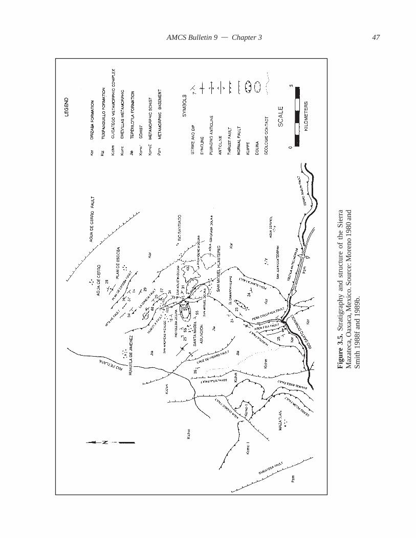
AMCS Bulletin 9 — Chapter 3
Figu
re 3
.5. S
tratig
raph
y an
d st
ruct
ure
of th
e Si
erra
Maz
atec
a, O
axac
a, M
exic
o. S
ourc
e: M
oren
o 19
80 an
dSm
ith 1
988f
and
198
9b.
47

AMCS Bulletin 9 — Chapter 3
Domingo to the southwest of the San Juan Coatzospan(Viniegra, 1966).
The Necoxtla Formation consists of pink andyellow variegated silty slates and mudstones with cal-careous and ferruginous concretions that are gray toolive green (Viniegra, 1965). The thickness of the unitis not known due to intense folding.
3.4.3.7 Atoyac FormationThe Atoyac formation was identified by Mena
(1958 in Ramos 1983, pp 121–122) and Tarango(1971)as a reef limestone in the locality of Sierra Atoyac inVeracruz. The formation comprises dark gray mud-stones and wackstones containing pellets, bioclasticfragments, and clasts of quartz. The limestone existsin beds of 40 to 80 centimeters.
The common fossils of the formation areSpiroloculina (ostracods), ammonites, and mats of thealgal Ouinaueloculina. Index fossils Spiroculina,Sulcoperculina globosa, and Sulconerculina vermuntiin the Atoyac Formation correlate to Campanian-Maestrichtian age.
The Atoyac Formation was identified 30 kilome-ters to the east of the study area near Agua Español(Moreno, 1980). The Atoyac Formation overlies theOrizaba Formation and ranges in thickness from 200to 800 meters (Ramos, 1983).
3.5 Quaternary SystemThe surface terrain of the Sistema Huautla Karst
Groundwater Basin consists of solutionally erodedlimestones that have formed a cherty orange claysoil ranging from a few centimeters to 10 meters inthickness. Within the soil profile are colluvial frag-ments of limestone and blocky chert. Most lime-stone areas form deep red terra rossa soils, but thisis not the case in the limestone region of the SierraMazateca.
In the bottoms of large dolinas such as the RíoIglesia, San Miguel, and San Agustín that are locatedadjacent to the overthrusted clastic cap rock, fluvialsystems flow on top of alluvial and colluvial regolithconsisting of conglomerates of shale, angular lime-stone cobbles, and arkose pebbles and cobbles. Theangularity of the bedload indicates a source of closeproximity. The soil on the hill slopes attains a thicknessof 1.5 meters. The soil profiles exposed from erosionin the bottoms of large dolinas are found to exceedseveral meters in thickness.
Other large dolinas with intermittent and peren-nial streams, such as the Agua Carlota and La Grietadolinas, that are not located adjacent to allochthonous
clastics contain both colluvial and alluvial sediments.Alluvial sediments consist of poorly sorted, angularlimestone, shale, and chert fragments, indicating shorttransportation. Residual soils in the dolinas have beendeposited by sheet wash from steep slopes. Local agri-culture has contributed to the erosion of theseslopes.
The bed of the Río Santo Domingo, located at thesouthern edge of the Sistema Huautla Karst Ground-water Basin, contains unconsolidated Quaternarysediments consisting of boulder conglomerates andalluvium derived from interior basins and metamorphichighlands to the west. These conglomerates representmost of the rock types of the region. They consistchiefly of metamorphics, such as schists, greenstones,and metavolcanics, sedimentary rocks, such as lime-stones, sandstones, and shales, intrusive plutonicrocks, such as granites, granodiorites, diorites andpegmatites, and extrusive plutonic rocks such as rhyo-lites, andesites, and tuffs. An unusual occurrence isan impure form of jadeite found in the alluvial gravels ofthe Río Santo Domingo (Smith, 1989a).
3.6 Stratigraphy of Sistema Huautla KarstGroundwater BasinBased on field observations and literature review,
the stratigraphy of the karst groundwater basin is foundto consist of the Jurassic, Cretaceous, and QuaternarySystems. The rocks distributed across the SistemaHuautla Karst Groundwater Basin vary in composi-tion from insoluble shales and sandstones to solublelimestones and dolostones.
The siliceous clastic rocks tend to occupy thewestern portion of the basin and follow a north-southdistribution along the regional structural axis. Exposedto the east are soluble carbonates that form the SistemaHuautla Karst Groundwater Basin. The distributionof the carbonates lies parallel to the silica clastic rocks.A complicating factor in identifying the rock units ofthe Sistema Huautla Karst Groundwater Basin is aseries of subparallel reverse faults and subper-pendicular normal faults (Figure 3.5).
The rocks across the basin may be grouped basedon physical characteristics. The rocks forming thewestern margin of the groundwater basin arethin-bedded mudstones, shales, and sandstones, withminor limestone beds. Lying in narrow bands to theeast are thin-bedded micritic limestones and beddedchert intercalated with thin shale partings. Exposedby erosion in the bottom of dolinas are massive beddedlimestones and dolostones with minor chert beds andnodules.
48

AMCS Bulletin 9 — Chapter 3
3.6.1 Western Margin of the Sistema Huautla KarstGroundwater BasinThe stratigraphy from San Andrés to San Agustín
Zaragoza consists of Jurassic clastics on the westernmargin of the Sistema Huautla Karst GroundwaterBasin and Cretaceous limestones and dolostones tothe east (Figure 3.6).
The siliciclastic rocks are composed of shales andsandstones with beds of limestone of the Jurassic.These rocks have been identified by Echanove (1963)and Moreno (1980) as belonging to the TepexilotlaFormation. These rocks tend to form the western limitof the karst groundwater basin and provide a cap rockoverlying allochthonous Cretaceous carbonates. TheTepexilotla Formation occupies the highest elevationswest of the San Agustín, Río Iglesia, and San Migueldolinas and extends south toward the Río SantoDomingo, crowning the peaks of Cerro Quemado.These rocks consist of arkosic sandstones, shales, lime-stones, and thin-bedded black mudstones with quartzveins. These rocks are allochthonous and form thehanging wall of the thrust sheet. The thrust fault is the
Huautla–Santa Rosa Fault (Moreno, 1980) and overliesCretaceous limestones. The contacts between differ-ent formations are buried by regolith.
Beneath the hanging wall of the Huautla Fault areLower Cretaceous limestones of the Tuxpanguillo andCapolucan Formations (undifferentiated) and theOrizaba Formation. On the east side of the fault arethin-bedded dark gray micritic limestones believed tobe the Tuxpanguillo Formation. The outcropping rocksare different in appearance from rocks on either sideof the fault. The Tuxpanguillo Formation forms cliffsabove the San Agustín Dolina on the west side. Theoutcrop may be traced from the west side of the RíoIglesia Dolina to the north to San Andrés. The out-crop also borders the road from San Andrés to Huautlade Jiménez (Echanove, 1963).
East of the Huautla Fault, identified by Moreno(1980), is the Falla de Peña Blanca or Peña BlancaFault. The fault marks the eastern limit of the outcropof the Tuxpanguillo Formation. The TuxpanguilloFormation may be a fault slice, since it appears inoutcrop for a limited areal extent. The presence of theTuxpanguillo Formation implies the existence of twofaults.
To the east of the high-angle reverse Peña BlancaFault, the physical characteristics of the limestoneschange abruptly. The rocks were observed to consistof thin to thick-bedded limestones, 4 centimeters to1.5 meters thick, intercalated with thin shales 2 milli-meters thick and bedded cherts 2 to 6 centimeters thickof the Orizaba Formation.
Moreno (1980) described the surface rocks fromSan Andrés to San Miguel Huautepec to the Río SantoDomingo and concluded that the rocks belong to theOrizaba Formation. He does not identify the rockssandwiched between overthrusted Jurassic rocks andthe identified units of the Orizaba Formation. Morenodid not make reference to Echanove’s work, whichextended up the fringe of the Sistema Huautla KarstGroundwater Basin (Figure 3.4).
When Moreno conducted his field investigations,he found that the fossils in the outcropping limestonesare poorly preserved due to recrystallization. He basedhis findings on identifying the fossil, Caprinida, ofthe Albian-Cenomanian near the community of SanAgustín. It is not known where he obtained his samplesfor identifying the surface rocks.
The outcrop of the Orizaba contains bothdolostone and limestone beds that alternate in colorfrom cream white to medium gray (Plate 3.1). Therock has been recrystallized to form a low-grademarble. This marmoratization occurs chiefly in folds
Figure 3.6. Lithofacies map of San Agustín, RíoIglesia, San Miguel, and La Providencia dolinas.
49
AMCS Bulletin 9 — Chapter 3
and in zones adjacent to faults. Internal structures offossils found in the rock were not identifiable due torecrystallization. The lack of abundant fossil beds anddolomitic limestones in the outcrops near San Agustínindicate a backreef facies.
In the area between San Andrés and San Miguelare the entrances to several deep vertical caves, in-cluding Sótano de San Agustín and Sótano del RíoIglesia. While these entrances are positioned adjacentto the allochthonous clastic cap rock, they are locatedin the Orizaba Formation.
3.6.2 Stratigraphy East of the Road from San Andrésto Nuevo Progreso and North to Agua de CerroThe area east of San Andrés is topographically
and structurally higher than the rock units found southof San Andrés to San Miguel, with the notable excep-tion of the topographically higher Jurassic rocks onthe western margin of the basin (Figure 3.5). The rockunits lying to the east are situated up to 400 metershigher topographically and structurally up dip. Therocks are either the upper Orizaba Formation or rocksof the Maltrata Formation (Viniegra, 1965). It appearsthat Moreno did not extend his field studies northeastof San Andrés and relied on photogeologic interpreta-tion.
On the road from San Andrés to San Felipe therock units consist of black thin-bedded micritic lime-stones from 2 to 6 centimeters thick, intercalated withbedded chert and shales. Thin-bedded limestones areinterbedded with a massive-bedded limestones onekilometer north of San Andrés. The massive beds arebetween 2 and 3 meters thick and contain breccia bedswith angular fragments up to 8 centimeters across.
Overlying and underlying the breccia beds arethick sequences of thin-bedded limestones intercalatedwith white to cream to black bedded chert estimatedto be 400 meters thick. The intercalated limestoneshave been observed in caves that drain into SistemaHuautla (i.e., Li Nita, Nita Zan, Sótano de Agua deCarrizo, Nita Ka, Nita Nanta, and Nita He). The rockunits found in Sótano de San Agustín are moremassive-bedded and less cherty in the upper levelsand shafts in the cave.
It was originally thought that the thin-beddedcherty limestones were the United Orizaba Formation.It is possible the cherty limestones are an extension ofthe rocks described by Viniegra (1965) as the MaltrataFormation. The formation is found in outcrop 5 kilo-meters north of Huautla near Zongolica Chilchotla(Viniegra, 1965). The northeast portion of the SistemaHuautla Karst Groundwater Basin is near the boundaryof outcrop for the Maltrata Formation.
The closest outcrop of fossiliferous limestones isone kilometer southeast of San Andrés in the La GrietaDolina. The floor of the dolina is 90 meters higherthan the floor of the San Agustín Dolina. Fossilifer-ous limestones composed of rudist clams belongingto the Orizaba Formation are seen near the entranceof the cave La Grieta and in surface outcrops nearPlan Carlota. This lateral variation indicates a facieschange from west to east from a back reef facies to areef facies.
Most of the cave entrances located in the north-ern portion of the karst groundwater basin are locatedin thin-bedded cherty limestones of possibly theMaltrata Formation or upper Orizaba Limestone.
3.6.3 Stratigraphy from San Miguel Huautepec to RíoSanto DomingoIn the southern portion of the Sistema Huautla
Karst Groundwater Basin, the surface rocks are com-posed primarily of Jurassic rocks on the western marginand massive-bedded units of the Orizaba Formation,as described by Moreno (1980). However, field in-vestigation during this study has indicated that the areais more complex than Moreno described. The pres-ence of additional allochthonous units and contactsbetween allochthonous units is in question.
Near the community of El Camarón, the surfacerocks consist of two distinct limestone formations. Theupper limestone unit is a dark gray thin-bedded sha-ley limestone 2 to 6 centimeters thick that is intenselyfolded and contains vein calcite fracture filling. Thisrock unit overlies massive-bedded rock 1.5 to 2 metersthick of the Orizaba Formation. The highly deformedthin-bedded limestones are believed to be a klippe orerosional remnant of Jurassic limestones and shalesof Tepexilotla Formation. These rocks are similar tothe rocks overlying the Huautla Fault. The klippe out-crops in a road cut and quarry near the square in thetown of El Camarón. The intensely deformed rocksextend for approximately 500 meters along a nar-row ridge that is less than 100 meters thick (Figure3.5).
In the vicinity of El Camarón and the PeñaColorada Canyon, the Orizaba Formation is estimatedat a thickness of 600 meters. Moreno (1980) provideda map showing the areal distribution of the OrizabaFormation. His map, constructed from field investi-gation and interpreting aerial photos, does notadequately define the areal distribution of the rockoutcrop as related to the position of defined faults.Moreno drew the Huautla Fault down the center ofthe Peña Colorada Canyon. He described the hangingwall of the fault as consisting of the Tepexilotla
50

AMCS Bulletin 9 — Chapter 3
Formation. While it was not obvious from traversingthe Peña Colorada Canyon that a major reverse faultexists down the center of the canyon, the alleged hang-ing wall does consist of massive units of the OrizabaFormation. In the western wall of the Peña ColoradaCanyon are a number of caves, most notably Cuevade Peña Colorada, an overflow resurgence cave ofSistema Huautla.
From the junction of the Peña Colorada Canyonand Río Santo Domingo, the massive units of theOrizaba Formation may be traced for two kilometersto the west, until a definite contact between underly-ing black slates are found in outcrop at river level.Near this junction to the west are metamorphics ofthe Cuicatlán Complex that lie as allochthonous strataover Cretaceous rocks. It was hypothesized that theoutcrop of massive beds of the Orizaba west of thePeña Colorada–Río Santo Domingo confluence wasin a separate groundwater basin than the SistemaHuautla Basin. The western limit of the basin may bedefined by a thrust fault located 1.5 kilometers westof Peña Colorada Canyon and east of Cueva de AguaFría (Figure 3.5).
The proposed position of the Jurassic outcrop ofthe Tepexilotla Formation is west of the present bound-ary, as indicated by the position of the Huautla Faultaccording to Moreno. Hence, the Huautla Fault is prob-ably located farther to the west, defining the contact
Plate 3.1. Limestones and dolostones 1.5 to 2 metersthick are characteristic of the Orizaba Formation.
between the allochthonous rocks of the Jurassic andthe underlying Cretaceous limestones.
3.7 ConclusionsDue to the structural complexity, the stratigraphic
units of the Sistema Huautla Karst Groundwater Ba-sin need to be better identified by index fossils to beable to confidently determine their sequence and toaccurately locate the stratigraphic positions of caveentrances. One could infer by the law of superposi-tion that the Orizaba Formation is overlaid by theMaltrata Formation in the study area, based on de-tailed descriptions of the lithology of type localities.Work by Echanove (1963) and Viniegra (1965) ex-tended up to the edges of the study area, and theirfindings could be extended into the study area pro-vided attention was paid to the appropriate structuralboundaries. The Maltrata Formation is a deep-waterfacies that overlies the Orizaba Formation concor-dantly at locations north of the study area. The Maltratais also composed of mud and siltstones in the areas itwas identified. In the Huautla area there are fewsilt- and mudstones associated with the thin-beddedblack cherty limestones. If this is the Maltrata Forma-tion, this location could have been free of terrigenousinflux of sediments and represents a facies change.
It was beyond the scope of this study to do de-tailed stratigraphic mapping, which would require
51

AMCS Bulletin 9 — Chapter 3
paleontological studies, possibly of microfossils. Thework by previous investigators has resulted in a posi-tive identification of rock units where sampled. Theirwork is important as a base-line stratigraphic inter-pretation. Unfortunately, their work is not definitivein this respect. They did not extend their fossil collectinginto the surrounding hillsides. Field investigations aspart of this research have indicated that there may beinconsistencies in previous interpretation of the strati-graphic position of rock units as related to structurecompared to what was observed in the field.
Identifying the stratigraphic positions of soluble andinsoluble rocks is important for interpreting the bound-aries of the karst groundwater basin and for providingan explanation of the genesis of cave development, as
discussed in a subsequent chapter.In this study, the following contributions were
made to the knowledge of stratigraphy of the SistemaHuautla Karst Groundwater Basin: Description of rockunits in the field. Location of rock units that arestratigraphically different from one another. New in-terpretation of the location of stratigraphic units withrespect to fault contacts; this interpretation is differ-ent than is provided on any geologic map by previousworkers. Tentatively identified the formations of rockunits the cave entrances are located within. Identifiedwhich rock units may provide allogenic recharge orperennial springs to karst swallets. Provided an Englishtranslation of the geologic research presented inSpanish-language professional journals.
52

AMCS Bulletin 9 — Chapter 4
CHAPTER 4
STRUCTURAL GEOLOGY
4.0 IntroductionPertinent to the study of the hydrology of the
Sistema Huautla Karst Groundwater Basin is the studyof its internal and external structures. It is believed bythis researcher that structural elements define the limitsof the karst groundwater basin. Prominent faults andfolds control the hydrologic flow paths and thus theoverall hydrologic pattern of the karst groundwaterbasin.
Mapping faults and folds in the subsurface of theSistema Huautla Karst Groundwater Basin provideda basis for comparison with faults and folds mappedat the surface and produced a more comprehensiveinterpretation of the geology of the karst groundwaterbasin. Previous work by Echanove (1963) and Moreno(1980) provided cross sections through the study areathat generalize the geologic interpretation of the com-plex structural geology. They did not have the advantageof being able to see the internal structure of the SierraMazateca from within the vertically extensive cavesof the study area.
Fortunately, 20 years of cave exploration andmapping have provided a tremendous database onhydrologic flow paths through the karst aquifer. Analy-sis of local structures and their orientation aids in theinterpretation of the three-dimensional quantitativemodel represented by a computer line plot of SistemaHuautla and other caves in the karst groundwater ba-sin. The line plots illustrate 100 kilometers of flowpaths that were physically surveyed and explored bycave explorers (Figures 1.3 and 1.4). The cave sur-veys represent flow paths that are active or currentlyinactive, as water has abandoned one fracture- orbedding-plane-controlled flow path for another.
To understand the local structural geology, a goodinterpretation of the stratigraphy and regional tectonichistory is necessary. In Chapter 3, stratigraphy andstructure as related to stratigraphic position of the
rocks were addressed. In this chapter, the regional tec-tonic history and local structural geology as interpretedby previous workers are presented.
Many additional structures of both large and smallscale were identified based on comparing offsets betweenopposite bedding planes and in some cases betweenoffset formations. Consequently, the structural styleis recognizable. The results of the field investigationare presented in the following sections.
4.1 Regional Tectonic HistoryCarfantan (1981a) stated that structures found in
south-central Mexico may be attributed to four tectonic-evolutionary phases from the Mesozoic to recent: acompressional phase during the Middle Cretaceousthat resulted in regional metamorphism and volcanicintrusion, compression occurring during the LaramideOrogeny, basement folding during the Late Miocene,and an extensional phase during the Miocene-Quaternary interval. Demant (1978) related the struc-tures to the development of the Neovolcanic Plateau.Moreno (1980) described four stages of structuralevolution of the Sierra Juárez, uplift of the basementrock and marine regression during the Late Cretaceous,uplift and compression during the Laramide Revolu-tion in the Paleocene, folding and faulting during thePaleocene and Eocene, and a taphrogenic phase fromLate Oligocene through the Miocene that resulted inthe uplift of the Sierra Juárez and subsidence of theVeracruz Basin to the east (Figure 4.1).
The two most important events shaping thestructural style of the Sierra Juárez occurred during acompressional phase in the Laramide Orogeny of theEarly Tertiary and during the extensional phase in theMiocene-Quaternary interval.
The structural evolution of south-central Mexicois very complex and poorly understood. It is believedthat complex structures that formed during theLaramide orogeny are a result of plate collision and
53
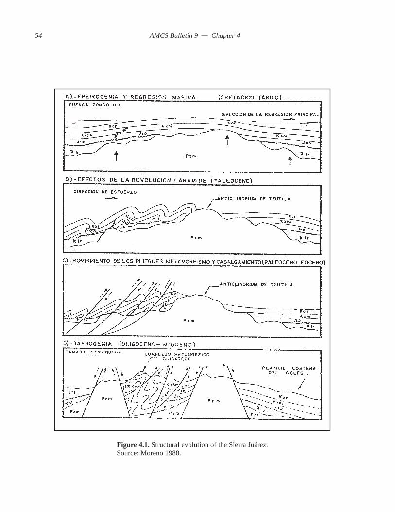
AMCS Bulletin 9 — Chapter 4
Figure 4.1. Structural evolution of the Sierra Juárez.Source: Moreno 1980.
54

AMCS Bulletin 9 — Chapter 4
the accretion of exotic terrains, which, according toCampa and Coney (1983), is what makes paleogeographicreconstruction of south-central Mexico so difficult.The area south of Mexico City is composed of a num-ber of distinct basement terrains (Campa and Coney,1983), with the oldest being the Oaxaca Complex ofGrenville age (Fries et al., 1962). The Oaxaca Terrainprovided the continental cortex during the Mesozoicupon which the rest of Mexico accreted or evolved.
The Laramide Orogeny of the Early Tertiary gaverise to the folded and faulted structures present in theSierra Juárez. There are two hypothesized mechanismsthat may have been responsible for the developmentof structures in the Sierra Juárez. The first hypothesis,developed by Campa and Ramirez (1979), attributedthe Mesozoic deformation to the development of awestern andesitic island arc, the Arco Alisitos. Thisisland arc was associated with easterly subductionadjacent to the Mexican continental cortex in the
western portion of south-central Mexico.In the second hypothesis, Urrutia (1980) and
Campa (1983) postulated that the arco-insular systemdeveloped by accretion as the result of obduction inthe Pacific until its collision with the Mexican conti-nental cortex.
Back-arc uplift of basement rocks, the OaxacanComplex, resulted from plate collision and subduc-tion of the Pacific Plate (Coney, 1976). Rise of theOaxacan Peninsula provided the mechanism for grav-ity sliding of sedimentary rocks over a decollementstrata consisting of Jurassic shales (Mossman andViniegra, 1976). Gravity sliding occurred from westto east.
The structural style of deformation in the SierraJuárez is complex, consisting chiefly of two distinctstyles, thin-skinned and block faulting. Thin-skinneddeformation formed during the compressional phaseof the Laramide Orogeny during the Paleocene and
Figure 4.2. Geologic cross-section of the Sierra Juárez and Cuencade Veracruz. Source: Mossman and Viniegra 1976.
55

AMCS Bulletin 9 — Chapter 4
Eocene, and block faulting occurred during theMiocene-Quaternary Interval (Figure 4.2). The com-pressive effects on ridged limestone produced anextensive fold belt striking NW-SE that consists ingeneral of westerly-regional-dip, asymmetrical folds,overturned folds bound by reverse faults, basal thrustfaulting, and overthrusting and imbrication similar tothe Alberta Foothills structures in the CanadianRockies (Mossman and Viniegra, 1976).
Charleston (1980) studied allochthonous meta-morphic rocks that outcrop on the western edge of theSierra Juárez. The rocks rest disconformably overMesozoic carbonates south of the Río Santo Domingoin the Sierra Juárez. These rocks were originally LowerCretaceous pelitic sediments deposited in a eugeocline.Metamorphism took place in an ancestral Benioffzone.
Charleston (1980) radiometrically dated gneissand schist from the Cuicateco Complex and attributedthe deformation to the Late Cretaceous and Early Ter-tiary, corresponding to the Laramide Orogeny. Themetamorphic rock on the western flank of the SierraJuárez represent a wide mylonitic band that separatesthe Maya terrain from the Oaxaca terrain (Campa andConey, 1983). Carfantan (1981a) postulates that thewide mylonitic band is related to the opening and clos-ing of an ocean basin and rift development duringTuronian time. However, the origin of these cataclasticrocks is poorly understood.
The second phase of deformation occurred dur-ing the Miocene-Quaternary interval at a time whenthe Cocos Plate was subducting beneath the continen-tal cortex of Mexico (Demant, 1978). At this time, theNeovolcanic Axis was formed and regional uplift oc-curred.
The uplift of the Sierra Juárez may also be attrib-uted to the reactivation of two structural basins, theVeracruz Basin and the Tehuacán-Oaxaca Basin. Theformer initially developed in the Lower Cretaceousduring the opening of the Gulf of Mexico and separa-tion of the Chiapanaca Plate from the Mexicana Plate(Carfantan, 1981a). Both of these basins form exten-sional tectonic boundaries to the east and west ofSierra Juárez. The Sierra Juárez is a horst block be-tween the Tehuacán and Veracruz Grabens.
On the eastern edge of the Sierra Juárez is theVeracruz Basin, which began accumulating thick se-quences of sediments at the beginning of the Tertiarydue to the initial uplift and subsequent erosion occur-ring during the Laramide Orogeny. This orogenicphase introduced large volumes of sediments onto thecontinental margin. Since its initiation, more than8,000 meters of sediments have accumulated
unconformably over Jurassic sediments in theHuayacocotla Aulacogen (Veracruz Graben) (Hoffmanet al., 1974). The Huayacocotla Aulacogen was formedduring the initial rifting that opened the Gulf of Mexicoduring the beginning of the Jurassic (Effing, 1980).Great influxes of Tertiary sediments may have reacti-vated the graben during the Miocene. The rise of theSierra Juárez during the Tertiary may be attributed toa regional uplift having been influenced from the re-activation and subsidence of the Veracruz andTehuacán-Oaxaca Basins. The uplift resulted in blockfaulting and north-south-oriented normal faultsthroughout the Sierra Juárez. The north-south orien-tation of normal faulting may be the result of isostaticadjustment between the subsiding Veracruz Basin andthe rising Sierra Juárez.
4.2 Structures of the Sierra MazatecaThe previous section described the origin of struc-
tural deformation of the Sierra Juárez and the largestgeologic structural features including the fold belt,graben of the Tehuacan-Oaxaca Basin, and theVeracruz Basin. This section provides a closer look atthe structures of the Sierra Juárez Geologic Sub-province as they pertain to the Sierra Mazateca.
The Sierra Juárez is a fold belt that consists ofstructures formed from both compressional and ex-tensional deformation. The fold belt is deformed intoa series of parallel asymmetrical folds with complexinternal structures, bounded by high-angle reversefaults, tear faults formed from tangential compression,thrust faults, normal faults, and large block faults.
The largest structures within the fold belt are thrustfaults. Viniegra (1966) described two major thrustfaults associated with the study area. These are theaerially extensive Cerro Rabón and Huautla ThrustFaults. Charleston (1981) described a major thrustfault, the Cuicateco Fault, south of the Río SantoDomingo. Echanove (1963) described a thrust faulton the western boundary of the study area but did notassign a name to the fault. To the south of the SistemaHuautla Karst Groundwater Basin lies a major tec-tonic boundary interpreted to be a transcurrent fault.The major faults associated with the study area aredescribed in the following sections.
4.2.1 Cerro Rabón Thrust FaultViniegra (1966) described the Cerro Rabón Thrust
Fault as having exposures in the front range of theSierra Mazateca (Figure 3.3). Traces of the thrust faultextend 40 kilometers to the north, where they disap-pear near Zongolica. The Cerro Rabón thrust fault hasbeen found 35 kilometers west of the study area along
56
AMCS Bulletin 9 — Chapter 4
the front range and 10 kilometers southwest of Huautlade Jiménez at exposures west of El Camarón alongthe Río Santo Domingo (Figure 3.5).
Several kilometers to the west of El Camarón, theCerro Rabón thrust fault disappears under two thrustsheets composed of cataclastic rocks of the CuicatecoFault, a reverse fault (Charleston, 1981), and Jurassicclastics of the Huautla Fault, also a reverse fault(Viniegra, 1966). The aerial extent and low angle ofthe fault suggest that this is a sole fault. It is believedthat the Cerro Rabón Fault underlies the SistemaHuautla Karst Groundwater Basin. There is no evi-dence that this fault extends south of the Río SantoDomingo into the Sierra Juárez.
In the front range, the hanging-wall strata consistsof the Tuxpanguillo-Capolucan and Orizaba Forma-tions (Early to Middle Cretaceous), which rest on topof intensely folded decollement strata of the UpperCretaceous Necoxtla slates (Viniegra, 1966). Threekilometers west of El Camarón, intensely foldedthin-bedded black slates are found in the river bed ofthe Río Santo Domingo. The slates are overlaid bymassive-bedded limestones of the Orizaba Formation.It is believed that the contact between the two units isthe Cerro Rabón Thrust Fault.
4.2.2 The Huautla–Santa Rosa FaultViniegra (1966) found that the rocks of the upper
Cretaceous Maltrata Formation rest discordantly overNecoxtla slates near Santa Rosa, 90 kilometers northof the study area. Viniegra hypothesized that the faultextends south to the Río Santo Domingo. Based onthis hypothesis, he named the fault the Huautla–SantaRosa Fault.
Echanove (1963), whose study area encompassedthe geologic sections between Teotitlán del Caminoand Huautla de Jiménez, mapped a large reverse fault1.5 kilometers west of Huautla de Jiménez. He foundJurassic rocks resting discordantly over lower Creta-ceous rocks of the Tuxpanguillo Formation (Figure4.3). Moreno (1980) described the Huautla Fault as athrust fault with a hanging wall consisting of Jurassicrocks of the Tepexiltotla Formation (Figure 3.5). Thefoot wall consists of rocks of the Orizaba Formation.Moreno positioned the fault east of Huautla deJiménez. The fault was traced from San Andrés to theRío Santo Domingo along the Peña Colorada Canyon.It is believed that the fault contact was verified in thefield by Moreno only in the San Andrés–San MiguelHuautepec areas.
The Orizaba geologic map indicates a major thrust(unnamed) with hanging wall rocks belonging to theJurassic overlying Cretaceous rocks. The fault extends
from 45 kilometers north of Mazatianquisco to Huautlade Jiménez and south across the Río Santo Domingo.South of the river the hanging wall of the Huautla Faultis depicted as being composed of Cretaceous rocks(Figure 3.3). In this area, the contact between thecataclastics and Cretaceous limestones may in factrepresent the contact of the regionally extensiveHuautla Fault.
It is believed that the fold belt has a thin-skinnedstructural style (Mossman and Viniegra, 1976), withruptured overturned folds with many parallel reversefaults. Consequently, the thrust fault Echanove de-scribed 1.5 kilometers west of Huautla de Jiménez maynot be the Huautla Fault as described by Viniegra(1965) and Moreno (1980) (Figure 4.3). For this re-search, the allochthonous Jurassic rocks will be referredto as the Huautla Thrust Fault.
The Huautla–Santa Rosa Fault is the most impor-tant major fault of the study area because the fault hasallowed noncarbonate rocks to overlie soluble carbon-ates (Figure 4.4). The position of noncarbonate rocksrelative to soluble carbonates is significant becausethe clastic aquifer provides allogenic recharge ag-gressive to the dissolution of limestone. Hence, thisrelationship has contributed to the development oflarge dolinas and the hydrologic framework of the sub-terranean drainage system. The Huautla–Santa RosaFault is not seen in Sistema Huautla or any other cavein the karst groundwater basin and therefore has nodirect influence in the development of cave passages.
4.2.3 Río Santo Domingo Transcurrent FaultThis fault is not described in the literature, but its
presence is obvious when examining the 1:250000Oaxaca and Orizaba geologic quadrangles. On thenorth side of the Río Santo Domingo, the stratigraphyindicates that massive Early and Middle Cretaceouslimestones have overthrusted Late Cretaceous lime-stones and Paleocene shales and sandstones. On thesouth side of the Río Santo Domingo, Paleocene sedi-ments conformably overlie Cretaceous carbonates andmaintain their superposition. While overthrustingoccurs all along the western side of the range, the sedi-mentary rocks south of the river have not undergonethe same degree of deformation as the sedimentaryrocks north of the river. The Cerro Rabón Sole Faultmay not extend south of the river (Vinegra, 1966),suggesting that a shear zone has developed normal tothe thrust front along the present day course of theRío Santo Domingo. Mossman and Viniegra (1976)noted that transcurrent faults may exist, based on aerialphotographs of the Sierra Juárez. Viniegra (1966)noted the existence of straight U-shaped valleys west
57
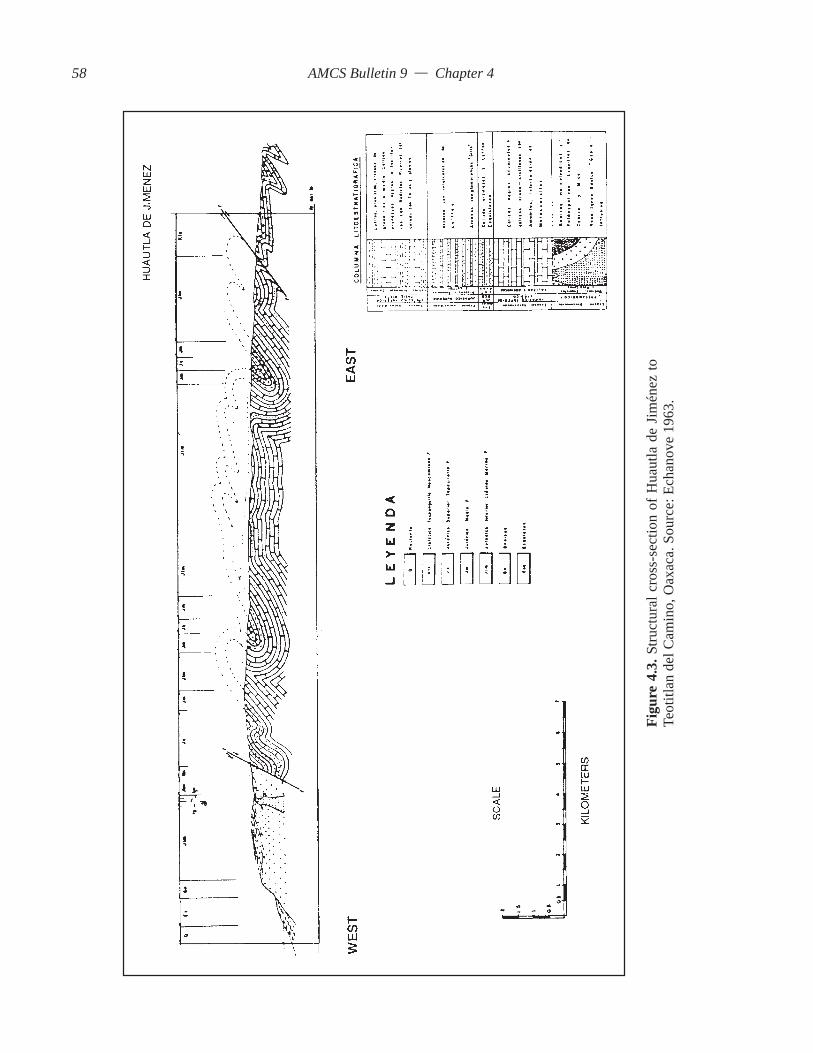
AMCS Bulletin 9 — Chapter 4
Figu
re 4
.3. S
truct
ural
cro
ss-s
ectio
n of
Hua
utla
de
Jim
énez
toTe
otitl
an d
el C
amin
o, O
axac
a. S
ourc
e: E
chan
ove
1963
.
58
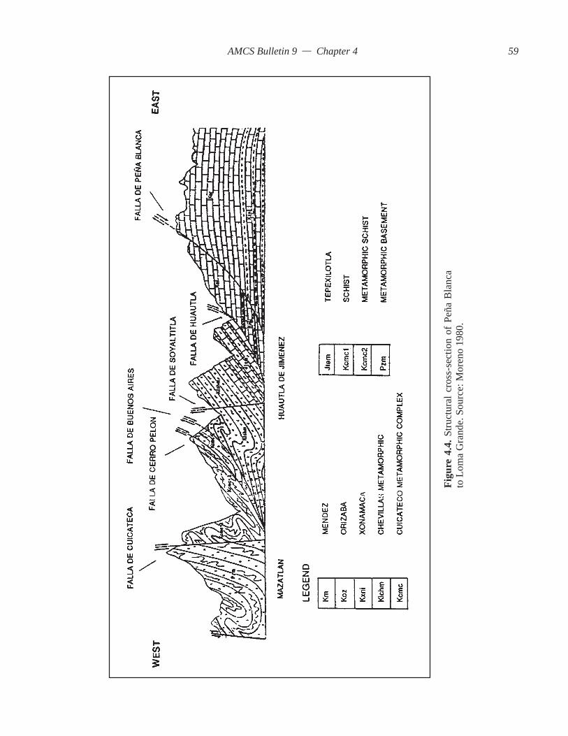
AMCS Bulletin 9 — Chapter 4
Figu
re 4
.4. S
truct
ural
cro
ss-s
ectio
n of
Peñ
a B
lanc
ato
Lom
a G
rand
e. S
ourc
e: M
oren
o 19
80.
59

AMCS Bulletin 9 — Chapter 4
of Orizaba. He considered the Acultzingo Valley tobe developed along a transcurrent fault. It is suggestedthat the Río Santo Domingo is also formed along atranscurrent fault.
4.2.4 Faults Between the Huautla–Santa Rosa Faultand the Cuicateco FaultLocated west of the study area are faults described
by previous workers (Figure 3.5). The faults are sig-nificant because they have been recognized andmapped. Any attempt at field mapping west of theHuautla Fault will require knowledge of knownfaults.
Echanove (1963), Viniegra (1966), Moreno(1980), and Charleston (1980) have described andassigned names to numerous faults located betweenthe Huautla–Santa Rosa Fault and the Cuicateco Fault.
Moreno (1980) described two thrust faults locatedwest of the normal fault, Falla de Soyaltitla. The thrustfaults are named Falla de Cerro Pelón and Falla deBuenos Aires. It is important to recognize the existenceand position of these faults as a baseline for studiesconducted in the field.
4.2.4.1 Falla de HierroMoreno (1980) described three normal faults west
of Huautla de Jiménez (Figure 3.5). These are the Fallade Hierro, Falla de Soyaltitla, and Falla de Agua deDuende. The hanging wall of each normal fault dropsto the east toward Huautla. Only the Falla de Hierro isdescribed here since its trace is within the study area.
Falla de Hierro is described by Moreno (1980) asa normal fault existing approximately one kilometerwest of Huautla de Jiménez. Moreno traced the faultfrom north of Huautla to the southeast towards ElCamarón. East of the fault is an anticline and a syn-cline. It appears this is the same fault described byEchanove (1963) as a thrust fault since the position ofthe anticline and syncline are similar.
4.2.4.2 Cuicateco FaultCharleston (1980) described metamorphic rocks
of the Cuicateco Complex located on the western sideof the Sierra Juárez (Figure 3.5). The Cuicateco Com-plex consists originally of eugeoclinal sandstones,shales, and volcanic flows tentatively assigned to theEarly Cretaceous. The sedimentary strata were subse-quently metamorphosed into schist and metavolcanics.
Carfantan (1981a) and Campa and Coney (1983)described the rocks on the west side of the Sierra Juárezfrom Concepción Pápalo to Teotitlán del Camino asconsisting of lenses of ophiolites (serpentines) thatwere mined for asbestos.
The Cuicateco Fault is subparallel to all of themajor thrust faults of the region and considered to begenetically related to all other thrust faults occurringduring the Laramide Orogeny. The Cuicateco Fault issubparallel to the Huautla–Santa Rosa Fault and theCerro Rabón Fault and has the largest known arealextent of reverse faults in the sierras. The trace of thefault extends north to Orizaba and south of Cuicatlán.The fault is identified on the 1:250,000 Orizaba andOaxaca geologic quadrangles as the thrust fault thatseparates cataclastic rocks from metasedimentaryrocks on either side of the Río Santo Domingo.
The rocks of the Cuicatlán Complex are alloch-thonous and rest over Jurassic metasedimentary flyschdeposits on the western slopes of the Sierra Mazatecaand carbonates south of the Río Santo Domingo inthe Sierra Cuicateco near Cueva Cheve.
Description of this fault is significant because itis one of the largest faults in the region and is geneti-cally related to the structural evolution of the area.However, the fault does not outcrop in the SistemaHuautla Basin.
4.2.5 Faults Of the Sistema Huautla Karst Groundwa-ter BasinMoreno (1980) described only one important fault
in the Sistema Huautla Karst Groundwater Basin; hecalled it Falla de Peña Blanca. He described the faultin the east-central portion of the Sierra Mazateca atSan Juan Coatzoapan. The fault is then traced to thenorthwest and joins the Huautla–Santa Rosa Fault atSan Agustín. The hanging wall of the fault consists ofthe Orizaba Formation, which overlies the MendezFormation, which correlates to the Maltrata Forma-tion of the Late Cretaceous (Figure 3.5).
4.3 Preliminary Geologic Field InvestigationsThe literature review is fundamental to the under-
standing of the geologic history, the tectonics of theregion, and past research conducted in the study area.Little geologic information was available on the areahypothesized to be the Sistema Huautla Karst Ground-water Basin. It was therefore necessary to define thegeology of the study area by interpretation of geologicfeatures from available maps and then conduct geo-logic field investigations to understand the influenceof these features in the karst groundwater basin. Thefield investigations were necessary to determine thestructure of the karst groundwater basin, the area ofprobable groundwater output, the structural influenceson flow patterns within the basin, and the hydro-geologic setting for the development of a model forspeleogenesis.
60

AMCS Bulletin 9 — Chapter 4
4.3.1 Lineament AnalysesIt has been recognized by numerous researchers
that solutional features (e.g., cave passages, shafts,solutional crevices) are formed primarily along frac-tures defined as bedding planes, joints, and faults(Pohl, 1955; Merrill, 1960; Ford, 1971; Palmer, 1972;Mylroie, 1977; Ford and Ewers, 1978; Crawford,1980; and Palmer, 1991). Of major importance to thisthesis was an investigation of the relationship between72.91 kilometers (Minton, 1988) of mapped cave pas-sage in the Sistema Huautla Karst Groundwater Basin tothe regional structural development. Are the cave pas-sages strike-orientated along steeply inclined beds,aligned along joints, and/or aligned along faults? Doesthe pattern of mapped cave passages follow any re-gional fracture-pattern trends expressed as topographiclineaments? Are topographic lineaments an expressionof regional fracture patterns?
Most researchers believe there is a correlationbetween topographic lineaments and structure, andsome karst researchers have described a correlationbetween topographic lineaments, structure, and cavepassage trend. However, there are hydrogeologic situ-ations where there is no apparent correlation betweenany of these features.
Boyer and McQueen (1964) determined that thereis a relationship between topographic lineaments andmapped joints in flat-lying rocks. In the Appalachianfold belt of Pennsylvania, it was found that there is nocorrelation between topographic linears and joint setsin tightly folded areas (Lattman and Matzke, 1961).Lattman and Parizek (1964) describe lineaments as azone of closely spaced fractures. They found that wellslocated on topographic lineaments hypothesized to befracture traces in carbonate aquifers had greater yieldsand intersected more conduits than in other areaswithin the same aquifer.
Wermund and Cepeda (1977) found that the de-velopment of caves correlated with fractures measuredin the field and from air photos in the Edwards Aqui-fer of Texas. Miller (1981) in his study of CavesBranch Karst found a strong correlation between photolineations and the alignment of cockpit karst features.Barlow and Ogden (1982) found a correlation betweenthe position of cave systems and their orientation withfracture traces in Arkansas. Ogden and Redman (1993)found a strong correlation between orientation of cavepassage segments, topographic lineaments, and frac-tures in dolostones of the eastern overthrust of Ten-nessee. Nelson and Monroe (1966) correlated a largeerosional feature observed on a topographic map witha major fault.
Viniegra (1966) described several U-shapedwest-east trending valleys in the Sierra Madre Orien-tal. One is the Acultzingo Valley, which is located northof the study area, near Orizaba. The limestone valleyis oriented normal to the regional strike and is thoughtto have been formed by chemical erosion along frac-tures. It is suggested by the orientation of the valleyand lack of vertical offset between stratigraphic unitsacross the valley that erosion occurred along astrike-slip fault.
Brown (1961) found that lineaments mapped fromaerial photos almost always indicate the presence offaults, but that they are not always consistent with jointsets in West Virginia and Pennsylvania. Deike (1989)studied Mammoth Cave and found that there is littlecorrelation between minor joint sets and straightpassage segments. No cave passages are aligned withtopographic lineaments thought to be fracture traces.There was a correlation between alignment of sink-holes and some cave passages. Ford and Williams(1989) found from intensive literature review that inmost instances there is no correlation between the lo-cation and position of cave systems in limestone withfracture traces.
An investigation was made to determine the sig-nificance of linear features in the Sistema HuautlaKarst Groundwater Basin as mapped from surfacestrike and fault measurements, topographic maps, andcave maps. The approach used was a comparativeanalysis based on number of segments and their ori-entation. Topographic lineament orientations distributedacross the karst groundwater basin were measured todetermine the influence these probable structural fea-tures have on the direction of subterranean drainageof the region. The most informative map available forthis purpose is the 1:50,000 scale Huautla TopographicMap prepared by the Mexican Topographic Service.
Ford and Williams (1989) defined fracture traces,fracture linears, and fracture lineaments as narrow lin-ear trends that are detectable from aerial photographyor topographic maps (Figures 1.5, 1.6).
El-Etr (1974) defined a lineament as any naturalfeature less than 10 kilometers long. This definitionfor describing lineaments was adopted by Miller(1981) during his structural interpretation of CavesBranch Karst in Belize. El-Etr’s definition of a linea-ment is expanded to include straight-line cave-passagesegments, faults, and bedding-plane orientations.
The method used to determine topographic linea-ments in this study was to measure straight line segmentsof stream valleys, karst valleys, narrow ridges, sink-holes that appear to be aligned, and dissected ridgelines that are 500 meters long or longer. Straight line
61

AMCS Bulletin 9 — Chapter 4
segments over 500 meters long were given a greaterweight. This weight was determined by adding thenumber of 500-meter segments along the length anddividing by 500 meters. This method emphasizes theimportance of long segments. The azimuth of eachstraight line segment was measured. The data for faultsmapped in the cave and on the surface were comparedbased on the number of faults and their orientation.The number of strike measurements was compared totheir orientation. All azimuth readings were adjustedfor an 8 degree magnetic declination, as indicted onthe Huautla Topographic Map. There were two promi-nent lineaments oriented to the northwest and two tothe southwest (Figure 4.5).
A total of 286 topographic lineaments 500 metersor longer were traced on the Huautla TopographicMap. The dominant orientation was along an azimuthbetween 330 and 350 degrees (Figure 4.6). The second-order orientation was between 300 and 310 degrees.The third-order lineament orientation was between 20and 30 degrees.
The computer line plot of mapped cave passagesyielded 476 hundred-meter-long straight line seg-ments. Cave passage orientations were dominant inseveral directions (Figure 4.6). The dominant cave
passage orientation was 320 to 340 degrees orienta-tion, the second order of dominance was from 340 to360 degrees, the third order was 300 to 310 degrees,and the fourth dominant orientation was from 20 to30 degrees.
Twenty-three fault planes mapped at the surfaceand in the subsurface, consisting mostly of normalfaults, were dominant in several directions (Figure4.6). Faults were dominant along two sets of azimuths,from 340 to 350 degrees and from 320 to 330 degrees.Second-order fault orientation was from 330 to 340degrees. A minor fault orientation occurs from 0 to 40degrees.
One hundred seventy-nine strike measurementswere taken across the groundwater basin (Figure 4.6).The strike of bedding planes had a dominant orienta-tion between 30 and 40 degrees. However, the greatestnumber of strike measurements are oriented between300 and 360 degrees with a dominant orientation be-tween 320 and 340 degrees.
4.3.2 ConclusionsAnalysis of topographic lineaments, faults,
straight-line cave passage segments, and strike and dipmeasurements indicates that there is a correlation
Figure 4.5. Major lineaments of the Huautla and Temascal topographic maps.
62
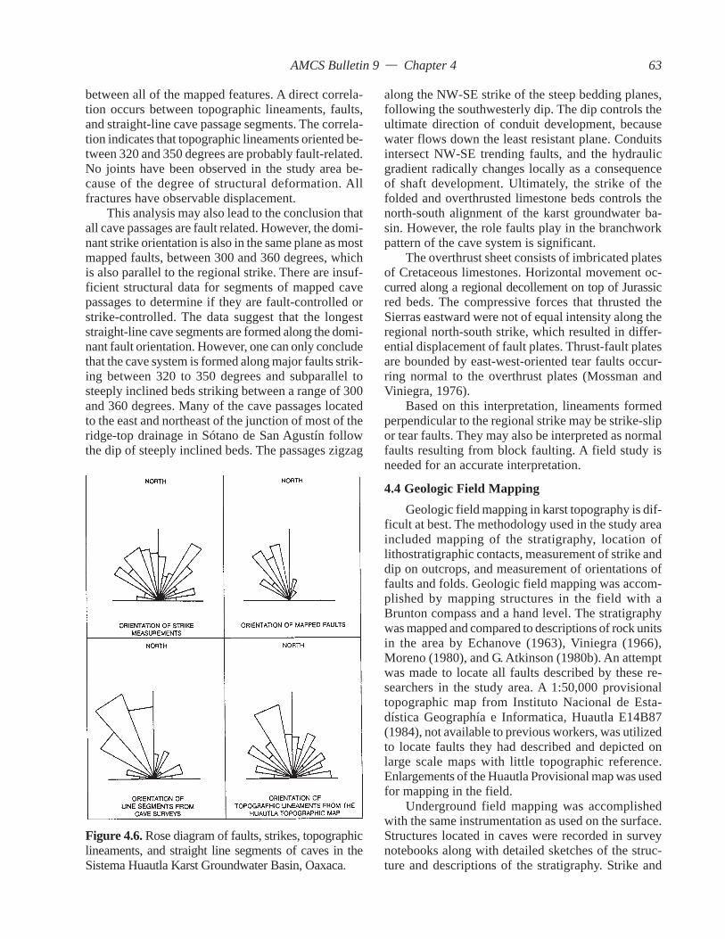
AMCS Bulletin 9 — Chapter 4
between all of the mapped features. A direct correla-tion occurs between topographic lineaments, faults,and straight-line cave passage segments. The correla-tion indicates that topographic lineaments oriented be-tween 320 and 350 degrees are probably fault-related.No joints have been observed in the study area be-cause of the degree of structural deformation. Allfractures have observable displacement.
This analysis may also lead to the conclusion thatall cave passages are fault related. However, the domi-nant strike orientation is also in the same plane as mostmapped faults, between 300 and 360 degrees, whichis also parallel to the regional strike. There are insuf-ficient structural data for segments of mapped cavepassages to determine if they are fault-controlled orstrike-controlled. The data suggest that the longeststraight-line cave segments are formed along the domi-nant fault orientation. However, one can only concludethat the cave system is formed along major faults strik-ing between 320 to 350 degrees and subparallel tosteeply inclined beds striking between a range of 300and 360 degrees. Many of the cave passages locatedto the east and northeast of the junction of most of theridge-top drainage in Sótano de San Agustín followthe dip of steeply inclined beds. The passages zigzag
along the NW-SE strike of the steep bedding planes,following the southwesterly dip. The dip controls theultimate direction of conduit development, becausewater flows down the least resistant plane. Conduitsintersect NW-SE trending faults, and the hydraulicgradient radically changes locally as a consequenceof shaft development. Ultimately, the strike of thefolded and overthrusted limestone beds controls thenorth-south alignment of the karst groundwater ba-sin. However, the role faults play in the branchworkpattern of the cave system is significant.
The overthrust sheet consists of imbricated platesof Cretaceous limestones. Horizontal movement oc-curred along a regional decollement on top of Jurassicred beds. The compressive forces that thrusted theSierras eastward were not of equal intensity along theregional north-south strike, which resulted in differ-ential displacement of fault plates. Thrust-fault platesare bounded by east-west-oriented tear faults occur-ring normal to the overthrust plates (Mossman andViniegra, 1976).
Based on this interpretation, lineaments formedperpendicular to the regional strike may be strike-slipor tear faults. They may also be interpreted as normalfaults resulting from block faulting. A field study isneeded for an accurate interpretation.
4.4 Geologic Field MappingGeologic field mapping in karst topography is dif-
ficult at best. The methodology used in the study areaincluded mapping of the stratigraphy, location oflithostratigraphic contacts, measurement of strike anddip on outcrops, and measurement of orientations offaults and folds. Geologic field mapping was accom-plished by mapping structures in the field with aBrunton compass and a hand level. The stratigraphywas mapped and compared to descriptions of rock unitsin the area by Echanove (1963), Viniegra (1966),Moreno (1980), and G. Atkinson (1980b). An attemptwas made to locate all faults described by these re-searchers in the study area. A 1:50,000 provisionaltopographic map from Instituto Nacional de Esta-dística Geographía e Informatica, Huautla E14B87(1984), not available to previous workers, was utilizedto locate faults they had described and depicted onlarge scale maps with little topographic reference.Enlargements of the Huautla Provisional map was usedfor mapping in the field.
Underground field mapping was accomplishedwith the same instrumentation as used on the surface.Structures located in caves were recorded in surveynotebooks along with detailed sketches of the struc-ture and descriptions of the stratigraphy. Strike and
Figure 4.6. Rose diagram of faults, strikes, topographiclineaments, and straight line segments of caves in theSistema Huautla Karst Groundwater Basin, Oaxaca.
63

AMCS Bulletin 9 — Chapter 4
dip measurements were recorded on both sides of thefaults, on fault planes, and on the limbs of folds. Struc-tural information was then transferred to a computerline-plot of the cave for assigning the exact positionin the subsurface.
Once faults described by the previous researcherswere located on the topographic map, then all otherfaults discovered during the geologic investigationcould be assigned a position on the map with the se-curity of knowing that they had not been describedpreviously.
4.4.1 StructureEchanove (1963) described the stratigraphy be-
tween Teotitlán del Camino and Huautla de Jiménez.Viniegra (1965) presented a lithofacies map definingthe surface rocks across the Sierra Mazateca. Moreno(1980) conducted field studies across the study areathat followed the road from Huautla to San Agustín.
G. Atkinson (1980b) field mapped from San Agustínto La Providencia. Although he did not produce anystructure maps of the area, the author was able to re-fer to his field notes from Huautla Project survey files.Echanove, Viniegra, and Moreno concluded that Ju-rassic allochthonous rocks cap the hills overlookingHuautla de Jiménez. Echanove and Viniegra extendedthe Tuxpanguillo Formation of the Lower Cretaceous,described west of Huautla de Jiménez, toward the pro-posed karst groundwater basin to the east.
Moreno (1980) determined that clastic surfacerocks of the Tepexilotla Formation form the overthrustsheet of Falla de Huautla and lie concordantly overthe Orizaba Formation exposed east of the fault.
As described in Chapter 3, Moreno (1980) pro-vided the interpretation that the Huautla Fault is tracedto the Río Santo Domingo along the Peña ColoradaCanyon.
Plate 4.1. San Agustín fault slice, Peña Blancafault. The picture is looking north toward SanAndrés. The entrnace to Sótano de San Agustínis beyond the saddle. The fault slice or wedgeis located to the left of the fault plane on thehangingwall.
4.4.2 Structures in the Overthrust Sheet ofHuautla–Santa Rosa FaultThe surface rocks capping the hills west of
the San Agustín Dolina, Río Iglesia Dolina, andSan Miguel Dolina adjacent to the karst consistof arkose sandstone up to a meter thick,thin-bedded shales, and thin-bedded limestonesof the Late Jurassic Tepexilotla Formation. Theincompetent strata are extremely deformed andexhibit fan and box folding. The contact withunderlying limestones is the Huautla overthrustfault.
4.4.3 San Agustín Fault SliceAs described in Chapter 3, there is a strati-
graphic change between rocks capping the hillsoverlooking the San Agustín Dolina and thosedirectly underlying (Figure 3.6). These rocksconsist primarily of shale, arkosic sandstone,and thin beds of limestone, lying discordantlyover limestones. Echanove (1963) and Viniegra(1966) described limestones similar to theTuxpanguillo Formation as those found belowthe allochthonous clastics.
Stratigraphic units below the Huautla Faultare thin-bedded dark gray to black limestones
64
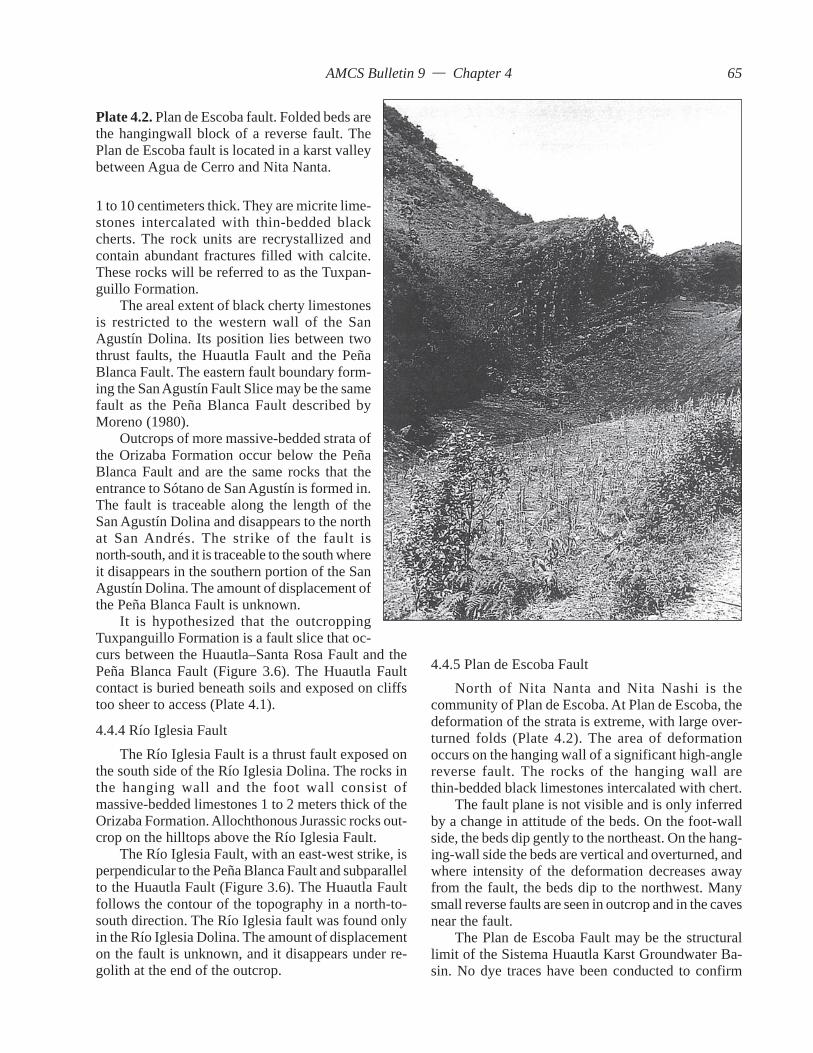
AMCS Bulletin 9 — Chapter 4
curs between the Huautla–Santa Rosa Fault and thePeña Blanca Fault (Figure 3.6). The Huautla Faultcontact is buried beneath soils and exposed on cliffstoo sheer to access (Plate 4.1).
4.4.4 Río Iglesia FaultThe Río Iglesia Fault is a thrust fault exposed on
the south side of the Río Iglesia Dolina. The rocks inthe hanging wall and the foot wall consist ofmassive-bedded limestones 1 to 2 meters thick of theOrizaba Formation. Allochthonous Jurassic rocks out-crop on the hilltops above the Río Iglesia Fault.
The Río Iglesia Fault, with an east-west strike, isperpendicular to the Peña Blanca Fault and subparallelto the Huautla Fault (Figure 3.6). The Huautla Faultfollows the contour of the topography in a north-to-south direction. The Río Iglesia fault was found onlyin the Río Iglesia Dolina. The amount of displacementon the fault is unknown, and it disappears under re-golith at the end of the outcrop.
4.4.5 Plan de Escoba FaultNorth of Nita Nanta and Nita Nashi is the
community of Plan de Escoba. At Plan de Escoba, thedeformation of the strata is extreme, with large over-turned folds (Plate 4.2). The area of deformationoccurs on the hanging wall of a significant high-anglereverse fault. The rocks of the hanging wall arethin-bedded black limestones intercalated with chert.
The fault plane is not visible and is only inferredby a change in attitude of the beds. On the foot-wallside, the beds dip gently to the northeast. On the hang-ing-wall side the beds are vertical and overturned, andwhere intensity of the deformation decreases awayfrom the fault, the beds dip to the northwest. Manysmall reverse faults are seen in outcrop and in the cavesnear the fault.
The Plan de Escoba Fault may be the structurallimit of the Sistema Huautla Karst Groundwater Ba-sin. No dye traces have been conducted to confirm
Plate 4.2. Plan de Escoba fault. Folded beds arethe hangingwall block of a reverse fault. ThePlan de Escoba fault is located in a karst valleybetween Agua de Cerro and Nita Nanta.
1 to 10 centimeters thick. They are micrite lime-stones intercalated with thin-bedded blackcherts. The rock units are recrystallized andcontain abundant fractures filled with calcite.These rocks will be referred to as the Tuxpan-guillo Formation.
The areal extent of black cherty limestonesis restricted to the western wall of the SanAgustín Dolina. Its position lies between twothrust faults, the Huautla Fault and the PeñaBlanca Fault. The eastern fault boundary form-ing the San Agustín Fault Slice may be the samefault as the Peña Blanca Fault described byMoreno (1980).
Outcrops of more massive-bedded strata ofthe Orizaba Formation occur below the PeñaBlanca Fault and are the same rocks that theentrance to Sótano de San Agustín is formed in.The fault is traceable along the length of theSan Agustín Dolina and disappears to the northat San Andrés. The strike of the fault isnorth-south, and it is traceable to the south whereit disappears in the southern portion of the SanAgustín Dolina. The amount of displacement ofthe Peña Blanca Fault is unknown.
It is hypothesized that the outcroppingTuxpanguillo Formation is a fault slice that oc-
65

AMCS Bulletin 9 — Chapter 4
the hydrologic boundary of the Sistema Huautla KarstGroundwater Basin on the opposite side of the fault.
4.4.6 Agua de Cerro AnticlineIn the discussion of the Plan de Escoba Fault, it
was noted that the limestone beds dip to the northeastopposite the regional dip on the foot-wall side of thethrust fault, implying that an anticline exists in thePlan de Escoba–Agua de Cerro area. The axis of theanticline strikes to the northwest. Strike and dip mea-surements indicate that the anticlinal fold occurs fromAgua de Cerro to La Providencia (Figure 3.5).
4.4.7 Agua de Cerro FaultThe Agua de Cerro Fault is marked on the
1:250,000 Orizaba geologic quadrangle. The authorhas assigned the name Agua de Cerro to the fault sincethere is no reference to it in the literature. The fault isa major normal fault that occurs east of Agua de Cerroand San Felipe and trends to the southeast toward RíoSantiago. The areas west of the fault represent the foot-wall side of a large fault block formed by regionaluplift during the Miocene-Quaternary interval. Thedisplacement on the Agua de Cerro Fault is unknown.This fault is significant to this study since it may rep-resent the eastern structural limit of the SistemaHuautla Karst Groundwater Basin (Figure 3.5).
4.4.8 La Grieta FaultThe La Grieta Fault is a reverse fault found along
the trail from San Andrés to La Grieta in the La GrietaDolina. This fault is well exposed along a trail thatdescends to the floor of the La Grieta Dolina. De-formed thin-bedded limestones of what may be theMaltrata Formation overlie massive fossiliferous lime-stone of the Orizaba Formation. The thrust fault strikesnorth-south, and the hanging wall beds exhibit fold-ing. The massive-bedded rock units underlying thefault plane are relatively undeformed. The amount ofdisplacement is unknown (Figure 3.5).
4.4.9 Structures Found Near El Camarón The El Camarón Klippe, an erosional remnant of
a thrust sheet consisting of incompetent Jurassiclimestones intercalated with shales, extends along anarrow ridge for a distance of 500 meters near thetown square of El Camarón (Figure 3.5). The lime-stone and shale unit consists of approximately 60percent limestone and 40 percent shale. The thin-bedded limestones and shales are intensely folded andunderlain by inclined strata of the Orizaba Formation(Figure 7.4). The structures found in the klippe con-sist of overturned and polyclinal folds. Dip taken onone of the inclined limbs of the polyclinal fold is 26
Plate 4.3. The El Camarón Klippe consists of intensely deformedlimestones and shales of the Tepexilotla Formation. The klippeis underlain by the Orizaba Formation.
66

AMCS Bulletin 9 — Chapter 4
degrees at an azimuth of 145 degrees. Cleavages onthe shale are oriented at 254 degrees. The dip of thefolded limestones and shales is opposite the south-west dip of the underlying massive-bedded limestonesof the Orizaba Formation (Plate 4.3).
Approximately 1.5 kilometers west of the PeñaColorada Canyon on the north wall of the Río SantoDomingo Canyon is a spring called Cueva de AguaFría (Stone, 1984). The spring discharges from thecenter of an anticlinal fold. The steep limb of the foldlies to the east, and a small ridge extends down theaxis of the asymmetrical anticlinal fold. The anticli-nal fold is a drag fold for a thrust fault, the Agua FríaThrust, occurring to the east. A ravine called El Ar-madillo lies on the east side of the ridge and is formedon the fault plane of the thrust fault (Figure 3.5).
Viniegra (1966) and Moreno (1980) illustrated theHuautla–Santa Rosa Fault as having a north-southstrike with the fault structurally separating the Juras-sic clastics from the Cretaceous carbonates. The faultis visible on the edge of the San Miguel Dolina and istraceable south toward the Peña Colorada Canyon.They traced the fault by utilizing aerial photos andplaced the position of the fault down the center of thePeña Colorada Canyon.
Field investigations by the author revealed a faultin the Peña Colorada. On both sides of the canyon,the walls are massive-bedded limestones of theOrizaba Formation. On the trail toward the commu-nity of Loma Grande, the limestones disappear underregolith and float material consisting of shales andsandstones. The Huautla–Santa Rosa Fault plane ishidden under this regolith. The position of the faultmust be moved out of the canyon and to the west. TheHuautla Fault outcrops in the Río Santo Domingo 3kilometers west of the Peña Colorada Canyon (Figure3.5).
4.4.10 Minor StructuresMany minor structures, mostly thrust faults, were
mapped across the karst groundwater basin. They areconsidered minor because the displacements are froma few meters to tens of meters. Associated with manyof the faults are drag folds that range from simpleasymmetrical folds to recumbent folds where the bedsthicken in the hinge area. Other folds seen along thehistoric route in Nita Nanta are box folds.
In some of the folds, the core has been deformedinto limestone rods or boudinage. In the caves, manyof the thin-bedded cherts associated with folds havebeen stretched to form chert boudins. The boudins havebeen formed by the shearing of thin-bedded limestonesbetween competent beds of limestones and by folding
of thin-bedded limestones adjacent to a fault plane.Where less movement occurred between compe-
tent beds, thin-bedded limestones are folded betweencompetent beds that show little to no deformation.
All of the minor faults seen in outcrop across thebasin have not been described. However, they are il-lustrated in Figure 3.5.
4.5 Major Structures Found In Sistema HuautlaSistema Huautla is a dendritic vertical drainage
system that conveys surface water down a multitudeof vertical shafts. Field observations have determinedthat in different areas of the basin one type of struc-ture appears more dominant than another, at least fromthe standpoint of the development of shafts and cavepassages.
In the northern portion of the basin, which isdrained by Sótano de San Agustín, most of the shaftseries are formed along normal faults that strikeroughly north-south. This includes the largest shaftsin the cave system.
Deep shafts formed on normal faults includeChristmas Shaft in Sótano del Río Iglesia, the Fissureand the Bowl Hole Series in Sótano de San Agustín,Sima Larga and Flip Pits in Sótano de Agua de Carrizo,TAG Shaft in Nita Ntau and Nita Nido, Flaky Shaftand Maelstrom Shaft in Nita Nanta, and Electric Shaftin Nita He. In these shafts, displacements along faultsare as large as 10 meters.
4.5.1 Yellow-Bag Dome FaultAt –600 meters in Sótano de San Agustín, a large
passage called Tommy’s Borehole intersects YellowBag Dome (Figure 4.7). The intersection is formed ontwo large normal faults. The foot wall of the largestfault reveals the core of a large overturned fold ofmassive-bedded limestones of the Orizaba Formation.On the other side of the fault, the hanging wall iscomposed of thin-bedded cherty limestones. The dis-placement along the fault is estimated to be 100 meters.
The Bowl Hole shaft series has formed along thesame normal faults as Tommy’s Borehole. It is hy-pothesized that this overturned fold is the core of alarge overturned syncline formed by the overthrustingof the Peña Blanca Fault.
In the northern half of the Sistema Huautla KarstGroundwater Basin, the western edge has formedalong this overturned syncline. The overturned folddescribed in Tommy’s Borehole is hypothesized to bethe core of a potentially extensive fold associated withoverthrusting of the Huautla Fault.
Ten kilometers north of the study area, at SanLorenzo, are similar geologic conditions. At this
67

AMCS Bulletin 9 — Chapter 4
location a large overturned syncline occurs beneaththe overthrusted Tuxpanguillo Formation. The coreof the syncline has been recrystallized or marmor-atized. The protolith is the United Orizaba Formation.Similar conditions exist all along the Huautla–SantaRosa Fault 40 kilometers north of the study area(Figure 3.3).
Recrystallized limestones are found throughout theSistema Huautla Karst Groundwater Basin. The stratain localized areas within Sistema Huautla have beenrecrystallized to the point of becoming a low-to-medium-grade marble along fault contacts and infolded strata. Marble is defined as a metamorphic rockconsisting predominantly of fine to coarse-grained re-crystallized calcite and/or dolomite, usually with agranoblastic, saccharoidal texture (Batson and Jack-son, 1987).
Sedimentary breccias of the Orizaba Formation
located near fault contacts in Sótano de San Agustínare intensely deformed and show flow lineations (Plate4.4). While the structural style of the Sistema HuautlaKarst Groundwater Basin is similar to the folded stratanorth of the basin, marmoratization is not as exten-sive. The limestones of the Sistema Huautla KarstGroundwater Basin exhibit varying degrees of recrys-tallization and may be considered transitional betweenlimestone and low grade marble.
4.5.2 Loggerhead Hall FaultA normal fault with undetermined displacement
occurs in Loggerhead Hall (Figure 4.7). This area inthe cave system is significant because it is the hydro-logic junction for many of the streams whithatch flowfrom the ridgetop caves. The fault is exposed at thenorth end of the chamber. The fault plane strikes 345degrees and dips at 74 degrees. A zone of brecciation
Plate 4.4. Richard Schrieber climbing over awall exhibiting flow lineation of breccia in Fis-sure Fault.
one meter thick occurs in the fault (Plate 4.5).On the hanging-wall side of the fault is a se-ries of parallel folds that have a frequency oftwo meters and an amplitude of one meter. Onthe foot-wall side is a drag fold consisting ofthin-bedded limestones 20 centimeters in thick-ness.
The Loggerhead Hall Fault is the junctionof several normal faults that make up theSistema Huautla Fault System. The SistemaHuautla Fault System is composed of normalfaults observed in the lower portions of thecaves La Grieta, Sótano de Agua de Carrizo,Nita Ka, and Nita Nanta. Normal faults weremapped in Nita Ka and Nita Nanta in the vi-cinity of Loggerhead Hall (Figure 4.7). Althoughfaults were not mapped near the hydrologicconnection between La Grieta and Sótano deAgua de Carrizo, faults are hypothesized toexist in the lower sections. This hypothesis fitsthe structural style of the area as defined bymapped faults in the previously mentionedcaves and the trends of mapped passages. Thefollowing rationale also supports the hypoth-esis. In Sótano de Agua de Carrizo, Sima Largaand the Flip Pits are formed along normalfaults, and the trend of a line extended throughthese shafts is toward the hydrologic junction.The Gorge of La Grieta is fracture-controlledand hypothesized to be formed on a normalfault.
68


AMCS Bulletin 9 — Chapter 4
is not seen again until it is exposed in the route to thebottom of Sótano de San Agustín via the 845 meterssump. A displacement of approximately 100 metersmay have occurred on the down-thrown portion of theLoggerhead Hall Fault.
4.5.3 Anthodite Hall Thrust FaultAnthodite Hall is the largest chamber in Sistema
Huautla and is located at a depth of 600 meters belowthe entrance of Sótano de San Agustín (Figure 4.7).Anthodite Hall measures 250 meters long by 150meters wide and is 80 meters high. Exposed in thewestern wall of the chamber is a large thrust fault plane(Plate 4.6). The fault plane strikes northeast-southwestand dips 20 degrees to the northwest. The fault is notexposed on the eastern side of Anthodite Hall due tocollapse and flowstone obscuring the fault trace.
Along the foot-wall block below the fault plane,
thin-bedded limestones are intensely deformed as over-turned folds and truncate at the fault plane. The bedsof the overturned folds strike northeast-southwest, andthe limbs of the fold vary in dip from 20 to 60 degrees,with a dip direction to the southeast or southwest,depending on where the measurement was taken onthe fold.
It was not possible to determine the displacementalong the fault. It is speculated that it is a major thrustfault, and it is possible that it is the subsurface expo-sure of the Peña Blanca Fault, since the position ofthis fault is down dip, 600 meters lower, and to thewest of its surface exposure.
4.5.4 Sala Grande de Sierra Mazateca FaultThe Sala Grande de Sierra Mazateca is a large
chamber located at a depth of 700 meters below theentrance of Sótano de San Agustín (Figure 4.7). It is
Plate 4.5. Mason Estees in the Loggerhead HallFault.
Cave survey of passage segments in thebottom levels of La Grieta, Nita Nanta, Sótanode San Agustín, Sótano de Agua de Carrizo, andNita Ka indicate that Loggerhead Hall is thehydrologic junction for most of the drainage atthe northern end of the groundwater basin. It isalso hypothesized that there is a structural ex-planation for this occurrence. The hydrologicjunction area is the structural junction of twolarge normal faults and quite possibly a zoneof accompanying conjugate normal faults as in-dicated by the number of parallel passagesmapped at the junction area (Figure 4.7).
The base level for the northern half of thekarst groundwater basin is on top of shales thatare phyllitic in appearance and texture. The faultthat Nita Nanta drains through has 2 meters ofdisplacement in this shale. The fault plane inthe carbonates is a slickensided surface withvertical striations and trends northwest-southeast. The Nanta drainage remains on topof shales until it reaches the Loggerhead Hallfault junction. From Loggerhead Hall, ground-water flows on top of limestone to the lakes at640 meters depth below Tommy’s Borehole.The phyllitic shale is not seen again on the wayto the sump at –845 meters in Sótano de SanAgustín.
West of Loggerhead Hall Fault is thedown-thrown side of the fault block. The basallimestone beds in Nita Nanta are massive-bedded black limestones. This distinctive unit
71

AMCS Bulletin 9 — Chapter 4
the site of Camp III and is 60 meters below andadjacent to Anthodite Hall. The Sala Grande is alsolocated beneath the allochthonous rocks of the HuautlaFault.
In the walls of the Sala Grande is a large normalfault that is exposed for a vertical distance of 60meters. The Sala Grande de Sierra Mazateca Faultstrikes northwest-southeast along an azimuth of 140degrees and dips 75 degrees. The northeast side of thefault is the foot wall. The limestone beds are 0.5 meterthick, with 2.5-centimeters-thick chert beds that ex-hibit drag folding and dip to the southeast 14 to 28degrees. The hanging wall, or down-dropped block ofthe fault, has beds that also dip to the southeast. Onthe opposite side, off the Sala Grande de SierraMazateca near Anthodite Hall, on the hanging-wallside of the fault, the beds dip to the southwest. Thefault plane consists of a zone of fault breccia one meterthick. High on the wall, a large horse block exists nearthe center of the fault (Plate 4.7). The horse block is 5meters across and 20 meters high. The fault may alsoextend into Anthodite Hall, although it was not no-ticed during investigations.
4.5.5 Fissure FaultA vertically extensive fault zone was discovered
in the Fissure Shaft Series of Sótano de San Agustín.The faults are exposed for a vertical extent of 300meters in the Fissure Shaft Series. The shafts are
oriented along the strike of the fault zone, which con-tains at least two faults. Exposed in the wall of the318 Shaft is a normal fault with one meter of displace-ment between massive beds of the Orizaba Formation.The fault strikes along an azimuth of 315 degrees (Fig-ure 4.7).
Below the 318 Shaft is the 180 Shaft. A sec-ond fault, Fissure Fault, strikes roughly parallel to thefault in the 318 Shaft and lies west of the fault. Thelarge-scale displacement along this normal fault hasnot been determined. The foot-wall side of FissureFault has a large reverse drag fold on the northeastside of the fault plane. Along the fault plane, the lime-stone is recrystallized, has a granoblastic texture, andsedimentary breccias are deformed, having lost theangularity of the fragments. The fragments exhibitflow lineation produced by the strain of deformation.
4.5.6 The Gorge FaultThe Gorge is located in the lower third of the verti-
cal extent of Sótano de San Agustín. The Gorge beginsat –640 meters and ends at –760 meters at the begin-ning of the Metro. The structural significance of thispassage is that it has formed along a normal fault thatis subperpendicular to the strike of the beds. The GorgeFault strikes along an azimuth of 265 degrees. Therecrystallized limestones of the Orizaba Formationhave an average strike of 350 degrees and a dip of 23degrees. The south side of the fault is the down-thrown
Plate 4.6. Anthodite Hall thrust fault.
72

AMCS Bulletin 9 — Chapter 4
side, with a displacement of one meter (Figure 4.7).
4.5.7 Nita He FaultTo the north of San Andrés is the community of
Plan Arena, where the upper cave entrances to thelabyrinth of Sistema Huautla are located. One caveentrance that was proven to be hydrologically con-nected, although not physically connected, to SistemaHuautla is Nita He. G. Atkinson (1980b) mapped twonormal faults in the entrance shaft series of Nita He(Plate 4.8).
The faults at the entrance exhibit compressionaldrag folding on the hanging-wall block that is relatedto the fault block changing position or reversing move-ment. The faults appear to be normal faults.
Nita He (Deep Pit) has two entrances leading intoone shaft. The shafts are both formed on faults thatare genetically related to one large fault. The entranceshaft, 130 meters deep, and the Vortex Shaft, 50 meters
observable up to 40 meters on the north side of theFootball Stadium and is formed as a result of thehanging-wall block dragging the beds of the foot-wallblock upward. The fault is a normal fault that strikes350 degrees. On the foot-wall block, the beds are ver-tical adjacent to the fault plane and dip 34 degreesaway from the fault plane. The beds on the up-thrownside of the fault are contorted and loose, making astrike and dip measurement unfeasible (Figure 4.7).
4.5.9 Nanta Gorge FaultAnother significant fault observed in Nita Nanta
occurs at the stratigraphic and hydrologic base levelof the karst groundwater basin. A normal fault is foundin the Nanta Gorge 1,006 meters below the highestentrance of the cave. The rocks that form the strati-graphic base level are light to medium gray phylliticshales. In the stream of the Nanta Gorge, a fault with2.5 meters of displacement is observed between
Plate 4.7. Sala Grande Sierra Mazateca Fault.
deep, are formed on this normal fault. The bed-ding on the north side of the fault (the foot wall)dips to the southeast at 29 degrees. On the southside of the fault, on the hanging-wall block,the beds are vertical from reverse drag. Thereare no obvious vertical beds outcropping at thesurface. To the southwest, perpendicular to thefault, the dip of the beds lessens to 25 degrees.
The Electric Shaft, a 90-meter-deep pit inNita He, is also formed on a large normal fault,which strikes 340 degrees and is subparallel tothe Nita He Fault. The displacement was notdetermined (Figure 4.7).
4.5.8 Football Stadium FaultIn Nita Nanta there is a large dome pit
called the Football Stadium. This room mayalso by accessed from the Nita Zan or Nita Sacave entrances via two deep shafts, Flaky Shaftand the Maelstrom Shaft. These shafts areformed on a large normal fault. Flaky Shaft isformed on a parallel fault that is comparativelyminor in comparison to the Football StadiumFault. The Flaky Shaft fault strikes north-south.It intersects the side of the Football Stadiumas a window 90 meters above the floor, andthe Maelstrom Shaft does the same 60 metersabove the floor.
A large fold is observed where the NaranjaPassage enters the Football Stadium along thenorth side. The Naranja Passage is formed inthe vertical limb of the large fold. The fold is
73

AMCS Bulletin 9 — Chapter 4
transpositional stratigraphic units. The Nanta GorgeFault strikes 335 degrees and the fault plane dips 39degrees. Slickensides are found on the fault plane inthe limestone. and striations are oriented vertically(Figure 4.7).
At the junction of the ED Survey another normalfault is observed. The fault has a low angle at the NantaGorge and ED Survey junction, with a dip of 39 de-grees and approximately 2 meters of displacement.Upstream in the ED Survey, the fault plane is observedto have a strike of 350 degrees and a dip of 50 degrees.
Plate 4.8. The Nita He Fault is displayed in the entrance to Nita He.
Figure 4.8. Structural cross-section of Sierra Mazateca and Sistema Huautla, Huautla de Jiménez, Oaxaca.
4.6 ConclusionsThe structure of the study area determines the
hydrologic east-west boundaries of the karst ground-water basin. The structural boundaries consist of bothcompressional and tensional structures. To the west isthe Huautla–Santa Rosa reverse fault, and to the eastis the Agua de Cerro normal fault (Figure 4.8). It ispossible that the groundwater divide for the northernend of the basin is the Plan de Escoba reverse fault.However, dye tracing needs to be conducted to
74

AMCS Bulletin 9 — Chapter 4
determine if the area between the Plan de Escoba Faultand Agua de Cerro is within the karst groundwaterbasin.
The lower boundary for subterranean dissolutionof limestone is determined by the Cerro Rabón Fault,below which exist metamorphosed black shale of theNexcolta Slates and phyllitic shales belonging to theJurassic. This base level was discovered by explora-tion of caves in the northern part of the Huautla KarstGroundwater Basin. The shales dip to the southwestat 20 to 30 degrees, 300 to 450 vertical meters perkilometer.
At the southern end of the basin, limestone is ex-posed along the floor of the canyon. The Cerro RabónFault is exposed in the floor of the canyon three kilo-meters to the west.
Groundwater flow is controlled by the structuraldevelopment of the basin. Conduit development oc-curs along fault trends parallel to the strike, and downthe dip of inclined bedding planes (Figure 4.9). Whilegroundwater flow is down the dip of the beds in theupper portion of the cave, and along the strike of thebedding in the lower portion, it is commonly alteredby numerous intersecting faults and is underlain byshales. Occasionally passages cut across faults thathave no bearing on the trend of the passage. For themost part, passage development in Sistema Huautlaappears to occur along the strike and down the dip ofbedding planes. Groundwater flow is locally dominated
by following the strike of the bedding for short dis-tances of 800 meters or less before changing directionand continuing to flow down the dip of the beds.Hydrological development therefore follows a zig-zag pattern generally down dip to the fault-controlledbase-level passages. At base level, conduits inter-sect a major north-south-trending fault system, theSistema Huautla Fault System, which consist of theNanta–Loggerhead Hall–Tommy’s Borehole Faults(Figure 4.7).
A major fault intersection consisting of normalfaults occurs at the junction of Nita Nanta, La Grieta,Sótano de Agua de Carrizo, and Nita Ka at LoggerheadHall in Sótano de San Agustín. The fault intersectionhas been assigned the name Sistema Huautla Fault andconsists of a system of faults related to regional uplift.The base level passages of each of the major tributarycaves are controlled by normal faults. West of theLoggerhead Hall Fault, the shales that form the hy-drologic base level for all caves east of the faultdisappear. The west side of the Loggerhead Hall Faultis the down-thrown block of the normal fault. Blacklimestones of the lower Orizaba Formation found inthe Nanta Gorge are not seen again until the LowerGorge of Sótano de San Agustín. The displacement isestimated at approximately l00 meters. This major faultintersection controls the hydrology of Sistema Huautlaat the base level and in shafts and passages where thefaults are encountered.
Figure 4.9. Structural cross-section of Sierra Mazateca and Sistema Huautla, Huautla de Jiménez, Oaxaca.
75

AMCS Bulletin 9 — Chapter 4
At different locations in Sistema Huautla, shaftsare formed along different types of faults. In the north-ern portion of the groundwater basin, some of the deepshafts are formed along normal and high-angle reversefaults. A swarm of subparallel thrust faults and nor-mal faults occurs from San Andrés to the Plan deEscoba thrust fault. While there are hundreds of shaftsin the caves along the northern end of the groundwaterbasin, many are formed down steeply inclined bed-ding. The caves located at the north and northeastportion of the basin trend down the dip of the beds.Faults allow water to descend to a lower stratigraphicposition to more permeable inclined bedding planesthat allow water to flow along the strike.
In the southern portion of the system, shafts areformed along normal faults related to the complex faultsystem of the Sistema Huautla Fault. Little is knownabout the internal structure of the southern portion ofthe Sistema Huautla Karst Groundwater Basin. Thedevelopment of conduits in Cueva de Peña Coloradais likely to be related to the Peña Colorada Fault. Thepassages are developed along the strike of the faultplane and strike of the inclined beds.
The following ideas are key to understanding thehydrology of the Sistema Huautla Karst GroundwaterBasin:
•The study area has undergone two stages of defor-mation that include compression during theLaramide Orogeny and crustal extension and blockfaulting during Oligocene and Miocene.
•Folding and rotation of the fault blocks has deter-mined the direction of the overall drainage of thekarst groundwater basin.
•The karst groundwater basin is formed along the axisof a thrusted faulted syncline.
•Allochthonous sandstones and shales of the Huautla–
Santa Rosa Fault form the western structuralboundary of the karst groundwater basin.
•Agua de Cerro Fault forms the eastern structuralboundary of the karst groundwater basin.
•The overall dip of the rocks in the basin are to thewest.
•The largest fault structures in the basin are thrust andreverse faults and the smallest are normal faults.
•The overall pattern or X-configuration of base levelconduits in the map plan of Sistema Huautla isattributed to a system of normal faults related toblock faulting.
•The zigzag pattern of tributary conduits is determinedby the strike and dip of steeply dipping beddingplanes.
•Deep shafts are formed along vertically extensivenormal faults. Shaft development along faultssteepens the vertical profile of the cave map.
•The majority of the conduit development in SistemaHuautla is along steeply dipping bedding planes.The stratigraphy is characterized by thin-beddedlimestones 2 centimeters to 2 meters in thickness.The density of bedding plane fractures is propor-tionally greater than the density of faults andjoints. Therefore, more bedding planes are ex-posed to autogenic and allogenic recharge.
•The tortuosity of groundwater flow is determined byfaults, strike and dip of the strata, and only lo-cally by folding.
•Base level development is partially defined by dip-ping shales in the eastern portion of the basin andhydraulic gradient in the western portion of thebasin.
•The vertical extent of the drainage system has beendetermined by the dip of the strata. The 1,760meter deep drainage system is formed in 700 to800 meters of limestone.
76
AMCS Bulletin 9 — Chapter 5
CHAPTER 5
KARST HYDROLOGY OF THE SISTEMA HUAUTLA
KARST GROUNDWATER BASIN
5.0 IntroductionGeologic field studies outlined in the previous
chapters have indicated that the Sistema Huautla KarstGroundwater Basin may be confined to a large thrustsheet. Internal drainage and the ultimate discharge ofgroundwater is controlled by the attitude of beds withinthe dipping strata and normal faults. Topographicdrainage divides within the structurally defined karstgroundwater basin serve only to divide surface runoffinto discrete inputs before it sinks into the karst land-scape. These small inputs from the surface ultimatelyunite to form the large underground streams of SistemaHuautla. Therefore, knowledge of the geologic struc-ture is of major importance in accurately establishingthe perimeter of the karst groundwater basin and inpredicting the general location of the main resurgences.
To test the hypothesis that groundwater flow isprimarily along a north-to-south strike, extensive fieldinvestigation would be required to locate springs southof the cave system.
Because the caves of the Huautla area are locatedin an interior mountain karst groundwater basin, therewere areas other than south of the cave system thatcould be the resurgence for Sistema Huautla. The sizeof the area that had to be searched for springs spannedtwo 1:50000 scale topographic maps, approximately1,316 square kilometers (Figure 5.1). Once the springswere located, activated coconut charcoal and un-bleached cotton dye receptors were placed in allsprings. Fluorescein dye (Color Index: Acid Yellow73) was injected into a subsurface stream accessiblethrough the Sótano de San Agustín entrance of SistemaHuautla to establish the groundwater flow directionfrom that stream to one or more springs. After the dyereceptors were retrieved and replaced with fresh ones,the receptors were analyzed for dye in a portable fieldlaboratory.
5.1 Previous WorkHuautla Project cave explorers made the first at-
tempts to find the springs that drain the caves locatedin the communities of San Agustín Zaragoza and SanAndrés Hidalgo in 1980. For the cave explorers, find-ing the springs meant that the true depth potential ofthe cave system could be ascertained. Old militarytopographic maps, aerial reconnaissance by cave ex-plorers, and stories by local Indians indicated that therewere at least two locations in which the springsmight exist. These were near the town of Agua Españolbelow San Juan Coatzospan and the Peña ColoradaCanyon near the town of El Camarón, each located 10kilometers south of San Agustín. A huge spring wasalso reported to be located over 20 kilometers to theeast, below the angular buttress of Cerro Rabón.
In the spring of 1980, Dino Lowery, Jill Dorman,Bob Jefferys, Ron Simmons, and Jerry Atkinson hikedalong the road from San Miguel Huautepec to Jalapade Diaz and found the large spring at the base of CerroRabón. It was thought that this spring was an unlikelyresurgence for the caves in the Huautla area (Stone,1983b).
In March of 1981, Steve Zeman, Dino Lowery,Bob West, Robert Hemperly, Jean Jancewicz, and BobBenedict investigated the rumor of springs below AguaEspañol. They were unable to find any springs. At theend of the 1981 expedition in May, Bill Stone and PatWiedeman hiked into the Peña Colorada Canyon be-low the town of El Camarón and discovered Cueva dePeña Colorada (Stone, 1983a). The cave did not havea flowing stream, but instead a huge sump 140 metersinto the cave.
In April of 1982, Bill Stone, Pat Wiedeman, SergioZembrano, and John Zumrick returned to the PeñaColorada Canyon and Río Santo Domingo and scoutedthe canyon walls for springs. Three springs were found,
77

AMCS Bulletin 9 — Chapter 5
Western Resurgence, HR Resurgence Cave, andSouthern Resurgence, including two large ones. Stoneattempted to do the first dye trace in the area. He placeddye receptors in the three springs and injected threekilograms of fluorescein dye in the Río Iglesia Dolina.The dye trace was inconclusive, because the team re-covered the charcoal dye receptors after only one weekand all were negative (Stone, 1983a). The team alsodove the sump in Cueva de Peña Colorada and foundlarge dry passage and a second entrance to the cavebeyond a 500-meter-long sump. They also passed asecond sump and explored the cave to a third sump.
In 1984, Stone returned with a large expeditionand spent three months exploring Cueva de PeñaColorada and other caves found in the canyon walls.They also discovered an additional spring, Agua Fría,the westernmost spring of the area (Stone, 1984). VineCave, another overflow cave like Cueva de PeñaColorada, was also explored (Stone, 1984, 1988). Theexpedition explored and surveyed 7 kilometers of cavepassages and seven sumps. The survey of Cueva dePeña Colorada indicated that the cave was trendingtoward Sistema Huautla. Explorations also indicatedthat the first six sumps were not flowing and may there-fore be perched. In the last sump, divers noted someflow.
5.2 Preliminary Investigation for SpringsBased on geologic observations and the previous
work of Huautla Project cave explorers, the areas ofinterest were ranked according to the most likely lo-cation of drainage output for the Sistema Huautla KarstGroundwater Basin (Figure 5.2).
The areas considered the most likely location forsprings are south of Sistema Huautla. This area is alsoalong the strike of strata dipping to the west. The areasouth of Sistema Huautla is divided into two areas:the Peña Colorada Canyon itself and areas west of thePeña Colorada–Río Santo Domingo confluence alongthe north wall of the canyon to the limestone-metamorphic contact located 3 kilometers to the west(lA and 1B on Figure 5.2). Springs and caves had beenreported by Stone (1984) southwest of the SistemaHuautla Karst Groundwater Basin in the PeñaColorada Canyon and on the south and north walls ofthe Río Santo Domingo canyons.
The second most important location for springswas directly southeast of Sistema Huautla and east ofthe major intermontane trail system that connects ElCamarón in the Sierra Mazateca with Chiquhuihuitlanin the Sierra Juárez. No information was available inthis area pertaining to springs. This area of spring
Figure 5.1. Sistema Huautla Karst Groundwater Basin study area, Huautla de Jiménez, Oaxaca, Mexico.
78

AMCS Bulletin 9 — Chapter 5
potential covers a distance of 2 kilometers from thetrail to the east (2 on Figure 5.2).
The third area was along the unexplored canyonwalls of the Río Santo Domingo for a distance of 35kilometers to the east (3 on Figure 5.2). The onlyknown spring previous to this investigation is theenormous Nacimiento Río Uruapan at the base of a1,500-meter escarpment (Stone, 1983a and 1984).Stone (1987) stated that he felt that the Río Uruapanwas the main resurgence for Sistema Huautla, a changein position from his earlier hypothesis.
The fourth area was located at the front range ofthe Sierra Mazateca from the Río Uruapan to beyondCampaña to San José de la Independencia for distanceof 35 kilometers (4 on Figure 5.2). Bordering the frontrange is the Presa Miguel Alemán. The Presa is a floodcontrol project controlled by the Temascal Dam. It isreported that large springs were inundated when thereservoir was created. The lake occupies a shorelinefrom Ixcatlán to San José de la Independencia.
The fifth area was located north of the SistemaHuautla Karst Groundwater Basin along the southerncanyon walls of the Río Petlapa (5 on Figure 5.2).The river drains the highlands north and northwest ofHuautla and the area to the northeast to the front rangeat San Rafel. The fifth area was considered unlikely,because subterranean drainage in Sistema Huautla is
to the south and northern drainage would be up thestructural dip. After the fact, Warild (1989) reportedthat no large springs were found in the Río PetlapaCanyon from María Luisa to the front range in a re-connaissance during the Australian 1988 ChilchotlaExpedition.
The sixth area was located due west of the karstgroundwater basin in the Tehuacán Valley (6 on Fig-ure 5.2). This area is the most unlikely of all, sincevalley floor elevations average 800 meters above sealevel. It is higher than the deepest point in SistemaHuautla and is covered by metamorphic rocks on theeastern slopes and valley floor.
After prioritizing potential locations of springs, itwas concluded that the areas most likely to be thedrainage output of the Sistema Huautla Karst Ground-water Basin needed to be examined physically. Theseareas were the Peña Colorada Canyon, Río SantoDomingo from the limestone-metamorphic contact tothe west, the length of the Río Santo Domingo to theeast, the front range from Cerro Rabón to a few kilo-meters north of Campaña, and the Tenango Valley fromCampaña to Tenango. These areas were covered onfoot by traversing a largely undescribed canyon andby motorboat on the Presa Miguel Alemán, a total dis-tance of 140 kilometers (Figure 5.3).
Figure 5.2. Legend for karst groundwater basin study area.
79

AMCS Bulletin 9 — Chapter 5
5.3 Location of SpringsA multi-day wilderness reconnaissance was
made for investigating springs and their physicalcharacteristics. It included recording spring locations,recording the temperature of each spring and surfacestream, estimating discharge, and placement of char-coal dye receptors in springs and surface streams.During the course of field studies, all springs and sur-face streams receiving charcoal dye receptors wereprecisely located on the Huautla and Soyaltepec Pro-visional Topographic Maps.
5.4 Peña Colorada CanyonSouth of Sistema Huautla is the large north-south
trending Cañón de Peña Colorada. The canyon receivessurface drainage from the surrounding highlands ofEl Camarón, San Miguel Huautepec, Santa MaríaAsunción, El Carrizal, Soyaltitla, and Aguacatitla, asurface drainage area of approximately 65 square ki-lometers. The canyon is 500 to 1,400 meters deep fromthe highest topographic prominence and derives itsname from a 300-meter-high orange- and red-stainedlimestone wall. There are numerous caves in the can-yon and on its slopes (Stone, 1984) (Figure 5.4 and
Plate 5.1).There are two resurgence caves in the Peña
Colorada Canyon, Cueva de Peña Colorada and VineCave (Figure 1.5). The latter, although believed to behydrologically related to the former (Stone, 1984), wasnot relocated because its access would have requiredtechnical wall climbing to reach the entrance.
To study the hydrologic relationship betweenSistema Huautla and Cueva de Peña Colorada, char-coal dye receptors were placed in Cueva de PeñaColorada at the first sump (Figure 5.5 and Plate 5.2).Charcoal dye receptors were also placed in the sur-face stream to detect leakage from the aquifer upstreamand at a small spring, Spring #1 on the east side of thePeña Colorada Canyon 200 meters downstream fromthe Cueva de Peña Colorada entrance.
The temperature of Peña Colorada’s cave waterwas measured at 20 degrees centigrade. The water tem-perature in Sistema Huautla is 18 degrees centigrade.Temperature variations between Spring #1, measuredat 21 degrees centigrade, and the cave water indicatedan unlikely relationship (Table 5.1).
Investigations downstream in the Peña ColoradaCanyon along the walls of the canyon revealed nu-merous small seeps along the east wall.
Figure 5.3. Reconnaissance route of the Sistema Huautla Karst Groundwater Basin investigation.
80

AMCS Bulletin 9 — Chapter 5
Figu
re 5
.4. C
ave
loca
tions
in th
e Pe
ña C
olor
ada
and
Río
San
to D
omin
go c
anyo
ns. S
ourc
e: S
tone
198
4.
81
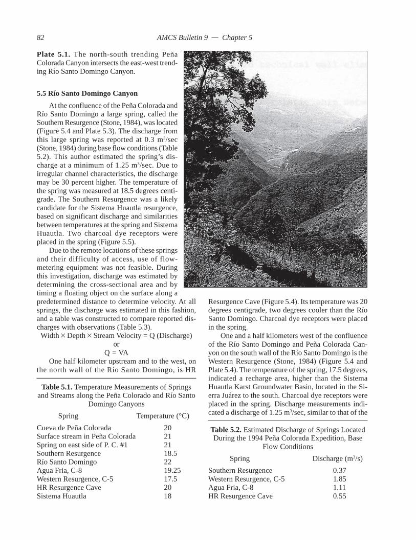
AMCS Bulletin 9 — Chapter 5
5.5 Río Santo Domingo CanyonAt the confluence of the Peña Colorada and
Río Santo Domingo a large spring, called theSouthern Resurgence (Stone, 1984), was located(Figure 5.4 and Plate 5.3). The discharge fromthis large spring was reported at 0.3 m3/sec(Stone, 1984) during base flow conditions (Table5.2). This author estimated the spring’s dis-charge at a minimum of 1.25 m3/sec. Due toirregular channel characteristics, the dischargemay be 30 percent higher. The temperature ofthe spring was measured at 18.5 degrees centi-grade. The Southern Resurgence was a likelycandidate for the Sistema Huautla resurgence,based on significant discharge and similaritiesbetween temperatures at the spring and SistemaHuautla. Two charcoal dye receptors wereplaced in the spring (Figure 5.5).
Due to the remote locations of these springsand their difficulty of access, use of flow-metering equipment was not feasible. Duringthis investigation, discharge was estimated bydetermining the cross-sectional area and bytiming a floating object on the surface along a
Resurgence Cave (Figure 5.4). Its temperature was 20degrees centigrade, two degrees cooler than the RíoSanto Domingo. Charcoal dye receptors were placedin the spring.
One and a half kilometers west of the confluenceof the Río Santo Domingo and Peña Colorada Can-yon on the south wall of the Río Santo Domingo is theWestern Resurgence (Stone, 1984) (Figure 5.4 andPlate 5.4). The temperature of the spring, 17.5 degrees,indicated a recharge area, higher than the SistemaHuautla Karst Groundwater Basin, located in the Si-erra Juárez to the south. Charcoal dye receptors wereplaced in the spring. Discharge measurements indi-cated a discharge of 1.25 m3/sec, similar to that of the
Table 5.1. Temperature Measurements of Springsand Streams along the Peña Colorado and Río Santo
Domingo CanyonsSpring Temperature (°C)
Cueva de Peña Colorada 20Surface stream in Peña Colorada 21Spring on east side of P. C. #1 21Southern Resurgence 18.5Río Santo Domingo 22Agua Fria, C-8 19.25Western Resurgence, C-5 17.5HR Resurgence Cave 20Sistema Huautla 18
predetermined distance to determine velocity. At allsprings, the discharge was estimated in this fashion,and a table was constructed to compare reported dis-charges with observations (Table 5.3).
Width × Depth × Stream Velocity = Q (Discharge)or
Q = VAOne half kilometer upstream and to the west, on
the north wall of the Río Santo Domingo, is HR
Table 5.2. Estimated Discharge of Springs LocatedDuring the 1994 Peña Colorada Expedition, Base
Flow ConditionsSpring Discharge (m3/s)
Southern Resurgence 0.37Western Resurgence, C-5 1.85Agua Fria, C-8 1.11HR Resurgence Cave 0.55
Plate 5.1. The north-south trending PeñaColorada Canyon intersects the east-west trend-ing Río Santo Domingo Canyon.
82
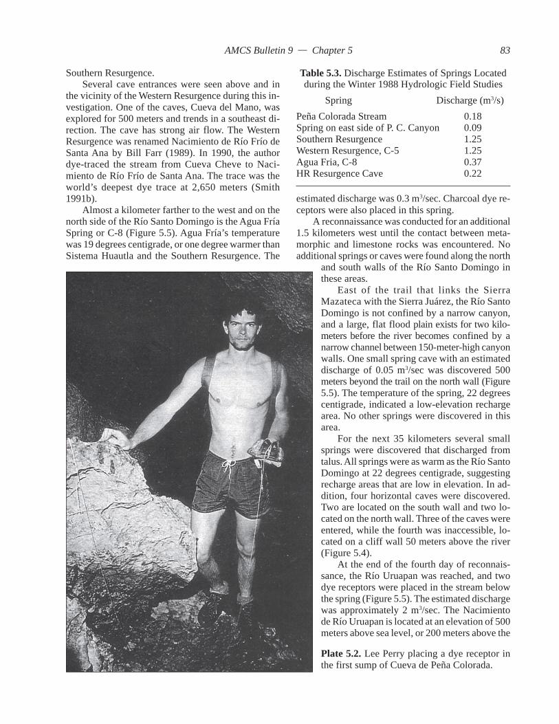
AMCS Bulletin 9 — Chapter 5
Southern Resurgence.Several cave entrances were seen above and in
the vicinity of the Western Resurgence during this in-vestigation. One of the caves, Cueva del Mano, wasexplored for 500 meters and trends in a southeast di-rection. The cave has strong air flow. The WesternResurgence was renamed Nacimiento de Río Frío deSanta Ana by Bill Farr (1989). In 1990, the authordye-traced the stream from Cueva Cheve to Naci-miento de Río Frío de Santa Ana. The trace was theworld’s deepest dye trace at 2,650 meters (Smith1991b).
Almost a kilometer farther to the west and on thenorth side of the Río Santo Domingo is the Agua FríaSpring or C-8 (Figure 5.5). Agua Fría’s temperaturewas 19 degrees centigrade, or one degree warmer thanSistema Huautla and the Southern Resurgence. The
and south walls of the Río Santo Domingo inthese areas.
East of the trail that links the SierraMazateca with the Sierra Juárez, the Río SantoDomingo is not confined by a narrow canyon,and a large, flat flood plain exists for two kilo-meters before the river becomes confined by anarrow channel between 150-meter-high canyonwalls. One small spring cave with an estimateddischarge of 0.05 m3/sec was discovered 500meters beyond the trail on the north wall (Figure5.5). The temperature of the spring, 22 degreescentigrade, indicated a low-elevation rechargearea. No other springs were discovered in thisarea.
For the next 35 kilometers several smallsprings were discovered that discharged fromtalus. All springs were as warm as the Río SantoDomingo at 22 degrees centigrade, suggestingrecharge areas that are low in elevation. In ad-dition, four horizontal caves were discovered.Two are located on the south wall and two lo-cated on the north wall. Three of the caves wereentered, while the fourth was inaccessible, lo-cated on a cliff wall 50 meters above the river(Figure 5.4).
At the end of the fourth day of reconnais-sance, the Río Uruapan was reached, and twodye receptors were placed in the stream belowthe spring (Figure 5.5). The estimated dischargewas approximately 2 m3/sec. The Nacimientode Río Uruapan is located at an elevation of 500meters above sea level, or 200 meters above the
Plate 5.2. Lee Perry placing a dye receptor inthe first sump of Cueva de Peña Colorada.
estimated discharge was 0.3 m3/sec. Charcoal dye re-ceptors were also placed in this spring.
A reconnaissance was conducted for an additional1.5 kilometers west until the contact between meta-morphic and limestone rocks was encountered. Noadditional springs or caves were found along the north
Table 5.3. Discharge Estimates of Springs Locatedduring the Winter 1988 Hydrologic Field Studies
Spring Discharge (m3/s)Peña Colorada Stream 0.18Spring on east side of P. C. Canyon 0.09Southern Resurgence 1.25Western Resurgence, C-5 1.25Agua Fria, C-8 0.37HR Resurgence Cave 0.22
83

AMCS Bulletin 9 — Chapter 5
Southern Resurgence. It is believed that this resur-gence is located up dip and is an unlikely resurgencefor the Sistema Huautla Karst Groundwater Basin.The Río Uruapan resurgence likely drains the CerroRabón Karst Groundwater Basin.
5.6 Front Range of the Sierra MazatecaIn the community of Ixcatlán, a motorboat was
rented, and a search along the banks of the PresaMiguel Alemán revealed no springs or streams dis-charging into the reservoir (Figure 5.3). North ofCampaña, a horizontal cave was discovered five metersabove lake level and explored for 150 meters to aflooded passage.
From Campaña, the inland trek involved travers-ing from 400 meters to 1,000 meters above sea levelto the town of Tenango. Enroute, local Indians revealedsprings that were small seepages supplying villages.They told of caves in the mountains and displayedjade beads recovered from them. The largest spring
was so difficult it was best to use more than enoughdye to ensure success. The amount of dye selectedwas 18.1 kilograms.
On January 22, 1988, 18.1 kilograms of dye wereinjected in the Upper Gorge at a depth of 620 metersbelow the entrance of Sótano de San Agustín (Plate5.5).
5.8 Analysis of Charcoal Dye ReceptorsAll dye receptors except the Río Uruapan were
recovered on February 4, 1988. In order to elute dyefrom the activated charcoal dye receptors, a solutionof 5 percent potassium hydroxide (KOH) and 95 per-cent of 70 percent isopropyl alcohol was formulated.Each of the seven samples was immersed in the elu-ent. Almost immediately, the elutant from one of theactivated charcoal samples turned bright fluorescentgreen. The positive test was from the Southern Resur-gence dye receptor. No other samples were visiblypositive after 24 hours.
Plate 5.3. Río Santo Domingo and the South-ern Resurgence.
discovered was west of Tenango at 1,300 meterselevation. It flowed across the surface for 500meters before sinking at a swallet in the karst.The estimated discharge was 0.5 m3/sec. Thisspring is located in the town of Río Santiago, 6kilometers to the east of San Agustín. It is calledNacimiento de Río Santiago (Figure 6.6).
5.7 Dye Tracing Sistema HuautlaAfter charcoal dye receptors were placed
in springs, fluorescein dye was injected into asubsurface stream located in Sótano de SanAgustín (Figure 5.6). Sótano de San Agustín isthe historic entrance to Sistema Huautla and isthe focal point for drainage from the northern,eastern, and western drainage divides of thekarst groundwater basin. It was determined thatthe cave stream in the Upper Gorge in Sótanode San Agustín, with a gradient of approximately25 percent consisting of many cascades and anestimated discharge of 0.3 m3/sec, was the bestlocation for introducing the dye. To reach theUpper Gorge to inject dye, 24 vertical shafts,the deepest being 110 meters, were descended.
The rule of thumb on a dye trace is 0.5 kilo-grams per 1.5 kilometers. The closest potentialsprings were 10 kilometers straight line distanceto the south and the most distant were approxi-mately 40 kilometers to the east. It was decidedthat since access to the injection site and springs
84


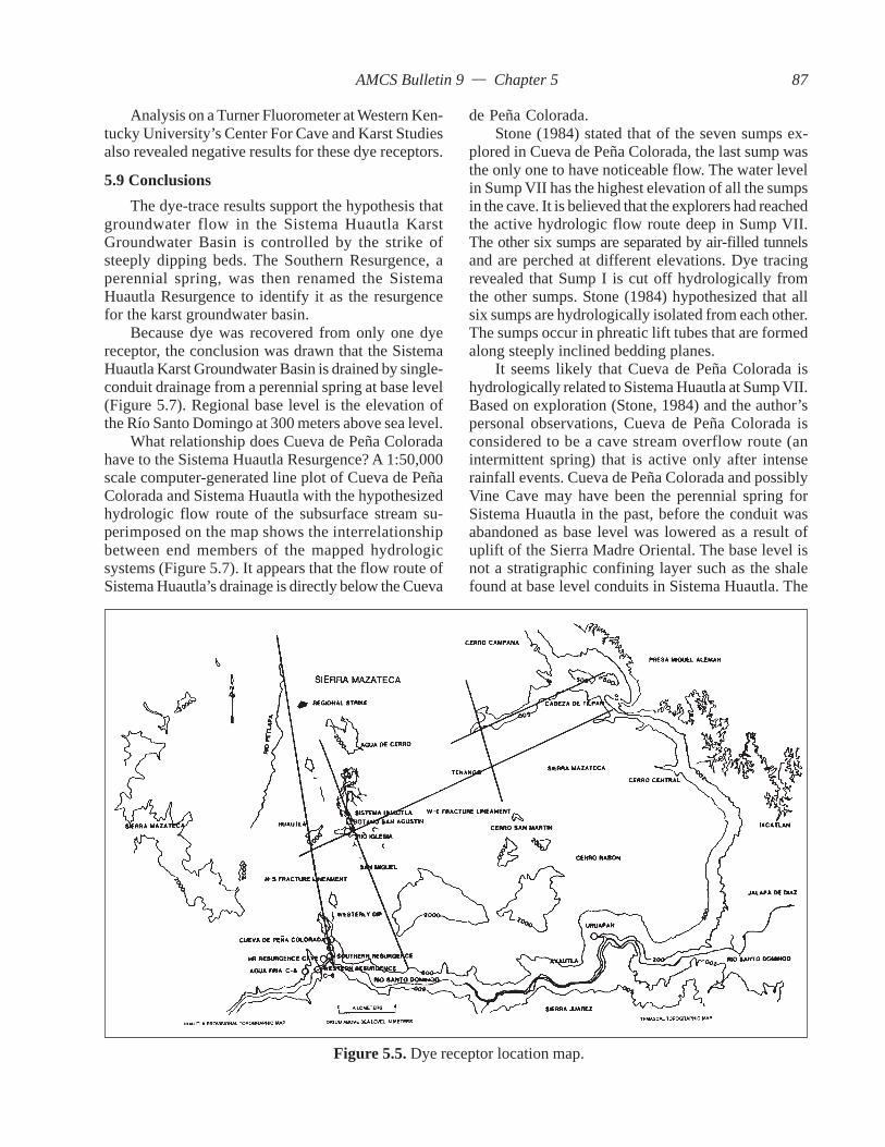
AMCS Bulletin 9 — Chapter 5
Analysis on a Turner Fluorometer at Western Ken-tucky University’s Center For Cave and Karst Studiesalso revealed negative results for these dye receptors.
5.9 ConclusionsThe dye-trace results support the hypothesis that
groundwater flow in the Sistema Huautla KarstGroundwater Basin is controlled by the strike ofsteeply dipping beds. The Southern Resurgence, aperennial spring, was then renamed the SistemaHuautla Resurgence to identify it as the resurgencefor the karst groundwater basin.
Because dye was recovered from only one dyereceptor, the conclusion was drawn that the SistemaHuautla Karst Groundwater Basin is drained by single-conduit drainage from a perennial spring at base level(Figure 5.7). Regional base level is the elevation ofthe Río Santo Domingo at 300 meters above sea level.
What relationship does Cueva de Peña Coloradahave to the Sistema Huautla Resurgence? A 1:50,000scale computer-generated line plot of Cueva de PeñaColorada and Sistema Huautla with the hypothesizedhydrologic flow route of the subsurface stream su-perimposed on the map shows the interrelationshipbetween end members of the mapped hydrologicsystems (Figure 5.7). It appears that the flow route ofSistema Huautla’s drainage is directly below the Cueva
de Peña Colorada.Stone (1984) stated that of the seven sumps ex-
plored in Cueva de Peña Colorada, the last sump wasthe only one to have noticeable flow. The water levelin Sump VII has the highest elevation of all the sumpsin the cave. It is believed that the explorers had reachedthe active hydrologic flow route deep in Sump VII.The other six sumps are separated by air-filled tunnelsand are perched at different elevations. Dye tracingrevealed that Sump I is cut off hydrologically fromthe other sumps. Stone (1984) hypothesized that allsix sumps are hydrologically isolated from each other.The sumps occur in phreatic lift tubes that are formedalong steeply inclined bedding planes.
It seems likely that Cueva de Peña Colorada ishydrologically related to Sistema Huautla at Sump VII.Based on exploration (Stone, 1984) and the author’spersonal observations, Cueva de Peña Colorada isconsidered to be a cave stream overflow route (anintermittent spring) that is active only after intenserainfall events. Cueva de Peña Colorada and possiblyVine Cave may have been the perennial spring forSistema Huautla in the past, before the conduit wasabandoned as base level was lowered as a result ofuplift of the Sierra Madre Oriental. The base level isnot a stratigraphic confining layer such as the shalefound at base level conduits in Sistema Huautla. The
Figure 5.5. Dye receptor location map.
87

AMCS Bulletin 9 — Chapter 5
Figure 5.8. Hypothesized karst groundwater basin boundary.
Figure 5.7. Sótano de San Agustín dye trace.
88
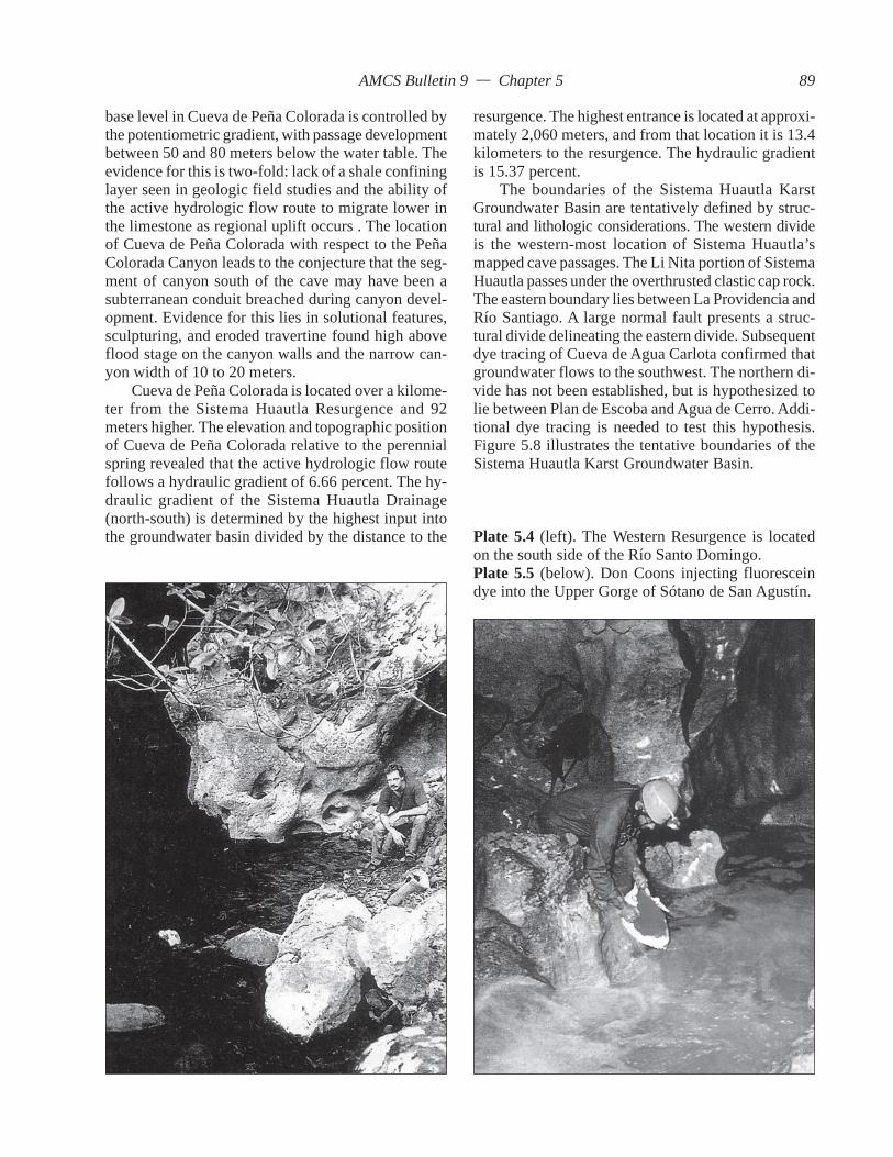
AMCS Bulletin 9 — Chapter 5
base level in Cueva de Peña Colorada is controlled bythe potentiometric gradient, with passage developmentbetween 50 and 80 meters below the water table. Theevidence for this is two-fold: lack of a shale confininglayer seen in geologic field studies and the ability ofthe active hydrologic flow route to migrate lower inthe limestone as regional uplift occurs . The locationof Cueva de Peña Colorada with respect to the PeñaColorada Canyon leads to the conjecture that the seg-ment of canyon south of the cave may have been asubterranean conduit breached during canyon devel-opment. Evidence for this lies in solutional features,sculpturing, and eroded travertine found high aboveflood stage on the canyon walls and the narrow can-yon width of 10 to 20 meters.
Cueva de Peña Colorada is located over a kilome-ter from the Sistema Huautla Resurgence and 92meters higher. The elevation and topographic positionof Cueva de Peña Colorada relative to the perennialspring revealed that the active hydrologic flow routefollows a hydraulic gradient of 6.66 percent. The hy-draulic gradient of the Sistema Huautla Drainage(north-south) is determined by the highest input intothe groundwater basin divided by the distance to the
resurgence. The highest entrance is located at approxi-mately 2,060 meters, and from that location it is 13.4kilometers to the resurgence. The hydraulic gradientis 15.37 percent.
The boundaries of the Sistema Huautla KarstGroundwater Basin are tentatively defined by struc-tural and lithologic considerations. The western divideis the western-most location of Sistema Huautla’smapped cave passages. The Li Nita portion of SistemaHuautla passes under the overthrusted clastic cap rock.The eastern boundary lies between La Providencia andRío Santiago. A large normal fault presents a struc-tural divide delineating the eastern divide. Subsequentdye tracing of Cueva de Agua Carlota confirmed thatgroundwater flows to the southwest. The northern di-vide has not been established, but is hypothesized tolie between Plan de Escoba and Agua de Cerro. Addi-tional dye tracing is needed to test this hypothesis.Figure 5.8 illustrates the tentative boundaries of theSistema Huautla Karst Groundwater Basin.
Plate 5.4 (left). The Western Resurgence is locatedon the south side of the Río Santo Domingo.Plate 5.5 (below). Don Coons injecting fluoresceindye into the Upper Gorge of Sótano de San Agustín.
89


AMCS Bulletin 9 — Chapter 6
CHAPTER 6
HYDROLOGIC FLOW PATTERNS
6.0 IntroductionThe structural geology of the Sistema Huautla
Karst Groundwater Basin controls the direction of flowof subsurface streams. Groundwater flow routes thatdefine the basin are oriented along the strike of thrust-faulted limestones and faults. In general, groundwaterflows from north to south to resurge at one perennialspring. However, it would be too simplistic to say thatall groundwater of the karst groundwater basin flowsfrom north to south. Examination of the quantitativemodel of the aquifer (cave surveys) reveals a com-plex flow pattern (Figure 6.1). The subsurface surveyof cave passages defines quantitatively the three-dimensional characteristics of conduit flow withinthe aquifer and the structural influence on flow pat-terns.
It is possible to form hypotheses from the SistemaHuautla model and hypothesize flow paths from sinkpoints at the surface and from streams within uncon-nected caves to stream confluences within the aquifer.To test the flow-route hypotheses, qualitative dyetraces establish precise confluence locations of swalletand tributary cave streams with the major streamswithin Sistema Huautla or to the Sistema HuautlaResurgence.
It is the purpose of this chapter to report on thefindings of dye traces from surface stream sinks, sepa-rate stream caves, and sink points in Sistema Huautlato confluences within Sistema Huautla. By conduct-ing dye traces, the quantitative model of the aquifer(cave survey) may be refined by establishing the rela-tionship of hydrologic input from other cave streamsources, defining the outermost stream input to delimitthe karst groundwater basin, and integrating sinkingsurface streams into the system.
6.1 MethodologyTo determine the relationship between surface and
subsurface inputs into Sistema Huautla, dye receptorswere placed at confluences deep within the cave sys-tem, and dyes were injected into various surface streamsinks and cave streams. Because of the extreme logisticsinvolved with placing and retrieving dye receptors,multiple dyes were used for simultaneous traces. Thefollowing dyes were used to trace groundwater flow:fluorescein (Color Index: Acid Yellow 73), opticalbrightener Tinopal SEM GX (Fabric BrighteningAgent 22), rhodamine WT (Color Index: Acid Red388), and diphenyl brilliant flavine 7 GFF (Color In-dex: Direct Yellow 96). The majority of the surfacesprings where dye might resurge were remote and oflittle use as a water resource, but several were majorwater supplies for the local population. Therefore, animportant factor in the selection of dyes was theirnontoxicity (Smart and Laidlaw, 1977; Smart, 1984).
Dye receptors were placed at major streamconfluences deep within the labyrinth of SistemaHuautla. Because of the complex hydrology of thekarst groundwater basin, dye receptors were alsoplaced at the outlet of the Sistema Huautla KarstGroundwater Basin (Sistema Huautla Resurgence) andat other spring locations outside the basin. Placing dyereceptors at all practical resurgences was necessarydue to the possibility of dye tracers bypassing dyereceptors in Sistema Huautla and its spring. Dye re-ceptors were placed to the south at springs along theRío Santo Domingo and the Peña Colorada Canyon,and to the east in a large spring on the Río Santiago,east of La Providencia.
Once dye receptors were retrieved, they weretreated with the appropriate eluent for the elution of
91
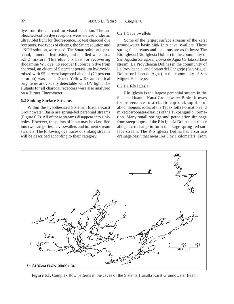
AMCS Bulletin 9 — Chapter 6
dye from the charcoal for visual detection. The un-bleached-cotton dye receptors were viewed under anultraviolet light for fluorescence. To test charcoal dyereceptors, two types of eluents, the Smart solution anda KOH solution, were used. The Smart solution is pro-panol, ammonia hydroxide, and distilled water in a5:3:2 mixture. This eluent is best for recoveringrhodamine WT dye. To recover fluorescein dye fromcharcoal, an eluent of 5 percent potassium hydroxidemixed with 95 percent isopropyl alcohol (70 percentsolution) was used. Direct Yellow 96 and opticalbrightener are visually detectable with UV light. Theelutants for all charcoal receptors were also analyzedon a Turner Fluorometer.
6.2 Sinking Surface StreamsWithin the hypothesized Sistema Huautla Karst
Groundwater Basin are spring-fed perennial streams(Figure 6.2). All of these streams disappear into sink-holes. However, the points of input may be classifiedinto two categories, cave swallets and influent streamswallets. The following dye traces of sinking streamswill be described according to their category.
6.2.1 Cave SwalletsSome of the largest surface streams of the karst
groundwater basin sink into cave swallets. Thesespring-fed streams and locations are as follows: TheRío Iglesia (Río Iglesia Dolina) in the community ofSan Agustín Zaragoza, Cueva de Agua Carlota surfacestream (La Providencia Dolina) in the community ofLa Providencia, and Sótano del Cangrejo (San MiguelDolina or Llano de Agua) in the community of SanMiguel Huautepec.
6.2.1.1 Río IglesiaRío Iglesia is the largest perennial stream in the
Sistema Huautla Karst Groundwater Basin. It owesits provenance to a clastic-cap-rock aquifer ofallochthonous rocks of the Tepexilotla Formation andmixed carbonates-clastics of the Tuxpanguillo Forma-tion. Many small springs and percolation drainagefrom steep slopes of the Río Iglesia Dolina contributeallogenic recharge to form this large spring-fed sur-face stream. The Río Iglesia Dolina has a surfacedrainage basin that measures 3 by 1 kilometers. From
Figure 6.1. Complex flow patterns in the caves of the Sistema Huautla Karst Groundwater Basin.
92

AMCS Bulletin 9 — Chapter 6
the highest topographic divide to the floor of thedolina, the total vertical relief is 620 meters. The RíoIglesia surface stream flows down hill slopes andacross the dolina floor for 2 kilometers and sinks intothe cave, Sótano del Río Iglesia, at an elevation of1,480 meters. The stream disappears at the base of a30 meter shaft within sight of daylight. Sótano delRío Iglesia was the Western Hemisphere’s deepest
cave in the late 1960s. It has a surveyed length of 4.205kilometers and a depth of 531 meters.
There is no known infeeding stream withinSistema Huautla’s Sótano de San Agustín that has aninput comparable to the volume of water that sinks inthe entrance of Sótano del Río Iglesia. To test the hy-pothesis that Sótano del Río Iglesia provides input tothe confluence in the Lower Gorge of Sótano de SanAgustín, dye receptors were located at all major streamconfluences in Sistema Huautla (Figure 6.3). Dyereceptors were also located at the Sistema HuautlaResurgence and at other spring locations.
Figure 6.2. Cave stream swallets and influent streamswallets.
Figure 6.3. Vertical profile of Sótano del Río Iglasia dye trace.
Table 6.1. Río Iglesia Dye TraceResult Dye receptor locations
– Lower Gorge– Metro– Upper Gorge– Lower Gorge #1– Lower Gorge #2– ED Survey– Nanta Gorge– Camp IV+ Sistema Huautla resurgence– Peña Colorada Sump 1– HR Resurgence Cave– Peña Colorada surface stream– Peña Colorada spring #1
93

AMCS Bulletin 9 — Chapter 6
After dye receptors were placed at the cave streamconfluences and at springs, four liters of rhodamineWT were injected into Río Iglesia (Plate 6.1). Dyereceptors were retrieved and treated with Smart Solu-tion (Smart, 1972; Smart and Brown, 1973). All dyereceptors were visually negative at the field labora-tory. Dye receptors were treated at the Center for Caveand Karst Studies laboratory and tested on a TurnerFluorometer. Dye was detected, below the visiblerange, in the Sistema Huautla Resurgence dye recep-tor (Table 6.1). It was therefore concluded that thesinking stream of Río Iglesia does not flow to any ofthe known stream confluences of Sistema Huautla, butlikely joins the main hydrologic flow route betweenSistema Huautla and the Sistema Huautla Resurgence.However, Stone (1994) writes that a large confluencewas discovered between Sump 2 and the Sump 9 in thenewly discovered part of Sistema Huautla. He specu-lates that the stream may be the water from Río Iglesia.
6.2.1.2 DiscussionThe direction of stream-flow in Sótano del Río
Iglesia is south to north, following the strike, which isopposite the dominant north-to-south trend of ground-water flow in the basin (Figure 6.1). Strike and dip
Plate 6.1 (above). James Smith injecting rhodamineWT dye into the swallet stream of Sótano de RíoIglesia. Plate 6.2 (right). A surface stream sinks intothe entrance of Cueva de Agua Carlota.
94


AMCS Bulletin 9 — Chapter 6
measurements indicate a change in dip direction tothe northwest. Surface measurements indicate that asynclinal fold may account for the change in ground-water flow direction to the north if the conduits aredeveloped along the strike of the strata.
The major control of cave orientation is believedto be fault control. Río Iglesia is hypothesized to beformed along the strike of a normal fault. The north-south orientation is also parallel to a system of normalfaults related to the Sistema Huautla Fault. It was notdetermined during this study if a normal fault con-trols passage development in Río Iglesia, but it islikely.
The Penthouse and the Echo Chamber, two largevertical shafts 130 and 150 meters deep, respectively,are formed along normal faults (Figure 6.4). The end
of Río Iglesia (overflow conduit) plots near AnthoditeHall, the largest chamber in Sótano de San Agustín ofSistema Huautla. It seems likely that the overflowconduit, the largest passage in Río Iglesia, is an over-flow for the Río Iglesia surface stream. It appears thatRío Iglesia’s surface stream at one time followed themain passage trend before stream piracy at the en-trance. During the rainy season, the sinking surfacestream bypasses the point of stream piracy and flowsdowna the main trunk as overflow. It is hypothesizedthat before Anthodite Hall began stoping to form thelarge chamber it is today, Río Iglesia’s cave streamcontributed to the development of the Sala Grande deSierra Mazateca and Anthodite Hall.
6.2.1.3 Cueva de Agua CarlotaTwo kilometers east of San Agustín Zaragoza is
the community of La Providencia (Figure 1.6). Thecommunity is situated around a perennial surfacestream on the flanks of a shallow llano (flat-flooreddolina) that is 800 meters long and 300 meters wide.A stream with an estimated discharge of 0.07 m3/secflows on top of Cretaceous shales and sinks into thelarge cave entrance of Cueva de Agua Carlota at anelevation of 1480 meters (Plate 6.2).
A cave survey conducted in 1970–71 by Cana-dian cavers from McMaster University and by the
Table 6.2. Cueva de Agua Carlota Dye TraceResult Dye receptor locations
– Río Santiago+ Sistema Huautla resurgence– HR Resurgence Cave– Cueva de Peña Colorada– Agua Fría– Nacimiento Río Frío de Santa Ana– Surface stream Peña Colorada
Plate 6.3. James Smith injecting optical brightener dye into the stream swallet ofCueva de Agua Carlota during the first attempt at dye-tracing the swallet.
97

AMCS Bulletin 9 — Chapter 6
Figu
re 6
.6. D
ye re
cept
or lo
catio
ns fo
r the
Cue
va d
e Agu
a C
arlo
ta d
ye tr
ace.
98
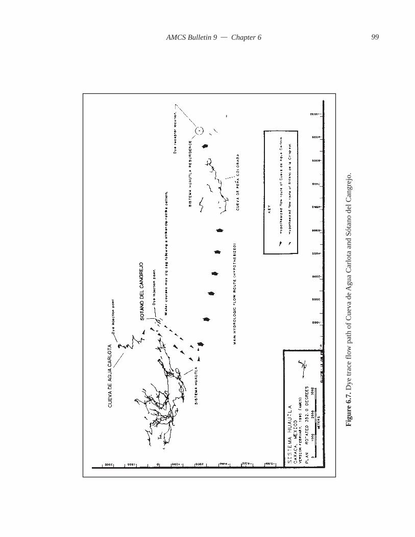
AMCS Bulletin 9 — Chapter 6
Figu
re 6
.7. D
ye tr
ace
flow
pat
h of
Cue
va d
e Agu
a C
arlo
ta a
nd S
ótan
o de
l Can
grej
o.
99

AMCS Bulletin 9 — Chapter 6
Huautla Project in 1990 (Figure 6.5) indicated thatgroundwater flow in Cueva de Agua Carlota trends tothe southwest in the direction of the Sistema HuautlaResurgence. The following hypothesis was developedbased on the cave survey: Cueva de Agua Carlota isthe easternmost perennial surface stream in theSistema Huautla Karst Groundwater Basin and ulti-mately discharges to the Sistema Huautla Resurgence.The cave survey indicated that conduit developmentfollows both north and south trends as the cave streamzigzags along the strike of the strata and in thedown-dip direction to the southwest towards the mainhydrologic flow route of Sistema Huautla.
To identify this flow route, charcoal dye receptorswere placed in springs and surface streams (Figure5.5, Figure 6.6, and Table 6.2). Two principal areaswhere dye receptors were located are to the south, atthe proven resurgence (Sistema Huautla Resurgence)and other springs in the Peña Colorada Canyon andalong the banks of the Río Santo Domingo, and to theeast, at a large spring near the community of RíoSantiago. At Cueva de Agua Carlota 5.9 kilograms offluorescein dye was injected into the surface stream(Plate 6.3). Dye receptors were recovered and analyzedat the field laboratory. The only positive dye receptorwas located at the Sistema Huautla Resurgence.
6.2.1.4 DiscussionDye tracing Cueva de Agua Carlota’s stream
swallet was attempted three times at various dischargerates in 1988, 1989, and successfully in 1990. In thefirst two attempts, dye receptors were left in place forat least three weeks at conditions of normal discharge(discharge rates normal for April and December, re-spectively). Late April and early May are the driestmonths of the water year and normally have base-flowconditions, while discharge rates during December arenominally higher.
It took one month for dye to discharge from theSistema Huautla Resurgence during the successful1990 attempt. The dye trace from Sótano de SanAgustín to the Sistema Huautla resurgence took onlytwo weeks. Discharge rates were different during thetwo dye trace attempts. The dye trace from Sótano deSan Agustín occurred during higher discharge. Thereis no way to know without physical exploration whatthe conduit characteristics are like beyond the knownsurveys of the two caves and how the movement ofwater through the aquifer may be impacted by the cavepassage morphology.
However, the following physical characteristicsof Cueva de Agua Carlota and Sótano de San Agustínand their relative position to structure within the karst
groundwater basin may account for the time differen-tial for dye exiting the cave system.
Cueva de Agua Carlota: It was observed that caveconduits alternate between strike and dip. The cave islocated at the eastern edge of the karst groundwaterbasin and is structurally higher. Dye was injected atthe entrance of the cave at 1480 meters above sea level.Deep potholes are located at the base of shafts whichimpound dye within pools.
Sótano de San Agustín: Cave is located down dipof thrust faulted limestones and is strike dominated.Conduit development at base level is the main chan-nel for groundwater flow from structurally higherinputs from the north and northeast. Sótano de SanAgustín has greater discharge. It is closer to the out-put of the system. Dye was injected at 640 meters depthor 880 meters above sea level. The stream sumps atthe bottom of the cave.
Cueva de Agua Carlota is located on the easternlimb of thrusted, faulted limestones 3 kilometers fromthe western edge of the groundwater basin. It is alsoapproximately 800 meters above base level and ap-proximately 1,200 meters above the spring for the karstgroundwater basin. If Cueva de Agua Carlota’s 4 ki-lometers of cave passage follows a zigzaggingnorth-south trend to the hypothesized hydrologic axis,a linear distance of 3 kilometers, then there may be 12kilometers of passage (assuming the same hydrologicpattern) by the time the water from the cave reachesthe main hydrologic flow route.
Cueva de Aqua Carlota has a zigzag pattern fol-lowing the strike and dip. The alternation betweennorth and south orientation along strike oriented pas-sage occurs in steeply dipping strata with dips thatvary from 20 degrees to vertical. As cave develop-ment progresses toward the western limit of thegroundwater basin toward base level, the zigzag pat-tern should change into a more linear developmentfollowing the axis of the plunging fold. Water fromCueva de Agua Carlota may intersect a master con-duit that transmits the entire drainage of the karstgroundwater basin to its discharge point (Figure 6.7and Figure 6.8).
The length of the flow route and impoundmenttime before the main hydrologic flow route is reachedis greater than was observed in Sótano de San Agustín.Dye in Cueva de Agua Carlota was still observed threedays after injection in deep potholes below cascadesand shafts. Impounded dye was slowly released fromthe potholes by circulation.
Although no dye receptors were placed in SistemaHuautla during the Cueva de Agua Carlota dye trace,it is believed that water from Cueva de Agua Carlota
100


AMCS Bulletin 9 — Chapter 6
does not enter into Sistema Huautla as tributary input,because Cueva de Agua Carlota’s drainage is south ofthe terminus of Sótano de San Agustín and there areno sizable tributary inputs below Upper Gorge.
It is concluded that the conduit drainage of Cuevade Agua Carlota enters the main hydrologic flow routefor the karst groundwater basin between the northerndrainage system of Sistema Huautla and the SistemaHuautla Resurgence.
6.2.1.5 Sótano del CangrejoIn the San Miguel Dolina or Llano de Agua are
seven explored caves (Jameson and Mothes, 1981).The caves are Cueva Inclinada, Sótano del Agua,Sótano del Escorpión, Cueva de la Sala Grande, Sótanodel Cangrejo, Cueva Chica, and Cueva de las Tinajas(Figure 1.6). A spring flows from the clastic cap rockaquifer and sinks into the cave swallet of Sótano deCangrejo at an elevation of 1540 meters.
Llano de Agua is located south of the Río Iglesiaand San Agustín Dolinas near the community of SanMiguel Huautepec (Figure 1.6). The dolina’s positionis between Sistema Huautla and its resurgence. Streamsinks in the San Miguel Dolina are hypothesized toenter into the main hydrologic flow route betweenSistema Huautla and the karst groundwater basin’sspring. To test this hypothesis, 6.8 kilograms of opti-cal brightener dye were injected in Sótano delCangrejo (Figure 6.7 and Table 6.3). Dye receptorswere retrieved and analyzed under UV light at the fieldlaboratory. The Sistema Huautla Resurgence dye re-ceptor tested positive.
6.2.1.6 DiscussionThe hydrologic flow route between Sistema
Huautla and the resurgence has only hypotheticallybeen reached via sump VII in Peña Colorada (Stone1984). There are no other segments of the main con-duit drainage explored thus far. Sótano del Cangrejois situated half way between the two known endpointsof the hydrologic system. The positive dye trace tothe Sistema Huautla Resurgence indicates that thesubsurface stream drainage of Sótano del Congrejo,and probably the other stream caves in the San MiguelDolina, intersect the main conduit drainage of the karstgroundwater basin.
6.2.2 Influent Stream SwalletsThere are a number of influent stream swallets
within the karst groundwater basin (Figure 6.2). Aninfluent stream swallet is defined as a surface streamthat loses discharge along its flow net. This phenom-enon results from streams flowing for a distance ontop of a clayey conglomeratic stream bed over frac-tured limestone. As the impervious stream bed thinsor changes into a poorly cemented conglomerate, thesurface stream diminishes until completely lost intothe fractured stratum. The springs feeding these sur-face streams result from both perched clastic cap rockaquifers and from perched springs originating fromcherty limestones.
Two major influent streams were dye traced. Bothof these influent streams are located in the San AgustínDolina and were hypothesized to be the source of cavestream tributaries within Sistema Huautla. These willbe referred to in the text as the San Andrés Swallet(Influent Stream Swallet #1) and Influent StreamSwallet #2 (Figure 6.2).
6.2.2.1 San Andrés SwalletThe San Agustín Dolina trends north-south and
has dimensions 1 by 2.5 kilometers. The west side ofthe dolina is composed of Jurassic flyschs and EarlyCretaceous limestones of the Tuxpanguillo Formation.Perennial springs discharge from the flysch and flowdown steep slopes of the dolina onto the floor, wherethey slowly lose water to the subsurface before disap-pearing. San Andrés Swallet (Influent Stream Swallet#1) is located at the north end of the San AgustínDolina at 1660 meters elevation (Figure 6.2). It flowsoverland from its spring for 500 meters and dimin-ishes in discharge before sinking. The discharge ofthe influent stream was measured at 0.07 m3/sec be-fore flowing onto alluvium.
It was hypothesized that the water from SanAndrés Swallet reappears in Sistema Huautla near
Table 6.3. Sótano del Cangrejo Dye TraceResult Dye receptor locations
+ Sistema Huautla resurgence– Cueva de Peña Colorada– Peña Colorada stream
Table 6.4. San Andrés Swallet Dye TraceResult Dye receptor locations
+ Sistema Huautla resurgence– Camp IV– Upper Gorge– Lower Gorge #1– Lower Gorge #2– Metro– Nanta Gorge– ED Survey+ Li Nita Waterfall Room
103

AMCS Bulletin 9 — Chapter 6
Camp III in Sótano de San Agustín at the Li NitaWaterfall Room. The influent swallet is above and inthe vicinity of the Li Nita Waterfall Room, which isthe juncture for some of the ridge-top drainage inputslocated at the north end of the Sistema Huautla KarstGroundwater Basin. There are also a series ofnorth-south-trending normal faults mapped in Sótanode San Agustín. Although these faults are not visibleon the surface, they may provide vertical access forsubsurface drainage that discharges to the Li NitaWaterfall Room.
To test this hypothesis, a dye trace was conducted.Charcoal dye receptors were located at all the main streamconfluences within Sistema Huautla and at the resur-gence (Figure 6.9 and Table 6.4). Less than 1 kilogram(0.9 kilograms) of fluorescein dye was injected at In-fluent Stream Swallet #1 (Plate 6.4). Dye receptorswere recovered and tested in the field laboratory. Twodye receptors were positive, the Li Nita Waterfall Roomand the Sistema Huautla Resurgence (Figure 6.10).
6.2.2.2 DiscussionWater from the San Andrés Swallet was hypoth-
esized to enter Sistema Huautla at the Li Nita Water-fall Room near Camp III. This hypothesis was acceptedbased on a positive dye trace to the Li Nita WaterfallRoom at –700 meters or 840 meters elevation (Figure6.10). The reason for the hydrologic connection to theLi Nita Waterfall Room of Sistema Huautla may bethe relationship of passage development to the
structural geology. The passages in Li Nita and Sótanode San Agustín have the westernmost strike-orientedpassage development in the aquifer. The passages thatare developed at the western edge of the groundwaterbasin are the Upper and Lower Red Ball Canyonstreams which feed the waterfall in the Li Nita Water-fall Room and the Mil Metro in Li Nita.
Stream piracy at the San Andrés Swallet allowswater to enter the aquifer and flow through conduitsdown the dip to the west to an eventual intersectionwith a larger strike-oriented conduit. The water thatsinks at the San Andrés Swallet is probably one of thesources for one of three major streams that join toform the large waterfall in the Li Nita Waterfall Room.It is less likely that Li Nita is the route of flow, sincethere were never any large stream confluences dis-covered during exploration. Therefore, the dye probablyflowed in the streams in either Upper or Lower RedBall Canyon. It was not possible to pinpoint which ofthe three streams the dye traveled in due to logistics.Both Red Ball Canyon streams were explored up-stream to sumps. A red ball was found in one of thestreams, hence the name of the passages.
The dye trace to the Li Nita Waterfall Room fromInfluent Swallet #1 is significant in that an additionaltributary has been traced into the system, indicating arelationship between input and output within the sys-tem. It also indicates that there is additional input intoSistema Huautla, other than the entrance shaft, fromwithin the subdrainage basin of the San Agustín Dolina.
Plate 6.4. Andy Grubbs injecting dye in the San Andrés swallet.
104


AMCS Bulletin 9 — Chapter 6
The cave Li Nita is located in the northernmostsection of the aquifer, compared to the San AndrésSwallet, which is situated west of Li Nita. Conduitdevelopment in Li Nita is controlled by strike and diprelationships and less by the influence of faults. TheLi Nita stream passage trends southwest along thestrike and crosses many small faults. Eventually, thecave stream is captured by faults and flows down shaftsat –500 meters. At this level the drainage profile steep-ens. Those caves with steep drainage profiles tend tobe steeper than the dip of the beds. However, that isnot the case where the strata is vertical. It may be thatconduit development at the western extremes of thekarst groundwater basin is located closer to the over-turned axis of the synclinal fold hypothesized toexist. Conduits have a less steep profile followingthe strike in a generally down-dip direction. Li Nitafollows this example.
The dye trace of the San Andrés Swallet revealsthe complexity of the western section of the aquiferand redefines the hydrologic schematic of the aquifer.It indicates that there is conduit development underthe cap rock of overthrusted Jurassic flyschs. There ismost likely a labyrinth of conduits present under thecap rock due to the many sink points along thesandstone-limestone contact.
6.2.2.3 Influent Stream Swallet #2The previous section described the largest sink-
ing stream in the San Agustín Dolina. This sectionwill describe the second largest sinking stream in thedolina, Influent Stream Swallet #2. The sinking streamis located on the western side of the San Agustín Dolinaand discharges from a spring that originates in theJurassic flysch cap rock (Figure 6.9). The stream sinks400 meters from its spring at 1560 meters elevation.At sink point, the stream had a discharge of 0.018 m3/sec, but it lost most of its volume before finally sink-ing. It was hypothesized that the sinking stream atInfluent Stream Swallet #2 connected with the Li NitaWaterfall Room, as did Influent Stream Swallet #1.The hypothesis was tested by injecting 2.2 kilogramsof optical brightener into the stream sink. Unfortu-nately the optical brightener dye was never recovered.Therefore, another trace will be necessary if this hy-pothesis is to be properly tested.
6.3 Dye-Tracing Other Tributary Cave Streams intoSistema HuautlaSistema Huautla consists of 55.9 kilometers of
conduits and shafts accessible through seventeen en-trances. Most of these entrances represent accesspoints for separate tributary streams that eventually
unite at base level 800 to 1,100 meters below the en-trance. These separate stream systems usually havemany small tributaries and trickle inputs, as seen dur-ing low flow conditions. Each tributary defines anindividual sub-drainage basin. All known tributarystreams have been followed physically and surveyedto present a quantitative model of the aquifer. Thesurvey also includes many individual caves that havebeen explored, but not connected because constric-tions of the conduit or shaft did not permit furtherphysical exploration.
It is the purpose of this section to determine thegroundwater flow from these individual cave streamsto stream inputs within Sistema Huautla (Figure 6.11).The significant caves that have not been physicallyconnected to Sistema Huautla are Nita He, Nita Nashi,Sótano de Agua de Carrizo, Nita Ka, Nita Nido andNtau, and Cueva de San Agustín.
Nita He and Nita Nashi were subjected to dyetraces. The others are discussed in this section withrespect to hydrology.
6.3.1 Nita HeNita He is a vertical drainage system consisting
of shafts and conduits that have a depth of 594 metersand a length of 1,554 meters (Figure 6.12). It is locatedbetween Li Nita and Nita Nanta in the community ofPlan Arena at an altitude of 1960 meters (Figure 1.6).The elevation of the Nita He entrance is one of thehighest in the karst groundwater basin, second only tothe ridge entrances of Nita Nanta, located at an eleva-tion of 2060 meters.
Nita He is located in an area with numerous caveentrances, some of which are entrances to SistemaHuautla. When the cave is viewed with respect to othercave conduits on a computer-generated line plot ofthe system, it is seen as unconnected with SistemaHuautla (Figure 6.11). The cave has the steepest pro-file of any cave in the area, with its vertical extenthaving developed along faults and steeply dippingbedding with dips from vertical to 25 degrees (G.Atkinson, 1980a). At the lowest level of Nita He, it
Table 6.5. Nite He Dye TraceResult Dye receptor locations
– ED Survey+ Camp IV– Metro+ Upper Gorge– Lower Gorge #1+ Lower Gorge #2– Nanta Gorge
107

AMCS Bulletin 9 — Chapter 6
Figu
re 6
.11.
Cav
es n
ot p
hysi
cally
conn
ecte
d to
Sis
tem
a Hua
utla
. Bol
d lin
es ar
e cav
es su
bjec
t to
dye t
race
s.
108

AMCS Bulletin 9 — Chapter 6
Figure 6.12. Source: G. Atkinson 1983.
109

AMCS Bulletin 9 — Chapter 6
was observed that conduit development is on top of ashale layer assumed to be the base level from NitaNanta to Tommy’s Borehole in Sótano de San Agustín.It was hypothesized that the north-south passage ori-entation supplied conduit drainage to SistemaHuautla’s Nita Nanta at the ED Survey confluence(Figure 6.13). To test this hypothesis, 0.9 kilogram offluorescein dye was introduced into the cave streamand charcoal receptors were stationed at streamconfluences in Sistema Huautla to receive the dye(Table 6.5).
6.3.2 DiscussionDye receptors at Camp IV, Upper Gorge, and
Lower Gorge tested positive for fluorescein dye in-jected at the entrance of Nita He (Figure 6.14). Thehypothesis that the ED Survey confluence was a partthe hydrology of Nita He was rejected because NitaHe’s stream flowed to the Camp IV dye receptorthrough the Scorpion Sump (Figure 6.15). ScorpionSump at 700 meters elevation above sea level andat –640 meters via the Sótano de San Agustín entranceis the junction for numerous conduit streams. The sig-nificance of the dye trace from Nita He to ScorpionSump is as follows: Nita He is a separate conduit drain-age. The drainage system has 1,100 meters of verticalrelief before joining with the main hydrologic con-duit. It is a separate subdrainage basin. It is a verticaldrainage system developed within the complex aniso-tropic framework of local structure (i.e., strike andfault controlled). It may represent strike-controlledconduit development. It is an example of lithologicbase-level control of conduit development on a shaleconfining layer. The ultimate hydraulic gradient iscontrolled by the dip of the shales.
6.3.3 Nita NashiThe northernmost significant vertical drainage
system known to exist in the Sistema Huautla KarstGroundwater Basin is Nita Nashi, located at an ap-proximate elevation of 1920 meters. The cave is locatedin Plan de Escoba, north of the ridge in which NitaNanta, highest and northernmost entrance to SistemaHuautla is located, (Figure 1.6). The cave is 640 metersdeep and 3,523 meters long. The explored terminusof Nita Nashi is 570 meters (map distance) from theED Survey stream confluence of Nita Nanta, 740meters from the confluence of the Nanta Gorge stream,and 1,150 meters (straight line map distance) fromthe Scorpion Sump near Camp IV of Sótano de SanAgustín.
It was hypothesized that the stream of Nita Nashiis tributary to the ED Survey (Figure 6.13). To test the
hypothesis, 4.5 kilograms of Direct Yellow 96 dyewere introduced into Nita Nashi’s cave stream, andunbleached cotton dye receptors were placed atsome tributary streams within Sistema Huautla(Table 6.6).
6.3.4 DiscussionThe hypothesis stating that Nita Nashi’s stream is
tributary to the ED Survey confluence was rejectedbased on a positive dye trace to the Camp IV cottondye receptor (Figure 6.14 and Figure 6.15). The sig-nificance of this dye trace is as follows: It extends thenorthern limit of the karst groundwater basin. Itproves the location of tributary input into the system.It defines a separate tributary route with a verticalextent of at least 1,100 meters before connecting tothe Scorpion Sump. It defines a separate subdrainagebasin.
6.4 Dye Traces of Stream Sinks within SistemaHuautlaDespite the exploration of many cave passages
within the labyrinth of Sistema Huautla, it has not beenpossible to follow all streams; thus many questionsremain as to their relationship to the hydrologic pat-tern of the karst groundwater basin. The disappearingstreams in question are the Nita Zan stream, whichdisappears into breakdown in the Football Stadium ofNita Nanta, Sótano de San Agustín’s stream from theFissure Route, which disappears at the –620 meterssump, and Sótano de San Agustín’s main stream, which
Table 6.6. Nita Nashi Dye TraceResult Dye receptor locations
– Nanta Gorge– ED Survey+ Camp IV+ Upper Gorge– Lower Gorge #1+ Lower Gorge #2– Metro
Table 6.7. Nita Zan Dye TraceResult Dye receptor locations
– Nanta Gorge+ ED Survey+ Camp IV– Metro+ Upper Gorge– Lower Gorge #1+ Lower Gorge #2
110
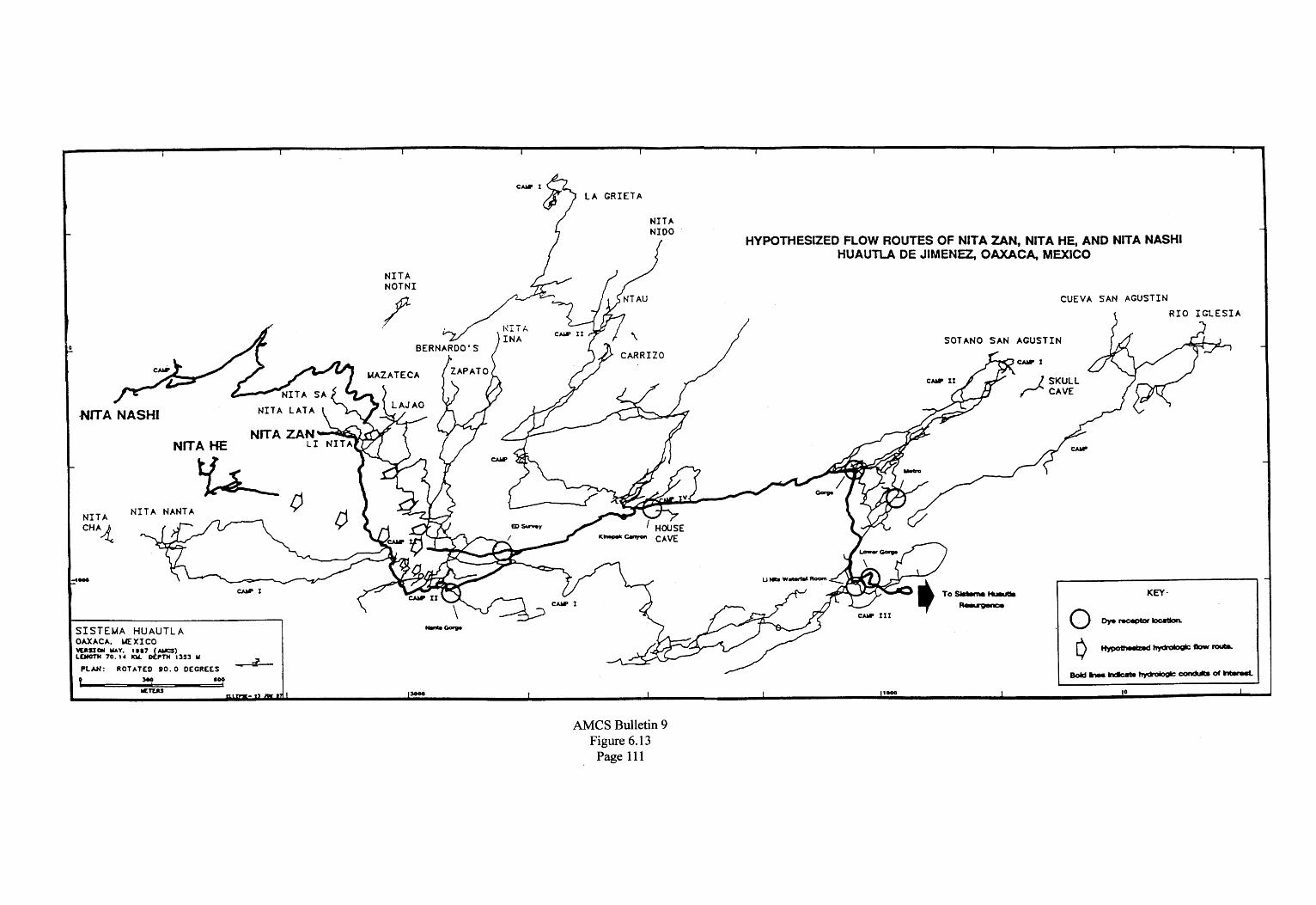


AMCS Bulletin 9 — Chapter 6
disappears at –805 meters in a sump.To determine the relationship of these streams to
confluences within the system dye traces were conducted.
6.4.1 Nita ZanNita Zan is a vertical drainage route that connects
into a tributary stream of Nita Sa after 650 meters, at–200 meters depth. The combined streams of Nita Zanand Nita Sa flow through steeply descending passagesand shafts to Nita Nanta’s Football Stadium at –586meters. That is the juncture point for Nita Nanta’sNaranja Passage cave stream as well as several water-falls that originate from a height greater than 150meters in the Football Stadium’s roof. Nita Zan’s wa-ter, as well as the other sources, sinks into the boulderfloor of the Football Stadium. It was assumed that thiswater was the source of the Nanta Gorge confluence,which is the largest stream in Nita Nanta (Figure 6.13).Nita Nanta’s lower stream passage is developed at baselevel on top of a shale confining layer. It serves as themain conduit through which tributaries of the NitaNanta subdrainage basin drain. To test the hypothesisthat Nita Zan’s water drains to the Nanta Gorge, 4.5kilograms of optical brightener dye were injected intoNita Zan’s stream to be received by cotton dye recep-tors placed at various confluences throughout thesystem (Table 6.7).
6.4.2 DiscussionThe hypothesis was rejected, as the ED Survey
confluence tested positive (Figure 6.14 and Figure6.15). The significance of this trace is as follows: Itdefines the location of the hydrologic input of streamsfrom Nita Zan and the Naranja Passage into NitaNanta’s main stream. It indicates that the hydraulicgradient between the point of entry into the break-down and output at the ED Survey is very steep,possibly vertical.
Defining the course of Nita Zan’s stream and ad-ditional converging streams to the ED SurveyConfluence is significant in that the stream’s positionis extrapolated three dimensionally from known in-puts and is recognized as a flow route comprising manyinputs from many smaller subdrainage basins.
6.4.3 Sótano de San Agustín Fissure Dye TraceSótano de San Agustín is a complex vertical stream
cave with several shaft series that converge toTommy’s Borehole level at –600 meters. The activehydrologic route occurs in the Fissure Series whichconsists of 350 meters of vertical shafts. The streamthat falls down these shafts eventually sumps at –620meters. It was hypothesized that the water at the sump
flows to the Upper Gorge. To test this hypothesis, oneliter of rhodamine WT dye was injected into a streamin the Sala Grande. The dye was never recovered atany dye receptor location. It is possible that there isanother independent stream route draining the sumpthat bypassed all dye receptors. The dye trace is there-fore inconclusive.
6.4.4 Dye Trace of Sótano de San Agustín’s 805 SumpMost of the known drainage of the Sistema
Huautla Karst Groundwater Basin flows throughSótano de San Agustín. The northern portion of thebasin contributes water from many conduit tributar-ies through the Scorpion Sump near Camp IV at –640meters in Sótano de San Agustín. Additional tributar-ies at other locations along the flow route enter alongits length in Sótano de San Agustín. Other flow routesenter at the Li Nita Waterfall Room, potentially by-passing the main drainage. It is believed that thewater from the Li Nita Waterfall Room is tributary tothe main hydrologic flow and reaches it by droppinginto the Lower Gorge where it intersects a large stream.
It is hypothesized that the water of the main hy-drologic flow route in the Metro, a large conduit at–760 meters that sumps at –805 meters, enters intothe Lower Gorge as the main stream. To test thishypothesis half a kilogram of fluorescein dye wasinjected into the Metro stream. Dye receptors werelocated in the Lower Gorge (Table 6.8).
6.4.5 DiscussionThe hypothesis was accepted since a dye receptor
located at Lower Gorge #2 site tested positive (Figure6.15). The significance of the dye trace is that it con-firmed what was suspected, a connection between the805 Sump and the Lower Gorge. The conduit betweenthe input and output may be totally water-filled. Thedistance between the two known points is estimatedfrom the cave survey to be 250 meters.
6.5 Tributary Stream CavesDye tracing of influent stream swallets, cave
swallets, stream sinks within Sistema Huautla, andcaves has defined complex relationships between inputand output within the karst aquifer. Not all possibili-ties for additional dye traces were exhausted, but due
Table 6.8. Dye Trace of the Metro Stream to the Lower Gorge
Result Dye receptor locations– Lower Gorge #1+ Lower Gorge #2
115

AMCS Bulletin 9 — Chapter 6
Figure 6.16. Sótano de Carrizo map based on Stone 1978. Nita She from Smith 1991c.
116

AMCS Bulletin 9 — Chapter 6
to time and logistics they were not feasible. There area number of major caves that appear to be tributarydrainage to Sistema Huautla. These caves will bebriefly discussed with respect to hydrologic relation-ships to known tributaries within Sistema Huautla.These caves are Sótano de Agua de Carrizo, Cuevadel Zapato, Nita Ka, Nita Nido and Nita Ntau, Cuevade Santa Cruz, and Cueva de San Agustín (Figure 1.6).
6.5.1 Sótano de Agua de CarrizoThe four entrances of Sótano de Agua de Carrizo,
two of which are parallel shafts, are located betweenSan Andrés Hidalgo and Nuevo Progreso on a ridgethat separates the San Agustín Dolina from the LaGrieta Dolina (Figure 1.6). The two highest entrancesto Sótano de Agua de Carrizo are Nita Ske and TarantulaCave (Figure 6.16). The caves from the two entranceseventually connect with Sótano de Agua de Carrizo at–235 meters as a tributary stream.
The main stream in the cave is joined by severalsmaller streams on their way to the base-level conduitat –800 meters. At –536 meters there is a bifurcationof the hydrologic flow, with separate shaft series ter-minating at –841 and –843 meters. The main streamfollows the 841-meter route. The deepest point of thecave, at –843 meters, carries a small stream, but it isnot the main stream of the cave that is followed fromthe entrance. Another parallel shaft series is encoun-tered at –600 meters above the Sima Larga, a 130-meter-deep shaft, in the 841-meter route. It ends at –678meters. The separate shaft series may have beenformed by the same stream pirated down more per-meable bedding planes or faults.
Carrizo’s conduit development follows the basictrend of passage development seen throughout theSistema Huautla Karst Groundwater Basin. Passageand shaft development follows a northwest-southeaststrike of bedding planes and zigzags following astrike-dip-strike trend in steeply dipping rocks. Thestream-gradient profile increases as shaft developmentoccurs along a fault. Ultimately, conduit developmentchanges direction and trends to the southeast to endwithin 60 meters of the Scorpion Sump. The Scor-pion Sump is a major hydrologic junction betweenSótano de Agua de Carrizo, La Grieta, Nita Ka, NitaNashi, and Nita He. A dye trace was not necessary toestablish the hydrologic connection to Sistema Huautladue to the close proximity of the surveys.
6.5.2 Cueva del ZapatoCueva del Zapato is located near the community
of Los Pinos (Figure 1.6). Cueva del Zapato is a 300meter deep stream cave. This cave follows a northwest
trend along the strike of the strata. It has not been com-pletely explored, but enough survey has been accom-plished to establish a trend and a potential location forconnection into Sistema Huautla. It is possible that Cuevadel Zapato will connect to Bernardo’s Cave (Figure 6.11).
6.5.3 Nita KaNita Ka is located near San Andrés at the north
end of the karst groundwater basin in a ridge that sepa-rates the San Agustín Dolina from the La Grieta Dolina(Figure 1.6). Nita Ka is a 760-meter-deep cave formedpredominately as a series of shafts down steeply dip-ping limestone (Figure 6.17). Some of the shafts areformed at intersecting normal faults that are parallelto the strike of the strata. The drainage pattern fol-lows the same attitude as the overall drainage patternof Sistema Huautla. The cave passages trend predomi-nantly to the northwest, then to the southwest. Thecave was not dye traced into the system because of itsclose proximity to Sistema Huautla (Figure 6.11). NitaKa lies about 100 meters horizontally and 130 metersabove the Scorpion Sump. It is hypothesized that thewater from Nita Ka finds its way to the Scorpion Sump.The Scorpion Sump is the hydrologic confluence formany of the vertical drainage systems in the north-eastern part of the karst groundwater basin.
6.5.4 Nita Nido and Nita NtauNita Nido and Nita Ntau are located in the com-
munity of Nuevo Progreso, which is situated on theridge that separates the San Agustín Dolina from theLa Grieta Dolina (Figure 1.6). The streams from eachof the two caves, Nita Nido and Nita Ntau, unite atthe base of a 130-meter-deep shaft before the cavebecomes impassable (Figure 6.18). The passages fromthe two entrances follow a northwest trend similar tothe conduit development of the rest of the caves in thearea to the northwest. It is interesting to note the align-ment and overlap of passage trends with La Grieta,Carrizo, and Nita Ka, all of which have extensive ver-tical cave development (Figure 6.11). Each of thesecaves represents development at different elevationswithin the vertically extensive aquifer along the strikeof steeply dipping beds. These conduits were prob-ably formed at the same time. Although each of thetwo caves carries a small stream, no dye tracing wasaccomplished due to time constraints. It is hard tospeculate a likely confluence for Nita Nido and NitaNtau based on the limited amount of surveyed pas-sage. If the cave continues to drop abruptly, then theconfluence may be near Camp II in La Grieta. Thereis a dome complex with a waterfall entering the LRoom of La Grieta. If the cave continues to follow
117

AMCS Bulletin 9 — Chapter 6
Figure 6.17. Source Smith 1991c.
118

AMCS Bulletin 9 — Chapter 6
Figu
re 6
.18.
119
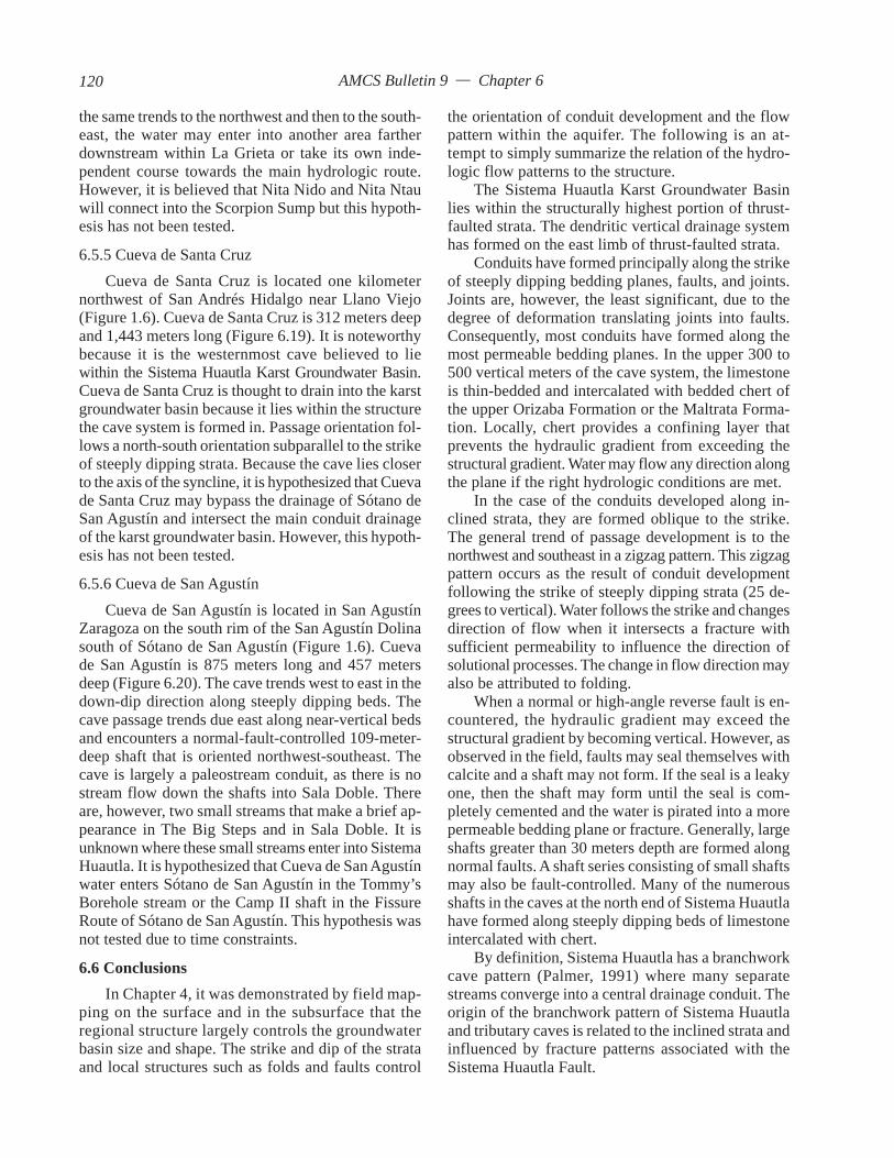
AMCS Bulletin 9 — Chapter 6
the same trends to the northwest and then to the south-east, the water may enter into another area fartherdownstream within La Grieta or take its own inde-pendent course towards the main hydrologic route.However, it is believed that Nita Nido and Nita Ntauwill connect into the Scorpion Sump but this hypoth-esis has not been tested.
6.5.5 Cueva de Santa CruzCueva de Santa Cruz is located one kilometer
northwest of San Andrés Hidalgo near Llano Viejo(Figure 1.6). Cueva de Santa Cruz is 312 meters deepand 1,443 meters long (Figure 6.19). It is noteworthybecause it is the westernmost cave believed to liewithin the Sistema Huautla Karst Groundwater Basin.Cueva de Santa Cruz is thought to drain into the karstgroundwater basin because it lies within the structurethe cave system is formed in. Passage orientation fol-lows a north-south orientation subparallel to the strikeof steeply dipping strata. Because the cave lies closerto the axis of the syncline, it is hypothesized that Cuevade Santa Cruz may bypass the drainage of Sótano deSan Agustín and intersect the main conduit drainageof the karst groundwater basin. However, this hypoth-esis has not been tested.
6.5.6 Cueva de San AgustínCueva de San Agustín is located in San Agustín
Zaragoza on the south rim of the San Agustín Dolinasouth of Sótano de San Agustín (Figure 1.6). Cuevade San Agustín is 875 meters long and 457 metersdeep (Figure 6.20). The cave trends west to east in thedown-dip direction along steeply dipping beds. Thecave passage trends due east along near-vertical bedsand encounters a normal-fault-controlled 109-meter-deep shaft that is oriented northwest-southeast. Thecave is largely a paleostream conduit, as there is nostream flow down the shafts into Sala Doble. Thereare, however, two small streams that make a brief ap-pearance in The Big Steps and in Sala Doble. It isunknown where these small streams enter into SistemaHuautla. It is hypothesized that Cueva de San Agustínwater enters Sótano de San Agustín in the Tommy’sBorehole stream or the Camp II shaft in the FissureRoute of Sótano de San Agustín. This hypothesis wasnot tested due to time constraints.
6.6 ConclusionsIn Chapter 4, it was demonstrated by field map-
ping on the surface and in the subsurface that theregional structure largely controls the groundwaterbasin size and shape. The strike and dip of the strataand local structures such as folds and faults control
the orientation of conduit development and the flowpattern within the aquifer. The following is an at-tempt to simply summarize the relation of the hydro-logic flow patterns to the structure.
The Sistema Huautla Karst Groundwater Basinlies within the structurally highest portion of thrust-faulted strata. The dendritic vertical drainage systemhas formed on the east limb of thrust-faulted strata.
Conduits have formed principally along the strikeof steeply dipping bedding planes, faults, and joints.Joints are, however, the least significant, due to thedegree of deformation translating joints into faults.Consequently, most conduits have formed along themost permeable bedding planes. In the upper 300 to500 vertical meters of the cave system, the limestoneis thin-bedded and intercalated with bedded chert ofthe upper Orizaba Formation or the Maltrata Forma-tion. Locally, chert provides a confining layer thatprevents the hydraulic gradient from exceeding thestructural gradient. Water may flow any direction alongthe plane if the right hydrologic conditions are met.
In the case of the conduits developed along in-clined strata, they are formed oblique to the strike.The general trend of passage development is to thenorthwest and southeast in a zigzag pattern. This zigzagpattern occurs as the result of conduit developmentfollowing the strike of steeply dipping strata (25 de-grees to vertical). Water follows the strike and changesdirection of flow when it intersects a fracture withsufficient permeability to influence the direction ofsolutional processes. The change in flow direction mayalso be attributed to folding.
When a normal or high-angle reverse fault is en-countered, the hydraulic gradient may exceed thestructural gradient by becoming vertical. However, asobserved in the field, faults may seal themselves withcalcite and a shaft may not form. If the seal is a leakyone, then the shaft may form until the seal is com-pletely cemented and the water is pirated into a morepermeable bedding plane or fracture. Generally, largeshafts greater than 30 meters depth are formed alongnormal faults. A shaft series consisting of small shaftsmay also be fault-controlled. Many of the numerousshafts in the caves at the north end of Sistema Huautlahave formed along steeply dipping beds of limestoneintercalated with chert.
By definition, Sistema Huautla has a branchworkcave pattern (Palmer, 1991) where many separatestreams converge into a central drainage conduit. Theorigin of the branchwork pattern of Sistema Huautlaand tributary caves is related to the inclined strata andinfluenced by fracture patterns associated with theSistema Huautla Fault.
120
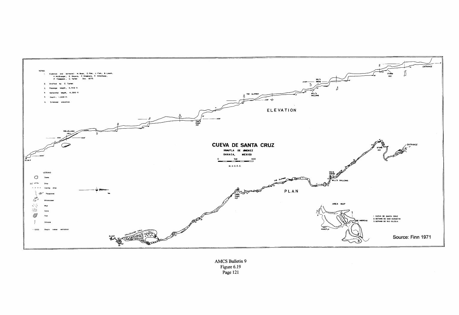
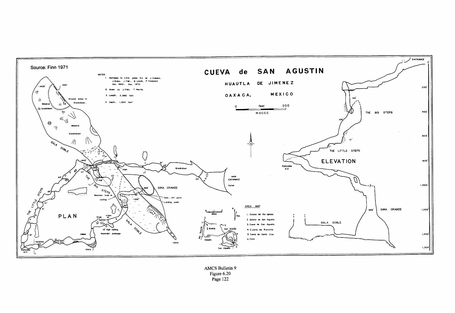

AMCS Bulletin 9 — Chapter 7
CHAPTER 7
GEOMORPHOLOGY AND SPELEOGENESIS OF THE
SISTEMA HUAUTLA KARST GROUNDWATER BASIN
7.0 IntroductionIn order to understand how the caves of the
Sistema Huautla Basin developed, it is necessary tounderstand the geomorphic evolution of the karstgroundwater basin. Integral to this understanding isthe relationship of surface topography, surface drain-age, and subsurface drainage systems in the SierraJuárez. First, it is necessary to identify the relation-ship between regional tectonic forces and geomorphicprocesses that have shaped the present landscape.Evidence has been gathered across the region to re-construct the neotectonics and subsequent geomorphicresponse to those changes. This evidence is based onstudies in the adjacent Veracruz Basin and observa-tions in the study area.
It is the purpose of this chapter to provide a time-frame for karst development in the Sierra Juárez anda model delineating the phases of Sistema Huautla’sspeleogenesis. The speleogenesis of Sistema Huautlais addressed from a conceptual viewpoint in an at-tempt to explain the position of conduits or cave levelsand their association with the water table.
7.1 Geomorphic Evolution of the Sierra JuárezFrom the end of the Laramide Orogeny to the
present, the Sierra Juárez and Veracruz Basin haveepisodically uplifted, as indicated by unconformitiesand an influx of conglomerates to the Veracruz Basin.Helu et al. (1977) studied seismic profiles and coresfrom sediments in the Veracruz Basin near Tuxtepec,Veracruz, and found a regionally extensive uncon-formity in Lower Miocene sediments above whichthere are 1,000 meters of pebble conglomerates. Theseconglomerates are comprised of Jurassic and Creta-ceous limestones and shales. Paleocurrent studiesindicate that they are derived from source areas to thewest (Figure 7.1).
The conglomerates were transported by fluvial
tributaries that drained the emerging Sierra Juárez andintermountain basins. The fluvial systems ultimatelydeposited their loads into deep submarine canyons andformed prograding fanglomerates in the bathyal envi-ronment of the Veracruz Basin. These submarine fansand canyons are end members of the ancientPapaloapan fluvial system that was formed during theearly Tertiary (Helu et al., 1977). The conglomeratesare relic to the formation of the ancient PapaloapanDrainage Basin and all of its tributaries.
The modern Papaloapan drainage system consistsof many large rivers, including the Río Blanco andRío Santo Domingo, that drain to the east to the La-guna de Alvarado on the Gulf Coast (Tamayo and West,1964).
One of the large modern day tributaries of thePapaloapan Drainage Basin is the Río Santo Domingo.While the Río Santo Domingo probably began flow-ing from the emerging highlands during the Eoceneand Paleocene, it was during the Late Oligocene andEarly Miocene that the Río Santo Domingo began todramatically shape the landscape of the Sierra Juárez,as indicated by the deposition of thick sequences ofconglomerates in the Veracruz Basin. Most of theconglomerates identified near Tuxtepec were de-rived from the Río Santo Domingo as the river carveda 2,000-meter-deep canyon across the Sierra Juárezand transported bedload from intermountain basins.However, paleo-reconstruction of the submarinefans in the Veracruz Basin indicates that there wereother parallel tributaries contributing fluvial material(Figure 7.1).
The relief of the Sierra Juárez must have been rela-tively subdued initially, with the rate of uplift beingrelatively gradual in the Late Oligocene. Formationof fluvial Oligocene and Early to Middle Miocenepebble conglomerates, consisting of Jurassic clasticsand Cretaceous carbonates with a minor percentageof volcanics and metamorphics (Helu et al., 1977),
123

AMCS Bulletin 9 — Chapter 7
indicate that the Sierra Juárez began a major phase oferosion during the post–Laramide Orogeny uplift.Moreno (1980) referred to the uplift as a taphrogenicphase belonging to the Oligocene and Miocene. Re-gional uplift and/or marine regression occurred in theEarly Miocene, as Late Oligocene sediments wereeroded in the Veracruz Basin. Uplift rates must havedramatically increased in the Early and Middle Miocene,and erosion of the Sierra Juárez began in earnest, asindicated by the deposition of thick sequences of con-glomerates.
The predominantly carbonate conglomerates dur-ing the Early and Middle Miocene were replaced byvolcanic sands and gravels in the Late Miocene, asidentified in seismic profiles and corings (Helu et al.,1977). The Late Miocene Filisola and Paraje SoloFormations are distributed across the Veracruz Basinand overlie Middle and Lower Miocene sediments.These formations consist of consolidated volcanicsands and gravels and conglomerates in a calcariousmatrix (Ramos, 1983). A change in grain size fromconglomerates to mostly sand-size particles indicatesthat the energy to transport conglomerates from high-land areas was substantially reduced, signaling a timeof tectonic quiescence. During the Late Miocene–Quaternary, uplift rates dramatically increased andproduced widespread block faulting of the SierraJuárez (Carfantan, 1981(b)).
A marine regression at the end of the Miocene ispunctuated by an unconformity and by Quaternaryalluviation. The shoreline of the Gulf of Mexico retreatedto its present position at the end of the Pleistocene.
7.2 Paleo-Fluvial EvidenceAnother indicator of an increase in uplift rates is
the disappearance of some of the fluvial systems flow-ing across carbonate rocks. Researchers have reportedevidence of paleo-fluvial features in many tropicalareas of the world (Lehmann, 1936; Lasserre, 1954;Williams, 1971; Monroe, 1973 and 1974; Day, 1978;and Miller, 1981). Williams (1972) stated that in thepolygon karst of New Guinea evidence of paleo-fluvialdrainage systems is imprinted in the topography. Miller(1981) determined that the Caves Branch Karst ofBelize contained paleo-fluvial karst features, but theinfluence of fluvial activity in developing the presentlandscape is uncertain. However, Miller’s reconstruc-tion of paleo-drainage lines from the polygonal karstprovided indirect evidence of paleo-fluvial activity.Paleo-drainage patterns across the Sierra Juárez arenot as difficult to interpret as those in the Searranx,Guatemala, and the Vaca Plateau, Belize, describedby Miller (1981).
Figure 7.1. Top: Generalized map of Veracruz basinand adjacent area. Heavy black line indicates easternlimit of Mesozoic outcrops. Dashed line is eastern limitof Cretaceous sedimentary rocks in subsurface. Areain which unconformities were mapped seismically isshown by diagonal lines. Bottom: Seismic-structuremap of pre–Early Miocene unconformity in part ofwestern margin of Veracruz basis. Source: Helu, et al.1977.
Analysis of linear features occurring across theSierra Juárez in both carbonate and noncarbonate rocksindicates the presence of features interpreted to be flu-vial remnants of the ancient Papaloapan DrainageBasin (Figure 7.2). The drainage pattern is dendritic,
124

AMCS Bulletin 9 — Chapter 7
with an orientation from west to east. This relic drainagesystem will be referred to as the Tenango tributary ofthe ancient Papaloapan drainage system. The headwa-ters of the drainage system appear to have originatedin the vicinity of the clastic cap rock near the SanAgustín Dolina. The west-to-east drainage course endsat Cabeza de Tilpan in the foreland area of the SierraJuárez. The ancient Tenango Fluvial System is a se-ries of large linear sinkholes forming a long karstvalley. The drainage system has numerous infeedingephemeral tributaries.
A less extensive drainage system occurs fromnorth to south from San Miguel to Río Santo Domingovia the Peña Colorada canyon. This modern drainagesystem is ephemeral and is active only during the wetseason and after large rains. It is reasonable to assumethat this drainage system was also active during theMiocene.
Relic fluvial features are probably Late Oligoceneor Early Miocene and were active when the first con-glomerates were deposited in the Veracruz Basin. TheTenango fluvial system flowing across limestonesprobably disappeared during a period of widespreaderosion corresponding to the Lower Mioceneunconformity. The unconformity indicates that therewas regionally extensive uplift and erosion. As themountain range uplifted, karst processes developedand the streams began to lose water into the underlyinglimestone aquifer. Although the present topography isthe result of active corrosional processes, the drain-age lines of a tributary of the ancient PapaloapanDrainage System are indelible on the topography ofthe area.
7.3 Karst DevelopmentMiller (1981) postulated that the polygonal karsts
of New Guinea, Guatemala, Puerto Rico, and Belizeare suggestive of millions of years of exposure anddenudation. Karst development in the emerging Si-erra Juárez probably first occurred 27 million yearsago during the Late Oligocene and Early Miocene.This estimate is based on the quantity of limestoneconglomerate in the subsurface of today’s foreland areaof the Sierra Juárez and the associated paleo-fluvialexpression. Karst processes and the first caves devel-oped as many of the tributary systems flowing acrossthe limestone disappeared.
Although karstification may have begun in theSierra Juárez 27 million years ago, it occurred only inareas where carbonate rocks were exposed. Karstifi-cation was likely to have been in the eastern portionof the emerging mountain range. Caves are integral tothe karstification processes in well developed karst
terrains. It is unknown how old the caves are in theSierra Juárez. Miller (1981) dated speleothems fromcave passages in the Caves Branch Karst of Belizeand determined that the base level passage was in anadvanced stage of development 140–215 thousandyears B.P. If uplift rates could be determined, then thedifference between successive base levels could beused to estimate the age of the cave system. However,further work remains to be done in this area.
7.4 Allochthonous Clastic Cap RockThe Laramide Orogeny marked the end of the
Cretaceous with dynamic forces that compressed andfolded the platform sediments of the Mexicanmiogeocline. During the Laramide Orogeny, EarlyCretaceous schists (Carfantan, 1981(a)) and Jurassicshales were thrusted over Cretaceous carbonates fromwest to east (Echanove, 1963; Viniegra, 1965;Mossman and Viniegra, 1976; Moreno, 1980; Zenteno,1984). The easterly extent of the overriding clasticsand metamorphics is unclear in the Sierra Juárez, sincethe easternmost outliers in the study area are the west-ern boundary of the karst groundwater basin.
It is also not known how thick the overriding platewas, but remnants of Jurassic formations indicate rock300–500 meters thick. This estimate is based on mea-surements of intensely folded and eroded Jurassicrocks located on the westerly fringe of the SistemaHuautla Karst Groundwater Basin between SanJerónimo and Huautla de Jiménez (Echanove, 1963).It is postulated that the clastics were of considerablethickness and may have extended partially or com-pletely across the Sistema Huautla Basin.
7.5 Retreat of Allochthonous Clastic Cap RockKarstification probably began in the Early Miocene
in the front range of the Sierra Juárez, where carbonaterocks were exposed to erosion. As previously men-tioned, there is a definite topographic expression ofwhat is interpreted to be a fluvial overprint of the relicPapaloapan Drainage Basin across the Sierra Juárezas well as the study area. Based on topographic fea-tures, it is hypothesized that allochthonous clastics mayhave extended across the Sistema Huautla KarstGroundwater Basin from one to three kilometers(Figure 7.3). The present position of the clastic caprock defines the western limit of the exposure of lime-stone outcrop and thus surficial karstification in theSistema Huautla Karst Groundwater Basin. Echanove(1963) described rocks west of the Huautla–Santa RosaFault in the tributaries of the Río Petlapa as belong-ing to the Lower Cretaceous Tuxpanguillo Formation.The resistant rocks of the Tepexilotla Formation form
125

AMCS Bulletin 9 — Chapter 7
Figure 7.2. Fluvial drainage map of the Sierra Mezateca.
Figure 7.3. Hypothesized extent of the allochthonous clastic cap rock.
126
AMCS Bulletin 9 — Chapter 7
the cap rock and surface drainage divide between theSistema Huautla Groundwater Basin and the RíoPetlapa. Erosion through the thrust sheet by the RíoPetlapa has exposed Lower Cretaceous limestones.Erosion is vertically dissecting and isolating fragmentsof the overthrust sheet. These outliers, or klippes, formthe cap rock for many of the mountaintops on the westside of the karst groundwater basin. Where the caprock is not isolated, it forms the western contact be-tween limestones and shales.
In the western portion of the range, noncarbonaterocks retreated as surficial fluvial systems incised thecap rock. Surface streams flowing over shales andsandstones, like the one in the bottom of the Río IglesiaDolina, sink at the edge of clastic cap rock (Plate 7.1).Springs discharging from the clastic cap-rock aquiferalso sink at the edge of the clastic cap rock. Masswasting of the clastic cap rock occurred by mechanicalweathering, and the debris was deposited as colluviumand alluvium in the adjacent dolinas. An example of
this occurs in the San Miguel Dolina, where the floorof the dolina is flat and the soils consist of mass wastedmaterial from the clastic cap rock (Plate 7.2). Sloperetreat along the cap rock and limestone valley wall isparallel to the hillslope (Hack, 1960).
Adjacent to the clastic cap rock, large dolinas haveformed along the western boundary of carbonate rocksfrom the community of San Andrés to the south toSan Miguel. These dolinas occur at an average eleva-tion of 1600 meters.
Another large dolina has formed at an elevationof 1100 meters near Santa Catarina in the southernportion of the Sistema Huautla Karst GroundwaterBasin. In this area, mixed carbonate and clastic rocksoccur west and east of the Santa Catarina Dolina. Onthe east side, at 1320 meters elevation, the El CamarónKlippe, a remnant of the Huautla–Santa Rosa Fault,is the easternmost exposure of detached clastics in thesouthern portion of the basin. The klippe is no farthereast than the noncarbonate rocks situated to the north
Plate 7.1. The Río Iglesia Dolina. The surfacestream in the dolina originates from diffuse-flowsprings dischanging from the Tepexilotla For-mation. The surface stream is the largest in theSistema Huautla Karst Groundwater Basin.
along the western edge of the San MiguelDolina. The overriding fault plane of theHuautla–Santa Rosa Fault, as seen in the ElCamarón Klippe, is fairly low-angle (Figure7.4). Erosional processes have carved a deepside canyon (Peña Colorada Canyon) throughthe thrust sheet into the underlying limestones.Limestone outcrops 2 kilometers west of the ElCamarón Klippe on the other side of the PeñaColorada Canyon (Figure 3.5). The Huautla–Santa Rosa Fault in the El Camarón area has alow-angle fault plane. The low angle of theoverthrust may have allowed the overridingthrust sheet to travel farther than would havea steeply inclined fault plane. This is indirectevidence that allochthonous rocks could haveextended farther east than their present position.
Additional evidence for a more easterlyextent of a clastic cap rock may be deduced fromthe size and width of dolinas and the location ofcave entrances on the tops and sides of narrowridges.
In the northern portion of the SistemaHuautla Karst Groundwater Basin, the SanAgustín Dolina is one kilometer wide, with along dimension of 2.5 kilometers (Plate 7.3).The axis of the dolina strikes north to south.
127

AMCS Bulletin 9 — Chapter 7
Plate 7.2 (above). The San Miguel dolina is a com-posite of several dolinas that have amalgamated toform one large dolina. The dolina is recharged fromsmall springs originating from the clastic cap rock.
Plate 7.3 (below). Three springs discharge from theallochthonous clastic cap rock aquifer into the SanAgustín dolina. The springs sink as influent swalletsbefore they are able to sink into the entrance to Sótanode San Agustín.
128

AMCS Bulletin 9 — Chapter 7
The west side of the dolina is capped by noncarbonaterocks. The dolina is approximately 500 meters deepfrom the highest drainage divide.
The Río Iglesia Dolina has similar dimensions tothe San Agustín Dolina, but it strikes west to east. Twothirds of the dolina is actually in noncarbonate rocksof the Tepexilotla Formation. The dolina is 600 metersdeep from the drainage divide.
The San Miguel Dolina, almost 2 kilometers longand one kilometer wide, is oriented northeast to south-west and consists of several large dolinas that extendfrom La Providencia to San Miguel.
The size of the dolinas is attributed to aggressivedissolutional processes of allogenic recharge fromsprings and surface runoff originating from within andon top of the clastic cap rock aquifer. As the clasticcap rock aquifer retreated, the width of the dolinasincreased by parallel slope retreat to the west. Thewidth of the dolina may represent the eastern extentof the thrust sheet.
The depth of the dolinas may be attributed to disso-lution of faulted carbonate rocks and the development ofconduit systems that are able to transport mass-wastedmaterial through the aquifer. If significant conduitsystems were not present or if the conduits werechoked by collapse, the floor of the dolina would ac-cumulate sediments and fill up, forming a flat-flooredllano.
Agriculture in the Sierra Mazateca has increasederosion of the slopes, and the influx of soil into theaquifer is occurring at a rate that exceeds the naturalrate. Sótano del Río Iglesia is a prime example. At theend of the Penthouse Chamber, the large passage di-mensions are reduced to a series of sand crawls chokedwith corn stalks and sediment. Occasionally, this pas-sage becomes impassable.
Additional evidence for a more easterly extent ofoverthrust clastics beyond the eastern edge of the largedolinas Río Iglesia, San Agustín, and San Miguel maybe deduced from the position of cave entrances rela-tive to drainage catchment size. The caves Sótano deSan Agustín and Sótano del Río Iglesia are located inenormous dolinas next to the clastic cap rock aquifer,and both have surface streams originating from springsin the clastic cap rock aquifer that sink into the en-trance or along the stream bed before reaching theentrance. Both caves have the largest diameter pas-sages in the Huautla area.
Caves located in the northern portion of the basinhave entrances located in a variety of topographic set-tings, from the bottoms of large dolinas (La Grieta) tolocations on the sides of narrow ridges (Nita Nanta).Generally, the passage sizes in the upper portions of
the drainage systems of the caves located in the north-eastern portion of the basin are much smaller thanthose located adjacent to the cap rock.
One could reason that caves and their entrancesshould not form on the sides of narrow ridges becausetheir catchments are so small that they could not con-centrate enough recharge to develop conduits or shafts.Hillslopes consisting of noncarbonate and carbonaterocks were measured across the basin, with slopes thatranged from 20 to 54 degrees. Williams (1971) foundthat dolina slopes averaged between 30 and 50 degreesin the polygonal karst of New Guinea. The entrancesinks to Nita Nanta’s entrances are less than 10 metersacross. Nita Nanta is the uppermost entrance toSistema Huautla and 446 meters higher than the en-trance to Sótano de San Agustín.
It is hypothesized that the entrance of Nita Nantaand cave entrances located on the side of the karsthills and steep sides of dolinas are indicators that therehad to have been a more extensive catchment for theconduits to have evolved. The original catchmentshave been eroded away and, consequently, the caveentrances are relic geomorphological features andtherefore older than the topography. The position of acave entrance with respect to its location within adolina catchment provides a clue to the evolution of
Figure 7.4. The El Camarón Klippe.
129

AMCS Bulletin 9 — Chapter 7
the dolina (Figure 7.5). In the earliest stage of dolinadevelopment, the cave entrance receives all drainagefrom the slopes of the drainage catchment. As thedolina evolves, drainage is lost to fractures, and a newlow point in the dolina is formed. Entrances locatedon the dolina walls are representative of a middle ero-sional stage of the dolina. Eventually, erosion willstrand the cave entrance on the side of karst hills orridges, and all evidence of the past drainage catch-ment may be lost.
Most of the caves developed in Plan Arena, suchas Nita He, Nita Zan, Nita Sa, and Li Nita, are locatedin the bottom of large dolinas 50 meters across orgreater. All of these are located in a large encloseddrainage basin or dolina 800 meters across.
Nita Nanta and Nita Nashi are located on the southside of the Plan de Escoba Fault valley. Nita Nanta islocated 20 meters below the summit of the south wall,a narrow ridge, of the Plan de Escoba karst valley.The large karst valley separates Agua de Cerro fromthe Nanta Ridge, has a northwest-to-southeast strike,and is one kilometer across. The valley has a depth ofapproximately 100 meters from its drainage divides.
The Plan de Escoba karst valley is a conglomera-tion of large dolinas, conical hills, and narrow ridges.Some of the large dolinas are 300 meters across and60 meters deep. The dolinas vary from linear to circu-lar to polygonal. The polygonal shapes are similar todescriptions of the cockpit karst of Jamaica (Sweeting,1958). Williams (1972) referred to the tropical karstof the Dari Hills in New Guinea as polygonal karst.He based his descriptive nomenclature on the shapesof sinkholes and the configuration of their topographicdrainage divides. Gerstenhauer (1960) found that cock-pits are generally formed along joints or faults.
The linear-shaped dolinas of the study area occuras a result of solution along the strike of steeply dip-ping bedding planes, along the strike of faults, and atthe contact with noncarbonate rocks. Examples of thelatter are the San Agustín, Río Iglesia, and San MiguelDolinas. The dolinas are often separated by pyrami-dal hills with a much lower hillslope declivity thanthe Puerto Rican conical hills, described by Monroe(1976) as having nearly vertical slopes. Lehmann(1927) named the conical-shaped hills he found in hisworld-wide studies kegelkarst.
The slopes of twenty-six pyramidal or conicalshaped hills were measured across the study area. Theaverage hillslope is 30 degrees. These residual hillsare formed from chemical weathering and erosionduring the retreat of the clastic cap rock. Conse-quently, karst hills are an artifact of dolina development.
Residual karst hills are found in the San Miguel Dolinaon the floor and slopes. Large residual karst hills arelocated between the San Agustín and Río Iglesia dolinas.Pyramidal karst hills are also found between the ero-sional remnant of the El Camarón Klippe and theoverthrusted clastics of the Huautla–Santa Rosa Fault.
As the clastic cap rock retreated, large dolinas andkarst valleys were left as traces of the cap rock’s formerposition in the study area. It is hypothesized thatthe clastic cap rock of the Cerro Rabón Overthrust
Figure 7.5. Evolution of a dolina in steeply dippinglimestone and the corresponding relationship of caveentrances located on ridge tops and cone-karst hills.A. Dolina forms next to allochthonous clastics fromallogenic recharge. B. As the clastic cap rock retreats,the dolina enlarges in depth and width. The originaldrainage outlet is abandoned and stranded higher onthe dolina wall, as allogenic recharge drains at the bot-tom of the dolina through a newly formed conduit. C.Remnant to the retreat of the cap rock are numerousdolinas. Original vadose conduits formed by allogenicrecharge are enlarged by autogenic input.
130

AMCS Bulletin 9 — Chapter 7
extended across the Nanta Ridge to Agua de Cerro andto the east of San Agustín to La Providencia. In evi-dence for this are large dolinas and karst valleys thatmay have been formed adjacent to the clastic cap rock.
7.6 Cavern Development TheoriesIt is only appropriate to introduce the chapter on
speleogenesis with a brief review of cave develop-ment theories. With an understanding of these ideas,observations made deep in the caves of SistemaHuautla can be incorporated into a theory of itsspeleogenesis.
Early researchers at the turn of the century wereembroiled in controversy as to whether caves weredeveloped in the vadose zone above the water table orbelow the water table in the phreatic zone, while oth-ers even debated the existence of a water table in karstterrain. Grund (1903), Dwerryhouse (1907), Katzer(1909), Martel (1921), and Mallot (1937) stated thatwater simply flowed from the surface through sink-holes to cave passages to springs and suggested thatcaves large enough to be explored were formed largelyin the unsaturated zone above the water table.
Gardner (1935) thought that big caves were formedon the up-dip side of surface valleys by vadose wateralong bedding planes and passage developmenttrended down dip. Gardner (1935) and Woodward(1961) thought that cave development was a responseto rapid changes in base level.
Swinnerton (1932) felt that caves were formed inthe shallow phreatic zone proximate and parallel tothe water table. Rhodes and Sinacori (1941) contendedthat Darcy’s Law applies in the initial stage of cavedevelopment and maximum conduit enlargement oc-curs where Darcy stream tubes converge at the spring.Thrailkill (1968) supported the idea that most phreaticflow is proximate to the water table and proposed adifferent model from the views of Swinnerton (1932)and Rhodes and Sinacori (1941). When input is eitherclose or far from a karst spring, the discharge is notsignificantly greater from a shallow phreatic zone thanfrom a deep phreatic zone.
W. Davis (1930) and Bretz (1942) believed thatcaves were formed in the deep phreatic zone underpermanently water-filled conditions under the influ-ence of Darcy’s Law.
Modern cave theorists Ford (1968, 1971), Fordand Ewers (1978), Palmer (1984), and Jennings (1985)concluded that the conditions for cave development varyconsiderably with local relief, climate, and geology;therefore, because these conditions are not uniformglobally, the traditional theories of cave development
may not apply to every hydrologic karst system. Con-duits may have polymodal development. Vadose andphreatic solution often occurs simultaneously alongthe same flow path (Palmer, 1984).
Ford and Ewers (1978) contend there is no gen-eral model of speleogenesis applicable to every cave.Instead, there are vadose caves, water table caves, andphreatic caves that may have been formed under thepartial influence of one or more of the classical theo-ries. Caves developed with great vertical relief areusually multiphase in development. A multiphase sys-tem consists of vadose streams contributing rechargeto phreatic streams.
Ford and Ewers (1978) described drawdown-vadose cave and invasion-vadose cave-developmenttheories. Ford (1977) developed the four-state modelbased on low to high fissure frequency to distinguishbetween phreatic and water-table caves. Worthington(1991) proposed a model for the development of con-duits in structurally influenced flow fields within akarst aquifer and their response to lowering of thewater table.
7.7 Other Caves Developed in a Similar Hydro-geologic SettingSpeleogenesis in the Sierra Juárez may be similar
in other areas of the mountain range, depending onthe location of the cave with respect to the retreatingclastic cap rock. Explorations to date have yieldednumerous vertical drainage systems across the sier-ras, and many of these cave systems have developedadjacent to clastic or metamorphic cap rock.
Sistema Cuicateco, located south of the Río SantoDomingo (Smith, 1991b), is developed adjacent to acap rock of schist and metavolcanics of the CuicatecoComplex (Charleston, 1980). Caves in excess of 1,000meters depth, Pozo de Ocatempa and Akemati, arelocated near Alcomunga, 40 kilometers north ofHuautla. They are also developed in the vicinity ofthe clastic cap rock of the Tepexilotla Formation(Smith, 1988e) (Figure 3.3). The 445-meter-deep cave,Xongo Dwini, located at Santa Ana Atiextlahuaca(Warild, 1992), is developed adjacent to the clasticcap rock of the Huautla–Santa Rosa Fault (Figure 3.3).
Caves developed in areas where no clastic cap rockappears to have existed are located at Cerro Rabón.Kijahe Xontjoa is currently 1,160 meters deep (Bitterliet al., 1990). Vertically extensive but poorly integratedcave drainage systems are developed near ZongolicaChilchotla (Warild, 1991). These caves appear to bedeveloped in the vicinity of Late Cretaceous shalesand more recent volcanics.
131

AMCS Bulletin 9 — Chapter 7
7.8 SpeleogenesisThe fundamental questions of cave development
in the Sistema Huautla Karst Groundwater Basin are:Were the caves formed as the clastic cap rock retreated,or were the caves formed after the clastic cap rockhad retreated to its present position? What role doesthe water table play in the evolution of SistemaHuautla? Was the evolution of the cave systempenecontemporaneous with development of the re-gional base level, or did the cave system evolve afterthe regional base level had developed to near itspresent position? Is there evidence of conduit devel-opment below the water table? Is there evidence ofconduit development above the water table? Are therelevels in the cave system that may be attributed toformer base levels? In order to answer these questionstwo scenarios of cave development are proposed.
7.8.1 Scenario I Cave DevelopmentInitially, the entire karst groundwater basin was
covered by an allochthonous clastic cap rock. As themountain range uplifted, the clastics were eroded byfluvial drainage systems. Eventually, thick depositsof sandstone and shale were eroded into the underly-ing carbonates. Uplift was continuous during the erosionof the clastic caprock. The regional base level was500 to 700 meters below the clastic cap rock when thecap rock was finally breached by erosion. Surfacestreams and springs discharged into the limestone,saturating the underlying fracture system. Proto-conduits were developed in a diffuse flow system.Basin-wide flow fields were established along thestructural gradient of steeply dipping bedding planesand along a system of faults that were formingpenecontemporaneous with uplift associated withblock faulting. Fracture-controlled Hagen-Poiseulleflow fields determined the location of conduit devel-opment. Groundwater circulation was deep to springsforming at regional base level in the Río SantoDomingo. Once the hydrologic circuit was complete,the flow fields of steeply dipping dip tubes were drawndown into the water table. The water table of thegroundwater basin was established from the springheadward into the groundwater basin. The hydraulicgradient of the water table was less than 10 percent.Enlargement of steeply dipping vadose conduits be-gan in the upper portion of the aquifer from allogenicand autogenic recharge. Vadose conduits providedrecharge to a base level phreatic conduit system de-veloping below the water table. The phreatic conduitsystem channeled all internal drainage in the aquiferto the Río Santo Domingo.
New conduits were developed at the edge of a re-treating clastic cap rock. The conduits formed first orto the east are the oldest conduits of the system. Cavesformed to the east of the present position of the clas-tic cap rock tend to be smaller than those conduitslocated next to noncarbonate rocks. Cave entranceson the sides of steep ridges and ridge tops were formedfrom larger drainage catchments located adjacent tothe clastic cap rack.
The cap rock to the east may have been muchthinner and eroded much faster than the western ex-posures because it was structurally higher. Currentelevations of the limestones on the east side of thebasin range from 1,800 to 2,000 meters. On the west-ern side of the basin, the Huautla–Santa Rosa Fault isexposed at 1,500 meters elevation in the Río IglesiaDolina.
Each subsurface drain in the cave system is verti-cal until a definite level of horizontal developmentoccurs. All caves except Sótano del Río Iglesia havesignificant vertical development before horizontaldevelopment occurs at depths between 600 and 1,000meters below the entrance. In Sótano del Río Iglesia,horizontal development begins at a depth of 150 metersbelow the entrance.
In this scenario, caves were formed initially byallogenic recharge as the cap rock retreated and thenmodified by mostly autogenic recharge. Even thoughthe vertical drainage system was formed in the earlystages by diffuse flow through fractures to the watertable, the vertical extent of the cave system was formedprimarily in the vadose zone (Figure 7.6).
7.8.2 Scenario II Cave DevelopmentIn the second scenario, the allochthonous clastic
cap rock did not extend much farther east than itspresent position. All caves were formed at the sametime. The regional water table was uniform across theSierra Juárez and consistent with regional paleo-fluvialsystems. Regional uplift was rapid, and the fluvialsystems flowing across the corrosional plane disap-peared as their allogenic sources sank at the edge ofthe carbonate basin. Initially, the fracture networkswere saturated and created a phreatic skeleton proxi-mate to the water table. Tectonic uplift rejuvenatederosional activity, and groundwater flow was to springsat the regional base level as defined by the Río SantoDomingo. Shallow conduit systems were developedproximate to the water table.
As the mountain range continued to uplift, differ-ent conduit levels were formed and new springs de-veloped at each successive base level. The spring rep-resenting the previous base level may have served as
132

AMCS Bulletin 9 — Chapter 7
lower portion of the system. The fact that phreatic lifttubes were not observed at different levels throughoutthe vertical extent may either be attributed to explora-tion bias or nonexistence in the areas of the cavesvisited. Cave explorers interested in deep caves tendto concentrate on going down rather than going up.There appear to be incoming shafts located at manypoints along the vertical drainage system. However,the shafts are considered to be of vadose origin.
The size of the conduits is merely a function ofthe subdrainage basin catchment size or the integra-tion of subdrainage basin drains. The conduit size mayalso be attributed to its development relative to itsposition to the clastic cap rock. Conduits receiving acontinuous source of allogenic recharge tend to de-velop faster, and the passage diameters are larger(Miller, 1981). Caves developed in smaller drainage-basin catchments were developed by autogenic input.Cave entrances located on the sides of ridges and ridgetops were formed in much larger catchments than thosethat presently exist. They were, however, limestonedrainage catchments that were removed by dissolu-tional processes. The vertical extent of the cave wasformed primarily by lowering of successive base lev-els under phreatic conditions and then modified undervadose conditions (Figure 7.6).
7.8.3 Water Table Relative to Cave DevelopmentThe difference between the two scenarios is the
vertical extent of groundwater circulation. The mor-phology of the cave system should provide the evidenceof the type of circulation during speleogenesis.
As seen in the vertical profile of the caves of theSistema Huautla Karst Groundwater Basin, there arethree basic morphological characteristics (Figure 1.4).The conduits in the cave system are steeply inclined,vertical, and horizontal. These features are developedin steeply dipping limestones that range from 10 to 90degrees, as indicated by field mapping. Steeply dip-ping passages and vertical shafts occur in the upperportion of the system, while horizontal developmentoccurs near the lower. Several distinct levels areapparent, giving rise to the question of passage devel-opment relative to a water table (Figure 7.7).
Ford (1971) pointed out that in the developmentof conduits in steeply dipping rocks where the struc-tural gradient is usually steeper than the existingtopographic or hydraulic gradient, conduits developalong structural weaknesses and flow paths of circu-lating groundwater. He also developed a four-statemodel to differentiate phreatic and water-table caves.This model was based on density of the fracture net-work (Ford, 1977). Ford and Ewers (1978) described
Figure 7.6. Two hypotheses of speleogenesis forSistema Huautla. Scenario I: The Sierra Juárez up-lifted 700 meters before the clastic cap rock was re-moved by erosion. Saturated fractures were drained,and the potentiometric surface drew down to a devel-oping spring at regional base level when the hydro-logic circuit was completed. The cave system wasformed initially under phreatic conditions and laterunderwent vadose modification. Vadose conduits drainto base-level phreatic conduit system. Scenario II: Theclastic cap rock was eroded to near its present posi-tion. The cave system was formed under phreatic con-ditions relative to the regional base level. Successivelevels were drained during continuous uplift. Conduitsdeveloped at former base levels were subsequentlymodified under vadose conditions. Each level in thecave was formed relative to the regional base level.Vadose conduits connecting former base levels drainto a base-level phreatic conduit system.
an overflow spring or was abandoned completely. Aseach level drained, a vadose system was developedand was modified by allogenic and autogenic recharge.Consequently, the cave was formed by multi-phasedevelopment.
The problem with Scenario II is that there shouldbe successive horizontal levels of phreatic lift tubedevelopment throughout the vertical extent of the cavesystem. Phreatic lift tubes were observed only in the
133

AMCS Bulletin 9 — Chapter 7
Figu
re 7
.8. P
rofil
e vi
ew fr
om S
tone
198
4.
Figu
re 7
.7. P
rofil
e of
Sis
tem
a H
uaut
la, C
ueva
de
Peña
Col
orad
a, a
nd th
e Si
stem
a H
uaut
la R
esur
genc
e:th
e de
velo
pmen
t of c
ave
leve
ls re
lativ
e to
the
wat
er ta
ble.
134

AMCS Bulletin 9 — Chapter 7
two types of vadose caves, drawdown-vadose cavesand invasion-vadose.
Cave mapping and the geology in the study areaindicate that a high fissure frequency occurs. The hy-drologic profile of the system is dominated by steepvadose drainage to base-level horizontal development.The lower portions of Sistema Huautla and Cueva dePeña Colorada are similar to Ford’s State 2 model asdefined by multiple loop phreatic caves (Figure 2.3and Figure 7.8).
Bögli (1966, 1980) described three distinctive cavelevels developed at three former base levels in theHölloch Cave, Switzerland, within a vertical extentof 600 meters. The morphology of each of these lev-els is characterized by undulating phreatic loops. Ford(1989) refers to Hölloch as representing State 2 de-velopment. If the entire vertical development ofSistema Huautla was initiated at the regional baselevel, the caves in the groundwater basin should bevery similar to Hölloch, with multiple levels of undu-lating phreatic lift tubes.
Fish (1977) described the development of a deepphreatic shaft or “lift” at Nacimiento Mante. Exley(1988) has proven by his world-record dive that Manteis a deep phreatic vertical shaft that is over 243 metersdeep. It is hypothesized that Mante exhibits Ford’sState 1 model, where the cave is developed along alow fissure frequency at a stable spring position.Worthington (1991) described a phreatic “drop” of 600meters in a single conduit in Gouffre Touya de Lietand Gouffre de la Consolation, France, which followsa bedding plane with a dip of 50 degrees. He also de-scribed Castleguard Cave as being 370 meters belowthe water table when it was formed.
Also fundamental to the problem of speleogenesisin the Huautla area is the cave development of SistemaCuicateco. Located across the Río Santo Domingo,its highest entrances are almost 1,000 meters higherthan those at Huautla. Sistema Cuicateco is drainedby steeply descending passages and shafts to –900meters, where a large borehole passage is underlainby phreatic loops with an amplitude of 30 meters(Smith, 1991b). With this in mind, one could projecta regional water table from the highest crest of thephreatic loop across to Huautla, where the entrancesof the caves are located. The master trunk of SistemaCuicateco descends at a gradient of 10 degrees towardthe spring, the Nacimiento Río Frío de Santa Ana ofVesely (1990) or the Western Resurgence of Stone(1984), which was proven by a dye trace to be its re-surgence (Smith, 1991b).
The Sistema Cuicateco Karst GroundwaterBasin occurs in a 3-kilometer-wide strip of limestone
Figure 7.9. Evolution of Río Santo Domingo Canyon,slope retreat of the clastic cap rock, and the develop-ment of conduits relative to the water table. A. RíoSanto Domingo flowed across the emerging SierraJuárez on clastics and metamorphics from the westonto limestones to the east. B. Uplift rates are fasterthan erosion rates. The Río Santo Domingo representsregional base level. C. Cap rock is removed by ero-sion, and allogenic recharge saturates underlying lime-stones. D. Hydrologic circuit is complete betweeninput and output as gravity drainage recharges watertable.
exposed by erosion along the Huautla Fault. It is bor-dered to the west by the Cuicateco Complex and tothe east by Paleocene shales and sandstones. The ex-planation for the occurrence of phreatic loops andtrunk passage in Sistema Cuicateco may be a perchedwater table formed by concentrating a tremendous
135
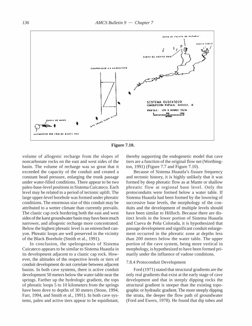
AMCS Bulletin 9 — Chapter 7
volume of allogenic recharge from the slopes ofnoncarbonate rocks on the east and west sides of thebasin. The volume of recharge was so great that itexceeded the capacity of the conduit and created aconstant head pressure, enlarging the trunk passageunder water-filled conditions. There appear to be twopaleo-base-level positions in Sistema Cuicateco. Eachlevel may be related to a period of tectonic uplift. Thelarge upper-level borehole was formed under phreaticconditions. The enormous size of this conduit may beattributed to a wetter climate than currently prevails.The clastic cap rock bordering both the east and westsides of the karst groundwater basin may have been muchnarrower, and allogenic recharge more concentrated.Below the highest phreatic level is an entrenched can-yon. Phreatic loops are well preserved in the vicinityof the Black Borehole (Smith et al., 1991).
In conclusion, the speleogenesis of SistemaCuicateco appears to be similar to Sistema Huautla inits development adjacent to a clastic cap rock. How-ever, the altitudes of the respective levels or tiers ofconduit development do not correlate between adjacentbasins. In both cave systems, there is active conduitdevelopment 50 meters below the water table near thesprings. Farther up the hydrologic gradient, the topsof phreatic loops 5 to 10 kilometers from the springshave been dove to depths of 30 meters (Stone, 1994,Farr, 1994, and Smith et al., 1991). In both cave sys-tems, paleo and active tiers appear to be equidistant,
thereby supporting the endogenetic model that cavetiers are a function of the original flow net (Worthing-ton, 1991) (Figure 7.7 and Figure 7.10).
Because of Sistema Huautla’s fissure frequencyand tectonic history, it is highly unlikely that it wasformed by deep phreatic flow as at Mante or shallowphreatic flow at regional base level. Only theprotoconduits were formed below a water table. IfSistema Huautla had been formed by the lowering ofsuccessive base levels, the morphology of the con-duits and the development of multiple levels shouldhave been similar to Hölloch. Because there are dis-tinct levels in the lower portion of Sistema Huautlaand Cueva de Peña Colorada, it is hypothesized thatpassage development and significant conduit enlarge-ment occurred in the phreatic zone at depths lessthan 200 meters below the water table. The upperportion of the cave system, being more vertical inmorphology, is hypothesized to have been formed pri-marily under the influence of vadose conditions.
7.8.4 Protoconduit DevelopmentFord (1971) stated that structural gradients are the
only real gradients that exist at the early stage of cavedevelopment and that in steeply dipping rocks thestructural gradient is steeper than the existing topo-graphic or hydraulic gradient. The more steeply dippingthe strata, the deeper the flow path of groundwater(Ford and Ewers, 1978). He found that dip tubes and
Figure 7.10.
136

AMCS Bulletin 9 — Chapter 7
anastomotic bands are the first conduits to developunder diffuse-flow conditions. Groundwater flow atthis stage is Darcian flow through fractures and steeplydipping bedding planes. Groundwater flow may beexplained by a Hagen-Poiseuille flow field, whichdemonstrates that deep flow in catchments larger than3 kilometers is more efficient than shallow flow(Worthington, 1991). White and Longyear (1962) statethat once the transition occurs between laminar flowand turbulent flow in a conduit, dissolutional processesare seven orders of magnitude more efficient. As con-duits enlarge and the hydrologic circuit is completedfrom input to output, the flow regime changes fromdiffuse flow to a turbulent flow system.
Studies have shown that anastomotic bands areformed in strata with dips less than 5 percent, whichare not described in the study area. Influenced bysteeply inclined strata and a high state of availablefissure frequency, multiple dip tubes enlarged in di-ameter as the piezometric surface rapidly drew down.Drawdown and reorientation of tributary flow fieldsincreased the permeability of the limestone and cre-ated ideal conditions for the development of vadosecave systems above base level. Worthington (1991)suggests that spacing between low-potential areas,where there are primary tubes or anastamoses, iscritical to the development of primary dip tubes. Thedistribution of sinkholes across the Sistema HuautlaKarst Groundwater Basin may represent low-potentialareas for the development of primary dip tubes. Ford(1971), Ewers (1982), and Worthington (1991) sug-gest that the 100-meter spacing of sinkholes aboveHölloch are indicative of primary dip-tube spacing.Ford (1965) and Jameson (1985) mapped primary diptubes at sink points. Dip tubes were observed drain-ing sink points in most of the dolinas in the study area.Dip tubes were observed to be formed along steeplyinclined bedding planes at most of the paleo sink pointsthroughout the basin (e.g., Li Nita, Nita Zan, etc.).Where sink points were located along faults (Nita He),dip tubes were not observed.
The proto-dip-tube conduits that would later formmajor conduits of the dendritic network of SistemaHuautla and related caves were formed during diffuseflow conditions prior to drawdown of the piezometricsurface in the same manner as described by Ewers(1982) and Ford and Williams (1989). As the piezo-metric surface drew down and flow fields reorientedto establish the most efficient flow path, the hydro-logic network was established. The flow field wasrouted through primary tubes of the hydrologic system.Worthington (1991) wrote that dissolutional processeswill increase from by from 103 to 106 along the principal
flow path once the hydrologic circuit has been com-pleted.
Ewers wrote that the reorientation of flow fieldsduring drawdown establishes a more efficient flowpath along a single plane. The dendritic system in thestudy area is developed along successive parallelplanes that are linked together by a highly integratedfracture system.
It is hypothesized that the regional base level waswell below the piezometric surface that developed theprimary dip tubes that formed the phreatic skeleton ofthe cave system (Figure 7.9). Well after drawdown ofthe piezometric surface, those hydrologic flow routesabandoned during flow field reorientation were laterconnected into the main flow system by gravity drain-age and recharge. This process is currently ongoingin the form of tributary input from trickles and smallstreamlets under the influence of vadose conditions.
When the piezometric gradient lowered to a sta-bilized position, as was the case in the study area, theprotoconduits consisting of dip tubes and slanted con-duits provided efficient path ways for allogenic andautogenic recharge (Palmer, 1991). Under vadose con-ditions in steeply dipping rock, the hydraulic gradientwhere groundwater flows down shafts may be steeperlocally than the structural gradient. Palmer (1991)indicated that vadose passages are formed by gravita-tional flow and follow the steepest available openings.Direct input into the conduits and a complete hydro-logic circuit to springs facilitated the formation ofconduits and shafts.
The hydraulic gradient for the vadose stream pas-sages in Sistema Huautla is 42 percent. The hydraulicgradient of the water table is at 3.7 percent (Figure7.7). When considering both the vadose zone and thewater table, the hydraulic gradient for the basin is ap-proximately 14 percent. The hydraulic gradient for thewhole basin is less than the structural gradient, whichaverages 40 percent.
Ford (1971) described conduit development insteeply dipping limestones as having two basic mor-phological characteristics. There are dip tubes that arelong linear tubes that occur parallel to the structuraldip and aslant tubes that are formed parallel to thestrike of dipping beds. In the caves of the SistemaHuautla Karst Groundwater Basin, both of these mor-phological types may be found, either in their activestate in sumps or inferred as relic features in vadoseconduits. The protoconduit dip tubes provided the mostefficient route for water to flow. Field mapping acrossthe basin indicates a southeast dip direction. Withinthe ridge -top caves (e.g., Nita He, Nita Mazateca, NitaZapato, Nita Ka, Nita Nido and Nita Ntau, Sótano de
137

AMCS Bulletin 9 — Chapter 7
Agua Carrizo, Nita Notni, Nita Lajao, Li Nita, NitaZan, Nita Sa, Cueva de Bernardo, and Nita Ina) pas-sage development trend is down dip, with minor strikedominated aslant passage development. The dendriticnature of Sistema Huautla and hydrologically relatedcaves is largely related to the development ofprotoconduits during saturation of the rock mass. Diptubes are formed under phreatic conditions. The in-clined passages and shafts in the study area are vadosemodifications of protoconduit development.
To summarize the process of protoconduit devel-opment, a phreatic skeleton of dip tubes was formedin a totally saturated fracture system. The mountainrange uplifted rapidly and gravity drainage to baselevel spring(s) completed the hydrologic circuit. Diptubes were evacuated, and vadose conduit develop-ment was initiated.
7.8.5 Vadose Passage DevelopmentFord and Williams (1989) postulated that vadose
systems develop after primary dip-tube systems com-plete the hydrologic circuit and that water flowing frominput to spring subsequently enlarges the tubes, in-creasing their capacity and facilitating drawdown ofthe piezometric surface. Palmer (1984) stated thatvadose and phreatic solution often occurs simulta-neously along the same flow path. Ford and Ewers(1978) described two basic types of vadose cavesformed in drained rock. These are drawdown-vadosecaves and invasion-vadose caves. Drawdown-vadosecaves are formed where vadose development occursin a phreatic skeleton that has been evacuated due todrawdown of the piezometric surface. Ford and Will-iams (1989) cited the Gouffre Berger and Gouffre JeanBernard as examples of drawdown-vadose caves (Fig-ure 2.2). They also stated that an invasion-vadose caveis formed by allogenic streams sinking into rock thathad been previously drained. This type of system lacksa primary tube network. In rock with dipping beds,the caves tend to have steeper profiles than drawdown-vadose caves. Ford and Ewers (1978) refer to theSpluga della Preta, Italy, and Epos Chasm, Greece, astwo examples of invasion-vadose caves (Figure 2.2).Ford and Williams (1989) contend that invasion-vadose caves occur in young mountain systemscharacterized by rapid uplift and high fracture perme-ability. Crawford (1978) described invasion-vadosecaves formed in relatively old limestones of Missis-sippian age in the Cumberland Plateau of Tennessee.
In considering the water table and the relativeposition of cave tiers in the study area, it is hypoth-esized that there had to have been great vertical reliefbetween base level and input, because the profiles of
Sistema Huautla indicate extensive vertical developmentwithout the development of significant intermediatelevels. No phreatic levels or levels with obviousphreatic characteristics have been found between theentrances of the caves in the groundwater basin andthe levels in the cave where base-level horizontal pas-sage development occur. One could argue that thesteeply dipping passages and shafts were originallyphreatic dip tubes at the protoconduit stage. Steeplydipping dip tubes and shafts represent between 500and 900 meters of vertical relief to where the first sig-nificant horizontal passages or levels are developed.
Based on physical evidence, Sistema Huautla’sspeleogenesis reveals a multiphase development. Thecave system comprises elements of the drawdown-vadose model, which implies an initial phreatic skeleton,and the invasion-vadose model with conduit develop-ment and modification from allogenic and autogenicrecharge. The base level of the cave system exhibitsboth vadose and phreatic elements. In the upper por-tion of the cave system’s base level, from Nita Nantato the 859 Sump in Sótano de San Agustín, the watertable is perched on shales and has a hydraulic gradi-ent of 28 percent.
These vadose drains recharge a phreatic systemthat may be partially inundated for 10 kilometers. Fordand Williams (1989) described the Gouffre Jean Ber-nard as having a comparable complexity.
7.8.6 Phreatic SegmentsFord and Williams (1989) stated that short
sections of phreatic cave that are associated with litho-logic perching or local phreatic lifting occur withinvadose caves. In Sistema Huautla and related cavesthere are sumps at many levels in the cave that are notassociated with the base-level water table (e.g., –826meters in Li Nita’s Scorpion Way, –1,030 meters atthe Li Nita–San Agustín connection, –1,080 meters indownstream Scorpion Sump, –900 meters in upstreamRed Ball Canyon in Sótano de San Agustín, and –805meters in Sótano de San Agustín). These sumps areformed in localized structural features such as folds,along faults, or in the lower levels of a horizontalpassage. They represent a perched water table whereactive phreatic development is occurring.
7.8.7 Field Evidence for Phreatic PassagesAn example of active and abandoned phreatic lift
tubes occurs in Cueva de Peña Colorada (Figure 7.8).Vine Cave, located in the Cañón de Peña Colorada,has a phreatic loop morphology and perched sumps(Figure 7.7). It seems that Vine Cave may connect intoCueva de Peña Colorada by virtue of its trend (Stone,
138
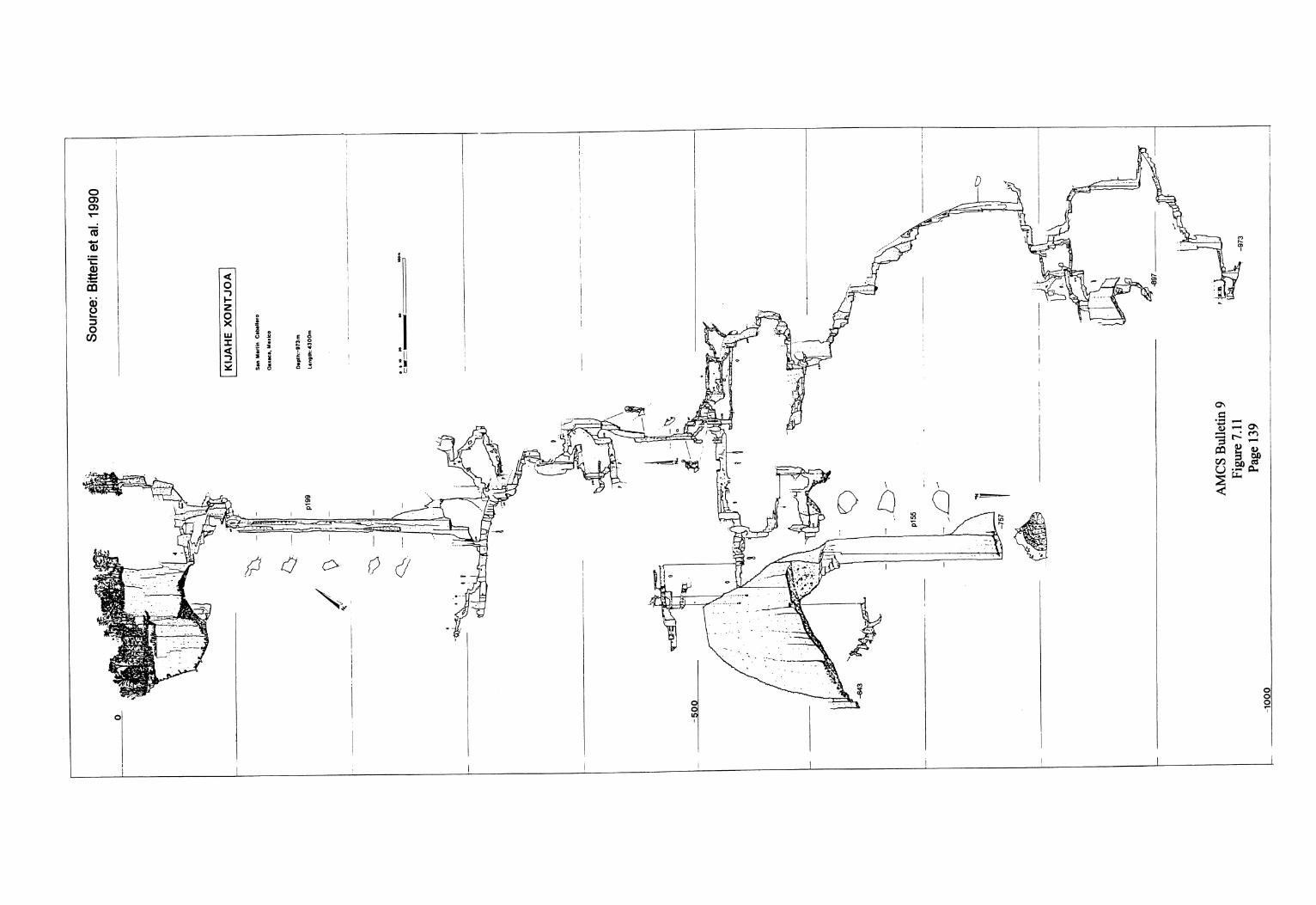

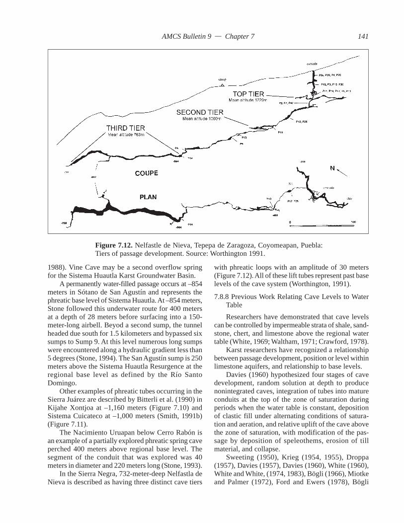
AMCS Bulletin 9 — Chapter 7
1988). Vine Cave may be a second overflow springfor the Sistema Huautla Karst Groundwater Basin.
A permanently water-filled passage occurs at –854meters in Sótano de San Agustín and represents thephreatic base level of Sistema Huautla. At –854 meters,Stone followed this underwater route for 400 metersat a depth of 28 meters before surfacing into a 150-meter-long airbell. Beyod a second sump, the tunnelheaded due south for 1.5 kilometers and bypassed sixsumps to Sump 9. At this level numerous long sumpswere encountered along a hydraulic gradient less than5 degrees (Stone, 1994). The San Agustín sump is 250meters above the Sistema Huautla Resurgence at theregional base level as defined by the Río SantoDomingo.
Other examples of phreatic tubes occurring in theSierra Juárez are described by Bitterli et al. (1990) inKijahe Xontjoa at –1,160 meters (Figure 7.10) andSistema Cuicateco at –1,000 meters (Smith, 1991b)(Figure 7.11).
The Nacimiento Uruapan below Cerro Rabón isan example of a partially explored phreatic spring caveperched 400 meters above regional base level. Thesegment of the conduit that was explored was 40meters in diameter and 220 meters long (Stone, 1993).
In the Sierra Negra, 732-meter-deep Nelfastla deNieva is described as having three distinct cave tiers
with phreatic loops with an amplitude of 30 meters(Figure 7.12). All of these lift tubes represent past baselevels of the cave system (Worthington, 1991).
7.8.8 Previous Work Relating Cave Levels to WaterTableResearchers have demonstrated that cave levels
can be controlled by impermeable strata of shale, sand-stone, chert, and limestone above the regional watertable (White, 1969; Waltham, 1971; Crawford, 1978).
Karst researchers have recognized a relationshipbetween passage development, position or level withinlimestone aquifers, and relationship to base levels.
Davies (1960) hypothesized four stages of cavedevelopment, random solution at depth to producenonintegrated caves, integration of tubes into matureconduits at the top of the zone of saturation duringperiods when the water table is constant, depositionof clastic fill under alternating conditions of satura-tion and aeration, and relative uplift of the cave abovethe zone of saturation, with modification of the pas-sage by deposition of speleothems, erosion of tillmaterial, and collapse.
Sweeting (1950), Krieg (1954, 1955), Droppa(1957), Davies (1957), Davies (1960), White (1960),White and White, (1974, 1983), Bögli (1966), Miotkeand Palmer (1972), Ford and Ewers (1978), Bögli
Figure 7.12. Nelfastle de Nieva, Tepepa de Zaragoza, Coyomeapan, Puebla:Tiers of passage development. Source: Worthington 1991.
141
AMCS Bulletin 9 — Chapter 7
(1980), and Palmer (1984) demonstrated that levelsin caves could be correlated to river terraces, signifyingthat paleo base levels were where passage develop-ment occurred proximate to the former water table.
Milanovic (1981) postulated that the base levelof erosion determines the ultimate direction of circu-lation for underground water in karst. Major erosionbases in continental regions include deep river val-leys and canyons . Worthington (1991) described asurface analog to low-gradient river caves. He usedthe Río Santo Domingo and Río Petlapa as examplesof low-gradient allogenic water flowing across karstoutcrops. He states that the rivers are able to entrenchfast enough to prevent capture to a lower course be-low the river bed. Smith and Crawford (1989) foundthat significant horizontal development of cave pas-sages controlled by lithology may occur well abovepresent base levels in the Cumberland Plateau Mar-gin Fluvial Karst.
Palmer (1987) provided a method for determin-ing past base levels by determining the relationshipbetween vadose-phreatic transition points or the“piezometric limit.”
It has been thought that cave levels or tiers were aresponse to exogenetic processes such as the lower-ing of local base level by fluvial processes. Theseexogenetic sources are challenged by Worthington(1991), who favors an endogenetic model for thedevelopment of cave levels. He maintained that thedevelopment of a cave tier is a function of the origi-nal flow net within the aquifer and has little to dowith regional base level. In fact, of the submerged con-duits he investigated, most were developed 20 to 50meters below the current base level or water table.
7.8.9 Base Level Development of Sistema HuautlaMorris et al. (1968) made geomorphological ob-
servations in Sótano del Río Iglesia and hypothesizedthat the large chambers in the cave were phreaticallyformed and modified by vadose streams. His evidencefor phreatic development is the occurrence of wall androof pocketing at three different levels. White (1988)described flood-water-generated features as consist-ing of sharp-edged residual blades, rock spans, andscoured pockets. Palmer (1975 and 1991) demon-strated that pocketing and solution pendants can alsobe formed from flood water in vadose passages.
Morris described phreatic levels in Sótano del RíoIglesia. He based his interpretation on the occurrenceof pocketing in the ceiling and walls. Because Sótanodel Río Iglesia is virtually surrounded by noncarbonaterocks and completely enclosed by the steep walls ofthe dolina, the pocket features are therefore more
logically formed by flood waters and are likely notphreatic features. The rest of the caves in the systemare more vertically oriented than Sótano del Río Iglesiaand were formed above the water table. It is suggestedthat Sótano del Río Iglesia was also formed above thewater table and that the horizontal levels are controlledby development along the strike of the beds and par-allel faults. The northeast dip of the beds may be dueto local warping of the strata due to overthrust fault-ing of the Huautla–Santa Rosa Fault.
Horizontal development of cave passages inSistema Huautla occurs at approximately 900 metersabove sea level or between –500 and –650 meters be-low the entrance of Sótano San Agustín. La Grietahas significant horizontal development approximately400 meters below its entrance or 200 meters abovethe levels formed in Sótano de San Agustín.
The main question is whether these levels werephreatically formed and are representative of old baselevels or passages whose control is either structuralor stratigraphic. As previously discussed, phreatic lifttubes are found in caves throughout the Sierra Juárezat active or former base levels.
In Cueva de Peña Colorada there are at least twowell-defined phreatic levels. The lowest level is theactive hydrologic route and has only been explored atthe spring and at Sump VII (Stone, 1984). The mor-phology of these passages, as defined by cave survey,indicates that the flow path of the water is steep. Thewater flowed along the strike of steeply inclined bed-ding planes and faults creating phreatic lifts (Ford,1971) or drops (Jameson, 1985). Ford (1971) defineda loop with a combination of one or more dip tubesand joint chimneys between successive piezometricsurfaces along a trunk as a “phreatic loop.” Accord-ing to Worthington (1991), where groundwater flowis parallel to the strike, phreatic loops may form alongsingular planes or in combinations of multiple planes.
The upper paleo-phreatic level of Cueva de PeñaColorada contains six perched sumps with differentwater level elevations. Flow through the perchedsumps is active only during high discharge and acts asan overflow conduit system. Indians have seen theentrance of Cueva de Peña Colorada discharging ahuge river of water during the rainy season. The cavesurvey of the upper phreatic level reveals a profile ofundulating phreatic tubes, with the lower portion ofthe loops water filled and static until a significant stormevent occurs and the tubes serve as an overflow route.The upper level represents the original hydrologicroute which has now been abandoned by continuousflow.
The entrance to Cueva de Peña Colorada is 92
142

AMCS Bulletin 9 — Chapter 7
meters above the spring level of the Sistema HuautlaResurgence (Stone, 1984). The original base level, asindicated by the crest of the highest phreatic loop, isat least 240 meters higher than the Sistema HuautlaResurgence. This estimate is based on the verticalposition of the top of the Whacking Great Chamber.Ford and Williams (1989) stated that the elevation ofthe top of the highest phreatic loops defines the stableposition of the piezometric surface. It is suggested thatthe development of phreatic tubes at the base level inCueva de Peña Colorada represents a mode of devel-opment to be expected in other parts of the system.There may be one or more levels of phreatic tubesassociated with the present base level (Figure 7.7).
Phreatic tubes have been located in other cavesand at various levels in the hydrologic basin. In Cuevade Agua Carlota, the cave stream follows a steep can-yon until the passage trend turns horizontal at –500meters (Smith, 1991d). The horizontal passage is a10-meter-diameter tube. In La Grieta above the Gorgeis a 300-meter-long, 20-by5-meter-diameter ellipticalphreatic tube. In Nita Nanta at –1080 meters, near theScorpion Sump, there is a 200-meter-long phreatic tube.
The rest of the horizontal drainage is through largerectangular trunk passages (e.g., in Nita Nanta, LowerNanta Gorge, in Sótano de San Agustín, Route 68,Kinepak Canyon, Tommy’s Borehole, and the Metro,in La Grieta, K-Borehole, in Sótano del Río Iglesia,Penthouse, Base Camp Chamber, and The Basement,and in Li Nita, Mil Metro). All of these passages ex-cept those in Sótano del Río Iglesia and Li Nita’s MilMetro represent the present base level and have ac-tive stream routes. The base levels of these passagesare controlled by lithology and a structural gradientthat is steeper than the hydraulic gradient.
None of these passages have the same phreaticpassage morphology as Cueva de Peña Colorada. Werethese base level passages modified by vadose streamsthat removed all evidence of phreatic morphology?The multilevel undulating tubes of Cueva de PeñaColorada are not present anywhere in Sistema Huautlaabove the 859 sump or in caves traced into the north-ern portion of the system. The only complex multi-level development occurs where La Grieta, Nita Nanta,and Sótano de Agua de Carrizo connect to Sótano deSan Agustín and where Li Nita connects to Sótano deSan Agustín. This complex passage development maybe associated with the convergence of most of thevadose drainage routes of the east and north por-tion of the basin. However, the horizontal developmentis significant and is controlled by two factors: Northeastof the Loggerhead Hall Fault, the lower drainages ofthe Nanta Gorge, Nita He, and La Grieta’s Grease Rock
Canyon are developed at the stratigraphic base levelas defined by shale; these appear to be vadose pas-sages and not phreatic tubes. On the west side of theLoggerhead Hall Fault no shales are present, and thebase level is controlled by a former water table.
The hydraulic gradient from the Sistema HuautlaResurgence to Sump VII of Cueva de Peña Coloradais 3 percent. From the Sistema Huautla Resurgence tothe Sótano San Agustín sump the hydraulic gradientis 3.7 percent, suggesting that for phreatic loops todevelop a very low hydraulic gradient is necessary.There are 138 vertical meters of air-filled passage inCueva de Peña Colorada from the top of the Whack-ing Great Chamber to the water level at Sump VII.From the water level in Sótano de San Agustín at –825meters to Camp IV at –640 meters is 185 verticalmeters. The hydraulic gradient from Camp IV, Sótanode San Agustín, to the top of the phreatic loop of theWhacking Great Chamber is 3.2 percent. From –520meters in the bottom of Sótano de San Agustín’s Fis-sure Series, the hydraulic gradient is 4 percent, only0.3 percentage points different from the present baselevel (Figure 7.7). The amplitudes of the phreatic loopsvary from 100 to 150 meters.
It is the author’s opinion that Cueva de PeñaColorada and possibly Vine Cave were phreatic con-duit systems that integrated somewhere in the PeñaColorada Canyon. That opinion suggests that erosionalprocesses incised the canyon and intersected the con-duit system. Cueva de Peña Colorada is currently theoverflow system to the active hydrologic drainage. Theconduit system most likely continued to a spring atthe base level of the Río Santo Domingo.
In conclusion it seems likely that the hydraulicgradient has been more or less uniform as the watertable has lowered to its present position (Figure 7.7).The upper-level horizontal passage development ofSistema Huautla is a relict of former base levels. De-spite the fact that there is very little morphologicalevidence for phreatic development in the various lev-els, the uniform hydraulic gradient indicates that thesecave tiers could have formed below a water table. It ishypothesized that most of the physical evidence ofphreatic morphology in the base-level passages ofSistema Huautla has been removed by vadose modifi-cation as the system channels an average of 3.5 metersof annual rainfall through its conduits.
The current base level in phreatic portion ofSótano de San Agustín (854 Sump) does not correlateto the base level of the Río Santo Domingo. Thephreatic base level passages in Sótano de San Agustínare over 300 meters higher than the base level of theRío Santo Domingo. Phreatic development from the
143

AMCS Bulletin 9 — Chapter 7
Sistema Huautla Resurgence to the 854 Sump ofSótano de San Agustín consists of multiple phreaticloops with varying amplitudes. In Cueva de PeñaColorada, phreatic loops have high amplitude and highfrequency. The base-level phreatic loops of Sótano deSan Agustín have high amplitude and low frequency(Figure 7.7).
7.8.10 Evidence of Vertical UpliftFrom the highest drainage divide in the Sierra
Juárez to the Río Santo Domingo, the vertical eleva-tion differential is 2,700 meters. Since the LaramideOrogeny at the end of the Eocene, the Sierra Juárezhas emerged a minimum of 2,700 meters of elevationabove the regional base level as defined by the RíoSanto Domingo. Helu et al. (1977) documented thickdeposits of Early Miocene conglomerates in theVeracruz Basin originating from the Sierra Juárez.
This research suggests that the uppermost phreaticloop in Cueva de Peña Colorada represents a previ-ous base level that corresponded to the regional baselevel. There is a 92-meter vertical difference betweenthe entrance to Cueva de Peña Colorada (overflowspring) and the Sistema Huautla Resurgence. The ver-tical distance from the highest known phreatic loop inCueva de Peña Colorada to the Sistema Huautla Re-surgence is 240 meters. Since the development of thecaves in the Sistema Huautla Karst Groundwater Ba-sin, the base level has lowered at least 240 meters.
One of the largest resurgences on the east side ofthe Sierra Juárez is the Nacimiento Uruapan. Thespring is located 400 meters above the Río SantoDomingo. Worthington (1991) stated that springs lo-cated well above base level may be indicative ofuplift rates that are greater than down cutting orkarstification rates. He described examples in PapuaNew Guinea and southwest China springs that dis-charge from the sides of cliffs.
The east side of the Sierra Juárez has had a greateruplift than the western portion of the range, as shownby the difference in elevation between the SistemaHuautla Resurgence at 306 meters and NacimientoUruapan at 500 meters elevation. The regional baselevel as defined by the Río Santo Domingo does notcorrelate with the base level of the NacimientoUruapan. The lack of correlation between base levelssuggests that uplift has occurred since the initial de-velopment of the caves and that the eastern portion ofthe range is rising faster than the western portion. Therate of uplift is unknown. South of the Río SantoDomingo, uplift rates appear to be greater and may beinfluenced by uplift of Oaxacan basement complex.If the rate of uplift were quantified, then the age of
the cave system could be ascertained. Worthington(1989, 1990, and 1991) determined the occupancy timefor three cave tiers in 732-meter-deep Nelfastla deNieva, Coyomeapan, Puebla, as having an average ageof 2.5 to 4 million years.
7.9 ConclusionEvidence indicates that Sistema Huautla’s devel-
opment is related to the regional tectonics. Fluvialsystems flowing across the carbonates disappearedduring the Early Miocene as the mountain range up-lifted. While the rate of uplift is unknown, it must havebeen consistent enough to saturate almost 1,000 ver-tical meters of rock fractures and bedding planes. Earlyprotoconduit development indicates a deep circulationto a base level spring followed by gravity drainage ofthe phreatic skeleton (Figure 7.9).
Slope retreat of a clastic cap rock provided earlyallogenic input to some point east of the present posi-tion of the cap rock. Allogenic recharge and more than3 meters of annual autogenic recharge are responsiblefor vadose passage development.
Karstification processes in the development ofdolinas have isolated cave entrances on the sides ofdolinas and on narrow ridges. Surface karst featuresare more recent than the subterranean drainage system.
Uplift has been more or less continuous since thecave system has developed, as determined by the pres-ence of cave levels and the elevation of the largestspring in the sierras, Nacimiento Uruapan, which iswell above present base level. Diving in theNacimiento Río Frío de Santa Ana has revealed thatstalactites occur 30 meters below the water table atregional base level (Farr, 1994). The presence ofstalactites in flooded passage may indicate that thepassage was uplifted and the conduit was drained al-lowing the stalactites to form. Subsequent flooding ofthe conduit may be attributed to tectonic lowering ofthe base level. Reflooding of the conduit implies thatuplift has not been uniform and that a lower phreaticlevel may exist below the present level. As an alterna-tive to tectonic uplift and subsidence, the base levelof the Río Santo Domingo could have been 60 metersdeeper and then buried by an influx of sediments oralluviated. Alluviation would also raise the water tableand reflood paleo-phreatic tubes. If the base level ofthe Río Santo Domingo was once lower than thepresent level, then a lower tier of phreatic passage mayexist below the explored phreatic level at SistemaCuicateco and Cueva de Peña Colorada.
There are at least two recognizable base levelsand a hypothesized third lower level below the pres-ently active phreatic system in the Sistema Huautla
144

AMCS Bulletin 9 — Chapter 7
Karst Groundwater Basin. The present base level asdefined by the Río Santo Domingo slopes up into thebasin to the lowest level of Sistema Huautla with ahydraulic gradient of 3.7 percent.
A calculated hydraulic gradient of 4 percent fromthe top of the highest phreatic loop in Cueva de PeñaColorada to the –600 meter level in Sótano de SanAgustín defines the highest original base level forSistema Huautla. The levels in the cave system maynot be related to regional base level, but instead belevels as defined by the original flow net. When com-paring cave tiers in Sistema Huautla to SistemaCuicateco and Nelfastla de Nieva, none of the cavesshow levels correlatable to past regional base levels.Distinct tiers within each cave also show no correla-tion to each other.
The entrances of Cueva de Peña Colorada andpossibly Vine Cave are the original conduits that fedsprings along the Río Santo Domingo.
The caves of the Sistema Huautla Karst Ground-water Basin reveal a multi-phase development,comprising elements of a drawdown-vadose cave,invasion-vadose cave, paleo-phreatic levels, season-ally active paleo-phreatic caves with multiple loops,and phreatic levels that are largely unexplored.
Worthington (1991) indirectly established the ageof the deep vertical Nelfastla de Nieva between 7.5
and 12 million years from the occupancy time for threecave tiers. The lower section of the cave is at 732meters above sea level or 432 meters above the eleva-tion of the Sistema Huautla Resurgence. Worthingtonstated that the tiers are separated by a mean of 230meters. There should be two more tiers to regionalbase level if there is uniform cyclicity. If so, then theage range for cave development is between 10 and 16million years, which correlates to the Early-MiddleMiocene uplift. Other caves in the Sierra Juárez Geo-logic Subprovince way be of comparable age.
However, Sistema Huautla may not be 10 to 16million years old. It is hypothesized that SistemaHuautla developed as the clastic cap rock was re-moved. As a result there was 700 to 800 meters ofrelief above the active phreatic base level in the karstaquifer. If there was an average of 1 millimeter of upliftper year, then it would only take 700,000 to 800,000years for the Sierra Mazateca to rise 700 to 800 meters.Two hundred meters of relief between the uppermostpaleophreatic level and the bottom of the activephreatic level in Cueva de Peña Colorada may havedeveloped in 200,000 years. It is hypothesized thatSistema Huautla is less than two million years old.More work is necessary to determine the age ofSistema Huautla.
145


AMCS Bulletin 9 — References
REFERENCES
Alvarado, J. G., 1976, Resultados obtenidos en laexploracion de la Plataforma de Cordoba yprincipales campos productores. Bol. Soc. Geol.Mexicana v. 37, pp. 53–59.
Atkinson, G., 1980(a), Huautla Project Report 1980.AMCS Activities Newsletter no. 11, Dec., pp. 54–58.
———, 1980(b), Field Notes.———, 1983, Nita He. AMCS Activities Newsletter
no. 13, Sep., pp. 54–58.Atkinson, T. C. and P. L. Smart, 1981, Artificial trac-
ers in hydrogeology. A survey of British hydro-geology 1980, The Royal Society, pp. 173–190.
Barlow, C. A. and A. E. Ogden, 1982, A statisticalcomparison of joint, straight cave segments, andphotolineament orientations. National Speleologi-cal Society Bulletin, Vol. 44, pp. 107–110.
Batson, B. L. and J. A. Jackson, 1987, Glossary ofgeology. American Geological Institute, Alexan-dria, Virginia.
Bazan, S., 1981, Distribucion y metalogenesis de laprovincia uranifera del Mesozoico de Mexico.Geomimet, 3a Epoca, julio/agosto de 1981, no.112, pp. 65–96.
Bitterli, T., P. Y. Jeannin, K. Meyers, and P. Rouiller,1990, Proyecto Cerro Rabon, Mexico 1985–1989,Speleo Projects, 58 p.
Bögli, A., 1966, Karstwasserflache und unterirdischekarstniveaus. Erdkunde, v. 20, pp. 11–19.
———, 1980, Karst hydrology and physical speleol-ogy. Springer-Verlag, Berlin.
Boon, J. M., 1969, Caving in Mexico. Canadian Caver.no. 1, December.
Boyer, R. E. and J. E. McQueen, 1964, Comparisonof mapped rock fractures and air photo features.Photo. Eng., v. 30, pp. 630–635.
Bretz, J H., 1942, Vadose and phreatic features of lime-stone caverns. Journal of Geology, v. 50, pp. 675–811.
Brown, C. W., 1961, Comparison of joints, faults, andair photo linears. Am. Ass. Pet. Geol. Bull., v. 45,no. 11, pp. 1888–1892.
Campa, M. F., and P. J. Coney, 1983, Tectono-strati-graphic terranes and mineral resource distributionsin Mexico. Can. J. Earth Sci., v. 20, pp. 1040–1051.
Campa, M. F. and J. Ramirez, 1979, La evoluciongeologica y la metalogenesis del noroccidente deGuerrero. Serie tecnicocientifica de la UniversidadAutonoma de Guerro, no. 1, 102 p.
Carfantan, J. C., 1981(a), Paleogeography and tecton-ics of the Sierra de Juarez–Isthmus of Tehuantepecarea and its relations with other terranes of south-ern Mexico and Central America. Am. Geol. Soc.Am. Abstract with Programs, v. 13, no. 2, p. 48.
———, 1981(b), Evolucion estructural del sureste deMexico; Paleogeografia e historia tectonica de laszonas internas mesozoicas. Univ. Nal. Auton.Mexico, Inst. Geol. Revista, v. 5, no. 2, pp. 207–216.
Carrasco, B., V. Flores, and D. Godoy, 1975, Tobasdel Cretacico inferior del area de Fortin-Zongolica,Estado de Veracruz. Revista del Inst. Mexicanodel Petroleo, Octobre, pp. 7–27.
Charleston, S., 1980, Stratigraphy and tectonics of theRio Santo Domingo Area, State of Oaxaca,Mexico: 26th Congres Geologique International,v. I, Sections 1 a 5, Juillet, Resumes, 324 p.
Chorley, R. J. and B. A. Kennedy, 1971, Physical ge-ography, a systems approach. London: PrenticeHall.
Compton, R. R., 1985, Geology in the field. JohnWiley and Sons Inc., 398 p.
Coney, P. J., 1976, Plate tectonics and the LaramideOrogeny. New Mexico Geological Society Spe-cial Publication, no. 6, pp. 5–10.
Courbon, P., C. Chabert, P. Bosted, and K. Lindsley,1989, Atlas of great caves of the world. Cave
147

AMCS Bulletin 9 — References
Books, St. Louis, 369 p.Coward, J. M. H., 1971, Agua Carlota, Mexico. Ca-
nadian Caver No. 2.Crawford, N. C., 1978, Subterranean stream invasion,
conduit cavern development and slope retreat: asurface-subsurface erosion model for areas of car-bonate rock overlain by less soluble and less caprock, Unpub. Ph.D. thesis, Clark University, 451 p.
———, 1980, The karst hydrogeology of theCumberland Plateau Escarpment of Tennessee;Part III; Karst valley development in the Lost Covearea, Franklin County, Tennessee. Cave and KarstSeries No. 1, Center for Cave and Karst Studies,Department of Geography and Geology, WesternKentucky University Bowling Green, 21 p.
Cserna, Z. de, 1967, Tectonic framework of southernMexico and its bearing on the problem of conti-nental drift. Bol. Soc. Geol. Mex. v. 30, pp. 159–168.
———, 1976, Mexico—geotectonics and mineraldeposits. New Mexico Geological Society Spe-cial Publication, no. 6, pp. 18–25.
Cvijic, J. 1925, Types morphologiques des terrainscalcaires. C.R. Acad. Sci. , Paris, v. 180, pp 592,757, 1038.
Davies, W. E., 1957, Erosion levels in the Potomacdrainage system and their relation to cavern de-velopment. Speleograph, v. 12, pp. 1–5.
———, 1960, origin of caves in folded limestone.National Speleological Society Bulletin, v. 22, pp.5–18.
Davis, D. G., 1980, Cave development in theGuadalupe Mountains: a critical review of recenthypotheses, National Speleological Society Bul-letin, v. 42, no. 3, pp. 42–48.
Davis, W. M., 1930, Origin of limestone caverns. Geo-logical Society of America Bulletin, v. 41, pp. 475–628.
Day, M. J., 1977, Surface hydrology within polygo-nal karst depressions in northern Jamaica, Pro-ceedings of the 7 International Speleological Con-gress (Sheffield), pp. 143–6.
———, 1978, The morphology of tropical humid karstwith particular reference to the Caribbean andCentral America, unpubl. Ph.D. thesis, Oxford,610 p.
Deike, G. H. III, 1960, Origin and geologic relationsof Breathing Cave, Virginia, National Speleologi-cal Society Bulletin, v. 22, pp. 30–42.
———, 1989, Fracture controls on conduit develop-ment. In Karst hydrogeology: concepts from theMammoth Cave area, (Eds. W. B. White and E. L.White), Van Nostrand Reinhold, New York, pp.
259–292.Demant, A., 1978, Caracteristicas del Eje Neavol-
canoco transmexicano y sus problemas deinterpretacion. Revista del Instituto de Geologia,UNAM, v. 2, no. 2, pp. 172–187.
Dreybrodt, W., 1981, Kinetics of the dissolution ofcalcite and its applications to karstification. Chem-istry Geology, v. 31, pp. 245–269.
———, 1988, Processes in karst systems: Physics,Chemistry, and Geology. Berlin: Springer, 288 p.
Droppa, A., 1957, Die Hohlen Demanovske Jaskyne.Slovak. Acad. Sci. Bratislavia.
———, 1966, The correlation of some horizontalcaves with river terraces. Studies in Speleology,v. 1, no. 4, pp. 186–192.
Drummond, I., 1968, How to capture a depth recordin three weeks. The Speleologist, v. 2, no. 16.
Durov, S. A., 1956, On the question of the origin ofsalt composition of karst water. Ukranian Chem.J. 22, pp. 106–111.
Dwerryhouse, A. R., 1907, Limestone caverns andpotholes and their mode of origin. Journal of theYorks. Ramblers Club. v. 2, pp. 223–228.
Eardley, A., Jr., 1951, Structural Geology of NorthAmerica. New York.
Echanove, O. A. E., 1963, Estratigrafia de una porcionde la Sierra Madre Oriental comprendida entreHuautla de Jimenez, Oaxaca y Coyomeapan,Puebla. Tesis Profesional, U.N.A.M., Mexico,D.F., 112 p.
Effing, R. S., 1980, The Huayacoctla aulacogen inMexico (Lower Jurassic) and the origin of the Gulfof Mexico. In: The Origin of the Gulf of Mexicoand the early opening of the northcentral AtlanticOcean, (Rex Pilger, ed.) Proceedings of a Sympo-sium at Louisiana State University, Baton Rouge,March 3–5, pp. 79–86.
Egemeier, S. J., 1973, Cavern development by ther-mal waters with a possible bearing on ore deposi-tion. Ph.D. Thesis, Geology, Stanford, University.
———, 1981, Cavern development by thermal wa-ters. Bull. Nat. Spel. Soc., v. 43, pp. 31–51.
El-Etr, H. A., 1974, Proposed terminology for naturallinear features. Utah Geol. Soc. Pub. #5, pp. 480–489.
Erben, H. K., 1956, El Jurasico Medio y el Callovianode Mexico. XX Congreso Geol. Int., Mexico.(Contribucion al congreso del Inst. de Geol. de laUNAM) 140 p.
Ewers, R. O., 1966. Bedding Plane Anastomoses andtheir Relationship to Cavern Passages. BulletinNational Speleological Society 28, pp. 133–140.
———, 1969, A model for the development of sub-
148

AMCS Bulletin 9 — References
surface drainage routes along bedding planes.Unpubl. MSc thesis, Univ. of Cincinnati, 84 p.
———, 1978, A model for the development of broadscale networks of groundwater flow in steeplydipping carbonate aquifers. Transactions of theBritish Cave Research Association, v. 5, no. 2, pp.121–125.
———, 1982, Cavern development in the dimensionsof length and breadth. Unpubl. Ph.D. thesis,McMaster Univ., 398 p.
Exley, S., 1988, World record broken in Mexico.AMCS Activities Newsletter, no. 17, December,pp. 96–99.
Farr, B., 1989, personal communication.———, 1994, personal communication.Finn, E., 1971, Mexico 70–71. Canadian Caver, no.
4, May.Fish, J. E., 1966, AMCS trip report: Huautla, state of
Oaxaca. AMCS Newsletter, v. 2, no. 3.———, 1967, AMCS trip report: Huautla de Jimenez,
Oaxaca. AMCS Newsletter, v. 3. no. 6.———, 1970, The exploration of Sotano de San
Agustin. Canadian Caver, no. III, Nov.———, 1977, Karst hydrogeology of Valles–San Luis
Potosi region, Mexico. Uhpubl. Ph.D. thesis,McMaster University, 469 p.
Fish, J. E. and W. Russell, 1966, Preliminary reporton Huautla caves. AMCS Newsletter, v. 2, no. 3.
Flores, J. V., 1961, Estratigrafia y correlacion de lasformaciones Cretacico-Jurasics del area com-prendida entre Tuxpango, Veracruz, a San Anto-nio Cañada Tochapa, Veracruz. Informe PEMEX(inedito)
Ford, D. C., 1965. The origin of limestone caverns: Amodel from the central Mendip hills, England.Bulletin of the National Speleological Society, v.27, no. 4, pp. 109132.
———, 1968, Features of cavern development in cen-tral Mendip. Trans. Cave Research Group of GreatBritain, v. 10, no. 1, pp. 11–25.
———, 1971, Geologic structure and a new explana-tion of limestone cavern genesis. Trans. CaveResearch Group of G.B., 13, pp. 81–94.
———, 1977, Genetic classification of solutional cavesystems, (ed. T.D. Ford) Proceedings of the Sev-enth International Congress, Sheffield, England,British Cave Research Association, Somerset,England, pp. 189–192.
———, 1989, Features of the genesis of Jewel Caveand Wind Cave, Black Hills, South Dakota, NSSBull. v. 51, pp. 100–110.
Ford, D. C. and R. O. Ewers, 1978, The developmentof limestone caverns in dimensions of length and
depth. Canadian Journal of Earth Science, v. 15,pp. 1783–1798.
Ford, D. C., P. L. Smart, and R. O. Ewers, 1983, Thephysiography and speleogenesis of CastleguardCave, Columbia Icefields, Alberta, Canada. Arc-tic Alpine Research, v. 15, pp. 437–450.
Ford, D. C. and P. Williams, 1989, Karst geomorphol-ogy and hydrology. Unwin Hyman, London, 601 p.
Fries, C. Jr., E. Schmitter, P. E. Damon, and D. E.Livingston, 1962. Rocas Precambricas de edadGrenvilliana de la parte Central de Oaxaca enOaxaca en Sur de Mexico. Boletin U.N.A.M., Inst.de Geol., v. 64, no. 3, pp. 45–53.
Gardner, J. H., 1935, origin and development of lime-stone caverns. Bulletin of the Geological Societyof America, v. 46, pp. 1255–1274.
Gerstenhauer, A., 1960, Der tropische kegelkarst imTabasco, Mexico. Z. Goamorph., Suppl. 2, pp. 22–48.
Gonzalez, A. J., 1976, Resultados obtiendos en laexploracion de la Platforma Cordoba y principalescampos productores. Bol. Soc. Geol. MaxicanaTomo XXXVII, no. 2, pp. 53–60.
Grund, A., 1903, Die karsthydrographie: Studien ausWestbosnien. Geog. Abh. heraus. von A. Penck,v. 7, pp. 103–200.
Gunn, J., 1985, A conceptual model for conduit flowdominated karst aquifers. Inter. Symposium onKarst Water Resources (Ankara, Turkey) Proceed-ings, pp. 1–10.
Gutierrez, F. O., 1981, Metamorphic belts of southernMexico and their tectonic significance. Geof. Int.v. 20-3, pp. 177–202.
Hack, J. T., 1960, Relation of solution features tochemical character of water in the ShenandoahValley, Virginia. U.S. Geol. Surv. Prof. Paper400-B, pp. 387–90.
Helu, P. C., V. V. Rodolfo, and B. P. Rodolfo, 1977,Origin and distribution of Tertiary conglomerates,Veracruz Basin. A.A.P.G. Bulletin, v. 61, no. 2,pp. 207–226.
Herak, M., 1977, Tecto-genetic approach to classifi-cation of karst terranes. Carsus Yugoslavia 9/4,Zagreb, Yugoslavia.
Herak, P. C., S. Bahun, and A. Magdelenic, 1969, Posi-tive and negative effects of development of karstin Croatia. Carsus Iugoslavia, Zagreb, Yugosla-via.
Hernandez-Garcia, G. R., 1973, Paleogeografia delPaleozoico de Chiapas. Mexico, Bol. Asoc. Mex.Geol. Pet., v. XXV, nos. 1–3, pp. 77–134.
Hill, C. A., 1981, Spleogenesis of Carlsbad Cavernsand other caves of the Guadalupe Mountains, Proc.
149
AMCS Bulletin 9 — References
8th Internat. Congress Speleology (BowlingGreen, Ky) v. 1, pp. 134–144.
———,1987, Geology of Carlsbad Caverns and othercaves in the Guadalupe Mountains, New Mexicoand Texas. N.M. Bureau Mines and Minerals Re-source Bulletin 117, 150 p.
Hobbs, S. L. and P. L. Smart, 1986, Characterizationof carbonate aquifers: A conceptual base. Proceed-ings 9th Congreso International de Espeleologia,v. 1, pp. 43–46.
Hoffman, P., J. F. Dewey, and K. Burke, 1974,Aulacogens and their genetic relation to geosyn-clines with a proterozoic example from GreatSlave Lake, Canada. Spec. Pub. Soc. Econ.Paleont. Mineral, v. 19, pp. 38–55.
Hose, L. D., 1981, The geology and hydrogeology ofthe Sistema Purification Area, Villa Hidalgo,Tamaulipas, Mexico. M.Sc. Thesis, CaliforniaState University, 148 p.
Howard, A., 1964, Model for cave development un-der artesian flow, Black Hills, South Dakota. NSSBulletin, v. 26, no. 1.
Imlay, R. W., 1943, Jurassic Formations of Gulf Re-gion. Bull. A.A.P.G., v. 27, no. 11, pp. 1411–1533.
Jakucs, L., 1977, Morphogenetics of karst regions.John Wiley, New York.
Jameson, R. A., 1981, Deer tracks in Cueva de losPajaros, Oaxaca, Mexico. AMCS Activities News-letter, no. 12, April, pp. 71–73.
———, 1985, Structural segments and the analysisof flow paths in the North Canyon of SnedegarCave, Friars Hole Cave System, West Virginia.Unpubl. MSc thesis, 421 p.
Jameson, R. A. and P. Mothes, 1981, Caves of the SanMiguel dolina. AMCS Activities Newsletter, no.12, April, pp. 37–42.
Jennings, J. N., 1971, karst. Australian National Uni-versity Press, Canberra, Australia.
———, 1985, Karst Geomcrphology, Basil BlackwellOxford, 293 p.
Kastning, E. H., 1977, Faults as positive and negativeinfluences on groundwater flow and conduit en-largement, in Dilamarter, R. R., and Csallany, S.C., eds. Hydrologic problems in karst regions:Bowling Green, Kentucky, Western KentuckyUniversity. pp. 193–201.
Katzer, E., 1909, karat und karsthydrographie. ZurKunde der Balkan halbinsel, v. 8, Sarajevo.
Kaye, C. A., 1957, The effects of solvent motion anlimestone solution. Journal of Geology, v. 65, pp.35–46.
Komatina, M., 1973, Conditions of karst developmentand zoning of karst terranes. Vesnik Geozavoda
X/XI, Beograd, Yugoslavia.Krieg, W., 1954, Höhlen und Niveaus, Die Höhle 5/1,
pp. 1–4.———, 1955, Zu Höhlen und Niveaus, Die Höhle 6,
pp. 74–77.Lasserre, G., 1954, Notes sur le karst de la Guadeloupe.
Erdkunde, v. 8, pp. 115–118.Lattman, L. H. and R. H. Matzke, 1961, Geological
significance of fracture traces. Photo. Eng., v. 27,no. 5, pp. 435–438.
Lattman, L. H. and Parizek, 1964, Relationship be-tween fracture traces and the occurrence of groundwater in carbonate rocks. Journal of Hydrology,v. 2, pp. 73–91.
Lehmann, O., 1927, Das tote gebirge als hochkarst.Mitt. Geogr. Ges. Wein, v. 70, pp. 201–242.
———, 1936, Morphologische studien auf Java.Geogr. Abhand. (Stuttgart), v. 3, p. 9.
McMaster University Caving and Climbing Club,1968, A Description of the Sotano del Rio Iglesia.MUCCC Publication number 1.
Maldonado-Koerdell, M., 1958, Nomenclatura,bibliografia y correlacion de las formacionescontinentales (y algunas marinas) del Mesozoicode Mexico. Bol. Asoc. Mex. Geol. Petroleros, v.10, pp. 287–308.
Mallot, C. A., 1937, Invasion theory of cavern devel-opment. Proc. Geol. Soc. Amer., p. 323.
Martel, E.-A., 1921, Nouveau traite des Eauxsouterraines: Doin, Paris.
McCabe, C., R. V. der Voo, and J. Urrutia-Fucugauchi,1988, Late Paleozoic or early Mesozoic magneti-zations in remagnetized Paleozoic rocks, State ofOaxaca, Mexico. Earth and Planetary ScienceLetters, v. 91, pp. 205–213.
Mena, R. E., 1960, El Jurasico marino de la region deCordoba, Ver. Bol. Asoc. Mex. Geol. Pet., v. XII,Nos. 7–8.
———, 1961, Estratigrafia y correlacion de lasformaciones Jurasico-Cretacico del area com-prendida entre Teotitlan del Camino–Huautla deJimenez, Oaxaca y Covcatlan–Cerro Zizinptepel,Puebla. Inf. Geol. 49 Z. V. Pemex (ined.).
Mena, R. E., and Maldonado, M. J., 1959, Informegeologico superficial del area de Acatlan–Huautlade Jimenez, Oaxaca: Inf. Geol. 37 Z. V. Pemex.
Merrill, G. K., 1960, Additional notes on vertical shaftsin limestone caves. Bulletin NSS, v. 22, Part 2,July, pp. 101–108.
Milanovic, P. T., 1981. Karst hydrogeololy. WaterResource Publications, Littleton, Colorado.
Miller, T. E., 1981, Hydrochemistry, hydrology andmorphology of the Caves Branch Karst, Belize.
150
AMCS Bulletin 9 — References
Unpublished Ph.D. Thesis, McMaster University,Hamilton, Ontario, 280 p.
Minton, M., 1988, Line plots of Sistema Huautla.———, 1991, Personal communication.Miotke, F. D. and A. N. Palmer, 1972, Genetic rela-
tionship between caves and landforms in the Mam-moth Cave National Park Area, Wurtzburg: BohlerVerlag, 69 p.
Monroe, W. H., 1970, A glossary of karst terminol-ogy, Geological Survey Water Supply Paper,1899-K.
———, 1973, Stratigraphy and petroleum possibili-ties of middle Tertiary rocks in Puerta Rico. Am.Assoc. Pet. Geol. Bull. v. 57, no. 6, pp. 1086–1099.
———, 1974, Dendritic dry valleys in the cone karstof Puerto Rico. Journal of Research of U.S. Geo-logical Survey, v. 2, no. 2, pp. 159–163.
———, 1976, The karst landforms of Puerto Rico. U.S. Geol. Sur. Prof. Paper 899, 69 p.
Morehouse, D. F., 1968, Cave development via thesulfuric acid reaction. NSS Bull. v. 30, pp. 1–10.
Moreno, G., 1980, Geologia del area de Huautla deJimenez, Oaxaca. Tesis Profesional, E. S. I. A., I.P. N., 35 p.
Morris, T., et al., 1968, A description of Sotano delRio Iglesia. McMaster University Caving andClimbing Club, Publication no. 1.
Mossman, R. W. and F. Viniegra, 1976, Complex faultstructures in Veracruz Province of Mexico. A. A.P. G. Bulletin, v. 60, no. 3, pp. 379–388.
Mullerried, F. K. G., 1936, Estratigrafia preterciariapreliminar del Estado de Chiapas. Bol. Soc. Geol.Mexicana, T.9, pp. 31–41.
Mylroie, J. E., 1977, Speleogenesis and karst geomor-phology of the Helderberg Plateau, SchoharieCounty, New York. Published Ph.D. thesis, Bul-letin 2, New York Cave Survey. 336 p.
———, 1984, Hydrologic classification of caves andkarst. Groundwater as a geomorphic agent, Allenand Unwin, Boston.
———, 1987, Influence of impermeable beds on col-lapse of bedrock voids in the vadose zone. 2ndMultidisciplinary Conference on Sinkholes andthe Environmental Impacts of Karst, Orlando,Florida, February 9–11. pp. 95–99.
Nelson, A. E. and W. H. Monroe, 1966, Geology ofFlorida Quadrangle, Puerto Rico. U. S. Geol. Surv.Bull. 1221-C, 22 p.
Ogden, A. E. and R. K. Redman, 1993, Methods forpredicting the direction of contaminant transportin flat-lying and folded carbonate rocks. AppliedKarst Geology, ed. B. F. Beck, Proceedings of theFourth Multidisciplinary Conference on Sinkholes
and the Engineering annd Environmental Impactsof Karst, Panama City, Florida, January 25–27,pp. 175–180.
Palmer, A. N., 1972, Dynamics of as sinking streamsystem, Onesquethaw, New York. NSS Bulletin,v. 34, pp. 101–107.
———, 1975, The origin of maze caves. NSS Bulle-tin, v. 37, pp. 56–76.
———, 1981, A geological guide to Mammoth CaveNational Park. Teaneck, NJ, Zephyrus Press, 210 p.
———, 1984, Geomorphic interpretation of karst fea-tures. In: Groundwater as a geomorphic agent (Ed.R. G. LaFleur), Allen & Uuwin, pp. 173–209.
———, 1987, Cave levels and their interpretation.NSS Bull., v. 49, pp. 50–66.
———, 1991, Origin and morphology of limestonecaves. Geological Society America Bulletin, 103,pp. 121.
Palmer, A. N. and M. V. Palmer, 1989, Geologic his-tory of the Black Hills, South Dakota, NSS Bulle-tin, v. 51, no. 2, pp. 72–99.
Plummer, L. N., D. L. Parkhurst and T. M. L. Wigley,1979, Critical review of the kinetics of calcite dis-solution and precipitation. In Chemical Modelingin Aqueous Systems, E. A. Jenne, Ed., Amer.Chem. Soc. Symp. Series 93, pp. 537–573.
Plummer, L. N., T. M. L. Wigley, and D. L. Parkhurst,1978, The kinetics of calcite dissolution in car-bon dioxide water systems at 5 to 60 degrees Cand 0.0 to 1.0 atm carbon dioxide. American Jour-nal of Science, v. 278, pp. 179–216.
Pohl, E. R., 1955, Vertical shafts in limestone caves.National Speleological Society Occasional Paper,no. 2.
Powell, R. L., 1970, Base level, lithologic and climaticcontrols of karst groundwater zones in south-cen-tral Indiana. Indiana Academy of Science, Pro-ceedings, v. 79, pp. 281–291.
———, 1976, Some geomorphic and hydrologic im-plications of jointing in carbonate strata of Mis-sissippian age in south-central Indiana. Ph.D. The-sis, Lafayette, Indiana, Purdue University, 169 p.
Quinlan, J. F., 1978, Types of karst, with emphasis oncover beds in their classification and development.Ph.D. Thesis, Geology, University of Texas, Aus-tin.
Quinlan, J. F. and R. O. Ewers, 1985, Groundwaterflow in limestone terranes: strategy, rationale andprocedure for reliable, efficient monitoring ofgroundwater quality in karst areas. NationalSymposium and Exposition on Aquifer Resto-ration and Groundwater Monitoring, Proceedings,Worthington, Ohio: National Water Well Associa-
151

AMCS Bulletin 9 — References
tion, pp. 197–234.Quinlan, J. F., P. L. Smart, G. M. Schindel, E. C.
Alexander, Jr., A. J. Edwards, and A. R. Smith,1992, Recommended administrative/regulatorydefinition of karst aquifers, principles for classi-fication of carbonate aquifers, practical evalua-tion of vulnerability of karst aquifers, and deter-mination of optimum sampling frequency atsprings. In NGWA and US EPA, Proceedings ofthe Third Conference on Hydrogeology, Ecology,Monitoring and Management of Groundwater inKarst Terranes, Nashville, TN pp. 573–635.
Ramirez L., 1991, Geology of the Pagaso asbestosdeposit, Concepcion Papalo, Cuicatlan, Oaxaca,in Salas, G. P., ed., Economic Geology, Mexico:Boulder, Colorado, Geological Society ofAmerica, The Geology of North America, v. P-3,pp. 343–347.
Ramos, E. L., 1979, Geologia de Mexico: Mexico,D.F., t. 3, 453 p.
———, 1983, Cuenca de Veracruz y Sierra de Juarez.Geologia de Mexico, Tomo III, 124 p.
Renault, H. P., 1967–1968, Contribution a l’etude desactions mechaniques et sedimentologiques dansla speleogenese. Ann. Speleo. v. 22, pp. 5–21; 209–267; v. 23, 259–307; 529–596; v. 24, 317–337.
Rhodes, R., and M. N. Sinacori, 1941, Pattern ofgroundwater flow and solution. Journal of Geol-ogy, v. 49, pp. 785–794.
Rodriguez, D., 1975, Informe geologico final“Prospecto Usila”, Informe inedito, PetroleosMexicanos, I.G.P.R. 127 p.
Roques, H., 1962, Considerations theoriques sur lachimie des carbonates. Ann. Speleo., v. 17, pp. 1–41, 241–284, 463–467.
———, 1964, Contribution a l’etude statique etcinetique des systemes gaz carbonique-eau-car-bonate. Ann. Speleo., v. 19, pp. 255–484.
Russell, W., 1964, AMCS Area Report: Huautla.AMCS Newsletter, v. I, no. 7, p. 1–2.
———, 1965, AMCS Trip Report: Huautla. AMCSNewsletter, v. I, no. 7. pp. 2–4.
Shuster, E. T. and W. B. White, 1971, Seasonal fluc-tuations in the chemistry of limestone springs: Apossible means for characterizing carbonate aqui-fers. Journal Hydrology, v. 14, pp. 93–128.
———, 1972, Source areas and climatic effects incarbonate ground waters determined by saturationindices and carbon dioxide pressures. Water Re-sources Research, v. 8, pp. 1067–1073.
Smart, P. L., 1972, A laboratory evaluation of the useof activated charcoal for detection of the tracerdye Rhodamine WT. M.Sc. Thesis (Geography),
University of Alberta. 188 p.———, 1984, A review of the toxicity of twelve fluo-
rescent dyes used for water tracing. NSS Bulle-tin, v. 44, pp. 21–33.
Smart, P. L. and M. C. Brown, 1973, The use of acti-vated carbon for the detection of the tracer dyeRhodamine WT. International Speleological Con-gress (6th, Olomouc, Czechoslovakia), Proceed-ings. v. 4, p. 285–292.
Smart, P. L. and S. L. Hobbs, 1986, Characterizationof carbonate aquifers: A conceptual base. In Na-tional Water Well Association, Proceedings of theThird Conference of Hydrogeology, Ecology,Monitoring, and Management of Groundwater inKarst Terranes, Nashville, Tennessee.
Smart, P. L. and I. M. S. Laidlaw, 1977, An evaluationof some fluorescent dyes for water tracers. WaterResources Research, Vol. 13, pp. 15–33.
Smith, D. I., T. C. Atkinson, and D. P. Drew, 1976,The hydrology of limestone terrains. In Scienceof Speleology, T. D. Ford and C. H. D. Cullingford,Eds., Academic Press, London, pp. 179–212.
Smith J. H., 1977, Personal journal, v. 2 and v. 3.———, 1978, Personal journal, v. 4.———, 1980, Personal journal, v. 6.———, 1983, The 1983 Expedition. NSS News, June,
pp. 172–174.———, 1984, Expedition Log: Nita Nanta Expedi-
tion. NSS News, October, pp. 306–312.———, 1988(b), Nita Ka. AMCS Activities News-
letter, no. 17, December, pp. 43–49.———, 1988(c), The 1988 Huautla Expedition.
AMCS Activities Newsletter, no. 17, December,pp. 31–38.
———, 1988(e), Sotano de Ocatempa, Mexico’s sec-ond 1000 meter deep cave. Georgia Underground,Vol. 25, No. 3, pp 15–20.
———, 1988(f), Expedition journal (unpublished)———, 1989(a), River of jade. The Explorers Jour-
nal, v. 67, no. 3, September, pp. 127–132.———, 1989(b), Expedition journal (unpublished)———, 1990, Expedition journal (unpublished).———, 1991(a), 1990 Cueva de Agua Carlota expe-
dition (Huautla Project Update). The ExplorersJournal, v. 69, no. 3, Fall, pp. 79–85.
———, 1991(b), Hydrogeology of the Sierra Juarez,Oaxaca, Mexico. AMCS Activities Newsletter, no.18, January, pp. 82–87.
———, 1991(c), Nita Ka Expedition 1988–89. AMCSActivities Newsletter, no. 18, January, pp. 70–76.
———, 1991(d), 1990 Cueva de Agua Carlota Expe-dition. AMCS Activities Newsletter, no. 18, Janu-ary, pp 77–81.
152
AMCS Bulletin 9 — References
———, 1994, Personal journal v. 7.Smith, J. H. and N. C. Crawford, 1989, Hydrogeologic
investigation of the Wayne Did Well–No BusinessBlowing–Lost Contact Cave Vertical DrainageSystem of the Cumberland Plateau, FranklinCounty, Tennessee. Caves and Caving in TAG: AGuidebook for the 1989 Convention of the Na-tional Speleological Society, Sewanee, Tennessee,ed. W. O. Putnam, National Speleological Soci-ety, 241 p.
Smith, J. H., M. Minton, and B. Stone, 1991, CuevaCheve: A Trilogy of recent deep cave discoveries.The Explorers Journal, v. 69, no. 1, Spring, pp. 4–15.
Smith, J. H. and W. Steele, 1988, Huautla. The Ex-plorers Journal, v. 66, no. 2, June, pp. 72–77.
Steele, J. F., 1987, Blade Cave: An archaelogical pres-ervation study in the Mazatec Region, Oaxaca,Mexico. M.A. Thesis, University Texas, San An-tonio.
Steele, W., 1977(a), The forbidden land . . . return toHuautla. AMCS Activities Newsletter, no. 6.
———, 1977(b), Expedition Report, The HuautlaProject, Christmas 1977. AMCS Activities News-letter no. 8.
———, 1981, Rio Iglesia 1980 Expedition—The Yearof the Nitas. Explorers Journal, March.
———, 1983, 1981 Agua de Cerro Expedition and1982 Expedition. NSS News, June, pp. 168–169.
———, 1994, Personal communications.Stone, B., 1977, New Year’s day in San Agustin.
AMCS Activities Newsletter no. 6, May.———, 1978, The Agua de Carrizo Expedition.
AMCS Activities Newsletter no. 9, pp. 33–52.———, 1979, Huautla 1979: The almost triple con-
nection. NSS News, July, pp. 151–155.———, 1983(a), A breakthrough at the Huautla re-
surgence. NSS News, June, pp. 169–172.———, 1983(b), Reconnaissance to the Huautla re-
surgence. AMCS Newsletter, no. 13, September,pp. 42–46.
———, 1984, Report on the findings of the 1984 PeñaColorada Expedition. submitted to the governmentof Mexico, June 6, 1984, 85 p.
———, 1987, Personal communications.———, 1988, Vine cave Peña Colorada Canyon.
AMCS Activities Newsletter, no. 17, December,pp. 50–58.
———, 1993, Personal communications.———, 1994, Personal communications.Sweeting, M. M., 1950, Erosion cycles and limestone
caverns in Ingleborough district of Yorkshire.Geog. J., v. 115, pp. 63–78.
———, 1958, The karstlands of Jamaica. Geog. J., v.124, pp. 184–199.
———, 1973, Karst Landforms. Macmillan, London.Swinnerton, A. C., 1932, Origin of limestone caverns.
Geol. Soc. Amer. Bull., v. 43, pp. 663–694.Tamayo, J. L., and R. C. West, 1964, Hydrography:
Handbook of Middle American Indians. v. 1, Uni-versity of Texas Press, Editor, West, pp. 92.
Tarango, G., 1971, Bosquejo geologico de lasvecindades del area de la Cuidad de Cordoba, Ver.Memorias Exc. Geol. no. 2, Tomo I, PEMEX,inedito
Thalman, H. E. and A. Ayala-Castañares, 1959,Evidencias micropaleontologicas sobre la edadCretacico Superior de las Pizarras Necoxtla. 20 p.
Thrailkill, J., 1968, Chemical and hydrologic factorsin the excavation of limestone caves, Geol. Soc.Amer. Bull. v. 79, pp.19–46.
Urrutia, J., 1980, Paleomagnetic studies of MexicanRocks. Ph.D. thesis. University of Newcastle uponTyne, England, 689 p
Vesely, C., 1990, personal communication.Von Knebel, W., 1906, Cave Science with Consider-
ation of Karst Phenomena. Summlung Natur-wissenscaftlichen und Mathematischen Mono-graphien, Heft 15 (Druck und Verlas von FriedrichVieweg und Sohn, Braunschweig) (partial trans-lation in Cave Geology 1, pp. 139–162).
Viniegra, F., 1965, Geologia del macizo de Teziutlany de la cuenca cenozoica de Veracruz. Asoc.Mexicana Geologos Petroleros Bol. v. 17, pp. 101–163.
———, 1966, Paleogeografia y tectonica delMesozico en la provincia de la Sierra Madre yMacizo de Teziutlan. Boletin de la AsociacionMexicana de Geologos Petroleros, v. 18, pp. 147–177.
Warild, A., 1989, Personal communication.———, 1991, Chilchotla 1987—Australian expedi-
tion to Mexico. AMCS Activities Newsletter, no.18, January, pp. 40–49.
———, 1992, Santa Ana ’90 expedition. AMCS Ac-tivities Newsletter, no. 19, August. pp. 62–73.
Waltham, A. C., 1970, Cave development in the lime-stone of the Ingleborough district. GeographyJournal, v. 136, pp. 574–584.
———, 1971, Controlling factors in the developmentof caves. Transactions of the British Cave Re-search Group, v. 13, no. 2, pp. 73–80.
Wermund, E. G. and J. C. Cepeda, 1977, Regional re-lation of fracture zones to the Edwards limestoneaquifer, Texas. Utah Geological Society, v. 5, pp.239–253.
153

AMCS Bulletin 9 — References
White, W. B., 1960, Terminations of passages in theAppalachian caves as evidence for a shallowphreatic origin. Bull of the NSS, v. 22, no. 1, pp.43–53.
———, 1969, Conceptual models for limestone aqui-fers. Ground Water, v. 7, pp. 15–21.
———, 1977, Conceptual models for carbonate aqui-fers revisited. In Hydrogeologic problems in karstregions, R. R. Dilmater and S. C. Csallany (eds.)Western Kentucky University, Bowling Green,Kentucky, pp. 176–187.
———, 1988, Geomorphology and hydrology of karstterrains. Oxford University Press, New York, 464 p.
White, W. B. and J. Longyear, 1962, Some limitationson speleo-genetic speculation imposed by the hy-draulics of groundwater flow in limestone. NittanyGrotto Newsletter 10, pp. 155–167.
White, W. B. and E. L. White, 1974, Base level con-trol of underground drainage in the Potomac RiverBasin. Proc. 4th conf. on karst geol. and hydrol.,W. Va. Geol. and Econ. Survey, pp. 41–53.
———, 1983, Patterns of cave development andspeleogenesis in West Virginia. In: An introduc-tion to the caves of east-central West Virginia,
(Eds. D. M. Medville, G. R. Dasher and E.Werner), NSS Convention guidebook, no. 23.
Williams, P. W., 1971, Illustrating morphometricanalysis of karst examples from New Guinea. Bull.Geol. Soc. Am, v. 83, pp. 761–796.
———, 1972, Morphometric analysis of polygonalkarst in New Guinea, Geol. Soc Am. Bull., v. 83,pp. 761–796.
Woodward, H. P., 1961, A stream-piracy theory of caveformation. NSS Bull., v. 23, no. 2, pp. 39–58.
Worthington, S. R. H., 1989, Speleogenese descavernes de la Sierra Negra. Sous Terre, v. 6, no.4, pp. 6–7.
———, 1990, Unpublished data.———, 1991, Karst hydrogeology of the Canadian
Rocky Mountains. Unpubl. Ph.D. Thesis, Mc-Master University, Hamilton, Ontario, p. 227.
Zenteno, D. J. M., 1984, Geologia de la RepublicaMoxicana. Inst. Nac. de Estadistica Geografia EInformatica, pp. 55–73.
Zötl, J. G., 1961, Die hydrographie des nordostalpinenkarstes. Steirische Beit. Hydrogeol., 1960/1961,pp. 53–183.
154