Search Tool that Utilizes Scientific Metadata Matched ...
18
Portland State University Portland State University PDXScholar PDXScholar Computer Science Faculty Publications and Presentations Computer Science 10-2013 Search Tool that Utilizes Scientific Metadata Search Tool that Utilizes Scientific Metadata Matched Against User-entered Parameters Matched Against User-entered Parameters Veronika Margaret Megler Portland State University, [email protected] David Maier Portland State University Follow this and additional works at: https://pdxscholar.library.pdx.edu/compsci_fac Part of the Databases and Information Systems Commons Let us know how access to this document benefits you. Citation Details Citation Details Megler, Veronika Margaret, and David Maier. "Search tool that utilizes scientific metadata matched against user-entered parameters." U.S. Patent No. 8,560,531. 15 Oct. 2013. This Patent is brought to you for free and open access. It has been accepted for inclusion in Computer Science Faculty Publications and Presentations by an authorized administrator of PDXScholar. Please contact us if we can make this document more accessible: [email protected].
Transcript of Search Tool that Utilizes Scientific Metadata Matched ...

Portland State University Portland State University
PDXScholar PDXScholar
Computer Science Faculty Publications and Presentations Computer Science
10-2013
Search Tool that Utilizes Scientific Metadata Search Tool that Utilizes Scientific Metadata
Matched Against User-entered Parameters Matched Against User-entered Parameters
Veronika Margaret Megler Portland State University, [email protected]
David Maier Portland State University
Follow this and additional works at: https://pdxscholar.library.pdx.edu/compsci_fac
Part of the Databases and Information Systems Commons
Let us know how access to this document benefits you.
Citation Details Citation Details Megler, Veronika Margaret, and David Maier. "Search tool that utilizes scientific metadata matched against user-entered parameters." U.S. Patent No. 8,560,531. 15 Oct. 2013.
This Patent is brought to you for free and open access. It has been accepted for inclusion in Computer Science Faculty Publications and Presentations by an authorized administrator of PDXScholar. Please contact us if we can make this document more accessible: [email protected].

US008560531B2
(12) United States Patent Megler et a].
US 8,560,531 B2 Oct. 15, 2013
(10) Patent N0.: (45) Date of Patent:
(54) SEARCH TOOL THAT UTILIZES SCIENTIFIC 2011/0040752 A1 2/2011 Svore et a1. METADATA MATCHED AGAINST 2011/0173193 A1* 7/2011 Ahn et a1. ................... .. 707/725 USER_ENTERED PARAMETERS 2012/0158704 A1* 6/2012 Lacal .......................... .. 707/723
OTHER PUBLICATIONS (75) Inventors: Veronika Margaret Megler, Oak Grove,
OR (U S); David Maier, Portland, OR (Us)
Lykke, M.-et al.; “Developing a Test Collection for the Evaluation of Integrated Search”; Advances in Information Retrieval; 32 Euro Conf.; ECIR 2010; pp. 627-630; 2010.
(73) Assignee: International Business Machines Jianhan, Z.-et al.; “DYNIQX: a novel meta-searchengine for the Corporation’ Armonk NY (Us) Web”; Intern’l Journal ofInformation Studies; vol. I, No. I, pp. 3-27;
Jan. 2009.
( >X< ) Notice: Subject to any disclaimer the term ofthis Ochoa, X.-et al.; “Use of Contextualized Attention Metadata for - ,- Ranking and Recommending Learning Objects”; CAMA
$12318 llssixgeltdegfé adlusted under 35 ’06;Ar1ington, VA, USA.; Nov. 11,2006. ' ' ' ( ) y ays' Soon, KH.-et al.; “Supporting Semantics-based Metadata Discovery
_ With MetaSys”; CZEN ’09; Central Zone Exploratory Network; (21) Appl' No" 13/175611 Pennsylvania State Univ.; 2009.
(22) Filed: Jul. 1, 2011 (Continued)
(65) Prior Publication Data Primary Examiner * Robert Beausoliel, Jr.
Us ZOE/0006976 A1 Jan 3 2013 Assistant Examiner * Alexandria Bromell ' ’ (74) Attorney, Agent, or Firm * Patents on Demand P.A.;
(51) Int CL Brian K. Buchheit; Scott M. Garrett G06F 17/30 (2006.01)
(52) US‘ Cl- (57) ABSTRACT USPC .............................. .. 707/7 23 A method for providing proximate dataset recommendations
(58) Field of Classi?cation Search can begin With the creation of metadata records correspond USPC ........................................ .. 707/725, 723, 724 ing to datasets that represent scienti?c data by a scienti?c See application ?le for complete search history. dataset search tool. The metadata records can conform to a
standardized structural de?nition, and may be hierarchical. (56) References Cited Values for the data elements of the metadata records can be
contained Within the datasets. Metadata records With a value U-S~ PATENT DOCUMENTS that is proximate to a user-entered search parameter can be
6 546 388 B1 4/2003 Edlund et a1 identi?ed. A proximity score can be calculated for each iden 637183324 B2 4/2004 Edlund et a1: ti?ed metadata record. The proximity score can express a 6,359,303 B2 2/2005 Dagtas et a1, relevance of the corresponding dataset to the user-entered 7,644,072 B2 1/2010 BudZik et a1. search parameters. The identi?ed metadata records can be 7,657,518 B2 2/2010 Budzik et a1~ arranged in descending order by the calculated proximity
200936715322’ 5,2253% 31‘ rating, creating a list of proximate dataset results. The proxi 2009/0216742 A1 8/2009 coffman et a1‘ mate dataset results can be presented Within a user interface. 2009/0248658 Al 10/2009 Mika 2010/0191722 A1* 7/2010 Boiman et a1. .............. .. 707/723 26 Claims, 4 Drawing Sheets
. . Search Tool User Interface Chem Device H5
105 ' \\- Proximate Dntnset E 1 10
Results 120
Search Paramcicm \
I70
Scienti?c Data Network _ Sources
I80 / I25
Scienti?c Datnsets I30
Sdsmim Damscl Search 4 Proximity Score Calculator Toul 140
\
/ Proximity Score
Metadata Creator "‘ 157
Search// ~- —/D;ilu Store Engine I60
Scienti?c Metadata Record»v 165

US 8,560,531 B2 Page 2
(56) References Cited
OTHER PUBLICATIONS
Gey, F.-et al.; “Advanced Search Technologies for Unfamiliar Metadata”; 22nd Annual Intern’l ACM SIGIR Conference on R&D
(SIGIR’99); 1999.
Wason, TD.-et al.; “An Intelligent Method for Searching Metadata Spaces”; Metadata and Organizing Educational Resources on the Internet; 2001. Wason, TD.-et al.; “Structured Metadata Spaces”; Journal of Internet Cataloging; pp. 263-278; 2000.
* cited by examiner

U.S. Patent 0a. 15, 2013 Sheet 1 of4 US 8,560,531 B2
Search Tool User Interface Client Device / 115
User .
105 '5' El \\ Proximate Dataset Results
Search Parameters 1 70
Scienti?c Data Sources
125
Scienti?c Datasets l 30
Server 135 @ Scienti?c Dataset Search / Proximity Score calculator
T001 140
7’ Proximity Score
Metadata Creator M 157
Search // we‘ Data Store
Engine 160
/ Scienti?c Metadata Records
1 65
FIG. 1


US. Patent Oct. 15, 2013 Sheet 3 of4 US 8,560,531 B2
Creates metadata records for scienti?c datasets
305
Receives search parameters from user 3 l0
Identi?es a results set of metadata records that are related to the received search
parameters 315
For each metadata record in the results set, calculates a proximity score With respect to
the search parameters 320
Arranges the metadata records of the results set in descending order by calculated
proximity score 325
l Presents the ordered results set to the user as
the ranked proximate dataset results 330
FIG. 3

US. Patent Oct. 15, 2013 Sheet 4 of4 US 8,560,531 B2
40
Determines the temporal distance for a metadata record from the temporal Search
parameter parameter 405
Determines the geospatial distance of the metadata record from the geospatial search
415
Converts the temporal distance into the temporal component of the proximity score
using a scaling Function 410
Combines the temporal and geospatial components to create the proximity score
for the metadata record 425
(Optional) Proximity score 5 0 7
NO
Removes the record from the results set
(Optional)
43 5
(Optional) Continues processing the results set
440
FIG. 4
Converts the geospatial distance into the geospatial component of the proximity score
using a scaling function 420

US 8,560,531 B2 1
SEARCH TOOL THAT UTILIZES SCIENTIFIC ME TADATA MATCHED AGAINST USER-ENTERED PARAMETERS
FEDERAL RIGHTS
The US. Government has certain rights to embodiments of the invention based on the National Science Foundation grant number OCE 0424602.
BACKGROUND
The present invention relates to the ?eld of data analysis and, more particularly, to a search tool for ?nding and ranking datasets having meta-data (e.g., scienti?c data) associated using user-entered parameters (e.g., numerical ranges of the metadata).
The scienti?c community has continually generated large volumes of data over the years. Advances in data collection devices (i.e., deployed sensors that transmit data to a central point) have streamlined and automated tasks that once required manual attention, increasing the rate at Which data is collected and analyZed. For example, the Center for Coastal Margin Observation and Prediction (CMOP) has accumu lated terabytes of data from various ?xed and mobile deployed sensors.
While this expansive collection of data provides research ers With a Wealth of information, it has become increasingly time-consuming and dif?cult to ?nd data relevant to a scien tist’s research problem. One example is data close to a speci ?ed time and location, Which is important When assessing the impact of one’s ?ndings in a broader or narroWer context. For example, a microbiologist may look for data near the Astoria Bridge in June of 2009 in order to put a collected Water sample from that location into physical context. In another example, the microbiologist may look for a variable such as nitrogen Within a speci?c range of values.
Locating and scanning each potentially relevant dataset (i.e., collection of related data points) not only requires time, but an understanding of each dataset’s storage location, access methods, and format as Well. Often, the researcher is unaWare of or unable to identify relevant datasets. For example, datasets from a sensor that is geospatially-?xed (i.e., stationary at a knoWn location) at the Astoria Bridge (or location of interest) must still be searched for the appropriate time interval. Datasets collected by mobile sensors require additional time to correlate the position of the sensor With respect to the Astoria Bridge and determine if the distance at Which the dataset Was collected is acceptable, before the dataset is examined for the time interval.
While many tools exist to analyZe and/ or visual data, these tools must be told a dataset and data ranges to analyZe/visu aliZe. While such tools alloW the researcher to ?nd needles in a haystack, the researcher is still left With the problem of Which haystacks are most likely to contain the needles they Want. That is, existing tools do not address the problem of assisting the researcher in discovering datasets that have the potential to be relevant to a speci?ed time and/or place (i.e., datasets that are “close” to the query in time and/ or place). More speci?cally, existing tools are largely based on text
matches. That is, content is indexed for keyWords, and these keyWords are matched to the indexed information. These types of matches do not translate Well for scienti?c data, Where a searcher is often most interested in results Within a
20
25
30
40
45
50
60
65
2 bound numeric range based on the gathered scienti?c data (or Within a bound subset of a larger mathematically expressible
set).
BRIEF SUMMARY
One aspect of the present invention can include a method for providing proximate dataset recommendations. Such a method can begin With the creation of metadata records cor responding to datasets that represent scienti?c data by a sci enti?c dataset search tool. The metadata records can conform to a standardized structural de?nition, Whether or not the data represented does so. Values for the data elements of the meta data records can be determined from the corresponding dataset. Metadata records that have values that are proximate to one or more user-entered search parameter can be identi ?ed. The proximity can be determined With respect to the radius of the range represented by the corresponding user entered search parameters. A proximity score can then be calculated for each identi?ed metadata record. The proximity score can express a relevance of the corresponding dataset to the user-entered search parameters. The identi?ed metadata records can be arranged in descending order by the calculated proximity rating, creating a list of proximate dataset results. The proximate dataset results can then be presented Within a user interface.
Another aspect of the present invention can include a sys tem for providing proximate dataset recommendations. Such a system can include user-entered search parameters, meta data records, and a scienti?c dataset search tool. The user entered search parameters can de?ne, for example, a interval, a time interval or a spatial location for the search. The meta data records can correspond to datasets representing scienti?c data. Each metadata record can contain the bounds of the dataset and a unique identi?er for the dataset. The scienti?c dataset search tool can be con?gured to generate a listing of proximate dataset results for the user-entered search param eters based on the metadata records. The order of the proxi mate dataset results can be based upon the proximity score of the metadata record. The proximity score can express the relevance of the dataset to the user-entered search parameters.
BRIEF DESCRIPTION OF THE SEVERAL VIEWS OF THE DRAWINGS
FIG. 1 is a schematic diagram illustrating a system that utiliZes a scienti?c dataset search tool to provide a user With a listing of proximate dataset results for entered search parameters in accordance With embodiments of the inventive arrangements disclosed herein.
FIG. 2 is an illustration of graphs and depicting a visual representation of the scoring of the temporal and geospatial components of metadata records that match user-entered search parameters in accordance With embodiments of the inventive arrangements disclosed herein.
FIG. 3 is a How chart of a method describing the basic operation of the scienti?c dataset search tool in accordance With embodiments of the inventive arrangements disclosed herein.
FIG. 4 is a How chart of a method detailing the calculation of the proximity score in accordance With embodiments of the inventive arrangements disclosed herein.
DETAILED DESCRIPTION
The present invention discloses a solution for identifying datasets of scienti?c data through a Web search (or other

US 8,560,531 B2 3
database search). Scienti?c data can be data characterized by numerical values or categorical data. Categorical data refers to a mathematically expressible set of items having an order or structure, Which can be bound to include/exclude subsets of the items. That is, categorical data can refer to a structure Where de?ned subsets of enumerable items are contained Within a larger set. Categorical data, for example, can have a hierarchical structure. For instance, a category of “photosyn thesis genes” can be a summary of a speci?c subset of genes.
Regardless of the type of scienti?c data being searched, the data sets have associated metadata that summarize sets of the data. That is, the metadata can de?ne searchable parameters, Which can represent signi?cant characteristics of a larger set of underlying data. Thus, the metadata can be searched, instead of the underlying data, Which determines (With a high probability) Whether a larger set of items satisfy search crite ria or not. This approach is signi?cantly more resource e?i cient than having to search the underlying data of the entire data set.
In one embodiment, a multi-stage search can be conducted, Where in an initial stage a reduced data set is generated from the data set, Where the reduced data set includes those items having metadata satisfying user-speci?ed constraints. In a second stage, the underlying data of the reduced data set can be searched for additional user-speci?ed constraints. Since each metadata value corresponds to a larger set of underlying data values, signi?cantly feWer items have to be searched to achieve the ultimate result. For instance, the reduced data set can include data items gathered Within a speci?c date range, Within a speci?c spatial region, and/ or belonging to a speci?c category of scienti?c data. The reduced data set can represent a more manageable quantity of data items, Which can be reasonably searched, Where a high probability (or at least a statistically reasonable probability) exists that the desired data items per the search parameters are included in the reduced data set. This high probability that the desired data items are present in the reduced data set is dependent on inherent characteristic of scienti?c data that facilitates group ing. For example, numerical values can be easily grouped Within a range, Where the metadata can specify that speci?c range. Similarly, categorical data can be grouped according to de?nable categories (i.e., the parent set of data items can be decomposed into a plurality of meaningful subsets of data items, each of Which include multiple data items).
Scienti?c data is often gathered by sensors, Which indicate values of one or more conditions proximate to the sensor at a given date and time. Thus, important metadata of the under lying data sets often includes geospatial and temporal data that represents Where and When the sensor readings are obtained. Other data is often dependent on the type of sensor and readings being obtained. For example, if the sensor is deployed in an ocean, relevant numeric data (for incorpora tion into the metadata) can include temperature, salt content (or quantities of some other measured substance), ?oW rate. Relevant categorical data can include species names, gene or transcript identi?ers, etc. Other data is generated by scienti?c models that simulate systems being observed. Information gathered directly from sensors can be referred to herein as raW scienti?c data.
Searching this raW scienti?c data using standard tech niques can be impractical. That is, craWling inclusive data in a single dimension (that is not pre-indexed or summarized) can be extensively time consuming. Performing signi?cant searches against these ranges against multiple dimensions Within de?ned constraints can be even more dif?cult. This is especially true When combining data from a large set of sensors to track real World phenomena. The problem is often
20
25
30
35
40
45
50
55
60
65
4 referred to as data overload, Which comes from an increas ingly large set of deployed sensors and monitoring applica tions, Which produce streaming data that is live, continuously changing, structurally invariant, and voluminous. The prob lem is not a lack of data, but in not being able to intelligently consume and digest the importance expressed by this data.
This type of streaming or generated data, referred to herein as scienti?c data is fundamentally different from traditional captured data sets in many important Ways, Which make digesting this information problematic; thereby leading to the data overload problems. When Working With scienti?c data, extraction, transformation, and load processes are not needed (or use of conventional ones are not appropriate) as streaming data is constantly being loaded. In other Words, there are no updates, only inserts (in huge quantities) to the data set. Next, analytics of scienti?c data must be performed in or close to the underlying database programmatically rather than relying on ad hoc queries (e. g., standard SQL queries) and other existing tools. Additionally, time, relative or absolute loca tions and multiple dimensional data sets (characteristics of scienti?c data) are different to express and consume in an easy to digest manner. The disclosure provides a solution Where scienti?c data is
indexed (and/ or summarized) Within metadata. This metadata is compared during a search against a set of user-entered parameters. Upon receipt of user-entered search parameters, a scienti?c dataset search tool can identify metadata records that are close to the user-entered search parameters. In one embodiment, the user-entered search parameters can repre sent soft boundaries, Which can be exceeded (yet a biasing formula prefers values Within the search parameter estab lished ranges), Which permits particularly relevant results close to the boundaries to be returned (as opposed to being automatically excluded, Which is the case With hard bound aries). In one embodiment, a proximity score can be calcu lated for each metadata record to numerically express the proximity of the metadata record to the user-entered param eters. The identi?ed metadata records can then be arranged by their proximity scores, in descending order, and presented to the user. In one embodiment, the proximity scores can be used for ?ltering records (as opposed to or in addition to being used for sorting/ranking purposes.) As Will be appreciated by one skilled in the art, aspects of
the present invention may be embodied as a system, method or computer program product. Accordingly, aspects of the present invention may take the form of an entirely hardWare embodiment, an entirely softWare embodiment (including ?rmware, resident softWare, micro-code, etc.) or an embodi ment combining softWare and hardWare aspects that may all generally be referred to herein as a “circuit,” “module” or “system.” Furthermore, aspects of the present invention may take the form of a computer program product embodied in one or more computer readable medium(s) having computer read able program code embodied thereon. Any combination of one or more computer readable medi
um(s) may be utilized. The computer readable medium may be a computer readable signal medium or a computer read able storage medium. A computer readable storage medium may be, for example, but not limited to, an electronic, mag netic, optical, electromagnetic, infrared, or semiconductor system, apparatus, or device, or any suitable combination of the foregoing. More speci?c examples (a non-exhaustive list) of the computer readable storage medium Would include the folloWing: an electrical connection having one or more Wires, a portable computer diskette, a hard disk, a random access memory (RAM), a read-only memory (ROM), an erasable programmable read-only memory (EPROM or Flash

US 8,560,531 B2 5
memory), an optical ?ber, a portable compact disc read-only memory (CD-ROM), an optical storage device, a magnetic storage device, or any suitable combination of the foregoing. In the context of this document, a computer readable storage medium may be any tangible medium that can contain, or store a program foruse by or in connection with an instruction processing system, apparatus, or device. A computer readable signal medium may include a propa
gated data signal with computer readable program code embodied therein, for example, in baseband or as part of a carrier wave. Such a propagated signal may take any of a variety of forms, including, but not limited to, electro-mag netic, optical, or any suitable combination thereof. A com puter readable signal medium may be any computer readable medium that is not a computer readable storage medium and that can communicate, propagate, or transport a program for use by or in connection with an instruction processing system, apparatus, or device.
Program code embodied on a computer readable medium may be transmitted using any appropriate medium, including but not limited to wireless, wireline, optical ?ber cable, RF, etc., or any suitable combination of the foregoing. Computer program code for carrying out operations for aspects of the present invention may be written in any combination of one or more programming languages, including an object oriented programming language such as Java, Smalltalk, C++ or the like and conventional procedural programming languages, such as the “C” programming language or similar program ming languages. The program code may execute entirely on the user’s computer, partly on the user’s computer, as a stand alone software package, partly on the user’s computer and partly on a remote computer or entirely on the remote com puter or server. In the latter scenario, the remote computer may be connected to the user’s computer through any type of network, including a local area network (LAN) or a wide area network (WAN), or the connection may be made to an exter nal computer (for example, through the Internet using an Internet Service Provider).
Aspects of the present invention are described below with reference to ?owchart illustrations and/ or block diagrams of methods, apparatus (systems) and computer program prod ucts according to embodiments of the invention. It will be understood that each block of the ?owchart illustrations and/ or block diagrams, and combinations of blocks in the ?ow chart illustrations and/or block diagrams, can be imple mented by computer program instructions. These computer program instructions may be provided to a processor of a general purpose computer, special purpose computer, or other programmable data processing apparatus to produce a machine, such that the instructions, which execute via the processor of the computer or other programmable data pro cessing apparatus, create means for implementing the func tions/acts speci?ed in the ?owchart and/or block diagram block or blocks.
These computer program instructions may also be stored in a computer readable medium that can direct a computer, other programmable data processing apparatus, or other devices to function in a particular manner, such that the instructions stored in the computer readable medium produce an article of manufacture including instructions which implement the function/act speci?ed in the ?owchart and/or block diagram block or blocks.
The computer program instructions may also be loaded onto a computer, other programmable data processing appa ratus, or other devices to cause a series of operational steps to be performed on the computer, other programmable appara tus or other devices to produce a computer implemented
20
25
30
35
40
45
50
55
60
65
6 process such that the instructions which execute on the com puter or other programmable apparatus provide processes for implementing the functions/acts speci?ed in the ?owchart and/or block diagram block or blocks.
FIG. 1 is a schematic diagram illustrating a system 100 that utiliZes a scienti?c dataset search tool 140 to provide a user 105 with a listing of proximate dataset results 120 for entered search parameters 170 in accordance with embodiments of the inventive arrangements disclosed herein. In system 100, the user 105 can enter search parameters 170 into the search tool user interface 115. The search parameters 170 de?ne a range, target, variance and/or other mathematically express ible constraint upon the scienti?c data set 130.
For example, the search parameters 170 can be values for location and time-related variables and/or limits used by the scienti?c dataset search tool 140 to determine the proximate dataset results 120. For instance, geospatial/temporal search parameters (e.g., parameters 170 in one embodiment) can express that the search is to be conducted for data collected in June of 2009 (temporal parameter) within 5 km (geospatial limit) of the Astoria Bridge (geospatial parameter). Although geospatial/temporal parameters are used throughout examples in this disclosure (as they are common examples of search parameters 170 applicable to scienti?c datasets 130), the disclosure is not to be construed as limited in this regard and any set of one or more numerically expressible param eters 170 can be utiliZed. Additionally, any parameters de?n ing a subset (e.g., category) of a larger dataset of categoriZed data can be one of the search parameters 170.
It should be understood that in one embodiment, the search parameters 170 are metadata parameters for other content. In one embodiment, the metadata parameters can represent summaries, mathematically (e.g., via numeric ranges or sets expressible via set theory) expressible characteristics of larger more complex sets of corresponding data set items. Regardless, the metadata greatly facilitates searching, mak ing it signi?cantly more e?icient (and less resource consum ing) than use of raw scienti?c data (e.g., the scienti?c datasets 130 to which the metadata corresponds).
In one embodiment, a matching of the search parameters 170 against the metadata 165 can be a ?rst stage (or an intermediate stage) in a multi-stage search strategy against the scienti?c datasets 130. That is, matching the parameters to the metadata 165 can signi?cantly reduce the relevant datasets 130 and/or searches 125. A re?nement search, such as one that utiliZes the numeric content of the scienti?c datasets 130 themselves, can further target relevant data for a search within the reduced (by using parameters 170) dataset. For example, when the metadata represents a summary or approximation of a larger set of corresponding values 130, an initial search against the summary can quickly reduce a vol ume of data that is to be considered, where the actual data (more detailed than the summary) can be used to determine end results.
Further, search parameters 170 can be used as ?ltering (or sorting) criteria for a search result set, such as a ?lter for results from a Web search from a Web search engine. In other words, a search can be performed using content criteria (key words, Boolean logic, etc.), which is also (concurrently) con strained by metadata characteristic of the content, which includes geo spatial and/ or temporal metadata characteristics, as detailed herein. The metadata characteristics can include numeric ranges or their equivalents (e. g., dates and date ranges can be treated numerically), categorical data, etc. The search tool user interface 115 can be a graphical user
interface that facilitates the user’s 105 interaction with the scienti?c dataset search tool 140. The search tool user inter

US 8,560,531 B2 7
face 115 can be con?gured to operate upon a client device 110. Client device 110 can represent a variety of computing devices con?gured to support operation of the search tool user interface 115 and communicate With the scienti?c dataset search tool 140 over a netWork 180. The scienti?c dataset search tool 140 can operate upon a
server 135 accessible by the netWork 180. The server 135 can represent the hardWare and/or softWare components neces sary to support the functionality of the tool 140.
In another contemplated embodiment, the scienti?c dataset search tool 140 can be an integrated component of a data processing system or data analysis tool. The data processing system can be a database system, for example, Which in various embodiments include relational database manage ment systems (RBDMS), object oriented databases, NoSQL databases, and the like.
The scienti?c dataset search tool 140 can represent a soft Ware application con?gured to generate the proximate dataset results 120 for the received search parameters 170. The sci enti?c dataset search tool 140 can include a metadata creator 145, a search engine 150, a proximity score calculator 155, and a collection of scienti?c metadata records 165 contained in a data store 160.
The metadata creator 145 can be a component of the sci enti?c dataset search tool 140 that creates the scienti?c meta data records 165. A scienti?c metadata record 165 can be a simple abstraction that contains basic information about a corresponding scienti?c dataset 130 that is relevant to the scienti?c dataset search tool 140.
For example, a scienti?c metadata record 165 can include the temporal bounds of the dataset, represented as a minimum and maximum time, the spatial bounds of the dataset, repre sented by a basic geometry type, and a unique identi?er for the dataset. It can also include a summary of each variable contained Within the dataset. In this context, a variable is a measured or calculated value. A scienti?c data source 125 can represent the electronic
storage location of the scienti?c datasets 130. The scienti?c data sources 125 can be accessible by the search tool 140 over netWork 180. A scienti?c dataset 130 can represent data col lected having a geospatial and temporal context like environ mental conditions. The dataset 130 can have multiple dimen sions of numerical ranges associated With it (e.g., geospatial dimension, temporal dimension, temperature dimension, pressure dimension, value dimension, etc.) The exact numeri cal ranges (and/or dimensions) for a dataset can vary depend ing on the nature of the scienti?c data itself and/or depending on the nature of a set of sensors used to gather the scienti?c data. Categorical data of the scienti?c dataset 130 can be treated as an equivalent of numerical ranges (i.e., using set theory based algorithms and constraints).
The metadata creator 145 can obtain the values to populate a scienti?c metadata record 165 by processing the corre sponding scienti?c dataset 130. For instance, temporal bounds can be extracted by scanning the date/time values of the scienti?c dataset 130. The spatial bounds can be expressed in a variety of Ways, such as a single set of coordi nates for a ?xed sensor or, for a mobile sensor, a set of minimum and maximum coordinates or a poly-line. Other bounds can be expressed by a numerical value or value ranges (e.g., temperature, pressure, salinity, acidity, toxicity, radio activity, etc.). FuZZy logic principles can be employed in one embodiment, to establish a group of numerical ranges With an expressible label, Which is mapped to the numerical range and is therefore its direct equivalent for purposes herein.
It should be understood that the above bounds are for illustrative purposes only and are not intended to be compres
20
25
30
35
40
45
50
55
60
65
8 sive or limiting on the scope of the disclosure. For example, spatial bounds established against the scienti?c dataset 130 can include, but are not limited to, points, lines, polylines, polygons, or other shapesibeyond the minimum and maxi mum coordinates. Hence, for a mobile sensor, the system 100 can choose to use min and max coordinates as Well as a
polyline, at different levels of a hierarchy. In one embodi ment, for a scienti?c model, spatial bounds can represent a three-dimensional complex polygon.
In another contemplated embodiment, the metadata creator 145 can be con?gured to utiliZe a hierarchical structure for scienti?c metadata records 165. The use of a hierarchical structure can alloW for the scienti?c metadata records 165 from one or more scienti?c datasets 130 to be logically grouped into a metadata collection.
For example, the scienti?c metadata record 165 for a multi Week data collection ocean cruise can begin With a root meta data record 165 that expresses values for the entirety of the cruise. That root metadata record 165 can then have an asso ciated subset of metadata records 165 that represent each segment or location Where data Was collected or can represent each Week of the cruise, and so on. The creation of neW scienti?c metadata records 165 by the
metadata creator 145 can be triggered manually or performed on a schedule. Depending upon the type of scienti?c data source 125, access to the scienti?c datasets 130 can require additional authorization information (i.e., usemame and passWord). A search engine 150 can be con?gured to identify scienti?c
metadata records 165 that satisfy at least one of the search parameters 170, in Whole or in part. That is, since it is desir able to identify datasets that are not necessarily an exact match to the geospatial/temporal search parameters 170, the search engine 150 can return a set of initial scienti?c metadata records 165 that are someWhat related to the search param eters 170.
In one embodiment, the search engine 150 can automati cally convert a non-numerically expressed set of user-entered parameters into the search parameters 170. For example, a user entered term of “salty” relating to Water can be automati cally translated into a numerical range of salinity, as can terms like “brackish”, and “fresh Water”. These types of conver sions can be shorthand Ways of expressing commonly utiliZed numeric parameters 170, Which are user con?gurable in that the ranges mapped to terms can be adjusted for user prefer ence. In another embodiment, a numeric equivalent to a term or set of terms can be presented to user 105 to verify the proper numeric range is being used for the term. Use of mappings may be used in embodiments Where non-technical personnel (e.g., managers, general population, etc.) are searching scienti?c datasets 130. It should be appreciated that scienti?cally minded users 105 may prefer to Work With more precise numerical search parameters 170 (and may disfavor use of approximate terms and mappings from a grammatical expression to a numeric boundary). The disclosure contem plates and supports searches based on either approach, or may provide user interfaces Where multiple different manners exist for expressing search parameters 170 or their equivalent.
In a relatively simplistic example, geospatial/temporal search parameters 170 can be entered that request data col lected Within 5 km of the Astoria Bridge during June of 2009. Initial scienti?c metadata records 165 returned by the search engine 150 can include all scienti?c metadata records 165 that are Within 5 km of the Astoria Bridge regardless of date as Well as scienti?c metadata records 165 for June of 2009 along the Columbia River. The initial scienti?c metadata records 165 may exceed the strict parameter boundaries in one

US 8,560,531 B2 9
embodiment. For example, some records for June 2009 may be returned that are between 5 and 6 KM of the Astoria Bridge, as can some records for May or July of 2009 that are within 1 KM of the Astoria Bridge, as can some records for May or July of 2009 that are between 5 and 6 KM of the Astoria Bridge.
It is important to note that the initial results returned by the search engine 150 are not necessarily the ?nal contents of the proximate dataset results 120. That is, the search engine 150 can aggregate a large set of scienti?c metadata records 165 that have the potential to be relevant to the search parameters 170. Some of the initial result will most likely be contained in the proximate dataset results 120, while others may be deter mined to be too far from the search parameters 170.
In an embodiment that utiliZes scienti?c metadata records 165 in the hierarchical structure, root scienti?c metadata records 165 can be initially assessed and returned by the search engine 150. Based on the assessment of the root records, their corresponding metadata records can be selected, assessed and returned.
Since scienti?c datasets 130 can contain a large amount of data, querying the actual scienti?c datasets 130 would require a substantial amount of time, which is the drawback of many conventional search systems. However, the search engine 150 can perform these same queries faster because it searches through the scienti?c metadata records 165 (i.e., it is faster to ?nd a keyword in a single paragraph than in a page).
To re?ne the initial results returned by the search engine 150 into the proximate dataset results 120, the proximity score calculator 155 can be used to determine the proximity score 157 for each initial scienti?c metadata record 165 returned. The proximity score 157 can quantitatively repre sent the “distance” of an identi?ed scienti?c metadata record 165 from the search parameters 170. The proximity score 157 can be calculated using a specialiZed scaling function and can independently evaluate and/ or weight a returned scienti?c metadata record’s 165 “distances”.
Once the proximity score 157 has been calculated for the initial scienti?c metadata records 165, the proximate dataset results 120 canbe generated by putting the scienti?c metadata records 165 in descending order by the calculated proximity score 157. Further, a threshold value (not shown) can be used to limit the quantity of records included in the proximate dataset results 120.
In an embodiment that utiliZes scienti?c metadata records 165 in the hierarchical structure, a proximity score 157 can be calculated for each subsequent scienti?c metadata record 165 of the metadata collection as the contents of the metadata collection are recursively examined.
The proximate dataset results 120 can then be presented to the user 105 in the search tool user interface 115. Using the search tool user interface 115, the user 105 can then be pro vided with access to the data elements of the scienti?c dataset 130 that corresponds to a selected proximate dataset result 120. The search tool user interface 115 can also be con?gured to
support management functions for those users 105 having the authority to modify select operational elements of the dataset search tool 140. For example, a system administrator 105 can be able to access menu options in the search tool user inter face 115 to modify the structure of scienti?c metadata records 165 or the underlying scripts that process the scienti?c datasets 130.
In another embodiment, auxiliary software applications can be used in the collection and/ or presentation of the proxi mate dataset results 120. For example, the user 105 can enter the geospatial component of the geospatial/temporal search
20
25
30
35
40
45
50
55
60
65
1 0 parameters 170 using GOOGLE MAPS. Graphics represent ing the scienti?c metadata records 1 65 contained in the proxi mate dataset results 120 can then be displayed on the map to visually indicate the physical locations where the data was collected as well as the area de?ned in the geospatial/tempo ral search parameters 170. Network 180 can include any hardware/ software/ and ?rm
ware necessary to convey data encoded within carrier waves. Data can be contained within analog or digital signals and conveyed though data or voice channels. Network 180 can include local components and data pathways necessary for communications to be exchanged among computing device components and between integrated device components and peripheral devices. Network 180 can also include network equipment, such as routers, data lines, hubs, and intermediary servers which together form a data network, such as the Internet. Network 180 can also include circuit-based commu
nication components and mobile communication compo nents, such as telephony switches, modems, cellular commu nication towers, and the like. Network 180 can include line based and/or wireless communication pathways. As used herein, presented data store 160 and scienti?c data
sources 125 can be a physical or virtual storage space con?g ured to store digital information. Data store 160 and/or sci enti?c data sources 125 can be physically implemented within any type of hardware including, but not limited to, a magnetic disk, an optical disk, a semiconductor memory, a digitally encoded plastic memory, a holographic memory, or any other recording medium. Data store 160 and/or scienti?c data sources 125 can be a stand-alone storage unit as well as
a storage unit formed from a plurality of physical devices. Additionally, information can be stored within data store 160 and/or scienti?c data sources 125 in a variety of manners. For example, information can be stored within a database struc ture or can be stored within one or more ?les of a ?le storage
system, where each ?le may or may not be indexed for infor mation searching purposes. Further, data store 160 and/or scienti?c data sources 125 can utiliZe one or more encryption mechanisms to protect stored information from unauthoriZed access.
It should be emphasiZed, that system 100 contemplates situations where searching of local and/or remote datasets 130 are searched. For example, the dataset 130 being searched can represent content available via the Internet, an Intranet, and the like. The scienti?c datasets 130 and the metadata records 165 can be distributed across a network
space. Further, the scienti?c datasets 130 and the metadata records 165 can be collocated or can be located in different places.
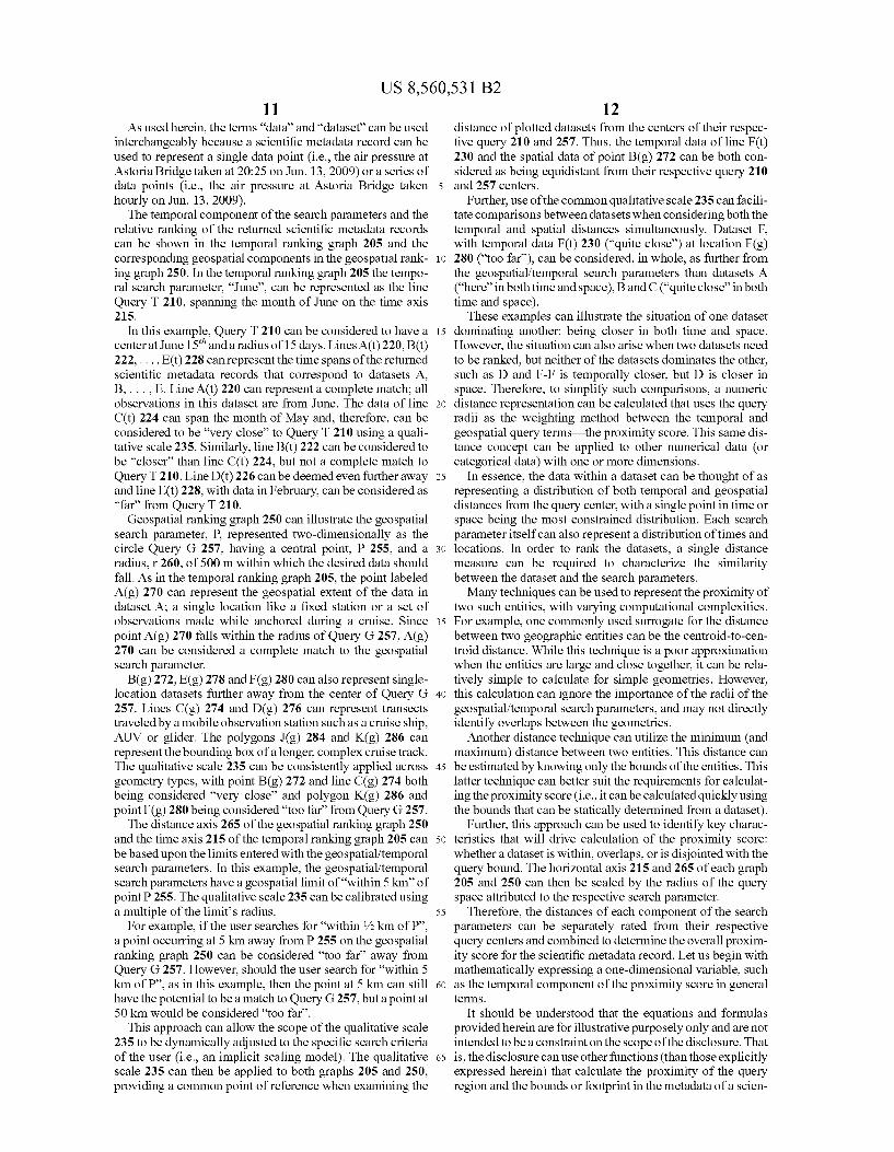
FIG. 2 is an illustration 200 of graphs 205 and 250 depict ing a visual representation of the scoring of the temporal and geospatial components of metadata records that match user entered search parameters in accordance with embodiments of the inventive arrangements disclosed herein. The graphs 205 and 250 shown in illustration 200 can visually represent operations/functions performed by the scienti?c dataset search tool 140 of system 100. The graphs 205 and 250 of illustration 200 can represent
the search parameters requesting results for “June within 5 km of P”, where P 255 is a speci?c location. Therefore, as discussed in FIG. 1, the dataset search tool can determine a set of scienti?c metadata records that have the potential to be relatively close to these search parameters based on a calcu lated proximity score. The proximity score of the components of these results can be visually illustrated by graphs 205 and 250, respectively.
US 8,560,531 B2 11
As used herein, the terms “data” and “dataset” can be used interchangeably because a scienti?c metadata record can be used to represent a single data point (i.e., the air pressure at Astoria Bridge taken at 20:25 on Jun. 13, 2009) or a series of data points (i.e., the air pressure at Astoria Bridge taken hourly on Jun. 13, 2009).
The temporal component of the search parameters and the relative ranking of the returned scienti?c metadata records can be shoWn in the temporal ranking graph 205 and the corresponding geospatial components in the geospatial rank ing graph 250. In the temporal ranking graph 205 the tempo ral search parameter, “June”, can be represented as the line Query T 210, spanning the month of June on the time axis 215.
In this example, Query T 210 can be considered to have a center at June 15th and a radius of 15 days. LinesA(t) 220, B(t) 222, . . . , E(t) 228 can represent the time spans of the returned
scienti?c metadata records that correspond to datasets A, B, . . . , E. Line A(t) 220 can represent a complete match; all observations in this dataset are from June. The data of line C(t) 224 can span the month of May and, therefore, can be considered to be “very close” to Query T 210 using a quali tative scale 235. Similarly, line B(t) 222 can be considered to be “closer” than line C(t) 224, but not a complete match to Query T 210. Line D(t) 226 can be deemed even further aWay and line E(t) 228, With data in February, can be considered as “far” from Query T 210.
Geospatial ranking graph 250 can illustrate the geospatial search parameter, P, represented tWo-dimensionally as the circle Query G 257, having a central point, P 255, and a radius, r 260, of 500 m Within Which the desired data should fall. As in the temporal ranking graph 205, the point labeled A(g) 270 can represent the geospatial extent of the data in dataset A; a single location like a ?xed station or a set of observations made While anchored during a cruise. Since point A(g) 270 falls Within the radius of Query G 257, A(g) 270 can be considered a complete match to the geospatial search parameter.
B(g) 272, E(g) 278 and F(g) 280 can also represent single location datasets further aWay from the center of Query G 257. Lines C(g) 274 and D(g) 276 can represent transects traveled by a mobile observation station such as a cruise ship, AUV or glider. The polygons J (g) 284 and K(g) 286 can represent the bounding box of a longer, complex cruise track. The qualitative scale 235 can be consistently applied across geometry types, With point B(g) 272 and line C(g) 274 both being considered “very close” and polygon K(g) 286 and point F(g) 280 being considered “too far” from Query G 257.
The distance axis 265 of the geospatial ranking graph 250 and the time axis 215 of the temporal ranking graph 205 can be based upon the limits entered With the geo spatial/temporal search parameters. In this example, the geospatial/temporal search parameters have a geospatial limit of “Within 5 km” of point P 255. The qualitative scale 235 can be calibrated using a multiple of the limit’s radius.
For example, if the user searches for “Within 1/2 km of P”, a point occurring at 5 km aWay from P 255 on the geospatial ranking graph 250 can be considered “too far” aWay from Query G 257. HoWever, should the user search for “Within 5 km of P”, as in this example, then the point at 5 km can still have the potential to be a match to Query G 257, but a point at 50 km Would be considered “too far”.
This approach can alloW the scope of the qualitative scale 235 to be dynamically adjusted to the speci?c search criteria of the user (i.e., an implicit scaling model). The qualitative scale 235 can then be applied to both graphs 205 and 250, providing a common point of reference When examining the
5
20
25
30
35
40
45
50
55
60
65
12 distance of plotted datasets from the centers of their respec tive query 210 and 257. Thus, the temporal data of line F(t) 230 and the spatial data of point B(g) 272 can be both con sidered as being equidistant from their respective query 210 and 257 centers.
Further, use of the common qualitative scale 235 can facili tate comparisons betWeen datasets When considering both the temporal and spatial distances simultaneously. Dataset F, With temporal data F(t) 230 (“quite close”) at location F(g) 280 (“too far”), can be considered, in Whole, as further from the geospatial/temporal search parameters than datasets A (“here” in both time and space), B and C (“quite close” in both time and space).
These examples can illustrate the situation of one dataset dominating another: being closer in both time and space. HoWever, the situation can also arise When tWo datasets need to be ranked, but neither of the datasets dominates the other, such as D and F-F is temporally closer, but D is closer in space. Therefore, to simplify such comparisons, a numeric distance representation can be calculated that uses the query radii as the Weighting method betWeen the temporal and geospatial query termsithe proximity score. This same dis tance concept can be applied to other numerical data (or categorical data) With one or more dimensions.
In essence, the data Within a dataset can be thought of as representing a distribution of both temporal and geospatial distances from the query center, With a single point in time or space being the most constrained distribution. Each search parameter itself can also represent a distribution of times and locations. In order to rank the datasets, a single distance measure can be required to characteriZe the similarity betWeen the dataset and the search parameters. Many techniques can be used to represent the proximity of
tWo such entities, With varying computational complexities. For example, one commonly used surrogate for the distance betWeen tWo geographic entities can be the centroid-to-cen troid distance. While this technique is a poor approximation When the entities are large and close together, it can be rela tively simple to calculate for simple geometries. HoWever, this calculation can ignore the importance of the radii of the geo spatial/temporal search parameters, and may not directly identify overlaps betWeen the geometries.
Another distance technique can utiliZe the minimum (and maximum) distance betWeen tWo entities. This distance can be estimated by knoWing only the bounds of the entities. This latter technique can better suit the requirements for calculat ing the proximity score (i.e., it can be calculated quickly using the bounds that can be statically determined from a dataset).
Further, this approach can be used to identify key charac teristics that Will drive calculation of the proximity score: Whether a dataset is Within, overlaps, or is disjointed With the query bound. The horizontal axis 215 and 265 of each graph 205 and 250 can then be scaled by the radius of the query space attributed to the respective search parameter.
Therefore, the distances of each component of the search parameters can be separately rated from their respective query centers and combined to determine the overall proxim ity score for the scienti?c metadata record. Let us begin With mathematically expressing a one-dimensional variable, such as the temporal component of the proximity score in general terms.
It should be understood that the equations and formulas provided herein are for illustrative purposely only and are not intended to be a constraint on the scope of the disclosure. That is, the disclosure can use other functions (than those explicitly expressed herein) that calculate the proximity of the query region and the bounds or footprint in the metadata of a scien

US 8,560,531 B2 13
ti?c dataset. Additionally, it is expected that minor variants and derivatives (Which are considered substantially similar to the equations beloW) be used in implemented systems. For example, minor variations and derivatives can represent opti miZations and adjustments suitable for a speci?c context of use and/ or administrator preferences.
Let Q Tm.” and QTmax represent the loWer and upper bounds of a one-dimensional variable, such as the query time range. Further, let dTml-n and dTmax represent the minimum and maxi mum times of the data in dataset d. For calculation purposes in the example of using time, all times can be translated into a monotonically increasing real number, for example “Unix time”. The equation beloW (Equation 1) can calculate dRml-n, the distance of dataset d’s minimum time from the temporal query “center” (i.e., the mean of QTml-n and QTmax), then scales the result by the siZe of the query “radius” (i.e., half its range).
((QTmaX — QTmin)/2 + QTmin)
(QTmax — QTmin)/2
= (ZdTmin — QTmax — QTmin)/ (QTmax — QTmin)
[ll dTmin — dRmin =
Similarly, Equation 2 can calculate dRmax, the “scaled time range distance” of the dataset’s maximum time.
Equation 3 can then calculate the overall temporal dis tance, dTdiSt, for the dataset from the query corresponding to the temporal search parameter.
dTdisr = [3]
0 dTmin 2 QTmins dTmax 5 QTmaX (A)
2%; dTmin 2 QTmin, dTmax > QTmaX (B)
2%; dTmin < QTmins dTmax 5 QTmaX (C)
W dTmin < QTmins dTmax > QTmaX (D) ZIdRMtZX — dRminl
(ldRmin + dRmaxl/ 2) — 1 dTmin > QTmin 0f dTmax < QTmax (E)
In Equation 3, case A can account for a dataset that is completely Within the query range; cases B, C, and D can account for a dataset that overlaps the query range above, beloW, and on both sides; and case E can account for a dataset that is completely outside of the query range.
Next, Equation 4 can represent the calculation of the tem poral component of the proximity score, dTS, for this dataset by applying a scaling function, s, to dTdiSt. The scaling func tion, s, can be used to convert the calculated distance from the query center, dTdiSt, into a numerical value.
For example, s can be expressed as (l00—f*dTdl-St), Where f can represent the maximum distance from the query center for a dataset to be considered “too far” on the qualitative scale 235. Thus, regardless of the value of f, a complete match can result in s:l00, since dTdiStIO; other results can be decreas ingly scaled With respect to dTdl-St and f.
‘in :5 (draw) [4]
Additionally, the geospatially/temporally proximate dataset search tool can be con?gured to alloW the scaling function, s, to be con?gurable for different users and/or dif ferent tasks.
5
20
25
30
35
40
45
50
55
60
65
14 The expression for a geospatial component can be similar
to that of the temporal component. Let C represent the center location 255 of the geospatial query 257 and r 260 the radius. The locations of the data Within a single dataset, d, can be represented by a single geometry, g. This geometry can be a point, line (or poly-line), or polygon. The variables dGml-n and dGmax can represent the minimum
and maximum distances of the geometry from C, using a distance measure such as Euclidean distance. Then, Equation 5 can be used to calculate the overall distance measure, dGdl-St.
0 dGmax i r [5]
(am /r — n2
2(dGmax — dGmin)/ ''
(dGmin + dGmax)/r — 1
(A)
dGdisr = dcmt-n s r, dcmax z r (B)
dGmin > r (C)
Case A of Equation 5 can represent When the dataset is completely Within the query radius; case B can represent When the dataset overlaps the query circle 257; and, case C can indicate that the dataset is completely outside the query circle 257.
Equation 6 can represent the calculation of the geospatial component of the proximity score, dGS, for dataset d by again applying the scaling function, s, to the calculated overall distance measure, dGdl-St.
d0: :S(dGdist) [6]
In Equation 7, the geospatial component, dGS, and the temporal component, dTS, can be combined to produce the proximity score, dPR, for the dataset. In this example, the geospatial and temporal components can be averaged.
dPR:(dGS+dTS)/(# of query components) [7]
In the above equation, the divisor is the number of number of query componentsiof Which in the provided example, equals 2 (space+time).
It should be noted that since each component of the prox imity score is scaled separately, the user can adjust the relative importance of each component With respect to their query by modifying the corresponding search parameters. That is, if in our example it is important for the datasets to be very close to the geospatial search parameter, then the user can reduce the value of the geospatial limit and/ or the value of f used in the scaling function, s, for the calculation of the geospatial com ponent of the proximity score, if alloWed.
It should be emphasiZed that nothing is unique about geospatial and/or temporal dimensions, and similar graphs and analysis can be performed for other search parameters. Additionally, the above equations can be utiliZed to determine a distance betWeen any numeric search parameter and use of geospatial and temporal values in examples are for illustrative purposes only and are not to be construed as a limitation of the disclosure.
FIG. 3 is a How chart ofa method 300 describing the basic operation of the scienti?c dataset search tool in accordance With embodiments of the inventive arrangements disclosed herein. Method 300 can be performed Within the context of system 100. Method 300 can begin in step 305 Where the scienti?c
dataset search tool can create the metadata records for the scienti?c datasets. Step 305 can be triggered manually or can occur automatically in response to a scheduled event (i.e., script).
Search parameters can then be received via the search tool user interface from the user in step 310. Then, in step 315, a

US 8,560,531 B2 15
results set of metadata records can be identi?ed that are related to the received search parameters.
For each record in the results set, a proximity score can be calculated with respect to the search parameters in step 320. Step 320 can utiliZe Equations 1-7 discussed in FIG. 2. It should be appreciated that the Equations 1-7 are provided to illustrate the concepts expressed herein and that derivatives and alternative calculations are to be considered within scope of the disclosure.
In step 325, the records of the results set can then be arranged in descending order by their calculated proximity score. The ordered results can be presented to the user as the proximate dataset results in step 330. Alternatively, the cal culated proximity score can be used to ?lter the results (as opposed to ordering them relative to each other).
FIG. 4 is a ?ow chart of a method 400 detailing the calcu lation of the proximity score in accordance with embodi ments of the inventive arrangements disclosed herein. Method 400 can be performed within the context of system 100, and/or in conjunction with method 300. Method 400 can further utiliZe the equations (Equations 1-7) discussed in FIG. 2. In method 400, geospatial and temporal parameters are focused upon, but it shouldbe understoodthe method 400 can function with any set (1 . . . N) of search parameters, as
de?ned herein. Method 400 can begin in step 405 where the scienti?c
dataset search tool can determine the temporal distance, dTdiSt, of a metadata record from the temporal search param eter. Step 405 can utiliZe Equations 1-3 from the discussion of FIG. 2. The temporal distance, dTdiSt, can then be converted into the temporal component of the proximity score using a scaling function, s, in step 410.
In step 415, the geospatial distance, dGdiSt, of the metadata record from the geospatial search parameter can be calcu lated. The geospatial distance, dGdiSt, can then be converted into the geospatial component of the proximity score using a scaling function, s, in step 420.
In step 425, the temporal and geospatial components canbe combined to create the proximity score for the metadata record. It can optionally be determined if the proximity score is less than or equal to Zero in step 430.
In one embodiment, when the proximity score is less than or equal to Zero, step 435 can execute where the metadata record can be removed from the results set (i.e., the metadata record is considered to be too far away from the geospatial/ temporal searchparameters to be of interest to the user). Upon completion of step 435 or when the proximity score is greater than Zero, processing of the other metadata records of the results set can continue in step 440.
The ?owchart and block diagrams in the Figures illustrate the architecture, functionality, and operation of possible implementations of systems, methods and computer program products according to various embodiments of the present invention. In this regard, each block in the ?owchart or block diagrams may represent a module, segment, or portion of code, which comprises one or more executable instructions for implementing the speci?ed logical function(s). It should also be noted that, in some alternative implementations, the functions noted in the block may occur out of the order noted in the ?gures. For example, two blocks shown in succession may, in fact, be processed substantially concurrently, or the blocks may sometimes be processed in the reverse order, depending upon the functionality involved. It will also be noted that each block of the block diagrams and/ or ?owchart illustration, and combinations of blocks in the block diagrams and/ or ?owchart illustration, can be implemented by special purpose hardware-based systems that perform the speci?ed
5
20
25
30
35
40
45
50
55
60
65
16 functions or acts, or combinations of special purpose hard ware and computer instructions.
What is claimed is: 1. A method for providing proximate dataset recommen
dations comprising: creating of a plurality of metadata records that correspond
to a plurality of datasets representing scienti?c data by a scienti?c dataset search tool, wherein said plurality of metadata records conform to a standardized structural de?nition, wherein values for data elements of a meta data record are contained within a corresponding
dataset; identifying at least one metadata record from the plurality
of metadata records having a value that is proximate to one or more user-entered search parameters, wherein
one of the search parameters is a temporal parameter, wherein proximity is determined with respect to a range represented by the corresponding user-entered search parameters;
calculating a proximity score for each identi?ed metadata record, wherein said proximity score expresses a rel evance of the corresponding dataset to the user-entered search parameters, wherein calculating the proximity score comprises calculating a temporal proximity score, wherein calculating the temporal proximity score fur ther comprises: determining a temporal distance, dTdl-St, from a central
point of the user-entered temporal search parameter for the dataset using the following formula or a varia tion or derivative thereof:
0 dTmin 2 QTmins dTmax 5 QTmax
(ldRml — n2 i dminz minsdmax> max 2mm - amt-u T QT T QT
(ldRminl — U2 dTdisr = dTmin < QTmin, dTmax i QTmax
ZIdRmax — dRminl
(WWI-1)2 +(|dRmaX|—1>2 ZIdRmax — dRminl
(ldRmin + dRmaXI/Z) — 1
dTmin < QTmins dTmax > QTmax
dTmin > QTmin 0r dTmax < QTmaxs
wherein QTml-n and QTmax represent the minimum and maximum bounds of the temporal search parameter range, dTml-n and d represent the minimum and maximum time values of the dataset, and dRml-n and dRmax represent the distance of dTml-n and d from the central point of the range; and
using the proximity score to ?lter or order metadata records to create a listing of dataset results.
2. The method of claim 1, further comprising: arranging the at least one identi?ed metadata record in
descending order by the calculated proximity rating, wherein said arranged metadata records create a listing of proximate dataset results; and
presenting the proximate dataset results within a user inter face.
3. The method of claim 1, wherein the user-entered search parameters comprise a geospatial parameter.
4. The method of claim 1, wherein the user-entered search parameters comprise a numeric range or a non-numeric parameter or keyword that can be translated to a numeric
range.
Tmax
Tmax

US 8,560,531 B2 17
5. The method of claim 1, wherein creating the plurality of metadata records further comprises:
accessing a data store storing a dataset; extracting from the dataset values for metadata record data
elements, Wherein the values comprise at least temporal bounds of the dataset, geospatial bounds of the dataset, and a unique identi?er for the proximate dataset result;
populating a neW metadata record With the extracted val ues; and
storing the neW metadata record in a data store accessible by the geospatially/temporally proximate dataset search tool.
6. The method of claim 1, Wherein calculating the proxim ity score for each identi?ed metadata record further com prises:
calculating the temporal proximity score for the identi?ed metadata record, Wherein said temporal proximity score is Weighted based upon a radius of a range expressed by the user-entered temporal search parameter;
calculating a geospatial proximity score for the identi?ed metadata record, Wherein said geospatial proximity score is Weighted based upon a radius of a range expressed by the user-entered geospatial search param eter; and
combining the temporal proximity score and the geospatial proximity score into the proximity score.
7. The method of claim 1, further comprising: converting the determined dTdl-St to the temporal proximity
score, dTS, using
‘in :5 (dram),
Wherein s is a scaling function that translates dTdl-St into a value Within a scale de?ned for the proximity score.
8. The method of claim 1, Wherein one of the search param eters is a geo spatial parameter, and Wherein calculating the proximity score comprises calculating a geospatial proximity score.
9. The method of claim 8, Wherein calculating the geospa tial proximity score further comprises:
determining a geo spatial distance, dGdiSt, from a central point of the user-entered geo spatial search parameter for the dataset using the folloWing formula or a variation or derivative thereof:
0 dcmax s r
(dam/r —1>2 2(dGmax — dGmin)/ ''
(dGmin + dGmax)/r — 1
dcdm = dGmin 5 r, dGmax 2 ''
dcmin > 1',
Wherein r is the radius of the range expressed by the user entered geospatial search parameter and dGml-n and dGmax are the minimum and maximum distances Within the dataset from the central point.
10. The method of claim 9, further comprising: converting the determined dGdl-St to the geospatial proxim
ity score, dGS, using
dGs:S(dGdist)>
Wherein s is a scaling function that translates dGtdl-St into a value Within a scale de?ned for the proximity score.
11. The method of claim 1, Wherein the proximity score utiliZes a scale having a loWer bound and an upper bound denoting a distant match and an exact match 0, respectively, to the user-entered geospatial and temporal search parameters.
20
25
30
35
40
45
50
55
60
65
18 12. The method of claim 11, further comprising: arranging the at least one identi?ed metadata record in
descending order by the calculated proximity score, Wherein said arranged metadata records create a listing of proximate dataset results, Wherein said arranging of the at least one identi?ed metadata record further com prises: and
comparing the calculated proximity score of the at least one identi?ed metadata record to the loWer bound of the scale.
13. The method of claim 1, Wherein the scienti?c dataset search tool is a component of a data analysis system.
14. The method of claim 1, Wherein the standardized struc tural de?nition of the plurality of metadata records utiliZes a hierarchical con?guration in Which metadata records are able to be nested Within a superior metadata record.
15. The method of claim 1, Wherein the user-entered search parameters include at least one limiting value for at least one of the user-entered search parameters, Wherein the calculated proximity score is further scaled With respect to the at least one limiting value.
16. A method for providing proximate dataset recommen dations comprising:
creating of a plurality of metadata records that correspond to a plurality of datasets representing scienti?c data by a scienti?c dataset search tool, Wherein said plurality of metadata records conform to a standardized structural de?nition, Wherein values for data elements of a meta data record are contained Within a corresponding
dataset; identifying at least one metadata record from the plurality
of metadata records having a value that is proximate to one or more user-entered search parameters, Wherein proximity is determined With respect to a range repre sented by the corresponding user-entered search param eters, Wherein one of the search parameters is a geospa tial parameter;
calculating a proximity score for each identi?ed metadata record, Wherein said proximity score expresses a rel evance of the corresponding dataset to the user-entered search parameters, Wherein calculating the proximity score comprises calculating a geospatial proximity score, Wherein calculating the geospatial proximity score further comprises: determining a geospatial distance, dGdiSt, from a central
point of the user-entered geospatial search parameter for the dataset using the folloWing formula or a varia tion or derivative thereof:
0 dcmax s r
(dam /r — n2
2(dGmax — dGmin)/ ''
(dGmin + dGmax)/r — 1
dcdm = dGmin 5 r, dGmax 2 ''
dGmin > 1',
Wherein r is the radius of the range expressed by the user-entered geospatial search parameter and dGml-n and dGmax are the minimum and maximum distances Within the dataset from the central point; and
using the proximity score to ?lter or order metadata records to create a listing of dataset results.
17. The method of claim 16, further comprising: converting the determined dGdl-St to the geospatial proxim
ity score, dGS, using

US 8,560,531 B2 19
wherein s is a scaling function that translates dGdl-St into a value Within a scale de?ned for the proximity score.
18. The method of claim 16, further comprising: arranging the at least one identi?ed metadata record in
descending order by the calculated proximity rating, Wherein said arranged metadata records create a listing of proximate dataset results; and
presenting the proximate dataset results Within a user inter face.
19. The method of claim 16, Wherein the user-entered search parameters comprise a temporal parameter.
20. The method of claim 16, Wherein the user-entered search parameters comprise a numeric range or a non-nu meric parameter or keyWord that can be translated to a numeric range.
21. A computer program product comprising: a non-transitory computer usable storage medium storing
computer usable program code executable by one or more processors, the computer usable program code comprising:
computer usable program code con?gured to create of a plurality of metadata records that correspond to a plu rality of datasets representing scienti?c data by a scien ti?c dataset search tool, Wherein said plurality of meta data records conform to a standardized structural de?nition, Wherein values for data elements of a meta data record are contained Within a corresponding
dataset; computer usable program code con?gured to identify at
least one metadata record from the plurality ofmetadata records having a value that is proximate to one or more user-entered search parameters, Wherein one of the search parameters is a temporal parameter, Wherein proximity is determined With respect to a range repre sented by the corresponding user-entered search param eters;
computer usable program code con?gured to calculate a
dTdisr =
proximity score for each identi?ed metadata record, Wherein said proximity score expresses a relevance of the corresponding dataset to the user-entered search parameters, Wherein calculating the proximity score comprises calculating a temporal proximity score, Wherein the computer usable code to calculate the tem poral proximity score is further con?gured to: determine a temporal distance, dTdiSt, from a central
point of the user-entered temporal search parameter for the dataset using the folloWing formula or a varia tion or derivative thereof:
0 dTmin 2 QTmin, dTmax i QTmax
(ldRml — n2 i dmz mm...» mm 2mm... - dRm-u T QT T QT
(mRmt-nl — n2 i dTmin < QTmin dTmax 5 QTmax ZIdRmaX — dRminl ,
dTmin < QTmin, dTmax > QTmax
dTmin > QTmin 0r dTmax < QTmaxs
Wherein QTml-n and QTmax represent the minimum and maximum bounds of the temporal search parameter range, dTml-n and dTmax represent the minimum and maximum time values of the dataset, and dRml-n and dRmax represent the distance of dTml-n and d from the central point of the range; and
Tmax
20 computer usable program code con?gured to use the prox
imity score to ?lter or order metadata records to create a listing of dataset results.
22. The computer program product of claim 21, the com 5 puter usable program code further comprising:
20
25
30
35
40
45
50
55
computer usable program code con?gured to convert the determined dTdl-St to the temporal proximity score, dTS, using
Wherein s is a scaling function that translates dTdl-St into a value Within a scale de?ned for the proximity score.
23. A computer program product comprising: a non-transitory computer usable storage medium storing
computer usable program code executable by one or more processors, the computer usable program code comprising:
computer usable program code con?gured to create of a plurality of metadata records that correspond to a plu rality of datasets representing scienti?c data by a scien ti?c dataset search tool, Wherein said plurality of meta data records conform to a standardiZed structural de?nition, Wherein values for data elements of a meta data record are contained Within a corresponding
dataset; computer usable program code con?gured to identify at
least one metadata record from the plurality ofmetadata records having a value that is proximate to one or more user-entered search parameters, Wherein proximity is determined With respect to a range represented by the corresponding user-entered search parameters, Wherein one of the search parameters is a geospatial parameter;
computer usable program code con?gured to calculate a proximity score for each identi?ed metadata record, Wherein said proximity score expresses a relevance of the corresponding dataset to the user-entered search parameters, Wherein calculating the proximity score comprises calculating a geospatial proximity score, Wherein the computer usable program code con?gured to calculate the geospatial proximity score further com prises:
computer usable program code con?gured to determine a geospatial distance, dGdl-St, from a central point of the user-entered geo spatial search parameter for the dataset using the folloWing formula or a variation or derivative thereof:
0 dcmax s r
(dam /r — n2
2(dGmaX — dGmin)/ 1‘
(dGmin + dGmax)/r — 1
dcdm = dGmin 5 r, dGmax 2 ''
dGmin > 1',
Wherein r is the radius of the range expressed by the user-entered geospatial search parameter and dGml-n and dGmax are the minimum and maximum distances Within the dataset from the central point; and
computer usable program code con?gured to use the prox imity score to ?lter or order metadata records to create a listing of dataset results.
24. The computer program product of claim 23, the com puter usable program code further comprising:
computer usable program code con?gured to convert the determined dGdl-St to the geospatial proximity score, dGS, using

US 8,560,531 B2 21
wherein s is a scaling function that translates dGdl-St into a value Within a scale de?ned for the proximity score.
25. A system comprising: one or more processors;
at least one non-transitory computer usable storage medium storing computer usable program code execut able by the one or more processors, the computer usable program code comprising:
computer usable program code con?gured to create of a plurality of metadata records that correspond to a plu rality of datasets representing scienti?c data by a scien ti?c dataset search tool, Wherein said plurality of meta data records conform to a standardized structural de?nition, Wherein values for data elements of a meta data record are contained Within a corresponding
dataset; computer usable program code con?gured to identify at
least one metadata record from the plurality of metadata records having a value that is proximate to one or more user-entered search parameters, Wherein proximity is determined With respect to a range represented by the corresponding user-entered search parameters, Wherein one of the search parameters is a geospatial parameter;
computer usable program code con?gured to calculate a proximity score for each identi?ed metadata record, Wherein said proximity score expresses a relevance of the corresponding dataset to the user-entered search parameters, Wherein calculating the proximity score comprises calculating a geospatial proximity score, Wherein the computer usable program code con?gured to calculate the geospatial proximity score further com prises:
computer usable program code con?gured to determine a geospatial distance, dGdl-St, from a central point of the
20
25
30
dTdisr =
22 user-entered geo spatial search parameter for the dataset using the folloWing formula or a variation or derivative thereof:
0 dTmin 2 QTmin, dTmax i QTmax
(ldRmaxl — U2 i d min - min, d max max 2mm - dRmt-u T > QT T > QT
(ldRminl — U2 i dTmin < QTmin dTmax 5 QTmax ZIdRmaX — dRminl ,
(WWI — n2 +(ldml-1)2 ZIdRmax — dRminl
(ldRmin + dRmaXI/Z) — 1
dTmin < QTmins dTmax > QTmax
dTmin > QTmin 0f dTmax < QTmaxa
Wherein r is the radius of the range expressed by the user-entered geospatial search parameter and dGml-n and dGmax are the minimum and maximum distances Within the dataset from the central point; and
computer usable program code con?gured to use the prox imity score to ?lter or order metadata records to create a
listing of dataset results. 26. The system of claim 25, the computer usable program
code further comprising: computer usable program code con?gured to convert the
determined dGdl-St to the geospatial proximity score, dGS, using
Wherein s is a scaling function that translates dGdl-St into a value Within a scale de?ned for the proximity score.
* * * * *