Seagrass - · PDF fileFifteen species of seagrass occur within the Great Barrier ... changes...
47
1 A Vulnerability Assessment for the Great Barrier Reef Seagrass Summary Diversity Fifteen species of seagrass occur within the Great Barrier Reef World Heritage Area (the World Heritage Area). Susceptibility The key elements for the survival of seagrass include: • Suitable light • Sediment • Salinity and temperature ranges • An appropriate level of nutrients • Minimal natural and human disturbance. Tolerance to different sediment, light and salinity regimes is known to vary between species, however thresholds for individual species are not well understood. Seagrass species with long-blade structures, large root systems and rhizomes can potentially withstand a greater depth of sediment deposition than shallow-rooted, small- leafed species because they can grow through deeper deposits. Smaller, shallow-rooted species can regrow rapidly on newly deposited sediments if conditions are right. Intertidal seagrass meadows are more vulnerable to increases in air and sea surface temperature, facing potential impacts such as burn-off and tissue damage. Deepwater seagrasses are less affected by changes in air and sea temperature due to the buffering effect of water depth. Seagrass meadows that grow in locations at the margins of their requirements are most susceptible to disturbances. Major pressures Seagrasses are facing major pressures from: • Poor water quality from catchment runoff (agricultural and urban/industrial) • Habitat loss and modification from increasing coastal development • Expansion in ports and shipping • Increased intensity of storms, floods and cyclones • Sea surface temperature and sea level rise. Cumulative pressures Much of the coastal seagrass habitat in the Great Barrier Reef World Heritage Area lies in sheltered coastal bays and estuaries that are also the centres of urban, port and coastal development. Seagrasses are vulnerable to changes in water quality from non-point (diffuse) sources. Their location in coastal areas where human actions and developments are concentrated, means they are also under significant cumulative pressure from local activities such as modification of coastal processes, dredging, reclamation and point source discharge. Seagrass habitat assessments concluded that seagrasses found in the Cairns/Trinity Inlet, Mourilyan, Townsville/Cleveland Bay, Abbot Point, and Gladstone harbour regions are the most at-risk from cumulative pressures 1,2, although individual pressures may have significant impacts on seagrasses in other locations. The Great Barrier Reef Outlook Report 2009 acknowledges that ultimately, if changes to the world's climate become too severe, no management actions will be able to climate-proof the Great Barrier Reef ecosystem, including seagrass. Information valid as of Feb 2012 Green turtle feeding on seagrass. Photo courtesy of www.seagrasswatch.org Seagrass meadow on Green Island reef flat, offshore Cairns, North Queensland taken 2 October 2009. Photo courtesy of www.seagrasswatch.org
Transcript of Seagrass - · PDF fileFifteen species of seagrass occur within the Great Barrier ... changes...

1
A Vulnerability Assessment for the Great Barrier Reef
Seagrass
SummaryDiversity Fifteen species of seagrass occur within the Great BarrierReef World Heritage Area (the World Heritage Area).
Susceptibility The key elements for the survival of seagrass include:• Suitable light• Sediment• Salinity and temperature ranges• An appropriate level of nutrients• Minimal natural and human disturbance.
Tolerance to different sediment, light and salinity regimesis known to vary between species, however thresholds forindividual species are not well understood. Seagrass species with long-blade structures, large rootsystems and rhizomes can potentially withstand a greaterdepth of sediment deposition than shallow-rooted, small-leafed species because they can grow through deeperdeposits. Smaller, shallow-rooted species can regrowrapidly on newly deposited sediments if conditions areright. Intertidal seagrass meadows are more vulnerable toincreases in air and sea surface temperature, facingpotential impacts such as burn-off and tissue damage.Deepwater seagrasses are less affected by changes in airand sea temperature due to the buffering effect of waterdepth. Seagrass meadows that grow in locations at the marginsof their requirements are most susceptible to disturbances.
Major pressures Seagrasses are facing major pressures from:• Poor water quality from catchment runoff (agricultural and urban/industrial)
• Habitat loss and modification from increasing coastal development
• Expansion in ports and shipping• Increased intensity of storms, floods and cyclones• Sea surface temperature and sea level rise.
Cumulative pressures Much of the coastal seagrass habitat in the Great BarrierReef World Heritage Area lies in sheltered coastal baysand estuaries that are also the centres of urban, port andcoastal development. Seagrasses are vulnerable tochanges in water quality from non-point (diffuse) sources.Their location in coastal areas where human actions anddevelopments are concentrated, means they are alsounder significant cumulative pressure from local activitiessuch as modification of coastal processes, dredging,reclamation and point source discharge. Seagrass habitat assessments concluded that seagrassesfound in the Cairns/Trinity Inlet, Mourilyan,Townsville/Cleveland Bay, Abbot Point, and Gladstoneharbour regions are the most at-risk from cumulativepressures1,2, although individual pressures may havesignificant impacts on seagrasses in other locations. The Great Barrier Reef Outlook Report 2009acknowledges that ultimately, if changes to the world'sclimate become too severe, no management actions willbe able to climate-proof the Great Barrier Reef ecosystem,including seagrass.
Information valid as of Feb 2012
Green turtle feeding on seagrass. Photo courtesy of www.seagrasswatch.org
Seagrass meadow on Green Island reef flat,offshore Cairns, North Queensland taken 2 October2009. Photo courtesy of www.seagrasswatch.org

2
Management in the Great Barrier Reef andadjacent areas in Queensland A direct legislative management tool for the protection ofseagrasses is the requirement for notification andpermission for plant removal under the Fisheries Act 1994(Queensland). Other planning and assessment Acts and Regulations areused to protect seagrass meadows from potentialdevelopment impacts, for example, through powers torefuse or manage particular activities, to declare protectedareas, or to place conditions on discharges or runoff.Examples of these tools are the Environment Protectionand Biodiversity Conservation Act 1999, the EnvironmentProtection (Sea Dumping) Act 1981, the Great BarrierReef Marine Park Act 1975 (as well its complementaryQueensland Marine Parks legislation) and the SustainablePlanning Act 2009 (Queensland). Implementation of legislative tools is supported bynational, state and local policies and guidelines that canspecify water quality criteria to protect aquatic ecosystemssuch as seagrass. Water quality management is applied toboth point and diffuse sources. For example, under theEnvironmental Protection Act 1994 (Queensland) pointsource facilities that discharge waters that may causeharm are assessed and licensed, and there are penaltiesfor non-compliance. Urban Stormwater Quality PlanningGuidelines 2010 are an example of diffuse pollutionmanagement for developed lands, and the Great BarrierReef Protection Amendment Act 2009 for agriculturalactivities. Ship-sourced pollutant management is managedwithin the framework of an international, national, stateand local implementation approach. This includes acommitment to a number of international conventions,legislation such as the Commonwealth Protection of theSea (Powers of Intervention) Act 1981, the TransportOperations (Marine Pollution) Act 1995 (Queensland) andthe Quarantine Act 1908.
Existing management actionsThe primary focus of actions to protect seagrass, asidefrom applying those tools identified above, is to improvewater quality entering the Great Barrier Reef. The ReefWater Quality Protection Plan 2009 sets targets forimprovement and is supported by the resources of theAustralian and Queensland governments, as well assignificant investment by industry, to implement changeand monitor progress. Other programs include education,awareness and action plans on what individuals can do tominimise their impacts on the environment such as theGreat Barrier Reef Climate Change Action Plan 2007-2012and the Reef Guardian program.
Great Barrier Reef Outlook Report 2009assessment Good. Changes in seagrass communities were reportedas appearing to be mainly due to natural cycles of declineand recovery, although influenced by runoff fromcatchments. However, since publishing of the GreatBarrier Reef Outlook Report 2009, some warning signshave emerged that require consideration:
• The Great Barrier Reef Second Report Card 2010found seagrass to be in poor condition with declines reported over the last four years.
• McKenzie et al 2011 report significant losses of seagrass in the areas directly affected by the path of Tropical Cyclone Yasi.3 They detail broader scale impacts of the 2010 –2011 wet season on seagrass meadows exposed to flooding and cyclones in the Great Barrier Reef. These impacts are on seagrass ecosystems already stressed following a number of major freshwater inflow years and extended periods ofcloud cover limiting growth periods.
• Seagrass meadows that had been consistently present for the past 15 years in Mourilyan Harbour4have been lost in recent years and substantial declines have occurred in the meadows adjacent to Cairns5, Townsville6, and Gladstone.7 Annual long-term monitoring programs all showed large declines in2010, with some locations showing declining trends in the recent years preceding this.
• McKenzie et al 2011 report that abundance of seagrasses south of Cooktown, while variable, has declined at monitored sites since 2009 (and earlier for some sites).3,8,9,10,11,12,13
Vulnerability assessment: High Defining a single vulnerability level to seagrasses at thescale of the Great Barrier Reef can be difficult due to the:• Nature of seagrass• Geographical scale of the Great Barrier Reef• Different species and habitats that support the growth of seagrass meadows
• Non-uniformity of pressures that meadows experience. For example, seagrass meadows located within portexpansion areas with approval for complete removal ofmeadows, have clearly a very high vulnerability,regardless of any offsets that may have been determinedto potentially compensate for their loss. Parts of the near shore coastal and intertidal environmentalong the urban or developed coast (south of Cooktown)are particularly exposed to poor water quality as well asother pressures, and, in some areas, repeated years ofexposure have resulted in declines in abundance ofseagrasses. Where the number of reproductive structures is poor, thereis insufficient seagrass remaining for successful vegetativeregrowth, or nearby meadows to provide recruitmentstock, the vulnerability assessment is high. There are alsoconcerns that with increasing pressures, the ability of thesystem to recover from recent losses may becompromised. However, in the Cape York Peninsularegion, both water quality and development pressures are,at present, low and meadows in this region have a lowvulnerability assessment. Climate change, whilst likely to affect all seagrassmeadows, is predicted to be most damaging to intertidaland shallow seagrass meadows.
A Vulnerability Assessment for the Great Barrier Reef Seagrass

3
A Vulnerability Assessment for the Great Barrier Reef Seagrass
It will take many years to address the poor water qualityentering the Great Barrier Reef, to improve practices thataffect water quality throughout the catchments adjacent tothe Reef, and then to see these improvements realised inthe Reef lagoon itself. Hence, a substantial level ofvulnerability remains, at least in the foreseeable future. The population growth in Australia is resulting in expansionof the urban footprint along the Queensland coast. Urbanexpansion leads to an increase in infrastructure andservices, and, unless well planned and implemented, canresult in significant impacts on the coastal environment.This can lead to changes to the flow of water across thelandscape, interrupted connectivity of waterways,disturbance of acid sulphate soils, sedimentation, reducedwater quality and drainage impacts as well as increasedvisitation impacts such as anchor and physical damage tomeadows from access.The resources boom in Queensland has resulted insignificant expansion of ports and shipping underway orproposed, including new ports, along the Great BarrierReef coast.14 Most involve direct and permanent loss ofseagrasses. Although as a percentage of the WorldHeritage Area they are small, some extensive areas ofcoastal and estuarine seagrasses occur in portenvironments due to their sheltered location.
Suggested actions to addressvulnerabilitiesCatchment runoffAt the scale of the Great Barrier Reef, the most significantresponse to improve the resilience for seagrass meadowsis to improve water quality. Therefore the most importantaction is to continue to implement the joint Australian andQueensland Government's Reef Water Quality ProtectionPlan to reduce pollutants released to receiving waters fromdiffuse sources. Actions to improve waterway stability,
riparian and wetland condition and the maintenance ofenvironmental flows are critical.For more localised (point source) and urban impactscontinued implementation of waste water managementremains important including:• Tertiary treatment technology and re-cycling• Urban storm water management through best practiceerosion and sediment control
• The application of water sensitive urban design techniques to new and existing urban land development.
Coastal developmentThe Australian and Queensland governments are workingtogether to undertake a comprehensive strategicassessment of the Great Barrier Reef World Heritage Areaand the adjacent coastal zone. The adequacy of theprotection for seagrass habitat in the Great Barrier ReefMarine Park will be an important component of thisassessment. Avoiding disturbance should always be the firstconsideration, but where, after careful assessmentconsideration, it cannot be avoided, environmental offsetsshould be required and applied to reduce other threats toseagrasses. Developers should consider the potential for shorelineretreat and subsequent movement of seagrass habitatinland, particularly under a climate change scenario, andfactor this in to all planning schemes to ensure the longterm viability of these habitats.
Understanding status and trends and requirements forecosystem healthIt is important to ensure management of seagrassmeadows is based on good science underpinned by aneffective research and monitoring program. Almost all thecurrent seagrass monitoring is on intertidal meadows andmuch of it in close proximity to ports. Despite this focusthe limits and tolerance of even intertidal seagrass speciesto various threats such as reduced light and increasednutrients are still not well understood. Very little is knownabout the population status, species diversity, ecologicalroles and/or pressures and thresholds for subtidal anddeepwater meadows and how close these species live tothe limits of their viability. A program to understand thedistribution and abundance of subtidal and deepwaterseagrasses should be implemented.
Climate changeThe broader national and global initiatives required toaddress climate change are not considered here. Effortsby the Great Barrier Reef Marine Park Authority(GBRMPA) are primarily aimed at understanding thevulnerability of the Great Barrier Reef ecosystems,including seagrass meadows, and helping to buildresilience to climate change in the ecosystem and thecommunities and industries that depend on it. Focusshould continue on actions to reduce threats from climatechange and improve the resilience of high-risk habitatsand species.
Seagrass meadow on Green Island reef flat offshore Cairns, NorthQueensland taken 17 March 2011. Photo courtesy of www.seagrasswatch.org

4
Seagrass
Background
Brief description of seagrass Some 30 seagrass species occur in Australian waters, half of which are found within the Great Barrier Reef.
14
Seagrasses are highly specialised flowering plants with roots, leaves and rhizomes that with the exception of one species (Enhalus acoroides) can live entirely immersed in seawater.
15,16,17 They are not a taxonomically unified group,
and not true grasses, but an ecological group that arose through convergent evolution.15,16,17
Seagrasses vary morphologically and ecologically, ranging from short-lived structurally small Halophila species to robust, long-lived structurally large species such as Enhalus acoroides.
18,19 They reproduce either asexually through
rhizome growth, or sexually via seeds from flowers fertilised by water-borne pollen. Seagrasses are habitats for diverse communities. They are primary producers, stabilise bottom sediments and are a store for carbon. Generally, the growth rates of seagrasses in the Great Barrier Reef is seasonally-dependent. The high-growth season is from June to November, with growth (both biomass and cover) peaking in spring and early summer. Later in summer, conditions generally become less favourable and growth slows, leading into the wet season when conditions can become unfavourable for growth (depending on the severity of a wet season) and growth can even cease. This can result in losses of whole meadows.
Geographical distribution Seagrasses are distributed widely along the Great Barrier Reef coast, especially in the protected sediment-covered areas.
20,21,22 They colonise a broad range of habitats - rivers, inlets, coastal, reef and intertidal, sub-tidal and
deepwater23,24
and also substrates - ranging from the nutrient rich soft mud adjacent to mangrove fringes to carbonate sands around cays on the outer Great Barrier Reef and some species even colonise coral reef platforms
18.
Whether or not a particular meadow is present or absent is determined by many factors including:
Suitable light levels
Sediment
Salinity and temperature ranges
An appropriate level of nutrients
Minimal natural and human disturbance regime. Notwithstanding those factors, seagrass distribution has been mapped or surveyed at varying scales, times and precision, and with different aims and methodologies, throughout the Great Barrier Reef. Seagrasses probably cover up to 5668 km
2 of the intertidal and shallow subtidal habitat in the Great Barrier Reef (or about 20 per cent of the
approximately 26, 000 km2 of the area seaward to a depth of about 15 metres) of which about 3063 km
2 has been
mapped. Figure 1 is a composite map covering findings of surveys conducted between 1984 and 2008 showing all the locations where seagrass was located.

5
Seagrass
Figure 1: Composite coastal seagrass distribution

6
Seagrass
Reports of where individual seagrass meadows have been surveyed and mapped are numerous. It is difficult to present them meaningfully here as meadows might have been extensive at a location in one year and absent in another or may not have been surveyed for some time. Survey reports are referenced below by region to assist people to find more detail:
Cape York Peninsula region.25,26,27
Extensive meadows have occurred in the Starke region, and in Bathurst, Princess Charlotte, Shelbourne and Margaret Bays. Seagrass communities are dominated by Halophila uninervis/H. ovalis and H. ovalis/H. spinulosa in the coastal intertidal and subtidal areas respectively.
Wet Tropics region. 25,28
Extensive meadows have occurred around Low Isles, Green Island and Hinchinbrook Channel. No regional species dominance has been evident. As many as eight species of seagrass have been reported as common throughout the region.
Burdekin Dry Tropics.16,29,30,31,32,33,34,35
Extensive meadows have occurred in Upstart, Cleveland and Bowling Green Bays. The main seagrasses in shallow waters near Townsville are Halophila ovalis, Halophila spinulosa, Halodule uninervis,Zostera muelleri subsp. capricorni and Cymodocea serrulata.
Mackay – Whitsunday.36,37,38,39,40
Between Bowen and Yeppoon the intertidal areas are dominated by Halodule uninervis and Zostera muelleri subsp. capricorni grow in intertidal areas.
Fitzroy.41,42,43,44,45
There are large seagrass areas in Shoalwater Bay and Port Curtis. Between the mainland and the Capricorn-Bunker Island Group, and in the shelter of the Swain Reefs deepwater Halophila meadows have been found. South of Yeppoon, Zostera and Halodule communities dominate intertidal areas, with Halophila communities dominating subtidal areas.
Mary-Burnett.46
Only the northern part of the regional catchment is within the Great Barrier Reef World Heritage Area. Large deepwater seagrass areas have occurred around Rodds Bay dominated by Halophila decipiens and H. Spinulosa. Extensive seagrass meadows also have occurred to the south of the Great Barrier Reef. Intertidal and shallow sub-tidal banks are dominated by Halodule uninervis and H. ovalis, with Zostera muelleri subsp. capricorni meadows in estuarine habitats.
Model outputs show the predicted likelihood of presence of seagrass for the coastal Great Barrier Reef (Figures 2 and 3).
2,47,48
Deepwater seagrass models are also available and meadows are estimated to cover ~40,000 square kilometres.
22
Deepwater surveys located vast areas of seagrass habitat at depths between 15 and 58 metres, composed primarily of Halophila species.
49,50 Beds were found on the mid-shelf off Townsville, and the inner-shelf Capricorn region and Turtle-
Howick Is group.

7
Seagrass
Figure 2: Probability of seagrass presence Cape York region during wet and dry seasons
47
Figure 3: Probability of seagrass presence Wet Tropics, Dry Tropics and Southern regions during wet and dry seasons
47

8
Seagrass
Population status in the Great Barrier Reef Seagrass ecosystems are in decline globally
51, and their rate of loss is accelerating
52. At the Great Barrier Reef-wide
scale, overall extent of seagrass meadows was considered to be relatively stable at the time of writing the Great Barrier Reef Outlook Report 2009. Few changes in extent had occurred over the preceding 20 years with only localised fluctuations observed inshore mainly due to natural cycles of decline and recovery although influenced by runoff from catchments.
14,53 Seagrass lost in several regions due to storms, flooding and cyclones
54 had recovered substantially
9,
while other meadows had expanded. Considering populations/groups of species, seagrass status was assessed as good. Observations suggested that there have been shifts in species composition in some seagrass meadows, but did not indicate any significant reef-wide changes.
22
Since publishing the 2009 Outlook Report however some warning signs have emerged:
The Great Barrier Reef Second Report Card 2010 finds seagrass to be in poor condition with declines reported over the last four years (P McGinnity, pers comm, 2012).
McKenzie et al report significant losses of seagrass in the areas directly affected by the path of Tropical Cyclone Yasi under the findings of the Intertidal Seagrass Marine Monitoring Program for 2011. In addition, there have been broad-scale impacts of the 2010 - 2011 wet season on seagrass meadows across the regions exposed to flooding and cyclones in the Great Barrier Reef (south of Cooktown). These impacts are on seagrass ecosystems that are already stressed following a number of years of major freshwater inflow and extended periods of cloud cover limiting growth periods.
Seagrass meadows present for the past 15 years in Mourilyan Harbour4 have been lost in recent years and
substantial declines have occurred in the meadows adjacent to Cairns5, Townsville
6, and Gladstone Harbour
7.
Annual long term monitoring programs all show large declines in 2010 with some locations also exhibiting declining trends over the last couple of years.
3
Cover of seagrass at a Great Barrier Reef-wide scale shows no evidence of long term sustained loss or gain. There is no consistent monitoring north of Cooktown but aerial surveys in the Princess Charlotte Bay region supports other evidence that seagrass in the northern Great Barrier Reef is stable, at least in terms of area. However, McKenzie et al further report that abundance south of Cooktown, while variable, has declined at monitored sites since 2009 (and earlier for some sites)
3,8,9,10,11,12,13 although the decadal trend is relatively stable.
A loss of meadows from surrounding or nearby regions, as was the case in the Mourilyan region, severely reduces recovery potential, as they serve as a regeneration source for regrowth. Seed banks or germination of seeds from nearby meadows will be more important in these cases. Repeated declines and recovery of meadows over the recent preceding years is likely to have reduced available stores
55, therefore the reproductive status of this region is considered
to be poor. 8,9,10,11,12,13
Recovery of seagrass meadows from impacts that have reduced them to their current state can take more than a decade.
31 Successful recovery is reliant on good conditions in future seasons, including sufficient light, and low levels of
pollutants, as well as integrity of the substrate available for recruiting to. Regional status reports are released each year on those meadows routinely monitored. Almost all the seagrass monitoring is on intertidal meadows. Despite this focus the limits and tolerance of even intertidal seagrass species to
reef intertidal(12 sites)
0
0.2
0.4
0.6
0.8
1
Ap
r-9
9
Oct
-99
Ap
r-0
0
Oct
-00
Ap
r-0
1
Oct
-01
Ap
r-0
2
Oct
-02
Ap
r-0
3
Oct
-03
Ap
r-0
4
Oct
-04
Ap
r-0
5
Oct
-05
Ap
r-0
6
Oct
-06
Ap
r-0
7
Oct
-07
Ap
r-0
8
Oct
-08
Ap
r-0
9
Oct
-09
Ap
r-1
0
Oct
-10
Ap
r-1
1
abu
nd
ance
(re
lati
ve t
o 9
5th
per
cen
tile
)
coastal intertidal(10 sites)
0
0.2
0.4
0.6
0.8
1
Ap
r-9
9
Oct
-99
Ap
r-0
0
Oct
-00
Ap
r-0
1
Oct
-01
Ap
r-0
2
Oct
-02
Ap
r-0
3
Oct
-03
Ap
r-0
4
Oct
-04
Ap
r-0
5
Oct
-05
Ap
r-0
6
Oct
-06
Ap
r-0
7
Oct
-07
Ap
r-0
8
Oct
-08
Ap
r-0
9
Oct
-09
Ap
r-1
0
Oct
-10
Ap
r-1
1
abu
nd
ance
(rel
ativ
e to
95
th p
erce
nti
le)
Figure 4: Generalised trends in seagrass abundance for coastal and reef intertidal habitat type relative to the 95th percentile (equally scaled)
3

9
Seagrass
various threats such as reduced light and increased nutrients are still not well understood. Very little is known about population status, ecological roles and/or pressures and thresholds for subtidal and deep meadows and how close these species live to limits of their viability. Intertidal seagrass status for 2010-2011 is summarised below and in Table 1.
Cape York Species composition is stable and follows seasonal trends at the one site on a fringing reef that has been monitored regularly since 2003
12 in a protected section of the bay adjacent to Archer Point, 15km south of Cooktown.
Wet Tropics Seagrass meadows appear to be relatively healthy, albeit dynamic with respect to biomass, area and species composition, with local and regional climate being the primary driver of change. However, seagrass cover in more southern sites of the region has been lower in recent years, and has been severely reduced following Cyclone Yasi
3.
Many of the meadows monitored in the region have low numbers of reproductive structures limiting capacity to reproduce after stress.
8,9,10,11,12,13
Seagrass habitat in Cairns Harbour and Trinity Inlet was reported in poor condition and in a highly vulnerable state in 2010.
5 Cairns Harbour meadows had been exhibiting a general downward trend for four to six years (depending on the
meadow) and in 2010 had been reduced to their smallest area and density recorded since the monitoring program began in 2001. A small shift in species presence in several of the meadows with a higher component of H. ovalis than previous years was noted. Baseline surveys pre-2001 had reported there were nearly 1,000 hectares of seagrass close to Cairns with a mixture of four species (Zostera muelleri subsp. capricorni, Halodule uninervis and Halophila ovalis were the most common). Previously extensive meadows of seagrass in the Mourilyan Harbour region monitored since 1993
56,57 have shown
declining trends over recent years and were reported to be in an extremely vulnerable state in 200958
. Three of the five meadows that were monitored over the period were completely absent in 2009 and the two remaining meadows showed significant decline. Surveys also indicated a complete species shift to the pioneering H.ovalis from the previously dominant Z. muelleri subsp. capricorni in one of the meadows. In 2010 almost all the Mourilyan Harbour meadows had disappeared with only an isolated patch of pioneering Halophila remaining.
4 Additionally, aerial surveillance conducted
outside of the Mourilyan Harbour monitoring area in 2009 could not find evidence of nearby meadows.
Burdekin Dry Tropics Seagrass status is reported as poor.
59 Abundance in the region had been good overall, but declined in recent years at
coastal and reef locations.13
Previously extensive meadows of seagrass in the Townsville Harbour region (monitored annually since 2007) underwent a third consecutive year of major decline to seagrass biomass (density) and area in 2010, remaining well below the peak levels seen in 2007 and 2008. Seagrasses in Townsville harbour are in a highly vulnerable state.
6 There are low numbers of reproductive structures indicating reduced resilience and capacity for
recovery.13
Mackay-Whitsunday Seagrass cover is variable throughout the region; however, all but one monitored site was in poor condition late in the 2010 monsoon season. Seagrass reproductive capacity is poor in the region, raising concerns about the ability of local seagrass meadows to recover from disturbances.
13 Subtidal meadows are not monitored. Deepwater seagrass
appeared relatively stable, but with inter and intra-annual variability at the local level.13
Fitzroy At coastal and estuarine locations, seagrass cover in the region has increased or is stable. There is a trend of decrease in seagrass cover at reef sites although they have had less than 10 per cent cover since monitoring started in 2007. There are low numbers of reproductive structures. The Shoalwater Bay site contains the most healthy coastal seagrass meadows along the urban coast of the Great Barrier Reef.
13
Ongoing monitoring of seagrass meadows in Port Curtis indicates that there are large areas of seagrass present, although following the floods of February 2011 the area had decreased to its lowest level since monitoring commenced in 2002.
7
10
Seagrass
Burnett-Mary Ongoing monitoring of coastal and subtidal seagrass meadows in Rodds Bay indicate that there are still large areas of seagrass present, although following the floods of February 2011 the area had decreased to its lowest recorded level since monitoring commenced in 2002.
7,60
Estuarine meadows monitored at Rodds Bay were in poor condition. There has been a decrease in seagrass cover since monitoring began in 2007 and no evidence of meadows could be found by late monsoon 2010. Seed banks and reproductive effort are in a poor state.
13
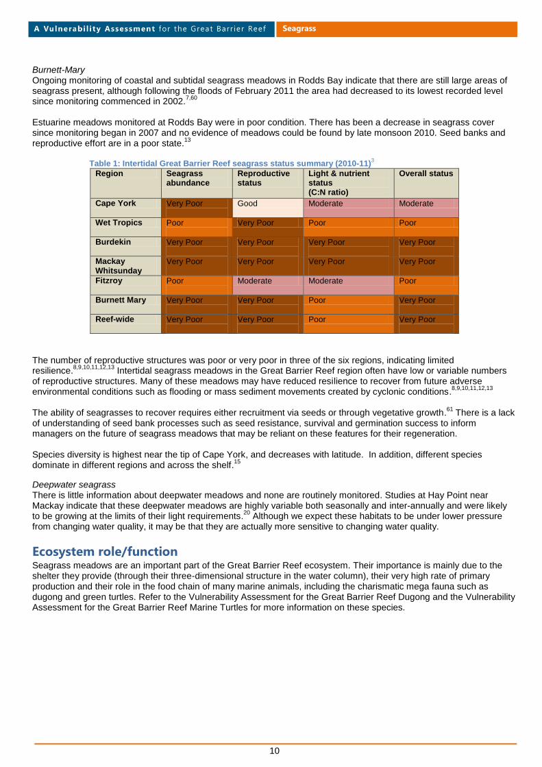
Table 1: Intertidal Great Barrier Reef seagrass status summary (2010-11)
3
Region Seagrass abundance
Reproductive status
Light & nutrient status (C:N ratio)
Overall status
Cape York Very Poor
Good Moderate Moderate
Wet Tropics Poor
Very Poor Poor Poor
Burdekin Very Poor
Very Poor
Very Poor
Very Poor
Mackay Whitsunday
Very Poor
Very Poor
Very Poor
Very Poor
Fitzroy Poor
Moderate Moderate Poor
Burnett Mary Very Poor
Very Poor
Poor Very Poor
Reef-wide Very Poor
Very Poor
Poor Very Poor
The number of reproductive structures was poor or very poor in three of the six regions, indicating limited resilience.
8,9,10,11,12,13 Intertidal seagrass meadows in the Great Barrier Reef region often have low or variable numbers
of reproductive structures. Many of these meadows may have reduced resilience to recover from future adverse environmental conditions such as flooding or mass sediment movements created by cyclonic conditions.
8,9,10,11,12,13
The ability of seagrasses to recover requires either recruitment via seeds or through vegetative growth.
61 There is a lack
of understanding of seed bank processes such as seed resistance, survival and germination success to inform managers on the future of seagrass meadows that may be reliant on these features for their regeneration. Species diversity is highest near the tip of Cape York, and decreases with latitude. In addition, different species dominate in different regions and across the shelf.
15
Deepwater seagrass There is little information about deepwater meadows and none are routinely monitored. Studies at Hay Point near Mackay indicate that these deepwater meadows are highly variable both seasonally and inter-annually and were likely to be growing at the limits of their light requirements.
20 Although we expect these habitats to be under lower pressure
from changing water quality, it may be that they are actually more sensitive to changing water quality.
Ecosystem role/function Seagrass meadows are an important part of the Great Barrier Reef ecosystem. Their importance is mainly due to the shelter they provide (through their three-dimensional structure in the water column), their very high rate of primary production and their role in the food chain of many marine animals, including the charismatic mega fauna such as dugong and green turtles. Refer to the Vulnerability Assessment for the Great Barrier Reef Dugong and the Vulnerability Assessment for the Great Barrier Reef Marine Turtles for more information on these species.

11
Seagrass
Ecosystem goods and services
Ecosystem goods and services
category
Services provided by the species, taxa or
habitat
Provisioning services (e.g. food, fibre, genetic
resources, biochemicals, fresh water) Crucial food for mega herbivores comprising more than 97 per cent of adult green sea turtle and dugong diet
62,63.
Food for many other species through direct grazing or detrital pathways for micro and meso herbivores (including amphipods, isopods, gastropods and copepods)
32,64, some
of which are part of marine food chains which lead to commercially and recreationally fished species
65..
Connectivity across the shelf66
. Larger predators also use seagrass meadows as foraging grounds
67.
Food, gathering, hunting and fishing sites for coastal people including Traditional Owners.
Cultural services (e.g. spiritual values,
knowledge system, education and inspiration, recreation and aesthetic values, sense of place)
As the major food for species such as dugong and green turtles seagrass has great importance to Traditional Owner interests in sea country management. An important cultural resource for recreation and spiritual fulfilment for Traditional Owners. Community spirit and activity through successful community monitoring program Seagrass Watch
68.
Supporting services (e.g. primary production,
provision of habitat, nutrient cycling, soil formation and retention, production of atmospheric oxygen, water cycling)
Key structural/foundational habitat, and nursery for many species
35,66,69,70,71. Some species are commercially
important, for example in the East Coast Trawl Fishery72
while others are valued by recreational and Indigenous fishers as catch or bait
65.
Major primary production73,74,75
Trapping organic nutrients
74
Nutrient cycling76
Regulating services (e.g. invasion resistance,
herbivory, pollination, climate regulation, disease regulation, natural hazard protection)
Carbon sequestration77
Baffle waves, reduce current, stabilise sediments, and protect against erosion and sediment re-suspension including during storms
78,79
Hydrodynamic modification15

12
Seagrass
Pressures influencing seagrass in the Great Barrier Reef Marine Park Pressures Catchment runoff, coastal development, and ports and shipping activities, are major pressures. These pressures influence the key drivers that are critical factors in the abundance, distribution and health of seagrass. Three of the key drivers are
15:
Light availability
Water quality (water clarity; sediment, nutrient and other pollutants; temperature)
Physical disturbance (natural and anthropogenic). Key seagrass habitats (rivers and inlets, coastal, reef and deepwater)
80 are more, or less, exposed to these pressures:
some are exposed at all times, others rarely. Much of the valuable coastal seagrass habitat in the Great Barrier Reef Marine Park and World Heritage Area lies in sheltered coastal bays and estuaries that are also the centres of urban, port and coastal development. While seagrasses are vulnerable to changes in water quality from non-point sources their location in these coastal areas of direct anthropogenic activity and development means they are also under significant pressure from local point source impacts. Assessment of habitats considered most at risk were those in the Cairns/Trinity Inlet, Townsville/Cleveland Bay, Abbot Point, Gladstone, and Mourilyan Harbour regions.
1,2
Monitoring has shown that light availability is influenced primarily by climatic factors such as day length, rainfall, wind speed and tidal amplitude.
5,7,12,43,44,58,81 However; water quality also affects light, particularly in the high risk area
identified in Figure 5. Different species respond to exposures in different ways and with different thresholds for tolerance to disturbance. A summary of the assessment of pressures is tabled below, however, for the detailed assessment and explanatory notes refer to Appendix 1.
13
Seagrass
Vulnerability assessment matrix The Great Barrier Reef Outlook Report 2009
14 identified a number of commercial and non-commercial uses of the
Marine Park, as well as climate change, coastal development and poor water quality from catchment run off as the key pressures reducing the resilience of the ecosystem. From the Great Barrier Reef Outlook Report 2009
15 it was considered that pressures such as climate change, coastal
development, catchment runoff and direct use are the key factors that influence the current and projected future environmental, economic and social values of the Great Barrier Reef. These pressures can impact directly and/or indirectly on habitats, species and groups of species to reduce their resilience. Using the vulnerability assessment framework adapted by Wachenfeld and colleagues
82, this assessment aims to provide an integration of social,
ecological, economic and governance information. For each key pressure in the Great Barrier Reef, exposure and sensitivity is assessed in relation to each other to reach a level of potential impact. The potential impact is then reassessed having considered the level of natural adaptive capacity that seagrasses have to respond to the pressure and the adaptive capacity that management has, or can apply, to reduce the potential impact from the pressure. This provides managers and stakeholders with an understanding of the key elements that each pressure can impose on the habitat, to reach a final assessment of the overall residual vulnerability of seagrasses to that particular pressure. This allows for the formulation of suggested actions to minimise the impact of the pressures which seagrass meadows are most vulnerable to.

14
Seagrass
Vulnerability assessment matrix summary for seagrass Exposed to
source of pressure
Degree of exposure to source of pressure
Sensitivity to source of pressure
Adaptive capacity – natural
Adaptive capacity – management
Residual vulnerability
Level of confidence in supporting evidence
Pre
ss
ure
s
Commercial tourism
Yes; locally
Low Low Good Good Low Good
Defence activities
Yes; locally
Low Low Good Good Low Good
Commercial fishing
Yes; locally
Low Low Good Good Low Good
Recreational fishing
Yes; locally urban coast
Low Low Good Good Low Good
Ports and shipping
Yes; locally (with potential for regional significance)
High within port limits
Very high e.g. for complete meadow removal
Poor e.g. for complete meadow removal
Good. Spatial confinement. Conditional approvals.
High for greenfield proposals and expanding sites
Good – effects of pollutants
Low outside port limits
Low e.g. distanced from activity
Moderate e.g. for medium density sediment plumes
Moderate. Some concern re removal and cumulative impact.
Low for areas outside port limits and influence of generated plumes
Poor – cumulative effects
Recreation (not fishing)
Yes; locally urban coast
Low Low Good Good Low Good
Traditional use
Yes; locally
Low Low Good Good Low Moderate
Climate change
Yes, entire region
High intertidal and shallow subtidal meadows
High e.g species close to tolerance limits now
Poor e.g. intertidal species unlikely to compensate for rise in temperature
Poor. Global action needed.
High particularly coastal zone.
Poor. Thresholds not known for many parameters. Uncertainty around climate predictions.
Low deepwater meadows
Lower e.g. species with wide tolerance ranges or buffered by deep water
Moderate. e.g able to recolonise
Moderate. Planning for shoreline retreat
Low deepwater meadows
Good. Growth rate greater than rising seas
Coastal development
Yes; developed coast and expanding
High along developed coast
High e.g. where meadows removed
Poor e.g. for complete meadow removal
Moderate. Cumulative impacts difficult to assess
Medium for much of the coast
Moderate
Low for remainder of coast
Moderate for polluted runoff
Moderate e.g. able to recolonise
Good Low for remote areas
Low for below threshold runoff
Good e.g. for temporary disturbance
Catchment runoff
Yes; seasonal flows as well as long term scale chronic pressure
High nearshore
High where pollutants carried by runoff are above thresholds
Poor if long duration, frequent, high pollutant levels
Moderate. Actions underway.
High. Addressing water quality will take many years.
Moderate
Medium. Distanced from river influence
Low dry season
Low for below thresholds
Good if temporary, low pollutant

15
Seagrass
Key concerns
Catchment runoff Catchment runoff and associated poor water quality is identified in the Great Barrier Reef Outlook Report 2009 as the second most significant pressure on the Great Barrier Reef after climate change. For seagrass it is probably the most significant. Seagrass monitoring at intertidal sites shows many sites are nutrient enriched, with seagrass tissue nitrogen levels in these regions increasing consistently over the last 15 years.
8,9,10,11,12,13
There are a number of broad categories of contributing factors that can reduce the quality of water entering the Great Barrier Reef, including from agriculture, coastal development, urban runoff, aquaculture, mining, shipping and boating, and changing conditions associated with climate change. Seagrass ecosystems that exist in estuarine and inlet, coastal or nearshore locations are directly exposed to catchment water pollution influences
83,84 and are consequently the most
at risk from land-based run-off. This area not only supports significant ecological communities, it is also the area of the Great Barrier Reef most used by fishing, ports, shipping, recreational visitors and commercial tourism operations — all sources of additional pressure. Whilst excellent progress towards targets for improving the quality of water to the Great Barrier Reef has been reported, it is acknowledged that it will take time for these achievements to translate into improved downstream marine condition. Monitored results are not yet showing evidence of change at the sites sampled within the Great Barrier Reef. This could be due to lag times in the system, natural variability masking any effect, or to insufficient changes to land management practices having yet been made.
The marine area most at risk of poor water quality (about eight per cent of the Great Barrier Reef waters) has been estimated by combining flood flow frequency
85 with a ranking of catchment
pollutant loads86,87
(Figure 5).
Coastal Development/Urban/industrial A growing human population leads to an increase in infrastructure and services and unless well planned and implemented, these constructions can impact and/or modify the coastal environment, changing the flow of water across the landscape, disturbing acid sulphate soils and causing sedimentation, reduced water quality and drainage impacts.
14 Increased boating and fishing, and
associated infrastructure and services that support this activity, like marinas, increase the risk of spills and physical damage through, for example, anchoring.
Port and shipping activities Port development, dredging, marinas, marine facility expansion and increased shipping traffic can cause loss of meadows
53,88,89
through direct removal, and also indirectly through changes to hydrodynamics, generation of sediment plumes that limit light for plant growth, and potentially smothering and/or burial. Developments are usually closely managed and generally the area of seagrass lost is small.
53 However the resources boom in
Queensland has resulted in significant expansion of ports and shipping. Proposals are underway for at least seven ports, or significant port expansions, along the Great Barrier Reef coast.
14
Most involve direct and permanent loss of seagrasses and the cumulative losses in particular are of concern.
Light availability Reductions in the light available to seagrasses for growth and photosynthesis are implicated in the large scale declines of seagrass that occurred in the Cairns/Trinity Inlet
5, Mourilyan Harbour
4, Townsville
6 and Gladstone
7. Some of the light
reduction is a consequence of a reduced tidal window due to natural cycles in daytime low tides and a reduction in solar irradiation. Turbidity and other factors associated with high rainfall and runoff
90 also contribute. Previous changes in
extent and abundance of intertidal meadows of Cairns Harbour and Trinity Inlet were linked to the degree and severity
Figure 5: Area most at risk of poor water quality

16
Seagrass
of exposure related stress.90
The decline is seagrass meadows in Mourilyan Harbour were also thought to be compounded by impacts from Cyclone Larry in 2006 and that these meadows had not yet had time to fully recover.
58
Research needs The limits and tolerance of seagrass species to various threats such as reduced light and increased nutrients are still not well understood.
Management of seagrass in the Great Barrier Reef Marine Park Management agencies with responsibilities for managing this habitat or impacts on this habitat within
the Great Barrier Reef World Heritage Area and the statutory and non-statutory tools that influence
the conservation management of this habitat. Legislation or policy Object as it applies to the habitat Tools for conservation Who administers it?
World Heritage Convention
Four natural heritage criteria with associated conditions of integrity. Criteria focus on: (i)geological processes and phenomena, including the evolution of the earth; (ii) ongoing ecological and biological processes; (iii) linked aesthetic components of the natural world; (iv) the biological diversity and habitats of threatened species.
Natural heritage Criteria iv states that the natural heritage asset must contain the most important and significant natural habitats for in situ conservation of biological diversity, including those containing threatened species of outstanding universal value from the point of view of science or conservation.
Provides State Parties to the Convention with definitions of natural and cultural heritage, measures for the protection of natural and cultural heritage; the means of administration and obligations of the Convention; funding arrangements, educational programs and reporting obligations.
United Nations Educational, Scientific and Cultural Organization (UNESCO)
Convention on Biological Diversity (CBD)
The three main objectives of the convention are:
The conservation of biological diversity
The sustainable use of the components of biological diversity
The fair and equitable sharing of the benefits arising out of the utilisation of genetic resources.
Provides State Parties to the Convention with global principles, objectives and obligations for the conservation of biodiversity Guides Australia's strategic planning to achieve national priority actions for biodiversity conservation through a range of objectives and targets for each.
United Nations Environment Programme (UNEP) – CBD Secretariat
Environment Protection and Biodiversity Conservation Act 1999
Legislative framework for environmental protection in Australia. There are seven relevant matters of national environmental significance for seagrass in the Great Barrier Reef:
world heritage properties
national heritage places
wetlands of international importance (listed under the Ramsar Convention)
listed threatened species and ecological communities
migratory species protected under international agreements
Commonwealth marine areas
Great Barrier Reef Marine Park
An action will require approval if the action has, will have, or is likely to have, a significant impact on a matter of national environmental significance.
Significant Impact Guidelines have been developed as a resource for the support of assessment and approvals process for actions.
An action likely to have a significant impact on seagrass could be deemed to be a 'controlled action' and require a greater level of scrutiny through an environmental impact assessment before consideration of approval.
Tools include the listing and regulation of threatened and protected species and communities, the preparation of
Department of Sustainability, Environment, Water, Population and Communities (SEWPaC).
Actions must be referred to the Minister and undergo an assessment and approval process.

17
Seagrass
Legislation or policy Object as it applies to the habitat Tools for conservation Who administers it?
recovery plans for threatened and protected species, the identification of key threatening processes and, where appropriate, the development of threat abatement plans (eg introduced pests).
Penalties for non-compliance.
Great Barrier Reef Marine Park Act 1975
Legislative framework for the management of the marine park.
Regulation of activities and development within the Marine Park. Zoning, assessment, issuing of permits and implementation of plans of management that collectively manage human activities. A planning framework can provide protection for seagrass by recognising areas of seagrass as protected, as marine coastal wetlands, or as areas of high ecological significance, or have desired outcomes for environmental objectives including indirectly by managing runoff and river flows. Special Management Areas can be created. Illegal to discharge waste into the Great Barrier Reef Marine Park without a permit. Fees for sewage water discharges. Policy development. Regular reporting requirements. Penalties for non-compliance.
Great Barrier Reef Marine Park Authority (GBRMPA)
Environment Protection (Sea Dumping) Act 1981
Provides for the protection of the environment by regulating dumping at sea, incineration at sea and artificial reef placements
Assessment, issuing of permits. There are existing approved dumping grounds for spoil within the Great Barrier Reef. Many of these dumping grounds have been used repeatedly for a number of years. Sites were initially selected to minimise impacts on sensitive areas (including seagrass meadows) and are carefully managed to ensure any adverse effects are prevented or minimised.
GBRMPA
Commonwealth Protection of the Sea (Powers of Intervention) Act 1981
Gives force to the Australian Government obligation to prepare for, and respond to, incidents of ship-sourced oil and chemical pollution.
Authorises taking of measures, as the Authority considers necessary to prevent, mitigate or eliminate any relevant danger.
Australian Maritime Safety Authority (AMSA)
Quarantine Act 1908 Management of ballast water Prevention of introduction of marine pests
Reduce the risk of introducing harmful aquatic organisms
Australian Quarantine and Inspection Service (AQIS)
Fisheries Act 1994 (Qld)
The act provides the framework to protect and conserve fisheries resources while maintaining profitable commercial and enjoyable recreational fishing sectors.
The destruction, damage or disturbance of marine plants without prior approval from Fisheries Queensland is prohibited.
Provides for declaration of Fish Habitat Areas and their protection from physical disturbance associated with coastal development
91,92.
Notification and permit requirements for marine plant removal.
Fish Habitat Management Operational Policy
93
East Coast Otter Trawl plan.
Regional plans.
Queensland State Government
Coastal local governments and port managers are entering into partnerships with the Queensland Government to manage protected marine plants in their areas. Fish habitat management strategies are developed jointly and enable long-term

18
Seagrass
Legislation or policy Object as it applies to the habitat Tools for conservation Who administers it?
Dugong Protection Areas Penalties for non-compliance
management under a self-assessable code.
Great Barrier Reef Protection Amendment Act 2009 (Qld)
Queensland Government Reef Regulations
Requires farmers in high risk catchments (Burdekin Dry Tropics, Wet Tropics and Mackay Whitsundays) to reduce the risk of pollutant runoff from their land.
Includes preparation of Environmental Risk Management Plans, as well as increased documentation and reporting requirements.
Queensland State Government
Marine Parks Act 2004 (Qld)
As for Great Barrier Reef Marine Park Act 1975 complementary management for Queensland waters.
As for Great Barrier Reef Marine Park Act and Regulations.
Queensland State Government
Environmental Protection Act 1994 (Qld)
To protect Queensland’s environment while allowing for development that improves the total quality of life, both now and in the future, in a way that maintains the ecological processes on which life depends (ecologically sustainable development).
Primary pollution control legislation with definitions of environmental harm. Water quality for the protection of aquatic ecosystems.
Assessment, permits and licensing, conditions for development and environmentally relevant activities. Include mining activities or an activity prescribed under the regulations (where a contaminant will or may be released into the environment when the activity is carried out and the release will or may cause environmental harm). Activities include aquaculture and intensive animal industry activities (feedlots, pig and poultry farming); chemical, coal and petroleum product activities; water treatment services (sewage and water); extractive activities; transport and maritime services; waste management and a series of miscellaneous activities. Many of the activities are sources of wastewater.
Queensland State Government Local Councils
Best Practice Standards and Guidelines
for planning, design and operation of sewage, and wastewater collection, transport treatment, disposal and reuse Penalties for non-compliance
Water Act 2000 (Qld) To advance sustainable management and efficient use of water and other resources by establishing a system for the planning, allocation and use of water.
Governs matters to do with local Government sewerage and water supply infrastructure.
Water resource plans and Resource Operation Plans. Requires consideration of environmental flow and water quality needs for protection of natural ecosystems in decision making. Licensing and allocation system. Penalties for non-compliance.
Queensland State Government
Plumbing and Drainage Act 2002 (Qld)
Water quality Deals with plumbing, drainage and on-site sewerage facilities. Specifies design requirements for facilities with a capacity of 21 or less equivalent persons.
Queensland State Government
Environmental Protection (Waste Management Regulation) 2000 (Qld)
To clarify waste management practices in Queensland and provide improved environmental safeguards.
Regulation to prohibit unlawful disposal of waste.
Developed in conjunction with local government and industry, the legislation
Queensland State Government

19
Seagrass
Legislation or policy Object as it applies to the habitat Tools for conservation Who administers it?
will benefit communities through safer disposal practices and cost savings from improved planning and management of waste services.
There are particular waste streams which are hazardous to the environment or to human health. These Hazardous Wastes are known in Queensland as Regulated Wastes and are controlled by additional specific legislation.
Sustainable Planning Act 2009 (Qld)
To seek to achieve ecological sustainability by— (a) managing the process by which development takes place, including ensuring the process is accountable, effective and efficient and delivers sustainable outcomes; and (b) managing the effects of development on the environment, including managing the use of premises; and (c) continuing the coordination and integration of planning at the local, regional and State levels.
Establishes process for land-use planning and development assessments. Identifies state legislation that may be triggered by development assessments and the process by which developments must be assessed against each piece of legislation. Regional plans identify:
Desired regional outcomes
Policies and actions for achieving these desired regional outcomes
The future regional land use pattern
Regional infrastructure provision to service the future regional land use pattern
Key regional environmental, economic and cultural resources to be preserved, maintained or developed.
A planning framework can provide protection for seagrass by recognising areas of seagrass as protected, as marine coastal wetlands, or as areas of high ecological significance, or set desired outcomes for environmental objectives including indirectly through managing runoff and river flows. Assessment, permits, licensing and conditions. Penalties for non-compliance
Queensland State Government
Nature Conservation Act 1992 (Qld)
To achieve conservation of nature through an integrated and comprehensive conservation strategy for the whole of the State
Involves (among other things) the following—
Dedication and declaration of protected areas
Management of protected areas
Ecologically sustainable use of protected wildlife and areas.
Provides for the preparation of Conservation Plans for native wildlife and their habitat under Ministerial discretionary powers.
Penalties for non-compliance.
Queensland State Government
Coastal Protection and Management Act 1995
(Qld)
(a) provide for the protection, conservation, rehabilitation and management of the coastal zone, including its resources and biological diversity;
Provides for development of State and Regional Coastal Management Plans with specific policies for coastal management issues.
Queensland State Government

20
Seagrass
Legislation or policy Object as it applies to the habitat Tools for conservation Who administers it?
and (b) have regard to the goal, core objectives and guiding principles of the National Strategy for Ecologically Sustainable Development in the use of the coastal zone; and (c) ensure decisions about land use and development safeguard life and property from the threat of coastal hazards; and (d) encourage the enhancement of knowledge of coastal resources and the effect of human activities on the coastal zone.
Designation of areas of high ecological significance managing coastal use, development and nature conservation. A planning framework can provide protection for seagrass by recognising areas of seagrass as protected, as marine coastal wetlands, or as areas of high ecological significance, or have desired outcomes for environmental objectives including indirectly by managing runoff and river flows.
Standards for wastewater discharge
Transport Operations (Marine Pollution) Act 1995 (Qld)
To protect Queensland’s marine and coastal environment by minimising deliberate and negligent discharges of ship-sourced pollutants into coastal waters, and for related purposes.
Gives effect to the MARPOL and OPRC conventions.
Aims to protect Queensland’s marine and coastal environment from adverse effects of ship-sourced pollution.
Queensland State Government
Vegetation Management Act 1999 (Qld)
Designed to manage broad scale vegetation clearing, one of the key activities responsible for water quality decline.
Progressively reduced clearing rates through to 2006 when broad scale clearing was effectively halted. Legislated buffer distances for different stream orders. Penalties for non-compliance.
Queensland State Government
Local Government Act 1993
Providing a legal framework for an effective, efficient and accountable system of local government in Queensland. Various roles including establishment of laws, planning, waste and stormwater management.
Policies, principles and plans in relation to Local Government operations. Most wastewater (excluding stormwater) in Queensland is treated at sewage treatment plants that are essentially a Local Government responsibility with licensing requirements for quality of discharge water.
Planning codes.
Local Councils
Reef Water Quality Protection Plan
Collaborative program of coordinated projects and partnerships designed to improve the quality of water in the Great Barrier Reef though improved land management in reef catchments. Focus is on reducing the load of diffuse agricultural sources of pollutants which account for more than 80 per cent of the load of nutrient and sediment delivered to Great Barrier Reef waters.
Improved land management. Education. Capacity building. Research and monitoring.
Joint Australian and Queensland Government initiative.
United Nations Convention on the Law of the Sea 1982, International Convention for the Prevention of Pollution
Part of the management framework for shipping activities.
A number of international and national management arrangements, conventions and obligations apply to shipping throughout all Australian waters, including the Great Barrier Reef that are implemented through
Various. Nationally – AMSA
State - Queensland
State Government

21
Seagrass
Legislation or policy Object as it applies to the habitat Tools for conservation Who administers it?
from Ships 1973 and the 1978 Protocol (MARPOL 73/78), International Convention on Oil Pollution Preparedness, Response and Cooperation (OPRC 90), and International Convention for the Control and Management of Ships Ballast Water and Sediments 2004 and others
Australian law.
National System for the Prevention and Management of Marine Pest Incursions
To reduce the risk of harmful aquatic organisms and pathogens being introduced by ships entering ports
AQIS
National Plan to Combat the Pollution of the Sea by Oil and Other Noxious and Hazardous Substances
Framework for ship-sourced oil and chemical spill response throughout Australia.
Implemented through various national and state level contingency plans, including the Queensland Coastal Contingency Action Plan. Most port authorities have individual Oil Spill Contingency Plans. A Great Barrier Reef and Torres Strait Vessel Traffic Service monitors vessel movements and provides ship traffic information, navigational assistance and maritime safety information to vessels.
Nationally –AMSA
State - Queensland
State Government
Sewage Discharge Policy 2005
Water quality Guiding principles and permitting requirements to minimise potential impacts of treated sewage discharges from marine outfalls on the Marine Park.
GBRMPA
Environmental Impact Management Policy and Dredging and Spoil Disposal Policy.
Sensitive environments defined and include seagrass
Dredging and material placement carefully managed to ensure any adverse effects such as degraded water quality, decreased availability light, releasing toxicants and/or smothering
53,88,89 are prevented or confined to areas away from sensitive environments.
GBRMPA
Great Barrier Reef Marine Park Zoning Plan 2003
A multiple-use marine protected area management tool that protects biodiversity by the regulation of activities within the Great Barrier Reef Marine Park
The Representative Area Program that provided the basis for Zoning Plan spatial planning decisions, established 70 broad-scale habitats, or bioregions and as such provides the Marine Park with an approach to ecosystem-based management. 34 per cent of the Marine Park is zoned as Marine National Park (green) or Preservation (pink) in which no extractive activities are permitted. Penalties for non-compliance.
GBRMPA
Environmental Protection (Water) Policy 2009 (Qld)
Achieving water quality fit for purpose including protection of aquatic ecosystems.
Framework for developing environmental values, management goals and water quality objectives. Application through planning, assessment, permits, licensing and conditions.
DERM

22
Seagrass
Legislation or policy Object as it applies to the habitat Tools for conservation Who administers it?
State Planning Policy 4/10 for Healthy Waters; Urban Stormwater: Quality Planning Guidelines 2010 and Codes of Practice (Qld)
To ensure that development for urban purposes, including community infrastructure, is planned, designed, constructed and operated to manage stormwater and waste water in ways that protect prescribed environmental values.
Seagrass can be identified as areas of high ecological value and hence water objectives are set to achieve their ecosystem protection. Establishes standards and best practice.
Queensland State Government Local Councils
Water Quality Guidelines
94,95
(Cwth & Qld)
Water quality for the protection of aquatic ecosystems.
Trigger values for protection of aquatic environments
GBRMPA Queensland State Government
Water quality improvement plans
(WQIPS)
Non legislative Between 2002 and 2009 many plans were developed along the Great Barrier Reef catchment. These WQIPS or Healthy Waterways Plan's environmental values and water quality objectives are now being scheduled into legislation under the Environmental Protection (Water) Policy 2009
Community driven through Natural Resource Management (NRM) Bodies. Townsville City Council. Voluntary practice uptake for improvements.
Queensland Coastal Plan and Regional Coastal Management Plans
Delivers a vision and direction for coastal management in Queensland.
Addresses major challenges associated with protecting the coast for future generations — recognising, planning for and managing the long-term impacts of natural events and human activities. Amongst other things identifying:
Areas of state significance for coastal management
Targets for improving sewage treatment works that discharge to coastal waters
Strong support for:
Protecting coastal wetlands
Retaining natural landscape values of the coast
Retaining and managing vegetation in riparian corridors
Rehabilitating, restoring and enhancing degraded coastal resources
Sharing information
Future urban development on the coast to be in existing townships
Strong performance criteria and justification for:
New canals and dry land marinas
Further development in erosion prone areas
Reclamation in coastal waters
Planning to adapt to climate change and sea level rise.
Queensland State Government
Regional NRM plans Management of natural resources. Community plans, capacity building and education around biodiversity, and partnerships to enhance biodiversity.
NRM bodies
Queensland Wetlands Program
Long-term conservation and management of wetlands
WetlandInfo – a synthesis of information on wetlands and their management Process for setting desired outcomes and management goals Rehabilitation guidelines
Queensland State Government Local Government
Climate Change Action Plan 2007-2012 and
Programs and actions to reduce threats from climate change and improve the resilience of high-risk
Development and implementation of tools (e.g. the emissions calculator) and systems for reef-based industries to
GBRMPA led but partnerships

23
Seagrass
Legislation or policy Object as it applies to the habitat Tools for conservation Who administers it?
Tourism Climate Change Action Strategy 2009-2012
habitats and species reduce greenhouse gas emissions, improve efficiencies and assist industry to be more resilient to the impacts of climate change
Great Barrier Reef Biodiversity Conservation Strategy 2012
GBRMPA
Informing the Outlook for Great Barrier Reef Coastal Ecosystems 2012
Program explores how the inshore marine, coastal and catchment ecosystems are all interconnected and reliant on one another for their functions.
Outcomes will raise awareness and inform decision makers, investors and community on the implications to the Great Barrier Reef ecosystems of decisions made about coastal development.
GBRMPA
Reef Guardian Program - councils, schools, farmers and graziers, Eye on the Reef, Eco certification program for high standard tourism operators, Pro-Vision Reef Stewardship for fisheries
To recognise the role of local governments, industries and community in addressing water quality issues. Programs include elements of understanding the vulnerability of the Great Barrier Reef and helping to build resilience to climate change in the ecosystem and the communities and industries that depend on it
Educating and partnering with people in programs that improve people's understanding of how things they do can affect the Great Barrier Reef, and what can be done to minimise those effects. Program designed to recognise and foster environmental stewardship for the Great Barrier Reef from local government, industries and the general community. Some of the indirect threats to seagrass can be minimised through these types of program.
Encourages best management practice in all activities, targeting those that could have effects on the Great Barrier Reef.
GBRMPA/Council, schools, farmers and graziers partnerships, Independent audit for tourism certification program.
Pollution control programs
To reduce the generation or accumulation of pollutants at the source.
Focus on education, prevention and regulation
Various
Seagrass-Watch monitoring program
Raises awareness on the condition and trend of nearshore seagrass ecosystems and provides an early warning of major coastal environment changes
In 2011 there were 58 monitored sites in the Great Barrier Reef World Heritage Area.
Queensland State Government
24
Seagrass
References 1. Rasheed, M.A., Taylor, H.A., Coles, R.G. and McKenzie, L.J. 2007, Coastal seagrass habitats at risk from human activity in the Great
Barrier Reef World Heritage Area: review of areas to be targeted for monitoring. Report to the Marine and Tropical Sciences Research Facility, Reef and Rainforest Research Centre Limited, Cairns.
2. Grech, A., Coles, R. and Marsh, H. 2011, A broad-scale assessment of the risk to coastal seagrasses from cumulative threats, Marine Policy 35(5): 560-567.
3. McKenzie, L.J., Waycott, M. and Collier, C. (in press), Rescue Marine Monitoring Program: intertidal seagrass, annual report for the sampling period 1st July 2010 – 31st May 2011, Department of Employment, Economic Development and Innovation (Fisheries Queensland), Cairns.
4. Fairweather, C., McKenna, S. and Rasheed, M. 2011, Long-term seagrass monitoring in the Port of Mourilyan: November 2010, Department of Employment, Economic Development and Innovation (Fisheries Queensland), Cairns, viewed 27/04/2012, <http://www.seagrasswatch.org/Info_centre/Publications/pdf/meg/Fairweather_et_al_2011b.pdf>.
5. Fairweather, C.L., McKenna, S.A. and Rasheed, M.A. 2011, Long term seagrass monitoring in Cairns Harbour and Trinity Inlet - December 2009 and 2010, Department of Employment, Economic Development and Innovation (Fisheries Queensland), Cairns, viewed 27/04/2012, <http://www.cairnsport.com.au/files/pdf/Cairns%20Long%20Term%20Seagrass%20Monitoring.pdf>.
6. Taylor, H.A. and Rasheed, M.A. 2011, Port of Townsville long-term seagrass monitoring: October 2010, Unpublished report by Department of Employment, Economic Development and Innovation, Northern Fisheries Centre, Cairns.
7. Sankey, T.L. and Rasheed, M.A. 2011, Gladstone permanent transects seagrass monitoring sites - February and March 2011 update, Department of Employment, Economic Development and Innovation, Brisbane.
8. McKenzie, L.J., Mellors, J., Waycott, M., Udy, J. and Coles, R.G. 2006, Intertidal seagrass monitoring, in Water Quality and Ecosystem Monitoring Program: Reef Water Quality Protection Plan: final report CRC Reef Research Centre, Townsville, pp. 230-278.
9. McKenzie, L.J., Mellors, J. and Waycott, M. 2007, Great Barrier Reef Water Quality Protection Plan Marine Monitoring Program: intertidal seagrass annual report for the sampling period 1 September 2006 - 31 May 2007, Department of Primary Industries and Fisheries, Cairns, viewed 27/04/2012, <http://www.rrrc.org.au/intranet/downloads/MMP-Intertidal-Seagrass-Report-0607.pdf>.
10. McKenzie, L.J., Mellors, J. and Waycott, M. 2008, Great Barrier Reef Water Quality Protection Plan Marine Monitoring Program: intertidal seagrass final report for the sampling period 1 September 2007-31 May 2008, Department of Primary Industries and Fisheries, Cairns, viewed 27/04/2012, <http://www.rrrc.org.au/mmp/downloads/DPI-McKenzie-L-et-al-2008-Intertidal-seagrass-monitoring.pdf>.
11. McKenzie, L.J. and Unsworth, R.K.F. 2009, Reef Rescue Marine Monitoring Program: intertidal seagrass final report for the sampling period 1 September 2008 - 31 May 2009, Department of Employment, Economic Development and Innovation (Fisheries Queensland), Cairns, viewed 27/04/2012, < http://www.rrrc.org.au/mmp/downloads/113a_FQ_Intertidal_seagrass_2008-09_FINAL-REPORT.pdf>.
12. McKenzie, L.J., Unsworth, R. and Waycott, M. 2010, Reef Rescue Marine Monitoring Program: intertidal seagrass annual report for sampling period 1 September 2009 - 31 May 2010, Department of Employment, Economic Development and Innovation (Fisheries Queensland), Cairns, viewed 27/04/2012, <http://www.rrrc.org.au/mmp/downloads/113a_DEEDI--JCU_final-annual-report_2009-10.pdf>.
13. Department of the Premier and Cabinet 2011, Reef Water Quality Protection Plan technical report baseline 2009, Reef Water Quality Protection Plan Secretariat, Department of the Premier and Cabinet, Brisbane, viewed 27/04/2012, < http://www.reefplan.qld.gov.au/measuring-success/report-cards/assets/technical-report.pdf >.
14. Great Barrier Reef Marine Park Authority 2009, Great Barrier Reef Outlook Report 2009, Great Barrier Reef Marine Park Authority, Townsville, viewed 27/04/2012, < http://www.gbrmpa.gov.au/__data/assets/pdf_file/0018/3843/OutlookReport_Full.pdf>.
15. Collier, C. and Waycott, M. 2009, Drivers of change to seagrass distributions and communities on the Great Barrier Reef. Literature review and gaps analysis, Report to the Marine and Tropical Sciences Research Facility, Reef and Rainforest Research Centre Limited, Cairns, viewed 27/04/2012, < http://www.rrrc.org.au/publications/downloads/113-JCU-Collier-C-et-al-2009-Seagrass-Disturbance-Review.pdf>.
16. Coles, R., McKenzie, L., Campbell, S., Mellors, J., Waycott, M. and Goggin, L. 2004, Seagrasses in Queensland waters, CRC Reef Research Centre Limited, Cairns.
17. Larkum, A.W.D., Orth, R.J. and Daurte, C.M. 2006, Seagrasses: biology, ecology and conservation, Springer, Dordrecht, The Netherlands.
18. Lee Long, W.J., Mellors, J.E. and Coles, R.G. 1993, Seagrasses between Cape York and Hervey Bay, Queensland, Australia, Australian Journal of Marine and Freshwater Research 44(1): 19-31.
19. Waycott, M., McMahon, K., Mellors, J., Calladine, A. and Kleine, D. 2004, A guide to tropical seagrasses of the Indo-West Pacific, James Cook University, Townsville.
20. Coles, R., Lee Long, W., McKenzie, L., Roelofs, A. and De'ath, G. 2000, Stratification of seagrasses in the Great Barrier Reef World Heritage Area, northeastern Australia, and the implications for management, Biologia Marina Mediterranea 7(2): 345-348.
21. Pitcher, C.R., Doherty, P., Arnold, P., Hooper, J., Gribble, N., Bartlett, C., Browne, M., Campbell, N., Cannard, T., Cappo, M., Carini, G., Chalmeres, S., Cheers, S., Chetwynd, D., Colegax, A., Coles, R., Cook, S., Davie, P., De'ath, G., Devereux, D., Done, B., Donovan, T., Ehrke, B., Ellis, N., Ericson, G., Fellegara, I., Forcey, K., Furey, M., Gledhill, D., Good, N., Gordon, S., Haywood, M., Hendricks, M., Jacobsen, I., Johnson, J., Jones, M., Kininmonth, S., Kistle, S., Last, P., Leite, A., Amrks, S., McLeod, I., Oczkowicz, S., Robinson, M., Rose, C., Seabright, D., Sheils, J., Sherlock, M., Skelton, P., Smith, D., Smith, G., Speare, P., Stowar, M., Strickland, C., Van der Geest, C., Venables, W., Walsh, C., Wassenberg, T.J., Welna, A. and Yearsley, G. 2007, Seabed biodiversity on the continental shelf of the

25
Seagrass
Great Barrier Reef World Heritage Area: CRC Reef Research Task final report, CSIRO Marine and Atmospheric Research, Cleveland, viewed 27/04/2012, < http://www.rrrc.org.au/publications/downloads/CRC-Reef-Seabed-biodiversity-continental-shelf-of-GBR-Extract.pdf>.
22. Coles, R., McKenzie, L., De'ath, G., Roelofs, A. and LeeLong, W. 2009, Spatial distribution of deepwater seagrass in the inter-reef lagoon of the Great Barrier Reef World Heritage Area, Marine Ecology Progress Series 392: 57-68.
23. Waycott, M., Collier, C., McMahon, K., Ralph, P., McKenzie, L., Udy, J. and Grech, A. 2007, Vulnerability of seagrasses in the Great Barrier Reef to climate change, in Climate change and the Great Barrier Reef: a vulnerability assessment, eds J.E. Johnson and P.A. Marshall, Great Barrier Reef Marine Park Authority and Australian Greenhouse Office, Townsville, pp. 193-235, viewed 27/04/2012, < http://www.gbrmpa.gov.au/__data/assets/pdf_file/0014/5423/chpt-8-Waycott-et-al-2007.pdf >.
24. Carruthers, T.J.B., Dennison, W.C., Kendrick, G.A., Waycott, M., Walker, D.I. and Cambridge, M.L. 2007, Seagrasses of south-west Australia: a conceptual synthesis of the world's most diverse and extensive seagrass meadows, Journal of Experimental Marine Biology and Ecology 350(1-2): 21-45.
25. Coles, R.G., LeeLong, W.J. and Squire, L.C. 1985, Seagrass beds and prawn nursery grounds between Cape York and Cairns, Department of Primary Industries, Brisbane.
26. Coles, R.G., LeeLong, W.J., McKenzie, L.J., Short, M., Rasheed, M.A. and Vidler, K. 1995, Distribution of deep-water seagrass habitats between Cape Weymouth and Cape Tribulation, northeastern Queensland, CRC Reef Research Centre, Townsville. 27. McKenzie, L.J., LeeLong, W.J. and Bradshaw, E.J. 1997, Distribution of seagrasses in the Lizard Island group - a reconnaissance survey, October 1995, CRC Reef Research Centre, Townsville. 28. McKenzie, L., LeeLong, W. and Yoshida, R. 2004, Green Island seagrass monitoring and dynamics, in Catchment to reef: water quality issues in the Great Barrier Reef region, 9-11 March 2004, Townsville: conference abstracts, eds. D. Haynes and B. Schaffelke , CRC Reef Research Centre, Townsville, pp.47.
29. LeeLong, W.J., Roelofs, A.J., Coles, R.G. and McKenzie, L.J. 2001, Monitoring Oyster Point seagrasses - 1995 to 1999: report to the Great Barrier Reef Marine Park Authority, Department of Primary Industries, Cairns.
30. Coles, R., LeeLong, W.J. and McKenzie, L.J. 1997, Distribution and abundance of seagrasses at Oyster Point, Cardwell - Spring (November) 1995 and Winter (August) 1996, Department of Primary Industries, Brisbane.
31. Birch, W.R. and Birch, M. 1984, Succession and pattern of tropical intertidal seagrases in Cockle Bay, Queensland, Australia: A decade of observations, Aquatic Botany 19: 343-367.
32. Kwak, S.N. and Klumpp, D.W. 2004, Temporal variation in species composition and abundance of fish and decapods of a tropical seagrass bed in Cockle Bay, North Queensland, Australia, Aquatic Botany 78(2): 119-134.
33. LeeLong, W.J., McKenzie, L.J. and Coles, R.G. 1997, Seagrass communities in the Shoalwater Bay region, Queensland: Spring (September) 1995 and Autumn (April) 1996, Great Barrier Reef Marine Park Authority, Townsville, viewed 27/04/2012, < http://www.gbrmpa.gov.au/__data/assets/pdf_file/0020/5546/gbrmpa_RP44_Seagrass_Communities_In_The_Shoalwater_Bay_Region_1997.pdf>.
34. McKenna, S.A., Rasheed, M.A., Unsworth, R.K.F. and Chartrand, K.M. 2008, Port of Abbot Point seagrass baseline surveys - wet and dry season 2008, Department of Primary Industries and Fisheries, Northern Fisheries Centre, Cairns, viewed 27/04/2012, < http://www.seagrasswatch.org/Info_centre/Publications/pdf/meg/Abbot_Point_2008_Baseline.pdf>.
35. Coles, R., Mellors, J., Bibby, J. and Squire, B. 1987, Seagrass beds and juvenile prawn nursery grounds between Bowen and Water Park Point: a report to the Great Barrier Reef Marine Park Authority, Department of Primary Industries, Brisbane.
36. Campbell, S.J., Roder, C.A., McKenzie, L.J. and LeeLong, W.J. 2002, Seagrass resources in the Whitsunday region 1999 and 2000, Department of Primary Industries and Fisheries, Cairns, viewed 27/04/2012, < http://www.seagrasswatch.org/Info_centre/Publications/Whitsundays_Seagrass_Survey_Final.pdf>.
37. Rasheed, M.A., Roder, C.A. and Thomas, R. 2001, Port of Mackay seagrass, algae and macro-invertebrate communities. February 2001, CRC Reef Research Centre, Townsville, viewed 27/04/2012, < http://www.reef.crc.org.au/publications/techreport/pdf/Technical%20Report%2043.pdf>.
38. Rasheed, M., Thomas, R. and McKenna, S. 2004, Port of Hay Point seagrasss, algae and benthic macro-invertebrate community survey - July 2004, Department of Primary Industries and Fisheries, Cairns, viewed 27/04/2012, < http://www.nqbp.com.au/publications/PortofHayPointSeagrassAlgaeandBenthicMacro-InvertebrateSurveyOctober2010.pdf>.
39. Coles, R.G., Lee Long, W.J., McKenzie, L.J. and Roder, C.A. (eds) 2002, Seagrass and marine resources in the dugong protection areas of Upstart Bay, Newry Region, Sand Bay, Llewellyn Bay, Ince Bay and the Clairview Region - April/May 1999 and October 1999, Research publication (Great Barrier Reef Marine Park Authority), no.72, Great Barrier Reef Marine Park Authority, Townsville, viewed 27/04/2012, < http://www.gbrmpa.gov.au/__data/assets/pdf_file/0020/5573/gbrmpa_RP72_Seagrass_And_Marine_Resources_In_The_DPAs_2002.pdf>.
40. Bowerman, M. 1997, Survey finds seagrass decrease in Ince Bay, Queensland Fisherman July: 27.
41. Rasheed, M.A., Thomas, R., Roelofs, A.J., Neil, K.M. and Kerville, S.P. 2003, Port Curtis and Rodds Bay seagrass and benthic macro-invertebrate community baseline survey, November/December 2002, Department of Primary Industries, Cairns, viewed 27/04/2012, <http://www.seagrasswatch.org/Info_centre/Publications/pdf/meg/Rasheed-et-al-2003.pdf>.
42. Rasheed, M.A., McKenna, S.A., Taylor, H.A. and Sankey, T.L. 2008, Long term seagrass monitoring in Port Curtis and Rodds Bay, Gladstone – October 2007, Department of Primary Industries and Fisheries, Northern Fisheries Centre, Cairns, viewed 27/04/2012, <http://www.seagrasswatch.org/Info_centre/Publications/pdf/meg/Rasheed-et-al-2008.pdf>.

26
Seagrass
43. Thomas, R., Unsworth, R.K.F. and Rasheed, M.A. 2010, Seagrasses of Port Curtis and Rodds Bay and long term seagrass monitoring, November 2009, Department of Employment, Economic Development and Innovation, Northern Fisheries Centre, Cairns, viewed 27/04/2012, <http://www.seagrasswatch.org/Info_centre/Publications/pdf/meg/Gladstone_2009.pdf>.
44. Chartrand, K.M., Rasheed, M.A. and Unsworth, R.K.F. 2009, Long term seagrass monitoring in Port Curtis and Rodds Bay, November 2008, Department of Employment, Economic Development and Innovation, Northern Fisheries Centre, Cairns, viewed 27/04/2012, <http://www.seagrasswatch.org/Info_centre/Publications/pdf/meg/Gladstone_2008.pdf>.
45. Taylor, H.A., Rasheed, M.A., Dew, K. and Sankey, T.L. 2007, Long term seagrass monitoring in Port Curtis and Rodds Bay, Gladstone – November 2006, Department of Employment, Economic Development and Innovation, Northern Fisheries Centre, Cairns, viewed 27/04/2012, <http://www.seagrasswatch.org/Info_centre/Publications/pdf/meg/GladstoneReport2006_Final.pdf>.
46. De'ath, G., Coles, R., McKenzie, L. and Pitcher, R. 2008, Spatial distributions and temporal change in distributions of deep water seagrasses in the Great Barrier Reef region, Reef and Rainforest Research Centre Limited, Cairns, viewed 27/04/2012, < http://rrrc.org.au/publications/downloads/113-AIMS-DPI-Death-et-al-_2008_-Deep-water-seagrasses.pdf>.
47. Grech, A. and Coles, R.J. 2010, An ecosystem-scale predictive model of coastal seagrass distribution, Aquatic Conservation: Marine and Freshwater Ecosystems 20: 437-444.
48. Grech, A., Coles, R., McKenzie, L. and Rasheed, M. 2008, Spatial risk assessment for coastal seagrass habitats in the Great Barrier Reef World Heritage Area: a case study of the Dry and Wet Tropics: report to the Marine and Tropical Sciences Research Facility, Reef and Rainforest Research Centre Limited, Cairns, viewed 27/04/2012, <http://rrrc.com.au/publications/downloads/113-JCU-Grech-A-et-al-2008-Spatial-Risk-Assessment-GBRWHA-Seagrasses.pdf>.
49. Lee Long, W.I., Coles, R.G. and McKenzie, L. 1996, Deepwater seagrasses in northeastern Australia - how deep, how meaningful? in Proceedings of an international workshop on seagrass biology, eds. J. Kuo, R. C. Phillips, D. I. Walker and H. Kirkman. , University of Western Australia, Perth, pp.41-50.
50. Pitcher, R., Doherty, P., Arnold, P., Hooper, J. and Gribble, N. 2009, Seabed biodiversity on the continental shelf of the Great Barrier Reef World Heritage Area, CRC Reef Research Centre, Townsville, viewed 27/04/2012, < http://www.reef.crc.org.au/resprogram/programC/seabed/GBR_Seabed_Biodiversity_CRC-FRDC_2003-021_Final_Report.pdf >.
51. Orth, R., Carruthers, T.J.B., Dennison, W., Duarte, A., Fourqurean, J.W., Heck, K.L., Hughes, A.R., Kendrick, G.A., Kenworthy, W.J., Olyarnik, S., Short, F.T., Waycott, M. and Williams, S.L. 2006, A global crisis for seagrass ecosystems, Bioscience 56(12): 987-996.
52. Waycott, M., Duarte, C.M., Carruthers, T.J.B., Orth, R.J., Dennison, W.C., Olyarnik, S., Calladine, A., Fourqurean, J.W., Heck, K.L., Hughes, A.R., Kendrick, G.A., Kenworthy, W.J., Short, F. and Williams, S.L. 2009, Accelerating loss of seagrasses across the globe threatens coastal ecosystems, Proceedings of the National Academy of Sciences, USA 106(30): 12377-12381.
53. Coles, R., McKenzie, L., Rasheed, M., Mellors, J., Taylor, H., Dew, K., McKenna, S., Sankey, T., Carter, A. and Grech, A. 2007, Status and trends of seagrass habitats in the Great Barrier Reef World Heritage Area: report to the Marine and Tropical Sciences Research Facility, Reef and Rainforest Research Centre, Cairns, viewed 27/04/2012, <http://www.rrrc.org.au/publications/downloads/113-QDPI-Coles-et-al-2007-Status-and-Trends.pdf>.
54. McLeod, J.J. 1997, Large scale seagrass dieback, in Report to governments on actions necessary for dugong conservation in the Great Barrier Reef and Hervey Bay/Great Sandy Strait Great Barrier Reef Marine Park Authority, Townsville.
55. McKenna, S.A., Rasheed, M.A. and Sankey, T.L. 2007, Long term seagrass monitoring in the Port of Mourilyan - November 2006, Department of Primary Industries and Fisheries, Northern Fisheries Centre, Cairns, viewed 27/04/2012, < http://www.seagrasswatch.org/Info_centre/Publications/pdf/meg/MourilyanNovember2006_Final.pdf>.
56. McKenzie, L.J., Rasheed, M.A., LeeLong, W.J. and Coles, R.G. 1996, Port of Mourilyan seagrass monitoring baseline surveys - summer (December) 1993 and winter (July) 1994, Ports Corporation of Queensland, Brisbane. 57. McKenzie, L.J., LeeLong, W.J., Roelofs, A.J., Roder, C.A. and Coles, R.G. 1998, Port of Mourilyan seagrass monitoring: first four years summer 1993 -1996, winter 1994 - 1997, Ports Corporation of Queensland, Brisbane. 58. Sankey, T. and Rasheed, M. 2010, Long term seagrass monitoring in the Port of Mourilyan - November 2009, Department of Employment, Economic Development and Innovation, Northern Fisheries Centre, Cairns, viewed 27/04/2012, <http://www.seagrasswatch.org/Info_centre/Publications/pdf/meg/FinalMourilyanHarbourReport_2009_lowres.pdf>.
59. McKenzie, L., Yoshida, R., Grech, A. and Coles, R. 2010, Queensland seagrasses: status 2010 - Torres Strait and East Coast, Department of Employment, Economic Development and Innovation, Brisbane, viewed 27/04/2012, <http://www.seagrasswatch.org/Info_centre/Publications/pdf/QLD_Seagrass_Status_2010.pdf>.
60. Chartrand, K.M., McCormack, C.V. and Rasheed, M.A. 2011, Port Curtis and Rodds Bay seagrass monitoring program, November 2010, Department of Employment, Economic Development and Innovation (Fisheries Queensland), Cairns. 61. Waycott, M., Longstaff, B.J. and Mellors, J. 2005, Seagrass population dynamics and water quality in the Great Barrier Reef region: a review and future research directions, Marine Pollution Bulletin 51(1-4): 343-350.
62. Bite, J., Marsh, H. and Lawler, I.R. 2003, The quality of seagrass as a dugong food resource: the importance of the effects of season and water depth, Gulf of Mexico Science 21(1): 121-122.
63. Lanyon, J.M., Limpus, C.J. and Marsh, H. 1989, Dugongs and turtles: grazers in the seagrass system, in Biology of seagrasses: a treatise on the biology of seagrasses with special reference to the Australian region, eds A.W.D. Larkum, A.J. McComb and S.A. Shepherd, Elsevier, Amsterdam, The Netherlands, pp. 610-634.
64. Vonk, J.A., Christianen, M.J.A. and Stapel, J. 2008, Redefining the trophic importance of seagrasses for fauna in tropical Indo-Pacific meadows, Estuarine, Coastal and Shelf Science 79(4): 653-660.

27
Seagrass
65. Department of Environment and Resource Management 2003, Seagrass, viewed 27/04/2012, <http://www.derm.qld.gov.au/environmental_management/coast_and_oceans/marine_habitats/seagrass.html> .
66. Meynecke, J., Lee, S., Duke, N. and Warnken, J. 2007, Relationships between estuarine habitats and coastal fisheries in Queensland, Australia, Bulletin of Marine Science 80(3): 773-793.
67. Heithaus, M.R., Dill, L.M., Marshall, G.J. and Buhleier, B. 2002, Habitat use and foraging behaviour of tiger sharks (Galeocerdo cuvier) in a seagrass ecosystem, Marine Biology 140: 237-248.
68. McKenzie, L.J., LeeLong, W.J., Coles, R.G. and Roder, C.A. 2000, Seagrass-watch: community based monitoring of seagrass resources, Biologia Marina Mediterranea 7(2): 393-396.
69. Coles, R. 1998, Tropical Queensland seagrasses, in Protection of Wetlands Adjacent to the Great Barrier Reef, eds. D. Haynes, D. Kellaway and K. Davis, Great Barrier Reef Marine Park Authority, Townsville, pp.61.
70. Coles, R.G., LeeLong, W.J. and Squire, L.C. 1985, Seagrass beds and prawn nurseries mapped in North East Queensland, Australian Fisheries 44(9): 24-25.
71. Coles, R.G., LeeLong, W.J., Squire, B.A., Squire, L.C. and Bibby, J.M. 1987, Distribution of seagrasses and associated juvenile commercial penaeid prawns in north-eastern Queensland waters, Australian Journal of Marine and Freshwater Research 38(1): 103-109.
72. Department of Employment, Economic Development and Innovation 2010, Annual status report 2009: East Coast Inshore Fin Fish Fishery, DEEDI, Brisbane, viewed27/04/2012, <http://www.dpi.qld.gov.au/documents/Fisheries_SustainableFishing/ECIFFF-ASR-2009-Final.pdf>.
73. Rasheed, M.A., Dew, K.R., McKenzie, L.J., Coles, R.G., Kerville, S.P. and Campbell, S.J. 2008, Productivity, carbon assimilation and intra-annual change in tropical reef platform seagrass communities of the Torres Strait, north-eastern Australia, Continental Shelf Research 28(16): 2292-2303.
74. Poiner, I.R. and Peterken, C. 1995, Seagrasses, in State of the Marine Environment Report for Australia: technical annex 1 - the marine environment, eds L.P. Zann and P. Kailola, Department of the Environment, Sport and Territories, Canberra, pp. 107-117.
75. Conservation International 2008, Economic values of coral reefs, mangroves, and seagrasses: a global compilation, Conservation International, Arlington, VA, viewed 27/04/2012, < http://www.coastalvalues.org/work/coralvalues.pdf>.
76. Costanza, R., D'Arge, R., DeGroot, R., Farber, S., Grasso, M., Hannon, B., Limburg, K., Naeem, S., O'Neil, R.V., Paruelo, J., Raskin, R.G., Sutton, P. and van den Belt, M. 1997, The value of the world's ecosystem services and natural capital, Nature 387: 253-260.
77. Laffoley, D. and Grimsditch, G. 2009, The management of natural coastal carbon sinks. International Union for Conservation of Nature and Natural Resources, Gland, Switzerland.
78. Lee Long, W.J. and Coles, R. 1996, Seagrass-sediment interactions in the Great Barrier Reef, in Great Barrier Reef: terrigenous sediment flux and human impacts, eds P. Larcombe, K.J. Woolfe and R.G. Purdon, 2nd edn, CRC Reef Research Centre, Townsville, pp. 97-100.
79. Mellors, J., Marsh, H., Carruthers, T.J.B. and Waycott, M. 2002, Testing the sediment-trapping paradigm of seagrass: do seagrasses influence nutrient status and sediment structure in tropical intertidal environments? Bulletin of Marine Science 71(3): 1215-1226.
80. Carruthers, T.J.B., Dennison, W.C., Longstaff, B.J., Waycott, M., Abal, E.G., McKenzie, L.J. and Lee Long, W.J. 2002, Seagrass habitats of northeast Australia: models of key processes and controls, Bulletin of Marine Science 71(3): 1153-1169.
81. Rasheed, M. and Unsworth, R. 2011, Long-term climate-associated dynamics of a tropical seagrass meadow: implications for the future, Marine Ecology Progress Series 422: 93-103.
82. Wachenfeld, D., Johnson, J., Skeat, A., Kenchington, R., Marshall, P.A. and Innes, J. 2007, Introduction to the Great Barrier Reef and climate change, in Climate change and the Great Barrier Reef: a vulnerability assessment, eds J.E. Johnson and P.A. Marshall, Great Barrier Reef Marine Park Authority and the Australian Greenhouse Office, Townsville, viewed 27/04/2012, < http://www.gbrmpa.gov.au/__data/assets/pdf_file/0014/4442/chpt-1-wachenfeld-et-al-2007.pdf>.
83. Furnas, M. 2003, Catchments and corals: terrestrial runoff to the Great Barrier Reef, Australian Institute of Marine Science, Townsville.
84. Furnas, M.J. and Brodie, J.E. 1996, Current status of nutrient levels and other water quality parameters in the Great Barrier Reef, in Downsream effects of landuse, eds H.M. Hunter, A.G.Eyles and G.E. Rayment, Department of Natural Resources,Brisbane. 85. Devlin, M., Harkness, P., McKinna, L. and Waterhouse, J. 2011, Mapping the surface exposure of terrestrial pollutants in the Great Barrier Reef. Report to the Great Barrier Reef Marine Park Authority, Australian Centre for Tropical and Freshwater Research, Townsville, viewed 27/04/2012, <http://www-public.jcu.edu.au/public/groups/everyone/documents/technical_report/jcu_086084.pdf>.
86. Brodie, J.E. and Waterhouse, J. 2009, Assessment of relative risks of the impacts of broad-scale agriculture on the Great Barrier Reef and priorities for investment under the Reef Protection Package. Stage 1, Australian Centre for Tropical and Freshwater Research, Townsville, viewed 27/04/2012, <http://www-public.jcu.edu.au/public/groups/everyone/documents/technical_report/jcuprd_055687.pdf>.
87. Brodie, J.E., Lewis, S.E., Bainbridge, Z., Mitchell, A., Waterhouse, J. and Kroon, F.J. 2009, Target setting for pollutant discharge management of rivers in the Great Barrier Reef catchment area, Marine and Freshwater Research 60(11): 1141-1149.
88. Long, B., Dennis, D., Skewes, T. and Poiner, I. 1996, Detecting an environmental impact of dredging on seagrass beds with a BACIR sampling design, Aquatic Botany 53(3-4): 235-243.
89. Erftemeijer, P.L. and Lewis, R.R. 2006, Environmental impacts of dredging on seagrasses: a review, Marine Pollution Bulletin 52(12): 1553-1572.

28
Seagrass
90. McKenna, S.A., Rasheed, M.A., Unsworth, R.K.F., Taylor, H.A., Chartrand, K.M. and Sankey, T.L. 2009, Long term seagrass monitoring in Cairns Harbour and Trinity Inlet – October/December 2008, Department of Employment, Economic Development and Innovation, Northern Fisheries Centre, Cairns, viewed 27/04/2012, < http://www.seagrasswatch.org/Info_centre/Publications/pdf/meg/McKenna_et_al_2009.pdf>.
91. Coles, R., Beumer, J., McKenzie, L. and Rasheed, M. 2005, Seagrass fisheries habitat in Queensland coastal waters and issues for their protection and management, in Rainforest meets reef: joint conference of CRC Reef and Rainforest CRC, 22-24 November 2005, Townsville: conference abstracts, eds. L. Goggin and T. Harvey, CRC Reef Research Centre, Townsville, pp.29.
92. Department of Primary Industries and Fisheries 2009, Declared fish habitat areas, viewed 27/04/2012, <http://www.dpi.qld.gov.au/28_1238.htm> .
93. Couchman, D. and Beumer, J. 2007, Management and protection of marine plants and other tidal fish habitats, in Fish habitat management operational policy, Department of Primary Industries and Fisheries, Brisbane.
94. Great Barrier Reef Marine Park Authority 2010, Water quality guidelines for the Great Barrier Reef Marine Park, rev edn, Great Barrier Reef Marine Park Authority, Townsville, viewed 27/04/2012, < http://www.gbrmpa.gov.au/__data/assets/pdf_file/0017/4526/GBRMPA_WQualityGuidelinesGBRMP_RevEdition_2010.pdf>.
95. ANZECC & ARMCANZ 2000, Australian and New Zealand guidelines for fresh and marine water quality. National Water Quality Management Strategy Paper No 4. Australian and New Zealand Environment and Conservation Council and Agriculture and Resource Management Council of Australia and New Zealand, Canberra. 96. Pears, R.J., Morison, A.K., Jebreen, E.J., Dunning, M.C., Pitcher, C.R., Courtney, A.J., Houlden, B. and Jacobsen, I.P. In review, Ecological risk assessment of the east coast otter trawl fisher in the Great Barrier Reef Marine Park: technical report, Great Barrier Reef Marine Park Authority, Townsville. 97. Kroon, F.J., Kuhnert, P.M., Henderson, B.L., Wilkinson, S.N., Kinsey-Henderson, A., Abbott, B., Brodie, J.E. and Turner, R.D.R. (in press), River loads of suspended solids, nitrogen, phosphorus and herbicides delivered to the Great Barrier Reef lagoon, Marine Pollution Bulletin.
98. Schaffelke, B., Carleton, J., Skuza, M., Zagorskis, I. and Furnas, M.J.(in press), Water quality in the inshore Great Barrier Reef lagoon: implications for long-term monitoring and management, Marine Pollution Bulletin.
99. Schaffelke, B., Carleton, J., Doyle, J., Furnas, M., Gunn, K., Skuza, M., Wright, M. and Zagorskis, I. 2010, Reef Rescue Marine Monitoring Program: final report of AIMS activities 2009/10: inshore water quality monitoring, Australian Institute of Marine Science, Townsville, viewed 27/04/2012, <http://www.rrrc.org.au/mmp/downloads/378_AIMS_final-annual-report_2009-10.pdf >.
100. Schaffelke, B., Thompson, A.A., Carleton, J.H., Davidson, J., Doyle, J.R., Furnas, M.J., Gunn, K., Skuza, M.S., Wright, M. and Zagorskis, I.E. 2009, Reef Rescue Marine Monitoring Program: final report of AIMS Activities 2008/09, Australian Institute for Marine Science, viewed 27/04/2012, < http://www.rrrc.org.au/publications/downloads/371b--378_AIMS_2008-09_Final-report.pdf>.
101. Devlin, M., Wenger, A., Waterhouse, J., Alvarez-Romero, J., Abbott, B. and Teixeira da Silva, E. (in press), Reef Rescue Marine Monitoring Program: flood plume monitoring annual report 2010-11. Incorporating results from the Extreme Weather Response Program flood plume monitoring. Report for the Great Barrier Reef Marine Park Authority, Australian Centre for Tropical Freshwater Research, James Cook University, Townsville.
102. Department of Sustainability, Environment, Water, Population and Communities 2012, State Party Report on the State of the Great Barrier Reef World Heritage Area (Australia) property ID N 154 in response to World Heritage Committee decision WHC 35 COM 7B.10, Department of Sustainability, Environment, Water, Population and Communities, Canberra, viewed 27/04/2012, <http://www.environment.gov.au/heritage/publications/strategy/pubs/gbr-state-party-report-feb12.pdf>.
103. Taylor, H.A., Rasheed, M.A. and Thomas, R. 2006, Port Curtis post oil spill seagrass assessment, Gladstone - February 2006, Department of Primary Industries and Fisheries, Northern Fisheries Centre, Cairns, viewed 27/04/2012, <http://www.seagrasswatch.org/Info_centre/Publications/pdf/meg/GladstonePostOilSpillReport2006_Final.pdf>.
104. Lough, J. 2007, Climate and climate change on the Great Barrier Reef, in Climate change and the Great Barrier Reef: a vulnerability assessment, eds J.E. Johnson and P.A. Marshall, Great Barrier Reef Marine Park Authority and Australian Greenhouse Office, Townsville, pp. 15-50, viewed 27/04/2012, < http://www.gbrmpa.gov.au/__data/assets/pdf_file/0015/4443/chpt-2-Lough-2007.pdf>.
105. McKenzie, L.J. and Campbell, S. 2004, Surviving the summer heat: seagrass and corals, Seagrass-Watch News 19.
106. Chin, A. 2005, Seagrasses, in State of the Great Barrier Reef on-line, ed. A. Chin, Great Barrier Reef Marine Park Authority, Townsville, viewed 27/04/2012, < http://www.gbrmpa.gov.au/__data/assets/pdf_file/0007/3976/SORR_SEAGRASS_June06.pdf>.
107. Campbell, S.J., McKenzie, L.J. and Kerville, S.P. 2006, Photosynthetic responses of seven tropical seagrasses to elevated seawater temperature, Journal of Experimental Marine Biology and Ecology 330(2): 455-468.
108. Roelofs, A., Rasheed, M., Thomas, R., McKenna, S. and Taylor, H. 2006, Port of Weipa long term seagrass monitoring, 2003-2005, Ports Corporation of Queensland, Brisbane, viewed 27/04/2012, < http://www.seagrasswatch.org/Info_centre/Publications/pdf/meg/Roelofs_et_al_2006.pdf>.
109. Collier, C.J., Uthicke, S. and Waycott, M. 2011, Thermal tolerance to two seagrass species at contrasting light levels: implications for future distribution in the Great Barrier Reef, Limnology and Oceanography 56(6): 2200-2210.
110. Brenchley, J.L. and Probert, R.J. 1998, Seed germination responses to some environmental factors in the seagrass Zostera capricorni from eastern Australia, Aquatic Botany 62(3): 177-188.
111. Fourqurean, J.W., Boyer, J.N., Durako, M.J., Hefty, L.N. and Peterson, B.J. 2003, Forecasting responses of seagrass distributions to changing water quality using monitoring data, Ecological Applications 13(2): 474-489.
112. Bridges, K.W., Phillips, R.C. and Young, P.C. 1982, Patterns of some seagrass distributions in the Torres Strait, Queensland, Australian Journal of Marine and Freshwater Research 33(2): 273-283.

29
Seagrass
113. Longstaff, B.J. 2003, Investigations into the light requirements of seagrass in Northeast Australia, Department of Botany, University of Queensland, Brisbane.
114. Longstaff, B.J. and Dennison, W.C. 1999, Seagrass survival during pulsed turbidity events: the effects of light deprivation on the seagrasses Halodule pinifolia and Halophila ovalis, Aquatic Botany 65: 105-121.
115. Dennison, W.C., Orth, R.J., Moore, K.A., Stevenson, C.J., Carter, V., Kollar, S., Bergstrom, P.W. and Batiuk, R.A. 1993, Assessing water quality with submerged aquatic vegetation, Bioscience 43(2): 86-94.
116. Udy, J.W. and Levy, D. 2002, Deep seagrass and coral habitats found in eastern Moreton Bay, The University of Queensland and Tangalooma Wild Dolphin Resort, Brisbane, viewed 27/04/2012, <http://www.marine.uq.edu.au/marbot/publications/pdffiles/deepseagrass%20.pdf>.
117. Carruthers, T.J.B. and Walker, D.I. 1999, Sensitivity of transects across a depth gradient for measuring changes in aerial coverage and abundance of Ruppia megacarpa Mason, Aquatic Botany 65: 281-292.
118. Kenworthy, W.J. and Fonesca, M.S. 1996, Light requirements of seagrasses Halodule wrightii and Syringodium filiforme derived from the relationship between diffuse light attenuation and maximum depth distribution, Estuaries 19(3): 740-750.
119. Hall, V., Inglis, G.J., Boyle, M. and Tutt, K. 2001, The complexities associated with managing the relationship between light and tropical seagrasses, CRC Reef Research Centre, Townsville.
120. Koch, E.W. 2001, Beyond light: Physical, geological and geochemical parameters as possible submersed aquatic vegetation habitat requirements, Estuaries 24: 1-17.
121. Udy, J.W., Dennison, W.C., LeeLong, W.J. and McKenzie, L.J. 1999, Responses of seagrass to nutrients in the Great Barrier Reef, Australia, Marine Ecology Progress Series 185: 257-271.
122. Udy, J.W. and Dennison, W.C. 1997, Growth and physiological responses of three seagrass species to elevated sediment nutrients in Moreton Bay, Australia, Journal of Experimental Marine Biology and Ecology 217(2): 253-277.
123. Mellors, J.E. 2003, Sediment and nutrient dynamics in coastal intertidal seagrass of north eastern tropical Australia, PhD thesis, James Cook University, Townsville.
124. Cambridge, M.L., Chiffings, A.W., Brittain, C., Moore, L. and McComb, A.J. 1986, The loss of seagrass in Cockburn Sound, Western Australia. II. Possible causes of seagrass decline, Aquatic Botany 24: 269-285.
125. McMahon, K., Nash, S.B., Eaglesham, G., Muller, J.F., Duke, N.C. and Winderlich, S. 2005, Herbicide contamination and the potential impact to seagrass meadows in Hervey Bay, Queensland, Australia, Marine Pollution Bulletin 51(1-4): 325-334.
126. Mueller, J., Haynes, D. and McLachlan, M. 1999, How did the dioxins get into the dugongs? What we know and what we don't know, in Sources, fates and consequences of pollutants in the Great Barrier Reef and Torres Strait, Townsville (Australia), 29-30 June 1999: conference abstracts, eds. D. Kellaway, Great Barrier Reef Marine Park Authority, Townsville, pp.13.
127. Haynes, D., Mueller, J. and Carter, S. 2000, Pesticide and herbicide residues in sediments and seagrasses from the Great Barrier Reef World Heritage Area and Queensland coast, Marine Pollution Bulletin 41(7-12): 279-287.
128. Great Barrier Reef Marine Park Authority 2003, Great Barrier Reef Marine Park Zoning Plan, GBRMPA, Townsville, viewed 27/04/2012, < http://www.gbrmpa.gov.au/__data/assets/pdf_file/0015/3390/GBRMPA-zoning-plan-2003.pdf >.
129. Muller, J., Haynes, D. and McLachlan, M. 1998, PCDD/Fs in the Great Barrier Reef environment of Australia, Organohalogen Compounds 39:105-108.
130. Haynes, D., Müller, J.F. and McLachlan, M.S. 1999, Polychlorinated dibenzo-p-dioxins and dibenzofurans in Great Barrier Reef (Australia) dugongs (Dugong dugon), Chemosphere 38: 255-262.
131. Wu, W., Wang, X., Paull, D. and Kesby, J. 2010, Defence force activities in marine protected areas: environmental management of Shoalwater Bay Training Area, Queensland, Australia, Chinese Journal of Oceanology and Limnology 28(3): 667-676.
132. Coles, R., Grech, A., Dew, K., Zeller, B. and McKenzie, L. 2008, A preliminary report on the adequacy of protection provided to species and benthic habitats in the east coast otter trawl fishery by the current system of closures, Department of Primary Industries and Fisheries, Brisbane, viewed 27/04/2012, < http://eprints.jcu.edu.au/16390/1/Coles_DPI_Trawl_Report_2007.pdf>.
133. Haynes, D., Ralph, P., Muller, J., Prange, J., MichalekWagner, K. and Waterhouse, J. 2000, The occurrence and impact of herbicides in the Great Barrier Reef, Australia, Reef Research 10(2-4): 3-5.
134. Haynes, D. 2001, Pesticide and heavy metal concentrations in Great Barrier Reef sediment, seagrass and dugongs (Dugong dugon), PhD thesis, University of Queensland, Brisbane.
135. Haynes, D., Ralph, P., Prange, J. and Dennison, W. 2000, The impact of the herbicide diuron on photosynthesis in three species of tropical seagrass, Marine Pollution Bulletin 41(7-12): 288-293.
136. Lewis, S.E., Brodie, J.E., Bainbridge, Z.T., Rohde, K.W., Davis, A.M., Masters, B.L., Maughan, M., Devlin, M.J., Mueller, J.F. and Schaffelke, B. 2009, Herbicides: a new threat to the Great Barrier Reef, Environmental Pollution 157(8-9): 2470-2484.
137. Olesen, B., Enríquez, S., Duarte, C.M. and Sand-Jensen, K. 2002, Depth-acclimation of photosynthesis, morphology and demography of Posidonia oceanica and Cymodocea nodosa in the Spanish Mediterranean Sea, Marine Ecology Progress Series 236: 89-97.
138. Collier, C.J., Lavery, P.S., Masini, R.J. and Ralph, P.J. 2008, Morphological, growth and meadow characteristics of the seagrass Posidonia sinuosa along a depth-related gradient of light availability, Marine Ecology Progress Series : 103-115.

30
Seagrass
139. Collier, C.J., Lavery, P.S., Ralph, P.J. and Masini, R.J. 2008, Physiological characteristics of the seagrass Posidonia sinuosa along a depth-related gradient of light availability, Marine Ecology Progress Series 353: 65-79.
140. Abal, E.G., Loneragan, N., Bowen, P., Perry, C.J., Udy, J.W. and Dennison, W.C. 1994, Physiological and morphological responses to the seagrass Zostera capricorni Aschers, to light intensity, Journal of Experimental Marine Biology and Ecology 178: 113-129.
141. Dennison, W.C. and Alberte, R.S. 1985, Role of daily light period in the depth distribution of Zostera marina (eelgrass), Marine Ecology Progress Series 25: 51-61.
142. Collier, C., Waycott, M. and Ospina, A.G. (in press), Responses of four Indo-Pacific seagrass species to shading, Marine Pollution Bulletin.
143. Campbell, S.J. and McKenzie, L.J. 2004, Flood related loss and recovery of intertidal seagrass meadows in southern Queensland, Australia, Estuarine, Coastal and Shelf Science 60(3): 477-490.
144. Ralph, P.J., Durako, M.J., Enriquez, S., Collier, C.J. and Doblin, M.A. 2007, Impact of light limitation on seagrasses, Journal of Experimental Marine Biology and Ecology 350(1-2): 176-193.
145. Bite, J.S., Campbell, S.J., McKenzie, L.J. and Coles, R.G. 2007, Chlorophyll fluorescence measures of seagrasses Halophila ovalis and Zostera capricorni reveal differences in response to experimental shading, Marine Biology 152(2): 405-414.
146. Campbell, S.J., McKenzie, L.J., Kerville, S.P. and Bite, J.S. 2007, Patterns in tropical seagrass photosynthesis in relation to light, depth and habitat, Estuarine, Coastal and Shelf Science 73(3-4): 551-562.
147. Kenworthy, W.J., Currin, C.A., Fonseca, M.S. and Smith, G. 1989, Production, decomposition, and heterotrophic utilization of the seagrass Halophila decipiens in a submarine canyon, Marine Ecology Progress Series 51: 277-290.
148. Inglis, G.J. 2000, Variation in the recruitment behaviour of seagrass seeds: implications for population dynamics and resource management, Pacific Conservation Biology 5: 251-259.
149. Independent Panel of Scientists with expertise on Great Barrier Reef water quality 2008, Scientific consensus statement on water quality in the Great Barrier Reef, Department of the Premier and Cabinet, Brisbane, viewed 27/04/2012, < http://www.reefplan.qld.gov.au/about/assets/scientific-consensus-statement-on-water-quality-in-the-gbr.pdf>.
150. Department of Employment, Economic Development and Innovation 2009, Queensland Fisheries Strategy 2009-2014, DEEDI, Brisbane, viewed dd/mm/yyyy, <http://www.dpi.qld.gov.au/documents/Fisheries_PolicyAndLegislation/Qld-Fisheries-Strategy- 09to14.pdf><http://edocs.gbrmpa.gov.au/RefWorks/2001-2010/2009/> OUTLOOK 2014 EVIDENCE: species.

31
Seagrass
Appendix 1: Vulnerability assessment matrix:
Pressures
Commercial marine tourism
Defence activities
Commercial fishing
Recreational fishing
Ports and shipping
Recreation (not fishing)
Traditional use of marine resources
Climate change
Coastal development
Catchment runoff
Exposed to source of pressure (Yes/No)
Yes; localised
Yes; localised, specific locations and times.
Yes; localised
Yes; localised. Mostly nearshore and around urban centres.
Yes; Localised (with potential for regional significance).
Yes; localised. Mostly nearshore and around urban centres.
Yes; localised. Mostly around urban centres south of Yarrabah, on sea country in areas further north.
Yes; Long temporal scale chronic pressure, Great Barrier Reef-wide.
Yes; Long temporal scale chronic pressure, primarily nearshore, developing coast predominantly south of Cooktown.
Yes; Long temporal scale chronic pressure, primarily nearshore although surface plumes can extend 100's of kilometres.
Degree of exposure (low, medium, high)
Low. Possible effects from boat propellers, anchors, mooring chains and rope, vessel waste discharge, small spills. High volume visitor access is to reef areas with established infrastructure rather than seagrass
Low. There are six designated defence training areas within or adjacent to the Great Barrier Reef World Heritage Area; the largest of these, with the highest intensity of use, is Shoalwater Bay Defence Training Area; others like Halifax Bay, or
Low. Possible effects from boat propellers, anchors, mooring chains and rope, vessel waste discharge, small spills. Key findings from the East Coast Otter Trawl Fishery ecological risk assessment
96
were that:
Low. Possible effects from bait digging, dragging, boat propellers, anchors, mooring chains and rope, waste, small spills and other physical impacts of boating activity on vegetated bottom.
Variable: Low to High. There are four major ports, six other trading ports and two very small operations. Both ports and shipping activities are focussed around geographically-discrete locations. Low. Where distanced from activity areas.
Low.
Principally in estuarine and intertidal coastal habitats* - from bait digging, boat propellers, anchors, mooring chains and rope dragging, other physical impacts of boating activity on vegetated bottom and
Low.
Possible effects from bait digging, dragging, gathering, anchor and/or propeller damage, rope dragging, other physical impacts of boating activity on vegetated bottom and possible
Variable: Low to High.
Likely to affect all habitats. Intertidal and shallow subtidal meadows will be most exposed: deepwater meadows (>20 metres) will be buffered to some extent, although some predicted changes may make currently viable locations for
Variable: Low to High. Low. Where distanced from urban / developed areas.
High. Directly adjacent to population centres. Increasing coastal development and consequent impacts on coastal
Variable: Low to High. Low. In the dry season flows are much lower from many rivers, some even drying completely e.g. the Don River. Low to High. In the wet season some areas receive more runoff than others and more or less polluted waters
97.

32
Seagrass
Pressures
Commercial marine tourism
Defence activities
Commercial fishing
Recreational fishing
Ports and shipping
Recreation (not fishing)
Traditional use of marine resources
Climate change
Coastal development
Catchment runoff
habitats although there is small scale visitation and operation in and around seagrass meadows generally near urban centres. Associated marina development to moor vessels.
Cowley Beach, are used far less often. Possible impacts primarily on shallow coastal or intertidal habitat within those limited areas. Most relevant in Shoalwater Bay Training Area.
• overall ecological risks from trawling in the Great Barrier Reef are relatively low, with most species, habitat types, species assemblages and ecosystem processes at low risk from the fishery; • overall footprint was lower in 2009 compared to 2005; and • protection afforded through zoning significantly contributed to the relatively low ecological risks from the fishery.
Possible groundings. Medium. Possible exposure to exotic species; oil and chemical spills. including ballast water discharged by commercial shipping, bio-fouling on hulls and inside internal seawater pipes of commercial and recreational vessels.
Shipping traffic is generally confined to specified channels and holding areas. High. Within port development, direct loss of habitat, impacts from dredging, marinas, marine facility expansion.
possible small spills.
small spills. growth of seagrass meadows shift outside of tolerance ranges
23.
Exposure to direct/indirect impacts including increased air and sea temperature, sea level rise, ocean acidification, storm and flood intensity, and altered ocean currents.
ecosystems remains an ongoing factor (particularly for nearshore habitats)*. Increased populations mean increased use with consequent potential impacts.
Where seagrass meadows are distanced from rivers they are less exposed to runoff. High. The marine area most at risk of poor water quality is nearshore waters from Cooktown south to around the Burnett River. This area was estimated by combining flood flow frequency
85
with a ranking of catchment pollutant loads
86,87 (refer
to Figure 5). Within this area pollutants are found at different loads and concentrations. For example, waters off the Wet Tropics and Mackay
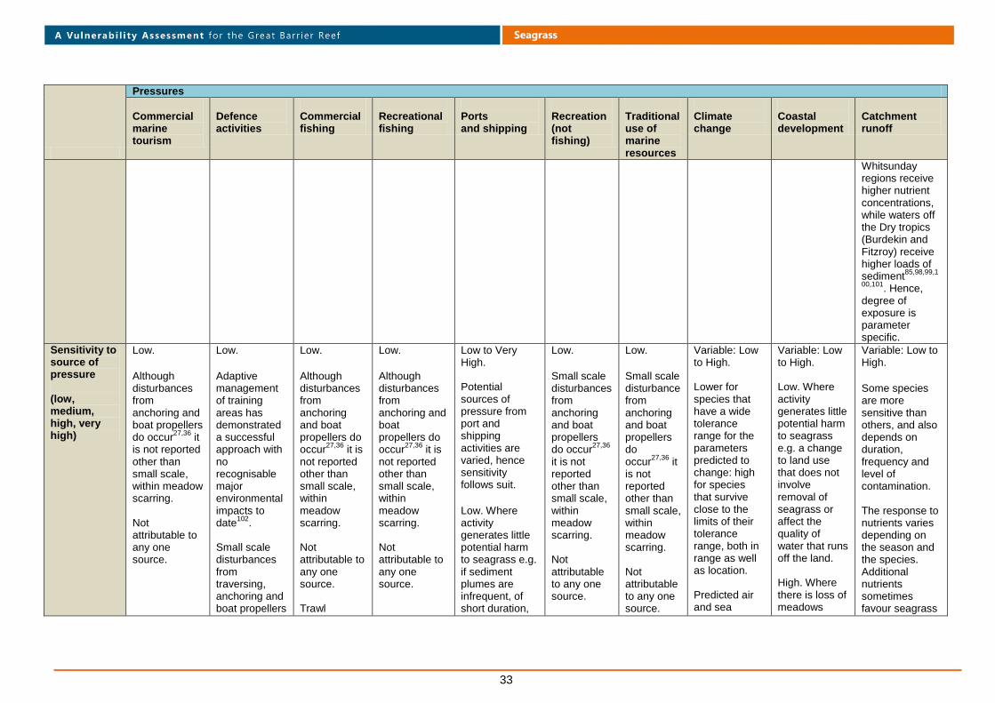
33
Seagrass
Pressures
Commercial marine tourism
Defence activities
Commercial fishing
Recreational fishing
Ports and shipping
Recreation (not fishing)
Traditional use of marine resources
Climate change
Coastal development
Catchment runoff
Whitsunday regions receive higher nutrient concentrations, while waters off the Dry tropics (Burdekin and Fitzroy) receive higher loads of sediment
85,98,99,1
00,101. Hence,
degree of exposure is parameter specific.
Sensitivity to source of pressure (low, medium, high, very high)
Low.
Although disturbances from anchoring and boat propellers do occur
27,36 it
is not reported other than small scale, within meadow scarring. Not attributable to any one source.
Low.
Adaptive management of training areas has demonstrated a successful approach with no recognisable major environmental impacts to date
102.
Small scale disturbances from traversing, anchoring and boat propellers
Low.
Although disturbances from anchoring and boat propellers do occur
27,36 it is
not reported other than small scale, within meadow scarring. Not attributable to any one source. Trawl
Low.
Although disturbances from anchoring and boat propellers do occur
27,36 it is
not reported other than small scale, within meadow scarring. Not attributable to any one source.
Low to Very High. Potential sources of pressure from port and shipping activities are varied, hence sensitivity follows suit. Low. Where activity generates little potential harm to seagrass e.g. if sediment plumes are infrequent, of short duration,
Low.
Small scale disturbances from anchoring and boat propellers do occur
27,36
it is not reported other than small scale, within meadow scarring. Not attributable to any one source.
Low.
Small scale disturbance from anchoring and boat propellers do occur
27,36 it
is not reported other than small scale, within meadow scarring. Not attributable to any one source.
Variable: Low to High. Lower for species that have a wide tolerance range for the parameters predicted to change: high for species that survive close to the limits of their tolerance range, both in range as well as location. Predicted air and sea
Variable: Low to High. Low. Where activity generates little potential harm to seagrass e.g. a change to land use that does not involve removal of seagrass or affect the quality of water that runs off the land. High. Where there is loss of meadows
Variable: Low to High.
Some species are more sensitive than others, and also depends on duration, frequency and level of contamination. The response to nutrients varies depending on the season and the species. Additional nutrients sometimes favour seagrass

34
Seagrass
Pressures
Commercial marine tourism
Defence activities
Commercial fishing
Recreational fishing
Ports and shipping
Recreation (not fishing)
Traditional use of marine resources
Climate change
Coastal development
Catchment runoff
possible. damage is to vegetative plant section rather than uprooting of the rhizome.
contain low concentrations of total suspended solids, or other toxicants, seagrass species are likely to be able to tolerate them easily. If a ship were to ground within a seagrass meadow, which has a low likelihood, it would most probably cause only minimal disturbance in a whole of meadow context. If the seagrass meadow was small, or the ship very large, and/or toxicants were spilt the sensitivity may increase to medium or even to high. Potential ongoing impact,
surface temperatures have a number of likely consequences including
104
drying out intertidal plants; stress from decreasing photosynthesis, increasing microbial activity and depletion of oxygen in the sediments
105;
seagrass burn-off
106,107;
changed growth rates, metabolism or reproductive success
23,107,10
8,109; changed
distribution of species
23,109;
damage (long-term exposure to 33 °C or greater)
109;
destruction of proteins and irreparable damage to tissues (above
through direct removal, and also indirectly through changes to hydrodynamics, and generation of poor water quality discharges.
Some species are more sensitive than others. Refer to catchment runoff for indirect pressures of poor water quality. Moderate to High. Where development affects connectivity between seagrass, saltmarsh and mangrove ecosystems.
growth121,122,123
and in other cases have negative effects (e.g. leaf size reduced in high nutrient treatments)
8,123
or can favour the growth of epiphtyes on the leaves of seagrasses which can shade the leaves from light
8,115,124.
Some herbicides block photosynthesis in seagrass at concentrations as low as
0.1 g/L, and there are concerns about their possible chronic threat
115,125,126,12
7,128,129,130,131,132,1
33,134,135,136.
High organic nutrient content in sediments

35
Seagrass
Pressures
Commercial marine tourism
Defence activities
Commercial fishing
Recreational fishing
Ports and shipping
Recreation (not fishing)
Traditional use of marine resources
Climate change
Coastal development
Catchment runoff
for example from release of antifoulant may increase sensitivity.
Operational discharges from ships such as sewage and ballast water, as well as potential oil spills
103, can
threaten water quality and can also introduce marine pests. Discharge release locations are limited however, and not expected to occur at levels that would be above low sensitivity. Potential sensitivity to introduced pests would depend on what the pest was. High. Activity can cause loss of meadows
about 38- 42°C)
23;
effects on seed germination
110.
Temperature tolerances are species specific
107,109.
Few studies have been done however to determine what the tolerance ranges, or thresholds are. With predicted increases in storm intensity
104
intertidal and nearshore subtidal seagrasses may experience lower salinities, and for longer periods, which may cause species shifts and habitat
inhibits the growth of seagrass
120.
Different species can tolerate different sediment, minimum light and salinity regimes
31,111,112,1
13,114,115,116,117,118,
119.
Few studies have been done however to determine what the tolerance ranges, or thresholds are.
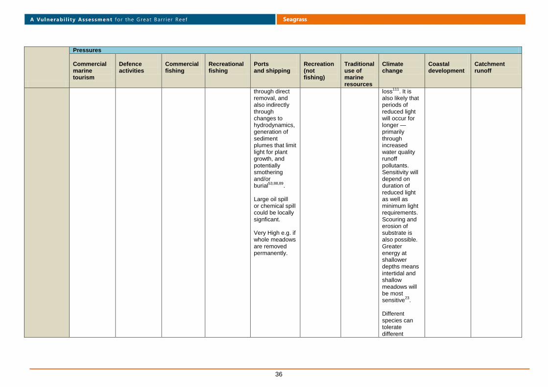
36
Seagrass
Pressures
Commercial marine tourism
Defence activities
Commercial fishing
Recreational fishing
Ports and shipping
Recreation (not fishing)
Traditional use of marine resources
Climate change
Coastal development
Catchment runoff
through direct removal, and also indirectly through changes to hydrodynamics, generation of sediment plumes that limit light for plant growth, and potentially smothering and/or burial
53,88,89.
Large oil spill or chemical spill could be locally signficant. Very High e.g. if whole meadows are removed permanently.
loss111
. It is also likely that periods of reduced light will occur for longer — primarily through increased water quality runoff pollutants. Sensitivity will depend on duration of reduced light as well as minimum light requirements.Scouring and erosion of substrate is also possible. Greater energy at shallower depths means intertidal and shallow meadows will be most sensitive
23.
Different species can tolerate different

37
Seagrass
Pressures
Commercial marine tourism
Defence activities
Commercial fishing
Recreational fishing
Ports and shipping
Recreation (not fishing)
Traditional use of marine resources
Climate change
Coastal development
Catchment runoff
sediment, minimum light and salinity regimes
31,111,11
2,113,114,115,116,11
7,118,119.
Changes in ocean circulation could affect where seagrass grows
23.
Predictions are that there will be an increase in magnitude to present day inshore northward moving currents
23
which may threaten the continued suitability of some existing habitable areas, although new areas may become suitable
120.
Sea level rise will mean

38
Seagrass
Pressures
Commercial marine tourism
Defence activities
Commercial fishing
Recreational fishing
Ports and shipping
Recreation (not fishing)
Traditional use of marine resources
Climate change
Coastal development
Catchment runoff
some intertidal sites will become shallow subtidal, potentially resulting in species shift. Sites below water will experience increased light attenuation and some currently viable sites may become unviable.
Adaptive capacity natural (Poor, moderate, good)
Good.
Ability to regrow or recolonise small areas following disturbance.
Good.
Ability to regrow or recolonise small area following disturbance. Time between activities that may cause impact is generally long. Poor if impacts of activities render substrate no
Good.
Ability to regrow or recolonise a small area following disturbance.
Good.
Ability to regrow or recolonise a small area following disturbance.
Variable. Capacity depends on nature, duration and frequency of disturbance.
Poor: if habitat is permanently removed, or is regularly impacted.
Variable: Effects of sediment deposition on seagrasses are species-specific
Good.
Ability to regrow or recolonise small area following disturbance
Good.
Ability to regrow or recolonise a small area following disturbance.
Variable. The capacity for adaptation is not well understood. Poor. Some tolerance thresholds are likely to be exceeded beyond capacity for adaptation. Temperature rises, in
Variable. Poor: if habitat is permanently removed, hydrodynamic changes make habitat unsuitable, is regularly impacted or receives water quality with pollutants above tolerance levels.
Variable. Capacity depends on duration, frequency and level of contamination.
Poor: if pollutants levels are delivered above plant tolerances, and/or reduce light availability below thresholds and for extended
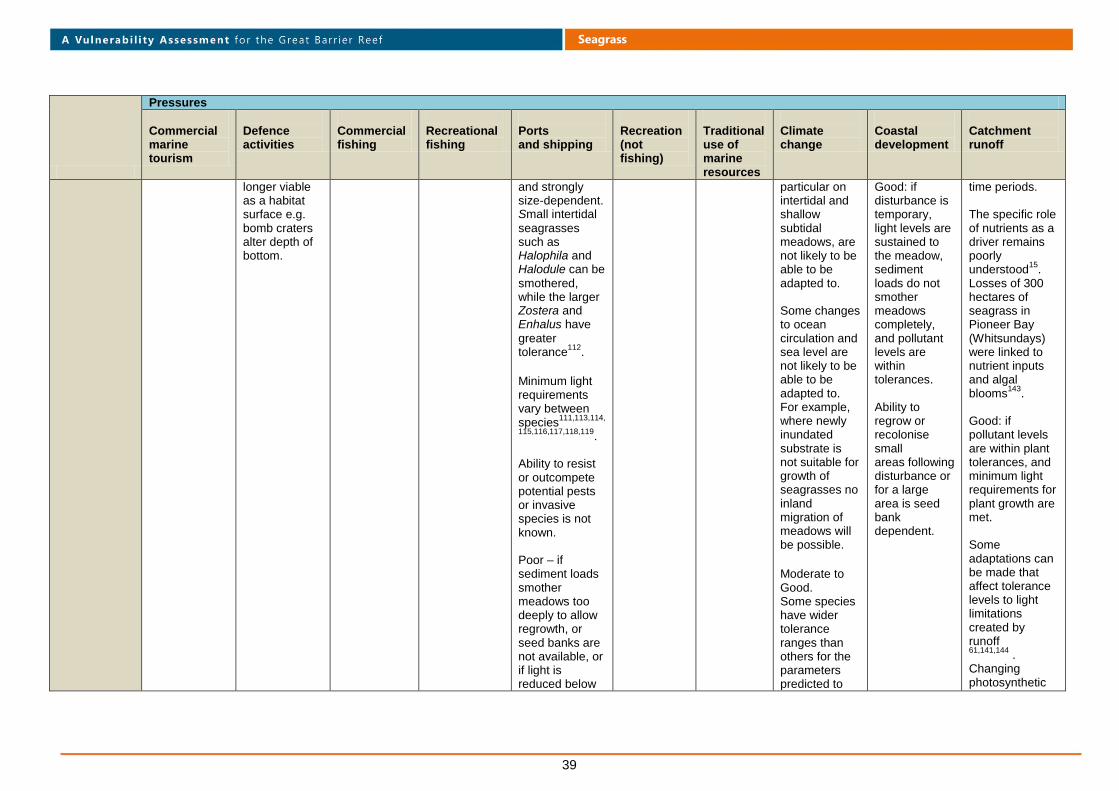
39
Seagrass
Pressures
Commercial marine tourism
Defence activities
Commercial fishing
Recreational fishing
Ports and shipping
Recreation (not fishing)
Traditional use of marine resources
Climate change
Coastal development
Catchment runoff
longer viable as a habitat surface e.g. bomb craters alter depth of bottom.
and strongly size-dependent. Small intertidal
seagrasses such as Halophila and Halodule can be
smothered, while the larger Zostera and Enhalus have
greater tolerance
112.
Minimum light requirements vary between species
111,113,114,
115,116,117,118,119.
Ability to resist or outcompete potential pests or invasive species is not known. Poor – if sediment loads smother meadows too deeply to allow regrowth, or seed banks are not available, or if light is reduced below
particular on intertidal and shallow subtidal meadows, are not likely to be able to be adapted to. Some changes to ocean circulation and sea level are not likely to be able to be adapted to. For example, where newly inundated substrate is not suitable for growth of seagrasses no inland migration of meadows will be possible.
Moderate to Good. Some species have wider tolerance ranges than others for the parameters predicted to
Good: if disturbance is temporary, light levels are sustained to the meadow, sediment loads do not smother meadows completely, and pollutant levels are within tolerances. Ability to regrow or recolonise small areas following disturbance or for a large area is seed bank dependent.
time periods. The specific role of nutrients as a driver remains poorly understood
15.
Losses of 300 hectares of seagrass in Pioneer Bay (Whitsundays) were linked to nutrient inputs and algal blooms
143.
Good: if pollutant levels are within plant tolerances, and minimum light requirements for plant growth are met. Some adaptations can be made that affect tolerance levels to light limitations created by runoff 61,141,144
. Changing photosynthetic
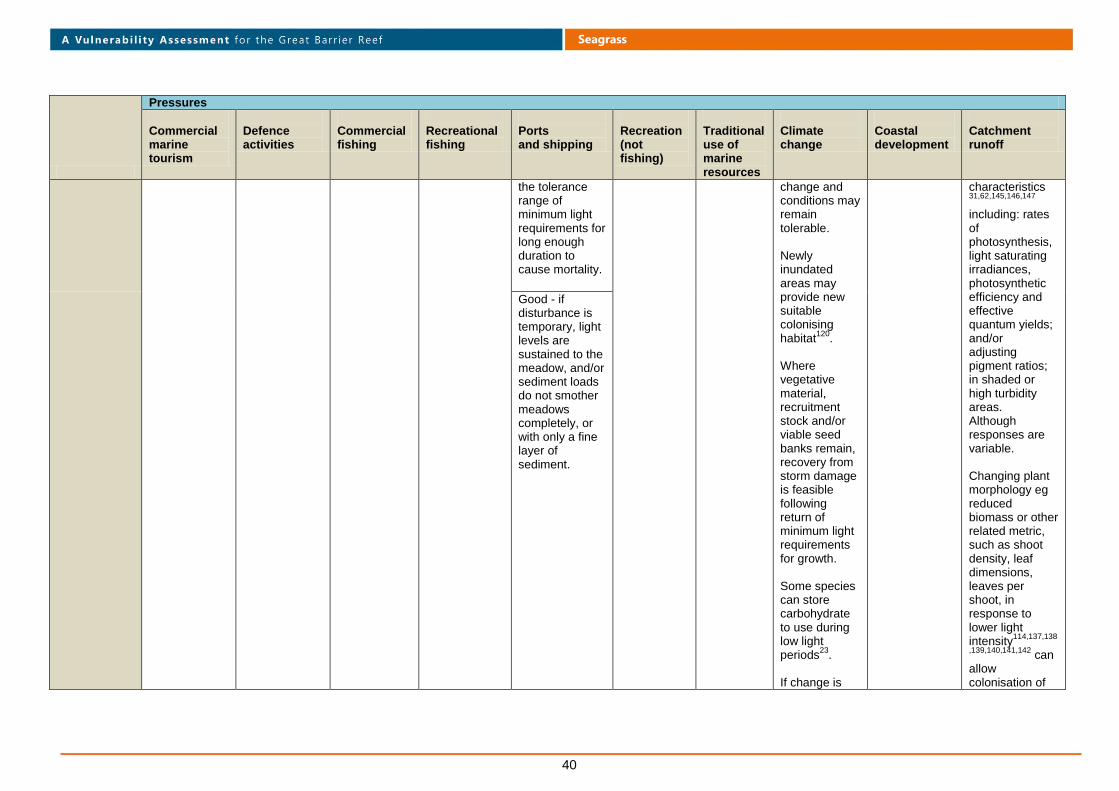
40
Seagrass
Pressures
Commercial marine tourism
Defence activities
Commercial fishing
Recreational fishing
Ports and shipping
Recreation (not fishing)
Traditional use of marine resources
Climate change
Coastal development
Catchment runoff
the tolerance range of minimum light requirements for long enough duration to cause mortality.
change and conditions may remain tolerable. Newly inundated areas may provide new suitable colonising habitat
120.
Where vegetative material, recruitment stock and/or viable seed banks remain, recovery from storm damage is feasible following return of minimum light requirements for growth. Some species can store carbohydrate to use during low light periods
23.
If change is
characteristics 31,62,145,146,147
including: rates of photosynthesis, light saturating irradiances, photosynthetic efficiency and effective quantum yields; and/or adjusting pigment ratios; in shaded or high turbidity areas. Although responses are variable. Changing plant morphology eg reduced biomass or other related metric, such as shoot density, leaf dimensions, leaves per shoot, in response to lower light intensity
114,137,138
,139,140,141,142 can
allow colonisation of
Good - if disturbance is temporary, light levels are sustained to the meadow, and/or sediment loads do not smother meadows completely, or with only a fine layer of sediment.

41
Seagrass
Pressures
Commercial marine tourism
Defence activities
Commercial fishing
Recreational fishing
Ports and shipping
Recreation (not fishing)
Traditional use of marine resources
Climate change
Coastal development
Catchment runoff
sufficiently slow, and does not surpass tolerances completely, some adaptations may be able to be made e.g. the rate of vertical growth of most seagrasses is greater than the predicted rate of rise in sea level
23.
Changes of species distributions and community compositions to those that tolerate new conditions may occur.
Changing plant morphology eg reduced biomass or other related metric, such as shoot
an area that might otherwise not be viable. Some species have the capacity to build up a persistent seed bank in the sediment enabling recovery from large scale vegetative loss
148.
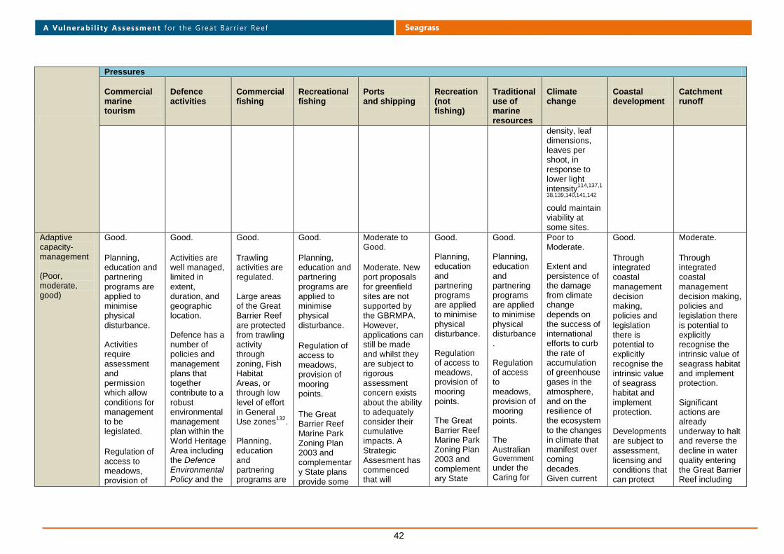
42
Seagrass
Pressures
Commercial marine tourism
Defence activities
Commercial fishing
Recreational fishing
Ports and shipping
Recreation (not fishing)
Traditional use of marine resources
Climate change
Coastal development
Catchment runoff
density, leaf dimensions, leaves per shoot, in response to lower light intensity
114,137,1
38,139,140,141,142
could maintain viability at some sites.
Adaptive capacity-management (Poor, moderate, good)
Good.
Planning, education and partnering programs are applied to minimise physical disturbance. Activities require assessment and permission which allow conditions for management to be legislated.
Regulation of access to meadows, provision of
Good.
Activities are well managed, limited in extent, duration, and geographic location. Defence has a number of policies and management plans that together contribute to a robust environmental management plan within the World Heritage Area including the Defence Environmental Policy and the
Good.
Trawling activities are regulated. Large areas of the Great Barrier Reef are protected from trawling activity through zoning, Fish Habitat Areas, or through low level of effort in General Use zones
132.
Planning, education and partnering programs are
Good.
Planning, education and partnering programs are applied to minimise physical disturbance.
Regulation of access to meadows, provision of mooring points.
The Great Barrier Reef Marine Park Zoning Plan 2003 and complementary State plans provide some
Moderate to Good.
Moderate. New port proposals for greenfield sites are not supported by the GBRMPA. However, applications can still be made and whilst they are subject to rigorous assessment concern exists about the ability to adequately consider their cumulative impacts. A Strategic Assesment has commenced that will
Good. Planning, education and partnering programs are applied to minimise physical disturbance. Regulation of access to meadows, provision of mooring points. The Great Barrier Reef Marine Park Zoning Plan 2003 and complementary State
Good. Planning, education and partnering programs are applied to minimise physical disturbance. Regulation of access to meadows, provision of mooring points. The Australian Government under the Caring for
Poor to Moderate. Extent and persistence of the damage from climate change depends on the success of international efforts to curb the rate of accumulation of greenhouse gases in the atmosphere, and on the resilience of the ecosystem to the changes in climate that manifest over coming decades. Given current
Good.
Through integrated coastal management decision making, policies and legislation there is potential to explicitly recognise the intrinsic value of seagrass habitat and implement protection. Developments are subject to assessment, licensing and conditions that can protect
Moderate.
Through integrated coastal management decision making, policies and legislation there is potential to explicitly recognise the intrinsic value of seagrass habitat and implement protection. Significant actions are already underway to halt and reverse the decline in water quality entering the Great Barrier Reef including

43
Seagrass
Pressures
Commercial marine tourism
Defence activities
Commercial fishing
Recreational fishing
Ports and shipping
Recreation (not fishing)
Traditional use of marine resources
Climate change
Coastal development
Catchment runoff
mooring points.
The Great Barrier Reef Marine Park Zoning Plan 2003 and complementary State plans provide some protection. Penalties for non-compliance.
Maritime Activities Environmental Management Plan
131.
Further management could be applied as required.
applied to minimise physical disturbance. Regulation of access to meadows, provision of mooring points.
Penalties for non-compliance.
protection.
consider cumulative impact. Good. Ports are confined to specific locations. Port expansions and major dredging proposals or other activities associated with ports generally require environmental impact assessment and permits or approvals. A combination of monitoring and modelling during dredging activity is used to minimise the risk that suspended sediments will cause impacts on any nearby seagrass meadows.
plans provide some protection.
our Country initiative, committed $10 million over five years towards the Reef Rescue Land and Sea Country Indigenous Partnerships Program. The program actively engages Aboriginal and Torres Strait Islander communities in the management and protection of the reef's marine resources and cultural diversity.
trajectories of greenhouse gas emissions, strategies that build resilience and reduce vulnerabilities of seagrass habitats will be increasingly crucial to their prognosis. Management will only be able to implement actions to address other sources of pressure to enhance ecosystem resilience, not mitigate the impacts of climate change directly. Moderate. Planning and legislative frameworks can factor in the potential for shoreline
seagrass. Waste water discharge quality is legislated. Codes of Practice and Water Sensitive Urban Design are in place to manage stormwater in local areas. Erosion and sediment control plans are legislated requirements during construction phases of development. Penalties for non-compliance. Cumulative impacts are however difficult to assess.
implementation of the Reef Water Quality Protection Plan, development and implementation of Healthy Waters Management Plans and precursor products) Implementation of water quality guidelines into permitting and decision making processes. A degree of uncertainty surrounds several elements of water quality management including thresholds, models of runoff, and effectiveness of strategies to minimise runoff from agricultural lands.
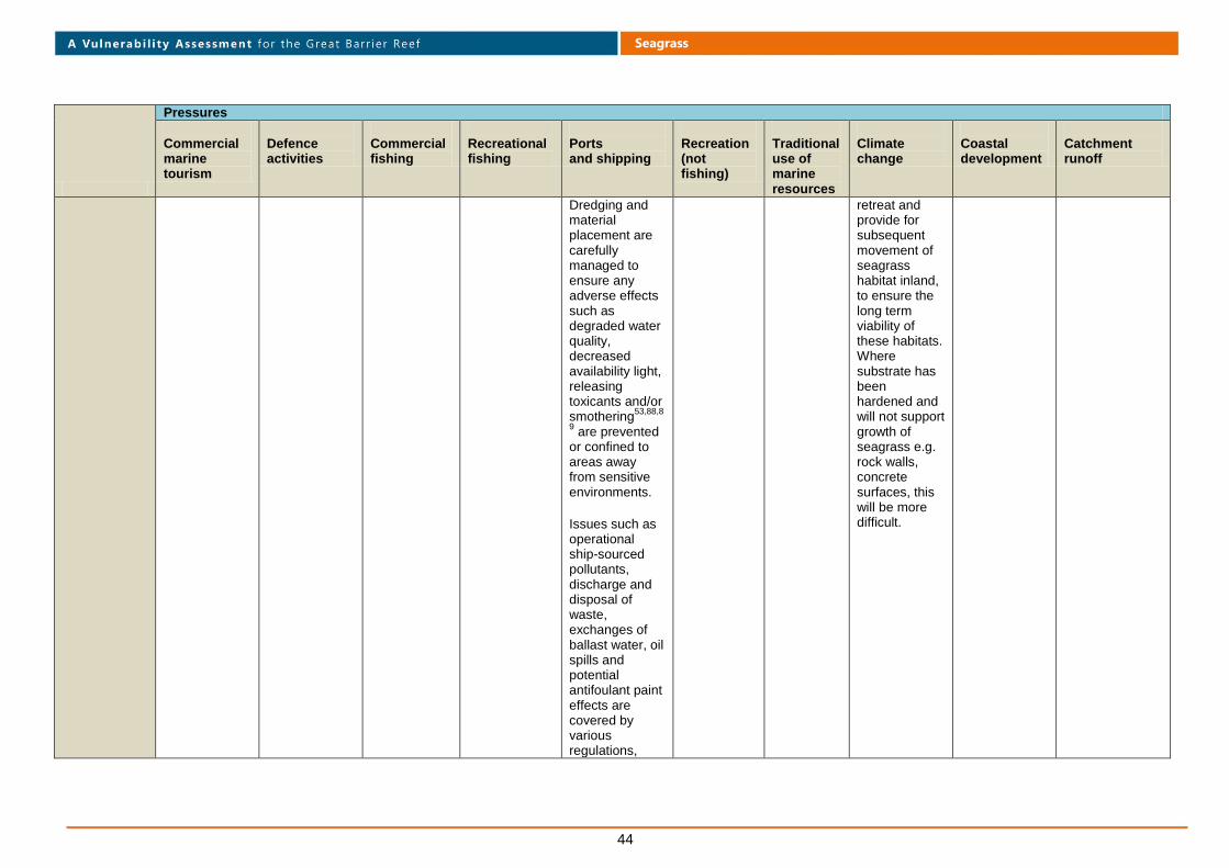
44
Seagrass
Pressures
Commercial marine tourism
Defence activities
Commercial fishing
Recreational fishing
Ports and shipping
Recreation (not fishing)
Traditional use of marine resources
Climate change
Coastal development
Catchment runoff
Dredging and material placement are carefully managed to ensure any adverse effects such as degraded water quality, decreased availability light, releasing toxicants and/or smothering
53,88,8
9 are prevented
or confined to areas away from sensitive environments.
Issues such as operational ship-sourced pollutants, discharge and disposal of waste, exchanges of ballast water, oil spills and potential antifoulant paint effects are covered by various regulations,
retreat and provide for subsequent movement of seagrass habitat inland, to ensure the long term viability of these habitats. Where substrate has been hardened and will not support growth of seagrass e.g. rock walls, concrete surfaces, this will be more difficult.

45
Seagrass
Pressures
Commercial marine tourism
Defence activities
Commercial fishing
Recreational fishing
Ports and shipping
Recreation (not fishing)
Traditional use of marine resources
Climate change
Coastal development
Catchment runoff
conventions and policies applied in the Great Barrier Reef.
Residual vulnerability (Low, medium, high)
Low. Low. Low. Low. Low - for areas outside port limits and the influence of plumes generated, primarily by dredging. Existing meadows within port limits are colonised by species that tolerate conditions experienced. High – if proposals to open new areas where meadows exist are successful (although impacts would be local) they are likely to result in losses. Also for existing port expansions that include reclamation and new berths there are meadow losses. Cumulative impacts are difficult to assess.
Low. Low. Low for deepwater.
High in the coastal zone.
Low for remote areas. Medium for much of Great Barrier Reef coast.
There are issues with capacity to control population growth to coastal areas and urban sprawl.
Cumulative impacts are difficult to assess.
High. Addressing the poor water quality entering the Great Barrier Reef is not a short-term problem with a simple solution. It will take many years to improve practices that affect water quality throughout the catchments adjacent to the Reef, and then to see these improvements realised in the Reef lagoon itself
149.
Level of confidence in
Good. Good12,14,15,131
.
Good.
Good. Good – for effects of
Good. Moderate.
Poor.
Moderate.
Moderate.
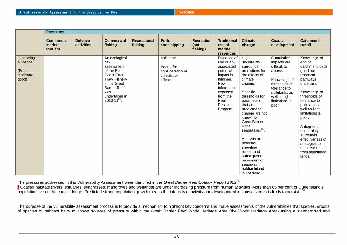
46
Seagrass
Pressures
Commercial marine tourism
Defence activities
Commercial fishing
Recreational fishing
Ports and shipping
Recreation (not fishing)
Traditional use of marine resources
Climate change
Coastal development
Catchment runoff
supporting evidence (Poor, moderate, good)
An ecological risk assessment of the East Coast Otter Trawl Fishery in the Great Barrier Reef was undertaken in 2010-11
96.
pollutants.
Poor – for consideration of cumulative effects.
Evidence of use or any associated potential impact is minimal. New information expected from the Reef Rescue Program.
High uncertainty surrounds predictions for the effects of climate change. Specific thresholds for parameters that are predicted to change are not known for Great Barrier Reef seagrasses
15.
Analysis of potential shoreline retreat and subsequent movement of seagrass habitat inland is not done.
Cumulative impacts are difficult to assess.
Knowledge of thresholds of tolerance to pollutants, as well as light limitations is poor.
Knowledge of end of catchment loads good but transport pathways uncertain. Knowledge of thresholds of tolerance to pollutants, as well as light limitations is poor.
A degree of uncertainty surrounds effectiveness of strategies to minimise runoff from agricultural lands.
The pressures addressed in this Vulnerability Assessment were identified in the Great Barrier Reef Outlook Report 2009.
14
* Coastal habitats (rivers, estuaries, seagrasses, mangroves and wetlands) are under increasing pressure from human activities. More than 85 per cent of Queensland's
population live on the coastal fringe. Predicted strong population growth means the intensity of activity and development in coastal zones is likely to persist.150
The purpose of the vulnerability assessment process is to provide a mechanism to highlight key concerns and make assessments of the vulnerabilities that species, groups of species or habitats have to known sources of pressure within the Great Barrier Reef World Heritage Area (the World Heritage Area) using a standardised and

47
Seagrass
transparent process. This was undertaken using a standard approach to assess exposure and sensitivity and adaptive capacity to potential impacts (Figure 1) based on the best-available information on that particular habitat, species or group of species.
Figure 1. The key components of vulnerability assessments (Adapted from Wachenfeld et al., 2007)
To achieve this objective it has been necessary to apply a linear relationship to comparisons that are sometimes non-linear by nature. For example, when applying the potential impact matrix
1 to create a combined score for exposure and sensitivity, if a species, group of species or habitat has a very high level of exposure to a pressure but
low sensitivity to it, it is scored as having a medium-high potential impact score. This medium-high score may be the same as determined for another assessment where there may be a low level of exposure but a very high level of sensitivity. This implies a linear relationship for the sensitivity a species or habitat has to a given level of exposure, which may not necessarily be the case. However, it does provide managers with the required level of resolution on these relationships for the purpose of the vulnerability assessments that inform the Great Barrier Reef Biodiversity Conservation Strategy 2012.
The methods used to determine the degree of exposure or sensitivity of sea snakes of the World Heritage Area against each source of pressure are described within the vulnerability assessments page of the GBRMPA website.
The natural capacity of sea snakes to adapt to pressures in the Great Barrier Reef, and the capacity of management to intervene (which in turn may assist sea snakes to adapt to these pressures), are considered as two dynamics that affect their residual vulnerability to any of the identified pressures. These two dynamics are then combined to produce an overall rating for adaptive capacity and then applied to the potential impact rating to provide a score for the residual vulnerability that sea snakes may be expected to experience for the given pressure. An explanation of the procedure by which this process has been applied and qualifying statements for the assessment of adaptive capacity (natural and management) scores are provided within the vulnerability assessments page of the GBRMPA website. © Commonwealth of Australia 2011 Published by the Great Barrier Reef Marine Park Authority ISBN 978 1 921682 63 6 This work is copyright. Apart from any use as permitted under the Copyright Act 1968, no part may be reproduced by any process without the prior written permission of the Great Barrier Reef Marine Park Authority.
1 The potential impact matrix is described within the vulnerability assessments page of the GBRMPA website.