SeaDataNet, Pan-European infrastructure for marine and ...
31
SeaDataNet, Pan-European infrastructure for marine and ocean data management + EMODNET By Dick M.A. Schaap – Technical Coordinator SeaDataNet & Coordinator EMODNet Bathymetry San Francisco – USA, 13 December 2015, RCN meeting
Transcript of SeaDataNet, Pan-European infrastructure for marine and ...
SeaDataNet, Pan-European infrastructure for marine and ocean data management
+ EMODNET
By
Dick M.A. Schaap – Technical Coordinator SeaDataNet & Coordinator EMODNet Bathymetry
San Francisco – USA, 13 December 2015, RCN meeting

EU – MAST EU –MASTII EU-FP5 EU-FP6 EU-FP7
SeaDataNet has set up and operates a pan-European infrastructure for managing marine and ocean data by connecting National Oceanographic Data Centres (NODCs) and oceanographic data focal points from 35 countries bordering European seas
90sEDMEDEuronodimMEDATLASEDIOS2002-2005Sea-Search2006-2011SeaDataNet2011-2015SeaDataNetII

Standards, services and tools
! Set of common standards for metadata and data formats for the marine domain, adapting ISO and OGC standards and achieving INSPIRE compliance
! Controlled vocabularies for the marine domain (> 160.000 terms over > 60 lists)
! Set of tools to be used by each data centre – capacity building and standardisation
! Pan-European services for discovery, access, visualisation and data
products

Pan-European directory services
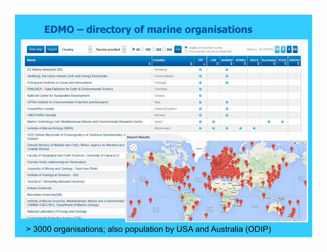
EDMO – directory of marine organisations
> 3000 organisations; also population by USA and Australia (ODIP)

CDI service for discovery and unified access of data
Already 102 data centres connected

CDI Data Discovery & Access service
December 2015: 102 data centres connected
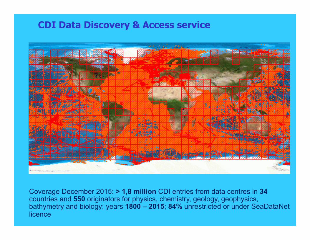
Coverage December 2015: > 1,8 million CDI entries from data centres in 34 countries and 550 originators for physics, chemistry, geology, geophysics, bathymetry and biology; years 1800 – 2015; 84% unrestricted or under SeaDataNet licence
CDI Data Discovery & Access service

Core partner in developing and building: European Marine Observation and Data Network 2009 2010 2011 2012 2013 2014 2015 2016 2017 2018 2019 2020
Phase 1 – limited sea basins (ca 6 MEuro)
Phase 2 - low resolution (ca 16 MEuro)
Phase 3 - multi-resolution (> 100 – 200 MEuro)
PROTOTYPING: allows users to assess and improve product by trying it out
Resulting in uptake of SeaDataNet standards and expansion of the infrastructure of data centres giving data overview and access

EMODnet Chemistry
! EMODNet Chemistry project has a scope of chemical substances: ! Pesticides and biocides ! Antifoulants ! Pharmaceuticals ! Heavy metals ! Hydrocarbons ! Radionuclides ! Fertilisers ! Organic matter(e.g. from sewers or mariculture) ! Chlorophyll ! Partial pressures of dissolved gases ! Acidity (from pH, pCO2, Total Inorganic Carbon, alkalinity) ! Others
! Compiling data collections and interpolated maps for regional seas in support of the MSFD implementation

Chemistry CDI Data Discovery and Access Service
! Dedicated CDI service for EMODNet Chemistry scope ! Three search interfaces for human users, upgraded as part of the
project: ! Quick Search with dynamic drilling down of search results;
! Extended Search with more flexibility for combining search options, including free search;
! Variables Vs Marine Regions with an interactive Matrix of variables in specific marine regions.

Chemistry CDI Data Discovery and Access Service

Chemistry CDI Data Discovery and Access Service
Discovery and harvesting of data sets for regional product groups
! EMODNet Chemistry 2 project is generating chemistry products per MSFD sea region
! Discovery and harvesting of data sets per MSFD region for specific chemical parameters is done in an almost full automatic method by:
! using a Robot harvester via the shopping mechanism to discover and retrieve specific data sets from distributed data centres
! to compile and maintain specific aggregate data sets as internal central data buffers that are transferred to regional groups for further processing and products generation.

Buffer CMS + Central User Interfacing
CDI User Interfaces
CDI Robot harvester
Specific data buffers
CDI User Interface + Shopper:
Access regulated via AAA
Agreed Settings
Dynamic Maintenance
Robot CMS to configure Robot harvesting profiles
MARIS master
RSM system extended with
administering robot transactions and via
central interfaces
API
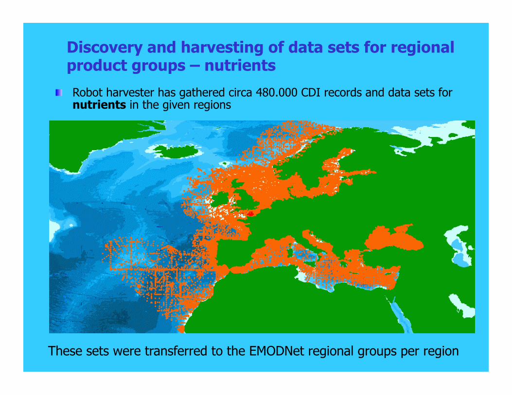
Discovery and harvesting of data sets for regional product groups – nutrients
! Robot harvester has gathered circa 480.000 CDI records and data sets for nutrients in the given regions
These sets were transferred to the EMODNet regional groups per region

Quality assessment for data and products
- Data Aggregation - Parameter Homogenization - Unit Conversion (to «umol/l») - Regional Quality Check - Global Analysis
data extraction
Regional
Regional
Regional data collections
Regional buffers Regiona
l a QCd data collections
Report errors to the data originators
Update the official copy of data
Feedback loop guarantees data quality upgrade
Questionnaire based on ISO/IEC 17025:2005
+ Data are checked, flagged and completed with metadata by National Collators

EMODnet Chemistry advanced services
Specific data buffers
OpenEarth services
ODV QC + aggregation
QCd data buffers
Regional experts
DIVA + OceanBrowser service
CDI Robot Harvester

Advanced services
! The validated and aggregated buffers of data sets are input for the products and advanced services:
! Interpolated maps as produced with DIVA software
! Time series graphics for all collected data sets via WPS
! OceanBrowser viewer as common service for viewing the DIVA maps and giving access to the time series graphics
! Sextant catalogue to document all products with metadata

OceanBrowser: Concentration maps of phosphate in spring per 10 years as animations

Spatial distribution and density by GeoServer layers in OceanBrowser
l Combination of WPS/WMS
l Density indicated by colours
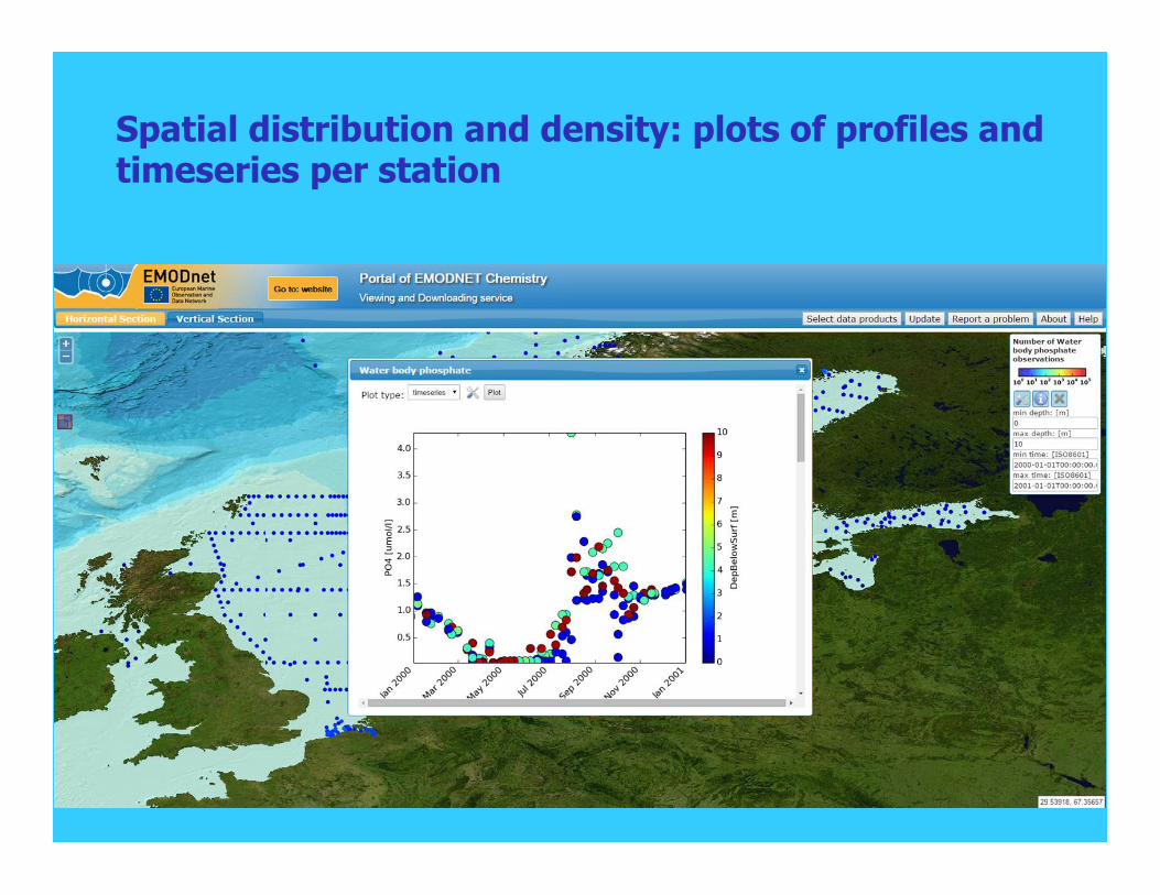
Spatial distribution and density: plots of profiles and timeseries per station

EMODNet Bathymetry ! Overall objective: to bring together bathymetric surveys of
European seas and to produce, publish and serve a harmonised and medium resolution Digital Terrain Model of all European seas
! > 13.800 surveys indexed ! DTM for all European seas at
1/8*1/8 arc minutes (~230 m) ! DTM uses > 7.000 survey data sets
and composite DTMs from 31 data providers from 18 countries and GEBCO_2015
! DTM contains 1.092.115.678 data points (28.799 rows x 37.922 columns)
! 3 high resolution coastal areas ! Latest release: 8 Sept 2015

DTM for European sea basins
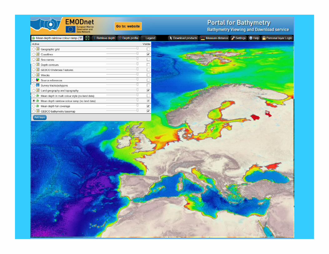
DTM for European sea basins

CDI overlay to indicate surveys

CDI overlay to indicate surveys + retrieve CDI metadata per survey

Sources layer to indicate used surveys and composite DTMs

Download DTM tiles in various formats

Bathymetric DTM – 3D-Viewer
DTM loaded into 3D-Viewer as developed and freely downloadable from Geo-Seas

www.emodnet-bathymetry.eu
www.seadatanet.org