SEA Street - NACTO
8
1 | SEATTLE (DESIGN PRECEDENT STUDIES, WINTER 2010) Seattle Public Utilities constructed a drainage project at 2nd Avenue NW known as a Street Edge Alternatives (SEA Streets) project. It involved the complete reconstruction of the street and its drainage system to reduce impervious area and install stormwater detention ponds. It was completed in the spring of 2001, and designed to provide drain- age that more closely mimics the natural landscape prior to development than tradi- tional piped systems. To accomplish this, Seattle reduced impervious surfaces to 11 percent less than a traditional street, provided surface detention in swales, and added over 100 evergreen trees and 1100 shrubs. The SEA Street was developed by planners from Seattle’s Public Utilities (SPU) in conjunction with local community groups, and the streets are partially maintained by homeowners on adjacent properties and by SPU. Street flooding has significant impacts on the city’s transportation infrastructure. Road flooding slows traffic and increases the risk of accidents. Standing water on streets erodes road surfaces and exacerbates pothole formation. In the winter, water from flooded streets can freeze and form hazardous driving conditions. Especially at inter- sections, street flooding makes crossing streets and walking difficult for pedestrians and bicyclists. Image coutesy of the Seattle P-I. SEA Street Seattle Public Utilities Seattle, U.S.A. (2001) Hiroko Matsuno Selina Chiu Location Map The SEA Street was first implemented on a small two-block test site in north- west Seattle (NW 117th and NW 120th Street on 2nd Avenue), a low-density residential area that lacked sidewalks and drainage infrastructure. Image coutesy of the Seattle P-I. The Stormwater Management Challenge Puget Sound 3rd Ave. NW Greenwood Ave. N 2nd Ave. NW NW 120th St. NW 117th St. Project site Pipers Creek Carkeek Park Seattle Before After
Transcript of SEA Street - NACTO

1 | SEATTLE (DESIGN PRECEDENT STUDIES, WINTER 2010)
Seattle Public Utilities constructed a drainage project at 2nd Avenue NW known as a Street Edge Alternatives (SEA Streets) project. It involved the complete reconstruction of the street and its drainage system to reduce impervious area and install stormwater detention ponds. It was completed in the spring of 2001, and designed to provide drain-age that more closely mimics the natural landscape prior to development than tradi-tional piped systems. To accomplish this, Seattle reduced impervious surfaces to 11 percent less than a traditional street, provided surface detention in swales, and added over 100 evergreen trees and 1100 shrubs.
The SEA Street was developed by planners from Seattle’s Public Utilities (SPU) in conjunction with local community groups, and the streets are partially maintained by homeowners on adjacent properties and by SPU.
Street flooding has significant impacts on the city’s transportation infrastructure. Road flooding slows traffic and increases the risk of accidents. Standing water on streets erodes road surfaces and exacerbates pothole formation. In the winter, water from flooded streets can freeze and form hazardous driving conditions. Especially at inter-sections, street flooding makes crossing streets and walking difficult for pedestrians and bicyclists.
Image coutesy of the Seattle P-I.
SEA Street Seattle Public UtilitiesSeattle, U.S.A. (2001)
Hiroko Matsuno Selina Chiu
Location MapThe SEA Street was first implemented on a small two-block test site in north-west Seattle (NW 117th and NW 120th Street on 2nd Avenue), a low-density residential area that lacked sidewalks and drainage infrastructure.Image coutesy of the Seattle P-I.
The Stormwater Management Challenge
Puge
t So
und
3rd
Ave.
NW
Gre
enw
ood
Ave.
N
2nd
Ave.
NW
NW 120th St.
NW 117th St.
Project site
Pipers Creek
Carkeek Park
Seattle
A PILOT PROJECT TO REDUCE RUNOFF
In a pilot project using ”green“ engineering, a block in Seattle’s Broadview neighborhood reduced stormwater runoff by 98 percent. Seattle Public Utilities spent $800,000 to create a natural drainage system in place of the traditional curb-and-gutter designs that send tainted runoff into area waters.
BEFORE
DESIGN FEATURES OF A NATURAL DRAINAGE SYSTEM
AFTER
Source: Seattle Public Utilities
Narrow, curved street Allows larger surface areas for swales
Culverts Swales are linked by underground overflow pipes
Individual parking for each house eliminates need for street parking and allows street to be narrow
MAKING MORE GREEN SPACE
One curved sidewalk Runs only along the west side of the street
Urban development removed many of the trees and natural surfaces that soaked up rain like a sponge. Without those natural barriers, rain not only has the potential to cause flooding and erosion, but it collects pollution and can overwhelm sewer systems. A natural drainage system slows the flow of runoff by making more water soak into the ground.
Swale detail
SWALES: STEERING STORMWATERA major feature of the project involved creating carefully graded and landscaped swales along the street to collect most of the runoff. Three types of swales were used on this project. All swales are filled with modified soils to speed absorption and vegetation to slow runoff but they serve different purposes during larger storms.
� Conveyance swaleDrains excess water to other swales through connecting overflow pipes
� Holding swaleAbsorbs the most water into ground and receives water from other swales
Liner
Modified soil
Modified soil
Overflow pipeOverflow pipe
Modified soil Sandy soil
River rocks
Lined (when needed)
Berming
� Flow control swaleRegulates flow of stormwater for all swales
Overflow pipe
Flow control structure
Grate
Flow directionWater from other swales flows downstream through underground overflow pipes into flow control swale
AbsorptionModified soil absorbs water until it begins to pool
PondingDuring heavy rains the catch basin backs storm water up through the grate, creating a pond in the swale
Overflow portAnother overflow pipe carries excess water to another swale 4
3
1
2
3
4
2
1
DAVID BADDERS/SEATTLE POST-INTELLIGENCER
Before After
2 | SEATTLE (DESIGN PRECEDENT STUDIES, WINTER 2010)
Natural Drainage System
The natural drainage systems approach to these problems is simple in concept: restore and utilize the environment to do the work it was intended it to do. Generally, the NDS approach does so by: increasing, along the edges of city streets, the amount of soil and plants in an interlinked network of “vegetated swales and cascades”; reducing the area of impervious surfaces on the street itself by adopting new, multi-functional street designs; and using these landscape features to allow stormwater to be absorbed into the ground, rather than sending polluted water, at unnaturally high velocities, to rush into local streams, lakes, and bays.
Water Quality
In addition to flooding and damaging flows to the creek, stormwater pollution is also a serious concern. As rain washes over the developed landscape, it may be contami-nated by oil and grease, heavy metals, pet waste, sediments, chemical fertilizers and pesticides.
SPU recognized that that the normalization of hydrologic conditions to pre-development levels is a key component of stream restoration efforts and concluded that infrastruc-ture-based solutions alone would not restore aquatic habitat. This understanding, in conjunction with increasingly stringent water quality regulations (which require the monitoring of pollutants in stormwater) led to SPU’s decision to begin implementing “greener” stormwater management projects.
Addressing the quality of stormwater and its impact on local waterbodies was a major component of SPU’s push towards NDSs. In addition to improving the water qual-ity of stormwater by removing contaminants, NDSs also enable greater groundwater recharge and significantly reduce the likelihood of flash flooding. SPU expects that the performance of NDSs will improve over time as plants mature and soil is stabilized, leading to an increase in overall filtration and retention.
SEA StreetDesign Features
Natural Drainage System
Bioswales
Porous Paving
Rain Gardens
Curvilinear Street
Community Improvement
Hydraulic Engineering x Soil Science and Botany = SEA Street Drainage
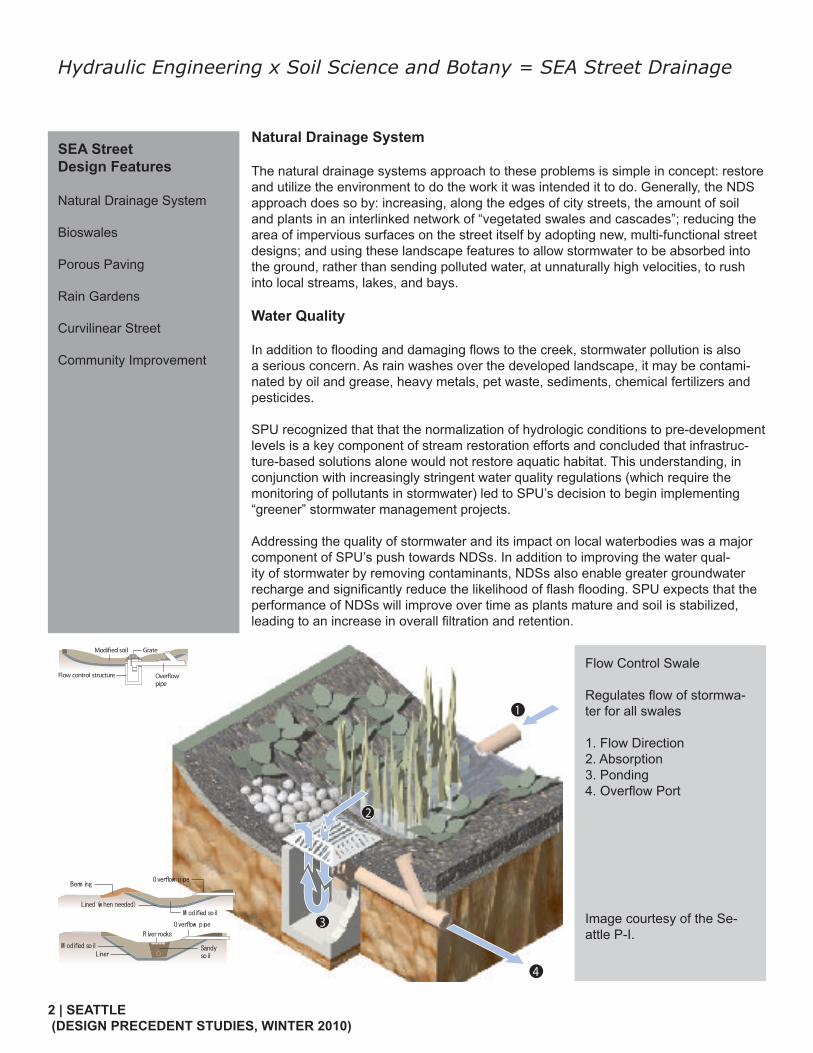
Flow Control Swale
Regulates flow of stormwa-ter for all swales
1. Flow Direction2. Absorption3. Ponding4. Overflow Port
Image courtesy of the Se-attle P-I.
4
3
2
1
Modified soil
Overflow pipe
Flow control structure
Grate
Liner
Overflow pipe
M odified soil Sandy soil
River rocks
M odified soil
Overflow pipe
Lined (w hen needed)
Berm ing

3 | SEATTLE (DESIGN PRECEDENT STUDIES, WINTER 2010)
Landscaping
The landscape elements serve an important role in both providing an aesthetic benefit as well as contributing to the management of rainfall. Trees will help to restore more of the evaporation and transpiration that was present before development.The landscape architect was involved more during the design than a typical project. The most apparent example of this is a sidewalk design that not only serves but at-tracts pedestrians.
There also was an emphasis on retaining existing large-scale trees and relocating vegetation to meet homeowner needs and project goals. The swales and surrounding areas are artfully graded and planted with native wetland and upland plant species. Granite boulders and various sizes of washed river rock provide both function and beauty.
The landscape design complements the drainage system function and focuses on native and salmon-friendly plantings. The system is unique in its use of grading, soil engineering, plant selection and layout as components that function together -- much as they do in a natural ecosystem.
Porous Sidewalks/ Pervious Surfaces
Sidewalks are made of a more porous concrete mixture than traditional side-walks that are highly impervious. Porous sidewalks have increased pore space in the concrete mixture, which allows for stormwater infiltration and reduced runoff volume.
Top: Photo courtesy of SPU
Upper and lower middle: Photo by Hiroko Matsuno
Bottom: Photo courtesy of New York City Department of City Planning
Left: Image courtesy of SPU
City nametag line (arial 18pt)
Low-impactProject
Perennials
Broadleaf EvergreenGround covers
Deciduous Trees
Wetland Emergents
Deciduous Screening Shrubs
BroadleafEvergreen Shrubs
Evergreen Trees
Low Deciduous Shrubs

4 | SEATTLE (DESIGN PRECEDENT STUDIES, WINTER 2010)
Traffic / Mobility
The design of SEA Street helps slow traffic. The narrower driving lane and meandering shape of the roadway create visual interest and cause traffic to move at a safe pace. Accordingly, this is an ideal location for pedestrians and bicyclists.
While the street’s shape and layout are unconventional, the SEA Street design team has ensured that large trucks and emergency vehicles can still safely access the entire street. Although they are not typically used for driving, the white strips, or “flat curbs,” provide an additional 2 ft. of driving room on either side of the 14 ft. roadway, for a total of 18 ft. across (enough for two fire trucks to pass each other). In addition, the roadside grass-planted strips are structural grass, reinforced with a lattice of material that can handle occasional traffic.
Parking needs for neighbors are also met on SEA Street based on parking surveys conducted by project planners. The angled parking distributed along the roadway in clusters is unique to SEA Street. Other NDS projects employ alternative parking plans.
Community Benefit
Accompanying the drainage improvements, this project has created a sense of place and community in the neighborhood. The addition of a sidewalk separates pedestrians from traffic and increases the feeling of safety in the neighborhood. “Walkability” from the sidewalk and the “garden-street” appeal makes this street a common destination for nearby residents.
The maintenance agreement between residents and Seattle Public Utilities encour-ages neighbors to get to know each other while they care for the plants in their shared right-of-way garden. Clusters of mailboxes create additional gathering spaces. The visual continuity of the street design and the street’s unique appearance also subtly link people together along the corridor.
Finally, anyone who lives on or near SEA Street project is now aware of their place in the larger context of the local watershed. Many community members have become involved in efforts to improve water quality and stream health in Pipers Creek. SEA Street evokes environmental awareness and action… stewardship by design.
Top: Photo courtesy of SPU
Bottom: Photo by Hiroko Matsuno
Top: Photos courtesy of SPU
Bottom: Photo by Hiroko Matsuno

5 | SEATTLE (DESIGN PRECEDENT STUDIES, WINTER 2010)
City nametag line (arial 18pt)
SEA Streets
Left picture:
A bird-eye view picture of 2nd Avenue NW and NW 117th Street
From this perspective, we can clearly see the linear street, the right-of-way plants and pedestrian path.
Photo courtesy by Harverd Report
Hydrologic Monitoring of Stormwater Management Project Seattle Public Utilities constructed two drainage projects in the north western part of the city to decrease stormwater quatities discharged to Pipers Creek, with the goal of reducing channel erosion there and water pollutant loadings to the stream. One proj-ect, the Viewlands Cascade Drainage System, replaced a narrow, partially concreted ditch with a wide series of stepped pools. The second installation, at 2nd Avenue NW and know as a Street Edge Alternatives (SEA Streets) project, involved the complete reconstruction of the street and its drainage system to reduce impervious area and install stormwater detention ponds. These projects have been monitored for flow in relation to precipitation to determine their actual benefits. Flow was sensed with shaft encoder floats and pressure transducers that recorded water depths behind V-notch weirs. Precipitation was recorded using tipping bucket gauges.
Monitoring has demonstrated that the Viewlands Cascade is capable of reducing the influent runoff volume by slightly more than one-third during the wetter months and overall for the year. Based on estimates for the ditch that preceded the Viewlands Cascade project, the new channel reduces runoff discharged to Pipers Creek in the wet months by a factor of three to the old ditch.
Based on estimates for a street drainage system design according to City of Seattle conventions, the SEA Street alternative reduces runoff discharged to Pipers Creek in the wet months by a factor of 4.7 relative to the conventional street. Despite serving a catchment less than 10% as large as the Viewlands Cascade, the 2nd Avenue NW project retains more than 1/3 as much runoff volume in the wet season as Viewlands, and thus has higher efficiency on a unit area basis. However, when normalized in terms of the cost per unit catchment area served, the SEA Streets project is consider-ably less cost-effective than the Cascade channel.
according to Harvard Report on Conservation Innovation, the NDS program is posi-tively characterized by:- Novelty- Significance- Effectiveness- Transferbility

6 | SEATTLE (DESIGN PRECEDENT STUDIES, WINTER 2010)
Transfer Neighborhood Streets into Traffic Calm Region City traffic engineers were at first opposed to the redesigned street plans that reduced the total paved surface area. According to SPU the redesigned streets are gradually gaining favor with this impair the delivery of public safety services. Once the pilot proj-ect was completed, the alternative street designs gradually gained acceptance among public safety officials, as they found that their ambulances and fire trucks could navi-gate the curvilinear street without exceptional difficulty.
photo on the LEFT:drainage system in SEA Street
photo on the RIGHT:drainage system outside of SEA Street
Both Phots by Selina Chiu
Stormwater management Evaluationstudies of the SEA program suggest that over the two-block area that was moniteored during the first two years of operation, the transmission of pollutants through stormwa-ter runoff was reduced by 98% and stormater flow velocities were reduced by approxi-mately 20%, compared to a conventional street and gutter system.
photo on the TOP:2nd Avenue before SEA Street project reconstruction
photo on the RIGHT:2nd Avenue after SEA Street project
Both Photos by Selina Chiu

7 | SEATTLE (DESIGN PRECEDENT STUDIES, WINTER 2010)
The Lesson We Learn
We read a lot of articles about the design, construction and management about the SEA Streets project. And we also visited several streets. The 2nd Avenue NW and NW 117th Street is a successful project with high quality in our opinion. The beautiful curvy shape of street, off-road parking lot for every house and well maintained natural drain-age system that looks like part of the garden, make us impressive by this project. To compare the 2nd Avenue NW and NW 117th Street with 2nd Avenue NW to NW 120th Street, it is obvious that 2nd Avenue NW to NW 120th Street is not as attractive as the previous one. In our analysis, we believe that it is because that 2nd Avenue NW to NW 120th is not as wide as 117th. And the terrain is different—117th is more flat than 120th.
We think SEA Streets is a very good pilot project in Seattle. To form a community with traffic calm, stormwater management and attractive visual appeal, SEA Streets project can provide many useful data and information. The best of all, it is also a cost-efficiency program that can tight-up the connection between neighborhoods.
Innovative Stormwater Solutions
-Re-creating wetland-Rain garden and swales-Stormwater parks, bio-retention ponds-Green roofs-Cisterns and rain barrels-Cascades, mini-waterfalls-Urban “greening” and natural plantings
Health and productivityResidents and community activists have enthusiastically supported the NDS approach in their neighborhoods because it improves quality of life by adding trees and plantings that have visual and aesthetic appeal, by adding sidewalks where there were none before, and slowing the speed of local traffic.
Cost efficiencyThe City of Seattle has found it is more cost-effective. Seattle Public Utilities estimates that the construction of infrastructure based on the NDS approach costs 25% less than traditional roadside stormater systems, because reducing runoff at source reduces the need to build additional pipes and holding tanks.
EducationLocal level—residents have been involved in many stages of planning and implementa-tion of individual NDS components.Promotion—the strong link between the City and researchers from the University of Washington ensures that the effectiveness of the program is studied quantitatively and can be rigorously applied elsewhere. photo on the TOP:
community mail boxes
photo on the DOWN:another SEA Streets Project on 2nd Avenue NW to NW 120th Street
photo on the TOP:community mail boxes
photo on the DOWN:another SEA Streets Project on 2nd Avenue NW to NW 120th Street
All photos by Selina Chiu

8 | SEATTLE (DESIGN PRECEDENT STUDIES, WINTER 2010)
Bibliography
“Incorporating Water Quality Features into the Right-of-Way.” Water Environment Research Foundation. 2008 <http://www.werf.org/>
James N. Levitt, Editor, Harvard Forest, PeterHam, Massachusetts, The Report on Conventional Innovation, 2004
London Climate Change Partnership, Adapting to climate change: Lessons for Lon-don, Greater London Authority, London. 2006
New York City Department of City Planning. “ROADWAY DRAINAGE & MAINTE-NANCE.” NYC.gov. 2008 <http://www.nyc.gov/portal/site/nycgov/?front_door=true>
Richard R. Horner, Heungkook Lim, Stephen J. Burges, Department of Civil and Environmental Engineering, University of Washington, Hydrologic Monitoring of The Seattle Ultra-urban Stormwater Management Projects, 2002
Seattle Public Utilities. “Street Edge Alternatives.” Seattle.gov. <http://www.seattle.gov/UTIL/About_SPU/Drainage_&_Sewer_System/Natural_Drainage_Systems/Street_Edge_Alternatives/SPU_001805.asp>
Sierra Club, Building Better II: A Guide to America’s Best New Development Proj-ects, Clean Water Edition. 2006
TAUS, MARGARET. “Innovative design cuts street runoff.” Seattle pi Local. 2002. <http://seattlepi.nwsource.com/local/95881_model20.shtml>
�������Image courtesy by Seattle Public Utilities