SCIENCE OF TSUNAMI HAZARDS - University of Oregonpages.uoregon.edu/tgiachet/paris-et-al-2013.pdfISSN...
11
ISSN 8755-6839 SCIENCE OF TSUNAMI HAZARDS Journal of Tsunami Society International Volume 32 Number 4 2013 MARINE CONGLOMERATE AND REEF MEGACLASTS AT MAURITUS ISLAND: Evidences of a tsunami generated by a flank collapse of the PITON DE LA Fournaise volcano, Reunion Island? R. Paris 1,2 , K. Kelfoun 1,2 , T. Giachetti 3 1 Clermont Université, Université Blaise Pascal, BP 10448, F-63000 Clermont-Ferrand, France *Corresponding author : [email protected] 2 CNRS, UMR 6524, Magmas et Volcans, F-63038 Clermont-Ferrand, France 3 Department of Earth Science, Rice University, Houston, TX 77005, USA ABSTRACT Tsunamis related to volcano flank collapse are typically a high-magnitude, low frequency hazard for which evaluation and mitigation are difficult to address. In this short communication, we present field evidences of a large tsunami along the southern coast of Mauritius Island ca. 4400 years ago. Tsunami deposits described include both marine conglomerates and coral boulders up to 90 m³ (> 100 tons). The most probable origin of the tsunami is a flank collapse of Piton de la Fournaise volcano, Réunion Island. Keywords: tsunami deposits; volcano flank failure; Mauritius Island; Reunion Island Vol. 32, No. 4, page 281 (2013)
Transcript of SCIENCE OF TSUNAMI HAZARDS - University of Oregonpages.uoregon.edu/tgiachet/paris-et-al-2013.pdfISSN...

ISSN 8755-6839
SCIENCE OF TSUNAMI HAZARDS
Journal of Tsunami Society International
Volume 32 Number 4 2013
MARINE CONGLOMERATE AND REEF MEGACLASTS AT MAURITUS ISLAND: Evidences of a tsunami generated by a flank collapse of the
PITON DE LA Fournaise volcano, Reunion Island?
R. Paris1,2, K. Kelfoun1,2, T. Giachetti3
1Clermont Université, Université Blaise Pascal, BP 10448, F-63000 Clermont-Ferrand, France *Corresponding author : [email protected]
2CNRS, UMR 6524, Magmas et Volcans, F-63038 Clermont-Ferrand, France 3Department of Earth Science, Rice University, Houston, TX 77005, USA
ABSTRACT Tsunamis related to volcano flank collapse are typically a high-magnitude, low frequency hazard for which evaluation and mitigation are difficult to address. In this short communication, we present field evidences of a large tsunami along the southern coast of Mauritius Island ca. 4400 years ago. Tsunami deposits described include both marine conglomerates and coral boulders up to 90 m³ (> 100 tons). The most probable origin of the tsunami is a flank collapse of Piton de la Fournaise volcano, Réunion Island. Keywords: tsunami deposits; volcano flank failure; Mauritius Island; Reunion Island
Vol. 32, No. 4, page 281 (2013)
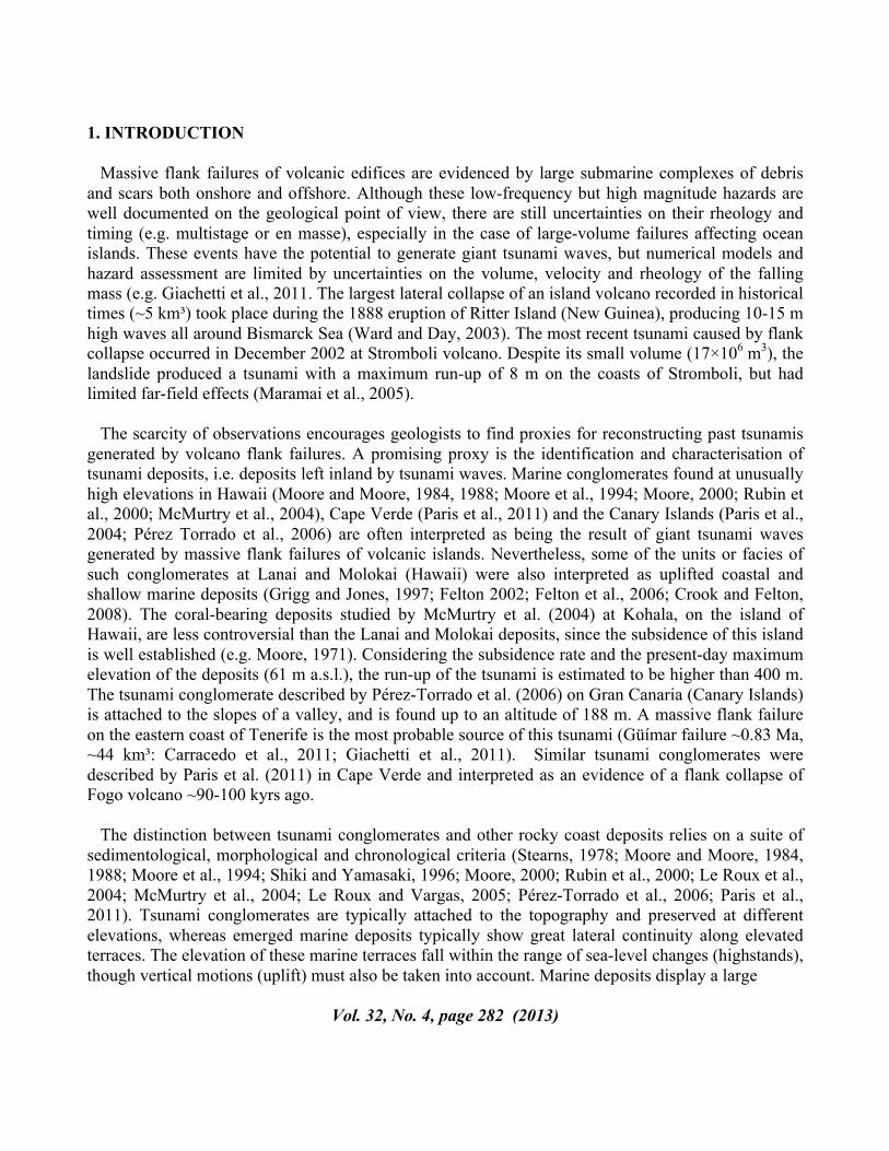
1. INTRODUCTION Massive flank failures of volcanic edifices are evidenced by large submarine complexes of debris and scars both onshore and offshore. Although these low-frequency but high magnitude hazards are well documented on the geological point of view, there are still uncertainties on their rheology and timing (e.g. multistage or en masse), especially in the case of large-volume failures affecting ocean islands. These events have the potential to generate giant tsunami waves, but numerical models and hazard assessment are limited by uncertainties on the volume, velocity and rheology of the falling mass (e.g. Giachetti et al., 2011. The largest lateral collapse of an island volcano recorded in historical times (~5 km³) took place during the 1888 eruption of Ritter Island (New Guinea), producing 10-15 m high waves all around Bismarck Sea (Ward and Day, 2003). The most recent tsunami caused by flank collapse occurred in December 2002 at Stromboli volcano. Despite its small volume (17×106 m3), the landslide produced a tsunami with a maximum run-up of 8 m on the coasts of Stromboli, but had limited far-field effects (Maramai et al., 2005). The scarcity of observations encourages geologists to find proxies for reconstructing past tsunamis generated by volcano flank failures. A promising proxy is the identification and characterisation of tsunami deposits, i.e. deposits left inland by tsunami waves. Marine conglomerates found at unusually high elevations in Hawaii (Moore and Moore, 1984, 1988; Moore et al., 1994; Moore, 2000; Rubin et al., 2000; McMurtry et al., 2004), Cape Verde (Paris et al., 2011) and the Canary Islands (Paris et al., 2004; Pérez Torrado et al., 2006) are often interpreted as being the result of giant tsunami waves generated by massive flank failures of volcanic islands. Nevertheless, some of the units or facies of such conglomerates at Lanai and Molokai (Hawaii) were also interpreted as uplifted coastal and shallow marine deposits (Grigg and Jones, 1997; Felton 2002; Felton et al., 2006; Crook and Felton, 2008). The coral-bearing deposits studied by McMurtry et al. (2004) at Kohala, on the island of Hawaii, are less controversial than the Lanai and Molokai deposits, since the subsidence of this island is well established (e.g. Moore, 1971). Considering the subsidence rate and the present-day maximum elevation of the deposits (61 m a.s.l.), the run-up of the tsunami is estimated to be higher than 400 m. The tsunami conglomerate described by Pérez-Torrado et al. (2006) on Gran Canaria (Canary Islands) is attached to the slopes of a valley, and is found up to an altitude of 188 m. A massive flank failure on the eastern coast of Tenerife is the most probable source of this tsunami (Güímar failure ~0.83 Ma, ~44 km³: Carracedo et al., 2011; Giachetti et al., 2011). Similar tsunami conglomerates were described by Paris et al. (2011) in Cape Verde and interpreted as an evidence of a flank collapse of Fogo volcano ~90-100 kyrs ago. The distinction between tsunami conglomerates and other rocky coast deposits relies on a suite of sedimentological, morphological and chronological criteria (Stearns, 1978; Moore and Moore, 1984, 1988; Moore et al., 1994; Shiki and Yamasaki, 1996; Moore, 2000; Rubin et al., 2000; Le Roux et al., 2004; McMurtry et al., 2004; Le Roux and Vargas, 2005; Pérez-Torrado et al., 2006; Paris et al., 2011). Tsunami conglomerates are typically attached to the topography and preserved at different elevations, whereas emerged marine deposits typically show great lateral continuity along elevated terraces. The elevation of these marine terraces fall within the range of sea-level changes (highstands), though vertical motions (uplift) must also be taken into account. Marine deposits display a large
Vol. 32, No. 4, page 282 (2013)

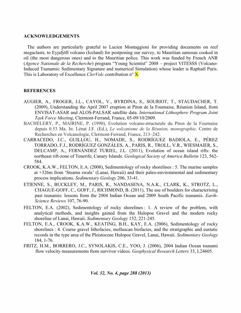
variety of sedimentary facies corresponding to specific shoreface to backshore environments. At the contrary, tsunami conglomerates result in a mixing of offshore, coastal and subaerial sediments. Marine bioclasts found in tsunami deposits are never in live or growth position. The internal stratification, or organisation, in subunits is not a key-feature of tsunami deposits, but together with clast-fabrics it can indicate successive inflows (landward imbrication) and outflows (seaward imbrication). In terms of mean grain size and thickness, landward fining and thinning may occur in tsunami conglomerates, but this alone cannot be considered as a unique diagnostic criteria. More convincing is the identification of rip-up clasts of the substratum in the lower part of a marine conglomerate, attesting for an erosive emplacement. 2. RÉUNION ISLAND AS A POSSIBLE SOURCE OF TSUNAMIS IN THE INDIAN OCEAN Réunion Island represents a possible source of tsunamis in the Indian Ocean, as more than 40 failures from the flanks of Piton des Neiges and Piton de la Fournaise shield volcanoes occurred during the last 2 Myrs (Labazuy 1996, Oehler et al., 2004). A large eastward (seaward) ground displacement was recorded by InSAR monitoring during the April 2007 eruption at Piton de la Fournaise (Augier et al., 2009), which is one of the more active volcanoes in the world. The last major flank failure of Piton de la Fournaise volcano may have occurred ca. 4500 years ago (Bachèlery & Mairine, 1990; Labazuy, 1996). Numerical simulations of different scenarios of flank collapses were realised by Kelfoun et al. (2010). As an example of worst-case scenario, a 10 km³ landslide on the eastern flank of Piton de la Fournaise volcano would generate waves up to 80 m high at the southern coast of Mauritius Island, which is located 170 km ENE of Réunion Island (Fig. 1).
Fig. 1. Sampling sites along the southern coast of Mauritius Island (Indian Ocean) and location of the Beau
Champ marine conglomerate (in yellow), interpreted as an evidente of tsunami.
Vol. 32, No. 4, page 283 (2013)

With the aim of identifying sedimentary evidences of past tsunamis, we surveyed the southern coast of Mauritius Island. In order to avoid confusion with deposits left inland by earthquake-induced tsunamis and cyclones, we have not considered coastal deposits and focused on evidences of marine inundation in terrestrial environments. Both Mauritius and Réunion islands were impacted by the 1883 Krakatau, 2004 Sumatra and 2010 Mentawai tsunamis, but wave runups were respectively below 7 m, 3 m and 2 m a.s.l. (Okal et al., 2006; Sahal et al., 2011; Sahal and Morin, 2012). Cyclone deposits are observed at altitudes always lower than 3 m (Montaggioni, 1978). 3. MARINE CONGLOMERATE IN MAURITIUS ISLAND
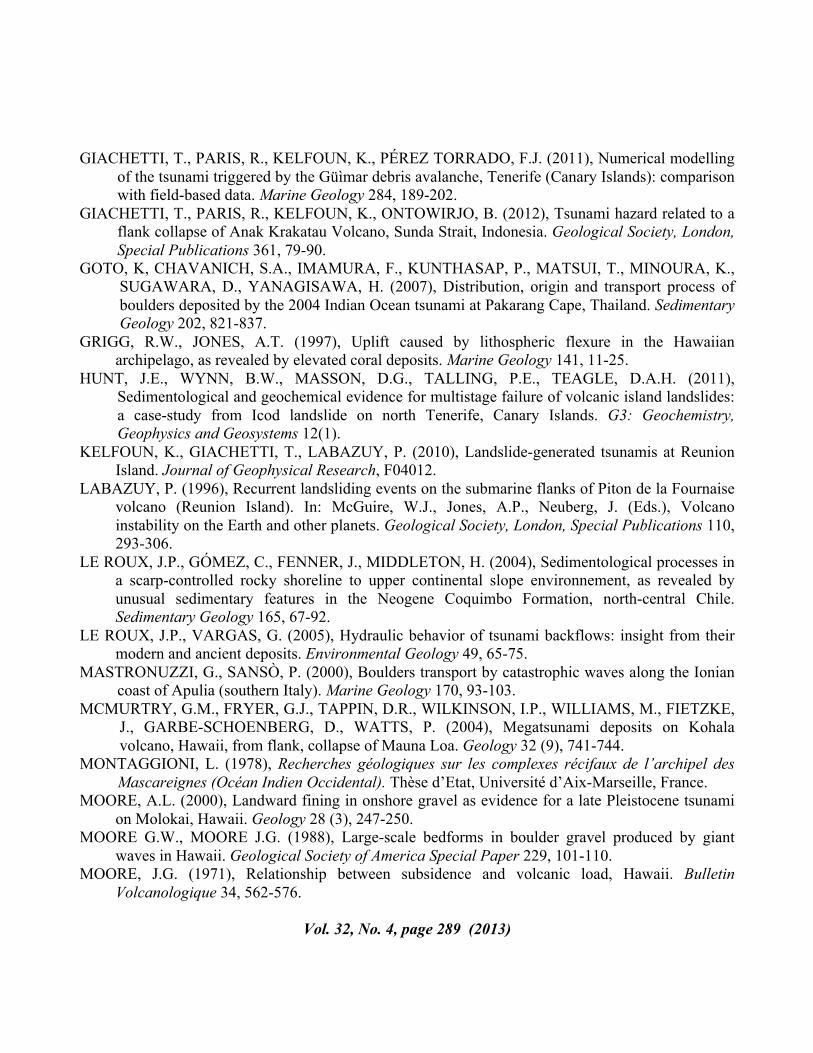
The most convincing evidence of tsunami inundation at high grounds is a marine conglomerate found between 10 and 15 m a.s.l. at several locations near Beau Champ (20°30’28”S / 57°26’19”E). The conglomerate is 20-45 cm thick, intercalated in a reddish lateritic soil at a depth of -50 to -80 cm from one section to another (Fig. 2).
Fig. 2. Tsunami conglomerate (coral and shells fragments) at a depth of 70 cm near Beau
Champ (altitude 11 m a.s.l.). Note the irregular and sharp contacts with soils below and above the event unit. The marine conglomerate is composed of corals (both branching forms and
brain corals) and shell fragments (bivalves and gastropods). A 14C age of 4425 ± 35 BP was obtained on a coral branch (this work).
Vol. 32, No. 4, page 284 (2013)

It is very poorly sorted and its composition reflects a mixing of two sediment sources: (1) marine bioclasts such as debris of corals (branching forms and brain corals), gastropods, and fragments of shells, and (2) fragments of volcanic rocks and minerals, from sand-size to pebbles. The mean thickness and grain size of the conglomerate fines landward. Basal contact with the underlying paleo-soil is erosive. The 14C age of 4425 ± 35 BP obtained on a coral branch (Poznan Radiocarbon Laboratory, Poland) represents a minimum age for the conglomerate, since it is not determined if the coral dated was alive or dead before being transported landward. Due to many similarities with the criteria mentioned above, the marine conglomerate found at Beau Champ could represent an evidence of tsunami in Mauritius ca. 4400 years ago. 4. REEF-MEGACLASTS AT UNUSUAL ALTITUDES The marine conglomerate described in this study is not the only sedimentary evidence of tsunami in Mauritius Island. Reef megaclasts were previously described by Montaggioni (1978) at unusual altitudes (3-40 m) for marine deposits (i.e. not linked to sea level high stands) along the coasts of Mauritius and Rodrigues islands. Uncalibrated 14C and U/Th ages of these blocks range between 3730 ± 100 BP and 6200 ± 800 BP (Montaggioni 1978). Diversity of the sedimentary facies and random orientation of the blocks (e.g. overturned) show that they were not in growth position and could not correspond to in-situ remnants of old reefs. Most of these reef fragments are located between 3 and 15 m, but L. Montaggioni also mentioned a 2 m³ Porites dome at 40 m a.s.l. (Coin de Mire, northern coast). The largest megaclast (100 m³) was found at 4 m a.s.l. near Tamarin (western coast). Between Montaggioni’s observations and our survey (April 2010) some of these megaclasts have been destroyed, and tsunami evidence is getting more or more erased by new buildings. A 90 m³ coral megaclast dated 5220 ± 150 BP (uncalibrated) by Montaggioni (1978) was found preserved close to the marine conglomerate at Beau Champ (Fig. 3). The long axis of the block is oriented N140°, tangent to a flow coming from the southwest. Many studies demonstrated that elongated boulders moved by tsunamis tend to dispose their long axis tangent to flow direction (e.g. Mastronuzzi and Sansò, 2000; Whelan and Kelletat, 2005; Goto et al., 2007; Paris et al., 2009; Etienne et al., 2011). Considering its dimensions and assuming a density of 1.2 g/cm³, this megaclast (length: 7 m; width: 5 m; height: 1.5-4 m) requires flow velocities higher than 3.6 m/s to be transported, if we assume that the block was already detached from its substratum, and 8.0 m/s if joint-bounded on the outer reef (based on equations proposed by Nandasena et al., 2011). Same calculations for the 100 m³ megaclast in Tamarin yields minimum flow velocities between 5 m/s (free block) and 16.7 m/s (joint-bounded) if we assume a density of 1.8 g/cm³ (beach rock). It is actually impossible to state if the megaclasts considered here were already detached from their substratum (e.g. by cyclonic swells or previous tsunamis) or joint-bounded. Rough estimates of flow depth can then be proposed considering the minimum flow velocities and different values of Froude numbers Fr = U / (gh)0.5, where U is the flow velocity, g is the acceleration due to gravity and h is the flow depth). Fr is a non-dimensional number that describes whether a flow is supercritical (>1), critical (=1), or subcritical (<1). For a tsunami, Fr varies spatially and temporally.
Vol. 32, No. 4, page 285 (2013)
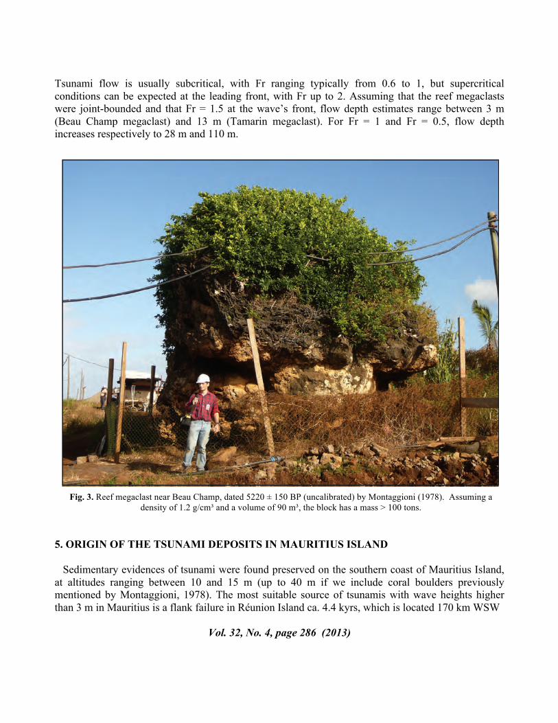
Tsunami flow is usually subcritical, with Fr ranging typically from 0.6 to 1, but supercritical conditions can be expected at the leading front, with Fr up to 2. Assuming that the reef megaclasts were joint-bounded and that Fr = 1.5 at the wave’s front, flow depth estimates range between 3 m (Beau Champ megaclast) and 13 m (Tamarin megaclast). For Fr = 1 and Fr = 0.5, flow depth increases respectively to 28 m and 110 m.
Fig. 3. Reef megaclast near Beau Champ, dated 5220 ± 150 BP (uncalibrated) by Montaggioni (1978). Assuming a
density of 1.2 g/cm³ and a volume of 90 m³, the block has a mass > 100 tons.
5. ORIGIN OF THE TSUNAMI DEPOSITS IN MAURITIUS ISLAND Sedimentary evidences of tsunami were found preserved on the southern coast of Mauritius Island, at altitudes ranging between 10 and 15 m (up to 40 m if we include coral boulders previously mentioned by Montaggioni, 1978). The most suitable source of tsunamis with wave heights higher than 3 m in Mauritius is a flank failure in Réunion Island ca. 4.4 kyrs, which is located 170 km WSW
Vol. 32, No. 4, page 286 (2013)

of the southern coast of Mauritius. The size and altitude of the reef megaclasts and conglomerate found in Mauritius do not necessarily require very large waves to be emplaced and deposited at an altitude of 15 m. However, the characteristics of sediments transported and deposited by tsunamis do not only depend on flow characteristics but also on the kind and size of sediments available (e.g. limited by the maximum size of reef megaclasts available). We were not able to find evidences of smaller reef clasts at altitudes higher than 15 m, but they might have been remobilised by post-tsunami erosion or destroyed by farming. Szczucińsky (2011) reinvestigated the 2004 Indian Ocean tsunami deposits along the Andaman coast of Thailand four years after the tsunami. He found that in about 50% of the sites, the deposits were not preserved, and when preserved, their internal structure was often blurred by bioturbation. Extrapolating these observations over a period of 4000 years suggests that the marine conglomerate found at Beau Champ is clearly the relict of a wider formation which was reworked soon after the tsunami. Destruction of vegetation by the tsunami would have enhanced slope erosion, especially in such a humid tropical environment. When trying to link the sedimentary evidences of a tsunami to its physical characteristics (flow velocity, depth), other uncertainties are related to the source mechanisms. In the case of a flank failure, the way the collapsing mass is released (velocity, in one go or multistage) is a key parameter in the determination of the characteristics of the resulting tsunami, as confirmed by numerical simulations (e.g. Kelfoun et al., 2010; Giachetti et al., 2011; Paris et al., 2011). The rheology chosen to simulate the landslide propagation (e.g. frictional or constant retarding stress) has only a second-order impact on the produced waves (Giachetti et al., 2011, 2012). Hunt et al. (2012) studied distal turbidites around the Canary Islands and proposed that some volcano flank failures are multistage retrogressive failures, separated by short gaps, and thus have a lower tsunamigenic potential compared to failures in one go. The youngest debris avalanche complex identified on the eastern flank of the Piton de la Fournaise volcano (Râle Poussé) is also sub-organised in three different units (Labazuy, 1996; Oehler et al., 2004): the first unit (< 10 km³) would correspond to the main failure, followed by two phases of reworking implying lower volumes (Oehler et al., 2004). 6. CONCLUSIONS
Sedimentary evidences of tsunami inundation are preserved along the southern coast of Mauritius Island. The more convincing deposits were found near Beau Champ, where reef megaclasts described by Montaggioni (1978) are associated with a marine conglomerate at altitudes ranging between 10 and 15 m a.s.l. This is far higher than the altitudes usually reached by earthquake-induced tsunamis (e.g. 2004 Indian Ocean tsunami), cyclone and marine high stand deposits along this coast. The most probable source for this tsunami is a flank failure of Piton de la Fournaise volcano in Réunion Island, which is located 170 km WSW of Mauritius. The age of the marine conglomerate (< 4400 ka) is concordant with the age of the last flank failure at Fournaise volcano (ca. 4500 ka). However, it is actually difficult to propose an inverse model of the failure (volume, fall velocity, in one go or multistage) from the characteristics of the tsunami deposits (e.g. maximum altitude, size of the reef megaclasts).
Vol. 32, No. 4, page 287 (2013)
ACKNOWLEDGEMENTS
The authors are particularly grateful to Lucien Montaggioni for providing documents on reef megaclasts, to Eyjafjöll volcano (Iceland) for postponing our survey, to Mauritian samosas cooked in oil (the most dangerous ones) and to the Mauritian police. This work was funded by French ANR (Agence Nationale de la Recherche) program “Young Scientist” 2008 – project VITESSS (Volcano-Induced Tsunamis: Sedimentary Signature and numerical Simulation) whose leader is Raphaël Paris. This is Laboratory of Excellence ClerVolc contribution n° X.
REFERENCES AUGIER, A., FROGER, J.L., CAYOL, V., BYRDINA, S., SOURIOT, T., STAUDACHER, T.
(2009), Understanding the April 2007 eruption at Piton de la Fournaise, Réunion Island, from ENVISAT-ASAR and ALOS-PALSAR satellite data. International Lithosphere Program Joint Task Force Meeting, Clermont-Ferrand, France, 05-09/10/2009.
BACHÉLERY, P., MAIRINE, P. (1990), Evolution volcano-structurale du Piton de la Fournaise depuis 0.53 Ma. In: Lénat J.F. (Ed.), Le volcanisme de la Réunion, monographie. Centre de Recherches en Volcanologie, Clermont-Ferrand, France, 213–242.
CARRACEDO, J.C., GUILLOU, H., NOMADE, S., RODRÍGUEZ BADIOLA, E., PÉREZ TORRADO, F.J., RODRÍGUEZ GONZÁLES, A., PARIS, R., TROLL, V.R., WIESMAIER, S., DELCAMP, A., FERNÁNDEZ TURIEL, J.L. (2011), Evolution of ocean island rifts: the northeast rift-zone of Tenerife, Canary Islands. Geological Society of America Bulletin 123, 562-584.
CROOK, K.A.W., FELTON, E.A. (2008), Sedimentology of rocky shorelines : 5. The marine samples at +326m from ‘Stearns swale’ (Lanai, Hawaii) and their paleo-environmental and sedimentary process implications. Sedimentary Geology 206, 33-41.
ETIENNE, S., BUCKLEY, M., PARIS, R., NANDASENA, N.A.K., CLARK, K., STROTZ, L., CHAGUÉ-GOFF, C., GOFF, J., RICHMOND, B. (2011), The use of boulders for characterising past tsunamis: lessons from the 2004 Indian Ocean and 2009 South Pacific tsunamis. Earth-Science Reviews 107, 76-90.
FELTON, E.A. (2002), Sedimentology of rocky shorelines : 1. A review of the problem, with analytical methods, and insights gained from the Hulopoe Gravel and the modern rocky shoreline of Lanai, Hawaii. Sedimentary Geology 152, 221-245.
FELTON, E.A., CROOK, K.A.W., KEATING, B.H., KAY, E.A. (2006), Sedimentology of rocky shorelines : 4. Coarse gravel lithofacies, molluscan biofacies, and the stratigraphic and eustatic records in the type area of the Pleistocene Hulopoe Gravel, Lanai, Hawaii. Sedimentary Geology 184, 1-76.
FRITZ, H.M., BORRERO, J.C., SYNOLAKIS, C.E., YOO, J. (2006), 2004 Indian Ocean tsunami flow velocity measurements from survivor videos. Geophysical Research Letters 33, L24605.
Vol. 32, No. 4, page 288 (2013)
GIACHETTI, T., PARIS, R., KELFOUN, K., PÉREZ TORRADO, F.J. (2011), Numerical modelling
of the tsunami triggered by the Güìmar debris avalanche, Tenerife (Canary Islands): comparison with field-based data. Marine Geology 284, 189-202.
GIACHETTI, T., PARIS, R., KELFOUN, K., ONTOWIRJO, B. (2012), Tsunami hazard related to a flank collapse of Anak Krakatau Volcano, Sunda Strait, Indonesia. Geological Society, London, Special Publications 361, 79-90.
GOTO, K, CHAVANICH, S.A., IMAMURA, F., KUNTHASAP, P., MATSUI, T., MINOURA, K., SUGAWARA, D., YANAGISAWA, H. (2007), Distribution, origin and transport process of boulders deposited by the 2004 Indian Ocean tsunami at Pakarang Cape, Thailand. Sedimentary Geology 202, 821-837.
GRIGG, R.W., JONES, A.T. (1997), Uplift caused by lithospheric flexure in the Hawaiian archipelago, as revealed by elevated coral deposits. Marine Geology 141, 11-25.
HUNT, J.E., WYNN, B.W., MASSON, D.G., TALLING, P.E., TEAGLE, D.A.H. (2011), Sedimentological and geochemical evidence for multistage failure of volcanic island landslides: a case-study from Icod landslide on north Tenerife, Canary Islands. G3: Geochemistry, Geophysics and Geosystems 12(1).
KELFOUN, K., GIACHETTI, T., LABAZUY, P. (2010), Landslide-generated tsunamis at Reunion Island. Journal of Geophysical Research, F04012.
LABAZUY, P. (1996), Recurrent landsliding events on the submarine flanks of Piton de la Fournaise volcano (Reunion Island). In: McGuire, W.J., Jones, A.P., Neuberg, J. (Eds.), Volcano instability on the Earth and other planets. Geological Society, London, Special Publications 110, 293-306.
LE ROUX, J.P., GÓMEZ, C., FENNER, J., MIDDLETON, H. (2004), Sedimentological processes in a scarp-controlled rocky shoreline to upper continental slope environnement, as revealed by unusual sedimentary features in the Neogene Coquimbo Formation, north-central Chile. Sedimentary Geology 165, 67-92.
LE ROUX, J.P., VARGAS, G. (2005), Hydraulic behavior of tsunami backflows: insight from their modern and ancient deposits. Environmental Geology 49, 65-75.
MASTRONUZZI, G., SANSÒ, P. (2000), Boulders transport by catastrophic waves along the Ionian coast of Apulia (southern Italy). Marine Geology 170, 93-103.
MCMURTRY, G.M., FRYER, G.J., TAPPIN, D.R., WILKINSON, I.P., WILLIAMS, M., FIETZKE, J., GARBE-SCHOENBERG, D., WATTS, P. (2004), Megatsunami deposits on Kohala volcano, Hawaii, from flank, collapse of Mauna Loa. Geology 32 (9), 741-744.
MONTAGGIONI, L. (1978), Recherches géologiques sur les complexes récifaux de l’archipel des Mascareignes (Océan Indien Occidental). Thèse d’Etat, Université d’Aix-Marseille, France.
MOORE, A.L. (2000), Landward fining in onshore gravel as evidence for a late Pleistocene tsunami on Molokai, Hawaii. Geology 28 (3), 247-250.
MOORE G.W., MOORE J.G. (1988), Large-scale bedforms in boulder gravel produced by giant waves in Hawaii. Geological Society of America Special Paper 229, 101-110.
MOORE, J.G. (1971), Relationship between subsidence and volcanic load, Hawaii. Bulletin Volcanologique 34, 562-576.
Vol. 32, No. 4, page 289 (2013)

MOORE J.G., MOORE G.W. (1984), Deposit from a giant wave on the island of Lanai, Hawaii.
Science 226, 1312-1315. MOORE, J.G., BRYAN, W.B., LUDWIG, K.R. (1994), Chaotic deposition by a giant wave, Molokai,
Hawaii. Geological Society of America Bulletin 106, 962-967. NANDASENA, N.A.K., PARIS, R., TANAKA, N. (2011), Reassessment of hydrodynamic equations
to initiate boulder transport by high energy events (storms, tsunamis). Marine Geology 281, 70-84.
NANDASENA, N.A.K., SASAKI, Y., TANAKA, N. (2012), Modeling field observations of the 2011 Great East Japan tsunami: efficacy of artificial and natural structures on tsunami mitigation. Coastal Engineering 67, 1-13.
OEHLER, J.-F., LABAZUY, P., LÉNAT, J.F. (2004), Recurrence of major flank landslides during the last 2−Ma−history of Réunion Island. Bulletin of Volcanology 66, 585–598.
OKAL, E. A., SLADEN, A., AND OKAL, E.A. (2006), Rodrigues, Mauritius, and Réunion islands field survey after the December 2004 Indian Ocean tsunami. Earthquake Spectra 22, 241–261.
PARIS, R., PÉREZ TORRADO, F.J., CABRERA, M.C., SCHNEIDER, J.L., WASSMER, P., CARRACEDO, J.C. (2004), Tsunami-induced conglomerates and debris flow deposits on the western coast of Gran Canaria (Canary Islands). Acta Vulcanologica 16(1), 133-136.
PARIS, R., WASSMER, P., SARTOHADI, J., LAVIGNE, F., BARTHOMEUF, B., DESGAGES, E., GRANCHER, D., BAUMERT, P., VAUTIER, F., BRUNSTEIN, D., GOMEZ, C. (2009), Tsunamis as geomorphic crises: Lessons from the December 26, 2004 tsunami in Lhok Nga, West Banda Aceh (Sumatra, Indonesia). Geomorphology 104, 59-72.
PARIS, R., GIACHETTI, T., CHEVALIER, J., GUILLOU, H., FRANK, N. (2011), Tsunami deposits in Santiago Island (Cape Verde archipelago) as possible evidence of a massive flank failure of Fogo volcano. Sedimentary Geology 239, 129-145.
PÉREZ TORRADO, F.J., PARIS, R., CABRERA, M.C., SCHNEIDER, J.L., WASSMER, P., CARRACEDO, J.C., RODRIGUEZ SANTANA, A., SANTANA, F. (2006), The Agaete tsunami deposits (Gran Canaria): evidence of tsunamis related to flank collapses in the Canary Islands. Marine Geology 227 (1-2), 137-149.
RUBIN, K.H., FLETCHER III, C.H., SHERMAN, C. (2000), Fossiliferous Lana’i deposits formed by multiple events rather than a single giant tsunami. Nature 408, 675-681.
SAHAL, A., MORIN, J. (2012), Effects of the October 25th, 2010 Mentawai tsunami in La Réunion Island (France): observations and crisis management. Natural Hazards 62, 1125–1136.
SAHAL, A., MORIN, J., SCHINDELÉ, F., LAVIGNE, F. (2011), A catalog of tsunamis in La Réunion island from August 27th, 1883 to October 26th, 2010. Science of Tsunami Hazards 30, 178–190.
SHIKI, T., YAMAZAKI, T. (1996), Tsunami-induced conglomerates in Miocene upper bathyal deposits, Chita Peninsula, central Japan. Sedimentary Geology 104, 175-188.
SPISKE, M., WEISS, R., BAHLBURG, H., ROSKOSCH, J., AMIJAYA, H. (2010), The TsuSedMod inversion model applied to the deposits of the 2004 Sumatra and 2006 Java tsunami and implications for estimating flow parameters of palaeo-tsunami. Sedimentary Geology 224, 29-37.
Vol. 32, No. 4, page 290 (2013)

STEARNS, H.T. (1978), Quaternary shorelines in the Hawaiian Islands. Bernice P. Bishop Museum
Bulletin 237, 57. SZCZUCIŃSKI, W. (2012), The post-depositional changes of the onshore 2004 tsunami deposits on
the Andaman Sea coast of Thailand. Natural Hazards 60, 115-133. WHELAN, F., KELLETAT, D. (2005), Boulder deposits on the southern Spanish Atlantic coast:
possible evidence for the 1755 AD Lisbon tsunami? Science of Tsunami Hazards 23, 25-38.
Vol. 32, No. 4, page 291 (2013)