
Science of the Total Environment · 2017. 1. 30. · Neil McIntyre⁎, Nevenka Bulovic, Isabel...
11
A multi-disciplinary approach to understanding the impacts of mines on traditional uses of water in Northern Mongolia Neil McIntyre ⁎, Nevenka Bulovic, Isabel Cane, Phill McKenna Sustainable Minerals Institute, The University of Queensland, Brisbane, Queensland 4072, Australia HIGHLIGHTS • Multi-disciplinary method to under- stand land use change impacts on water resources • First multi-disciplinary study of mining- related impacts on Mongolian liveli- hoods • Discovery of scale and type of impacts on herding community • Attribution of impacts to small-scale gold mining over other types of mining • Recommendations for improved moni- toring, reporting, engagement and reg- ulation. GRAPHICAL ABSTRACT abstract article info Article history: Received 16 December 2015 Received in revised form 11 March 2016 Accepted 13 March 2016 Available online 24 March 2016 Editor: Simon Pollard Mongolia is an example of a nation where the rapidity of mining development is outpacing capacity to manage the potential land and water resources impacts. Further, Mongolia has a particular social and economic reliance on tradi- tional uses of land and water, principally livestock herding. While some mining operations are setting high standards in protecting the natural resources surrounding the mine site, others have less incentive and capacity to do so and therefore are having adverse effects on surrounding communities. The paper describes a case study of the Sharyn Gol Soum in northern Mongolia where a range of mining types, from artisanal, small-scale mining to a large coal mine, operate alongside traditional herding lifestyles. A multi-disciplinary approach is taken to observe and attribute causes to the water resources impacts in the area. Surveys of the herding household community, land use mapping, and monitoring the spatial variations in water quality indicate deterioration of water resources. Collectively, the differ- ent sources of evidence suggest that the deterioration is mainly due to small-scale gold mining. The evidence included the perception of 78% of the interviewed herders that water quality had changed due to mining; a change in the foot- print of small-scale gold mining from 2.8 to 15.2 km 2 during the period 1999 to 2015; and pH and sulphate values in 2015 consistently outside the ranges observed at a baseline site in the same region. It is concluded that the lack of base- line data and effective governance mechanisms are fundamental challenges that need to be addressed if Mongolia's transition to a mining economy is to be managed alongside sustainability of herder lifestyles. © 2016 The Authors. Published by Elsevier B.V. This is an open access article under the CC BY-NC-ND license (http://creativecommons.org/licenses/by-nc-nd/4.0/). Keywords: Mining Herding Pasture River Livelihoods Pollution Science of the Total Environment 557–558 (2016) 404–414 ⁎ Corresponding author. E-mail address: [email protected] (N. McIntyre). http://dx.doi.org/10.1016/j.scitotenv.2016.03.092 0048-9697/© 2016 The Authors. Published by Elsevier B.V. This is an open access article under the CC BY-NC-ND license (http://creativecommons.org/licenses/by-nc-nd/4.0/). Contents lists available at ScienceDirect Science of the Total Environment journal homepage: www.elsevier.com/locate/scitotenv brought to you by CORE View metadata, citation and similar papers at core.ac.uk provided by Elsevier - Publisher Connector
Transcript of Science of the Total Environment · 2017. 1. 30. · Neil McIntyre⁎, Nevenka Bulovic, Isabel...

Science of the Total Environment 557–558 (2016) 404–414
Contents lists available at ScienceDirect
Science of the Total Environment
j ourna l homepage: www.e lsev ie r .com/ locate /sc i totenv
brought to you by COREView metadata, citation and similar papers at core.ac.uk
provided by Elsevier - Publisher Connector
A multi-disciplinary approach to understanding the impacts of mines ontraditional uses of water in Northern Mongolia
Neil McIntyre ⁎, Nevenka Bulovic, Isabel Cane, Phill McKennaSustainable Minerals Institute, The University of Queensland, Brisbane, Queensland 4072, Australia
H I G H L I G H T S G R A P H I C A L A B S T R A C T
• Multi-disciplinary method to under-stand land use change impacts on waterresources
• First multi-disciplinary study of mining-related impacts on Mongolian liveli-hoods
• Discovery of scale and type of impactson herding community
• Attribution of impacts to small-scalegold mining over other types of mining
• Recommendations for improved moni-toring, reporting, engagement and reg-ulation.
⁎ Corresponding author.E-mail address: [email protected] (N. McIntyre).
http://dx.doi.org/10.1016/j.scitotenv.2016.03.0920048-9697/© 2016 The Authors. Published by Elsevier B.V
a b s t r a c t
a r t i c l e i n f oArticle history:Received 16 December 2015Received in revised form 11 March 2016Accepted 13 March 2016Available online 24 March 2016
Editor: Simon Pollard
Mongolia is an example of a nation where the rapidity of mining development is outpacing capacity to manage thepotential land and water resources impacts. Further, Mongolia has a particular social and economic reliance on tradi-tional uses of land and water, principally livestock herding. While some mining operations are setting high standardsin protecting the natural resources surrounding the mine site, others have less incentive and capacity to do so andtherefore are having adverse effects on surrounding communities. The paper describes a case study of the SharynGol Soum in northern Mongolia where a range of mining types, from artisanal, small-scale mining to a large coalmine, operate alongside traditional herding lifestyles. A multi-disciplinary approach is taken to observe and attributecauses to the water resources impacts in the area. Surveys of the herding household community, land use mapping,andmonitoring the spatial variations inwater quality indicate deterioration of water resources. Collectively, the differ-ent sources of evidence suggest that the deterioration ismainly due to small-scale goldmining. The evidence includedthe perception of 78% of the interviewed herders that water quality had changed due tomining; a change in the foot-print of small-scale gold mining from 2.8 to 15.2 km2 during the period 1999 to 2015; and pH and sulphate values in2015 consistently outside the ranges observed at a baseline site in the same region. It is concluded that the lack of base-line data and effective governance mechanisms are fundamental challenges that need to be addressed if Mongolia'stransition to a mining economy is to be managed alongside sustainability of herder lifestyles.
© 2016 The Authors. Published by Elsevier B.V. This is an open access article under the CC BY-NC-ND license(http://creativecommons.org/licenses/by-nc-nd/4.0/).
Keywords:MiningHerdingPastureRiverLivelihoodsPollution
. This is an open access article under the CC BY-NC-ND license (http://creativecommons.org/licenses/by-nc-nd/4.0/).

405N. McIntyre et al. / Science of the Total Environment 557–558 (2016) 404–414
1. Introduction
1 Gol is ‘river’ in Mongolian.2 A Soum is a secondary level political administration similar to a county in the U.S.3 An Aimag is bigger than a Soum and is a first-level political administration similar to a
province.
Mining regions face radical changes to landscapes. This applies to themine sites themselves, but also to surrounding areas impacted by landclearance, new infrastructure, waste dumps, and human settlements.These land use changes, as well the abstraction and discharge of waterby the mine, can significantly impair water resources in terms of avail-ability of good quality water and potential impacts on a range of fresh-water ecosystem services (Hodges, 1995). A particular concern is thelong-lasting, potentially perpetual water quality impacts that cancomewith geological perturbations in the forms of acid, salt and metal-liferous drainage. These types of change can stretchwell beyond the op-erational life of the mine, and the social and environmental adverseimpacts in cases are considered to outweigh the benefits of the project(Bai et al., 2011). As well as being long-lasting in some cases, the im-pacts on water can also be spatially diffuse, with spills, seepage andwaste discharges having the potential to impair water resources welldownstream of the source (Byrne et al., 2012).
Many mining companies employ good practice to effectively man-age the known risks, driven both by government and self-regulation.This involves good practice through all stages of the mine project, in-cluding mine rehabilitation and post-closure management (McIntyreet al., 2015). This is most often the case for well-regulated and large-scale mines; however in many developing mining regions it is the lesswell managed and smaller-scale mining activities that are the primarysource of risk. While small-scale mines in some cases are legal and cov-ered by regulations that aim to protect the environment, numerous fac-tors can mean that effective regulation is a challenge. These include therelative transience of the mines, the spatially diffuse development andabandonment of sites, the poor accessibility of mining areas to officialsand the potential for corruption. There is also less incentive for respon-sible water management if the small-scale mining company does nothave a national and international reputation to protect.Water quality is-sues that have been highlighted downstream of small-scale mines in-clude mercury and cyanide contamination (these being used inextraction of gold), elevated sediment loads due to poor sedimentman-agement, and elevated pH, salts andmetals concentrations (Cordy et al.,2011; Hillman et al., 2015). The mixing of different types of mining inone catchment, along with other land uses that affect hydrological re-gimes and water quality, can lead to uncertainty and disputes aboutthe source of impairment to water resources.
The hydrological impacts of changes to vegetation cover, topographyand soil properties, and the construction of dams, levees and impervioussurfaces have been studied widely in the context of various land uses,including mining (Ferrari et al., 2009). The sediment and pollutionsources associated with landscape changes have also been the subjectof considerable investigation, as have the effects of industrial, agricul-tural and human uses and discharges of water (Rodriguez et al., 2013;Zhou et al., 2016). While the localised impacts of these changes are rel-atively well understood, the catchment scale impacts of local land usechanges have proven difficult to observe, due to natural diffusion of im-pacts and the increasing number of influences as scale increases. Thetechnical challenges of monitoring local land use changes over catch-ment scales also constrain understanding. Furthermore, detectingchanges in hydrology and water quality, often against considerableweather-driven variability and other background effects, requires in-vestment in multi-scale, multi-parameter monitoring networks andthe associated capacity to manage these and interpret the data. Evenwhere catchments are well-monitored, there can be considerable prob-lems attributing changes to individual land and water users (McIntyreet al., 2014).
The challenge of attributing deterioration in water supplies to landuse change can be approached by multi-disciplinary research, whichaims to combine different types of evidence. In particular, the lack oflong-term hydrological and water quality monitoring often meansthat evidence of change must be qualitative, through records of the
observations and experiences of long-standing, local land and waterusers or managers. Formalising such records and combining with hy-drological monitoring is an established approach to understanding his-torical changes to water resources (Gebrehiwot et al., 2010; McHughet al., 2007). Another scientific discipline area that has become well-established in water resources research is remote sensing and mappingof land use change (e.g. Dewan and Yamaguchi, 2009; Mattikalli andRichards, 1996). The reconstruction of land use maps dating back tothe first Landsat satellitemission can provide catchment-scale evidenceto support or contest the evidence gained from hydrological monitoringand/or qualitative records. In particular, the land use mapping providesa catchment view, which can be essential in identifying the upstreamland use changes that govern downstream water resources.
Such amulti-disciplinary approach can have particularly value in re-gions experiencing rapid land use development. The economic pres-sures for rapid development mean that baseline hydrologicalmonitoring can be particularly insufficient, meaning that anecdotal re-cords and reconstruction of land use maps are essential supplements.Developing capacity to identify and manage environmental risks andgovern effectively can fall behind the new challenges and new develop-ments in international good practice (McIntyre et al., 2015). Further-more, in rapidly developing regions traditional uses of water, whilehaving relatively low economic value at national scale, can still be es-sential for the livelihoods of much of the population.
Mongolia has a long history of mining since the early 1920s, but thepolitical change from socialism to an open-market economy in the early1990s has seen a dramatic growth inmining development and the issu-ing of mining licences. In contemporary Mongolia, many areas are al-ready experiencing rapid development of large scale mining, primarilyof coal and gold, as well as small-scale mining, and associated land usechange such as deforestation, urbanisation, abandonment andovergrazing of pasture lands (Endicott, 2012). Numerous studies havereported deteriorations in quantity and quality of water resources dueto mining development (Brumbaugh et al., 2013; Hillman et al., 2015;Stubblefield et al., 2005). Furthermore, a lack of baseline data coupledwith out-dated environmental management techniques means thatthewater impacts of long-standingmines are often not well document-ed. Thewatermanagement performance of mining companies has beenunder increasing scrutiny, and howeffectively goodwatermanagementpractices have been and are being followed is variable, particularly con-sidering the range of practices across large-scale and smaller-scalemines.
A particular area of concern is the impact of mining on herder life-styles. Currently about 30% ofMongolians live as herders and rely on an-imal husbandry as their primary livelihood source (Robbins and Smith,2014). Traditional herding uses inter-generational knowledge of re-gional water supplies and in many cases semi-nomadic lifestyles toovercome intermittent shortages of land and water. Thus pasture andwater sources for herds and herders are critical natural resources. Inmany areas, the rapid expansion of mining has occurred alongside ap-parently dramatic changes in land use,water use andherder livelihoods,yet this is not well documented and in most areas the baseline dataneeded to detect and attribute change are almost non-existent. Therole of different types of mining operations among the various other in-fluences on water resources is unclear.
The paper presents a case study of a herding region in the north ofMongolia, in Sharyn Gol1 Soum,2 of Darkhan-Uul Aimag,3 which has ex-perienced rapid mining development and represents the rapidity ofland use change and associated environmental risks in much ofMongolia. The paper has the following objectives:
406 N. McIntyre et al. / Science of the Total Environment 557–558 (2016) 404–414
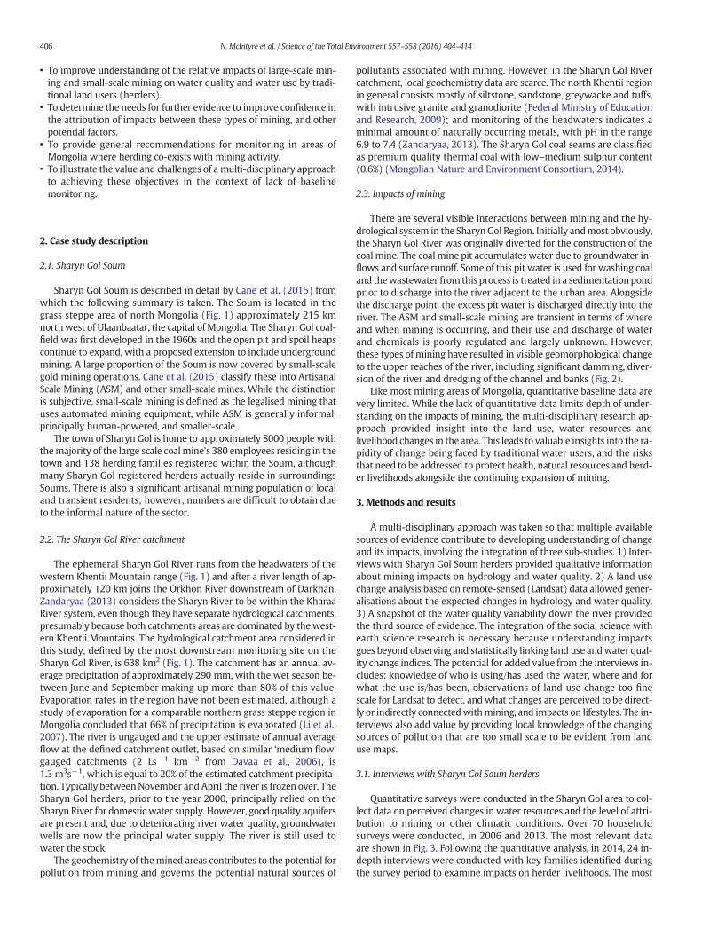
• To improve understanding of the relative impacts of large-scale min-ing and small-scale mining on water quality and water use by tradi-tional land users (herders).
• To determine the needs for further evidence to improve confidence inthe attribution of impacts between these types of mining, and otherpotential factors.
• To provide general recommendations for monitoring in areas ofMongolia where herding co-exists with mining activity.
• To illustrate the value and challenges of a multi-disciplinary approachto achieving these objectives in the context of lack of baselinemonitoring.
2. Case study description
2.1. Sharyn Gol Soum
Sharyn Gol Soum is described in detail by Cane et al. (2015) fromwhich the following summary is taken. The Soum is located in thegrass steppe area of north Mongolia (Fig. 1) approximately 215 kmnorthwest of Ulaanbaatar, the capital of Mongolia. The Sharyn Gol coal-field was first developed in the 1960s and the open pit and spoil heapscontinue to expand, with a proposed extension to include undergroundmining. A large proportion of the Soum is now covered by small-scalegold mining operations. Cane et al. (2015) classify these into ArtisanalScale Mining (ASM) and other small-scale mines. While the distinctionis subjective, small-scale mining is defined as the legalised mining thatuses automated mining equipment, while ASM is generally informal,principally human-powered, and smaller-scale.
The town of Sharyn Gol is home to approximately 8000 people withthemajority of the large scale coalmine's 380 employees residing in thetown and 138 herding families registered within the Soum, althoughmany Sharyn Gol registered herders actually reside in surroundingsSoums. There is also a significant artisanal mining population of localand transient residents; however, numbers are difficult to obtain dueto the informal nature of the sector.
2.2. The Sharyn Gol River catchment
The ephemeral Sharyn Gol River runs from the headwaters of thewestern Khentii Mountain range (Fig. 1) and after a river length of ap-proximately 120 km joins the Orkhon River downstream of Darkhan.Zandaryaa (2013) considers the Sharyn River to be within the KharaaRiver system, even though they have separate hydrological catchments,presumably because both catchments areas are dominated by thewest-ern Khentii Mountains. The hydrological catchment area considered inthis study, defined by the most downstream monitoring site on theSharyn Gol River, is 638 km2 (Fig. 1). The catchment has an annual av-erage precipitation of approximately 290 mm, with the wet season be-tween June and September making up more than 80% of this value.Evaporation rates in the region have not been estimated, although astudy of evaporation for a comparable northern grass steppe region inMongolia concluded that 66% of precipitation is evaporated (Li et al.,2007). The river is ungauged and the upper estimate of annual averageflow at the defined catchment outlet, based on similar ‘medium flow’gauged catchments (2 Ls−1 km−2 from Davaa et al., 2006), is1.3 m3s−1, which is equal to 20% of the estimated catchment precipita-tion. Typically betweenNovember and April the river is frozen over. TheSharyn Gol herders, prior to the year 2000, principally relied on theSharyn River for domestic water supply. However, good quality aquifersare present and, due to deteriorating river water quality, groundwaterwells are now the principal water supply. The river is still used towater the stock.
The geochemistry of themined areas contributes to the potential forpollution from mining and governs the potential natural sources of
pollutants associated with mining. However, in the Sharyn Gol Rivercatchment, local geochemistry data are scarce. The north Khentii regionin general consists mostly of siltstone, sandstone, greywacke and tuffs,with intrusive granite and granodiorite (Federal Ministry of Educationand Research, 2009); and monitoring of the headwaters indicates aminimal amount of naturally occurring metals, with pH in the range6.9 to 7.4 (Zandaryaa, 2013). The Sharyn Gol coal seams are classifiedas premium quality thermal coal with low–medium sulphur content(0.6%) (Mongolian Nature and Environment Consortium, 2014).
2.3. Impacts of mining
There are several visible interactions between mining and the hy-drological system in the SharynGol Region. Initially andmost obviously,the Sharyn Gol River was originally diverted for the construction of thecoal mine. The coal mine pit accumulates water due to groundwater in-flows and surface runoff. Some of this pit water is used for washing coaland thewastewater from this process is treated in a sedimentationpondprior to discharge into the river adjacent to the urban area. Alongsidethe discharge point, the excess pit water is discharged directly into theriver. The ASM and small-scale mining are transient in terms of whereand when mining is occurring, and their use and discharge of waterand chemicals is poorly regulated and largely unknown. However,these types of mining have resulted in visible geomorphological changeto the upper reaches of the river, including significant damming, diver-sion of the river and dredging of the channel and banks (Fig. 2).
Like most mining areas of Mongolia, quantitative baseline data arevery limited. While the lack of quantitative data limits depth of under-standing on the impacts of mining, the multi-disciplinary research ap-proach provided insight into the land use, water resources andlivelihood changes in the area. This leads to valuable insights into the ra-pidity of change being faced by traditional water users, and the risksthat need to be addressed to protect health, natural resources and herd-er livelihoods alongside the continuing expansion of mining.
3. Methods and results
A multi-disciplinary approach was taken so that multiple availablesources of evidence contribute to developing understanding of changeand its impacts, involving the integration of three sub-studies. 1) Inter-views with Sharyn Gol Soum herders provided qualitative informationabout mining impacts on hydrology and water quality. 2) A land usechange analysis based on remote-sensed (Landsat) data allowed gener-alisations about the expected changes in hydrology and water quality.3) A snapshot of the water quality variability down the river providedthe third source of evidence. The integration of the social science withearth science research is necessary because understanding impactsgoes beyond observing and statistically linking land use andwater qual-ity change indices. The potential for added value from the interviews in-cludes: knowledge of who is using/has used the water, where and forwhat the use is/has been, observations of land use change too finescale for Landsat to detect, andwhat changes are perceived to be direct-ly or indirectly connectedwithmining, and impacts on lifestyles. The in-terviews also add value by providing local knowledge of the changingsources of pollution that are too small scale to be evident from landuse maps.
3.1. Interviews with Sharyn Gol Soum herders
Quantitative surveys were conducted in the Sharyn Gol area to col-lect data on perceived changes in water resources and the level of attri-bution to mining or other climatic conditions. Over 70 householdsurveys were conducted, in 2006 and 2013. The most relevant dataare shown in Fig. 3. Following the quantitative analysis, in 2014, 24 in-depth interviews were conducted with key families identified duringthe survey period to examine impacts on herder livelihoods. The most

Fig. 2. Dams and geomorphology impacts of small-scale mines on the banks of the Sharyn Gol River.
Fig. 1. Sharyn Gol location, the principal land uses in 2015, and water quality sampling locations.
407N. McIntyre et al. / Science of the Total Environment 557–558 (2016) 404–414

408 N. McIntyre et al. / Science of the Total Environment 557–558 (2016) 404–414
relevant comments from these interviews are displayed in Table 1,which classifies comments into those relating to: river water qualityand health impacts; changes fromusing river water to using groundwa-ter wells; water availability; recreational use of the river; and attribu-tion of impacts.
Many of the interviewees discussed a specific period in the late1990'swhen the river becamepolluted, for example one interviewee re-ported “in the early 90's the river was very clean, where everybodydrank [from it]. Now it became impossible to drink…”. Due to the uncer-tainty about river water quality the government advised them to stopdrinking the river water. Many of the interview results indicate thatthe switch from using the river to groundwater wells for drinkingwater supply is the single greatest water-related impact. The herdershave invested or intend to invest in groundwater wells, often with sup-port or intended support of the local government, or purchase waterfrom the commercially run Sharyn Gol Soum well. That source ofwater is not only an economic cost but can take up a significant amountof time collectingwater that is usually spent tending to income generat-ing sources or caring for children, sick or elderly. Continually, herdersdiscussed the heightened health risk of recreational activities due toriver pollution, particularly swimming and fishing activities that arecommon in summer months. The herders with one exception did notcomment on the mine pit affecting groundwater yields, in contrast tosome other parts of Mongolia where managing groundwater impactshas requiredmajor investment bymining companies (Cane et al., 2015).
The predominant pollutants associated with mines (salts, acidityand dissolved metals), unlike the oxygen depletion and eutrophicationproblems associatedwith urban and agricultural areas andmany indus-tries, are not usually visible to water users, unless changing conditionsallow the precipitation of metal compounds such as iron hydroxide.The inability of the herders to see or measure key pollutants and theirreliance on anecdotal evidence about the risks causes great uncertaintyand potential risks to livestock and family health. For example, the com-ments “even for the livestock it's unsafe to drink from there” and thecontrasting “we haven't noticed negative impacts to the animals” illus-trate the uncertainty. Evidently, effective monitoring and publicreporting of water quality is required to further understand the effectof water sources on herders and their livestock.
Fig. 3.Herders' perceptions about: a) changes inwater quantity and b) changes inwater quality
Approximately half the interviewed herders perceived deteriorationin river water quantity and quality, and those who perceived a changeconsistently attributed it to mining (Fig. 3). The interviews highlightedthe attribution is directed at small-scale gold mining. This perceptionis based partly on the timing of the mining developments matchingtiming of impacts, and partly on herders' observations of mining prac-tices. It may also be biased somewhat because the small-scale miningis perceived as transient and providing little local benefit, while theASM mining and large-scale mining are traditionally local employers.However, the absence of comments directly attributing impacts to theASM or large coal mine is perhaps surprising considering the absenceof water quality control measures except the rudimentary, recentlyinstalled sedimentation pond prior to the coal mine wastewater dis-charge point. Although one interviewee noted the impact of pig farmingon river water quality, the probable sources of pollution from cattle anddomestic waste were not mentioned, and deforestation impacts onwater resources did not feature in the responses. Thewater quality sam-pling described below elucidates the relative impacts of the differenttypes of mining.
3.2. Linking land use change data to water risks
Landsat imagery was used to create a time-series of the region, in-volving a total of 18 Landsat scenes spanning over 26 years, from 1989to 2015. The data were compiled and analysed using ArcGIS softwareto determine the spatial extents and temporal changes in the targetland-use categories. The methods used to delineate the land-use areasand the ground-truthing are described in Appendix 1 (on-line supple-mentary material). Four time-slices are shown in Fig. 4 to illustratethe land use changes over the period 1989–2015; and Fig. 5 plots thechange in land use areas using data from all 18 sampled years. Theseland use data were reviewed; and the implications of the observedland use for hydrology and water quality are discussed based on obser-vations made in comparable published case studies.
The land use change mapping illustrates rapid expansion of small-scale mining, which by 2013 has a considerable footprint extendinginto the catchment headwater areas. Thewater resources risks of unreg-ulated and poorly managed small-scale mining are well known (e.g.
; c) attribution of quantity changes tomining; d) attribution of quality changes to mining.

Table 1Comments from herding families about the water resources impacts associated withmining.
Potential impact onwater resources
Herders' comments Authors' notes
River water qualityand healthimpacts
1. “10 years ago we used todrink from the river, butnow we go to the Soumcenter for drinkingwater… 16 years ago theriver was clean andfresh… Even for the live-stock it's unsafe to drinkfrom there”
1. There is a groundwaterwell in the Soum centre.
2. “The summer is theworst. It continues fromJune to October… Be-cause the gold compa-nies and ninjasa are mostactive in the summertime. It's kind of seasonalwork. In the winter timethey all stop. And whenit gets warmer, from thespring time they start”
2. Small-scale mining andASM stops in the winterdue to frozen groundand water.
3. “We haven't noticednegative impacts to theanimals. We live close tothe Soum, so we have awater well. People wholive far away from Soum[Centre], might be stilldrinking from the river,especially people livingin the downstream…38–39 km away fromhere. Most of them arenomadic herders, so theydon't have access towater wells.”
3. The survey did not in-clude the herders welldownstream of theSoum.
4. “In the early 90's theriver was very clean,where everybody drank.Now it became impossi-ble to drink…”
4. This is consistent withthe timing of the rapidspread in small-scalemining (Fig. 5).
5. “Mainly the ninjas wash-ing their gold in theriver, and now the riverlooks red”
5. The river is intermittent-ly red according to thisreport; red water isoften linked with acidmine drainage.
Change from usingriver water tousinggroundwaterwells
1. “…her family is planningto ask government to as-sist them to dig a well inthe area. She said she hasspoken to governmentand they have promisedto build a well, but saidthey don't have themoney to do so at themoment.”
1. The local governmenthave a program of build-ing new wells.
2. “we stopped drinkingfrom the river. We nowdrink from the well. Butour livestock still drinksfrom the river.”
2. This is variable – anoth-er herder family report-ed that they now usegroundwater for theirlivestock.
3. “The local governmentbuilt us an electricalwater well, because theysuggested us not to drinkfrom the river”
Water availability 1. “Now because of the goldmines, water is not onlypolluted, but in terms ofquantity it's depleted”“Gold companies are alsochanging the river flow”
1. The gold mines dam theriver, which is expectedto increase seepage andevaporation losses. Thereis a question of lossesthrough the river bed dueto the close proximity ofthe coal mine pit.
Table 1 (continued)
Potential impact onwater resources
Herders' comments Authors' notes
2. “My winter place is 9 kmaway from the Soum andwe have a ground waterwell there. We used topump water from 40 mdeep and watered ouranimals. But now it hasdried out.”
2. This is consistent withthe national survey ofstatus of groundwatersprings and rainfalltrends (Dagvadorj et al.,2009); and it may be as-sumed there is no directlink to the mining.
3. “In 2020, governmentsays that there will bewater from Orkhon river,Bulgan Aimag. It's im-possible. People from theOrkhon valley would ob-viously protest againstit.”
3. Although Sharyn Gol isin an area of semi-aridclimate, the area is notshort of water due tolow demand for water;however the proposedcoal mine expansion willconsiderably increasedemand.
Recreational use ofthe river
1. “Sometimes when theriver becomes clearer,children go there toswim.”
1. The popular bathingpoint is downstream ofSharyn Gol where thewater quality was foundto be worst.
2. “There are a number ofpeople who also try tofish, but there aren't anyfish.”
2. The water quality surveyfound that the pHaround the small-scalemines is too low to sup-port most species of fish.
Attribution ofimpacts
1. “All people blame theninjas. But it's actually thegold mining companies,who are not doing the re-habilitation properly. Ithink the local govern-ment together with thecentral governmentshould take measures onthis issue”
1. Good practice rehabilita-tion should usually returnthe land to productiveuse, with no adverse im-pacts on water resources.
2. “it's the gold mines whoare polluting the river.The coal mine has beenoperating since 1960'sand the river was stillclean.”
2. This is supported by thesnap shot of water qual-ity conducted in August2014, reported in thispaper.
3. “When they clean thedirt with the gold in theriver, dirt pollutes theriver. Also they mightuse the mercury forwashing…”
3. We saw no evidence ofuse of mercury, althoughthe water quality sam-pling did not include it.
a ASM miners are regularly referred to as ninjas by locals.
409N. McIntyre et al. / Science of the Total Environment 557–558 (2016) 404–414
Cordy et al., 2011). The displacement of native vegetation and soil espe-cially from riparian areas, and lack of investment in floods, erosion, sed-iments management and mined land rehabilitation, can radicallyincrease sediments and nutrient loads downstream, as previously ob-served in Mongolia (Stubblefield et al., 2005). The creation of on-lineand off-line storage ponds (Fig. 2) can increase evaporation and bed-infiltration and hence reduce flows downstream, and alter the naturalflow and sediments regimes. The exposure of rock to the atmosphere,in particular the large spoil (waste rock) heaps, can be sources of salts,acidity and metals that cause long-term impacts on river water qualitywith potential risks to ecosystems and human health (Byrne et al.,2012). These contamination sources depend on the local mineralogyand hydrology, andweathering and leaching processes. These processescan be controlled by following good practice; however these are oftennot considered in a small-scale mining operation. In some cases therehas been capping (covering with soil) of the spoil heaps after thesmall-scale mining operations have ended; however the benefits ofthis depend on the ability of the capping to divert water away fromthewaste, which is unknown. Another type of concern is contaminationwith chemicals, in particular mercury, sometimes used in the process of

Fig. 4. Changes in land use from 1989 to 2015 represented by the modelled land cover for four time slices.
410 N. McIntyre et al. / Science of the Total Environment 557–558 (2016) 404–414
separating gold from the ore. Although its use in mining is illegal inMongolia, and no reliable information about the gold extractionmethods at Sharyn Gol was obtained (due to the non-participation ofthe small-scale miners in the project), mercury use by small-scaleminers is a major national and international concern (Brumbaughet al., 2013).
The land use footprint of the large-scale coal mine at Sharyn Gol(Fig. 1) is dominated by the mine pit and spoil heaps. The pit extendsto approximately 120 m below original land surface. Although the pitbase is well below the natural groundwater level, there is no evidencethat theminehas significant groundwater impacts (although newques-tions about potential groundwater impact are raised by current plans todeepen and extend themine). As the SharynGol River has been diverted
Fig. 5. Land use areas since 1989.
around the north-east periphery of the pit, there is also a question ofhow the groundwater drawdown may affect infiltration thought thechannel bed. The two discharge points from the mine pit are shown aspoints 4 and 5 in Fig. 2. The impacts of these discharges and runofffrom the coal mine's rock heaps, will be explored further in the nextsub-section, where water quality measurements are reported.
The othermajor land use in the catchment area of interest is herding.Pasture land is not owned by any particular herder, rather the wide ex-panse of pasture land is leased by herders through registration in theSoumarea. The intensity of herding is increasing inMongolia, and inten-sification of grazing has been linked to deteriorating water resourcesthrough soil degradation, riverbank erosion and nutrient pollution ofrivers (Maasri and Gelhaus, 2011). A notable source of riparian zonedamage in some areas around the Sharyn Gol Soum is cattle accessingthe river.
In summary, review of the land use data and relevant literature re-sults in the followingpotential risks to thewater resources in the SharynGol Soum: increased sediments and associated contaminants due to theexpansion of mining, in particular the rapid expansion of small-scalemining and ASM; reduced flows and perturbed flow regimes by dam-ming and diversion of the river and potential increased river-bed infil-tration near to the coal mine; increased pH, salts and dissolved metalsin the river due to leaching from the small-scale mining spoil heaps;pollution from chemicals potentially used as part of gold mine extrac-tion; agricultural pollution and erosion from cattle accessing the ripari-an areas; and potential pollution from urban wastewater discharges.
3.3. Monitoring river water quality
Like most rivers in Mongolia, baseline surveys of water quality oftendo not exist, and routine or scientific monitoring of mining and otherland use impacts is not regularly undertaken, or the results are not ac-cessible. The UNESCO report of Zandaryaa (2013) remarks “There areno systematically observed data to assess the pollution from mining
411N. McIntyre et al. / Science of the Total Environment 557–558 (2016) 404–414
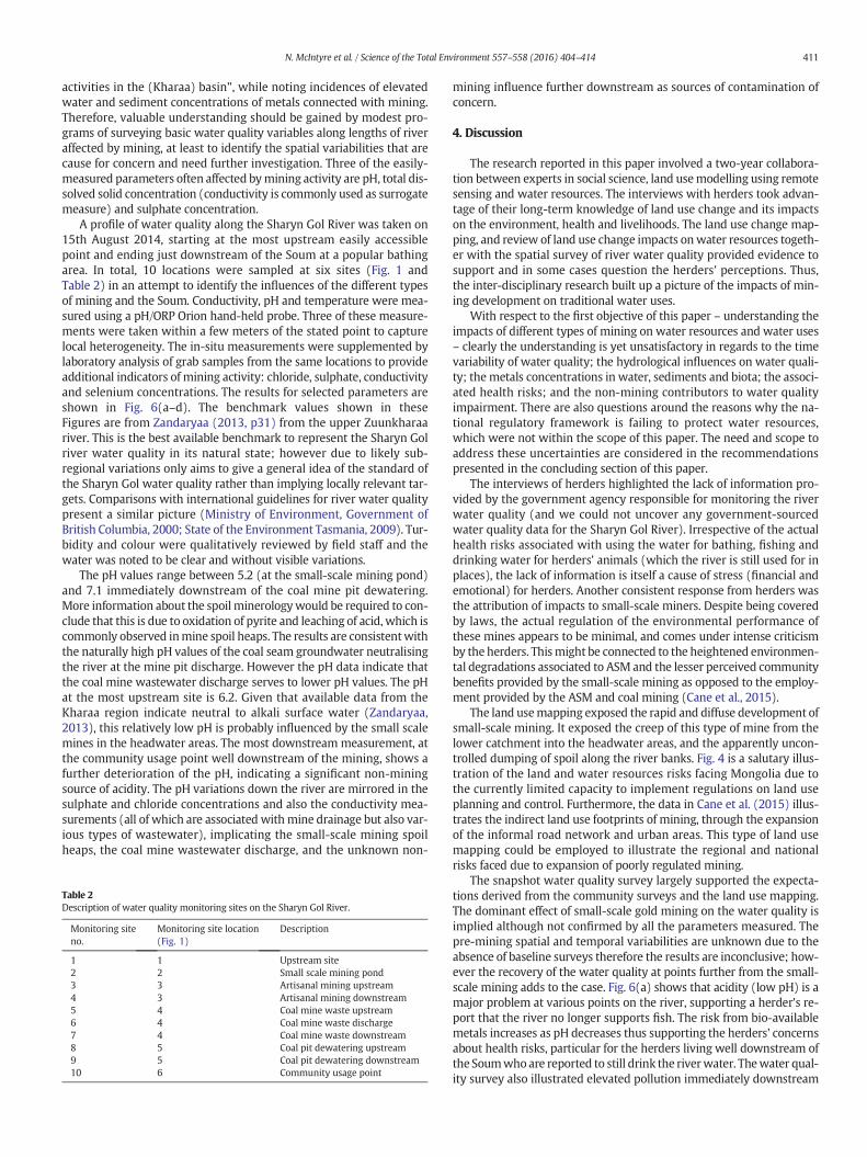
activities in the (Kharaa) basin”, while noting incidences of elevatedwater and sediment concentrations of metals connected with mining.Therefore, valuable understanding should be gained by modest pro-grams of surveying basic water quality variables along lengths of riveraffected by mining, at least to identify the spatial variabilities that arecause for concern and need further investigation. Three of the easily-measured parameters often affected bymining activity are pH, total dis-solved solid concentration (conductivity is commonly used as surrogatemeasure) and sulphate concentration.
A profile of water quality along the Sharyn Gol River was taken on15th August 2014, starting at the most upstream easily accessiblepoint and ending just downstream of the Soum at a popular bathingarea. In total, 10 locations were sampled at six sites (Fig. 1 andTable 2) in an attempt to identify the influences of the different typesof mining and the Soum. Conductivity, pH and temperature were mea-sured using a pH/ORP Orion hand-held probe. Three of these measure-ments were taken within a few meters of the stated point to capturelocal heterogeneity. The in-situ measurements were supplemented bylaboratory analysis of grab samples from the same locations to provideadditional indicators of mining activity: chloride, sulphate, conductivityand selenium concentrations. The results for selected parameters areshown in Fig. 6(a–d). The benchmark values shown in theseFigures are from Zandaryaa (2013, p31) from the upper Zuunkharaariver. This is the best available benchmark to represent the Sharyn Golriver water quality in its natural state; however due to likely sub-regional variations only aims to give a general idea of the standard ofthe Sharyn Gol water quality rather than implying locally relevant tar-gets. Comparisons with international guidelines for river water qualitypresent a similar picture (Ministry of Environment, Government ofBritish Columbia, 2000; State of the Environment Tasmania, 2009). Tur-bidity and colour were qualitatively reviewed by field staff and thewater was noted to be clear and without visible variations.
The pH values range between 5.2 (at the small-scale mining pond)and 7.1 immediately downstream of the coal mine pit dewatering.More information about the spoil minerologywould be required to con-clude that this is due to oxidation of pyrite and leaching of acid, which iscommonly observed inmine spoil heaps. The results are consistentwiththe naturally high pH values of the coal seam groundwater neutralisingthe river at the mine pit discharge. However the pH data indicate thatthe coal mine wastewater discharge serves to lower pH values. The pHat the most upstream site is 6.2. Given that available data from theKharaa region indicate neutral to alkali surface water (Zandaryaa,2013), this relatively low pH is probably influenced by the small scalemines in the headwater areas. The most downstream measurement, atthe community usage point well downstream of the mining, shows afurther deterioration of the pH, indicating a significant non-miningsource of acidity. The pH variations down the river are mirrored in thesulphate and chloride concentrations and also the conductivity mea-surements (all of which are associated withmine drainage but also var-ious types of wastewater), implicating the small-scale mining spoilheaps, the coal mine wastewater discharge, and the unknown non-
Table 2Description of water quality monitoring sites on the Sharyn Gol River.
Monitoring siteno.
Monitoring site location(Fig. 1)
Description
1 1 Upstream site2 2 Small scale mining pond3 3 Artisanal mining upstream4 3 Artisanal mining downstream5 4 Coal mine waste upstream6 4 Coal mine waste discharge7 4 Coal mine waste downstream8 5 Coal pit dewatering upstream9 5 Coal pit dewatering downstream10 6 Community usage point
mining influence further downstream as sources of contamination ofconcern.
4. Discussion
The research reported in this paper involved a two-year collabora-tion between experts in social science, land usemodelling using remotesensing and water resources. The interviews with herders took advan-tage of their long-term knowledge of land use change and its impactson the environment, health and livelihoods. The land use change map-ping, and review of land use change impacts onwater resources togeth-er with the spatial survey of river water quality provided evidence tosupport and in some cases question the herders' perceptions. Thus,the inter-disciplinary research built up a picture of the impacts of min-ing development on traditional water uses.
With respect to the first objective of this paper – understanding theimpacts of different types of mining on water resources and water uses– clearly the understanding is yet unsatisfactory in regards to the timevariability of water quality; the hydrological influences on water quali-ty; themetals concentrations in water, sediments and biota; the associ-ated health risks; and the non-mining contributors to water qualityimpairment. There are also questions around the reasons why the na-tional regulatory framework is failing to protect water resources,which were not within the scope of this paper. The need and scope toaddress these uncertainties are considered in the recommendationspresented in the concluding section of this paper.
The interviews of herders highlighted the lack of information pro-vided by the government agency responsible for monitoring the riverwater quality (and we could not uncover any government-sourcedwater quality data for the Sharyn Gol River). Irrespective of the actualhealth risks associated with using the water for bathing, fishing anddrinking water for herders' animals (which the river is still used for inplaces), the lack of information is itself a cause of stress (financial andemotional) for herders. Another consistent response from herders wasthe attribution of impacts to small-scale miners. Despite being coveredby laws, the actual regulation of the environmental performance ofthese mines appears to be minimal, and comes under intense criticismby the herders. Thismight be connected to the heightened environmen-tal degradations associated to ASM and the lesser perceived communitybenefits provided by the small-scale mining as opposed to the employ-ment provided by the ASM and coal mining (Cane et al., 2015).
The land usemapping exposed the rapid and diffuse development ofsmall-scale mining. It exposed the creep of this type of mine from thelower catchment into the headwater areas, and the apparently uncon-trolled dumping of spoil along the river banks. Fig. 4 is a salutary illus-tration of the land and water resources risks facing Mongolia due tothe currently limited capacity to implement regulations on land useplanning and control. Furthermore, the data in Cane et al. (2015) illus-trates the indirect land use footprints of mining, through the expansionof the informal road network and urban areas. This type of land usemapping could be employed to illustrate the regional and nationalrisks faced due to expansion of poorly regulated mining.
The snapshot water quality survey largely supported the expecta-tions derived from the community surveys and the land use mapping.The dominant effect of small-scale gold mining on the water quality isimplied although not confirmed by all the parameters measured. Thepre-mining spatial and temporal variabilities are unknown due to theabsence of baseline surveys therefore the results are inconclusive; how-ever the recovery of the water quality at points further from the small-scale mining adds to the case. Fig. 6(a) shows that acidity (low pH) is amajor problem at various points on the river, supporting a herder's re-port that the river no longer supports fish. The risk from bio-availablemetals increases as pH decreases thus supporting the herders' concernsabout health risks, particular for the herders living well downstream ofthe Soumwhoare reported to still drink the riverwater. Thewater qual-ity survey also illustrated elevated pollution immediately downstream

Fig. 6.Water qualitymeasurements and benchmark ranges (dashed lines). Location numbers refer to Table 2. X-axis scale shows relative distance downstream between sites. Vertical barsshow range of measurements. Where two or more sites are at the same location, these are artificially spaced out for clarity.
412 N. McIntyre et al. / Science of the Total Environment 557–558 (2016) 404–414
of the coal process water discharge, indicating that the sedimentationpond is not sufficient. There was also a significant non-mining sourceof pollution. The source was not identified but may be domestic waste-water that is not connected to the Soum'swastewater treatment facility.Cattle having access to the river is another source of contamination thatmay have affected the survey results.
Ideally, amore comprehensive suite of parameters including prioritymetals and ions would be monitored. The optimal design of monitoringfor understanding and attributing water quality change depends on thenatural water and sediment quality and other sources of pollution, andmay involve sampling suites of ions and metals and analysing theirinter-relations over different seasons (Armah et al., 2010; Liu et al.,2003; Vega et al., 1998; Younger andWolkersdorfer, 2004). Another pri-ority in cases like Sharyn Gol is health protection. To this end, metalsand metalloids (total and bio-available) known to be of regional healthconcern (Zandaryaa, 2013) should be monitored in parts of the riverused as drinkingwater (cattle or humans) and for bathing to determinethe level of compliancewith national standards. However, in cases suchas Sharyn Gol, where existing knowledge about water quality is lackingand best practicemonitoring is realistically amedium to long-term goal,the priority is to collect the basic data that would build the evidence tosupport the case for and direct investment in a longer term monitoringeffort. Thus the priority is for continuous monitoring of pH and conduc-tivity at key locations in the river (including a location representing thepre-mined condition of the catchment) and in effluents to increase un-derstanding of water quality variability and its causes; and river flowdata to support the calculation of mass loads and hence the significanceof the potential pollution sources to downstream concentrations.
Although limited to a snapshot of basic water quality variables, thelevel of monitoring undertaken in this study can have significant influ-ence on knowledge and perceptions of the herders and other membersof the community. Repeated monitoring with simple, low-cost equip-ment may be undertaken by the community after only basic training,with the potential for a participatory monitoring committee involvingcommunity, government, scientists and mining representatives to de-velop common views on further monitoring priorities and attributionof impacts (Himley, 2014). The engagement with the herders withinthe project illustrated considerable interest in learning more about thefactors affecting changes in water quality and the environmental andhealth risks; and being able to contribute local knowledge and valuesto collaborative land andwater resources management. The opportuni-ty for engaging Mongolia's herders in land and water managementforms a key set of recommendations from the broader project (Caneet al., 2015).
The extrapolation of the case study findings to other regions ofMongolia must be done cautiously due to variations in types of miningand environmental management standards, as well as variations in ge-ology, hydrology and natural chemistry of river water. In the KharaaRiver system, which the Sharyn River is considered part of due to thegeographical similarities, there are growing concerns about the sustain-ability of water resources and their vulnerability to climate and land usechange, and a large program of work is attempting to understand therisks (Zandaryaa, 2013). With around 16% of the land use in the KharaaRiver system accounted for bymines or prospective mines, and approx-imately 5% of the land already being used for this purpose in the SharynRiver catchment, the case study represents some of the broader regional

413N. McIntyre et al. / Science of the Total Environment 557–558 (2016) 404–414
concerns quite well. Indeed, with the continuing transition from tradi-tional herding to a mining economy on a national scale, the lessonslearned from the case study about potential risks to water resourcesand arising conflicts have wider, national significance.
A particularly interesting and challenging aspect of mining impactsin Mongolia is the strong history and continuing traditions of herdingand the associated reliance on traditional water sources. The quantityand quality of these sources are changing, and in many places thischange is accelerating or will accelerate partly or wholly due to mining.The continuing transition to amining economy, indeed any economy in-volving intense land and water use, requires a new attitude to watermanagement and investment that better recognises the need andvalue of engineered storage, treatment and distribution of water. Min-ing, with its radical changes to the natural hydrology and the abilityfor companies to invest funds and expertise in local and regionalwater infrastructure, can create major opportunity for new and betterwater sources for society including herders. The obstacles to thishighlighted in the case study include the lack of data and knowledgeon the natural water environment, lack of adoption of engineering solu-tions, lack of effective governance to implement regulations, and lack ofsystems to ensure local communities arewell informed and have a voicein land and water use decisions. These are globally relevant challenges,not just in developing countries; however the rapidity of change in thestrongly traditional land and water use setting of Mongolia means thatthe evidence is forceful, even within the limited scope of our research.
A final point of discussion is around the fourth objective of the paper— to illustrate the value and challenges of a multi-disciplinary approachto understanding impacts of mining on water resources of herders. Thevalue of the multi-disciplinary approach for the case study lies in thethree independent, complementary sources of evidence about the pres-ence of impacts and the reasons for these impacts. Each of the three dis-ciplinary approaches – community interviews and surveys, land usemapping, and water quality monitoring – alone would not have led tomuch confidence in conclusions. The conclusions from thewater qualitymonitoring are cautious and the need for further monitoring has beenemphasised; the potential for the socio-economic context influencingthe herders' opinions has also led to cautious interpretations of surveyresults; andwhile the creep of the small-scale mining into the headwa-ters is evident from the land usemapping, the impact of this depends onthequality ofminingpractices being adopted andhence themappingbyitself is of limited value. However, together, the three sources of evi-dence are much more persuasive. Furthermore, the potential for ex-change of knowledge and informing and empowering herders via thisexchange is another benefit of combining the social and earth scienceapproaches to the problem. Regarding the challenges of the multi-disciplinary approach, inevitably the division of research resources hasresulted in gaps that may be considered important from a disciplinarypoint of view, for example with respect to limitations in thewater qual-ity monitoring.
5. Conclusions
This study has presented three lines of evidence regarding the im-pacts of a developing mining activity on traditional water resourcesand water uses: surveys of impacted traditional users; land use changemapping and inference aboutwater resources risks; and a spatial surveyof water quality designed around the potential mining influences. Thecombination of these three sources of evidence leads to a clear conclu-sion: there are mining impacts on water quality and water users espe-cially from small-scale, transient operators who have less stake inlocal livelihoods; andwhile this could be prevented by application of ac-cepted good practice, the rate of expansion of mining interests is notcommensurate with rate at whichMongolia is putting in place effectivegovernance systems to ensure good practice.
Notwithstanding the clarity of this overall conclusion, the level of ev-idence to support prioritisation of interventions in the case study area
does not exist. In particular, the range of factors affecting water quality(mining and non-mining) and the current health risks from pollutionare not well quantified and require investment in monitoring. Nationalmonitoring programs need supplemented by local baseline data pro-grams where land and water use change is foreseeable. The lack of sys-tems for protecting the water rights of communities is anotherfundamental problem that requires remediation in the case studyarea, but provides motivation and direction for prospective miningareas. National initiatives are starting to address the issue of communityeducation and empowerment in water management.
Acknowledgement
The researchwas supported and funded by theAustralianAgency forInternational Development (AusAID) under the project "Supportingwomen during a mining boom (Mongolia)" (Grant ID: ADRA 66461)and by the Australian Research Council under the Future Fellowshipprogram (Project ID: FT140100977). The following people provided es-sential contributions to facilitating and undertaking the field work: Ms.Ashlee Schleger, Dr. Munkhzul Dorjsuren, and Ms. Uyanga Enkhjargal.
Appendix A. Supplementary data
Supplementary data to this article on the applied land use changemapping methods can be found online at http://dx.doi.org/10.1016/j.scitotenv.2016.03.092.
References
Armah, F.A., Obiri, S., Yawson, D.O., Onumah, E.E., Yengoh, G.T., Afrifa, E.K.A., Odoi, J.O.,2010. Anthropogenic sources and environmentally relevant concentrations of heavymetals in surface water of a mining district in Ghana: a multivariate statistical ap-proach. J. Environ. Sci. Health A 45, 1804–1813. http://dx.doi.org/10.1080/10934529.2010.513296.
Bai, Y., Wang, R., Jin, J., 2011. Water eco-service assessment and compensation in a coalmining region — a case study in the Mentougou District in Beijing. Ecol. Complex. 8(2), 144–152. http://dx.doi.org/10.1016/j.ecocom.2011.01.003.
Brumbaugh,W.G., Tillitt, D.E., May, T.W., Javzan, C., Komov, V.T., 2013. Environmental sur-vey in the Tuul and Orkhon River basins of north-central Mongolia, 2010: metals andother elements in streambed sediment and floodplain soil. Environ. Monit. Assess.185 (11), 8991–9008. http://dx.doi.org/10.1007/s10661-013-3229-9.
Byrne, P., Wood, P.J., Reid, I., 2012. The impairment of river systems by metal mine con-tamination: a review including remediation options. Crit. Rev. Environ. Sci. Technol.42 (19), 2017–2077. http://dx.doi.org/10.1080/10643389.2011.574103.
Cane, I., Schleger, A., Ali, S., Kemp, D., McIntyre, N., McKenna, P., Lechner, A., Dalaibuyan,B., Lahiri-Dutt, K., Bulovic, N., 2015. Responsible Mining in Mongolia: Enhancing Pos-itive Engagement. Sustainable Minerals Institute, Brisbane. https://www.csrm.uq.edu.au/publications/responsible-mining-in-mongolia-enhancing-positive-engagement.
Cordy, P., Veiga, M.M., Salih, I., Al-Saadi, S., Console, S., Garcia, O., Mesa, L.A., Velásquez-López, P.C., Roeser, M., 2011. Mercury contamination from artisanal gold mining inAntioquia, Colombia: the world's highest per capita mercury pollution. Sci. Total En-viron. 410–411, 154–160. http://dx.doi.org/10.1016/j.scitotenv.2011.09.006.
Dagvadorj, D., Natsagdorj, L, Dorjpurev, J., Namkhainyam, B, 2009. Mongolia: AssessmentReport on Climate Change. Mongolia: Ministry of Nature, Environment and Tourism.
Davaa, G., Dambaravjaa, O., Sugita, M., 2006. Surface water inMongolia. http://www.suiri.tsukuba.ac.jp/~raise/new/press/youshi_sugita8.pdf.
Dewan, A.M., Yamaguchi, Y., 2009. Land use and land cover change in Greater Dhaka,Bangladesh: using remote sensing to promote sustainable urbanization. Appl.Geogr. 29 (3), 390–401. http://dx.doi.org/10.1016/j.apgeog.2008.12.005.
Endicott, E., 2012. A History of Land Use in Mongolia: The Thirteenth Century to the Pres-ent. Palgrave Macmillan, New York, United States 228 pp.
Federal Ministry of Education and Research, 2009. IWRM in Central Asia – Model RegionMongolia (MoMo): Final Project Report – September 2009. 203 pp. http://www.iwrm-momo.de/download/MoMo%202009_MoMo1%20Final%20Report.pdf Accessed15 Feb 2016.
Ferrari, J.R., Lookingbill, T.R., McCormick, B., Townsend, P.A., Eshleman, K.N., 2009. Surfacemining and reclamation effects on flood response of watersheds in the Central Appa-lachian plateau region. Water Resour. Res. 45 (4), W04407. http://dx.doi.org/10.1029/2008WR007109.
Gebrehiwot, S.G., Taye, A., Bishop, K., 2010. Forest cover and stream flow in a headwaterof the Blue Nile: complementing observational data analysis with community per-ception. Ambio 39 (4), 284–294. http://dx.doi.org/10.1007/s13280-010-0047-y.
Hillman, A.L., Abbott, M.B., Yu, J., Bain, D.J., Chiou-Peng, T., 2015. Environmental legacy ofcopper metallurgy and Mongol silver smelting recorded in Yunnan Lake sediments.Environ. Sci. Technol. 49 (6), 3349–3357. http://dx.doi.org/10.1021/es504934r.
https://www.csrm.uq.edu.au/publications/responsible-mining-in-mongolia-enhancing-positive-engagement
https://www.csrm.uq.edu.au/publications/responsible-mining-in-mongolia-enhancing-positive-engagement

414 N. McIntyre et al. / Science of the Total Environment 557–558 (2016) 404–414
Himley, M., 2014. Monitoring the impacts of extraction: science and participation in thegovernance of mining in Peru. Environ. Plan. A 46 (5), 1069–1087. http://dx.doi.org/10.1068/a45631.
Hodges, C.A., 1995. Mineral resources, environmental issues, and land use. Science 268(5215), 1305–1312.
Li, S.G., Asanuma, J., Kotani, A., Davaa, G., Oyunbaatar, D., 2007. Evapotranspiration from aMongolian steppe under grazing and its environmental constraints. J. Hydrol. 333,133–143. http://dx.doi.org/10.1016/j.jhydrol.2006.07.021.
Liu,W.X., Coveney, R.M., Chen, J.L., 2003. Environmental quality assessment on a river sys-tem polluted by mining activities. Appl. Geochem. 18, 749–764. http://dx.doi.org/10.1016/S0883-2927(02)00155-5.
Maasri, A., Gelhaus, J., 2011. The new era of the livestock production in Mongolia: conse-quences on streams of the Great Lakes Depression. Sci. Total Environ. 409,4841–4846. http://dx.doi.org/10.1016/j.scitotenv.2011.08.005.
Mattikalli, N.M., Richards, K.S., 1996. Estimation of surface water quality changes in re-sponse to land use change: application of the export coefficient model using remotesensing and geographical information systems. J. Environ. Manag. 48 (3), 263–282.http://dx.doi.org/10.1006/jema.1996.0077.
McHugh, O.V., McHugh, A.N., Eloundou-Enyegue, P.M., Steenhuis, T.S., 2007. Integratedqualitative assessment of wetland hydrological and land cover changes in a datascarce dry Ethiopian highland watershed. Land Degrad. Dev. 18 (6), 643–658.http://dx.doi.org/10.1002/ldr.803.
McIntyre, N., Ballard, C., Bruen, M., Bulygina, N., Buytaert,W., Cluckie, I., Dunn, S., Ehret, U.,Ewen, J., Gelfan, A., Hess, T., Hughes, D., Jackson, B., Kjledsen, T., Merz, B., Park, J.-S.,O'Connell, E., O'Donnell, G., Oudin, L., Todini, E., Wagener, T., Wheater, H., 2014.Modelling the hydrological impacts of rural land use change. Hydrol. Res. 45 (6),737–754. http://dx.doi.org/10.2166/nh.2013.145.
McIntyre, N., Woodley, A., Danoucaras, N., Coles, N., 2015. Water management capacitybuilding to support rapidly developing mining economies. Water Policy http://dx.doi.org/10.2166/wp.2015.017 In Press.
Ministry of Environment, Government of British Columbia, 2000. Ambient Water QualityGuidelines for Sulphate — Overview Report. http://www.env.gov.bc.ca/wat/wq/BCguidelines/sulphate/sulphate.html.
Mongolian Nature and Environment Consortium, 2014. Coal Mine Methane (CMM) Re-source Assessment and Emissions Inventory Development in Mongolia. Ulaanbaatar,
Mongolia 190 pp http://www.ravenridge.com/wp-content/uploads/MNEC-CMM-Grant-Final-Report_FINAL.pdf, Accessed 15 Feb 2016.
Robbins, A., Smith, G. (2014). Case Study: World Bank Engagement with Mongolia's Sov-ereignWealth Fund. SovereignWealth Fund Secretariat. TheWorld Bank Group, Feb-ruary 2014, No. 85818. http://www-wds.worldbank.org/external/default/WDSContentServer/WDSP/IB/2014/03/13/000442464_20140313112629/Rendered/PDF/858180BRI0REPL00Box382147B00PUBLIC0.pdf.
Rodriguez, J.P., McIntyre, N., Díaz-Granados, M., Quijano, J.P., Maksimović, C., 2013. Mon-itoring and modelling to support wastewater system management in developingmega-cities. Sci. Total Environ. 445–446, 79–93. http://dx.doi.org/10.1016/j.scitotenv.2012.12.022.
State of the Environment Tasmania, 2009. Water quality guidelines for aquatic ecosys-tems. http://soer.justice.tas.gov.au/2009/table/22/index.php.
Stubblefield, A., Chandra, S., Eagan, S., Tuvshinjargal, D., Davaadorzh, G., Gilroy, D.,Sampson, J., Thorne, J., Allen, B., Hogan, Z., 2005. Impacts of gold mining and landuse alterations on the water quality of Central Mongolian rivers. Integr. Environ. As-sess. Manag. 1 (4), 365–373. http://dx.doi.org/10.1002/ieam.5630010406.
Vega, M., Pardo, R., Barrado, E., Daban, L., 1998. Assessment of seasonal and polluting ef-fects on the quality of river water by exploratory data analysis. Water Res. 32 (12),3581–3592.
Younger, P.L., Wolkersdorfer, C., 2004. Mining impacts on the fresh water environment:technical and managerial guidelines for catchment scale management. Mine WaterEnviron. 23, S2–S80.
Zandaryaa, S. (Ed.), 2013. Water Quality of the Kharaa River Basin, Mongolia PollutionThreats and Hotspots Assessment. Technical Report Under GEF Project “IntegratedNatural Resource Management in the Baikal Basin Transboundary Ecosystem”(Mongolia and Russia), 2011–2014. UNESCO International Hydrological Programme,Ulaanbaatar 88 pp.
Zhou, P., Huang, J., Pontius, R.G., Hong, J., 2016. New insight into the correlations betweenland use and water quality in a coastal watershed of China: does point source pollu-tion weaken it? Sci. Total Environ. 543, 591–600. http://dx.doi.org/10.1016/j.scitotenv.2015.11.063.


