SC-225 SITE SC-10SC 1-66 US 221 Chao & Associates,...
5
396.41 396.49 396.50 396.47 L C BIG CURL TAIL CREEK L SURVEY CONTROL POINT - NAIL EL. = 398.54 NAVD88 DATUM SCSP COORDINATES N:831806.1970' E:1604639.6139' WOODED WOODED WOODED WOODED INV. 18" RCP = 401.68 (SILTED IN) INV. 18" RCP = 399.51 (SILTED IN) TRAIL TRAIL SURVEY CONTROL POINT - REBAR EL. = 395.76 NAVD88 DATUM SCSP COORDINATES N:831626.8334' E:1604390.7851' TREE LINE TREE LINE TREE LINE TREE LINE FLOW FLOW REMOVE EXISTING BRIDGE AND GUARDRAIL CLEARING AND GRUBBING FOR EQUIPMENT STAGING/STORAGE AREA C CURLTAIL ROAD (GRAVEL) LOCATION MAP NOT TO SCALE SC-10 US 221 SC-505 SC 1-66 SC-225 SITE PRELIMINARY Revised: Drawn: Date Sheet Number File: Checked: Project No.: Chao & Associates, Inc. Civil - Structural - Survey 7 Clusters Court Columbia, SC 29210 Voice: (803) 772-8420 Fax: (803) 772-9120 Email: [email protected] 583759C - R3.dwg & LAND SURVEYORS CONSULTING ENGINEERS C1.0 June 9, 2016 Existing Condition & Demolition Plan US Forest Service Road 505 Bridge Over Big Curltail Creek Sumter National Forest In Abbeville County, South Carolina HMC GAL 583759 3 DAYS BEFORE DIGGING IN SOUTH CAROLINA Palmetto Utility Protection Service FIRE HYDRANT WATER VALVE POWER POLE & GUY OVERHEAD ELECTRIC DROP INLET (DI) CURB INLET (CI) LEGEND LIGHT POLE STORM DRAIN PIPE GAS VALVE SANITARY SEWER MANHOLE CONCRETE SIDEWALK SANITARY SEWER LINE (MATERIAL UNKNOWN) NATURAL GAS LINE UNDERGROUND TELEPHONE WATER LINE FENCE CONC. CURB & GUTTER ELEC BOX CLEANOUT (CO) JUNCTION BOX (JB) YARD INLET (YI) WATER METER TELEPHONE PED EROSION CONTROL MATTING UNDERGROUND FIBER OPTIC LINE UNDERGROUND CABLE TV Construction notes: 1. Contractor is cautioned that the location and/or elevation of existing utilities shown herein are based on records provided by the utility company and information obtained from the field. Contractor shall verify all existing field conditions and utilities prior to beginning work. 2. Contractor is required to contact Palmetto Utility Protection Service (811) three days prior to any digging or commencing construction. 3. Provide silt fence and other erosion control devices, as may be required, to control soil erosion during construction. All disturbed areas shall be cleaned, graded and stabilized with grassing immediately after completion of construction in the area. 4. Contractor shall repair any damage caused to any existing site features to remain including, but not limited to, buildings, pavement, curb and gutter, storm drains, underground utilities, fencing, etc. in their entirety. Repairs shall be at the contractor's expense. 5. Sod shall be installed in all areas disturbed by construction that are not intended to be covered by impervious material, unless otherwise indicated. 6. If necessary, slopes which exceed four vertical feet or 4:1 slopes should be stabilized with an approved turf reinforcing mat in addition to hydroseeding. It may be necessary to install temporary slope drains during construction. Temporary berms may be needed daily until slope is brought to grade. 7. Contractor shall take necessary action to minimize the tracking of mud onto the paved roadway from construction areas. Contractor to daily remove mud/soil from pavement as required. 8. All erosion control devices shall be properly maintained during all phases of construction until the completion of all construction activities and all disturbed areas have been stabilized. Additional control devices may be required during construction in order to control erosion and/or offsite sedimentation. All temporary control devices shall be removed once construction is complete and the site is stabilized to the satisfaction of Abbeville County. 9. Contractor shall abide by all provisions of the applicable city and or county storm drainage and erosion control ordinances as well as the South Carolina Sediment Reduction Act. 10. All excavation is unclassified. Excess material is to be removed from the site and disposed of in a legal manner. 11. All construction staking shall be provided at the contractor's expense.
Transcript of SC-225 SITE SC-10SC 1-66 US 221 Chao & Associates,...

396.41
396.49
396.50
396.47
L
C
B
IG
C
U
R
L
T
A
IL
C
R
E
E
K
L
SURVEY CONTROL POINT - NAIL
EL. = 398.54 NAVD88 DATUM
SCSP COORDINATES
N:831806.1970'
E:1604639.6139'
WOODED
WOODED
WOODED
WOODED
INV. 18" RCP = 401.68
(SILTED IN)
INV. 18" RCP = 399.51
(SILTED IN)
TR
AIL
T
R
A
I
L
SURVEY CONTROL POINT - REBAR
EL. = 395.76 NAVD88 DATUM
SCSP COORDINATES
N:831626.8334'
E:1604390.7851'
T
R
E
E
L
I
N
E
T
R
E
E
L
I
N
E
T
R
E
E
L
I
N
E
T
R
E
E
L
I
N
E
F
L
O
W
F
L
O
W
REMOVE EXISTING BRIDGE AND GUARDRAIL
CLEARING AND GRUBBING
FOR EQUIPMENT
STAGING/STORAGE AREA
C C
UR
LT
AIL
RO
AD
(GR
AV
EL)
LOCATION MAP
NOT TO SCALE
S
C
-
1
0
U
S
2
2
1
S
C
-5
0
5
S
C
1
-
6
6
S
C
-
2
2
5
SITE
PR
ELIM
IN
AR
Y
Re
vise
d:
Dra
wn
:
Date
Sheet Number
File
:
Ch
ecke
d:
Pro
je
ct N
o.:
Ch
ao
&
A
sso
cia
te
s, In
c.
Civil - S
tructural - S
urvey
7 C
lusters C
ourt
Colum
bia, S
C 29210
Voice: (803) 772-8420
Fax: (803) 772-9120
Em
ail: consult@
chaoinc.com
58
37
59
C - R
3.d
wg
& LA
ND
S
UR
VE
YO
RS
CO
NS
ULT
IN
G E
NG
IN
EE
RS
C1.0
June 9, 2016
Existin
g C
on
ditio
n &
D
em
olitio
n P
lan
US
F
orest S
ervice R
oad 505
Bridge O
ver B
ig C
urltail C
reek
Sum
ter N
ational F
orest
In A
bbeville C
ounty, S
outh C
arolina
HM
CG
AL
58
37
59
3 DAYS BEFORE DIGGING IN
SOUTH CAROLINA
Palmetto Utility Protection Service
FIRE HYDRANT
WATER VALVE
POWER POLE & GUY
OVERHEAD ELECTRIC
DROP INLET (DI)
CURB INLET (CI)
LEGEND
LIGHT POLE
STORM DRAIN PIPE
GAS VALVE
SANITARY SEWER
MANHOLE
CONCRETE
SIDEWALK
SANITARY SEWER LINE
(MATERIAL UNKNOWN)
NATURAL GAS LINE
UNDERGROUND
TELEPHONE
WATER LINE
FENCE
CONC. CURB &
GUTTER
ELEC BOX
CLEANOUT (CO)
JUNCTION BOX (JB)
YARD INLET (YI)
WATER METER
TELEPHONE PED
EROSION CONTROL
MATTING
UNDERGROUND
FIBER OPTIC LINE
UNDERGROUND
CABLE TV
Construction notes:
1. Contractor is cautioned that the location and/or elevation of existing
utilities shown herein are based on records provided by the utility
company and information obtained from the field. Contractor shall
verify all existing field conditions and utilities prior to beginning work.
2. Contractor is required to contact Palmetto Utility Protection Service
(811) three days prior to any digging or commencing construction.
3. Provide silt fence and other erosion control devices, as may be
required, to control soil erosion during construction. All disturbed
areas shall be cleaned, graded and stabilized with grassing
immediately after completion of construction in the area.
4. Contractor shall repair any damage caused to any existing site
features to remain including, but not limited to, buildings, pavement,
curb and gutter, storm drains, underground utilities, fencing, etc. in
their entirety. Repairs shall be at the contractor's expense.
5. Sod shall be installed in all areas disturbed by construction that are
not intended to be covered by impervious material, unless otherwise
indicated.
6. If necessary, slopes which exceed four vertical feet or 4:1 slopes
should be stabilized with an approved turf reinforcing mat in addition
to hydroseeding. It may be necessary to install temporary slope
drains during construction. Temporary berms may be needed daily
until slope is brought to grade.
7. Contractor shall take necessary action to minimize the tracking of
mud onto the paved roadway from construction areas. Contractor to
daily remove mud/soil from pavement as required.
8. All erosion control devices shall be properly maintained during all
phases of construction until the completion of all construction
activities and all disturbed areas have been stabilized. Additional
control devices may be required during construction in order to
control erosion and/or offsite sedimentation. All temporary control
devices shall be removed once construction is complete and the site
is stabilized to the satisfaction of Abbeville County.
9. Contractor shall abide by all provisions of the applicable city and or
county storm drainage and erosion control ordinances as well as the
South Carolina Sediment Reduction Act.
10. All excavation is unclassified. Excess material is to be removed from
the site and disposed of in a legal manner.
11. All construction staking shall be provided at the contractor's expense.
L
C
B
IG
C
U
R
L
T
A
IL
C
R
E
E
K
L
SURVEY CONTROL POINT - NAIL
EL. = 398.54 NAVD88 DATUM
SCSP COORDINATES
N:831806.1970'
E:1604639.6139'
WOODED
WOODED
WOODED
WOODED
INV. 18" RCP = 401.68
(SILTED IN)
INV. 18" RCP = 399.51
(SILTED IN)
TR
AIL
T
R
A
I
L
SURVEY CONTROL POINT - REBAR
EL. = 395.76 NAVD88 DATUM
SCSP COORDINATES
N:831626.8334'
E:1604390.7851'
T
R
E
E
L
I
N
E
T
R
E
E
L
I
N
E
T
R
E
E
L
I
N
E
T
R
E
E
L
I
N
E
F
L
O
W
F
L
O
W
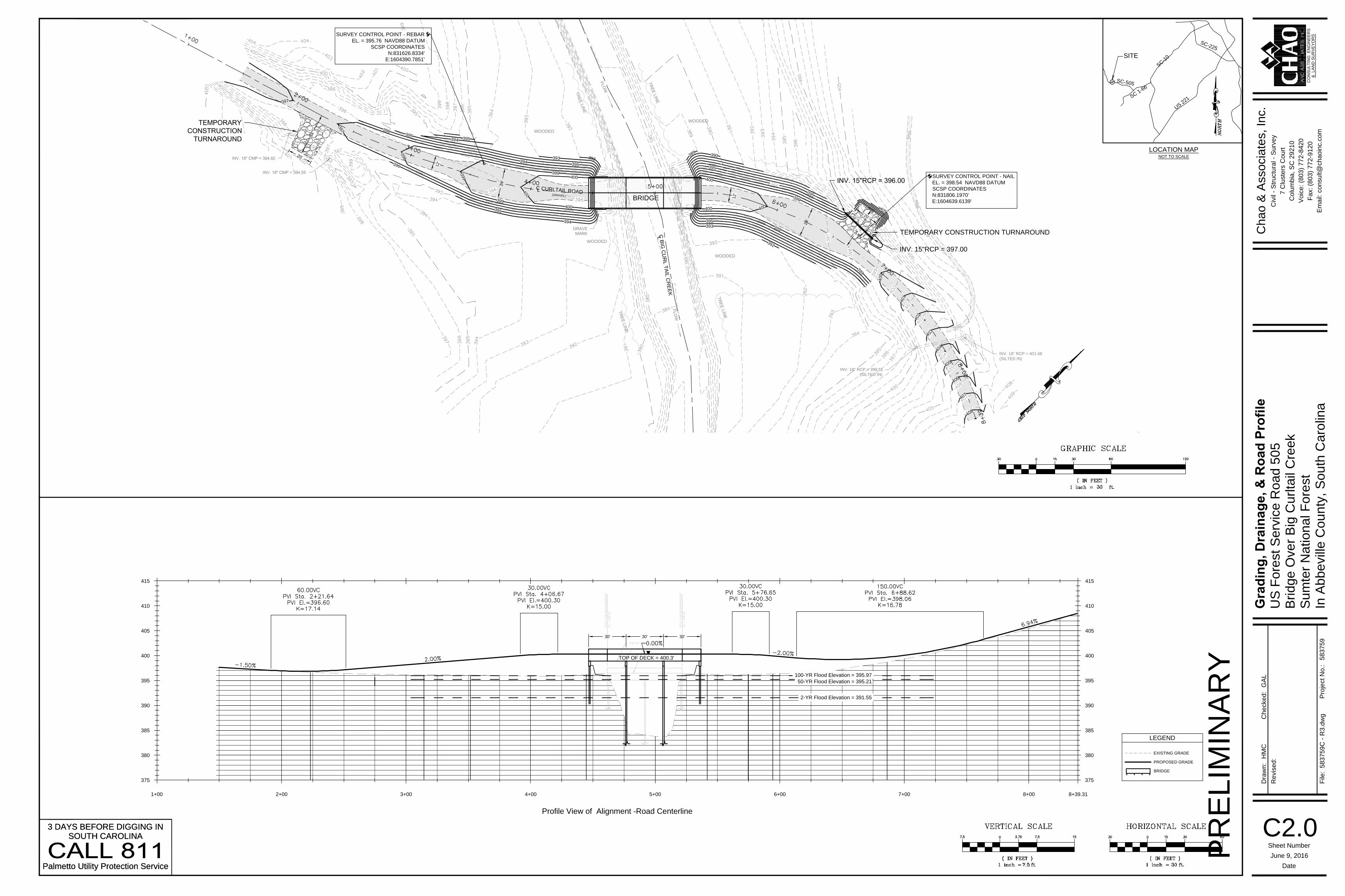
BRIDGE
C C
UR
LT
AIL
RO
AD
(GR
AV
EL)
3
9
2
3
9
4
3
9
9
4
0
0
393
3
9
6
3
9
5
3
9
5
3
9
9
399
395
3
9
6
395
400
400
394
394
4
0
1
400
3
9
5
3
9
9
4
0
0
400
395
3
8
9
3
9
9
4
0
0
3
9
9
3
9
2
393
3
9
0
3
9
5
2
0
'
3
4
'
4
0
5
3
4
'
2
0
'
INV. 15"RCP = 397.00
2
4
'
1
2
'
2
4
'
1
2
'
TEMPORARY CONSTRUCTION TURNAROUND
Profile View of Alignment -Road Centerline
375
380
385
390
395
400
405
410
415
375
380
385
390
395
400
405
410
415
1+00 2+00 3+00 4+00 5+00 6+00 7+00 8+00 8+39.31
TOP OF GUARDRAIL
TOP BARRIER CURB
TOP BRIDGE DECK
ST
A. 0
+0
0 B
EG
IN
B
RID
GE
EL
. =
3
96
.5
0
ST
A. 0
+0
0 B
EG
IN
B
RID
GE
EL
. =
3
96
.5
0
TOP OF DECK = 400.3'
100-YR Flood Elevation = 395.97
50-YR Flood Elevation = 395.21
2-YR Flood Elevation = 391.55
30' 30' 30'
Re
vise
d:
Dra
wn
:
Date
Sheet Number
File
:
Ch
ecke
d:
Pro
je
ct N
o.:
Ch
ao
&
A
sso
cia
te
s, In
c.
Civil - S
tructural - S
urvey
7 C
lusters C
ourt
Colum
bia, S
C 29210
Voice: (803) 772-8420
Fax: (803) 772-9120
Em
ail: consult@
chaoinc.com
58
37
59
C - R
3.d
wg
& LA
ND
S
UR
VE
YO
RS
CO
NS
ULT
IN
G E
NG
IN
EE
RS
C2.0
June 9, 2016
Grad
in
g, D
rain
ag
e, &
R
oad
P
ro
file
US
F
orest S
ervice R
oad 505
Bridge O
ver B
ig C
urltail C
reek
Sum
ter N
ational F
orest
In A
bbeville C
ounty, S
outh C
arolina
HM
CG
AL
58
37
59
LOCATION MAP
NOT TO SCALE
S
C
-
1
0
U
S
2
2
1
S
C
-5
0
5
S
C
1
-
6
6
S
C
-
2
2
5
SITE
PR
ELIM
IN
AR
Y
3 DAYS BEFORE DIGGING IN
SOUTH CAROLINA
Palmetto Utility Protection Service
3 DAYS BEFORE DIGGING IN
SOUTH CAROLINA
Palmetto Utility Protection Service
LEGEND
PROPOSED GRADE
EXISTING GRADE
BRIDGE

Re
vise
d:
Dra
wn
:
Date
Sheet Number
File
:
Ch
ecke
d:
Pro
je
ct N
o.:
Ch
ao
&
A
sso
cia
te
s, In
c.
Civil - S
tructural - S
urvey
7 C
lusters C
ourt
Colum
bia, S
C 29210
Voice: (803) 772-8420
Fax: (803) 772-9120
Em
ail: consult@
chaoinc.com
58
37
59
C - R
3.d
wg
& LA
ND
S
UR
VE
YO
RS
CO
NS
ULT
IN
G E
NG
IN
EE
RS
C2.1
June 9, 2016
Cu
rltail R
oad
S
ectio
ns
US
F
orest S
ervice R
oad 505
Bridge O
ver B
ig C
urltail C
reek
Sum
ter N
ational F
orest
In A
bbeville C
ounty, S
outh C
arolina
HM
CG
AL
58
37
59
PR
ELIM
IN
AR
Y
LEGEND
PROPOSED GRADE
EXISTING GRADE
BRIDGE

L
C
B
IG
C
U
R
L
T
A
IL
C
R
E
E
K
L
SURVEY CONTROL POINT - NAIL
EL. = 398.54 NAVD88 DATUM
SCSP COORDINATES
N:831806.1970'
E:1604639.6139'
WOODED
WOODED
WOODED
WOODED
INV. 18" RCP = 401.68
(SILTED IN)
INV. 18" RCP = 399.51
(SILTED IN)
TR
AIL
T
R
A
I
L
SURVEY CONTROL POINT - REBAR
EL. = 395.76 NAVD88 DATUM
SCSP COORDINATES
N:831626.8334'
E:1604390.7851'
T
R
E
E
L
I
N
E
T
R
E
E
L
I
N
E
T
R
E
E
L
I
N
E
T
R
E
E
L
I
N
E
F
L
O
W
F
L
O
W
BRIDGE
LIMIT OF DISTURBED AREA, TYP.
(CONSTRUCTION LIMIT)
SILT FENCE, TYP.
HYDROSEEDING AND MATTING
C C
UR
LT
AIL
RO
AD
(GR
AV
EL)
DOUBLE ROW OF SILT FENCE
3
9
2
3
9
4
3
9
9
4
0
0
393
3
9
6
3
9
5
3
9
5
3
9
9
399
395
3
9
6
395
400
400
394
394
4
0
1
400
3
9
5
3
9
9
4
0
0
400
395
3
8
9
3
9
9
4
0
0
3
9
9
3
9
2
393
3
9
0
3
9
5
4
0
5
FIRE HYDRANT
WATER VALVE
POWER POLE & GUY
OVERHEAD ELECTRIC
DROP INLET (DI)
CURB INLET (CI)
LEGEND
LIGHT POLE
STORM DRAIN PIPE
GAS VALVE
SANITARY SEWER
MANHOLE
CONCRETE
SIDEWALK
SANITARY SEWER LINE
(MATERIAL UNKNOWN)
NATURAL GAS LINE
UNDERGROUND
TELEPHONE
WATER LINE
FENCE
CONC. CURB &
GUTTER
ELEC BOX
CLEANOUT (CO)
JUNCTION BOX (JB)
YARD INLET (YI)
WATER METER
TELEPHONE PED
EROSION CONTROL
MATTING
UNDERGROUND
FIBER OPTIC LINE
UNDERGROUND
CABLE TV
LOCATION MAP
NOT TO SCALE
S
C
-
1
0
U
S
2
2
1
S
C
-5
0
5
S
C
1
-
6
6
S
C
-
2
2
5
SITE
Re
vise
d:
Dra
wn
:
Date
Sheet Number
File
:
Ch
ecke
d:
Pro
je
ct N
o.:
Ch
ao
&
A
sso
cia
te
s, In
c.
Civil - S
tructural - S
urvey
7 C
lusters C
ourt
Colum
bia, S
C 29210
Voice: (803) 772-8420
Fax: (803) 772-9120
Em
ail: consult@
chaoinc.com
58
37
59
C - R
3.d
wg
& LA
ND
S
UR
VE
YO
RS
CO
NS
ULT
IN
G E
NG
IN
EE
RS
C3.0
June 9, 2016
Ero
sio
n P
reven
tio
n &
S
ed
im
en
t C
on
tro
l P
lan
US
F
orest S
ervice R
oad 505
Bridge O
ver B
ig C
urltail C
reek
Sum
ter N
ational F
orest
In A
bbeville C
ounty, S
outh C
arolina
HM
CG
AL
58
37
59
3 DAYS BEFORE DIGGING IN
SOUTH CAROLINA
Palmetto Utility Protection Service
Area of disturbance: 0.7 acre
PR
ELIM
IN
AR
Y

STANDARD NOTES
1. If necessary, slopes, which exceed eight (8) vertical feet should be stabilized with synthetic
or vegetative mats, in addition to hydroseeding. It may be necessary to install temporary
slope drains during construction. Temporary berms may be needed until the slope is
brought to grade.
2. Stabilization measures shall be initiated as soon as practicable in portions of the site where
construction activities have temporarily or permanently ceased, but in no case more than
fourteen (14) days after work has ceased, except as stated below.
Where stabilization by the 14th day is precluded by snow cover or frozen ground
conditions stabilization measures must be initiated as soon as practicable.
Where construction activity on a portion of the Site is temporarily ceased, and
earth-disturbing activities will be resumed within 14 days, temporary stabilization measures
do not have to be initiated on that portion of the Site.
3. All sediment and erosion control devices shall be inspected once every calendar week. If
periodic inspection or other information indicates that a BMP has been inappropriately or
incorrectly installed, the Permittee must address the necessary replacement or modification
required to correct the BMP within 48 hours of identification.
4. Provide silt fence and/or other control devices, as may be required, to control soil erosion
during utility construction. All disturbed areas shall be cleaned, graded, and stabilized with
grassing immediately after the utility installation. Fill, cover, and temporary seeding at the
end of each day are recommended. If water is encountered while trenching, the water
should be filtered to remove any sediments before being pumped back into any waters of
the State.
5. All erosion control devices shall be properly maintained during all phases of construction
until the completion of all construction activities and all disturbed areas have been
stabilized. Additional control devices may be required during construction in order to control
erosion and/or offsite sedimentation. All temporary control devices shall be removed once
construction is complete and the site is stabilized.
6. The contractor must take necessary action to minimize the tracking of mud onto paved
roadway(s) from construction areas and the generation of dust. The contractor shall daily
remove mud/soil from pavement, as may be required.
7. Residential subdivisions require erosion control features for infrastructure as well as for
individual lot construction. Individual property owners shall follow these plans during
construction or obtain approval of an individual plan in accordance with S.C Reg. 72-300 et
seq. and SCR100000.
8. Temporary diversion berms and/or ditches will be provided as needed during construction
to protect work areas from upslope runoff and/or to divert sediment-laden water to
appropriate traps or stable outlets.
9. All waters of the State (WoS), including wetlands, are to be flagged or otherwise clearly
marked in the field. A double row of silt fence is to be installed in all areas where a 50-foot
buffer can't be maintained between the disturbed area and all WoS. A 10-foot buffer should
be maintained between the last row of silt fence and all WoS.
10. Litter, construction debris, oils, fuels, and building products with significant potential for
impact (such as stockpiles of freshly treated lumber) and construction chemicals that could
be exposed to storm water must be prevented from becoming a pollutant source in storm
water discharges.
11. A copy of the SWPPP, inspections records, and rainfall data must be retained at the
construction site or a nearby location easily accessible during normal business hours, from
the date of commencement of construction activities to the date that final stabilization is
reached.
12. Initiate stabilization measures on any exposed steep slope (3H:1V or greater) where
land-disturbing activities have permanently or temporarily ceased, and will not resume for a
period of 7 calendar days.
13. Minimize soil compaction and, unless infeasible, preserve topsoil.
14. Minimize the discharge of pollutants from equipment and vehicle washing, wheel wash
water, and other wash waters. Wash waters must be treated in a sediment basin or
alternative control that provides equivalent or better `treatment prior to discharge;
15. Minimize the discharge of pollutants from dewatering of trenches and excavated areas.
These discharges are to be routed through appropriate BMPs (sediment basin, filter bag,
etc.).
16. The following discharges from sites are prohibited:
Wastewater from washout of concrete, unless managed by an appropriate control;
Wastewater from washout and cleanout of stucco, paint, form release oils, curing
compounds and other construction materials;
Fuels, oils, or other pollutants used in vehicle and equipment operation and
maintenance; and
Soaps or solvents used in vehicle and equipment washing.
17. After construction activities begin, inspections must be conducted at a minimum of at least
once every calendar week and must be conducted until final stabilization is reached on all
areas of the construction site.
18. If existing BMPs need to be modified or if additional BMPs are necessary to comply with
the requirements of this permit and/or SC’s Water Quality Standards, implementation must
be completed before the next storm event whenever practicable. If implementation before
the next storm event is impracticable, the situation must be documented in the SWPPP and
alternative BMPs must be implemented as soon as reasonably possible.
19. A Pre-Construction Conference must be held for each construction site with an approved
On-Site SWPPP prior to the implementation of construction activities. For non-linear
projects that disturb 10 acres or more this conference must be held on-site unless the
Department has approved otherwise.
Temporary Seeding
Permanent Seeding
Browntop
Millet (Alone)
Species lbs./ac Jan Mar Apr May Jun Jul AugFeb Sep Oct Nov Dec
40
10
56
10
50
8
Browntop
Millet (Mix)
Rye Grain
(Alone)
Rye Grain
(Mix)
Rye Grain
(Alone)
Rye Grain
(Mix)
Weeping
Lovegrass
(Alone)
Weeping
Lovegrass
(Mix)
4
2
For Steep Slopes / Cut Slopes
Species
Jan Mar Apr May Jun Jul AugFeb Sep Oct Nov DecLbs/Ac
Bahia Grass
(Alone)
40
Bahia Grass
(Mix)
30
Bermuda Grass
(Hulled) (Alone)
Bermuda Grass
(Hulled) (Mix)
8-12
46
40
20
40
2
Fescue, Tall
(KY31) Alone
Sericea Lespedeza
(Scarified) Alone
or Mix (inoculate
with EL Innoculant
Fescue, Tall
(KY31) mix
Ladino Clover
(mix only)
Innoculate with AB
Innoculant
Weeping
Lovegrass (Alone)
4
2
8-10
Weeping
Lovegrass (Mix)
Crownvetch (Mix)
(Inoculate with
Type M Innoculant
For Steep Slopes / Cut Slopes
Seeding Schedule
M
a
x
i
m
u
m
s
p
a
c
i
n
g
=
6
'
8"
4"
18"
(minimum)
18"
(minimum)
8"
18" TO 24"18" TO 24"
V-shaped trench detailFlat-bottom trench detail
Runoff
Runoff
Compacted earth
Filter fabric
Compacted earth
Filter fabric
Wire mesh
Wire tie
12" of filter fabric
Wire tie
12" of filter fabric
Fabric attachment detail
1.25 LB./linear ft. steel post
Filter fabric
14 gage
6" x 6" wire mesh
Heavy duty wire tie
spaced 6" max.
R
u
n
o
f
f
Use either flat-bottom or V-bottom
trench shown below
Backfill trench with
compacted earth
Fabric attachment
see detail
Bury fabric and mesh
14 gage wire fence
with 6" x 6" mesh
Silt fence installation
1.33 LB./linear ft.
steel post
Wire tie
Reinforced Silt Fence Construction
Not to scale
Note:
Contractor shall remove sediment accumulated along the fence when it
reaches 1/3 the height of the fence
Wire mesh
1.
3B.
12"
6"
3A.
2"-5"
4.
5.
3"
2.
1. Prepare soil before installing rolled erosion control products (RECP's), Including any
necessary application of lime, fertilizer, and seed.
Note: When using cell-o-seed do not seed prepared area. Cell-o-seed must be installed
with paper side down.
2. Begin at the top of the slope by anchoring the RECP's In a 6" (15 cm) deep x 6" (15 cm)
wide trench with approximately 12" (30cm) of RECP's Extended beyond the up-slope
portion of the trench. Anchor the RECP's with a row of staples/stakes approximately 12"
(30 cm) apart in the bottom of the trench. backfill and compact the trench after stapling.
Apply seed to compacted soil and fold remaining 12" (30 cm) portion of RECP's back over
seed and compacted soil. Secure RECP's over compacted soil with a row of staples/stakes
spaced approximately 12" (30 cm) apart across the width of the RECP's.
3. Roll the RECP's (a.) down or (b.) horizontally across the slope. RECP's will unroll with
appropriate side against the soil surface. all recp's must be securely fastened to soil
surface by placing staples/stakes in appropriate locations as shown in the staple pattern
guide. when using the dot system, staples/stakes should be placed through each of the
colored dots corresponding to the appropriate staple pattern.
4. The edges of parallel RECP's must be stapled with approximately 2" - 5" (5 cm - 12.5 cm)
overlap depending on RECP's type.
5. Consecutive RECP's spliced down the slope must be placed end over end (shingle style)
with an approximate 3" (7.5 cm) overlap. Staple through overlapped area, approximately 12"
(30 cm) apart across entire RECP's WIDTH.
Note: *In loose soil conditions, the use of staple or stake lengths greater than 6" (15 cm)
may be necessary to properly secure the RECP's.
6"
Rolled Turf Reinforcement Matting
Erosion Control Detail
NOT TO SCALE
Slope installation
Sediment Basin Slope Tracking Detail
Not To Scale
Applicant's Certification:
"I (we) hereby certify that all clearing, grading, construction and/or development will be done
pursuant to this plan and I (we) are responsible for the land disturbance and related
maintenance thereof. SCDHEC & Abbeville County authorities will be allowed to enter the
project site for the purpose of on-site inspections."
Owner / Person Financially Responsible Date
Designer's Certification:
"I hereby certify that this plan is designed to contain soil on the property concerned to the
maximum extent, to provide for the protection of the property and the proposed improvements
theron from the effects of flooding, to provide for the control of the runoff from the property, and
that all provisions for sediment control and storm drainage are in accordance with the
stormwater management and sediment control ordinance for SCDHEC & Bamberg County"
Signature Date
S.C. Registration Number: 21629
Gerald A. Lee, P.E.
Dozer treads create cleat
imprints parallel to the slope
contour
Note:
Should be seeded and stabilized immediately.
S
l
o
p
e
Temporary Construction Turnaround
Not To Scale
6" SCDOT CR-14 Crusher Run
12" Compacted subgrade compacted to
98% standard proctor
Construction sequence
1. Receive NPDES coverage from SCDHEC.
2. Pre-construction meeting with engineer.
3. Notify Abbeville County and SCDHEC at least 48 hours prior to beginning land disturbing
activities.
4. Clearing and grubbing only as necessary for installation of silt fence.
5. Installation of silt fence.
6. Clearing and grubbing of site or demolition.
7. Rough grading.
8. Begin installation of bridge.
9. Perform site stabilization.
10. Remove temporary sediment & erosion control measures after entire area draining to
device is stabilized.
11. Submit notice of termination (NOT) to SCDHEC.
Re
vise
d:
Dra
wn
:
Date
Sheet Number
File
:
Ch
ecke
d:
Pro
je
ct N
o.:
Ch
ao
&
A
sso
cia
te
s, In
c.
Civil - S
tructural - S
urvey
7 C
lusters C
ourt
Colum
bia, S
C 29210
Voice: (803) 772-8420
Fax: (803) 772-9120
Em
ail: consult@
chaoinc.com
58
37
59
C - R
3.d
wg
& LA
ND
S
UR
VE
YO
RS
CO
NS
ULT
IN
G E
NG
IN
EE
RS
C4.0
June 9, 2016
Co
nstru
ctio
n D
etails
US
F
orest S
ervice R
oad 505
Bridge O
ver B
ig C
urltail C
reek
Sum
ter N
ational F
orest
In A
bbeville C
ounty, S
outh C
arolina
HM
CG
AL
58
37
59
PR
ELIM
IN
AR
Y