Satellite Meteorology Education Resources from COMET: What’s New? Marianne Weingroff The COMET...
30
Satellite Meteorology Education Satellite Meteorology Education Resources from COMET: What’s New? Resources from COMET: What’s New? Marianne Weingroff The COMET Program Boulder, Colorado
-
Upload
edith-hutchinson -
Category
Documents
-
view
216 -
download
1
Transcript of Satellite Meteorology Education Resources from COMET: What’s New? Marianne Weingroff The COMET...

Satellite Meteorology Education Satellite Meteorology Education Resources from COMET: What’s New?Resources from COMET: What’s New?
Marianne Weingroff
The COMET ProgramBoulder, Colorado
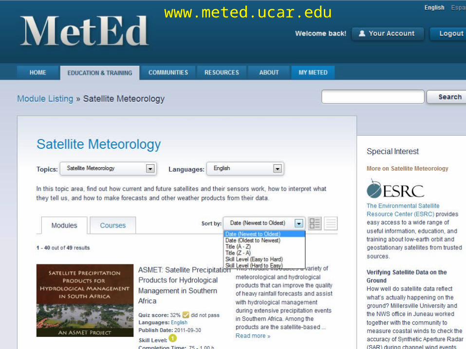
www.meted.ucar.eduwww.meted.ucar.edu

Simple FREE Registration RequiredSimple FREE Registration Required

MetEd Registration StatisticsMetEd Registration Statistics2 August 20112 August 2011
Total Registered Total Registered Users Users > 200,000> 200,000
Total Users from Total Users from outside United Statesoutside United States > 66,000> 66,000
Total Countries Total Countries (includes Dependencies and Territories)(includes Dependencies and Territories)
> 200> 200
Total UniversitiesTotal Universities > 1,200> 1,200
Hours of InstructionHours of Instruction > 600> 600

Advanced Satellite Sounding: The Benefits of Hyperspectral ObservationAdvanced Satellite Sounding: The Benefits of Hyperspectral Observation Advances in Microwave Remote Sensing: Ocean Wind Speed and Direction Advances in Microwave Remote Sensing: Ocean Wind Speed and Direction An Introduction to POES Data and Products An Introduction to POES Data and Products An Introduction to the EUMETSAT Polar System An Introduction to the EUMETSAT Polar System Blowing Snow: Baker Lake, Nunavut, Canada 04-10 February 2003 Blowing Snow: Baker Lake, Nunavut, Canada 04-10 February 2003 Creating Meteorological Products from Satellite Data Creating Meteorological Products from Satellite Data Deformation Zone Analysis Deformation Zone Analysis Deformation Zone Diagnosis Deformation Zone Diagnosis Deformation Zone Distribution Deformation Zone Distribution Determining Visibility Determining Visibility Dust Enhancement Techniques Using MODIS and SeaWiFS Dust Enhancement Techniques Using MODIS and SeaWiFS Dynamic Feature Identification: The Satellite Palette Dynamic Feature Identification: The Satellite Palette Feature Identification Exercises: Clouds, Snow, and Ice Using MODIS Feature Identification Exercises: Clouds, Snow, and Ice Using MODIS Feature Identification Using Environmental Satellites Feature Identification Using Environmental Satellites Forecasting Dust Storms , Version 2Forecasting Dust Storms , Version 2 FORMOSAT-3/COSMIC FORMOSAT-3/COSMIC Satellite Meteorology: GOES Channel Selection, Version 2 Satellite Meteorology: GOES Channel Selection, Version 2 (NEW!)(NEW!) GOES-R: Benefits of Next-Generation Environmental MonitoringGOES-R: Benefits of Next-Generation Environmental Monitoring Imaging with NPOESS VIIRS: A Convergence of Technologies and ExperienceImaging with NPOESS VIIRS: A Convergence of Technologies and Experience Introduction to Tropical Meteorology, Tropical Remote SensingIntroduction to Tropical Meteorology, Tropical Remote Sensing
Applications Applications Jason-2: Using Satellite Altimetry to Monitor the OceanJason-2: Using Satellite Altimetry to Monitor the Ocean
Bold = published in last 5 yrs
COMET Modules on COMET Modules on Satellite TopicsSatellite Topics
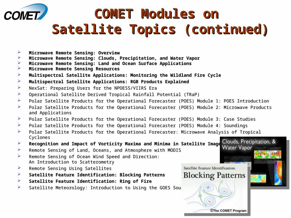
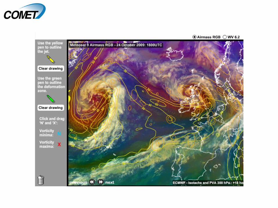
Microwave Remote Sensing: Overview Microwave Remote Sensing: Overview Microwave Remote Sensing: Clouds, Precipitation, and Water Vapor Microwave Remote Sensing: Clouds, Precipitation, and Water Vapor Microwave Remote Sensing: Land and Ocean Surface Applications Microwave Remote Sensing: Land and Ocean Surface Applications Microwave Remote Sensing ResourcesMicrowave Remote Sensing Resources Multispectral Satellite Applications: Monitoring the Wildland Fire Cycle Multispectral Satellite Applications: Monitoring the Wildland Fire Cycle Multispectral Satellite Applications: RGB Products Explained Multispectral Satellite Applications: RGB Products Explained NexSat: Preparing Users for the NPOESS/VIIRS EraNexSat: Preparing Users for the NPOESS/VIIRS Era Operational Satellite Derived Tropical Rainfall Potential (TRaP)Operational Satellite Derived Tropical Rainfall Potential (TRaP) Polar Satellite Products for the Operational Forecaster (POES) Module 1: POES Introduction Polar Satellite Products for the Operational Forecaster (POES) Module 1: POES Introduction Polar Satellite Products for the Operational Forecaster (POES) Module 2: Microwave Products and Applications Polar Satellite Products for the Operational Forecaster (POES) Module 2: Microwave Products and Applications Polar Satellite Products for the Operational Forecaster (POES) Module 3: Case Studies Polar Satellite Products for the Operational Forecaster (POES) Module 3: Case Studies Polar Satellite Products for the Operational Forecaster (POES) Module 4: Soundings Polar Satellite Products for the Operational Forecaster (POES) Module 4: Soundings Polar Satellite Products for the Operational Forecaster: Microwave Analysis of Tropical Cyclones Polar Satellite Products for the Operational Forecaster: Microwave Analysis of Tropical Cyclones Recognition and Impact of Vorticity Maxima and Minima in Satellite ImageryRecognition and Impact of Vorticity Maxima and Minima in Satellite Imagery Remote Sensing of Land, Oceans, and Atmosphere with MODIS Remote Sensing of Land, Oceans, and Atmosphere with MODIS Remote Sensing of Ocean Wind Speed and Direction:Remote Sensing of Ocean Wind Speed and Direction:
An Introduction to Scatterometry An Introduction to Scatterometry Remote Sensing Using Satellites Remote Sensing Using Satellites Satellite Feature Identification: Blocking PatternsSatellite Feature Identification: Blocking Patterns Satellite Feature Identification: Ring of FireSatellite Feature Identification: Ring of Fire Satellite Meteorology: Introduction to Using the GOES Sounder Satellite Meteorology: Introduction to Using the GOES Sounder
COMET Modules on COMET Modules on Satellite Topics (continued)Satellite Topics (continued)
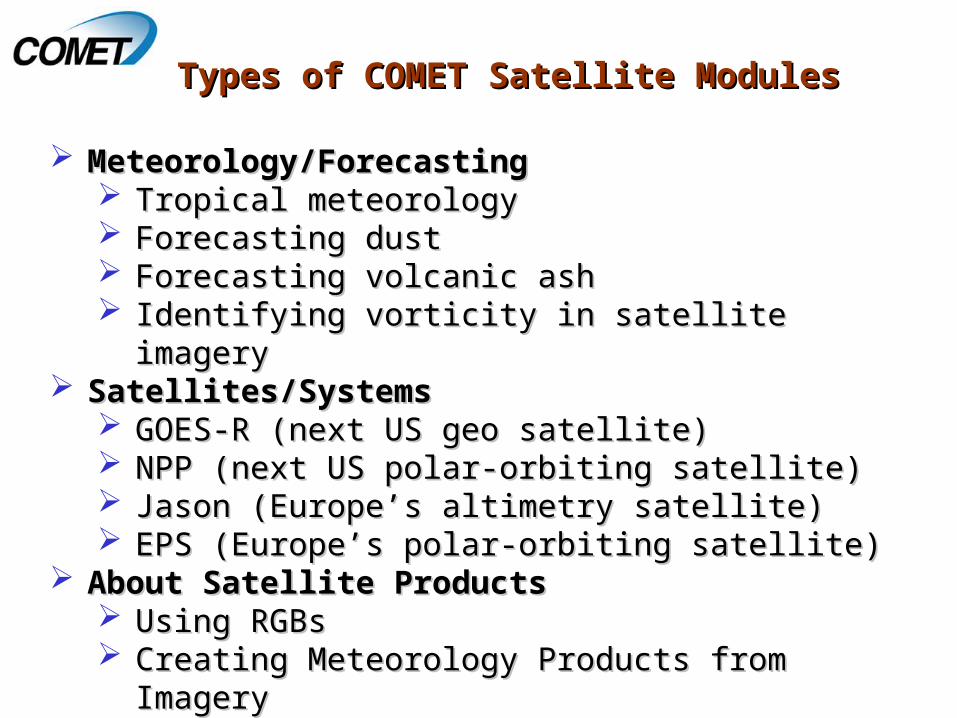
Meteorology/ForecastingMeteorology/Forecasting Tropical meteorologyTropical meteorology Forecasting dustForecasting dust Forecasting volcanic ashForecasting volcanic ash Identifying vorticity in satellite imagery Identifying vorticity in satellite imagery
Satellites/Systems Satellites/Systems GOES-R (next US geo satellite)GOES-R (next US geo satellite) NPP (next US polar-orbiting satellite)NPP (next US polar-orbiting satellite) Jason (Europe’s altimetry satellite)Jason (Europe’s altimetry satellite) EPS (Europe’s polar-orbiting satellite)EPS (Europe’s polar-orbiting satellite)
About Satellite ProductsAbout Satellite Products Using RGBsUsing RGBs Creating Meteorology Products from ImageryCreating Meteorology Products from Imagery
Types of COMET Satellite ModulesTypes of COMET Satellite Modules

Meteorology/Forecasting Topics: Meteorology/Forecasting Topics: Tropical MeteorologyTropical Meteorology
http://meted.ucar.edu/tropical/textbook

Forecasting Topics: DustForecasting Topics: Dust
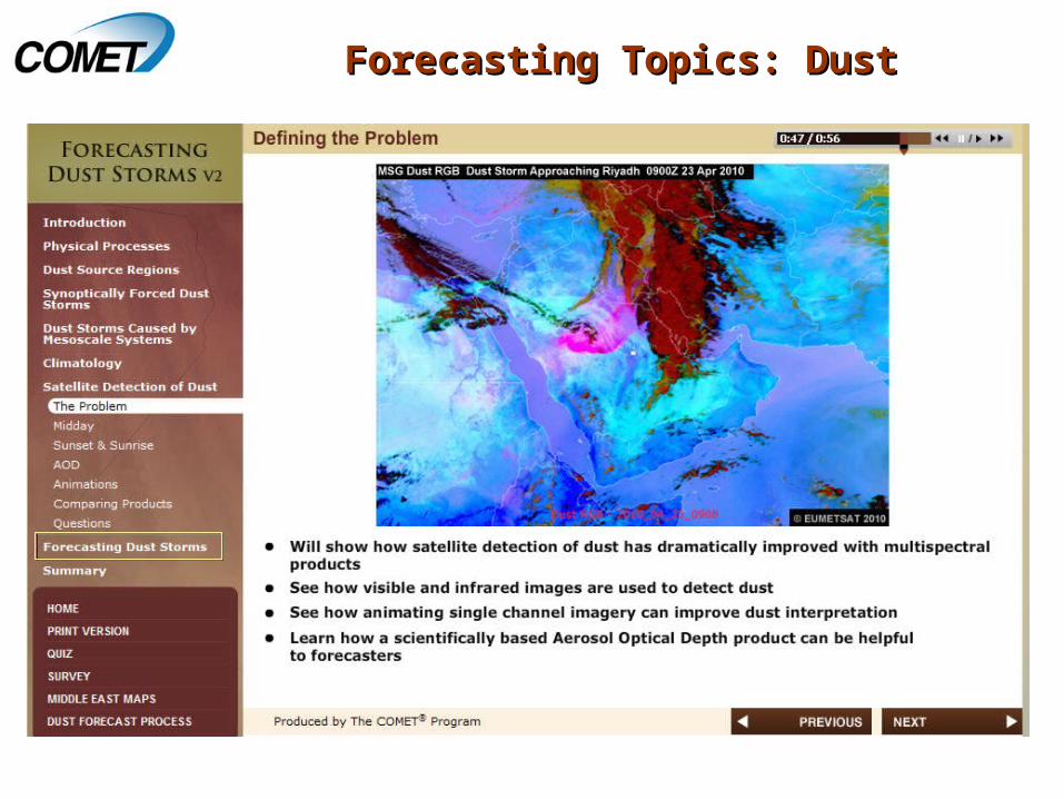
Forecasting Topics: DustForecasting Topics: Dust

Dynamic Feature Identification: Dynamic Feature Identification: The Satellite Palette – The Satellite Palette –
Newest Releases Newest Releases
• Coming next: “Short Waves and Cyclogenesis” and Coming next: “Short Waves and Cyclogenesis” and “Atmospheric Rivers”“Atmospheric Rivers” Link to series interface…


New Satellites: GOES-RNew Satellites: GOES-R
Includes 3 sections: Overview, Environmental Monitoring, & Resources
GOES-R benefits and the ability to monitor 13 unique hazards and phenomena
Each topic includes:• Background and Needs
(general public)• Capabilities and Benefits
(decision makers)• Technical Improvements
(forecasters)
• Link to module…

Link to the module…
New Satellites: JASON-2New Satellites: JASON-2

New Satellites: JASON-2New Satellites: JASON-2

Updated GOES Channel Selection Updated GOES Channel Selection ModuleModule

About Satellite Products: RGBsAbout Satellite Products: RGBs

About Satellite Products: RGBsAbout Satellite Products: RGBs
RGB compositing techniques are a RGB compositing techniques are a powerful way to distill and highlight powerful way to distill and highlight salient informationsalient information
Module provides an introduction to Module provides an introduction to basic methods and “best practices”basic methods and “best practices”
Also available “Also available “Aplicaciones Aplicaciones satelitales multiespectrales: satelitales multiespectrales: explicación de los realces RGB”explicación de los realces RGB”

About Satellite Products: RGBsAbout Satellite Products: RGBs

About Satellite Products: RGBsAbout Satellite Products: RGBs

International Activities
Aviation Climate
Hydrometeorology Mesoscale Meteorology
NorthernLatitudes
Environmental
Education
Numerical Weather Prediction
Marine Met &Oceanography
RoadWeather
Tropical Meteorology
FireCoastalWeather
SatelliteMeteorology
SatelliteMeteorology
SpaceWeather
Module Topic AreasModule Topic Areas

Translated Modules: Translated Modules: 17 en Español , 10 en Francais17 en Español , 10 en Francais
TranslationsTranslations
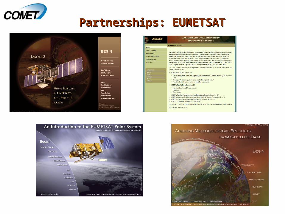
Partnerships: EUMETSATPartnerships: EUMETSAT

The ESRC: The ESRC:
EEnvironmental nvironmental SSatellite atellite Resource esource CCenterenter

The ESRC: The ESRC: COMET’s RoleCOMET’s Role
1. Maintain the ESRC website
2. Populate it with our own materials, including smaller, focused learning-objects derived from our larger training modules
3. Provide the necessary quality assurance and monitoring to ensure that all resources are appropriate and well described before being made available

Community’s Role in the ESRCCommunity’s Role in the ESRC1. Use the site
2. Populate it with materials that you know and trust using the online submission form

Coming Soon/In Progress/NextComing Soon/In Progress/Next
““Atmospheric DustAtmospheric Dust”, many global case examples (fall 2011)”, many global case examples (fall 2011)
““Climate Monitoring from SatellitesClimate Monitoring from Satellites”” (fall 2011)(fall 2011) Jointly funded by EUMETSAT/NESDISJointly funded by EUMETSAT/NESDIS
Additional collections of satellite modules into DL Courses:Additional collections of satellite modules into DL Courses: Multispectral Applications
Polar-orbiting Satellite Basics
Satellite Sounding
““Introduction to NPP/JPSSIntroduction to NPP/JPSS”” (winter 2011-2012)(winter 2011-2012)
Updates to existing polar orbiting-related modulesUpdates to existing polar orbiting-related modules
““Atmospheric CompositionAtmospheric Composition” (beginning fall/winter 2011)” (beginning fall/winter 2011)

URLs:URLs:
http://meted.ucar.eduhttp://meted.ucar.edu
http://meted.ucar.edu/topics/modules/satellitehttp://meted.ucar.edu/topics/modules/satellite
http://meted.ucar.edu/esrchttp://meted.ucar.edu/esrc
Questions?Questions?
[email protected]@ucar.edu