Satellite imagery, human ecology, anthropology, and ... · PDF fileSatellite Imagery, Human...
22
Human Ecology, Vol 22, No. 3, 1994 Satellite Imagery, Human Ecology, Anthropology, and Deforestation in Madagascar Robert W. Sussman, 1 Glen M. Green, 2 and Linda K. Sussman 3 Satellite images were used to determine rates of deforestation over the past 35 years and to identify current deforestation "hotspots" in the eastern rainforests and in the dry endemic forests of southern Madagascar. The analysis of population trends, topography, and coincident ethnographic research points to a number of different factors influencing deforestation in these regions. Each of these factors generates different problems for conservation and development, most of which are not being dealt with adequately. KEY WORDS: deforestation; satellite imagezy; development; conservation policy. INTRODUCTION In this paper, we explore how satellite imagery and ethnographic methods can help us understand some of the reasons for deforestation in particular areas. Our examples are drawn from three different regions of Madagascar: the eastern rainforest, forests growing on limestone forma- tions in the west, and xerophytic and gallery forests in the dry regions of the south. These examples cover broad, regional trends as well as very lo- calized areas of deforestation. We also will discuss how satellite imagery and ethnographic studies can help reveal problems with conservation policy in each of these regions. Madagascar separated from Africa about 170-180 million years ago and has been in approximately the same position for around 120 million years (Rabinowitz et al., 1982, Rabinowitz et al., 1983). Many of the plants and animals apparently reached Madagascar across a water barrier after 1Department of Anthropology, Washington University, St. Louis, Missouri 63130. 2Departrnent of Geography, Boston University, Boston, Massachusetts. 3Departments of Internal Medicine and Anthropology, Washington University, St. Louis, Missouri 63130. 333 03/30-7839/94/0900-0333507.00/0 O 1994PlenumPublishing Coq>oration
Transcript of Satellite imagery, human ecology, anthropology, and ... · PDF fileSatellite Imagery, Human...

Human Ecology, Vol 22, No. 3, 1994
Satellite Imagery, Human Ecology, Anthropology, and Deforestation in Madagascar
Robert W. Sussman, 1 Glen M. Green, 2 and Linda K. Sussman 3
Satellite images were used to determine rates of deforestation over the past 35 years and to identify current deforestation "hotspots" in the eastern rainforests and in the dry endemic forests of southern Madagascar. The analysis of population trends, topography, and coincident ethnographic research points to a number of different factors influencing deforestation in these regions. Each of these factors generates different problems for conservation and development, most of which are not being dealt with adequately.
KEY WORDS: deforestation; satellite imagezy; development; conservation policy.
INTRODUCTION
In this paper, we explore how satellite imagery and ethnographic methods can help us understand some of the reasons for deforestation in particular areas. Our examples are drawn from three different regions of Madagascar: the eastern rainforest, forests growing on limestone forma- tions in the west, and xerophytic and gallery forests in the dry regions of the south. These examples cover broad, regional trends as well as very lo- calized areas of deforestation. We also will discuss how satellite imagery and ethnographic studies can help reveal problems with conservation policy in each of these regions.
Madagascar separated from Africa about 170-180 million years ago and has been in approximately the same position for around 120 million years (Rabinowitz et al., 1982, Rabinowitz et al., 1983). Many of the plants and animals apparently reached Madagascar across a water barrier after
1Department of Anthropology, Washington University, St. Louis, Missouri 63130. 2Departrnent of Geography, Boston University, Boston, Massachusetts. 3Departments of Internal Medicine and Anthropology, Washington University, St. Louis, Missouri 63130.
333
03/30-7839/94/0900-0333507.00/0 O 1994 Plenum Publishing Coq>oration

334 Sussman, Green, and Sussman
the mid-Cretaceous and have been relatively isolated for the past 50-55 million years (Daflington, 1957; Raven and Axelrod, 1974; Leroy, 1978; Tattersall, 1982). Until the arrival of humans, 1500-2000 years ago (Dewar, 1984), these forms had little competition from mainland species and for millions of years the plants and animals of Madagascar had an independent evolutionary history (Leroy, 1978; Tattersall, 1982; Gentry, 1988; Sussman, 1991).
Many conservation biologists believe that Madagascar should be con- sidered among the highest conservation priorities (Raven and Axelrod, 1974; National Research Council, 1980; Myers, 1988; Jolly, 1989; McNeely et al., 1990; Mittermeier et al., 1992). However, the poverty that afflicts Madagascar's people threatens to destroy what remains of this unique bi- ology. The average income is around $200 per year (Population Reference Bureau, 1992), and Madagascar has a $2.5 billion debt which nearly equals its yearly gross national product. Real income has dropped 25% in the past 5 years (Jolly, 1989). With the population over 13 million and a population growth rate of 3.3% per year, there will be over 33 million people on the island by the year 2020. Thus, widespread poverty, increasing population, and the absence of resources and techniques to improve the productivity of agricultural and pasture lands have led to massive deforestation.
RAINFOREST OF EASTERN MADAGASCAR
In Madagascar, the need of an expanding population to clear land for subsistence agriculture (forest farming), and not large-scale timbering, has been the major cause of rainforest destruction (Rauh, 1979; Jolly and Jolly, 1984; Sussman et al., 1985; Jenkins, 1987). Much of the eastern rain- forest has been cleared for small-scale shifting agriculture (Humbert, 1927; Jolly and Jolly, 1984; Jolly, 1986). In newly cleared forest areas such as these, the nutrients are quickly leeched from the soil and the resulting fields provide only a few years of subsistence before they are depleted (Betsch, 1972; Berry and Johnson, 1986). Unfortunately, under present conditions, fields are not abandoned for periods long enough to allow forest regen- eration (Jolly, 1980; FAO/UNEP, 1981; Jenkins, 1987). Soil no longer pro- tected by forest is subject to rapid erosion, and annual watershed erosion rates as high as 250 tons per hectare have been reported in Madagascar (Helfert and Wood, 1986), leading to siltation and flooding on many rivers.
Satellite-based remote sensing can be used to map the history, pro- gress, and processes of deforestation in Madagascar. Remotely sensed im- ages at optical wavelengths have been available for Madagascar since 1972 from the U.S. Landsat series of satellites (Freden and Gordon, 1983). We

Deforestation in Madagascar 335
were able to distinguish rainforests from surrounding savannah and secon- dary vegetation for regions of eastern Madagascar with the use of analog image interpretation applied to Landsat (0.6-0.7 ~tm, visible red light) im- ages (Green and Sussman, 1990).
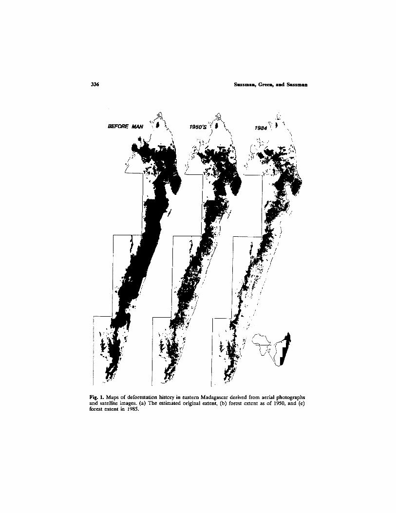
Deforestation of Madagascar's eastern rainforests has resulted in a mosaic of small plots at various stages of clearing and secondary growth, which can be identified by a relatively bright and heterogeneous tone on the Landsat images. Active deforestation fronts can be identified by bright patches along the forest boundary. We examined 38 separate Landsat Mul- tispectral Scanner (MSS) images at 1:1,000,000 scale, each covering 185 km by 185 km. Visual interpretation of these prints permitted us to classify and map Madagascar into two land cover types: continuous forest and non- forest (Green and Sussman, 1990). In Fig, 1, we show the progressive de- forestation that has taken place over the past 2000 or so years (from Green and Sussman, 1990). The map in the middle (Fig. lb) is derived from vege- tation maps prepared by French botanists, Humbert and Dame (1965), us- ing aerial pho tographs taken in 1949-50. H u m b e r t and Darne also estimated the original extent of rainforest. This estimate is shown on the left (Fig. la). Using Landsat data from 1985, we generated the map on the right (Fig. lc).
The aerial extent of rainforest was determined by digitizing these at 1:1,000,000 scale maps. Rainforest probably covered 11.2 million ha of the east coast at colonization, of which 7.6 million ha remained by 1950. By 1985, only 3.8 million ha remained. Thus, in 1985 only 50% of the rainforest existing in 1950, and only 34% of the original extent was still standing. This yields an average rate of clearance of 111,000 ha (1.5%) per year between 1950 and 1985 (Green and Sussman, 1990).
Several factors apparently influence deforestation in eastern Madagas- car. We found that rates of deforestation were directly related to population density (Table I) and the slope of the land (Fig. 2). In Fig. 2, we have combined the three maps shown in Fig. 1. The blue areas represent forest cut prior to 1950, red areas are those cut between 1950 and 1984, and the green represent that forest which remained in 1985. To visually display the relationship between deforestation and slope these colors are applied to a computer-generated shaded relief image in which areas of higher slope ap- pear as raised regions. The slope image was generated from a digital terrain model produced using maximum change value of 2' by 2' grid cells from 1:500,000 topographic maps (Green and Susssman, 1990). In the southeast, the only forest remaining is that located on very steep slopes.
In the northern region as of 19.85, there are still large areas of low- lying tropical forests. These forests remain because the population density in the north is generally much lower than in the south. However, delores-
336 Sussman, Green, and Sussman
BEFORE MAN ~ ,'~ .. [ ~
,
/
~5o~ ~ ~ ~ ) '\ .
:'~ ~._~ \
~ , ~ ~ ) ~
, ~ ' ~ ~, J
�9 , ,
�9
.
;" ;:~
.~ !
/ [
..
I;: !,
r~ryJ: , ' : ."~..~ ..
o~ ,
i . f~~ ,: . .
r . , , ~ ,.. -~ ,~
~ ~' , '2 .
~ ~. ~
, ~ / .
;~
"" ~? ,
Fig. 1. Maps of deforestation history in eastern Madagascar derived from aerial photographs and satellite images. (a) The estimated original extent, (b) forest extent as of 1950, and (c) forest extent in 1985.

Deforestation in Madagascar
Table I. Area of the Eastern Rain Forest of Madagascar, for the Period and Population Density Specified
337
Year
Deforestation Aerial a Forest Forest b rates from extent remaining perimeter 1950 to 1985
(ha • 106) (%) (km • 103) (ha x 103/year)
High (>10 per squarekilometeO Original 4.7 100 3.5 1950 2.4 50 7.8 1985 0.89 19 4.5
Medium (5-10persquareki lometer) Original 3.4 100 2.2 1950 2.5 76 4.9 1985 1.3 38 5.0
Low (<5 per square kilometer) Original 3.1 100 3.4 1950 2.7 86 5.0 1985 1.6 51 6.1
Total Original 11.2 100 9.1 1950 7.6 67 17.7 1985 3.8 34 15.6
43
37
31
111
"A measure of the error in aerial extent at each time period can be estimated by using the number of digitization grid cells (81 ha each) that include forest boundary. The greater the number of these cells, the larger the potential errors. We estimate this error to be +_2%, :t:6%, and +_11%, respectively, for original coverage, 1950 and 1985.
bPerimeter lengths from 1:1,000,000 scale maps may be underestimated during the digitization process because small-scale features of forest boundaries are lost. We calculate this error to be approximately 10% (Adapted from Green and Sussman, 1990).
tation is proceeding in all areas and the remaining forests in the north are now also being cleared. In fact, the population density in much of the north is now as high as it was in the south 35 years ago (National Institute of Geodesy and Cartography of Madagascar, 1969, 1984).
Given current rates of population growth and observed average de- forestation over the past 35 years it is clear that forest on areas of low relief are preferentially cleared. In an attempt to visualize what the eastern rainforests may look like 35 years from now if these patterns of defores- tation continue, we eliminate in Fig. 3 those forests present in 1985 which cover areas of low and moderate slope (<7*) using topographic relief as a mask on the forest extent as of 1985 (Fig. lc). Only about 38% of the

338 Sussman, Green, and Sussman
Fig. 2. A shaded image of topographic relief of eastern Madagascar overlain by colors depicting the amount of forest remaining at different times (see text for detailed explanation).

Deforestation in Madagascar 339
rainforest remaining in 1985, and 12.5% of the original extent will still exist if all forests on lower slopes are cleared, leaving an area of only 1.4 million ha. Not only will the total area of forest be reduced, but as can be seen in Fig. 3, the forests will have been fragmented into many small parcels. Both of these changes, it is thought, will have a profound effect on rates
Fig. 3. Computer-generated map of possible future extent of rainforest in eastern Mada- gascar in the event that all forest on lower slope areas (<7*) are destroyed.

340 Sussman, Green, and Sussm~,n
of extinction in Madagascar (Frankel and Soul6, 1981; Pollock, 1986). Also, particular forest types are preferentially destroyed, particularly the lowland forests predominantly present in areas of lower relief, little of which may remain in 35 years.
A number of reserves were established in Madagascar in the 1920s and 1930s. Most of these reserves were still largely intact as of 1985. Many of them may still be relatively untouched in 35 years because they are pre- dominantly present in areas of very steep slope and high elevation (Fig. 4). These reserves probably have been protected not by conservation efforts, or efforts at sustainable agriculture surrounding them, but solely by the natural topography. The locations of natural reserves were actually chosen in the first place because they were remote and of difficult access: "in little populated or mountainous areas which would be shielded from the pressure of a population in constant search of new crop land" (Andriamampianina, 1984, p. 219).
This points out a fundamental problem with current conservation thinking. Conservation efforts on the east coast of Madagascar have fo- cused mainly on protected reserves (MacKinnon and MacKinnon, 1987; Nicoll and Langrand, 1989; NcNeely et al., 1990; Mittermeier et al., 1992). Adopting a "laager mentality," reserves are viewed as fortresses established to keep people out and thereby to preserve biodiversity. These areas gen- erally are protected only as long as they are remote, or presumably with armed guards once the population increases (see, for example, McNeely et al., 1990). Finally, when the situation becomes extreme or commercial needs become attractive, reserve boundaries are ignored. For example, in 1964 one of the 12 reserves in eastern Madagascar was declassified in favor of commercial exploitation (Andriamampianina, 1984) and portions of Za- hamena Reserve (see Fig. 4), the only eastern reserve with large tracts of forest on low slopes, have been "degazetted."
In reality, to slow deforestation and maintain an integral forest in the east, conservation efforts must be focused at the fronts of deforestation and ultimately involve a cooperative effort by conservationists and local people to develop means of establishing sustainable use of lands that have already been cleared. Satellite imagery can be used to locate these fronts and to monitor the success or failure of conservation and development ef- forts to slow their advance.
DRY FORESTS OF SOUTHERN MADAGASCAR
We now briefly discuss two examples from the southern dry forests of Madagascar where there are no steep slopes to protect the forest and

Deforestation in Madagascar 341
Fig. 4. Computer-generated composite map of eastern Madagascar in which colors relate to forest extent, topographic relief, and protected status. White areas depict forested reserves located in regions of high slope; pink areas depict forest in reserves in regions of low slope. Only Zahamena Reserve (centrally located) contains large tracts of forest on low slopes at moderate elevations. No reserve contains large tracts of low elevation rainforest.

342 Sussman, Green, and Sussman
there are only two large reserves. Figure 5, a Landsat image acquired in 1984, shows the dry, limestone forests of southern Madagascar. Most of these forests were present up until the early 1970s. The major city on the west coast is Toliara. The dark areas in Fig. 5 are forest cover while the light patch stretching to the east of the city is a recently deforested area along the road that connects Toliara to the capital, Antananarivo.
By examining Landsat images of this region acquired in 1972 and maps derived from aerial photos acquired in 1949-50, it is clear that the vast majority of this extensive deforestation has occurred since 1970 and probably is related to an economic downturn in Madagascar (Verin, 1990) and to a global increase in fuel prices. Since 1970, there has ben a massive movement of population from the countryside into the cities (Salomon, 1977; Hoerner, 1981, 1986). This also correlates with a collapse of much of the agricultural infrastructure in much of southern Madagascar (after the ouster of the Malagasy First Republic-government) and an increase in the incidence of cattle rustling (Hoerner, 1982; V6rin, 1990).
Fig. $. Satellite image of dry forests of the west coast on limestone formations near Toliara. Image is approximately 30 km across.

Deforestation in Madagascar 343
Most of the cooking in Madagascar traditionally is done with charcoal or dead wood (Rafidison, 1987). With the population increase in the large cities, like Toliara, after 1970 local surrounding regions could not produce enough dead wood to supply fuel needs. Thus, a large-scale charcoal in- dustry was begun in the early 1970s.
A bag of charcoal costs almost $3 and will last a family approximately 2 months. Deforestation for charcoal has led to many bleak-looking land- scapes on which only bare limestone rocks remain and, after clearing, the land is basically unused. Using techniques similar to those we employed in the east, we estimate that, since 1972, more than 100,000 ha of limestone forest bordering Toliara have been cleared (Green et al., nd). There are alternatives to cooking with charcoal, such as using fast growing gourds that have replaced the use of charcoal in a number of regions throughout the world (Bragg et al., 1987). However, we know of no major effort to reduce the use of charcoal and the destruction of limestone forest in south- western Madagascar (Rafidison, 1987).
BEZA MAHAFALY
Our last example is a small reserve in the south, Beza Mahafaly. This reserve was established in 1978 as part of a cooperative effort by the Uni- versity of Madagascar, Washington University, and Yale University to en- courage research, conservation, development, and education. It was inaugurated as a Special Government Reserve in 1986 and has been funded largely by World Wildlife Fund and USAID (Richard et al., 1987). In 1990, World Wildlife Fund (though originally only one of many funding agents for the activities at the reserve) took it upon itself "to transfer the Con- servation and Development in Southern Madagascar Project to the Mala- gasy People" (Wyckoff-Baird, personal communication, 1990), though WWF and USAID would still control, manage, and monitor the funding of the project. This, of course, eliminated any official scientific input ex- ternal to the funding agents.
Figure 6a is an aerial photograph taken in 1987 of the region in which the reserve is located. The dark areas in this image are dense gallery forests. The lighter narrow curving area to the east of the forest is the dry bed of the Sakamena River. Notice the great contrast in image brightness between the west and east sides of the river. Figure 6b is the same area in 1968, clearly showing there was rich gallery forest on both sides of the river at that time. Thus, this forest was cut comparatively recently, within the last 25 years. We estimate from satellite images acquired in 1984 that at that time less than 4500 ha of dense gallery forest remained in all of southern Madagascar.

344 Sussman, Green, and Sussman
Fig. 6. Aerial photographs of the region surrounding the Beza Mahafaly Reserve. (a) pho- tograph taken in 1987, (b) photograph taken in 1968.
During an ethnographic study, L.K.S. (in press, in prep. a) questioned the people concerning the recent necessity of converting this forest into cropland and pasture, and we found the reasons to be counterintuitive.
Unlike highly populated areas like Toliara, wood is generally not cut for firewood by residents in the region of Beza Mahafaly. Women normally collect brush and dead wood in forests adjacent to the villages. The major reasons for cutting trees are to dear areas for subsistence agriculture and

Deforestation in Madagascar 345
to build houses and corrals (Sussman, 1990). Beza Mahafaly is located in a semi-arid area and it has been generally assumed that any forest clearing in this region was related to periodic droughts and the need for more dry season croplands (e.g., Hoerner, 1977; Barbour, 1988). However, in this region one large, dry season field has been productive for at least 80 years and it currently supplies most of the sustenance for the more than 800 people in the Sakamena Valley. This field is what drew people to the region 60-80 years ago and is the backbone of the local subsistence economy. It is used for the cultivation of corn, manioc, sweet potatoes, onions, toma- toes, various leaves, and beans. In the wet season, much of this field floods

346 Sussman, Green, and Sussman
(as seen by the bright, reflective area just east of the Sakamena River in Fig. 6a) and the local residents fish in it (Fig. 7). Some residents also at- tempt to grow dee in portions of this field during the wet season, though usually unsuccessfully. At this time, fields in other areas, many along the Sakamena River, are used for corn, manioc, sweet potato, and melon pro- duction (Sussman, 1990).
Apparently, the reason for recent clearing of forest in the immediate area surrounding the Beza Mahafaly Reserve has little to do with the need for more dry season crops. The major agricultural problems occur in the rainy season, especially due to failure of the corn crop. Ultimately it was the lack of fertility of some wet season fields, which had been used for the past 30-40 years, that necessitated clearing new fields. Further, with the economic downturn in the early 1970s, cattle rustling became common and widespread in southern Madagascar. This forced the people of the Sakamena Valley to concentrate their cattle, so they could better guard them. Thus, rather than being spread over a very wide area and being tended by lone young males, sometimes quite distant from the villages, the cattle began to be kept closer to the main villages. In fact, a few additional hamlets, with permanent residents, were established within a few kilometers of the main villages solely for the guarding of cattle. This leads to over-
Fig. 7. Local residents fishing in a dry season field at Beza Mahafaly during the wet seaSOll.
Deforestation in Madagascar 347
cropping of the regions around the villages. Cattle also serve as the banking system of the rural Malagasy in that people invest in cows when they have extra cash and sell them when they need money. With the loss of cattle more crops are needed to create a surplus for generating cash. Further- more, regeneration is poor in gallery forests that are not protected because they are overgrazed.
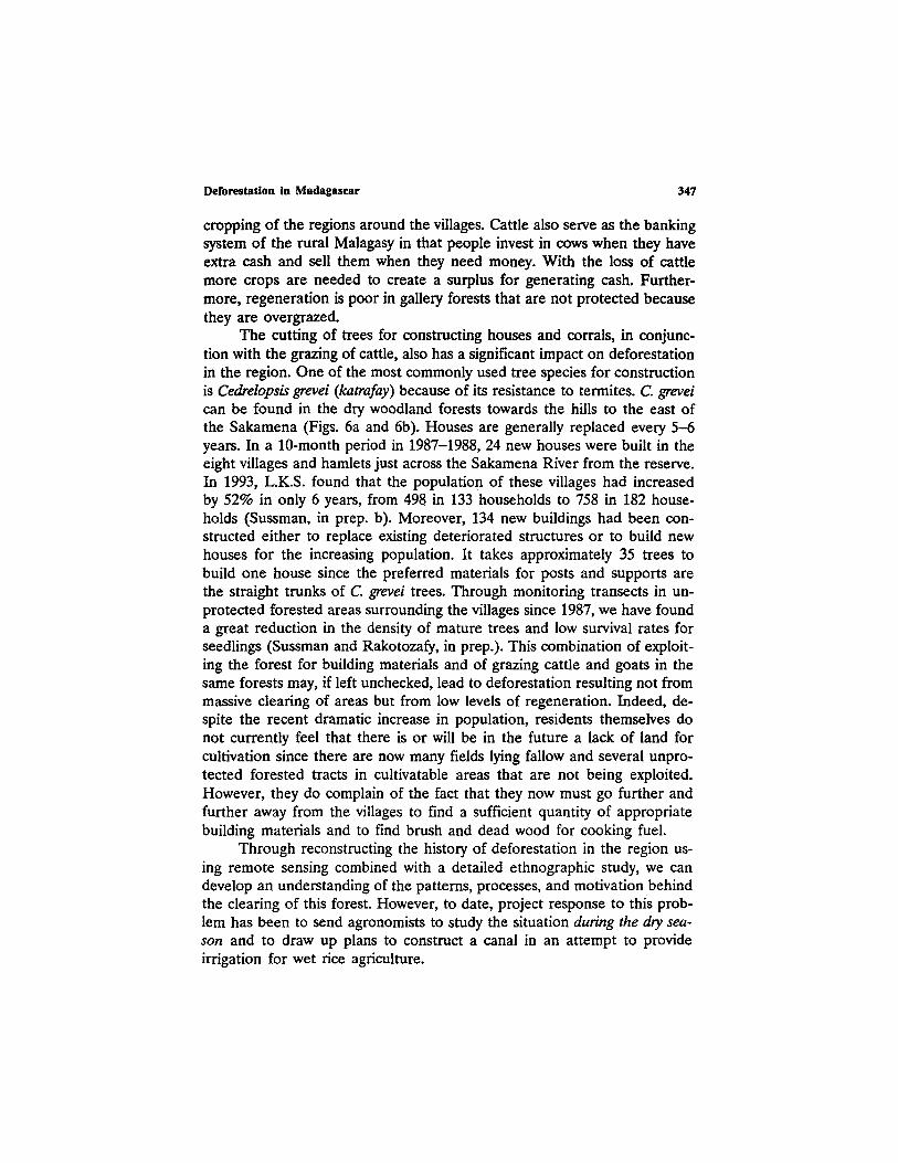
The cutting of trees for constructing houses and corrals, in conjunc- tion with the grazing of cattle, also has a significant impact on deforestation in the region. One of the most commonly used tree species for construction is Cedrelopsis grevei (katrafay) because of its resistance to termites. C. grevei can be found in the dry woodland forests towards the hills to the east of the Sakamena (Figs. 6a and 6b). Houses are generally replaced every 5-6 years. In a 10-month period in 1987-1988, 24 new houses were built in the eight villages and hamlets just across the Sakamena River from the reserve. In 1993, L.K.S. found that the population of these villages had increased by 52% in only 6 years, from 498 in 133 households to 758 in 182 house- holds (Sussman, in prep. b). Moreover, 134 new buildings had been con- structed either to replace existing deteriorated structures or to build new houses for the increasing population. It takes approximately 35 trees to build one house since the preferred materials for posts and supports are the straight trunks of C. grevei trees. Through monitoring transects in un- protected forested areas surrounding the villages since 1987, we have found a great reduction in the density of mature trees and low survival rates for seedlings (Sussman and Rakotozafy, in prep.). This combination of exploit- ing the forest for building materials and of grazing cattle and goats in the same forests may, if left unchecked, lead to deforestation resulting not from massive clearing of areas but from low levels of regeneration. Indeed, de- spite the recent dramatic increase in population, residents themselves do not currently feel that there is or will be in the future a lack of land for cultivation since there are now many fields lying fallow and several unpro- tected forested tracts in cultivatable areas that are not being exploited. However, they do complain of the fact that they now must go further and further away from the villages to find a sufficient quantity of appropriate building materials and to find brush and dead wood for cooking fuel.
Through reconstructing the history of deforestation in the region us- ing remote sensing combined with a detailed ethnographic study, we can develop an understanding of the patterns, processes, and motivation behind the clearing of this forest. However, to date, project response to this prob- lem has been to send agronomists to study the situation during the dry sea- son and to draw up plans to construct a canal in an attempt to provide irrigation for wet rice agriculture.

348 Sussman, Green, and Sussman
The people living adjacent to the Beza Mahafaly reserve have had little or no experience with wet dee agriculture or with large irrigation sys- tems (Sussman, 1990). Furthermore, at the present time, it is not dea r whether the canal would actually provide water to villages near the Beza Mahafaly Reserve or in fact flood the productive dry season field and de- stroy the local economy. Problems of long-term maintenance of the canal have not been addressed nor has any detailed delineation ever been carded out of the actual fields to be irdgated, of their owners and their plans, or of the crops currently cultivated and their yields in those fields. Moreover, the intensive labor requirements for wet dee agriculture have not been con- sidered and could prove to be a major problem. At present, the main factor limiting the expansion of household fields, and even the complete cultiva- tion of already existing fields, appears to be a lack of labor. In most cases, it is a man and his wife alone who cultivate the fields with hand tools. Furthermore, since almost all married women under the age of 40 either have young children or are pregnant (Sussman, 1988, in prep. b), wives are unable to work intensively or consistently in the fields. Division of labor for agricultural chores is quite prevalent and it is noteworthy, in the context of the proposed canal, that it is women alone who currently cultivate rice.
Although cattle rustling, and a means to protect cattle and provide sustainable pasture are major concerns, these problems have been essen- tially ignored by the project. Recent government policies concerning cattle rustlers have somewhat alleviated the problem and some families are be- ginning to alter their cattle herding practices by bringing herds to former, more distant, pasturelands in the savannahs over the hills to the east. Now, during this change, would be an ideal time to consult with local residents and attempt to develop a village-wide, long-term, conservation-based strat- egy for cattle grazing.
The cutting of new fields up to 1987 appears to have been motivated less from a desire to enlarge cultivated areas than from problems of infer- tility in fields that had been used for many years. To date, however, there has been no attempt by the project to find ways to ensure the continued fertility of the wet and dry season fields currently in use.
RECOMMENDATIONS
In reference to these examples of the complexity of factors involved in deforestation and development, we make the following broad recom- mendations:
First, there is a paucity of ethnographic research. Detailed ethno- graphic studies must be done before any meaningful development/conser-

Deforestation in Madagascar 349
vation projects can begin. In-depth investigations must be carried out on local needs, current patterns of exploitation of natural resources, demo- graphics, and existing resources in order to develop with local residents an integrated, long-term, conservation-oriented plan. To date, most of the communication between Western conservation and development agencies and the people of Madagascar has taken place in the capital. For example, at the Beza Mahafaly Reserve, everyday management has been turned over (by WWF) to the University of Antananarivo and the Department of Wa- ters and Forests. The local Malagasy population has little or no input into the goals or direction of the project. The Malagasy agencies in the capital are, in most cases, as remote and uninformed about rural Madagascar as we are. In a study for the World Bank of 68 rural development projects, Kottak (1990) found that those projects that were socioculturally compat- ible were twice as likely to succeed, in economic terms, as were those that disregarded or gave inadequate attention to local culture (see also, Ander- son and Huber, 1988). In this context, inappropriate actions by conservation and development agencies at Beza Mahafaly include: introduction of new dry season crops (such as okra and beets) that are not used by the local people (who normally have ample food during the dry season, in any case); the distribution of new corn seed that did not store well during the rainy season; the lack of attention to the major problems of cattle rustling and the rapid decrease of suitable pastureland; the lack of recognition of prob- lems associated with the exploitation of forests for building materials, the grazing of cattle in some of the exploited areas, and the rapidly increasing population; and the attempt to introduce wet rice agriculture to replace corn, manioc, beans, and sweet potatoes as major subsistence crops and onions as the primary cash crop.
Second, we believe that the culture of the conservation and develop- ment agencies themselves must change. Between 1978 and 1990, there were four major administrative changes in the World Wildlife Fund. USAID changed personnel three times between 1985 and 1990. In all of these in- stitutions, there is extremely little communication from one administration to the next on specific projects and each change calls for a complete re- education of new personnel. It is the policy of USAID and the World Bank to transfer personnel from one country to another every 3 years and thus personnel switch from one unrelated project and country to another. The reason given is that these people must remain "objective" (Mahar, 1990), but the result is that for the most part they remain ignorant.
Between 1985, when the Beza Mahafaly Reserve was inaugurated as a special government reserve, and 1990, at least ten separate develop- ment/conservation evaluation missions had been sent to the reserve by WWF and USAID. These included from two to nine individuals, few of

350 Sussman, Green, and Sussman
whom spoke Malagasy. They visited the site for no more than 2 weeks, usually for less than 48 hours. Few members of these missions communi- cated with members of previous missions and none knew about or bothered to contact the only ethnographer to conduct research in the region, L. Suss- man, whose project was partially funded by WWF and USAID.
Third, we believe that the concept of development itself must change in these institutions. Small projects are not supported, yet we feel it is nee- essary to steer away from large over-innovative projects, based on a West- ern model of development. Kottak (1990) has suggested that development projects examine what he calls Romer's rule: The goal of stability is the main impetus for change. In many regions, including the Sakamena Valley, people desire to maintain the lifestyle that they have had for generations. However, because of such factors as increasing population, diminishing land for cultivation, decreasing accessibility of building materials and firewood, and general economic and ecological conditions, changes have to be made in order to maintain (as much as possible) the ways of the past.
For example, in 1987, with a USAID grant, we began to reconstruct a portion of a road to the village bordering the reserve. This road was used to transport agricultural crops to the local markets, but had become nearly impassable. This was one of two priority projects requested by local people so that they could maintain commerce networks established in the past. The completion of this road has been canceled because of infighting between two Malagasy political agencies and because new WWF and USAID administrators believed the sole purpose of the road was to allow easier access to the reserve.
Within Western conservation and development agencies in Madagas- car there is e• little understanding or interest in on-the-ground, grass roots development, of this kind. Most of the people involved in con- servation and development in Madagascar have very little interest in staying in rural areas long enough to understand local residents' problems and needs. Development projects in these areas ultimately will involve a great deal of time rather than a great deal of money, and these large agencies seem willing to spend a lot of money but very little time.
Fourth, we believe there is a need to establish organizations to moni- tor projects and empirically evaluate the success or failure of conservation and development agencies (see for example, Seidman and Anang, 1992). Most of these agencies (both government and nongovernment organiza- tionS) have only in-house reviews. Anthropologists and other social scien- tists, and environmental and conservation biologists should continue to do independent research in regions where conservation and development pro- jects are being conducted. At present, this research would likely need to be funded by scientific granting agencies or private foundations inde-

Deforestation in Madagascar 351
pendent of the major conservation and development agencies. Hopefully, the results would convince these large agencies (or the people or govern- merits that fund them) of the necessity for basic research in conservation and development before large-scale projects are begun.
Objective criteria must be developed to evaluate projects. For in- stance, predictive maps such as those we have shown here can be generated and then satellite images used to monitor progress in areas surrounding planned projects. After areas of intense deforestation are identified, social scientists could conduct research to determine the social, economic, and political context related to this clearing. Following basic ethnographic and social research, attempts can be made, with environmental scientists, agronomists and especially local people, to determine if alternative, sus- tainable land use practices are feasible. Furthermore, by continuously moni- toring satellite images of the region, the effectiveness of these projects in
�9 slowing rates of deforestation can be measured objectively. In the last 10 years, while conservation and development agencies have repeatedly spo- ken about using satellite images to map deforestation in Madagascar and organizing international committees to oversee this research, little research has been done. It took independent funding and a small-scale, collaborative effort for us to develop our maps of eastern Madagascar, and the total cost was approximately $5000.
This relates to one final problem involving the accessibility of Landsat data. The Landsat system was created in 1972 and privatized in 1986. Prices for various Landsat derived products have fluctuated greatly. At times the higher cost of satellite data may have discouraged the use of satellite images in research on deforestation since change detection studies require numer- ous scenes. Landsat data continuity, always seen as crucial for the success of the U.S. remote sensing community, is now in question following the fail- ure of the Landsat 6 in late 1993. Furthermore, data acquired in the early 1970s (those data most useful for change studies) are stored on digital tape in Sioux Falls, and currently, by our estimates, nearly 40% of that digital data acquired of Madagascar has deteriorated and is no longer usable.
In Madagascar, we may have less than 35 years to save much of the lowland rainforest areas of the east coast. If we leave this task solely in the hands of major conservation and development agencies without outside input and monitoring, we fear that our prediction will come true.
ACKNOWLEDGMENTS
This project would not have been possible without the generous aid of the Ministries of Higher Education and Scientific Research, the School

352 Sussman, Green, and Sussman
of Agronomy of the University of Antananarivo, and the Mus6um d'Art et d'Arch6ologie. We especially thank B. Rakotosamimanana, B. Andriami- haja, B. and V. Randrianasolo, J. Andriamampianina, P. Rakotomanga, J.- A. Rakotoarisoa, and A. Rakotozafy. The hospitality and assistance of the people of Analafaly and the reserve guards is also gratefully acknowledged. We also thank Michael Fienen and Andrew Nelson for field and laboratory assistance and Clifford Behrens for inviting us to participate in this project and for his helpful comments on the manuscript. The research was funded in part by the World Wildlife Fund, National Science Foundation, Fulbright Senior Research Grants, the National Geographic Society, Pew Midstates Science and Mathematics Consortium, BRSG SO7 RR077054 awarded by the Biomedical Research Support Grant Program, Division of Research Resources, National Institutes of Health, and Washington University.
REFERENCES
Anderson, R. S., and Huber, W. (1988). The Hour of the Fox; Tropical Forests, the World Ban, and Indigenous People in Central India. University of Washington Press, Seattle.
Andriamamplanina, J. (1984). Nature reserves and nature conservation in Madagascar. In Jolly, A., Oberl~, P., and Roland, R. (eds.), Key Environments: Madagascar. Pergamon Press, Oxford, pp. 219-228.
Barbour, R. (1988). Plan de Travail pour les Activit,~s de Developpement ~ Beza Mahafaly. Unpublished report to WWF.
Berry, L., and Johnson, D. L. (1986). Geographical approaches to environmental change. In Dahlberg, K. A., and Bennett, J. W. (eds.), Natural Resources and People. Westview, Boulder, pp. 67-105.
Betsch, J. M. (1972). La microfaune du sol ~ Madagascar, t~moin de la sant~ des sois. Comptes Rendus de la Conference Internatlonale sur ia Conservation de la Nature et de ses Ressources /~ Madagascar, Tananarive, Madagascar, Morge, IUCN, 1970.
Bragg, W. G., Duke, D. L., and Shultz, E. B., Jr. (1987). Rooffud: annual roots as cookstove fuel in the arid third world. Presented at the 28th Annual Meeting, Society for Economic Botany, Chicago, Illinois.
Darlington, P. J., Jr. (1957). Zoogeography: The Geographical Distribution of Animals.John Wiley and Sons, New York.
Dewar, R. E. (1984). Recent extinctions in Madagascar: The loss of the subfossii fauna. In Martin, P. S., and Klein, R. G. (eds.), Quaternary Extinctions: A Prehistoric Revolution. University of Arizona Press, Phoenix, p. 574-593.
FAO/UNEP (1981). Tropical Forest Resources Assessment Project. Forest Resources of Tropical Africa. Part II Country Briefs. FAO, Rome.
Frankei, O. H., and Soul~, M. E. (1981). Conservation and Evolution. Cambridge University Press, Cambridge.
Freden, S. C., and Gordon, F., Jr. (1983). Landsat satellites. In Colweil, R. (ed.), Manual of Remote Sensing. American Society of Photogrammetry, Falls Church, Virginia, pp. 517-570.
Gentry, A. H. (1988), Distribution and evolution of the Madagascar Bignoniaceae. In Golblatt, P., and Lowry, P. P., II (eds.), Modern Systematic Studies in African Botany. Monographs in Systematic Botany from the Missouri Botanical Garden, Volume 25, St. Louis, Missouri Bot. Gard., p. 175-185.

Deforestation in Madagascar 3~3
Green, G. M., and Sussman, R. W. (1990). Deforestation history of the eastern rain forests of Madagascar from satellite images. Science 248:212-215.
Green, G. M., Feinan, M., and Nelson, A. (rid). Deforestation History of the Forests of Southern Madagascar (in preparation).
Helfert, M. R., and Wood, C. A. (1986). Shuttle photos show Madagascar erosion. Geotimes 31:4-5.
Hoerner, J. M. (1977). L'eau et I'agriculture darts le sud-ouest de Madagascar. Madagascar Rev. de Geographic. 30: 63-104.
Hoerner, J. M. (1981). Tulear et le sud-ouest de Madagascar: appoche demographique. Madagascar Rev. de Geographic 39: 9-49.
Hoerner, J. M. (1982). Les vols de boeufs dans le sud Malgache. Madagascar Rev. de Geographie 41: 45-105.
Hoerner, J. M. (1986). Geographie Regionale du Sud-Ouest de Madagascar. Association des Geographes de Madagascar, Antananarivo.
Humbert, H. (1927). La Destruction d'une Flore Insulaire par le Feu. Memoires de L'Academie Malgache, Fascicule V, Tananarive.
Humbert, H., and Cours Dame, G. (1965). Carte Internationale du Tapis V#g~tal: Madagascar, 1:1,000,000. French Institute of Pondich~ry, Toulouse.
Jenkins, M. D. (ed.) (1987). Madagascar: An Environmental Profile. IUCN, Gland. Jolly, A. (1980). A World Like Our Own. Yale University Press, New Haven. Jolly, A. (1986). Lemur survival. In Benirschke, K. (ed.), Primates: The Road to Sustainable
Populations. Springer Verlag, New York. Jolly, A. (1989). Banking on Madagascar. Earthwatch, April. Jolly, A., and Jolly, R. (1984). Malagasy economics and conservation: A tragedy without
villains. In Jolly, A., Oberl~, P., and Roland, R. (eds.) Key Environments: Madagascar. Pergamon Press, Oxford, p. 211-217.
Kottak, C. P. (1990). Culture and "economic development." Am. AnthropoL 92: 723-731. Leroy, J.-F. (1978). Composition, origin, and affinities of the Madagascar vascular flora. Ann.
Missouri Bot. Gard. 65: 535-589. MacKinnon, J. and MacKinnon, K. (1987). Etude du r~seau des aires protegees du domaine
afrotropical: I'exemple malgache. In Mittermeier, R. A., Rakotovao, L. H., Randrianasolo, V., Sterling, E. J., and Devitre, D. (eds.) Priorit~s en Mati~re de Conservation des Esp~ces ~ Madagascar. IUCN, Gland, p. 21-26.
Mahar, D. (1990). Economic Development or Destruction in the Amazon? Paper presented at the United Nations Association Mini-Conference, St. Louis, May 17, 1990.
McNeely, J. A., Miller, K. R., Reid, W. V., Mittermeier, R. A., and Werner, T. B. (1990). Conserving the World's Biological Diversi~y. IUCN, WRI, CI, WWF-US, and World Bank, Gland and Washington, D.C.
Mittermeier, R. A., Konstant, W. R., Nicoll, M. E., and Langarand, O. (1992). Lemurs of Madagascar: An Action Plan for Their Conservation, 1993-1999. IUCN, Gland.
Myers, N. (1988). Threatened biotas: "Hotspots" in tropical forests. Environmentalist 8: 1-20. National Institute of Geodesy and Cartography (1969). Atlas De Madagascar. Antananarivo. National Institute of Geodesy and Cartography (1984). Population Density Map, 1984,
1:6,000,000. Antananarivo. National Research Council (1980). Research Priorities in Tropical Biology. National Academy
of Sciences, Washington, D.C. Nicoll, M. E., and Langrand, O. (1989). Madagascar: R~vue de la Conservation et des Aires
Protegees. WWF, Gland. Pollock, J. (1986). Towards a conservation policy for Madagascar's eastern rain forests. Primate
Conservation 7: 82-86. Population Reference Bureau (1992). World Populations Data Sheet. Washington, D. C. Rabinowitz, P. D., Coffin, M. F., and Falvey, D. (1982). Salt diapirs bordering the continent
margin of northern Kenya and southern Somalia. Science 215: 663-665. Rabinowitz, P. D., Coffin, M. F., and Falvey, D. (1983). The separation of Madagascar and
Africa. Science 220: 67-69.

354 Sussmun, Green, and Sussman
Rafidison, M. (1987). Contribution ~ l'Etude des Production et Consumation de Combustibles Forestiers duns un Centre Urbain et sa Petipherie (Cas de Betioky Sud 1987). Memoire de Fin d'Etudes, Universit~ d'Antananarivo, Madagascar.
Ranh, W. (1979). Problems of biological conservation in Madagascar. In Bramweil, D. (ed.), Plants and Islands. Academic press, London, p. 405-421.
Raven, P. H., and Axelrod, D. I. (1974). Angiosperm biogeography and past continental movements. Ann. Missou~ Bot. GarcL 61: ~;39-673.
Richard, A. F., Rakotomanga, P., and Sussman, R. W. (1987). Beza-Mahafaly: recherches fondamentales et applique~s. In Mittermeier, R. A., Rakotovao, L. H., Randrianasolo, V., Sterling, E. J., and Devitre, D. (eds.), Priorit~s en Mati~re de Conservation des Esp~ces ,~ Madagascar. IUCN, Gland, pp. 45-49.
Salomon, J. N. (1977). Tulear: un exemple de croissance et de structure urbaine en milieu tropical. Madagascar Revue de Geographic. 30: 33-61.
Seidman, A., and Anang, F. (1992). 21st Century Africa: Towards a New Vision of Self-Sustainable Development. African World Press, Trenton.
Sussman, L. K. (1988). The Use of Herbal Preventive Treatment for Pregnant Women and Neonates Among the Mahafaly of Southern Madagascar. Annual Meeting of the American Anthropological Assocation.
Sussman, L. IC (1990). Unpublished report to World Wildlife Fund. Sussman, L. K. (in press). Medical beliefs and practices among the Mahafaly of Southwest
Madagascar. Proceedings of the Sixth International Congress on Traditional and Folk Medicine, American Botanical Council, Austin.
Sussman, L. K. (rid). The Ways of the Ancestors: A Medical Ethnography of a Mahafaly Village in Southern Madagascar (Monograph) (in preparation a).
Sussman, L. K. (nd). Demographic patterns in a rural Southern Madagascar village: implications for conservation and sustainable development (in preparation b).
Sussman, L. K. and Rakotozafy, A. (rid). The Ethnobotany of the Mahafaly of Southern Madagascar. (Monograph) (in preparation).
Sussman, R. W. (1991). Primate origins and the evolution of angiosperms. Am. J. PrimatoL 23: 209-223.
Sussman, R. W., Richard, A. F., and Ravelojaona, G. (1985). Madagascar: Current projects and problems in conservation. Primate Conservation 5: 53-59.
Tattersall, I. (1982). The Primates of Madagascar. Columbia University Press, New York. V~rin, P. (1990). Madagascar. Additions Karthala, Paris.