SANTA YNEZ RIVER BANK PROTECTION EVALUATION
35
January 20, 2011 CLIENT: City of Lompoc PREPARED BY: Penfield & Smith 111 East Victoria Street Santa Barbara, California 93101 (805) 963-9532 WORK ORDER NO.: 19513.01 PROJECT MANAGER: Craig A. Steward, P.E., CFM SANTA YNEZ RIVER BANK PROTECTION EVALUATION City of Lompoc, CA
Transcript of SANTA YNEZ RIVER BANK PROTECTION EVALUATION

January 20, 2011
CLIENT: City of Lompoc PREPARED BY: Penfield & Smith 111 East Victoria Street Santa Barbara, California 93101 (805) 963-9532 WORK ORDER NO.: 19513.01 PROJECT MANAGER: Craig A. Steward, P.E., CFM
SANTA YNEZ RIVER BANK PROTECTION EVALUATION
City of Lompoc, CA

Santa Ynez River Bank Protection Evaluation
Penfield & Smith i
TABLE OF CONTENTS EXECUTIVE SUMMARY ........................................................................................................... 1
PURPOSE OF REPORT ............................................................................................................ 2
LOCATION ................................................................................................................................ 2
BACKGROUND ......................................................................................................................... 2
METHODS ................................................................................................................................. 2
CURRENT CONDITIONS .......................................................................................................... 4
OPTIONS EXPLORED .............................................................................................................15
OPTIONS EVALUATED IN-DEPTH ..........................................................................................18
RECOMMENDATIONS .............................................................................................................28
LIST OF FIGURES Figure A - Vicinity Map ............................................................................................................... 2 Figure B - Project Location Map ................................................................................................. 2 Figure C - Typical Channel Section (looking downstream) ......................................................... 5 Figure D - Likely Top of Bank Locations After Many Years ........................................................ 7 Figure E - Sample Locations ...................................................................................................... 8 Figure F - Well Locations (USGS and City Well Information) .....................................................10 Figure G - Storm Water Outfalls ................................................................................................15 LIST OF TABLES Table 1 - Grain Size Analysis ..................................................................................................... 8 Table 2 - Groundwater Elevation Summary ...............................................................................10 Table 3 - 55 Year Daily Average Stream Flow...........................................................................11 Table 4 – Recorded Historic Floods ..........................................................................................13 Table 5 - Statistical Flood Predictions at Lompoc ......................................................................13 Table 6 - Condition of Outlets for Storm Drains Referenced in Figure G ...................................14 Table 7 - Options Explored During the Investigation .................................................................16 Table 8 - Evaluation Matrix .......................................................................................................27 LIST OF PHOTOS
Photo 1 - Santa Ynez River, System constructed 2002, photo taken 2010 ................................19 Photo 2 - Arroyo Simi, January 2010 just after construction ......................................................19 Photo 3 - Santa Ynez River - River Course in Solvang, .............................................................21 Photo 4 - Santa Ynez River - River Course, ..............................................................................21 Photo 5 - Pilot Channel - Sisquoc River ....................................................................................23 Photo 6 - Rock Rip-Rap Bank Protection – Santa Maria River near Suey Crossing ..................25 Photo 7 - Storm damage on Santa Ynez River 2001 .................................................................29 Photo 8 - Same location June 2010 ..........................................................................................29 Photo 9 - Same location immediately after pile installation (2002) .............................................29

Santa Ynez River Bank Protection Evaluation
Penfield & Smith i
APPENDICES
EXHIBITS
o Option 1 – Reinforced Vegetative Bank Protection
o Option 2 – Reinforced Vegetative Bank Protection with Graded Slope
o Option 3 – Pilot Channel
o Option 4 – Rock Slope Protection with Pilot Channel
o 2009A - Historic Erosion Progress
o Parcel Ownership Exhibit
o 10-Year Inundation Limits
o 50-year Inundation Limits
o 100-year Inundation Limits
SELECTED SITE PHOTOGRAPHS
HISTORIC AERIAL PHOTOGRAPHS
CALCULATIONS AND ANALYSIS
o HEC-RAS Results
o Sediment Evaluation
o Grain Size Analysis – Fruit Growers Laboratories
o Statistical Flood Frequency Analysis
o Cost Analysis
o Project Schedule
PRELIMINARY GEOMORPHIC EVALUATION
o Stillwater Science
REFERENCE MATERIAL
o Planning Studies and Reports Provided by the City of Lompoc
o Street, Grading, and Drainage Plans for Areas Discharging to the Project Area

Santa Ynez River Bank Protection Evaluation
Penfield & Smith Page 1
EXECUTIVE SUMMARY Since 1969 and especially over the last 10 years the Santa Ynez River bank adjacent to the Riverbend bikeway has experienced accelerated bank erosion resulting recently in the creation of a large erosion feature east of Riverside Drive between Bush Avenue and Bell Avenue. This report preliminarily evaluates the extent of potential erosion damage from short-term and long-term bank erosion of the river bank and investigates the cause of the bank erosion. In addition, it evaluates the feasible options for reducing the pace of the erosion. The evaluation has included:
Field visits at the erosion site
Review of historical photographs
Study local sediment and sedimentation potential
Investigation of local habitat and potential for environmental disturbance
Flood analysis and hydraulic modeling
Impacts of adjacent storm water facilities
Preliminary assessment of a broad range of erosion protection methods
Detailed assessment of four possible erosion protection methods (beneficial and detrimental impact assessment, concept plan layout, level of protection, quantity and cost estimate)
Findings include:
The erosion feature is likely the natural consequence of large storms in 1969, 1978,
1983, 1998, 2001, and 2005;
The erosion feature is negatively affecting sediment transport in this portion of the river;
On-going erosion from the feature will likely impact the existing Riverbend Trail bicycle
path within the space of the next one or two large storms with a recurrence interval of 10
years or greater;
Ongoing erosion continuing north and west from the feature is estimated to erode
through large areas of land, potentially eventually including Riverbend Park after many
decades; and,
On-going erosion will reduce the natural habitat value of the native and riparian
vegetation to the north, through expansion of in-channel habitat;
We recommend construction of a Reinforced Vegetative Bank Protection (RVBP) system (Option 1). The RVBP system is most likely to provide long-term protection for the more frequent storm events at the least annualized cost, and also result in the least adverse impact to the channel. The initial construction cost is estimated to be about $800,000 with an estimated project life of 50 years. Other expenses including survey, engineering, environmental review, permitting, and construction administration are estimated to be about $411,000. The time to construct the system, starting from engineering design, is estimated to range from 17 months to 28 months.

Santa Ynez River Bank Protection Evaluation
Penfield & Smith Page 2
PURPOSE OF REPORT The purpose of this report is to evaluate feasible options for protection of the riverbank along a portion of the Santa Ynez River in the City of Lompoc, and through evaluation, to recommend the option most advantageous to the City. The subject portion of riverbank in this area has exhibited rapid retreat in the last ten years, and concern has been expressed that it might present a threat to public and private properties adjacent to the river, unless controlled. This report will attempt to identify the cause of the retreat, explain the most feasible options for addressing the situation, and recommend the option evaluated to be most advantageous to the City.
LOCATION The eroded bank is situated on the eastern side of Lompoc, on the western/southern bank of the Santa Ynez River (Figure A). It is approximately 750-feet east of the portion of Riverside Drive that is between Bush Avenue and Bell Avenue. It is generally accessed on foot, from a trailhead located at the intersection of Riverside Drive and Barton Avenue (Figure B). It is located on land owned by the City of Lompoc and used for public recreation. Recreational uses include open space and a bicycle path.
BACKGROUND The Santa Ynez River flows generally from the east to the west through the Lompoc Valley. As the river emerges from between the Santa Rita Hills and the Santa Ynez Mountains, it wraps around the City of Lompoc on the east and north, before flowing toward Vandenberg Air Force Base and out to the Pacific Ocean. The City of Lompoc is situated on alluvial sediments that have been formed by the action of the river. The City and
adjacent properties have, on occasion, experienced flooding of various magnitudes.
METHODS The evaluation of bank stabilization methods for this eroded section of the Santa Ynez River‟s bank was initiated with a visit to the site by representatives of the City of Lompoc, Penfield & Smith, Stillwater Sciences, Rincon Consultants, Inc., California Department of Fish and Game, the Central Coast Regional Water Quality Control Board, and Army Corps of Engineers. The site visit included a discussion among the group of the possible methods for stabilizing the riverbank at this site. It also included discussions of the potential root of the observed erosion and whether there may be a need to arrest a natural process that is occurring within the
Figure A - Vicinity Map
Figure B - Project Location Map
SITE
EROSION
SITE

Santa Ynez River Bank Protection Evaluation
Penfield & Smith Page 3
riverbed. These discussions were documented and were the incorporated into the analysis presented in this report. The following information was specifically requested to be included in the evaluation:
Locate the top of bank on an exhibit.
Review the flood flow data for the area.
Provide exhibits showing the inundation limits of various sized flood events.
Provide an historical context for the situation and the project.
Assess impacts to downstream properties.
Evaluate data with respect to sediment transport.
Indentify the natural and man-made drainage patterns affecting the site. Review the City
improvement plans to identify storm drains and points of discharge.
Locate the elevation of the groundwater basin.
Assess the selected options with respect to effectiveness, impacts and longevity (how
long before replacement).
Evaluate the maintenance needs of the selected options.
Compare a number of differing options, including returning the banks to their natural
angle of repose, before making a recommendation.
The City of Lompoc provided the team of consultants with information that further supported a comprehensive evaluation of the situation. The information included:
Topographic mapping (source: Jones and Stokes, topographic mapping used to prepare
the Riverbend Park environmental documents,)
Riverbend Park and Trail Master Plan and EIR, Volumes I, II, and III, 2004-2005
Historic aerial photographs;
Planning studies and reports (see attached list of sources)
As-Built design plans of adjacent streets and drainage facilities (see attached list of
sources)
Revegetation plans of nearby projects (see attached list of sources)
Biological surveys prepared for recent projects in the subject area, and
Boring logs from nearby directional drilling and bridge projects
In addition to this information, the consultant team was able to supplement the City information from the following sources:
United States Geologic Survey (USGS) – stream flow data
The Federal Emergency Management Agency (FEMA) – flood data

Santa Ynez River Bank Protection Evaluation
Penfield & Smith Page 4
Santa Barbara County Flood Control District – historic aerial photographs, rainfall, and
stream flow data.
Field-collected samples and photographs
Penfield & Smith records and reports
CURRENT CONDITIONS The following discussion addresses the existing condition of the project site, including many, if not all, of the items specifically requested by during the project field visit.
Landforms The erosion site is located between the banks of the Santa Ynez River which, as in any river bed, is a dynamic location with the river banks shifting from time to time. This portion of the river has been impacted since the construction of Bradbury Dam in the early 1950s. As such, the flows to the City of Lompoc do not represent the natural flow or volume of the river. The river has had to adapt to routinely less sediment inflow and less flow volume. It is likely that adaptation has already occurred, along with slow residential and commercial development of the valley, and thus this portion of the river is likely in a state of dynamic equilibrium. Dynamic equilibrium typically refers to a state in which a stream or river bed generally neither trends toward erosion nor deposition of the bed. Therefore, based on review of historic photographs and available topographic mapping1, the elevation of the Santa Ynez River bed at this location is generally stable and is not experiencing an on-going trend of degradation (lowering) or aggradation (filling in). With respect to this location, indications are that if the localized bank failure can be repaired in a manner similar to the pre-damaged condition, it is likely to remain stable and not exacerbate a problem elsewhere in the vicinity. The river channel at this location is composed of the river bed, which carries the storm flow from the smaller (10-year and smaller) events, and a wider overbank which carries any larger flows. The river bottom is composed of coarse sand and gravel while the overbanks are composed of sand and silty sand. Indeed, most of the Lompoc Valley is composed of alluvial sediments. See Figure C.
1 Sufficiently detailed aerial topographic mapping of this reach includes mapping from 1968, 2000, and 2008.

Santa Ynez River Bank Protection Evaluation
Penfield & Smith Page 5
0 200 400 600 800 1000 1200 1400 1600 180075
80
85
90
95
100
105
110
Riverbend Park Lom poc Plan: Santa Ynez Year 2000 5/19/2010
Geom : Lompoc Year 2000 Fl ow: FEMA
River = Santa Ynez Reach = Lompoc RS = 11.68
Stati on (ft)
Ele
vatio
n (ft
)
Legend
Ground
Bank Sta
Figure C - Typical Channel Section (looking downstream)
Progression of Erosion Historic aerial photographs have been reviewed, and they indicate prominent changes within this reach of the river particularly following the 1969 flood. Prior to this time, the river flow line typically was near the easterly bank (away from the City). After the 1969 flood, the flow began shifting to the westerly side of the river at the upstream end of the erosion site, a process that has continued through to the present day. As a consequence of this flood and subsequent high flows, the lower westerly banks at this location have experienced substantial erosion, progressing from the south to the north. In addition to channel changes noted in 1969, comparing appendix aerial exhibits 1979-A and 1983-A shows a significant bank loss on the order of 100 feet wide and 500 feet long. The loss of this bank material included the loss of a line of trees along the edge of the bank which may have been instrumental in stabilizing this area. See appendix exhibit labeled 2009-A, “Historic Erosion Progress”. After the year 2000, the extent and rate of the erosion increased significantly, as the erosive face entered into a section of river bank that was less stable. A substantial area of riverbank including another line of trees and riparian growth that had historically protected this portion of the bank was lost between 2000 and the summer of 2001, likely occurring during the large (greater than 10-year return period) storm of early 2001. As a result of this loss and the meandering of the riverbed, another extensive amount of lower river bank was eroded during the large (approximately 10-year return period) storm of 2005. In response to this 2005 erosion, the City relocated the bike path that had been in design, moving it farther away from the river bank. Additional erosion has since occurred, some of which during smaller storms in early 2008, and is likely to continue during future substantial storm flows. Since the bank loss in the 2008 storms, the top edge of the lower riverbank in this area measures about 120 feet from the edge of the
LOWER BANK
UPPER BANK
GROUND SURFACE
OVERBANK
RIVERBED
RIVERBEND PARK AND BIKE PATH

Santa Ynez River Bank Protection Evaluation
Penfield & Smith Page 6
paved bike path at its nearest point. Therefore, the river bank in this area has retreated up to about 450 feet from its position in 1968. The City park property has provided a healthy floodplain buffer from adjacent private parcels and residences. As the erosion continues, this buffer will be reduced, increasing the likelihood of structural damage and loss of life. River Bend Park, located downriver to the north of the eroded bank, includes both sports facilities and a significant open area which is enjoyed by many of the local residents. Potential erosion damage to the bikeway, park facilities, riparian habitat and open space would be a significant loss to both the human and natural communities. Derek Booth of Stillwater Sciences has prepared a preliminary assessment of the erosive behavior of this portion of the river, based on historic evaluation of this area of the Lower Santa Ynez River. The draft report is included in the Appendices and is summarized with the following statements:
“Based strictly on the past behavior of this bend, continued downstream translation would be the likely dominant erosion process, with an outer boundary perhaps similar to the “LIKELY PATH OF BANK EROSION” line shown on the drawing “Bank Erosion Progression.pdf”…( Figure D), although progressing much more slowly than suggested by the extent of that line. Absent any remedial action and assuming a continuation of past channel-migration rates based on a typical frequency of large floods, erosion would reach the vicinity of McLaughlin Road only after many decades (>50 years). This estimate ignores any retardation from the scrap metal at the downstream end of the present bend, which is unengineered and of unknown long-term stability, that would further slow the rate of migration. Some relocation of a portion of the bicycle trail, however, would probably be needed after the next one or two large (i.e., >5-year recurrence) floods.”

Santa Ynez River Bank Protection Evaluation
Penfield & Smith Page 7
Figure D - Likely Top of Bank Locations After Many Years

Santa Ynez River Bank Protection Evaluation
Penfield & Smith Page 8
Sediment Type As part of this evaluation, grab samples were collected in the vicinity of the erosion feature from both the river bottom and from the lower bank. The samples were analyzed for sediment size and for nutrient value. Sample locations are shown on Figure E. The soils samples yielded the information in Table 1. Nutrient analyses results are attached to the report. They indicate that primary nutrient levels are generally less than optimal. The project biologist has indicated that they will be adequate, however, for the proposed native riparian plantings to be included in various stabilization options.
Table 1 - Grain Size Analysis
Physical Characteristics
Sample 1 (bed)
Sample 2 (bank)
Sample 3 (bed)
D90, mm 11.0 0.75 12.0
D84, mm 10.5 0.70 11.0
D50, mm 3.1 0.45 2.0
Sand, % 88.0 91.2 93.2
Silt, % 8.0 8.0 5.0
Clay, % 3.2 1.8 1.2
Borings were reviewed from recent adjacent projects. These borings confirm that the river sediments consist of sands and gravels to a significant depth2. Biological Setting Onsite vegetation consists of native and non native plants, including but not limited to, willows, sycamore and cottonwood trees, and castor bean. Vegetation along the bank of the river proposed for repair is sparse, due to its near vertical slopes and past scour from winter storms. Upstream and downstream of the project site, significant vegetation exists, which consists of native riparian growth, such as willows. State and Federal Environmental Compliance3 - Biological Resources
2 Geotechnical Feasibility Study, Permanent Utility Conduits Crossing the Santa Ynez River at River Park, Lompoc,
California; prepared by Earth Systems Consultants Northern California; September 22, 1995.
Figure E - Sample Locations

Santa Ynez River Bank Protection Evaluation
Penfield & Smith Page 9
Any of the options being considered will involve work in the riverbed and on the banks of the Santa Ynez River, therefore, each option is proposed in a similar biological setting. For the purpose of complying with the National Environmental Policy Act (NEPA) and the California Environmental Quality Act (CEQA), existing environmental baseline conditions will need to be identified and potential impacts documented with recommendations to avoid and/or mitigate biological impacts. To achieve this, a biological assessment will need to be prepared. The biological assessment would evaluate onsite flora (plants) and fauna (wildlife). The findings from these analyses will determine the temporary and permanent impacts triggered by project activities. Based on a cursory review of the area, Steven Hongola of Rincon Consultants anticipates the need to evaluate the site for the presence of Least Bell‟s vireo, Southwestern willow flycatcher, California red-legged frog, steelhead, and their associated habitats. However, until a formal survey is conducted, onsite resources cannot be confirmed. In addition to review by the City of Lompoc, state and federal agencies also have jurisdiction over work conducted in and adjacent to the Santa Ynez River. As a result, a U.S. Army Corps of Engineers (ACOE) Section 404 Permit, a California Regional Water Quality Control Board (RWQCB) Section 401 Water Quality Certification, and a California Department of Fish and Game (CDFG) Streambed Alteration Agreement will need to be obtained. Additionally, consultation with the U.S. Fish & Wildlife Service and the National Marine Fisheries Service will also be required, as a part of the Army Corps of Engineers‟ permit review process. Any impacts to state and federally listed species and their habitats, as a result of the construction of the chosen option will require mitigation in the form of avoidance and/or restoration/revegetation for areas temporarily and permanently disturbed. Mitigation for temporary disturbance is usually required at a 1:1 ratio. Mitigation required to offset permanent impacts can vary between 3:1, 5:1, or 10:1, depending on the resource being impacted. The presence of biological resources can also influence the construction schedule, subjecting construction activities during the bird nesting season (i.e. March 1 to September 15) to additional mitigation requirements. Groundwater The level of groundwater in the vicinity of the project site may impact:
Slope stability, particularly on steeper slopes with sandy soils
The amount and vigor of vegetation growth.
Channel bottom elevations in the area of the erosion site vary from about elevation 75-feet (mean sea level datum, NGVD1929) to 85 feet. The top of bank varies from elevation 89 to 91. Groundwater measurements have been taken at a number of wells in the vicinity. Locations of the wells are shown on Figure F. A summary of the measurements are shown in Table 2 and in detail in the attachments.
3 Email from Rincon Consultants, Steven Hongola, dated June 18, 2010.

Santa Ynez River Bank Protection Evaluation
Penfield & Smith Page 10
Table 2 - Groundwater Elevation Summary
Figure F - Well Locations (USGS and City Well Information)
Well A Well B Well C Well D Well E Well F Well G Well H Well I Well J Well K
No. of Measurements 28 35 41 561 31 31 30 100 31 194 507
Beginning Date Sep-91 Aug-91 Mar-89 Mar-50 Feb-95 Mar-87 Jan-88 Dec-87 Aug-90 Mar-65 Jan-52
Ending Date Aug-09 Aug-09 Sep-09 Sep-09 Aug-09 Aug-09 Aug-09 Aug-09 Aug-09 Aug-09 Sep-09
Average WS Elevation, MSL 40.2 41.0 35.56 50.37 47.77 51.45 52.94 48.02 47.46 51.86 25.33
Minimum WS Elevation, MSL 31.4 33.7 24.64 40.13 38.96 37.10 37.04 33.34 36.71 35.84 18.40
Maximum WS Elevation, MSL 55.8 54.8 54.80 63.07 57.53 58.40 141.00 62.70 75.58 77.29 43.28
PROJECT SITE
Santa Ynez River Bank Protection Evaluation
Penfield & Smith Page 11
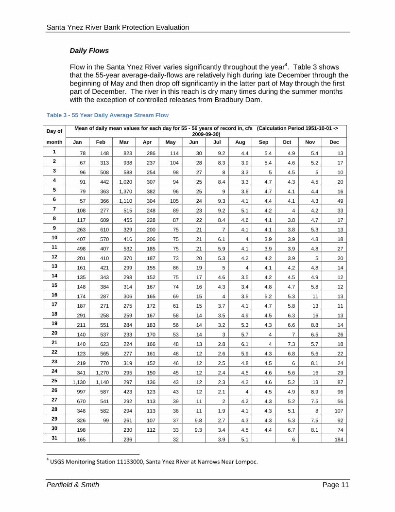
Daily Flows Flow in the Santa Ynez River varies significantly throughout the year4. Table 3 shows that the 55-year average-daily-flows are relatively high during late December through the beginning of May and then drop off significantly in the latter part of May through the first part of December. The river in this reach is dry many times during the summer months with the exception of controlled releases from Bradbury Dam.
Table 3 - 55 Year Daily Average Stream Flow
Day of Mean of daily mean values for each day for 55 - 56 years of record in, cfs (Calculation Period 1951-10-01 ->
2009-09-30)
month Jan Feb Mar Apr May Jun Jul Aug Sep Oct Nov Dec
1 78 148 823 286 114 30 9.2 4.4 5.4 4.9 5.4 13
2 67 313 938 237 104 28 8.3 3.9 5.4 4.6 5.2 17
3 96 508 588 254 98 27 8 3.3 5 4.5 5 10
4 91 442 1,020 307 94 25 8.4 3.3 4.7 4.3 4.5 20
5 79 363 1,370 382 96 25 9 3.6 4.7 4.1 4.4 16
6 57 366 1,110 304 105 24 9.3 4.1 4.4 4.1 4.3 49
7 108 277 515 248 89 23 9.2 5.1 4.2 4 4.2 33
8 117 609 455 228 87 22 8.4 4.6 4.1 3.8 4.7 17
9 263 610 329 200 75 21 7 4.1 4.1 3.8 5.3 13
10 407 570 416 206 75 21 6.1 4 3.9 3.9 4.8 18
11 498 407 532 185 75 21 5.9 4.1 3.9 3.9 4.8 27
12 201 410 370 187 73 20 5.3 4.2 4.2 3.9 5 20
13 161 421 299 155 86 19 5 4 4.1 4.2 4.8 14
14 135 343 298 152 75 17 4.6 3.5 4.2 4.5 4.9 12
15 148 384 314 167 74 16 4.3 3.4 4.8 4.7 5.8 12
16 174 287 306 165 69 15 4 3.5 5.2 5.3 11 13
17 187 271 275 172 61 15 3.7 4.1 4.7 5.8 13 11
18 291 258 259 167 58 14 3.5 4.9 4.5 6.3 16 13
19 211 551 284 183 56 14 3.2 5.3 4.3 6.6 8.8 14
20 140 537 233 170 53 14 3 5.7 4 7 6.5 26
21 140 623 224 166 48 13 2.8 6.1 4 7.3 5.7 18
22 123 565 277 161 48 12 2.6 5.9 4.3 6.8 5.6 22
23 219 770 319 152 46 12 2.5 4.8 4.5 6 8.1 24
24 341 1,270 295 150 45 12 2.4 4.5 4.6 5.6 16 29
25 1,130 1,140 297 136 43 12 2.3 4.2 4.6 5.2 13 87
26 997 587 423 123 43 12 2.1 4 4.5 4.9 8.9 96
27 670 541 292 113 39 11 2 4.2 4.3 5.2 7.5 56
28 348 582 294 113 38 11 1.9 4.1 4.3 5.1 8 107
29 326 99 261 107 37 9.8 2.7 4.3 4.3 5.3 7.5 92
30 198 230 112 33 9.3 3.4 4.5 4.4 6.7 8.1 74
31 165 236 32 3.9 5.1 6 184
4 USGS Monitoring Station 11133000, Santa Ynez River at Narrows Near Lompoc.

Santa Ynez River Bank Protection Evaluation
Penfield & Smith Page 12
Peak Flows Understanding the relationship between how often particular flood flows occur and what type of damage potential is involved allows a better understanding of the relationship of potential risk to the cost of protection. At some point, the cost of providing protection against flood damage exceeds the cost of loss or repair. Typically flood flows are measured at gauging stations along the river. Since the period of collection data (period of record) seldom approaches the design criteria for various structures, statistical models are used to extrapolate data beyond the period of record. The statistical models also assist in determining ranges of uncertainty which increase the further the data extends past the period of record. Statistical analyses do not guarantee the timing or size of future flood flows. They do not predict changes in climate. They only estimate, based on the history of what has previously been measured, a rough estimate of future risk. Risk, for flood analyses, is described as „chance of occurrence‟. That means a one-percent chance storm (sometimes referred to as a 100-year storm) has a one-percent chance of occurring in any one year. Damage is typically estimated from the depth and extent of inundation coupled with erosion potential. The Santa Ynez River has overflowed a number of times in the past, dramatically inundating adjacent farmlands and changing the bed of the river. The largest flood recorded by official gauges on the Santa Ynez River occurred in January 1907 as a result of a 4-day storm, and had an estimated peak flow of 120,000 cubic feet per second (cfs) at Lompoc (near the State Highway 246 Bridge).5 A study of peak flows on the Santa Ynez River using alternative methods has been published6. It uses the long term (100 years to 10,000 years) geologic record of overflows to estimate the peak flow rates in the river. In particular, this method estimates that the currently published flood of record (January 1907 of 120,000) would more likely have been closer to 55,000 cfs and suggests that the 1907 gauging data as well as the data from several other events in the 1920s may have been in error. The report suggests that recent gauging data appears to conform more closely to the geologic record. Therefore, the actual flood of record may have been the 1969 event with a peak flow rate of 80,000 cfs. These modifications significantly alter the statistically predicted flow rates, particularly for 50-year and larger return periods. Other notable floods occurred in 1914, 1969, and 1978. Table 4 identifies a list of some of the largest floods in this reach of the river. Table 5 provides a summary of the anticipated statistical occurrence of flooding at this location based on the observation of 80 years of runoff, FEMA hydrologic analysis, and a statistical analysis using revised discharge rates from the Paleoflood Study. Of the 11 highest ranking flood events, three (highlighted in yellow) fall within the recent period of bank erosion noted by this report and all are for 10-year or larger events.
5 Flood Insurance Study; Federal Emergency Management Agency, September 30, 2005; page 14.
6 Paleoflood Study for Bradbury Dam Cachuma Project, California; April 1996.

Santa Ynez River Bank Protection Evaluation
Penfield & Smith Page 13
Table 4 – Recorded Historic Floods
USGS Gauging Data Paleo Flood
Ranking Year Flow Rate7
cfs Year Flow Rate
cfs
1 1907 120,000 1969 80,000
2 1969 80,000 1978 63,200
3 1914 75,000 1907 55,000
4 1978 63,200 1938 45,000
5 1938 45,000 1983 42,300
6 1983 42,300 2001 42,300
7 2001 42,300 1998 39,300
8 1998 39,300 1952 39,000
9 1952 39,000 1943 32,000
10 1943 32,000 2005 28,800
11 2005 28,800 1914 27,500
Table 5 - Statistical Flood Predictions at Lompoc
Percent Chance of Occurrence in Any One Year
Return Period years
Peak Flow8
cfs FEMA
9
cfs Paleo Flood
10
cfs
50 2 3,180 3,370
20 5 13,700 13,700
10 10 28,800 34,000 27,600
5 20 52,800 48,500
2 50 104,000 93,000 89,800
1 100 162,000 118,000 134,000
Based on these flood estimates the lower bank of the Santa Ynez River within the study area will contain approximately the 10-year runoff event, regardless of which statistical flood prediction method shown in Table 5. The upper bank will contain approximately the 100-year event using the FEMA flood prediction. Since the lower bank is the area that has been subject to on-going erosion and is subject to the most frequent assaults, it will benefit most frequently from protection. Refer to Figure D. Therefore, the differences between the various flow estimates for the larger storms are not significant factor in this evaluation. Storms larger than 10 to 20-year events have a potential to result in widespread damage to the overbank areas which include Riverbend Park and a portion of the bike path. The larger the runoff event, the deeper and more swift the overflow will be. For relatively shallow flows, damage may be limited to debris clean up, while larger, deeper flows may erode or sweep away structures. At this location, it is not physically or financially feasible to protect these facilities from the larger storms. Attached exhibits show the anticipated limits of inundation for the 10-year, the 50-year and the 100-year storm events.
7 USGS Annual Peak Flow Data for USGS Gaging Station 11133000, Santa Ynez River at Narrows Near Lompoc.
8 Ibid. USGS Annual Peak Flow Data.
9 Op. Cit. Flood Insurance Study; Table 3, p 31.
10 Op. Cit. Paleoflood Study for Bradbury Dam Cachuma Project; Table 3-3, p 17. Revised peak discharges were
inserted into statistical analysis of annual peak discharges.

Santa Ynez River Bank Protection Evaluation
Penfield & Smith Page 14
Scour As part of a design study for utility crossings near the project site, a scour analysis was prepared11. It stated:
“During flooding of the river, the erosive forces of the rapidly flowing river will cause erosion of the river bed and the banks. The depth to which soil will be removed by erosion is dependent on both the magnitude and duration of flooding, as well as on-site and on-site and soil characteristics. The boring in the river bed (Boring 3) encountered poorly-graded sand to a depth of approximately 19-feet. Below 19-feet, the sand was interbedded with thin seams of clay. These conditions indicate that the active scour zone extends to a depth of about 19-feet at the location of Boring 3. However, it is likely that the scour depth is greater in other areas of the river bed due to variability in the flow path and soil deposits. The County of Santa Barbara Flood Control and Water Conservation Department (sic) estimates the scour depth to be approximately 25-feet in the portion of the Santa Ynez River that is the subject of this study. This depth seems to correspond to our observations from the soil profile at Boring 3.”
Drainage Storm drain and surface outfalls to the Santa Ynez River within the study area are shown on Figure G. Storm drainage facilities consist of either storm drain pipes that discharge onto to the top of the lower bank or swale/culvert systems discharging to the river. Derek Booth of Stillwater Sciences has stated on pages 5 and 6 of the Technical Memorandum, attached to this report:
“Although several drainage ditches and pipes enter the outer bend at Site 1 (i.e. erosional site which is the subject of this study), they do not appear to have any but the most local effects on the pattern of bank erosion. Such localized bank saturation and gully erosion surely provide a locally favorable site for bank retreat, but there is little evidence that the overall geometry or rates of channel migration have been strongly influenced by them…or that their absence would have altered the basic course of channel change.”
Table 6 outlines the findings of the storm drain investigation specific to this study. Table 6 - Condition of Outlets for Storm Drains Referenced in Figure G
Storm Drain Designation
Tributary Area acres
Downstream Condition
A 5 Minor erosion evident at downstream outlet. No significant impact to bank.
B 13 Minor erosion evident at downstream outlet. No significant impact to bank.
C 7 Discharges to river bottom. No impact to bank.
11
Geotechnical Feasibility Study, Permanent Utility Conduits Crossing the Santa Ynez River at River Park, Lompoc, California; prepared by Earth Systems Consultants Northern California; September 22, 1995, page 12.

Santa Ynez River Bank Protection Evaluation
Penfield & Smith Page 15
Figure G - Storm Water Outfalls
OPTIONS EXPLORED As part of the bank stabilization evaluation, numerous methods of bank stabilization were evaluated. As indicated, during the site visit, many of these were discussed and conceptually evaluated. See Table 7.

Santa Ynez River Bank Protection Evaluation
Penfield & Smith Page 16
Table 7 - Options Explored During the Investigation
Concept Options Stabilization Pros Cons
Rock Rip-Rap (ungrouted) Loose angular rock stacked or dumped on a sloped bank
Has worked on a site near the Lompoc Wastewater Treatment Plant
Generally flexible, providing protection even after failure
Expensive
Does not encourage vegetative cover
Require extensive grading
Likely to fail when supporting sediments move
Has failed at this location in the past
Rock Rip-Rap (grouted) Loose angular rock stacked or dumped on a sloped bank. The voids between the rock are then filled with grout or concrete
None
Expensive
Requires extensive grading.
Rigid and prone to failure on with minimal undercutting
Generally smooth surface increases flow velocity, consequently increasing erosion at the toe of the structure.
Does not encourage vegetation
Not generally accepted by permitting agencies
Fill with Vegetative Slope Stabilization Area eroded during recent storms would be filled and vegetated with native plants.
Natural
Fill is expensive and difficult to acquire in the quantities required for this project.
Not capable of withstanding large storm flows as proven by the bank loss at the project site in 2001.
Bank protection not likely to survive until vegetation has been successfully established.
Likely to require replacement or maintenance after major storms.
Reinforced Fill with Vegetative Slope Stabilization Area eroded during recent storms would be filled and vegetated with native plants. The exposed soil surfaces would be reinforced with synthetic materials.
Natural
Fill is expensive and difficult to acquire in the quantities required for this project.
Not capable of withstanding large storm flows.
Fill reinforcing materials, if scoured out before vegetation is established, can flush downstream.
Likely to require replacement or maintenance after major storms.
Gabions Metal mesh baskets which are filled with cobble-sized stone. The baskets are stacked against the bank.
None
Expensive
Subject to failure by debris and age
Generally smooth surface increases flow velocity, consequently increasing erosion at the toe of the structure.
Not recommended with deep sediment movement expected at this site
Does not encourage vegetation
Not generally accepted by permitting agencies.
Soil Cement Slope Protection A soil and cement mixture is moistened, placed, and compacted on the face of a slope.
Can be effective with a deep toe
Uses mostly native soils for materials (soil)
Fairly easy to construct
Extensive excavation
Does not encourage vegetation
Not generally accepted by permitting agencies.

Santa Ynez River Bank Protection Evaluation
Penfield & Smith Page 17
Concept Options Stabilization Pros Cons
Tie-Back Walls A vertical wall that typically depends on cable and anchors into the soil behind the wall for structural support.
None
Not well suited where toe erosion is expected.
Generally smooth surface increases flow velocity, consequently increasing erosion at the toe of the structure.
Tends to fail catastrophically
Does not encourage vegetation
Not generally accepted by permitting agencies.
Soil Nail Walls A vertical or near-vertical grout wall that that receives support from long helical „screws‟ placed into the soil behind the wall.
None
Very expensive
Generally smooth surface increases flow velocity, consequently increasing erosion at the toe of the structure.
Does not encourage vegetation
Not generally accepted by permitting agencies.
Pipe and Wire Revetment A system of wire covered fences supported on metal pipes.
Has been used throughout Santa Barbara County
Relatively inexpensive
Encourages native vegetation
Does not function well in erosive conditions.
Wire mesh can capture or damage fish
Requires maintenance occasionally
Not generally accepted by permitting agencies.
Poses a potential hazard to recreational users
Reinforced Vegetative Slope Protection (RVSP) A system of vegetation planted on the bank and/or in the streambed which is reinforced with strings of piles connected with cables.
Has been effective at locations on the Santa Ynez River and other rivers
Encourages establishment of native vegetation and natural sediment deposition
Requires little, if any, maintenance
Lasts longer than many other protection types, and is self-healing after damage from storm flows.
Moderately expensive initial cost
Requires manmade materials in the river
Poses a potential hazard to recreational users
Rock Groins A line of loose rock formed into a line roughly perpendicular to the flow.
None Not recommended for areas with deep scour
Bendway Weirs A rock weir extending across the channel in such a way that flows tend to be concentrated towards the center of the channel.
None Not recommended for rivers with deep scour
Graded Pilot Channel A graded ditch constructed down the middle of a stream to carry low flows.
Inexpensive initial construction cost Not capable of protecting banks at larger than a 2- to 5-year runoff event
Requires repeated construction
Requires repeated permitting to be maintained
Moderately expensive over time due to continually needing maintenance/reconstruction.
Cantilever Retaining Wall A vertical concrete wall and footing supporting a slope.
None Not recommended for areas with deep scour, under these conditions prone to catastrophic and unexpected failure

Santa Ynez River Bank Protection Evaluation
Penfield & Smith Page 18
Concept Options Stabilization Pros Cons
Crib Wall A near vertical wall constructed of reinforced concrete beams (similar to lincoln logs)
Can support limited vegetation Not recommended for areas with deep scour
Rubber Tire/Auto Body Revetment Rubber tires or crushed automobile bodies stacked along a stream bank and cabled together.
Inexpensive
Self healing when undercut
Recycles unwanted materials
Introduces manmade, potentially hazardous materials into the river
Such materials can be carried downstream during large flows.
Does not encourage vegetative growth
Not generally accepted by permitting agencies.
Articulated Concrete Block Slope Protection Formed concrete shapes typically tied together with cable and placed en-mass as a mat on a stream bank.
Effective, if tied into adjacent slopes and toe sufficiently
Allows limited amounts of vegetation
Can be quickly installed
Generally smooth surface increases flow velocity, consequently increasing erosion at the toe of the structure.
Will require significant grading and disturbance
Moderately expensive.
Not generally accepted by permitting agencies.
OPTIONS EVALUATED IN-DEPTH Based on critical review of the options, input from City staff, and permitting agencies the following options or combinations of options were selected for more in-depth evaluation. Exhibits have been prepared for each of the Options Evaluated In-Depth, and are attached as part of the Appendices. An explanation of the method of protection, a description of how each option works, the expected cost, level of riverbank protection, maintenance requirements, expected project life and method of eventual failure is described. Costs have been estimated on an annualized basis based on conceptual designs shown in the Exhibits. Initial costs include: permitting and environmental analysis, complete design, construction, environmental mitigation, anticipated maintenance, and on-going permitting costs if applicable. Annualized costs take the initial project cost, assuming an annual rate of inflation of 6% and spread the initial cost over a life span range equal to the associated project longevity. Construction and maintenance costs are based on recent projects of similar scope and size, if available, and as referenced in standard cost estimating guides and include a 25 percent contingency. Design, survey, permitting and construction administration costs are based on a percentage of the construction cost. The project costs are for comparison purposes only and do not represent a guarantee to be able to construct or maintain a system for the estimated cost.
Option 1 – Reinforced Vegetative Bank Protection (RVBP) with no grading Description: A series of lines of piles (typically steel) (called bents) are installed within the river bed adjacent to the slope to be protected. The lines of piles are placed perpendicular to the river bank and each line is connected with fairly widely spaced cables, usually four to six strands. Riparian vegetation is planted extensively between the pile bents. See Exhibit 1.

Santa Ynez River Bank Protection Evaluation
Penfield & Smith Page 19
Photo 1 - Santa Ynez River, System constructed 2002, photo taken 2010
Photo 2 - Arroyo Simi, January 2010 just after construction
How it works: During periods of high flow, the piles and cables collect debris floating in the floodwater. The planted riparian vegetation (depending on how well established) and the collected debris slow down the water, allowing the sediment in the water to drop out (meaning the sediment settles and is deposited in the area of these improvements along the edge of the riverbed) thereby re-building the riverbank. Because the water is slowed through the system, typically the riparian root systems will survive the higher flows and re-establish more quickly, generating a self-healing system that, depending on sediment loads, will eventually be covered with sediment and vegetation. The action of dramatically increased roughness caused by the RVBP system tends to cause the higher velocity current to scour more towards the center of the channel, usually helping to clear the center channel of vegetation and permanent islands. This action

Santa Ynez River Bank Protection Evaluation
Penfield & Smith Page 20
significantly improves the sediment transport function for this area compared to the pre-project condition. Maintenance: Little to no maintenance is required after the initial vegetation is established. Occasional maintenance may include repair of cables or clamps. Level of Protection: Approximately a 10-year storm. The top of existing lower riverbank at this location is only at the elevation of the 10-year storm water-surface-elevation (WSE); therefore, the tops of proposed piles are to approximately match the existing top of riverbank elevation. RVBP systems, however, have lasted and protected riverbanks through much larger storms, even when river flows have been higher than the top of the piles, and the proposed piles at this location are not expected to wash out during such larger storms. Additionally, by protecting the lower bank and slowing the flow adjacent to the bank, the RVBP system also provides protection to the overbank area, the upper riverbank, and the land beyond those areas. Longevity: 50 years or longer Annualized Cost: $77,100 Initial Cost: $1,205,000 Failure Mode: Failure occurs when there is erosion between the pile bents and the bank or when there is a loss of a pile. Typically, this type of system will not fail catastrophically. If there is a loss of a pile, the remainder of the system will stay in place. Since the piles are connected together with cables, the piles act as a system, supporting one another and preventing loss of piles downstream. These types of failures can be repaired relatively easily or in some cases, just ignored. Other: Sedimentation analysis has shown that this type of system will tend to return the river to a condition more like it was in 2000.

Santa Ynez River Bank Protection Evaluation
Penfield & Smith Page 21
Option 2 – RVBP with graded slope Description: Same as Option 1 except that the adjacent river bank would be graded back to a stable 2:1 slope and vegetated. See Exhibit 2.
Photo 3 - Santa Ynez River - River Course in Solvang, Constructed 1991, Photo taken 2001
Photo 4 - Santa Ynez River - River Course, Constructed 1991, Photo taken 2010
How it works: Same as Option 1 with the exception that there is greater access to the river. (Note that historic off road vehicle (ORV) use at the project site may be more likely to continue, if the slope at the bank of the riverbed is artificially reduced through grading.)

Santa Ynez River Bank Protection Evaluation
Penfield & Smith Page 22
Maintenance: Little to no maintenance is required after the initial vegetation is established. Level of Protection: See Option 1. Longevity: 50 years or longer Annualized Cost: $88,100 Initial Cost: $1,378,000 Failure Mode: See Option 1. Other: See Option 1.

Santa Ynez River Bank Protection Evaluation
Penfield & Smith Page 23
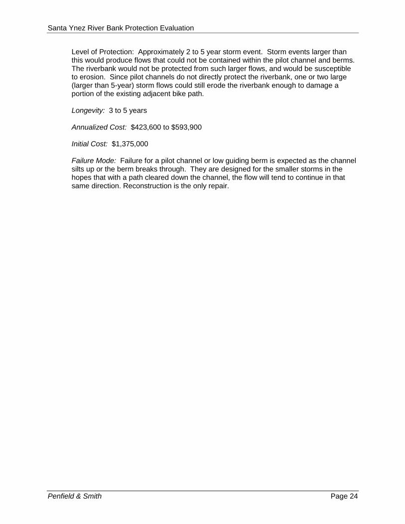
Option 3 – Pilot Channel Description: A small shallow channel is graded into the river bottom during a period when there is not flow in the river. The excess soil from the excavation is formed into a berm that would guide small storm flows away from the eroded bank. For the purposes of the cost estimate, containment of a 5 year storm event has been assumed. Longevity is estimated by the frequency of having to completely re-establish a pilot channel after a large (larger than 5-year) storm. See Exhibit 3. History of Pilot Channel Near Lompoc: According to Santa Barbara County Flood Control District maintenance officials, there is no record of pilot channel construction on this reach of the Santa Ynez River. Further downstream below the Lompoc Wastewater Treatment Plant outfall, the County has records of clearing a pathway through dense willow growth that affected the ability of the river to carry flood flows. Pathways were cut during the periods of 1992-1993, 1995-1995, and 1997-1998. The width of the swath cut varied from 100 feet to 300 feet. All clearing was done with hand tools or equipment with cutter blades. No pilot channel was constructed.
Photo 5 - Pilot Channel - Sisquoc River
How it works: For small storms (2-year to 5-year events), the water in the river would be guided away from the eroded bank and down a more preferred course. Maintenance: The pilot channel and berm would likely need to be restored and vegetation within the pilot channel removed every year or so. Since the riverbed would be disturbed during this annual restoration, it is likely environmental permits would need to incorporate an annual maintenance plan for a period of 5 years or new permits would be required each year. Replanting for the annual restoration disturbance would also be required. After larger storm events, the active flow channel within the riverbed may have shifted so much that the pilot channel would need to be completely reconstructed.
Santa Ynez River Bank Protection Evaluation
Penfield & Smith Page 24
Level of Protection: Approximately 2 to 5 year storm event. Storm events larger than this would produce flows that could not be contained within the pilot channel and berms. The riverbank would not be protected from such larger flows, and would be susceptible to erosion. Since pilot channels do not directly protect the riverbank, one or two large (larger than 5-year) storm flows could still erode the riverbank enough to damage a portion of the existing adjacent bike path. Longevity: 3 to 5 years Annualized Cost: $423,600 to $593,900 Initial Cost: $1,375,000 Failure Mode: Failure for a pilot channel or low guiding berm is expected as the channel silts up or the berm breaks through. They are designed for the smaller storms in the hopes that with a path cleared down the channel, the flow will tend to continue in that same direction. Reconstruction is the only repair.

Santa Ynez River Bank Protection Evaluation
Penfield & Smith Page 25
Option 4 – Rock Slope Protection Keyed into the Riverbed and Construction of a Pilot Channel Description: Rock slope protection provides a blanket of appropriately sized rock over the river bank slope. The river bank slope will need to be graded to a stable 1.5 horizontal to 1 vertical or 2.0 horizontal to 1 vertical slope. A large excavation is made at the toe of the slope into which additional rock is placed. The depth of the toe excavation will need to be 15-feet deep or more to address the anticipated scour at this site. Maximum scour has been estimated at 25 feet at the center of the channel. All the rock will be underlain by a layer of filter rock which will support the larger rock layer and help prevent it from sinking into the moist river sediments. In addition to the rock slope protection, it is proposed that a pilot channel, similar to Option 3 be constructed to minimize the erosion and sediment movement at the toe of the rock slope protection. See Figure 4
Photo 6 - Rock Rip-Rap Bank Protection – Santa Maria River near Suey Crossing
How it works: For small storms (2-year to 5-year events), the water in the river would be guided away from the rock slope protection and down a more preferred course. During larger storms (up to approximately a 10-year event), the rock would shield the soil from the higher velocity flows. Maintenance: The pilot channel and berm would likely need to be restored every year or so. Level of Protection: Approximately 5 to 10 year storm event depending on the direction of the current. Longevity: 15 to 25 years Annualized Cost: $549,700 to $683,000

Santa Ynez River Bank Protection Evaluation
Penfield & Smith Page 26
Initial Cost: $3,980,000 Failure Mode: Rock slope protection fails when the soils supporting it lose strength, as when they become saturated and begin to move. This may occur when there are storm flows that significantly exceed the level of protection, when the force of the flow is directed at a near perpendicular angle towards the bank, or when flows overtop the structure and remove part of the supporting soil behind it. Under these circumstances, the rock would tend to slip down into the „liquefied‟ sediments, leaving the slope exposed to erosion. Repair would entail removal of the damaged section of the rock slope protection and complete reconstruction of the rock filter, rock slope protection and rock toe protection.

Santa Ynez River Bank Protection Evaluation
Penfield & Smith Page 27
Option 5 – No Project Option 5 maintains the potential for bank erosion in the project area to follow the path as shown on and described on Page 7. The cost of the No Project Option is at least partially non-monetary. There will be a continuing loss of bank, and as the bank erosion creeps northward and westward, native vegetation and associated habitat can be expected to be lost. Also, loss of the channel bank will eventually require the relocation of the bicycle path, if there remains an area to which it is possible to relocate the path. The cost of implementing the No Project Option includes the relocation of the bike path, and relocation of sports field facilities. It will also include the value of the land lost to bank erosion (difference in area between land lost with bank protection and that lost without bank protection, which will require additional land acquisition12. Bike Path Relocation: $1,800,000 Sports Facility Relocation (including additional land acquisition): $4,500,000 Loss of Land: 36 acres at $35,000 per acre (agriculture use) = $1,260,000 Other Costs (Design, Permitting, etc): $550,000 If these costs were annualized over a time period of 15 years, the amount of funds necessary to be saved each year to cover the anticipated damages would be $599,100.
Table 8 summarizes a number of facts regarding the various options. Table 8 - Evaluation Matrix
Option Maintenance Level of Protection
Longevity Annualized Cost
Failure Mode Sediment Transport
1 – RVBP only
Rare 10 year storm* 50+ years $77,100 Slow and self healing
Better
2 – RVBP with Graded Slope
Rare 10 year storm* 50+ years $88,100 Slow and self healing
Better
3 – Pilot Channel
Frequent 3 to 5 year storm 3 to 5 years maximum
$423,000 to $593,900
Frequent and rapid
Poor
4 – Rock Slope Protection with Pilot Channel
Frequent to Moderate
10 year storm 15 - 25 years $549,700 to $683,900
Rapid Poor
5 – No Project
N/A None 15 $599,100 on-going Poor
* RVBP provides substantial protection benefits in storms larger than the 10-year storm, however, at this project location, the existing lower riverbank height limits the proposed height of RVBP protection to the 10-year storm water surface elevation.
12
Replacement costs compiled with the assistance of the City of Lompoc based on Riverbend Park construction.

Santa Ynez River Bank Protection Evaluation
Penfield & Smith Page 28
RECOMMENDATIONS Based on the findings that:
The erosion feature is likely the natural consequence of large storms in 1969, 1978,
1983, 1998, 2001, and 2005;
The erosion feature is negatively affecting sediment transport in this portion of the river;
On-going erosion from the feature will likely impact the existing Riverbend Trail bicycle
path within the space of the next one or two large storms with a recurrence interval of 10
years or greater;
Ongoing erosion continuing north and west from the feature is estimated to erode
through large areas of land, potentially eventually including Riverbend Park after many
decades; and,
On-going erosion will reduce the natural habitat value of the native and riparian
vegetation to the north, through expansion of in-channel habitat;
We recommend Option 1 – Reinforced Vegetative Bank Protection (RVBP) system. The RVBP system is most likely to provide long-term protection at the least annualized cost, and also result in the least adverse impact to the channel. At this location, given the formation of the river with an upper and lower bank, it is only feasible to protect the lower bank. That means that the RVBP system will work effectively to protect from flows reaching to the height of the lower bank or up to the size of a 10-year runoff event. Once the lower bank is overtopped, the RVBP system will provide a lesser amount of protection for 20 and 50-year runoff events. These runoff events are characterized by short term, shallow, relatively low velocity flow across the Riverbend Park lands. The RVBP system will not be particularly effective in protecting from larger than 50-year runoff events which would consist of relatively deep, higher velocity flows across the Riverbend Park and adjacent lands. In providing protection during lower and moderate flood flows, the RVBP system will encourage the river to scour within the historic channel bottom away from the banks.

Santa Ynez River Bank Protection Evaluation
Penfield & Smith Page 29
This option will also improve in-stream habitat diversity and sediment transport through this section of the Santa Ynez River. Proposed restoration of the affected area will create and enhance habitat indigenous to the location. As river flows deposit sediment in the project area,
the lower riverbank will gradually rebuild itself, restoring the bank without significant redirection of flow or change in upstream or downstream velocities and without impacting the pre-erosion water surface elevations. The ability of RVBP systems to provide such riverbank protection and habitat restoration has been proven at other locations along the Santa Ynez River, and at sites on other rivers. An RVBP system was constructed in 1991 on the
Santa Ynez River at The River Course in Solvang, which performed as intended through the large 10-year+ storms of 1998, 2001, and 2005, and currently continues to
function as described above. Another RVBP system was installed on the Santa Ynez River near Buellton in 2001/2002 to protect the Central Coast Water Authority pipeline which was threatened by bank erosion during the large storm of 2001. See Photos 7 – 9. This system has also performed as intended, not only surviving the large storm of 2005, but allowing the riverbank to begin to be rebuilt by the action of the storm flows depositing sediment in the area of the RVBP system.
Photo 7 - Storm damage on Santa Ynez River 2001
Photo 9 - Same location immediately after pile installation (2002)
Photo 8 - Same location June 2010

Santa Ynez River Bank Protection Evaluation
Penfield & Smith Page 30
Design and construction costs (rounded) for a RVBP system with an expected life span of 50 years are as follows:
Design & Survey: $ 160,000
Permitting: 133,000
Construction: 800,000
Maintenance: 11,000 (assumed to occur twice during design life span)
Annualized Total Cost $ 77,100 Implementation of a RVBP system will require the following steps:
Preliminary Site Assessment: An evaluation of the environmental baseline conditions will need to be undertaken and would include the preparation of a Biological Assessment and Wetland Delineation Report, required surveys including any required protocol-level surveys, and Geotechnical Investigation/Soils Report. The City of Lompoc will need to determine if an Archaeological Phase I Investigation will need to be conducted. The amount of time to complete the necessary reports will depend on the timing of surveys and peer review of the reports by the City of Lompoc. Duration: 3 to 6 months
Preliminary Design. The information in this report represents most of a preliminary design. Additional information needed may include preliminary structural analysis and preparation of full scale plans. Duration: 2 months
Environmental Review: Prior to issuance of any permits/agreements, the project must be found in compliance with the California Environmental Quality Act (CEQA). Given the project‟s location, proposed improvements and construction activities have the potential to impact environmental resources. As the Lead Agency, the City of Lompoc will be responsible for preparing the CEQA document for the project. We will assume a Mitigated Negative Declaration (MND) will be prepared. The amount of time to complete environmental review will need to account for preparation, circulation and public review, and adoption of the MND. Note, to expedite review by the permitting agencies noted, the Notification Packages will be submitted as soon as they are complete with the MND being submitted after it has been adopted by the City. Duration: 4 to 6 months
Environmental Determination. The Lompoc City Council will hold a meeting to review the findings of the environmental review and make an environmental finding. This should occur prior to any irrevocable portion of the project proceeds. Duration: 1 month.
Full Design, Plans and Specifications: A detailed survey of the project area will need to be performed followed by the preparation of plans, specifications, calculations, and reports to describe and build the RVBP system. Construction access, site clearing and restoration, and landscaping will also be addressed. Duration 3 to 6 months.
Permitting: At the preliminary site investigation held on March 17, 2010, representatives from Army Corps of Engineers, Regional Water Quality Control Board - Central Coast Region, and the California Department of Fish & Game were present. Notification Packages will be prepared and submitted to these permitting agencies in addition to consultations with U.S. Fish & Wildlife Service and the National Oceanic and Atmospheric Administration (NOAA). These permitting agencies will document environmental conditions and assign conditions of approval to their permit/agreement. The permitting process is likely to extend throughout the entire final design process. Duration: 8 to 12 months.

Santa Ynez River Bank Protection Evaluation
Penfield & Smith Page 31
Preparation of Bidding Package: The plans, specifications, and quantity estimates developed in the full engineering task will be compiled and reviewed by the City prior to being put out to bid. During this period a Storm Water Pollution Prevention Plan will be developed to be included in the bidding package, if applicable. Duration: 1 month.
Project Bidding, Selection and Start-up: The bidding process for a public project typically can take six to ten weeks to complete from initial release of bidding documents to selection of the qualified bidder. After selection, the qualified bidder must provide the bonds and contractor documentation required in the specifications. Construction will typically be divided into two portions, 1) construction and landscaping and 2) Landscape Maintenance (see below). Duration: 3 to 5 months.
Construction and Landscaping: Construction activities will commence after all permits/agreements have been obtained. In our experience, the contractor would retain the qualified biologist as a sub-consultant to conduct the required pre-construction surveys to ensure limits of work are clearly delineated and to survey the project area for any sensitive bird and animal species. Permit conditions will require the city to restore temporary and permanent impacts related to the project. Impact to mitigation planting ratios typically require a 1:1 ratio for temporary impacts and 3:1 or 5:1 ratio for permanent impacts. Temporary impacts include construction access, staging and storage areas, and any other areas that get disturbed during construction. Permanent impacts would include the area associated with the number of piles driven into the ground and un-grouted rock rip-rap (if proposed). For example, if 50 piles are proposed at one square foot each, a total of 50 sf has been permanently taken out of the watershed. The impact to mitigation ratio at 3:1 would require 150 sf to be restored in an area within that watershed. The project biologist will be responsible for identifying candidate sites that will satisfy the impact-to-mitigation planting requirements for permanent impacts. A Restoration/Planting Plan will be developed to identify the areas to be planted, restored, created and enhanced, and proposed irrigation. This plan will be used to assess the performance criteria established by the biologist over time. Duration: 3 to 5 months.
Landscape Maintenance: The permitting agencies will require that the City oversee the restoration and maintenance of the approved Habitat Mitigation Monitoring Plan (HMMP) for a minimum of five years before they will formally accept the project as complete. Plants shall be cared for and replaced as necessary to provide the vegetation necessary for this system to be successful as well as complying with the permit/agreement conditions assigned to the project. Duration: 5 years.

Santa Ynez River Bank Protection Evaluation
Penfield & Smith
APPENDICES
EXHIBITS
o Option 1 – Reinforced Vegetative Bank Protection
o Option 2 – Reinforced Vegetative Bank Protection with Graded Slope
o Option 3 – Pilot Channel
o Option 4 – Rock Slope Protection with Pilot Channel
o 2009A - Historic Erosion Progress
o Parcel Ownership Exhibit
o 10-Year Inundation Limits
o 50-year Inundation Limits
o 100-year Inundation Limits
SELECTED SITE PHOTOGRAPHS
HISTORIC AERIAL PHOTOGRAPHS
CALCULATIONS AND ANALYSIS
o HEC-RAS Results
o Sediment Evaluation
o Grain Size Analysis – Fruit Growers Laboratories
o Statistical Flood Frequency Analysis
o Cost Analysis
o Project Schedule
PRELIMINARY GEOMORPHIC EVALUATION
o Stillwater Science
REFERENCE MATERIAL
o Planning Studies and Reports Provided by the City of Lompoc
o Street, Grading, and Drainage Plans for Areas Discharging to the Project Area