San Tomas Expressway Improvement Projects between ... · PDF fileSan Tomas Expressway...
20
San Tomas Expressway Improvement Projects between Homestead Rd. and El Camino Real County of Santa Clara Roads & Airports Department Craig Petersen, Project Manager Infrastructure Development Dan Collen, Deputy Director
Transcript of San Tomas Expressway Improvement Projects between ... · PDF fileSan Tomas Expressway...
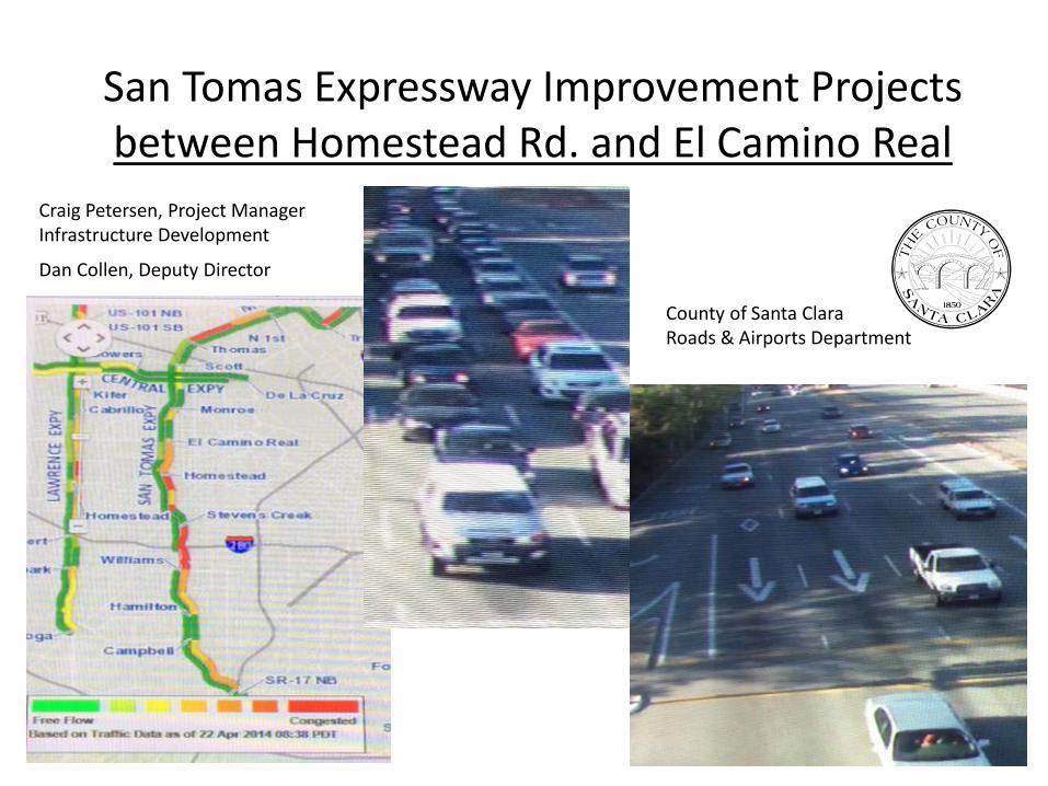
San Tomas Expressway Improvement Projectsbetween Homestead Rd. and El Camino Real
County of Santa ClaraRoads & Airports Department
Craig Petersen, Project ManagerInfrastructure Development
Dan Collen, Deputy Director

3 Concurrent Projects
• - El Camino Real Intersection (turn lanes)
• - Widen expressway from 6 to 8 lanes*Homestead intersection lefts
• - Extend the Bike/Ped trail*
*Both involve sound wall replacement, both on same schedule for construction
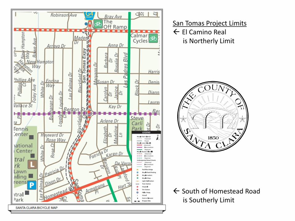
San Tomas Project Limits El Camino Real
is Northerly Limit
South of Homestead Road is Southerly Limit
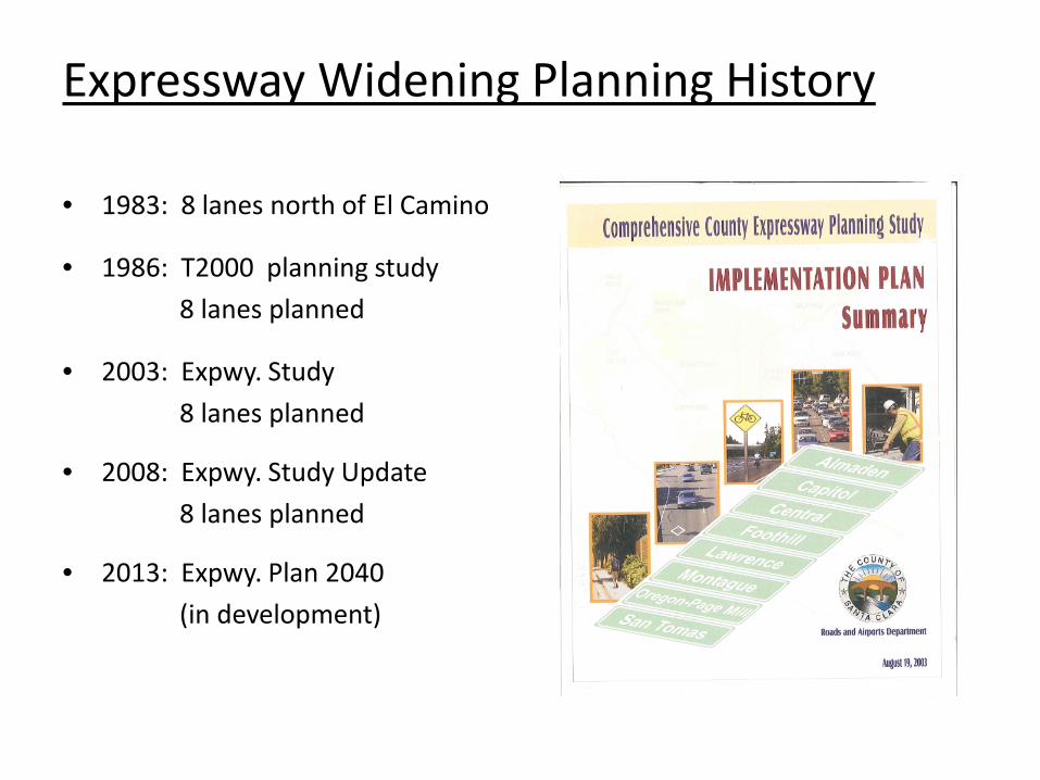
Expressway Widening Planning History
• 1983: 8 lanes north of El Camino
• 1986: T2000 planning study 8 lanes planned
• 2003: Expwy. Study 8 lanes planned
• 2008: Expwy. Study Update8 lanes planned
• 2013: Expwy. Plan 2040 (in development)
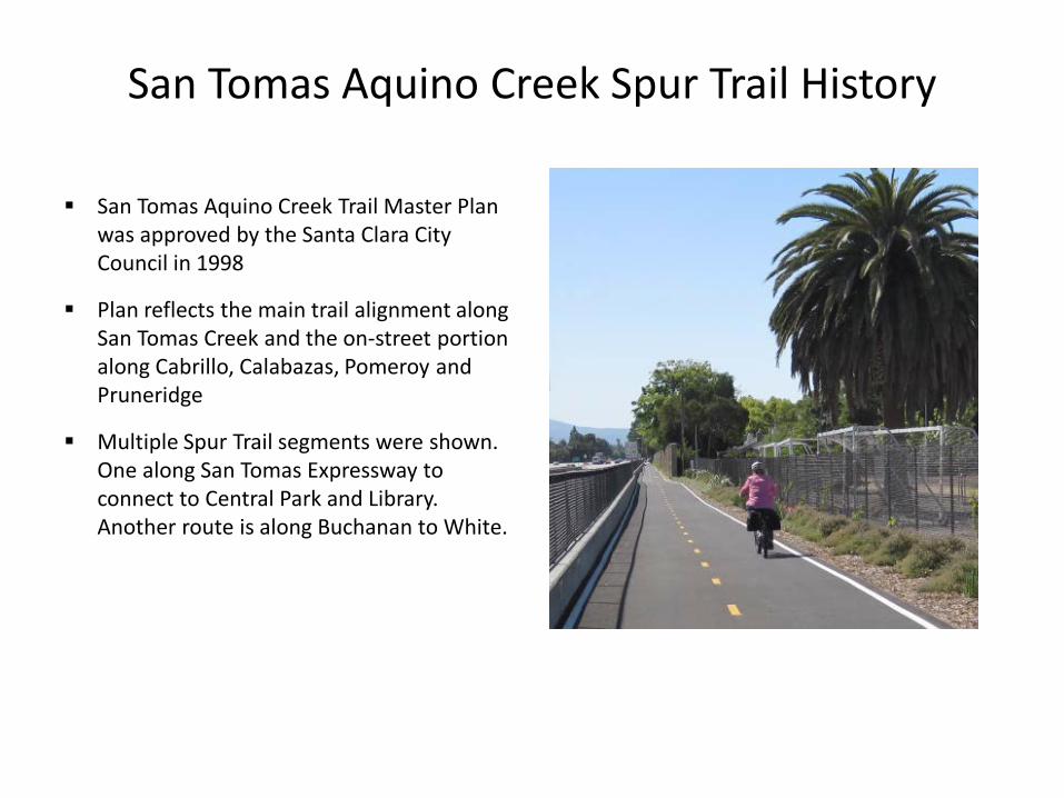
San Tomas Aquino Creek Spur Trail History
San Tomas Aquino Creek Trail Master Plan was approved by the Santa Clara City Council in 1998
Plan reflects the main trail alignment along San Tomas Creek and the on-street portion along Cabrillo, Calabazas, Pomeroy and Pruneridge
Multiple Spur Trail segments were shown. One along San Tomas Expressway to connect to Central Park and Library. Another route is along Buchanan to White.
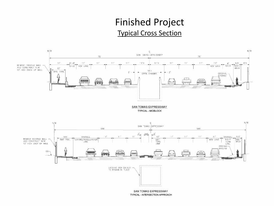
Finished ProjectTypical Cross Section

Finished project- near HomesteadPlan View
Additional lanesDouble leftsTrail, sidewalk, NB bus stop

Plan View near Benton
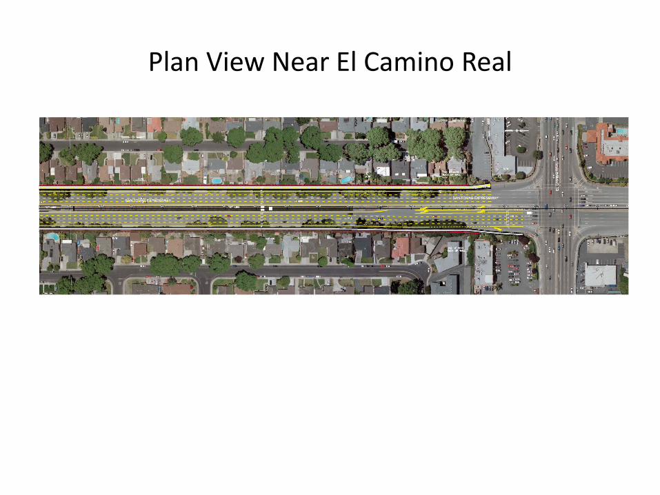
Plan View Near El Camino Real

Project Benefits – TrafficIncreased Capacity improves traffic signal operation, reducing emissions , saving gas, time and money
El Camino AM 44.44 1,691$ 51$ 867$ 2,610$ 652,484$ Benton AM 117.01 4,454$ 135$ 2,284$ 6,873$ 1,718,157$ Homestead AM 78.20 2,976$ 91$ 1,526$ 4,593$ 1,148,226$
El Camino PM 60.84 2,316$ 70$ 1,187$ 3,573$ 893,359$ Benton PM 44.28 1,685$ 51$ 864$ 2,601$ 650,175$ Homestead PM 95.27 3,626$ 110$ 1,859$ 5,596$ 1,398,937$
334.77 12,741$ 388$ 6,533$ 19,662$ 4,915,495$ 440.05 16,748$ 509$ 8,588$ 25,845$ 6,461,337$
Total w/o ECRTotal w/ ECR
Annual Cost Savings ($)
San Tomas Expressway 8-Lane Project - El Camino Real to Homestead Rd (Cost Savings by Intersection Delay)
Peak Period Total Cost Savings ($)
Peak Period Delay
Reduction (Hrs)
Peak Period Emission Cost
Savings ($)
Peak Period Fuel Cost
Savings ($)
Peak Period Time Cost Savings ($)Intersection
Peak Hour
Emissions (tons) ( $9.80) AM 0.0034 0.0102 0.10$ 25.02$ Fuel (gals) ($3.86) AM 71 213 822.00$ 205,500.63$ Time (hrs) ($19.52) AM 78 234 4,566.60$ 1,141,648.85$
Emissions (tons) PM 0.0034 0.0102 0.10$ 25.02$ Fuel (gals) ($3.86) PM 66 198 764.12$ 191,028.75$ Time (hrs) ($19.52) PM 75 225 4,390.96$ 1,097,739.28$
10,543.87$ 2,635,967.55$
San Tomas Expressway 8-Lane Project - El Camino to Homestead (Cost Savings by Corridor Delay)
Amount Save Per Day
Amount Save Per Peak Hour
Total
CategoryCost Savings Per
Day ($)Cost Savings Per Year
($)Peak
Period
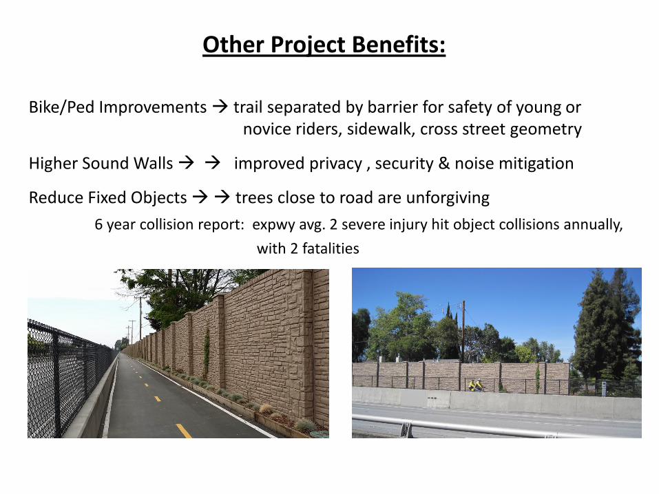
Other Project Benefits:
Bike/Ped Improvements trail separated by barrier for safety of young or novice riders, sidewalk, cross street geometry
Higher Sound Walls improved privacy , security & noise mitigation
Reduce Fixed Objects trees close to road are unforgiving 6 year collision report: expwy avg. 2 severe injury hit object collisions annually,
with 2 fatalities
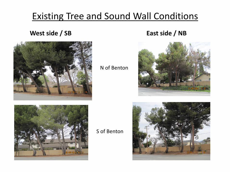
Existing Tree and Sound Wall ConditionsWest side / SB East side / NB
N of Benton
S of Benton

Arborist ReportCondition of Trees
-Have been topped and heavily side pruned, resulting in moderate to poor health-Original spacing too close for tree type/size-Several trees are leaning and in danger of falling
Site Issues
-Area is much too narrow for tree types-Side slope affecting tree health & stability
Conclusion: current large trees are not compatible even with existing site, and due to health & safety issues would have to removed eventually.

Tree-Saving Alternatives? Locate bike trail as needed to leave trees (more offset from property line):
doesn’t allow for San Tomas widening, actually requires lane takeaway. No trail or sidewalk, widening only for 8 lanes, bike/ped use shoulder: too
risky for many bikers; no ped facilities = incomplete street; no convenient alternative for peds; no wall on west side. Widening impacts most trees.
Trail on East side instead of West: all same issues plus more utility conflicts and requires trail cross expressway at El Camino. Inconsistent with trail plan.
Squeezing lanes further: without eliminating shoulder, only 1.5’ gained, not significant enough to affect tree removal.
No NB sidewalk: peds will continue to walk on shoulder, as no convenient access in that area. Widening alone on NB will necessitate removal of all but about 30 trees, and those may go also if they affect wall installation.
Widen into median: would require reconstructing box culvert, scope and cost excessive and on order of four times planned project cost.
Grade separate San Tomas to eliminate widening?: Over would be intrusive to neighborhood, under is impossible due to creek, scope and costs unnecessary
Consider BRT or Transit Solution and Drop All Projects: BRT exists on San Tomas today. Project ped facilities improve transit access.
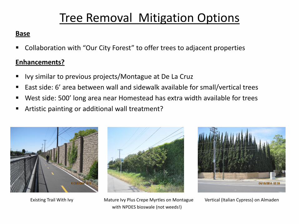
Tree Removal Mitigation OptionsBase
Collaboration with “Our City Forest” to offer trees to adjacent properties
Enhancements?
Ivy similar to previous projects/Montague at De La Cruz East side: 6’ area between wall and sidewalk available for small/vertical trees West side: 500’ long area near Homestead has extra width available for trees Artistic painting or additional wall treatment?
Existing Trail With Ivy Mature Ivy Plus Crepe Myrtles on Montague Vertical (Italian Cypress) on Almadenwith NPDES bioswale (not weeds!)
Hearing on environmental document: June 10, 2014
Potential start construction date: Fall 2014
Duration: altogether at least 6 months. Limiting any particular property to 2 to 3 weeks for wall construction.
Schedule

Your thoughts?
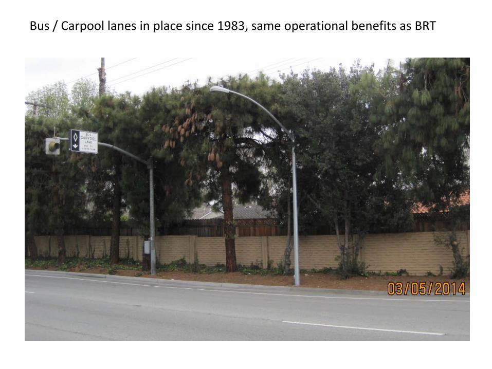
Bus / Carpool lanes in place since 1983, same operational benefits as BRT

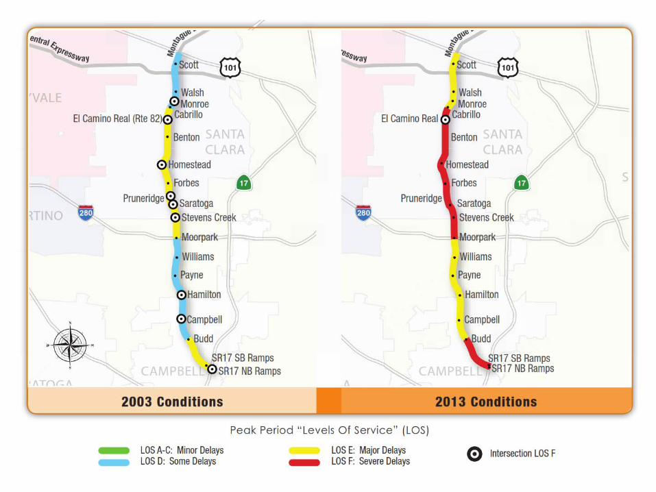
PM Congestion Map
Long traffic backup southbound begins at Homestead