San Luis Obispo Creek Watershed Enhancement Plan Creek Waters… · · 2011-02-09San Luis Obispo...
95
San Luis Obispo Creek Watershed Enhancement Plan Prepared for: California Coastal Conservancy By: The Land Conservancy of San Luis Obispo County January 2002
Transcript of San Luis Obispo Creek Watershed Enhancement Plan Creek Waters… · · 2011-02-09San Luis Obispo...

San Luis Obispo CreekWatershed Enhancement Plan
Prepared for:
California Coastal Conservancy
By:
The Land Conservancyof San Luis Obispo County
January 2002

San Luis Obispo Creek Watershed Enhancement Plan
Prepared for:
California Coastal Conservancy
By:
The Land Conservancy of San Luis Obispo County
January 2002 Contributing Authors: Brian B. Stark – Land Conservancy of San Luis Obispo County Brett Wilkison - Land Conservancy of San Luis Obispo County This plan was completed with the generous participation of the San Luis Obispo Creek Watershed Steering Committee. Thank you all for your time, energy, and commitment to the health of our watershed resources. San Luis Obispo Creek Watershed Steering Committee Bruce Bonifas California Conservation Corps Kim Busby California Polytechnic University, SLO – Coastal Resources Institute
Brian Dietterick California Polytechnic University, SLO Julia Dyer Regional Water Quality Control Board Tim Duff California Coastal Conservancy Joy Fitzhugh San Luis Obispo County Farm Bureau Neil Havlik City of San Luis Obispo Dave Highland California Department of Fish and Game Royce Larson University of California Cooperative Extension – Farm Advisor Susan Litteral San Luis Obispo County Engineering Department Malcolm McEwen Natural Resources Conservation Service Connie O'Henley Central Coast Salmon Enhancement, Inc. Margaret Roper California Department of Fish and Game Chris Rose Regional Water Quality Control Board

1
TABLE OF CONTENTS PREFACE.......................................................................................................................... 4
I. WATERSHED DESCRIPTION .................................................................................. 6
WATERSHED VALUES AND BENEFICIAL USES.................................................................... 7 SOUTHERN STEELHEAD TROUT........................................................................................ 9 GEOGRAPHIC REFERENCES .............................................................................................. 9 REGULATORY FRAMEWORK........................................................................................... 12
Federal Agencies....................................................................................................... 12 State Agencies ........................................................................................................... 14
II CRITICAL ISSUES DOCUMENTATION.............................................................. 18
STEELHEAD TROUT INSTREAM HABITAT AND MIGRATION BARRIERS ........................... 18 RIPARIAN VEGETATION / BUFFER QUALITY................................................................... 22 STREAMBANK STABILITY............................................................................................... 23 SURFACE WATER QUALITY............................................................................................ 25
Nutrients and Dissolved Oxygen............................................................................... 25 Temperature.............................................................................................................. 29 Sedimentation/Erosion.............................................................................................. 30 Pathogens.................................................................................................................. 31 Treated Effluent......................................................................................................... 31 Priority Organics ...................................................................................................... 32
SURFACE WATER QUANTITY ......................................................................................... 32 EXOTIC PLANT SPECIES ................................................................................................. 35 OTHER STREAM ECOLOGY ISSUES ................................................................................. 37
Non-Native Fish ........................................................................................................ 37 Debris Accumulation................................................................................................. 37
III. ORGANIZATIONAL CAPACITY EVALUATION............................................ 41
REGULATORY AND PLANNING AGENCIES ...................................................................... 41 City of San Luis Obispo ............................................................................................ 41 County of SLO........................................................................................................... 43 California Department of Parks and Recreation...................................................... 46
OTHER GOVERNMENT ORGANIZATIONS......................................................................... 46 Natural Resource Conservation Service................................................................... 46 San Luis Coastal Resource Conservation District.................................................... 47 California Conservation Corps................................................................................. 48 California Polytechnic State University (Cal Poly)................................................. 48 University of California Cooperative Extension....................................................... 50
NON-GOVERNMENT ORGANIZATIONS............................................................................ 50 Land Conservancy of San Luis Obispo County ........................................................ 50 Environmental Center of San Luis Obispo ............................................................... 52 San Luis Obispo County Farm Bureau..................................................................... 52 The Nature Conservancy........................................................................................... 53
LANDOWNERS................................................................................................................ 53 SUMMARY RECOMMENDATIONS FOR ORGANIZATIONAL CAPACITY .............................. 53

2
IV. PROJECT OPPORTUNITIES ............................................................................... 56
STREAMBANK STABILIZATION ....................................................................................... 59 Andrews Property ..................................................................................................... 59 Stenner Creek at Parker Barn................................................................................... 61 Stenner Creek Bank Repairs ..................................................................................... 63 Mustang Village ........................................................................................................ 64
EXOTIC SPECIES REMOVAL............................................................................................ 65 Stenner Creek Cape Ivy Management Project.......................................................... 65 San Luis Obispo Creek – Reach 6 Weed Management............................................. 66
REVEGETATION AND RIPARIAN HABITAT ENHANCEMENT ............................................. 67 Froom Creek Road Revegetation / Decommissioning .............................................. 67 Land Conservancy Property / San Luis Obispo Creek ............................................. 68
LAND MANAGEMENT PRACTICES................................................................................... 69 Cal Poly Grazing Lands............................................................................................ 69 Brizziolari Creek Culvert Replacement and Drainage Improvements ..................... 70 Energy Dissipater for Serano Ranch Culvert ........................................................... 72
URBAN AND AGRICULTURAL RUNOFF ........................................................................... 72 Stenner Creek Constructed Wetlands ....................................................................... 72 Storm Drain Stenciling for Downtown San Luis Obispo .......................................... 74
INSTREAM HABITAT CREATION / MODIFICATION........................................................... 75 Marre Weir Fish Passage ......................................................................................... 75 Upper San Luis Obispo Creek Fish Passage at Highway 101 ................................. 76 Brizziolari Creek Fish Passage – Blacksmith Crossing ........................................... 77 Johnson Ranch Fish Passage Improvements Project ............................................... 78
LAND ACQUISITION........................................................................................................ 79 Lower San Luis Obispo Creek Floodplain Properties #1......................................... 80 Upper San Luis Obispo Creek and Headwaters ....................................................... 82 Lower San Luis Obispo Creek Floodplain Properties #2......................................... 83
TECHNICAL STUDIES...................................................................................................... 84 Unpaved Roads Assessment at Cal Poly................................................................... 84 Watershed-Wide Steelhead Trout Census................................................................. 84 Follow-up studies on Bacteria .................................................................................. 84 Water Quality Pesticide Study .................................................................................. 85
V. PROJECT FUNDING SOURCES ........................................................................... 86

3
List of Tables Table 1. Special Status Plant Species in the San Luis Obispo Creek Watershed .......................................7 Table 2. Extent of Steelhead Trout in San Luis Obispo Creek and Tributaries.......................................20 Table 3. Summary of Channel Stability Evaluation and Modeling (Land Conservancy, 1996)...........24 Table 4. 1999 CCAMP tissue data from San Luis Obispo Creek..................................................................32 Table 5. Water Rights Permits for the San Luis Obispo Creek Watershed...............................................33 Table 6. Summary Recommendations for Critical Issues ...............................................................................39 Table 7. Grant Funding Opportunities. ...............................................................................................................86 List of Figures Figure 1. San Luis Obispo Creek Watershed Location………………………………................................6 Figure 2. San Luis Obispo Creek Watershed: Subwatersheds.....................................................................10 Figure 3. San Luis Obispo Creek Watershed Stream Reach Delineations.................................................11 Figure 4. Coastal Zone Intersection ......................................................................................................................16 Figure 5. Estimated Extent of Steelhead Trout Population............................................................................21 Figure 6. Bank Erosion Index (Questa Engineering Corp.) ..........................................................................24 Figure 7. Nitrate Levels: Prefumo Creek............................................................................................................27 Figure 11. Lower Watershed Project Locations..................................................................................................58 Figure 12. Potential Bank Stabilization Method.................................................................................................60
Appendices Appendix A. List of Steering Committee Members and Project Ranking Criteria Appendix B. Landowner Contact Letter

4
PREFACE The San Luis Obispo Creek Watershed Enhancement Plan was prepared to focus local restoration partners toward a coordinated watershed enhancement effort. This plan recognizes that most land within the watershed is privately owned, and efforts to improve riparian habitats will depend on the participation of local landowners. Through cooperative restoration programs with private landowners and local partner organizations, enhancement efforts in this watershed are gaining great momentum. This plan seeks to provide recommendations for continued cooperative enhancement projects with the voluntary participation of local landowners, and broaden the scope of current enhancement activities. The problems facing the Watershed are typical to most rural and urbanizing watersheds. Rural areas are experiencing bank and hillside erosion due to historic animal management practices that contribute sediment to the steams. Farming practices have also resulted in nutrient loading in some of our important streams. In our urban areas, channelization has removed instream habitat and created high stream velocities that cause downstream erosion. Historic urban effluent discharges have also impacted the streams over time. Stream enhancement in the San Luis Obispo Creek Watershed is not a new idea. Various organizations, agencies, and individuals have been working for many years to improve both upland and riparian habitat conditions. From these efforts a wide and diverse set of project partners has emerged. Coordination among these groups has been informal but consistent over time. This plan attempts to formalize project priorities, reduce duplicative projects, and identify potential funding sources for high priority projects in the San Luis Obispo Creek Watershed. The San Luis Obispo Creek Watershed is a well-studied watershed. Extensive information has been developed with respect to hydrology, vegetation, stream conditions, fish habitats, fish migration barriers, and water quality. Rather than re-create technical studies, this plan makes use of existing information to make recommendations calling for specific actions that address known watershed problems. The depth of available information has facilitated an objective review of conditions for steelhead trout and a scientifically sound set of enhancement strategies. The California Coastal Conservancy provided the Land Conservancy of San Luis Obispo County with funding for this plan. In preparing this plan, the Land Conservancy worked closely with a local Steering Committee made up of individuals, organizations and agencies involved in watershed enhancement. Every effort has been made to address issues that cover a broad spectrum of enhancement strategies. The participation of each group has been very important and has helped this plan reflect the needs and capabilities of a diverse set of watershed stakeholders.

5
This enhancement plan begins with a watershed description to familiarize readers with the San Luis Obispo Creek Watershed. This section also describes some of the unique values that make the watershed special. The watershed description is followed by a section that identifies the critical issues in the watershed that need to be addressed in the enhancement effort. Critical issues are based on existing studies and form the framework upon which specific enhancement projects will be based. The organizational capacity chapter identifies organizations and agencies that are now, and will be in the future, important participants in enhancement projects. The goal of this section is to explore the capacity of local enhancement partners to see that the recommended projects are implemented effectively. The most vital section of this enhancement plan is the project opportunities chapter. This chapter identifies and prioritizes projects that are ready for immediate implementation. These represent actions that can be undertaken in the next several years to directly improve habitats for steelhead trout. The final section discusses some potential funding sources for enhancement work. Finally, the Land Conservancy and Steering Committee understand that this plan and the projects listed within reflect current watershed problems and enhancement opportunities. As projects listed in this plan are implemented, new project opportunities will be identified. The critical issues, however, will remain more constant, thereby preserving this plan as guide for future projects.

6
I. WATERSHED DESCRIPTION The San Luis Obispo Creek Watershed drains approximately 84 square miles of land surrounding San Luis Obispo, California and carries the drainage to the Pacific Ocean at Avila Beach. The main waterway is San Luis Obispo Creek, the headwaters of which begin as flow from the Santa Lucia Range. Figure 1. San Luis Obispo Creek Watershed Location
San Luis Obispo
Avila Beach
Morro Bay
Atascadero
41
101
Pismo Beach
101
Los Osos
Pacific Ocean
San Luis Obispo CreekWatershed
E Watershed Boundary
Urban Areas
Stenner Creek, which also carries the drainage of the Brizziolari Creek subwatershed, joins San Luis Obispo Creek in downtown San Luis Obispo. These tributaries also begin in the Santa Lucia Range and flow through the California Polytechnic State University. These creeks flow through agricultural land surrounding the University and continue through urbanized areas of San Luis Obispo. Prefumo Creek, which drains Laguna Lake, the southern Los Osos Valley, and the north slopes of the Irish Hills, joins the mainstem of San Luis Obispo Creek south of the City. Froom Creek, also draining the Irish Hills also has its confluence immediately south of the City. South of the City of San Luis Obispo, the Creek flows though a narrow agricultural valley of the Irish Hills and out to the ocean at Avila Beach. Along the Northern Avila

7
Valley are the confluences with the East Fork of San Luis Obispo Creek (also called Acacia Creek) and Davenport Creek. These tributaries begin along a small range extending southeast of San Luis Obispo and flow through a mix of grasslands and agricultural areas in the northern Edna Valley, and the industrial/airport area south of the City. Finally, a series of minor tributaries, the largest being San Miguelito (See Canyon) Creek, join in the lower sections of the mainstem.
Watershed values and beneficial uses San Luis Obispo Creek and its tributaries have long been a significant resource to the community. The watershed provides habitat and migration corridors for many species of plants, animals and fish, while also offering recreational opportunities, a water supply for agriculture, and ground water recharge. Fish and Wildlife San Luis Obispo Creek is one of the southernmost habitats for the southern steelhead trout, a federally listed threatened species. Species of concern along the creeks in this watershed also include the western pond turtle, the California red- legged frog and the two-striped garter snake. The estuarine waters near Avila Beach are also home to the tidewater goby, a federally listed endangered fish species. Numerous mammals and bird species frequent the riparian corridors in this watershed. A 1986 U.S. Fish & Wildlife study found over 75 different species during a brief period. Notable species include birds of prey such as the cooper’s, sharp-shinned, and red-shouldered hawks, kingfishers, and blue herons. Other special status birds include the western bluebird and the yellow warbler. Mammals found along the creeks include opossum, gray squirrel, ground squirrel, pocket gopher, raccoon, weasel, coyote and pacific blacktail deer. Amphibians such as the pacific tree frog, bull frog, western fence lizard, and southern alligator lizard have also been observed. Plants The San Luis Obispo Creek Watershed is also home to a number of special status plant species. The following table lists these species. Table 1. Special Status Plant Species in the San Luis Obispo Creek Watershed
Common Name Scientific Name San Luis Obispo Star Tulip Calochortus obispoensis San Luis Obispo Dudleya Dudleya abramsii ssp murina Brewer’s Chorizanthe Chorizanthe breweri Chorro Creek Bog Thistle Cirsium fontinale var. obispoensis Betty’s Live-forever Dudleya Bettinae Jones Layia Layia jonesii Hoffman Sanicle Sanicula hoffmanii Cuesta Pass Sidalcea Sidalcea hickmanii var. anomala
Source: San Luis Obispo Creek Restoration Plan, The Land Conservancy of San Luis Obispo County, 1988.

8
Vegetation along the channels is important habitat for terrestrial and aquatic wildlife and for bank stabilization. Trees found along the riparian corridor include willow, alder, walnut, sycamore, oak, cottonwood, box elder, and eucalyptus. Trees shade the creek keeping water temperatures low enough to support cool-water fisheries. Trees also provide cover for the numerous bird species and mammals. Common groundcover plants include coyote bush, monkey flower, blackberry, sedges, rushes, cattails, and chamise. The roots of these plants, and the trees, serve to hold soil together and add stability to the channel banks. There are also a number of invasive, non-native plants in the disturbed areas of the watershed. These include castor bean, sweet fennel, poison hemlock, nasturtium, and various thistles. These species out-compete the native riparian species, yet do not provide the same protective and forage functions as the native plant species. Two species, the giant reed (Arundo donax) and Cape ivy (Delairea oderata) are becoming more widespread and pose the greatest threats to the native ecology. Both species supplant native plant communities. Giant reed also compromises creek channels by constricting the flow and causing flood problems and erosion. In certain specific areas, several species of eucalyptus and tree of heaven (Ailanthus altissima) are threats to the native ecology. While less widespread, their locations are associated with important steelhead trout habitats. Recreation San Luis Obispo Creek also has significant recreational value. As the channels flow through Cuesta Park, Santa Rosa Park, Laguna Lake Park, and Mission Plaza in downtown San Luis Obispo, they enhance recreational activities for area users. Along the creeks in the upper watershed, riparian vegetation provides an excellent environment for hiking and jogging, and in the lower section, the channel meanders along a bicycle path. In addition, the numerous bird species make the watershed’s riparian areas excellent areas for birding. Finally, the area at the mouth of San Luis Obispo Creek at Avila Beach is a popular swimming area. Water supply San Luis Obispo Creek has historically been an important water source for local agriculture. Most of the current diversion and withdrawal occurs south of San Luis Obispo. It is estimated that roughly 580 acre-feet of surface water per year is diverted for agricultural use. The groundwater basins lying beneath the watershed conform with the watershed boundaries and have strong hydrologic connections. During drier times the aquifer is recharged by San Luis Obispo Creek, but during wet years the aquifer may also contribute flow to the creek through seeps. This groundwater supply is also important as nearly 409 acre-feet of groundwater per year are withdrawn for agriculture. The municipal water supply for San Luis Obispo, however, does not come from within the San Luis Obispo Creek Watershed. It is imported from neighboring watersheds to the north. (Stetson Engineers, 1995)

9
Southern Steelhead Trout The central focus of this plan is habitat enhancement for southern steelhead trout. The San Luis Obispo Creek Watershed lies within the South Central Coast Evolutionarily Significant Unit. An Evolutionarily Significant Unit or "ESU" is a distinctive group of Pacific salmon, steelhead, or sea-run cutthroat trout. The San Luis Obispo Creek Watershed is home to southern steelhead trout, listed as a threatened species on August 18, 1997. The ESU includes all naturally-spawned populations of steelhead (and their progeny) in streams from the Pajaro River (inclusive) to, but not including, the Santa Maria River. As part of the federal listing for steelhead, the National Marine Fisheries Service has designated specific areas as “Critical Habitat.” Critical habitat for steelhead has been designated to include all river reaches and estuarine areas accessible to listed steelhead. Also included are adjacent riparian zones. Southern steelhead trout have been listed as Threatened due to significant declines in their numbers in the last few decades. The main reasons for population drops are thought to be habitat loss resulting from stream channelization, grazing impacts, sedimentation, and poor water quality.
Geographic References Throughout this enhancement plan, reference is made to specific creeks, subwatersheds, and stream reaches. These are described below. Beginning with the San Luis Obispo Creek Steelhead Trout Habitat Inventory and Investigation (Cleveland, 1995), stream reaches were identified along the mainstem of San Luis Obispo Creek. These same reaches are now commonly used in subsequent watershed studies. In 1996, stream reaches were also identified and mapped for the main tributary streams and have also become standardized. These now form a consistent guide in referring to sections of streams in the watershed. The maps on the following pages provide a geographic reference to the watershed. Figure 2 illustrates the extent of the San Luis Obispo Creek Watershed and the associated subwatersheds. Figure 3 indicate the reach delineations of the mainstem and major tributary streams.

10
Figure 2. San Luis Obispo Creek Watershed: Subwatersheds
Port San Luis
Pacific Ocean
Stenner Cr.
Brizzio
lari C
r.
See Canyon Cr.
Froom Cr.
Davenport Cr.
Canyon Cr.
E. ForkSLO Cr.
Prefumo
Sycamore Cr.
UpperSan Luis
Obispo Cr.
E
San Luis Obispo Creek Watershedand Sub-Basins
Upper
Reservoir CanyonCreek
LowerSan Luis
Obispo Cr.
MiddleSan Luis
Obispo Cr.
Harford Cr.
City of San Luis Obispo
Mid-Stenner/ Olde Garden

11
Figure 3. San Luis Obispo Creek Watershed Stream Reach Delineations
SL - San Luis Obispo Creek ST – Stenner Creek PR – Prefumo Creek BR – Brizziolari Creek
EF – East Fork DV – Davenport Creek SE – See Canyon Creek FR – Froom Creek
ST-3
ST-2
ST-1
SL-16
SL-15
SL-14SL-13
SL-12
SL-11SL-10
SL-9
SL-8
SL-7
EF-2EF-1
SL-6
SL-5
SL-4
SL-3
SL-2SL-1
PR-1
PR-2
FR-1
SM-1
San Luis Obispo Creek WatershedCreek Reaches

12
Regulatory Framework The San Luis Obispo Creek Watershed lies within the jurisdictional boundaries of numerous federal, state, and local government jurisdictions. Some of these agencies have regulatory authority in the area that relate to work in and along streams. This section gives a brief overview of those agencies that must be involved in local riparian restoration and enhancement projects.
Federal Agencies United States Army Corps of Engineers (USACE) The San Luis Obispo Creek Watershed lies within the Los Angeles District of the South Pacific Division (see the map below). The local office is located in Ventura, CA.
The Congress of the United States has assigned to the U.S. Army Corps of Engineers the responsibility for regulation of construction and other work in the waters of the United States. The Corps is charged with protecting our nation's harbors and navigation channels from destruction and encroachments, and with restoring and maintaining environmental quality. This is accomplished by regulating activity in three areas: discharge of dredged or fill material in coastal and inland waters and wetlands, construction and dredging in navigable waters of the United States, and transport of dredged material for dumping into ocean waters. The principal regulatory mechanisms of the USACE that relate to watershed enhancement are the Clean Water Act, Section 404(b)(1) Guideline; Marine Protection, Research and Sanctuaries Act; Endangered Species Act; National Historic Preservation

13
Act; Coastal Zone Management Act; National Environmental Policy Act; Fish and Wildlife Coordination Act; and others, as they relate to the regulatory actions of the District. United States Army Corps of Engineers Ventura Field Office 2151 Alessandro Dr., Suite 255 Ventura, CA 93001 United States Fish and Wildlife Service (USFWS) The U.S. Fish and Wildlife Service is the principal federal agency for conserving, protecting, and enhancing fish, wildlife, plants, and their habitats for the continuing benefit of the public. The Service enforces federal wildlife protection laws such as the Endangered Species Act, and work in a consultation arrangement with the USACE to assure that permitted projects protect fish and wildlife. When protected species are involved, the Service prepares “Biological Opinions” on the projects to assess potential impacts and restrict potentially harmful activities. The San Luis Obispo Creek Watershed lies in the Service’s Pacific Region (Region #1). This region headquarters is in Portland Oregon and the region contains the states of Oregon, Washington, Idaho, Nevada, California, Hawaii and the Pacific Islands. The local office is located in Ventura, CA. United States Fish and Wildlife Service Ventura Field Office 2493 Portola Rd., Suite B Ventura, CA 93003 National Marine Fisheries Service (NMFS) The National Marine Fisheries Service is a division of the National Oceanic and Atmospheric Administration (NOAA). The NOAA Fisheries strategic plan contains three goals: rebuilding and maintaining sustainable fisheries, promoting the recovery of protected species, and protecting and maintaining the health of coastal marine habitats.
The San Luis Obispo Creek Watershed is in the National Marine Fisheries Service’s Southwest Region and the local office is in Long Beach, CA. Headquarters for the National Marine Fisheries Service's Southwest Region (California, Hawaii, and the Pacific Trust Territories), located in Long Beach, California, is responsible for managing fisheries in the Pacific Islands for lobster, bottomfish, swordfish, and precious coral; and off the coast of California for salmon, groundfish, and anchovy; and or conducting enforcement, marine mammal and habitat programs to protect fishes, marine mammals and endangered species within the region.

14
Enforcement activities are carried out in cooperation with other state and federal agencies in the Southwest Region to ensure compliance with various federal regulations relating to the stewardship of fisheries and protected species. For example, NMFS works locally with the Army Corps permitting process by providing “Biological Opinions” on proposed projects. These opinions describe potential impacts to protected species and contain restrictions that assure protection of these species during project implementation. National Marine Fisheries Service 501 W. Ocean Blvd., Suite 4200 Long Beach, CA 90802-4213 United States Environmental Protection Agency (USEPA) Founded in 1970 as an independent executive agency, the Environmental Protection Agency is generally responsible for protecting human health and safeguarding the natural environment (air, water and land) in the United States. In its mission statement, the EPA identifies as its charge, research, standard-setting, monitoring and enforcement with regard to five environmental hazards: air and water pollution, solid waste disposal, radiation and pesticides. While presiding over the entire country, the EPA also coordinates and supports research and pollution mitigation activities by state and local governments as well as private and public groups, individuals and educational institutions. The San Luis Obispo Creek Watershed lies in the USEPA’s Southwest Region (Region 9). This region contains Arizona, California, Hawaii, Nevada and the Pacific Islands and the headquarters are in San Francisco. United States Environmental Protection Agency 75 Hawthorne St. San Francisco, California, 94105
State Agencies California Department of Fish and Game (CDFG) The San Luis Obispo Creek Watershed is in CDFG’s Region 3, a region that includes Alameda, Contra Costa, Lake, Marin, Mendocino, Monterey, Napa, San Benito, San Luis Obispo, San Mateo, Santa Clara, Santa Cruz, San Francisco, Sonoma, and Solano Counties. The local regional office is in Yountville, CA, but local CDFG employees have satellite offices in San Luis Obispo County. The Department of Fish and Game is responsible for conserving, protecting, and managing California's fish, wildlife, and native plant resources. To meet this responsibility, the law requires any person, state or local government agency, or public utility proposing a project that may impact a river, stream, or lake to notify the Department before beginning the project. If the Department determines that the project

15
may adversely affect fish and wildlife resources, a Lake or Streambed Alteration Agreement (1600 Agreement) is required. The principal enforcement mechanism for the CDFG is the California Fish and Game Code, Section 1600. California Department of Fish and Game Region 3 Office P.O. Box 47 Yountville, CA 94599 Regional Water Quality Control Board (RWQCB)
The Regional Water Quality Control Board is the local administrative unit of the State Water Resources Control Board. The San Luis Obispo Creek Watershed lies in Region 3, the Central Coast Region. The local office is in San Luis Obispo. The mission of the RWQCB is to develop and enforce water quality objectives and implementation plans that will best protect the beneficial uses of the State's waters. Each RWQCB has nine part-time members appointed by
the Governor and confirmed by the State Senate. RWQCBs develop "basin plans" for their hydrologic areas, govern requirements, issue waste discharge permits, take enforcement action against violators, and monitor water quality. The focus of the RWQCB is water quality. Their mandate comes from the federal Clean Water Act (CWA). In California, the Porter-Cologne Water Quality Control Act of 1970 (Porter-Cologne Act) is the primary vehicle for implementation of California’s responsibilities under the federal CWA. As part of their responsibilities, the RWQCB maintains the State’s 303 (d) list of impaired water bodies (section 303 (d) of the CWA). When a water body is listed on the 303 (d) list, regional offices prepare studies and remediation plans to bring water quality to within the State’s standards. Sections of San Luis Obispo Creek are listed as impaired water bodies by the RWQCB. The RWQCB becomes involved in watershed enhancement projects as part of Section 401 of the CWA. The Board works in coordination with the Army Corps and issues the compliance documents for this section of the CWA. Regional Water Quality Control Board Central Coast Region 81 S. Higuera St., Suite 200 San Luis Obispo, CA 93401

16
California Coastal Commission The California Coastal Commission was established by voter initiative in 1972 (Proposition 20) and was made permanent by the Legislature in 1976 (the Coastal Act). The primary mission of the Commission, as the lead agency responsible for carrying out California’s federally approved coastal management program, is to plan for and regulate land and water uses in the coastal zone consistent with the policies of the Coastal Act. Commission jurisdiction in the coastal zone (which is specifically mapped) is broad and applies to all private and public entities and covers virtually all manner of development activities, including any division of land, a change in the intensity of use of state waters and of public access to them. According to the Public Resources Code:
"Coastal zone" means that land and water area of the State of California from the Oregon border to the border of the Republic of Mexico, specified on the maps identified and set forth in Section 17 of that chapter of the Statutes of the 1975-76 Regular Session enacting this division, extending seaward to the state's outer limit of jurisdiction, including all offshore islands, and extending inland generally 1,000 yards from the mean high tide line of the sea. In significant coastal estuarine, habitat, and recreational areas it extends inland to the first major ridgeline paralleling the sea or five miles from the mean high tide line of the sea, whichever is less, and in developed urban areas the zone generally extends inland less than 1,000 yards. (Figure 4)
Figure 4. Coastal Zone Intersection
Mo rro Ba y
Avila B ea ch
S LO C re ekW atersh ed
Co a sta l Z o ne

17
The Coastal Zone in this region only extends one mile inland from the coast. Therefore, the Coastal Commission only has jurisdiction over a small area of the San Luis Obispo Creek Watershed. California Coastal Commission 725 Front Street, Suite 300 Santa Cruz, CA 95060-4508
18
II CRITICAL ISSUES DOCUMENTATION This section documents critical issues in the San Luis Obispo Creek Watershed. It identifies known problems and provides a geographic context for future restoration actions. The critical issues center on impacts to southern steelhead trout, a threatened species in this region. The critical issues discussed have been identified in various documents relating to the San Luis Obispo Creek Watershed and form the framework for specific restoration projects and recommendations contained in later chapters. This section does not provide a comprehensive description of the biological and hydrologic factors in the watershed, but rather is intended to be a description of known problem areas in the watershed where future projects are recommended for implementation. The San Luis Obispo Creek Watershed is an urban impacted watershed. The mainstem of San Luis Obispo Creek flows through and, at some points, under the City of San Luis Obispo. In addition, two major tributaries, Stenner and Brizziolari Creeks, flow through campus lands of the California Polytechnic State University (Cal Poly) and the City. Within the urban area many creek banks have been channelized with a patchwork of concrete, gabion baskets, rip-rap and cement sacks; all of which have increased the flow velocity during storm events. This has contributed to severe erosion of the remaining unprotected banks (Cleveland, 1995). Encroaching development has lead to the narrowing of the riparian corridor and the degradation of riparian vegetation. Urban impacts also include pollution from storm drain runoff and the accumulation of garbage. The San Luis Obispo Creek Watershed is an area with extensive grazing and crop production uses. In some areas of the watershed, land management practices have contributed to resource degradation. In other areas good agricultural management techniques have provided for diverse habitats. Critical issues arising from agricultural lands include nutrient loading, vegetation damage, and erosion. Despite these problems, much of the watershed does exhibit adequate and healthy resources for steelhead trout as well as other creek users. An important part of this enhancement effort is keeping those areas that currently support steelhead pristine, while facilitating the restoration of the areas that currently do not support steelhead. The critical issues identified in this document are based on reviews of available literature. All of these issues, while described separately, are intimately intertwined with each other. Implementation of this enhancement strategy will entail work on all of these issues.
Steelhead Trout Instream Habitat and Migration Barriers Steelhead trout and other native fishes rely on a diverse assemblage of instream habitats. Pools, runs, riffles, and flatwater make up the principle habitat types found in the San Luis Obispo Creek Watershed. The distribution of these habitats, their quality, ease of access, and degree of shelter determine the health of instream habitat. It is the goal of this enhancement effort to maintain habitat diversity, quality, and fish migration access where it exists and to improve it where it does not.

19
Instream habitat has been well studied in the San Luis Obispo Creek Watershed. Paul Cleveland (1995) identified the primary habitat deficiency in San Luis Obispo Creek as the shortage of deep pool habitat. Cleveland observed that Reaches 8-13 of the mainstem, all urban reaches, lacked pools, riffles, complex instream shelter, and gravel substrate (see reach delineations on page 9). Upstream from the City, habitat in Reaches 14 and 15 was severely lacking in instream shelter and pools. Overall, few of the habitat units (13%) had any instream shelter and as much as 70% of the stream had no overhead canopy cover. Throughout the mainstem of San Luis Obispo Creek, the channel substrate averaged 50-100% embedded with fine sediments. This condition does not allow adequate oxygen to reach steelhead eggs. Ideally, substrate embeddedness should be below 20%. Migration access barriers for adult steelhead trout were also identified in San Luis Obispo Creek at the culvert upstream from Cuesta Park and the culvert under Highway 101 at the base of the Cuesta Grade (Cleveland, 1995). Barriers have also been identified in the greater San Luis Obispo Creek Watershed in the San Luis Obispo Creek Restoration Plan (Land Conservancy of SLO County, 1988). A more complete description of migration barriers was offered in the Final Plan for Restoration Actions in the San Luis Obispo Creek Watershed, Unocal Oil Spill, Avila Beach, 1992. This restoration plan, released in 1999, identified 10 barriers in the watershed and funding was allocated for their removal or modification. An additional barrier in Cuesta Canyon is described in a 1998 study by Levine-Fricke-Recon. Several other barriers that were not described in any of these reports have been identified by the California Department of Fish and Game (CDFG) through personal communications. These include barriers on Brizziolari Creek. Removal or modification of the highest priority barriers is already being funded through the “Final Plan for Restoration Actions in the San Luis Obispo Creek Watershed; Unocal Oil Spill, Avila Beach, 1992.” The remaining barriers represent more costly or lower priority projects but some may have significant benefits to migrating steelhead trout. The remaining migration impediments also include a great number of culverts in tributary streams. Removing these culverts and replacing them with span bridges can improve passage in most situations. A specific Steelhead Trout Habitat Assessment on a portion of San Luis Obispo Creek between the old Highway 1 Bridge and the Prado Rd. Bridge (Reaches 7 & 8) was completed by Jones and Stokes in November, 1997. This study subdivided reaches 7 and 8 into 18 sub-reaches. In general, the area was found to be deficient in pool habitat. While some spawning gravels were observed, other necessary habitat components, such as pools, were missing. Steelhead fry were observed during the study in all the areas except the sub-reach immediately below the wastewater plant. Fry density increased downstream from the facility and increased upstream of the facility. This suggests that some further study of the impacts of the outfall in this specific sub-reach is necessary. Throughout the study reaches riparian vegetation varied, but few areas exhibited instream habitat and canopy cover. Finally, the study included pool tail

20
embeddedness. In all but a few cases it was 50% or more, indicating that sedimentation is a problem in this sub-reach and confirming the previous evaluation by Cleveland (1995). Another specific study of steelhead trout habitat in San Luis Obispo Creek was completed in August, 1998 by Levine, Fricke, Recon (LFR). The area studied included the 4,283 feet upstream of the Highway 101 culvert in Cuesta Canyon (Reach 16). Canopy cover was high in this reach and the substrate was primarily clean gravel. The gravel conditions in this reach are good for spawning, but a lack of pools restricted the amount of rearing habitat. Also, the instream cover that did exist lacked complexity, giving the reach a low shelter rating. Upstream of Hanson and Gularte Creeks, the flow was greatly reduced. No steelhead were observed during the habitat survey. The extent of steelhead trout presence throughout the watershed has not been systematically studied. Anecdotal evidence based on personal communications, however, has provided some basic guidelines. Table 2 and Figure 5 are based on personal communications, site specific surveys, and estimates of potential access constraints. Extensive research on steelhead trout locations was beyond the scope of this plan. The map, therefore, is not meant to be a definitive delineation. Rather it is a very basic guide of locations generated as a basis of recommendations for current project priorities. Table 2. Extent of Steelhead Trout in San Luis Obispo Creek and Tributaries
Stream Steelhead Trout Extent Basis of Determination San Luis Obispo Creek 14 foot dam in Cuesta Canyon Personal Comm. – Dave Highland (CDFG) Reservoir Canyon High cascade as reservoir site.
Some remnant population upstream.
Assumed based on known barrier.
Stenner Creek Area of wooden bridge at Serano Ranch
Personal Comm. – Dave Highland (CDFG)
Brizziolari Creek Approximately ¼ mile upstream of the botanical garden area, Cal Poly
Adult steelhead observance - Dave Highland (CDFG)
Prefumo Creek Prefumo Homes subdivision. Some landowners report fish higher in the watershed
Personal Comm. – Neil Havlik (SLO)
Froom Creek Foster Ranch Personal Comm. – Neil Havlik (SLO) See Canyon Creek Dam in upper watershed Assumed based on known barrier. Davenport Creek Unknown East Fork Unknown Old Garden Creek Foothill Blvd. Observance at site downstream and
unimpaired passage to Foothill Blvd. – Personal Comm. Dave Highland (CDFG).

21
Figure 5. Estimated Extent of Steelhead Trout Population
Summary Recommendations In general, enhancement of instream habitat throughout the watershed should focus on the creation of pools, the addition of complex instream shelter (undercut banks, log shelters, root wads), the provision of clean gravel substrate and the maintenance of mature overhead riparian canopy. Projects that reduce the impacts of urban and agricultural runoff are also suggested. Similarly, projects that reduce upland erosion and sedimentation and thus preserve gravel substrate for steelhead spawning are needed. A priority should be placed on creation of deep pool habitat in the reaches of San Luis Obispo Creek downstream of the wastewater treatment facility (SL-3 to SL-9). These reaches are already short of this habitat type and will experience lower water flows when the City begins wastewater reuse. In addition, habitat complexity should be increased in

22
mainstem reaches 14 through 16 because these reaches provide high quality spawning habitat yet little rearing habitat. Fish migration access can be improved throughout the watershed by removing undersized culverts and replacing them with span bridges. While these passages are often seen as lower priorities as individual projects, combining these over time may benefit steelhead. When opportunities arise, these culverts should be replaced. Finally, some systematic survey of steelhead presence should be undertaken throughout the watershed. This information would be helpful for long term success monitoring of habitat enhancement projects and would provide a more scientific framework for assigning priorities for future projects. The study should describe the upstream extent of steelhead presence for San Luis Obispo Creek and its main tributary streams. It should also be completed for minor drainages known to host steelhead, or where habitat enhancement activities have begun.
Riparian Vegetation / Buffer Quality Riparian vegetation is a vital factor in the provision of habitat for steelhead trout. Riparian buffers reduce water velocity, trap sediment loads for spawning, and mitigate contaminants associated with nearby roads, agricultural, industrial, and residential activities. Riparian vegetation also acts to stabilize channel banks, thereby reducing erosion and preventing excessive sedimentation into the creeks. The overhead canopy provided by mature riparian trees maintains cooler water temperatures and serves as a source of woody debris that contributes to pool and instream cover habitat formation. The roots of these trees can also contribute to other instream shelter types such as undercut banks. Robust canopy may also reduce algal blooms that can lead to dissolved oxygen depletion in creek waters by reducing solar exposure. A study of riparian vegetation quality along the mainstem of San Luis Obispo Creek found that streambank vegetation was severely lacking on Reaches 6 and 11-15 (Cleveland, 1995). An earlier study further concluded that the overall quality of riparian vegetation along the mainstem was low, as over half the reaches lacked adequate overhead canopy (Hallock et. al., 1994). Overhead riparian canopy is the vegetative mass produced by trees and large shrubs that shields streams from solar radiation and maintains cooler water temperatures. Cleveland observed that no single reach possessed more than 60% overhead cover and that Reaches 6 and 8-10 were most lacking in canopy. The Restoration Plan for San Luis Obispo Creek (1988) addressed both streambank vegetation and overhead canopy. Based on this study, a significant portion of the work completed in the watershed up to this date has been to revegetate specific sections of San Luis Obispo Creek and its tributaries. A 1998 study of historic conditions in the watershed has helped focus these projects by identifying portions of upper San Luis Obispo Creek, lower San Luis Obispo Creek between the South Higuera off-ramp and San Luis Bay Drive and sections of Reservoir Canyon, East Fork, Stenner, and Davenport Creeks as the areas most needing of revegetation (Land Conservancy, 1998).

23
Exotic plant species have been identified as a priority problem in the watershed (Final Plan for Restoration Actions in the San Luis Obispo Creek Watershed, Unocal Oil Spill, Avila Beach, 1992). An inventory of exotic plants was also conducted in association with the Phase II Waterways Management Plan developed by the Zone 9 Flood Control and Water Conservation Advisory Committee (County of San Luis Obispo). This information is being used by the Land Conservancy to develop an Exotic Plants Management Plan. Based on these works, Arundo donax (Giant Reed), and Delairea oderata (Cape Ivy) were considered the greatest threats to healthy steelhead trout habitat. Summary Recommendations The main terrestrial limiting factor for steelhead populations in the San Luis Obispo Creek Watershed is the lack of riparian vegetation. It is primarily the lack of riparian vegetation throughout the watershed that allows excessive channel erosion, sedimentation, bank instability, water pollution, and high water temperatures. Consequently, all areas in the watershed that currently lack a vegetated riparian corridor need to be revegetated where restoration is feasible. For each project it will be critical to identify and treat the root cause of vegetation loss. Within this general recommendation, the priority for restoration of riparian vegetation in the near future should be Reaches 13-15 of the mainstem due to the potential high quality of spawning habitat in this section of the Creek. A secondary priority should be attached to restoring streambank and canopy vegetation to Reaches 8-12 on the mainstem. Reach 6, also identified by Cleveland as a problem area, has undergone restoration and revegetation efforts in the last year.
Streambank Stability Streambank stability is critical for steelhead trout. Stable streambanks support diverse native vegetation necessary for overhead canopy and instream habitat establishment. Stable native vegetation contributes woody debris to creeks that in turn creates pool habitat and adds to overall habitat complexity. Eroding streambanks degrade fish habitat by causing excess sediment loading to the creek system. The excess sediment accumulates in the stream channel downstream of erosion sources and increases the instability of the channel system. The accumulated sediment can divert water into downstream banks and create new areas of erosion. Accumulated sediment in the stream also spoils fish spawning habitat by reducing oxygen-rich water flow to trout eggs that are buried in the gravel beds. Finally, accumulated sediment contributes to local flooding as it reduces the stream’s channel capacity. Streambank stability has been extensively studied in the San Luis Obispo Creek Watershed. In 1995, stream reaches were delineated for the mainstem of San Luis Obispo Creek and bank stability problems were identified (Land Conservancy, 1995). The report,

24
entitled “A Hydrologic Survey of the San Luis Obispo Creek Watershed,” provides a summary of bank stability problems using a modified version of the Stream Reach Inventory and Channel Stability Elevation Model used by the U.S. Forest Service. The model considered bank slope, occurrences of eroded banks, vegetative cover, bankfull channel capacity, occurrence of bank cutting, occurrence of deposition, and bottom size distribution. Each reach was ranked in one of four categories for each parameter and the combined scores resulted in a comparative ranking of stream instability. The lowest ranking is the reach with the most instability. Reach 15 was not included in this study. Table 3. Summary of Channel Stability Evaluation and Modeling (Land Conservancy, 1996)
Reach 1 2 3 4 5 6 7 8 9 10 11 12 13 14
Score 74 39 61 63 51 58 54 67 63 47 49 38 44 70
Rank 1 13 6 4 9 7 8 3 5 11 10 14 12 2 Reaches SL-1, 14, 8, 4, and 9 were identified as the most unstable in the mainstem of San Luis Obispo Creek and Reaches 2, 12 and 13 were found to be the most stable. Reaches 15 and 16 were not included in this evaluation. Figure 6. Bank Erosion Index (Questa Engineering Corp.)
These same reaches were studied again in 2000 by Questa Engineering Corp. as part of the Phase II Waterways Management Plan process undertaken by the County Flood Control and Water Conservation District, Zone 9. This study included some of the tributary basins as well, and consisted of a stream resource and bank stability inventory. Questa applied a different ranking system for erosion severity, as illustrated in Figure 6. The higher numbers represent more severe erosion. This more recent analysis confirms earlier studies indicating severe erosion along San Luis Obispo Creek on Reaches 1 and 14 and also
indicated severe erosion in Reaches 6 and 7, and Stenner Creek Reaches 1 and 2. The Questa study also identified Reach 15 of San Luis Obispo Creek as an area experiencing severe bank erosion (Figure 6). Additionally, aerial reconnaissance performed in May, 2001 for this enhancement plan revealed that there are numerous highly eroded banks along Prefumo Creek. While not currently viewed as good steelhead habitat, Prefumo Creek is being enhanced through the removal of several fish migration barriers. It is expected that once these barriers are

25
eliminated, Prefumo Creek will once again serve as steelhead spawning and rearing habitat. Completion of fish passage projects is scheduled for 2002. Summary Recommendations A high priority should be placed on repair of eroded banks in Reaches 14 and 15 of San Luis Obispo Creek due to their proximity to potential spawning areas and the high sediment contribution to the City of San Luis Obispo. Attention should also focus on Stenner Creek, Reaches 1 and 2 due to the presence of steelhead and potential contribution of sediment to downstream reaches. Secondary priority should be given to Reaches 3,6 and 7 of San Luis Obispo Creek. There is severe erosion in these areas, yet they are further downstream in the watershed and are affecting less of the overall channel length. Repair of the eroded banks along Prefumo Creek is also a secondary priority. Improving streambank stability on Prefumo will improve water quality and spawning habitat while also complimenting current efforts to eliminate fish migration barriers in the channel. Also, repair of eroded banks along Prefumo will decrease the sediment loads contributed to Laguna Lake downstream.
Surface Water Quality
Nutrients and Dissolved Oxygen The nine-mile reach of San Luis Obispo Creek downstream of the March Street bridge is listed as an impaired water body by the Regional Water Quality Control Board due to nutrient levels. The State Standard for nitrate varies depending on the “Beneficial Uses” identified by the State for a particular water body. The nitrate standards for which San Luis Obispo Creek is listed as impaired relate to agricultural beneficial uses and municipal supply. Impairment is declared when nitrate as nitrogen levels reach 5 parts per million (ppm) for irrigated crop use. Excessive nutrient levels can cause large algal blooms that both photosynthesize (producing dissolved oxygen) and respire (consuming dissolved oxygen). Microbes consuming decaying algae also consume dissolved oxygen. When respiring or decaying, algal blooms consume dissolved oxygen needed by other aquatic life such as salmonids. This becomes a problem when oxygen levels fall below those necessary to support the native aquatic life. Basin Plan Objectives have been set for dissolved oxygen for several beneficial use categories including “cold freshwater habitat” and “fish spawning”. The standard for these uses is 7mg/L, or Parts Per Million (ppm). Studies completed in the San Luis Obispo Creek Watershed indicate impairment for this parameter in certain areas. The designation of an impaired water body is made pursuant to section 303(d) of the 1972 CWA. Water bodies on the 303(d) list do not meet water quality standards, even after point sources of pollution have installed the minimum required levels of pollution control technology. The law requires that local jurisdictions establish priority rankings

26
for water on the 303(d) list and develop action plans, known as Total Maximum Daily Loads (TMDL), to improve water quality. The TMDL for nutrients is underway and will be completed by the RWQCB in June 2002. A 1994 study entitled “Nutrient Objectives and Best Management Practices for San Luis Obispo Creek” (Hallock et. al., 1994) quantified nutrient levels throughout the San Luis Obispo Creek Watershed. The study focused on nuisance algae and its roll in eutrophication (dissolved oxygen depletion) of local streams. This study began with a study of causative factors related to algae growth and identified velocity, temperature, Nitrate-NO3, and substrate factors as the most predictive. Total dissolved solids (TDS), Phosphate-PO4, and flow volume were the least predictive. Temperature, Nitrate-NO3, and Phosphate-PO4 are the most readily modifiable factors to improve the water quality and reduce the algal growth that contribute to eutrophication. Therefore, projects reducing these factors should be developed. The nutrient objectives study divided the watershed into three units for assessment: upstream, midstream, and downstream. In general, the upstream sites had the best water quality. The midstream sites all showed some degradation, with site I (Prefumo Cr. upstream of confluence with San Luis Obispo Creek) being characterized as severely impaired due to very high nitrates and low dissolved oxygen. Summer was the worst time for this site. The confluence area of Stenner Creek and Brizziolari Creek was rated as moderately impaired for high nitrates and low dissolved oxygen. Some sub-sampling in these streams indicated that abrupt increases in nitrate levels were most often associated with row crop operations. The downstream sites were impacted both by upstream loading and by the discharge of treated wastewater. In these reaches, neither Nitrate nor Phosphorus limited algae growth. Water quality at site K (lower Higuera St. Bridge) was the most impaired with the highest mean algal growth. Dissolved oxygen levels were among the lowest measured. The study states that site K may pose a significant barrier to upstream and downstream migration of aerobic biota. Hallock (1994) listed the City of San Luis Obispo’s wastewater facility as one of the main sources of nitrate discharge in the watershed. Nitrate, however, is not regulated through the discharge permit because there has not been a determination of a nitrate standard for discharge. Additional research is necessary before specific goals are set for nitrate levels. This research will be progressing through the TMDL process underway at the Regional Water Quality Control Board. This process involves gaining better understanding of the effects of nitrate in our local streams, identification of sources, and cooperation between owners of these sources to promote voluntary measures for water quality improvement. The process may or may not result in a nitrate standard depending on what actions can be initiated on a voluntary basis to improve the water quality. Future plans for the City’s wastewater facility include reclaiming treated water for landscaping use. This will reduce total nitrate discharges, but may affect fish habitats (see separate discussion below). The City is already undertaking some projects, including land

27
Site H - Nitrate / Nitrogen
0
5
10
15
20
25
30
1 2 3 4 5 6 7 8 9 10 11 12
Month
Nit
rate
/Nit
rog
en (
pp
m)
NIT 1997NIT 1998NIT 1999NIT 2000NIT 2001
and water rights acquisitions to retain more non-effluent water in the streams, as mitigation for reduced wastewater discharge. These projects may affect the relative impacts of nitrate discharge. Nutrients are also monitored monthly by the SLO Creek Monitors (SLOCM), a volunteer program of the Land Conservancy of San Luis Obispo County. The SLO Creek Monitors program has established 14 sites along streams in the San Luis Obispo Creek Basin. These vary somewhat from the previous study, but the monitoring results confirm Hallock’s findings. In general, late summer is when nitrate levels reach their highest. Figure 7. Nitrate Levels: Prefumo Creek
The SLO Creek Monitor’s site H, located on Prefumo Creek at Calle Joaquin, is roughly analogous to Hallock’s site I. During most months, the nitrate-as-nitrogen levels exceed the measuring capacity of the kit (15 ppm).
Occasionally dilutions are made up to calculate the actual
numbers. The 3-year average September level of nitrate (as Nitrogen) at this site is 16.6 ppm. This nitrate- laden water enters San Luis Obispo Creek approximately .3 miles downstream. The causes of high nitrate levels in lower Prefumo Creek are likely related to adjacent agricultural practices. The adjacent lands are used for row crops and the land is treated with fertilizers. The nitrate problem at this site may be complicated by the high nitrates found in the groundwater basin in this region. A City owned well adjacent to the creek at this site has been found to have groundwater that exceeds 45 ppm Nitrate ion. In fact, several wells in this area have high nitrate levels, some reaching as high as 100 ppm Nitrate ion. During some times of the year, the groundwater level is very close to the level of the creek water and some water exchange occurs. It is speculated that the high nitrate levels found in Prefumo Creek are caused at least in part by the contaminated groundwater. Standard management practices such as vegetation installation are unlikely to affect nitrate levels in this area. (Boyle Engineering, 1991) The SLO Creek Monitors data show increases in nitrate in the middle reaches of Stenner Creek as well. Site K, located on Stenner Creek at the Highway 101 crossing has an average September nitrate as nitrogen level of 3 ppm, while the upstream site (M) in upper Stenner Canyon has a September average of 0 ppm for nitrate as nitrogen. These increases are likely due to runoff from pasturelands. Site F, located on San Luis Obispo Creek at the Mission Plaza has a September average of 0 ppm as well, indicating that increases in nitrates are occurring downstream of that point. The downstream site on San Luis Obispo Creek at Ontario Rd. (C), has consistently high levels and a September average of 13.6 ppm for nitrate as nitrogen. From this dataset, it is apparent that nitrate
Source: SLO Creek Monitors / Land Conservancy of San Luis Obispo County

28
inputs are coming primarily from Prefumo Creek with some inputs from middle Stenner Creek reaches. The SLOCM program measures dissolved oxygen (DO), but the samples are not routinely taken in the early morning when DO levels are at their lowest. However, DO levels have been measured at levels known to be harmful to salmonids in upper San Luis Obispo Creek (Cuesta Park), lower Prefumo Creek at Calle Joaquin, middle San Luis Obispo Creek at Bianchi Lane, and throughout Old Garden Creek. The most recent investigation of nutrients and dissolved oxygen was undertaken by the Regional Water Quality Control Board during 2000 and 2001. This study indicates that
nitrate levels increase markedly in the middle reaches of San Luis Obispo Creek, primarily in the area of the wastewater discharge point and confluence with Prefumo Creek (Figure 8.). There is some decrease as the water flows to the lower reaches but levels remain high in those reaches. Nitrate levels decreased rapidly upstream of the Prefumo Creek confluence and wastewater facility. The lowest dissolved oxygen levels in this study were in the morning hours in the estuarine area near the outlet (Figure 9.). This is likely the
result of upstream nutrient inputs combined with increased respiration of
water-born plant life that is more abundant in the estuarine waters due to the absence of canopy cover. Solar heating of the water may also be a contributor as warmer water holds less dissolved oxygen. Dissolved oxygen also reached low levels in upper San Luis Obispo Creek and immediately downstream of the confluence with Prefumo Creek. Dissolved oxygen deficiencies do appear related to high nitrate levels in the San Luis Obispo Creek Watershed, so projects intended to reduce nutrient loading are justified. In upper San Luis Obispo Creek, the DO deficiencies are likely due to other causative factors for algal blooms, such as solar exposure and water temperature.
Figure 8. Nitrate as Nitrogen: San Luis Obispo
Source: Regional Water Quality Control Board
Figure 9. Dissolved oxygen in San Luis Obispo Creek
Source: Regional Water Quality Control Board

29
Summary Recommendations Based on the nitrate measurements, the highest priority projects to decrease nutrient pollution in the watershed should take place along lower Prefumo Creek and the reaches of San Luis Obispo Creek downstream of the Marsh Street Bridge. Nitrate reduction in the Prefumo Creek reach may be problematic because the nitrate pollution has extended into the shallow groundwater basin that interacts with the stream. Projects should also be initiated downstream of the Prefumo confluence in areas used for row crops. Hallock noted increases in nitrates were related to row crop operations. Riparian buffer strips and improved management of fertilizer applications are two potential project types. Similar projects should be initiated along the middle reaches of Stenner and Brizziolari Creeks. Nitrate reductions in these areas may help reduce oxygen depletion in areas known to be important to steelhead trout. In these reaches, riparian buffer strips and improved animal management practices are suggested. Low dissolved oxygen rates measured in upper San Luis Obispo Creek do not appear to be directly related to elevated nitrate levels. These likely correspond to water temperature increases, low water velocity, and solar exposure. Projects are suggested for this area that increase canopy cover and shade the creek. The Regional Water Quality Control Board has initiated a TMDL study for nutrients in the watershed. Once complete, the report will recommend and lead to implementation of measures to reduce nutrient pollution in the watershed. This enhancement effort should recognize the TMDL process when it reaches the implementation stage and seek to make all other restoration efforts in the watershed compatible and consistent.
Temperature Steelhead trout are considered cold-water fish, and water temperature is an important factor in steelhead trout health. Water temperature is a function of air temperature, stream depth, stream width, and overhead canopy density. Warm water temperatures can retard steelhead growth, reduce their rearing densities, increase their susceptibility to disease, and decrease the ability of young steelhead to compete with other species for food and avoid predation (Spence et al., 1996). Warmer water also retains less dissolved oxygen, which can stress steelhead trout and increase their vulnerability to disease. An additional problem caused by warm water is the proliferation of exotic warm-water fishes such as carp. Cleveland (1995) reports high numbers of carp in San Luis Obispo Creek downstream from the wastewater treatment facility and in the lower reaches of Prefumo Creek. These fish compete with trout for food and may prey on the eggs of steelhead trout.

30
A temperature level of 20°C (68°F) for daily average water temperatures has been used in central and southern California by CDFG to evaluate the suitability of stream temperatures for steelhead and rainbow trout. However, since much of the scientific data have been derived from fish native to northern localities, these levels are only general guidelines. Steelhead in the San Luis Obispo Creek Watershed may have higher temperature tolerances. A 1994 study of water quality in the watershed found that water temperature in Reaches 3-8 of the mainstem were on average 2-3 degrees higher than the rest of the watershed (Hallock et. al., 1994). The difference was especially prominent during the summer months when Reaches 7 and 8 were recorded at 23° and 25°C in July and August as compared to temperatures of 17-19°C in the reaches upstream. The study concluded that this difference was due to the impact of poor canopy cover in these reaches as well as warm water discharge from the wastewater facility upstream of Reach 8. Water quality sampling done by the Land Conservancy’s SLO Creek Monitors confirms water temperatures higher than optimum, with readings in the range of 23-25°C. The SLOCM data show high temperatures even in upper San Luis Obispo Creek (Cuesta Park) with levels as high as 22.5°C. These high temperatures may also be related to occasional dissolved oxygen deficiencies in upper San Luis Obispo Creek. Summary Recommendations The study by Hallock (1994) indicates that the lack of riparian canopy cover is a causative factor in elevated water temperatures. It is recommended, therefore, that riparian canopy trees be planted in areas experiencing temperature problems. Stream reaches downstream from the wastewater facility have the highest temperatures and should be enhanced with additional canopy to reduce the impacts of the facility effluent and upstream solar exposure. Upstream areas, such as upper San Luis Obispo Creek, should also be planted with canopy trees due to the importance of these reaches for steelhead spawning.
Sedimentation/Erosion Sedimentation has been identified as a problem in the San Luis Obispo Creek Watershed by several reports. A study of steelhead habitat in 1995 found that gravel substrate suitable for spawning was found only in Reach 15 and that the remaining 14 miles of the mainstem were dominated by silt clay and sand (Cleveland, 1995). The study also found that where gravel was the co-dominate substrate in the channel it was 75-100% embedded with sediment (less than 20% is preferred). A hydrologic survey of the watershed in 1996 further concluded that erosion from destabilized streambanks is largely responsible for the sedimentation and turbid water quality that destroys fish spawning habitat (Land Conservancy, 1996). Upland erosion of lands within the San Luis Obispo Creek Watershed and channel and bank erosion are among the most challenging issues facing enhancement efforts in the watershed. Erosion impacts the streams by carrying nonpoint source pollution to the water, degrading fish spawning habitat, and causing further bank instability. Erosion and

31
sedimentation also has the ability to contribute chemical pollution such as pesticides, herbicides, and fertilizers to the creeks. Additional causes of erosion and sedimentation in the San Luis Obispo Creek Watershed are vegetation removal, intensified grazing, unpaved roads, and disturbance associated with construction. These sources have not been examined in as much detail as streambanks, but in certain specific locations they are the main causes of sedimentation. Summary Recommendations Reduction of sediment input into the creeks is a high priority throughout the watershed. Upper San Luis Obispo Creek, all of Stenner Creek, and all of San Miguelito (See Canyon) Creek are the highest priorities due to their existing spawning habitat. Tributaries contributing to these streams should be considered equally important. Reduction of sedimentation should focus initially on eroding streambanks, as they have been identified as a principal source of sediment. However, unpaved roads in the upper San Luis Obispo Creek, Stenner Creek, Brizziolari Creek, and Prefumo Creek subwatersheds should be studied for their sediment contribution. The Stenner and Brizziolari Creek subwatersheds represent a good opportunity to begin this work because a majority of the roads in this area are publicly owned. Any recommendations from a roads study in this area can be implemented on a larger scale than elsewhere in the watershed.
Pathogens The San Luis Obispo Creek Watershed is listed as an impaired water body for pathogens. Studies conducted in the summer of 2001 by the Regional Water Quality Control Board found that fecal coliform level requirements in three areas were not meeting state standards: Mission Plaza in downtown San Luis Obispo, middle Stenner Creek, and lower San Luis Obispo Creek. The TMDL process underway at the Regional Board will provide more detailed information about the sources of pathogen pollution and possible remedies. This study will be complete in March 2003. Summary Recommendations The recommendations provided by the TMDL study should be supported with respect to their solutions for pathogen pollution.
Treated Effluent Prior to 1994, the City of San Luis Obispo’s Wastewater Facility discharged effluent containing residual chlorine and un- ionized ammonia (Cleveland, 1995). Upgrades to the treatment facility have since addressed this problem. Currently both the Regional Water Quality Control Board and the City maintain monitoring efforts with respect to the quality of the discharged wastewater. This is a permitted discharge monitored by the State and current standards based on receiving water quality are being met. The City’s discharge permit is renewed each five years and discharge requirements are subject to change.

32
Summary Recommendations The City and Regional Water Quality Control Board should continue monitoring the wastewater facility discharge, and the TMDL process should be supported as a means of understanding nitrate problems and planning for water quality improvements.
Priority Organics The Regional Water Quality Control Board has also listed the section of San Luis Obispo Creek downstream of the Marsh St. Bridge as impaired for priority organics. This pollution category includes over 100 organic constituents. San Luis Obispo Creek, however, has only been sampled for several of the constituents. The listing for this category was based on spikes in Chlordane, hexachlorocyclohexane (HCH), and PCB. Recent sampling by the RWQCB in the summer of 2001 did not detect these substances in San Luis Obispo Creek. However, fish tissue sampling undertaken in the San Luis Obispo Creek Estuary by the Central Coast Ambient Monitoring Program (CCAMP) / RWQCB in 1999 indicated residual PCB in local estuary fish above the Maximum Tissue Residue Level (MTRL). Therefore, the RWQCB has recommended to the State Board that the priority organics listing for San Luis Obispo Creek be clarified to indicate it is for PCB only. Table 4. 1999 CCAMP tissue data from San Luis Obispo Creek.
1995-1997 CONSTITUENT MATRIX CONCENTRATOIN MTRLa
(µ(µg/Kg) (µ(µg/L) ALPHA-HCH tissue <1.0b 1.7
BETA-HCH tissue <2.0 6.0
DELTA-HCH tissue <2.0 none
GAMMA-HCH tissue <1.0 8.2
CHLORDANE tissue 2.0 8.3
TOTAL PCB tissue 56.0 5.3 a. MTRLs are derived from California Toxic Rule water quality objectives. b. An “<” indicates levels are at or below non-detection concentration. Summary Recommendations Periodic sampling of fish tissues by the RWQCB’s Statewide Monitoring Program should be continued to assure that PCB levels are not increasing.
Surface Water Quantity San Luis Obispo Creek and most of its main tributaries are perennial streams. The East Fork and Davenport Creeks are seasonal. Sufficient water quantity is essential for the maintenance of instream riparian habitats. San Luis Obispo Creek is listed by the State Water Resources Control Board (SWRCB) as a fully appropriated stream system (California’s Water Code sections 1205-1207). This designation signifies that the Creek cannot support any further prolonged diversion

33
beyond those already permitted. The SWRCB adopted this declaration to cover the entire year for San Luis Obispo Creek, yet in other cases this designation can apply to specified months. Table 5 lists the permitted diversions of surface water in the watershed. Table 5. Water Rights Permits for the San Luis Obispo Creek Watershed
(Source: State Water Resources Control Board, Water Rights Division)
Permit Number
Name Location Use Amount
A003022 Devincenzo SLO Creek Direct diversion .25 cfs
A012586 Kirschner Stenner Creek Fish culture .029 cfs
A031068 Cal Poly Stenner Creek .06 cfs
S000608 Ahearn Gularti Creek .135 cfs
S000619 CHX Hanson Creek .135 cfs
S000620 CHX Reservoir Canyon Creek
1 gallons/day
S0005286 Rossi SLO Creek No amount listed
S007789 H.B. Boom Unnamed tributary to SLO Creek
No amount listed
S007790 J.J. Stewart Unnamed tributary No amount listed
S009027 Maino Davenport Creek Stock watering 1.3 cfs
S009049 Joe Guidetti Davenport Creek No amount listed
S009475 Davis Davenport Creek Domestic No amount listed
S009983 John Guidetti Davenport Creek No amount listed
S010894 Carr See Canyon underflow
8640 gallons/day
A013068 Cal Poly Brizziolari Ck. .06 cfs
A024914 Deasy Davenport Creek 16 acre feet of storage
A023852 Mathews Tributary to East Fork
2160 gallons/day
A023855 Bond Tributary to East Fork
1500 gallons/day
S007789 H.B. Boom Tributary to East Fork
8000 gallons/day
A026716 Northwinds Tributary to East Fork
No amount listed
S013193 Cleveland See Canyon Ck. .045 cfs A028995 Avila Beach
County Water District
See Canyon underflow
.156 cfs
S013500 Frucht See Canyon underflow
Domestic 5000 gallons/day
S013533 Christensen See Canyon underflow
Domestic No amount listed
SO12732 San Miguelito Water Co.
SLO Creek 1.01 cfs

34
Surface water use in the San Luis Obispo Creek Watershed is primarily associated with agricultural operations downstream of the City. The City uses no surface water for municipal supply. Some water withdrawal, however, is occurring from urban residential properties along local streams. During the mapping phase of the Phase II Waterways Management Plan (SLO Co. Zone 9), numerous diversions were catalogued from residential properties within San Luis Obispo. The amount of water drawn and timing of withdrawal are unknown. Other sources of surface water loss are evaporation due to direct solar exposure of local creeks and transpiration from riparian vegetation. The presence of some exotic plants with high water consumption levels, such as Giant reed and Eucalyptus, may be contributing to water loss. The amount of water loss from these sources, however, is unknown. The City’s plan to install a Water Reuse Project has prompted studies and projects to mitigate for the reduction of water available to steelhead trout downstream. As part of its mitigation measures, the City has purchased agricultural property downstream of the wastewater facility. This land is being converted from agricultural use to a habitat restoration site, so agricultural diversions previously undertaken on that property will cease. The City has also agreed to replace another large surface diversion with a groundwater well downstream of Los Osos Valley Rd.. Other opportunities for surface rights acquisition downstream of the facility are tied directly to purchases of fee title to land. Other surface rights acquisition possibilities may exist in the upper watershed, and will be discussed later under the Project Opportunities section. No current opportunities exist to purchase water rights separate from the property. Summary Recommendations Projects to enhance surface water quantity for steelhead trout should focus on acquisition of fee title to properties containing both riparian and appropriative water rights. Purchases related to appropriative diversions should focus on stream reaches downstream of the wastewater treatment facility. This type of project is problematic, however, because the only permitted withdrawals in these reaches that are large enough to be effective contributors to enhancement of fish habitats are currently associated with agricultural operations. Purchasing and condemning these water rights would degrade the viability of these operations and could lead to land use changes that are not beneficial to streams. Agriculture is an important part of the local economy and agricultural uses can be consistent with a healthy riparian corridor if properly managed. The most effective strategy to protect water quantity is to pursue property acquisition on unfarmed lands, securing the riparian rights for fisheries protection in perpetuity. This type of project is a priority along all perennial streams in the watershed because they all contribute water to the lower reaches of San Luis Obispo Creek. In some specific areas, it may be acceptable to replace surface diversions with groundwater wells. Some study of groundwater quality, availability, and sustainability

35
would be needed prior to recommending this action, however. This concept is less suited to the stream reaches downstream of the East Fork confluence because the groundwater levels are more closely related to the stream levels in that groundwater basin (Boyle, 1991) and subsurface diversion may simply act to lower stream levels in a different manner. Water withdrawal from urban residences for landscaping is not regulated and is not illegal. It should be addressed, however, through educational materials in an effort to make citizens reconsider this use. By promoting water conservation, awareness of fishery needs, and less water- intensive landscaping, some instream water volume may be preserved. The educational campaign should also include information about proper screening requirements for riparian diversions to prevent entrainment of young fish. Finally, surface water can also be protected through installation of canopy cover throughout the watershed and removing certain exotic plants. By reducing solar exposure, evaporation of surface water can be reduced. Removal of exotic plants may increase flow in certain sections of the watershed where these species are widespread. Eucalyptus trees in upper San Luis Obispo Creek and Giant reed plants in lower San Luis Obispo Creeks should be removed and replaced with native vegetation.
Exotic Plant Species Non-native (exotic) plants are found throughout the San Luis Obispo Creek Watershed. Some of these plants are considered invasive as they out-compete native plants along stream corridors, consequently leading to a degradation of riparian habitat. Native wildlife are adapted to the habitats, shelter, and foods provided by native plants. When these plants are supplanted by exotic species, their benefits are lost. Native riparian plants are also part of the natural ecology and are the basis of stable riparian system.
Non-native plants have been surveyed in the San Luis Obispo Creek Watershed as part of the County’s Phase II Waterways Management Plan. Certain species have been located using a global positioning system (GPS) and the locations are now stored in map form. Supplementary mapping by the Land Conservancy was undertaken for their San Luis Obispo Creek Watershed Exotic Species Management Plan which will be completed in 2002. Regionally, weeds have been studied by the local Weed Management Area. Exotic species studies have identified the main threats to local riparian habitats as giant reed (Arundo donax) (pictured), Cape ivy (Delairea oderata), poison hemlock (Conium maculatum), tree of heaven (Ailanthus altissima), several species of eucalyptus, and castor bean (Ricinus communis). Giant reed exists in most streams in the area, with the upstream-most occurrences beginning in Reach 15. Extensive invasions can also be found in all reaches within and downstream of the City of San Luis Obispo. Cape ivy is found in

36
Stenner Creek with the upper extent just upstream of the Highland Dr. Bridge (upper reach 2). It is also widespread in all reaches within and downstream of the City. Both Cape ivy and giant reed spread primarily in a downstream direction by broken nodes or rhizomes. They have the capability to overtake areas with rich native vegetation and need to be managed proactively to prevent habitat degradation. Cape ivy also contains chemicals that are toxic to fish if the material gets into the watercourse. Castor bean and poison hemlock are found throughout the watershed, primarily in disturbed areas. When these plants get established, they prevent the regeneration of native plants. Over time these species can supplant native habitats if not controlled. Other various weeds including anise, cocklebur, yellow star thistle, milk thistle and Italian thistle are found in disturbed areas throughout the watershed. These should be considered in the same category as castor bean and hemlock and the recommendations for those plants are the same as those listed below. Eucalyptus trees and tree of heaven are problems in specific areas. Eucalyptus occur in high densities in upper San Luis Obispo Creek and, to a lesser extent, middle Stenner Creek. Tree of heaven is established in the middle Stenner Creek area. Both of these species are capable of out-competing native species and have allopathic properties that alter soil chemistry and prevent native plant re-colonization. Eucalyptus oils are also known to be toxic to fish, including steelhead trout. Summary Recommendations Giant reed should be managed beginning in Reaches 14 and 15 of San Luis Obispo Creek and progress downstream. A systematic effort moving downstream has been shown to be the most effective strategy in other watersheds. Working in upstream areas first reduces the volume of source material available to cause downstream invasions. Proactive work should also commence in the middle Reaches 4-7 of the mainstem due to the fact that large sections of these reaches are currently under weed management programs associated with revegetation projects. Because upstream weeds tend to be the cause of weed invasions downstream, an extended management area in the middle reaches may serve to prevent more serious invasions further downstream. Once in this area, the weeds can be most effectively managed because access is available and weed management activities are already underway on 3 properties. The middle reaches, 4-7, also contain valuable trout habitat and healthy riparian vegetation. Protecting these areas is a good investment in existing habitat protection. In other areas throughout the watershed, giant reed should be treated opportunistically when doing other projects. Over time, the efforts beginning in the upper watershed will progress towards management of downstream giant reed populations. Cape ivy should be treated in Reaches 1 and 2 of Stenner Creek as the highest priority to prevent habitat loss. These reaches still have high quality habitat that can be preserved. Work on this area would also stem the downstream spread of the plant. As with giant

37
reed, cape ivy should be aggressively treated in Reaches 4-7 to maintain the existing riparian vegetation values. Castor bean and hemlock should be managed in association with revegetation projects because eliminating them requires native plant establishment. Once native plants are dominant on previous invasion sites, these weeds tend to remain subordinate. Where invasions of these weeds are found dominant, they should be considered an indicator of the need for revegetation. The tree of heaven invasion on Stenner Creek should be treated as a priority project because the invasion is small enough to manage before it spreads. Eucalyptus removal should be undertaken in upper San Luis Obispo Creek due to the existence of steelhead trout in the area and the impacts eucalyptus can have on water toxicity for steelhead trout.
Other Stream Ecology Issues
Non-Native Fish The proliferation of carp in the lower reaches of San Luis Obispo Creek has been identified as a problem for trout (Cleveland, 1995). These non-native fish prey on steelhead eggs and compete for food resources. The 1995 steelhead habitat survey recommended consideration of a carp eradication program in the lower reaches of San Luis Obispo Creek. The feasibility of a carp eradication program is at this point questionable, though such a program may have benefits for steelhead populations in certain sections of the mainstem. In recent years, Chinook Salmon have been regularly sighted in San Luis Obispo Creek. These likely originate from the pen rearing operation located in San Luis Bay, as they are not known to have ever been native to the San Luis Obispo Creek Watershed. Their impacts to the steelhead fishery are unknown. It is likely that current habitat conditions such as higher water temperatures would discourage widespread establishment of the species in the San Luis Obispo Creek Watershed.
Debris Accumulation The accumulation of debris, including garbage, residential, commercial and agricultural products continues to be a problem all over the watershed. Annual cleanup efforts, held in conjunction with Creek Day, have helped remove tons of garbage and eliminate debris dams that could cause flooding. Currently, the remains of several bridges are also obstructing flows in the last mile of the creek. Efforts to remove these structures may be necessary in the future.

38
Summary Recommendations In order to maintain clear stream channels and ensure the quality of the Creek’s aesthetic and biological resources, annual creek cleanups should be continued. Support for increased advertising is suggested to increase the number of volunteers participating. Any other efforts to remove certain types of debris in specific areas will need to be addressed on a case-by-case basis, but should be supported. The possible benefits of a carp eradication program should be studied to determine whether or not such a program would be justified as a future stream enhancement project. Chinook salmon populations should also be monitored to assess any impacts they may have on native steelhead trout.

39
Table 6. Summary Recommendations for Critical Issues
Critical Issue Priority Recommendation General Recommendation
Instream Habitat and Migration Barriers
• Creation of deep pool habitat in Reaches 3-9 of San Luis Obispo Creek
• Creation of pool habitat for steelhead rearing in Reaches 14 and 15 of San Luis Obispo Creek
• Creation of pools • Addition of instream shelter • Provision of clean gravel substrate • Maintenance of mature overhead riparian
canopy • Reduction of urban and agricultural runoff • Reduction of upland erosion and sedimentation • Removal of undersized culverts and
replacement with span bridges
Riparian Vegetation/Buffer Quality
• Revegetate Reaches 13-15 of San Luis Obispo Creek
• Restore streambank and canopy vegetation to Reaches 8-12 of San Luis Obispo Creek
• Revegetate, where possible, the riparian corridors in the watershed that currently lack vegetation
Streambank Stability • Repair eroded banks on Reaches 14 and 15 of San Luis Obispo Creek
• Repair streambanks on Stenner Creek, Reaches 1 and 2
• Repair banks on Reaches 3, 6 and 7 of San Luis Obispo Creek
• Repair eroded banks along Prefumo Creek
Surface Water Quality Nutrients and Dissolved Oxygen
• Decrease quantity and concentration of nutrient runoff into San Luis Obispo Creek downstream of the Marsh Street Bridge, and middle Stenner and Brizziolari Creeks. Implementation of Best Management Practices in these areas
• Recognize and collaborate with the TMDL process when it reaches the implementation stage
Temperature • Install riparian canopy along upper San Luis Obispo Creek
• Install additional riparian canopy along the areas downstream of the City’s wastewater facility
• Plant riparian canopy trees in areas of the watershed that are exhibiting high water temperatures
Sedimentation/Erosion • Reduce input of sediment into upper San Luis Obispo Creek, all of Stenner Creek and all of San Miguelito (See Canyon) Creek
• Study unpaved roads in the upper San Luis Obispo Creek, Stenner Creek, Brizziolari Creek and Prefumo Creek subwatersheds for a measure of their sediment contribution to the watershed. Begin on Stenner and Brizziolari Creek subwatersheds as the land is owned by Cal Poly.
• Reduce input of sediment throughout the watershed
• Reduce sediment by focusing initially on eroding streambanks; then shift focus to the sediment contribution caused by unpaved roads in the watershed
Pathogens • Support the recommendations provided by the TMDL process
Treated Effluent • Continue monitoring by the City of San Luis Obispo and Regional Water Quality Control Board of the discharge of the wastewater facility
• Support the TMDL process as a means of understanding nitrate problems
Surface Water Quantity
• Acquisition of riparian properties and / or easements
• Address, through public education, the issue of urban surface water diversion
• Install riparian canopy cover and remove exotic plants
• Increase the number of deep pools in the lower reaches of the watershed

40
Citations Avila Beach Trustee Council. Final Plan For Restoration Actions Within the San Luis Obispo Creek Watershed: Unocal Oil Spill, Avila Beach, 1992. California Department of Fish and Game, Office of Oil Spill Prevention and Response; U.S. Fish and Wildlife Service, 1999. Boyle Engineering Corporation, 1991. Final Report: Groundwater Basin Evaluation. Prepared for the City of San Luis Obispo, January 1001. Cleveland, Paul A. San Luis Obispo Creek Steelhead Trout Habitat Inventory and Investigation. Land Conservancy of San Luis Obispo County, 1995. Hallock, Brent G. et.al. Nutrient Objectives and Best Management Practices For San Luis Obispo Creek. Coastal Resources Institute, Cal Polytechnic State University, 1994. Jones and Stokes. Steelhead Trout Habitat Assessment on San Luis Obispo Creek, San Luis Obispo County, California. Prepared for the Land Conservancy of San Luis Obispo County, 1997. Land Conservancy of San Luis Obispo County. San Luis Obispo Creek Restoration Plan. 1988. Land Conservancy of San Luis Obispo County. San Luis Obispo Creek Watershed Historic Arial Photo Evaluation. 1998. Land Conservancy of San Luis Obispo County. San Luis Obispo Creek Watershed Hydrologic Survey. 1996 Legget, D. Marre Dam Study for Fish Passage Improvement. California Polytechnic State University, Senior Project, 1994. Levine-Fricke-Recon. Steelhead Trout Habitat Investigation, Lower San Luis Obispo Creek. Prepared for the Land Conservancy of San Luis Obispo County, 1998. Questa Engineer Corp. and The Morro Group, Inc. Phase II Waterways Management Plan, San Luis Obispo Creek Watershed. Prepared for the San Luis Obispo County Zone 9 Flood Control and Water Conservation Advisory Committee, 2001. Office of Spill Prevention and Response. Final Funding Plan For Projects to Compensate for Injuries to Natural Resources Impact by the Hydrocarbon Contamination and Cleanup at Avila Beach. California Department of Fish and Game, 2001. Spence, B.C, G.A. Lomnicky, R.M. Hughes and R.P. Novitski. An Ecosystem Approach to Salmonid Conservation. TR-4501-96-6057. ManTech Corp, Corvalis, OR, 1996.

41
III. ORGANIZATIONAL CAPACITY EVALUATION This section of the plan is intended to evaluate the current status of watershed enhancement projects and identify agencies and particular stakeholders that can be most effective in restoring watershed values through specific projects.
Regulatory and Planning Agencies
City of San Luis Obispo The City of San Luis Obispo has administrative jurisdiction within the City limits. This area makes up approximately 20% of the watershed. Among the administrative programs that foster stream and water quality protection are the stream setbacks ordinance and municipal street sweeping. Construction regulations also prevent the degradation of streams by runoff from construction sites. The City of San Luis Obispo will also be responsible for stormwater quality as part of Phase II of the National Pollution Discharge Elimination System (NPDES). The NPDES permit program, authorized by the Clean Water Act, controls water pollution by regulating point sources that discharge pollutants into waters of the United States. In March of 2003 the City of San Luis Obispo will be required to have a discharge permit for the stormwater collection system and a plan for monitoring and reducing pollutants. The City has already begun investigating funding options and implementation measures in anticipation of the new rules. The City’s Open Space and Greenbelt program also preserves open space lands in the watershed. The City currently holds 3,400 acres of open space lands in either fee or easement. These lands are maintained as habitat areas as well as being managed for public recreation and for restoration of degraded resources. Three recently acquired properties include the DeVaul and Foster Properties and the Johnson Ranch, all of which contain tributaries of San Luis Obispo Creek. Listed below are current City sponsored projects that foster watershed enhancement. Upper San Luis Obispo Creek Fish Migration Barrier Removal This project on San Luis Obispo Creek is located upstream of the stream crossing at Highway 101 at the base of Cuesta Grade. The City will be removing or altering a dam used between the late 1800s and the 1950s for water supply. The 14 foot high dam is filled with sediment and constitutes a major barrier to the migration of steelhead and other native fish. Beginning in the summer of 2002, the dam will be removed or altered, sediment will be removed upstream of the dam, the channel banks will be revegetated and instream habitat improvements will be added. The California Department of Fish and Game is funding this project with a $310,000 grant.

42
Fish Monitoring Program at City Wastewater Facility Beginning in 2005, the City’s planned Wastewater Reuse Project that will reduce the discharge of treated wastewater to San Luis Obispo Creek by reusing the water for irrigation. As a way to minimize and monitor the impact of this water quantity reduction on steelhead, the City has undertaken a five-year study (2000-2005) to determine the timing of out-migration for steelhead smolts. The study makes use of a trap installed in San Luis Obispo Creek from March to December of each year. The trap is removed during the winter to allow for the free upstream passage of spawning adult steelhead. The study is funded by the City. Fish Surveys from City Wastewater Facility to Avila Beach As another part of the required mitigation for the Water Reuse Project, the City is performing a five-year study (2000-2005) to evaluate summer pool habitat in San Luis Obispo Creek downstream of the wastewater facility. The purpose of the study is to determine the effects of reduced summer water levels on populations of over-summering steelhead and resident rainbow trout. The study makes use of above-water and underwater surveys to gather its data. The study is funded by the City. Filipponi Ecological Area Restoration In conjunction with the Land Conservancy, the City is currently in the construction phase of its Filipponi Ecological Area Restoration. Located along the mainstem and East Fork Creek, on 74 acres purchased by the City, the Filipponi Ecological Area will include several seasonal and perennial wetlands, a revegetated riparian corridor, and added instream habitat for steelhead. While a part of the City’s greenbelt, the Filipponi property is also being used as a mitigation site for the City’s Water Reuse Project and the County’s Airport Expansion Project. The Avila Beach Trustee Council, California Department of Fish and Game, Regional Water Quality Control Board, the David and Lucille Packard Foundation, and the City and County of San Luis Obispo are funding the restoration of the property. Construction is slated to last two years and the estimated cost is $600,000. Coon Creek Migration Barrier Removal As another part of its mitigation for the Water Reuse Project, the City will be removing a migration barrier on Coon Creek, a stream that lies outside of the San Luis Obispo Creek Watershed in the Irish Hills, northwest of San Luis Obispo. While currently inaccessible to steelhead because of the migration barrier, Coon Creek has viable spawning and rearing habitat. Implementation of this project is expected to occur within the next two years. This project is funded by the City. Pool Creation Upstream and Downstream of the Wastewater Facility The lack of pool habitat has been shown as the primary limiting factor of steelhead population in the watershed (Cleveland, 1995). As part of its mitigation measures for the Water Reuse Project, the City will be constructing a total of ten pools through several instream habitat enhancement projects. Previously, these projects were all to be located downstream of the Wastewater Facility. Subsequent studies revealed that a mixed addition of pool habitat upstream and downstream of the facility might better serve over-summering populations of juvenile steelhead. The construction of three of the ten pools

43
on the Filipponi property will be carried out next year. The seven remaining pools will be constructed on different locations within the next five to ten years. This project is funded by the City. Through its continuing Greenbelt program and mitigation projects, the City of San Luis Obispo will remain a viable and active partner for watershed enhancement. Projects associated with these programs should be supported.
County of SLO The County of San Luis Obispo is currently working through the Zone 9 Flood Control and Water Conservation Committee on a Waterways Management Plan for the San Luis Obispo Creek Watershed. This plan focuses on flood control issues, yet provides for improved flood management practices in the watershed and the consideration of habitat needs. Creation of the plan has involved a great deal of research into watershed conditions such as fish habitats, riparian vegetation, channel substrate, rare species locations, and hydrology. This information is also used to assist in the planning of restoration projects and forms the basis for many of the recommendations included in this Enhancement Plan. The County of San Luis Obispo will be using the information developed by Zone 9 to propose projects that meet flood control objectives while considering habitat improvements as part of the projects when practical. The County will also be responsible for NPDES permits for stormwater starting in 2003. The County’s permit will cover non- incorporated areas. Regional Water Quality Control Board, Central Coast Region Section 303(d) of the 1972 Clean Water Act requires that states, territories and authorized tribes develop lists of impaired waters. The law requires that these jurisdictions establish priority rankings for water on the lists and develop action plans, known as Total Maximum Daily Loads (TMDL), to improve water quality. The Regional Water Quality Control Board, Central Coast Region is currently developing Total Maximum Daily Load (TMDL) studies and plans for nutrients, pathogens, and priority organics (PCB’s). These processes are expected to be ongoing over the next 2 years. Local enhancement partners should participate in the RWQCB programs and assist with recommended actions. The RWQCB also functions as the local administrator of National Pollutant Discharge Elimination System (NPDES) permits. Authority for these permits comes from the 1972 Clean Water Act and has historically been the primary tool in the management of pollution to the state’s waterways./ The NPDES permit functions to control for point sources of pollution, facilities that discharge directly into a stream or other water body. All waste treatment plants are required to have NPDES permits. Stormwater permits are issued through the NPDES permitting process. In March 2003 the City of San Luis Obispo will be required to hold a stormwater permit. Included in this permit are requirements for the City to take specific actions to improve the quality of

44
stormwater. Also in March of 2003, there will be more stringent requirements for stormwater runoff from industrial facilities and construction sites. The RWQCB is a local permitting agency for instream and riparian area projects for which a federal 404 permit is required. Section 404 of the Clean Water Act is administered by the U.S. Army Corps of Engineers. Each 404 permit requires a “Water Quality Certification”, also known as a 401 permit after Clean Water Act section 401. In this capacity, the RWQCB reviews project plans and makes recommendations and requirements for protecting water quality. In addition to their regulatory activities, the RWQCB undertakes water quality monitoring at a statewide level. Much of this work is done through the Central Coast Ambient Monitoring Program (CCAMP). The CCAMP is the Central Coast Regional Water Quality Control Board's regionally scaled water quality monitoring and assessment program. The purpose of the program is to provide scientific information to Regional Board staff and the public, to protect, restore, and enhance the quality of the waters of central California. The RWQCB addresses nonpoint source pollution (pollution from diffuse sources) through the State Nonpoint Source Program. This program incorporates a three tiered approach for pollution control that includes Tier 1) “Self determined approach”, or voluntary implementation of Best Management Practices (BMPs), Tier 2) “Regulatory encouragement”, in which the RWQCB is more involved in BMPs and may involve waivers of waste discharge requirements, and Tier 3) Issuance of Waste discharge requirements. The primary goal of the RWQCB is to achieve water quality with the least degree of regulatory enforcement. To this end, the RWQCB is working voluntarily on programs such as ranch water quality workshops with local landowners. Finally, the RWQCB works locally in funding water quality improvement projects. Grants offered through the RWQCB include 319(h) and 205(j) funds which originate through the Clean Water Act and fund programs for nonpoint source pollution reduction plans and implementation projects. The RWQCB also has an allocation from California Proposition 13, a state water bond, and manages projects associated with pollution settlement programs. National Marine Fisheries Service The National Marine Fisheries Service (NMFS) is currently working with the U.S. Army Corps of Engineers, and other “Lead Agencies” as a consulting agency for steelhead trout. This agency provides biological opinions related to those permitted projects occurring in local streams in order to assess their potential impact on steelhead trout. If projects have a potential to impact steelhead or their habitat, the National Marine Fisheries Service prepares terms and conditions for project permits that are intended to protect steelhead and their habitat. NMFS is also currently monitoring several mitigation projects in the San Luis Obispo Creek Watershed.
45
United States Fish and Wildlife Service The U.S. Fish and Wildlife Service (USFWS) is currently working with the U.S. Army Corps of Engineers, and other “Lead Agencies” as a consulting agency for the California red-legged frog. This agency provides biological opinions related to projects occurring in local streams and wetland areas in order to assess their potential for injuries to red- legged frogs. If projects have a potential to impact red- legged frogs or their habitat, the USFWS prepares terms and conditions for project permits that are intended to protect red- legged frogs and their habitat. The terms and conditions for protection of frogs are also consistent with protection of trout habitats. Representatives from the USFWS are also among the members of the Avila Beach Trustee Council, a shared management entity that is overseeing numerous restoration projects to compensate for resource injuries caused by a 1992 oil spill in Avila Beach. These projects include streambank revegetation and modification of fish migration barriers. The USFWS is also a potential source of funding for watershed enhancement projects. Through their “Partners for Fish and Wildlife” Program, the USFWS provides support for partnership projects that enhance habitat quality for fish and wildlife. Local project proponents are encouraged to work with the USFWS to take advantage of their funding programs. California Department of Fish and Game The California Department of Fish and Game is involved in the San Luis Obispo Creek Watershed at several levels. The CDFG maintains a local staff biologist that assists with project permits for work along streams. Through this process conditions are attached to projects to prevent degradation of stream habitats. The CDFG also maintains staff locally for sport fish restoration. The sport fish restoration team assists with local fish habitat improvement projects by supplying technical expertise and even works directly on some of these projects. The CDFG’s Office of Spill Prevention and Response (OSPR) has been active in this watershed in a restoration funding capacity and as a response team for several recent oil spills at the outflow of the watershed. Representatives from CDFG-OSPR are among the members of the Avila Beach Trustee Council that is overseeing numerous restoration projects to compensate for resource injuries caused by a 1992 oil spill in Avila Beach. These specific projects are managed in the field by the Land Conservancy of San Luis Obispo County, and are described in the Land Conservancy section below. The Trustee Council manages the restoration funds and is responsible for assuring that restoration settlement projects are complete and improve conditions for injured resources. Finally, the CDFG is one of the main funding organizations for steelhead trout habitat enhancement. The Department manages several restoration grant programs including funds associated with Senate Bill 271 and with Proposition 13, a water resources bond issue. Funding programs such as these will be very helpful in implementing projects described in this plan.

46
Local project proponents are encouraged to work closely with the CDFG to take advantage of their technical expertise, permit assistance, and funding programs. CDFG maintains a local Basin Planner position to assist with local enhancement efforts.
California Department of Parks and Recreation The California Department of Parks and Recreation is currently involved in a planning effort to develop a land acquisition and recreation plan for the Irish Hills, the coastal range that extends from Montaña de Oro State Park to Pismo Beach. A sizable portion of the Irish Hills lies within the San Luis Obispo Creek Watershed, including upper Prefumo Creek, lower San Luis Obispo Creek, San Miguelito Creek and Davenport Creek. Consequently, State Parks’ plan and their future work related to this plan will make them a part of the resource enhancement community for the San Luis Obispo Creek Watershed. Local project proponents are encouraged to recognize State Parks’ expansion into the watershed and take part in the public phase of the planning process for the Irish Hills once it begins. Once State Parks’ has established their jurisdiction within the watershed, project proponents are also encouraged to make use of State Parks’ experience in recreation planning and natural resource management.
Other Government Organizations
Natural Resource Conservation Service Formerly the Soil Conservation Service, the Natural Resource Conservation Service is an established federal agency under the Department of Agriculture. The NRCS lists as its prime responsibility the conservation of natural resources on private land. NRCS programs throughout the country include the Environmental Quality Incentives Program (EQIP), Wildlife Habitat Incentive Program (WHIP), the Wetlands Reserve Program, the Grazing Lands Conservation Program, the Soil and Watershed Surveys, and the Flood Risk Reduction Program. The purpose of the Environmental Quality Incentives Program (EQIP) is to maximize environmental benefits per federal dollar expended on private lands. The program provides financial incentives and technical and educational assistance. It assists farmers and ranchers in mitigating or resolving soil, water, and related natural resource problems and in complying with environmental laws. Congress authorized EQIP in the 1996 Farm Bill. EQIP works primarily in priority areas identified by local communities and where significant natural resource concerns exist. These priority areas are identified in a locally led conservation process through work groups that gather community input to ensure that the program reflects local needs and priorities. To date, the San Luis Obispo Creek Watershed has not been designated as a “priority” area. This remains an option for the future, however, and local watershed partners will be encouraged to assist the local NRCS working groups to investigate future participation in this program. The Wildlife Habitat Incentives Program (WHIP) is a voluntary program for people who want to develop and improve wildlife habitat primarily on private land. Through WHIP USDA's Natural Resources Conservation Service provides both technical assistance and

47
up to 75 percent cost-share assistance to establish and improve fish and wildlife habitat. WHIP agreements between NRCS and the participant generally last from 5 to 10 years from the date the agreement is signed. By targeting wildlife habitat projects on all lands and aquatic areas, WHIP provides assistance to conservation-minded landowners who are unable to meet the specific eligibility requirements of other USDA conservation programs. The Grazing Lands Conservation Program will ensure that technical, educational, and related assistance is provided to those who own private grazing lands. It is not a cost share program. This technical assistance will offer opportunities for each of the following: better grazing land management; protecting soil from erosive wind and water; using more energy-efficient ways to produce food; conserving water; providing habitat for wildlife; sustaining forage and grazing plants; using plants to sequester greenhouse gases and increase soil organic matter; and using grazing lands as a source of biomass energy and raw materials for industrial products. Each of the other programs listed above is also available now to landowners and watershed partners. As local projects are developed, the NRCS has the capacity to be an important local partner. Local project partners are encouraged to make more use of the NRCS’ various programs.
San Luis Coastal Resource Conservation District Resource Conservation Districts (RCDs) are an established branch of state government. In California they are organized under Division 9 of the California Public Resources Code, administered by the Governor, the State Resources Agency, and the Department of Conservation. There are close to 3,000 RCDs nationwide and they are dedicated to the conservation of land, water, forest, wildlife and other related resources. Of the two local RCDs, San Luis Coastal RCD (SLCRCD) has boundaries that include the San Luis Obispo Creek Watershed, although their work has mostly been tied to the Chorro Creek Watershed which drains into the Morro Bay Estuary. In the Chorro Creek Watershed, SLCRCD has partnered most recently with the Chorro Flats Enhancement Project, a multi-agency and organization effort to enhance the ability of floodplains to capture sediment and thereby reduce the amount of sediment reaching the estuary. The SLCRCD also has a temporary staff position for a Watershed Coordinator funded by the State Department of Conservation. This coordinator assists local watershed programs throughout their region with technical expertise and organizational assistance. The RCD maintains relationships with private landowners as well, providing opportunities for enhancement projects. While the San Luis Coastal RCD is not currently undertaking specific projects in the San Luis Obispo Creek watershed, the organization remains a viable project proponent and local partner for future projects in this area.

48
California Conservation Corps Founded in 1976, the California Conservation Corps model themselves after the Civilian Conservation Corps made famous during the 1930s and 40s. The CCC are dedicated to public service, field work and educational activities. In the San Luis Obispo Creek Watershed, the CCC have been valuable enhancement project partners for multiple agencies and organizations. CCC personnel have been responsible for restoring riparian habitat, stabilizing streambanks, removing exotic plan species, and modifying fish migration barriers. The CCC are unique in their ability to supply skilled enhancement project labor, and are a critical long term partner for future projects. They most often function as a partner to other project proponents, but have also participated in grant solicitation for restoration labor funding. This has been a great benefit to the watershed. It is anticipated that the CCC will remain one of the main enhancement project participants in the San Luis Obispo Creek Watershed. Local partners are encouraged to contact the CCC to arrange collaborative projects.
California Polytechnic State University (Cal Poly) With over 3,000 acres of land surrounding the drainages of Brizziolari and Stenner Creek, Cal Poly is the largest single landowner in the San Luis Obispo Creek Watershed. Management of these lands is divided between two divisions of the university. The Facilities Planning Department is in charge of managing and maintaining all infrastructure on campus, including electricity, gas, water, pipes, landscaping, culverts, bridges, fencing and buildings. The College of Agriculture’s Farm Management and Operations Department is responsible for the general oversight of the dairy, poultry, beef, horse, crop, fruit and organic agricultural operations on the campus. Specific management of these units is the responsibility of each respective department. The University has been an active enhancement partner in the San Luis Obispo Creek Watershed, working internally toward improved land management practices and with other partner organizations for stream revegetation and improved fish passage. The University has provided access to the Land Conservancy of San Luis Obispo County for revegetation of 2,000 linear feet of streambanks and removal of three fish migration barriers. The newly re-designed sheep unit, which makes use of rotational grazing, is another example of proactive resource stewardship on the campus. Cal Poly’s Coastal Resources Institute, an interdisciplinary, advisory organization with over 80 affiliated faculty also participates by focusing on the management of natural resources, including land, water, timber, flora and fauna on campus. CRI specializes in the production of management plans, habitat inventories, environmental and social analyses, and policy planning. CRI has written several proposals and plans addressing land management improvements and changes on Cal Poly’s lands. Their current proposals are described below.

49
319(h) Water Quality Grant In June 2001, Cal Poly’s Coastal Resources Institute (CRI) successfully applied to State Water Resources Control Board for funding to implement water quality improvement projects on campus lands located in both the Chorro and San Luis Obispo Creek Watersheds. Projects to be implemented over the next couple of years with this funding were divided into two categories. In the Erosion and Sediment Control category, CRI plans to do the following: replace and add fencing along Stenner, Brizziolari Creek, and Chorro Creeks; improve culverts along Poly Canyon Road adjacent to Brizziolari Creek; construct five storm water detention basins along a road to a gravel mine adjacent to Brizziolari Creek; construct one large storm detention basin on the downstream side of a gravel pit; and stabilize/revegetate 6,667 square yards of eroding slope adjacent to the road leading to the gravel mine. Under the second category, Protection and Enhancement of Riparian Corridor, CRI will oversee the restoration of riparian vegetation and bank stability to 1,400 linear feet of Brizziolari Creek adjacent to the Beef Feedlot and Bull Test Areas. The expected date of completion for all these projects was given as October or November 2002, although depending on disbursement of funds, some projects may not be implemented until the following year. Cal Poly requested $129,702 in funds from the State Water Board, and combined that with a non-federal match contribution of $92,304 for a total project budget of $222,006. Water Quality Management Plan For Cal Poly Land In San Luis Obispo Creek and Chorro Creek Watersheds In May 2001, the Facilities Planning Department submitted to the Regional Water Quality Control Board for approval the Water Quality Management Plan for Cal Poly’s land in the Chorro and San Luis Obispo Creek Watersheds. The plan specifically addresses the future management of the three waste discharge requirements (WDRs) currently permitted on the campus. The plan also institutes an internal management structure to make the Facilities Planning Department responsible for and capable of implementing best management practices on campus land within the two watersheds. An appendix to the plan makes several suggestions that could be priority projects for Cal Poly in the future. First, the plan suggests that a Cal Poly-specific water quality monitoring program for Stenner, Brizziolari and Chorro Creeks could be of use in evaluating riparian health on the campus. Second, the plan suggests that an effort be made to identify and shift to alternative water sources on campus so as not to draw on the surface water in the creeks. A third suggestion is to recognize and expand an informal invasive weed eradication program currently being sustained by a few ecology classes every year. Up to this date, these classes have borne the sole responsibility for this work. The plan suggests that the university embrace this work and provide for its expansion and continuance.

50
Finally, the University campus will be subject to the Phase II NPDES requirements for storm drainage. Plans are in process to determine how storm drainage will be managed on campus through this program. The University’s ability to secure grants, provide technical expertise, and implement physical projects makes them a strong and capable project proponent. The University should be encouraged to continue physical projects and land management improvements, and work with other partner organizations to secure funding and additional projects.
University of California Cooperative Extension The University of California maintains a cooperative extension office in San Luis Obispo that works with area landowners on implementation of improved land management techniques. These management practices are aimed at improving water quality on agricultural lands. The UCCE’s Farm Advisor’s Office also coordinates workshops to educate local landowners about new management practices and the importance of water quality on rangelands.
Non-Government Organizations
Land Conservancy of San Luis Obispo County The Land Conservancy of San Luis Obispo County is the local, non-profit land trust for San Luis Obispo County. The Land Conservancy’s mission is to protect and preserve open space lands with environmental, agricultural, scenic, and cultural values. The Conservancy’s mission is achieved through conservation easements, fee purchases, and ecological restoration. The Land Conservancy began a watershed enhancement program for the San Luis Obispo Creek Watershed in 1995 by sponsoring 2 technical studies. One was a steelhead trout habitat inventory completed with the assistance of Central Coast Salmon Enhancement. The other was a hydrologic survey of the watershed. These studies were funded through a 319h grant from the Regional Water Quality Control Board and resulted in the creation of a priority project plan with 12 projects. Since that time, the Conservancy has restored several miles of streambanks in the San Luis Obispo Creek Watershed and completed most of the original priority projects. These projects have been funded from various sources including the Regional Water Quality Control Board, the National Fish and Wildlife Foundation, the David and Lucille Packard Foundation, and most recently, the settlement between Unocal and the Avila Beach Trustee

51
Council (U. S. Fish and Wildlife Service and the California Department of Fish and Game’s Office of Spill Prevention and Response (OSPR)) for the Avila Beach Bluff Spill in August, 1992. The Land Conservancy is also active in modifying fish passage migration barriers in the watershed. Currently, the Land Conservancy has completed modifications at 9 locations, all funded through the Avila Beach Trustee Council. As the map indicates, most migration barriers to steelhead trout have been treated to improved migration access.
Three additional project areas for the Land Conservancy involve watershed education, creek cleanup events, and volunteer mobilization. The Land Conservancy has prepared a set of public service announcements that run on local television stations that educate the public on agricultural runoff, storm water pollution, and watershed geography. The Land Conservancy is also a sponsor of the annual San Luis Obispo Creek Day Festival. Creek Day is a creek cleanup held each September and is planned in partnership with Central Coast Salmon Enhancement and the City of San Luis Obispo. Each year, Creek Day volunteers remove approximately 3-4 tons of garbage from local creeks. The event also includes a watershed education fair with over 25 hands-on displays
about a wide variety of watershed health issues. The Land Conservancy also manages a great number of community volunteers for a variety of projects. Each year, hundreds of community members join the Land Conservancy for tree planting projects, garbage cleanups, and to participate in the Conservancy’s SLO Creek Monitors program. The SLO Creek Monitors are community volunteers that sample water quality throughout the watershed to track trends and trouble areas. Finally, the Land Conservancy manages the storm drain stenciling program for the San Luis Obispo urban area. The program involves the stenciling of approximately 800 storm drains to remind citizens that storm drains empty directly into creeks without treatment. The water quality monitoring program uses volunteers to sample water quality at 10 sites throughout the watershed each month in order to identify seasonal water quality trends and trouble spots. The Land Conservancy will continue to take an active role in organizing watershed enhancement projects.

52
Environmental Center of San Luis Obispo The Environmental Center of San Luis Obispo is a non-profit, community-based environmental education and advocacy center. ECOSLO focuses on all manner of environmental issues, including environmental policy, land use and land development, farmworker safety, water quality, riparian restoration and public recreation. In cooperation with the City of San Luis Obispo, ECOSLO operates a volunteer land stewardship program called SLO Stewards. SLO Stewards focuses on native plant restoration and trail construction on city-owned open space and riparian lands. Past projects have involved the restoration of native riparian vegetation along sections of San Luis Obispo Creek. ECOSLO has the long-term capacity to undertake education projects associated with watershed enhancements. Example projects may include outreach to urban residents regarding nonpoint source pollution and water withdrawal from urban creeks. ECOSLO’s continuation of stewardship activities along creeks on City property is also encouraged.
San Luis Obispo County Farm Bureau The San Luis Obispo County Farm Bureau is the local agricultural education and advocacy organization and is affiliated with both state and national Farm Bureau federations. The County Farm Bureau works to unite farmers, ranchers and those concerned with agriculture locally to promote, protect and improve common agricultural interests. As the most prominent organization representing local agriculture, the County Farm Bureau engages in activities and has responsibilities that naturally relate to the San Luis Obispo Creek Watershed. In cooperation with the University of California Cooperative Extension, the Farm Bureau runs a series of farm and ranch water quality short courses that explore the way agriculturists can implement and sustain management practices that insure good water quality and natural resource health. These programs deal with a variety of topics including agricultural runoff, nutrient pollution, fencing, grazing and soil erosion. The Farm Bureau is also in the early stages of starting agricultural working groups for certain subwatersheds of the watershed. These working groups will gather together farmers and ranchers to discuss a broad range of topics relating to agriculture, including natural resources and environmental laws. The Farm Bureau has expressed an interest in broadening the scope of these working groups in the future to include those involved in watershed enhancement. In order to establish good working relationships and design voluntary stream enhancement projects, local watershed enhancement partners should use, as much as possible, the Farm Bureau’s valuable function as an outreach organization to the local agricultural community. The Farm Bureau should also be supported in their effort to

53
both implement their working group program and expand their water quality short course program.
The Nature Conservancy The Nature Conservancy is a national and international land conservation organization. Through its local and state offices, and its collaboration with the David and Lucile Packard Foundation, The Nature Conservancy has been successful in protecting large properties of high resource value throughout San Luis Obispo County. The Nature Conservancy’s recently purchased a conservation easement over 1,500 of land in the Davenport Creek subwatershed of the San Luis Obispo Creek Watershed. Now owned by the City of San Luis Obispo, this easement consists of a self-contained small watershed area that will be protected from future development and associated impacts. Coastal Watershed Conservation Plan For the Irish Hills With funding from the California State Coastal Conservancy, The Nature Conservancy recently produced a plan that identified significant resources in the Irish Hills and recommended strategies for their protection and restoration. Among numerous other recommendations regarding land management, recreation and restoration potential, the plan recommended that large parcels of land be protected either through fee title purchase or conservation easement in four areas: the Pecho Coast Highlands, the Serpentine Highlands, the Indian Knob area and the lower San Luis Obispo Creek and Pismo Creek riparian corridors. The Nature Conservancy’s ability to protect large areas of high resource value holds numerous benefits for the San Luis Obispo Creek Watershed. Through their focus on the Irish Hills, The Nature Conservancy has the capacity to protect a significant portion of the lower watershed. The Nature Conservancy’s collaboration with other local project proponents is encouraged and welcomed.
Landowners Private landowners will continue to be the most important local partners for enhancement projects in the San Luis Obispo Creek Watershed. Regular outreach to landowners by all participating enhancement partners is encouraged. Numerous landowners are currently undertaking land management practices that foster healthy creeks, and their efforts should be encouraged by enhancement groups, and where possible, supported through the provision of matching funds.
Summary Recommendations for Organizational Capacity The San Luis Obispo Creek Watershed has a great number of agencies and organizations working toward enhancement. The creation of new organizations, therefore, is not necessary for improving local actions at this time. Rather, existing organizations can be strengthened and supported to address watershed needs.

54
Due to the fact that a sizable portion of the watershed is adjacent to agricultural lands, a priority for increasing organizational capacity will be expanding the reach of three organizations dealing with agriculture: the County Farm Bureau, the University of California Cooperative Extension Farm Advisor’s Office (UCCE) and the Natural Resource Conservation Service (NRCS). The Farm Bureau has the capacity to function as the outreach organization between watershed enhancement partners and those involved with agriculture locally. The Farm Bureau has expressed a willingness to implement a watershed teams approach as an offshoot of their working groups program, which brings together farmers and ranchers from similar geographic areas for meetings on agriculture-related issues. The watershed teams approach would broaden the working groups program to include the input and resources of specific groups working on watershed enhancement. The Farm Bureau is already working with UCCE to offer short courses to ranchers and farmers on issues relating to water quality. The future expansion of this program and the implementation of a watershed teams approach will greatly benefit outreach and education efforts and is therefore considered a priority recommendation of this plan. Additionally, the collaboration between the Farm Bureau and UCCE should be expanded to encourage ranchers and farmers to develop water quality plans for their properties. UCCE is the organization capable of providing the technical support and possible funding needed to produce these plans. The Natural Resource Conservation Service is the important third link between the resource enhancement community and local agriculture. The NRCS is an ideal partner for the Farm Bureau and UCCE in their outreach to farmers and ranchers. Like UCCE, the NRCS has valuable technical expertise and funding mechanisms that they can lend to enhancement efforts on private land in the watershed. One high priority is to encourage NRCS to list the San Luis Obispo Creek Watershed for the Environmental Quality Incentives Program. Once the watershed is listed for EQIP, the local NRCS will have the ability to provide financial incentives and increased technical and educational assistance to farmers and ranchers on mitigation solutions related to soil, water and other natural resources. The Farm Bureau, UCCE and all other watershed enhancement partners are encouraged to work with the NRCS in getting the watershed listed for EQIP. With regard to the urban areas of the watershed, there is a considerable role to be played in the education of the public on urban water pollution and runoff. Specifically, urban businesses, homeowners, and the general public need to be educated about the function of storm drains and the water quality issues associated with storm drain dumping. Also needed is a program to disseminate information to contractors and builders about the water quality problems caused by runoff from construction sites. The Land Conservancy, City of San Luis Obispo and the Environmental Center of San Luis Obispo (ECOSLO) have all in the past taken a role in monitoring and protecting urban water quality. An increased presence, however, is now needed to continually educate the public about urban water quality. Due to its mission as non-governmental

55
education and advocacy center for San Luis Obispo, ECOSLO would be the best organization to lead this campaign. The Land Conservancy and the City of San Luis Obispo should work with ECOSLO to investigate funding sources for this educational program. ECOSLO is also encouraged to explore the possibility of implementing an urban water quality short course modeled after the Farm Bureau’s short courses.

56
IV. PROJECT OPPORTUNITIES The projects listed below represent current opportunities for watershed enhancement. Each project addresses the critical issues previously listed and described. The projects are divided into project types based on the critical issues documentation. Each project listed has been reviewed by a Watershed Enhancement Steering Committee made up of representatives from diverse interests in the watershed. Their review was based on the criteria listed in Appendix A. The process of identifying projects was based on the critical issues documentation, outreach to, and interviews with, agencies and organizations active in watershed enhancement, and direct mail contact with landowners throughout the watershed. In most cases, currently available projects are those that have been pursued in the past by active solicitation of watershed enhancement partners. Each organization has projects that are high priorities for their programs and they have shared these projects for inclusion in this plan. Letters were sent to landowners throughout the watershed by the Land Conservancy to solicit interest by willing landowners in new projects. The letter, Appendix B, requested interested landowners to contact the Land Conservancy and schedule a site visit. The mailing resulted in several new contacts. The projects resulting from contacts and letters are described below. They appear in the order in which they were ranked by the Steering Committee under specific project type headings. Most of the projects listed contain elements of several project types. For purposes of ranking they were placed in a category indicating the dominant project need. The estimated budgets are preliminary, and should not be considered as the final costs. Budgets have been included to indicate the magnitude of funding needed for successful implementation.

57
Figure 10. Upper Watershed Project Locations

58
Figure 11. Lower Watershed Project Locations

59
Streambank Stabilization
Andrews Property The project site lies on property in upper San Luis Obispo Creek, upstream of Reservoir Canyon Road (See Fig. 10). The property contains approximately .7 miles of San Luis
Obispo Creek, much of it in eroded condition. The instability appears to have been caused by channel incision and the subsequent undercutting of mature canopy trees. The erosion currently taking place on the property is one of the main sources of sediment entering the Creek in this critical subwatershed. In addition to the downstream impacts to steelhead trout habitat, sediment influx into the City contributes to flooding problems. Bank instability has also resulted in a
lack of stable riparian vegetation, a condition that overexposes the creek to solar heating and contributes little instream habitat. This site has been identified as a high priority restoration site based on recommendations in the Phase II Waterways Management Plan prepared by the San Luis Obispo County Flood Control and Water Conservation District, Zone 9. The extensive reach of the Creek that is in a single ownership provides one of the best opportunities for effective restoration in the San Luis Obispo Creek Watershed. Restoration Proposal Critical restoration actions for this site will include re-sloping approximately 625 linear feet of eroded banks, stabilizing the bank footings with vegetation-integrated structural work, replanting the riparian corridor, and implementing Best Management Practices concerning the cattle grazing operation. Eroded banks on the south streambank should be re-sloped to support native riparian plantings. Access to these banks is relatively easy and the soils are well suited to revegetation. Several eroded banks on the north streambank can be similarly treated.

60
Much of the north streambank, however, is comprised of a shale-type substrate that is not well suited for revegetation. These sections, however, are contributing less fine sediment to the stream system. In these areas, the upper banks where soil erosion is a greater problem should be sloped back and treated with dense buffer strips. Figure 12. Potential Bank Stabilization Method
Following restoration, a cattle management program should be instituted that includes riparian pasture fencing and off-creek watering facilities. These actions will reduce animal unit days on the creek and foster more complete natural recovery of the site. Cattle can still be grazed in the riparian areas, but in a more restrictive fashion. Implementation of this recommendation will require funds for fencing and watering equipment. Restoration on this site may be phased if necessary. It will be important however to work in areas large enough to tie stable banks into currently stable banks. Permitting for the project can be accomplished under Nationwide Permit # 27 and #33 through the USACE. Additional permits will include a Streambed Alteration Agreement (1603) with the CDFG, and a 401 Certification from the RWQCB. Project Benefits The total project area, including installation of animal fencing and management, is 3.4 acres, the revegetation area is approximately .7 miles (mostly re-graded banks), and the grading will repair 625 feet of bank erosion. In addition, the project will create 6 root-ball pools and stabilize a threatened mature sycamore tree. Stabilization of one specific bank will also prevent the undercutting of several mature coast live oak trees.

61
This project addresses several of the summary recommendations in the critical issues section, including bank stabilization, revegetation, and canopy installation in Reach 15. Surface water quality will also improve as sedimentation is reduced. This project gets its importance from the degraded nature of the site and the value of the stream reach to steelhead trout. Estimated Project Budget The estimated budget for this project is $250,000
Stenner Creek at Parker Barn This project is located along middle Stenner Creek (Figure 10). This 700-foot long reach of Stenner Creek is severely eroded and future stability is compromised by the proliferation of an exotic tree called “Tree of Heaven” (Ailanthus altissima). On the left bank (looking upstream), Ailanthus comprises approximately 90% of the vegetative cover. Some sections on the right bank are also impacted (as pictured below).
Ailanthus thrives even in poor soils and can grow 1 to 2 feet (30 to 60 cm) wide and 35 to 65 feet (10 to 20 m) tall. One Tree of Heaven can produce up to 350,000 seeds in a year. Seedlings establish a taproot three months from germination and quickly out-compete many native plant species for sunlight and water. The tree has a big taproot, but the root system is apparently not robust enough to stabilize streambanks. Ailanthus also produces a toxin in its bark and leaves. As these accumulate in the soil,
the toxin inhibits the growth of other plants. This area on Stenner Creek is the uppermost infestation in the Stenner Creek basin and serves as a potential propagule source for a spreading invasion. Once the Ailanthus is controlled, the streambanks in this area will require stabilization. Current bank erosion contributed to sedimentation of Stenner Creek, an important steelhead trout habitat area. Restoration Proposal This project will remove Ailanthus on this site to facilitate restoration. The vertical streambanks will be re-sloped to form a stable bank capable of supporting native vegetation. All graded slopes will be revegetated using native species of trees and shrubs.

62
Ailanthus is very difficult to remove. A glyphosate herbicide (Rodeo ), either sprayed onto the leaves or painted onto a freshly cut stump will kill the plant. The first step will
be removal of existing trees to facilitate bank grading. Mature trees will be sawcut and the stumps manually removed. Smaller trees will be manually removed as part of the grading process. Large trees not in the graded area will be sawcut and the stumps painted with herbicide. Smaller plants will be treated with a foliar application of herbicide. Seedlings can be removed by hand. Grading will remove much of the root systems, but ongoing herbicide application will be necessary over a three-year period to
prevent re- infestation. Grading will establish a bank slope of approximately 2.5:1 and the bank toe will be secured using a combination of coir bio- logs and live willow staking as pictured. Several existing dead tree stumps (Cyprus) will be secured into the banks using “dead-man” logs and cable. These will continue to create seasonal pool habitat for steelhead trout. Most of the graded slopes will be protected at the toe with natural fiber rolls and live willow staking. The project design will also incorporate some hard revetment such as rip rap for protection of the bridge on the project site. Project benefits This project will stabilize 150 feet of eroded banks and revegetate approximately 600 linear feet of Stenner Creek. It is consistent with the summary recommendations for streambank stability, sedimentation, and exotic species removal. The project is also surrounded both upstream and downstream by past restoration projects addressing bank stability and revegetation. This project will be complimentary of those efforts. Estimated Budget The estimated budget for this project is $60,000

63
Stenner Creek Bank Repairs This project consists of repairing 2 areas of eroded streambanks on Stenner Creek (Figure 10). Both of the eroded banks are vertical and about 15 feet high. Bank #1 (downstream) is an approximately 100-foot section and Bank #2 is 120 feet in length. The critical soil height of the bank results in gravitational erosion aggravated by mechanical or fluvial erosion. This sediment is deposited directly into Stenner Creek, an important steelhead stream. Both of these banks are rated as “severe” in the Phase II Waterways Management Plan. Repair of these two banks is critical for sediment management in the Stenner Creek basin. The two banks are separated by approximately 300 feet, so both can be repaired as one project with better economy.
Restoration Proposal Restoration of these banks will require grading the bank slopes to form a 2.5:1 slope and installation of toe protection at the base of the slope. The lower protection will be in the form of fiber rolls planted with live willow. The upper banks will be protected with erosion control netting and mulch, and be revegetated using native riparian plants. Repair of Bank #2 will require the removal of one mature oak tree. It is mostly undercut currently and its
collapse is eminent. Oaks will be incorporated into the revegetation to replace this tree. The repair of Bank #1 will include the installation of 2 root-ball pool creating structures. These are included because the channel bottom is very uniform on the site and there is no visible flow route. This may hinder fish migration during lower flows. The roots will serve to narrow the channel slightly and create turbulence. The result will be a more defined stream channel, a more appropriate width to depth ratio, and two new pools. Project Benefits Repairing these banks will reduce erosion and subsequent sedimentation of 250 linear feet of Stenner Creek. The project will also increase the area of stable riparian vegetation. The project meets the summary recommendation for bank stabilization projects in Stenner Creek Reaches 1 and 2. The root balls at Bank #1 will create two additional pools

64
in the reach and create a more defined flow channel. Riparian habitat and instream habitats will be added and improved. Estimated Budget The estimated budget for this project is $53,200
Mustang Village The project site lies on lower Brizziolari Creek, immediately upstream of its confluence
with Stenner Creek (Figure 10). This eroding bank contributes sediment to Stenner Creek, one of the more productive steelhead trout spawning streams. The erosion appears to be caused as a result of deflection from streambank armoring immediately upstream of the erosion site. Beyond reducing the sedimentation caused by this eroding bank, restoration on this site offers a good opportunity to incorporate instream habitat improvements such as root wad pool structures.
This eroded bank is listed as moderate using the streambank erosion index developed for the Phase II Waterways Plan. The project is also complimentary of a recent fish passage improvement project on the adjacent reach of Stenner Creek. Restoration Proposal Stabilizing this eroded streambank will entail grading the banks to establish a slope capable of supporting native vegetation. Most of the streambank toe should be stabilized using a combination of vegetation and natural fiber logs. At the upstream extent, deflection from an upstream revetment creates higher flow velocities, so some hard materials such as rip rap and root balls will be installed. Any hard structures will be designed to improve instream habitats such as pools. The upper slopes of the streambanks will be revegetated with native groundcover and large tree species. Permitting for the project can be accomplished under Nationwide Permit # 27 and #33 through the USACE. Additional permits will include a Streambed Alteration Agreement (1603) with the CDFG, and a 401 Certification from the RWQCB. Project Benefits This project will restore a 200-foot section of Brizziolari Creek near the confluence with Stenner Creek, a section of creek known to support steelhead trout. It is consistent with the summary recommendations for streambank stability in Reaches 1 and 2 of Stenner Creek. Water quality is also expected to benefit due to reduced sedimentation.

65
Estimated Budget The estimated budget for this project is $35,000.
Exotic Species Removal
Stenner Creek Cape Ivy Management Project This project site is located on Stenner Creek both upstream and downstream of the Highland Drive Bridge (Figure 10). This reach of Stenner Creek has the upstream-most
invasion of cape ivy in the Stenner Creek basin, and is a likely source of propagules for the downstream invasions. Currently, cape ivy is dominant in the understory of the riparian corridor and is climbing into the canopy. Restoration Proposal Cape ivy will be sprayed with Rodeo Brand herbicide over it’s entire extent. Efforts will be made to prevent collateral loss of existing native shrubs. It is anticipated that the area will need to be treated several times prior to revegetation efforts. Once the cape ivy is dead, the area will be re-planted with native understory plant species. A three-year
maintenance regime is planned following the revegetation to manage re-sprouting cape ivy and other weeds. This initial project is planned for both banks along 900 feet of Stenner Creek. Approximately 13,500 square feet of cape ivy will be removed and replaced by approximately 900 native plants. Project Benefits This section of Stenner Creek has valuable steelhead trout habitat that will be protected, including large canopy trees. Without treatment, the current cape ivy invasion threatens to kill all the existing canopy cover. Once the cape ivy is removed, the native shrubs will provide better bank stability and riparian habitat. Estimated Budget The estimated budget for this project is $42,000 over 3 years.

66
San Luis Obispo Creek – Reach 6 Weed Management This project site is located immediately downstream of the Filipponi Ecological Area (Figure 11), an extensive area of revegetation and habitat enhancement. In fact, weed
management and riparian revegetation are occurring on the two properties immediately upstream of this site, forming an extended buffer of managed riparian corridors that is approximately one mile long. This project site has some developed willow stands and scattered riparian trees, but also has extensive invasions of Cape ivy (Delairea oderata) and giant reed (Arundo donax). A minor invasion of hemlock is also present.
Restoration Proposal This project consists of weed management along a .25-mile length of Reach 6 immediately downstream of the Filipponi Ecological Area restoration site for a minimum of three years. Giant reed will be removed by first removing the above-ground biomass. Once the canes grow to 3 feet, they will be treated with Rodeo, a glyphosate herbicide approved for aquatic use. Cape ivy will be treated with a foliar application of 2 % Rodeo during the dormant season for native plants. It is expected that several seasons of treatment will be necessary to control the plants on this site. Hemlock will be managed by manual removal, mowing, selected herbicide use, mulch, and replanting with native plants. Any areas left bare by giant reed and Cape ivy removal will be replanted with native plants as well. Project Benefits Weed management of this site will add approximately .25 miles to the middle watershed weed management buffer area and protect the existing native vegetation from being overtaken. Through long-term weed management in the buffer area, native plants will become dominant and provide a higher level of habitat quality and diversity through these stream reaches. Estimated Budget The estimated budget for this project is $25,000.
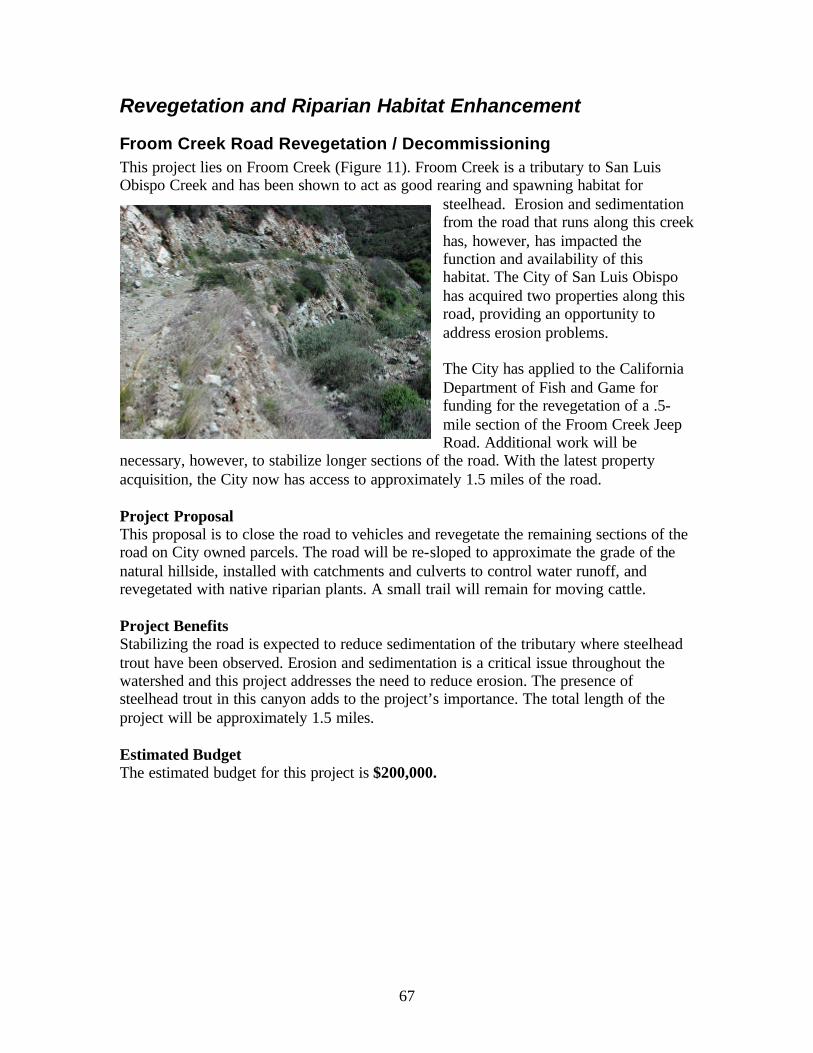
67
Revegetation and Riparian Habitat Enhancement
Froom Creek Road Revegetation / Decommissioning This project lies on Froom Creek (Figure 11). Froom Creek is a tributary to San Luis Obispo Creek and has been shown to act as good rearing and spawning habitat for
steelhead. Erosion and sedimentation from the road that runs along this creek has, however, has impacted the function and availability of this habitat. The City of San Luis Obispo has acquired two properties along this road, providing an opportunity to address erosion problems. The City has applied to the California Department of Fish and Game for funding for the revegetation of a .5-mile section of the Froom Creek Jeep Road. Additional work will be
necessary, however, to stabilize longer sections of the road. With the latest property acquisition, the City now has access to approximately 1.5 miles of the road. Project Proposal This proposal is to close the road to vehicles and revegetate the remaining sections of the road on City owned parcels. The road will be re-sloped to approximate the grade of the natural hillside, installed with catchments and culverts to control water runoff, and revegetated with native riparian plants. A small trail will remain for moving cattle. Project Benefits Stabilizing the road is expected to reduce sedimentation of the tributary where steelhead trout have been observed. Erosion and sedimentation is a critical issue throughout the watershed and this project addresses the need to reduce erosion. The presence of steelhead trout in this canyon adds to the project’s importance. The total length of the project will be approximately 1.5 miles. Estimated Budget The estimated budget for this project is $200,000.

68
Land Conservancy Property / San Luis Obispo Creek The Land Conservancy of San Luis Obispo County purchased the 5 acre Collins property in 2001 (Figure 11). The ownership includes approximately 700 linear feet of San Luis Obispo Creek’s northern bank. Historic land use included cattle grazing and the property is currently used for grazing. The riparian corridor is currently experiencing erosion behind a thick row of willows. The willows divert water against
the unstable banks because there is insufficient vegetation in the riparian buffer area. The site also lacks plant species diversity and canopy trees. Similar conditions exist on the property immediately upstream of the Land Conservancy property. The owner of that property has expressed interest in cooperating on a larger revegetation project and has offered access to an additional 700 linear feet of San Luis Obispo Creek. Restoration Proposal This proposal is for installation of riparian buffer strip vegetation along 1,400 feet of San Luis Obispo Creek. The installed vegetation will consist of native riparian trees and shrubs. The planting area will be a regular corridor 20 feet wide, making the total restoration area 28,000 square feet. Plantings will be maintained for a period of 3 years. Some lower bank areas such as the one pictured above may be graded and / or treated with fiber rolls to increase stability. Land management will play an important roll in the long term stewardship of the property. Appropriate fencing and animal management methods will be included in the project to assure long term success. Project Benefits The new riparian vegetation strip will prevent erosion of the streambanks, reduce sedimentation to the creek, filter sediment from returning floodwaters, increase riparian water storage and percolation, and provide enhanced stream canopy cover. The revegetation is also complimentary to revegetation of 1,200 feet of streambank recently completed on the creek starting 700 feet upstream from this site. San Luis Obispo Creek and it’s riparian corridor has been designated as “Critical Habitat” for southern steelhead

69
trout by the National Marine Fisheries Service. Enhancement of these areas, therefore, meets both local and national goals. Estimated Budget The estimated budget for this project is $55,000
Land Management Practices
Cal Poly Grazing Lands Cal Poly manages livestock grazing activities in the upper Stenner Creek drainage (Figure 10). Rangeland in this area is generally in good condition, but some specific locations are impacted by livestock concentration. When grazing pressure is high, less residual biomass is left on the soil surface and the ground becomes more prone to erosion. In addition, where animals congregate for water, the animals’ density may cause soil compaction and erosion, resulting in sedimentation and reduced groundwater recharge. These situations can be remedied using improved management practices, including fencing and providing alternative watering locations. Restoration Proposal This project would incorporate new fencing designs and a series of off-stream watering facilities on rangeland in the upper Stenner Creek drainage. Improved fencing will section off the range so animals can be moved to successive grazing areas in a rotational grazing system. These management procedures will reduce successive animal unit days on each field and promote faster recovery of grasses necessary for feed and slope stabilization. A managed grazing operation will also lead to less animal unit days along creeks as the animals are moved to fields that are not near streams. These fields also require alternative water sources for the livestock. Several off-stream watering stations will reduce the necessity for animals to be near the stream. Water gaps, sections of the stream designated and fenced to allow limited livestock access may also be included in the management structure. Two important aspects of managed livestock programs are adaptive management and commitment to the methods outlined in the ranch plan. This project will include the preparation of a ranch plan that describes the management and monitoring methods that will be used to adaptively manage grazing operations on this land. The ranch plan will include fence maintenance procedures, livestock density estimates, monitoring procedures, and any other water quality protection methods utilized. Project Benefits Through installation of a rotational grazing system and the resulting range quality improvements, hillsides in the Stenner Creek basin will become more stable and erosion will be reduced. Improved range may also increase water retention on the hillsides, reducing the rate of runoff and contributing to groundwater recharge. Reduction of

70
animal unit time in the riparian corridors will foster improved vegetation conditions and reduced bank erosion along Stenner Creek. These benefits are expected to increase habitat quality for steelhead trout in an important spawning area. The total area that will be improved is approximately 323 acres. The project includes approximately 8.25 miles of fencing and 6 off-creek water supplies to further the establishment of the rotational grazing system. Estimated Budget The estimated budget for this project is $29,000
Brizziolari Creek Culvert Replacement and Drainage Improvements This project addresses an undersized culvert on upper Brizziolari Creek (Figure 10). Undersized culverts represent problems for steelhead trout in the form of increased erosion and sedimentation, and fish passage. The culvert shown below cannot pass
normal high waters and causes regular flooding. Water passing over the road and culvert washes the road out and flushes sediment into the channel. The low capacity and stream alignment also appear to be causing sediment detention upstream of the
structure and filling of the historic stream channel. Sediment accumulation is further limiting the culvert’s flow capacity and preventing fish passage. Restoration Proposal This project will replace the undersized culvert with an oversized culvert at least seven feet in width and three feet deep. The larger culvert will be partially buried so the stream has a natural channel bottom. In addition, the culvert will be placed at a more appropriate angle to prevent sediment accumulation at the inlet. The old channel will be stabilized using native riparian vegetation. Banks along the new alignment will be stabilized with vegetated fiber rolls and erosion control netting. Upstream, additional water bars and rolling dips would be implemented on the road in order to handle runoff before it enters into this problem area. In addition to the culvert replacement, some drainage improvements will be implemented immediately upstream of the culvert location. This work will include the installation of a new drainage swale on the south side of the road. The swale will collect drainage from 2 existing drainages and carry it to Brizziolari Creek downstream of the new culvert.

71
This project action is expected to reduce some flow above the culvert and keep drainage from flowing over the road. The tributaries entering at this site are small drainages not used by steelhead. Upstream, additional water bars and rolling dips would be implemented on the road in order to handle runoff before it enters into this problem area. Approximately 450 ft upstream of the main project area, the bank of one of the larger tributaries to Brizziolari Creek is becoming increasingly unstable and constitutes a sediment source to Brizziolari Creek. This bank will be recontoured and revegetated with native grass species and live willow cuttings. The project area is approximately 120 square feet. Once complete, all project areas will be revegetated with native riparian plants. Project Benefits This project addresses the critical issues related to erosion and sedimentation by reducing sedimentation of a known steelhead stream caused by road flooding and channel bank erosion. Repairing habitats in the upper reaches of Brizziolari Creek is also consistent with efforts to improve fish passage into this subwatershed. The project is also consistent with the general recommendation that small culverts be replaced with span bridges or other natural bottom structures. The project will result in improved riparian vegetation and channel stability in the area surrounding the project. Estimated Budget The estimated budget for this project is $35,000

72
Energy Dissipater for Serano Ranch Culvert
The Serano Ranch is a unit of Cal Poly State University located in the Stenner Creek basin (Figure 10). The ranch lands are used for livestock grading. The ranch lands contain a number of small drainages and unpaved roads. In several locations, roads cross these small drainages through culverts. One of these culverts is resulting in erosion of the gully downstream of the road crossing. The culvert is perched above the elevation of the gully, so runoff falls to the gully
with erosive force. Eroded sediment enters Stenner Creek. Restoration Proposal An energy dissipater is proposed for this location to reduce the erosive force of the drainage water. The dissipater will be made of boulders installed in the gully bottom. Willows will be planted among the rocks and along the gully banks to begin the stabilization process. Estimated Budget The estimated budget for this project is $3,000
Urban and Agricultural Runoff
Stenner Creek Constructed Wetlands As part of their Water Quality Management Plan, Cal Poly has addressed water pollution issues associated with its Dairy Cow facility located alongside Stenner Creek (Figure 10). Cal Poly possesses one of its three Waste Discharge Permits for this area and the runoff from the facility is currently stored in a lagoon located downhill. The storage capacity of the lagoon is limited, however, and water is periodically released via spray irrigation on nearby pasturelands where vegetation can metabolize nutrients. The pastures, much like the lagoon, have a limited absorption capacity and any excess water is lost to run-off. The solution may lie in development of a secondary wetland treatment pond that cleans excess water enough to either reuse in other agricultural capacities beyond irrigated pasture, or possibly release it into Stenner Creek.

73
Restoration Proposal The proposed project will install a constructed wetland to collect dairy unit wastewater and treat it for nutrients and sediment. Wetland plants will metabolize nutrients in the water and dense vegetation will filter out suspended sediments. The focus of the project is to abate point source pollution from the Cal Poly dairy unit lagoons, which includes storm water runoff. Another goal is for the project to serve as a demonstration project addressing the challenges of wastewater management practices for a production dairy at Cal Poly.
The artificial wetland would be located in a two-acre rectangular parcel. The site was identified from soil analysis of the areas adjacent to the dairy. The wetland will be contained by a redundant confinement system: both a clay and plastic liner (if adequate funding is available). The wetland design consists of a clay liner (12-18 inches thick) and berms approximately 6 feet high, which will be lined with a HD polyethylene plastic liner. To assure there is no leakage from the wetland, piezometers will underlay the clay liner and read to record any
change in pressure. The flow through the wetland system will be between 30,000 and 60,000 g/d, depending on the nitrogen content, with temporary storm water storage of approximately 2-3 acre-feet. During the dry season the processed water can be stored for recycling, and used as needed to keep the open lagoon (existing) at its maximum functioning capacity. During the wet season, this water can be released through spray irrigation. The open water lagoon (existing) will be managed to address the storm water issues during January and February. It will contain approximately 3 acre-feet of dead storage to reduce and eliminate odors, 8.5 acre-feet of available wastewater for recycling flush water, 5.8 acre-feet for stormwater runoff, and 4.1 acre-feet of emergency free board storage. It is anticipated that there will be approximately 12 acre-feet of storage with the emergency wetland storage. The 3 acre-feet of dead storage can be recovered by pumping the organic sediment out of the lagoon prior to the rainy season and removing it for compost. Project Benefits Specifically, the wetland project will address sediment and nutrient loading, groundwater recharge, reuse of treated water, establishment of wildlife habitat, enhancement of visual quality, and provide a research and technology transfer laboratory for the university and agricultural community. The project addresses the summary recommendations for

74
projects that reduce nutrients and dissolved oxygen depletion in the middle Stenner Creek subwatershed. Estimated Budget The total project costs to complete the construction of the artificial wetland is $68,600.
Storm Drain Stenciling for Downtown San Luis Obispo Storm drains have been stenciled throughout the San Luis Obispo urban area to inform citizens that they drain directly to local creeks. However, the drains in the central downtown district have not been stenciled. The downtown area has a number of businesses that use potentially harmful cleaning and industrial compounds that can impact the creeks when not disposed of properly. Marking the storm drains in this area will help educate downtown businesses and the users of downtown about the potential impacts of dumping on the local environment. Stencils in this area should be designed to be consistent with the aesthetic theme of the downtown area rather than painted with spray paint. Restoration Proposal This project requires the purchase of up to 250 decorative tiles or other drain marking materials to deliver the message that storm drains discharge directly to streams without the benefit of treatment. The design will be chosen in cooperation with the City of San Luis Obispo and the Downtown Association. The installation of the markings will be accompanied by an educational campaign to local businesses on the proper disposal of cleaning materials and other potentially harmful compounds. Project Benefits The project has the potential to reduce the level of dumping of cleaning solutions and toxic compounds into the creeks in the urban areas. In addition, the high visibility of these markings in the downtown area will educate a broader cross-section of the community on the issue of storm runoff. This project is also consistent with the National Pollution Discharge Elimination System (NPDES) programs. Estimated Budget The estimated budget for this project is $7,500.

75
Instream Habitat Creation / Modification
Marre Weir Fish Passage The Marre Weir, located at the San Luis Obispo Creek Estuary (Figure 11), is a metal sheet pile structure that spans the width of San Luis Obispo Creek. The purpose of the weir is to prevent saltwater incursion into the groundwater upstream. This groundwater is a principle water source for the adjacent housing development. However, the structure also presents a migration barrier to steelhead trout during certain flows. The weir is approximately 30 years old and was retrofitted with a set of fish ladders in the 1980’s. The success of the ladders has not been evaluated, but maintenance has been identified as an important issue. The principal maintenance problem is the accumulation of debris during high flows that clogs the structure. An additional problem related to the fish ladder is it’s placement off to the side. It is possible that fish are not being attracted to the fish ladder because they are more attracted to the water coming out of an existing low point in the center of the weir. At low tide, the water level downstream drops and the downstream pool gets shallower. This reduces the ability of migrating steelhead to develop the launch speed necessary to leap the structure. Steelhead trout are known to congregate in this downstream area while awaiting appropriate flows or very high tides. The San Luis Obispo Creek Restoration Plan, 1988, also mentions the weir being a barrier to prickly sculpin migration. The sculpin are a known predator on young crayfish and it is believed that impacts to the sculpin population may have resulted in crayfish proliferation and subsequent increase in predation of red- legged frog eggs. Restoration Proposal A feasibility study of fish migration improvement strategies is underway and expected to be complete early in 2002. This proposal is to implement the preferred alternative for

76
passing steelhead trout. Options include step weirs, cutting a low-flow notch, and possibly replacing the structure with a more fish friendly structure. Project Benefits Replacement or modification of the weir would allow unrestricted migration access for steelhead trout. It would prevent fish from accumulating at the base of the weir where they are vulnerable to poaching and predation. Free migration access is critical to the long term enhancement of fish populations. Providing free access at this location is also complimentary of over 10 other migration access improvement projects in the San Luis Obispo Creek Watershed. Estimated Budget The estimated budget for this project is unknown until the completion of the alternatives study. To date, $117,000 has been raised and restricted for work on the final alternative. If the chosen project is more costly, then additional funds will be necessary.
Upper San Luis Obispo Creek Fish Passage at Highway 101 This project is located in San Luis Obispo Creek downstream of the Highway 101 culvert in Cuesta Canyon (Figure 10). Upper San Luis Obispo Creek is important for steelhead as a spawning and rearing area. Several projects have been recently undertaken in the upper watershed to improve fish passage to spawning habitat. In 2000, Caltrans installed baffles inside of the culvert that crosses under the freeway. In 2001, follow-up work was completed on the culvert’s apron. One final project is necessary downstream of the culvert apron to assist fish in clearing a three foot drop. Restoration Proposal Caltrans is proposing to install a single boulder weir downstream of the apron to increase the stream elevation and reduce jump height. Modification of an existing bedrock feature will also help establish an appropriate migration pathway for fish. …plans…Once fish can access the culvert apron, previously installed passage aids will guide fish to upstream habitats. Project Benefits Steelhead trout have been observed in the project area trying to migrate upstream. Facilitating access at this location will provide access to additional spawning grounds. This project is also complimentary of work Caltrans has already implemented in the culvert and on the apron. In addition, the Land Conservancy of San Luis Obispo County and the Avila Beach Trustee Council Agencies completed fish passage improvements at the next culvert upstream at Stagecoach Rd. Finally, the City of San Luis Obispo has acquired funding to provide fish passage at an abandoned dam just upstream from
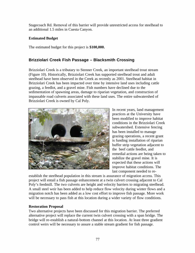
77
Stagecoach Rd. Removal of this barrier will provide unrestricted access for steelhead to an additional 1.5 miles in Cuesta Canyon. Estimated Budget The estimated budget for this project is $100,000.
Brizziolari Creek Fish Passage – Blacksmith Crossing Brizziolari Creek is a tributary to Stenner Creek, an important steelhead trout stream (Figure 10). Historically, Brizziolari Creek has supported steelhead trout and adult steelhead have been observed in the Creek as recently as 2001. Steelhead habitat in Brizziolari Creek has been impacted over time by intensive land uses including cattle grazing, a feedlot, and a gravel mine. Fish numbers have declined due to the sedimentation of spawning areas, damage to riparian vegetation, and construction of impassable road culverts associated with these land uses. The entire subwatershed of Brizziolari Creek is owned by Cal Poly.
In recent years, land management practices at the University have been modified to improve habitat conditions in the Brizziolari Creek subwatershed. Extensive fencing has been installed to manage grazing operations, a recent grant is funding installation of riparian buffer strip vegetation adjacent to the beef cattle feedlot, and remedial actions are being taken to stabilize the gravel mine. It is expected that these actions will improve habitat conditions. The last component needed to re-
establish the steelhead population in this stream is assurance of migration access. This project will entail a fish passage enhancement at a twin culvert crossing adjacent to Cal Poly’s feedmill. The two culverts are height and velocity barriers to migrating steelhead. A small steel weir has been added to help reduce flow velocity during winter flows and a migration notch has been added as a low cost effort to improve fish passage. More work will be necessary to pass fish at this location during a wider variety of flow conditions. Restoration Proposal Two alternative projects have been discussed for this migration barrier. The preferred alternative project will replace the current twin culvert crossing with a span bridge. The bridge will re-establish a natural-bottom channel at this location. At least three gradient control weirs will be necessary to assure a stable stream gradient for fish passage.

78
The second alternative is installation of a boulder weir downstream of the culverts to deepen the pool at the culvert outlet, thus reducing the jump height into the culvert and increasing the launch depth for steelhead trout. The weir will be designed with a low flow notch as well and allow passage into the new pool. In addition to the weir, the steel backwatering device will be fitted with a rounded pipe cover to reduce the possibility of injury to both out-migrant and spawning fish. The second alternative is less expensive, but would not provide the high level of passage that would be achieved through the preferred alternative. Project Benefits This project will provide improved access to approximately 1.5 miles of additional steelhead trout habitat. Habitat conditions in the target area are also expected to improve in the future as well. The project is consistent with the regional goal of removing or modifying all access impediments for steelhead trout. The project is also complimentary of the 10 migration barrier modifications funded by the Avila Beach Trustee Council, and an additional migration improvement project being undertaken by the City of San Luis Obispo. Project Budget The estimated budget for the preferred alternative is $75,000 The estimated budget for the second alternative project is $10,000
Johnson Ranch Fish Passage Improvements Project This project is located where Ayers Creek passes under Highway 101 (Figure 11). The
purpose of the Johnson Ranch Fish Passage Improvements Project is to enhance the ability of native fish, particularly southern steelhead, to access the upper reaches of an un-named tributary to San Luis Obispo Creek informally known as Ayers Creek. The upper reaches of the watershed appear to offer good to excellent spawning and rearing habitat, and are only marginally accessible due to the nature of the culverts carrying the flow of Ayers Creek under Highway 101 and adjacent roadways, and the effects of many years of livestock grazing adjacent to and within the lower waterway.

79
The culverts in question run under Ontario Road, Highway 101, and Clover Ridge Road which is adjacent to Highway 101 in this area. The lands on which the roads occur are either County- or State- owned and maintained. It is expected that there would be no issues of ownership, nor any changes in ownership once the project is constructed. Restoration Proposal The project will involve improving migration access at five locations by installing “step pools” and Washington baffles within the crossings or immediately downstream of them. In addition to the fish passage work, approximately 5,000 feet of fencing will be installed to exclude cattle from the riparian corridor immediately upstream of the access work. Project Benefits It is anticipated that the project will make a reach of approximately two miles of the unnamed creek crossing the Johnson Ranch accessible to migrating steelhead, as well as to other native fish species. Fencing of the nearby riparian corridor will help vegetation re-establish on the lower portion of the site and improve habitat values in the newly accessible areas. Estimated Budget The estimated total cost of the project is $125,000
Land Acquisition Land acquisition projects have the potential to preserve high quality habitat areas in perpetuity. Through fee ownership or conservation easements held by a public agency or conservation organization, these lands can also be managed for long-term steelhead habitat health. Land conservation can also be economical, as preservation of high quality habitat areas is usually less expensive than creating the same habitats. Several property owners in the San Luis Obispo Creek Watershed have expressed interest in selling land, or currently have it listed for sale. The two projects described below each contain extensive reaches of the mainstem of San Luis Obispo Creek, and offer excellent enhancement opportunities that directly address critical issues described in this plan.

80
Lower San Luis Obispo Creek Floodplain Properties #1 This opportunity consists of two properties that encompass the flood plain of lower San Luis Obispo Creek from an area called the “Narrows” to San Luis Bay Drive. Both parcels contain the mainstem and floodplain of San Luis Obispo Creek. The properties are owned by the same owner and the preferred project is to pursue conservation on both parcels together. The first property is a 45-acre parcel currently used as an apple orchard. This parcel would best be protected through the purchase of a conservation easement. The Land Conservancy of San Luis Obispo County currently holds a conservation easement along the riparian corridor on the west bank of the stream between San Luis Bay Drive and the existing wood bridge upstream. This easement was secured to protect a riparian restoration project. A larger opportunity still exists however to protect the entire floodplain on this property. In addition, the floodplain easement would provide access for extended revegetation efforts, and more importantly on this site, exotic plant species management. Throughout this property, exotic cape ivy and Giant reed are proliferating. While under control in the revegetation area, throughout the rest of the site they compromise the health of an otherwise improving habitat area. The second property consists of 30 acres directly upstream of the apple orchard in the location known as the Narrows. This parcel is valuable as flood plain and also acts as a confluence area of several diverse ecosystems. The parcel functions as high quality wildlife habitat and has been suggested as a site for a nature park. The riparian habitat on this property is among the best quality habitat between the City of San Luis Obispo and the Highway 101 bridge, as mentioned in Cleveland’s 1995 Steelhead Trout Habitat Inventory. The high quality habitat, however, is facing degradation due to expanding populations of exotic plants. Notably, cape ivy and Giant reed are establishing on the site, so access is critical for managing this invasion and protecting the habitat. The second parcel is also along the route of the proposed City-to-Sea Greenway and Recreation Trail. For this purpose, this parcel would best be protected through the purchase of fee title. Acquisition is important in this area to prevent land use changes that would compromise the valuable habitat quality and recreational access.

81
Project Benefits Protection of these two properties will support efforts to preserve and restore the natural and scenic character of the lower San Luis Obispo Creek riparian corridor. In
combination with the Land Conservancy’s recent purchase of the 5-acre Collins Property and the acquisition of other conservation easements over the years, the protection of these properties will secure habitat for steelhead trout as well as the endangered California red- legged frog and the western pond turtle. The protection of these properties also assures site locations for future projects to restore the area’s formerly diverse riparian forest.
Protection of these two properties is in keeping with the recommendations provided by the County of San Luis Obispo’s Phase II Waterways Plan. The plan seeks to preserve floodplain that slows and holds floodwater as well as prevent construction that elevates and paves ground within the riparian corridor. The protection of these two properties is also consistent with the recommendations provided by the Coastal Watershed Conservation Plan for the Irish Hills (The Nature Conservancy, 2001). The plan listed the lower San Luis Obispo Creek riparian corridor as one of the four priority areas for land acquisition and protection within the Irish Hills. Finally, these two properties are within the scenic corridor of Highway 101, south of San Luis Obispo. This scenic corridor acts as the gateway and greenbelt to the City and the City has made protection of these values an explicit priority by recently purchasing several properties on the southern outskirts alongside Highway 101. Protection of these two properties would therefore be consistent with the City’s greenbelt program. Also, the City, County of San Luis Obispo and Land Conservancy are engaged in a long-term effort to establish a City-to-Sea Greenway, including a multi-use recreation trail that begins in the City of San Luis Obispo and leads to the ocean at Avila Beach. The proposed path of this trail leads through both of the described properties. Protection of these properties would assure the trail of appropriate land on which to be constructed. Protecting high quality habitats and providing access for restoration and exotic weed management address the summary recommendations for riparian vegetation, streambanks stability and water quality. Protecting floodplains from additional development supports recommendations in the County’s Phase II Waterways Management Plan as a way to protect downstream owners from increased flooding and downstream habitats from

82
floodwater velocities. The project is adjacent to currently held easements and is proximate to land recently purchased by the City of San Luis Obispo (Johnson Ranch), City-owned land at the Filipponi Ecological Area, and Land Conservancy five-acre property immediately downstream. Estimated Project Budget Acquisition costs will be based on appraisals. The parcel recommended for fee acquisition is listed for $710,000. A “before and after” appraisal will be used to determine the value of the easement on the other parcel. The estimated value of the easement parcel is $770,000.
Upper San Luis Obispo Creek and Headwaters The City of San Luis Obispo has identified the Ahearn Ranch as an important land acquisition opportunity in the upper San Luis Obispo Creek drainage (Figure 10). The 700-acre property is bisected by Highway 101 as the highway cuts from the Cuesta Summit to the upper end of the San Luis Valley. The ranch spans one mile from its northern to southern boundary, includes approximately 1.1 miles of the mainstem of San Luis Obispo Creek and includes most of the drainage basins of Hansen and Gularte Creeks, headwater tributaries of San Luis Obispo Creek. The landowner has approached the City of San Luis Obispo regarding the possibility of a sale. Project Benefits The acquisition of the Ahearn Ranch would ensure the protection of high quality steelhead spawning habitat. The stream is generally in good shape, but there are several opportunities for bank stabilization work. While the spawning habitat value is high in this area, there are few pools for rearing of young steelhead. Purchase of this property would provide the opportunity to improve the pool habitats. Preservation of this upper watershed area is also consistent with three fish passage improvement projects, one planned and two complete, that will open this area for fish migration and spawning. Once protected, the Ahearn Ranch affords opportunities for stream enhancement projects such as a series of pond and wetland structures to prevent eroded sediment and contaminants carried by runoff from Highway 101 from reaching the creek. This acquisition will also provide an opportunity for projects that diversify steelhead trout habitats in upper San Luis Obispo Creek.

83
In addition to this project’s potential benefit to steelhead, the acquisition of the property offers habitat protection for a number of rare local species including, the California red-legged frog, the southwestern pond turtle, the Central Coast newt, golden eagles, and an occasional California condor. The Ahearn Ranch also possesses great scenic and recreational values. The ranch lies within the scenic corridor of Highway 101 and is adjacent to the Los Padres National Forest. A large culvert on the property that currently facilitates the passage of livestock under the highway can also accommodate pedestrian and equestrian traffic, thus serving as the long sought after recreational connection between the western and eastern sides of the freeway. Portions of the early Cuesta Grade roadway (circa 1920s) often seen in historic photographs of the area are still intact and can be incorporated into future recreational trail systems. Finally, a county road (Stagecoach Road) which runs through the property from the bottom of Cuesta Canyon to the top the Cuesta Grade is the adopted route of the Juan Bautista DeAnza National Historic Trail. This project of the National Park Service and numerous regional and local organizations seeks to preserve the rural and scenic character of the trail surroundings. Estimated Budget The acquisition costs would be based on a current appraisal at the time of offering. The property is not currently listed, but it’s value is estimated at $ 2.75 Million.
Lower San Luis Obispo Creek Floodplain Properties #2 This proposal is for the purchase of a conservation easement over floodplain lands along lower San Luis Obispo Creek. The project would permanently preserve approximately 20 acres of floodplain, including both banks of San Luis Obispo Creek. The Creek and floodplain are designated as “Critical Habitat” for southern steelhead trout by the National Marine Fisheries Service. The project would also be consistent with several other projects and proposals intended to form a lower San Luis Obispo Creek Conservation Area.
Estimated Project Budget Acquisition costs will be based on appraisals. A “before and after” appraisal will be used to determine the value of the easement.
Figure 12. Project Site and Proposed Lower San Luis Obispo Creek Conservation Area Components

84
Technical Studies
Unpaved Roads Assessment at Cal Poly
The California Polytechnic State University (Cal Poly) controls most of the upper Stenner Creek and Brizziolari Creek drainages. Much of this land is used for livestock grazing. Access to these areas is via unpaved roads. There are approximately 7 miles of unpaved roads in this area, and visual inspection in the winter shows that some of these roads are experiencing severe erosion. These roads may be large source of sediment to both Stenner and Brizziolari Creeks. The extent of their contribution is, however, unmeasured at this time.
Study Proposal A roads inventory and assessment is recommended in this area to identify problem areas and recommend erosion control methods. The study will include a risk assessment of past and future sediment contribution and a priority ranking of roads to be improved. A road erosion inventory/assessment will provide for continued implementation of Best Management Practices (BMPs). These practices will incorporate water quality improvements into routine improvements or enhancements. Estimated Budget The estimated budget for this project is $20,000
Watershed-Wide Steelhead Trout Census A great effort has been made throughout the San Luis Obispo Creek Watershed to enhance habitat for steelhead trout with the expectation of increasing steelhead numbers. However, no recent baseline data is available from which to measure increases in steelhead populations. This information is necessary for long term effectiveness monitoring of habitat enhancement projects. Study Proposal The study would survey the entire mainstem of San Luis Obispo Creek, it’s main tributaries, and any other drainages within which enhancement activities are underway. The study will center on the presence and abundance of southern steelhead trout, determining the upstream extent of steelhead and estimating abundance in the study drainages. Estimated Budget The estimated budget for this study is $20,000.
Follow-up studies on Bacteria Pathogens, in the form of fecal coliform bacteria, have been detected in several locations in the San Luis Obispo Creek Watershed. Follow-up studies have been conducted by the

85
Land Conservancy of San Luis Obispo County, Regional Water Quality Control Board and County Environmental Health Department. Each of the studies showed continued problems, particularly in the San Luis Obispo Mission Plaza. Due to the high fecal coliform levels, warning signs have been placed at the Mission Plaza to inform the public. Study Proposal Until this problem is researched in enough detail to produce and explanation and potential improvement project, ongoing monitoring in needed. This project suggests sampling six sites two times each year to track the bacteria problem. A three year period is proposed. If fecal coliform levels consistently test within state standards during this study period, warning signs should be removed. Estimated Budget The estimated budget for this study is $3,000
Water Quality Pesticide Study Much of the San Luis Obispo Creek Watershed is located adjacent to agricultural operations. Many of the row crop operations use pesticides to control insect predation on their crops. The affect of these chemical applications in areas immediately adjacent to the creeks has never been extensively studied. Possible over-application or misapplication has the ability to severely impact riparian ecosystems by either contaminating runoff and creek water or by killing the specific insect populations on which steelhead trout feed. Study Proposal ECOSLO has been a lead organization in addressing the intersection of issues relating to local agriculture and the environment. As a partner in the Central Coast Environmental Health Project, ECOSLO is currently exploring funding options to enable pesticide studies of both Arroyo Grande and Los Osos Creek. It is recommended that ECOSLO conduct a one-time water quality study of certain portions of the San Luis Obispo Creek Watershed. A pesticide study such as this will be useful in determining and addressing the impact of agricultural chemicals on water quality. Any study of pesticide in creek waters should be coordinated with the Regional Water Quality Control Board to assure the use of standard methods and reporting requirements. Estimated Budget The estimated budget for this project is $3,000.

86
V. PROJECT FUNDING SOURCES Funding sources for the projects listed in this plan will vary over time. Table 7 describes a variety funding options at the time of this plan, but the list is not comprehensive. Table 7. Grant Funding Opportunities.
Grant Program Description USEPA 319(h) Program Implementation grants for non-point source water quality improvements.
They originate from the Clean Water Act and are administered by the USEPA. More information is available at: http://www.swrcb.ca.gov/nps/grants.html
USEPA 205(j) Program These grants also originate from the Clean Water Act, and are used for planning purposes for non-point source pollution reduction. More information is available at: http://www.swrcb.ca.gov/nps/grants.html
CDFG - SB 271 Enactment of SB 271 created the Salmon and Steelhead Trout Restoration Account This legislation, which took effect in 1997, can provide $8 million annually through fiscal year 2002/2003 for salmon and steelhead restoration in coastal drainages.
RWQCB - Proposition 13 Watershed Protection Program - $10 Million Nonpoint Source Pollution Control Program - $22 Million. Coastal Nonpoint Source Control Program
In March 2000, California voters approved Proposition 13 (2000 Water Bond), which authorizes the State of California to sell $1.97 billion in general obligation bonds to support safe drinking, water quality, flood protection and water reliability projects throughout the state. The State Water Resources Control Board (SWRCB) will help allocate $763.9 million of these funds to local projects throughout California. More information is available at: http://www.swrcb.ca.gov/nps/grants.html
California Coastal Conservancy – Salmonid Recovery Program (Proposition 12)
The Coastal Conservancy has $15 Million to allocate from this program. $7.5 Million / year over two remaining years. There is not a formal grant process, however. Contact the Coastal Conservancy for information. Tim Duff – (510) 286-3826 1330 Broadway, 11th Floor Oakland, CA 94612
State Department of Water Resources
The California Department of Water Resources has a variety of grants and loans available to address water use efficiency, water conservation, and groundwater management purposes through the Safe Drinking Water, Clean Water, Watershed Protection, and Flood Protection Bond Act (Proposition 13). For a complete listing of all program details see http://wwwdwr.water.ca.gov/grants-loans/default.html,email [email protected] or call 916/327-1663.
USDA-Natural Resources Conservation Service Wildlife Habitat Incentives Program (WHIP).
WHIP supports voluntary project on privately owned land. Through this program, grantees may receive technical assistance from the NRCS and up to 75% of the project implementation funding.

87
National Fish and Wildlife Foundation • 5-Star Restoration
Challenge Grants • Pacific Grassroots
Salmon Initiative
The National Fish and Wildlife Foundation has several relevant granting programs for steelhead trout habitat enhancement and protection. See http://www.nfwf.org for more information.
The North American Wetland Conservation Act
Standard grants program available to private and public organizations, as well as individuals who have developed partnerships to implement wetlands restoration, enhancement, and conservation work. The grants require a minimum 1:1 non-federal match. For a complete description of the program and application instructions visit the website above or email [email protected] or call 703/358-1784. Grant proposals are due March 1 and July 26, 2002.
American Rivers, in partnership with the National Oceanic and Atmospheric Administration (NOAA),
Community-Based Restoration Program. These grants are designed to provide support for local communities that are utilizing dam removal or fish passage to restore and protect the ecological integrity of their rivers and improve freshwater habitats important to migratory (anadromous) fish. Applicants are encouraged to contact American Rivers to discuss potential projects prior to submitting an application. For a complete application and eligibility guidelines visit the website above or email [email protected] or call 202/347-7550, ext.3006. Applications deadlines are December 1 and April 1, 2002.
The U.S. Fish and Wildlife Service
Partners for Fish and Wildlife (PFW) Contact the Ventura Field Office at: 2493 Portola Rd., Suite B Ventura, CA 93003

88
APPENDIX A List of Steering Committee Members and Project Ranking Criteria

89
SAN LUIS OBISPO CREEK WATERSHED ENHANCEMENT PLAN
Steering Committee (SC) Bruce Bonifas California Conservation Corps Kim Busby California Polytechnic University, SLO – Coastal Resources Institute
Brian Dietterick California Polytechnic University, SLO Julia Dyer Regional Water Quality Control Board Tim Duff California Coastal Conservancy Joy Fitzhugh San Luis Obispo County Farm Bureau Neil Havlik City of San Luis Obispo Dave Highland California Department of Fish and Game Royce Larson University of California Cooperative Extension – Farm Advisor Susan Litteral San Luis Obispo County Engineering Department Malcolm McEwen Natural Resources Conservation Service Connie O'Henley Central Coast Salmon Enhancement, Inc. Margaret Roper California Department of Fish and Game Chris Rose Regional Water Quality Control Board Contributing Authors Brian Stark Land Conservancy of San Luis Obispo County Brett Wilkison Land Conservancy of San Luis Obispo County

90
Project Evaluation Criteria for the San Luis Obispo Creek Watershed Enhancement Plan
Criterion are weighted equally and therefore not listed in any specific order. 1. Benefits and Costs:
Under this criterion, expected project benefits should be evaluated in comparison with the expected project costs. Proposed projects that are the least costly way to provide a particular type and amount of benefit will be most favored.
2. Multiple types of benefits:
This criterion considers the extent to which a proposed project will have more than one type of benefit (i.e. steelhead trout and red- legged frog protection.) Project benefits should be measured in terms of the quality and amount of benefit. Originally, multiple benefits such as recreation were listed in the criteria. In discussing this aspect, we chose only to consider environmental benefits.
3. Long-lasting benefits:
The ability to protect and ensure project benefits over a long term should also be considered. In measuring the long lasting benefits of a proposed project, the steering committee should consider both the type of benefit and the anticipated quality of its implementation. For example, under this criterion a public pier built using concrete pilings with access via land owned by a public agency would be preferable to a pier built with wood pilings with access via land leased to a public agency.
4. Likelihood of Success:
This criterion considers factors affecting the likely success of a project. Projects that have less risk or uncertainty (i.e. political, technical) are preferred under this criterion. The steering committee should also consider the ability to monitor and evaluate any proposed project’s success as well as the ability to correct problems that arise during implementation and the qualifications of companies or individuals expected to implement the project.
5. Technical Feasibility:
This criterion takes into account the ability to ensure that a project is technically sound. Projects should be evaluated based on their level of uncertainty or on the risk involved in implementation. Also, under this criterion, the track records of the organizations and agencies implementing similar projects should be considered.

91
6. Meeting needs for critical issues: This criterion measures the degree to which a proposed project is consistent with and addresses the identified critical issues and restoration needs of the watershed. As the restoration needs have not been ranked in terms of priority in the enhancement plan, this criterion must consider the extent to which a proposed project fully resolves the need or needs within its scope. Also under this criterion, a proposed project should be measured in terms of its integration and cooperation with other projects addressing the same or similar critical issues.

92
APPENDIX B Landowner Contact Letter

93
SAMPLE Name Address City, State, Zip Dear Landowner, The Land Conservancy has been working for over five years to restore habitat for steelhead trout in the San Luis Obispo Creek Watershed. During this time we have replanted over three miles of stream banks on privately owned property, removed non-native weeds, and removed several barriers to trout migration. As we continue our efforts to enhance trout populations in San Luis Obispo's creeks, we are looking for places to implement new projects. As a landowner in the watershed, you have the greatest day-to-day knowledge of the creeks, their problems, and the various ways we might go about improving them. We are interested in meeting with you to discuss the conditions of your creek and any ideas for enhancement projects that you may have. Specifically, we are looking for projects that address stream bank erosion, nutrient pollution, weed management, and in-stream habitat enhancement. This is a voluntary program. New project ideas will be described in a Watershed Enhancement Plan that will be circulated to public agencies for funding. The goal of this plan is to increase funding for steelhead habitat enhancement in the San Luis Obispo area. We hope you will join us in this effort. If you have an interest in creek restoration or an idea in mind about the enhancement of steelhead habitat on your property please contact us soon so that we can incorporate it into this Enhancement Plan. If you have questions about the plan, implementation strategies, or any other stream-related issues please feel free to contact Brian Stark at our office at any time. We look forward to hearing back from you. Sincerely, Ray Belknap Executive Director P.S. If this letter has reached you in error and you are not a landowner on a creek within the San Luis Obispo Watershed, we apologize for our mistake. Landowners with creek property are identified via a map and database system and the process can sometimes be tricky.