San Gabriel Mountains National Monument FAQs
5
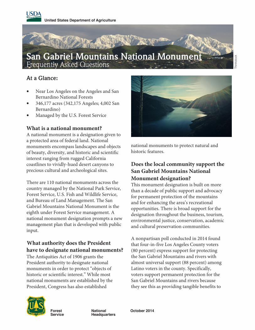
United States Department of Agriculture Forest Service National Headquarters October 2014 San Gabriel Mountains National Monument Frequently Asked Questions At a Glance: • Near Los Angeles on the Angeles and San Bernardino National Forests • 346,177 acres (342,175 Angeles; 4,002 San Bernardino) • Managed by the U.S. Forest Service What is a national monument? A national monument is a designation given to a protected area of federal land. National monuments encompass landscapes and objects of beauty, diversity, and historic and scientific interest ranging from rugged California coastlines to vividly-hued desert canyons to precious cultural and archeological sites. There are 110 national monuments across the country managed by the National Park Service, Forest Service, U.S. Fish and Wildlife Service, and Bureau of Land Management. The San Gabriel Mountains National Monument is the eighth under Forest Service management. A national monument designation prompts a new management plan that is developed with public input. What authority does the President have to designate national monuments? The Antiquities Act of 1906 grants the President authority to designate national monuments in order to protect “objects of historic or scientific interest.” While most national monuments are established by the President, Congress has also established national monuments to protect natural and historic features. Does the local community support the San Gabriel Mountains National Monument designation? This monument designation is built on more than a decade of public support and advocacy for permanent protection of the mountains and for enhancing the area’s recreational opportunities. There is broad support for the designation throughout the business, tourism, environmental justice, conservation, academic and cultural preservation communities. A nonpartisan poll conducted in 2014 found that four-in-five Los Angeles County voters (80 percent) express support for protecting the San Gabriel Mountains and rivers with almost universal support (88 percent) among Latino voters in the county. Specifically, voters support permanent protection for the San Gabriel Mountains and rivers because they see this as providing tangible benefits to Thinkstock
Transcript of San Gabriel Mountains National Monument FAQs
United States Department of Agriculture
Forest Service
National Headquarters
October 2014
San Gabriel Mountains National MonumentFrequently Asked Questions
At a Glance:
• Near Los Angeles on the Angeles and SanBernardino National Forests
• 346,177 acres (342,175 Angeles; 4,002 SanBernardino)
• Managed by the U.S. Forest Service
What is a national monument?A national monument is a designation given to a protected area of federal land. National monuments encompass landscapes and objects of beauty, diversity, and historic and scientific interest ranging from rugged California coastlines to vividly-hued desert canyons to precious cultural and archeological sites.
There are 110 national monuments across the country managed by the National Park Service, Forest Service, U.S. Fish and Wildlife Service, and Bureau of Land Management. The San Gabriel Mountains National Monument is the eighth under Forest Service management. A national monument designation prompts a new management plan that is developed with public input.
What authority does the Presidenthave to designate national monuments?The Antiquities Act of 1906 grants the President authority to designate national monuments in order to protect “objects of historic or scientific interest.” While most national monuments are established by the President, Congress has also established
national monuments to protect natural and historic features.
Does the local community support the San Gabriel Mountains National Monument designation? This monument designation is built on more than a decade of public support and advocacy for permanent protection of the mountains and for enhancing the area’s recreational opportunities. There is broad support for the designation throughout the business, tourism, environmental justice, conservation, academic and cultural preservation communities.
A nonpartisan poll conducted in 2014 found that four-in-five Los Angeles County voters (80 percent) express support for protecting the San Gabriel Mountains and rivers with almost universal support (88 percent) among Latino voters in the county. Specifically, voters support permanent protection for the San Gabriel Mountains and rivers because they see this as providing tangible benefits to
Thin
ksto
ck

the community, with particular importance on clean water, clean air, wildlife habitat, and ensuring there are accessible public lands protected from development for children to play and experience nature. (Source: http://tinyurl.com/kxz2v4f)
Over the past decade, elected officials have initiated and Congress has approved two studies of the area to assess the way the open space should be protected and managed in the future and to determine how to achieve additional recognition, resources and special designation to enhance recreational opportunities for the area.
Why does the San Gabriel Mountains area warrant designation as a national monument?Designation as a national monument recognizes the area’s important geological, ecological, historic, scientific and recreational resources.
The monument’s history is rich. In addition to important Native American and European sites and features, this monument has an equally impressive array of 20th and 21st century scientific and cultural achievements. There are more than 600 archeological sites within the monument. Notably, two Native American rock art sites are listed on the National Register of Historic Places.
Beginning in the late 1800s, recreation became popular in the area, which has since served as a natural “back lot” to many Hollywood productions.
The monument area also has a strong scientific history. Mount Wilson Observatory is internationally known as the place where notable scientists such as Edwin Hubble and Albert Einstein conducted research or visited. Established in 1933, the San Dimas Experimental Forest is the only such forest in southern California and has a long history as a research site in the fields of hydrology and ecology.
The rivers of the San Gabriel Mountains National Monument not only provide drinking water, but
are also areas of high ecological significance, supporting rare populations of native fish, animals and plants. The monument is also home to iconic species including the California condor, California spotted owl, Nelson’s bighorn sheep and 1,000-year-old limber pines.
Vegetation communities, including chaparral and oak woodland, represent a portion of the rare Mediterranean ecosystem found in only 3 percent of the world. The monument also provides suitable habitat for 52 Forest Service Sensitive Plants and as many as 300 California-endemic species, including Pierson’s lupine and San Gabriel bedstraw, that grow only in the San Gabriel range.
In addition to the enormous wildland and watershed conservation values, a major benefit of creating a national monument will be to vastly enhance recreational access and interpretative and environmental education for millions of visitors.
The San Gabriel Mountains area, specifically the Angeles National Forest, provides more than 70 percent of the open space and nearly one-third of the drinking water for Los Angeles County.
Will the Forest Service manage the monument? Yes. The agency will capitalize on the opportunity to further protect the resources and engage in watershed conservation while creating new and innovative ways to reconnect one of the largest U.S. urban area to the great outdoors. As always, the

Forest Service is interested in moving forward on proposed land use initiatives with the feedback and support of the nearby communities.
What information was considered in setting the boundaries of the monument?The boundary decision is based upon the desire to highlight the area for visitation, protection, and management. The various uses permitted in the monument as well as the monument’s boundary, modified from legislative proposals for the area, reflect extensive input from the public and what is necessary to protect the area’s historical sites and ecological values.
Will a monument designation bring additional resources to the area?If previous monument designations are an indication, this monument designation is expected to bring additional resources to the area. Already, more than 4 million annual visits are made on the Angeles National Forest. That number is expected to increase with the designation of a national monument. One study, released in 2014 by an economics firm, suggests that local economies benefit from national monuments. Among the findings is that “protecting public lands can assist western communities working to promote a more robust economic future” under several factors, including jobs, income, property values and recreation.
Based on 2012 data, the Forest Service estimates that the Angeles National Forest, with the monument overlaying about half of the forest, contributes 597 full- and part-time jobs and more than $39 million to the local economy.
The Forest Service has also begun initial investment to improve visitor experiences in the San Gabriel Mountains in its new status as a national monument. The Angeles and San Bernardino National Forests were provided $300,000 to hire eight additional youth conservation corps crews to improve various visitor recreation sites and visitor centers. The Angeles National Forest will add a partnership coordinator, a volunteer coordinator,
Will the national monument designation benefit visitors to the area?The monument is an important recreational setting for millions of residents in Los Angeles County and surrounding areas. For many urban residents, the monument provides the only available and measurable open space. The site also provides general educational, cultural and recreational opportunities, including hiking, hunting, fishing, horseback riding and cycling, and archeological, astronomical and geological interpretation.
Within three years of the designation, a management plan will be developed with public input. The management plan will be developed and implemented pursuant to the National Forest Planning Rule in an open and transparent process. The Secretary of Agriculture has directed the Forest Service to provide for maximum public involvement in the development of the plan, including consultation with tribes, State, and local governments, as well as community-based environmental conservation, health and justice organizations. The ultimate goal is to enhance access for diverse communities to an exceptional experience in one of our nation’s special places.
and transmission infrastructure affected?Are existing water, flood control, utility
The monument designation will not affect existing operation, maintenance, replacement or modification of water resource, flood control, utility, pipeline or telecommunications facilities within the
a conservation education coordinator, and threevisitor information specialists. The forests also will replace signs throughout the area.

monument. New facilities or expansions of existing facilities may occur to the extent consistent with the proper care and management of the objects protected by the designation, and subject to the Secretary’s special uses authorities and other applicable law.
What types of recreational activities are currently allowed and will they changewithin the national monument?Current recreational opportunities include, for example, geological, natural history and cultural interpretation activities, hiking, bicycling, hunting, horseback riding, fishing, picnicking, skiing and off- highway vehicle use. The Forest Service will continue to manage these opportunities, consistent with the proper care and management of the objects protected by this proclamation. Nothing in the designation will prohibit special events; the Forest Service will continue to evaluate requests for special use permits on a case-by-case basis.
Will current or potential mining be affected within the national monument? The monument designation will withdraw the area from all forms of location, entry, and patent under mining laws, and from disposition under all laws relating to mineral and geothermal leasing, except under the Materials Act of 1947 (sand, stone, gravel).
Will monument designation affect wildland fire response or fuels treatment of the area?Wildland fire is a natural part of this ecosystem and the area has had significant fires in recent years. There are five firefighting stations within the monument. The monument designation will not interfere with future wildland fire management.
Vegetative management treatments will continue to be used to address the risk of wildfire, insects, or diseases that could endanger the natural and cultural resources or threaten public safety. To manage for healthy forests and reduce the risk of severe fire and/ or insect-caused mortality, it will be necessary to conduct thinning or prescribed burning with some periodic removal of timber or biomass. Reducing the risk of severe wildland fire is a critical factor in protecting the objects of the monument.
Will there be any fees or an Adventure Pass required with visitation to the monument?Monument designation, itself, does not prompt a fee. An Adventure Pass will be required at picnic areas where a pass is required today. The same site-specific fee will continue to be required at campgrounds and off-highway vehicle areas.
What Congressional districts cover the
Rep. Tony Cardenas 38 acresRep. Paul Cook 6300 acresRep. Judy Chu 310,300 acresRep. Howard “Buck” McKeon 14,700 acresRep. Grace Napolitano 3300 acresRep. Adam Schiff 11,500 acres
San Gabriel Mountains?The monument overlays several federal congressional districts, including:
* Approximate acreage

San G
abrie
l Rive
r
Pine Mtn
Iron Mtn
Echo Mtn
Mt Lowe
Mt Islip
Vetter Mtn
Mt Wilson
Mt Lukens
Mt Harwood
Mt BurnhamMt Gleason
Waterman Mtn
Telegraph Pk
Mt Williamson
Mt San Antonio
San Gabriel Pk
South Mt Hawkins
Mt Baden-Powell
SA
N G
AB
RIE
L C
YN
RD
MUN-Foothill Blvd
MO
UNT
BA
LDYROAD
BIG PINES HIG HWAY
ALISO
CANYON ROAD
LAC-S
andCanyon
Road
MOUNT
EMM
AR
O
AD
EAST FORK ROAD
Sources: Esri, HERE, DeLorme, TomTom, Intermap, increment P Corp., GEBCO, USGS, FAO, NPS, NRCAN, GeoBase, IGN, Kadaster NL, Ordnance Survey, Esri Japan, METI, EsriChina (Hong Kong), swisstopo, MapmyIndia, © OpenStreetMap contributors, and the GIS User Community
2
2
39
39
!(
!(!(
§̈¦15
§̈¦10
§̈¦8
§̈¦5
§̈¦15
£¤101
ArcadiaLos Angeles
Bakersfield
Angeles NF
Vicinity Map
DisclaimerThe USDA Forest Service makes nowarranty, expressed or implied, regarding thedata displayed on this map, and reserves theright to correct, update, modify, or replace thisinformation without notification.
ReferencesMap prepared by the U.S. Forest Service withdata provided by the Angeles & SanBernadino National Forests.
For more information about this map, contactthe U.S. Forest Service.
Monument boundary area encompasses346,177 acres.
LegendMajor Roads
Secondary Roads
Basic Ownership
USDA FOREST SERVICE
NON-FS
BLM
State 0 5 102.5Miles
San Gabriel Mountains National MonumentFinal Boundary
ÜFinal Boundary