SAMPLE · National Due Diligence Services (NDDS), a division of American Surveying & Mapping, Inc....
18
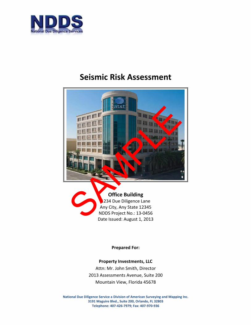
National Due Diligence Service a Division of American Surveying and Mapping Inc. 3191 Maguire Blvd., Suite 200, Orlando, FL 32803 Telephone: 407-426-7979; Fax: 407-970-936 Seismic Risk Assessment Office Building 1234 Due Diligence Lane Any City, Any State 12345 NDDS Project No.: 13-0456 Date Issued: August 1, 2013 Prepared For: Property Investments, LLC Attn: Mr. John Smith, Director 2013 Assessments Avenue, Suite 200 Mountain View, Florida 45678 SAMPLE
Transcript of SAMPLE · National Due Diligence Services (NDDS), a division of American Surveying & Mapping, Inc....
National Due Diligence Service a Division of American Surveying and Mapping Inc. 3191 Maguire Blvd., Suite 200, Orlando, FL 32803
Telephone: 407-426-7979; Fax: 407-970-936
Seismic Risk Assessment
Office Building
1234 Due Diligence Lane Any City, Any State 12345
NDDS Project No.: 13-0456 Date Issued: August 1, 2013
Prepared For:
Property Investments, LLC
Attn: Mr. John Smith, Director 2013 Assessments Avenue, Suite 200
Mountain View, Florida 45678
SAMPLE
Corporate Headquarters 3191 Maguire Blvd., Suite 200, Orlando, FL 32803 PH: 407-426-7979 Fax: 407-426-9741 2
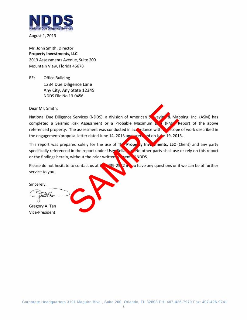
August 1, 2013 Mr. John Smith, Director Property Investments, LLC 2013 Assessments Avenue, Suite 200 Mountain View, Florida 45678 RE: Office Building 1234 Due Diligence Lane
Any City, Any State 12345 NDDS File No 13-0456 Dear Mr. Smith:
National Due Diligence Services (NDDS), a division of American Surveying & Mapping, Inc. (ASM) has completed a Seismic Risk Assessment or a Probable Maximum Loss (PML) Report of the above referenced property. The assessment was conducted in accordance with the scope of work described in the engagement/proposal letter dated June 14, 2013 and executed on June 19, 2013.
This report was prepared solely for the use of The Property Investments, LLC (Client) and any party specifically referenced in the report under User Reliance. No other party shall use or rely on this report or the findings herein, without the prior written consent of NDDS.
Please do not hesitate to contact us at 877-439-2582 if you have any questions or if we can be of further service to you. Sincerely,
Gregory A. Tan Vice-President
SAMPLE
Corporate Headquarters 3191 Maguire Blvd., Suite 200, Orlando, FL 32803 PH: 407-426-7979 Fax: 407-426-9741 3
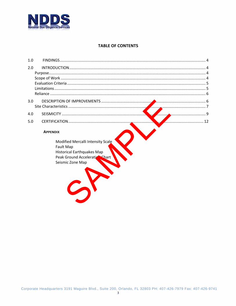
TABLE OF CONTENTS
1.0 FINDINGS ......................................................................................................................................... 4
2.0 INTRODUCTION ................................................................................................................................ 4 Purpose ................................................................................................................................................... 4 Scope of Work ........................................................................................................................................ 4 Evaluation Criteria .................................................................................................................................. 5 Limitations .............................................................................................................................................. 5 Reliance .................................................................................................................................................. 6
3.0 DESCRIPTION OF IMPROVEMENTS .................................................................................................. 6 Site Characteristics ................................................................................................................................. 7
4.0 SEISMICITY ....................................................................................................................................... 9
5.0 CERTIFICATION ............................................................................................................................... 12
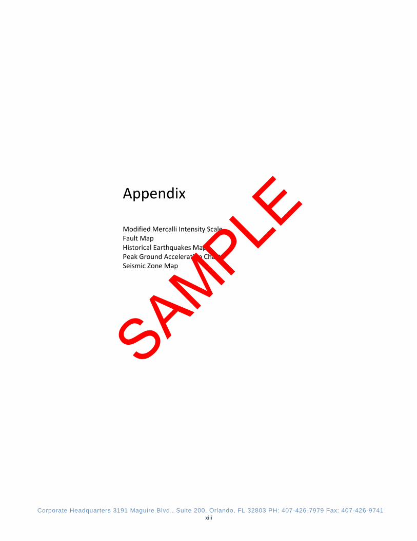
APPENDIX
Modified Mercalli Intensity Scale Fault Map Historical Earthquakes Map Peak Ground Acceleration Chart Seismic Zone Map
SAMPLE
Corporate Headquarters 3191 Maguire Blvd., Suite 200, Orlando, FL 32803 PH: 407-426-7979 Fax: 407-426-9741 4
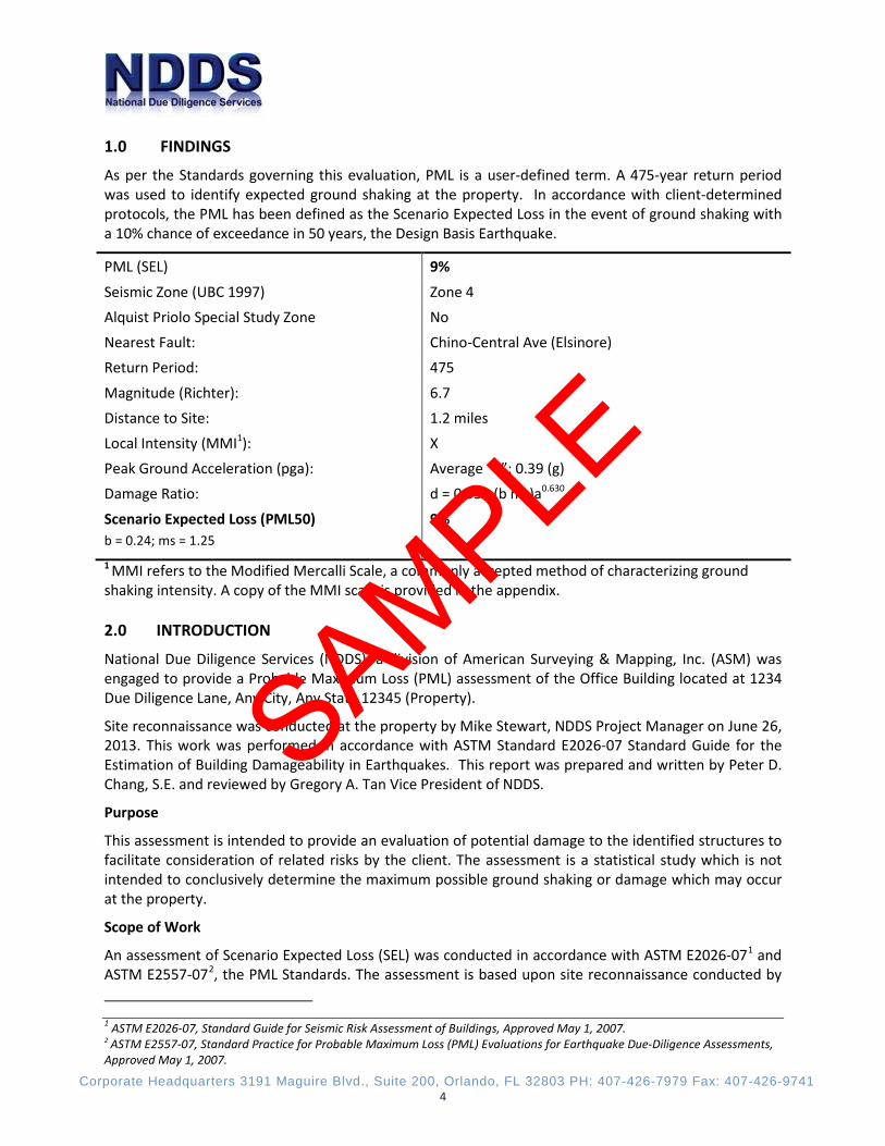
1.0 FINDINGS
As per the Standards governing this evaluation, PML is a user-defined term. A 475-year return period was used to identify expected ground shaking at the property. In accordance with client-determined protocols, the PML has been defined as the Scenario Expected Loss in the event of ground shaking with a 10% chance of exceedance in 50 years, the Design Basis Earthquake.
PML (SEL) 9%
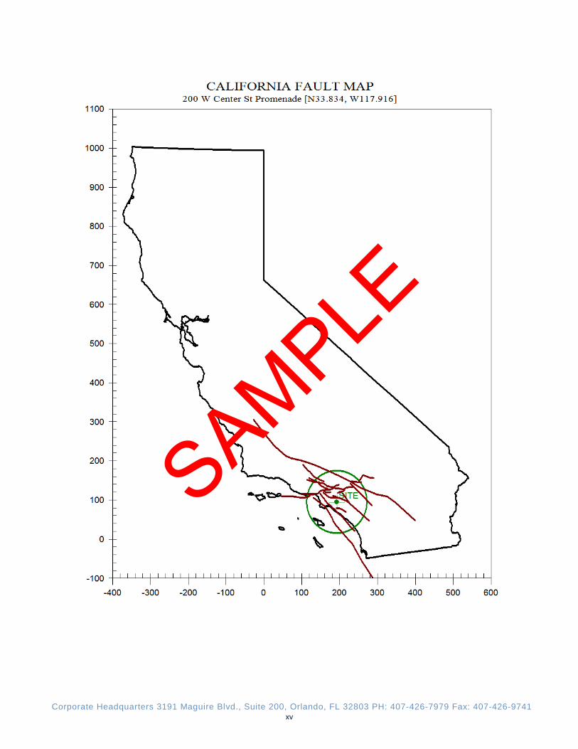
Seismic Zone (UBC 1997) Zone 4 Alquist Priolo Special Study Zone No Nearest Fault: Chino-Central Ave (Elsinore) Return Period: 475
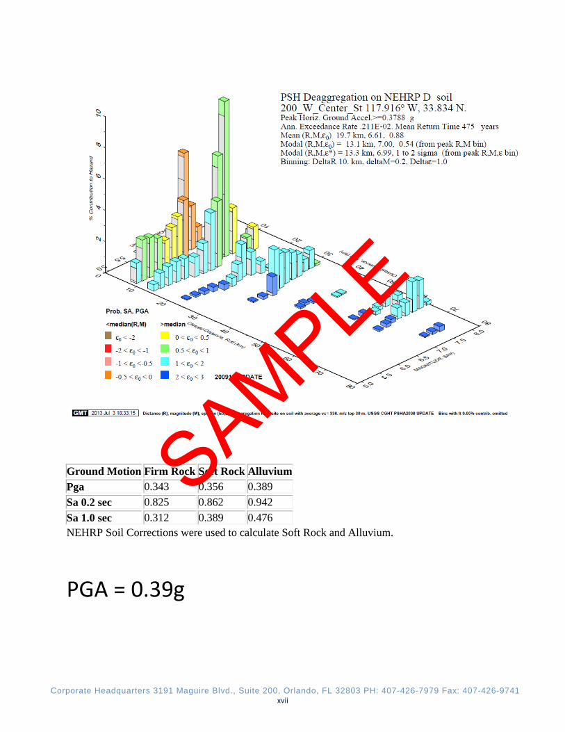
Magnitude (Richter): 6.7 Distance to Site: 1.2 miles Local Intensity (MMI1): X Peak Ground Acceleration (pga): Average “a”: 0.39 (g) Damage Ratio: d = 0.554 (b ms)a0.630
Scenario Expected Loss (PML50) b = 0.24; ms = 1.25
9%
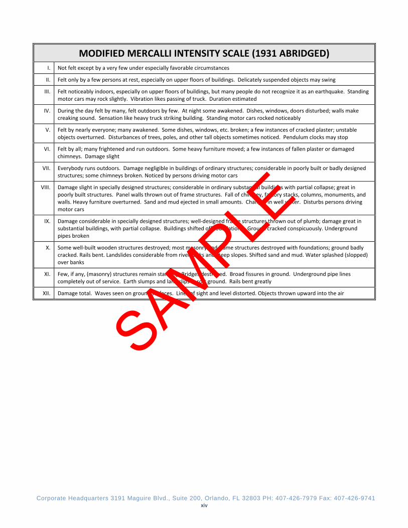
1 MMI refers to the Modified Mercalli Scale, a commonly accepted method of characterizing ground shaking intensity. A copy of the MMI scale is provided in the appendix. 2.0 INTRODUCTION
National Due Diligence Services (NDDS), a division of American Surveying & Mapping, Inc. (ASM) was engaged to provide a Probable Maximum Loss (PML) assessment of the Office Building located at 1234 Due Diligence Lane, Any City, Any State 12345 (Property).
Site reconnaissance was conducted at the property by Mike Stewart, NDDS Project Manager on June 26, 2013. This work was performed in accordance with ASTM Standard E2026-07 Standard Guide for the Estimation of Building Damageability in Earthquakes. This report was prepared and written by Peter D. Chang, S.E. and reviewed by Gregory A. Tan Vice President of NDDS.
Purpose
This assessment is intended to provide an evaluation of potential damage to the identified structures to facilitate consideration of related risks by the client. The assessment is a statistical study which is not intended to conclusively determine the maximum possible ground shaking or damage which may occur at the property.
Scope of Work
An assessment of Scenario Expected Loss (SEL) was conducted in accordance with ASTM E2026-071 and ASTM E2557-072, the PML Standards. The assessment is based upon site reconnaissance conducted by
1 ASTM E2026-07, Standard Guide for Seismic Risk Assessment of Buildings, Approved May 1, 2007. 2 ASTM E2557-07, Standard Practice for Probable Maximum Loss (PML) Evaluations for Earthquake Due-Diligence Assessments, Approved May 1, 2007.
SAMPLE

Corporate Headquarters 3191 Maguire Blvd., Suite 200, Orlando, FL 32803 PH: 407-426-7979 Fax: 407-426-9741 5
Peter Chang, structural engineer of California. No review of building code compliance, calculation or verification of the structural design or assessment of concealed conditions has been performed.
Damage estimates include the result of potential liquefaction at the property, but exclude damages to building finishes, contents and equipment as well as damages which may result from fire, flooding and other events which may occur as a result of seismic activity.
Evaluation Criteria
In accordance with the Standards governing this work, Probable Maximum Loss (PML) is a user-defined term. There is no one method of calculating PML and no universally accepted value for certain variables. The intensity of ground shaking and resulting damage to the structures are determined statistically.
Using commonly available software, we have identified a scenario which will result in an intensity of ground shaking consistent with a Design Basis Earthquake, DBE - ground motion with a 10 % probability of exceedance in 50 years - equivalent to a 475-year return period for exceedance. Based upon this estimate of ground shaking, the damage to buildings at the property is typically evaluated using the Scenario Expected Loss (SEL).
Scenario Expected Loss represents an estimate of damage at the mean value of a normal distribution curve describing damage to a large population of buildings similar to that being assessed. In a portfolio of similar buildings, approximately 50% are likely to experience less than the estimated damage, while the balance are likely to experience more than the estimated damage.
Per ASTM E2557-07, Section 6.5.1.4, for commercial mortgage backed securities the PML is defined as the SELDBE.
Limitations
This report is the intellectual property of NDDS, and may not be used without NDDS’s express written authorization. Unauthorized use of this report is a violation of NDDS’s legal rights. Any unauthorized use of this report shall be subject to civil and criminal penalties and shall be responsible to indemnify, defend and hold NDDS harmless from any and all losses, damages and claims arising from such use.
The conclusions of this assessment are strictly limited by the agreed scope of services. It is important to understand that the estimate of Probable Maximum Loss is not intended to guarantee the performance of any structure or to represent the maximum possible damage to the structure in the event of an earthquake – neither the maximum credible ground shaking nor the maximum possible building damage has been used in estimating the PML. The estimate is a calculation intended to help the client understand and manage business risks; and considers two factors derived from statistical information, ground shaking intensity and damageability of the structure. The value for each of these factors depends upon a targeted confidence level defined separately in this report. For example, the intensity of ground shaking used in the PML calculation generally assumes a 10% chance of exceedance in 50 years. It is critical to understand that ground shaking and building damage can occur at levels in excess of the estimates developed here.
Not only is there a statistical probability that the estimated ground shaking and damage will be exceeded, but there is no certainty as to when the estimated ground shaking may occur. Though the estimate assumes a 10% chance of exceedance in 50 years, ground shaking at or higher than the estimate could occur today or may not occur for thousands of years.
Damageability has been estimated utilizing the damage prediction method developed by Messrs. Charles C. Thiel, Jr. and Theodore C. Zsutty, (see “Earthquake Spectra” Vol. 3, No. 4: Nov. 1987 titled
SAMPLE

Corporate Headquarters 3191 Maguire Blvd., Suite 200, Orlando, FL 32803 PH: 407-426-7979 Fax: 407-426-9741 6
Earthquake Characteristics and Damage Statistics), CGS and USGS web sites and other sources as determined appropriate by the engineer. In the absence of information to the contrary, buildings present at the property are assumed to have been constructed in accordance with building codes in common use at the time of construction or, when applicable, subsequent significant modification. Except as specifically identified herein, this assessment does not include the review or completion of plans, structural calculations, geotechnical investigations, or collection or analysis of soil samples. As a result, conclusions of this assessment are subject to a high degree of uncertainty.
This Report represents our opinion based on professional experience and judgment as exercised within the agreed scope of services. Documents and data provided for our consideration are assumed to be true, correct and complete, and have been reviewed for informational purposes only – neither the design nor functionality of improvements has been considered critically, and no evaluation of life-safety or specific damage expected as a result of the identified seismic activity has been performed.
Reliance
This report was conducted on behalf of and for the exclusive use of Property Investments, LLC, its successor’s and assigns. Property Investments, LLC, its successor’s and assigns may distribute the reports to other parties without limitation; however it is acknowledged that the reports provided to third parties are for informational purposes only. NDDS will issue a reliance letter if requested. 3.0 DESCRIPTION OF IMPROVEMENTS
The subject Office Building is located at 1234 Due Diligence Lane, Any City, Any State 12345. The Property is located in a commercial area of Any, Any State, and consists of one parcel of land that totals approximately 1.21 acres. The Property is improved with one 8-story commercial office building totaling 196,688 square feet (SF). The building was constructed in 1991 of slab-on-grade steel frame construction. Exterior walls consist of pre-cast concrete panels. The surrounding grounds consist of asphalt-paved driveways, parking areas, cast in-place concrete sidewalks, and landscaped areas.
Structural drawings were not provided for our review. Therefore, based on our limited site assessment, the structural components of the building appear to be as follows:
Foundations
Foundation appears to consist of cast-in-place reinforced concrete slabs-on-grade with integral conventional perimeter concrete grade beams and intermediate reinforced concrete spread footings beneath steel columns.
Building Frames
The subject building is of steel framed construction throughout. The exterior walls are pre-cast concrete panels and fixed grass windows. Each floor level consists of concrete topping placed on thin gauge corrugated steel and act compositely with the steel framing. The roofing is a low-slope system with corrugated metal decking and wide flange bolted steel structural supports.
Lateral Load Resisting System
The primary lateral load resisting elements of the building appear to be ductile steel moment resisting frames and horizontal floor and roof diaphragms. Each floor level consists of concrete topping placed on thin gauge corrugated steel and act compositely with the steel framing.
SAMPLE
Corporate Headquarters 3191 Maguire Blvd., Suite 200, Orlando, FL 32803 PH: 407-426-7979 Fax: 407-426-9741 7
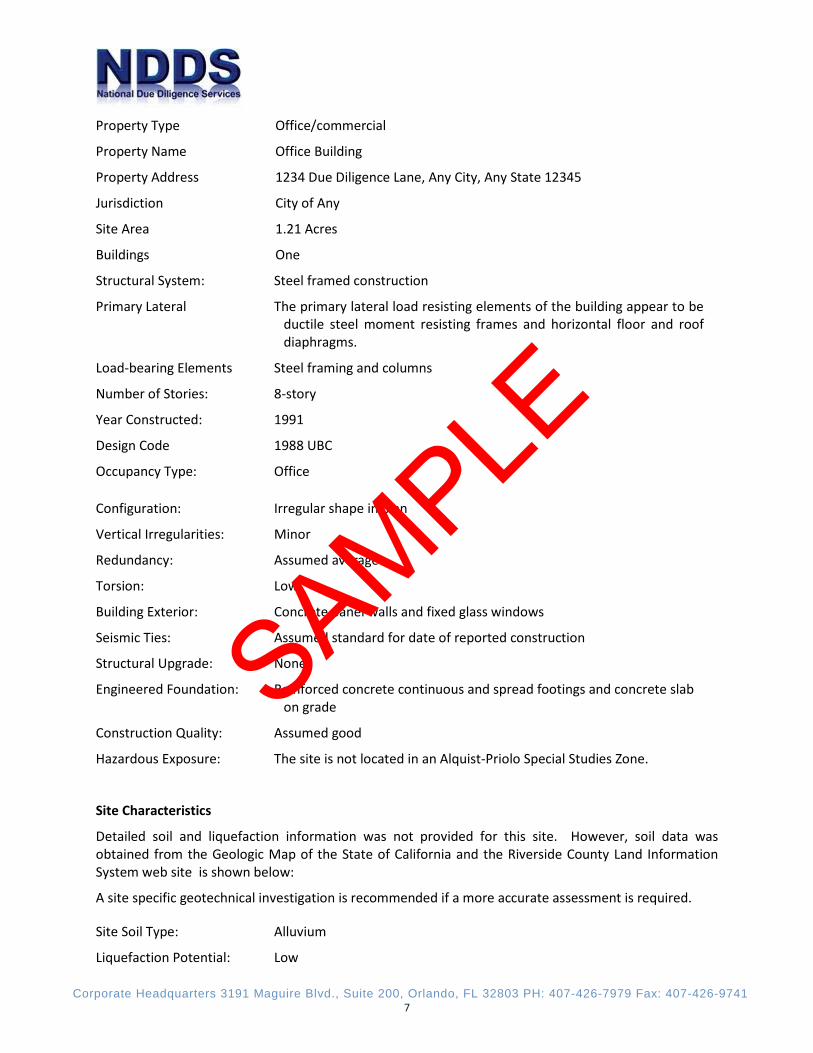
Property Type Office/commercial
Property Name Office Building
Property Address 1234 Due Diligence Lane, Any City, Any State 12345
Jurisdiction City of Any
Site Area 1.21 Acres
Buildings One
Structural System: Steel framed construction
Primary Lateral The primary lateral load resisting elements of the building appear to be ductile steel moment resisting frames and horizontal floor and roof diaphragms.
Load-bearing Elements Steel framing and columns
Number of Stories: 8-story
Year Constructed: 1991
Design Code 1988 UBC
Occupancy Type: Office
Configuration: Irregular shape in plan
Vertical Irregularities: Minor
Redundancy: Assumed average
Torsion: Low
Building Exterior: Concrete panel walls and fixed glass windows
Seismic Ties: Assumed standard for date of reported construction
Structural Upgrade: None
Engineered Foundation: Reinforced concrete continuous and spread footings and concrete slab on grade
Construction Quality: Assumed good
Hazardous Exposure: The site is not located in an Alquist-Priolo Special Studies Zone.
Site Characteristics
Detailed soil and liquefaction information was not provided for this site. However, soil data was obtained from the Geologic Map of the State of California and the Riverside County Land Information System web site is shown below:
A site specific geotechnical investigation is recommended if a more accurate assessment is required.
Site Soil Type: Alluvium
Liquefaction Potential: Low
SAMPLE
Corporate Headquarters 3191 Maguire Blvd., Suite 200, Orlando, FL 32803 PH: 407-426-7979 Fax: 407-426-9741 8
Landslide Potential: Low
Fault Rupture Potential: Low (The Chino-Central Ave (Elsinore) Fault is closest known active fault to the site and is located 1.2 miles from the site.
SAMPLE
Corporate Headquarters 3191 Maguire Blvd., Suite 200, Orlando, FL 32803 PH: 407-426-7979 Fax: 407-426-9741 9
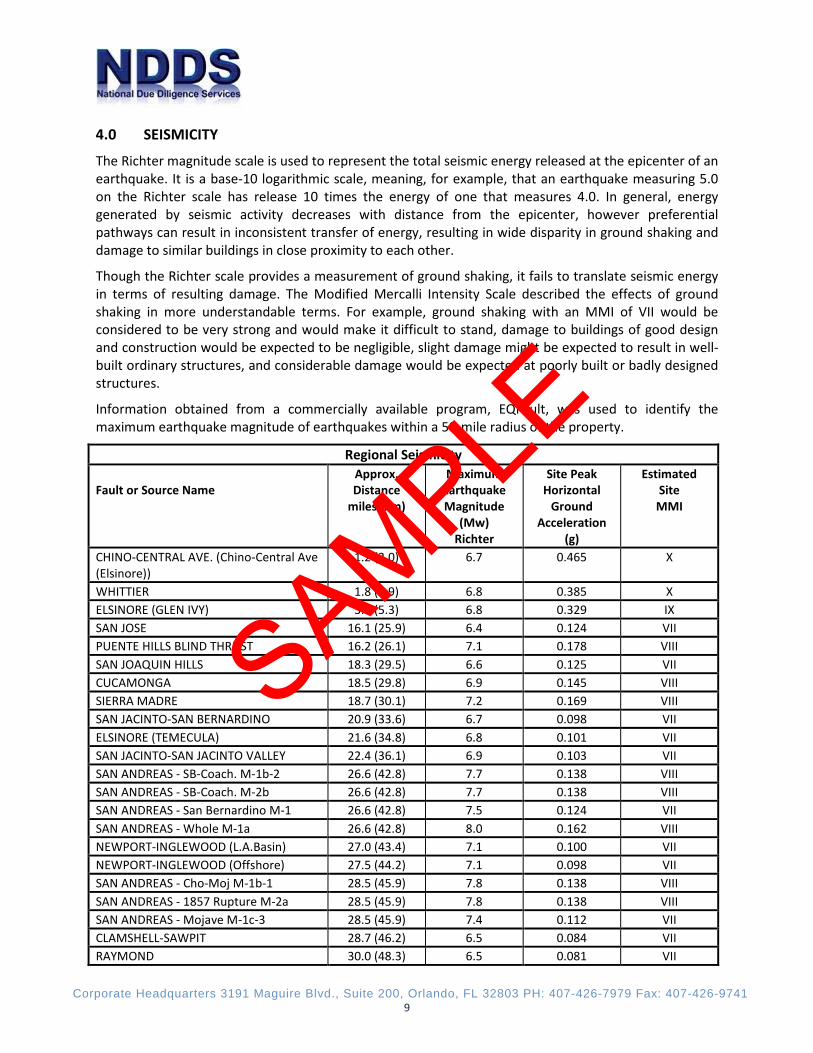
4.0 SEISMICITY
The Richter magnitude scale is used to represent the total seismic energy released at the epicenter of an earthquake. It is a base-10 logarithmic scale, meaning, for example, that an earthquake measuring 5.0 on the Richter scale has release 10 times the energy of one that measures 4.0. In general, energy generated by seismic activity decreases with distance from the epicenter, however preferential pathways can result in inconsistent transfer of energy, resulting in wide disparity in ground shaking and damage to similar buildings in close proximity to each other.
Though the Richter scale provides a measurement of ground shaking, it fails to translate seismic energy in terms of resulting damage. The Modified Mercalli Intensity Scale described the effects of ground shaking in more understandable terms. For example, ground shaking with an MMI of VII would be considered to be very strong and would make it difficult to stand, damage to buildings of good design and construction would be expected to be negligible, slight damage might be expected to result in well-built ordinary structures, and considerable damage would be expected at poorly built or badly designed structures.
Information obtained from a commercially available program, EQFault, was used to identify the maximum earthquake magnitude of earthquakes within a 50-mile radius of the property.
Regional Seismicity
Fault or Source Name Approx. Distance
miles (km)
Maximum Earthquake Magnitude
(Mw) Richter
Site Peak Horizontal
Ground Acceleration
(g)
Estimated Site
MMI
CHINO-CENTRAL AVE. (Chino-Central Ave (Elsinore))
1.2 (2.0) 6.7 0.465 X
WHITTIER 1.8 (2.9) 6.8 0.385 X ELSINORE (GLEN IVY) 3.3 (5.3) 6.8 0.329 IX SAN JOSE 16.1 (25.9) 6.4 0.124 VII PUENTE HILLS BLIND THRUST 16.2 (26.1) 7.1 0.178 VIII SAN JOAQUIN HILLS 18.3 (29.5) 6.6 0.125 VII CUCAMONGA 18.5 (29.8) 6.9 0.145 VIII SIERRA MADRE 18.7 (30.1) 7.2 0.169 VIII SAN JACINTO-SAN BERNARDINO 20.9 (33.6) 6.7 0.098 VII ELSINORE (TEMECULA) 21.6 (34.8) 6.8 0.101 VII SAN JACINTO-SAN JACINTO VALLEY 22.4 (36.1) 6.9 0.103 VII SAN ANDREAS - SB-Coach. M-1b-2 26.6 (42.8) 7.7 0.138 VIII SAN ANDREAS - SB-Coach. M-2b 26.6 (42.8) 7.7 0.138 VIII SAN ANDREAS - San Bernardino M-1 26.6 (42.8) 7.5 0.124 VII SAN ANDREAS - Whole M-1a 26.6 (42.8) 8.0 0.162 VIII NEWPORT-INGLEWOOD (L.A.Basin) 27.0 (43.4) 7.1 0.100 VII NEWPORT-INGLEWOOD (Offshore) 27.5 (44.2) 7.1 0.098 VII SAN ANDREAS - Cho-Moj M-1b-1 28.5 (45.9) 7.8 0.138 VIII SAN ANDREAS - 1857 Rupture M-2a 28.5 (45.9) 7.8 0.138 VIII SAN ANDREAS - Mojave M-1c-3 28.5 (45.9) 7.4 0.112 VII CLAMSHELL-SAWPIT 28.7 (46.2) 6.5 0.084 VII RAYMOND 30.0 (48.3) 6.5 0.081 VII
SAMPLE
Corporate Headquarters 3191 Maguire Blvd., Suite 200, Orlando, FL 32803 PH: 407-426-7979 Fax: 407-426-9741 10
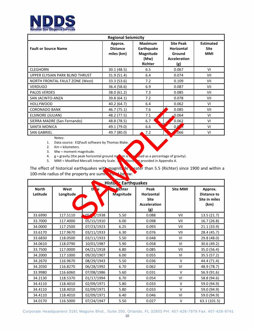
Regional Seismicity
Fault or Source Name Approx. Distance
miles (km)
Maximum Earthquake Magnitude
(Mw) Richter
Site Peak Horizontal
Ground Acceleration
(g)
Estimated Site
MMI
CLEGHORN 30.1 (48.5) 6.5 0.067 VI UPPER ELYSIAN PARK BLIND THRUST 31.9 (51.4) 6.4 0.074 VII NORTH FRONTAL FAULT ZONE (West) 33.3 (53.6) 7.2 0.109 VII VERDUGO 36.4 (58.6) 6.9 0.087 VII PALOS VERDES 38.0 (61.2) 7.3 0.085 VII SAN JACINTO-ANZA 39.8 (64.1) 7.2 0.078 VII HOLLYWOOD 40.2 (64.7) 6.4 0.062 VI CORONADO BANK 46.7 (75.1) 7.6 0.085 VII ELSINORE (JULIAN) 48.2 (77.5) 7.1 0.064 VI SIERRA MADRE (San Fernando) 48.8 (78.5) 6.7 0.062 VI SANTA MONICA 49.1 (79.0) 6.6 0.059 VI SAN GABRIEL 49.7 (80.0) 7.2 0.066 VI
Notes: 1. Data source: EQFault software by Thomas Blake. 2. Km = kilometers. 3. Mw = moment magnitude. 4. g = gravity (the peak horizontal ground motion is expressed as a percentage of gravity). 5. MMI = Modified Mercalli Intensity Scale. Definitions are provided in Appendix A.
The effect of historical earthquakes with magnitude greater than 5.5 (Richter) since 1900 and within a 100-mile radius of the property are summarized below:
Historic Earthquakes North
Latitude West
Longitude Date Richter
Magnitude Peak
Horizontal Site
Acceleration (g)
Site MMI Approx. Distance to Site in miles
(km)
33.6990 117.5110 05/31/1938 5.50 0.088 VII 13.5 (21.7) 33.7000 117.4000 05/15/1910 6.00 0.098 VII 16.7 (26.8) 34.0000 117.2500 07/23/1923 6.25 0.093 VII 21.1 (33.9) 33.6170 117.9670 03/11/1933 6.30 0.076 VII 28.4 (45.7) 33.6830 118.0500 03/11/1933 5.50 0.048 VI 29.8 (48.0) 34.0610 118.0790 10/01/1987 5.90 0.058 VI 30.6 (49.2) 33.7500 117.0000 04/21/1918 6.80 0.085 VII 35.0 (56.4) 34.2000 117.1000 09/20/1907 6.00 0.055 VI 35.5 (57.2) 34.2670 116.9670 08/29/1943 5.50 0.036 V 44.4 (71.4) 34.2030 116.8270 06/28/1992 6.70 0.062 VI 48.9 (78.7) 33.9980 116.6060 07/08/1986 5.60 0.031 V 56.9 (91.6) 34.2130 118.5370 01/17/1994 6.70 0.054 VI 58.8 (94.6) 34.4110 118.4010 02/09/1971 5.80 0.033 V 59.0 (94.9) 34.4110 118.4010 02/09/1971 5.80 0.033 V 59.0 (94.9) 34.4110 118.4010 02/09/1971 6.40 0.046 VI 59.0 (94.9) 34.0170 116.5000 07/24/1947 5.50 0.027 V 63.1 (101.5)
SAMPLE
Corporate Headquarters 3191 Maguire Blvd., Suite 200, Orlando, FL 32803 PH: 407-426-7979 Fax: 407-426-9741 11
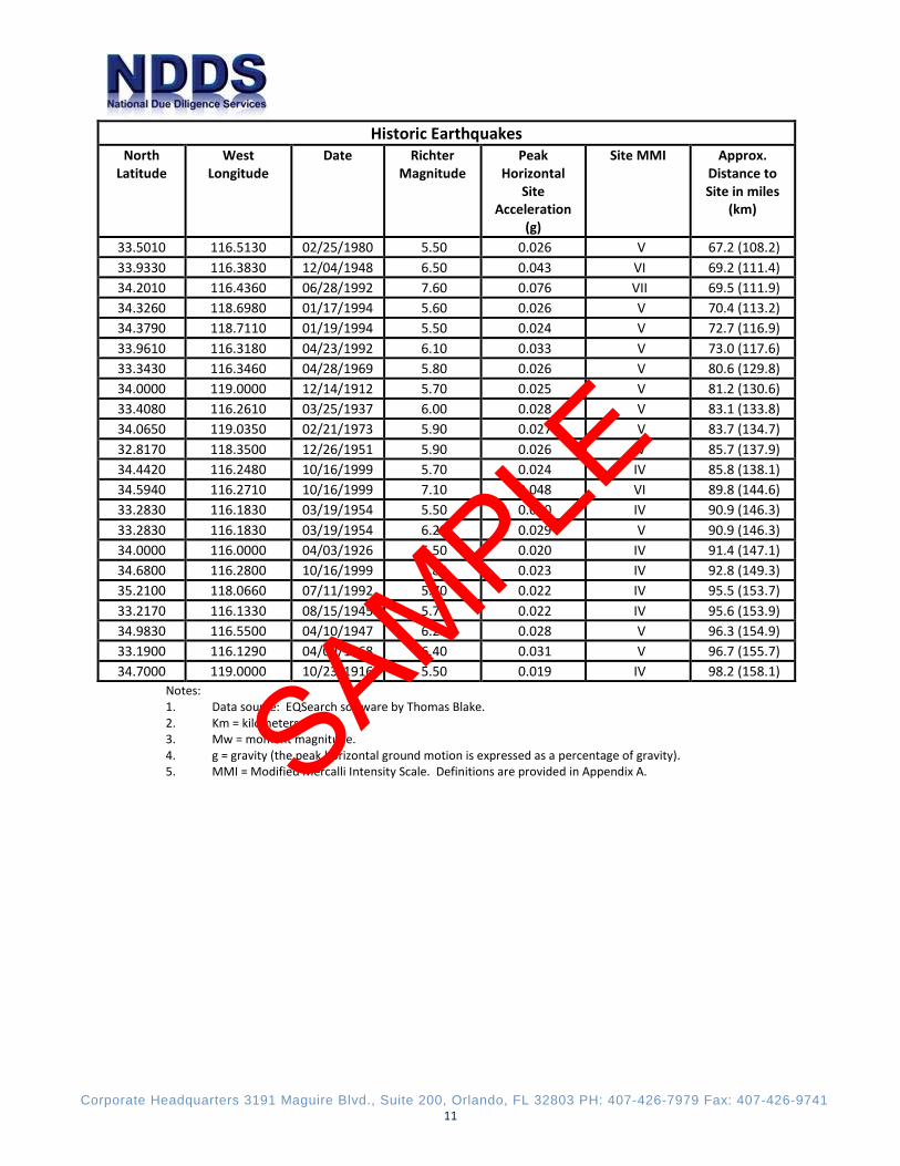
Historic Earthquakes North
Latitude West
Longitude Date Richter
Magnitude Peak
Horizontal Site
Acceleration (g)
Site MMI Approx. Distance to Site in miles
(km)
33.5010 116.5130 02/25/1980 5.50 0.026 V 67.2 (108.2) 33.9330 116.3830 12/04/1948 6.50 0.043 VI 69.2 (111.4) 34.2010 116.4360 06/28/1992 7.60 0.076 VII 69.5 (111.9) 34.3260 118.6980 01/17/1994 5.60 0.026 V 70.4 (113.2) 34.3790 118.7110 01/19/1994 5.50 0.024 V 72.7 (116.9) 33.9610 116.3180 04/23/1992 6.10 0.033 V 73.0 (117.6) 33.3430 116.3460 04/28/1969 5.80 0.026 V 80.6 (129.8) 34.0000 119.0000 12/14/1912 5.70 0.025 V 81.2 (130.6) 33.4080 116.2610 03/25/1937 6.00 0.028 V 83.1 (133.8) 34.0650 119.0350 02/21/1973 5.90 0.027 V 83.7 (134.7) 32.8170 118.3500 12/26/1951 5.90 0.026 V 85.7 (137.9) 34.4420 116.2480 10/16/1999 5.70 0.024 IV 85.8 (138.1) 34.5940 116.2710 10/16/1999 7.10 0.048 VI 89.8 (144.6) 33.2830 116.1830 03/19/1954 5.50 0.020 IV 90.9 (146.3) 33.2830 116.1830 03/19/1954 6.20 0.029 V 90.9 (146.3) 34.0000 116.0000 04/03/1926 5.50 0.020 IV 91.4 (147.1) 34.6800 116.2800 10/16/1999 5.80 0.023 IV 92.8 (149.3) 35.2100 118.0660 07/11/1992 5.70 0.022 IV 95.5 (153.7) 33.2170 116.1330 08/15/1945 5.70 0.022 IV 95.6 (153.9) 34.9830 116.5500 04/10/1947 6.20 0.028 V 96.3 (154.9) 33.1900 116.1290 04/09/1968 6.40 0.031 V 96.7 (155.7) 34.7000 119.0000 10/23/1916 5.50 0.019 IV 98.2 (158.1)
Notes: 1. Data source: EQSearch software by Thomas Blake. 2. Km = kilometers. 3. Mw = moment magnitude. 4. g = gravity (the peak horizontal ground motion is expressed as a percentage of gravity). 5. MMI = Modified Mercalli Intensity Scale. Definitions are provided in Appendix A. SAMPLE
Corporate Headquarters 3191 Maguire Blvd., Suite 200, Orlando, FL 32803 PH: 407-426-7979 Fax: 407-426-9741 12
5.0 CERTIFICATION This assessment was conducted on behalf of and for the exclusive use and benefit of The PRES Companies (Client), its successors, and assignees. The PRES Companies may distribute the report to other parties without limitation; however it is acknowledged that the report provided to third parties is for informational purposes only. NDDS will issue a reliance letter if requested. NDDS has completed this assessment in accordance with the agreed scope of services. The work was performed as an independent contractor, without undue influence of the Client or owner of the Property. To the best of our knowledge and belief, the undersigned have no personal relationship with or interest in any party involved in this transaction.
Peter D. Chang PE, SE Structural Engineer
Gregory A. Tan Vice President
SAMPLE
Corporate Headquarters 3191 Maguire Blvd., Suite 200, Orlando, FL 32803 PH: 407-426-7979 Fax: 407-426-9741 xiii
Appendix Modified Mercalli Intensity Scale Fault Map Historical Earthquakes Map Peak Ground Acceleration Chart Seismic Zone Map
SAMPLE
Corporate Headquarters 3191 Maguire Blvd., Suite 200, Orlando, FL 32803 PH: 407-426-7979 Fax: 407-426-9741 xiv
MODIFIED MERCALLI INTENSITY SCALE (1931 ABRIDGED) I. Not felt except by a very few under especially favorable circumstances
II. Felt only by a few persons at rest, especially on upper floors of buildings. Delicately suspended objects may swing
III. Felt noticeably indoors, especially on upper floors of buildings, but many people do not recognize it as an earthquake. Standing motor cars may rock slightly. Vibration likes passing of truck. Duration estimated
IV. During the day felt by many, felt outdoors by few. At night some awakened. Dishes, windows, doors disturbed; walls make creaking sound. Sensation like heavy truck striking building. Standing motor cars rocked noticeably
V. Felt by nearly everyone; many awakened. Some dishes, windows, etc. broken; a few instances of cracked plaster; unstable objects overturned. Disturbances of trees, poles, and other tall objects sometimes noticed. Pendulum clocks may stop
VI. Felt by all; many frightened and run outdoors. Some heavy furniture moved; a few instances of fallen plaster or damaged chimneys. Damage slight
VII. Everybody runs outdoors. Damage negligible in buildings of ordinary structures; considerable in poorly built or badly designed structures; some chimneys broken. Noticed by persons driving motor cars
VIII. Damage slight in specially designed structures; considerable in ordinary substantial buildings with partial collapse; great in poorly built structures. Panel walls thrown out of frame structures. Fall of chimney, factory stacks, columns, monuments, and walls. Heavy furniture overturned. Sand and mud ejected in small amounts. Changes in well water. Disturbs persons driving motor cars
IX. Damage considerable in specially designed structures; well-designed frame structures thrown out of plumb; damage great in substantial buildings, with partial collapse. Buildings shifted off foundations. Ground cracked conspicuously. Underground pipes broken
X. Some well-built wooden structures destroyed; most masonry and frame structures destroyed with foundations; ground badly cracked. Rails bent. Landslides considerable from riverbanks and steep slopes. Shifted sand and mud. Water splashed (slopped) over banks
XI. Few, if any, (masonry) structures remain standing. Bridges destroyed. Broad fissures in ground. Underground pipe lines completely out of service. Earth slumps and land slips in soft ground. Rails bent greatly
XII. Damage total. Waves seen on ground surfaces. Lines of sight and level distorted. Objects thrown upward into the air
SAMPLE
Corporate Headquarters 3191 Maguire Blvd., Suite 200, Orlando, FL 32803 PH: 407-426-7979 Fax: 407-426-9741 xv
SAMPLE

Corporate Headquarters 3191 Maguire Blvd., Suite 200, Orlando, FL 32803 PH: 407-426-7979 Fax: 407-426-9741 xvi
SAMPLE
Corporate Headquarters 3191 Maguire Blvd., Suite 200, Orlando, FL 32803 PH: 407-426-7979 Fax: 407-426-9741 xvii
Ground Motion Firm Rock Soft Rock Alluvium Pga 0.343 0.356 0.389 Sa 0.2 sec 0.825 0.862 0.942 Sa 1.0 sec 0.312 0.389 0.476 NEHRP Soil Corrections were used to calculate Soft Rock and Alluvium.
PGA = 0.39g
SAMPLE
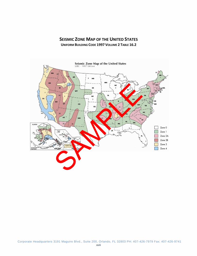
Corporate Headquarters 3191 Maguire Blvd., Suite 200, Orlando, FL 32803 PH: 407-426-7979 Fax: 407-426-9741 xviii
SEISMIC ZONE MAP OF THE UNITED STATES UNIFORM BUILDING CODE 1997 VOLUME 2 TABLE 16.2
SAMPLE

![Investor Presentation - Update on NCE and NDDS programs [Company Update]](https://static.fdocuments.in/doc/165x107/577cb4b61a28aba7118ca04e/investor-presentation-update-on-nce-and-ndds-programs-company-update.jpg)