Saluda Hydroelectric Project (FERC No. 516) Study · PDF filesturgeon (Acipenser brevirostrum)...
19
- 1 - Saluda Hydroelectric Project (FERC No. 516) Study Plan Study Plan Name: 2005 Diadromous Fish Studies Applicable Hydro Projects: Saluda Hydro FERC No. 516 I. Study Objective The objectives of this study are: (1) to document presence / absence of target diadromous fish species in the Lower Saluda River (LSR) and the upper Congaree River during the spring migratory period; (2) to determine the relative abundance and spatial and temporal distributions of species found to be present in the reach; and (3) to document spawning of these species in the Saluda River relative to the Congaree River. Target anadromous species for the study include American shad (Alosa sappadissima), hickory shad (Alosa mediocris), and blueback herring (Alosa aestivalis). One catadromous species, the American eel (Anguila rostrata), will also be targeted. The following tasks will be necessary to meet this objective: a) Review and evaluation of historical records of target diadromous fish species occurrence in the Saluda-Congaree portion of the Santee - Cooper River Basin, and b) Sampling of the LSR and upper Congaree River for target diadromous species during the spring spawning season. II. Basis Restoration of anadromous clupeids to South Carolina waters has become an important objective of resource agencies. Each spring, efforts to pass migrating American shad and blueback herring are undertaken at the first barriers to migration in the Santee - Cooper system. Once passed, these fish have several migration pathways from which to choose. One such pathway results in these fish entering the Saluda River near Columbia. The relative abundance and potential spawning of this segment of the population is of particular interest to managers. The FERC licensing process requires an assessment of potential impacts to fish and wildlife resources by the project and its operations (18CFR4.51). The United States Fish and Wildlife Service (USFWS) has mandatory conditioning authority for fishway prescriptions at all FERC licensed hydro projects; and the National Oceanographic and Atmospheric Administration – National Marine Fisheries Service (NOAA Fisheries) has similar mandatory conditioning authority where anadromous and/or catadromous species are involved. III. Geographic and Temporal Scope Diadromous fish studies will focus on the Lower Saluda River (LSR), from downstream of Saluda Hydro Dam to its confluence with the Broad River, and the upper Congaree River, from its origin at the confluence of the Saluda and Broad rivers to Rosewood Boat Landing. Studies are scheduled to begin in February 2005, with a final report issued by December 31, 2005.
Transcript of Saluda Hydroelectric Project (FERC No. 516) Study · PDF filesturgeon (Acipenser brevirostrum)...

- 1 -
Saluda Hydroelectric Project (FERC No. 516) Study Plan
Study Plan Name: 2005 Diadromous Fish Studies Applicable Hydro Projects: Saluda Hydro FERC No. 516 I. Study Objective The objectives of this study are: (1) to document presence / absence of target diadromous fish species in the Lower Saluda River (LSR) and the upper Congaree River during the spring migratory period; (2) to determine the relative abundance and spatial and temporal distributions of species found to be present in the reach; and (3) to document spawning of these species in the Saluda River relative to the Congaree River. Target anadromous species for the study include American shad (Alosa sappadissima), hickory shad (Alosa mediocris), and blueback herring (Alosa aestivalis). One catadromous species, the American eel (Anguila rostrata), will also be targeted. The following tasks will be necessary to meet this objective: a) Review and evaluation of historical records of target diadromous fish species occurrence in
the Saluda-Congaree portion of the Santee - Cooper River Basin, and b) Sampling of the LSR and upper Congaree River for target diadromous species during the
spring spawning season. II. Basis Restoration of anadromous clupeids to South Carolina waters has become an important objective of resource agencies. Each spring, efforts to pass migrating American shad and blueback herring are undertaken at the first barriers to migration in the Santee - Cooper system. Once passed, these fish have several migration pathways from which to choose. One such pathway results in these fish entering the Saluda River near Columbia. The relative abundance and potential spawning of this segment of the population is of particular interest to managers. The FERC licensing process requires an assessment of potential impacts to fish and wildlife resources by the project and its operations (18CFR4.51). The United States Fish and Wildlife Service (USFWS) has mandatory conditioning authority for fishway prescriptions at all FERC licensed hydro projects; and the National Oceanographic and Atmospheric Administration – National Marine Fisheries Service (NOAA Fisheries) has similar mandatory conditioning authority where anadromous and/or catadromous species are involved. III. Geographic and Temporal Scope Diadromous fish studies will focus on the Lower Saluda River (LSR), from downstream of Saluda Hydro Dam to its confluence with the Broad River, and the upper Congaree River, from its origin at the confluence of the Saluda and Broad rivers to Rosewood Boat Landing. Studies are scheduled to begin in February 2005, with a final report issued by December 31, 2005.

- 2 -
IV. Summary of Existing Data The South Carolina Department of Natural Resources (SCDNR), USFWS, and NOAA Fisheries have collaborated to develop the Santee Cooper Basin Diadromous Fish Passage Restoration Plan (USFWS et al. 2001), which has been submitted to and accepted by FERC as a Comprehensive Plan under Section 10(a)(2)(a) of the Federal Power Act. The plan identifies the Saluda River as being less than optimal for diadromous fish restoration efforts for a variety of reasons including: the large number of dams in the basin (approximately 13); the limited number of river miles available to upstream migrating fish prior to reaching the Saluda Hydro Dam (approximately 10); and the cost and potential biological limitation (i.e., pressure-related impacts to outmigrating fish) of establishing fish passage at the Saluda Hydro Dam. In addition, cold hypolimnetic water released from the Saluda Hydro Dam may cause migrating fish to select the warmer water of the Broad River and not enter the Saluda (USFWS et al. 2001). According to two recent reviews (Welch 2000, Newcomb and Fuller 2001), the target species noted above (American shad, hickory shad, blueback herring, and American eel) are among the diadromous fish species that occurred historically in Saluda-Congaree sub-basin. Shortnose sturgeon (Acipenser brevirostrum) and Atlantic sturgeon (Acipenser oxyrinchus) also occurred historically in the sub-basin; however, these species have not been recently documented in the study area upstream of old Granby Lock and Dam. While some limited fish passage above old Granby Lock and Dam may be possible through the abandoned lock or during high flows, passage may be hindered for bottom-oriented species (USFWS et al. 2001) such as sturgeons. V. Methodology a) Review of Historical Distributions of Target Species
Two reviews of historical occurrences of target species in the Santee-Cooper River Basin have been completed (Welch 2000, Newcomb and Fuller 2001). These two reports, along with any relevant supplemental information that can be acquired from study participants and resource agencies, will be reviewed and used to update historical distribution patterns in the Saluda-Congaree sub-basin.
b) Sampling of Target Species
Gillnetting Adult American shad, hickory shad, and blueback herring will be sampled using gillnetting methods during the 2005 spawning season. Sampling for target species will occur at the following four locations (Figure 1):
1. The LSR at Hope Ferry Landing; 2. The LSR upstream of the Gardendale Canoe Landing; 3. The LSR adjacent to Riverbanks Zoo; and 4. The Congaree River in the vicinity of Rosewood Landing.
Beginning on or around February 1 of each sampling year, gillnets will be set once per week for one run. A typical run during this period will include setting nets at each site and then returning to the first site to retrieve the nets. Nets will be set during daylight hours and

- 3 -
fished for at least 4 hours. In addition to sampling for early run fish, this would allow for resolution of problems associated with access, site selection, and for various trip-based logistical problems to be addressed. This sampling schedule will continue through March 1, or until notification is received from the SCDNR that significant numbers of anadromous alosids have begun to move through the St. Stephens Fish Lift at Pineopolis Dam. Following notification of significant movements of alosids at St. Stephens, sampling will increase to twice per week. During this period, sampling sites will be run at least twice in a day. Following deployment, nets will be checked without being removed from the water on the first run (if possible), and then retrieved on the second or third trip. Nets will be fished for as much of the daylight period as possible, with the number of trips dependent on the amount of time required to make one run of the nets, travel time, etc. Twice-per-week sampling will continue on this schedule through April of each sampling year. Beginning on or around May 1, sampling will be reduced to once per week and will continue until approximately June 1. Sampling during this period will follow the once-per-week sampling regime as described above. Gillnetting will utilize two 100 ft-long (30.5 m) monofilament gill nets at each sampling location: (1) one – 30 m x 2 m, 2.5 in (6.4 cm) stretch mesh; and (2) one – 30 m x 2 m, 5 in (12.7 cm) stretch mesh. Each net will be set perpendicular or at an angle to the shore, with the larger mesh net set downstream of the smaller. All fish collected in the gill nets will be identified to species, weighed (0.1 kg), measured for total length (mm), sexed (if possible without sacrificing), and released alive when possible. A measurement of water temperature (ºC) and dissolved oxygen (mg/L) will also be taken at each location. Survey data will be evaluated for presence or absence of diadromous species known to have occurred historically in this reach of the Saluda/Congaree sub-basin. In addition, a species list will be compiled of all diadromous species encountered during the study. Catch per Unit Effort (number of fish/net hours fished) will be determined and presented in the final report. Data will be compared by date and location. Ichthyoplankton Sampling Ichthyoplankton nets will be fished in conjunction with gillnets, whenever possible. Specifically, one plankton net (0.5 m x 1 m, 1.0 mm mesh; surface and bottom), equipped with flowmeter, will be fished in the general vicinity of each gillnetting location. Nets will be anchored facing upstream in sufficient flow to sample effectively. Nets will be deployed after the first gillnet is set at each location and allowed to fish for four hours. If no ichthyoplankton are collected, or if clogging of the net proves to be problematic, the length of time that the nets are fished may need to be adjusted in consultation with the resource agencies. Ichthyoplankton samples will be preserved in 90% ETOH and returned to the laboratory for identification. All alosid larvae and eggs will be measured for standard length (0.1 mm) and identified to the lowest possible taxon. Larval densities (number / cm3) will be calculated, compared by date and location, and presented in the final report.

- 4 -
American Eel Sampling Eel Traps will be baited and allowed to fish undisturbed for two days each week from February through May. Traps will also be deployed at the following locations to document presence/absence and relative abundance of adult and juvenile Amercan eels:
1. The LSR at the mouth of the Saluda Dam spillway; 2. The mouth of Rawls Creek adjacent to Saluda Shoals Park; 3. The mouth of Twelvemile Mile Creek or the base of Corley Mill Dam, depending
on suitable access; and 4. The LSR downstream of Interstate 26 near the USGS gaging station.
All captured eels will be identified, measured for total length (0.1 mm), examined and released and the location of capture will be noted.
VI. Schedule and Required Conditions a) The review of historical occurrences of target diadromous fish species in the
Saluda/Congaree sub-basin will be completed by the end of February 2005. b) Sampling for target diadromous species below the Saluda Hydro Dam will be conducted
from February through May during 2005. A draft report summarizing the 2005 sampling results will be issued by November 1, 2005, with a final report issued by December 31, 2005. The final report will include all sampling results and conclusions regarding presence and population status of diadromous species, as well as a summary of historical distributions in the area.
VII. Use of Study Results Results of the diadromous fish study will be used as an information resource during discussion of relicensing issues with the SCDNR, USFWS, relicensing issue working groups and other relicensing stakeholders. In addition, the study will provide baseline information for future studies and basin management decisions in the Santee –Cooper Basin. VIII. Study Participants
NAME ORGANIZATION PHONE E-MAIL Applicant Leads
Stephen E. Summer SCANA Services (803)217-7357 [email protected]
Alan W. Stuart Kleinschmidt (803)822-3177 [email protected]
Shane Boring Kleinschmidt (803)822-3177 [email protected]
Agency Leads Dick Christie SCDNR (803)289-7022 [email protected] Amanda Hill USFWS (843)727-4707, x24 [email protected] Prescott Brownell NOAA Fisheries (843)762-8591 [email protected]
ov William Argentieri SCE&G (803)217-9162 [email protected] Other
Participants Randy Mahan SCANA Services (803)217-9538 [email protected]
- 5 -
IX. List of Attachments ATTACHMENT A: Map of Diadromous Fish Sampling Locations on the Lower Saluda and
Upper Congaree Rivers ATTACHMENT B: Meeting Notes from November 10, 2004, Diadromous Fish Study Meeting ATTACHMENT C: Sampling Recommendations Provided by Resource Agencies (Received
via e-mail December 8, 2004) X. List of References Newcomb, T.J. and J.S. Fuller. 2001. Anadromous and catadromous fish survey of
Santee/Cooper Basin in North Carolina and South Carolina. Department of Fisheries and Wildlife Sciences, Virginia Polytechnic Institute and State University, Blacksburg, VA. Final Report, Prepared for Duke Power, June 25, 2001. 25 pp.
United States Fish and Wildlife Service, National Marine Fisheries Service, and South Carolina
Department of Natural Resources. 2001. Santee-Cooper Basin diadromous fish passage restoration plan.
Welch, S.M. 2000. A report on the historical inland migrations of several diadromous fishes in
South Carolina Rivers. Department of Aquaculture, Fisheries and Wildlife, Clemson University, Clemson, SC. Report prepared for Mr. Douglas W. Cook, South Carolina Department of Natural Resources. December 4, 2000. 19 pp.

ATTACHMENT A
Map of Diadromous Fish Sampling Locations on the Lower Saluda and Upper Congaree Rivers

0 1 2 3 40.5Miles
1
2
3
4
12
3
4
1
2
3
4
LegendGillnetting Sites
Hope Ferry Landing
Gardendale Canoe Landing
Riverbanks Zoo
Rosewood Landing
Saluda Spillway
Rawls Creek
Twelvemile Creek
Eel Trap Sites
USGS Gage
1
2
3
4
1
2
3
4Lake Murray
101 T ra de Z one Dr. , S te. 21- AW. Co lumbia , S C 2 91 70Tel eph on e: (80 3) 8 22- 317 7Fax : (80 3) 82 2- 318 3www.Klein sch mi dtUSA .c om
A
South Carolina Electric & Gas CompanyColumbia, South Carolina
Saluda Hydroelectric ProjectFERC No.: 516
Lower Saluda River and Congaree RiverDiadromous Fish Sampling Locations
Scale:
Project No:
Date Drawn:
AS SHOWN
455-020
01-11-2005
ATTACHMENT B
Meeting Notes from November 10, 2004, Diadromous Fish Study Meeting

Saluda Hydro Relicensing – Diadromous Fish Study Meeting – November 10, 2004 Meeting Location – SCE&G Training Center – Columbia, SC
Revision 12-10-04
- 1 -
Attendees: Steve Summer SCE&G Dick Christie SCDNR Bill Argentieri SCE&G Steve Leach SCDNR Kristina Massey SCE&G Hal Beard SCDNR Randy Mahan SCE&G Amanda Hill USFWS Alan Stuart Kleinschmidt Mark Cantrell USFWS Shane Boring Kleinschmidt Alison Guth Kleinschmidt Action Items:
• Prepare a study plan for sampling diadromous fish on the Lower Saluda River and distribute to the resource agencies for review and comment.
• Obtain and distribute D.O. and flow data to the agencies. SCE&G will obtain data from
the USGS.
• Organize canoes, transportation, etc. that is needed for a low flow float trip on the lower Saluda on the 29th of November (to be taken care of by Alison).
• Set up meeting with Prescott Brownell of NOAA fisheries about sturgeon issues.
• Check on permitting for studies, who needs to be there?
• Steve Leach and Mark Cantrell said that they could provide an electronic copy of the
Santee Cooper Basin Diadromous Fish Passage Restoration Plan to anyone who needs it. Meeting Notes: These notes summarize the major items discussed during the meeting and are not intended to be a transcript or analysis of the meeting. Alan Stuart opened the meeting at 10:00 AM and noted that the focus of the meeting would be to discuss: (1) Target Species and Restoration Plans for the Lower Saluda River (LSR), (2) Historical data needs, (3) NOAA shortnose sturgeon sampling permit, (4) Lower Saluda River Sampling logistics, (5) Sampling in Lake Murray tributaries and, (6) Establish a date for low flow float trip on the Lower Saluda River & above Lake Murray.

Saluda Hydro Relicensing – Diadromous Fish Study Meeting – November 10, 2004 Meeting Location – SCE&G Training Center – Columbia, SC
Revision 12-10-04
- 2 -
Target Species and Restoration Plans:
The agencies began this discussion by briefly stating the target species that they would like to see included in the diadromous fish study. The fish mentioned include: blueback herring, hickory and American shad, American eel, Atlantic and shortnose sturgeon, and striped bass. Dick Christie noted that the Broad River Basin is considered number one (most promising) for fish restoration in the Santee Cooper Diadromous Fish Passage Restoration Plan. He also mentioned that the restoration plan is considered a general, wide-reaching plan.
The group decided that more studies need to be performed in order for the agencies to more fully develop their restoration plan, which is considered a living document.
Historical Data Needs:
Mark Cantrell mentioned that the flows into Lake Murray vs. the flows out of Lake Murray would provide great comparison data from which to figure out a fish’s response to flow. Amanda Hill mentioned that she would like to look at temperature distributions as requested by Doug Cooke. Simple temperature data comparing the Broad River and LSR may rule out the presence of sturgeon.
Amanda Hill stated that it would be helpful to know the temperature data above and below the dam. This would allow the agencies to determine how far downstream the project influences. Steve Leach brought up the possibility of using USGS as a source for temperature data, possibly from the last 10-15 years. Dick Christie concurred that January through August would be good months to look at in regards to temperatures, flows, etc. Amanda Hill asked if there were temperature and D.O. monitors on the Congaree itself. In response, it was stated that there was only stage data on Gervais Street. Also that there is possible data for city at sewer plant, which needs to be checked into. Moreover, around October of ’88 through the present there should be data available at the dam. The agencies asked SCE&G to investigate locations for additional monitors, and the agencies will provide what data they already have. It was pointed out that SCDHEC may have some data prior to 1988.
Mark Cantrell of the USFWS asked how the project operations have changed since they first began. In response, Kristina Massey stated that since there is no flood storage pool, the project has always operated to pass large inflows so the dam won’t be overtopped. Up to the late 1950s the project was operated as a base-load facility, and the lake fluctuated much more than it does at the present. From the 1960s to 1990s, the project moved into a load-following and peaking mode, generating when power was most needed on the system and reducing the amount of annual lake fluctuation. The annual flow of water through the system has remained relatively unchanged. Currently the project is used primarily to meet system reserve needs.

Saluda Hydro Relicensing – Diadromous Fish Study Meeting – November 10, 2004 Meeting Location – SCE&G Training Center – Columbia, SC
Revision 12-10-04
- 3 -
Alan inquired as to where the striped bass fit into the study plan. Hal Beard replied that the striped bass use the river for refuge and then they leave and no one is sure when they arrive, what the environmental demands are and where they go. It is possible that over-exploitation could occur. Although inconclusive, work conducted by Gene Hayes suggests that, to some degree, landlocked striped bass may utilize the Upper Saluda River as spawning area. Generally, the LSR is a two-tiered fishery, trout in the winter and striped bass in the summer. Hal continued to mention that there is also concern that the striped bass could become genetically depressed due to the over fishing of the best individuals.
Mark Cantrell would like to know how stripers have been sampled historically. The group stated that the sampling performed by Hal Beard is the first sampling that has been done on a regular basis. Hal indicated he usually samples in May/October. Dick suggested that IFIM study work has been done by Isley and Jobsis.
NOAA Shortnose Sturgeon sampling permit:
• Will be discussed in a meeting with Prescott Brownell Saluda River Sampling Logistics: Gill Netting: When: Start in the beginning of March (1x a week) then increase to 3x's a week from the
third week in March through April 4am to 10am or 2pm to 8pm.
Where: One gillnet near the mouth of the Saluda River near the Congaree River and one towards the dam.
Supplies: 2 ½” to 7” stretch mesh nets. One net should be constructed of 2.5-inch stretched
mesh, the other of 5-inch stretched mesh. How: Possibly set at an angle to the bank. Fish two nets (one net of each mesh size) at
each site, to cover approximately one half of the river’s width if possible.
The group began to discuss gillnetting and its caveats. Hal Beard mentioned that he will be interested in how the gill netting is going to be performed; he has not had much luck with it in the past. However, he has achieved the most luck with it when the nets were set at an angle to the bank, rather than perpendicular. When considering a site for the net, one must consider both access and velocity. (i.e., Is velocity going to increase fish catch?) According to Dick, in order to target American shad and blueback herring, the smallest mesh size needs to be 2 ½ “ for smaller fish and as much as 7” for larger adults. Moreover, net panels need to be made to the right length and height in order to cover the channel. The group mentioned that SCE&G may want to test the feasibility of gillnetting in 2004.

Saluda Hydro Relicensing – Diadromous Fish Study Meeting – November 10, 2004 Meeting Location – SCE&G Training Center – Columbia, SC
Revision 12-10-04
- 4 -
Mark Cantrell clarified that the goals of this early study were as follows: to determine the presence or absence of target species, what their distribution is in the habitat, and where along the river they are located. Kristina brought up the fact that flows may be a serious setback when gillnetting, all depending on how wet of a winter and spring we have. The group decided that sampling should occur in 6 hour time periods. The time period for setting and monitoring gill nets should be during either 2:00 pm -8:00 pm, or possibly 4:00 am to 10:00 am. According to Dick Christie there should be a gill net set up at least at one site around the mouth of the Saluda River at the Congaree River and one in the upper reaches, near the dam (Saluda Shoals). Hal Beard suggested that one of the nets should be located about 100m below the zoo bridge.
Alan suggested using the passage rates at St Stephens as a catalyst to increase sampling efforts in the LSR. Coordination with SCDNR, as was done during the relicensing of Columbia Hydro, was proposed. There needs to be coordination with Doug Cooke and Steve Leach to find out when the fish are being passed. Steve Leach responded that the peak at Pinopolis Dam occurs around March 7th and at St. Stevens around the 20th of March.
The discussion turned to possible sampling times and dates. It was mentioned that SCE&G may only need to sample using gill nets once a week until end of March, beginning of April, and then increase up to around 3x’s a week. Hal cautioned against sampling too far into April because of the large amount of stripers.
The agencies indicated that it may be acceptable to electrofish while gill nets were soaking.
Note: The following comments and clarifications were made by the resource agencies following the meeting: Starting in February, set nets once a week for one run. A run will include setting nets at each site and then returning to the first site to retrieve the nets. The nets should be allowed to fish for at least 4 hours. In addition to sampling for early run fish, this would allow for resolution of problems associated with access, site selection, and various trip-based logistical problems to be addressed. After notification of “significant” alosine passage at the Santee Cooper dams, increase sampling dates to twice per week (The agencies suggested shooting for Monday and Thursdays, to allow for some variation due to hazardous weather conditions). The sites should be run at least twice in a day, so that nets are checked without removing from the water, if possible, on the first run, and then retrieved on the second or third trip. The goal is to fish the nets for as much of the daylight period as possible. The number of trips will be dependent on the amount of time required to make one run of the nets, travel time, etc. and can be adjusted accordingly. Nets should be fished in this mode through April and then reduced to one run (on one day) per week through May if alosine catch has decreased significantly.

Saluda Hydro Relicensing – Diadromous Fish Study Meeting – November 10, 2004 Meeting Location – SCE&G Training Center – Columbia, SC
Revision 12-10-04
- 5 -
The sites should be determined by locating adequate fishing habitat in close proximity to a private, public or improvised launching facility. Ideally, three sampling locations should be sampled. These locations should roughly correspond to upper, middle and lower sections of the river. A potential upper-river site should be near the SCE&G ramp at Saluda Shoals. The middle river should be generally between Fourteen Mile Creek and the Interstate 20 Bridge; the lower-river site suggested is in the vicinity of Riverbanks Zoo. Actual locations may have to be adjusted at the time of sampling due to varying flow conditions.
One additional site in the Congaree River near the confluence of the Broad and Saluda Rivers would provide information on relative abundance of fish in the river and provide indications as to whether they are selecting for the Saluda or Congaree. Sampling with the same techniques and timing as in the Saluda River would also provide insight to the effectiveness of gear and techniques, and was strongly encouraged by the agencies. Fishing near the Rosewood landing on Congaree River may prove suitable for this site. If the catch of non-target species is high at any of the sampling sites, the length of time nets are fished can be shortened to reduce by-catch.
Eel Traps: When: February to April Where: At the mouths of rivers, channels and islands Supplies: Eel pots can possibly be ordered from Wildco
Amanda Hill of FWS mentioned that they would like eel pots to be set at the mouths of rivers, channels and islands and that they were looking for potential elvers. She also stated that these would not be as laborious as gillnetting, the eel traps only needed to be checked every couple of days. Hal Beard indicated that in the past he has caught about three eels in a 10 day sampling season on average, and also that he had 5 yrs of data. Amanda replied that she would like to get that data from him if at all possible. The group mentioned that the first step was to compile as much historical data as possible.
The discussion turned to time periods in which to sample. Mark Cantrell said that February to April would be the best time to deploy eel pots. The USFWS will provide info on equipment suppliers such as Wildco.
Note: The following comments and clarifications were made by the resource agencies following the meeting: Efforts should be made to determine whether eel traps can be fished on a corresponding schedule with gill nets sets. If locations as previously described (e.g. creek entrances) can be located near gill net sites, they should be utilized. Eel traps should be set there upon first deployment of the day, and checked at the end of

Saluda Hydro Relicensing – Diadromous Fish Study Meeting – November 10, 2004 Meeting Location – SCE&G Training Center – Columbia, SC
Revision 12-10-04
- 6 -
the day. They could also be left set until the next trip (once twice a weekly sampling starts), when they should be checked and re-baited.
Plankton Nets: When: While gill netting Where: DNR would prefer that plankton nets be set to fish off the bottom Supplies ½ meter, 220/500 micron single nets, possibly with flow meter attached
Amanda Hill mentioned that they would like SCE&G to put up fixed plankton nets to gather eggs and larvae. In response, Alan mentioned that if gillnetting and electrofishing provide no results, plankton nets may be unnecessary. Amanda said that plankton nets are just another way of determining presence or absence, and they are definitely needed during the spring of 2005, if nothing else.
In regards to the nets themselves, Mark Cantrell mentioned that they would prefer tows but it may be difficult to do in the river, so maybe stationary nets would be better for a given period of time. Moreover, in regards to catching herring, shad and stripers, Mark pointed out that ½ meter, 220 micron would perform the best. He also stated that a flow meter would provide volume measurements, but you would need a meter attached to each net unless they are paired closely together. The group decided that single nets, not bongo nets, should be used. DNR would prefer that the river was fished off the bottom. It was concluded that plankton nets can be sampled while electrofishing and gillnetting are taking place.
Note: The following comments and clarifications were made by the resource agencies following the meeting: Efforts should be made to fish plankton nets in conjunction with gillnets. Plankton nets may be anchored after the first gill net set at each site and retrieved upon the last gillnet retrieval of the day. This will allow for filtering the maximum volume of water during low flow periods, increasing the likelihood of sampling alosine eggs and larvae. However, if clogging with vegetation, detritus, etc. becomes problematic, plankton nets may be retrieved at the retrieval stage of the first run for gillnets each day. If clogging is still problematic, then shorter sampling times should be investigated.
Telemetry Study:
FWS expressed the desire to have a telemetry study preformed with some sentinel fish for American shad. This study will help the agencies determine if the shad utilize the Broad and LSR or just the Broad River. Also if they have thermal preferences and selection based upon the water temperature. Dick Christie believes it would be a good idea to do this because we do not know where they go. Dick Christie also mentioned that it would benefit SCE&G if the American Shad went up the Broad River.
Saluda Hydro Relicensing – Diadromous Fish Study Meeting – November 10, 2004 Meeting Location – SCE&G Training Center – Columbia, SC
Revision 12-10-04
- 7 -
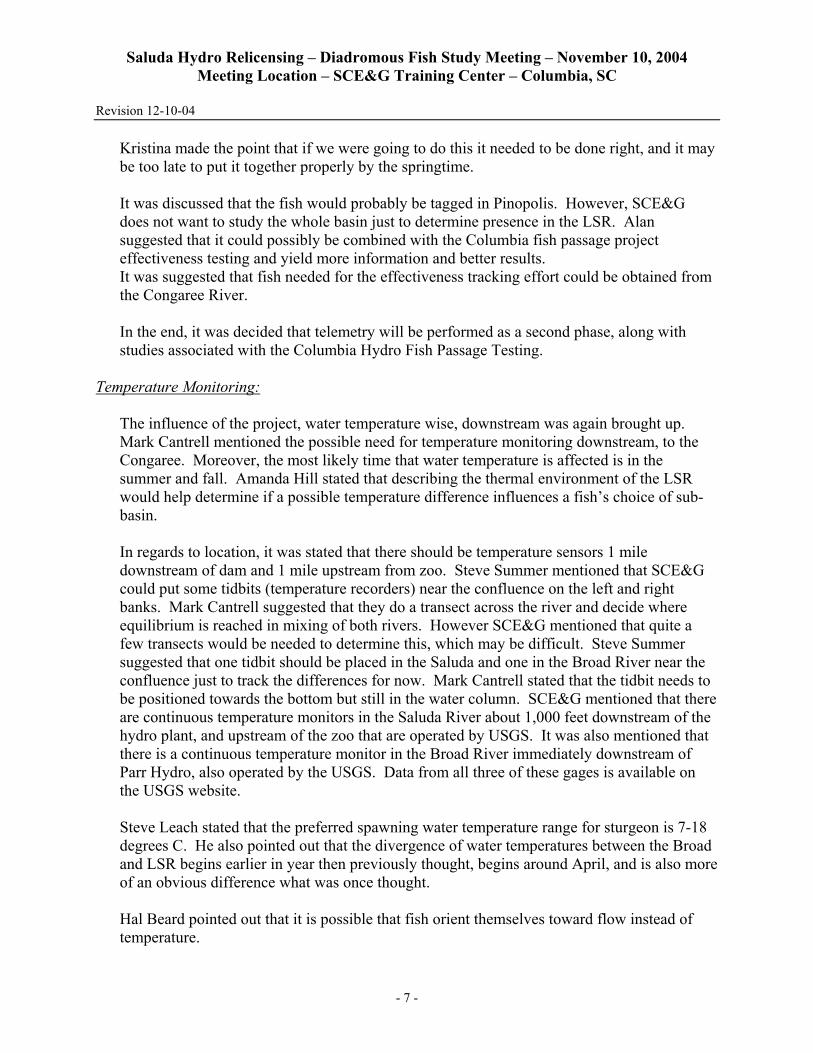
Kristina made the point that if we were going to do this it needed to be done right, and it may be too late to put it together properly by the springtime.
It was discussed that the fish would probably be tagged in Pinopolis. However, SCE&G does not want to study the whole basin just to determine presence in the LSR. Alan suggested that it could possibly be combined with the Columbia fish passage project effectiveness testing and yield more information and better results. It was suggested that fish needed for the effectiveness tracking effort could be obtained from the Congaree River.
In the end, it was decided that telemetry will be performed as a second phase, along with studies associated with the Columbia Hydro Fish Passage Testing.
Temperature Monitoring:
The influence of the project, water temperature wise, downstream was again brought up. Mark Cantrell mentioned the possible need for temperature monitoring downstream, to the Congaree. Moreover, the most likely time that water temperature is affected is in the summer and fall. Amanda Hill stated that describing the thermal environment of the LSR would help determine if a possible temperature difference influences a fish’s choice of sub-basin.
In regards to location, it was stated that there should be temperature sensors 1 mile downstream of dam and 1 mile upstream from zoo. Steve Summer mentioned that SCE&G could put some tidbits (temperature recorders) near the confluence on the left and right banks. Mark Cantrell suggested that they do a transect across the river and decide where equilibrium is reached in mixing of both rivers. However SCE&G mentioned that quite a few transects would be needed to determine this, which may be difficult. Steve Summer suggested that one tidbit should be placed in the Saluda and one in the Broad River near the confluence just to track the differences for now. Mark Cantrell stated that the tidbit needs to be positioned towards the bottom but still in the water column. SCE&G mentioned that there are continuous temperature monitors in the Saluda River about 1,000 feet downstream of the hydro plant, and upstream of the zoo that are operated by USGS. It was also mentioned that there is a continuous temperature monitor in the Broad River immediately downstream of Parr Hydro, also operated by the USGS. Data from all three of these gages is available on the USGS website.
Steve Leach stated that the preferred spawning water temperature range for sturgeon is 7-18 degrees C. He also pointed out that the divergence of water temperatures between the Broad and LSR begins earlier in year then previously thought, begins around April, and is also more of an obvious difference what was once thought. Hal Beard pointed out that it is possible that fish orient themselves toward flow instead of temperature.

Saluda Hydro Relicensing – Diadromous Fish Study Meeting – November 10, 2004 Meeting Location – SCE&G Training Center – Columbia, SC
Revision 12-10-04
- 8 -
It was decided that this study would be “tabled” as well. Sampling in Lake Murray tributaries:
The agencies indicated that they would like an evaluation of potential spawning areas in the Lake and in tributaries. Amanda Hill stated that a characterization of the physical habitat below the dam and above the Lake would be helpful. This can possibly be submitted in GIS format, and would be used to determine if there is potential diadromous fish spawning habitat.
Hal Beard pointed out that Gene Hayes did some cursory work to determine if stripers could possibly be reproducing in middle Saluda, and his determination concluded that numbers were insignificant.
“Tabled” Studies
• Telemetry Study
• Temperature Monitoring in LSR and Congaree.
• Will possibly do a future Habitat Evaluation if it is in conjunction with a required flow study.
• Will determine need of habitat study after video fly-over and float trip.
Low Flow Float Trip on the Lower Saluda River:
The meeting concluded with a discussion of the canoe trip that was going to be taking place on the Lower Saluda River during low flows (400-500 cfs). It was determined that the 29th of November was the best date for everyone.
Amanda and Alan will both ask Prescott Brownell to attend.
The meeting adjourned at approximately 3:00 pm.

ATTACHMENT C
Sampling Recommendations Provided by Resource Agencies (Received via e-mail from SCDNR on December 8, 2004, with concurrence from USFWS
on December 7, 2004)

- 1 -
Sampling Recommendations Provided by Resource Agencies
RE: Saluda River Sampling Logistics Gill netting: After discussion with various biologists in the area we suggest the following changes to
the gillnetting sampling regime that was originally discussed on November 10, 2004. These changes are designed to most effectively sample for determination of spatial and temporal distributions of alosine fishes in the system and to begin to generate an index of quantity. The general concept is to set nets near sites with boat access, so that after nets are set at one site, the boat can be trailered to the next site. For these first year studies, it is assumed that changes will need to be occur to compensate for unforeseen or as of yet poorly understood issues of manpower, river levels, site selection, gear applicability and other factors.
When: Starting in February, set nets once a week for one run. A run will include setting nets at each site and then returning to the first site to retrieve the nets. The nets should be allowed to fish for at least 4 hours. In addition to sampling for early run fish, this would allow for resolution of problems associated with access, site selection, and various trip-based logistical problems to be addressed. After notification of “significant” alosine passage at the Santee Cooper dams, increase sampling dates to twice per week (We’d suggest shooting for Monday and Thursdays, to allow for some variation due to hazardous weather conditions). The sites should be run at least twice in a day, so that nets are checked without removing from the water, if possible, on the first run, and then retrieved on the second or third trip. The goal is to fish the nets for as much of the daylight period as possible. The number of trips will be dependent on the amount of time required to make one run of the nets, travel time, etc. and can be adjusted accordingly. Nets should be fished in this mode through April and then reduced to one run (on one day) per week through May if alosine catch has decreased significantly. NOTE: length of sets, etc. should be adjusted if impacts to other species are discovered. Where: The sites should be determined by locating adequate fishing habitat in close proximity to a private, public or improvised launching facility. Three locations spread out along the river should be sampled, allowing managers to determine if fish are ascending rapids and are present at the dam. The locations should roughly correspond to upper, middle and lower sections of the river. A probable upper-river site should be near the SCE&G ramp at Saluda Dam. The actual gill netting site may have to be adjusted in varying flow conditions. The middle river should be generally between Fourteen Mile Creek and the Interstate 20 Bridge; the lower-river site suggested is in the vicinity of Riverbanks Zoo. As noted; actual locations may have to be adjusted due to varying flow conditions. One additional site in the Congaree River near the confluence of the Broad and Saluda Rivers would provide information on relative abundance of fish available to use the Saluda River, and is strongly encouraged. Sampling with the same techniques and timing as in the Saluda River would provide insight to the effectiveness of gear and techniques. Fishing near the Rosewood landing on Congaree River may prove suitable for this site.

- 2 -
Supplies: Fish two nets at each site, approximately one half of the river’s width. One net should be constructed of 2.5-inch stretched mesh, the other of 5-inch stretched mesh. How: Nets should be “set” from the riverbank out perpendicular or angled to the shoreline, depending on flow conditions. Larger mesh nets should be fished downstream of the smaller mesh nets. Eel Traps Efforts should be made to determine whether eel traps can be fished on a corresponding schedule with gill nets sets. If locations as previously described (e.g. creek entrances) can be located near gill net sites, they should be utilized. Eel traps should be set their upon first deployment of the day, and checked at the end of the day, but probably may be left set until the next trip (once twice a weekly sampling starts). On the next trip, eel traps should be checked and re-baited. Plankton nets Efforts should be made to fish plankton nets in conjunction with gillnets. Plankton nets may be anchored after the first gill net set at each site and retrieved upon the last gillnet retrieval of the day. This will allow for filtering the maximum volume of water during low flow periods, increasing the likelihood of sampling alosine eggs and larvae. However, if clogging with vegetation, detritus, etc. becomes problematic, plankton nets may be retrieved at the retrieval stage of the first run for gillnets each day. If clogging is still problematic, then shorter sampling times should be investigated.