Sainte-Marie - Concordia University · Sainte-Marie Gateway to the City Historical Context. 2.0....
23
Sainte-Marie Gateway to the City Sainte-Marie Urban Revitalization Plan Prepared for : URBS 433: Advanced Urban Laboratory Professor Pierre Gauthier Presented by: Cedric Capacchione Amita Dixit Stavroula Tomaras APRIL 2006
Transcript of Sainte-Marie - Concordia University · Sainte-Marie Gateway to the City Historical Context. 2.0....

Sainte-MarieGateway to the City
Sainte-Marie Urban Revitalization Plan
Prepared for : URBS 433: Advanced Urban LaboratoryProfessor Pierre Gauthier
Presented by: Cedric CapacchioneAmita DixitStavroula Tomaras
APRIL 2006

Sainte-MarieGateway to the City
Table of Contents1.0 Introduction…………………………………………………………. 3
2.0 Historical context……………………………………………………. 5
3.0 Strengths and Weaknesses………………………………………… 6
4.0 Aims and Objectives…………………………….…………………. 9
5.0 Design Proposal……………………………………………………… 12
5.1 Farmer’s Market……………………………………………. 13
5.2 Parc Sainte-Marie……………………………………….… 16
5.3 Papineau Market…………………………………………… 19
6.0 Conclusion…………………………………………………………… 22
7.0 Bibliography………………………………………………………… 23

Sainte-MarieGateway to the City
Introduction
Suggest design improvements and policyinitiatives for the Sainte-Marie district basedon an informed analysis of the existingphysical, social, and economic realities of thearea.
UnemploymentCrimeCongestionPollutionVacant/underused land
Source: Ville de Montreal
Our Goals
Major problems identified for the area
Our Assignment
Intensify land useCreate housingImprove employment opportunitiesMinimize the impacts of trafficEnhance neighbourhood appealCreate dynamic entry to the CBD
1.0

Sainte-MarieGateway to the City
Introduction
Site A: Portal Jacques-Cartier
Site B: Parc Sainte-Marie
Site C: Marché Papineau
Sites of Intervention
Faubourg Sainte Marie
A
BC
Montrealrue Ontario
rue Ontario
aven
ue P
apin
eau
rue
Duf
rens
e
Faubourg Sainte Marie
1.0

Sainte-MarieGateway to the City
Historical Context
2.0
Sainte-Marie has seen a change over time fromthe rural faubourg it once was to the industrialgauntlet it became at the turn of the 20th
century. The remnants of this activity existtoday, evident in the allotment system, qualityof housing, and churches that dot the area. Itis also responsible for much of the vacant landthat exists today.
During the Sixties and Seventies the area sawsome major interventions that affected thedistrict residents. These included the erectionof the Radio-Canada tower and theconstruction of the Ville-Marie Expressway,which together displaced as many as 3000people. Although historically separated by theescarpments, and by the river that followedwhat is now St. Antoine street, FaubourgQuebec and Saint-Jacques/Sainte-Marie werefurther divorced from each other as an axis ofeast-west traffic cut between them.
Currently the provincial and municipalgovernments are working to transform NotreDame Street into an eight-lane urbanboulevard that will connect with the VilleMarie Expressway. This will certainly increasethe amount of traffic that comes into the citycentre, especially if Highway 25 is extendedfrom Laval. It is imperative therefore toreduce the impact this traffic will have onresidents.
Source: Bibliotheque Nationale
Source: Bibliotheque Nationale
Source: Authors

Sainte-MarieGateway to the City
Strengths and Weaknesses
3.0
Proximity to the Central Business District
Proximity to the Waterfront
Proximity to the Gay Village
Telecommunication industry cluster
Strengths
Traffic
Permeability
Social Problems
Environment
Weaknesses
The area is heavily oriented towardsautomobiles. The Jacques Cartierbridge generates a great deal ofcommuting traffic that creates anunpleasant environment forpedestrians and shoppers. Themodernization of

Sainte-MarieGateway to the City
Strengths and Weaknesses
3.0
Area 1
Area 2
Area 3
Area 4
Area 5
Area 1 – WarehousesArea 2 – BrownfieldArea 3 – Underneath BridgeArea 4 – GatewayArea 5 - Waterfront

Sainte-MarieGateway to the City
Strengths and Weaknesses
3.0
- Train tracks- Jacques-Cartier Bridge- Future Notre-Dame Boulevard- Existing industry (Molson brewery, warehouses, etc.)
- Extend waterfront recreation eastward- Develop green space for the area (waterfront esplanade)- Eliminate vestiges of industrial activity in order to redevelop and redesign the waterfront between Berri and Frontenac
Area 5 & 5.1The waterfront presents a major opportunity to reinvest in the area and extend the old port into an esplanade if industry can eventually be relocated.
- Contaminated industrial sites- Access to the Expressway
- Demolition housing to make way for condominium or commercial buildings large enough to frame Renée-Levesque on the south side- Reinforce Cité-des-ondes- Redesign Papineau Square- Reconfigure access to the Ville-Marie Expressway (Viger, Notre-Dame, Autoroute)
Area 4These blocks are underdeveloped and do not suit the scale of the street. The houses on the south side are isolated and could be demolished to make way for larger buildings.
- Bridge prevents full use of land- Narrow parcels of land- Pollution caused by noise, traffic, etc.
- Beautification of the area- Reduction or relocation of drug-use- Parking- Green buffer between sidewalk and underneath bridge
Area 3This land is peculiar because of its position underneath the bridge. It is an eye-sore and represents a potentially hazardous area, especially at night.
- Historic prison restricts demolition and creates an awkward parcel of land
- Develop commercial property on vacant lots to harmonize with existing buildings- Frame entrance to the CBD- Divide block to increase permeability- Construct a range of housing types and tenures to maximize the social equity and dollar value of land being developed
Area 2This stretch of Ste. Catherine is occupied by large commercial and institutional buildings. As such we recommend developing the vacant land for commercial purposes, taking advantage of the commuter road infrastructure.Historic prison is of heritage value and cannot be destroyed.
- Existing institutional buildings- Zoning by-laws
- Densify residential fabric by constructing housing- Improve visual quality of the environment- Build stronger sense of community east of Papineau- Better define the area between Frontenac and Papineau- Build market for more local amenities
Area 1Currently a mixture of residential, warehouse, and institutional buildings; our aim is to make it predominantly residential.
ConstraintsOpportunitiesLocation

Sainte-MarieGateway to the City
Aims and Objectives
4.0
Aims ObjectivesImprove the Pedestrian Landscape • Break-down large blocks
• Create parks and squares• Improve quality of streetscape• Remove heavy industrial activity• Introduce tram system along Rene-Levesque and Ontario
Develop waterfront • Remove train tracks• Build high-end housing along the water• Establishing local high street for Faubourg Quebec on Notre- Dame• Provide amenities for residents
Build Vibrant Gateway to the CBD • Define district using clear, distinct symbols• Frame Rene-Levesque with tall buildings• Cover Ville-Marie Expressway to make room for real-estate development• Integrate Expressway entrance/exits with Notre-Dame expansion• Design gateway landscape at the bridge to signify entrance to the CBD
Improve Socio-Economic Profile of the Districts • Construct affordable housing• Create jobs for residents• Reinforce the tele-communications industry cluster• Consolidate health and community services for residents

Sainte-MarieGateway to the City
Aims and Objectives
4.0
Aims Objectives
Area 1Create neighbourhood identity
• Increase population by constructing affordable moderate density housing• Remove/relocate warehouses• Reduce surface parking • Rectify mismatched contrada
Area 2, 3Increase Vitality
Increase visual appeal
Promote Street life
• Improve streetscape• Promote Ste. Catherine Street east of de Lorimier• Reduce de Lorimier barrier effect with paving stones, crosswalks, and trees• Develop vacant lots
• Address spaces beneath bridge• Create buffers from traffic-heavy street• Improve streetscape• Develop extraverted buildings
• Make blocks more permeable• Introduce pedestrian amenities• Reinforce public spaces• Create interesting amenities
De Lorimier and Ste. CatherineUnderneath bridgeParking for the SQ

Sainte-MarieGateway to the City
Aims and Objectives
4.0
Aims Objectives
Area 4Reduce Traffic
Frame Entrance to the CBD
• Consolidate lanes by tying together Ville-Marie and Notre-Dame• Make Rene-Levesque main traffic corridor• Extend bike paths from Notre-Dame, and tie in with downtown network • Allow possibility for eventual tram network
• Build high rises on Rene-Levesque• Create monumental architecture near bridge• Redesign parcels of land adjacent to bridge (SAQ)• Use bridges arches to create perspective, helping frame the entrance.
Area 5Redevelop the Waterfront
Create a self-sustaining waterfront community
Improve the traffic circulation
• Remove the train tracks• Consider the eventual relocation of the Molson Breweries, integrating the historical buildings with any new development• Build new housing along the waterfront• Add some convenience retail along Notre Dame for new residents
• Move the Ville-Marie entrance further east• Cover the Ville-Marie and open new street connections• Increase the availability of public transit
Viger AvenueTrain tracks
Notre Dame Street

Sainte-MarieGateway to the City
Design Proposal
5.0
Before
After

Sainte-MarieGateway to the City
Portal Jacques Cartier
5.1
Cross-section view
Plan view
Perspective viewMed. Density Residential
High Density Residential
Mixed Use
Commercial
Viger Avenue

Sainte-MarieGateway to the City
Portal Jacques Cartier
5.1
Total number of buildings 3
Total number of units proposed 110
Total floor space (m2) 12,320m2
Total estimated construction costs $23,725,600
Proposed Residential Space*
Total number of buildings 5
Total floor space (m2) 44,072m2
Total estimated construction costs $85,279,320
Proposed Commercial Space*
Along with rejuvenating the entrance to the CBD we propose to intensify landuse along Viger Avenue, which is currently undeveloped, and which presents aperfect opportunity for the construction of office space that could complimentthe adjacent telecommunications industry.
Residential development is also proposed, capitalizing on the view overlooking the river and newly designed sculpture park on Viger. It will add vitality to Ste. Catherine Street and its close proximity to the metro makes it ideal for transit use.
*Cost estimates based on $1,880/m2 for residentialor $210,000 per dwellingFor commercial office space $1935/m2
Source: Andre Piccolo
Total Cost : $109 M

Sainte-MarieGateway to the City
Portal Jacques Cartier
5.1
Local Impacts
The entrance to the Gay Village from the east is marked by the Jacques Cartier Bridge. Inorder to demarcate this gateway, to create a genuine symbol of the community wepropose enforcing the intersection at Sainte Catherine Street and de Lorimier Avenue withsymbols that represent this community, like the rainbow flag. This will signal on the onehand recognition from the city of a distinct cultural area as well as create a symbolicplace for the residents of St. Jacques to meet, celebrate, and enjoy themselves.
Currently the entrance to the city and the CBD is a warren of roads, medians, parkinglots and empty spaces. Instead of generating admiration, awe or pride the gatewaycreates a sense of dereliction. By building a dynamic gateway to the CBD and using theJacques Cartier bridge to frame it we hope to create a representational space that willcause an image to form in people’s minds, a symbol that speaks of Montreal. This is trueof many cities and of many communities. With the proper attention it should be possiblefor Montreal as well.
Metropolitan Impacts
Source: Wikipedia
Examples of Gateways
Source: www.excellent europe.com
Gateway over Ontario Street in Hochelaga-Maisonneuve, a district that suffers from many of the same problems as Sainte-Marie/Saint-Jacques

Sainte-MarieGateway to the City
Parc Sainte-Marie
5.2
Cross-section view
Plan view
Perspective viewMed. Density Residential
High Density Residential
Mixed Use
Commercial
Unnamed Street

Sainte-MarieGateway to the City
Parc Sainte-Marie
5.2
Total number of buildings 82
Triplexes 48
Ateliers 8
Storefront 18
Condos 8
Total number of units proposed 658
Total floor space (m2) 73,696m2
Total estimated construction costs $138,180,000
Proposed Residential Space*
Total number of buildings 30
Total floor space (m2) 20,355m2
Total estimated construction costs $39,386,925
Proposed Commercial Space*We propose to build a mixed usedevelopment on the brownfieldlocated across from the bridge.The quality, type, and tenure ofhousing can be suited to providefor low-income, medium-income,and high-income buyers both byvarying the dwelling types and byrequiring that developersdedicate a nominal percent toaffordable housing. This influxof residents will ensure thatSainte Catherine Street east ofde Lorimier becomes a successfulcommercial street again.
*Cost estimates based on $1,880/m2 for residentialor $210,000 per dwellingFor commercial office space $1935/m2
Source: Andre Piccolo
Total Cost : $177.5 M

Sainte-MarieGateway to the City
Parc Sainte-Marie
5.2
Local Impacts
Metropolitan Impacts
Residents living in west Sainte-Marie are pinched in-between the rail yards to the east, thebridge to the west, and Notre-Dame to the south. Because of the mixture of land-use inthe area, and because of the block morphology residents of Sainte-Marie west are not wellserved by convenience retail. Their closest options are the grocery store at Frontenace orat Papineau. However these are both located at the extreme periphery of their district.
The development of the brownfield will revitalize the stretch of Sainte Catherine Streetabove it and will galvanize the district by bringing in more residents, more taxes, andmore activity. By providing a mixture of housing types the demographic profile of newresidents may include families, artists, students, business travelers, and assorted otherurban dwellers. The provision of a large green space surrounded by triplexes will createan attractive atmosphere for prospective buyers, and will hopefully foster a sense ofcommunity around it.
The development of vacant parcels of land around Sainte-Marie is of prime importance inrebuilding the community and making it one in which residents can feel secure andcomfortable in their neighbourhood. The provision of affordable housing can go towardsMontreal’s promise to create 5000 homes (Solidarité 5000 logements). By re-investing inthe district businesses are likely to be attracted, more money will go to the city, andproperty values will increase, a positive for home-owners, although renters may begin tofeel pressure from rent. However, if co-op housing, rent-control, and other measuresare implemented then it should still be possible to retain a low-income tenantpopulation.
Sainte-MarieGateway to the City
Marché Papineau
5.3
Cross-section view
Plan view
Perspective viewMed. Density Residential
High Density Residential
Mixed Use
Commercial
Ste. Catherine Street

Sainte-MarieGateway to the City
Marché Papineau
5.3
Total number of buildings 6
Total number of units proposed 6
Total floor space (m2) 672m2
Total estimated construction costs $1,260,000
Proposed Residential Space*
Total number of buildings 6
Total floor space (m2) 1,564m2
Total estimated construction costs $3,026,340
Proposed Commercial Space*
Instead of trying to rejuvenate the retail activity opposite Papineau metro we propose thecreation of a new public space. As the bridge represents the eastern limit of the GayVillage this space should be highly representational, reflecting the culture of the localpopulation. Furthermore, in order to create an attraction that will stimulate activity andlessen the impact of the Jacques Cartier bridge as a barrier we propose a farmer’s marketbe built on the site, offering seasonal enjoyment and shopping year round. Parking will belocated beneath the bridge, as it currently is, allowing customers to make purchases withtheir cars and to allow vendors to bring their wares.
*Cost estimates based on $1,880/m2 for residentialor $210,000 per dwellingFor commercial office space $1935/m2
Source: Andre Piccolo
Total Cost** : $4.3 M
** Excludes demolition cost and public works
Sainte-MarieGateway to the City
5.3
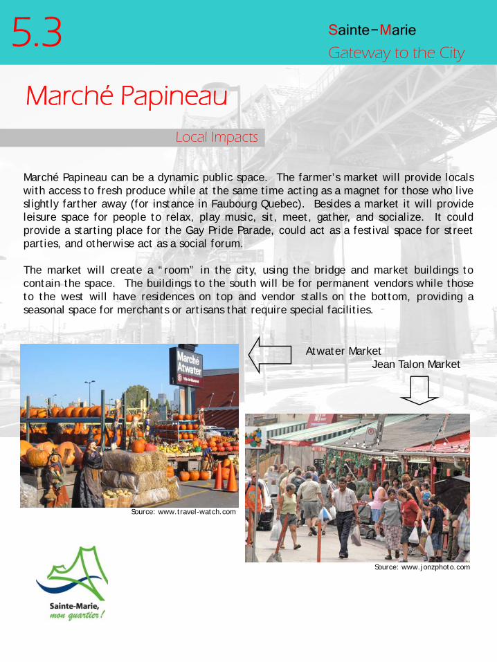
Local Impacts
Marché Papineau can be a dynamic public space. The farmer’s market will provide localswith access to fresh produce while at the same time acting as a magnet for those who liveslightly farther away (for instance in Faubourg Quebec). Besides a market it will provideleisure space for people to relax, play music, sit, meet, gather, and socialize. It couldprovide a starting place for the Gay Pride Parade, could act as a festival space for streetparties, and otherwise act as a social forum.
The market will create a “room” in the city, using the bridge and market buildings tocontain the space. The buildings to the south will be for permanent vendors while thoseto the west will have residences on top and vendor stalls on the bottom, providing aseasonal space for merchants or artisans that require special facilities.
Marché Papineau
Source: www.jonzphoto.com
Atwater MarketJean Talon Market
Source: www.travel-watch.com

Sainte-MarieGateway to the City
6.0ConclusionBy implementing the designs we have proposed it is possible to give a new lease on life
to the Sainte-Marie district. Beyond stimulating the local economy, providing dwellings
for people, and improving the landscape within the area our proposal will ensure that
Sainte-Marie is marked as one of the newest, most promising districts on the island. By
using the Jacques Cartier Bridge as a backdrop to frame the entrance to the CBD, and by
creating a space of representation around it we believe that Montrealers and visitors
alike will have a better appreciation for the city, will be able to visualize it in more
symbolic terms and thus have easier access to it in their mental repetoir. Saint Jacques
will become the symbolic and cultural home to the gay population while Sainte Marie,
currently under represented, will mature as a neighbourhood, spurred on by the
development in its borders, making it really the gateway to the city.

Sainte-MarieGateway to the City
7.0References
Excellent Europe, www.excellenteurope.com
Jonzfoto, www.jonzphoto.com
Navigateur Urbain, www.navurb.com
Travel Watch, www.travel-watch.com
Ville de Montreal, http://ville.montreal.qc.ca
Wikipedia, www.wikipedia.com
Websites
Piccolo, Andre. Construction cost estimates. (Received as class e-mail)