Saint Lucia Natural Resources and Agricultural …Saint Lucia Natural Resources and Agricultural...
235
Saint Lucia Natural Resources and Agricultural Development Project - Studies and Proposals for the Implementation of a Land Registration Programme Table of Contents Executive Secretariat for Economic and Social Affairs Department of Regional Development GENERAL SECRETARIAT OF THE ORGANIZATION OF AMERICAN STATES DEPARTMENT OF REGIONAL DEVELOPMENT EXECUTIVE SECRETARIAT FOR ECONOMIC AND SOCIAL AFFAIRS Washington, D.C. 1986 Table of Contents Preface Glossary of acronyms Equivalencies Table of Contents http://www.oas.org/usde/publications/Unit/oea36e/begin.htm (1 of 7) [4/12/2000 12:04:24 PM]
Transcript of Saint Lucia Natural Resources and Agricultural …Saint Lucia Natural Resources and Agricultural...

Saint Lucia Natural Resources andAgricultural Development Project -Studies and Proposals for theImplementation of a Land RegistrationProgramme
Table of Contents
Executive Secretariat for Economic and Social Affairs
Department of Regional Development
GENERAL SECRETARIAT OF THE ORGANIZATION OF AMERICAN STATES
DEPARTMENT OF REGIONAL DEVELOPMENT EXECUTIVE SECRETARIAT FOR ECONOMICAND SOCIAL AFFAIRS
Washington, D.C. 1986
Table of Contents
Preface
Glossary of acronyms
Equivalencies
Table of Contents
http://www.oas.org/usde/publications/Unit/oea36e/begin.htm (1 of 7) [4/12/2000 12:04:24 PM]

Executive summary
Introduction
Chapter 1. Basic characteristics of rural settlement
1.1. General background
1.1.1. Population and economy1.1.2. Inherited characteristics of the rural sector
1.2. The distribution of population and land
1.2.1. Population distribution1.2.2. The distribution of agricultural land1.2.3. Spatial differentiation of population and land distribution
1.3. Human settlements in rural Saint Lucia
1.3.1. Criteria for the typification of human settlements1.3.2. Types of settlements
Chapter 2. Land tenure and distribution as constraints on agricultural development
2.1. Land tenure
2.1.1. Land ownership and rental2.1.2. Ownership and operation of the agricultural holdings2.1.3. Family lands
2.2. Land distribution
2.2.1. Holding size categories2.2.2. Fragmentation and centralization2.2.3. Characterizing the land distribution problem2.2.4. The landless population
2.3. Land use and technology
2.3.1. Uses of agricultural land2.3.2. Intensity of land use2.3.3. Land use and family land2.3.4. Land utilization2.3.5. The function of production
Chapter 3. Legal and institutional framework for natural resources conservation and development
3.1. Legal background of land development control and regulation
Table of Contents
http://www.oas.org/usde/publications/Unit/oea36e/begin.htm (2 of 7) [4/12/2000 12:04:24 PM]

3.1.1. Land ownership and registration3.1.2. Land use control and regulation
3.2. Legal background of natural resources conservation and development
3.2.1. Forest protection3.2.2. Beach protection3.2.3. Wildlife protection and areas of natural and historic interest3.2.4. Natural resources use
3.3. Institutional structures for natural resources conservation and development
3.3.1. Institutional development and coverage of issues of natural resourcesdevelopment3.3.2. Institutional coordination on natural resources conservation anddevelopment3.3.3. Manpower resources for natural resources conservation and development3.3.4. Recent trends in institutional development
Chapter 4. Dynamics of the land problem
4.1. Recent land development trends
4.1.1. The dynamics of land distribution4.1.2. Proposals and actions concerning land tenure4.1.3. General proposals for land redistribution
4.2. Specific land development projects
4.2.1. Roseau smallholder resettlement scheme4.2.2. Dennery Farmco4.2.3. Private redistribution of land: Marquis estate4.2.4. Integrated rural development: Fond Assor4.2.5. Evaluation of proposals for change
Chapter 5. Alternative approaches to land transformation
5.1. Alternative solutions to land tenure problems
5.1.1. Multiple ownership and fragmentation5.1.2. Insecure forms of tenure5.1.3. Inefficient system for the registration of ownership
5.2. Alternatives for land redistribution
5.2.1. Basic objectives and options
Table of Contents
http://www.oas.org/usde/publications/Unit/oea36e/begin.htm (3 of 7) [4/12/2000 12:04:24 PM]

5.2.2. Indirect intervention5.2.3. Limited direct interventions5.2.4. Comprehensive direct interventions5.2.5. Broad policy options
Chapter 6. Short-term strategy for land redistribution
6.1. Basic characteristics of the strategy
6.1.1. Objective of the strategy6.1.2. Structure of the strategy
6.2. Intervention at the national level
6.2.1. Land taxation6.2.2. Financial instruments6.2.3. Regulation of land development
6.3. Intervention at the local level
6.3.1. Reconsolidation of small holdings6.3.2. Redistribution of land6.3.3. Expansion of the rural frontier6.3.4. Coordination with other agricultural development activities
Chapter 7. Guidelines for legal and institutional change in matters related to agricultural landdevelopment
7.1. Required actions and general principles
7.1.1. Required actions7.1.2. General principles
7.2. Legal developments
7.2.1. Management of natural resources7.2.2. Land registration7.2.3. Land redistribution
7.3. Institutional development
7.3.1. Management of natural resources7.3.2. Land registration7.3.3. Land redistribution
Chapter 8. Pilot project on land registration: Morne panache
8.1. Project overview
Table of Contents
http://www.oas.org/usde/publications/Unit/oea36e/begin.htm (4 of 7) [4/12/2000 12:04:24 PM]

8.1.1. Objectives8.1.2. Selection of the project area8.1.3. Main components of the pilot project
8.2. Characteristics of the pilot project
8.2.1. Land tenure and distribution8.2.2. Present land use8.2.3. Potential land use
8.3. Cadastral survey and land adjudication
8.3.1. Title registration8.3.2. Essential procedures8.3.3. Cadastral survey8.3.4. Cadastral survey methodology
8.4. Research on land redistribution needs
8.4.1. Evaluation of the land registration experience8.4.2. Analysis of land distribution problems8.4.3. Institutional framework for project implementation
8.5. Financial analysis and assessment of farming systems
8.5.1. Project costs8.5.2. Assessment of farming systems
Annex A. Land resources
SummaryA.1. Factors affecting soil formation
A.1.1. Geology and lithologyA.1.2. ClimateA.1.3. ReliefA.1.4. Soil characteristics
A.2. Characteristics of the vegetation
A.2.1. Ecological classificationA.2.2. Methodology used in the classificationA.2.3. Description of life zones
A.3. Land capability classes
A.3.1. Definition of land capabilities
Table of Contents
http://www.oas.org/usde/publications/Unit/oea36e/begin.htm (5 of 7) [4/12/2000 12:04:24 PM]

A.3.2. Characteristics of the land classesA.3.3. Land availability by capability classes
A.4. Environmental management of land resources
A.4.1. Environmental considerations for management of agricultural naturalresourcesA.4.2. Characteristics of soil erosionA.4.3. Principles of land resource managementA.4.4. Recommendations for land resource management
A.5. Land capability in selected watersheds
A.5.1. Marquis River basinA.5.2. Roseau River basinA.5.3. Vieux Fort River basinA.5.4. Canelles River basinA.5.5. Troumasse River basinA.5.6. Fond d'Or River basinA.5.7. Cul de Sac River basin
Annex B. Water resources
SummaryB.1. General background
B.1.1. Objectives of the studyB.1.2. Evaluation of basic information
B.2. Rainfall patternsB.3. Available flows at river basin levelB.4. Demand at the river basin levelB.5. Development potential at the river basin level
B.5.1. Marquis River basinB.5.2. Roseau River basinB.5.3. Vieux Fort River basinB.5.4. Canelles River basinB.5.5. Troumasse River basinB.5.6. Fond d'Or River basinB.5.7. Cul de Sac River basin
Annex C. Environmental prospective
C.1. Objectives and strategy for environmental planning
Table of Contents
http://www.oas.org/usde/publications/Unit/oea36e/begin.htm (6 of 7) [4/12/2000 12:04:24 PM]

C.1.1. Protection of mangroves and coastal ecosystems (Objective 1)C.1.2. Linkage with the Ministry of Agriculture (Objective 2)C.1.3. Strategy for environmental planning
C.2. Methodology for determining environmental units
C.2.1. Inventory of physical resourcesC.2.2. Quantification of ecological processesC.2.3. Definition of environmental units
C.3. Procedure for determining environmental impactC.4. Environmental assessment of Marigot Bay
C.4.1. BackgroundC.4.2. Development proposalsC.4.3. Physical environmentC.4.4. DevelopmentC.4.5. Analysis for environmental managementC.4.6. AlternativesC.4.7. An outline of the OAS Tourism Planning Seminar
References
Annex D. Population and land distribution in Saint Lucia: Basic information
Annex E. Characteristics of landholding patterns in Saint Lucia: Basic information
Annex F. List of technical reports on Saint Lucia prepared by OAS staff, GOSL technicians andconsultants
The Organization of American States
Table of Contents
http://www.oas.org/usde/publications/Unit/oea36e/begin.htm (7 of 7) [4/12/2000 12:04:24 PM]

PrefaceThe unique land tenure problems inherited by Saint Lucia have represented a major constraint for thedevelopment of the agricultural sector. They are one of the most important factors preventing the farmingcommunity from diversifying production and increasing productivity. Conscious of the complexity of theproblem, and cognizant of the far-reaching social and economic impact that possible solutions couldhave, the Government of Saint Lucia requested technical cooperation from the Organization of AmericanStates. This cooperation had two objectives: to undertake the studies required to design feasible technicalalternatives and to identify complementary actions capable of taking full advantage of the solution ofland tenure problems.
The present report synthesizes the technical studies undertaken during 1981 by a team of national andinternational specialists working with the Ministry of Agriculture. This work led to the identification,design and evaluation of a pilot project on land registration, the objective of which was to test thefeasibility of the technical solutions proposed for the establishment of a land cadaster and the granting ofland titles. The pilot project was also designed to enlarge existing knowledge of the multiple constraintsaffecting the development of the small farming community in Saint Lucia and to investigate the extent ofthe existing land tenure problems in a fairly representative community. The results obtained from theimplementation of the pilot project in 1982-1983 were used in the design of an eight year nation-wideLand Registration and Titling Project to be implemented with financing provided by the United StatesAgency for International Development (USAID) between 1984 and 1992.
In researching the land tenure problems of Saint Lucia many valuable insights were obtained concerningthe natural resource base of the country and the development potential of the agricultural sector. Thesestudies have a value that goes beyond their usefulness for the design and evaluation of solutions to theland tenure problems: they constitute a source of information for policy makers and techniciansconcerned with other areas of the development effort. Although dated with respect to certainsocio-economic factor, the studies contain valuable information on the natural resource base of thecountry and the many structural characteristics of Saint Lucian society. In consideration of this, theDepartment of Regional Development is publishing a limited number of the present report, whichcontains the initial studies of an ongoing technical cooperation project.
As such, the contents of this publication are neither self-contained nor are its specific conclusions final.Rather, they represent the clarification of an important step in the understanding of the developmentproblems of one of the new member states of the Organization. In this effort, the technical staff of theGeneral Secretariat and the international consultants who worked on this project benefited from thesupport provided by Government officials, who made a substantial and original contribution to theinformation compiled for this technical cooperation effort.
The results obtained confirm the usefulness of the Department's integrated approach to developmentplanning and implementation in a small country. Carrying out these studies has given the staff of theDepartment of Regional Development the opportunity to develop a specific approach to the delivery of
Preface
http://www.oas.org/usde/publications/Unit/oea36e/ch01.htm (1 of 2) [4/12/2000 12:04:28 PM]

technical cooperation services in a nation of the English-speaking Caribbean. This experience hasprovided valuable guidance for the Department's activities in other member states with similarcharacteristics.
Kirk P. Rodgers - Director - Department of Regional Development
Saint Lucia - Location of Saint Lucia
Saint Lucia - General Reference
Preface
http://www.oas.org/usde/publications/Unit/oea36e/ch01.htm (2 of 2) [4/12/2000 12:04:28 PM]

Glossary of acronymsBAI Booker Agriculture International
CARDI Caribbean Research Development Institute
CDB Caribbean Development Bank
CDC Commonwealth Development Corporation
CFC Caribbean Food Corporation
CIDA Canadian International Development Agency
CPU Central Planning Unit
CWA Central Water Authority
EDF European Development Fund
LDA Land Development Authority
MOA Ministry of Agriculture
NDC National Development Corporation
OAS Organization of American States
SLLRC Saint Lucia Land Reform Commission
SLMF Saint Lucia Model Farms
UNDP United Nations Development Programme
WINBAN Windward Islands Banana Growers Association
Glossary of acronyms
http://www.oas.org/usde/publications/Unit/oea36e/ch02.htm [4/12/2000 12:04:28 PM]

http://www.oas.org/usde/publications/Unit/oea36e/pv.GIF
http://www.oas.org/usde/publications/Unit/oea36e/pv.GIF [4/12/2000 12:04:29 PM]

http://www.oas.org/usde/publications/Unit/oea36e/pvii.GIF
http://www.oas.org/usde/publications/Unit/oea36e/pvii.GIF (1 of 2) [4/12/2000 12:04:30 PM]

http://www.oas.org/usde/publications/Unit/oea36e/pvii.GIF
http://www.oas.org/usde/publications/Unit/oea36e/pvii.GIF (2 of 2) [4/12/2000 12:04:30 PM]

EquivalenciesCURRENCY EQUIVALENTS
Since 1976:
Currency Unit = East Caribbean dollarEC$ 1.00 = US$ 0.370US$ 1.00 = EC$ 2.68
WEIGHTS AND MEASURES
Kilometer = 0.62 mileSquare kilometer (km2) = 0.386 square mileHectare (ha) = 2.47 acresMeter (m) = 39.37 inches
Equivalencies
http://www.oas.org/usde/publications/Unit/oea36e/ch03.htm [4/12/2000 12:04:30 PM]

Executive summaryThis document is a synthesis of the studies carried out in Saint Lucia as part of the Natural Resources andAgricultural Development Project. The Project was the result of a technical cooperation agreementbetween the Government of Saint Lucia and the Secretariat for Economic and Social Affairs of theGeneral Secretariat of the Organization of American States. Project activities were jointly executed bythe Department of Regional Development of the OAS and the Ministry of Agriculture of the Governmentof Saint Lucia. The studies were undertaken between February 1981 and February 1982 by a team oftechnicians based in Castries and consisting of personnel of the Ministry of Agriculture and staff andconsultants of the OAS.
The Project was designed to assist the Government in the implementation of the Land RegistrationProgramme and to find solutions to land tenure problems adversely affecting agricultural development.Furthermore, the Government was provided with information and advice regarding policy options for thetransformation of the inherited and concentrated land ownership pattern. Finally, the Project included thedesign of a Pilot Project on Land Registration in a selected rural settlement to help initiate the LandRegistration Programme and to facilitate field research on land shortages currently being faced by smallfarmers in Saint Lucia.
To supply the Government of Saint Lucia with the studies requested, Project activities were concentratedon (1) evaluation of natural resources and recommendations on environmental management; (2) analysisof land-related constraints affecting agricultural development in the rural settlements of Saint Lucia; (3)identification of alternative land transformation policies; and (4) design of a pilot project on landregistration. Twenty-one technical reports were prepared by OAS experts and consultants and nationalspecialists as a result of these efforts (see Annex F). The information gathered during the Projectprovided the basis for the preparation of a Development Atlas of Saint Lucia.1
1 The maps contained in the Atlas are: Geology, Water Resources, Land Capability, LifeZones, Land Use and Human Settlements, and Land Tenure.
The eight chapters in the present document deal with the main topics researched by the projects and therecommendations made to the Government. They are supported by six technical annexes containing thedetailed information upon which specific conclusions and recommendations are based.
Chapter One: Characteristics of the Rural Settlements in Saint Lucia
Saint Lucia is basically a village society, with settlements clustered around Castries and along the coast.Urban/rural distinctions are difficult to define. A population of 118 900 inhabitants was recorded in1980, representing an annual growth rate of 1.59 percent during the 1970-80 decade. Agriculture is themajor productive sector; 40 percent of the population was employed in this sector in 1970; 60 percent ofexports were agricultural of which 80 percent were bananas. Saint Lucia has a monoculture economy tiedto export agriculture and dependent on preferential access to the United Kingdom market. Transport anddistribution of exports is organized through an agreement between the Windward Islands and Geest
Executive summary
http://www.oas.org/usde/publications/Unit/oea36e/ch04.htm (1 of 6) [4/12/2000 12:04:32 PM]

Industries, a diversified multinational corporation.
A combination of factors related to population distribution, land tenure, land distribution and land useallows the identification of five different types of rural settlements: urban areas; very poor small farmingcommunities settled on areas of low agricultural productivity; settlements fully engaged in the productionof export crops in small farms of over five acres located in areas of high agricultural productivity; smallfarming communities (farms predominantly of less than five acres) engaged in the production of exportstaples; and rural settlements highly dependent on urban sources of income.
Chapter Two: Land Tenure and Distribution as Constraints to Agricultural Development
An examination of land tenure and distribution provides definition of the structure of production andpower in the rural sector. Man/land relations, characterized in Chapter 2, show the extent to which theserelationships represent constraints to agricultural development.
In 1973/74, data of the last Agricultural Census, 70.6 percent of all landholdings were owned or held inowner-like possession; 92.6 percent of farmland was held this way. Renters accounted for 18.3 percent ofall holdings but controlled only 2.8 percent of farmland; farm rental units averaged 1.0 acre in size. Theskewed nature of land distribution is evident from the fact that more than 80 percent of the holdings inSaint Lucia (of less than five acres) control only 14 percent of all the land in farms while 1 percent of theagricultural holdings (of fifty acres or more) exercise control over almost 60 percent of the land.
The complex land tenure is further, complicated by the antiquated system of land registration, theregistration of deeds, and the succession laws that grant inheritance rights to all descendants of thedeceased. The former makes land transfer difficult, costly and risky; the latter leads to excessive landfragmentation or creates situations of ownership in common, "family lands."
The "family land" situation is considered an obstacle to development for five reasons: 1) co-ownersseldom have legal evidence of their right to ownership; 2) lack of documentation makes it difficult forowners to obtain credit; 3) investment is discouraged by the conventional right of harvest by co-ownerswhether they participate in cultivation or not; 4) since not all owners are interested in farming, some landis idle or underutilized; and 5) successive subdivision over time has fragmented the land. Advantages ofthe system are that it has served as a mechanism to avoid the excessive fragmentation implicit insuccession laws, guaranteed significant portions of the population access to land, and provides gardenplots which subsidize urban wages and wages of commercial farms workers, serving as a form of socialsecurity.
Land fragmentation is particularly severe in Castries, Canaries and Gros Islet where 50 percent or moreof holdings fall in the 0.1-4.9 acre size range. Concentration is noticeable in Gros Islet, Vieux Fort andAnse La Raye where it comprises more than 70 percent of farmland.
Land use varies according to farm size and the relation is inverse for crop land uses. The latter comprise94 percent of land use in the 0.1-0.9 acre category but drop to 42 percent of land use on farms larger than500 acres. There is a direct correlation between idle land and plot size, i.e. only 3 percent of land is idle(forest and other land) in the smallest category while nearly half is idle in the largest. The pressure onland in small plots is considered excessive because of the fact that many are hillside farms located inlands that require careful conservation.
Chapter Three: Legal and Institutional Framework for Natural Resources Conservation and Development
Executive summary
http://www.oas.org/usde/publications/Unit/oea36e/ch04.htm (2 of 6) [4/12/2000 12:04:32 PM]

The analysis of the legal and institutional framework addresses institutional capacity for naturalresources conservation and development, particularly land resources for agricultural development. Fourareas of concern have been identified.
First, the system of land registration is complicated and inefficient, making the acquisition and disposalprocess difficult for individuals. The land market is sluggish due to this problem. A system of titleregistration and the introduction of a "trust for sale" would facilitate land and credit acquisition therebyimproving the land market situation.
Second, the lack of a cadastral survey is an important information gap in the definition of ownership.This lack of information precludes land control and effective taxation. A tax system can be used as adevelopment tool to gradually reduce land ownership concentration and land underutilization.
Third, existing land use legislation concentrates primarily on control of urban land and buildingconstruction. Legislation addressing natural resources development and environmental issues isinsufficient. Misuse of land, water, mangrove forests and other natural resources has proceededunchecked.
Fourth, there are 18 institutions concerned with the development of natural resources in Saint Lucia andthese address only specific and partial aspects of broader issues. No single institution is currentlyaddressing the complex and interdependent problems of natural resource development. Institutions havevarying capabilities and competence and competing areas of interest. Existing institutional relationshipsare vertical with no horizontal linkages, limiting coordinated decision-making and action to the Cabinetlevel. Technical personnel are thinly dispersed throughout the Government resulting in the fragmentationof decision-making authority and resources, thereby reducing Government capacity to cope with pressingand complex problems of natural resource management and development. Institutional change is requiredto:
- Reduce fragmented decision making, a prerequisite to obtaining unified and consistentGovernment action to preserve and develop natural resources.
- Cope with the public sector technical problems involved in the management of naturalresources, particularly land resources.
- Reshape the existing institutional system so as to ensure a unified decision-makingstructure aided by more efficient technical support.
- Catalyze changes in the existing legislation, which could occur along with the institutionalchanges.
Chapter Four: Dynamics of the Land Problem
Recent land distribution trends are indicative of notable changes in land subdivision and ownershippatterns. Land acquired by private individuals and the Government from large estate owners accountedfor a modification of ownership status of almost one quarter of the lands held in large holdings in1973/74. Nearly 25 percent of all available good agricultural lands has been transferred from private togovernment ownership. A further 3400 acres have been transferred from agricultural to industrial, touristor urban use.
Subdivision accounts for 45 percent of all land transfers. Few cases of consolidation occur, probably
Executive summary
http://www.oas.org/usde/publications/Unit/oea36e/ch04.htm (3 of 6) [4/12/2000 12:04:32 PM]

because of lack of tenure definition and credit alternatives to enable such a transaction. Governmentintervention accounts for one-third of total agricultural subdivision.
Chapter Five: Alternative Approaches to Land Transformation
Recommendations made by the Land Reform Commission addressing tenure problems includemodification of existing laws, introduction of new legislation and execution of a cadastral survey of allland properties on the island. These activities are only part of a wider programme to create conditions forsmall farmers to make a meaningful contribution to the country's agricultural development. If smallfarmers are to play a successful role in agricultural development, better man/land relationships will haveto be fustened and this can be accomplished through programs which will ensure that this group offarmers receives technological inputs of appropriate scales to satisfy its needs for production andmaintenance of infrastructure.
Alternatives considered for removal of the land-related constraints to agricultural development includeboth indirect and direct intervention by the Government. Their main implications for the case of SaintLucia are reviewed in this chapter as a basis for decision making.
Indirect interventions consist primarily of taxation and regulation:
- Progressive land tax to induce land owners either to put land into production or sell and toincrease government revenue to finance land redistribution activities.
- Financing of land purchase so as to provide credit to individuals willing to consolidatesmall holdings to purchase land.
- Loan Guarantee to facilitate land acquisition by small farmers for agricultural purposes,enlarge farms and establish a base for expanded operations.
- Regulation of sales and leases to add flexibility to the land market and prevent priceincreases.
- Regulation of subdivision to prevent excessive subdivision and conversion tononagricultural use.
Limited direct interventions involve intervention in the land distribution structure to solve resourceproblems, community conflicts over land or to take advantage of acquisition opportunities:
- Reconsolidation of holdings to solve localized problems of land scarcity within smallfarming areas.
- Redistribution of unused estate lands to give farmers access to these lands for individual orjoint operation.
Comprehensive direct interventions aimed at nationwide impact on the land distribution structure;
- Establishment of a land bank to acquire properties and resell them to small farmers therebyspeeding up the redistribution process.
- Elimination of large estates to do away with holding sizes determined to be excessivelylarge by relevant economic criteria.
Chapter Six: Short-Term Strategy for Land Redistribution
Executive summary
http://www.oas.org/usde/publications/Unit/oea36e/ch04.htm (4 of 6) [4/12/2000 12:04:32 PM]

The short-term land redistribution strategy recommended to the Government was designed to fulfill theGovernment's goal of improving agricultural productive capacity and to guarantee access to sufficientamounts of land for surplus agricultural production by full-time farmers. The aim of the strategy was thegradual transformation of the land distribution structure by provision of incentives to encourage positiveaspects of existing trends of land ownership distribution. A short-term approach is adopted by thisstrategy with direct and indirect interventions aimed at the national and/or local level.
National-level interventions include land taxation, the use of financial instruments to give small farmersaccess to land, regulation of land development to prevent inefficient use of resources and excessivesubdivision of agricultural land. Local-level interventions include consolidation of small holdings toreduce land scarcity as a constraint to small farmers, redistribution of land which is unused orunderutilized and expansion of the rural frontier by bringing marginal lands into production through theuse of innovative technology. Cadastral survey and land adjudication are the activities that trigger theprocess of land transformation the strategy is aiming to guide and speed up.
Chapter Seven: Guidelines for Legal and Institutional Change in Matters Related to Agricultural LandDevelopment
Changes in Saint Lucia's legal and institutional structures are required for natural resources management,land registration and agricultural land redistribution. These changes should: 1) develop a unifieddecision-making capability in matters related to natural resources management; 2) complete coverage ofissues of conservation and land utilization; 3) introduce long-term planning capabilities by means ofproper utilization of technical manpower; and 4) differentiate between institutional responsibilities forpolicy decisions and routine implementation.
Legislation required for natural resource management includes watershed protection, marine ecosystemprotection and protection of areas of natural and historical interest. Regulatory powers should be given toGovernment enabling it to intervene in private sector activities involving water resources, agriculturalland use, utilization of beaches and areas of natural beauty, fisheries exploitation and harbour utilization.To implement the proposed short-term strategy, legislation will have to be passed on land taxation,financial instruments, land development regulation and control of excessive subdivision. Additionally,the existing Land Acquisition Ordinance must be revised to enable expropriation by Government and toallow for more accurate land valuation.
Relatively complex institutional changes are required to effectively manage resources and satisfyconservation and regulation goals. It is recommended that a Natural Resources Authority be created andits major responsibility be long-term decision making and implementation surveillance. Formation of aTechnical Secretariat is also recommended to provide the Authority with advice on long-term planningand policy making. The creation of the Secretariat will obviate the need for establishing a ministry toexecute these tasks and will consolidate technical capabilities and identify deficiencies in the manpowersupply. Linkages of the Authority and Secretariat to existing institutions are outlined in Chapter 7, as arerecommendations for improvement of the current institutional structure.
Chapter Eight: Pilot Project on Land Registration: Morne Panache
The Pilot Project on Land Registration is designed to initiate a land titling programme and researchpractical problems involved in land distribution. The expected benefits are operations experience;
Executive summary
http://www.oas.org/usde/publications/Unit/oea36e/ch04.htm (5 of 6) [4/12/2000 12:04:32 PM]

understanding of internal farm organization of hillside farming on a variety of soil types; development offarm models and management recommendations compatible with sound economic criteria andconservation requirements; understanding of land distribution needs of small farmers and the best way ofimplementing specific projects.
The main components of the Pilot Project are; 1) survey and land adjudication; 2) research onredistribution needs; 3) reconsolidation of holdings; 4) land redistribution; 5) expansion of the ruralfrontier.
The Morne Panache farming community and adjacent lands to the east (1 300 acres total) were chosen asbeing representative of 47 percent of the settlements identified in the settlement typology (Chapter 1).
Land tenure and distribution in the area are difficult to ascertain precisely because of lack of data. The1980 Farmers Survey showed 152 holdings comprising 694 acres of the total of 1300. Nearly 80 percentare in the 1.0-9.9 acre size category with less than 8 percent below one acre. Renting and sharecroppingof small areas are common, various types of tenure are identifiable and disputes over property boundariesor land ownership are not uncommon.
Bananas are the predominant crop grown but represent a low proportion of land use (28 percent) becauseof the presence of large vacant areas. Much of the land is marginal, but the cultivable areas areintensively cultivated by smallholders. Only 10.9 percent of the land is classified as highly productive.
Cadastral survey operations will be carried out in four stages: 1) index map preparation; 2) fieldcompilation; 3) survey and adjudication (order, appointment of officers, claims and demarcation); and 4)registration. Upon completion of the survey the adjudication record will be completed and notice of itscompletion will be given with a ninety day response period allowed for grievances. The initialregistration process will then proceed and claims will be filed with the proposed Registry to beestablished in Castries. As outlined in the Land Act of 1981, the Registry will include information onland characteristics (with reference numbers to registration blocks and parcel identification maps), a fulldescription of proprietor and imposed restrictions and a statement of encumbrances (mortgages, leases,charges).
Research on land redistribution needs will focus on evaluation of the general land registrationexperience, evaluation of problems related to land shortage, reconsolidation by exchange and purchase,and expansion of the agricultural frontier. Specialized studies in agricultural economics, anthropologyand agronomy will be carried out to define procedures to ensure an appropriate and sustained use of land.This will involve analysis of farming systems and of the relationship of farm size to land tenure patterns.
The time frame for implementation of the cadastral survey is approximately four months, excluding thepreparatory community survey and community work. The Land Reform Management Unit of theMinistry of Agriculture will be responsible for implementation of the Land Registration Programme. Fullinvolvement of the Department of Lands and Surveys is contemplated for the preparation of the cadastralsurvey and associated maps. The Registrar of Lands will perform registration activities and serve as theinstitutional core of the New Registry.
Executive summary
http://www.oas.org/usde/publications/Unit/oea36e/ch04.htm (6 of 6) [4/12/2000 12:04:32 PM]

IntroductionThe sound utilization of scarce natural resources in Saint Lucia is a precondition for equitabledevelopment. The scarcity of natural resources presents a long-term constraint on the evolution of adiversified economy in a country of small territorial size heavily reliant on land and water resources andareas of scenic beauty to sustain agriculture and forestry, industry, tourism and urban development.Knowledge of resource availability must be combined with that regarding the interaction and linkages ofresources to components of the natural and man-made environment. Such knowledge is mandatory toreduce risks of damaging small and fragile island environments vulnerable to adverse impacts of humanactivity. Agriculture is of increasing social importance in Saint Lucia and is an activity with a highdegree of interaction with the natural environment. Consequently, it is essential that sound land usepatterns and agricultural practices be established and, in many areas, soil conservation measures forsustained intensive farming be undertaken.
Economic History
Saint Lucia has been unable to reach high levels of development and a diversified economic structurebecause of politico-economic circumstances. The uncertainties of the early periods of colonizationbrought about by the wars between France and England prevented the island from joining the sugar canebonanza of the seventeenth and eighteenth centuries. In fact, sugar cane did not supersede the earlyexport crops of tobacco, cotton and ginger until a century after it became the mainstay of Barbados,Antigua and other colonies. After emancipation shortages of labour and protectionist colonial practicesdiscouraged efficiency and prevented the industry from surviving the introduction of beetroot sugar inthe European markets.
The collapse of the major export crop did not lead directly to its replacement in Saint Lucia. Alternativesources of employment for the population and the presence of a large community of small farmersconcentrating on subsistence crops prevented the economic system from collapsing with the fall of themain export crop. In times of declining agricultural activity the population and economic livelihood weresupported by port activities at Castries (the chief coaling station in the West Indies), employmentgenerated by the construction of the United States army and navy bases at Vieux Fort and Gros Islet andthe reconstruction of Castries after its destruction by a fire in 1948.
When these sources of employment disappeared in the 1950s, Saint Lucia turned increasingly toagriculture as a source of income, in particular to the banana industry, which grew very rapidly at thattime. Banana exports began in the 1920s, declined in the 1930s because of Panama disease and ceasedduring the Second World War when there were no ships to carry the fruit. After the war a new start wasmade with disease-resistant bananas. The industry had its major expansion when the sugar industrycollapsed in the early 1960s, releasing the large, fertile valleys for banana cultivation. In 1965, bananasformed nearly 90 percent of the country's total exports, making Saint Lucia the first Caribbean economydependent on the monocultivation of bananas.
Introduction
http://www.oas.org/usde/publications/Unit/oea36e/ch05.htm (1 of 3) [4/12/2000 12:04:33 PM]

Development of the Agricultural Sector
Despite significant expansions of the manufacturing and tourism sectors, agriculture remains the mostimportant economic sector in Saint Lucia. In 1978 the sector accounted for 27 percent of the GrossDomestic Product at market prices and for 50 percent of total exports, employing about 40 percent of thecountry's labour force. Recently, production has dropped, affecting both exports and foods tuffs. Themajor reasons for the decline are the antiquated land tenure system, the skewed distribution of landresources, the poorly organised marketing systems for domestic agriculture, the lack of adequate creditfacilities, and the inadequately developed agricultural services.
In defining a solution to land tenure problems, well planned, long-term actions are required to replace theexisting inefficient system of registration of rights to the land with a modern system of title registrationand a cadastre, in addition to other legislative changes to protect tenants and to avoid excessivesubdivision of lands. A set of more complex and long-term actions will be required to modify the highlyconcentrated pattern of land ownership that the country inherited and that is preventing the developmentof a more diversified, efficient and egalitarian agriculture. These actions need to be planned andimplemented within the broad framework of other developmental actions, and consideration must begiven to the pressing need to protect the environment and preserve renewable natural resources.
Objectives of the Report
Environmental management, the rational utilisation of the environment for egalitarian socioeconomicdevelopment, has been used as the general framework for defining planning actions aimed at removingland-related constraints to agricultural development. As a government activity, environmentalmanagement should reconcile short-term demands for the utilisation of natural resources with long-termconservation needs. This process inevitably introduces changes in the socioeconomic structure thatultimately defines natural resource utilisation in a country.
Within this general framework, the information from studies summarized in this report was collectedwith the following objectives in mind:
a) To make a preliminary prospectus of natural resource availability (particularly land andwater) and of the conservation measures required for their rational utilisation in thedevelopment of agriculture.
b) To analyze information concerning the constraints affecting agricultural development inSaint Lucia. To study the role of the existing land tenure and the skewed distribution of landresources in the development of agriculture in the different types of rural settlements in thecountry.
c) To identify alternative approaches to solving land distribution problems in order to devisea policy on land redistribution and identify a pilot project on land registration to initiate thesolution of the problems of land tenure.
Organization of the Report
The first three chapters of this report provide an overview of existing conditions in Saint Lucia related tobasic characteristics of rural settlements (Chapter 1); land tenure distribution and patterns and theconstraints to agricultural development they present (Chapter 2); and the effectiveness of legalmechanisms and the technical capacity and interaction of institutions (Chapter 3).
Introduction
http://www.oas.org/usde/publications/Unit/oea36e/ch05.htm (2 of 3) [4/12/2000 12:04:33 PM]
An analysis of constraints on and opportunities for land management, based upon observations ofresettlement projects or activities of estate lands, appears in Chapter 4. The following three chapters aredevoted to the presentation of alternative approaches to solving problems of land transformation (Chapter5); definition of a short-term strategy for land redistribution (Chapter 6); and, recommendations for legaland institutional change (Chapter 7). Chapter 8 is an outline of a pilot project in Morne Panache andincludes an implementation process for land transformation.
The extensive analyses of land and water resources which served as references in several sections of themain report are included as Annex A - Land Resources and Annex B - Water Resources. Annex C -Environmental Prospective, is a basis for those parts of the report in which recommendations are madeconcerning the rational utilization of natural resources as an integral part of agricultural development.Other annexes include, Annex D - Population and Land Distribution: Basic Information; Annex E -Characteristics of Landholding Patterns in Saint Lucia; Basic Information; and Annex F - List oftechnical reports prepared by OAS staff, Government of Saint Lucia, technicians and consultants. Therecommendations found in the latter were the basis for the report which follows.
Introduction
http://www.oas.org/usde/publications/Unit/oea36e/ch05.htm (3 of 3) [4/12/2000 12:04:33 PM]

Chapter 1. Basic characteristics of ruralsettlement
1.1. General background1.2. The distribution of population and land1.3. Human settlements in rural Saint Lucia
1.1. General background
1.1.1. Population and economy1.1.2. Inherited characteristics of the rural sector
1.1.1. Population and economy
In 1980 Saint Lucia had 118 961 inhabitants, over 12 000 more than in 1970. The population increased atan average rate of 1.59 percent annually between 1970 and 1980, representing a decline from the previous1.91 percent average yearly growth experienced between 1960 and 1970. Table 1-1 shows populationgrowth from 1843 to 1980.
Saint Lucia is fundamentally a village society, with farm families living in urban centres and walking totheir land daily. A large part of the rural population is within daily commuting distance of Castries orVieux Fort, the two major centers of urban employment. Rural women market their food crops in theurban centers. In turn, urban families have rural family land which provides them with part of their foodrequirements.
As in most small ex-colonial countries, the Saint Lucian economy has been traditionally tied to exportagriculture and dependent on external supplies and markets. Sugar cane production was the predominantactivity until the mid-1950's, with export bananas becoming the new monoculture from the late 1950's tothe present. Recently attempts have been made to diversify the economy, with emphasis on tourism andindustry. The country's independence in 1979 gave impetus to a desire for diversification of agricultureand the economy as a whole.
Despite a tourism boom during the 1970's, agriculture continues to be the major productive sector.Industrial activity is rudimentary and narrowly based. In 1978 agriculture provided 60 percent of allexports and re-exports, roughly 80 percent of which consisted of bananas. According to the 1970
Chapter 1. Basic characteristics of rural settlement
http://www.oas.org/usde/publications/Unit/oea36e/ch06.htm (1 of 17) [4/12/2000 12:04:38 PM]

population census, agriculture employed 40 percent of the labour force. While this percentage may besmaller today, many urban jobs are still directly or indirectly linked to agriculture.
1.1.2. Inherited characteristics of the rural sector
The transformation from sugar cane to banana production allowed more smallholders to produce the majorcrop but preserved the essential structure of dependency. The preferential access of Windward Islandsbananas to the United Kingdom market and the monopolistic role of Geest Industries as a large producerand sole purchaser and distributor of the crop generates a situation of high vulnerability for Saint Lucia'smajor agricultural product. Stability of demand is based on preferential treatment, and distribution isdependent on one large multinational with various commercial interests.
TABLE 1-1. POPULATION GROWTH, 1843-1980
Census year Total population (000) Population growth (000) Average annual growth (%)
1843 20.7 - -
1851 24.2 3.5 1.88
1861 26.7 2.5 1.33
1871 31.6 4.9 1.83
1881 38.6 7.0 2.15
1891 42.2 3.6 0.93
1901 49.9 7.7 1.82
1911 48.6 -1.3 0.26
1921 51.5 2.9 0.60
1946 70.1 18.6 1.44
1960 86.1 16.0 1.52
1970 101.5 15.4 1.91
1980 118.9 17.4 1.59
Source: Shurcliff, Alice W., and John F. Wellemayer, Economic Development in the EasternCaribbean Island, St. Lucia, Series No. 4 ISER University of West Indies March, 1967.Population Census 1970 and 1980.
Recent attempts at diversification of agricultural production have had little success. Bananas provide arelatively attractive monthly income that few other crops can match. Attempts to expand other sectors,such as tourism, have aggravated the negative trade balance. The lack of internal investment capital hasgreatly restricted government options for diversification in all sectors.
The legal system inherited from the colonial powers has greatly affected the tenure pattern of the ruralsector. The succession and land laws in Saint Lucia are based on the French system. Under the existingsuccession laws, all heirs participate in the property rights of the deceased, and this often results inprogressive fragmentation of landholdings. Deeds to land are vague and often landholders do not possessdocuments, inviting abuse by powerful landholders and protected litigation in the courts. Under theseconditions, many farmers are unwilling to invest in the land they work.
Chapter 1. Basic characteristics of rural settlement
http://www.oas.org/usde/publications/Unit/oea36e/ch06.htm (2 of 17) [4/12/2000 12:04:38 PM]

Large landholders have traditionally been the favoured producer group, deriving their power from theoriginal distribution of land in large tracts. The productive alluvial valleys and surrounding lands areowned by this group, forcing small farmers to locate on the more remote hillsides. The estate owner istypically a part-time farmer, dividing his energies between rural and urban businesses. Their nonfarmactivities range from commerce and industry to tourism and trade. They may include investments outsideof Saint Lucia so as to reduce the risks of unexpected political decisions. These entrepreneurs obviouslydo not limit their instruments to the rural sector, and will transfer resources to other activities, dependingupon the prospects of each of them. The observed tendency today of subdividing the large estate so as tofree capital for other activities reflects a rationale of diversification on the part of the entrepreneur. Thiscolonial legacy and its more recent manifestations have resulted in a backward rural sector in Saint Lucia,still at the cutlass stage on small holdings and well below the theoretical potential on the large valleyestates.
1.2. The distribution of population and land
1.2.1. Population distribution1.2.2. The distribution of agricultural land1.2.3. Spatial differentiation of population and land distribution
1.2.1. Population distribution
Despite major drops in mortality and sustained high birth rates, population growth has been slow becauseof emigration. Population increase has differential effects on rural and urban areas; even between villagesdifferences in demographic dynamics can be found.
The tradition of population clustering in coastal villages has changed. The 1980 Population Census revealsthat the coastal towns and villages of Vieux Fort, Laborie, Canaries, Choiseul, Arise la Raye, and Denneryall experienced population decline during the past decade.1 This is most likely a response to an improvedroad network throughout the island, the availability of regular inland transportation and the existence ofopportunities in other parts of the island.
1 Government of Saint Lucia, "Population Census, 1980," Preliminary Counts, Castries 1981,(mimeo).
As Table 1-2 indicates, the island's 10 quarters show variable population increase, with six growing at arate below the national average and four above that rate. This contrasts with the period 1960 to 1970,when, with a higher growth rate for the country as a whole, only the Quarters of Anse la Raye andCanaries recorded overall declines in population. The percentage of the population living in the Quarter ofCastries declined between 1970 and 1980. This Quarter grew at an annual rate of only 0.57 percent, anincrease significantly below the national average. Gros Islet (overspill of Castries) and Vieux Fort bothexperienced a growth rate that indicates that new construction, tourism, and industrial expansion haveattracted people to these areas. The Quarters of Gros Islet, Vieux Fort, and Micoud are all gaining inpopulation relative to the rest of the island but only in Micoud this growth is agriculturally based. Therural sections of Laborie, Dennery, Anse La Raye and Canaries show modest increase in population
Chapter 1. Basic characteristics of rural settlement
http://www.oas.org/usde/publications/Unit/oea36e/ch06.htm (3 of 17) [4/12/2000 12:04:38 PM]

which, in the absence of further corroborative data, suggest some measure of stability or limited growth inthe agricultural economy of these areas. Map 1-1 shows population distribution by quarter and Map 1-2the increase or decrease in rural population, by quarter.
1.2.2. The distribution of agricultural land
The land distribution pattern revealed in the 1973/74 Agricultural Census is characterized by theconcentration of land resources in few holdings and by the existence of a large number of extremely smallholdings.2 Nine holdings of 500 acres and over (0.2 percent of total holdings) control 26 902 acres (37.4percent of total land in holdings). At the other extreme, 4730 holdings of less than 1 acre each (45.3percent of the total) control only 1 733 acres (2.4 percent of the land in holdings). In broad terms, largeholdings (50 acres and over), representing 1.2 percent of the total number of holdings, control 42 034acres, or 58.5 percent of the total land in holdings. Medium-size holdings (between 10 to 50 acres) are notimportant either in terms of their number (674 holdings, only 6.5 percent of the total number of holdings)or in terms of the land they control (12 695 acres, 17.6 percent of the total land in holdings).3 Smallholdings (0.1 acre to 10 acres) are the most important group in terms of numbers, as there were 9 640holdings or 92.4 percent of the total number of holdings in 1973/74 (10 436), but they control only 17 272acres or 24.0 percent of the total land in holdings (72 001 acres). (See Annex E, Tables E-1 and E-2.)
2 Government of Saint Lucia, "Agricultural Census 1973/74," Ministry of Agriculture,Castries 1975.
3 As of 1982 the contribution of large holdings to the concentration of ownership has changedsignificantly due to subdivision through sales to individuals and transfer to Government ofsome large estates (Chapter 4). An accurate presentation can only be provided through a newagricultural census.
TABLE 1-2. DISTRIBUTION OF HOUSEHOLD POPULATION IN URBAN AND RURALAREAS, 1960, 1970, 1980
Source: Technical Supplement to the Draft Advisory Nation Physical Development Plan for Saint Lucia,UNDP: 1975
Map 1-1. Saint Lucia - Distribution of Household Population by Quarter, 1980
Chapter 1. Basic characteristics of rural settlement
http://www.oas.org/usde/publications/Unit/oea36e/ch06.htm (4 of 17) [4/12/2000 12:04:38 PM]

Chapter 1. Basic characteristics of rural settlement
http://www.oas.org/usde/publications/Unit/oea36e/ch06.htm (5 of 17) [4/12/2000 12:04:38 PM]

Source: Table 1-2. Distribution of Population in Urban and Rural Areas, 1960, 1970, 1980
Map 1-2. Saint Lucia - Distribution in Household Population by Quarter, 1970/80
Chapter 1. Basic characteristics of rural settlement
http://www.oas.org/usde/publications/Unit/oea36e/ch06.htm (6 of 17) [4/12/2000 12:04:38 PM]

Source: Table 1-2, Distribution of Household Population in Urban and Rural Areas, 1960,1970, 1980
Concentration of ownership is only significant within the group of large holdings, particularly in thecategory of 500 acres and over, where nine holders had more than one estate in 1974. The largest amountof land held by one owner is 2760 acres in eight holdings, owned by one company. The smallest is 500
Chapter 1. Basic characteristics of rural settlement
http://www.oas.org/usde/publications/Unit/oea36e/ch06.htm (7 of 17) [4/12/2000 12:04:38 PM]

acres in two holdings. Holders of more than one property controlled 12 378 acres or 17.2 percent of totalland in holdings in 1973/74. In 1974, foreign ownership of land in Saint Lucia affected 30 estates, a totalof 23 889 acres (26.9 percent of the total land in holdings).4 Of this total, 83.7 percent was in holdings ofover 500 acres (36.4 percent of total holdings in this category in the hands of foreigners) whereas thelarger number of holdings was in the 100 to 500 acres size group, controlling only 15.1 percent of the landin the hands of foreigners.
4 United Nations Pood and Agriculture Organization, Land Tenure in Saint Lucia; Findingsand Recommendations, Rome, 1975.
1.2.3. Spatial differentiation of population and land distribution
By analysing available information, it is possible to identify subnational differences in populationstructure and their relationship to the distribution of land resources which are important in characterizingthe structure of human settlement on the island.5
5 Any attempt to analyse the structure of the Saint Lucian population in spatial terms on thebasis of existing information is beset by difficulties. The spatial units for which data havebeen compiled by different departments of Government, and for particular purposes, do notalways correspond with each other.
Census data for 1970 are available by groups of enumeration districts in each quarter of the island, thoughthe quarters themselves are defined differently for the Census than they are for purposes of administration.
Data for the Agricultural Census of 1973/74, on the other hand, are available only by quarters. It istherefore not possible to show variations in patterns between subregions below the level of the quarter forthe data.
The ratio of land to farm population for each quarter suggests that pressure on farmland is relatively moreacute in the Quarters of Choiseul, Castries and Canaries than in Micoud and Gros Islet (Table 1-3). Thearid conditions of the Choiseul area and its overworked and eroded soils further compound man/landpressure in that region. The distribution of farm population is shown in Map 1-3.
It is useful to compare the gross ratios presented in Table 1-3 with the percentage of farm holdings of lessthan one acre for each quarter of the island (Table 1-4). For the island as a whole 43.2 percent of holdingsare below one acre (Map 1-4 shows the percentage of such holdings by quarter). The quarters which havean even greater percentage than the national average of holdings of this minimal size are Castries, Anse LaRaye, Canaries, Choiseul and Gros Islet. Tables 1-3 and 1-4 suggest the same conclusions about quartersthat have acute pressure on available land resources. Both Anse La Raye and Gros Islet have a highpercentage of holdings below one acre and higher than average ratio of land per person. This suggests amore inequitable distribution of farmland in these two quarters than elsewhere, although these quarterscombined have only 16.5 percent of the holdings of less than one acre nationally and 14.2 percent of thetotal farm population. A further indication of differences in resource limitations between one subregion ofthe island and the next may be gleaned by looking at the age structure of the population within eachquarter (see Annex D, Table D-1).6 The percentage of the population in the 15-44 age group is higher inthe villages and towns than in the more rural areas. In some districts, notably Choiseul, the contrast isstriking. The presence of lower-than-average percentages in the critical segment of the working populationsuggests a depletion due to emigration. The areas most affected by out-migration of the productive labourforce include the villages of Anse La Raye and Dennery. The rural areas of Canaries, Vieux Fort and Gros
Chapter 1. Basic characteristics of rural settlement
http://www.oas.org/usde/publications/Unit/oea36e/ch06.htm (8 of 17) [4/12/2000 12:04:38 PM]

Islet, on the other hand, attract people from other parts of the island hopeful of finding jobs in tourism,industry and commerce. The working population (15-44) of Micoud shows a pattern very close to thenational average in both the rural and urban sectors. This indicates the relative lack of population pressureon the available resources in this region relative to other parts of the island.
6 In the tabulations in Annex D, the main village and its environs in each quarter is indicatedby the number 1 in each case except for Castries where the respective numbers are 1-4. Theother numbers listed for each quarter indicate rural areas.
TABLE 1-3. RATIO OF LAND TO FARM POPULATION BY QUARTER, 1973/74
Quarter Farm Population Percentageof total farmpopulation
Totalacreage in
farms
Percentage of totalacreage in farms
Ratio(acres per
person)
Castries 12 548 24.0 10 659 14.8 0.85
Anse La Raye 2 566 4.9 5 796 8.0 2.26
Canaries 2 374 4.5 2 248 3.1 0.94
Soufriere 4 522 8.6 6 953 9.7 1.54
Choiseul 4 584 8.8 2 016 2.8 0.45
Laborie 3 886 7.4 5 832 8.1 1.50
Vieux Fort 4 324 8.3 4 692 6.5 1.08
Micoud 3 670 7.0 11 301 15.7 3.08
Dennery 8 935 17.2 10 552 14.7 1.18
Gros Islet 4 874 9.3 11 952 16.6 2.45
TOTAL 52 283 100.0 72 001 100.0
Source: Government of Saint Lucia, Ministry of Agriculture, Agricultural Census 1973/74.
Map 1-3. Saint Lucia - Distribution of Farm Population by Quarter, 1973/74
Chapter 1. Basic characteristics of rural settlement
http://www.oas.org/usde/publications/Unit/oea36e/ch06.htm (9 of 17) [4/12/2000 12:04:38 PM]

Chapter 1. Basic characteristics of rural settlement
http://www.oas.org/usde/publications/Unit/oea36e/ch06.htm (10 of 17) [4/12/2000 12:04:38 PM]

Source: Table 1-3. Ratio of Land to Farm Population by Quarter, 1973/74
TABLE 1-4. HOLDINGS UNDER ONE ACRE BY QUARTER, 1973/74
Quarter Holdings below 1 acre (No.) Total holdings (No.) % holdingsbelow 1 acre
Holdings below1 acre as % ofnational total
Castries 1 318 2 399 54.9 21.9
Anse La Raye 288 618 46.6 5.7
Canaries 189 363 52.0 3.3
Soufriere 416 999 41.6 9.1
Choiseul 469 1 004 46.7 9.2
Laborie 323 787 41.0 7.2
Vieux Fort 346 915 37.8 8.4
Micoud 222 1 086 20.4 9.9
Dennery 610 1 586 38.4 14.5
Gros Islet 549 1 181 46.4 10.8
Total 4 730 10 938 * 43.2 * 100.0
* Includes 502 "holdings without land." Consequently percentage changes from 45.3 to 43.2.See Annex E, Table E-1, for comparison.
Source: Government of Saint Lucia, Ministry of Agriculture, Agricultural Census 1973/74.
Map 1-4. Saint Lucia - Holdings Under One Acre by Quarter, 1973/74
Chapter 1. Basic characteristics of rural settlement
http://www.oas.org/usde/publications/Unit/oea36e/ch06.htm (11 of 17) [4/12/2000 12:04:39 PM]

Chapter 1. Basic characteristics of rural settlement
http://www.oas.org/usde/publications/Unit/oea36e/ch06.htm (12 of 17) [4/12/2000 12:04:39 PM]
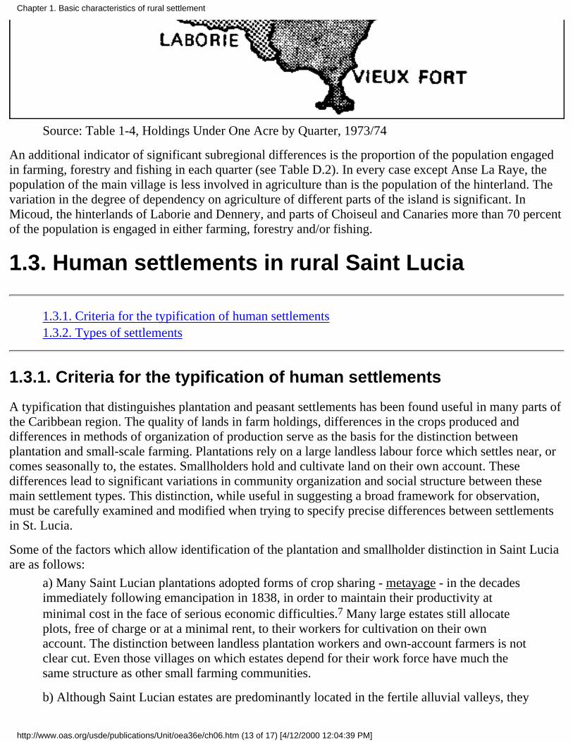
Source: Table 1-4, Holdings Under One Acre by Quarter, 1973/74
An additional indicator of significant subregional differences is the proportion of the population engagedin farming, forestry and fishing in each quarter (see Table D.2). In every case except Anse La Raye, thepopulation of the main village is less involved in agriculture than is the population of the hinterland. Thevariation in the degree of dependency on agriculture of different parts of the island is significant. InMicoud, the hinterlands of Laborie and Dennery, and parts of Choiseul and Canaries more than 70 percentof the population is engaged in either farming, forestry and/or fishing.
1.3. Human settlements in rural Saint Lucia
1.3.1. Criteria for the typification of human settlements1.3.2. Types of settlements
1.3.1. Criteria for the typification of human settlements
A typification that distinguishes plantation and peasant settlements has been found useful in many parts ofthe Caribbean region. The quality of lands in farm holdings, differences in the crops produced anddifferences in methods of organization of production serve as the basis for the distinction betweenplantation and small-scale farming. Plantations rely on a large landless labour force which settles near, orcomes seasonally to, the estates. Smallholders hold and cultivate land on their own account. Thesedifferences lead to significant variations in community organization and social structure between thesemain settlement types. This distinction, while useful in suggesting a broad framework for observation,must be carefully examined and modified when trying to specify precise differences between settlementsin St. Lucia.
Some of the factors which allow identification of the plantation and smallholder distinction in Saint Luciaare as follows:
a) Many Saint Lucian plantations adopted forms of crop sharing - metayage - in the decadesimmediately following emancipation in 1838, in order to maintain their productivity atminimal cost in the face of serious economic difficulties.7 Many large estates still allocateplots, free of charge or at a minimal rent, to their workers for cultivation on their ownaccount. The distinction between landless plantation workers and own-account farmers is notclear cut. Even those villages on which estates depend for their work force have much thesame structure as other small farming communities.
b) Although Saint Lucian estates are predominantly located in the fertile alluvial valleys, they
Chapter 1. Basic characteristics of rural settlement
http://www.oas.org/usde/publications/Unit/oea36e/ch06.htm (13 of 17) [4/12/2000 12:04:39 PM]

are not separated by great distance from the hillside regions occupied by the peasantry. Thereis enough regular commerce between villages to preclude the development of markeddifferences in social structure between villages close to the plantations and other ruralcommunities.
c) Bananas for export are grown by both large estates and the peasantry, so that during thelast two decades the interests of the two sectors have converged to a limited extent.
7 Woodville, Marshall, "Metayage in the Sugar Industry of the British Windward Islands1838-1965", Jamaica Historical Review 5 (1), 1965, pp. 28-55.
Other characteristics of saint Lucian society prevent rigid definition of a spatial classification of humansettlements. The island has had an extremely unstable economic history which has forced people tobecome accustomed to seeking out opportunities in other parts of the island or overseas. Rural peoplemoved from the countryside to work on construction of the United States bases at Vieux Fort and GrosIslet during World War II, on the reconstruction of Castries after the fire of 1948, and for spurts ofemployment offered at the port (refuelling ships with bunker coal, in earlier decades). Thousands of saintLucians have migrated for varying periods of time to work overseas. The "opportunity structure" of mostpeople, whether rural or urban, involves the continuous creation of multiple options for training and jobs,and there is a tendency for people to have several occupations simultaneously. A recent report on smallfarming points out that in order to reduce their risks farmers have adopted "a system of resourceallocation, cropping patterns and cropping technologies that emphasize heterogeneity."8 Farmers in allparts of the island tend to grow a combination of cash crops and crops for domestic use.
8 Vasantha Narendran, "Farming Systems in St. Lucia: An Anthropological Perspective,"CARDI, Saint Lucia, 1981.
1.3.2. Types of settlements
It must be emphasized that the typification presented in Table 1-5 is not comprehensive; certain importantdistinguishing features have been omitted because they do not seem to be central to the specific study.9 Itwill be noted that most rural communities are characteristic of either type B or C. Types B and C arewithin the same continuum, and it is often difficult to determine whether a particular settlements conformsmore closely to one type or the other.
9 A new classification of settlements was made in 1983. The methodology used and results ofthis work will appear in a settlement report on recent Project activities.
TABLE 1-5. TYPES OF HUMAN SETTLEMENTS
Type Characteristics Settlements
Chapter 1. Basic characteristics of rural settlement
http://www.oas.org/usde/publications/Unit/oea36e/ch06.htm (14 of 17) [4/12/2000 12:04:39 PM]

A-1: Urban, or urban functionrelated, as defined by functionaland economic relationships.
Less than 50% of population engagedin agriculture, forestry and fishing,and/or concentration of tourism,industry, commerce, andconstruction, and/or served withgreatest frequency by independentlyowned transport vehicles allowingresidents to commute to work inurban areas.
Castries, Vieux Fort, Marisule,Augier, Reduit, Black Bay,Bois D'Orange, Gros Islet,Dennery (village), Soufriere(town), Choiseul (village),Laborie (village). Settlementswhich show signs of increasingdependency on urban jobs, e.g.,Bexon area, Babonneau area,1
Ti Rocher (Castries).1
A-2: Related to urban area bylocation but have no urbanfunctions.
Heavy reliance on non-agriculturalsources of income (e.g.: craftwork inthe Choiseul Quarter, remittances inAnse La Raye and CanariesQuarters).
Reunion, Cafetere, Monchy,Desrameaux, La Borne,Theordorine, Anse La Verdure.
B: Rural, agricultural functionssupported by good naturalresource base.
Concentration of small farmersproducing crops that enjoy the mostreliable market system (bananas,coconuts, fresh vegetables) and/orgood rainfall, soils not seriouslyeroded and/or high percentages of1-5 and 5-10 acre holdings.
Babonneau,1 La Gare, Balata,Marquis, Paix Bouche, Marc,Fond Cannie, Chassin,Forestiere, Trois Piton, FondPetit, Ravine Poisson,Guesneau, Odsan, Boguis,Deglos, Becage, Barre deL'Isle, Ti Rocher (Castries),1La Ressource, Mon Repos,woodlands, Au Leon, BelleVue, Morne Panache, Banse,Canelles, Grande Ravine, Vige,Desruisseau, La Rue, La Caye,Annus, Micoud, Giraud, SaintJoseph, Ti Rocher, Saltibus,Blanchard, Millet, La Croix,Maingot, Grace, De Many,Latille, Ti Riviere, L'EauMineur, Moreaux, Degard,Durocher, Mahaut, La CourVine, Galba, Lumbard,Seleau,2 Raillon, Choco Mel,2Londonderry, Praslin, Patience,Mamiku, Derniere Riviere.
Chapter 1. Basic characteristics of rural settlement
http://www.oas.org/usde/publications/Unit/oea36e/ch06.htm (15 of 17) [4/12/2000 12:04:39 PM]

C-1: Predominantly smallholdings (under 1 acre).
Holdings generally smaller than typeB with a greater percentage under 1acre and/or greater land constraintthan type B because of mountainousterrain which restricts settlementexpansion or because nearby landsare controlled by well-cultivatedmedium and large estates.
Roseau, Soucis, Saint Philip,Crown Lands, Migni, Garrand,Colombette, Debbarrah, Sarot,Fond Assau, Durandeau,Dupui, Hill 20,2 Pois Dous,2La Haut, Talvern, Eating,Dauphin, Belle Fond, LaPointe, Malgretoute, Jac Mel,Grand Riviere, Fond SaintJacques.
C-2: Predominantly smallholdings (under 1 acre)
Lower rainfall, than in type C-1 orpoorer soils and/or heavier rate ofemigration (especially the 15-44 agegroup) than occurs in areascharacterized in type C-1.
Morne Sion, Delcer, Ravenau,Fiette, Victoria, La Fargue,Industry, Debreul, Esperance,La Pointe (Choiseul), LaRiche.
D: Former sugarcane growingareas.
Areas that did not go into intensivecultivation of replacement cashstaples.
Morne Jacques, Mal Mason,Masacre, Sarot, Au Tabor,Robot, Belvedere, Gertrine,Ravine Duval, Savanne,Bouton Chateau Belair,Esperance (Canaries).
1 Settlements that have characteristics of more than one type.
2 Not traceable on the 1: 25 000 scale. Directorate of Overseas Survey Map.
Source: Carnegie, C., "The Rural Population of Saint Lucia: A Preliminary Analysis," OASTechnical Report, Castries, Saint Lucia, September 1981 (mimeo). Directorate of OverseasSurvey: 1: 25 000 scale map and Government of Saint Lucia, Ministry of Agriculture: 1980Farmer Survey.
Table 1-6 helps to clarify the distinction between types B and C. For example, in comparison with TiRocher (Micoud), Fond Saint Jacques has a high concentration of holdings below one acre and a lowpercentage of holdings between one and ten acres.
TABLE 1-6. SIZE OF HOLDINGS: TI ROCHER (MICOUD) AND FOND SAINT JACQUES, 1980
Acres 0-1 1-5 5-10 10-50 50+ Total No. of holdings
Ti Rocher 9.3% 53.1% 26% 11.7% 0.7% 128
Fond St. Jac. 58.3% 31.0% 6.4% 3.7% 0.4% 216
Source: Government of Saint Lucia, Ministry of Agriculture, 1980 Farmer Survey.
Finally, squatting on private estates or on Crown Lands has been a persistent problem since emancipation,and it is likely that several communities that are now well established were originally formed in this way.Their ownership and other patterns gradually came to conform to those of other rural communities.Villages on the periphery of or within large estates may have been formed originally by squatters but are
Chapter 1. Basic characteristics of rural settlement
http://www.oas.org/usde/publications/Unit/oea36e/ch06.htm (16 of 17) [4/12/2000 12:04:39 PM]

now indistinguishable from other rural communities. It also appears that squatting is haphazard, involvingisolated cases or very small groups of people rather than clear zones of settlement. Even among thesegroups there might be a great deal of shifting from one season to the next or involvement into and out ofagriculture as personal circumstances determine.
Chapter 1. Basic characteristics of rural settlement
http://www.oas.org/usde/publications/Unit/oea36e/ch06.htm (17 of 17) [4/12/2000 12:04:39 PM]

Chapter 2. Land tenure and distributionas constraints on agriculturaldevelopment
2.1. Land tenure2.2. Land distribution2.3. Land use and technology
Land tenure and distribution are key factors to understanding the structure of production and power inSaint Lucia's rural sector. The following analysis is an attempt to characterize man/land relations andindicates the extent to which these relationships represent major constraints on agricultural development.Many of the data used are drawn from the 1973/74 Agricultural Census. While this information issomewhat dated and has certain deficiencies, it remains the best available at the national level. It has beensupplemented with recent survey data and field observations.
2.1. Land tenure
2.1.1. Land ownership and rental2.1.2. Ownership and operation of the agricultural holdings2.1.3. Family lands
2.1.1. Land ownership and rental
Various forms of land tenure influence the stability of the rural sector. If large numbers of farmers haveonly temporary access to land (through short-term sharecropping agreements, for example), socialproblems are likely to be severe. The 1973/74 Agricultural Census indicates that 70.6 percent of allholdings were "owned or held in ownerlike possession." No less than 92.6 percent of the total farm areawas held in this way, suggesting that the sector was reasonably stable in this respect. This classificationapparently includes family land, an issue discussed at greater length below.
The next most prominent tenure category was that of renter, which represented 18.3 percent of totalholdings yet controlled only 2.8 percent of the island's farmland, averaging 1.0 acre per rental unit. Whilenot a major problem nationally, these small producers may present one in specific localities. In the censusquarter of Castries, Vieux Fort, and Dennery they constitute 24.4 percent, 27.8 percent, and 43.9 percent,
Chapter 2. Land tenure and distribution as constraints on agricultural development
http://www.oas.org/usde/publications/Unit/oea36e/ch07.htm (1 of 16) [4/12/2000 12:04:43 PM]

respectively, of all holdings.
2.1.2. Ownership and operation of the agricultural holdings
Another dimension of land tenure, the relation between ownership and operation of the holding, can beevaluated indirectly from census data. This relation is important when considering any "land to the tiller"programme or when examining questions of absentee ownership.
One indicator of the gap between owners and those who work the land is the legal form of landholding.While 98.4 percent of all holdings were owned by individuals (civil persons), 26.5 percent of the land washeld by nineteen corporations. Another indicator of this gap is the incidence of management by thirdpersons (farm administrators). A total of 57 holdings of 50 acres or larger were so managed in 1973/74representing 39.5 percent of total farmland in Saint Lucia.
A certain disparity of land tenure emerges from this analysis. While the majority of farmers own the landthey work, which suggests a high degree of tenure stability, localized problems of small rental holdingsand squatting exist. On the other hand, a small number of large owners control a disproportionate part ofthe national territory, but do not work the land directly.
2.1.3. Family lands
Family land is inherited land held in common by the heirs. This important type of land tenure in SaintLucia requires separate analysis. The concept of family land originates from the laws of intestatesuccession (death in the absence of a will), which provide that property be divided in equal shares amongthe surviving spouse and all legitimate children. 1
1 In the absence of a spouse and legitimate children, succession devolves to ascending,descending or collateral relatives. Illegitimate children succeed only in the absence of legalissue.
While each heir has the legal right to demarcate and subdivide his inheritance, few such subdivisions takeplace. On small holdings the process is frequently more expensive than the value of the land. On largeholdings, where the size of the inheritance might justify the cost, land is frequently maintained intactthrough will provisions or by agreement of the heirs.
In the absence of official statistics on the extent of family land, estimates range all the way from 10percent to 64 percent of total farmland.2 Because landholdings tend to be small, the number of producerswill be proportionately larger than the area.
2 United Nations Food and Agriculture Organization, op.cit., pp. 20-29. FAO reports thatquestions on family land were included in the 1973/74 Agricultural Census, although nothinghas been published and nothing referring to this question was found in the original censusforms.
A recent survey of 245 rural holdings of 15 acres or fewer revealed that 104 of the parcels (42.4 percent)consist of family land.3 Analyses of four Catchment Area Surveys show the area of family land to varyfrom 1.9 percent to 70.5 percent of the region surveyed. The situation appears to be of little significance insome areas, especially where larger farms predominate, but can represent the major form of landholding inareas where small farms are numerous.
Chapter 2. Land tenure and distribution as constraints on agricultural development
http://www.oas.org/usde/publications/Unit/oea36e/ch07.htm (2 of 16) [4/12/2000 12:04:43 PM]

3 University of the West Indies and Mid-West Consortium for International Activities(U.W.I. - MUCIA), "The Economic Role of Women in Small Scale Agriculture: The EasternCaribbean," Saint Lucia, 1981 (mimeo).
The family land system has been condemned by many land tenure specialists who have visited SaintLucia. Foreman declared it to be "the greatest single factor responsible for the unsatisfactory state of theisland economy."4 The disadvantages are:
a) Co-owners of family land seldom have a deed or other legal evidence of their right to theland.
b) Lack of legal documents impedes the sale of land and makes it extremely difficult toobtain credit.
c) Investment is discouraged by the conventional right of all co-owners to harvest permanentcrops grown on the land, whether they participate in their cultivation or not.
d) Since not all heirs are interested in actively farming the land, some areas are left unused orunderutilized.
e) Over generations the increasing number of co-owners of a holding may reduce eachindividual claim to an area too small to farm.
4 Foreman, R.A., "Land Settlement Scheme for Saint Lucia," British Government ColonialOffice, Castries, 1958, p. 15.
There can be no doubt that the informality of the registration procedure and lack of cadastral informationare primary in a combination of factors that slow the transformation of present agriculture as a commercialsubsector. The advantages of the family land system are that family land has served as a mechanism toavoid excessive fragmentation implicit in succession laws; that a significant proportion of the populationhas been guaranteed access to land, whether on a full-time basis or as a supplementary income source; thatgarden plots are often grown by estate and urban workers helping subsidize wages from large farmers andurban employers; and that for those who do not work the land themselves family land serves as a type ofsocial security and place of future residence.
The problem associated with the "family land" tradition of multiple small plots farmed by one family is infact a product of the succession laws. Fragmentation can become severe over generations. Census data,while probably understating the problem, suggest that only 11.7 percent of all holdings are composed oftwo or more parcels and fewer than half of one percent contain three or more.
Any major changes in the family land tradition, as proposed by Foreman and others, will inevitably havesocial and economic consequences. According to statistics presented in the 1975 FAO report, 43 percentof the holders of family land felt that this arrangement in no way prevented them from making proper useof the land and only 29 percent stated that they would like to abolish this form of tenure in favour ofindividual property rights.5 The local farm population must obviously be consulted and involved in theprocess of deciding on any proposed change to avoid social and economic disruption.
5 Op. cit., pp. 29-30.
Chapter 2. Land tenure and distribution as constraints on agricultural development
http://www.oas.org/usde/publications/Unit/oea36e/ch07.htm (3 of 16) [4/12/2000 12:04:43 PM]

2.2. Land distribution
2.2.1. Holding size categories2.2.2. Fragmentation and centralization2.2.3. Characterizing the land distribution problem2.2.4. The landless population
2.2.1. Holding size categories
The skewed nature of land distribution in Saint Lucia is readily visible and in many respects reflects theplantation/peasant system established by the colonial powers. While the change in monoculture (fromsugar to bananas) has increased participation in cash crop production, no fundamental change in the landdistribution pattern has resulted.
Tables E-1 through E-5, Annex E, characterize land holding patterns on the island. Many of the data aredrawn from the 1973/74 Agricultural Census, but more recent information is used where available. Thechoice of holding size categories used in the analysis is based on initial observations of the function thatland has for the various types of holders. Holdings in the 0.1 - 0.9 acre category average only 0.4 acreseach (tables E-1 and E-2), which suggests that these plots have only a supplementary function as anincome source. Farms in the 1.0 - 4.9 acre category average only 2.2 acres, which indicates that most ofthese producers still have considerably less land than 4 to 5 acres of good agricultural land considerednecessary to fully employ the farm family using existing technology.6 Both of these categories can beconsidered subfamily holdings by this criterion, representing the level where the greatest land need will befound.
6 See Zadek, S., "Appraisal Report on Roseau Small Holder Resettlement Scheme,"Government of Saint Lucia, Ministry of Finance, Central Planning Unit, Castries, 1980(mimeo).
The adequacy of operator family labour in farming is used as a major criterion for determining theremaining size categories. The degree of dependency on wage labour, as given in the Census, helpsseparate family and commercial holdings (Graph 2-1).7
7 Calculated as the percentage of paid workers in the total labour force during the week priorto the Census (1973/74) within each holding size.
GRAPH 2-1. Paid Workers as a Percentage of All Workers by Holding Size (Acres)
Chapter 2. Land tenure and distribution as constraints on agricultural development
http://www.oas.org/usde/publications/Unit/oea36e/ch07.htm (4 of 16) [4/12/2000 12:04:43 PM]

Source: Agricultural Census 1973/74
While some wage labour is recorded in the 0.1 - 4.9 acre category (assumed to be smaller than thatnecessary to fully employ the farm family), this is likely to be provided from earnings of family labour onlarger farms, a variable not measured by the Census.
In the 5.0 - 9.9 acre category family labour provides over 80 percent of total labour requirements and onlyoccasional outside workers are necessary. The 10.0 - 49.9 acre category can still be considered anessentially "family farm" situation, although purchased labour has increased to 31.7 percent of the total.
The situation changes radically for holdings over 50 acres. Census data show purchased labour asrepresenting 74.4 percent of total requirements in the 50.0 - 99.9 acre category and 87.5 percent in the50.0 - 499.9 acre category. These holdings can be defined as "commercial" with respect to labour use. The500.0 acre category represents a qualitative rather than a quantitative distinction from other large farmsbecause it is composed of the nineteen largest estates on the island. Labour on these farms is almostentirely purchased (97.9 percent).
2.2.2. Fragmentation and centralization
Tables E-1 and E-2 of Annex E show that the smallest holding category represents 45.3 percent of allfarmers, but contains only 2.4 percent of the area of farmed land.8 The 8,558 holdings in the 0.1 - 4.9 acre
Chapter 2. Land tenure and distribution as constraints on agricultural development
http://www.oas.org/usde/publications/Unit/oea36e/ch07.htm (5 of 16) [4/12/2000 12:04:43 PM]

group (the two "subfamily" categories) represent 82.0 percent of all holdings yet control only 14.2 percentof total farmland. The 122 holdings with more than 50 acres represent only 1.2 percent of all farms butcontrol 58.4 percent of the land. The largest nineteen holdings (+500 acres) alone contain 37.4 percent ofthe total area. This shows the inequality of land distribution to be severe, especially when land quality isconsidered.9
8 This percentage is a calculation of total holdings which includes 502 "Holdings WithoutLand". Actual percentage is 43.2 percent, as shown elsewhere in this report.
9 In the quarter of Dennery it was found that up to 87 percent of the lands in classes I, II, andIII were in holdings of over 500 acres and that large farms (over 50 acres) accounted foralmost all the good lands available in the quarter.
Comparison by census quarter (Table E-1) shows an extreme concentration of micro-holdings (0.1 - 0.9acres) in Castries (58.1 percent), Canaries (55.1 percent) and Gros Islet (52.8 percent). Where thesubfamily categories (0.1 - 4.9 acres) in the quarters of Vieux Fort and Choiseul are considered jointly,they represent the most critical situation, with over 90 percent of all holdings falling within the 0.1 - 4.9range. In only three of the quarters does the percentage fall below 80 percent. These figures indicate thatinequality of land distribution in Saint Lucia is widespread.
The concentration of land ownership in large holdings (over 50 acres) is most severe in Gros Islet, VieuxFort, and Anse La Raye, where it exceeded 70 percent of total farmland (Table C-2). Large estates (500.0acres) occupy half of the land in Anse La Raye and Vieux Fort and 68.4 percent in Gros Islet. The areaoccupied by large holdings (500.0 acres) as a percentage of total area, by quarter, is shown in Map 2-1.
2.2.3. Characterizing the land distribution problem
An attempt to rank the census quarters in terms of the severity of land fragmentation concentration ispresented in Table 2-1.
The quarters are ranked by the percentage that each of the four land distribution situations represents ofthe total number of holdings (in the case of fragmentation) or area (in the case of concentration). Forexample, the Quarter of Castries had the largest percentage of holdings in the 0.1 - 0.9 acre size and wasamong the quarters with the smallest percentage of area included in the 50 acre category.
The "inequality index" is calculated by allocating weights for each quarter according to its rank (e.g., theindex for Castries is 10 + 7 + 2 + 5 = 24), as shown in Table 2-2. The assumption is that each of the foursituations is equally constraining and permits summation in a single index. Differences in the productivepotential of the quarters were not considered. From the inequality index, quarters can be categorized intorelative "degrees of severity" regarding the land distribution problem. Map 2-2 shows the distribution ofthe quarters according to three classes of severity.
To better qualify the severity of unequal land distribution, the problem can also be examined in terms ofthe function of land for the holder. The Census provides national data on the occupation of the landholder,permitting identification of those for whom agriculture is the primary occupation, those who workprimarily as agricultural labourers on the land of others, and those who depend largely on non-farmemployment. Wage labour in agriculture is found primarily (although not exclusively) on estates.Non-farm work includes fishing as well as urban jobs. These data are presented in Annex E, Table E-3.
Chapter 2. Land tenure and distribution as constraints on agricultural development
http://www.oas.org/usde/publications/Unit/oea36e/ch07.htm (6 of 16) [4/12/2000 12:04:43 PM]

Fewer than half of all landholders are full-time farmers. One of every three has a non-agriculturaloccupation and one out of six is an agricultural employee. The function of land as a supplemental incomesource is most pronounced in the smallest and the largest size categories. Only one-fourth of all holders inthe 0.1 - 0.9 size category are self-employed farmers. Half of them have non-agricultural jobs, anotherone-fourth are rural wage workers. Over one-third of all holders included in the 1.0 - 4.9 acre category(most likely those with smaller plots) also depend on other occupations for their principal source oflivelihood. Many of these part-time farmers probably work family land and grow subsistence crops in theirspare time.
Map 2-1. Saint Lucia - Area of Holdings Above 500 Acres by Quarter, 1973/74
Chapter 2. Land tenure and distribution as constraints on agricultural development
http://www.oas.org/usde/publications/Unit/oea36e/ch07.htm (7 of 16) [4/12/2000 12:04:44 PM]

Source: Table E-2, Area of Holdings by Quarter and Size Category, 1973/74
TABLE 2-1. LAND FRAGMENTATION/CONCENTRATION RANKING BY QUARTERS,1973/74
RankFragmentation a/ Concentration b/
0.1-0.9 0.1-4.9 50.0 500.0
10 Castries Vieux Fort Gros Islet Gros Islet
9 Canaries Choiseul Vieux Fort Anse La Raye
8 Gros Islet Gros Islet Anse La Raye Vieux Fort
7 Choiseul Castries Canaries Micoud
6 Anse La Raye Canaries Micoud Dennery
5 Vieux Fort Soufriere Soufriere Castries
4 Soufriere Anse La Raye Dennery Soufriere
3 Laborie Laborie Laborie Laborie
Chapter 2. Land tenure and distribution as constraints on agricultural development
http://www.oas.org/usde/publications/Unit/oea36e/ch07.htm (8 of 16) [4/12/2000 12:04:44 PM]

2 Dennery Dennery Castries Canaries
1 Micoud Micoud Choiseul Choiseul
a. Quarters ranked by numbers of small holdings as a percentage of total number of holdings.
b. Quarters ranked by area of large holdings as a percentage of total area; 10 is the highestranking (amount), 1 the lowest. Source: Annex E, Tables E-1 and E-2.
TABLE 2-2. LAND FRAGMENTATION/CONCENTRATION; ACTUAL RANKING, 1973/74
Fragmentation ConcentrationInequality Index
0.1 - 0.9 0.1 - 4.9 50.0 500.0
Gros Islet 8 8 10 10 36
Vieux Fort 5 10 9 8 32
Anse La Raye 6 4 8 9 27
Castries 10 7 2 5 24
Canaries 9 6 7 2 24
Soufriere 4 5 5 4 18
Choiseul 7 9 1 1 18
Micoud 1 1 6 7 15
Dennery 2 2 4 6 14
Laborie 3 3 3 3 12
Source: Table 2-1.
Map 2-2. Saint Lucia - Land Fragmentation/Concentration
Chapter 2. Land tenure and distribution as constraints on agricultural development
http://www.oas.org/usde/publications/Unit/oea36e/ch07.htm (9 of 16) [4/12/2000 12:04:44 PM]

Source: Table 2-2, Land Fragmentation/Concentration Actual Ranking, 1973/74
These findings indicate that land serves a social function for the small holder which differs significantlyfrom that of the commercial farmer. Not only is emphasis placed on food crops, but the part-time smallholder may, in some instances, be unable to work more land even if it were available.
The fact that fewer than half of the largest holders are self-employed in agriculture may be explained by
Chapter 2. Land tenure and distribution as constraints on agricultural development
http://www.oas.org/usde/publications/Unit/oea36e/ch07.htm (10 of 16) [4/12/2000 12:04:44 PM]

their multiple roles as landlords and businessmen. Their principal occupation may change over time,depending on where the most profit can be obtained. Currently, however, agriculture appears unable tocompete with commerce and urban land speculation.
2.2.4. The landless population
There are numerous reports of the existence of a sizable landless population in Saint Lucia, although noprecise data are available to quantify this assertion or to analyze its spatial distribution. When carrying outits hearings the Land Reform Commission received testimony on the question of squatting that indicatedthe existence of a large group of landless peasants. The Forest Supervisor reported the presence ofsquatters in the forest reserve and spoke of penalties and other efforts to alleviate the problem they posed.Errand, Louvet, and Jalousie states also reported intrusions from squatters in the past few years. Otherestates, while claiming no problem with squatters, did comment on the prevalence of praedial larcenyfrom their holdings. Several of the large estates submitted written statements to the Commission reportingthat they allocate portions of land to their workers for planting gardens.10 This has been a long tradition ofSaint Lucian estates that apparently continues to be widespread. The practice perhaps mitigates ordisguises the problem of landlessness.
10 Saint Lucia Land Reform Commission, "Public Hearings 1979/80 Transcription," Castries,1980 (mimeo); and "Written Memoranda Submitted to the Commission, 1979-1980"(unpublished).
Squatting is not assigned a specific tenure category in the Agricultural Census, nor is there any indicationthat it is included in the "other types of tenure" category. This may be attributed to the illegality ofsquatting and the reluctance of the squatter to provide the census enumerator with information.
"Landless" in the Saint Lucian context encompasses a variety of different relationships of people to land inthe rural sector. There are people who rent land on a seasonal, yearly or long-term basis, squatters onprivately owned or Crown lands, and people who operate holdings too small to provide an adequateincome for their families without other forms of employment. These conditions can impose considerableinsecurity of tenure on agricultural producers which restricts their productive potential. These effectsmight vary in severity from one farmer to the next or between one part of the island and another.Furthermore, land possession itself does not ensure the disappearance of unfavourable conditions. Thedifficulty of securing registered title to freehold property, the lack of price supports and adequatemarketing arrangements for produce, the difficulty in securing agricultural loans, and several otherconditions tend to constrain the farming community regardless of the form of tenure.
While renting and squatting indicate landlessness, not all renters and squatters are necessarily landless. Inthe Caribbean Research Development Institute (CARDI) sample of 31 Saint Lucian farmers, at least 5 ofthe 21 for whom information is complete show different forms of tenure on different farm plots in theirholdings. A lease or rental may be combined with more secure tenure on freehold or family land.11 Theseforms of tenure have become part of the small farming system over time. In some instances they mayrepresent a temporary phase in the farmer's working career, supporting him until he gains access to familyland or takes up another occupation. In other instances, rental and leasehold may be used by the smallfarmer as a device for spreading risk.
11 Vasantha Narendran, op. cit.
The implicit assumption that when given access to land the landless will become long-term agricultural
Chapter 2. Land tenure and distribution as constraints on agricultural development
http://www.oas.org/usde/publications/Unit/oea36e/ch07.htm (11 of 16) [4/12/2000 12:04:44 PM]

producers must also be carefully evaluated, particularly in connection with the age structure of thislandless population. The existing information indicates that not all the rural population is equally willingto engage in full-time farming. Over the years, a pattern has developed in which young people below age35 are under-represented in the local agricultural sector, but gradually take their place in agriculture duringtheir middle years.12
12 Carnegie, C., op. cit., p. 33.
2.3. Land use and technology
2.3.1. Uses of agricultural land2.3.2. Intensity of land use2.3.3. Land use and family land2.3.4. Land utilization2.3.5. The function of production
Various aspects of farming practices have been identified as constraints on land development and asjustification for promoting a reformulation of the structure of the rural sector. Large farms are accused ofunderutilizing the land at their disposal. While land is used more intensely on small farms, its utilization isseen as technologically backward, resulting in a relatively low level of efficiency. The following analysischaracterizes land use and technology in Saint Lucia's rural sector and suggests areas of constraints onproduction.
2.3.1. Uses of agricultural land
Land use by holding size is presented in Table 2-3. This analysis is based solely on 1973/74 Census datasince the 1980 Farmer Register provides information only on the area of crops damaged by HurricaneAlien and not on total land use. The proportion of land in permanent crops (bananas, tree crops) is high forall size categories, averaging 39.6 percent. It is lowest for the smallest and largest holder categories andhighest for the 5.0 - 9.9 acre size category. This activity is characterized by its permanence, providing landcover and protection against erosion year-round.
The production of other crops, primarily food provisions, shows a marked decrease as farm size increases.The smallest size category has (0.1 - 0.9 acres) over half of its area devoted to this activity, while on thelargest farms (500 acres) 7 percent of the area is planted with annual crops. This suggests an essentiallysubsistence and non-commercial nature for these crops. They also provide the least protection againstresource degradation because of their limited canopy and the seasonal nature of production. The secondlargest major-use class, in terms of area, is forest land, which increases with average farm size. Becausethere is little exploitation of forest on farmlands in Saint Lucia, this category can be considered unusedland, as can the "other land" category in Table 2-3.
Chapter 2. Land tenure and distribution as constraints on agricultural development
http://www.oas.org/usde/publications/Unit/oea36e/ch07.htm (12 of 16) [4/12/2000 12:04:44 PM]

2.3.2. Intensity of land use
A summary of the three major land use categories, expressed as a percentage of total area, is useful forcomparing the intensity of use by holding size. Table 2-4 shows percentages of land by size category.Cropland includes both permanent and annual (other) crops. Unused land is composed of forest and otherland from Table 2.3. The intensity of land use is seen to be in inverse proportion to holding size, e.g.,pressure on land in the smallest size category (0.1 - 0.9 acres) appears excessive, considering that mostlands in this category are hillside farms requiring careful conservation measures. In the three smallest sizecategories (10 acres) over 80 percent of total area is used for crops. Cropland intensity drops to just over40 percent on the largest farms (500 acres), lending support to the contention that the large holder uses hisland less intensively than he might. Pasture area is much smaller on large holdings than might be expectedand is probably even less today given the observed reduction in cattle production on large units during the1970s.
TABLE 2-3. LAND USE BY HOLDING SIZE, 1973/74
Source: Ministry of Agriculture and Lands, Agricultural Statistics: Census Data, 1973/74,Castries 1975.
TABLE 2-4. MAJOR LAND USE BY HOLDING SIZE, 1973/1974
HOLDER SIZE(acres)
AREA TOTAL AREA(%)
CROPLAND (%) GRASSLAND (%) UNUSED (%)
0.1 - 0.9 1 733 100.00 93.8 3.2 3.0
1.0 - 4.9 8 471 100.00 80.4 11.0 8.6
5.0 - 9.9 7 059 100.00 81.1 7.1 11.8
10.0 - 49.9 12 704 100.00 64.7 7.7 27.6
50.0 - 499.9 15 132 100.00 53.5 14.6 31.9
500.0 26 902 100.00 41.6 9.9 48.5
TOTAL 72 001 100.00 57.9 10.2 31.9
Source: Table 2-3.
The implicit assumption that "unused" land on large holdings can in fact be farmed profitably would becontested by many owners involved. Most unused land consists of hillside forest or scrub. The richalluvial valleys found on many large estates are generally being cultivated with permanent crops.Observation suggests, however, that were this unused land found on medium sized and small holdings,much of it would be under cultivation. Recent land sales by large estates, releasing unused land foragricultural purposes, tend to confirm this observation. The reasons for this difference in land use betweenholding sizes must be identified to determine how a "profitable" activity is defined by each holder type.13
13 For the large holder, the profitability calculation includes provision for a return on investedcapital. The peasant farmer, on the other hand, will probably undertake production on land aslong as he earns at least a wage equivalent for his labour even though little or nothing is leftas returns on capital.
Chapter 2. Land tenure and distribution as constraints on agricultural development
http://www.oas.org/usde/publications/Unit/oea36e/ch07.htm (13 of 16) [4/12/2000 12:04:44 PM]

2.3.3. Land use and family land
Analysis is required to ascertain the frequency of non-use of plots within small holder communities,information not apparent in the census data. The methodology of census enumeration explains why thissituation is not documented: all holdings where no economic activity had occurred during the precedingtwelve months were simply ignored for census purposes.
The proportion of family land claimed by holders who were actually farming in the survey of threecatchment areas varied from 20.4 percent to 34.6 percent, which indicates that a major part of family landin these regions was not being worked (Table 2-5). While this limited information cannot be extrapolatedto the nation as a whole, it does suggest that considerable unused land exists at both ends of the farm sizespectrum, though for quite different reasons.
TABLE 2-5. FAMILY LANDS IN THREE SELECTED AREAS, 1972
Total family land(acres)
Portion claimed(acres)
%
Chopin 103 21 20.4
Micoud 318 110 34.6
Vige 687 189 27.5
TOTAL 1 108 320 28.9
Source: Government of Saint Lucia, Ministry of Agriculture, Socioeconomic Survey of ThreeCatchment Areas, 1972.
Because no documentation of vacant lands exists, analysis of why land is vacant is tenuous at best. Theexplanation would partially appear in the family land arrangement, in which some co-owners live far fromthe land (perhaps even outside the country) and are not interested in working it. There are probably otherlimitations, e.g., physical, restricting the use of family lands for agriculture.
2.3.4. Land utilization
While it is not always easy to document the existence of unused land in the rural sector, the question ofunder- and overutilisation of land is even more difficult, but nevertheless important. The data abovesuggest that many small holdings are being utilised beyond what can be considered a rational degree ofintensity, given the steep topography and the need for permanent vegetation cover over considerable areasof these farms. Both producer education and alternative employment will be necessary to reduce thispressure on the ecosystem.
Underutilization of particularly productive and ecologically stable soils such as the alluvial valleys is animportant problem as well, especially from the point of view of national product and income. There areindications that these valleys are undercapitalized and underutilised today, which suggests that privateprofit calculation is not necessarily compatible with the national interest.14
14 This is the case with two large estates now controlled by the Government, Dennery Factoryand Roseau Estates, where large investments in field development are required to make theproperties productive.
Chapter 2. Land tenure and distribution as constraints on agricultural development
http://www.oas.org/usde/publications/Unit/oea36e/ch07.htm (14 of 16) [4/12/2000 12:04:44 PM]

2.3.5. The function of production
In the absence of value or income data, crops grown by different holding sizes can be taken as a measureof the importance of its cultivation to the producer. For the two smallest holding sizes (0.1 - 4.9 acres),food crops are the most frequently grown and represent the activities in which the smallholder makes thegreatest contribution to national production (see Graph 2-2).
As holding size increases, participation in food production decreases in favour of export and commercialcrops. In the largest size category (500 acres), production is specialized in a small number of high-incomecrops (bananas, coconuts and limes).
Banana production for export is found on farms of all sizes, although only one-third of the holdings in the0.1 - 4.9 acre categories produced any. This compares with over 60 percent of the holdings in the 5.0 - 9.9and 10.0 - 49.9 size categories. The widespread distribution of this major cash crop among holding sizescan be explained by its relatively high income potential and the absence of significant economies of scalein production, given the existing level of technology. The lower participation of the smallest holdings maybe due to their difficulty in gaining membership in the Banana Growers Association.
GRAPH 2.2. Contribution to National Food Production Made by Small Holders (0.1 - 4.9 acres)
Source: Government of Saint Lucia, Ministry of Agriculture. Agricultural Statistics, CensusData, 1973/74
Chapter 2. Land tenure and distribution as constraints on agricultural development
http://www.oas.org/usde/publications/Unit/oea36e/ch07.htm (15 of 16) [4/12/2000 12:04:44 PM]

Chapter 2. Land tenure and distribution as constraints on agricultural development
http://www.oas.org/usde/publications/Unit/oea36e/ch07.htm (16 of 16) [4/12/2000 12:04:44 PM]

http://www.oas.org/usde/publications/Unit/oea36e/p005.GIF
http://www.oas.org/usde/publications/Unit/oea36e/p005.GIF (1 of 2) [4/12/2000 12:04:45 PM]

http://www.oas.org/usde/publications/Unit/oea36e/p005.GIF
http://www.oas.org/usde/publications/Unit/oea36e/p005.GIF (2 of 2) [4/12/2000 12:04:45 PM]

Chapter 3. Legal and institutionalframework for natural resourcesconservation and development
3.1. Legal background of land development control and regulation3.2. Legal background of natural resources conservation and development3.3. Institutional structures for natural resources conservation and development
This chapter provides an analysis of the current legal and institutional framework for natural resourceconservation and development, with emphasis on land resources and their critical importance toagricultural development. Specific proposals to deal with the problems detected are provided in Chapter7.
3.1. Legal background of land development controland regulation
3.1.1. Land ownership and registration3.1.2. Land use control and regulation
Land control legislation was introduced by the French Government when the laws of the Coutume deParis were accepted as the basis for French colonial law in Saint Lucia. Additions to the law were madethroughout the 18th century.1 Initially the legislation addressed inheritance, land registration, and thedemarcation of Crown Lands. Additions to this body of law concern taxation, some aspects of naturalresource conservation, and urban land use control. The existing legal structure has grown through newlegislation or by amendments to existing laws. A recent study evaluating the legal structure whichaddresses natural resource issues indicates that it can be considered incomplete in its coverage of issuesand often insufficient in regard to current development needs.2
1 "Arret en Règlement du Conseil Supérieur portant que la Coutume de Paris et lesOrdonnances du Roi Seront suivies en cette Ile" (5 November 1681), St. Lucia RevisedOrdinances; A.M. Lewis, Vol. I - VII; Castries: Voice Publishing Company, 1957.
For instance the "Ordre du Roi au sujet des cirquante pas du bord de mer" (6 août 1704)
Chapter 3. Legal and institutional framework for natural resources conservation and development
http://www.oas.org/usde/publications/Unit/oea36e/ch08.htm (1 of 15) [4/12/2000 12:04:47 PM]

Saint Lucia Revised Ordinances, op.cit., Vol. VI, Appendix 11; p. 35
2 Rojas, E., "Institutional and Legal Aspects of Agricultural Land Development Planningand Implementation in Saint Lucia," OAS Technical Report, Castries, November 1981.
3.1.1. Land ownership and registration
The Saint Lucia Civil Code allows freeholding of lands by individuals or companies.3 Aliens are requiredto obtain a license from the Cabinet to buy, lease or hold a mortgage on land in Saint Lucia.4Enforcement of this law allowed nearly 30 percent of the agricultural lands to be acquired by foreignersduring the 1960s and 1970s.5
3 "The Civil Code", Revised Ordinance, op. cit., Vol. IV, Cpt. 242.
4 The Aliens Act, 10/1973 (Landholding Regulation).
5 FAO, op. cit., p. 10.
FAO estimated that in 1973 the Government owned 26 798 acres of land, of which 16 385 acres werestate forest (10 165 acres of protected forest and 6 220 acres of forest reserves); 6 395 acres wereagricultural holdings; 2518 acres corresponded to the Queen's Chain and approximately 1 500 acres topublic roads and buildings.6 In the same year, 70 777 acres were privately owned, of which 63 577 acreswere in agricultural holdings, 5 900 acres were non-urban land not in agricultural holdings and 1 300acres were urban land. At that time, 54 745 acres had uncertain ownership and tenure status (e.g.,ungranted Crown Lands, unregistered Government Lands, etc).
6 Ibid, p. 16.
Legislation currently allows government to acquire lands, including agricultural land, compulsorily whennecessary. The acquisition process may generate implementation difficulties in complex acquisitionprograms involving multiple owners because of the complicated statutory rules of assessment ofcompensation in the Land Acquisition Ordinance (section 19); these rules require determination of a freemarket price. The well-known distortions that occur in land markets coupled with the traditional lowdynamism of the agricultural land market do not ensure that a fair value may be obtained through thisprocedure. These rules may need to be changed to allow for valuation procedures capable of accountingfor the value of the land, capital and other productive factors.7
7 See, for example, Matthew, C., and J. Girard, "Report on the Valuation of Fond Estate",Ministry of Agriculture and Lands, June, 1973 (unpublished).
The acquisition of land by private individuals tends to be unduly complicated by the existing system ofregistration of rights. The introduction of a title registration system will facilitate the process, and theintroduction of "a trust for sale" will help solve multiple ownership problems created by existinginheritance laws.8
8 Both are proposals made by the Saint Lucia Land Reform Commission in its "InterimReport" published in June 1980 (mimeo), and accepted by Government. Legislation in thisconnection has already been drafted and is being circulated for corrections.
The deficiencies of the existing system of ownership registration, a bottleneck for all land transactions
Chapter 3. Legal and institutional framework for natural resources conservation and development
http://www.oas.org/usde/publications/Unit/oea36e/ch08.htm (2 of 15) [4/12/2000 12:04:47 PM]

(the Registration of Deeds), affects agriculture by making it difficult for farmers with no clear title toobtain credit.9 The land market in Saint Lucia is very inactive, particularly for small holdings, where thedifficulties created by the registration system are greater.10
9 The Mode of Registering Deeds Ordinance, Saint Lucia Ordinances, 1945. op. cit.,(8/1961).
10 Rickman, R., Saint Lucian Land Market A Brief Survey, Technical Report, Ministry ofAgriculture, Castries, December 1981 (mimeo).
The lack of a cadastral survey makes the taxation system incomplete. Lands taxes are used as a source ofincome for the Government (currently supplying less than 0.04 percent of the government's recurrentrevenue);11 an annual flat rate tax per acre is assessed according to property size (no tax for properties ofless than 10 acres, 25 cents per acre for properties between 10-50 acres 50 cents for those of 50-100acres, 75 cents for 100-500 acres and EC$1 per acre for properties of 500 acres and over).12 A cadastralsurvey would fill an information gap which, in effect, is preventing land control and the utilization oftaxes as a development tool to gradually reduce land ownership concentration and land underutilization.
11 Land and House Tax Ordinance (11/1952), Amended by Ordinance 19/1965; 16/1966.
12 Ministry of Finance, Inland Revenue Department.
3.1.2. Land use control and regulation
Legislation concerning land use regulation has evolved over time and concentrates on the control ofurban land, the building situation and construction. Only minor pieces of legislation have been enactedfor natural resource protection or management.
The Town and Country Planning Ordinance first established development control by creating a CentralHousing and Planning Authority with powers to prepare or adopt schemes containing developmentproposals and to enforce compliance with these schemes.13
13 Town and Country Planning Ordinance, (10/1945), Saint Lucia Ordinances ... 1945, op.cit., pp. 7 and ff.
In 1971, the Central Housing and Planning Authority was dissolved by the enactment of the LandDevelopment (Interim Control) Act, 1971, which established the Development Control Authority.14 Thisact was passed as a temporary measure while full planning legislation was put before the House ofAssembly. To date, no new legislation has been passed and the 1971 Act remains the only urbanplanning legislation effective in Saint Lucia. Urban land development is also subject to the followingenactments:
a) The Public Works and Roads Ordinance (1969) with regard to siting and access for anydevelopment proposals.
b) The Industrial and Commercial Buildings Act (1973).
c) The Public Health Act (1975) for sanitation, sewage treatment and other public healthmeasures.
Chapter 3. Legal and institutional framework for natural resources conservation and development
http://www.oas.org/usde/publications/Unit/oea36e/ch08.htm (3 of 15) [4/12/2000 12:04:47 PM]

14 Saint Lucia, Land Development (Interim Control) Act 1971, No. 8 of 1971. TheDevelopment Control Authority is a board of seven members including the TechnicalOfficer in charge of Housing, Public Works, and Health Services, with the Chief TechnicalOfficer in charge of Town and Country Planning Development acting as ExecutiveSecretary.
Although the development controls powers given to the Authority are ample in scope, they are restrictedin where they can be applied: Section 9 and the First Schedule of the Act state that buildings and otherworks intended solely for agricultural purposes will be considered as permitted, hence not requiringpermission from the Authority to be developed.15 Therefore, the development control powers of theAuthority are confined to urban areas. Implementation of land use proposals and building regulationsprepared by the Authority depends on the process of granting a planning permit for development. Twomain problems have been encountered in implementing these proposals. First, not all developers applyfor permission. Furthermore, the Authority lacks sufficient staff to prosecute all cases of illegaldevelopment, and the fines set by the 1971 Act are low, offering little disincentive to evasion, andsecond, decisions on major development proposals are made by the Cabinet (re: Hess TranshipmentTerminal, Hotels, etc.), discouraging the Authority in the fulfillment of its tasks...
15 Section 9 also states that although no permission is required for buildings, or land use foragricultural purposes, such development shall be subject to any conditions and restrictionsimposed by regulations made by the Cabinet with reference to the provisions of the Act. Infact, no regulations have been issued by the Cabinet.
The powers of the Authority were further reduced by the creation of the National DevelopmentCorporation.16 According to the legislation, this statutory body has powers to act as DevelopmentControl Authority within designated development areas. Special areas need to be designated by theGovernor General and approved by the House of Assembly. Development areas have been designated invarious sections of the Gros Islet - Castries urban corridor, Vieux Fort and Dennery giving NDC controlover substantial sections of these urban areas. Currently, there are two development control authorities inSaint Lucia with powers to regulate development in nine urban areas.
16 The National Development Corporation Act (9/1971), sections 15 and 17.
3.2. Legal background of natural resourcesconservation and development
3.2.1. Forest protection3.2.2. Beach protection3.2.3. Wildlife protection and areas of natural and historic interest3.2.4. Natural resources use
Chapter 3. Legal and institutional framework for natural resources conservation and development
http://www.oas.org/usde/publications/Unit/oea36e/ch08.htm (4 of 15) [4/12/2000 12:04:47 PM]

3.2.1. Forest protection
The only legislation with a bearing on the control and regulation of rural land use is the Forest, Soil andWater Conservation Ordinance enacted in 1945. This Ordinance covers only a narrow aspect of naturalresource conservation. The Ordinance delegates to the Chief Forest Officer the duties of managing alllands Crown Lands (Section 3), overseeing the timber industry and timber dealers in the country andpreventing the unlawful removal of timber from Crown Lands (Sections 6 and 18). Provisions was madein the Ordinance for the establishment of forest reserves (Sections 19 and 20) and/or the declaration ofprotected forests on private lands, allowing the Chief Forest Officer to regulate its utilization "in order toprotect covered areas of importance for protection against storms, prevention of soil erosion, themaintenance of water supplies in springs, rivers and reservoirs and the preservation of health."17
17 The Forest, Soil and Water Conservation Ordinance (6/1945).
The declaration of preserved and protected forests and their corresponding rules and provisions are theonly aspects of the Ordinance dealing with the regulation of land use in rural areas. They address onlythe forestry-related aspects of soil and water conservation, without considering the agricultural land useaspects of environmental management.
3.2.2. Beach protection
The beaches are the only other natural resource partially protected by legislation in Saint Lucia. TheBeach Protection Ordinance (21/1963) is very limited in scope, preventing digging and removal of sand,stones, shingle or gravel from the seashore. The Ordinance permits the Government to undertake suchoperations and authorises the Minister of Communications and Works to grant licenses to private citizensor companies to carry out any activities prohibited by the Ordinance. The definition of seashore given inthe Ordinance is fairly broad (including the bed and shore of the sea, every channel, creek, bay or estuaryand every river as far as the tide flows), and the Government owns all lands covered by the Ordinance(the Queen's Chain), but no legal provision exists in this legislation for the integrated protection of thedelicate coastal ecosystems on which much of the tourism industry is based. These ecosystems are beingpermanently damaged by pollution and overexploitation.
3.2.3. Wildlife protection and areas of natural and historic interest
Two pieces of legislation important for the protection of the environment and the scenic beauty of SaintLucia are the Wildlife Protection Act (9/1980) and the Saint Lucia National Trust Act (No. 16, 1975).18
The former was enacted specifically to protect various species of wildlife that are either unique to SaintLucia or of ecological importance, and the latter to legally sanction an institution capable of preservingbuildings and areas of architectural, historical or natural interest. While only the Wildlife Protection Actis regulatory in character, the National Trust is important regarding actions required for protectingnatural resources.
18 The Saint Lucia National Trust Act, No. 16 of 1975.
Chapter 3. Legal and institutional framework for natural resources conservation and development
http://www.oas.org/usde/publications/Unit/oea36e/ch08.htm (5 of 15) [4/12/2000 12:04:47 PM]

3.2.4. Natural resources use
Other than the Forest Soil and Water Conservation Ordinance (6/1945), there is no legislation ruling onissues of land use and development in rural areas or on other natural resources use. Misuse of land,water, mangrove, swamps and other natural resources has proceeded unchecked in Saint Lucia for years.
They lack of water resource use legislation is particularly conspicuous. A scarcity of water is becomingevident, but no regulatory measures have been implemented. To use water resources properly, legislationaddressing ownership and exploitation rights, the resolution of disputes and watershed protection must bepassed. Some infrastructure may be necessary to increase water availability in certain watersheds.19
19 Oelsner, J., Saint Lucia, Water Resources; OAS Technical Report, Saint Lucia, May 1981(mimeo).
3.3. Institutional structures for natural resourcesconservation and development
3.3.1. Institutional development and coverage of issues of natural resources development3.3.2. Institutional coordination on natural resources conservation and development3.3.3. Manpower resources for natural resources conservation and development3.3.4. Recent trends in institutional development
3.3.1. Institutional development and coverage of issues of naturalresources development
Currently there are eighteen different institutions concerned with natural resource development in SaintLucia. Table 3-1 shows that no single institution is capable of dealing integrally with the complex andinterdependent problems of natural resource development in the country. Each institution addressesspecific or partial aspects of the issues. This is also reflected in the legislative coverage of the relevantproblems. Table 3-2 shows the institutional and legal coverage of the main issues related to landdevelopment in Saint Lucia, distinguishing between partial and integral coverage and indicating wherecoverage actually exists, has been proposed, or does not exist at all. Most of the issues have not beenaddressed by institutional or legislative measures. There have been very few proposals related to landtenure and forestry aimed to improve the existing situation (see sections 3.1 and 3.2). In areas wherelegal and institutional coverage of an issue do exists, it is noticeably partial (for example, the BeachProtection Ordinance concerns only sand mining), not covering all the dimensions of the problem.
3.3.2. Institutional coordination on natural resources conservationand development
There are multiple relationships between the different institutions listed in Table 3-1, and theserelationships (legal and financial dependency; different degrees of mutual control and regulation;
Chapter 3. Legal and institutional framework for natural resources conservation and development
http://www.oas.org/usde/publications/Unit/oea36e/ch08.htm (6 of 15) [4/12/2000 12:04:47 PM]

complementary or conflicting spheres of influence; involvement of the same individuals in themanagement of different institutions, etc.) determine the possible degree of coordination in action and thelevels of internal conflict within the system. A simplified analysis of these relationships shows the mainfeatures of the problem. Chart 3-1 illustrates the system of institutions concerned with natural resources.Only the basic relationships of legal and financial dependency are shown to illustrate certain structuralcharacteristics of the system today. At least four inferences can be drawn from Chart 3-1.
First, relationships of direct dependency in the institutions of the Central Government are strictly vertical,without horizontal interdependence. When this type of structure is coupled with the specific area ofconcern of each institution, highly uncoordinated actions are to be expected from Government. The onlypossible level of coordinated decision making is the Cabinet level, a level that cannot cope with thespecific technical aspects involved in coherent governmental action on natural resource (landdevelopment) management. Technical coordination is left in the hands of interagency coordinationcommittees that at best have advisory powers. Under these circumstances, effective coordination is rarelyachieved.
TABLE 3-1. INSTITUTIONS CONCERNED WITH NATURAL RESOURCES DEVELOPMENTIN SAINT LUCIA, 1981
Type Controlling Agency Institution Laws, ordinancesand regulations
affecting theinstitution
Involvement in landdevelopment
CentralGovernment
Cabinet Cabinet The Aliens(landholdingregulation)Act: 10/1973
Granting alienslandholding licenses
Ministry ofAgriculture
Lands Department The Crown LandsOrdinance. 7/1945(amended byOrdinance,19/1960) andRegulations
Control and Registry ofCrown Lands
The Surveyors andBoundarySettlementOrdinance,47/1961 (amendedby Act 16/1972)
The ColonySurvey Ordinance,47/1953
Chapter 3. Legal and institutional framework for natural resources conservation and development
http://www.oas.org/usde/publications/Unit/oea36e/ch08.htm (7 of 15) [4/12/2000 12:04:47 PM]

Forestry Division The Forest, Soiland WaterConservationOrdinance, 6/1945
Protection of CentralForest Reserve
The Forest, Soiland WaterConservation(Crown Landforest produce)Rules
Control of protectedforest
The WildlifeProtection Act,1980
Conservation of wildlifeand areas of naturalinterest
Ministry ofAgriculture
ExtensionDivision
Advise farmers onlanduse, agriculturalpractices, markets, etc.
EngineeringDivision
Centralization ofhydrological andhydrometeorologicalinformation
Planning anddevelopment of irrigationprojects
Promotion of soilconservation
Office of theChief AgriculturalOfficer
Control over operationaldivisions
Control over landdevelopment projects(tree cropsdiversification, coconutrehabilitation, etc.)
Ministry of Finance,Development andPlanning
Central PlanningUnit,EnvironmentalPlanning Section
Town and CountryPlanningOrdinance,10/1945
Landuse control in urbanareas
LandDevelopment(Interim Control)Act, 8/1971
Building Control
Chapter 3. Legal and institutional framework for natural resources conservation and development
http://www.oas.org/usde/publications/Unit/oea36e/ch08.htm (8 of 15) [4/12/2000 12:04:48 PM]

The Industrial andCommercialBuilding Act,1983
Inland Revenue Land and HouseTax Ordinance,11/1952 (amendedby Ordinances,41/1965; 16/1966and Act 20/1970and 19/1977)
Definition of tax
Collection of land taxes
Ministry ofAgriculture
Agricultural Bank The AgriculturalBank Ordinance,19/1965 (amendedby Acts 18/1970and 27/1970)
Credit for agriculturaldevelopment
Ministry of Youth,CommunityDevelopment, SocialAffairs and Sports
Saint LuciaCentral WaterAuthority
Development anddistribution of water fordomestic, industrial uses
Sewage development andcontrol
Ministry ofCommunications andWorks
Works Division The Public Worksand RoadsOrdinance, 1969
Planning, execution andmaintenance of majorinfrastructure
The BeachProtectionOrdinance,21/1963
Control of sand mining
Judiciary System Registrar The Civil Code Registration of landtransactions andinheritances
The Mode ofRegistration ofDeeds Ordinance,8/1961
The Wills (FormalValidity)Ordinance,57/1965
Chapter 3. Legal and institutional framework for natural resources conservation and development
http://www.oas.org/usde/publications/Unit/oea36e/ch08.htm (9 of 15) [4/12/2000 12:04:48 PM]

TheAdministration ofSmall SuccessionsOrdinance
Cabinet NationalDevelopmentCorporation
NationalDevelopmentCorporation Act,1971
Land development forurban, tourism orindustrial purposes
Development controlauthority withindevelopment area
Control of Governmentland linked todevelopment projects
Cabinet Housing andUrbanDevelopmentCorporation
Housing andUrbanDevelopmentCorporation Act,1971 (Slumclearance andHousingOrdinance)
Planning anddevelopment of land forresidential and othercommunity purposes
Statutory Saint LuciaNational Trust
The Saint LuciaNational TrustAct, 16/1975
Preservation of buildingsand objects of historicand architectural interestand areas of natural orscenic importance
Ministry ofAgriculture
CommodityAssociations
The CommercialCode of SaintLucia
Marketing of agriculturalcommodities
BananaOrdinance, 1934Saint Lucia
Land use advice
Banana GrowersAssociationOrdinance,35/1953
Credit
Coconut GrowersAssociationOrdinance
Chapter 3. Legal and institutional framework for natural resources conservation and development
http://www.oas.org/usde/publications/Unit/oea36e/ch08.htm (10 of 15) [4/12/2000 12:04:48 PM]

AgriculturalAssociationOrdinance
Private
Private Banks The CommercialCode of SaintLucia
Credit for land aquisitionand development
ResearchInstitutions
Improvement ofcultivation practices,landuse, farmmanagement technologyand productivity
Source: Rojas, E. "Institutional and Legal Aspects of Agricultural Land Development,Planning and Implementation in Saint Lucia", op. cit.
TABLE 3-2. INSTITUTIONAL AND LEGAL COVERAGE OF THE MAIN ISSUES OF LANDDEVELOPMENT
Main issues in land developmentLegal coverage Institutional coverage
Partial Integral Partial Integral
Natural resources conservation
Soil erosion
Water catchment protection E P E
Deforestation E P E P
Water utilization
Degradation of coastal ecosystems
Protection of areas of natural interest E
Land tenure
Unsecured tenure systems P
Family lands P
Inefficient registration systems P
Land ownership
Concentration of ownership
Scarcity of land in small holdings
Land utilization
Overcultivation of lands
Underutilization in large holdings
Monocultivation E
Urban invasion of agri-cultural lands E P E
Chapter 3. Legal and institutional framework for natural resources conservation and development
http://www.oas.org/usde/publications/Unit/oea36e/ch08.htm (11 of 15) [4/12/2000 12:04:48 PM]

E = ExistingP = Proposed
Source: Rojas, E., "Institutional and Legal Aspects of Agricultural Land Development:Planning and Implementation in Saint Lucia," op. cit.
CHART 3-1. Institutions Concerned With Natural Resources Development
Second, there are four institutional levels of Government involved in land development decision making.Given the fact that areas of competence are fairly specialized (ignoring conspicuous cases of duplication)and that implementation depends heavily on political commitment, sharp differences among institutionsin their position in the decision making hierarchy prevents joint action when necessary. Institutions morestrategically located in the hierarchy monopolize the resources allocated to the solution of a specificproblem, to the detriment of other institutions. When these differences in position do not reflect thepolitical and technical priorities of the solution to the problems that the institutions are addressing,distortions in the priorities for resource allocation can be expected.
Third, duplication of responsibility and effort (see Table 3-1) occurs in the structure of relations amonginstitutions. Statutory bodies with ample capability for action in land development (e.g., The NationalDevelopment Corporation) are often created to bypass decision making bottlenecks of the CentralGovernment's bureaucracy. The flexible technical structure of this type of institution coupled with themore direct linkage between decision making and execution inherent in its structure makes coordinationwith agencies of the Central Government unlikely, especially when there is no financial or politicaldependence.
Fourth, fragmentation of decision making results from both the structure of relations (Chart 3-1) and theinstitutions' partial involvement in natural resources development (Table 3-2). Deficiencies ingovernmental actions are the result not only of a deficient legal and institutional structure, but oferroneous conceptualization of the problem. Institutions tend to develop their own perceptions, anddefinitions of concepts and solutions to problems in their specific area of interest. These conceptualdefinitions are often in conflict with those of other institutions directly or indirectly addressing the sameproblems. When the conceptual frame of reference is divergent, no coordination or complementaryaction can be expected from government agencies.
3.3.3. Manpower resources for natural resources conservation anddevelopment
The institutions of the Central Government whose manpower have expertise in resources managementare the following:
a. The Land Department, Forestry Division, and the Agricultural Services including theExtension Division, Engineering Division, the Statistical Unit and other operational units, ofthe Ministry of Agriculture;
b. The Economic Section, Environmental Planning Section and Building Design Section ofthe Central Planning Unit of the Ministry of Finance; and
c. The Works Division of the Ministry of Communications and Works.
Chapter 3. Legal and institutional framework for natural resources conservation and development
http://www.oas.org/usde/publications/Unit/oea36e/ch08.htm (12 of 15) [4/12/2000 12:04:48 PM]

A total of 198 government posts, 4.6 percent of total Government personnel, are involved. These postsare separated into three broad groups in Table 3-3: managerial posts (involving top-level decision makingwithin the civil service), technical posts (requiring a university degree or high level of training) andassistant posts (requiring specialized training). The data shown in the table represent the posts consideredin the budget estimates, not necessarily actual manpower in different institutions. Lack of resources tomeet the expenditures considered in the estimates, or lack of qualified personnel, prevents institutionsfrom filling all positions.
Interpretation of Table 3-3 requires the consideration of factors that undermine the manpower capacity ofthe Government to deal with land development problems. Note that in the institutions evaluated, less than20 percent of the manpower is of technical level, the level capable of undertaking complex tasks ofplanning and control. The overemphasis at the assistant level can be explained by the chronic scarcity ofresources and trained manpower, but this cannot be endorsed as desirable in the long term.
Four institutions for which information was available were evaluated to determine how many positionsconsidered in the estimates were filled; Table 3-4 shows that almost 30 percent of the positions are notfilled (in one institution, 50 percent). Although this information cannot be extrapolated to the whole civilservice of Saint Lucia, first-hand information indicated that the situation in other departments is notbetter but probably worse.
Managerial positions are always filled, out of necessity, with vacant positions found only at the technicaland assistant levels. The total absence of manpower at the technical level (i.e., Forestry Division) orchronic shortage, has been partially alleviated by foreign technical assistance, mainly British, brought tothe country to fill the more important gaps (i.e., the agrarian economist in the Ministry of Agriculture,economic planners at CPU, etc.) until positions can be occupied by Saint Lucians.
There are qualified and complementary staff capable of dealing with natural resource and landdevelopment issues in all the previously mentioned institutions. Rationalization of the use of thesemanpower resources is essential if meaningful action is to be expected from Government in the shortterm. This rationalization necessarily involves a reshaping of the relationships that currently existbetween the institutions that employ these manpower resources.
TABLE 3-3. MANPOWER AVAILABILITY IN CENTRAL GOVERNMENT INSTITUTIONSCONCERNED WITH LAND DEVELOPMENT, 1981-82
Source: Government of Saint Lucia, 1981-82 Estimates, Government Printing Office,Castries: 1981.
TABLE 3-4. MANPOWER AVAILABILITY IN FOUR SELECTED INSTITUTIONS:COMPARISON OF BUDGET ESTIMATE POSTS AND ACTUAL PERSONNEL, 1981
AgriculturalServices
Forestry Division EnvironmentalPlanning
Land Department
Posts Actual Posts Actual Posts Actual Posts Actual
Managerial 4 4 1 1 1 1 2 2
Technical 13 10 1 - 4 1 6 4
Assistant 76 57 22 12 9 5 21 16
Chapter 3. Legal and institutional framework for natural resources conservation and development
http://www.oas.org/usde/publications/Unit/oea36e/ch08.htm (13 of 15) [4/12/2000 12:04:48 PM]

Total 93 71 24 13 14 7 29 22
Actual as % ofbudget estimateposts
76% 54% 50% 76%
Sources:
a. National Budget.
b. Ministry of Agriculture, Programme of Activities 1981, Castries: January, 1981 (mimeo),pp. 159-164.
c. Personal Communication with the Government Town Planner.
d. Personal Communication with the Superintendent of Lands and Surveys.
3.3.4. Recent trends in institutional development
Since the institution building effort of the early seventies - creation of the National DevelopmentCorporation, the Housing and Urban Development Corporation, the Town and Country PlanningDepartment, which is now the Environmental Planning Section of CPU, the Development ControlAuthority, the Saint Lucia National Trust, etc. - no major changes have been introduced in theinstitutional structure of the Saint Lucia Government. Awareness of the need for change has encouragedproposals for institutional development, which will nevertheless reproduce the problems of the existinginstitutional structure. For example, the Environmental Planning Section of CPU has been studying anew Land Development and Building Act that attempts to solve some of the drawbacks of the existingLand Development (Interim Control) Act of 1971.20 In doing so, it reshapes the composition of theDevelopment Control Authority and unifies the urban development control powers currently splitbetween the Authority and the National Development Corporation. Although the draft introduces manyimprovements in the existing situation for the control of urban development, it fails to consider theintimate relationship that exists between different aspects of land development. The provisions of the actare applicable to urban areas without reference to rural land use and coastal ecosystems that are affectedby development. The draft follows the existing trend towards fragmented decision making by reinforcingthe Authority's power only within urban areas.
20 Ministry of Finance, Central Planning Unit, Environmental Planning and BuildingControl Section, "Land Development Control Act" (draft bill, unpublished).
The problem of fragmented decision making is further aggravated by other proposals like the draft of theForest, Watershed and Soil Conservation Act which has been promoted for a number of years by theForestry Division of the Ministry of Agriculture. The creation of a Forest, Watershed and ConservationAuthority as the senior decision making body for these subjects is proposed in the draft.21 The act givesthe Authority the power to protect forest and important watersheds and to carry out necessary works.Both the definition of the Authority's responsibilities and its powers of intervention are confined to thesetopics without considering that forest invasion and damage to the watershed and soil originated inexisting agricultural practices and the overall macro-economy of agriculture and land distribution.
21 Ministry of Agriculture, Forestry Division, "Forest, Watershed and Soil Conservation
Chapter 3. Legal and institutional framework for natural resources conservation and development
http://www.oas.org/usde/publications/Unit/oea36e/ch08.htm (14 of 15) [4/12/2000 12:04:48 PM]

Act" (draft bill, unpublished).
Other actions undertaken by the Ministry of Agriculture provide a third example. To implement therecommendations made by the Saint Lucia Land Reform Commission in its interim report, the Ministryof Agriculture has set up a new section, the Land Reform Management Unit, which is responsible forimplementation of these proposals in collaboration with the Lands Department. The Lands Department isconcerned with problems of land registration and distribution, aspects directly related to the sphere ofinfluence of the Forest, Watershed and Conservation Authority.
The above is illustrative of the persistent tendency within the public sector to view problems in isolationand of the institutions' attempt to separately find legal, administrative and financial solutions.Modification of this negative trend is imperative to bring about a unified view of the natural resourcesconservation development efforts. Certainly such a change will imply unification of decision makingcapacity and rationalization in the use of available manpower at the technical level to parallel therequired changes in the legal structure.
Chapter 3. Legal and institutional framework for natural resources conservation and development
http://www.oas.org/usde/publications/Unit/oea36e/ch08.htm (15 of 15) [4/12/2000 12:04:48 PM]

http://www.oas.org/usde/publications/Unit/oea36e/p033.GIF
http://www.oas.org/usde/publications/Unit/oea36e/p033.GIF [4/12/2000 12:04:49 PM]
Chapter 4. Dynamics of the land problem
4.1. Recent land development trends4.2. Specific land development projects
4.1. Recent land development trends
4.1.1. The dynamics of land distribution4.1.2. Proposals and actions concerning land tenure4.1.3. General proposals for land redistribution
The land question in Saint Lucia has been a topic of study and debate for over a quarter of a century.Initially, attention was placed upon the negative effects of the land tenure systems which are remnants ofa mixed French and British colonial heritage. More recently preoccupation with the overall problem ofagricultural development and its socioeconomic consequences in an independent nation has focusedattention on other land-related constraints to agricultural development. Land distribution, use, andutilization are now being discussed with land tenure when debating agricultural development.
In Chapter 2, the most relevant aspects of the land problem in Saint Lucia were discussed on the basis ofexisting information. Although somewhat dated, the information available permits the identification ofstructural constraints on agricultural development: natural resource management and scarcity ofcultivable land; the traditional land distribution structure; unclear definition of ownership and tenure; asizable cohort of landless farmers and/or squatters; and lack of an effective land registration system. Thediscussion that allows concentrates on Saint Lucia's land problem with emphasis on recent trends in landdistribution, proposals and actions concerning land tenure and general proposals for change in man/landrelationships. Section 4.2 includes a review of several land transformation projects that have beenproposed and reached varying levels of implementation. The relevant considerations will focus onexisting institutional capacities for project implementation and costs and benefits of the various proposedprojects.
4.1.1. The dynamics of land distribution
The land distribution pattern outlined in Section 2.2 of Chapter 2, has changed over the years as a resultof private sector activities and Government interventions. By 1980, land sales by estate owners combinedwith Government acquisition of estates and settlement projects resulted in a modification of the
Chapter 4. Dynamics of the land problem
http://www.oas.org/usde/publications/Unit/oea36e/ch09.htm (1 of 17) [4/12/2000 12:04:52 PM]

ownership status of almost a quarter of the lands held in large holdings in 1973/74. Over the last sevenyears at least 17 percent (close to 7 000 acres) of the 42 000 acres that in 1973/74 were in holdingsgreater than 50 acres has been subdivided into smaller holdings. Six percent has come into directGovernment control and one percent has just changed hands without being subdivided.1 This represents arapid shift in land ownership caused primarily by the desire of large landholders to move out ofagriculture and the willingness of Government and some committed individuals to become involved inagricultural production. The government has accounted for the subdivided 1 549 acres and acquiredownership of other 2 700 acres; private individuals have acquired over 1 200 acres recently subdivided inmedium size farms, for agricultural purposes. Over 3 400 acres have been transferred from agricultural tourban uses as a result of subdivision which accounts for close to 45 percent of the transferred lands, asubstantial loss to agriculture in a country so short of productive land.
1 Estimates based on the analysis of data from the 1973/74 Agricultural Census, Tax PayingList 1974-1980 from the Inland Revenue, Deeds of Sale registered between 1974-1980 inthe Registrar, and information given by Government official and private agriculturists.
This pattern of change of land distribution has occurred fairly smoothly despite its ad hoc nature and thelosses to agriculture. The impetus of demand for land has been development of tourism and industrycombined with urban development. The pattern is likely to continue, but at a slower rate because mostexisting urban development areas have infilling capacity and almost all the land designated by theGovernment in its physical plans for urban development has already been affected by this process. In anycase, the subdivision of agricultural land for urban purposes is likely to continue on an informal basis tosupply housing lots for the urban poor in the villages within commuting distance of Castries.
Private subdivision of land for agricultural purposes, 22 per cent of total subdivided land, is a trend thathas gained momentum despite the scarcity of capital and credit for land purchases and the generalizedlack of secure and clear title for land.
Direct Government intervention accounted for almost one-third of total agricultural land subdividedduring the period 1976-1981. This confirms the importance of Government intervention in the landmarket even in circumstances where its actions are fairly ad hoc. During the period considered noexplicit policy concerning land distribution was defined by the Government. Nevertheless, during the lastsix years the control of nearly 4 600 acres of the best agricultural lands, nearly 25 percent of all goodlands available, has been transferred from the private sector to Government either as a loan (RoseauEstate) for a resettlement project or by direct purchase (Dennery Farmco, Section 4.2.2).
A survey of Saint Lucian land market operations focusing on sales of holdings greater than one acrereveals that over the past five years average land values followed a recognisable pattern, with small salesmore profitable per acre than large ones.2 This trend is more visible if the largely urban quarters of GrosIslet and Castries are included, along with the 1.00-1.99 acre size range in Soufriere. Included in theseare sales for holiday home sites of over EC$70 000 per acre without dwelling. Even in the predominantlyrural quarters the value of small plots, probably for combined house and gardening use, is still twice thatof the 2.00-4.99 acre size group. The 2.00-4.99 acre group consistently shows lower rates than the5.00-9.99 acre group as does the 10.00-49.99 acre group in agricultural areas. This may be explained bythe theory that those with money to buy agricultural land are not interested in farms under five acreswhile those interested in smaller lots for non-housing purposes suffer from an absolute constraint ofcapital availability and poor credit-worthiness.
Chapter 4. Dynamics of the land problem
http://www.oas.org/usde/publications/Unit/oea36e/ch09.htm (2 of 17) [4/12/2000 12:04:52 PM]

2 Rickman, R., "Saint Lucian Land Market, A Brief Survey," op. cit.
Table 4-1 provides a summary of registered land transactions for the entire island. The average value oflarge estate sales is extremely low compared to other size classes. Although it is true that large estatesoccupy most of the best agricultural land in Saint Lucia, they also include substantial amounts of pooruncultivated and uncultivable land. Most of the ten registered sales appear to be of such low value land.Unregistered sales, both private transfers and to Government range from EC$2 000 to EC$5 000 per acrefor better land (1 EC$ = US$0.37); with little distinction between subdivision sizes. In at least one case,small plots were sold at a substantial reduction to estate workers unable to raise sufficient money to buylarger blocks which the estate preferred to sell.
TABLE 4-1. SUMMARY OF LAND TRANSACTIONS, 1976-1981 (all values inflated to 1981)
Size group (acres)Whole island Whole island less Castries, Gros Islet and
1.00 - 1.99 acres for Soufriere
Total Acreage Acreage price peracre (EC$)a
Total Acreage Average price peracre (EC$)
1.00 - 1.99 159 17 153 53 4 749
2.00 - 4.99 625 5 355 362 2 294
5.00 - 9.99 652 6 221 404 2 945
10.00 - 49.99 1 195 3 964 765 2 781
more than 50.00 1 890 553 1 610 497
TOTAL 4 521 3 194
a. 1 EC$ = US$0.37.
Source: Ministry of Agriculture, Department of Lands and Surveys, Compilation of LandTransactions.
Concessional purchases are also obvious when raw data of lands and survey compilation is inspected.During one year, the value per acre for one size group within a quarter can range from tens to thousandsof dollars. Although this may be explained in part by variable intrinsic value, it also suggests two otherexplanations which are to some extent supported by the evidence available. First, many sales are to closerelatives (subdivision of family land) and former employees. Secondly, many people have little idea ofthe potential market value of the land they are either purchasing or selling.
The 1973/1974 Census indicates that agricultural holdings consisted of 72 000 acres. Assuming that landsold in lots of one acre and over was agricultural land initially, registered land transactions from 1976 to1981 accounted for more than 6 percent of the land in holdings. If unregistered purchases of large estatesby both Government and private individuals are also included, the total area in transactions increases byat least 8 000 acres to 12 500 acres or over 17 percent of the land in holdings. The immediate reaction tothis estimate might be that, despite the archaic system of registration of deeds, the land market is active.However, the scale of such activity is greatly affected by the sales of large estates, the ownership ofwhich is rarely in dispute. The predominance of purchasers such as Government and professional peoplewho have resources to check on the legitimacy of the vendor's ownership also reduces problems ofverification.
Chapter 4. Dynamics of the land problem
http://www.oas.org/usde/publications/Unit/oea36e/ch09.htm (3 of 17) [4/12/2000 12:04:52 PM]

A qualitative inspection of the registered transactions shows that many of the small land sales aresubdivisions of other properties. Few show evidence of consolidation of holdings, which may be due to alack of desire or money for reconsolidation. A contributing factor may be reluctance to buy land forwhich no clear ownership exists, a frequent occurrence for small parcels.
4.1.2. Proposals and actions concerning land tenure
The first and only national land survey in Saint Lucia was conducted by the French Government in theeighteenth century and is still used as the reference point of land surveying on the island.3 The legaldocument for proof of ownership, the land deed, frequently omits precise information on the total sizeand the geographical boundaries of the property. A large number of farmers have no documentationwhatsoever for the land they work.
3 Lafort de Latour "Description Générale et Particulière de 1'Ille de St. Lucia," Paris, 1774.
Individual land surveys exist and have been undertaken predominantly for larger holdings and land thathas increased in value because of tourism or urban expansion. While these surveys supplement landdocumentation, they do not provide an adequate base for resolution of future boundary disputes. Surveytends to be so expensive that few smallholders can afford it. Consequently, information on smallholdings would be required as part of a data base used for boundary dispute resolution.
Even for the few landowners with a deed and land survey, the principle of "caveat emptor" defines thebasic legal attitude regarding definition of land ownership rights. Deeds are filed under the name of thepurchaser rather than parcel number making the task of establishing clear title to the land practicallyimpossible. Various specialists studying the land tenure question in Saint Lucia have, over the years,suggested a national land survey and compulsory registration as solution to this problem.4 Such a projectwould require expansion and modernization of the present Lands and Survey Department, the formationof a special Land Court, and a reshaping of the Registry. Before 1981, no action had been taken in thisrespect. Resistance to act may be based less upon cost considerations than upon the complexity of theissue. Besides the technical problems of producing a cadastre in the complex topographical setting ofrural Saint Lucia, there are numerous questions that land registration raises but does not solve.
4 Foreman, R.A., op. cit.; Mathurin, Emerson D.C., "An Unfavourable System of LandTenure: The Case of Saint Lucia," Agricultural Superintendent, Saint Lucia, ca. 1966(unpublished); FAO, op. cit.; Allsenbrook, G, "Saint Lucia, A Study on Possible Conversionfrom the Civil Code of the Laws of Succession and Land Tenure," CIDA, Castries, 1978(mimeo); Lawerence, J.C.D., "Land Tenure in Saint Lucia", BDD, ODA, Saint Lucia: 1979(mimeo); Saint Lucia Land Reform Commission, "Interim Report," Saint Lucia: June 1980(mimeo).
Disputes over land ownership have been muted in the past because of the cumbersome and expensivelegal system. Land survey and registration will bring disputes into the open, with both political and socialrepercussions. Multiple and competitive claimants of ownership over a single plot of land may end upassigning certain farmers less land than they are currently occupying or may demonstrate that actualoccupants of the land are not rightful claimants. Solution to the problems of these new types of landlessfarmers will certainly put a burden on the Government. If remedies are not directed at the landregistration and survey process, implementation of the whole Land Titling Programme may be
Chapter 4. Dynamics of the land problem
http://www.oas.org/usde/publications/Unit/oea36e/ch09.htm (4 of 17) [4/12/2000 12:04:52 PM]

jeopardized.
A land survey may imply dividing land into minuscule plots far below what might be consideredminimum size to guarantee family subsistence. This is likely to be the case for family land, since thesurvey and registration process will have to respect all claims to these lands, however remote. Thepresent succession laws will perpetuate this problem over time. Reconsolidation of small holdings willneed to be encouraged in areas where extreme subdivision is likely to occur in order to prevent the landfrom being left uncultivated. Credit for land purchases is normally a major constraint on this process; it isusually made available only after the implementation of the land titling programme. As an alternativesolution, determination of what constitutes "minimum size of holding" (Section 7.2.3) and changes in thesuccession laws to limit the number of heirs and otherwise modify land inheritance have been suggested,but political and technical considerations have delayed any decision in this area.5
5 Foreman, R.A., op. cit., and FAO, op. cit.
Another problem that land survey and registration will help to identify, but will not solve, is that ofunused and underutilized land. In the case of Crown Lands appropriate use can easily be determined bythe Government. A national land use plan and a variety of instruments ranging from a more effectiveland tax based on present use to expropriation powers in case of non-adherence may be necessary.
A final question relates to the change in the social function of land that survey and registration will mostsurely expose. Smallholders in Saint Lucia consider land a guarantee for family subsistence, andtherefore land do not see it as an exchangeable commodity. Once clear title is established, land becomesa capital good and necessary exchanges and sales will be permitted that can lead to more efficient use ofthe land. Establishment of clear title may also initiate a process of land concentration, even withinsmallholder communities, denying access to land to more and more families. While this has been anhistorical tendency in most capitalist nations and a prerequisite for efficient use of scarce land resources,the difficulty of providing alternative employment for displaced families in Saint Lucia may requireshort-term Government intervention in the land market to ameliorate the undesirable social effects of thisphenomenon.
The foregoing observations in no way reduce the need for a comprehensive land survey and registrationprogramme in Saint Lucia. They do suggest however, that prior experience should be acquired in one ormore relatively small test areas before the programme is launched on a national scale.
4.1.3. General proposals for land redistribution
i. Land redistribution
The need to promote a more equitable distribution of land in Saint Lucia has deep historical roots datingfrom the original French land system of quarters. Foreman cites an 1897 British Royal Commissionwhich recommended that the Government "... exert itself in the direction of facilitating the settlement ofthe labouring population on the land... as small peasant proprietors."6
6 Foreman, R.A., op. cit.
During the 1970s, debate on the need to redistribute land reached a climax with growing calls for reformsthat in 1979 led to the establishment of a Land Reform Commission (LRC). Extensive hearings havetaken place and the final report of the commission was being awaited at the time of this study. While it is
Chapter 4. Dynamics of the land problem
http://www.oas.org/usde/publications/Unit/oea36e/ch09.htm (5 of 17) [4/12/2000 12:04:52 PM]

too early to evaluate the final report or Government action on it, it is becoming increasingly clear thatland redistribution is difficult politically and no more than a partial solution to a much more complexproblem.
Chapter 2 of this report has clearly documented the inequality of land distribution in Saint Lucia, but landshortage is only one of a number of serious constraints faced by the smallholder. To minimize these, theinstitutional and technological changes suggested in Section 2.3, Chapter 2, are necessary to guaranteethat the new smallholder is not condemned to a marginal existence on his own plot of land.
The concept of "land hunger" itself has to be qualified in the Saint Lucian case. For many smallholdersland is a secondary source of income only supplementing cash wages. Distribution of land to these andother landless workers may remove them from the wage labour force with the consequent impact onexport agriculture. Further redistribution of land in family-sized plots is a one-generation solution at bestif no clear rules preventing uneconomical subdivisions are enforced.
ii. Technological solutions
The tendency to recommend technological solutions for the problem of underdevelopment in the ruralsector springs from the impressive gains in productivity that can be realized from intensive application ofmodern inputs and capital expenditures. It is frequently assumed that technology is neutral, offering allproducers the same opportunities. In actual fact, technological packages are frequently developed forspecific types of farmers; emphasis on pure stand banana production research is a case in point. Whilethe results are useful for the large farmer, only recently has research focused on the rationality ofintercropping on small farms and on adapting existing technology and institutions to the smallholder'sneeds.
The need for irrigation has received much attention during the last few years, but again the technologyproposed is designed with the large farmer in mind. While this heavy investment may be justified from anational point of view, little attention has been paid to the need for investment on small hillside farmsupstream from the irrigation system and the implicit relationship that exists between the two farmingsystems.
Despite the lack of specific technological packages for the small farmer, it can be argued that technologyis not the major limiting factor in the development of Saint Lucia's rural sector. Major investments in thisfield, without solving fundamental institutional problems in the area of land tenure, will benefit arestricted group of landholders at best.
4.2. Specific land development projects
4.2.1. Roseau smallholder resettlement scheme4.2.2. Dennery Farmco4.2.3. Private redistribution of land: Marquis estate4.2.4. Integrated rural development: Fond Assor4.2.5. Evaluation of proposals for change
Chapter 4. Dynamics of the land problem
http://www.oas.org/usde/publications/Unit/oea36e/ch09.htm (6 of 17) [4/12/2000 12:04:52 PM]

In addition to the general proposals for change outlined previously, several types of projects have beenproposed as partial solutions to the land problem. Four different types have been identified for analysis.7
a) Government resettlement projects. Several resettlement projects have been proposed. TheRoseau Small Holder Resettlement Scheme, originally proposed in 1975 and at present inthe initial stages of implementation, will be discussed here.
b) Government-owned farm. In the early 1950's the Government intervened in the sugarestates but returned them to private ownership. A more recent case of Government purchaseof a large estate for production purposes, the Dennery Landco/Farmco Organization,hereafter referred to as Dennery Farmco, will be used to illustrate the problems andpotentials of Government as large landowner.
c) Private land redistribution. The inability to farm land adequately and the fear ofexpropriation has led many large landowners to sell all or part of their estates. The MarquisEstate has been chosen to exemplify the case of the landowner who chose to sell land to hisworkers on a preferential basis.
d) Integrated rural development. The proposed Fond Assor Project is examined as anexample of revitalization of a smallholder farm community. While it never passed theplanning stage, this project illustrates the possibilities of working directly with peasantfamilies who already have access to land. The analysis will identify the potential anddifficulties that each project presents for basic changes in the rural sector with the objectiveof using this experience in future project identification.
7 See Strachan, Lloyd, "Land Reformulation in Saint Lucia: Evaluation of the Need forChange ... of Existing Proposal to Bring It About", OAS Technical Report, Castries, July1981.
4.2.1. Roseau smallholder resettlement scheme
i. Project description
As early as 1975 Geest Industries (W.I.) Limited offered to dispose of 1 932 acres of the 5 880 acres itheld in two large estates - Cul de Sac and Roseau. An integrated rural development study wasundertaken, and it concluded that the Roseau lands offered the best potential for such activities andrecommended that the Government acquire 330 acres in the upper part of this valley.
In 1976, the Commonwealth Development Corporation (CDC), a British state organization specializingin overseas investments, was invited to discuss a potential land development project with Geest. TheCDC was subsequently asked by the Saint Lucian Government to prepare a feasibility study, whichrecommended the acquisition of 1 800 acres of the Roseau estate for a smallholder project.8
8 Commonwealth Development Corporation, "Roseau Small Holder Project," Castries, April1978 (mimeo).
The original plan suggested that 400 smallholders receive 2.5 acres of valley land (for pure standbananas) and 2.5 acres of hillside, for fruit and vegetables. The split-holding proposal was later discardedand the number of participants reduced to 175 farming 1 344 of the 1 800 acre area.9 There are now 115
Chapter 4. Dynamics of the land problem
http://www.oas.org/usde/publications/Unit/oea36e/ch09.htm (7 of 17) [4/12/2000 12:04:52 PM]

valley farms of 5 acres each for pure stand banana production and 60 hillside farms with 12 acres apiecefor banana and fruit production.
9 Zadek, S., op. cit.
Capital for the project will be provided by Geest (EC$2 million), the Saint Lucian Government (EC$372000), the European Development Fund (EC$6 million), the CDC (EC$7.7 million), and other loansources. The project will be administered by Saint Lucia Model Farms Limited (SLMF), with sharecapital of EC$30 000 equally divided among the National Development Corporation, the CDC andGeest. The land will be operated as an estate until it is turned over to the smallholder. The SLMF willredevelop valley lands (levelling, drainage, roads, irrigation), provide access to and necessary terracingon hillside farms and, with the help of the new farmer, plant the banana and fruit trees before turning theland over to the smallholder. SLMF will also provide and maintain the basic infrastructure (boxingplants, transport, cableways, etc.) necessary to guarantee efficient marketing. Finally, SLMF will beresponsible for technical orientation of the new farmer.
The smallholder will gain access to land under a lease agreement of ten years, duration on valley farmsand fourteen years for hillside properties. At the end of this time payment for the land and otherinvestments are presumed to be completed. Both valley and hillside farmers will assume a large debt,calculated at a minimum of EC$54 000 (1979 prices). If the grants requested from the Saint LuciaGovernment and the European Development Fund do not materialize, the average farmer debt will reachEC$85 000 (1979 prices) or EC$104 000 in 1980.10
10 Ibid., pp. 10-13.
ii. Degree of intervention
Geest appears to have taken the initiative in proposing the sale of its land. The Government wasapparently invited to participate rather than guide the direction of change. Geest's decision was motivatedby both economic and political considerations. The 1978 CDC report cites "six years decline (inproduction) due to drought" and "violent criticism and hostility by the opposition party" as major reasonsfor the sale of the land.
A Geest submission to the Land Reform Commission indicates that the company began selling land asearly as 1973 and by 1979 had sold 1 456 acres of the Cul de Sac estate and 205 acres of the Roseauproperty.11 The sale of the additional 1 800 acres for smallholder resettlement was within this generalplan of asset liquidation. While political pressure may have been a factor in this decision, the fact thatshipping and marketing bananas is much more profitable for Geest than producing them makes thedivestiture a logical one from the company's point of view.
11 Saint Lucia Land Reform Commission, "Written Memoranda Submitted to theCommission 1979-1980" (unpublished).
Intervention at the level of the small holding, on the other hand, is far reaching. The SLMF determineswhat initial investments are made and paid for by the new farmer and what the farmer will grow and howit will be grown. Failure to follow technical recommendations during the lease period can lead tosuspension of the lease and removal of the family from the project.
iii. Relation to government objectives
Chapter 4. Dynamics of the land problem
http://www.oas.org/usde/publications/Unit/oea36e/ch09.htm (8 of 17) [4/12/2000 12:04:52 PM]

The project appears to meet several objectives proposed in the 1977-81 Sector Plan for Agriculture.12
Emphasis on banana (valley) and mango (hillside) production will help maximize foreign exchangeearnings. The proposed intensity of land use is a major improvement over that existing under Geestmanagement. All 115 valley farms are still exclusively dependent on banana production, which indicatesthat the diversification proposed by the Government has not been extended to banana lands.
12 Government of Saint Lucia, Ministry of Finance, Central Planning Unit, "Sector Plan forAgriculture, 1977-1981," Castries, 1977 (mimeo).
iv. Cost and financing
The major investment items of the project, in order of priority, are field development, smallholderhousing, land, and infrastructure. It is surprising that such massive field development investment (EC$7million) is required for what had been regarded as a productive estate. This cost is accounted for byirrigation equipment, levelling and drainage on valley farms and terracing on hillside units.
Valley farmers start paying principal and interest from year one, since banana production is assumed tobe near its peak when the producer takes over. Hillside farmers are given a five year moratorium onprincipal payments because of the slower maturing rate of the fruit trees.
It has been assumed that EC$6.4 million of a total cost of EC$18.1 million (35.4 per cent) will be in theform of grants from the Saint Lucia Government and the European Development Fund. The remainderwill be in the form of soft loans at 6 percent interest. A decrease in the grant component or increase in thelevel of interest charged will automatically increase the farmer's debt load.
v. Gestation period
The repayment period was assumed to be 20 years in the most recent project appraisal report. Presentinformation suggests that this period has been collapsed to 10 years for the valley farms and 14 years forhillside units. This will increase annual lease costs substantially, thereby reducing the farmers netincome.
vi. Implementation difficulties
In the original proposal, the turnover of land was to be gradual, beginning in 1979 and ending in 1983.Work on infrastructure has begun but no settlement has as yet taken place. This would appear attributableto:
- inability of the promoting agency to arrange all necessary financing
- lack of concordance on the necessary legal instruments (lease, deed of sale)
- lack of decision concerning smallholder selection criteria
The original smallholder selection proposal called for requiring that a EC$2 500 down payment andgiving ex-Geest workers on the Roseau Estate preference. Both of these provisions have since beendropped, with selection open to all qualified Saint Lucians without any down payment.
Several first and second generation problems are evident in the project as now planned, e.g., if formerGeest workers are not selected as settlers a serious social problem may emerge in the region. A survey inthe Roseau Resettlement Scheme found 26.5 percent of the population over 14 years of age
Chapter 4. Dynamics of the land problem
http://www.oas.org/usde/publications/Unit/oea36e/ch09.htm (9 of 17) [4/12/2000 12:04:52 PM]

unemployed.13 It also revealed that squatting in housing and on land was a common occurrence on Geestland, a reality ignored by project documents.
13 Government of Saint Lucia, Ministry of Finance, Central Planning Unit, "RoseauResettlement Scheme, Phase 11: A Sociological Analysis of the Social Aspects," Castries,n.d. (mimeo).
Another problem is the highly specialized nature of production, especially on the valley farms wherebananas are the only crop to be grown. This makes the valley farmer highly vulnerable to price changes,insect and disease problems, natural disasters, and fluctuations in the availability of irrigation water.Recognition that the available water is insufficient has already led to a reduction in the projected area ofirrigated banana lands, leaving more than half of the new valley farmers without this valuable input.
The critical moment for the project will occur at the lease period's end, when SLMF turns allmanagement and common services over to the smallholders. No adequate provision for fostering a strongcooperative organization or promoting increased participation of the smallholders in SLMF decisionmaking appears to have been made.
Land sales and subdivision through inheritance will accelerate at the end of the lease period. This willlead to the fragmentation of plots and their possible transfer from high income cash crops to lower riskfood crops, thus reducing the income generating capacity of the valley. Any subsequent attempt toreconsolidate plots will be slow and expensive.
vii. Impact on land and income equality
Despite the above observations, the Roseau Resettlement Scheme has much to offer regarding its originalpurpose of returning land to Saint Lucian farmers. While 175 instead of 400 will acquire land, incomeprojections suggest that participants will be able to improve their standards of living over time and togenerate large volumes of production and foreign exchange earnings for the nation. The smallholderswill also produce some local foodsuffs (particularly fruit) and demand for local labour will be created,since the holdings are somewhat larger than most families can farm alone. The stated objective of usingthis project as "a pilot for future resettlement schemes" is questionable, given the massive volumes ofcapital (and smallholder debt) that are involved.
4.2.2. Dennery Farmco
i. Project description
Dennery Farmco is an agricultural enterprise of 2 772 acres situated in the Mabouya Valley.Approximately 1 500 acres are considered appropriate for cultivation; the remaining 1 272 acres consistof roads, ravines, steep hillsides and infertile land.
In May 1978 the original owners, the Barnard family, agreed to sell the land and buildings belonging totheir two companies, Dennery Factory Company Ltd. and Bosquet D'Or Ltd., to the Saint LuciaGovernment. This property is held by the Government via a wholly - owned corporation, LandcoLimited, a subsidiary of the National Development Corporation. The total cost of the land was EC$3.6million, part of which has yet to be paid off. The operating assets of the two companies were sold toanother newly constituted company, Dennery Farmco Ltd. The shareholders of this company wereoriginally intended to include the Caribbean Food Corporation, but the arrangement failed to materialize.
Chapter 4. Dynamics of the land problem
http://www.oas.org/usde/publications/Unit/oea36e/ch09.htm (10 of 17) [4/12/2000 12:04:52 PM]
The EC$2.0 million in shares are now owned 60 percent by Government, 20 per cent by the Barnardfamily and 20 percent by Booker Agriculture International (BAI), the last of which having also providedmanagement services until early 1981. Farmco leases the land and associated fixed assets from Landco ata rent of EC$270 000 per annum.
ii. Degree of intervention
The extent of Government-initiated change in operations is minimal. The previous owners wished todispose of the property for various reasons and the Government was a suitable buyer. As a result, socialintervention has been minimal except for a possibly more benign approach to responsibility as a majoremployer and attempt to encourage a more productive attitude amongst the work force. In the future, thiscould lead to the replacement of temporary labour with permanent employees.
iii. Relation to Government objectives
Government policies relevant to the Farmco operation are reflected to some degree by actual activities.Despite hurricane and flooding problems, yields of bananas are approaching the targets laid down byBAI in the revised plan of operations.14 Although such a development is essential for project viability aswell as for generating valuable foreign exchange, no activities have been initiated to produce food forlocal consumption. A significant diversification component was envisaged in the revised plan ofoperations, but capital shortage and the need to cut expenditure on experimentation have all buteliminated proposals for crop and livestock diversification.
14 Booker Agriculture International Ltd., Dennery Farmco Ltd., Saint Lucia, RevisedOperational Plan, July, 1980 - June, 1985; April, 1980.
The main resources of capital, management, and labour are being used to boost banana production. Whenbanana production is stabilized, opportunities for spreading diversification may arise. Such enterprisesare not without risk, and the ability of a large estate to take temporary losses caused by innovation is oneadvantage of the estate system over the smallholder.
Dennery Farmco has a small core of permanent management and administrative staff, but the fieldworkers are all employed by the day. Of the 700 people on the company's books, only about 400 willactually work on an average day. The number employed has not fluctuated dramatically since the changeof ownership, nor has the system of casual labour. It is suggested that real wages have risen throughbonus payments for good work, which indicates the relevance of instituting a reward system whereregular workers get priority when work is scarce. Such a system could be the first step towards creating apermanent work force. Benefits of the casual labour system are: 1) available work may be distributed toseveral individuals during periods of employment scarcity such as after Hurricane Alien thus providingincome for many people, and 2) it provides a source of supplementary income for workers who havegardens (in either estate or private land) used for subsistence.
The value posed in providing land for subsistence farming suggests another Government objective:provision of land for landless agricultural workers. The Farmco model may appear totally incompatiblewith this aim because the land is held and worked as an estate. However, long term opportunities forworker involvement may exist. One way to provide these opportunities is to sell portions of an estateonce land has been disencumbered. Another possibility would be to issue equity to workers once Farmcobecomes profitable.
Chapter 4. Dynamics of the land problem
http://www.oas.org/usde/publications/Unit/oea36e/ch09.htm (11 of 17) [4/12/2000 12:04:52 PM]

iv. Costs and financing
The cost of buying and rehabilitating a large estate such as Dennery is extremely high. Land costs ofEC$3.6 million and capital expenditures estimated at EC$6.2 million over the first three years arerequired.15 If working capital is taken into account, the total project cost is over EC$24 million and afinancing gap of EC$3.9 million is envisaged over a ten-year period. Problems caused by neglect ofinfrastructure and crops before purchase have been compounded by Hurricane Alien and several flashfloods.
15 National Development Corporation, "Position Paper Dennery Farmco Ltd.", Castries,January 1981 (unpublished).
Since March 1981 the project has been reformulated to reduce costs considerably. The CaribbeanDevelopment Bank (CDB) is being approached for the additional loan finance required at preferentialrates of interest. Substantial amounts have been saved by the cancellation of the BAI managementcontract and a cutback of diversification projects. As a result, an even greater reliance is placed on thefinancial success of 500 acres of irrigated and intensively cultivated bananas. Work on other areas of theestate will take second place, possibly hastening the decline in productivity as drains, roads, and otherinfrastructure deteriorate.
Government intervention at Dennery facilitated soft loan financing. A total of EC$4.05 million has beenallocated by CDB and further loans are being negotiated. A private owner is unlikely to obtain favorableterms or be willing to take on such a debt.
The run-down condition of the estate before purchase required a great deal of investment to ensureprofitability and debt repayment. The Government often finds that intervention in estates which areneglected and underutilized requires massive financing. Unless the valuation of estates considers existingconditions and investment requirements, productive capacity cannot be gauged and prediction of debtrepayment capability will be difficult.
v. Gestation period
The run-down nature of the estate is reflected in the length of the gestation period. According to theNCD, operations at Farmco will not break even until year nine, a very late point for what had beenpurchased as a going concern.
vi. Implementation difficulties
A preliminary assessment of first generation problems and results encountered at Farmco is nowpossible. The problems may be attributed to deficient infrastructure, the weather, a top-heavymanagement structure, and lack of working and investment capital. They have either been bypassed (lackof infrastructure led to concentration of operations in areas where it is adequate) or overcome(termination of BAI management contract and remotivation of the work force). The financing problemsare under review at present. The satisfactory establishment of a productive banana operation is essentialas a base from which to build.
There are several possible problems that a large Government-owned farm such as Farmco may encounterin the future. First, management may become unduly bureaucratic and unable to respond to changingcircumstances, a frequent problem in Government enterprises. Second, it will be essential to maintain
Chapter 4. Dynamics of the land problem
http://www.oas.org/usde/publications/Unit/oea36e/ch09.htm (12 of 17) [4/12/2000 12:04:52 PM]

investment even when prices and output result in low returns. The dangers of letting infrastructuredeteriorate have been well demonstrated in the last few years. Finally, the labour force must receivesufficient motivation. Although increased wages may achieve this in the short run, other, more subtlemechanisms may be of greater social benefit in the long run. Such changes may include a regularizationof the work force, provision of health insurance, etc. More fundamental changes would involve not onlyequitable distribution to workers once company operations become profitable, but also workerparticipation in production decisions and the sale of land not used by Farmco to landless workers.
vii. Impact on land and income equality
Farmco's success as an efficient producer of export crops will benefit the national economy. It isreasonable to assume that whatever surplus is generated will be reinvested in productive activities. Theworkers may receive a more equitable income than before if the Government respects their right toorganize. No provision has been made (or appears likely) to redistribute the rich valley land to theworkers, although the possibility of providing workers with less fertile hillside land still exists.
4.2.3. Private redistribution of land: Marquis estate
i. Project description
A number of large private estates have recently taken the initiative to subdivide and resell land withoutany direct Government participation. In some cases this has resulted in land being converted fromagricultural use and to tourism, industry and housing.
The Marquis Estate, which occupies the northeastern coast of the fertile Marquis River Valley, is a primeexample of private land subdivision for agricultural purposes. In 1980 the estate consisted of 2 550 acres,930 of which were in crops (primarily coconuts and bananas), 550 in natural forest and 1 070 classifiedas scrub land. Roughly 400 acres had been terraced (200 acres of which were previously scrub land) and80 acres of bananas were being grown under irrigation. As of March 1980 the estate employedapproximately 200 persons.16
16 Saint Lucia Land Reform Commission, "Written Memoranda...," op. cit.
Prior to 1980 about 150 acres had been sold, and during that year it was announced that the owner (LordWaltston of Newton) planned to dispose of the Babonneau section of the estate, which consisted of 1 000acres. The arable lands were to be "offered on easy payment terms to the estate workers."17 According toinformation provided to the Land Reform Commission, the estate was to be divided into areas of 3 to 25acres with former estate workers paying half the going price. The project appeared to offer redistributionof land to those who worked it at no public expense.
17 Ibid., p. 3.
By July 1981 a total of 608 acres of the Babonneau section of the estate had been sold. Of approximately100 families working on the property, 19 were able to buy a total of 102 acres (an average of 5.4 acresper family). The remainder was sold to estate personnel and the general public in units that varied from10 to 78 acres.
ii. Degree of intervention
Other than a consensus that the days of the large foreign landholder are numbered, there appears to have
Chapter 4. Dynamics of the land problem
http://www.oas.org/usde/publications/Unit/oea36e/ch09.htm (13 of 17) [4/12/2000 12:04:52 PM]

been no official pressure prompting the sale of the land. The reasons given by the administrator werepurely economic, suggesting that the sale was intended to free capital needed for development of theremaining estate lands.
iii. Relation to Government objectives
The transfer of land from foreign to local ownership and the sale of land to estate workers are in keepingwith popular sentiment in Saint Lucia today. To the extent that subdivision results in more intensive useof the land, the Government objective of increased production will have been furthered.
iv. Cost and financing
Land was sold to the nineteen estate workers in three to seven acre plots at EC$1 500 per acre, withpayments spread over a maximum of five years at 10 per cent interest. A down payment was required,presumably with the intention of separating workers with the capacity to save and meet future landpayments from those who could not. In most cases the workers continued their jobs on the estate, payingfor the land with wages and/or produce. Other purchasers acquired funds for the total price through bankloans or other sources. The price was higher than that paid by workers and no area of less than ten acreswas sold.
v. Impact on land and income equality
This experience has proved disappointing in terms of making land available to the worker. Fewer than 20percent of the 100 families working for the estate are actually qualified to buy land, although as many as43 showed interest in doing so at some time.18 The reasons for this could be:
a) While the size of the down payment was flexible (EC$600 to EC$1 500), few workingfamilies had savings of this amount;
b) The necessity to pay for the land in five years at 10 percent interest may have been seenas an unrealistically heavy debt load; and
c) The purchase price, while apparently favourable, may have been seen as high relative toother potential purchases.19
18 Information supplied by the administrator of Marquis Estate.
19 The land sold to estate workers was not immediately accessible and only now is a roadbeing opened. As a basis for land price comparison, the 1979 price to be charged hillsideparticipants in the Roseau Resettlement Scheme was EC$400 per acre.
Non-estate workers were discouraged from participating by the minimum ten-acre lot requirement andthe necessity of raising the money for the total price within 90 days of purchase. The estate had littleinterest in becoming a land bank for outsiders and was unwilling to spend additional funds on thedemarcation of small units.20
20 Land survey and demarcation services alone are estimated at EC$300 per acre on theMarquis Estate (1981).
Despite its shortcomings, this experience has resulted in the formation of several new small- andmedium-sized holdings. This is likely to lead to more intensive land use with somewhat greater emphasis
Chapter 4. Dynamics of the land problem
http://www.oas.org/usde/publications/Unit/oea36e/ch09.htm (14 of 17) [4/12/2000 12:04:52 PM]

on food production. While the results are disappointing with respect to the stated objective of the sale,the experience may prove useful in formulating future guidelines to ensure more effective Governmentand worker participation in land transfers.
4.2.4. Integrated rural development: Fond Assor
i. Project description
The Fond Assor Rural Development Project was conceived in the early 1970s to address the problems ofsmallholders. While it never passed the planning stage, the proposal offers an interesting contrast to thepreceding three projects, all based on large estates. The project area chosen was part of the Monier/FondAssor water catchment basin. This and three other basins had been studied early in the decade with theobjective of developing a comprehensive resource conservation program in each. The project area was750 acres, containing 90 rural properties (8.3 acres apiece) and 500 residents.21
21 Government of Saint Lucia, Ministry of Agriculture, Lands, Fisheries and Co-operatives,Office of the Chief Agricultural Officer, Castries, filed in 1973 (unpublished): "A Proposalof Integrated Rural Development for Agriculture", "Catchment Development Project: FondAssor"; "Proposals for a Cadastral Survey, Land Registration and the Improvement of theLand Tenure Situation in the Integrated Land Development Project - Fond Assor"; "ProjectCosts."
When it became evident that the existing land tenure pattern would not permit a successful conservationprogram, the concept of a "pilot land registration project" with demarcation and registration of allproperties in the area was added to the original proposal. At a later date the project was elevated to aCatchment Area Integrated Rural Development Programme.
Finally, the project consisted of the following activities:
- land demarcation, adjudication and registration;- land use zoning;- soil and water conservation (waterways, terracing); and- construction of feeder roads, power lines and a cableway.
A total of 475 acres, or 63.3 percent of the area, was scheduled for terracing at a cost of EC$700 per acre(1974). Land use and cultural practices were to be carefully monitored, with farmers receiving inputs atsubsidized rates.
The project was to be managed by a Land Development Authority empowered to administer Governmentland and acquire lands where no adequate solution could be reached regarding ownership or subdivision.The project would have been staffed by seven professionals, including three full-time extension officersat its peak period.
ii. Relation to Government objectives
Project objectives evolved over time and were initially limited to the testing of erosion controltechnology in a river basin setting and making a cost/benefit analysis of the results. The objective ofcreating secure land tenure in the area was added later. At the final integrated rural development stage theobjective was the creation of "a new order of farmers, competent persons capable of bringing a satisfying
Chapter 4. Dynamics of the land problem
http://www.oas.org/usde/publications/Unit/oea36e/ch09.htm (15 of 17) [4/12/2000 12:04:52 PM]

income to the operator and his family." While none of these objectives contradict overall Governmentpolicy for the rural sector, their evolution indicates an increasing complexity of the project which mayhave been responsible for its failure to be implemented.
iii. Cost and financing
The costs during the first five years of the project were estimated at EC$1.7 million (1974). Included inthis were staff and office space, equipment, terracing, road-building and other capital inputs, cadastralsurvey and land registration, and subsidies on the purchase of inputs. The farmer was to pay thesubsidized cost of the inputs and part of the costs of terrace construction. The remainder was to befinanced by Government, directly and through soft loans from agencies such as the CaribbeanDevelopment Bank.
iv. Gestation period
While the most intense period of project development was scheduled for the first five years,administration by the Land Development Authority was to continue for ten years. The internal economicrate of return, estimated at a modest 8 percent per year, was based on a 25-year period.
v. Implementation difficulties
Since the project never reached fruition, the nature of the difficulties likely to have been encountered canonly be surmised. The enforcement of land use zoning would have been difficult, although the generousgrants and subsidies would have facilitated acceptance by many landowners. The heavy dependenceupon Government financing that this implied may well have made the project impractical from both afinancial and political standpoint.
vi. Impact on land and income equality
The 90 landowners in the area stood a good chance of gaining significantly from the project, had it beenimplemented. However, one specialist considered the project an inadequate model for improving landtenure conditions in Saint Lucia as a whole because of its limited impact even as a learning experiencefor subsequent programs.
4.2.5. Evaluation of proposals for change
The four projects examined above represent different approaches to the problem of land tenure and ruraldevelopment. Their common elements, however, merit a comparative evaluation.
i. Initial motivation
In all but the Fond Assor project the initial motivation appears to have been rooted in the private interestof large landowners in divesting themselves of all or part of their land. In both the Roseau and DenneryFarmco cases, Government was invited to participate after the decision to sell had been made. This initself does not negate the importance of the projects but suggests that they were accommodated withinGovernment programs rather than being chosen specifically for inclusion. The question of theGovernment's paying market prices for large estates that are clearly in a state of decapitalization requiresbroader discussion in Saint Lucia.
ii. Principal objectives
Chapter 4. Dynamics of the land problem
http://www.oas.org/usde/publications/Unit/oea36e/ch09.htm (16 of 17) [4/12/2000 12:04:52 PM]

The projects share common objectives, and within each the objectives overlap. Production maximizationis a major objective in all but the Marquis Estate project, in which the primary objective is the sale ofland. Fond Assor and part of the Roseau project emphasise resource conservation. The implicitassumption, that maximum production is compatible with individual and national welfare, isquestionable.
The risk-averting nature of peasant production has not been scrutinized. At Roseau a large number ofparticipants will be dependent exclusively on banana income. Dennery Farmco has systematicallyeliminated proposals for crop diversification, disregarding the significant history of such production onthe estate.
The objective of improving land tenure is evident in the Roseau and Fond Assor cases. Both proposedcreating clear title for smallholders, although at Roseau title is to be given only after a ten- tofourteen-year period. The Marquis project also provides for demarcation prior to land sale.
iii. Proposed level of technology
Emphasis on production maximization implies heavy reliance on capital-intensive technology. Whileheavy capital investments may be justified in the rich alluvial valleys, the possibility of repaying a heavydebt for hillside farms must be seriously questioned. Even in the case of Roseau, the question of theability of smallholders to maintain the heavy infrastructure planned for the project remains unanswered.
iv. Worker/producer participation
All but Dennery Farmco are projects designed to serve participant needs, yet the future participants werenot consulted at the decision making stages. Lack of effective participation in any project is likely toresult in failure. The Dennery Farmco project was less pretentious in this respect since no workerparticipation was ever envisaged. This will become an increasing problem for management, however, asworker alienation leads to labour strikes.
v. Applicability at the national level
None of the four projects studied serve as a model for land redistribution at the national level. All but theMarquis project are too expensive and technologically complex, with heavy dependence on outsidefinancing. The Marquis project, on the other hand, addresses the needs of only a handful ofworker/producers. The divergent patterns of development in the two major valley projects, Roseau andDennery, suggest that no clear policy on future valley development exists, although this is of the highestpriority for national economic planning.
Chapter 4. Dynamics of the land problem
http://www.oas.org/usde/publications/Unit/oea36e/ch09.htm (17 of 17) [4/12/2000 12:04:52 PM]

http://www.oas.org/usde/publications/Unit/oea36e/p050.GIF
http://www.oas.org/usde/publications/Unit/oea36e/p050.GIF [4/12/2000 12:04:53 PM]

http://www.oas.org/usde/publications/Unit/oea36e/p053.GIF
http://www.oas.org/usde/publications/Unit/oea36e/p053.GIF [4/12/2000 12:04:54 PM]

Chapter 5. Alternative approaches toland transformation
5.1. Alternative solutions to land tenure problems5.2. Alternatives for land redistribution
5.1. Alternative solutions to land tenure problems
5.1.1. Multiple ownership and fragmentation5.1.2. Insecure forms of tenure5.1.3. Inefficient system for the registration of ownership
The search for solutions to land-related constraints on agricultural development in Saint Lucia includedconsideration of proposals regarding land tenure and the alternative approaches to land redistribution putinto practice by many countries.1
1 See for Example, Foreman, R.A., op. cit. "Land Settlement Scheme for Saint Lucia," SaintLucia Government Printing Office, Castries 1958; Mathurin, Emerson D.C., op. cit.; FAO;op. cit.; Allsenbrook, G., "Saint Lucia; A Study on Possible Conversion from The CivilCode of The Laws Of Succession And Land Tenure," CIDA, Saint Lucia; 1978 (mimeo).Lawrence, J.C.D., "Land-Tenure in Saint Lucia," British Development Division, SaintLucia, 1979 (mimeo); Saint Lucia Land Reform Commission, "Interim Report," Castries,June 1980 (mimeo).
Prior to making recommendations, the Saint Lucia Land Reform Commission made a detailed analysis ofthe alternative solutions proposed for land tenure problems. The analysis is presented in theCommission's Interim Report.2 Only the main features of this analysis are reproduced here; they providea general background for the solutions recommended in this report. The implementation of the PilotProject outlined in Chapter 8 constitutes the first phase of putting these recommendations into practice.
2 Saint Lucia Land Reform Commission, "Interim Report," op. cit.
As was discussed in Chapter 2, land tenure problems in Saint Lucia have been constraining agriculturaldevelopment for many years. They can be summarized as:
a) A high incidence of multiple ownership of lands due to the characteristics of theinheritance laws.
Chapter 5. Alternative approaches to land transformation
http://www.oas.org/usde/publications/Unit/oea36e/ch10.htm (1 of 9) [4/12/2000 12:04:55 PM]

b) Excessive fragmentation of the Land which occurs when subdivision takes place andleads to uneconomic sizes of holdings.
c) Unsecure forms of tenure (sharecropping, squatting, informal rentals, etc.), which preventappropriate development of lands.
d) An inefficient system of registration of ownership (deeds registration), which makesdealings in land costly and uncertain.3
3 Ibid.
The alternative solutions to land tenure problems discussed by the Land Reform Commission in its reportare summarized in the following sections.
5.1.1. Multiple ownership and fragmentation
The Commission considered impractical the FAO suggestion to amend succession laws to reduce thenumber of potential heirs to one farming unit.4 Instead, the Commission decided to focus on theproblems of multiple ownership (considering them basically a problem of negotiability of land) andrecommended the introduction of a Trust for Sale.
4 FAO, op. cit.
The Commission also endorsed a previous recommendation regarding legal provisions to establish theminimum size of agricultural holdings in accordance with ecological conditions. Given this approach,alternative courses of action stressing the economics of small farming and collateral options forreconsolidation of small holdings were not considered.
5.1.2. Insecure forms of tenure
The Commission recommended the introduction of legislation to make land rentals and other forms ofunsecure tenure statutory, thereby putting tenants and landlords under the control of the courts. Therecommendation emphasised the encouragement of emphyteutic leases to give long-term security totenants in order to foster land development investment in rented lands.5 This alternative wasrecommended for short-term actions since the elimination of sharecroppers and tenants, by means of landredistribution on a freeholding basis or by the creation of state farms, was not considered feasible. It wasdecided that while long-term solutions are preferable the short-term disadvantages of currentarrangements must be addressed.
5 A long-term lease by which the tenant is entitled to compensation from the landlord at theend of the tenancy for all improvements made to the land by mutual consent.
5.1.3. Inefficient system for the registration of ownership
After a review of the benefits and disadvantages of various systems of land registration currently in usein the Caribbean, "deeds registration" and "registration by certificate of title", the Commission opted fora system of registration by certificate. It recommended the ODA System, a variation of the TorrensSystem.6
Chapter 5. Alternative approaches to land transformation
http://www.oas.org/usde/publications/Unit/oea36e/ch10.htm (2 of 9) [4/12/2000 12:04:55 PM]
6 The Overseas Development Administration of the British Government devised thisvariation and introduced it in Antigua, Montserrat, Cayman Islands, Turks and CaicosIslands, British Virgin Islands and Anguilla.
To produce a new system of registration of lands (a registered title and cadastre) the following steps arerequired:
a) A Land Adjudication Tribunal (adjudicator, demarcators, record officials, and surveyors)must be appointed.
b) The adjudication officer must request persons with claim to land within the adjudicationarea to make a claim and demarcate the boundaries.
c) Demarcation and survey officers should meet with claimants and reach agreement ontheir rights and boundaries. If no agreement is reached the matter is referred to theAdjudication Tribunal.
d) A demarcation index map must be prepared and show all land parcels with a uniqueidentification. An adjudication record must also be prepared, showing each parcel bynumber reference to the map, owner of the parcel and registered land rights.
e) After expiration of an appeals period the adjudication record must be declared final anddelivered to the Registrar of Lands for compilation.
The Commission also recommended that all land disputes be solved by a Land Court with further right toappeal to the West Indies Associated Court of Appeal.
The implementation of this new system needs to be phased, according to the financial and institutionalcapacity of the country. The peculiarities of Saint Lucia (British-French legal heritage, topography, highincidence of land disputes, high fragmentation of holdings, etc.), as opposed to the other islands wherethe system has been implemented, makes previous regional experiences somewhat irrelevant. Therequirement for more knowledge of types of tenure problems likely to appear and the need to testsurveying methods, map scales, types of registry, etc., led to the proposal of a Pilot Project, whosecharacteristics are discussed in Chapter 8.
5.2. Alternatives for land redistribution
5.2.1. Basic objectives and options5.2.2. Indirect intervention5.2.3. Limited direct interventions5.2.4. Comprehensive direct interventions5.2.5. Broad policy options
The alternatives for land redistribution discussed here represent a selection from the options considered.This selection was based on an analysis of the socioeconomic and political context in which the actions
Chapter 5. Alternative approaches to land transformation
http://www.oas.org/usde/publications/Unit/oea36e/ch10.htm (3 of 9) [4/12/2000 12:04:55 PM]

are to be implemented. As a result, options involving significant departures from the existing andforeseeable sociopolitical framework have not been considered. Attention has therefore been focusedupon alternative actions that are politically viable in the short and medium term within the financial andadministrative capacity of the country.7
7 Rojas, E., op. cit.
5.2.1. Basic objectives and options
There is no final definition of the specific objectives the Government will pursue to reduce existing landdistribution constraints to agricultural development. However, there is a strong commitment to solveproblems of land tenure related to land registration, insecured tenure, family lands and land disputes. Infact, recommendations made by the Land Reform Commission for the resolution of these problems havealready been accepted by the Government and implementation is under way. Steps have also been takento initiate a cadastral survey, an indispensable technical instrument for planning and implementing anintegrated land redistribution programme.
All governments in Saint Lucia have emphasized the need to deal with the problems posed by theownership and distribution of lands, with a view to improving both the productive capacity of theeconomy and the productivity of the agricultural sector, and to ensure that the landless agriculturalworkers and the land starved peasant families have access to land for agricultural production.
The land redistribution model envisaged is based upon a strong agro-industrial structure capable ofprocessing locally the production of small- and medium-sized farmers organized in cooperatives, therebymaximizing the employment-creation capacity of the agricultural sector at the local level. This scenariohas been pursued by all Saint Lucian governments during the past 15 years.
Fulfillment of the objectives of this land distribution model involves introducing of important changes inthe current land distribution structure. These changes can be introduced by means of direct governmentintervention or by indirect intervention that will guide ongoing market processes towards the desiredobjectives. The differences between these two options are the time required to achieve the changes andthe certainty of their achievement. When well planned and executed, direct intervention by governmentcan attain results more rapidly and with greater certainty than indirect intervention. However, indirectintervention has the advantage of being less disruptive of the ongoing economic processes and much lesscostly. Of course, combinations of direct and indirect interventions not only are possible but constitutethe path often chosen by governments.8
8 Rickman, R., and E. Rojas, "Alternative Approaches to Land Redistribution in SaintLucia," Technical Report, Ministry of Agriculture/OAS, Castries, August 1981 (mimeo).
The choice of the preferred alternatives required recognition of certain broad constraints. These relate tothe overall stability of the country's economy and the capacity of the government to implement therecommended actions. Agriculture provides 60 percent of all the country's exports and employs nearly 40percent of the labour force. Consequently, any decline in agricultural production would have importanteffects on the whole economy. In this sense, Saint Lucia is ill equipped to cope with the possibleshort-term drop (which can persist for several years) in agricultural production observed in manycountries where direct government intervention has introduced important changes in the land distributionstructure. Regardless of the case, both direct and indirect interventions in land distribution structures are
Chapter 5. Alternative approaches to land transformation
http://www.oas.org/usde/publications/Unit/oea36e/ch10.htm (4 of 9) [4/12/2000 12:04:55 PM]

very demanding on financial, legal and bureaucratic capabilities of governments. Therefore, analysis andevaluation of the compatibility between policy choices and implementation capabilities is critical forsuccess.
5.2.2. Indirect intervention
Almost all the negative aspects of concentration of land ownership, such as underutilization or scarcity ofland for sale in the market, can be affected by indirect actions, particularly taxation and Governmentregulations. To obtain results, indirect actions rely on the operation of market mechanisms which can bemodified by the Government's indirect intervention. Uncertainty in obtaining the desired results and thetime lag involved in the operation of these mechanisms are disadvantages of this approach. Indirectinterventions, in general, allow the economic system time to adapt to the new circumstances, thusproducing less disruption than drastic direct actions. The more important indirect interventions aredescribed in the following paragraphs.
i. Progressive land tax
The predominant negative aspect of concentration of land ownership, the holding of large portions ofland unused or underutilized by large holders, can be effectively discouraged by progressively increasingthe currently very low land tax rates. Rates in Saint Lucia can be increased substantially withoutaffecting agricultural production but may result in land owners having either to put land into productionor to sell it. This option is not only highly feasible, given the extremely low rates of the land tax (up toEC$1 per acre in holdings of over 1 000 acres), but also easy to implement because of the small numberof holdings over 10 acres (796 farms in 1974). This increase in rates will supply additional revenue to theGovernment that can be used to finance direct interventions in the land distribution structure.
ii. Taxation of underutilized lands
Taxation for underutilization of lands is an alternative that can be very effective in encouragingproductivity in agriculture. The tax system can also be used to discourage land uses potentially dangerousto the conservation of soils. However, in a complex topography and land capability structure like that ofSaint Lucia these alternatives are difficult to implement. Clear technical parameters defining the potentialof the different types of lands with regard to updated market trends need to be devised. The relevant soilconservation measures must also be defined. Additionally, clear assessment procedures and rights ofappeal must be established together with the development of the necessary technical capabilities at theDepartment of Inland Revenue.
iii. Financing of land purchases
If the encouragement of land sales through progressive taxation is to be effective, credit for landpurchases must be made available through either the banking system or other specialized agencies. Legaladvice and surveying may also be required to facilitate land acquisition, at least until a full system ofregistration of titles is in operation.
iv. Loan guarantees
The Government can guarantee the loans made by local credit institutions to selected farmer-buyers. Thissystem allow farmers to acquire land by borrowing money and then use the land as security fordevelopment loans, or vice versa. Control over the utilization of the system through supervised farm
Chapter 5. Alternative approaches to land transformation
http://www.oas.org/usde/publications/Unit/oea36e/ch10.htm (5 of 9) [4/12/2000 12:04:55 PM]

development plans is required to ensure that the farmer does not exceed his repayment capacity.
v. Regulation of sales and leases
Creation of flexibility in the land market will require measures to regulate sales and leases to prevent theincreased availability of capital for land purchases from generating price increases. Unfair land pricescan be regulated by linking credit for land purchase to the assessed value of the land. The assessmentshould be made by the lending institution and should be based upon the productive potential of the landand the value of the capital investment made on the land. Imposition of fairly high land taxes wouldrequire some tenancy protection measures to prevent landlords from passing tax increases on to theirtenants. By linking rents to the pre-tax levels and introducing a system for readjustment according toinflation rates in all the statutory tenancies some protection could be provided. The problem is not veryextensive because in 1974 only 2.8 percent of the total land in holdings was held in tenancy, but it mayaffect a fair proportion of small holders (18.3 percent of total holders were renting land in 1974).
vi. Regulation of land subdivisions
A more active land market may generate pressures to subdivide lands beyond a minimum economic size.This will rarely happen when land is acquired for agricultural purposes, particularly when this is done bymeans of a loan. However, the subdivision of agricultural land may occur and result in conversion tourban uses. In situations where agriculture is highly profitable this problem tends to be minimal.Nevertheless, government control over all land subdivision is advisable to minimize the drain of landsfrom agriculture.
5.2.3. Limited direct interventions
The Government may intervene in the land distribution structure to solve specific natural resourceproblems, alleviate problem situations in small communities, or take advantage of land acquisitionopportunities such as the sale of estates. The scope of these actions may be limited either spatially or bythe type of action required. No single action in isolation will save the complex land distribution problemsof the country. However, a combination of Government actions may constitute good pilot projects to testthe feasibility of innovative ideas, train personnel in land redistribution undertakings, and show effectiveresults in the short term. Included among limited direct interventions are the following:
i. Reconsolidation and resettlement provides a solution to the land scarcity problem faced byfull-time farmers who hold less than five acres. According to 1973/74 figures, there werenearly 3 250 full-time farmers unable to participate optimally in agriculture as a result of nothaving sufficient land to farm (average size of farms, 1.17 acres).
Currently these 3 250 farmers control no more than 3 800 acres. A total of 16 250 acreswould be needed to supply each farmer with 5 acres. Reconsolidation would involvedisplacement of some of the full-time holders in order to redistribute their portion of the 3800 acres. Another 12 450 acres previously in large holdings must then be added to resettleof the remaining 2 490 farmers. Although this alternative is conceivable, it is not feasible interms of the inherent implementation difficulties involved and the social disruptions thatmight be generated. Solutions of this type must be confined to small areas for selectedgroups of farmers, where resettlement of some of them on new lands alleviates the scarcityof land for those who remain. Given the number of people and the amount of land involved
Chapter 5. Alternative approaches to land transformation
http://www.oas.org/usde/publications/Unit/oea36e/ch10.htm (6 of 9) [4/12/2000 12:04:55 PM]

in Saint Lucia, direct intervention is advisable only on a very small scale and in selectedareas. In the final analysis, if land markets are made more flexible and population continuesto pull out of agriculture, the rural problem will be gradually alleviated by land transferswithin this group of farmers.
New and diversified complementary sources of employment at the local level(agro-industries) may reduce pressure on land by simply reducing the number of smallholders engaged in full-time farming. If all the available land existing in 1973/74 holdingswere distributed equally, the 22 300 acres of good agricultural land would accommodateapproximately 4 500 holders at five acres each. Another 2 700 holders could beaccommodated on the 40 000 acres of marginal land, but 3 200 holders would still be leftwith no land.
ii. Redistribution of unused estates
Acquisition of estates that are for sale provides the Government with another type ofopportunity to undertake limited direct intervention in the redistribution of lands. Theprecise contribution to redistribution that this type of intervention can make is related to thekind of participation that those who are going to farm the land will have. Variousalternatives can be used, each involving different degrees of integration of the farmers intothe undertaking:
a) Individual operations: Land is distributed among farmers on a freehold basis.Capital is provided by loans on an individual basis and each small farmeroperates independently, repaying the loans directly to the lending agency.
b) Joint operations: Like individual operations, except that for specific tasksboth land and labour are pooled and paid according to the amount of labour andcapital provided (e.g., harvesting of crop, irrigation).
c) Joint farming: Much the same as joint operations except that the pooling ofresources and joint operations center on farm enterprises operated in common(e.g., bananas in common, food crops individually).
d) Cooperative farming: Land and capital are cooperatively owned andindividuals will have reversion rights. Wages are paid according to the amountof work performed, and payments on land and capital are made on the basis ofcontributions by individuals to the cooperative farming venture.
e) Collective farming: All farm enterprises are operated collectively. Land andcapital are owned collectively, ordinarily without reversion rights. Wages arepaid with no payment for land or capital individual members may havecontributed.
f) Government farms: Land and capital are owned by government, whilemanagement and labour are hired.
A combination of these types of integration may be used to suit specific circumstances. Thefinal decision on the degree of integration may vary according to institutional andtechnological requirements.
Chapter 5. Alternative approaches to land transformation
http://www.oas.org/usde/publications/Unit/oea36e/ch10.htm (7 of 9) [4/12/2000 12:04:55 PM]

5.2.4. Comprehensive direct interventions
As an alternative to the restricted scope of limited direct interventions discussed previously, theGovernment may choose to speed up the land redistribution process aiming at a nationwide impact.These comprehensive direct interventions can be of two types: 1) land purchase and disposalprogrammes that speed up and stimulate the conditions of a competitively functioning land market (landbank), or 2) elimination of certain types of holdings nationwide.
i. Land bank
To speed up the land redistribution process that is slowly taking place through market mechanisms, theGovernment may decide to increase the land supply on the market to match the foreseeable demand. Tofacilitate the process the Government may form a land bank that would acquire properties for sale on theopen market (or expropriate land, when necessary), which in turn would be sold to small farmers inappropriate sizes once the land is developed. Besides this function of adjusting supply of land to demand,the land bank may fulfill other tasks. The most important would be to ensure full and rational landutilization and prevent subdivision of lands below viable economic size. The land bank can fulfill theseaims by attaching conditions to the transfer of land to small farmers. A convenient system is to effect thetransfers by lease for the number of years required to pay for the land. During the lease period the farmermust comply with the farm production plan as a condition for continuing in the programme. At the end ofthe established period the land becomes a freehold under a final limitation giving the land bank firstchoice of the property in case of sale and the right to acquire it for reallocation to one heir, withcompensation to the others, should the holder have died.
A complement to the above action could be land acquisition by the farmer form the land bank usingcapital borrowed through various types of credit schemes. Again, underutilization and uneconomicsubdivision of land may be prevented by attaching the final limitation conditions to the loan agreementbefore full title to the land is granted.
ii. Elimination of very large land holdings
The elimination of large estates can be attempted by Government on a nationwide basis by determining amaximum economic scale (related to size) for large holdings and operating according to the followingalternatives:
a) Acquisition of all lands in excess of the determined maximum size whenever a largeestate is for sale.
b) Expropriation of all underutilized lands on large estates that exceed the defined limit.
c) Expropriation of all lands in excess of the maximum defined size without regard to theirutilization status.
These alternatives involve various degrees of direct intervention, and their selection will have to be madeon the basis of an objective evaluation of the implementation capacity of the government. The landsacquired can then be redistributed using one of the alternatives already discussed (Section 5.2.3, ii).
Government leasing of underutilized lands on large estates for direct development is a land utilizationimprovement alternative that poses serious management problems. Although direct intervention may bejustified if dangerously high underutilization of lands in large estates is detected, indirect interventions
Chapter 5. Alternative approaches to land transformation
http://www.oas.org/usde/publications/Unit/oea36e/ch10.htm (8 of 9) [4/12/2000 12:04:55 PM]

may be more effective.
5.2.5. Broad policy options
Selection of one, or a set, of alternative modifications of the land distribution structure must be madewith the understanding that their implementation may initiate different long-term development trends.The existing land distribution pattern in Saint Lucia is inefficient and therefore incapable of sustaininglong-term diversified agricultural development. The pattern represents a situation of inequitabledistribution of opportunities among the population. A more efficient and equitable pattern will bedifficult to establish because of restricted availability of land resources and population pressures. Twobroad policy options are open in, this respect.
One is provision to existing holders of farm holdings of sufficient size to guarantee the generation ofenough surplus for reinvestment and development facilitating agricultural development by achievingoptimum farm sizes. It must be noted that in this option the proportion of the rural population in the wageearning labour force will increase. In this circumstances the agricultural or primary sector is unable toabsorb all the rural labour force, then it is necessary to consider policies for development of secondaryand tertiary activities to absorb surplus labour
The alternative to this pattern of development is one in which capital and labour remain undivided, as inthe cooperative models already outlined in Section 5.2.3, ii. Achievement of this type of developmentwill require far reaching changes in the organizational arrangements of agricultural productionsimultaneously with the changes required in land distribution patterns.
Realization of the multiple benefits of a more egalitarian development of agriculture is dependent uponchoices that the Government makes on land redistribution and on its efforts to promote new forms oforganizing the systems of production. Land redistribution can only play a meaningful role within thewider context of other agricultural development activities. The benefits of a land redistribution processcan only be fully enjoyed if an integrated transformation of the agricultural sector occurs. Existingconstraints on marketing, capital and the availability of inputs must also be removed to achieve thetransformation.
Chapter 5. Alternative approaches to land transformation
http://www.oas.org/usde/publications/Unit/oea36e/ch10.htm (9 of 9) [4/12/2000 12:04:55 PM]

Chapter 6. Short-term strategy for landredistribution
6.1. Basic characteristics of the strategy6.2. Intervention at the national level6.3. Intervention at the local level
6.1. Basic characteristics of the strategy
6.1.1. Objective of the strategy6.1.2. Structure of the strategy
The implementation of the Land Registration Programme recommended by the Land ReformCommission provides an opportunity to initiate a coordinated set of actions aimed at modification of theskewed land distribution pattern of the country. The land adjudication process and cadastral survey areinstrumental to the Programme's implementation and will allow the Government to accurately ascertainthe extent of land ownership concentration and to carry out research on production and incomecharacteristics in rural communities.
The introduction of the registration by title system will bring about flexibility in land markets. Existingevidence shows that without Government intervention this flexibility will not benefit small farmers.Coordinated Government action is therefore required to ensure that subdivided land will not continue tobe acquired only by groups with access to capital or credit. Consideration of the short- and medium-termpolitical circumstances has directed Government attention to a limited range of the possible actionsdiscussed in Chapter 5. They do not represent a full scale land reform but are designed only to initiate aprocess of change whose ultimate objective is the attainment of a more equitable and efficient landdistribution structure in Saint Lucia.
6.1.1. Objective of the strategy
The proposed strategy has been designed to enable the Government to initiate implementation of actionsleading to the achievement of its goal of removing land distribution constraints now facing farmers. Theobjectives of this strategy are to improve the productive capacity of the agricultural sector and toguarantee that the majority of full-time small farmers have access to sufficient land to enable them to
Chapter 6. Short-term strategy for land redistribution
http://www.oas.org/usde/publications/Unit/oea36e/ch11.htm (1 of 7) [4/12/2000 12:04:57 PM]

engage in surplus production agriculture. The design of the strategy included consideration of 1) thelimited financial and institutional capabilities the Government currently has for programmeimplementation, and 2) the need for avoiding disruption in agricultural production, which is critical to thecountry as a foreign exchange earner and major source of employment.
The aim of the strategy is gradual transformation of the land distribution structure by provision ofincentives which it is hoped will encourage positive aspects of existing trends in land ownershipdistribution. Direct and indirect actions and interventions within the context of the institutional, legal andfinancial framework of the country are proposed.
The strategy adopts a short-term, multi-level approach, to avoid the difficulties of obtaining fullcoordination between long-term complex actions at various levels of Government. Each recommendationincluded represents a set of possible actions or projects at one level (national or local) of the landdistribution problem. While integration of the recommendations into a comprehensive programme ofland reform and rural development is desirable in the long run, the recommendations are sufficientlyindependent to allow for differential phasing in of their implementation without sacrifice of efficiency.
The identification of points of direct intervention at the local level has been based upon opportunitiespresented by the Government decision to change the system of registration of land rights and to carry outa cadastral survey at the national level. The implementation of the Land Registration Programme requiresa pilot project to be undertaken in an appropriate area and that the Programme be expanded from theproject area to the rest of the country as the process of land survey and adjudication advances.
6.1.2. Structure of the strategy
Of the alternatives available for direct and indirect interventions to fulfill Government objectives, sixwere chosen as part of the strategy. Three are directed to the national level and three to the local level(see Table 6.1). Interventions at the national level are both direct and indirect and are geared to guidespontaneous operation of the market mechanism towards the removal of land concentration constraints.Direct interventions at the local level are aimed at small holding consolidation, redistribution of unusedland on large estates and expansion of the agricultural frontier.
Indirect national interventions of the type included in the strategy can have significant impact on thestructure of land redistribution in the long run. The proposed direct interventions are very limited inspatial scope and therefore do not intensify the impact significantly.
6.2. Intervention at the national level
6.2.1. Land taxation6.2.2. Financial instruments6.2.3. Regulation of land development
Chapter 6. Short-term strategy for land redistribution
http://www.oas.org/usde/publications/Unit/oea36e/ch11.htm (2 of 7) [4/12/2000 12:04:57 PM]

6.2.1. Land taxation
The objectives of land taxation are 1) to increase the availability of agricultural lands in the market byinducing large holders to dispose of land they cannot farm efficiently, and 2) to generate revenue forimplementing other land redistribution projects.
A progressive land tax already exists in Saint Lucia. Holdings under 10 acres are exempt, and the raterises as holding size increases. The combined effect of the low level of the tax and the nature of thecollection procedures makes the existing land tax system ineffective both as a source of revenue and as apolicy instrument for attainment of land redistribution goals.
TABLE 6-1. SHORT-TERM STRATEGY FOR LAND REDISTRIBUTION
Level of Intervention Direct Interventions Indirect Interventions Objectives
National 1. Land taxation Promote disposal ofunused lands by largeholders, and as source ofrevenue for landredistribution
2. Financial instruments Facilitate access to landfor small farmers, adjustsupply and demand oflands
3. Regulation of landdevelopment
Prevent inefficientutilization of naturalresources and subdivisionsof agricultural lands
Cadastral Survey and LandAdjudication
Secure tenure of lands
Local 4. Consolidation of smallholdings
Reduce land scarcity as aconstraint to small farmersto engage in surplusagriculture
5. Redistribution of land Allocation of unused orunderutilized land in largeholding to committedsmall farmers
6. Expansion of the ruralfrontier
Incorporation intoagricultural production ofunused land by adoptionof new technologies
Source: Rojas, E., and L. Strachan, "A short-term Strategy for Land Redistribution in SaintLucia," OAS Technical Report, Castries, September 1981.
Chapter 6. Short-term strategy for land redistribution
http://www.oas.org/usde/publications/Unit/oea36e/ch11.htm (3 of 7) [4/12/2000 12:04:57 PM]

Collection procedures can be improved and there is considerable latitude for increasing the tax basewithout creating undue hardship for farmers effectively working their land and for discouragingspeculative retention of lands. The present tax rate for large properties is only EC$1.00 per acre. A highertax would encourage the sale of land that is not being productively farmed, the possible effect beingexpansion and improvement of the land market. Tax revenue must be used to finance land acquisitionand other aspects of land reformulation. Increase in this tax should be phased to allow farmers to adjustto the new levels and for Government to incorporate land productivity considerations to avoid excessivetaxation of infertile lands.
According to the 1973/74 Agricultural Census, a total of 54 729 acres the 796 holdings will be affectedby an increase in land taxation, although differentially, because it is advisable to retain the progressivenature of the tax. The tax is to be designed to include in the land market lands currently unused in largeholdings (approximately 22 900 acres) which have agricultural potential (over 40 percent).
6.2.2. Financial instruments
Facilitation of access to land for small farmers by provision of long-term financing for land purchase andadjustment of the long-term supply and demand for agricultural lands are two objectives of the use offinancial instruments.
No effective capital market exists in Saint Lucia for long-term financing of land purchases. The absenceof an effective market decreases the chances of small farmers to acquire more land in the open market.Bank loans are granted for short periods and at commercial interest rates. This discriminates against thefarmer who has no alternative income source to pay for land in the short run. Long-term credit for landpurchases would help small farmers to acquire 1) lands presently unused or underutilized by largeholdings, 2) adjacent small properties that may be consolidated with their existing property, or 3) theinheritance rights of co-heirs of family lands so as to get enough land into surplus agriculture.Adjustment of supply and demand in the land market is particularly important when large undevelopedtracts of land are put on sale. Development of these lands prior to sale is a function that can beundertaken by a land bank. Such a bank can also provide the financing function described above andserve as a repository and clearing house for lands acquired by the Government for land redistribution.
A nationwide and fully comprehensive attempt to consolidate small holdings in Saint Lucia requires thetransfer of ownership of no less than 12 000 acres to provide the nation's full-time farmers with at least 5acres each. At an average price of EC$2 000 per acre, the land bank may be dealing with financing overEC$24 million worth of land purchases and become involved in developing the necessary infrastructureon at least 50 percent of this land (6 000 acres). Given the possible scope of the land bank, it is necessaryto consider the use of alternative purchase instruments (bonds, treasury notes, etc.) and a phasedprogramme of land acquisition as the land survey programme advances. This would greatly reduce thecash flow requirements.
6.2.3. Regulation of land development
A major objective of land development regulation is the utilization of the country's most importantnatural resources (land, water and coastal areas) to prevent ecological damage from misuse. Long-termdevelopment of agriculture and tourism, the country's most important economic activities (in terms ofemployment and foreign exchange earnings), is heavily dependent upon the rational utilization of natural
Chapter 6. Short-term strategy for land redistribution
http://www.oas.org/usde/publications/Unit/oea36e/ch11.htm (4 of 7) [4/12/2000 12:04:57 PM]

resources.
Degradation of resources is observed in agriculture in the form of soil erosion, which goes uncheckedbecause of lack of capital investment and inadequate agricultural practices. Progressive deforestation ofthe headwaters of watersheds has reduced the availability of water for irrigation and is affecting thestability of coastal ecosystems on which tourism heavily depends. Loss of agricultural lands to urban use,arising from uncontrolled urban growth in recent years and excessive subdivision of some agriculturalland, is systematically reducing the number of holdings effectively engaged in agriculture. Theseproblems persist because of the deficient institutional arrangements for land development control.Considering the changes in land distribution that will occur in the near future, it is necessary that controlaspects of national land use and development should ultimately be vested in a single entity to eliminateduplication of action and provide definition of authority. This entity, the Natural Resources DevelopmentAuthority, would be responsible for both rural and non-rural land and would control the utilization ofnatural resources of economic importance in the country. In addition, it would control subdivision ofagricultural lands and ensure that new holdings arising from subdivisions conform to a set of criteria forlong-term economic viability.
6.3. Intervention at the local level
6.3.1. Reconsolidation of small holdings6.3.2. Redistribution of land6.3.3. Expansion of the rural frontier6.3.4. Coordination with other agricultural development activities
The strategy contains three types of actions at the local level: 1) reconsolidation of small holdings tofully utilize land actually occupied by small farmers, 2) redistribution of land to farmers who cannot beaccommodated on lands previously occupied by the community, and 3) expansion of the rural frontier.The two initial steps closely follow the implementation of the Land Registration Programme. Theprimary focus should be on a pilot project area selected to satisfy certain criteria. The project area should:
a) Illustrate problems of land registration whose solution would provide valuable experiencefor future stages of implementation of the Land Registration Programme.
b) Contain a majority of full-time farmers controlling less than five acres of goodagricultural lands (or the equivalent in lands on lower classes).
c) Be situated in an area where underutilized land exists, so that the Government may obtaincontrol of land that can be used to alleviate the scarcity of land experienced by smallfarmers.
The tangible results of the complex undertaking of such a programme must involve the appropriatecombination of reconsolidation and redistribution activities. A project including these activities has theadvantage of helping to solve conflicts that may arise from a land registration programme, particularlythose related to land occupation accompanied by no proven claim. Local community participation iscritical in this regard because community feedback is continuously necessary to optimize the
Chapter 6. Short-term strategy for land redistribution
http://www.oas.org/usde/publications/Unit/oea36e/ch11.htm (5 of 7) [4/12/2000 12:04:57 PM]

consolidation and redistribution activities. Property owners must therefore be prepared to accept andparticipate in the survey process.
6.3.1. Reconsolidation of small holdings
Reconsolidation is aimed at reducing the land scarcity constraint on small farmers and thus enablingthem to engage in surplus agriculture and make a larger contribution to agricultural development.Existing data indicate large numbers of holdings in small farmer communities that are composed of toolittle land to support the owner family and permit productive investment. Only a minority of the familiesin these communities (about 40 percent) are full-time farmers. Others depend on rural wage employmentor urban jobs as their principal source of income and work small garden areas primarily for subsistence.The reconsolidation of small holding will hopefully create viable full-time farming unit by facilitating theexchange of lands between farmers and through the purchase of previously unused lands by qualifiedcandidates drawn from the same communities. Land reconsolidation activities will be linked with landredistribution activities when purchase of unused land occurs.
6.3.2. Redistribution of land
The reconsolidation activity outlined in the preceding section will reveal the existence of a shortage ofland for full-time farmers. Acquisition and redistribution of estate land will be necessary to accommodatethese families. Allocation to committed farmers of unused or underutilized lands currently controlled bylarge holdings is the objective of land redistribution.
While the precise extent of land underutilized in large estates is unknown, there are indications that up to50 percent of the land included within their boundaries falls within this category, representing 21 000acres. A large portion of these lands may be marginal for cultivation with present technology, thusreducing the extent of redistribution of suitable land to small farmers. Questions on how the rich valleylands should be organized once estates are purchased as well as those regarding tenure rights forsquatters will further affect the actual amount of land available for distribution. Regardless, lands suitablefor agriculture must be developed and subdivided into economically viable plots with development andsubdivision based upon ecological and technological criteria. A major role of Government in this processwill be the provision of necessary conditions conducive to the establishment of a productive ruralcommunity. Two very important preconditions for that development will be feeder road construction andtechnical assistance to farmers.
6.3.3. Expansion of the rural frontier
To satisfy the objective of expanding the rural frontier, marginal lands must be incorporated intoagricultural production through the introduction of new technologies and crops and innovative forms ofproduction.
The lands specified for local level intervention actions in sections 6.3.1 and 6.3.2 are those with potentialfor permanent farming using existing technology. Where moisture or soil contraints are severe, largeareas of land are rendered submarginal, making continuous traditional agriculture impossible.Technology exists for transforming these areas into forests for charcoal or methane production or intospecial arid areas for crops such as cashew. The process involves relatively large capital expenditures
Chapter 6. Short-term strategy for land redistribution
http://www.oas.org/usde/publications/Unit/oea36e/ch11.htm (6 of 7) [4/12/2000 12:04:57 PM]

and/or excessive gestation periods that are prohibitive for individual farmers. However, special projectscan be designed for these areas, using Government participation as the necessary catalyst to attractprivate investors to these areas.
There is ample scope for projects on marginal lands and over 23 000 acres of this type of land exist inSaint Lucia. Nevertheless, topography, ownership problems, and technological constraints may reducethe amount of land that can actually be used to expand the rural frontier.
6.3.4. Coordination with other agricultural development activities
The success of the local level interventions described in this chapter requires preferential support fromthe Ministry of Agriculture. Support is especially important for interventions related to extension,diversification of production, and marketing. The successful execution of limited actions of direct landredistribution by Government may in time become more sophisticated and comprehensive and approachwhat may be considered a desirable level of integrated rural development.
A continuos process of evaluation and reformulation of the actions being carried out as part of thestrategy must be undertaken by the appropriate bodies of the Ministry of Agriculture. This process shouldconcentrate mainly on the following activities;
a) Detailed survey of the areas where the land registration is going to take place in order toidentify possible conflicts and project opportunities;
b) Continuous monitoring of the effect on the land distribution structure of the indirectinterventions at the national level;
c) Assessment of the results obtained through direct interventions.
The knowledge gained through this research and evaluation process is essential for the successfulimplementation of both the Land Registration Programme and the Land Redistribution Strategy.
The basic premise of the various activities outlined in the short-term strategy for land redistribution isthat a strong political commitment to implement the land registration process does exist, and it ispresumed that basic studies concerning land development regulation have been made. To illustrate thecomplexity and difficulties likely to be encountered in the implementation of even mild correctiveactions related to agricultural development, the following chapters concentrate on 1) a brief discussion ofthe characteristics of the pilot project on land registration, and 2) the types of legal and administrativechanges required to increase Government capacity to regulate the use of natural resources, protect theecology, and implement land registration and redistribution actions.
Chapter 6. Short-term strategy for land redistribution
http://www.oas.org/usde/publications/Unit/oea36e/ch11.htm (7 of 7) [4/12/2000 12:04:57 PM]

Chapter 7. Guidelines for legal andinstitutional change in matters related toagricultural land development
7.1. Required actions and general principles7.2. Legal developments7.3. Institutional development
7.1. Required actions and general principles
7.1.1. Required actions7.1.2. General principles
7.1.1. Required actions
The analysis provided in Chapter 3 of the institutional and legal structure concerned with agriculturalland development problems identified two major inadequacies:
a) Insufficient coverage of main problem areas, especially those of integrated naturalresources management, originating from partial legal coverage of problem areas andtechnical manpower shortages in most institutions.
b) Fragmentation of decision-making capacity at different levels within the Governmenthierarchy, which, coupled with scarce technical backing and rigid vertical lines ofcommand, results in uncoordinated Government actions.
These shortcomings configurate a situation in which the Government lacks legal and institutionalstructures to achieve its goals of agricultural development and land transformation.1 The removal of thisshort-term constraint will require early action. Coordination of actions is needed at both legal andinstitutional levels. Legislation to empower Government to regulate key areas of natural resourcesdevelopment, particularly agricultural land development, must be provided and institutional change mustoccur to ensure technical implementation of legislation.
1 Rojas, E., op. cit.
Chapter 7. Guidelines for legal and institutional change in matters related to agricultural land development
http://www.oas.org/usde/publications/Unit/oea36e/ch12.htm (1 of 10) [4/12/2000 12:04:59 PM]
Broad areas to be covered by legal and institutional changes are natural resources management, landregistration and agricultural land redistribution. Actions related to land registration have been initiated byGovernment in both the legal and the institutional areas (establishment of the appropriate operational unitin the Ministry of Agriculture and drafting of required legislation). In the following sections the actionsmentioned above will be linked with concrete proposals for management of natural resources andagricultural land redistribution. The proposals include full consideration of the interdependent nature ofthe environment and the intricate linkages that exist between all forms of land development and theutilization of key natural resources (water, forest, beaches, areas of scenic interest and coastalecosystems.)
7.1.2. General principles
To establish the changes required in the existing legal and institutional structure to regulate naturalresources development, the following principles should be followed:
a) Attainment of a unified decision making capability within a basically multi-sectoralproblem area.
b) Establishment of complete legal and institutional coverage of main issues concerningnatural resource conservation and development and land registration and utilization.
c) Introduction of long-term planning capabilities within the decision making structure bymeans of proper utilization of the scarce technical manpower available and organization ofdecision making procedures which enable thorough review of planning proposals andtechnical advice. This should be coupled with clear differentiation between policy decisions(entrusted to a unified decision making structure) and routine implementation (entrusted tothe various ministries and institutions within the framework of the legislation.)
d) Avoidance of disruption of ongoing bureaucratic and technical activities in the field bygradual introduction of the required changes.
The following sections contain specific guidelines for an institutional development process. Theguidelines cannot be considered full-scale proposals for institutional rearrangements within the SaintLucian Government structure but directives whose feasibility is worth being explored throughly. Theyare intended to convey the need for an integrated understanding of the problem and the defined prioritiesbefore specific changes are introduced.
7.2. Legal developments
7.2.1. Management of natural resources7.2.2. Land registration7.2.3. Land redistribution
Chapter 7. Guidelines for legal and institutional change in matters related to agricultural land development
http://www.oas.org/usde/publications/Unit/oea36e/ch12.htm (2 of 10) [4/12/2000 12:04:59 PM]

7.2.1. Management of natural resources
Legal developments in natural resources management should enable the Government to protect keyresources from improper use and to ensure the preservation in perpetuity of renewable resources.Accordingly, legislation should be developed to enable the Government to protect resources and regulatetheir utilization. A need for differentiation is implicit in the various types of actions included in these twoactivities. The protection activity normally concentrates on prevention of use of certain natural resourcesor on prohibition of uses that can damage the resources. Governmental action is required continuouslywhen protection levels have been specified based upon determination of the known availability orscarcity of a resource. Regulation activities are different and require a flexible attitude on the part of theGovernment since the type and intensity of interventions may change according to the economicimportance of the resource or the level of development reached by the whole economic system.Regulation requires permanent monitoring and evaluation to ensure its relevance to the changingdevelopment needs of the country and the preservation of the natural resources. Technical managementplans and procedures are therefore required to give specific meaning to the broad definitions normallycontained in legislation.
The main areas requiring conservation activities by the Government are forests, watersheds andwatercourses, wildlife, marine ecosystems and areas of natural or historical interest. The naturalresources where regulation of use is urgently needed are water, soil, beaches and areas of natural beauty,fisheries and harbours. Consequently, in the field of protection, it is suggested that, as a supplement tothe existing Wildlife Protection Act (1980), the following legislation should be developed:
a) Forest protectionb) Watershed and watercourse protectionc) Marine ecosystems protectiond) Protection of areas of natural historical interest
The draft bill prepared by the Forestry Division can be used as a model, with minor amendments, for allaspects of protection.2 The technical results expected from the CIDA technical assistance project to theForestry Division on forestry management, particularly the Forestry Boundary Survey and the ForestManagement Plan, can supply the technical information required for legislation on forest, watershed, andwatercourse protection.3
2 As was mentioned in Section 3.3, a major change has to be introduced in the institutionalproposals of this Act. The powers proposed for a Forest, Watershed and ConservationAuthority need to be merged with the Natural Resources Development Authority, as thedecision making body in matters concerning the implementation of these Acts.
3 CIDA, Forest Management Assistance, Saint Lucia, Plan of Operation, ProjectN°868/00702, October 1, 1981.
In the case of marine ecosystems (coral reefs, mangrove swamps, sea bed and fishing areas), there is littleknowledge of protection requirements. The results of the project Conservation and DevelopmentRequirements for the Southeast Coast of Saint Lucia can be used to define the basic framework forlegislation and implementation in this area.4
4 Research project being implemented by the Eastern Caribbean Natural Area ManagementProgramme with the collaboration of the Saint Lucia National Trust and the coordination of
Chapter 7. Guidelines for legal and institutional change in matters related to agricultural land development
http://www.oas.org/usde/publications/Unit/oea36e/ch12.htm (3 of 10) [4/12/2000 12:04:59 PM]

the Central Planning Unit.
However, much more field research is required to fully ascertain conservation requirements.
In regard to the protection of areas of natural and historical interest, legislation is needed to definedifferent levels of protection according to the nature and importance of the areas and to specify means ofenforcement and procedures to determine when compensation or acquisition of land is necessary. Thework done by the Saint Lucia National Trust supplies the necessary technical background to initiatemeaningful work in this area.5
5 Saint Lucia National Trust, "Review of the Saint Lucia National Trust - 1979," Castries,1979 (mimeo); "Recommendations to the Commission on Land Reform Concerning thePreservation and Promotion of the Natural and Cultural Resources of Saint Lucia," Castries,1980 (unpublished); "Proposed Maria Island Nature Reserve," Project Proposal, Castries,1978.
Regulation should also be developed to permit Government intervention in private sector activities in thefollowing natural resource areas:
a) Regulation of water resourcesb) Soil conservation and usec) Utilization of beaches and areas of natural beautyd) Exploitation of fisheriese) Utilization of harbours
Regulation of water resources use is a critical problem that has not been integrally approached. Variousinterrelated actions are needed in this field, both legal and institutional, and there is a particularly urgentneed for a water law to define ownership rights. Most modern water legislation declares water a nationalproperty and requires usage rights to be acquired by the private sector. Definition of public watercoursesand utilization rights, use of water overspills, rights-of-way for infrastructure and the like, need legaldefinition in Saint Lucia.6 Long-term conservation of water resources is extremely dependent uponobtaining the expected results from the watershed protection activities. Coordination between ownershiprights and water protection legislation is essential, as is coordination of institutions that will administerthese laws.
6 Oelsner, J., "Water Resources," OAS, Department of Regional Development, TechnicalCooperation Mission, 1980-1981, Technical Report, Castries, May 1980 (mimeo).
Soil conservation outside of protected forest and watershed areas is an activity that has to be carried outto avoid adverse effects of agriculture and urban development. Legislation in this field can play only apartial role in protecting soils. The bulk of the effort has to be focused upon promotion of sound landuses and agricultural practices. The Government must be legally empowered to intervene when grossmisuse of soils occurs. Legislation should enable the Government to serve protection orders whennecessary and to enforce compliance. Provisions enabling Government intervention on private lands toprotect soil and prevent irreparable damage to the land should also be included in legislation.
Legislation regulating the use of the entire coastline of Saint Lucia should be directed at preservation ofresources on which the tourism industry depends. Beaches and coastal areas are threatened by sandmining, obstructive buildings, clearing of mangroves, etc. The Government must claim its ownershiprights over the Queen's Chain that covers most of the areas threatened and, as landowner, grant rights of
Chapter 7. Guidelines for legal and institutional change in matters related to agricultural land development
http://www.oas.org/usde/publications/Unit/oea36e/ch12.htm (4 of 10) [4/12/2000 12:04:59 PM]

use or construction subject to conditions defined by an environmental impact study of the proposal.
Currently, little knowledge exists about Saint Lucia's fisheries. Resources have not been quantified andthe activities of fishermen have only recently been regulated and controlled by the Fisheries Division ofthe Ministry of Agriculture. A more active involvement of Government in regulation of these activitiesand more legal powers of prosecution and prevention of malpractices are required.
Finally, the initiation of operations in the oil transshipment terminal at Cul de Sac and shipping activityin Saint Lucia's ports, increases the risk of pollution in harbours and on beaches generated by ships.Government action, both legislative and institutional should be at three different levels: prevention ofpollution, control of accidents and compensation. At the preventive level, the Government should jointhe countries that have signed and enforce the provisions of the OILPOL Convention7 and the MARPOLConvention8 which will replace OILPOL. In the area of accident control the Government should joinother Caribbean countries to establish a regional pollution control center, in conjunction with joining theINTERVENTION Convention, to ensure its right to act in international waters in case of an accident.9 Inaddition, the Government should request shippers to be members of the TOVALOP and CRISTALagreements as a supplementary assurance of their capacity to meet their eventual liabilities.10 TheGovernment should join the CLC Convention,11 to ensure compensation to persons suffering propertydamage from oil pollution, and the Supplementary Convention FUND,12 which provides compensationwhen CLC is inadequate and encourages shipowners to comply with safety measures.
7 International Convention for the Prevention of Pollution of the Sea by Oil adopted in 1975.
8 International Convention for the Prevention of Pollution from Ships, adopted in 1973 butnot yet in force.
9 International Convention Relating to Intervention on the High Seas in Case of OilPollution Casualties, which was adopted in 1965 and entered into force in May 1975.
10 TOVALOP is the Tanker Owners Voluntary Agreement Concerning Liability for OilPollution, adopted in 1969. CRISTAL is the Contract Regarding an Interim Supplement toTanker Liability for Oil Pollution.
11 International Convention on Civil Liability for Oil Pollution Damage of 1969, whichentered into force on June 19, 1975.
12 International Convention on the Establishment of an International Fund for Compensationfor Oil Pollution Damage of 1971. The convention has not yet entered into force.
These guidelines reflect the tasks required to provide the country with a minimum of laws to protect itsfragile ecology. Although legislation plays an important role, there is a concomitant need for efficientinstitutions to manage the use of natural resources in accordance with national development needs.Institutional changes complementary to legislative introductions will be discussed in Section 7.3.
Chapter 7. Guidelines for legal and institutional change in matters related to agricultural land development
http://www.oas.org/usde/publications/Unit/oea36e/ch12.htm (5 of 10) [4/12/2000 12:04:59 PM]

7.2.2. Land registration
Implementation of a system of registration of title has already been started by the Government.Currently, draft legislation covering all the aspects of the land registration process is being circulated forcomments. These drafts are:
a) Land Adjudication Actb) Registered Land Actc) Land Surveyors Actd) Survey Regulations
The draft legislation is well suited to the needs of the Land Registration Programme, apart from theshortcomings using general boundaries in the cadastral survey and titling documents.13
13 Mae, Leslie B., "Registration of Title to Land, Proposals for a General Cadastre; PilotProject Morne Panache," OAS Technical Report, Castries, November 1981 (mimeo).
7.2.3. Land redistribution
The legislation requirements of a land redistribution programme can vary according to the extent of theprogramme and the nature of the actions the Government attempts to implement in order to introducechanges in land distribution patterns. The implementation of the proposed short-term strategy for landredistribution will require some new legislation.
Of the three components of the strategy aimed at the national level, namely land taxation, financialinstruments, and regulation of land development, only the last is covered by the suggested legislationreviewed in Section 7.2.1 Another instrumental, legal development needed in Saint Lucia is that relatedto subdivision. The Government must be empowered by legislation to control excessive subdivision ofagricultural lands and ensure that every subdivision proposal is reviewed and approved by an authority.Subdivision regulation, including determination of minimum size of holdings, should be defined on thebasis of analytical criteria specified by the Government. This information should be compiled and madeavailable in a technical report which will serve as a basis for review of subdivision requests. Decisions onindividual cases should be communicated in technical memorandum form.
Implementation of the land taxation proposals included in the proposed strategy will require modificationof the existing land taxes14 in order to meet the following minimum criteria:
a) Differentiation of urban from agricultural land tax. Land has a different function in urbaneconomies and taxation has to reflect this difference if it is to be used as a tool forGovernment intervention.
b) Maintenance of the progressive nature of the existing legislation, and thresholddifferentials in order to provide incentives for modification of redistribution of unused landsin very large holdings.
c) Definition of land valuation procedures according to the productive potential of the land.
d) Introduction of a system of increasing tax rates for under-utilized lands once a cadastrebecomes available.
Chapter 7. Guidelines for legal and institutional change in matters related to agricultural land development
http://www.oas.org/usde/publications/Unit/oea36e/ch12.htm (6 of 10) [4/12/2000 12:04:59 PM]

14 Land and House Tax Ordinance (11/1952) amended by Ordinances 19/1965 and 16/1966and by Acts 20/1970 and 19/1971.
Finally, implementation of the financial instruments suggested in the strategy may not require enactmentof new laws. All the land development functions of a land bank can be immediately assumed by theNational Development Corporation, given its scope as defined by the legislation that created theCorporation.15 Currently, NDC is managing important amounts of agricultural lands acquired by or beingtransferred to the Government. Expansion of this institution into a land bank is basically a matter ofstaffing. The financial activities of a land bank (loans, management of mortgages, etc.) can be managedby the recently created National Commercial Bank or other financial institutions. As suggested in thestrategy, seed money for implementing this proposal may be needed but the bulk of the financing shouldbe provided by the new land tax.
15 The National Development Corporation Act (9/1971.)
More direct interventions the Government may want to make in the land market will involve acquisitionof private lands for redistribution. The existing Land Acquisition Ordinance (12/1945) is unsuitable forany meaningful and prompt action by Government when acquisition must be compulsory; the proceduresare not expeditions enough to guarantee uninterrupted production throughout the acquisition process.Furthermore, the valuation procedures established by the Ordinance are unsuitable in circumstances of afairly inactive and distorted agricultural land market. Valuation methods reflecting the potentialproductive capacity of the land and the value of the capital invested would be more realistic whenconsidering prevailing condition in rural Saint Lucia.
7.3. Institutional development
7.3.1. Management of natural resources7.3.2. Land registration7.3.3. Land redistribution
Compensation for the inabilities of the existing institutional structure to deal with issues of managementof natural resources and land registration and distribution, calls for major changes in the decision makingstructure and in the operational procedures of many institutions.16
16 Rojas, E., op. cit.
Relatively complex institutional changes are required to effectively manage the country's naturalresources, which are affected by a multiplicity of socioeconomic activities. Because different institutionsare responsible for specific activities, decisions of each institution must be highly coordinated with thoseof others. This is particularly true because of the confusion inherent in the dual management objective ofconservation and regulation (Section 7.2.1)
Institutional development in relation to land registration is less complex, affecting only three institutions:the Lands Department, the Registrar, and the Judiciary System. Implementation of a Land RedistributionProgramme at the level defined by the short-term strategy involves relatively minor changes in the
Chapter 7. Guidelines for legal and institutional change in matters related to agricultural land development
http://www.oas.org/usde/publications/Unit/oea36e/ch12.htm (7 of 10) [4/12/2000 12:04:59 PM]

existing institutional structure. Any other, more intensive programme that includes direct Governmentinvolvement in land redistribution and reconsolidation will require upgrading the operational capabilitiesin the Ministry of Agriculture to deal with the complex planning and implementation problems posed bysuch an undertaking.
7.3.1. Management of natural resources
Unification of top level decision making in matters of policy and long-term planning and the fullutilization of scarce technical manpower are the most pressing issues regarding management of naturalresources. Institutions must be reorganized so as to cope with both problems simultaneously, ensuring theinvolvement and interaction of three ministries and seven organizations which have different resourcemanagement responsibilities.
Given the many shortcomings of creating yet another ministry to deal with problems of coordination andmanagement, it is advisable to place the top decision making level in an institutional structure distinctfrom the central Government structure.17 This institutional structure should be an authority, the NationalResources Development Authority (NRDA). When dealing with long-term policy decisions its memberswill consult with other relevant institutions or organizations. The National Development Corporation, theTourist Board, the Naturalist Society, the National Trust, commodity associations and the like can forman advisory body to the Authority.
17 Being located at the same level in the decision making hierarchy, new ministries dealingwith the management of natural resources tend to fall into advisory positions for actions tobe undertaken by other ministries. Transfer of the multiplicity of duties and power fromother ministries is normally difficult and ends up creating difficulties in coordination.
To allow the Authority the widest possible sphere of decision making in resources management andavoid overloading it with routine decisions, a distinction must be made between 1) long-term policydecisions and surveillance of implementation, and 2) regulation of resource use and projectimplementation. The first will be the responsibility of the Authority and the second that of the relevantministries.
Long-term planning, of recommendation policy to the Authority and preparation of environmentalimpact assessments are complex operations requiring interdisciplinary and technical capabilities. Nosingle existing Government organization includes the variety of technical personnel required to performplanning and policy tasks to the extent necessary. The performance of these tasks is irregularly requiredand the creation of a permanent institution responsible for undertaking them is not appropriate. Instead, itis recommended that a Technical Secretariat be created with the function of drawing on technicalcapabilities from different agencies for specific endeavors with defined time frames. To supplementdeficiencies in technical personnel, the Secretariat could obtain technical assistance from internationalagencies and be empowered to contract short-term consultants when necessary.
The resulting proposal for the institutional structure for management of natural resources is shown inChart 7-1. The basic activities of each component of the structure are quoted on the left and below eachinstitution. Indication is given of each institution's sphere of influence in relation to each type of activityundertaken. Full arrows specify dependency within the structure (in matters related to management ofnatural resources) between the institutions shown. These institutions do not lose their dependency on theinternal chain of command of their own ministries in all other matters. Broken arrows show lines of
Chapter 7. Guidelines for legal and institutional change in matters related to agricultural land development
http://www.oas.org/usde/publications/Unit/oea36e/ch12.htm (8 of 10) [4/12/2000 12:04:59 PM]

advice (Technical Secretariat) or consultation (advisory body).
As is shown in Chart 7-1, the top decision making is left to the Authority. As a corporate body,representative of a wide variety of concerns, it would concentrate the capacity to give overall guidanceand surveillance of implementation. Implementation of policies and plans is left to institutions moresuited to cope with each problem. The denominations given to each are as close as possible to existingnames but the need to have all these institutions at the same level of the command hierarchy within theministries is stressed by the use of the name "division" for all of them. A division, the third level ofdecision making in the structure of the ministries, is considered the most suitable for implementationpurposes. Institutions not at division level currently (i.e., Environmental Planning Section of CPU)should be upgraded to this level.
The duties of the different divisions remain the same but include expanded capacity of intervention to beprovided to Government by the development of proposed legislation (see Section 7.2.1). Aditionally, thedivisions would be asked to place technical manpower at the disposal of the Technical Secretariat toundertake the long-term planning, policy preparation and impact assessment tasks required by theAuthority. The Technical Secretariat would have only a small core of permanent staff (the technicalsecretary and a few clerical workers) required to support the routine activities of the Authority. This staffwill be expanded by the means already described, when necessary.
CHART 7-1. Proposed Institutional Structure for Natural Resources Management
Source: Rojas, E., 'Institutional and Legal Aspects of Agricultural Land DevelopmentPlanning and Implementation in Saint Lucia,' op, cit.
The powers of the Authority should be ample but controlled by the Cabinet, once a decision is adoptedthe Authority will have to have the financial and administrative powers for implementating it.
7.3.2. Land registration
Given the importance of agricultural land as the main natural resource of Saint Lucia, and the key role ofthe Land Registration Programme in future distribution and utilization of agricultural lands, it seemsdesirable to put the Land Registration Programme under the direction of the National ResourcesDevelopment Authority. As is shown in Chart 7-2, the land registration activities entrusted to thejudiciary system were also included within the sphere of control of the Authority. This control isconfined to the definition of the spatial priorities for the land registration process and by no means shouldbe construed as central Government interference with the judiciary system.
In the proposed institutional structure, both the Ministry of Agriculture and the Ministry of Finance carryout socioeconomic research within rural and urban areas, respectively, in order to supply the TechnicalSecretariat with information to recommend priorities. Once priorities have been set by the Authority andapproved by the Cabinet the land adjudication process can be initiated by the adjudicator, the cadastralsurvey compiled by the Lands Department, and titles registered by the Registrar.
Chapter 7. Guidelines for legal and institutional change in matters related to agricultural land development
http://www.oas.org/usde/publications/Unit/oea36e/ch12.htm (9 of 10) [4/12/2000 12:04:59 PM]

7.3.3. Land redistribution
Implementation of the proposed short-term strategy for land redistribution does not require major legaldevelopments because its implementation is possible with only minor changes required in the existinglegal structure. The same is true for the institutional aspects where most of the actions can beimplemented by existing institutions.
The land development aspects of the financial instruments can be implemented by the NationalDevelopment Corporation and the financial aspects by the National Commercial Bank (section 7.2.3).Although no changes in the institutional structure are required, it is necessary to point out that theinstitutions to be used to implement the policy should follow the guidelines and options prepared by theNatural Resources Development Authority. This is to ensure coordination with the other aspects of landdevelopment and avoid conflict with other Governmental actions in the field. Reinforcement of the staffof both institutions seems to be the only institutional change required at this stage.
Reinforcement of the Inland Revenue Department and modification of land valuation and tax collectionprocedures seem to be the main institutional development activities required to implement the landtaxation proposals of the short-term strategy.
CHART 7-2. Proposed Institutional Structure for Land Registration
Source: Rojas, E., 'Institutional and Legal Aspects of Agricultural Land DevelopmentPlanning and Implementation in Saint Lucia,' op. cit.
Finally, implementation of the regulation of land development activity outlined in the strategycorresponds with activities of the Natural Resources Development Authority. Therefore, all theinstitutional changes mentioned in Section 7.3.1 are advisable. The preparation of impact assessments ofprojects involving drastic changes in land use patterns and the control of subdivision of agricultural lands(key aspects of regulation of land development) will fall within the decision making sphere of theAuthority. The Technical Secretariat will advise the Authority on assessments and related regulation willbe implemented by the Extension Division of the Ministry of Agriculture and the Registrar.
Implementation of the proposed short-term strategy for land redistribution does not require majorinstitutional changes. However, if the Government adopts a policy of direct acquisition and redistributionof land, more institutional changes will be necessary. Should such a policy be pursued, it isrecommended that the Land Reform Management Unit of the Ministry of Agriculture be upgraded to thelevel of division in order to execute Cabinet-approved policies and plans adopted by the Authority. Plansand policies should be drawn from alternatives prepared by the Technical Secretariat.
Chapter 7. Guidelines for legal and institutional change in matters related to agricultural land development
http://www.oas.org/usde/publications/Unit/oea36e/ch12.htm (10 of 10) [4/12/2000 12:04:59 PM]

Chapter 8. Pilot project on landregistration: Morne panache
8.1. Project overview8.2. Characteristics of the pilot project8.3. Cadastral survey and land adjudication8.4. Research on land redistribution needs8.5. Financial analysis and assessment of farming systems
8.1. Project overview
8.1.1. Objectives8.1.2. Selection of the project area8.1.3. Main components of the pilot project
8.1.1. Objectives
The Pilot Project is designed to initiate, on an exploratory level, a programme of land registration and tocarry out research on problems of land distribution in a specific area to allow detailed design of landredistribution activities. The basic premise of the project is that the land situation is a major constraint fora majority of the island's small farmers which can be eliminated or greatly reduced by a phased programof land transformation.
The Pilot Project has both national and local objectives. At the national level the project will:
- initiate land survey and registration activities planned by the Government, and
- test the technical feasibility of a national programme of land redistribution.
Within the Project area, two local objectives are to:
- increase the security of tenure by providing title to all legitimate rural landowners, and
- study the feasibility of providing an adequate land base for as many small full-time farmersas possible.
Chapter 8. Pilot project on land registration: Morne panache
http://www.oas.org/usde/publications/Unit/oea36e/ch13.htm (1 of 23) [4/12/2000 12:05:03 PM]
The land survey and registration activities of the Project, although experimental in nature, can beconsidered by the Government as the initial step of the National Land Registration Programme. Thetraining and experience gained in the Project area will support progressive expansion of survey andregistration activities throughout the island. The land redistribution policy dimension of the Project ismore limited, because of the technical complexity and political sensitivity of this question. The researchto be undertaken will provide valuable information on the need for and mechanics of redistribution in theMorne Panache area. Implementation of a nationwide program will require serious political decisionsregarding the future structure of agriculture in Saint Lucia.
Project objectives have been kept as simple and operational as possible, to avoid placing heavy demandson the local administration. Nevertheless, the multi-dimensional nature of the objectives may still giverise to certain implementation difficulties. At the local level, the provision of security of title for somemay imply unsecured tenure for others, i.e., squatters and tenants. Concern for the rights of landlessproducers must therefore be incorporated into the Project, and research on the opportunities for creatingnew holders must be undertaken. A knowledge of these and other problems likely to be encountered andthe testing of alternative solutions to them are among the main of the Pilot Project.
8.1.2. Selection of the project area
The area chosen for the Pilot Project (Map 8-1), is the Morne Panache farming community and theadjacent lands to the east, including the Bosquet D'Or and Glavier sections of the Government-ownedLandco Limited.1 The area consists of approximately 1 300 acres on the south side of the Mabouya Riverin the Dennery Quarter. The main criteria used in selecting the project area were the following:
a) The area should exemplify problems of land registration whose solution will represent avaluable experience for future stages of the National Land Registration Program.
b) There should be a land distribution pattern indicating a strong farming region, but with asevere land shortage for small, full-time farmers.
c) The area should have underutilized estate land that can be incorporated into small-farmproduction.
1 See Chapter 4, Section 4.2.2.
The Dennery Quarter was chosen over three suggested others (Gros Islet, Choiseul and Micoud), as afirst approximation of a project region. The Gros Islet Quarter is of little importance agriculturally and issubject to pressures of urbanization and tourism that do not characterize other quarters to the samedegree. The Choiseul Quarter is the most critical in terms of land demand but, given the scarcity ofunused agricultural land, appears to offer little possibility for a successful pilot project within areasonably short time.2 The Micoud Quarter is a strong farming region, widely known for its landdisputes. A land survey in this region would be slow and costly, hardly a suitable setting for a project inwhich a survey is only the first of several stages involving research and evaluation of future activities.
2 Rojas, E., "Implementation of the National Transformation and Land Reform Policy inSaint Lucia, Second Part: Evaluation of the Pilot Project Area of Lafiette," OAS TechnicalReport, Castries, November 1980 (mimeo).
Saint Lucia - Pilot Project Area - Land Capability
Chapter 8. Pilot project on land registration: Morne panache
http://www.oas.org/usde/publications/Unit/oea36e/ch13.htm (2 of 23) [4/12/2000 12:05:03 PM]

Source: G.O.S.L. Natural Resources and Agricultural Development Project, O.A.S.,Department of Regional Development
The Dennery Quarter, in contrast, has a larger proportion of small full-time holdings than the nation as awhole and contains Government lands (Landco Limited) that can be made available for redistribution. Itis also located on a principal road 15 miles from Castries, facilitating project implementation withoutexcessive exposure to urban influences.
Within the Dennery Quarter, two possible pilot areas were identified: the Morne Panache/Bosquet D'Orarea to the south of the Mabouya River and the Derniere Riviere/Belmont area to the north. Both weresufficiently close to Landco lands that relocation of families needing land could take place withoutuprooting them from their communities. Closer examination revealed that much of the Government landin the Belmont area, while of satisfactory quality for small-scale farming, was already occupied by largenumbers of squatters and small renters. This would have complicated the land redistribution researchactivities of the project and greatly increased the complexity of identifying land available forresettlement.
The Morne Panache area appears to be a more typical small-farm community, less dependent thanDerniere Riviere/Belmont on the large estate as a source of wage income. While Government land inBosquet D'Or offers somewhat less farming potential than in the Belmont area, it is relatively free ofsquatters and the available area is larger, permitting careful land use zoning prior to settlement.
The project area is delimited by the Mabouya River and one of its tributaries on the north and west, bythe Glavier-Dennery road along a natural divide to the south and the boundary of the Bosquet D'Or andGlavier sections of Landco Limited to the east and southeast. These boundaries are sufficiently welldefined to permit designation of the area as the registration block within the Land RegistrationProgramme.
8.1.3. Main components of the pilot project
The pilot project has five main components, and each represented by a set of activities that will beperformed sequentially:
i. Land survey and adjudication
a. Pre-adjudication dialogue with the communityb. Cadastral survey, land adjudication and title registrationc. Research and evaluation of the land adjudication and survey activity
ii. Research on land redistribution needs
a. Land distribution structureb. Land demands and availabilityc. Planning of land reconsolidation and redistribution activities
iii. Reconsolidation of holdings
a. Increase in community awareness of opportunities arising from landreconsolidationb. Land exchanges or purchases within the small-farm community
Chapter 8. Pilot project on land registration: Morne panache
http://www.oas.org/usde/publications/Unit/oea36e/ch13.htm (3 of 23) [4/12/2000 12:05:03 PM]

iv. Redistribution of land
a. Acquisition of land for redistributionb. Zoning and planned subdivision of landc. Resettlement of qualified farmers
v. Expansion of the agricultural frontier
a. Identification of lands unsuitable for small farm agricultureb. Project design of alternative land uses
Successful completion of the land survey and registration activity is a prerequisite to the initiation ofsubsequent activities. Difficult land disputes may drag on for years, but clear title must be determined fora majority of holdings before any meaningful evaluation of the need for reconsolidation andredistribution can be made. Once this evaluation is available, both of these activities can advancesimultaneously. Consolidation of holdings within the existing farming community will to some extentreduce the need for redistribution of land outside of it. The release of existing farm land by familiespurchasing new, larger farms in the resettlement area will, on the other hand, provide new opportunitiesfor reconsolidation.
In the short term, the pilot project will concentrate on activities (i) and (ii), which will provideinformation required to prepare specific projects on activities concerned with the reconsolidation of smallholdings, land redistribution and expansion of the agricultural frontier. A detailed analysis and evaluationof these activities will be made in the following sections. Activities (iii), (iv), and (v) will have to bedesigned when the results of activities (i) and (ii) are obtained.
The main characteristics of the pilot project area will be described first to give a general background tothe problems of land registration and redistribution likely to exist.
8.2. Characteristics of the pilot project
8.2.1. Land tenure and distribution8.2.2. Present land use8.2.3. Potential land use
8.2.1. Land tenure and distribution
The choice of a relatively small project area (approximately 1 300 acres) simplifies control overactivities. Unfortunately, secondary data are generally not available at this level of disaggregation; the1973/74 Agricultural Census and published data for the 1980 Population Census are only available at thequarter level.
Research by the Land Reform Management Unit of the Department of Lands and Surveys of the Ministryof Agriculture revealed four survey plans showing estates in excess of one hundred acres within theProject area (See Table 8-1). Two of these, Fournier (104 acres) and Theobald (163 acres), have beensubdivided into smaller holdings.
Chapter 8. Pilot project on land registration: Morne panache
http://www.oas.org/usde/publications/Unit/oea36e/ch13.htm (4 of 23) [4/12/2000 12:05:03 PM]

TABLE 8-1. REGISTERED HOLDINGS IN PROJECT AREA, BY SIZE CLASS, NOVEMBER1981
Holding size class Holdings Acreage
(acres) (No.) (%) (No.) (%)
0-1 0 0 0 0
1-5 10 27 19.9 2
5-10 9 24 58.0 6
10 - 25 11 30 161.2 18
25 and above 7 19 680.0 74
Total 37 100 919.1 100
Source: Information from the Department of Lands and Surveys, 1981.
The most significant inference to be made from Table 8-1 is the fact that no registered holdings of lessthan one acre are recorded, while the 1980 Farmer Survey shows 8 percent of the holdings in twocommunities of the study area as being less than one acre (see Table 8-2). This is probably the result ofthe expenses of deed and title registration under the current system, which prevents small farmers fromproperly registering their lands.
An analysis of holding sizes in these two communities is presented in Table 8-2. The Farmer Surveyregistration shows 152 holdings with a total of 699 acres, or 4.6 acres apiece. This area constitutes 77.7percent of the estimated 900 acres in the pilot area, excluding Landco lands, and 54.6 percent of the 1280 acres calculated to be within the total Project boundary.
Nearly 80 percent of these holdings and 60 percent of the land are in the 1.0-9.9 acre size categories,precisely those in which a large percentage of land-hungry full-time farmers are located. While thisapparent need for more land satisfies one of the Project area selection criteria, the results must bequalified by observations of the Farmer Survey compared with the findings of the 1973/74 AgriculturalCensus (the latter shows only 51 percent of land holders in these size groups).
Secondary data sheds little light on land tenure in the Project area. Information gathered in the fieldindicates that, as in the Dennery Quarter as a whole, renting and sharecropping of small areas is common.Cases of boundary and ownership disputes were noted, which suggests that the Project area is no lesscomplex than any other areas of a similar size.
Taking into consideration this underestimation and the fact that some holdings exist on Project landoutside the Morne Panache and Dubonair communities, the total number of holdings to be consideredwill probably approximate 200.3
3 While the number of squatters on Landco land is known to be large, observation suggeststhat they do not occupy a significant area in the Bosquet D'Or and Glavier sections.
Chapter 8. Pilot project on land registration: Morne panache
http://www.oas.org/usde/publications/Unit/oea36e/ch13.htm (5 of 23) [4/12/2000 12:05:03 PM]

8.2.2. Present land use
Data on land use collected by the 1980 Farmer Survey are restricted to an estimate of the plants and treesdestroyed by Hurricane Alien. Because banana tree losses reached an average of 98 percent, statisticsgiven for this crop can be taken as the total before the hurricane. Using survey data, it can be estimatedthat in 1980 the Morne Panache and Dubonair areas contained 430 000 banana trees, coveringapproximately 358 acres (at 1 200 trees per acre).4
4 This density, rather than the recommended density of 800 trees per acre, is used here forconversion to area because of the observed lack of pruning and resultant thicker tree stands.
Field observation reveals that coconuts and food crops are widely grown, but bananas are clearly thedominant income source. A systematic point sample of land use in the central portion of the Project area(excluding part of the Morne Panache and the Landco Limited lands), based on 1981 air photos, revealsthe land use structure highly dominated by bananas and tree crops and other trees (see Table 8-3). Landtenure situations likely to be encountered in the project area include:
a) Individual owner-operator, with or without deed and survey of the land.
b) Co-owner of family land, with or without documentation.
c) Occupant with consent of owner but without rent payment.
d) Tenant (renter, sharecropper, lessee) with payment in cash or kind, with or without afixed lease period.
e) Squatter with prescription rights (30 years' permanence on land).
f) Squatter with no legal right to the land he works.
TABLE 8-2. RECORDED HOLDINGS IN PROJECT AREA BY SIZE CLASS; DISTRIBUTIONIN TWO FARMING COMMUNITIES, 1980
Holdingsize
Morne Panache Dubonair Total
No. ofholdings
Area(acres)
No. ofholdings
Area(acres)
No. ofholdings
% Area(acres)
%
0.0 - 0.9 8 3.45 4 2.25 12 7.9 5.70 0.8
1.0 - 4.9 71 165.50 16 39.50 87 57.2 205.00 29.3
5.0 - 9.9 30 186.75 4 20.50 34 22.4 207.25 29.7
10.0 - 24.9 7 73.75 9 119.00 16 10.5 192.75 27.6
25.0 2 62.25 1 26.00 3 2.0 88.25 12.6
118 491.70 34 207.25 152 100.0 698.95 100.0
Source: 1980 Farmer Survey.
An individual may have access to land through a combination of two or more of the above situations.Individual or multiple plots of land may be involved. When the land is not owner-operated, the ownermay reside in the neighbourhood, elsewhere in Saint Lucia, or overseas. Such land may even be Crown
Chapter 8. Pilot project on land registration: Morne panache
http://www.oas.org/usde/publications/Unit/oea36e/ch13.htm (6 of 23) [4/12/2000 12:05:03 PM]

Lands, with or without the Government's knowledge.
Disputes will typically arise over property boundaries or ownership of land. The latter will involveclaims of individual ownership, claims to a share of family land, or prescription rights through squatting.The data underestimate the number of extremely small (0.0-0.9 acre) holdings and those with 25 acres ormore. To the extent that this is true in the Project area, the proportion of small (1.0-9.9 acre) holdings andthe area they control will be relatively smaller.
8.2.3. Potential land use
An analysis of land capability classes shows that nearly all the land in the project area is marginal,particularly that in large estates (Class IV or poorer). Yet much of it is intensely cultivated by smallholders.5
5 See Annex A, sections A.3 and A.5 for description of and data on land capability in thecountry.
TABLE 8-3. LAND USE STRUCTURE, PILOT PROJECT AREA
Land use %
Roads and urban areas 2
Annual crops 4
Coconuts 15
Bananas 28
Tree crops and other trees 23
Secondary scrub growth 24
Grass and pasture 3
Total 99
The distribution of private and state land by capability class is shown in Table 8-4. The location of theland capability classes is shown on Map 8-1. Highly productive land (classes I, II and III) constitutesonly 10.9 percent of the Project area. These are valley lands located immediately south of the MabouyaRiver. Hillside land is divided between Class VI, where continuous farming is possible as long as thenecessary conservation measures are taken, and Class VII, where permanent cover (for example, treecrops) is recommended. Part of the Class VII land is unsuitable for small farm agriculture.
The land available from Landco Limited is predominantly Class VII, which means that only part will besuitable for redistribution purposes. The remainder will be set aside for permanent forest cover or speciallarge scale agricultural projects.
TABLE 8-4. LAND CAPABILITY CLASSES IN THE PILOT PROJECT AREA (acres)
Capability class Private Landco Total %
I 60.2 26.2 86.4 6.7
II 23.2 12.3 35.5 2.8
Chapter 8. Pilot project on land registration: Morne panache
http://www.oas.org/usde/publications/Unit/oea36e/ch13.htm (7 of 23) [4/12/2000 12:05:04 PM]

III 18.5 18.5 1.4
VI 616.1 49.2 665.3 52.0
VII 200.8 273.6 474.4 37.1
Total 900.3 379.8 1 280.1 100.0
Source: Pretell, O., "Land Resources in Saint Lucia," OAS Technical Report, Washington,1982 (unpublished).
8.3. Cadastral survey and land adjudication
8.3.1. Title registration8.3.2. Essential procedures8.3.3. Cadastral survey8.3.4. Cadastral survey methodology
8.3.1. Title registration
Of the three systems currently used to record the rights to and over land, that of registration of title isconsidered the most advantageous one.6 Its benefits are recognized by many countries but establishmenthas been delayed in many because of its technical requirements. One important requirement is theprovision of plans (maps) of sufficient accuracy, in which every parcel can be clearly identified.
6 Mae, Leslie B., op. cit.
The other two systems are private conveyance and registration of deeds. The latter is currently in use inSaint Lucia. The shortcomings of private conveyance and of registration of deeds have been the subjectof many discussions and reports. A comparative analysis of the various systems of land record and areview of the previous reports on this subject have been very effectively carried out by the Land ReformCommission, as is shown in the Interim Report of June 1980.
The system of registration of title, when competently established and efficiently operated, confers thefollowing benefits:
a) An inspection of the register shows, at any time, the legal status of the land.Consequently, any person dealing on the evidence of the register need have no fear ofeviction. Only the registered owner can dispose of his rights.
b) All dealings in land can be carried out with security, expeditiously and at reasonable cost.
c) A registered land owner can borrow money quickly and easily on the security of his land.
d) Litigation over land is greatly reduced.
e) Absentee landlords and reversionary beneficiaries need have no fear that they will losetheir rights.
Chapter 8. Pilot project on land registration: Morne panache
http://www.oas.org/usde/publications/Unit/oea36e/ch13.htm (8 of 23) [4/12/2000 12:05:04 PM]

f) The acquisition and holding of land by small proprietors is greatly facilitated.
g) Complete protection is given to persons who have restrictive rights over land, e.g., a rightof way or water.
h) Absolute security is given to creditors who lend money on the security of land.
i) The administration of every public service and every branch of national activity connectedwith land is greatly assisted by the existence of an up-to-date and accurate map and recordof land property throughout the country.
8.3.2. Essential procedures
There are four main procedures for efficient registration of land titling, which will be followed in theProject area:
a) Definition of the parcels of land, the nature of the rights and interest affecting each parceland the persons affected. Each parcel must be indexed by a unique number becauseconfusion can result if the titles are indexed by using the owner's name. It is not unusual tofind more than one person with the same or similar name.
b) Title depends on the act of registration, not on the documentary instruments, but thecreation, annulment and transfer of rights to land are affected by these instruments. Landtransfer or interest in land by a certain party is not affected by the presentation ofdocumentation until registration has occurred.
c) The working records must be kept accurate, safe and continuously cleared of out-of-datematerial. Protective duplication of the primary documents is the basic precaution ensuringthe safety of the records. Duplication by photocopy or microfilm and safe storage is arelatively inexpensive insurance against the cost and confusion resulting from thedestruction of a registry.
8.3.3. Cadastral survey
The primary function of the cadastral survey is to lay the foundation and satisfy the initial requirementsof title registration. This is normally accomplished by dividing the country into registration sections,which are further subdivided into registration blocks. In the case of the Pilot Project, its entire area can beconsidered a registration section subdivided into three registration blocks. The objectives of the cadastralsurvey are as follows:
a) Definition of the procedures for assigning boundaries to parcels of land within the PilotProject.
b) Unambiguous location of parcels on the ground in a manner that permits easy relocationwhen necessary to the satisfaction of the courts.
c) Assurance that there are no gaps between, or overlaps of, the parcels.
d) Incorporation of all changes and consolidations as they occur.
Chapter 8. Pilot project on land registration: Morne panache
http://www.oas.org/usde/publications/Unit/oea36e/ch13.htm (9 of 23) [4/12/2000 12:05:04 PM]

By far the greatest source of litigation related to land tenure is the definition of boundaries. If boundarydisputes are to be reduced to a minimum, the land to which entries relate must be clearly defined. A veryconvenient way to ensure such definition of units of land is to divide the region into blocks and to tieeach block to the national grid.
i. Cadastral blocks
The use of cadastral blocks is an effective way of controlling both field and office compilation by dealingwith small areas at a time. The most important working feature of such blocks is that they must becapable of being depicted in the plan as a whole on a single manageable sheet of paper. The maximumdimensions of the blocks on the ground are determined by the scale to be employed. There is someflexibility here, as both the sheet size and the scale can be varied to suit the local situation. Suggestedscales for the Pilot Project area are 1:1 250 and 1:2 500. The use of cadastral blocks provides thefollowing advantages:
a) It avoids the partial depiction of single parcels on two or more map sheets.
b) It permits an orderly and permanent reference numbering of registered parcels to occur.This is especially important in the case of mutations.
c) It makes for the economical demarcation and location of the land parcels by thesystematic subdivision of the registration section.
ii. Grid ties
In the last decade some of the English-speaking Caribbean islands recognised the importance of tying allsurveys to the national grid. To emphasize this importance a number of them have actually written thisrequirement into their legislation; such is the case of the British Virgin Islands, the Cayman Islands,Antigua, and the Turks and Caicos Islands. The vast majority, however, continue to carry out surveys ina haphazard manner. In some instances even when the survey is done in relation to importanttopographical detail such as rivers and roadways, these are not properly indicated; such problems havebeen frequent in Saint Lucia.
The importance of making grid ties cannot be overemphasized. A cadastral plan, apart fromunambiguously defining the parcellation of land, should also provide the necessary information for therelocation of lost boundaries. Such relocation can best be accomplished if the surveyed lands are tied tothe grid. Fortunately, in Saint Lucia the density of major and minor control grid points is such that tiescan be made with little extra effort on the part of the surveyor. Another advantage of tying the cadastralplan to the national grid is that it can then be easily related to the existing topographic maps, makingplanning of land use and land development easier and less costly.7
7 The Directorate of Overseas Surveys has produced topographic maps sheets of Saint Luciaat 1:50 000 and 1:25 000 scales. Work is being carried out at present on 1:2 500 scale maps.
Regulation Number 5 (subsections 1 and 2 under Section 28 of the Draft Land Surveyors Act) impliesthat all future surveys in Saint Lucia will be tied to the national grid. This is a welcome change in thelegislation and will greatly facilitate compilation of the index map for registration of titles. The processof compilation under the current system is most difficult and clearly identifies the shortcomings of anunstructured system of land titling and registration.8
Chapter 8. Pilot project on land registration: Morne panache
http://www.oas.org/usde/publications/Unit/oea36e/ch13.htm (10 of 23) [4/12/2000 12:05:04 PM]

8 Serieux, J. E., "Report on the Progress of the Map Index of Land Parcels in Saint Luciafrom Available Government Records," Ministry of Agriculture, Castries, November, 1981(mimeo).
iii. Control network
It is essential to have an adequate and dense supply of control stations to effectively execute thenecessary grid ties. There are approximately 162 control stations uniformly distributed over Saint Lucia.Therefore, a reasonable assumption may be made that the existing control is sufficiently dense to allowties to be made without great effort on the part of surveyors. However, there may be a need for furtherbreakdown of the control in some instances. Within the Pilot Project area itself there is a need for suchfurther control. This can easily be done by traversing along the existing roadways and tying the traverseto existing control. There are two control stations (92 and 127) within close proximity of the Project area.
It is the responsibility of the Lands and Surveys Department to maintain and extend the control, asnecessary. The control stations might be adequate in terms of their numbers and density but they are notalways adequately targeted. Stations must be beaconed and kept in place, and properly maintained to befully utilized.
iv. Manpower resources
A review of the manpower available reveals that the implementation of a general cadastral survey ofSaint Lucia will depend on the use of survey technicians operating under the general supervision oflicensed land surveyors. Regulation 13 of the proposed legislation (Subsection 3 under Section 28 of theDraft Land Surveyors Act) allows for such a procedure. This new provision greatly facilitates theimplementation of the cadastral survey in the Morne Panache Pilot Project area and also reduces the costof surveying smaller landholdings.
8.3.4. Cadastral survey methodology
The basic goal of the survey is to provide control of sufficient density to form a framework on which tobase the compilation of boundaries. The actual location of the individual parcels will be done by use ofconventional ground survey methods. The standard of accuracy obtainable will be determined by suchfactors as available personnel, methodological approach and the limitations imposed by terrain.
The cadastral operations will be carried out in the following stages:
i) preparation of an index map at an appropriate scale,ii) field compilation,iii) adjudication, andiv) completion.
i. Index map
The Directorate of Overseas Surveys is preparing maps at a scale of 1:2 500 to cover all developed areasof Saint Lucia. The areas excluded from this mapping exercise are the rain forests of the South CentralSection and the areas of Millet, Mount Gimie and Saltibus. If necessary, these areas could be included inthe mapping without further photography. The 1:2 500 mapping will provide a natural base map fordevelopment of the index map.
Chapter 8. Pilot project on land registration: Morne panache
http://www.oas.org/usde/publications/Unit/oea36e/ch13.htm (11 of 23) [4/12/2000 12:05:04 PM]

At present all survey plans relating to definition of parcels and boundaries are kept at the Department ofLands and Surveys, where they are checked and approved by the Superintendant of Lands and Surveysand Commissioner of Crown Lands. A detailed search will be made at the Lands and Surveys Office todetermine the existence of recorded surveys within the project area. These plans will be reduced orenlarged to a scale of 1:2 500 and compiled into an index map showing all registered and certified plans.9
9 Land Reform Management Unit staff have already commenced such work on acountry-wide basis on the 1:25 000 scale maps that allows for a minimum mapping unit of10 acres. See Serieux, J. E., op. cit.
ii. Field compilation
The next stage of the Land Titling and Registration activity is to publicise the programme in the PilotProject area and proceed with the pre-cadastral dialogue with the community. This can be done by radiobroadcasts and in publication newspapers. The latter method, of course, will be very limited in its effect,not only because of the problem of illiteracy but because quite a substantial proportion of the farmingcommunity speak only Patois, a French Creole dialect (53 percent of the banana farms' inhabitants areilliterate and 30 percent speak Patois alone).10 The Agricultural Extension Officer could disseminateinformation about the project through collaboration with farmers in the extension service programmesand through general dialogues with community leaders.
10 WINBAN Survey.
iii. Adjudication
The Land Adjudication Act 1981 (Draft Legislation) clearly establishes the process to be followed indefining the boundaries of, rights to, and interest in the various parcels of land. This legislation followsrecommendations of the Land Reform Commission in order to provide a complete cadastral survey andthe basis for the systematic introduction of title registration to land.
a. Adjudication order
In accordance with Section 3 of the Land Adjudication Act, the Minister may by order declare that heintends to adjudicate and register rights and interest in land within a specific area. The Minister has theright to amend or revoke the order. Once it is carried it is then published in the Gazette for publicnotification.
b. Appointment and powers of officers
Under Section 4 of the Land Adjudication Act, on or after the publication of an order the ministerappoints an adjudication officer for the area. This officer may appoint demarcation, recording, andsurvey officers necessary for performing the duties and exercising the power imposed and conferredupon them by the Act. The officers involved in the adjudication listed below have the power to act on thebehalf of minors and absentee parties.
Demarcation Officer: outlines the boundaries of each and every parcel of land whether it is the subject ofa claim or not. All parcels must be accounted for including public roads, rights of way and other CrownLands. The powers of the demarcation officer are:
He may divide the adjudication section into blocks which shall be given distinctive numbers or letters.
Chapter 8. Pilot project on land registration: Morne panache
http://www.oas.org/usde/publications/Unit/oea36e/ch13.htm (12 of 23) [4/12/2000 12:05:04 PM]

With consent of the interested parties, adjust the boundaries of any land in the adjudication section,reallocate the same to ensure more beneficial occupation thereof or to effect a more suitable subdivisionthereof.
Make any reservation he considers necessary for the purposes of defining existing roads, pathways anddrains.
The Survey Officer: has the overall responsibility to execute survey work as required by the adjudicationprocess and the specific responsibility of completing the demarcation index map ensuring that all parcelshave an identifying number.
The Recording Officer: will consider all claims to any interest in land and prepare a register of the rightsand interests arising from these claims.
The Demarcation Officer or Survey Officer may, at any reasonable time, enter any land within theadjudication area for the purpose of demarcation or survey of any parcel and may summon any personwho can provide information regarding the boundaries.
c. Claims and demarcation
Sections 5 through 15 of the Land Adjudication Act allows for the following procedures:
The adjudication area can be divided into sections, in keeping with the Registration Blocks previouslymentioned, and each area may be given a distinctive name. The names of settlements in the Pilot Projectarea can be applied to these adjudication sections, e.g., Morne Panache, Dubonair.
The Adjudication Officer prepares a separate notice for each section with the following elements forclaims and demarcation.
a) Specification as early as possible of the situation and limits of the adjudication section.
b) Requirement of any person who claims any interest in land within the adjudicationsection to make a claim either in writing or in person or by his authorised agent according tolaw within the period, place, and manner specified in the notice.
c) Requirement of all claimants to land within the adjudication section to mark or indicatethe boundaries of the land claimed, in such manner and before the date specified by theDemarcation Officer.
The Adjudication Officer must give the adjudication exercise full publicity in the most effective mannerin order to bring it to the attention of all interested parties. At least seven days' notice of demarcationmust be given before the demarcation exercise begins. Notice of the time and place at which thedemarcation will begin is given and require that every claimant to indicate the boundaries of the landaffected by his claim. It is the responsibility of each claimant to have his boundaries cleared.
iv. Completion of an adjudication record
The adjudication record, as specified in sections 18 to 24 of the Land Adjudication Act, consists of aform on each parcel of land showing:
a) The number and the approximate area of the parcel as shown on the demarcation map.
Chapter 8. Pilot project on land registration: Morne panache
http://www.oas.org/usde/publications/Unit/oea36e/ch13.htm (13 of 23) [4/12/2000 12:05:04 PM]

b) Either 1) the name and description of the person entitled to be the registered owner of theparcel, with particulars of the manner of acquisition and any restriction on his power ofdealing with it, or 2) the fact that the parcel is Crown Land. It is not unusual to find twopeople with the same name. Therefore, any information that will positively identify theperson entitled, such as a National Insurance number, should be noted.
c) Particulars of any registrable right under the Registered Land Act, such as a lease,mortgage, charge, easement, profit or restrictive agreement affecting the parcel, togetherwith the name and description of the person entitled to the benefit and particulars of anyrestriction on his power of dealing with it.
d) The name of the guardian of minors, people suffering from unsoundness of mind, ordisabled persons for the purpose of adjudication.
e) A list of the documents, if any, produced to the Recording Officer and retained by him forthe purpose of adjudication.
f) The date on which the form is completed.
When completed, the form will be signed by the Recording Officer and if possible, in the case ofprivately owned land, will include an acknowledgement signed by the owner of the parcel and by anyperson recorded as having an interest in the parcel. In this fashion the owner and every other claimantaccept the record.
When the Adjudication Record of an adjudication section has been completed, the Adjudication Officersigns and dates a certificate to that effect. Notice is immediately given of the completion and of the placeat which the adjudication record can be inspected along with the corresponding demarcation map.
Provisions allow for objection by any aggrieved person affected by the adjudication and demarcationexercise, provided that this objection is made within ninety days of the publication of completion of theadjudication record. After the expiration of ninety days, or the determination of all petitions, theadjudication records will become final.
The procedure for hearing disputes will normally be the same as those of a civil suit. The only exceptionis that the Adjudication Officer may admit evidence which would not be normally admissible in a courtof law, use evidence from other claims contained in any official record, and call evidence of his own.
The Registered Land Act 1981 (Draft), following recommendations of the Land Reform Commission,provides for the systematic registration of title to land in Saint Lucia. Through systematic compilation,the following will be accomplished: definition of parcels, determination of rights and interested parties,and registration in a methodical manner and orderly sequence by sections, blocks and parcels throughoutthe island.
For the purpose of registering the title to land, a Registrar will be appointed. His responsibility will be toadminister the Registry which will be established in Castries. For the purposes of the Morne PanachePilot Project, however, the present Registry of Deeds will undertake the functions of the new Registry.The Registry as established by the Registered Land Act 1981 will contain the following components: a)1) Land Register; 2) a registry map; 3) parcel files containing the instruments supporting existing entriesin the Land Register and any plans and documents filed; 4) an application book in which applications are
Chapter 8. Pilot project on land registration: Morne panache
http://www.oas.org/usde/publications/Unit/oea36e/ch13.htm (14 of 23) [4/12/2000 12:05:04 PM]

recorded and numbered consecutively as they are made at the Registry; 5) an index showing the names ofproprietors of land, together with all leases and charges showing the number of the parcels in which theyare interested, and 6) a register and file of powers of attorney.
The Land Register will consist of three sections in respect to each parcel:
a) Property section, containing a brief description of land or lease with reference to theregistry map or filed plan, the number of the registration block, the reference number of theparcel, and other information relating to the parcel, such as its area.
b) Proprietorship section, containing a full description of the proprietor and a note of anycaution or restriction affecting right of disposition.
c) Incumbrances section, containing a statement of mortgages, charges, leases and otherincumbrances.
8.4. Research on land redistribution needs
8.4.1. Evaluation of the land registration experience8.4.2. Analysis of land distribution problems8.4.3. Institutional framework for project implementation
8.4.1. Evaluation of the land registration experience
An evaluation of the multiple aspects of the land registration experience of the Pilot Project is required todesign the National Land Registration Programme. While the full impact of the programme cannot beanticipated, several areas for research and evaluation can be identified:
a) The process of land ownership clarification will sharpen existing disputes and bring latentones into the open. The ability of the adjudication system to deal fairly and efficiently withsuch disputes is essential.
b) Producers in the Project area who have no claim to land or who are unable to producesatisfactory claims may find their position threatened by survey and registration. Alternativeforms of access to land (lease agreements, etc.) may be required to avoid expulsion of thesefamilies.
c) Family lands are likely to present special problems for survey and registration. Thisinstitution serves an important social function in Saint Lucia, e.g., it discourages excessivefragmentation of land (implicit in the present inheritance laws) and provides access to landfor many who could not otherwise afford it. Any change introduced by the Pilot Projectshould therefore be carefully evaluated.
d) Community involvement procedures and public information methods used in the PilotProject need to be evaluated for their further utilization at the national level.
e) Land surveying methods, surveying team composition and procedures, map scales,
Chapter 8. Pilot project on land registration: Morne panache
http://www.oas.org/usde/publications/Unit/oea36e/ch13.htm (15 of 23) [4/12/2000 12:05:04 PM]

indexing systems, and recording and duplicating methods tested in the Pilot Project areaneed to be appraised for their applicability and relevance to the National Land RegistrationProgramme.
The experience gained in the Pilot Project will allow the Government to calculate the resources (human,institutional and financial) required to introduce the system of registration of title at the national level andto negotiate resources from lending or donor agencies to complement those that can be devoted to thisprogramme from the Government's regular budget. In addition, by linking the knowledge gainedconcerning the land distribution problems existing in small farming communities with that concerningnational agricultural development policies it will be possible to identify the basic land adjudicationblocks and to set priorities for the execution of the land adjudication and cadastral survey activities. Inthis way, the long-term programme of land registration can be linked with short- and medium-termagricultural development goals.
8.4.2. Analysis of land distribution problems
Land survey and adjudication activities will provide a precise picture of the ownership and landdistribution pattern in the Project area and permit the identification of small full-time farmers with toolittle land. This knowledge will allow for the design of specific projects aimed at amelioration of thissituation including both reconsolidation of holdings within existing communities and redistribution ofestate lands in the surrounding area. While closely related, the two activities need to be analyzedseparately. Reconsolidation requires an initial analytical stage followed by a guided programme ofexchange and land purchase.
i. Land shortage
The following variables must be taken into consideration in determining land shortage:
a) Predominant income source. Families who depend primarily on farming will be givenpriority in the programme.
b) Productive capability of the land. This must be translated into classes of average incomepotential to allow determination of the amount of land needed to provide a target income foran average farm family.
c) Total area of land owned or controlled by each full-time farm family. The ownership ofmultiple holdings, whether in the project area or not, must be taken into consideration.
A comparison of minimum holding size (item b) and the area of land already owned (item c) will providea first approximation of land shortage. Determination of the amount of family labour available and theintention to continue full-time farming will clarify the need for additional land and the ability toeffectively work it. Investigation of the economic structure of small farms will allow a more precisedefinition of minimum holding sizes. Existing knowledge on the operations of small farmers does notallow a precise definition of this central decision making criterion.
ii. Reconsolidation by exchange and purchase
Several types of opportunities for reconsolidating holdings within the small-farm community will emergeonce the survey and adjudication process has been completed:
Chapter 8. Pilot project on land registration: Morne panache
http://www.oas.org/usde/publications/Unit/oea36e/ch13.htm (16 of 23) [4/12/2000 12:05:04 PM]

a) Farmers with scattered plots may exchange land so as to reduce travel time andrationalize farming operations. Total holding size may remain unchanged.
b) New land titles will activate the local land market, e.g., various properties owned bynon-residents or farmers about to retire may become available. A special line of credit couldbe used to direct these sales, assuring that they serve to create as many new viable smallunits as possible.
c) Additional plots may become available as families who chose to buy larger areas offormer estate land surrender holdings in the small farm community.
The precise conditions on which such a reconsolidation process can succeed are not known. Research isrequired to assess the amount of land involved, loan requirements for land purchases or compensation inexchange, the loan repayment capacity of farmers willing to undertake the reconsolidation, the extent towhich reconsolidation may occur spontaneously if financing for land purchases is available, etc.
The success of this reconsolidation activity will depend, in large part, on a line of preferential credit atthe disposition of Project management. In its absence, changes will probably take place to worsen thepattern of land distribution in the Pilot Project area. The security of carefully titled land may attract newbuyers to the area, forcing land prices beyond affordability for the smallest farmers. Apart from thispossibility, market forces will tend to favour larger local purchasers regarding competition to buy land,leaving behind the farmers who most need additional land. At best, reconsolidation will only solve partof the land shortage problem in the Project area. Redistribution of estate land may be required to furtherreduce this constraint.
iii. Land redistribution
An initial evaluation of land needs among Morne Panache and Dubonair farmers, based on the 1980Farmer Survey, suggests that up to 300 acres may be needed in addition to land gained from thereconsolidation process. The objective of land redistribution in this case will be to make unused orunderutilized land available to full-time small-farm families who are willing and able to work it.
Research should concentrate on an evaluation of the economics of land redistribution under conditions ofextreme scarcity of good agricultural lands in the Project area and in most of the small farmingsettlements in Saint Lucia. The size of viable holdings, requirements of infrastructure, investment in soilconservation and field development, etc., need to be carefully explored to assess the feasibility anddesirability of the whole undertaking.
The size of holdings should be determined in large part by the desired income level. To determine thesize, the objective of full use of family labour is important, with recognition that some underemploymentin settlements may be inevitable. The Project will attempt to define suitable farm enterprise combinationswith regard to land resources and income potential classes.
Research activities will be initiated with the preparation of a land use zoning and subdivision plan for thearea. Lands to be subdivided must be first classified into three general use zones: 1) suitable for smallscale agriculture; 2) suitable for large scale special projects, and 3) compulsory permanent forest cover.Only lands in the 1) category will be subdivided for redistribution. Farm size will vary according to thequality of the resource base. Access to each holding from the place of residence of the prospectivepurchasers must be taken into account in the subdivision design. Access to new holdings is an essential
Chapter 8. Pilot project on land registration: Morne panache
http://www.oas.org/usde/publications/Unit/oea36e/ch13.htm (17 of 23) [4/12/2000 12:05:04 PM]

condition for success. Analysis of project viability should consider that purchasers will probably not liveon the farm but commute daily from a neighbouring village and that the commercial orientation of eventhe smallest farmers in the area requires access to markets.
Land purchase will not eliminate all the constraints facing the small farmer. The need for technicalassistance, secure markets and production credit will assume greater importance once land constraints areremoved. The project will identify minimum service support levels and special assistance requirementsof farmers in the Project area.
iv. Expansion of the agricultural frontier
Land capability analysis within the Project area reveals the existence of lands which are unsuitable forsmall agriculture but have potential for certain unconventional production alternatives. Climate and/orsoils seriously limit the growth of bananas and food plants but certain tree crops may producesatisfactorily. The long gestation period to bring these crops to maturity, the need to introduce newproduction technology, and the relatively low value/acre/year (implying the need for large acreages)discourages many potential investors.
To encourage the Government and private entrepreneurs to initiate experimentation and productiveinvestments on these lands, the Pilot Project proposes to: 1) conduct a natural resources inventory of thearea, 2) identify commercial crops appropriate for its natural environment and an existing market, and 3)undertake an initial evaluation of their feasibility.
The information gathered will assist in the design of experimental farming of alternative crops for theselands. As estimated, 23 000 acres of such lands exists in Saint Lucia and a major part of it could bebrought under extensive production.
8.4.3. Institutional framework for project implementation
It is estimated that the cadastral survey and land adjudication in the Pilot Project area can beimplemented within a period of four months from the moment the survey and adjudication teams beginfield activities. Preparatory work with the community and compilation of registered surveys that must beundertaken prior to the field work are not included in this time frame.
The executing agency of the Pilot Project will be the Ministry of Agriculture through the Land ReformManagement Unit, established with the purpose of implementing the Land Registration Programme andthe land redistribution policies of the Government. Full involvement of the Department of Lands andSurveys, also of the Ministry of Agriculture, is contemplated in the preparation of the cadastral surveyand maps. The Registrar of Lands will perform the registration activities in the Pilot Project and serve asthe institutional core for the new Registry.
As a result of the work undertaken by the Government through the Land Reform Commission, fourinterrelated legislative acts have been drafted and are currently being considered for approval. These are:1) Registered Land Act, 2) Land Surveyors Act and Survey Regulations, 3) Land Adjudication Act, and4) Agricultural Small Tenancies Act. This legislation needs to be approved by the House of Assemblybefore the Project teams initiate field work.
Chapter 8. Pilot project on land registration: Morne panache
http://www.oas.org/usde/publications/Unit/oea36e/ch13.htm (18 of 23) [4/12/2000 12:05:04 PM]

8.5. Financial analysis and assessment of farmingsystems
8.5.1. Project costs8.5.2. Assessment of farming systems
8.5.1. Project costs
Pilot Project costs are estimated on the order of EC$365 781 (US$136 485).11 Estimates of personnelrequirements and expenditures for field operation are presented in Table 8-5 for a four month period forthe land titling and registration activity. The Pilot Project is now under way and consequently actual staffand costs may vary from the estimates shown.
11 1 US$ = EC$2.68 at December 1981 prices (when project was designed.)
Of the aforementioned EC$254 981, a total of EC$60 000 is already in the 1981 Government Budget andwill be devoted to the purchase of land surveying equipment for the Project. The balance of EC$194 981remains to be grant funded.
In addition to the EC$194 981, an amount of EC$171 600 should be funded in order to implement theresearch activity. Thus, the total unfinanced Project costs are EC$366 581, or US$136 783.
Of the of EC$171 600, EC$118 800 (US$44 328) would be devoted to defraying the expenses of seniorresearch staff and the remaining EC$52 800 (US$19 701) to covering auxiliary staff, transport, officespace and supplies.
The research effort requires four senior specialist months in each of the following fields:
a) Agricultural economist with farm management and/or land economics orientation;b) Rural sociologist or cultural anthropologist with field experience; andc) Field agronomist with farm systems and crop diversification experience.
TABLE 8-5. PILOT TITLING AND REGISTRATION PROJECT PERSONNELREQUIREMENTS AND EXPENDITURES FOR FIELD OPERATION (FOUR MONTHS)
Personnel or project component EC$ EC$/month
Managerial staff 26 000 6 500
A. Field staff
2 Surveyors 10 400 1 300
2 Survey technicians 6 000 750
4 Chainmen 6 400 400
12 Labourers 16 800 350
1 Driver 2 080 520
Chapter 8. Pilot project on land registration: Morne panache
http://www.oas.org/usde/publications/Unit/oea36e/ch13.htm (19 of 23) [4/12/2000 12:05:04 PM]

Labour overhead costs 14 690 -
Subtotal A 56 370
B. Office staff
3 Draughtsmen 8 700 725
1 Secretary/typist 2 900 725
Labour overhead costs 3 240 -
Subtotal B 14 840
C. Equipment
2 Theodolites 25 000 -
1 Electromagnetic Distone
Measuring equipment, e.g.,
Guppy with set of triple reflectors 25 000 -
2 Compass theodolites (Wild T 0) 12 000 -
2 Steel tapes (80 meters) 1 100 -
2 Electronic calculators 1 056 -
- Boundary marks 5 000 -
- Drawing tables and stools 2 000 -
- Miscellaneous (ranging rods, etc.) 2 000 -
Subtotal C 73 156 -
D. Transportation
1 Land Rover 4 WD 45 000 -
E. Adjudication and registration
- Adjudication magistrate, 4 months fee 7 000 1 750
- Registrar 7 000 1 750
Subtotal E 14 000
F. Office rental (6 months) 4 800 1 200
Summary
Chief surveyor 26 000
Field staff 56 370
Office staff 14 080
Equipment 73 156
Transportation 45 000
Adjudication and registration 14 000
Office rental 4 800
10% unforeseen expenses 20 815
Chapter 8. Pilot project on land registration: Morne panache
http://www.oas.org/usde/publications/Unit/oea36e/ch13.htm (20 of 23) [4/12/2000 12:05:04 PM]

Total 254 981
On strictly financial considerations it appears that the estimated surveying, titling and registration cost ofapproximately EC$85 per acre is within a reasonable range and affordable by the farmers themselves. Itcan be anticipated that land with clear title would bring a premium price, higher than current marketprices by at least this amount. The productivity gain, 15 percent of net returns of banana production,would cover this expenditure in one year.
No holdings of less than one acre are registered at present time while the 1980 Farm Survey indicatesthat a full 8 percent of farmers in the area (Morne Panache, Dubonair) fall in that category. It is likelythat the expense of deed registration under current legislation is far too high in proportion to land value.Assuming net return of EC$500/acre of bananas, the expense of the Pilot Project seems well withinreasonable boundaries.
8.5.2. Assessment of farming systems
Current land use intensity has created concern over steep hillside farming in Saint Lucia. However, themulti-canopied production system present in the Pilot Project area (e.g., bananas, coconuts, dasheen)seems sufficiently protective of topsoil. This cropping pattern is standard throughout the country,although it may be more effective in the northern part of the island, which has older soils and a morewell-developed soil profile, than in the south, where skeletal soils and igneous aggregates are morecommon.
The many unanswered questions regarding appropriate and sustained land use will be best answered byan analysis of farming systems and their relationship to farm size and land tenure patterns. The existenceof a titling programme and a cadastral survey should provide a unique opportunity for investigating thetechnology of hillside farming systems and making a contribution to sound environmental managementand utilization.
In accordance with the typology of human settlements prepared by the Project the Morne Panache areacorresponds to settlements where there is a concentration of small farmers producing crops that enjoy themost reliable market system (bananas, coconuts, fresh vegetables).12 The area receives good rainfall andcontains soils not easily eroded and a higher percentage of holdings in the 1-5 acre and 5-10 acrecategories.
12 See Carnegie, C., op. cit.
The following rural settlements are considered similar to the Pilot Project area in accordance with thecriteria outlined above:
1. Babonneau2. Balata3. Paix Bouche4. Chassin5. Forestierre6. Ti Rocher (Castries)7. Guesneau8. Bogious
Chapter 8. Pilot project on land registration: Morne panache
http://www.oas.org/usde/publications/Unit/oea36e/ch13.htm (21 of 23) [4/12/2000 12:05:04 PM]

9. La Gare10. Cacoa11. Marquis12. Fond Cannie13. Bocage14. Trois Piton15. Marc16. Ravine Poisson17. Odsan18. Deglos19. Barre de L'Isle20. Fond Petit21. Derniere Riviere22. Au Leon23. La Ressource24. Morne Panache25. Grande Ravine26. La Caye27. Saint Joseph28. Micoud29. Ti Rocher30. Blanchard31. Desruisseau32. Degard33. De Mailly34. Ti Riviere35. Mahaut36. Morieux37. La Cour Ville38. Seleau39. Choco Mel40. Praslin41. Patience42. Mon Repos43. Mamiku44. Raillon45. Lumbard46. Durocher47. L'Eau Mineur48. Galba49. Latille50. Grace51. Woodlands52. Belle Vue53. Banse54. Canelles
Chapter 8. Pilot project on land registration: Morne panache
http://www.oas.org/usde/publications/Unit/oea36e/ch13.htm (22 of 23) [4/12/2000 12:05:04 PM]
55. Vige56. La Rue57. Annus58. Giraud59. Londonderry60. Saltibus61. Millet62. La Croix Maingot
Of the 131 settlements identified (see Chapter 1), 47 percent, comprising 30.5 percent of ruralhouseholds, have characteristics similar to those of Morne Panache. Consequently, the experience to bederived from the Pilot Project area should be an applicable and operational procedure replicable in closeto half of the island's communities.
A substantial number of the benefits from the two Pilot Project activities of land title registration andresearch for land redistribution are indirect and external to the Pilot Project itself. The major indirectbenefits that can be singled out at this time include the following:
a) Field operation experience with land titling and registration procedures.
b) Understanding of the internal farm organisation of hillside farming on a variety of soiltypes.
c) Development of farm economics models and management recommendations compatiblewith sound conservation.
d) Better knowledge of the land redistribution needs of small farming communities and thebest ways of implementing specific projects.
The Pilot Project area covers 1 300 acres (500 hectares). Land cadastre and registration activities costEC$85 per acre, excluding management costs and vehicle and equipment investment that can be used inthe national cadastre survey. The land redistribution research activity will cover an estimate 200farm-operator households with a total population of 1 100 inhabitants. Farm systems and householdsurvey costs are estimated to be EC$43 per person exclusive of ordinary services paid by Project funds.
Chapter 8. Pilot project on land registration: Morne panache
http://www.oas.org/usde/publications/Unit/oea36e/ch13.htm (23 of 23) [4/12/2000 12:05:04 PM]

http://www.oas.org/usde/publications/Unit/oea36e/p109.GIF
http://www.oas.org/usde/publications/Unit/oea36e/p109.GIF [4/12/2000 12:05:05 PM]

http://www.oas.org/usde/publications/Unit/oea36e/p111.GIF
http://www.oas.org/usde/publications/Unit/oea36e/p111.GIF [4/12/2000 12:05:06 PM]

Annex A. Land resources
SummaryA.1. Factors affecting soil formationA.2. Characteristics of the vegetationA.3. Land capability classesA.4. Environmental management of land resourcesA.5. Land capability in selected watersheds
SummaryLeslie R. Holdridge's analytic method of establishing life zones was used to define five complete and twotransition life zones. The criteria are location, climatic conditions, topography and natural vegetation. Thelife zones defined are tropical dry forest, tropical dry forest transition to tropical very dry forest, tropicalmoist forest, subtropical moist forest, subtropical wet forest, subtropical wet forest, transition tosubtropical rain forest and subtropical rain forest. In Saint Lucia, the zones are located in nearly concentricrings as a consequence of the topography and the rainfall pattern.
Eight land capability classes were defined based on soil fertility, stoniness, soil drainage, depth, slope,erosion hazard and rainfall. The land capability classes in 31 watersheds are summarized in Tables A-7and A-8. Class I soils comprise 2.65 percent of the total land area; they are suitable for cultivation andirrigation, and have flat topography and no limiting factors. Class II soils comprise 0.94 percent of thetotal land area; they are also suitable for cultivation and irrigation, having flat to rolling topography;limiting factors can be compensated by good management. Class III soils, 1.20 percent of the total area,are suitable for cultivation or irrigation; they have flat to rolling topography and limiting factors such asmedium-fertility soil due to stoniness or shallowness. They require intensive management. Class IV soils,0.78 percent of the total area, have limited cultivation or irrigation possibilities and may be prone toerosion due to hilly topography. They require limited management when used for permanent tree crops; ifclean cultivation is attempted, the danger of erosion increases, requiring soil conservation measures. ClassV soils, 3.82 of the total area, are unsuitable for cultivation but are suitable for intensive pasture. There aresevere limitations, especially drainage considerations, and intensive management is required. Class VIsoils, 16.90 percent of the total area, are unsuitable for cultivation but appropriate for permanent crops;soil cover is shallow and stony soils impose severe limiting conditions, requiring strict conservationmeasures. Class VII soils, 67.01 percent of the total area, are usually natural forest and unsuitable forcultivation; in selected areas they can support timber production or permanent crops. There are extremelysevere limitations associated with this class and requirements for strict conservation measures. Class VIIIsoils, 6.70 percent of the total area, are unsuitable for any cultivation and are appropriate only for nationalparks and wildlife zones; they should be left in their natural state and protected. The distribution of land
Annex A. Land resources
http://www.oas.org/usde/publications/Unit/oea36e/ch14.htm (1 of 29) [4/12/2000 12:05:11 PM]

capability classes has been mapped and will appear in the Saint Lucia Development Atlas, a collection ofmaps of the country in preparation by the OAS.
Encroachment on natural forest and the clearing of land on the steep mountainous interior for thecultivation of bananas has caused serious erosion. This has reduced the infiltration capacity of criticalwatersheds, reducing water flow in rivers during dry seasons and causing excessive run-off during wetseasons. Erosion adversely affects coastal ecosystems through sedimentation, and damages irrigationsystems by silting their channels, rendering valuable land unusuable because of the high cost of clearingthese channels. Slumping, sliding, gullying and sheet erosion are common on improperly cleared soils.Solutions to these problems require comprehensive changes in cultivation practices (such asdiversification), investment in infrastructure, adoption of soil-conserving cultivation practices, mixedcropping and the protection of existing forests. Analyses of major river basins are presented summarizingsoil, life zones, rainfall, land capability and management recommendations.
A.1. Factors affecting soil formation
A.1.1. Geology and lithologyA.1.2. ClimateA.1.3. ReliefA.1.4. Soil characteristics
Of the five major factors influencing the formation of soils (parent material, climate, topography,vegetation and time) the narrow range of parent materials from which the soils have developed and thewide variation in rainfall patterns (see A.2.2) caused by the steep topography of the island are the ones thatbest explain the great variety of soils in Saint Lucia.1 A brief review of these basic characteristics is ofhelp in understanding the origin of the soils existing in the country.
1 Stark, J., et al., Soil and Land-Use Surveys N°20, Saint Lucia, The Regional ResearchCentre, Imperial College of Tropical Agriculture, University of the West Indies, Trinidad andTobago, October 1966.
A.1.1. Geology and lithology
Saint Lucia is almost entirely of volcanic origin, presenting andesite, dacite and basalt rock formationsprobably of Tertiary or Quaternary age. Sedimentary beds occur but are of small extent. Beds of mixedsedimentary and volcanic origin are more common; they have good bedding and stratification such astuffs, agglomerate tuffs and conglomerates.2
2 Newman, W.R., A Report on General and Economic Geological Studies, St. Lucia, WestIndies, United Nations, Programme of Technical Assistance, St. Lucia, November 1965(mimeo).
The north, east and central sections of the island are geologically older than the midwestern section. Theyoungest areas of Saint Lucia are the fan-shaped glacis slopes in the south. Uplift has certainly affectedthe island, since coral limestone has been found in small quantities between 100 feet and 150 feet above
Annex A. Land resources
http://www.oas.org/usde/publications/Unit/oea36e/ch14.htm (2 of 29) [4/12/2000 12:05:11 PM]

sea level. This coral limestone is believed to belong to the Pleistocene age.3 "A shower or series ofshowers of dacitic-type ash, containing abundant bipyramidal quartz crystals, have fallen at a relativelyrecent date over most of Saint Lucia especially the south and central parts, probably at the time of the lasteruption in the Soufriere area. Of varying depth when deposited and of even greater variation in depthafter early movement and transport by rain and water, the effects of this layer of ash over differentunderlying materials can be seen in many soil profiles. A large number of Saint Lucia's soils are developedfrom a combination of different lithological parent materials."4
3 Stark, J., et al., op. cit.
4 Ibid.
A.1.2. Climate
Saint Lucia's location (between 13° 43' 00" and 14° 07' 00" latitude north and 60° 53' 00" and 61° 05' 00"longitude west of Greenwich) defines its tropical climate tempered by the influence of the ocean and thenortheasterly trade winds. Table A-1 shows the average monthly temperatures at three stations, all at lessthan 100 feet above sea level. The average temperature during winter (December-May) is approximately2.5°C lower than in summer (June-November). Considering the topographic configuration and on-sitetemperature measurements, it is estimated that temperatures decrease by 1°C for each 100 meters ofaltitude change (3.5°F over 1 000 feet).
TABLE A-1. SAINT LUCIA AVERAGE MONTHLY TEMPERATURES (°C)
Station Period Jan Feb Mar Apr May Jun Jul Aug Sep Oct Nov Dec Average
Hewanorra 73/80 25.6 25.8 25.8 26.5 27.6 27.7 27.8 27.7 27.7 27.4 26.9 26.0 26
Roseau 69/78 24.7 24.7 25.1 25.7 26.7 27.2 23.1 26.9 26.8 26.4 26.0 24.8 26
Union 75/80 25.7 26.2 26.2 26.0 26.8 27.6 27.7 27.6 27.5 27.7 27.4 26.8 27
Source: Ministry of Agriculture, Land and Water Use Unit.
In Saint Lucia, 50 percent of the yearly evaporation occurs during the dry season from December to May(see Table A-2). However, the relative humidity shows little variation, on average, as indicated by TableA-3 (Roseau Station). Rainfall patterns in Saint Lucia are highly dependent on elevation. High levels ofrainfall (over 150 inches) occur in the mountainous interior, whereas the lowlands in the south and northreceive less than 60 inches per year (see Annex B, section B.2).
TABLE A-2. AVERAGE MONTHLY EVAPORATION (Pan A)
Roseau Station 78/80
Jan Feb Mar Apr May Jun Jul Aug Sep Oct Nov Dec TOTAL
(mm) 112 118 146 180 153 146 143 138 130 105 105 105 1 632
(inches) 4.41 4.64 5.75 6.14 7.09 6.02 5.75 5.63 5.43 5.12 4.13 4.13 64.64
Union Station Union Station
(mm) 134 132 181 168 173 145 146 134 130 118 99 102 1 662
(inches) 5.27 5.22 7.13 6.60 6.82 5.70 5.74 5.27 5.10 4.65 3.90 4.03 65.43
Annex A. Land resources
http://www.oas.org/usde/publications/Unit/oea36e/ch14.htm (3 of 29) [4/12/2000 12:05:12 PM]

TABLE A-3. RELATIVE HUMIDITY (%)
Roseau Station 68/70 and 72/79
Jan Feb Mar Apr May Jun Jul Aug Sep Oct Nov Dec Average
75.1 72.8 71.9 69.7 72.6 74.1 74.4 76.5 76.0 77.1 75.8 75.4 74.3
Source: Ministry of Agriculture, Land and Water Use Unit.
A.1.3. Relief
The island has a steep, mountainous topography except in the south and extreme north. Saint Lucia iscrossed by a central mountain ridge running axially south-southwest to north-northeast, which causes aradial drainage pattern with rivers running to the coasts on either side of the island (see Annex B, sectionB.1).
Three main physiographic areas can be distinguished. The first comprises the central, eastern and northernparts of the island, which have mature relief and alluvial valleys (Roseau, Cul de Sac, Fond D'Or andMarquis); peaks range from 200 feet in the north to 1 800 feet in the center. The second area is themidwestern section, starting south of the Roseau Valley and extending 5 miles inland up to the Pitons; thearea includes the highest and most precipitous mountains (Mount Gimie 3 117 feet, Piton Canarie 3 012feet, Paix Bouche 2 445 feet) and youthful land forms. It contains the only active soufriere (hot watersulphur spring) on the island. The third region, located in the southwestern section of Saint Lucia, ischaracterized by a fan-shaped glacis sloping gently seaward, deeply cut by narrow gorges.
A.1.4. Soil characteristics
Although the range of parent rocks is narrow (andesites, dacites and occasional basalts), there are a varietyof forms (from fine ash to coarse agglomerates and dikes) with different compactness and porosity; whencombined with the climate they are significant in soil formation.5 While the island temperature isrelatively uniform, it has a widely varying rainfall pattern. Thus the parent materials are subject todifferent amounts of leaching.
5 Ibid.
The complicated and steep topography of the island and dacitic ash showers contribute to the furtherdifferentiation of soil types. "In comparatively stable areas with heavy rainfall and little or no dry season,latosols or latosolic soils have developed. The clay of these soils is usually kaolinitic, but it is thought thatallophane and illite may also occur under special conditions. In dry areas with several months dry season,expanding lattice clays of the montmorillonitic type are found, sometimes associated with pan formationresulting from cementation by siliceous products released by weathering."6
6 Ibid.
A.2. Characteristics of the vegetation
A.2.1. Ecological classification
Annex A. Land resources
http://www.oas.org/usde/publications/Unit/oea36e/ch14.htm (4 of 29) [4/12/2000 12:05:12 PM]

A.2.2. Methodology used in the classificationA.2.3. Description of life zones
A.2.1. Ecological classification
Although there are numerous methodologies of environmental classification, the one used here is theclassification of Natural Life Zones or World Plant Formations, devised by Leslie R. Holdridge.7 Thissystem has been used in the environmental mapping of a number of Latin American countries; it permitscartographic identification and depiction of the relationships between climatic factors.
7 Holdridge, Leslie R., Life Zone Ecology, 1967.
The system uses the relationships between mean annual biotemperature, average annual precipitation andthe potential evapotranspiration derived from these two measurements, to divide altitudinal and latitudinalbelts into life zones. These major climatic units are closely correlated with characteristic plantassociations, defined by the physiognomy of the natural vegetation. From climatic data, the classificationcan be used to predict the natural vegetation of an area or suggest crop species. Conversely, observation ofthe natural vegetation can be used to predict environmental conditions where such data are not available.
When using the life zone classification, three limitations must be borne in mind. First, ecological change isusually gradual rather than abrupt. Second, other factors such as soil type, wind and salt spray may have asignificant effect. For instance, thin soils will dry out rapidly in the dry season and therefore support adrier type of vegetation than valley bottoms that have the same climate but deeper soils fed by rivers fromwetter areas. Third, the historical effect of man on observed vegetation must not be forgotten. Clearing dryareas for cultivation promotes soil erosion which cannot support regrowth. Where there is cutting forcharcoal and for banana crops, a return to the original climax vegetation is indefinitely delayed.
When mapping, each life zone is assigned a different symbol and colour. The symbol consists of the nameof the base region or altitudinal belt, in capital letters, followed by the name of the formation or life zonein small letters. For example, S-wf represents the Subtropical wet forest formation. Transitionalformations also carry geometric figures which indicate temperature and/or precipitation variation. Forexample, S-df > S-vdf indicates the life zone Subtropical dry forest transition to Subtropical very dryforest.
A.2.2. Methodology used in the classification
The information contained on the topographic map was studied as basis for the actual mapping of the classboundaries through field observations using Holdridge's system.
i. Cartographic compilation
The life zones were sketched on a 1:50 000 scale topographic map after field verification of life zoneboundaries on the ecologic map.
ii. Preparation of the ecologic map
The investigatory work included an analysis of precipitation and temperature data. The identification oflife zones from knowledge of vegetation is based on physiognomic differentiation observable in natural
Annex A. Land resources
http://www.oas.org/usde/publications/Unit/oea36e/ch14.htm (5 of 29) [4/12/2000 12:05:12 PM]

secondary vegetation. Life zone identification was facilitated by observing cultivation indicators such astypical crops, the organization of agricultural activities and land use in the densely populated areas.
Elevation levels were verified by altimeter to determine the altitudinal belts. At points within a life zonewhere a change was observed in vegetation or cultivation practices, or the presence was noted of indicatorspecies that did not correspond to the life zone identified, the elevation was calculated to determine thecorresponding altitudinal belt. These indicators provided the basis for the projection of a line on thetopographic maps. In projecting the lines, orographic position, wind direction and atmospheric factorswere considered.
iii. Life Zones of Saint Lucia
The ecology of Saint Lucia is extremely diverse; vegetation ranging from cacti to giant evergreen foresttrees is found within a few miles. Five life zones and two transitional life zones were identified. Theirarrangement is almost that of concentric rings, as a result of rainfall increases towards the mountainouscentre of the island. The major life zones are:
- Tropical dry forest- Tropical dry forest transition to Tropical very dry forest- Tropical moist forest- Subtropical moist forest- Subtropical wet forest- Subtropical wet forest transition to Subtropical rain forest- Subtropical rain forest
A.2.3. Description of life zones
i. Tropical dry forest (T-df)
a. Location
The areas belonging to this life zone form a continual coastal belt around Saint Lucia except for the areaaround Soufriere, which is Tropical moist forest (T-mf), and the extreme south and north of the island,which are transitions to Tropical very dry forest (T-vdf). The belt is wider in the north, east and south thanin the west: in the west it extends inland a maximum of one mile, while in the east it reaches up to 3.5miles inland. The lower valleys of all the rivers in the country belong to the Tropical dry forest. Most ofthe main agricultural lands of the Marquis, Fond D'Or, Dennery, Troumasse, Canelles and Vieux Fortrivers belong to this life zone. However, deep soils in these valleys and the rivers flowing through themproduce growing conditions closer to those of Tropical moist forest.
b. Climatic conditions
Generally, the Tropical dry forest formation has temperatures above 24°C (Hewanorra InternationalAirport). Precipitation in the life zone is recorded by a number of rain gauges. Its annual rainfall variesfrom 61.26 in (1 556 mm) at La Fargue to 85.16 in (2 163 mm) at Corinth. Its average potentialevapotranspiration may be 60 percent higher than the total annual precipitation.
c. Topography and vegetation
The coastal belt of Tropical dry forest has been cleared in the past. Some areas have been largely
Annex A. Land resources
http://www.oas.org/usde/publications/Unit/oea36e/ch14.htm (6 of 29) [4/12/2000 12:05:12 PM]

abandoned, while in others natural vegetation has been replaced by permanent agriculture. Rainfallseasonal crops can be productive, but intensive agriculture requires irrigation infrastructure. Thesecondary woodlands have variable growth and lack of cultivated structure. Most of the growth isshrubby. The composition of these secondary woodlands is chiefly Goyavier, Myrtaceae spp.; GrandFeville, Cocolobis pubescens L.; Adegond, Maytemus elliptica (Lamb) Urb.; Commier maudit, Burserasimaruba.
The shrub species include Faramea occidentalis v.a., Myrcia citrifolia a., Ixora ferrea f., Melastomaceaespp. O., Aiphenes minima r., Fagard trifoliata, Ardisia guadalupensis and Tabernaemontana citrifolia.Most of the dry woodlands do not contain large trees. Instead they consist of a low, dense thicket ofsaplings. The most severely degraded areas often become covered with croton thicket, principally Crotonpopulifolius, C. choristolephis and C. wuellschlaegilianus with mats of Pitcairnia albucidifolia on rocks.Whether these areas, if left alone, would eventually support their previous climax vegetation is a matterfor debate.
d. Considerations for appropriate land use
Natural vegetation in flat areas of the Tropical dry forest has completely disappeared, and the land is nowused for agriculture. The land in these flat areas consists of alluvial soils that constitute the more valuablesoils of the country because of their high capability (classes I to V). These are irrigable soils and, exceptfor class V, can be used for intensive cultivation of many annual crops.
In appropriate soil conditions, and with supplementary irrigation, the climate characteristics of this lifezone allow production of a wide variety of crops such as avocados, pineapples, watermelons, sugar cane,cotton, sesame, bananas, rice, peanuts, beans, yams, cassava, corn, tobacco, cacao, tomatoes and grapes.Wood from these climatic conditions is in high demand all over the world, including Tectona grandis,Swietenia macrophylla, Tabebura spp., and Credrella spp.
ii. Tropical dry forest transition to tropical very dry forest (T-df > T-vdf)
The areas identified are in the extreme north and south, near Cap and Vieux Fort respectively, which areSaint Lucia's driest areas. The dry scrub woodlands merge into thorn scrub and poor grazing similar tothorn savannah.
Rainfall is 51.80 inches (1 313 mm) in the extreme north; the soils are predominantly shallow and stony,which prevents their use for agriculture. In certain areas of alluvial and colluvial soils the land is suitablefor agriculture with irrigation.
iii. Tropical moist forest (T-mf)
a. Location
Areas belonging to this formation extend over the important agricultural valleys in-country. The widestareas of the Tropical moist forest are in the eastern part of the island, occupying a large portion of the Culde Sac and Roseau valleys. The Marquis and Fond D'Or river valleys and the Soufriere area also havecharacteristics of Tropical moist forest zone.
b. Climatic conditions
The Tropical moist forest zone has as climatic limits average temperatures above 24°C and an averageannual rainfall between 2 000 and 4 000 mm. In Saint Lucia, it is possible to find these conditions from
Annex A. Land resources
http://www.oas.org/usde/publications/Unit/oea36e/ch14.htm (7 of 29) [4/12/2000 12:05:12 PM]

sea level (Soufriere) to approximately 150 m above sea level.
Rainfall occurs all year, and the annual average precipitation varies from 2 199 mm in Roseau to 2 786mm in Vanard. The wet season is from June to December; June and October are the months of mostprecipitation. During this period, run-off is extensive and adequate drainage is essential for bothagriculture and roads. Generally, there is a water shortage from January to May, the worst months beingFebruary and March.
c. Topography and vegetation
The topography is flat to undulating in the greater part of this life zone; elevations vary from sea level to150 m. Trees used to make up the natural vegetation, but the forests have been cleared for agriculture withonly a few remnants left.
d. Considerations for appropriate land use
The determining factors for land use in this life zone are soil type, gradient and proper selection of species.The cost of agricultural production is higher than in drier zones - first, because of the need for moreintensive control of pests and diseases, which are more common and numerous owing to the greaterhumidity, and, second, because of the periodic need for cultural practices owing to the rapidity with whichmost of the cultivated soils lose their fertility.
Agriculture in this life zone requires careful management. The farmer who continously works the sameland finds that rainfall leaches out plant nutrients, exhausting the soil and rendering the land unproductive.
Proper selection of crops is very important. An example of a species improperly selected would bepineapple. It is unable to compete with the faster growing weeds, and the fruit will be of inferior qualitybecause it requires a long dry season for concentration of the sugar in the fruit. The only lands suitable forintensive agriculture are those of very fertile alluvial soils; even here only high-yield crops can beprofitable. Lands with shallow soils and moderate gradient are the best suited for perennials such as cacao,certain tropical fruits and coffee, on a smaller scale. Due to the variable deficit of water in the areas of thislife zone between January to May, usually occurring in February and March, the establishment ofirrigation can be advantageous.
iv. Subtropical moist forest (S-mf)
a. Location
This life zone is of limited extent and is isolated between areas of Tropical dry forest. These lands arelocated at higher altitudes than the Tropical dry forest, between 400 to 1 000 feet above sea level.
b. Climatic conditions
This formation has as climatic limits a mean annual temperature between 18 and 24°C and an averageannual rainfall between 1 000 and 2 000 mm.
There are two rain gauges located in this life zone, one in Patience and another in Girand (see Table A-4).The amount of rainfall is the same as in the Tropical dry forest, but, because of the lower temperature, theevapotranspiration is also lower and consequently more water is available.
The soils, however, are shallow, stony and low in fertility.
Annex A. Land resources
http://www.oas.org/usde/publications/Unit/oea36e/ch14.htm (8 of 29) [4/12/2000 12:05:12 PM]

c. Topography and vegetation
The relief varies from very undulating to broken. Because of edaphic conditions in this life zone, thevegetation consists of species characteristic of drier ecosystems.
TABLE A-4. SUBTROPICAL MOIST FOREST (S-mf)
River Basin or Area Rain Gauge Name Continuity yearsAverage annual rainfall
mm in
Black Bay Giraud 1933-47 2,490 98
Fond Patience 1951-80 2,000 79
Source: Oelsner, J., "Water Resources," OAS Technical Report, Castries, June 1981.
d. Considerations for appropriate land use
There are two areas with characteristics of Subtropical moist forest, one around Mount Gomier, in thesouthwestern part of the country, and the other around Mt. Victoria in the eastern part. In both cases theedaphic conditions prevent agricultural use for seasonal crops. These two areas, along with othersbelonging to the Tropical dry forest, are considered marginal land for agricultural use except for certainspecies like cashew, or trees for charcoal or methanol production.
v. Subtropical wet forest (S-wf)
a. Location
The lands in this life zone are located primarily between the slopes of the mountains that form asouth-southwest to north-northeast axial ridge and the belt consisting of Tropical dry forest andSubtropical moist forest. The Subtropical wet forest is the largest life zone of the country.
b. Climatic conditions
Climatic conditions in this life zone vary under the influence of the anticyclones and the trade winds thattraverse the country. The rainfall pattern is similar to that of the Tropical moist forest and Subtropicalmoist forest except that the orographic rain is heavier. Because the rain is longer in duration, it exerts amajor influence on the composition and physiognomy of the vegetation.
This formation has climatic limits between 18 and 24°C and an annual rainfall between 2 000 and 4 000mm.
Within this life zone, average annual rainfall ranges from 2 117 in Londonderry to 2 970 in Barre deL'Isle, which has recorded the highest precipitation (see Table A-5). The temperature in this life zonevaries according to location and is estimated at 24°C near the coast, but falls to as low as 18°C on theslopes at 2 950 feet (900 m) above sea level.
TABLE A-5. SUBTROPICAL WET FOREST (S-wf)
Rain Gauge Name Continuity (years)Average Annual Rainfall
mm in
Woodlands 1933-54 2 904 114.33
Annex A. Land resources
http://www.oas.org/usde/publications/Unit/oea36e/ch14.htm (9 of 29) [4/12/2000 12:05:12 PM]

Londonderry 1933-60 2 117 83.36
Park 1933-68 2 297 90.45
Beausejour 1933-48 2 606 102.61
La Perle 1933-50 2 283 89.91
Barre de L'Isle 1941-80 2 970 116.92
Note: This formation has climatic limits between 18 and 24° C.Source: Oelsner, J., op. cit.
The average potential evapotranspiration may be estimated at 60 percent less than the total average annualprecipitation. In this life zone, three-fifths of the rain water escapes as run-off, so that the rivers carrywater throughout the year.
c. Topography and vegetation
The topography is predominantly mountainous in this life zone. The elevation ranges from 500 feet (152m) to 1 000 feet (304 m). The natural vegetation consists of tree species of variable commercial value.Most of the primary forest has been cut down, with the remaining natural forest on the steepest slopes.
The boundary between the Tropical moist forest and the Subtropical wet forest was identified by theexistence of tree ferns (the natural vegetation of this life zone) after crossing the Ravine Creviche in theCastries-Dennery border zone, near Barre de L'Isle Ridge.
d. Considerations for appropriate land use
The main determining factors for land use in this life zone are soil type, gradient and species. The cost ofseasonal agricultural production is higher than in drier zones, for two reasons. There is a need for adequatedrainage infrastructure and for control of pests and diseases, which because of greater humidity are morecommon and numerous. Second, there is a need for land rotation because of the rapidity with which mostof the cultivated soils lose their fertility.
The lands suitable for intensive agriculture are those containing very fertile alluvial soils. Lands withshallow soils and moderate gradient are best suited for perennials such as cacao, rubber, subtropical fruitsand coffee and tea on a smaller scale.
The steeply sloping lands not suitable for agriculture should be kept forested. With efficient management,these forests can supply wood and serve as protection for the catchment basins. Failure to do so will resultin accelerated erosion of the best soils, located in the lower part of the river basin, as has happened insome areas of the Fond D'Or valley (Dennery Estate), where the irrigation channels are completely filledwith silt from the erosion of the upper part of the valley. This situation prevents the use of the land underirrigation.
In the deforested areas, commercially valuable species such as pine in the Barre de L'Isle area andeucalyptus in the Millet area have been established with good results. Another species used in somecountries with similar life zones, besides Pinus occidentalis, is Didynopanax morototoni.
The guava (Psidium spp.) grows in second growth areas dispersed throughout the country as in the ChopinRidge. The fruit of this tree can provide the basis for the development of a large scale industry, as canother subtropical fruits. The experiments on fruit processing carried out by the Union Agricultural Station
Annex A. Land resources
http://www.oas.org/usde/publications/Unit/oea36e/ch14.htm (10 of 29) [4/12/2000 12:05:12 PM]

will be useful in establishing such an industry. Cultivation of bananas is recommended only on the mildslopes and alluvial soils.
vi. Subtropical wet forest transition to Subtropical rain forest (S-wf S-rf)
The areas identified are at higher altitude and have more rainfall than the Subtropical wet forest. Theserains preclude the use of the land for agricultural purposes and it is recommended that the area remainforested for the protection of the catchment basin.
An exception is Belle Plaine, where even with an average annual rainfall of 4 259 mm agriculture ispossible because of the high quality of soil (Table A-6). Improvement of the drainage system is required.
TABLE A-6. SUBTROPICAL WET FOREST TRANSITION TO SUBTROPICAL RAIN FOREST(S-wf S-rf)
Area or River Basin Rain Gauge Name Continuity yearsAverage Annual Rainfall
mm in
Troumasse Quilesse 1935-78 3 743 147.35
Canelles Edmund Forest 1980
Choiseul Bath Nursery 1950-80 2 623 103.30
Choiseul Belle Plaine 1933-48 4 259 167.69
Soufriere La Dauphine 1933-40
Source: Oelsner, J., op. cit.
vii. Subtropical rain forest (S-rf)
a. Location
The Subtropical rain forest area is centered in the wet forest zone. The rain forest areas are located at theheadwaters of the Troumasse and Roseau (Canelles) rivers, between Mt. Gimie and Piton St. Esprit, and inthe northeastern part of this area.
b. Climatic conditions
No meteorological data have been recorded for this life zone in Saint Lucia. However, the plant speciesand physiognomy endow it with distinct characteristics that differentiate it from the wet forest zone. Thiszone receives the highest rainfall in Saint Lucia, in the form of orographic rains. The average annualrainfall is probably about 4 000 mm. The temperature varies around 19°C. The average potentialevapotranspiration may be estimated at 75 percent less than mean annual rainfall. In this life zone, morethan three-fourths of the rain reaches the rivers, which therefore carry water throughout the year.
c. Topography and vegetation
Relief is broken over the greater part of this zone. The elevation ranges from 1 000 to 2 000 feet (300-600m). The natural vegetation consist of trees, characteristically covered with parasitic and epiphytic plants.The species native to this life zone grow more rapidly than those of the wet forest zone and exibit greatnatural regeneration.
d. Considerations for appropriate land use
Annex A. Land resources
http://www.oas.org/usde/publications/Unit/oea36e/ch14.htm (11 of 29) [4/12/2000 12:05:12 PM]

Because of the excessive humidity, the lands of the Subtropical rain forest life zone are valueless for directagriculture. It is essential that the natural plant cover of these lands be preserved as a means of controllingrun-off and soil erosion.
A.3. Land capability classes
A.3.1. Definition of land capabilitiesA.3.2. Characteristics of the land classesA.3.3. Land availability by capability classes
A.3.1. Definition of land capabilities
Land capability classes were defined using information available on the characteristics of the 49 differentsoils that exist in Saint Lucia,8 mapped at a scale of 1:25 000. Data on slopes were taken from the 1:25000 scale map of Saint Lucia (DOS Edition 3, 1974); this information in conjunction with the climaticinformation was used to define land capability.
8 Stark, J. et. al., op. cit., pp. 28-46, and Soil Map of Saint Lucia scale 1:25 000.
The following criteria were used to characterize the soils:
- fertility: subdivided into high, medium or low;- stoniness: subdivided into high, moderate and low;- drainage: subdivided into good, moderate and poor;- depth: either shallow or deep; and- erosion hazard: either high, moderate or low.
These variations in soil characteristics were defined using the detailed information supplied by the soilsurvey in relation to soil location, parent material, topographic conditions where they occur, propensity toerosion, vegetation, physiography, drainage, stoniness, permeability, horizontal profile, chemicalcharacteristics, etc.
Slopes were subdivided into groups: 0 to 5 percent, 5-10 percent, 10-15 percent, 15-20 percent, 20-25percent, 25-30 percent and 30 percent and over. The available rainfall information was analyzed and thedifferent areas of the country were divided into areas of low, moderate and high rainfall.
Using these criteria, the different soils of Saint Lucia were classified in eight land capability classes.9Given the multiple combinations possible, the classification of each soil poses a specific problem. A slightvariation in slope or rainfall pattern may determine a change in capability class of a basicallyhomogeneous soil type in a fairly small area. It is not possible to document each of the classificationsmade; in the following sections, the broad characteristics of each land capability class will be indicatedand examples of soils in each class will convey the criteria used in the classification.
9 Klingebiel, A., and P. Montgomery, "Land Capability Classification," AgricultureHandbook, No. 210, 1966.
Annex A. Land resources
http://www.oas.org/usde/publications/Unit/oea36e/ch14.htm (12 of 29) [4/12/2000 12:05:12 PM]

The eight classes of lands were mapped on a 1:25 000 scale map and measured with a planimeter in orderto estimate the availability of land resources in each of the 31 watersheds identified. Table A-7 showsaverage of land capability classes for the various river basins and basin areas. The river basins listed inTable A-7 are shown on Map A-1. Table A-8 contains information illustrative of specific characteristics ofland capability classes in selected river basins and areas.
A.3.2. Characteristics of the land classes
a. Land capability class I
Included in land capability class I are all lands suitable for cultivation and irrigation with flat topographyand no major limiting factors. With good management, these lands are highly productive and do notpresent special conservation problems (see Table A-8).
b. Land capability class II
These lands are also suitable for irrigation and cultivation. They have flat to gently undulating topography.Limiting factors are not severe and can be compensated for with good management practices. Highproductivity can be attained with good management and by implementing moderate conservationmeasures, generally drainage or contour planting in undulating areas (see Table A-8).
TABLE A-7 LAND CAPABILITY CLASSES BY RIVER BASINS
Source: Pretell, O. and S. Polius, "Land Capability Classification and Crop Allocation inSaint Lucia," OAS/Ministry of Agriculture Technical Report, Saint Lucia: October, 1981.
Oelsner, J., "Natural Resources and Agricultural Development: Mater Resources", OASTechnical Report, op. cit.
Map A-1. Saint Lucia. River Basins and Areas
Annex A. Land resources
http://www.oas.org/usde/publications/Unit/oea36e/ch14.htm (13 of 29) [4/12/2000 12:05:12 PM]

Annex A. Land resources
http://www.oas.org/usde/publications/Unit/oea36e/ch14.htm (14 of 29) [4/12/2000 12:05:13 PM]

Source: Pretell, O. and J. Polius, 'Land Capability Classification and Allocation in SaintLucia,' O.A.S./Ministry of Agriculture Technical Report, Saint Lucia, October, 1981
c. Land capability class III
Class III contains lands suitable for cultivation and irrigation with flat to undulating topography but withlimiting factors (generally medium fertility soils, or moderate stoniness or shallowness). Medium to highproductivity can be attained under intensive management and conservation, particularly from sheet erosion(see Table A-8).
d. Land capability class IV
This group of lands hat limited cultivation or irrigation possibilities. Flat to very undulating topographymay make these lands prone to erosion. When used for permanent tree crops, limited soil conservationmeasures are required; with other crops requiring clean cultivation, the danger of erosion increases,demanding soil conservation as part of the technological management package. Medium productivity canbe attained with good management (see Table A-8).
e. Land capability class V
These are lands which are unsuitable for cultivation but suitable for intensive pasture. Severe limitingfactors exist, particularly drainage considerations. When intensive management is applied, highproductivity is possible with pasture and crops adapted to water-logged conditions. Soil conservation isnecessary for long-term preservation of these lands (see Table A-8).
f. Land capability class VI
These lands are unsuitable for cultivation but appropriate for permanent crops (tree crops, fruit trees) andnatural pasture. Under certain conditions of soil and climate, some intercropping is possible with annualswhich require no tilling. Topography, shallow soils and stoniness are very severe limiting conditions. Useof these lands requires strict observance of soil conservation measures (see Table A-8).
g. Land capability class VII
Land in Class VII is normally natural forest unsuitable for cultivation. In selected areas, timber productionis possible; in areas where soils, topography and climatic conditions are better, coffee and cacao can begrown. Extremely severe limitations are associated with this class of lands and strict conservationmeasures should be observed in their use (see Table A-8).
TABLE A-8. RIVER BASINS: AREAS ILLUSTRATIVE OF SPECIFIC CHARACTERISTICS OFLAND CAPABILITY CLASSES
Source: Pretell, O., and J. Polius, "Land Capability Classification and Crop Allocation inSaint Lucia," OAS/Ministry of Agriculture Technical Report, Saint Lucia: October 1981.
Annex A. Land resources
http://www.oas.org/usde/publications/Unit/oea36e/ch14.htm (15 of 29) [4/12/2000 12:05:13 PM]

Olsner, J., "Natural Resources and Agricultural Development: Water Resources", OASTechnical Report, op. cit.
h. Land capability class VIII
Land totally unsuited to cultivation, suitable only for national parks and wildlife zones. These lands shouldbe left in their natural state and protected (see Table A-8).
A.3.3. Land availability by capability classes
Table A-9 is based on the information contained in Table A-7 and shows the skewed distribution of landcapability classes. The predominance of class VII and the lack of land in the desirable classes I-IV isevident.
TABLE A-9. LAND CAPABILITY CLASSES: TOTAL AREA AND CULTIVATIONPOSSIBILITIES
Class Land area (acres) % of total area Cultivation possibility
I 3 989.70 2.65 Cultivable
II 1 422.03 0.94 Cultivable
III 1 809.57 1.20 Cultivable
IV 1 178.08 0.78 Limited cultivation
V 5 757.58 3.82 Pasture
VI 25 477.51 16.90 Permanent crops
VII 101 050.70 67.01 Timber, natural forest
VIII 10 103.90 6.70 National park
150 789.07 or 235.6 sq mi 100.00
Source: Table A-7.
The factors that render areas unsuitable for agriculture are steep slopes, shallow soil, stoniness, lowfertility and aridity. Despite these factors, population pressure results in attempted intensive cultivation ofthese lands and their degradation. A study should be done and the findings serve as a basis for theprovision of alternative technological packages that would allow continued productive use of the lands,both in low and high population density areas.
Lands suitable for intensive agriculture, Classes I-IV, cover about 8 400 acres, or about 5.5 percent of thetotal land of the country. Intensive agriculture will continue to be established in these areas. Efforts mustbe made to maintain these high-potential lands in agricultural production and restrict their use for urbanand industrial activities.
It is evident that land of a particular class is not continuous in its distribution. For example, Class I soilsare found scattered over twenty river basins, and range in size from under 10 acres, in the SavannesBay-Vieux Fort area, to over 700 acres in Cul de Sac. Such a pattern makes it difficult to plan for theoptimum utilization of any one or more parcels of land in a particular class (Table A-7).
Annex A. Land resources
http://www.oas.org/usde/publications/Unit/oea36e/ch14.htm (16 of 29) [4/12/2000 12:05:13 PM]

A.4. Environmental management of land resources
A.4.1. Environmental considerations for management of agricultural natural resourcesA.4.2. Characteristics of soil erosionA.4.3. Principles of land resource managementA.4.4. Recommendations for land resource management
A.4.1. Environmental considerations for management of agriculturalnatural resources
Water unifies and links all ecosystems; indeed, rainfall patterns play a major role in explaining soilformation in Saint Lucia (Annex B, section B-2). Further, another water-related process, erosion, is at theroot of the gradual degradation of land resources on the island.
Erosion can be the result of natural factors (heavy rainfall over very steep slopes) or be catalyzed by man'sactivities (deforestation of areas with steep slopes and shallow soils). These two problems differ in termsof the capacity that society has to cope with them. Whereas the effects of natural erosion can be modifiedby man's action (reforestation, contour drainage construction, etc.), man-generated erosion can normallybe avoided or at least reduced to manageable proportions.
Although man's activities have been the cause of some soil erosion for many years (sugar cane cultivation,shallow soils, timber exploitation in unsuitable areas, etc.) the recent practice of cultivating bananas in thesteep mountainous interior of the island has caused serious erosion to take place; encroachment intonatural forest to expand banana cultivation is daily aggravating the problem. Population pressure on alimited amount of good agricultural lands, together with a highly concentrated land ownership pattern,creates the need to cultivate unsuitable lands and this in turn fosters soil erosion.
Heavy erosion adversely affects coastal ecosystems through sedimentation on seabed vegetation, an initialcomponent of the animal food chain. Mangrove forests, which often reduce all the effects of heavyerosion, are being destroyed to accommodate tourism development.
Clearing of forest lands for agriculture has seriously reduced the infiltration capacity of many of the mostcritical watersheds on the island, reducing water flow in streams and rivers during dry spells. Excessivewater run-off is at the origin of the heavy soil loss being experienced in many areas of the country.
Encroachment into protected areas is increasing soil damage. This is the case at the Castries WaterworksReserve (created in 1916), which covers the slopes of Piton Flore and La Sorciere. It contains mainlyprimary forest with some advance second growth. It is connected by a narrow strip along the Barre deL'Isle or central watershed to the southern and more extensive block of forested public land. This was nota defined forest reserve until recently and has not been well protected, so that, while there is a large centralcore of inaccessible primary forest, shifting cultivators have been very active at the periphery.
The present Central Forest Reserve covers approximately 16 561 acres, or about 11 percent of the totalarea of the country. There has been a variable degree of intervention. For photointerpretation andfieldwork, accessible areas were defined. Three kinds of use or degrees of intervention can be defined: 1)
Annex A. Land resources
http://www.oas.org/usde/publications/Unit/oea36e/ch14.htm (17 of 29) [4/12/2000 12:05:13 PM]

natural forest, 2) secondary forest, plantations of maho, mahogany and pine or a combination ofclandestine agroforestry activities, and 3) areas cleared for agriculture.
The part of the Central Forest Reserve with the greatest degree of intervention is the Castries WaterworksReserve area in the north, where almost one-third of the area has been cleared and is under secondaryforest. In the strip along the Barre de L'Isle more than 75 percent is under secondary forest, plantation ofpines and agroforestry activities, with some areas dedicated to agriculture. These two areas of the CentralForest Reserve (Castries Waterworks Reserve and Barre de L'Isle) are the headwaters of the Fond D'Orriver basin, and intervention affects profoundly the lands at the bottom of the valley, which are of highcapability, classes I to IV, and have one of the best irrigation systems in the island. This intervention iscausing accelerated soil erosion that damages the irrigated lands by silting the channels of the irrigationsystem, making the land unsuitable for irrigation because of the high cost of maintenance of the channel.The damage has been so great that areas of valuable land have been declared marginal for agriculture use.
In the southern part of the Central Forest Reserve the intervention occurs mainly in the south portion,affecting directly the Troumasse, Canelles, Vieux Fort and Doree river basins.
A.4.2. Characteristics of soil erosion
Many of the soils that are found in Saint Lucia are very susceptible to erosion. Slumping and sliding arecommon on recently cleared soils in the steep interior where tree roots are no longer present to retain thesoil. Gully erosion is commonly found in Saint Lucia under various slope and rainfall conditions. When nodrains are built, gullies often start near roads and footpaths where water flow concentrates, increasing itserosive power. All sloping cultivated lands in Saint Lucia are affected by sheet erosion of the surface soil.This soil is rich in organic matter and has important physical and chemical properties. Adverse effects ofsheet erosion are more rapidly and severely felt on shallow soils resting upon hard substratum.
Once soil has been lost very little can be done to remedy the problem; over the years decreasing yields andabandoned lands are the result of heavy erosion. The pattern of shifting cultivation practiced by smallfarmers and squatters in the interior hills is a consequence of the process of permanent exhaustion of theland base; after a few years of cultivating a patch of cleared forest, yields decrease so much that the land isabandoned and new forest is cleared. Heavy erosion and water loss are the ill effects of such practices.
A.4.3. Principles of land resource management
The adverse impact of man's activities is the result of economic, social and environmental factors.Avoidance of these adverse effects requires change in all the interacting factors. Although soil erosion isan important negative consequence arising from current agricultural practices in Saint Lucia, the solutionto these problems is not just technical (in terms of soil conservation practices and investment in therequired infrastructure). Only when agricultural output generates a sufficient surplus can capitalinvestment in soil conservation be profitable. New husbandry practices and crop combinations may berequired to reverse the exhaustion of fertility.10
10 Pool, D., "Natural Resource Management," OAS Technical Report, Castries, October 1981(mimeo).
A solution of the soil erosion problem now facing Saint Lucia involves the introduction of importantchanges into structural factors of the country's agricultural development process. Diversification of
Annex A. Land resources
http://www.oas.org/usde/publications/Unit/oea36e/ch14.htm (18 of 29) [4/12/2000 12:05:13 PM]

production (introduction of tree crops in areas not suitable for clean cultivation), increases in productivityand in value added locally to agricultural production (so as to generate capital for investing in soilconservation), and redistribution of underutilized lands to reduce pressures on lands unsuitable forcultivation are structural changes that are necessary to foster a sound pattern of natural resource utilizationin the agricultural sector and to reduce the risks of soil erosion.
A.4.4. Recommendations for land resource management
Sound utilization of land resources involves consideration of an environmental management dimensionprior to decisions regarding what constitutes the best land uses. Land capability, as discussed in thepreceding section, is one aspect of this issue. Soil conservation is the other aspect that defines thelimitations affecting the use of the resources.
Parent material, slope cover and rainfall determine a soil's risk of erosion. Given the topography of SaintLucia and the variety of rainfall patterns that exists, it is not possible to make specific soil conservationrecommendations applicable to all circumstances. Nevertheless, as a general framework, the followingguidelines are applicable to soil conservation and the slope of lands.
i. Lands with slopes of over 30 percent should not be used for agriculture; the permanentvegetative cover must be protected.
ii. Lands with slopes of 20-30 percent can be used for tree crops and forestry withconservation measures to avoid gully erosion and landslides in areas of high rainfall.
iii. Lands with slopes of 10-20 percent can be farmed using soil conservation measures asappropriate (terracing, benches, etc.).
iv. Lands with slopes of less than 10 percent can be intensively farmed depending on otheraspects of land capability; in areas of heavy rainfall, the steeper lands may require soilconservation measures (contour planting, terracing, etc.) and others may require drainage.
Less than 20 percent of the lands in Saint Lucia can be farmed without important soil conservationinvestment; this is indeed a restrictive situation, particularly when returns from agriculture are not veryhigh.11
11 Stark, J., et al., op. cit., p.27.
Among the soil conservation measures, those involving low capital investment (contour drains, plantingpatterns perpendicular to slope, permanent tree cover to provide protection to the soil) are to beencouraged for small hillside farming communities. Capital intensive conservation practices such as benchterracing and orchard benches should be undertaken on a small scale when land use changes are attemptedto move toward high productivity crops. In the absence of specific soil conservation measures, mixedcropping of bananas and ground provisions as currently practiced in many small hillside farmingcommunities is to be encouraged for the soil conservation benefits and for helping the farmer to spread therisks of natural disasters.
Protection of existing forests is important not only to preserve the water catchment areas of importantwatersheds but also to avoid excessive water run-off that may damage agricultural lands downstream.Protection of coastal ecosystems (mangrove forests, for instance) is necessary to preserve fishing groundsand scenic beauties in the country. Coastal waters are also being threatened by shipping activity.
Annex A. Land resources
http://www.oas.org/usde/publications/Unit/oea36e/ch14.htm (19 of 29) [4/12/2000 12:05:13 PM]

Specific environmental management recommendations were prepared for each of the watersheds analysedin the study, taking into consideration the general criteria spelled out above and the particularcharacteristics of each watershed (rainfall patterns, soils, slopes, etc.).12
12 Pretell, O., and J. Polius, op. cit.
A.5. Land capability in selected watersheds
A.5.1. Marquis River basinA.5.2. Roseau River basinA.5.3. Vieux Fort River basinA.5.4. Canelles River basinA.5.5. Troumasse River basinA.5.6. Fond d'Or River basinA.5.7. Cul de Sac River basin
To illustrate the main characteristics of the detailed land capability analyses made, profiles of landcapabilities for the important watersheds are summarized in this section. The main environmentalmanagement recommendations for these watersheds are also given. The watersheds of the Marquis,Roseau, Vieux Fort, Canelles, Troumasse, Fond D'Or and Cul de Sac Rivers have been selected becausethey include the important water resources (Annex B) and most of the good agricultural lands in thecountry. Detailed information concerning other watersheds included in Table A-7 can be found in theoriginal analysis of land capability classes.13
13 Ibid.
A.5.1. Marquis River basin
i. General characteristics
Located in the northeast of the island, it has 7 659 acres. In the upper parts of the river basin the parentrock is comprised of hornblende andesite, andesite ash and altered andesite. The middle and lowerportions of the river basin are on basalt with some andesite. Along the river there are detectableconcentrations of manganese. The average annual temperature is above 24°C and the average annualrainfall is about 88 inches (2 240 mm). Tropical dry forest characterizes the lower part of the valley; theupper part is Tropical moist forest. The watershed divide near the coast is characterized by Subtropicalmoist forest; the interior is Subtropical wet forest. The rainfall near the coast is 70 inches (1 778 mm); it ismore than 100 inches (2 540 mm) in the upper river basin (see Table A-10).
ii. Soil conditions
Along the central part of the valley alluvial soils of medium to high fertility occur with almost norequirement for special management. Near the coast the alluvial soils have limiting problems of drainageand salinity. A great portion of the soil bordering the alluvials has slopes from 5° to 20°, where the majorlimitations are drainage and erosion, and is thus classified as Class VI, suitable for tree crops. The soils
Annex A. Land resources
http://www.oas.org/usde/publications/Unit/oea36e/ch14.htm (20 of 29) [4/12/2000 12:05:13 PM]

with slopes primarily of 20° have been classified as class VII with limitations of erosion. Soils with slopesbetween 20° and 30°, near the coastal area, have been classified as Class VII with the limitation of aridity;these are marginal for agricultural use except for production of trees to be used for charcoal and methanol,and permanent fruit trees like cashew.
iii. Crop allocation
Marquis is the most fertile river basin in the northeast because it receives the most water. Neverthelesssome irrigation is necessary in the lower valley area during dry spells.
iv. Environmental management
The upper watershed requires total protection since it serves as a water source for Castries. Any humanintervention within the water catchment area will increase erosion, producing sediment that will result indeterioration of the water supply and quality. Alluvial soils along the Marquis River can be intensivelycultivated with good management and conservation practices.
Class VI soils can be used for permanent tree crops or managed for forestry production as appropriate.Experience with bench terraces cropped with bananas, coconuts and fruit trees has been positive.
A.5.2. Roseau River basin
i. General characteristics
This is the largest river basin in the country, covering 11 989 acres. The development of land isconstrained by an obvious water deficit. The parent material consists of some recent alluvial material inthe lower river basin. The middle and upper river basin lies on andesite porphyry, andesite ash and alteredandesite. The estimated average annual temperature is 26°C and the average annual rainfall ranges from70 inches (1 778 mm) to 150 inches (3 810 mm). The life zones that characterize the area are Subtropicalrain forest in the upper river basin, Tropical moist forest in the middle and Tropical dry forest in the lowerbasin (see Table A-11).
TABLE A-10. MARQUIS RIVER BASIN LAND CAPABILITY
Land capabilityclass
Acres Percentage of totalbasin area
Crop allocation Limitation
I 265.30 3.5 Vegetables, bananas,limited food crops,sugar cane
None
II 49.41 0.6 Vegetables, bananas,limited food crops,sugar cane
Drainage (alight)
III 72.57 0.9 Vegetables, bananas,limited food crops,sugar cane
Drainage (slight)
IV - - - -
V 24.70 0.3 Permanent tree crops,limited food crops
Slope, erosion,drainage
Annex A. Land resources
http://www.oas.org/usde/publications/Unit/oea36e/ch14.htm (21 of 29) [4/12/2000 12:05:13 PM]

VI 2 178.58 28.4 Permanent tree crops,limited food crops
Slope, erosion,drainage
VII 4 784.46 62.5 Timber and charcoal Erosion
VIII 284.10 3.7 - -
Total 7 659.12 100.0
Source: Pretell, O., and J. Polius, "Land Capability Classification and Crop Allocation inSaint Lucia," OAS/Ministry of Agriculture Technical Report, Saint Lucia: October, 1981.Oelsner, J., "Natural Resources and Agricultural Development: Water Resources", OASTechnical Report, op. cit.
ii. Soil conditions
Approximately 1 310 acres of land have been identified as being of high quality, located between the deltaof the Roseau River and its junction with the Millet River. Another 1 440 acres on gently sloping landwith erosion hazard can be used for tree crop establishment.
iii. Environmental management
Management of the upper watershed in the Forest Reserve requires absolute protection to preventdegradation and adverse effects on downstream areas, and also to maintain stable water supplies fordomestic agricultural and industrial use. Proper forestry management should allow exploitation only inselected areas (plantation and natural forest management).
Limitations of classes VI and VII land allow only agroforestry production systems that provide fruit treecrops as well as charcoal and limited timber production. Some conservation measures such as contourdrains and grass barriers should be implemented on a watershed basis. Terrace construction is notrecommended because of high rainfall and unstable soil conditions.
Land classified I, II and III can be used for banana cultivation or more intensive crops as market andeconomic conditions dictate. Control of erosion and proper management are required to maintain thesesoils in continuous production. Irrigation may be required in the dry season.
Further salt water intrusion should be prevented at the mouth of the Roseau River. Control of industrialcontaminants is necessary to maintain fisheries habitat along the coast.
A.5.3. Vieux Fort River basin
i. General characteristics
The basin covers about 7 205 acres and originates from an undisturbed forest area which receives over 150inches (3 810 mm) of rainfall annually. The parent materials of the lower part are dacite (Belfond pumiceflows) and tuffs, in the middle part they are andesite porphyry and in the upper part andesite ash andaphyric basalt. The average annual temperatures are 26.4°C in the coastal area and less than 24°C in theupper parts of the basin. The life zones that characterize the river basin are Tropical dry forest in thecoastal area, Tropical moist forest in the middle valley area and Subtropical wet forest and Subtropicalrain forest in the upper part (See Table A-12).
TABLE A-11. ROSEAU RIVER BASIN LAND CAPABILITY
Annex A. Land resources
http://www.oas.org/usde/publications/Unit/oea36e/ch14.htm (22 of 29) [4/12/2000 12:05:13 PM]

Land capability class Acres Percentage of total basinarea
Crop allocation Limitation
I 753.47 6.3 Food crops, bananas None
II 404.53 3.4 Food crops, bananas Drainage (slight)
III 121.99 1.0 Food crops, bananas Drainage (slight)
IV 27.79 0.2 Limited food crops,pasture, bananas
Drainage
V 3.09 - Limited food crops,pasture, bananas
Drainage
VI 1 440.55 12.0 Cocoa, citrus, avocado,mango, other tree crops
Erosion, slope
VII 7 923.81 66.1 Permanent tree crops,tree crops: timber andcharcoal species
Slope, erosion
VIII 1 313.94 11.0 - -
Total 11 989.17 100.0
Source: Pretell, O., and J. Polius, "Land Capability Classification and Crop Allocation inSaint Lucia," OAS/Ministry of Agriculture Technical Report, Saint Lucia: October 1981.Oelsner, J., "Natural Resources and Agricultural Development: Water Resources", OASTechnical Report, op. cit.
ii. Soil conditions
This long river basin is composed of an intricate pattern and distribution of soils. The flat alluvials are notcontinuous and are broken by soils having steep slopes. There are about 1 042 acres of flat land suitablefor irrigation. The upper and middle basin are formed by highly erodable soils that are subject to slipping.
iii. Environmental management
The upper watershed requires protection. Because of high precipitation and steep topography, agriculturalpractices must include strict conservation measures in order to prevent soil loss. Permanent tree cropsmixed with banana production will help to reduce soil loss.
The flat coastal plain is relatively fertile but requires irrigation to sustain intensive agriculture of eithercrops or pasture.
A.5.4. Canelles River basin
i. General characteristics
The Canelles River has its origin in the area with the highest recorded rainfall. The forest cover of theheadwaters area should be protected. It is a long, narrow basin, covering 4 188 acres. The parent rock inthe lower part consists of dacite (Belfond pumice flows) and tuffs, the center part of andesite prophyry andin the upper part of andesite ash and altered andesite. Aphyric basalt occurs in the head water area. The
Annex A. Land resources
http://www.oas.org/usde/publications/Unit/oea36e/ch14.htm (23 of 29) [4/12/2000 12:05:13 PM]

average annual temperature is 26°C in the coastal area; it it less than 24°C in the headwaters. The averageannual rainfall is 60 inches (1 523 mm) in the coastal area and more than 150 inches (3 810 mm) in theheadwaters. The lower part of the river basin is characterized by Tropical dry forest, the middle part bySubtropical wet forest and the upper part by Subtropical rain forest (see Table A-13).
ii. Soil conditions
Along the river are about 240 acres of alluvial soil (Class I) suitable for irrigation and intensiveagriculture. The hills on both sides of the river in the coastal area have shallow soils and, combined withexisting arid conditions, have marginal value for agricultural use. The soils of the hills in the center part ofthe river basin are steeper (5° to 20°); their main limitations are erosion and, in some places, poor drainageand low fertility. In the upper part of the basin the soils are highly erodable and subject to slipping.
TABLE A-12. VIEUX FORT RIVER BASIN LAND CAPABILITY
Land capabilityclass
Acres Percentage of totalbasin area
Crop allocation Limitation
I 208.44 2.9 Food crops, bananas,sugar cane
None
II - - - -
III - - - -
IV 29.34 0.4 Food crops, bananas,sugar cane
-
V 805.97 11.2 Limited food crops,pasture
Drainage
VI 1 347.91 18.7 Cocoa, citrus, mango,other tree crops
Erosion, slope
VII 4 781.77 66.4 Permanent tree crops(coconuts, timber andcharcoal species)
Erosion, slope, landslippage
VIII 32.42 0.4 - -
Total 7 205.85 100.0
Source: Pretell, O., and J. Polius, "Land Capability Classification and Crop Allocation inSaint Lucia," OAS/Ministry of Agriculture Technical Report, Saint Lucia: October 1981.Oelsner, J., "Natural Resources and Agricultural Development: Water Resources", OASTechnical Report, op. cit.
TABLE A-13. CANELLES RIVER BASIN LAND CAPABILITY
Land capability class Acres Percentage of totalbasin area
Crop allocation Limitation
I 240.86 5.7 Food crops, bananas None
II - - - -
III - - - -
Annex A. Land resources
http://www.oas.org/usde/publications/Unit/oea36e/ch14.htm (24 of 29) [4/12/2000 12:05:13 PM]

IV - - - -
V 15.44 0.4 Limited food crops,pasture
Drainage
VI 631.50 15.1 Citrus, cacao,avocado, mango
Erosion, slope
VII 3 301.07 78.8 Permanent tree crops,timber and charcoalspecies
Erosion, shallow soils
VIII - - - -
Total 4 188.07 100.0
Source: Pretell, O., and J. Polius, "Land Capability Classification and Crop Allocation inSaint Lucia," OAS/Ministry of Agriculture Technical Report, Saint Lucia: October 1981.Oelsner, J., "Natural Resources and Agricultural Development: Water Resources", OASTechnical Report, op. cit.
iii. Environmental management
The upper watershed lying within the Forest Reserve requires protection because if vegetation is removedthe combined effects of heavy rainfall and steep topography will cause erosion. The Mount Gimie andQuilesse areas produce heavy stream flow in highly erodable soils. Production forestry should be carriedout only in selected areas. The upper watershed is a parrot habitat also requiring protection from intensivehuman intervention.
Owing to high precipitation and heavily dissected topography, the practice of growing bananas on steepsoils must be subject to strict conservation measures to prevent soil loss. Mixing permanent tree cropswith banana trees (currently practiced in some areas) will help to reduce soil loss.
Marginal dry coastal lands can be used for charcoal production or extensive livestock raising but will notsupport intensive agriculture because of water shortage and low soil fertility.
Alluvial soils found in the lower portion of the Canelles River can be used for intensive banana productionif good soil conservation practices are followed.
A.5.5. Troumasse River basin
i. General characteristics
The basin is located in the southeast and has 9 599 acres. It originates from an undisturbed forest areawhich has the highest recorded rainfall on the island, over 150 inches (3 810 mm) annually. The riverbasin has variable temperatures, from about 26°C in the coastal area to about 17°C at the top of MountGimie. Parent material is andesite or prophyry in the lower basin and andesite ash altered andesite in theupper part. The life zones that characterize this river basin are Tropical dry forest in the coastal area,Tropical moist forest in the middle valley, and Subtropical wet forest and Subtropical rain forest at higheraltitudes (see Table A-14).
ii. Soil conditions
Annex A. Land resources
http://www.oas.org/usde/publications/Unit/oea36e/ch14.htm (25 of 29) [4/12/2000 12:05:13 PM]

The principal soil-forming factors here are rainfall and topography. In the coastal area there are marginallands; limiting factors are aridity, shallowness and steepness. The soils peripheral to the central valleyhave high erosion hazards and are subject to slumping. In the center of the valley are 643 acres of goodland suitable for irrigation.
iii. Environmental management
In the management of the watershed the same guidelines should be followed as in the Canelles Riverbasin.
TABLE A-14. TROUMASSE RIVER BASIN LAND CAPABILITY
Land capability class Acres Percentage of total basinarea
Crop allocation Limitation
I 273.29 2.8 Food crops, bananas,sugar cane
None
II - - - -
III 46.32 0.5 Food crops, bananas,sugar cane
Slope (gentle)
IV 81.83 0.9 Limited food crops,pasture, fruit trees
Drainage, slope
V 242.41 2.5 Limited food crops,pasture, fruit trees
Drainage, slope
VI 2 768.39 28.8 Citrus, avocado, cacao,mango
Slope, erosion
VII 5 584.65 58.2 Permanent tree crops,timber and charcoalspecies
Slope, erosion
VIII 602.16 6.3 Leave in natural state -
Total 9 599.05 100.0
Source: Pretell, O., and J. Polius, "Land Capability Classification and Crop Allocation inSaint Lucia," OAS/Ministry of Agriculture Technical Report, Saint Lucia: October 1981.Oelsner, J., "Natural Resources and Agricultural Development: Water Resources", OASTechnical Report, op. cit.
A.5.6. Fond d'Or River basin
i. General characteristics
Located in the eastern part of the island (near Roseau and Cul de Sac) this basin contains the largestexpanse of irrigable agricultural land. The parent material consists of agglomerate tuffs, andesiteagglomerate and mud flow flanking the lower basin, while andesite agglomerate, andesite ash and alteredandesite occur in the upper part. The average annual temperature is 26°C. The average annual rainfall isabout 79 inches (2 007 mm) at La Caye in the lower river basin. The lower part of the basin ischaracterized by Tropical dry forest; further inland Tropical moist forest gives way to Subtropical wet
Annex A. Land resources
http://www.oas.org/usde/publications/Unit/oea36e/ch14.htm (26 of 29) [4/12/2000 12:05:13 PM]

forest with changing altitude. The basin's total area is 9 992.76 acres (see Table A-15).
ii. Soil conditions
The most valuable land in the basin is the flat alluvium, having land capability varying between classes Iand IV. However, land clearing of the upper parts of the basin has created a high erosion hazard, causingsilting of the drainage system in the valleys. The soils in the hills close to the coast are very shallow andrest on a cemented parent material, which creates conditions typical of drier areas; hence they are marginalfor agricultural use. The hilly soils in the center of the river basin, especially around Mabouya, have higherosion hazards and are subject to slumping. The steeper soils of the upper river basin have erosionproblems.
iii. Environmental management
The upper limits of the watershed lie within the Forest Reserve; these lands should be maintained asnatural forest and not cultivated.
Areas that are gently sloping and receive sufficient rainfall (Dernier Riviere, Fond Petit, Morne Panache)are suitable for the establishment of permanent crops. Erosion control is necessary where landslips andsoil movement are a problem. Terracing may be tested in appropriate areas.
Only a small area is available for intensive cultivation of vegetables or annual crops. Under presenteconomic conditions bananas are the most appropriate crop in classes I, II and III soils. Proper soilconservation and management are required for good yields.
Marginal dry coastal lands can be managed as natural forests supplying charcoal on a sustained basis.Reforestation should only be considered in denuded areas. Clearing natural forest to plant fast growingspecies is not an economically or ecologically wise policy.
TABLE A-15. FOND D'OR RIVER BASIN LAND CAPABILITY
Land capabilityclass
Acres Percentage of totalbasin area
Crop allocation Limitation
I 646.94 6.5 Food crops, bananas, sugarcane
None
II 231.6 2.3 Food crops, bananas, sugarcane
Drainage (slight)
III 245.5 2.5 Food crops, bananas, sugarcane
Drainage (moderate)
IV 78.74 0.8 - -
V 81.83 0.8 Limited food crops, pasture,fruit trees
Drainage (severe)
VI 2 336.07 23.4 Citrus, avocado, cacaopapaya, other permanent treecrops and limitedsemipermanent tree crops
Erosion, slope, landslipping
Annex A. Land resources
http://www.oas.org/usde/publications/Unit/oea36e/ch14.htm (27 of 29) [4/12/2000 12:05:13 PM]

VII 6 069.46 60.7 Some permanent tree crops,timber and charcoal species
Land slipping,erosion
VIII 3 02.62 3.0 Leave in natural state
Total 9 992.76 100.0
Source: Pretell, O., and J. Polius, "Land Capability Classification and Crop Allocation inSaint Lucia," OAS/Ministry of Agriculture Technical Report, Saint Lucia: October 1981.Oelsner, J., "Natural Resources and Agricultural Development: Water Resources", OASTechnical Report, op. cit.
TABLE A-16. CUL DE SAC RIVER BASIN LAND CAPABILITY
Land capabilityclass
Acres Percentage of totalbasin area
Crop allocation Limitation
I 776.63 6.9 Food crops, bananas,sugar cane
None
II 594.44 5.3 Food crops, bananas,sugar cane
Drainage (slight)
III - - - -
IV 98.82 0.9 Limited food crops,bananas, pasture
Erosion, drainage(severe)
V 75.66 0.7 Limited food crops,bananas, pasture
Erosion, drainage(severe)
VI 1 232.11 11.0 Mango, citrus,avocado, other treecrops
Erosion, slopes
VII 8 376.66 74.8 Permanent tree crops Erosion, slopes
VIII 46.32 0.4 - -
Total 11 200.64 100.0
Source: Pretell, O., and J. Polius, "Land Capability Classification and Crop Allocation inSaint Lucia," OAS/Ministry of Agriculture Technical Report, Saint Lucia: October 1981.Oelsner, J., "Natural Resources and Agricultural Development: Water Resources", OASTechnical Report, op. cit.
A.5.7. Cul de Sac River basin
i. General characteristics
The basin is situated in the central western part of the island and covers 11 200 acres. It is the third largestriver basin on the island, but has the largest extent of land suitable for irrigation. The river has its origin inthe area with the highest rainfall. The greater portion of the basin lies in andesite ash and altered andesite.The average annual temperature is 26°C and the average annual rainfall varies from 80 inches (2 030 mm)to 150 inches (3 810 mm) in the headwaters. The basin is characterized by Tropical moist forest except for
Annex A. Land resources
http://www.oas.org/usde/publications/Unit/oea36e/ch14.htm (28 of 29) [4/12/2000 12:05:13 PM]

the upper part near the headwaters, which is Subtropical wet forest and Subtropical rain forest (see TableA-16).
ii. Soil conditions
There are about 1 545 acres of land suitable for irrigation, of which 469 acres are suitable for intensivecultivation. The soil in the upper part of the river basin has erosion hazards. The slopes bordering the riverbasin are subject to erosion and sliding.
iii. Environmental management
The area of the Forest Reserve should be extended to include steeply sloping lands near the Barre de L'Isleto prevent cultivation, which would cause soil loss, and to provide a larger water catchment area underprotection. These soils are highly erodable and should not be cultivated. Natural forests should bemaintained for protective cover and wildlife habitat. Production forestry should be carefully managed inselected areas.
Erosion control is critical in areas which are otherwise suitable for tree crops and agroforestry. Charcoalproduction and management of the natural forest may provide some forestry products in appropriate areas.Natural vegetation should be kept on river banks to prevent slumping and soil loss.
Bananas and/or fruit tree crops can be successfully grown in alluvial soils. Irrigation may be necessaryduring the dry months. Before any intensive vegetable production is undertaken in the lower Cul de Sacvalley, the problem of flooding and drainage must be resolved. Successful drainage operations in thelower valley are dependent on the adoption of compatible drainage systems by the oil transshipmentterminal.
Annex A. Land resources
http://www.oas.org/usde/publications/Unit/oea36e/ch14.htm (29 of 29) [4/12/2000 12:05:13 PM]

http://www.oas.org/usde/publications/Unit/oea36e/p115.GIF
http://www.oas.org/usde/publications/Unit/oea36e/p115.GIF (1 of 2) [4/12/2000 12:05:15 PM]

http://www.oas.org/usde/publications/Unit/oea36e/p115.GIF
http://www.oas.org/usde/publications/Unit/oea36e/p115.GIF (2 of 2) [4/12/2000 12:05:15 PM]

Annex B. Water resources
SummaryB.1. General backgroundB.2. Rainfall patternsB.3. Available flows at river basin levelB.4. Demand at the river basin levelB.5. Development potential at the river basin level
SummaryThe three objectives of this preliminary assessment of water resources are to evaluate existinginformation and ascertain its usefulness and relevance, to prepare a preliminary balance of waterresources, and to make recommendations for water management.
The available maps and rainfall and climatological information were reviewed to identify contour lines,the river network and watersheds. Existing rainfall and baseflow information were analyzed toapproximate the hydrological probability of flow occurrence in 28 river basins.
The following information deficiencies prevented a more substantial analysis: there are few operationalrain gauge stations, so that complete rainfall statistics are lacking; the equipment at climatologicalstations is not standard, so that information is inaccurate; flow controls are not systematically located, sothat the hydrological information is incomplete and inaccurate; and the lack of a water usage inventoryprecluded the preparation of an exact balance of water resources.
The limited information available permits the following statements about supply and demand. TheCentral Water Authority (CWA) has 25 intakes and the installed capacity to supply 3.4 million gallonsper day (mgd) on the island. The Castries-Gros Islet urban area takes 2.25 mgd, Vieux Fort takes .5 mgdand the remainder is supplied to the rest of the country. The daily per capita demand in urban and ruralareas is 48 gallons. In the hotels, 120 gallons per person per day are required. Banana boxing plants,numbering approximately 100 in the country, require between 3 200 and 28 000 gallons daily, dependingon plant size; the plants usually operate two days a week. One million gallons a day are required toirrigate 200 acres (5 000 mgd per acre); irrigation is usually required for five months in the year. Landclasses I-III (U.S. Conservation Service Land Classification System) have the best prospects forirrigation. A total of 5 034 acres requiring 25.7 mgd have been identified in 7 basins as being suitable forirrigation (see Table B-6).
Detailed analyses of water supply and demand are made for the Marquis, Roseau, Vieux Fort, Canelles,
Annex B. Water resources
http://www.oas.org/usde/publications/Unit/oea36e/ch15.htm (1 of 16) [4/12/2000 12:05:19 PM]

Troumasse, Fond D'Or and Cul de Sac river basins. Recommendations for the use of surplus or provisionfor shortages are made.
B.1. General background
B.1.1. Objectives of the studyB.1.2. Evaluation of basic information
B.1.1. Objectives of the study
There are very few sources of reliable information on water resources in Saint Lucia, which prevents adetailed analysis of the existing conditions and precise projections of long-term trends of wateravailability. The main objectives of this preliminary assessment of water resources in Saint Lucia are toevaluate the existing basic information, to ascertain its usefulness and relevance and to prepare apreliminary balance of water resources at the national level. In doing so, the study formulatesrecommendations for water management and development policies and identifies project proposals forshort-term action.1
1 Oelsner, J., "Saint Lucia, Water Resources," OAS Technical Report, Saint Lucia, May1981 (mimeo).
The following sections concentrate on the results of the balance of water resources for the variouswatersheds and discusses their development potential, matching supply with foreseeable water demandsfor urban, tourism, industrial and agricultural development. The recommendations for institutional andlegal development for water resource management are summarized in Chapter 7 of this report.
B.1.2. Evaluation of basic information
i. Cartography
The 1:50 000 map scale (Edition 3, DOS, U.K., 1980) was used as the basis for calculations and analysis.This map contains contour lines at intervals of 200 feet; the river network; main, secondary and feederroads and tracks; elevation bench marks referring to ground level; identification of beaches, cliffs,swamps and mangroves; and other detailed geographic data. For specific purposes (forestry coverage,cultivated areas, etc.) the 1:25 000 map scale (Edition 3, DOS, U.K., 1974) was used.
ii. Rainfall measurements
During the 1930's, there were 34 rain gauge stations in operation in Saint Lucia. This number wasreduced to the present 15 stations during the early 1950's. Only six of the original stations are stillfunctioning. Table B-1 indicates the distribution of the precipitation gauge network by river basin and thecontinuity of the measurements taken.
TABLE B-1. PRECIPITATION GAUGE NETWORK*
Annex B. Water resources
http://www.oas.org/usde/publications/Unit/oea36e/ch15.htm (2 of 16) [4/12/2000 12:05:19 PM]

Basin or area Name of precipitation gauge ContinuityYears Evaluation
Marquis Marquis Estate 33-80 Good
Marquis Babonneau 58-80 Good
Fond D'Or Cardi La Ressource 80-
La Caye 41-80 Good
Ressource 41-45
Border 34-49
Rabot 36-48 Good
Ford Doux 36-40
Dennery Errard 35-
Prospect 33-48 Good
Fond Patience 51-80 Good
Fond Estate 72-80 Good
Troumasse Mahaut 52-80 Poor
Troumasse Estate 33-69 Good
Quilesse 35-78 Good
Canelles Edmund Forest 80-
Vieux Fort Beause jour (V.F.) 33-80 Fair
Woodlands 33-54 Good
Retraite 33-42
Daubergour 33-34
Black Bay Girand 33-48 Good
Black Bay 33-69 Fair
Piaye Londonderry 33-60 Good
Balembouche Morne Lezard 33-54 Good
Balembouche 41-70 Fair
Dorée Park 33-68 Good
Choiseul Fargue 48-79 Fair
Bath Nursery 50-80 Good
Belle Plaine 33-48 Good
L'Ivrogne Union Vale 33-80 Good
Beausejour (Soufr.) 33-48 Good
Soufriere La Perle (Soufr.) 33-50 Good
Ruby 33-48 Good
Annex B. Water resources
http://www.oas.org/usde/publications/Unit/oea36e/ch15.htm (3 of 16) [4/12/2000 12:05:19 PM]

La Dauphine 33-40
Roseau Roseau 33-80 Good
La Perle (Roseau) 33-
Mont D'Or 33-50 Good
Belair 33-54 Good
Vanard 33-54 Good
Cul de Sac Soucis 33-54 Good
Crown Lands 33-51 Good
Ravine Poisson + 33-36
Barre de L'Isle 41-80 Good
Castries Government House 45-80 Good
Bol. Gdns. 33-41
Barracks Vigie 33-42
Choc Union 33-80 Good
Choc 33-44 Good
La Brelotte or D'Orange Trouya 77-80
Corinth 33-53 Good
Northern Peninsula Cap Estate 40-79 Fair
Reduit 33-40
Southern Peninsula Moule-a-Chique 33-67 Good
Point Sable 33-38
* Stations used in the analysis of water resources. Stations which started to operate duringthe last months of 1980 are excluded.
+ Ravine is a term used locally for tributary river.
Source: Oelsner, J., "Saint Lucia, Water Resources," OAS Technical Report, Saint Lucia,May 1981 (mimeo).
iii. Climatological information
There are only four climatological stations in operation in Saint Lucia and all are located in the coastalzone: one at Union Agricultural Station, one at Roseau Agricultural Station (WINBAN), and one at eachof the two airports, Vigie and Hewanorra. The equipment in the Union and Roseau stations is similar.Both have a Type A evaporation pan, Campbell heliograph, actinometer, maximum and minimumthermometers, rain gauge, hygrometer, rain recorder and wind meter. In both cases the evaporation panrequires certain adjustments to conform to international standards: no painting, proper ventilation andleveling. It would be desirable to take 3 daily recordings. In the interior of the island at elevations above100 feet the only available climatological information is for rainfall.
Annex B. Water resources
http://www.oas.org/usde/publications/Unit/oea36e/ch15.htm (4 of 16) [4/12/2000 12:05:19 PM]

iv. Hydrological background
A significant restriction for water resource development and planning is the absence of systematic flowcontrols. In the past, various institutions have made water flow measurements but no permanentsystematic hydrological information has been gathered for a list of all flow measurements taken in SaintLucia (see Table B-7, at the end of this annex). Data have not been consistently collected over time;deficiencies in the existing information give an inaccurate picture of the hydrological behaviour of thewatersheds. Nevertheless, by using the available information and making complementary flowmeasurements, it was possible to obtain an approximation of the availability of water resources in theisland and to make a preliminary balance for the most important watersheds.
The configuration of the country's watersheds is defined by the location of the major elevations, whichform a spine (La Barre de L'Isle) that runs south-southwest to north-northeast in the center of the island.Rivers that flow radially to the north and east have less pronunced gradients than those that flow to theCaribbean coast. Most rivers are rather short, the longest being 15 to 18 km in length. Some rivers, likethe Roseau, have well defined high, medium and low courses, which have gradients ranging from 1:50 inthe high course to 1:680 in the medium course and 1:6 000 in the delta.
B.2. Rainfall patternsThe topography of Saint Lucia has an influence on rainfall patterns; there is high rainfall in themountainuous interior, while lands at the extreme north and south of the island get less than half as muchrainfall. Table B-2 contains data on the average rainfall for 28 river basins; these represent 72 percent ofthe country's surface, omitting the very small watersheds of the northern section of the country.
TABLE B-2. RAINFALL BY WATERSHED
Basin No. NameDrainage area Rainfall
Volume (hm3)acres km2 in mm
1. Salles 890 3.6 60.23 1 530 5.51
2. Esperance 2 273 9.2 70.07 1 780 16.38
3. Dauphine 1 409 5.7 69.68 1 770 10.08
4. Marquis 7 512 30.4 88.18 2 240 68.09
5. Fond D'Or 9 711 39.3 97.24 2 470 97.07
6. Dennery 4 645 18.8 90.55 2 300 43.24
7. Praslin 1 977 8.0 85.43 2 170 17.36
8. Fond 4 472 18.1 106.69 2 710 49.05
9. Volet 1 779 7.2 79.13 2 010 14.47
10. Troumasse 7 586 30.7 119.68 3 040 93.32
11. Micoud 2 298 9.3 76.77 1 950 18.52
12. Canelles 4 028 16.3 101.18 2 570 41.89
13. Vieux Fort 7 240 29.3 91.33 2 320 67.97
Annex B. Water resources
http://www.oas.org/usde/publications/Unit/oea36e/ch15.htm (5 of 16) [4/12/2000 12:05:20 PM]

14. Black Bay 3 583 14.5 74.01 1 880 27.26
15. Piaye 2 768 11.2 92.91 2 360 26.43
16. Balembouche 1 334 5.4 83.46 2 120 11.44
17. Dorée 2 743 11.1 111.81 2 840 31.52
18. Choiseul 2 273 9.2 89.36 2 270 20.88
19. L'Ivrogne 1 433 5.8 87.00 2 210 12.81
20. Soufriere 3 954 16.0 109.84 2 790 44.64
21. Canaries 3 410 13.8 108.26 2 750 37.95
22. Grand Riviere de L'Anse La Raye 2 174 8.8 106.69 2 710 23.84
23. Petite Riviere de L'Anse La Raye 1 661 4.7 88.18 2 240 10.52
24. Roseau 11 861 48.0 120.47 3 060 146.88
25. Cul de Sac 9 563 38.7 111.02 2 820 109.13
26. Castries 1 137 4.6 90.94 2 310 10.62
27. Choc 3 410 13.8 87.79 2 230 30.77
28. La Brelotte 2 397 9.7 72.04 1 830 17.75
Note: See Table A-7 for land capability characteristics.
Source: Oelsner, J., "Saint Lucia, Water Resources," OAS Technical Report, Saint Lucia,May 1981 (mimeo). Table 8.
The evaluation of water resources for the main river basins based on yearly average values of rainfallpresents severe constraints, given the small size of the watersheds (they never exceed 48 km2, 11 860acres). The use of monthly values also presents limitations, but because of the scarcity of information.They were considered acceptable for this preliminary evaluation of water resources.
Statistical analysis shows that Saint Lucia receives a recordable level of rainfall every month. To identifythe probabilities of occurrence of the recorded rainfall levels and to establish the normal distributionthroughout the year, six stations were selected as representative of the rainfall regime at the mostimportant locations and most significant elevations on the island: Barre de L'Isle, Troumasse, Marquis,Quilesse, Roseau and La Fargue.
Table B-3 contains the monthly values of rainfall (maximum, minimum and normal) for the selectedstations but does not reflect the periods of drought, which can last up to 45 days, giving low run-off inwatercourses due to the small size and lack of regulating capacity of the river basins. Some dry upcompletely during the dry season.
B.3. Available flows at river basin levelThe analysis will concentrate on the 28 river basins identified in Table B-2. While no water flowmeasurement stations exist, in the past some measurements have been taken and stage statistics takenduring the dry season at three stations (Petite Riviere du Vieux Fort, Grande Riviere du Vieux Fort at
Annex B. Water resources
http://www.oas.org/usde/publications/Unit/oea36e/ch15.htm (6 of 16) [4/12/2000 12:05:20 PM]

Woodland and at Boxing Plant) were converted to flow values. This information does not permit aprecise identification of available flows and their reliability. It is also not possible to make a frequencyanalysis of monthly and daily flow values as required by the small size of the watershed. As a substitute,the available information was analysed to determine the minimum observed base flows for eachwatershed, correlating these values with the monthly rainfall data which would have given the flow. Inthis way an approximation of the hydrological probability of occurrence was obtained. For thesepurposes, metered discharge values were transformed into natural discharge values (values withoutalteration from upstream intakes). Table B-4 summarizes the results of this exercise, showing base flowsper watershed with a high probability of occurrence.
B.4. Demand at the river basin levelNo water usage inventory has been taken for Saint Lucia. Table B-5 summarizes current water intakesfor different river basins; background information was obtained from the Saint Lucia Central WaterAuthority (CWA). The columns "CWA Maximum Intake" contain the maximum installed pumpcapacity.
Water diverted by CWA is used for both domestic and industrial purposes. Present water requirementsare approximately 48 gallons/person/day (160 liters/second/person/day) in the rural and urban areas and120 gallons/room/day (63 liters/second/room/day) for the hotels. Banana boxing plants consume between3 200 and 28 000 gallons/day, depending on their size, and normally operate twice a week. It is estimatedthat some 100 boxing plants are currently in operation.2 Field packing technology, currently beingintroduced in Saint Lucia may change these estimates.
2 Madramootoo, C.A. and H.M. Sanchez, "A Coordinated and Unified Approach to theDevelopment of Water Resources in Saint Lucia," Castries, December 1980 (mimeo).
TABLE B-3. MONTHLY RAINFALL PARAMETERS IN SELECTED RIVER BASINS
Source: Oelsner, J., "Saint Lucia, Water Resources," OAS Technical Report, Saint Lucia,May 1981 (mimeo), Table 9.
TABLE B-4. NATURAL BASE FLOWS DETECTED WITH HIGH PROBABILITY OFOCCURRENCE
Basin Station mgd l/s l/s prob km Observations %
Marquis1 Sorciere N°1 0.039 2 9.1 81
Sorciere N°2 0.005 0.3 0.48 83 Conserv. req.
Piton 0.017 0.9 2.8 65
Joseph 0.010 0.5 2.6 65
Louisie 0.011 0.6 1.8 65
Marquis 0.195 10 3.6 81
Babonneau 0.028 1 0.33 83 Conserv. req.
Roseau Roseau 700 ft 0.98 52 3.7 84
Roseau a. jct.
Annex B. Water resources
http://www.oas.org/usde/publications/Unit/oea36e/ch15.htm (7 of 16) [4/12/2000 12:05:20 PM]

Millet 2.93 150 8.3 90
Millet a. jct.
Roseau 0.98 43 5.0 90
Sarot2 3.62 163 5.0 90
Roseau Factory
(WINBAN) 4.44 233 5.9 89
Fond D'Or Dernier, Ressource 1.98 104 8.4 98
Mabouya, Bona Vista 3.44 1.81 17.0 98
Bosquet D'Or 5.36 282 9.0 98
Mabouya, Fon D'Or 3.96 208 14.5 98
Praslin Mamiku 0.85 45 6.2 86
Fond Bridge 1.82 95 6.1 75
Troumasse Boxing Plant 4.73 248 9.2 75
Cul de Sac Geest pump 2.25 119 3.8 68
Ravine Poisson 0.26 13.7 2.8 75
Choc Union 0.29 15 1.8 90
Dennery St. Joseph Estate 1.37 72 5.6 86
Vieux Fort Woodland 1.00 52.4 11.3 98
Boxing Plant 1.73 91.2 4.9 98
Petite Above junction
Riviere Grande Riviere 0.51 26.7 5.7 98
At junction ofPetite + Grande 2.25 118 5.1 98
1 Indicated are minimum recordings taken at different times. As shown in Table B-7, CWAabstracted on April 17, 1963, the most unfavourable or lowest combination whichapproximated 0.5 million gallons per day (mgd).
2 In the driest years, such as 1977 (January-May), the flow could decrease to 2.6 mgd (4.2l/s/km2) as estimated by CWA.
Source: Oelsner, J., "Saint Lucia, Water Resources," OAS Technical Report, Saint Lucia,May 1981 (mimeo). Table 10.
There are currently 25 water intakes, of which the seven located in the Marquis basin, the three at Choc(2 wells and one surface intake), two at Cul de Sac and one at Roseau. All supply water to the GrosIslet-Castries urban corridor (see Table B-5). The CWA has the installed capacity to supply 3.4 milliongallons per day (mgd) on the island: 2.25 mgd to the Gros Islet-Castries area, .5 mgd to Vieux Fort andthe ramainder to the rest of the country.3
3 It should be noted that the figures refer to installed pump capacity at 100 percent
Annex B. Water resources
http://www.oas.org/usde/publications/Unit/oea36e/ch15.htm (8 of 16) [4/12/2000 12:05:20 PM]

efficiency. Some pumps, like those at Talvern and Marquis, are currently operating at 25 to40 percent efficiency. See Hughes, P., Report on Available Hydrological Data for theMarquis Catchment Area and Possible Modifications to the Existing Hill-20 Supply Systemto Minimize Pumping Cost, Jamaica, June 1978 (mimeo).
It is estimated that about 500 acres (200 ha) are currently under irrigation, with an approximateconsumption of water of 300 mgd. Assuming a high efficiency rate for irrigation, approximately 2.4inches/month is required to irrigate one acre of land (150 mm-ha/month).4 On the average, 1 mgd arerequired to irrigate 200 acres; irrigation is required generally during the first 5 months of the year.5
4 Based on an evapotranspiration rate of approximately 6 inches per month.
5 Bannie & Partners, Saint Lucia, Water Resources Development Study; Stage III, SaintLucia, June 1978 (mimeo); Madramootoo, C.A. and H.M. Sanchez, op. cit.
The areas with the best prospects for irrigation are those in land classes I to III which have non-erosiveflat land: 0-5 percent slope, good soil depth, moderate to slow filtration capacity, moderate to highproductive capacity and manageable clay texture (in some areas surface drainage may be required). Atotal of 5 034 acres (2 037 ha) of land have been identified as having the highest potential for benefittingfrom irrigation. For this purpose, a total of 25.17 mgd of water will be required (see Table B-6).
TABLE B-5. CURRENT WATER INTAKES
Basin Location of intakeCWA max intake CWA min intake Irrigation
mgd l/s mgd l/s mgd l/s
1. Sallee
2. Esperance
3. Dauphine Upstream bridgeroad
La Guerre - LaBorne
0.5 3 0.02 1
4. Marquis Babonneau +Marquis
0.70 37 0.5 26 0.231 12
5. Fond D'Or Ravine Cochon +Ravine
Basin Noir 0.16 8 0.16 8 E
Ravine Saut 0.10 5 0.05 3 E
6. Dennery
7. Praslin
8. Fond Ravine Calfoure 0.04 2 0.04 2 E
9. Volet
10. Troumasse Affluent near toLatille
0.092 5
Annex B. Water resources
http://www.oas.org/usde/publications/Unit/oea36e/ch15.htm (9 of 16) [4/12/2000 12:05:20 PM]

11. Micoud
12. Canelles At 1 000 ft a.s.l. 0.20 10 0.20 10 E
13. Vieux Fort Ressource +upstream
Chateau Bel Air 1.50 80 0.40 21 0.531 28
14. Black Bay E
15. Piaye
16. Balembouche E
17. Dorée 0.10 5 0.071 4
18. Choiseul
19. L'Ivrogne French Canal,Deville Rv.
7 ? 1 52
20. Soufriere 3 Springs 0.15 8 0. 10 5 E
21. Canaries 0.035 2 0.035 2
22. Grande Riviere de L'AnseLa Raye
Mt. Plaisant Estate 0.03 2 0.03 2
23. Petite Riv. de L'Anse LaRaye
24. Roseau Sarot 1.50 79 0.54 28 E
25. Cul-de-Sac Ravine Poisson 0.80 42 0.26 14 E
26. Castries
27. Union 0.25 13 0.25 13 E
28. La Brelotte
TOTAL 4.7 296 2.6 139 0.88
1 A Coordinated and unified approach to the Development of Water Resources in SaintLucia (1980).
2 WINBAN
E: Currently existing irrigation. Amount of water extracted is unkown.
Source: Oelsner, J., "Saint Lucia, Water Resources," OAS Technical Report, Saint Lucia,May 1981 (mimeo), Table 11.
TABLE B-6. IRRIGABLE LANDS AND WATER DEMAND IN SELECTED RIVER BASINS
Basin Ha Acres mgd
Marquis 153 378 1.89
Roseau 539 1 332 6.66
Troumasse 121 299 1.50
Annex B. Water resources
http://www.oas.org/usde/publications/Unit/oea36e/ch15.htm (10 of 16) [4/12/2000 12:05:20 PM]

Fond D'Or 473 1 169 5.84
Canelles 101 250 1.25
Cul de Sac 584 1 443 7.22
Vieux Fort 66 163 0.81
Total 2 037 5 034 25.17
Source: Oelsner, J., "Saint Lucia, Water Resources," OAS Technical Report, Saint Lucia,May 1981 (mimeo). Table 12.
B.5. Development potential at the river basin level
B.5.1. Marquis River basinB.5.2. Roseau River basinB.5.3. Vieux Fort River basinB.5.4. Canelles River basinB.5.5. Troumasse River basinB.5.6. Fond d'Or River basinB.5.7. Cul de Sac River basin
On the basis of the information in the preceding sections and considering existing water developmentprojects, a basic evaluation of water resource development potential is presented for the most importantand promising watersheds, including those of the Marquis, Roseau, Vieux Fort, Canelles, Troumasse,Fond D'Or and Cul de Sac. Lack of reliable information prevents a valid analysis of the other watersheds.
B.5.1. Marquis River basin
Currently CWA intakes draw off all available base flow of the Babonneau subbasin at points upstream ofthe junction with the Ravine Talvern and the base flow of the Marquis river upstream of its junction withthe Ravine Chassin. Table B-5 shows that the installed capacity is approximately 0.7 mgd, and to date themost critical observed flow is 0.5 mgd (see footnote, Table B-4). Consequently, the available flows arethose from other subbasins located downstream of CWA's intakes.
The existing information indicates that Marquis Estate is willing to irrigate 60 acres of land, demanding0.3 mgd, apart from the 0.23 mgd that is currently used for irrigation of lands that form part of the 378acres identified with irrigation potential in the river basin. Additionally, the Babonneau PoultryCooperative will demand 0.3 mgd for its boxing plants, water for livestock and small farm irrigation.Therefore, water demand can be estimated at 0.6 mgd within the basin. To meet these demands, waterregulation works will be necessary. Three possibilities are open in the short term:
i. Up to 0.327 mgd (17 l/s) might be obtained from the Babonneau River by using a collectorcanal or pipelines up to 9 km in length with intakes located on the left bank of the river at175 feet and reaching Ravine Peauyane.
Annex B. Water resources
http://www.oas.org/usde/publications/Unit/oea36e/ch15.htm (11 of 16) [4/12/2000 12:05:20 PM]

ii. Similarly, about 0.212 mgd could be obtained by collecting the affluence on the rightbank of the Marquis river constructing a canal of 5 km with intakes installed at 150 feet.
iii. Water flows from the Dauphin River could be diverted to the Marquis watershed bymeans of a tunnel of 1 km starting in the Dauphin at an elevation of 200 feet and ending inthe Ravine Peauyane, thus increasing its flow by.06 mgd.
These additional flows will meet demand during the dry season (January-May). To fully assess thefeasibility of these proposals, the installation of flow measurement stations on the Marquis River atL'Hermitage and on the Dauphin River at 200 feet asl is recommended. It would be also desirable tore-establish the flow controls at the pumping and gravity intake stations on the Babonneay and Marquisrivers.
This study has established the limited water availability in the Marquis River basin, which dependsheavily on the infiltration and ground storage capacity of the catchment areas of the rivers, creeks andsprings currently in use. Efficient and equitable utilization of the water resources depends on a strictdemarcation of the river basins. This is necessary for the Forestry Service to be given legal and financialpower to assure the conservation of forest resources of the basins. This action will be of primeimportance to the river basins that feed Sorciere N° 2 and the Babonneau intake, as observed in TableB-4.
B.5.2. Roseau River basin
Although the Roseau River basin has important land resources (more than 1 300 acres of irrigable land)its development has been hampered by a lack of sufficient water. At present, CWA takes 1.50 mgd fromthe Roseau River at Sarot; additionally, some 0.53 mgd are being extracted to irrigate lands in the lowerparts of the basin. The minimum natural flow measured at Sarot is 3.62 mgd, but CWA estimates that inthe driest years this flow can decrease even further, to 2.6 mgd.
In the near future, CWA is considering increasing the amount of water drawn at Sarot from the present1.50 mgd to 2.1 mgd to meet future demands in Castries.6 The Saint Lucia Model Farms ResettlementProject will require additional water for irrigating 300 acres of bananas and vegetables, demanding anadditional 1.5 mgd of water over current use.
6 Tourism alone will require 70 000 additional gallons per day over current needs in the next5 years if it expands according to projections. See OAS, Tourism Development Program,"Five Years Development Plan of Tourism, Saint Lucia," Technical Document, October1981 (mimeo).
Construction of a stationary reservoir located outside the Roseau River bed in the Cender de Feu valley isbeing considered to satisfy total projected demand. This reservoir will have an initial capacity of 196 mg(0.7 hm3, Alternative A) or 318 mg (1.4 hm3, Alternative B), to be increased at a later phase to 327 mg(1.5 hm3) or 451 mg (2 hm3), respectively. The dam would collect the water by gravity from the Roseaunear its junction with the Millet River and simultaneously serve CWA's requirements at Sarot and theirrigation needs of the lower Roseau. The cost of the dam (1979 prices) would be EC$10 800 000(Alternative A) or EC$20 100 000 (Alternative B). To ensure proper siting and design of the dam, a moredetailed study of the hydrological behaviour of the basin is required. A permanent flow measurementcontrol has been installed in the Roseau downstream from its confluence with the Millet.7 Further strong
Annex B. Water resources
http://www.oas.org/usde/publications/Unit/oea36e/ch15.htm (12 of 16) [4/12/2000 12:05:20 PM]

protection measures are needed at the head of the watershed.7 As part of the EDF's Project of Technical Assistance to the Land and Water Use Unit ofthe Ministry of Agriculture.
An alternative to the construction of a dam is to increase the Roseau River's flow by transferring some ofthe flows available in the upper Troumasse basin. This alternative will be discussed in Section B.5.5.
B.5.3. Vieux Fort River basin
Originating in a well preserved forest area that has one of the highest rainfall levels, over 150 inches peryear, the Vieux Fort River basin is formed by two principal rivers, the Petit Riviere du Vieux Fort andthe Grand Riviere du Vieux Fort, the latter carrying up to three times the flow of the former.
Recently, CWA increased its pumping capacity to 1 mgd at the headwaters of the Grande Riviere duVieux Fort upstream from Chateau Bel Air. There are several intakes for domestic, industrial andagricultural use nearby at the junction of the Petite and Grande Riviere, drawing an estimated 1.3 mgd. 8Because the minimum natural base flow estimated from existing data is 2.25 mgd, any growth in demandin the future will have to be met through regulation works or by transferring water from otherwatersheds.
8 Great Northern Capital Corporation, "Water Resources Study for Vieux Fort Area,"Castries, 1973; Madramootoo, C.A., and H. M. Sanchez, op. cit.
Future short-term demand for water will arise from the 40 acres of land to be irrigated as part of thedevelopment of the experimental livestock station at Beausejour, which will require 0.2 mgd.9 A similaramount will be required for irrigation, livestock and the operation of boxing plants in the Laborie-Augierarea. Tourism development in the area is expected to demand an additional 0.05 mgd.10
9 Madramootoo, C.A., and H.M. Sanchez, op. cit.
10 OAS, Tourism Development Program, op. cit.
Including water demands for new industries and the growth of population, new demands for water willamount to 0.5 mgd within the next five years. In the long term it is estimated that up to 6.0 mgd will berequired in the area; however, this projection assumes high population targets for the area (nearly 80 000persons) and sharp increases in tourism and industrial development.11
11 Underwood, McLellen and Associates, Ltd. - UMA, 1973.
Construction of a reservoir on the Vieux Fort River upstream from Tourney is under consideration; itwould supply between 6 and 7 mgd. At present, there is no justification for building such a facility.Instead, it is recommended that transferring water flows from the headwaters of the Canelles and/orTroumasse be studied as a viable low cost alternative. There is an urgent need to have flow controlupstream from the existing intakes of the lower reach of the Vieux Fort or, alternatively, on the Petite andGrande Riviere du Vieux Fort.
Annex B. Water resources
http://www.oas.org/usde/publications/Unit/oea36e/ch15.htm (13 of 16) [4/12/2000 12:05:20 PM]

B.5.4. Canelles River basin
Like the Vieux Fort, the Canelles River originates in one of the areas with highest rainfall in the country.Indeed, 36 percent of the total area of the Canelles basin is above 600 feet above sea level and receivesnearly half of the watershed's inflow, equivalent to 3 510 mm (20.5 hm3).
According to the available background information, the forest cover of the headwaters area above theGrande Riviere du Vieux Fort at Woodlands has the same characteristics as exist over the 600 feet levelin the Canelles basin. It seems that the geological characteristics are also the same.
A specific base flow at Woodland has been estimated at 11 l/s/km using flow data from 1975. This valueis lower than the lowest value detected in 1971. From this figure, available flows of 1.25 mgd (66 l/s) canbe estimated. Discounting the installed intake capacity by CWA, the availability is still 1 mgd.
To irrigate 250 acres of suitable land using the Canelles watershed, an estimated 1.25 mgd will berequired. Other competitive demands on the waters of this watershed may arise from the need tosupplement the flows of the Grande Riviere du Vieux Fort. There is the alternative of drawing 0.5 mgd(26 l/s) at an altitude of about 500 feet above sea level, diverting this flow by a pipeline or canal of 3 kmto another branch of the Canelles river, and from there through a tunnel of 1.5 km (4 900 feet) to theGrande Riviere du Vieux Fort. Under these conditions it is probable that at least 0.5 mgd will beavailable to irrigate the 250 acres identified downstream.
No hydrological information is available for the Canelles basin. To obtain realistic figures it isrecommended that a flow control be installed at the Canelles River near 200 feet asl, or close to thebridge which connects De Mailly with Desruisseau. Additionally, strict control is required to maintainthe forest cover over 500 feet asl.
B.5.5. Troumasse River basin
According to the scarce background information available on this river basin, which records one of thehighest specific flows during the low water period, the water resources of this basin are not being utilizedat this time. Only recently has 0.09 mgd (5 l/s) been extracted from one of the branches of the CanellesRiver for irrigation purposes. According to the estimate shown in Table B-6, approximately 299 acrescan be irrigated, requiring 1.5 mgd.
This basin has extremely favourable headwaters conditions for resource development. The area above600 feet comprises 53 percent of the basin and receives 64 percent of the average yearly rainfall - 3 645mm (50 hm3). Applying a rationale similar to the one used in Section B.5.4, it is possible to estimate anavailable base flow of 3.5 mgd or 185 l/s.
This allocation would be sufficient to cover the future demands envisioned by CWA for the Roseau atSarot and also the requirements for the "Saint Lucia Model Farms" irrigation project. These requirementsfluctuate between 2.1 and 3.6 mgd. Another alternative is to make use of all or part of these resources inthe Vieux Fort River basin, which could double the available water upstream from Resource. A thirdalternative is for the two basins to share the resources in accordance with their requirements andpriorities.
Water could be transferred from the Troumasse River basin to the Roseau River basin through a 1.9 km
Annex B. Water resources
http://www.oas.org/usde/publications/Unit/oea36e/ch15.htm (14 of 16) [4/12/2000 12:05:21 PM]

(6 200 feet) tunnel starting at 650 feet asl at the junction of the Quilesse Ravine and the Troumasse orthrough a combination of a canal or pipeline and a tunnel at a slightly higher elevation.
To transfer the water flow from the Troumasse to the Vieux Fort, the intake work should be located 650feet asl. The flow would be transported through a canal or pipeline for 3-4 km to Ravine Noel, anotherbranch of the Troumasse, and then through a tunnel of 9 km (3 000 feet) to the Canelles. This wouldincrease the flow of the Canelles, which would then be diverted at 500-plus feet, as indicated previously(Section B.5.4).
It is recommended that a water measurement control be installed on the Troumasse River at Mahaut nearthe bridge and that the forest resources of the Troumasse headwaters, which at present are threatenedwith destruction, be preserved.
B.5.6. Fond d'Or River basin
This river basin is formed by the Derniere Riviere and Grande Riviere subbasins of the Mabouya River.Currently, the CWA is diverting 0.16 mgd of the Ravine Couchon and Ravine Basin Noir for domesticand industrial uses. Additionally, other intakes for irrigation are known to exist but neither the numbernor the amount drawn is currently known. From the flow measurements for the dry season of the years1979, 1980 and 1981, it is estimated that the available base flow in the Derniere Riviere subbasin isapproximately 1.8 mgd and that the base flow of the Mabouya between the Bona Vista and Bosquet D'Orrivers varies between 3.4 and 5.4 mgd.
Together with the Roseau and Cul de Sac basins, the Fond D'Or basin contains the best agricultural landsin the country. It is estimated that up to 1 170 acres could be irrigated, demanding 5.8 mgd.
A reservoir fed with diversions located at 160 feet asl on the Ravine Coauchon and Derniere Riviere,with a capacity of 1.2 hm3 near the Grande Ravine, has been proposed to provide for future waterdemands.12
12 Bannie and Partners; Water Resources Development..., op. cit.
An alternative solution would be to consider construction of a 12 km collector canal on the left bank ofthe river at 50 feet asl starting at Mabouya near Thomazo. The canal could divert the flow of the DerniereRiviere after its junction with the Ravine Basin Noir and other creeks, before it arrives at the last branchof the Fond D'Or northeast of the Dennery Factory. This canal could be constructed in stages, starting atan intermediate point that could attend to the development of most of the favourable irrigation areas. Thiswould permit amortizing the investments in shorter periods.
It is recommended that the following flow measurement stations be installed: Mabouya after its junctionwith the Thomazo river and the Derniere Riviere after its junction with the Petite Riviere. It will also benecessary to make a survey of all the existing irrigation intakes and to expand the defined protectionlimits of the tributary river basins, which are adequate but not ideal. It might be advisable to includesome of the land situated between 200 and 800 feet.
Annex B. Water resources
http://www.oas.org/usde/publications/Unit/oea36e/ch15.htm (15 of 16) [4/12/2000 12:05:21 PM]

B.5.7. Cul de Sac River basin
This river basin contains the largest single area of irrigable lands, 1 443 acres, which will demandapproximately 7.0 mgd of water. Currently, the CWA has in operation an installed pump capacitycapable of diverting 0.8 mgd at the headwaters, (13 percent of the basin area) of the Cul de Sac at RavinePoisson. Taking this into consideration, it is evident that the available base flow can only meet 20 percentof the potential water demand. To fully develop the potentially irrigable land, one or more reservoirs willbe required.13
13 Ibid.
TABLE B-7. FLOW MEASUREMENTS
TABLE B-7. FLOW MEASUREMENTS (cont. 1)
TABLE B-7. FLOW MEASUREMENTS (cont. 2)
TABLE B-7. FLOW MEASUREMENTS (cont. 3)
TABLE B-7. FLOW MEASUREMENTS (cont. 4)
TABLE B-7. FLOW MEASUREMENTS (cont. 5)
TABLE B-7. FLOW MEASUREMENTS (cont. 6)
TABLE B-7. FLOW MEASUREMENTS (cont. 7)
TABLE B-7. FLOW MEASUREMENTS (cont. 8)
TABLE B-7. FLOW MEASUREMENTS (cont. 9)
Annex B. Water resources
http://www.oas.org/usde/publications/Unit/oea36e/ch15.htm (16 of 16) [4/12/2000 12:05:21 PM]

http://www.oas.org/usde/publications/Unit/oea36e/p162.GIF
http://www.oas.org/usde/publications/Unit/oea36e/p162.GIF [4/12/2000 12:05:23 PM]

http://www.oas.org/usde/publications/Unit/oea36e/p165.GIF
http://www.oas.org/usde/publications/Unit/oea36e/p165.GIF [4/12/2000 12:05:25 PM]

Annex C. Environmental prospective
C.1. Objectives and strategy for environmental planningC.2. Methodology for determining environmental unitsC.3. Procedure for determining environmental impactC.4. Environmental assessment of Marigot BayReferences
C.1. Objectives and strategy for environmentalplanning
C.1.1. Protection of mangroves and coastal ecosystems (Objective 1)C.1.2. Linkage with the Ministry of Agriculture (Objective 2)C.1.3. Strategy for environmental planning
A preliminary assessment of the environmental problems of Saint Lucia was done in 1981 with thefollowing objectives:
C.1.1. Protection of mangroves and coastal ecosystems (Objective 1)
Since immediate development pressures exist in the coastal zone, the Ministry of Planning and Ministryof Agriculture agreed to investigate the mangrove and surrounding areas of Marigot Bay and use theecosystem analysis procedure as an example in environmental planning and management. The emphasiswas not only to focus on the ecological importance of the mangrove forest but to quantify the physicalprocesses (natural drainage, run-off, sedimentation, contamination sources, etc.), with a view to the sitingof the proposed facilities and to the potential consequences of altering existing ecological processes.Maps and documents were gathered, government officials consulted, a field trip organized, and a briefanalysis presented. The data sources, steps in the ecosystem analysis, and overall methodology fordetermining environmental units used in environmental management were discussed with counterpartagencies and presented as part of the OAS Tourism Planning Seminar (section C.7).
Annex C. Environmental prospective
http://www.oas.org/usde/publications/Unit/oea36e/ch16.htm (1 of 15) [4/12/2000 12:05:40 PM]

C.1.2. Linkage with the Ministry of Agriculture (Objective 2)
An environmental consultant is needed to define national land use zoning in relation to settlementpatterns in order to 1) determine priorities for production and land transformation on a spatial basis(Rojas, 1980), and 2) identify natural resources management issues important to the LandTransformation Programme.
Information related to a quantitative and spatial analysis of the natural and scenic resources (soils, water,geology, forestry, natural features) will be required to identify the basic issues of agriculturaldevelopment, define environmental units, and develop the related zoning recommendations. Initialstudies will include definition of environmental units based on the available information concerning theisland's environment (climate, topography, land capability, erosion, surface drainage patterns, forestcover, etc.). Environmental management criteria should be defined for each unit. This spatialdisaggregation will provide the basis for land use and crop allocation zoning proposals to be made infuture stages of programme implementation.
The environmental units, urban and tourism development areas and protected areas and areas that can bedevoted to intensive agriculture should be identified. Crop allocation zoning should be outlined for allexisting agricultural development areas in the different environmental units so as to guide decisionmaking and extension work respecting the agricultural sector.
C.1.3. Strategy for environmental planning
There are three basic reasons why attempts at environmental planning in Saint Lucia have failed:
a) There is no political awareness concerning the future effects of development.
b) The ideas presented for structural and institutional change have never fitted well intoexisting government operations and could not be implemented without causing considerabledisruption to normal procedure (Charles, 1978 a and b; and Charles and Butler, 1980).
c) The existing institutional structure never had sufficient decision-making powers to beeffective.
The Development Control Authority established by law within the Ministry of Planning has theresponsibilities of environmental evaluation.
However, it is apparent that agencies with authority do not necessarily worry about environmentalproblems, whereas other agencies (particularly the Forestry and Fisheries Divison of the MOA), whichhave more direct responsibility for conservation of natural resources, do not have the powers to evaluatethe impact of development projects or officially designate specific area for restricted use.
A successful environmental planning strategy would be to reinforce existing institutional structures(DCA) and involve both Government and non-Government groups having a particular interest inenvironmental management (Chart C-1). The environmental planning officer of DCA would work inpermanent consultation with the following agencies in the following areas of concern:
Agency Area of Concern
Annex C. Environmental prospective
http://www.oas.org/usde/publications/Unit/oea36e/ch16.htm (2 of 15) [4/12/2000 12:05:40 PM]

Forestry Division Water catchment, habitat conservation for rare and endangered species,timber concessions
Fisheries Coastal fisheries
MOA Technical Unit Land use zoning
Tourist Board Scenic resources, coastal development
Non-Government interests Public issues
CHART C-1. Institutional Organization for Environmental Planning
Source: Pool, D., 'Environmental Prospective: Natural Resource and AgriculturalDevelopment', O.A.S. Technical Report, Saint Lucia: November, 1980
The candidate for the position of environmental planning officer should have a scientific or technicalbackground with experience in the environmental sciences. If candidates with these qualifications do notexist, then an experienced ecologist or scientist provided by a donor agency should help train the personand serve as senior adviser for two years or so.
The basic work plan should be located within the MOA Technical Unit, whereas the basic informationfor preparing environmental units would be based on environmental management criteria generatedprimarily by the DCA and the environmental planning officer.
C.2. Methodology for determining environmentalunits
C.2.1. Inventory of physical resourcesC.2.2. Quantification of ecological processesC.2.3. Definition of environmental units
C.2.1. Inventory of physical resources
To define the environmental units and develop related zoning recommendations, basic data concerningthe quantitative and spatial analysis of the natural resources should be collected from existing sources.The initial inventory of physical resources will utilize the following sources of information:
a) Aerial photos: most recent island-wide coverage in 1954.
b) Topographic maps (scale 1:25 000 and 1:50 000).
c) Climatic data: precipitation distribution and frequency (data available for approximately20 stations).
d) Watersheds (approximately 20 major ones) determine flow, erosional features andquantity of human intervention data available. Water Authority.
Annex C. Environmental prospective
http://www.oas.org/usde/publications/Unit/oea36e/ch16.htm (3 of 15) [4/12/2000 12:05:40 PM]

e) Coastal erosion maps: Port Authority.
f) Forest cover and forest reserve boundaries: Ministry of Agriculture.
g) Habitat of rare and endangered species. Ministry of Agriculture, Forestry Division.
h) Topography, erosion, land capability, OAS study.
i) Scenic and natural areas: Tourism Board, Eastern Caribbean Natural Area ManagementProgram.
j) Geology and geomorphological maps, UN study.
k) Mineral deposits (pumice, other), OAS study.
Other helpful sources of background information on physical parameters are reviewed in section C.6 andreferenced at the end of this annex.
C.2.2. Quantification of ecological processes
The physical units of the landscape are all connected by common processes or ecosystem functions suchas water flow, erosion, run-off, sedimentation and nutrient cycling and productivity. For example,mangroves, estuaries, beaches, and coral reefs are all connected to terrestrial ecosystems by waterrun-off. Likewise, streams and rivers connect upland forested watersheds to intensively cultivated valleysand floodplains. Many of these coupling mechanisms involve the timing or behaviour of biological lifecycles and the net movement of nutrients and organic materials.
The occurrences of these regional couplings are relevant socioeconomic phenomena. Man, his actions,and his dependence on natural ecosystems are all related to the ability of regions to maintain a livableenvironment where agriculture, forestry, industry, and urbanization are compatible at low costs tosociety. Island ecosystems cannot subsidize a completely artificial environment, therefore naturalundisturbed ecosystems are needed to maintain regional homeostasis. For these reasons we mustunderstand and protect those ecosystem couplings that are essential for attainment of the proper balancebetween anthropic and natural ecosystems.
Quantification of ecological processes facilitates assessment of the impact of developments such as sandextraction, dredge and fill operations, waste disposal, and mining.
C.2.3. Definition of environmental units
On the basis of the physical parameters and quantification of the ecological processes, homogeneousunits will be mapped and subsequently managed by environmental criteria used in land use zoning.
Areas for conservation of water catchments, valuable natural features, national parks, forest reserves andpreservation of historical and archaeological sites should be mapped, as should areas appropriate forintensive agriculture and forestry. The overall purpose in defining environmental units is to combineresource quality and quantity with management considerations.
On the basis of recommended national strategies for balanced development and of the identified naturalresource values, a number of geographic sub-regions of the island have been identified (UNDP, 1975).
Annex C. Environmental prospective
http://www.oas.org/usde/publications/Unit/oea36e/ch16.htm (4 of 15) [4/12/2000 12:05:40 PM]

These will be evaluated as potential development areas based on the management criteria outlined foreach environmental unit. For example, rural areas that have a high capability to absorb additionaldevelopment and public works must be evaluated in terms of environmental management criteria andinclude:
a) Prime agricultural development lands, first priority areas. Agricultural activities should befurther rationalized and intensified in the Choc-Ti Rocher-Babonneau area, in the Cul deSac-Roseau area, in Rich Fond Valley, and in the quarters of Micoud, Vieux Fort, Laborieand Choiseul.
b) Forest development areas. Possibilities for lumber or charcoal production could beencouraged on private lands under careful management if marginal lands are reforested. Thearea identified as the Central Forest Reserve should be surveyed and its boundaries marked.Extraction of timber should be allowed only under careful management by the ForestryDivision. Measures of protection should be applied to Crown and private lands surroundingthe Central Forest Reserve which, because of their land capability and ecological value,should come under the control of the Forestry Division.
c) Water catchment areas. Within the defined water catchment areas, various protectionmeasures, development controls and management policies are required. Deforestationshould be stopped immediately. Catchment areas should be protected against human,animal, and chemical contamination.
d) Conservation of natural areas. There are several natural areas (pitons, volcanic sulfursprings, Mt. Gimie, mangroves, coral reefs, canyon, Saint Lucian parrot habitat, etc.), thatrequire protection through legislative and development control measures.
e) Tourism development areas. Castries-Gros Islet axis, Soufriere Valley, Vieux Fort andother areas defined in the OAS Tourism Plan should be designated as tourism developmentareas. Plans should incorporate environmental management criteria and address land useconstraints to preserve the qualities that makes Saint Lucia attractive.
C.3. Procedure for determining environmentalimpactIn environmental planning, identification, through the assessment of potential impact, of the hazards toecosystems associated with specific types of land utilization is necessary. At the core of impactassessment is a presumption of adverse effects for certain identified development activities. The term"adverse effect" may be defined as follows:
Effects are considered adverse if environmental change or stress causes some biotic population ornon-viable resource to be less safe, less healthy, less abundant, less productive, less esthetically orculturally pleasing, or if the change or stress reduces the diversity and variety of individual choice, thestandard of living or the extent of sharing of life's amenities; or if change or stress tends to lower thequality of renewable resources or to impair the recycling of depletable resources (Clark, 1974).
According to this definition, environmental impact assessment is the evaluation of adverse and positive
Annex C. Environmental prospective
http://www.oas.org/usde/publications/Unit/oea36e/ch16.htm (5 of 15) [4/12/2000 12:05:40 PM]

ecological effects and the determination of their impact on human needs.
The prediction of ecological disturbances such as change in run-off, loss of vegetation, or discharge oftoxic substances is possible but their quantification is sometimes difficult. A system of impact predictionand an analysis of the consequences of ecological disturbance are critical in the determination ofnecessary constraints to siting and design of development projects in upland forested watersheds,agricultural regions, coastal zones, urban and industrialized areas and recreational sites. Impactassessment must not only consider one important species, but rather focus on the entire ecosystem. Anecosystem consists of a functional assemblage of plants, animals, decomposed organisms, non-livingsubstances, a climatic regime and man. A list of major land use activities and agents causing adverseimpacts is found in Table C-1 (adapted from McEachern and Towle, 1974).
There are two basic steps in environmental impact evaluation: a) information gathering and b) analysis ofpotential problems associated with a specific site based on broad management guidelines. Theinformation needs can be summarized as follows (Island Resources Foundation, 1973):
a) A complete written description of the proposed site, including maps, aerial photographs,physical parameters, hydrogeology, drainage patterns, topography, vegetation cover,geomorphology, etc.
b) A detailed description of the project proposal, including design plans, constructionmethods, movement of earth materials for project activity. The report should detail workaccomplished and should describe final site geometry, the movement of materials, and theenvironmental conditions of the site and adjacent lands after the project is completed.
TABLE C-1. MAJOR LAND USE ACTIVITIES CAUSING ADVERSE IMPACTS INDEVELOPING ISLANDS
Major land use activities Subactivities
Energy and Natural Resources 1. Excavation, earth moving
A. Power Generation 2. Dredging
B. Mining 3. Channels, cuts and fills
C. Reclaimed Land 4. Wetland landfill
D. Logging 5. Vegetation clearing
Industrial and Residential 6. Structures: hotels, residential
E. Oil Storage 7. Utilities
F. Residential 8. Marinas, docks, piers
G. Commercial 9. Landfills, garbage and solid waste
Transportation 10. Sewage outfall, treatment
H. Airpots 11. Waste water
I. Ports 12. Oil spills
J. Highways 13. Open burning
K. Pipelines 14. Collecting flora and fauna and historic objects
Recreation 15. Access by activities inappropriate to the area
Annex C. Environmental prospective
http://www.oas.org/usde/publications/Unit/oea36e/ch16.htm (6 of 15) [4/12/2000 12:05:40 PM]

L. Marine-oriented
M. Land-oriented
Waste Emplacement
N. Disposal
O. Ocean dumping
Source: Pool, D. "Environmental prospective", OAS Technical report Castries 1980,(mimeo).
By combining the basic data gathered above with environmental management guidelines, an analysis canbe made of the proposed activity. Broad guidelines (Odlum, 1976) and questions to be reviewed for eachproject include the following categories:
1. Protection and wise utilization of valuable ecosystems:
a) Wherever destruction or severe alteration of areas of naturally high primaryproductivity (e.g., well developed forests, coastal estuaries) is contemplated,benefits and costs should be carefully compared.
b) Loss of productive agricultural land through urbanization or otherdevelopment activities should be carefully analyzed. Is land of comparablequality available for cultivation in nearby areas? Will food imports be increasedas a result of taking agricultural lands out of production?
c) Is recreational land going to be destroyed? Are there sufficient alternativerecreational areas for future generations?
d) Are aesthetic or scenic values going to be degraded or destroyed? Will thetourism or other sectors be affected?
e) Is the natural recovery process (ecological succession) Likely to bedisrupted? Will it be possible for natural processes to repair damage caused bydevelopment activity?
f) Will critical wildlife habitat (feeding areas, spawning and breeding grounds,nesting and nursery areas) be destroyed?
g) Will pests or disease vectors such as mosquitoes and snails become morecommon?
h) Are endangered species dependent on the proposed development area?
i) Is the impact area significant to commercial fisheries?
j) Will the proposed development limit or preclude uses of surrounding land?
k) If the carrying capacity (human) is to be increased, will there be sufficientwater supply and disposal facilities?
l) Does the area to be developed contain archaeological or historic sites?
Annex C. Environmental prospective
http://www.oas.org/usde/publications/Unit/oea36e/ch16.htm (7 of 15) [4/12/2000 12:05:40 PM]

2. Prevention of adverse alterations of air and water quality:
a) Will the proposed development increase the presence of heavy metals, toxicchemicals and industrial and human wastes, increasing pressure on presentdisposal system?
b) Will there be activity which increases water turbidity to such high levels forextended periods of time that aquatic life will be destroyed?
c) Will there be increased danger of accidental oil spills?
d) Will the project endanger acceptable air quality? This should be maintained,since degraded air can lead to respiratory deseases.
3. Attention of physical parameters:
a) Will the proposed development cause accelerated soil erosion?
b) Are surface drainage patterns or run-off rates going to be altered? If so, theconsequences must be anticipated. When large areas are paved with asphalt,infiltration rates are greatly reduced and the rate of run-off accelerated. Forexample, a small stream which prior to construction might be adequate tohandle run-off from even the heaviest rains would become a dangerous floodthreat after construction due to inability to accommodate a more sudden andgreater flow.
c) Does the project contemplate the construction of jetties, causeways, etc.?Inshore currents and patterns of sediment deposition in coastal waters can beseriously affected by such construction, which can lead to accelerated beacherosion. If structures are absolutely necessary, then they should be designed sothat little resistance to currents is offered and sedimentation transport anddeposition are not affected. Natural beach erosion patterns should beunderstood before development is attempted.
C.4. Environmental assessment of Marigot Bay
C.4.1. BackgroundC.4.2. Development proposalsC.4.3. Physical environmentC.4.4. DevelopmentC.4.5. Analysis for environmental managementC.4.6. AlternativesC.4.7. An outline of the OAS Tourism Planning Seminar
Annex C. Environmental prospective
http://www.oas.org/usde/publications/Unit/oea36e/ch16.htm (8 of 15) [4/12/2000 12:05:40 PM]

C.4.1. Background
As an example of the type of environmental analysis required for decision making, this section providean evaluation of the status of the mangrove forest ecosystem in terms of future proposed developmentplans for Marigot Bay and present guidelines to avoid short- and long-term conflict in land use andenvironmental degradation. The ideas and data included are based upon field observations, proposeddevelopment plans, governmental and international donor agency documents, and discussions withRobert Devaux (National Trust), Gabriel Charles and Paul Butler (Forestry Division, Ministry ofAgriculture), John Rickards (Naturalists Society), Paul Hippolyte (Central Planning Unit) and NickBowden (Hurricane Hole Hotel).
Marigot is a small, protected bay surrounded by coastal hills on the west coast of Saint Lucia about 6miles south of the capital, Castries. Historically, the bay was a favorite hiding place for pirates and alsoprovided a secluded anchorage when the British Navy escaped the French. Today, the bay has a marina,Dr. Doolittles Restaurant, Hurricane Hole Hotel, and several private residences, and is a popularpicturesque location for visiting yachts and exploring tourists. Because of the protection offered by thenatural setting, over 50 boats anchored there during Hurricane Alien in 1980.
C.4.2. Development proposals
Besides the existing facilities, the following development projects are proposed for Marigot Bay:
Project Activity
1) Flamboyant Park, Ltd. 57 houses constructed on 16 acres
2) The Moorings Hotel, yacht base chartering
3) Mr. Gold and Partners i) 13 housing units as indicated
ii) gradual expansion of Doolittles complex
iii) pumping of sand as indicated
iv) donation of about 70 acres of the steep upper slope to the ridge top andaccess via ravine to the National Trust as a nature reserve
4) Mr. Maraj Proposed development at eastern end of bay
The exact locations of these developments are not fully known, and therefore only approximateplacement is attempted in map C-1.
C.4.3. Physical environment
The eastern end of Marigot Bay is bordered with fringing mangroves (principally red and white) thatextend approximately the length of the Queen's Chain (186 feet) landward, changing abruptly to a thinstrip of brackish water species such as acrosticum fern, hibiscus, and then subtropical dry forest on thehill slopes. Evidence of human intervention includes small garden plots, forest clearings, and mangrovedeforestation. The upland forest age is dependent on past and present land ownership and use patterns.For example, most of the forested land on the north side of Marigot Bay is an even-aged natural standwith little or no recent disturbance, whereas the natural vegetation has been cleared for grazing at the
Annex C. Environmental prospective
http://www.oas.org/usde/publications/Unit/oea36e/ch16.htm (9 of 15) [4/12/2000 12:05:40 PM]

extreme eastern end of the bay.
Two small streams, one intermittent and the other spring-fed, drain into the bay, forming the only naturalwaterways with visible flow. Overland flows and seepages probably occur throughout the watershed(Map C-2), depending on rainfall and local vegetation cover. Erosion and sedimentation processes tendto be more accelerated in areas of recent soil disturbance or vegetation removal as compared to forestedareas, although no quantitative data exist for detailed comparisons.
i. Importance of natural drainage patterns
The basic processes that are critical, particularly in Marigot Bay, are those pathways which linkterrestrial and aquatic ecosystems. In any development scheme, normal precautions are required toprevent interference with the natural pattern of drainage and to prevent contamination of run-off water.Water in the form of streams, run-off and sewerage causes erosion, sedimentation, and pollution,resulting in environmental degradation and a reduction of touristic and social values. Increased baresurface areas such as roads, parking lots and housing units will increase run-off. All proposeddevelopment projects for Marigot Bay jointly need to consider erosion and eventually sedimentation ofthe bay.
Map C-1. Saint Lucia. Existing Facilities and Proposed Development Activities for Marigot Bay
Source: Pool, D., 'Environmental Prospective: Natural Resources and AgriculturalDevelopment', O.A.S. Technical Report. Saint Lucia: November, 1980
Map C-2. Saint Lucia. Physical Environment of Marigot Bay
Source: Pool, D., 'Environmental Prospective: Natural Resource and AgriculturalDevelopment', O.A.S. Technical Report, Saint Lucia: November, 1960
ii. Relevance of the mangrove forest
The mangrove forest ecosystem is uniquely adapted to changes in soil salinity and tidal fluctuations andconsequently serves as a buffer between terrestrial and marine ecosystems. Not only are mangrovesimportant as a source of detritus used as a basis for fish production, but also stabilized sediment,transported from upland areas, traps nutrients and filters contaminants from fresh water run-off, andprovides nurseries for shrimp and fisheries and habitat for wildlife.
With increased development on all sides of Marigot Bay, the elimination of the mangrove forest willresult in increased run-off, an increasing rate of sedimentation and nutrient input into the bay and adiminution of fisheries and wildlife habitats.
C.4.4. Development
From a developer's viewpoint, the mangroves provide a visual obstacle and a physical barrier to enteringthe bay, besides serving as breeding sites for sand flies and msoquitoes. The future touristic, cultural,historical and natural values of Marigot Bay will depend not on the elimination of the two acre mangroveforest, but on implementation of a closely coordinated development plan that considers severalhigh-density facilities spatially arranged with adequate green belt areas so as not to physically crowd orexceed the carrying capacity of Marigot Bay.
Annex C. Environmental prospective
http://www.oas.org/usde/publications/Unit/oea36e/ch16.htm (10 of 15) [4/12/2000 12:05:40 PM]

In the short term it seems likely that the mangroves will be removed from around the eastern end of thebay along the frontage controlled by Flamboyant Park, Ltd., and Mr. Maraj. Mr. Gold has indicated thathe will not disturb the mangroves controlled by him.
C.4.5. Analysis for environmental management
The framework for the management analysis of an ecosystem must include not only the important biota,but the major physical factors, their interaction and how in combination they affect the life of the system.In other words, environmental management must encompass entire ecosystems. Any attempt to manageseparately one of the many interdependent components of an ecosystem will very likely fail. Thefollowing general environmental management rules should be considered in the preparation of adevelopment plan for Marigot Bay:
a) Drainage ways: Alteration of any drainage by realignment, bulkhead ing, filling or anyother process that shortcuts the natural rate or pattern of flow or blocks or impedes itspassage, is unacceptable.
b) Basin circulation: Any significant change from the natural rate of water flows of a coastalwatershed is presumed to be detrimental.
c) Run-off contamination: Any significant dishcarge of suspended solids, nutrients, or toxicchemicals is presumed to be adverse.
d) Buffer areas are to be provided between shoreland residences and coastal waters of a sizeto correlate with the extent and density of shoreline development.
e) Water collected by storm drains is to be cleansed by treatment and its discharge regulated.
f) Water basins with poor flushing are to be avoided as marina sites.
More specifically, environmental managers of Marigot Bay, e.g., government planners, privatedevelopers, the Tourism Board and the Naturalists Society, should evaluate the following specificparameters which influence natural processes in order to provide an integrated management approach:
a) Determine natural drainage patterns and quantity and frequency of run-off andsedimentation. Altered drainages and run-off due to road construction and earth movementmay result in increased sedimentation of the bay.
b) Determine carrying capacity of the area in terms of future water consumption, sewagedisposal, touristic, cultural and historical values.
c) Determine the impact of removal of natural vegetation in terms of increased erosion andsedimentation.
d) Determine impact of coastline alteration including proposed dredge and fill for increasedbeach areas. Before construction of jetties or marinas, request detailed study of basincirculation patterns.
Annex C. Environmental prospective
http://www.oas.org/usde/publications/Unit/oea36e/ch16.htm (11 of 15) [4/12/2000 12:05:40 PM]

C.4.6. Alternatives
The fact that no definite management or development plan is available for Marigot Bay means there isstill time to consider all the development alternatives which will include well-planned projects andprovide for natural vegetation or buffer areas. It has been mentioned that a possible land exchange mightoffer the opportunity to establish a national park or national historic site which includes approximately70 acres of land in the upper watershed. These proposals should be carefully considered, since thepermanent establishment of a national park would insure long-term homeostasis in the area. Without thisstability the very factors that make the bay so attractive an area for investment in tourism could bedestroyed.
C.4.7. An outline of the OAS Tourism Planning Seminar
On October 30, 1980, the Tourism Planning Seminar took place at the Halcyon Sands Hotel, in Castries.Part of the seminar discussion focused on natural resources in terms of environmental planning.Following is a brief outline of the topics and problems discussed:
I. Definition of Environmental Planning
A. Centers on an integrated approach to regional development scheme that insures long-termisland stability.
B. Growth and expansion policy of Saint Lucia needs to be evaluated in terms of social,cultural and economic needs.
C. Environmental management involves more than air and water pollution control.
II. Institutional Concept
A. Present situation:
1. No central source of environmental data.
2. No government authority to assess environmental impact of proposeddevelopment projects.
3. Definite need to exchange information, reports, ideas and appraisals on allproposed projects.
B. Strategy:
1. Name an environmental planning officer in the Development ControlAuthority (Ministry of Planning) to prepare an assessment of all proposedprojects.
2. Should have the authority to request more baseline ecological data from theprivate sector or government depending who is doing the development.
3. The position requires someone with general knowledge of various aspects ofenvironmental management and could possibly be trained by a senior advisorfinanced by a donor agency for a period of two years.
Annex C. Environmental prospective
http://www.oas.org/usde/publications/Unit/oea36e/ch16.htm (12 of 15) [4/12/2000 12:05:40 PM]

4. The office of the environmental planner would also require close liaison withother ministries such as Agriculture and Foreign Affairs, Trade, Commerce andTourism as well as non-government interests.
III. Methodology for Obtaining Data Base
A. Inventory of physical resources:
1. Aerial photos (no recent ones with forest coverage)2. Topographic maps (scale 1:25 000, 1:50 000)3. Climatic data4. Watersheds5. Coastal erosion maps (Port Authority)6. Forest cover7. Forest reserve boundaries8. Mining deposits9. Other helpful documents
- Eastern Caribbean Coastal Investigation (Deane, Thom &Edmonds, BDD, 1970-73).
- Soil and Land Use Survey N° 20, Saint Lucia Regional ResearchCentre of the British Caribbean, U.W.I.
- UNDP Physical Planning Project
- land capability, water catchment areas, etc.
- Agricultural Census (1973-74).
- Cadastre (1973-74)
- Eastern Caribbean Natural Area Management Program-Survey ofConservation Priorities in the Lesser Antilles (resource data, maps)
B. Identification and quantification of ecological processes:
1. Processes which should be studied include:
a) erosionb) run-offc) sedimentationd) nutrient cyclinge) productivity
2. Data which can be used as basis for evaluating development impact:
a) sand extractionb) dredge and fillc) marina or hotel constructiond) black coral priatinge) waste disposalf) mining
Annex C. Environmental prospective
http://www.oas.org/usde/publications/Unit/oea36e/ch16.htm (13 of 15) [4/12/2000 12:05:40 PM]

IV. Description and Function of Environmental Units
A. Purpose is to combine resource quality and quantity with management considerations.
B. Resource capability is based on:
1. Water availability2. Sewage treatment and disposal3. Population density4. Ecosystem carrying capacity5. Land capability6. Climatic, topographic characteristics7. Natural and man-made hazards (e.g., floods, hurricanes, mud slides, oilspills)
C. Areas of environmental concern:
Critical area Value
Beaches Tourism, shoreline protection
Forest Wildlife habitat, tourism, potable water supply
Volcano Tourism
Coral reefs Black coral, tourism, shoreline protection
ReferencesBeach, H., "An Environmental Study of Saint Lucia," Student's Report, 1974 (available at CentralPlanning Unit Library).
Beard, J.S., "Report on Forestry in Saint Lucia," Government Printery, Castries: 1944, 19 pp.
Butler, P., and D. Jeggo, "Assessment of the Effects of Hurricane Alien on the status of Amazonaversicolor," Ministry of Agriculture, Forestry Division, 1980.
Caribbean Research Center, "Water in Our Development," 1980, 25 pp.
Charles, G., Unpublished inter-office memo. Proposed Conservation Areas and the Setting Up ofBeaches and Parks Commission together with related topics, Ministry of Agriculture, Forestry Division,1978, 2 pp.
Charles, G., Letter to Premier suggesting a Steering Committee for Beaches and Parks Commission,1978.
Charles, G., and P. Butler, Environmental Commission Task Force, Ministry of Agriculture, ForestryDivision, 1980, 2 pp.
Clark, J., "Coastal Ecosystems," The Conservation Foundation, Washington, D.C., 1974, 178 pp.
Deane, C., M. Thom, and H. Edmunds, Eastern Caribbean Coastal Investigations (1970-73). RegionalBeach Erosion Control Programme, U.W.I., Trinidad, British Development Division (4 Vol.), 1973.
Annex C. Environmental prospective
http://www.oas.org/usde/publications/Unit/oea36e/ch16.htm (14 of 15) [4/12/2000 12:05:41 PM]

Division of Forestry, "Forestry Work Plan for 1979-1980," Ministry of Agriculture, 1970.
Flamboyant Park, Ltd., "General Description of Flamboyant Park, Ltd.," 9 pp.
Eastern Caribbean Natural Area Management Programme, Resource Data Maps Saint Lucia (15 maps),1980.
Euddards, R.W., Unpublished notes on Draft Bill, "Land Development and Building Act," UNDP, 1977,5 pp (Available CPU).
Government of Saint Lucia, Saint Lucia National Plan, 1977, 56 pp.
Graunke, B., "A Report on Savannes Bay," Ministry of Agriculture, n.d., 7 pp.
Island Resources Foundation, "UNDP Environmental Survey (Contract 133/73)," 1973.
Leonce, L.M., "A Preliminary Study of Potential Water Requirements, Collection and Storage in SaintLucia," McGill University, 1978.
McEarchern, J., and E. Towle, Ecological Guidelines in Island Development, IUCN Publication N° 30,1974, 65 pp.
Ministry of Agriculture, "Hurricane Alien: Agricultural Rehabilitation and Development," 1980, 51 pp.
Odium, W., Ecological Guidelines for Tropical Coastal Development, IUCN Publication N° 42, 1956, 60pp.
Roberts, H.H., "Coral Reefs of Saint Lucia, West Indies," Caribbean. Journal of Science 12 (3-4):179-190, 1972.
Rojas, E., "Implementation of the National Agricultural Transformation and Land Reform Policy in SaintLucia," OAS Technical Report, Saint Lucia, 1980.
UNDP "Draft Advisory National Physical Development Plan for Saint Lucia," 1975, 71 pp.
Whitman, D., "Assessment of the Effects of Hurricane Alien on Government Forests in Saint Lucia,"Ministry of Agriculture, Forestry Division, 1980, 17 pp.
The Voice, "New Hotel Yachting project for Marigot," October, 1980, p. 6.
Zadek, S., and T. Bennedicks, "Appraisal of Windward Islands Fishing Boat Development Project,"Central Planning Unit, 1980, 23 pp.
Annex C. Environmental prospective
http://www.oas.org/usde/publications/Unit/oea36e/ch16.htm (15 of 15) [4/12/2000 12:05:41 PM]

http://www.oas.org/usde/publications/Unit/oea36e/p195.GIF
http://www.oas.org/usde/publications/Unit/oea36e/p195.GIF [4/12/2000 12:05:42 PM]

http://www.oas.org/usde/publications/Unit/oea36e/p206.GIF
http://www.oas.org/usde/publications/Unit/oea36e/p206.GIF [4/12/2000 12:05:44 PM]

http://www.oas.org/usde/publications/Unit/oea36e/p207.GIF
http://www.oas.org/usde/publications/Unit/oea36e/p207.GIF [4/12/2000 12:05:46 PM]

http://www.oas.org/usde/publications/Unit/oea36e/p208.GIF
http://www.oas.org/usde/publications/Unit/oea36e/p208.GIF [4/12/2000 12:05:47 PM]

http://www.oas.org/usde/publications/Unit/oea36e/p209.GIF
http://www.oas.org/usde/publications/Unit/oea36e/p209.GIF [4/12/2000 12:05:49 PM]

http://www.oas.org/usde/publications/Unit/oea36e/p210.GIF
http://www.oas.org/usde/publications/Unit/oea36e/p210.GIF [4/12/2000 12:05:51 PM]

http://www.oas.org/usde/publications/Unit/oea36e/p211.GIF
http://www.oas.org/usde/publications/Unit/oea36e/p211.GIF [4/12/2000 12:05:53 PM]

http://www.oas.org/usde/publications/Unit/oea36e/p212.GIF
http://www.oas.org/usde/publications/Unit/oea36e/p212.GIF [4/12/2000 12:05:55 PM]

http://www.oas.org/usde/publications/Unit/oea36e/p213.GIF
http://www.oas.org/usde/publications/Unit/oea36e/p213.GIF [4/12/2000 12:05:56 PM]

http://www.oas.org/usde/publications/Unit/oea36e/p214.GIF
http://www.oas.org/usde/publications/Unit/oea36e/p214.GIF [4/12/2000 12:05:58 PM]

http://www.oas.org/usde/publications/Unit/oea36e/p215.GIF
http://www.oas.org/usde/publications/Unit/oea36e/p215.GIF [4/12/2000 12:05:59 PM]

Annex D. Population and landdistribution in Saint Lucia: BasicinformationTABLE D-1. POPULATION AGE STRUCTURE, BY QUARTER AND AREA, 1970
Source: 1970 Population Census.
TABLE D-2. WORKING POPULATION IN AGRICULTURE, FORESTRY AND FISHING, BYQUARTER AND AREA ENGAGED, 1970
Quarter Area Total working populationAgriculture, forestry, fishing
N° %
Castries 1 1 280 22 1.7
2 84 6 7.1
3 4 105 226 5.5
4 10 2 20.0
5 1 285 59 4.6
6 584 38 6.5
7 493 11 2.2
8 3 946 1 930 48.9
Anse La Raye 1 530 261 49.2
2 781 253 32.4
Canaries 1 285 145 50.8
2 165 122 73.9
Soufriere 1 877 225 25.6
2 1 009 651 67.5
Choiseul 1 129 33 25.6
2 77 66 85.7
3 1 162 656 56.4
Laborie 1 573 162 28.2
2 137 109 73.5
3 541 409 75.6
Annex D. Population and land distribution in Saint Lucia: Basic information
http://www.oas.org/usde/publications/Unit/oea36e/ch17.htm (1 of 2) [4/12/2000 12:06:02 PM]

Vieux Fort 1 1 078 356 23.0
2 476 166 34.8
3 525 424 80.7
Micoud 1 677 352 51.9
2 508 369 72.6
3 576 422 73.2
4 664 561 87.5
Dennery 1 667 303 45.4
2 1 569 1 270 80.9
Gros Islet 1 310 49 15.8
2 1 276 738 59.7
Total 26 379 10 426 39.56
Source: 1970 Population Census.
Annex D. Population and land distribution in Saint Lucia: Basic information
http://www.oas.org/usde/publications/Unit/oea36e/ch17.htm (2 of 2) [4/12/2000 12:06:02 PM]

http://www.oas.org/usde/publications/Unit/oea36e/p221.GIF
http://www.oas.org/usde/publications/Unit/oea36e/p221.GIF [4/12/2000 12:06:04 PM]

http://www.oas.org/usde/publications/Unit/oea36e/p230.GIF
http://www.oas.org/usde/publications/Unit/oea36e/p230.GIF (1 of 2) [4/12/2000 12:06:06 PM]

http://www.oas.org/usde/publications/Unit/oea36e/p230.GIF
http://www.oas.org/usde/publications/Unit/oea36e/p230.GIF (2 of 2) [4/12/2000 12:06:06 PM]

http://www.oas.org/usde/publications/Unit/oea36e/p231.GIF
http://www.oas.org/usde/publications/Unit/oea36e/p231.GIF [4/12/2000 12:06:08 PM]

Annex E. Characteristics of landholdingpatterns in Saint Lucia: BasicinformationTABLE E-1. NUMBER OF HOLDINGS BY QUARTER AND SIZE CATEGORY, 1973/74
Source: Ministry of Agriculture and Lands, Agricultural Statistics, Census Data 1973/74,Castries, 1975.
TABLE E-2. AREA OF HOLDINGS BY QUARTER AND SIZE CATEGORY, 1973/74
Source: Ministry of Agriculture and Lands, Agricultural Statistics, Census Data 1973/74,Castries, 1975.
TABLE E-3. LANDHOLDER OCCUPATION BY FARM SIZE, 1973/74
Size category (acres)
OccupationA Total 0.0-0.9 1.0-4.9 5.0-9.9 10.0-49.9 50.0-499.9 500.0
Agricultural self-employed 48.6 25.4 65.1 78.1 75.2 44.9 30.0
Agricultural hired employee 16.0 23.6 12.7 0.8 2.0 7.1 10.0
Non-agricultural 35.4 50.9 22.1 21.2 22.8 48.9 60.0
Total % 100.0 100.0 100.0 100.0 100.0 100.0 100.0
A. As percentage of the total number of holdings in each size category.
Source: Ministry of Agriculture and Lands, Agricultural Statistics, Census Data. 1973/74.Castries, 1975.
TABLE E-4. NUMBER OF HOLDINGS BY REGION AND SIZE CATEGORY, 1980
RegionA
Size category (acres)
Total 1.0-0.9 1.0-4.9 5.0-9.9 10.0-49.9 50.00
No. % No. % No. % No. % No. % No. %
NORTHERN 1 266 100.00 347 27.40 655 51.73 168 13.27 88 6.95 8 0.65
CENTRAL 2 581 100.00 577 22.35 1 330 51.55 452 17.51 216 8.36 6 0.23
EASTERN 1 126 100.00 181 16.07 621 55.15 231 20.51 86 7.63 7 0.62
SOUTHWESTERN 1 098 100.00 552 50.27 363 33.06 103 9.38 67 6.10 12 1.18
SOUTHERN 880 100.00 130 14.77 4 689 53.18 202 22.95 70 7.95 10 1.13
Annex E. Characteristics of landholding patterns in Saint Lucia: Basic information
http://www.oas.org/usde/publications/Unit/oea36e/ch18.htm (1 of 2) [4/12/2000 12:06:08 PM]

Total 6 951 100.00 1 787 25.70 3 437 49.44 1 156 16.63 527 7.58 44 0.63
A. Subdivisions used by the Extension Division of the Ministry of Agriculture.
Source: Government of Saint Lucia, Ministry of Agriculture, 1980 Farmer Survey.
TABLE E-5. NUMBER AND AREA OF HOLDINGS OVER 50 ACRES BY QUARTER ANDSIZE CATEGORY, 1973/74
Source: Special tabulation from the Agricultural Census, 1973/74, and List of Tax Holders,1976.
Annex E. Characteristics of landholding patterns in Saint Lucia: Basic information
http://www.oas.org/usde/publications/Unit/oea36e/ch18.htm (2 of 2) [4/12/2000 12:06:08 PM]

http://www.oas.org/usde/publications/Unit/oea36e/p241.GIF
http://www.oas.org/usde/publications/Unit/oea36e/p241.GIF [4/12/2000 12:06:09 PM]

Annex F. List of technical reports onSaint Lucia prepared by OAS staff, GOSLtechnicians and consultantsA. PRELIMINARY WORK
1. "Implementation of the National Agricultural Transformation and Land Reform Policy inSt. Lucia," Eduardo Rojas, November 1980 (CPR No. 6264, OAS-PRD, GGI, 1980)
2. "Project for Technical Assistance to the Government of St. Lucia in Support of theNatural Resources and Agricultural Transformation Policies," Biennium 1980-1981
B. ENVIRONMENTAL MANAGEMENT, NATURAL RESOURCES CONSERVATION ANDDEVELOPMENT, AND LAND USE ZONING
3. "Environmental Prospective," Douglas Pool, November 1980 (CPR No. 6266, OAS-PRD,GGI, 1980)
4. "Water Resources," Juergen Oelsner, June 1981 (OAS-PRD, Headquarters)
5. "Flow Measurement," Juergen Oelsner, June 1981 (OAS-PRD, Headquarters)
6. "Land Capability Classification and Crop Allocation in Saint Lucia," Oscar Pretell(OAS-PRD, Headquarters) and Julius Polius (Ministry of Agriculture), October 1981
7. "The Feasibility of Pumice Stone Mining in Saint Lucia," Raymond Howard-Goldsmith,December 1980 (CPR No. 6265, OAS-PRD, GGI, 1980)
8. "Land Zoning in Saint Lucia: A Summary and Background Paper" (Draft), Oscar Pretell,(OAS-PRD Headquarters) and Douglas Pool, March 1981 (CPR No. 6331 OAS-PRD, GGI,1981)
9. "Natural Resource Management", Douglas Pool, October 1981 (CPR No. 6331OAS-PRD, GGI, 1981)
10. "Institutional and Legal Aspects of Agricultural Land Development Planning andImplementation in Saint Lucia," Eduardo Rojas, OAS Project Chief, November, 1981.
C. RURAL HUMAN SETTLEMENTS
11. "Aspects of Spatial Variation in Human Settlements in Saint Lucia," Charles Carnegie,April 1981 (CPR No. 6330, OAS-PRD, GGI, 1981)
12. "Land Reformulation in Saint Lucia: Evaluation of the Need for Change and of Existing
Annex F. List of technical reports on Saint Lucia prepared by OAS staff, GOSL technicians and consultants
http://www.oas.org/usde/publications/Unit/oea36e/ch19.htm (1 of 2) [4/12/2000 12:06:10 PM]

Proposals to Bring it About," Lloyd Strachan, July 1981 (CPR No. 6387, OAS-PRD, GGI,1981)
13. "The Rural Population of St. Lucia: A Preliminary Analysis" (Final Report), Charles V.Carnegie, September 1981 (CPR No. 6330 OAS-PRD, GGI, 1981)
14. "Report on the Progress of the Map Index of Land Parcels in Saint Lucia from AvailableGovernment Records," J.E. Serieux, B.A. (Ministry of Agriculture), November 1981
15. "Saint Lucia Land Market, A Brief Survey," Robert Rickman (Ministry of Agriculture),December 1981
D. ALTERNATIVE POLICIES FOR LAND REDISTRIBUTION
16. "Alternative Approaches to Land Redistribution in Saint Lucia," Robert Rickman(Ministry of Agriculture) and Eduardo Rojas, Project Chief, August 1981
17. "A Short-Term Strategy for Land Redistribution in Saint Lucia", Eduardo Rojas, OASProject Chief and Lloyd Strachan (CPR No. 6387, OAS-PRD, GGI, 1981), September 1981
E. PILOT PROJECT
18. "Pilot Project of Land Redistribution in the Morne Panache Area; Project Profile," LloydStrachan, September 1981 (CPR No. 6387, OAS-PRD, GGI, 1981)
19. "Registration of Title to Land, Proposals for a General Cadastre-Pilot Project MornePanache," Leslie B. Mae, November 1981 (CPR No. 6436, OAS-PRD, GGI, 1981)
20. "Land Titling and Registration; Pilot Project-Morne Panache Area," J.J.Castro-Chamberlain, December 1981 (OAS-PRD, Headquarters)
21. "Land Titling and Registration; Pilot Project-Morne Panache Area," Summary,December 1981.
Annex F. List of technical reports on Saint Lucia prepared by OAS staff, GOSL technicians and consultants
http://www.oas.org/usde/publications/Unit/oea36e/ch19.htm (2 of 2) [4/12/2000 12:06:10 PM]

http://www.oas.org/usde/publications/Unit/oea36e/p245.GIF
http://www.oas.org/usde/publications/Unit/oea36e/p245.GIF [4/12/2000 12:06:11 PM]

http://www.oas.org/usde/publications/Unit/oea36e/p246.GIF
http://www.oas.org/usde/publications/Unit/oea36e/p246.GIF [4/12/2000 12:06:11 PM]

http://www.oas.org/usde/publications/Unit/oea36e/p249.GIF
http://www.oas.org/usde/publications/Unit/oea36e/p249.GIF [4/12/2000 12:06:12 PM]

The Organization of American StatesThe purposes of the Organization of American States (OAS) are to strengthen the peace and security ofthe Hemisphere; to prevent possible causes of difficulties and to ensure the pacific settlement of disputesthat may arise among the member states; to provide for common action on the part of those states in theevent of aggression; to seek the solution of political, juridical, and economic problems that may ariseamong them; and to promote, by cooperative action, their economic, social, and cultural development.
To achieve these objectives, the OAS acts through the General Assembly; the Meeting of Consultation ofMinisters of Foreign Affairs; the three Councils (the Permanent Council, the Inter-American Economicand Social Council, and the Inter-American Council for Education, Science, and Culture); theInter-American Juridical Committee; the Inter-American Commission on Human Rights; the GeneralSecretariat; the Specialized Conferences; and the Specialized Organizations.
The General Assembly holds regular sessions once a year and special sessions when circumstanceswarrant. The Meeting of Consultation is convened to consider urgent matters of common interest and toserve as Organ of Consultation in the application of the Inter-American Treaty of Reciprocal Assistance(known as the Rio Treaty), which is the main instrument for joint action in the event of aggression. ThePermanent Council takes cognizance of matters referred to it by the General Assembly or the Meeting ofConsultation and carries out the decisions of both when their implementation has not been assigned toany other body; monitors the maintenance of friendly relations among the member states and theobservance of the standards governing General Secretariat operations; and, in certain instances specifiedin the Charter of the Organization, acts provisionally as Organ of Consultation under the Rio Treaty. Theother two Councils, each of which has a Permanent Executive Committee, organize Inter-Americanaction in their areas and hold regular meetings once a year. The General Secretariat is the central,permanent organ of the OAS. The headquarters of both the Permanent Council and the GeneralSecretariat is in Washington, D.C.
The Organization of American States is the oldest regional society of nations in the world, dating back tothe First International Conference of American States, held in Washington, D.C., which on April 14,1890, established the International Union of American Republics. When the United Nations wasestablished, the OAS joined it as a regional organization. The Charter governing the OAS was signed inBogota in 1948 and amended by the Protocol of Buenos Aires, which entered into force in February1970. Today the OAS is made up of thirty-two member states.
MEMBER STATES: Antigua and Barbuda, Argentina, The Bahamas, (Commonwealth of),Barbados, Bolivia, Brazil, Chile, Colombia, Costa Rica, Cuba, Dominica, (Commonwealth of),Dominican Republic, Ecuador, El Salvador, Grenada, Guatemala, Haiti, Honduras, Jamaica,Mexico, Nicaragua, Panama, Paraguay, Peru, St. Kitts and Nevis, Saint Lucia, Saint Vincent andthe Grenadines, Suriname, Trinidad and Tobago, United States, Uruguay, Venezuela.
The Organization of American States
http://www.oas.org/usde/publications/Unit/oea36e/ch20.htm (1 of 2) [4/12/2000 12:06:13 PM]

The Organization of American States
http://www.oas.org/usde/publications/Unit/oea36e/ch20.htm (2 of 2) [4/12/2000 12:06:13 PM]


![91 No. 12 ] Saint Lucia Development Bank Act [ 2008.95 No. 12 ] Saint Lucia Development Bank Act [ 2008. I ASSENT [L.S.] PEARLETTE LOUISY, Governor-General. August 6, 2008. SAINT LUCIA](https://static.fdocuments.in/doc/165x107/60d79801c1ef9976f85ec2a2/91-no-12-saint-lucia-development-bank-act-2008-95-no-12-saint-lucia-development.jpg)