SAH JOAQUIN HISTOltlAN - San Joaquin County … JOAQUIN HISTOltlAN PUBLISHED QUARTERLY BY SAN...
8
SAH JOAQUIN HISTOltlAN PUBLISHED QUARTERLY BY SAN JOAQUIN COUNTY HISTORICAL SOCIETY VOLUME IX JULY - SEPTEMBER 1973 NUMBER 3 TALES OF OLD SAN JOAQUIN CITY BY EARLE E. WILLIA;\1S [Continued from the April - June Issue] TilE NEW HOPE AGRICULTURAL COLONY In November, 1846, while the log cabin of Captain Imus was up the San Joaquin River in a little sailing schooner, the being built on the high ground along the west bank of the San Comet. Just upriver from the site where John Doak and Joaquin River, another settlement was taking shape several Jacob Bonsall were to establish their ferry two years later miles to the east on the other side of the river along the north I :\Iossdale "Y") the launch encountered snags in the main bank of the Stanislaus. This was to become the Mormon channel and put into the east branch, landing the party of settlement of New Hope under the leadership of Samuel colonists and their cargo on the east bank of the slough. This Brannan, and incidentally the first agricultural colony in San is no\\' Walthall Slough.' Joaquin Valley. Some twenty men, part of the group of 238 The party then proceeded overland southeast for about six Mormons who had arrived in San Francisco on the ship miles to a location on the north bank of the Stanislaus, about Brookl.vn on July 31,1846, were outfitted by Brannan and sent one and a half miles up from its mouth. The location had :::' , EAST SIDE OF THE SAN JOAQUIN RIVER, 100kinQ south from the approach to the Durham Ferry bridQe. Trees lining the banks of Sturgeon Bend and the Stanislaus River may be seen along the horizon (top left half of photograph). San Joaquin City was located across the river (to the riqht of the photoQraph). while New Hope Colony was located about one mile east of the left edQe of the photoQ raph.
Transcript of SAH JOAQUIN HISTOltlAN - San Joaquin County … JOAQUIN HISTOltlAN PUBLISHED QUARTERLY BY SAN...

SAH JOAQUIN HISTOltlAN PUBLISHED QUARTERLY BY
SAN JOAQUIN COUNTY HISTORICAL SOCIETY
VOLUME IX JULY - SEPTEMBER 1973 NUMBER 3
TALES OF OLD SAN JOAQUIN CITY BY EARLE E WILLIA1S
[Continued from the April - June Issue]
TilE NEW HOPE AGRICULTURAL COLONY
In November 1846 while the log cabin of Captain Imus was up the San Joaquin River in a little sailing schooner the being built on the high ground along the west bank of the San Comet Just upriver from the site where John Doak and Joaquin River another settlement was taking shape several Jacob Bonsall were to establish their ferry two years later miles to the east on the other side of the river along the north I Iossdale Y) the launch encountered snags in the main bank of the Stanislaus This was to become the Mormon channel and put into the east branch landing the party of settlement of New Hope under the leadership of Samuel colonists and their cargo on the east bank of the slough This Brannan and incidentally the first agricultural colony in San is no Walthall Slough Joaquin Valley Some twenty men part of the group of 238 The party then proceeded overland southeast for about six Mormons who had arrived in San Francisco on the ship miles to a location on the north bank of the Stanislaus about Brooklvn on July 311846 were outfitted by Brannan and sent one and a half miles up from its mouth The location had
EAST SIDE OF THE SAN JOAQUIN RIVER 100kinQ south from the approach to the Durham Ferry bridQe Trees lining the banks of Sturgeon Bend and the Stanislaus River may be seen along the horizon (top left half of photograph) San
Joaquin City was located across the river (to the riqht of the photoQraph) while New Hope Colony was located about one mile east of the left edQe of the photoQ raph
I (F IIi JO(H I III~TOIn
TALES OF OLD SAN JOAQUIN CITY cont pniouslv been selected by Brannan It was a beautiful place the lowlands of rich river loam and silt dotted with ancient live oak trees spreading their branches and shade onr a large area It was truly an idyllic spot Sam Brannans (arden of Eden near Sturgeon Bend and the little band of pioneers envisioned the time when their New Hope would become the nucleus of a great center of Mormonism in the far wpst 2
The colonists had come with the ntention of settling permanently and of quickly preparing for the arrival of Brigham Young and the remainder of the rvlormon party who lt(1( moving westward bv the overland route The Comet had been loaded at YerbaBuena (San Francisco) with seed wheat and potatoes wagons and horses farm equipment and implpments and household ares They brought with them a Pulgas redvood sawmill which thev had obtained at Searsville I Woodside) on the Peninsula and the soon completed one large log house and two smaller ones in the we tern stvle sawing the boards from oak logs they found on the ground They used these boards for sheathing siding and flooring Then they covered the houses with oak shakes split from Jogs
The had come armed wilh nfles small arms and fishing gear and one man in a few hours could bring in enough game or fish to last the settlement for a week When the houses were completed they plowed the ground and sowed eighty acres of wheat Then they fenced it to keep out the wild
horses bears deer elk and the smaller wild animals that abounded in the whole area Thev cut up the fallen oak trees to make fencing rolling the butts and large pieces into a line and then cOering them with branches and limbs Like the houses this was after the western style a practice which thev had borrowed from the Mexican vaqueros of the land grants across the San Joaquin River
There were a number of Indian villages along the rivers of this area but none west of the San Joaquin where Captain Imus had built his cabin nor on the north side of the Stanislaus where ew Hope was taking shape However Sam Brannans men remained cautious at all times and guards were placed around the buildings nightly
The crops had been sown the land fenced and a ferry put into operation on the Stanislaus within two months after their arrial The men were now able to rest from their labors secure in their oaken houses But dissention developed among the men that firsl winter aggravated by the arrogant beha viol of their leader William Stout Ma tters were soon broufht to a head when according to Colonel F T Gilbert I Thompson and West Histor of San Joaquin County California with IIlustratioll 1879 page 100) Stout addressed his men somewhat as follows
ow boys we have got through putting in our crop and have got it fenced in now go to work each of you and select a good farm of 160 acres and make out the boundaries e will go to work and put up houses one at a
N _shyLSlA 1)
s
a straight line along the Central Pacific Railroad line which crosses the San Joaquin River at Mosss Ferry fMossdale Y) Johnsons Ferry lies to the north and Durham Ferry Iies to the south (below the bottom right corner of the photograph)
E
1879 MAP OF THE NORTH PORTION OF TULARE TOWNSHIP Paradise Cut between Tom Paine(s) Slough and the San Joaquin River to the north of it had not yet been dredged Note Mohrs Landing on Old River just above Bethany and Wickland Note also the communities of Ellis Tracy and Bantas in
6
S lOtnl IIISTOHl
T ALES OF OLD SAN JOAQUIN CITY time so that by the time the crop is ready to harvest you will all have vour houses and farms But I selected this place this house and this farm are mine This was the straw that broke the camels back and
Sam Brannan was sent for to hear the mens grievances Upon his arrival a church meeting was called in the largest of the three structures at which a unanimous resolution dedicating the entire settlement to the Twelve Apostles (to the Church leadership) was adopted thus thwarting Stouts plan to assume personal ownership A few days later Stout left the group returning to San Francisco
But this was only the beginning of the difficulties that were to plague the small band that winter In locating the colony along the lowlands of the Stanislaus Brannan and Stout had failed to take into account the idiosvncrasies of Mother Nature A mile and a half to the southwest was the mouth of the Stanislaus River flowing into the San Joaquin at an angle against the current And just below (north) this pOint lay Sturgeon Bend where the combined waters of the San Joaquin and all of its tributaries were forced to flow in a counter-clock-wise motion creating the whirlpool effect in the hairpin turn of the river In January (1847) these waters seemed to flow with a vengeance into Sturgeon Bend the result of extra heavy rains that month Coupled with a high tide backing up the wa ters of the San Joaquin on its lower reaches the Stanislaus River backed up and spilled its water down the steep narrow overflow channel that by-passed its mouth cascading the silt-laden flood waters at great speed and pressure into the outer periphery of the reverse curve of Sturgeon Bend In one hour an eight-foot rise was recorded at the Bend and yet the waters continued to rise The inevitable finally happened the torrents of water spilling over into the lowlands and plains on both sides of the San Joaquin and north side of the Stanislaus The floodwaters swept the buildings and fences away the men clinging to the debris as it lodged in the trees
PICNIC PARTY OF YOUNG SAN JOAQUIN CITY PEOPLE at the old Henry Fink Grove of oak trees on his ranch near Paradise on Tom Paine Slough Third
(cont) Lpon their return to the site of the colony days later
following the subsidence of the flood waters they were appalled at the desolation they found Upon digging up a batch of potatoes they found all rotten to the core They could not even reach Sturgeon Bend to fish and wildlife was now frighteningly scarce They left one or two at a time some to join the settlements on Dry Creek and the Mokelumne others to return to the families thev had left behind in San Francisco Even a visit by Brannan in April was not enough to give the men the determination that would be needed to re-establish their community in antiCipation of the arrival of Brigham Young and his Saints in California and the subsequent establishment of New Hope as their headquarters3 In November (847) the last of these Mormon pioneers Alondus Buckland left the ill-fated colony
In 1849 New Hope came back to life briefly but with a new name Stanislaus City - and a new purpose - to serve the miners on their wav from Stockton to the Southern Mines A ferr~ was re-estabiished at the same point on the Stanislaus as the original Mormon ferry and an 1851 map of the area shows that the road from Stockton (over what is now the approximate route of Airport Way to the Stanislaus River) to Tuolumne Citv C crossed the Stanislaus River at this site othing cameof the attempt to re-settle the area however and b~ May 1851 a pioneer of the area Henry Grissim was farming the land5
BAlTAS
Another interesting settlement whose existence was contemporary with that of San Joaquin City was Bantas This little settlement owed its existence to the need for a way-station along the Stockton-Pueblo San Jose stage route between Stockton and the Livermore Pass The Elk Horn Inn had been constructed in the winter of 1849 by A E Henrv and a certain Dr Hopkins at the point where the River Road
man from the left (sitting) is William Riecks later sheriff of San Joaquifl County Photo taken about 1890 by Charlie Dreyer of San Joaquin City
Courtesy 01 the author
- 10111 111~T()ItI
TALES OF OLD SA JOAQCI CITY through San Joaqui1 City crossed the stage route and contltlued northestward to Iohrs Landin on Old Rier ll11ost immediately the Inn cranged hards and the new propnetor A IcCafer begar rurming adyertisements In
the Fpoundbruary 1850 issues of the Stockton Times newspaper It was descdbed as fiye miles e5t of Bonsel and Doaks Ferry on the San Joaquint The Inn was opened iollOing the establishment of Slocums Fern in 1819 some threpound miles below I north j the Doak and 130nsell Ferr I IossdaJe Y and Johnsons Ferry which in turn was established between the other two With the opening of these tO ferries the stage route as shortened between Stockton and the Livermore Pass west of the rier the road from Slocums Ferry met the road from Johnsons Ferrv and from their interseciion the route lav across what is now the Sterart Tract At the Tom Paine Slough it crossed at iust about the point where the Southern Pacific Railroad crosses it todav
Leaing Elk Horn Inn the road followed along the south bank of Tom Paine Slough to Mohrs Landing where it left Old River and then headed directh into the Liermore Pass and on to San Jose Along Tom Paine Slough on the south side was a tule marsh about a half-mile ide and it often oerflowed when the tide came in An earh settler ir the area a man bgt the narTe 01 ChalTberlain took oer the Elk Hern Inn circa nd he built there
1lt l
IUles unti In the png (I lS4ii
from LinIlCJres Pb cal dOfl
iust about v here ~~~t~middot
etarished and [ol1od tilt 1 and BIJnsalr~ Cit This road ran propert north of Tra r
plant site the roaa d
north of what is now Arbor Roa It was [I
another stage statlOn or more properh a teamsters was erected about the year 1857 that the first grain was hauled from San Joaquin Ct to lohr5 Landing
This house had been erected b J H Smith the famous Go Ahead Johnny Smith stage-driver and teamster to the Iother Lode towns in the earlv days Built in sections in Boston Massachusetts it was shipped around the Horn In a sailing vessel which delivered it at Mohrs Landing After assembling his structure Smith also built barns and stables The house was painted white and was known as the Little White House to distinguish it from Chamberlains White House a scant two miles to the southeast Smiths original house and outbuildings were destroyed by fire in 1963
It is interesting to note that Edward B Carrell lat Corral Hollow stated in his dian under the date of Ylarch 3 1857 that The road is bad between Chamberlains and Stockton the slews IS 1filling up Like all other stage and wagon roads of the 1850s and 1860s the River Road was dust~ in summer and almost impassable in wet weather
In 11163 Henr~ C Banta bought Chamberlains hite House and then with the construction of the Central Pacific Hailroad across his propert~ in the late 1860s he built new build1l1gs about a half-mile south of the original site b There was a great amount of activity at Bantas during the 1860s unerous buildings were constructed large sheep and cattle
~ (ont I (Illab lIee built as lIe] as a termirallor the hea eirLing to tile l1iling countrY l1angt as a thousanct h)rE~ and mu1es Ilere corralled there at a time and hidrEds more Iere or the road eight-span teams were a common sight
J H Smith played a leading part in these operations from is headquarters at the Little White House The teaming ~taLOl at Bantas before the coming of the railroad was operated b~ Caleb String Merrill
About the time the railroad came through Tulare Township the levee along the south side of Tom Paine Slough was constructed to reclaim the land between the River Road and the Slough itself This was the first levee construction job undertaken amwhere on the Delta
This work or reclamation was done bv Chinese laborers man hundreds of them using wheelbarrows to clean out th~
SOUTH BANK OF TOM PAINE SLOUGH re levee work dae by Chlnese before the turn ce(Ury This is the site of the original bridge
Courtesy of the author
channel and to build up the levee to a height of five feet or more above high-tide level Cp to a few years ago a son of J H SI1i th lived on Union Island He was in his nineties then and eyerv year he would visit the farmers along Arbor Road and Tom Paine Slough to relive with them the old days when he was a boy living a t the Little White House
He renembered vividh the home where he had been born and raised and the old agon shed that for years after the construction of the levee was filled with wooden wheelshybarrOs stacked high one on top of the other They had heavy Ivooden Ilheels with iron tires and their bodies were made of staes from the hakes of oaken whiskey barrels bolted and banded to a wooden frame with handles
Smith also recalled the deeply-rutted wagon road along the edge ot the tule marshes and the great wagons and teams hauiing supplies and machinery to the mines lost of the heavy maehinery boilers crushers pumps and other mining eqUipment was hauled direct from San Francisco by wagon Some 01 the teams were of sixteen to twenty horses A single jerkllne running along the left side of the near horses to the
19
lO(1l I III TOHI I (E t1
TALES OF OLD SAl JOAQUIl CITY (con~t~ bit of the near leader guided the team A steady pull on the line and the teamsters Haw Haw meant a left turn a series of jerks and a Gee Gee meant a turn to the right
And then there was the road that branched off the River Road from his house and went diagonally across the land the
m Chinese had reclaimed in a northeasterly direction and across Tom Paine Siough on a bridge that they also built The
as
ip as ld )b
S le
SICurn nilS IS a i l1al Gldpe tLlil Olr
bridge was a half mile from the Little White House and about two hundred yards east of the Laurel Asel1ue bridge at Hog Island It was the first to be built across any of the Delta waterways and it opened up that fertile region beleen Old Hiyer and Tom Paine Slough known now as the Paradise and Steart tracts 9 The bridge was a monumental
leat for those days being thirty feet wide and over two hundred feet long from pier to pier
At low tide the wooden piles (or piers) can still be seen four on each side of the Slough but the bridge itself is gone Gone too is the beautiful grove of oak trees that once shaded the bridge
Another bridge across Tom Paine Slough was built just a little later It was east of Chamberlains White House where the Stockton stage road went down (east) to the ferries hile the writer realizes he is going far afield in his Tales of Old San Joaquin City even getting off the River Road in crossing Tom Paine Slough yet there is another tale that should be told at this point in the narrative as it will give the reader a better insight into the road conditions during these pioneer years
According to the story that has been passed down orally through the years one summer day after the McCloud Stage from Stockton had ltrossed the San Joaquin at the Johnson Ferry and was on its way across the river bottom lands toward Chamberlains the passengers noticed that they were being followed by some mounted men Because the stage carried a heavy money box and because every seat was filled with passengers including some of the fair sex the drier whipped up the horses and there was a race and pursuit across the tule flats that liould do justice to any modern western movie
Because the rutted road was dry and the dust thick the team and stagecoach threw up a cloud of dust so
n~a t i the robbers from immediat(h and fhe guard knew they oLiI~i soon the had passed over the
was or hard ground where the dust made their plans accordingly
Oer the bridge the two men threw tne l~(Jle bpx onr the bridge rail into the waters of the slough CP1JrlUll1g on to ChamberlainS White House at top sneed
Judging correctl what had transpired the would-be stage robbers topped ai the bridge and desperately attempted to r(~COer the mone box The were unsuccessful however
Dr J n Id
rn 1e ~1shyy of ld
1e 15 1e INTERIOR OF CHARLIE DREYERS WEST SIDE 19 HOTEL AND BAR at Bantas following his removal n from San Joaquin City Charlie was not only an early Ie photography enthusiast but also a talented artist 1e The sign over the near end of the bar reads WE
WELCOME ALL NATIONS CARRIE TO TRUST YOU TO WH ISKEY OH NO ITS TOO RISKY TO PAY FOR YOUR BOOZE THEN I CANT REFUSE Stenciled on the bottle cases (lower riQht corner) is LIVERMORE SODA WORKS Courtesy of the author
I(E~II Iotlll IIISTOHI
TALES OF OLD SAN JOAQUIN CITY (con~t) because the mud in the slough was too deep and they had to flee before the men at Chamberlains would be able to organize and arm a posse to hunt them down
The coming of the railroad to Bantas gave the community a new lease on life in 1869 although the establishment of Tracy as a junction point by the Central Pacific Railroad in 1878 sealed its fate once and for alllO At its height Bantas boasted a permanent population of 150 inhabitants with a post office four general stores two blacksmith shops one hotel one livery stable one boot and shoe maker and five saloons It was strictly a railroad town serving as a shipping point for cattle and sheep with corrals and chutes for loading the livestock onto railroad cars and pits for sheep dipping Thousands of cattle from the huge Miller and Lux ranges to the south were driven down the River Road through San Joaquin City for shipment out of Bantas for years In time grain fields replaced the open cattle ranges of the valley and in time shipping from Bantas became a thing of the past Like so many other promising communities of the period it languished for some time finally becoming little more than a memory of a colorful past in San Joaquin County
TlOLll1E CITY
With great expectations Tuolumne City was founded in the early spring of 1850 It bid fair to become the county seat of Stanislaus County soon after the formation of the latter in 185412 It was located on the Tuolumne River about three miles up from its mouth and about two miles east of the place where S J Grayson had established his ferry (at Gra~sonville) on the San Joaquin River the prior year
A gentleman by the name of Paxton McDowell was the promoter of the enterprise He laid out lots on 160 acres of ground fronting on the river and sold them at high prices on the promise and expectation that the traffic coming through Corral Hollow (from the Livermore Valley) and out of Lone Tree Can~on would swing south to take advantage of the Gra~son Ferr~ and the river route along the Tuolumne River to the Southern Mines Also lcDowel had his sights set on the nverboat traffic that was sure (he thought) to develop between Tuolumne City and Stockton and he built docks and landings to accommodate the expected nO of boats and barges From the first a le boats did make their way up to Tuolumne City but the were hampered and endargered by the many snags and obstructions in the river channels
LaH in the same ear the vater level in the rher went dow to uch an e~tent tb boab could not naigate upstrean that far ResldenlS panic1ed and began to desert
their new city almost as quickly as they had created it and Paxton McDowell abandoned the project with great loss to the businesses and individuals who had cast their lots with him The usual pioneer-town business establishments had mushroomed to life - the saloons hotels livery stables general merchandise stores barber shops blaeksmith shops harnessmakers - even a newspaper office and a post office - only to wither and die as quickly A few of the buildings on front street were not of the usual wood construction of the pioneer town but had been built of briek with great iron doors like those found in the Mother Lode towns
Perhaps the most interesting enterprise of them all was the combination gambling hall and entertainment house (actually a tent structure) that had been moved down from the Sonora mining region The move to Tuolumne City was voluntary but the move from Sonora was at the sheriffs request When the bubble burst in the little river town this house of entertainment moved out in the fashion of a circus and established itself by the side of the road in the mouth of Corral Hollow canyon Being on the main line of traffic between the coast region and the Southern Mines the establishment was calcula ted to drain off some of the gold coming down from the mines in the pokes and saddlebags of the returning miners Edward B Carrell13noted in his diary their arrhal from Tuolumne City in December of 1850 and two months later the demise of its nefarious operations with the murder of four men in the tent
In the middle 1860s Tuolumne Citv was revived due to the development of grain farming in thearea and ships plied the Tuolumne during periods of high water carrying grain to Stockton In 1870 when the Central Pacific Railroad was bullt through the San Joaquin Valley the new town of Jodeslo sealed the fate of the little river town once and for all The inhabitants and a number of the buildings of Tuolumne City literally moved en masse to the new railroad cown
HILLS FERRY
1J1~ Ferry illS inside the southern boundary of StaniSlaus County was another important rier tovm The
on the San Joaquin was irt operated lt1 n~an naD1ed Thcrnp~on 13rIike the
towns took their transem trade from tbe titt Corral Hollow and Stockton for the most part lIil]~ FelT~ took its trade from Spanish-Californians cmd IeXlcans passing through Pacheco Pass and u) thrlJ1gh the
ARTISTS CONCEPTION of Hills Ferry at its prime Taken from the Newman Diamond Jubilee (1868-1963) publica lion
- JO(HT IlISTOHl
T ALES OF OLD SAN JOAQUIN CITY at West Side on their way to the Mother Lode Hills Ferry had rs a relatively long and relatively interesting history5 le especially during the first two decades of its existence when le cattle thieves bandits and lawless characters in general h made their rendezvous and sanctuary from the law there ld Like the other river settlements that were contemporary
of in le r Id
Lit ir s ~ rJt )ll
rl ~
(con~t) with San Joaquin City the history of Hills Ferry was explicitly interwoven with that of its sister cities all having a common background and a common bond through the waterways and wagon roads which connected them
[To Be Continued In Next Issue J
Id Taken from the Newman Ie
Id
_shy Diamond Jubilee a EARLY PHOTOGRAPH OF HillS FERRY Note steamboat In background (1888-1963) publicalion
EDITORS NOTES A State Registered Landmark erected approximately one mile east of The Mossdale Y crossing of the San Joaquin River on the south side of Highway 120 commemorates the event
THE COMET - 1846 - FIRST SAIL LAUNCH First Known sail launch to ascend San Joaquin River from San Francisco landed here in autumn 1846 Carried twenty Mormon pioneers who founded New Hope agriCultural project on Stanislaus [River) Yoke of oxen and span of mules driven from Marshs Landing (Antioch) by two men who followed crude map drawn by Merritt the trapper Two years later Doak and Bonsall operated here [Mossdale Y] the first ferry on the San Joaquin River
The presence of Sam Brannans Mormon party in Stockton was noted several years later by Captain Weber when he named the slough that passed through the south-central part of Stockton for them Walthall Slough evidently takes its name from a pioneer land-owner in that area Madison Walthall Sr A Mexican-American War veteran he came to California in 1849 and was soon after elected to the states first legislature from San Jose He came to San Joaquin County about 1850
1 apparently at the end of his one-year legislative term r 2 For the reader who may wish to obtain a brief overview of the Mormon actlv ties in Cal1fornJa during this reriod two sources are recommended 11 Hubert H Bancroft History of California Vol V (The Works of Hubert H Bancroft Volume XXII) Chapter XVIII and pages 544middot554 of Chapter XX 21 Norma B Ricketts Mormons and the Discovery 01 Gold (Placerville Pioneer Press 1966)
bull 3 Sam Brannan cad envIsioned New Hope Colony as the terminous of the long marc~ overland of the Mormons who to leave behind tram
ihe persecution of the eastern states as moved out to the West to establish a permanent home After his VISI to the sticken he received word that Instead of their march to You~gs followers were at the Great Lake and tre California members were ordered back Utah This of course ended Brannans dreams and New Hopes purpose
Tuolumne City described by the author in this Issue of the Historian was apprOXimately three miles east of the San River on the north bank of the Tuolumne River In lodays Stanislaus
5 State Registered Landmark No 436 located near Ripon commemorates the founding of the Mormon settlement
NEW HOPE - 1846 - FIRST WHEAT ApprOXimately six miles west twenty Mormon from ship Bfoo~lyn founded first known colony In Valley planted Ilrst wheatmiddot also irrigated by poe and method Erected three log houses sawmill and lerry across Stanislaus Seltlement later ~nown as City
6 The following advertisement appeared for several months in the Stockton Times
ELK HOlN INN ThiS well known stand IS located on the road leading from Stockton to Pueblo San Jose five miles west of Bonsell and Doaks Ferry on the San
Joaquin The travellln public will find here accomodations tor themselves ard their arlmals as good as the country can afford Animals kepI al low rates per month The proprietor invites the public to calt and examine fa themselves A McCatler
Mohrs Landing was established on the Old River by a pioneer settler in the Bethany area John Mohr He arrived in San Joaquin County in 1857 bUYing 240 aces on the south side 01 the Old River This was at the same time that JOhn OBrien and Edward B Carrell had organized the Pacific Coal Mining Company up in Corral Hollow Coal from the mining operation was hauled by wagon to Mohrs Landing where it was transferred onto barges for shlpmect to Stockton and San Francisco Within four years Ihe town of Wickland was laid out lust a half-mile Ilgtelow the landing and it thrived for some eight years - until the coming of the railroad across the Tulare Township The town of Ellis was laid out along tM Central Pacific Railroad route Just south of Wickland in 1869 and the coal was then shipped out by railroad with a spur line the Corral Hollow Railroad connecting the mines eight miles to the south with the Central Pacific The settlement (ElliS) grew rapidly and by October of the following year (1870) according to a Stockton Independent news article of October 26th the new town already had some 45 to 50 buildings It boasted good flat soil and it even had an ocganized Sunday School - a sure sign of growing up Most Of the WCKland reSidents moved to Ellis taking their buildings with them but In 1879 the little community (Wickland) could still boast that it had a hOtel a waehouse a blacksmith shop and a number of homes A ferry established earlier In conjunction with the landing operations continued te opeate under the name of Naglees Ferry
In 1878 te Southern Pacific built a line from Oakland to connect with tee eXisting Cerlral Pacdie line that ran from the Bay Area to Stockton t1Gugh E IS With tre oificia opening of the new line on September 8 1878 t1e city of Tracy was barr at tre point where the two rail lines met sorre trree miles east of Ellis The Ells residents then moved to the new ali unctcn abandonng that site comp etely
8 Heny Banta and hiS brother Williarr carre to Caillornia (San Joaquin County) In 1854 Ie hiS own words he bill [SIC] the town off Banta n 1867-68 along the rail line whlcr rae from Stockton to San A very bref Dlograpry including Bantas own account was published in 1954 by the San Joaquin Pioneer and Hlstoncal Society under the title Ups and Dowens of a Ole Calafomaen The original manusCrIpt is at the Haggin Pioneer Museum in StocKtor
9 At tnat time Paradise Cut had not yet been dredged between Old River and Tom Paine Slough (See 1879 Tulare Township map on page 16)
10 Tne best deSCription of what after Tracy became the railroad Junction pOlet can be found 111 own words Mitten just after the turn of the century
tha [they] run tha [the] AntIoch Branch to Whare tha town of tracy [is cow located) one mile and a half Bee low tM town of Banta and moved tha town off ellS [Eilis) up thare and Irat ruened tha town of Banta So I had to sellout for what I Cold gil (Henry Comes Bania Ups and Dowens of a Ole Calafomaen)
FHI row OTE~ I COllt I
stabe were bu bJ Banta a a cost cf $6 ODO
12 ThiS IS when ore that the CDLgtry seat was ocated seWe1lens betoe Modesto waS se~IIElt upon in as the permanent sea~ of county government Adamsshyville Empe City La Grar-ge and Koghfs Fery
13 Edward B Carrell toolt up residence In Corral Hollow in 1850 This s the sa1le area referred to by Me Williams in the prevIous Historian as the Spanards EI Arroyo de Buenos AIes The author IS in possession 01 a the Carrell diaries
14 Modesto was ioealed approxlrratey nine miles east of Tuolumne City The colony of Paradise laid out rn 1867 five miles east of Tuolumne City ard also or the river suttered the same fate as ils flval cty Readers Interested In the toundlng of Modesto are eterred te Modestos 1970 centerrlal publication One Hundred Years by Jeanrelle Gould Mano
15 In 1888 the present city ot Newman was ald out and lOIS were oliered for sale by the Southern PaCific Railroad which had just completed its line down the West Side like the reSidents of Tuolumne City before them the cllizers of Hilis Ferry were induced to up lOCK stock and barrel and mOve to the new railroad stop some miles to the souI1wesl The first fOur p3ges of the Newman Diamond Jubilee 1888-1963 published by a specla Newman J~bllee Committee in 1963 contain an interesting account of HIli s Ferry
Persons interested in doing research on local history whether members of the Society or not are invited to submit their manuscripts for publica lion in the Historian The editor must however reserve the right to accept or reject andior edit all material and photographs submitted
While none of the original rna terial printed in the quarterly is copyrighted we would apprecia Ie acknowledgement of the source by anyone using any portion thereof
SA JOAQn~ HISTORL The Quarterly of the
SA JOAQUI~COUlTY HISTORICAL SOCIETY INC Published Four Times Each Year
pO Box 21 Lodi California 95240 Editor Robert Bonta
The San Joaquin County Historical Society a non-profit corporation meets the fourth Monday of each month except for July and August Annual memberships are Individual- $500 Corporate - $800 and Junior $100 and include a subscription to the San Joaquin Historian ~on-members may purchase individual copies from the Societys Secretary at $100 per cop~ The Society also operates the San Joaquin Count Historical I-luseum at Micke Grove Persons wishilig to dona Ie items should contact the -Iuseum Direlttor
OfficPls of the S JO Ql I COlTY IlISTOmCL SOCIETY
11 Elwood L 1 (1s Pnsidtnt Edward Pic icp- Presiitll t
lrs Hnarrl W Soptan lIart ilqn TnaSlir(1
D1KElTOHS Hoi )(rt Bonta Dr HO(lr-ci T Letcher 1j~ Urllll D Kttielnlan Sr Dr -tred B ehiJel
s JOHHI lotTY II1STOHlCL 1lSEl1 Irs L Philip Iedora I Johnson Dirpctor
llicke Grove Park 11793 Iicke Grove Road Lodi California
Phonearea209 368-9154 POBox21LodiCaliL95240
Iblpllaupous from thp ~TO(KTO TIIES
TlOLL1E CITY The subscribers having been appointed Agents for the
abOe flourishing town are prepared to dispose of several lots admirably located A map may be seen at our office corner of 1lain and Eldorado streets
HEATH amp ElWRY Agents
advertisement March 23 1850)
PICKED lP ADRIFT CAPI S ]IZED in the San Joaquin river about 20 miles
below Stockton a small sail boat about three tons burthen sloop rigged bottom green sides white with red stripe contains some clothing and a small quantity of provisions and a memorandum book containing papers bearing the name of John Lawrence Inquire of
FIRST ALCALDE Stockton advertisement March 23 1850)
San Joaquin City election results for organization of first San Joaquin County government [only the top vote-getter in each category and the number of votes he received is listed]
Clerk of the Supreme Court --W G Marcy 46middot [votes] County judge -- Benjamin Williams 44 Surveyor -- A K Flint 46 Sheriff -- Dr R p Ashe 44 Recorder M T Robertson 44 Clerk -- J Patterson 46 Assessor -- Thomas McSpedon 36 Treasurer -- C J Buffum 40
I San Joaquin City election results continued]
In addition to San Joaquin City the following were the only other polling places in San Joaquin County Atherton and Dais Ranch Isbells Ranch French Camp Stockton Kmghts Ferry Reds Tent
news ilem April 6 18501
ISIT TilE ~lt HIHprlt eOy y
lOlH Iii ~l (0 P 1 EDESi) r TllHOl(1I middot~IHY
CLOSED JIODXYS TUmiddotSDt YS EW YEAHS D Y TlLKS(IIG D Y D CHRISTJLS DA Y
I (F IIi JO(H I III~TOIn
TALES OF OLD SAN JOAQUIN CITY cont pniouslv been selected by Brannan It was a beautiful place the lowlands of rich river loam and silt dotted with ancient live oak trees spreading their branches and shade onr a large area It was truly an idyllic spot Sam Brannans (arden of Eden near Sturgeon Bend and the little band of pioneers envisioned the time when their New Hope would become the nucleus of a great center of Mormonism in the far wpst 2
The colonists had come with the ntention of settling permanently and of quickly preparing for the arrival of Brigham Young and the remainder of the rvlormon party who lt(1( moving westward bv the overland route The Comet had been loaded at YerbaBuena (San Francisco) with seed wheat and potatoes wagons and horses farm equipment and implpments and household ares They brought with them a Pulgas redvood sawmill which thev had obtained at Searsville I Woodside) on the Peninsula and the soon completed one large log house and two smaller ones in the we tern stvle sawing the boards from oak logs they found on the ground They used these boards for sheathing siding and flooring Then they covered the houses with oak shakes split from Jogs
The had come armed wilh nfles small arms and fishing gear and one man in a few hours could bring in enough game or fish to last the settlement for a week When the houses were completed they plowed the ground and sowed eighty acres of wheat Then they fenced it to keep out the wild
horses bears deer elk and the smaller wild animals that abounded in the whole area Thev cut up the fallen oak trees to make fencing rolling the butts and large pieces into a line and then cOering them with branches and limbs Like the houses this was after the western style a practice which thev had borrowed from the Mexican vaqueros of the land grants across the San Joaquin River
There were a number of Indian villages along the rivers of this area but none west of the San Joaquin where Captain Imus had built his cabin nor on the north side of the Stanislaus where ew Hope was taking shape However Sam Brannans men remained cautious at all times and guards were placed around the buildings nightly
The crops had been sown the land fenced and a ferry put into operation on the Stanislaus within two months after their arrial The men were now able to rest from their labors secure in their oaken houses But dissention developed among the men that firsl winter aggravated by the arrogant beha viol of their leader William Stout Ma tters were soon broufht to a head when according to Colonel F T Gilbert I Thompson and West Histor of San Joaquin County California with IIlustratioll 1879 page 100) Stout addressed his men somewhat as follows
ow boys we have got through putting in our crop and have got it fenced in now go to work each of you and select a good farm of 160 acres and make out the boundaries e will go to work and put up houses one at a
N _shyLSlA 1)
s
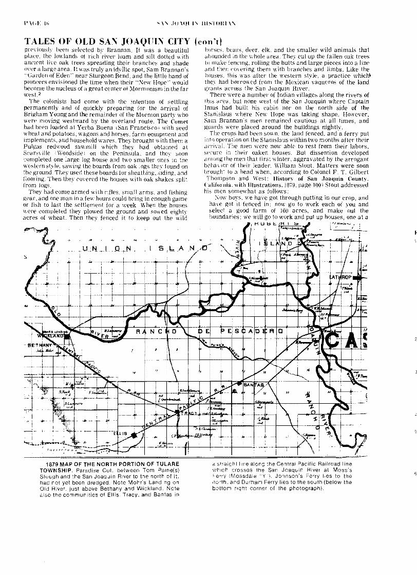
a straight line along the Central Pacific Railroad line which crosses the San Joaquin River at Mosss Ferry fMossdale Y) Johnsons Ferry lies to the north and Durham Ferry Iies to the south (below the bottom right corner of the photograph)
E
1879 MAP OF THE NORTH PORTION OF TULARE TOWNSHIP Paradise Cut between Tom Paine(s) Slough and the San Joaquin River to the north of it had not yet been dredged Note Mohrs Landing on Old River just above Bethany and Wickland Note also the communities of Ellis Tracy and Bantas in
6
S lOtnl IIISTOHl
T ALES OF OLD SAN JOAQUIN CITY time so that by the time the crop is ready to harvest you will all have vour houses and farms But I selected this place this house and this farm are mine This was the straw that broke the camels back and
Sam Brannan was sent for to hear the mens grievances Upon his arrival a church meeting was called in the largest of the three structures at which a unanimous resolution dedicating the entire settlement to the Twelve Apostles (to the Church leadership) was adopted thus thwarting Stouts plan to assume personal ownership A few days later Stout left the group returning to San Francisco
But this was only the beginning of the difficulties that were to plague the small band that winter In locating the colony along the lowlands of the Stanislaus Brannan and Stout had failed to take into account the idiosvncrasies of Mother Nature A mile and a half to the southwest was the mouth of the Stanislaus River flowing into the San Joaquin at an angle against the current And just below (north) this pOint lay Sturgeon Bend where the combined waters of the San Joaquin and all of its tributaries were forced to flow in a counter-clock-wise motion creating the whirlpool effect in the hairpin turn of the river In January (1847) these waters seemed to flow with a vengeance into Sturgeon Bend the result of extra heavy rains that month Coupled with a high tide backing up the wa ters of the San Joaquin on its lower reaches the Stanislaus River backed up and spilled its water down the steep narrow overflow channel that by-passed its mouth cascading the silt-laden flood waters at great speed and pressure into the outer periphery of the reverse curve of Sturgeon Bend In one hour an eight-foot rise was recorded at the Bend and yet the waters continued to rise The inevitable finally happened the torrents of water spilling over into the lowlands and plains on both sides of the San Joaquin and north side of the Stanislaus The floodwaters swept the buildings and fences away the men clinging to the debris as it lodged in the trees
PICNIC PARTY OF YOUNG SAN JOAQUIN CITY PEOPLE at the old Henry Fink Grove of oak trees on his ranch near Paradise on Tom Paine Slough Third
(cont) Lpon their return to the site of the colony days later
following the subsidence of the flood waters they were appalled at the desolation they found Upon digging up a batch of potatoes they found all rotten to the core They could not even reach Sturgeon Bend to fish and wildlife was now frighteningly scarce They left one or two at a time some to join the settlements on Dry Creek and the Mokelumne others to return to the families thev had left behind in San Francisco Even a visit by Brannan in April was not enough to give the men the determination that would be needed to re-establish their community in antiCipation of the arrival of Brigham Young and his Saints in California and the subsequent establishment of New Hope as their headquarters3 In November (847) the last of these Mormon pioneers Alondus Buckland left the ill-fated colony
In 1849 New Hope came back to life briefly but with a new name Stanislaus City - and a new purpose - to serve the miners on their wav from Stockton to the Southern Mines A ferr~ was re-estabiished at the same point on the Stanislaus as the original Mormon ferry and an 1851 map of the area shows that the road from Stockton (over what is now the approximate route of Airport Way to the Stanislaus River) to Tuolumne Citv C crossed the Stanislaus River at this site othing cameof the attempt to re-settle the area however and b~ May 1851 a pioneer of the area Henry Grissim was farming the land5
BAlTAS
Another interesting settlement whose existence was contemporary with that of San Joaquin City was Bantas This little settlement owed its existence to the need for a way-station along the Stockton-Pueblo San Jose stage route between Stockton and the Livermore Pass The Elk Horn Inn had been constructed in the winter of 1849 by A E Henrv and a certain Dr Hopkins at the point where the River Road
man from the left (sitting) is William Riecks later sheriff of San Joaquifl County Photo taken about 1890 by Charlie Dreyer of San Joaquin City
Courtesy 01 the author
- 10111 111~T()ItI
TALES OF OLD SA JOAQCI CITY through San Joaqui1 City crossed the stage route and contltlued northestward to Iohrs Landin on Old Rier ll11ost immediately the Inn cranged hards and the new propnetor A IcCafer begar rurming adyertisements In
the Fpoundbruary 1850 issues of the Stockton Times newspaper It was descdbed as fiye miles e5t of Bonsel and Doaks Ferry on the San Joaquint The Inn was opened iollOing the establishment of Slocums Fern in 1819 some threpound miles below I north j the Doak and 130nsell Ferr I IossdaJe Y and Johnsons Ferry which in turn was established between the other two With the opening of these tO ferries the stage route as shortened between Stockton and the Livermore Pass west of the rier the road from Slocums Ferry met the road from Johnsons Ferrv and from their interseciion the route lav across what is now the Sterart Tract At the Tom Paine Slough it crossed at iust about the point where the Southern Pacific Railroad crosses it todav
Leaing Elk Horn Inn the road followed along the south bank of Tom Paine Slough to Mohrs Landing where it left Old River and then headed directh into the Liermore Pass and on to San Jose Along Tom Paine Slough on the south side was a tule marsh about a half-mile ide and it often oerflowed when the tide came in An earh settler ir the area a man bgt the narTe 01 ChalTberlain took oer the Elk Hern Inn circa nd he built there
1lt l
IUles unti In the png (I lS4ii
from LinIlCJres Pb cal dOfl
iust about v here ~~~t~middot
etarished and [ol1od tilt 1 and BIJnsalr~ Cit This road ran propert north of Tra r
plant site the roaa d
north of what is now Arbor Roa It was [I
another stage statlOn or more properh a teamsters was erected about the year 1857 that the first grain was hauled from San Joaquin Ct to lohr5 Landing
This house had been erected b J H Smith the famous Go Ahead Johnny Smith stage-driver and teamster to the Iother Lode towns in the earlv days Built in sections in Boston Massachusetts it was shipped around the Horn In a sailing vessel which delivered it at Mohrs Landing After assembling his structure Smith also built barns and stables The house was painted white and was known as the Little White House to distinguish it from Chamberlains White House a scant two miles to the southeast Smiths original house and outbuildings were destroyed by fire in 1963
It is interesting to note that Edward B Carrell lat Corral Hollow stated in his dian under the date of Ylarch 3 1857 that The road is bad between Chamberlains and Stockton the slews IS 1filling up Like all other stage and wagon roads of the 1850s and 1860s the River Road was dust~ in summer and almost impassable in wet weather
In 11163 Henr~ C Banta bought Chamberlains hite House and then with the construction of the Central Pacific Hailroad across his propert~ in the late 1860s he built new build1l1gs about a half-mile south of the original site b There was a great amount of activity at Bantas during the 1860s unerous buildings were constructed large sheep and cattle
~ (ont I (Illab lIee built as lIe] as a termirallor the hea eirLing to tile l1iling countrY l1angt as a thousanct h)rE~ and mu1es Ilere corralled there at a time and hidrEds more Iere or the road eight-span teams were a common sight
J H Smith played a leading part in these operations from is headquarters at the Little White House The teaming ~taLOl at Bantas before the coming of the railroad was operated b~ Caleb String Merrill
About the time the railroad came through Tulare Township the levee along the south side of Tom Paine Slough was constructed to reclaim the land between the River Road and the Slough itself This was the first levee construction job undertaken amwhere on the Delta
This work or reclamation was done bv Chinese laborers man hundreds of them using wheelbarrows to clean out th~
SOUTH BANK OF TOM PAINE SLOUGH re levee work dae by Chlnese before the turn ce(Ury This is the site of the original bridge
Courtesy of the author
channel and to build up the levee to a height of five feet or more above high-tide level Cp to a few years ago a son of J H SI1i th lived on Union Island He was in his nineties then and eyerv year he would visit the farmers along Arbor Road and Tom Paine Slough to relive with them the old days when he was a boy living a t the Little White House
He renembered vividh the home where he had been born and raised and the old agon shed that for years after the construction of the levee was filled with wooden wheelshybarrOs stacked high one on top of the other They had heavy Ivooden Ilheels with iron tires and their bodies were made of staes from the hakes of oaken whiskey barrels bolted and banded to a wooden frame with handles
Smith also recalled the deeply-rutted wagon road along the edge ot the tule marshes and the great wagons and teams hauiing supplies and machinery to the mines lost of the heavy maehinery boilers crushers pumps and other mining eqUipment was hauled direct from San Francisco by wagon Some 01 the teams were of sixteen to twenty horses A single jerkllne running along the left side of the near horses to the
19
lO(1l I III TOHI I (E t1
TALES OF OLD SAl JOAQUIl CITY (con~t~ bit of the near leader guided the team A steady pull on the line and the teamsters Haw Haw meant a left turn a series of jerks and a Gee Gee meant a turn to the right
And then there was the road that branched off the River Road from his house and went diagonally across the land the
m Chinese had reclaimed in a northeasterly direction and across Tom Paine Siough on a bridge that they also built The
as
ip as ld )b
S le
SICurn nilS IS a i l1al Gldpe tLlil Olr
bridge was a half mile from the Little White House and about two hundred yards east of the Laurel Asel1ue bridge at Hog Island It was the first to be built across any of the Delta waterways and it opened up that fertile region beleen Old Hiyer and Tom Paine Slough known now as the Paradise and Steart tracts 9 The bridge was a monumental
leat for those days being thirty feet wide and over two hundred feet long from pier to pier
At low tide the wooden piles (or piers) can still be seen four on each side of the Slough but the bridge itself is gone Gone too is the beautiful grove of oak trees that once shaded the bridge
Another bridge across Tom Paine Slough was built just a little later It was east of Chamberlains White House where the Stockton stage road went down (east) to the ferries hile the writer realizes he is going far afield in his Tales of Old San Joaquin City even getting off the River Road in crossing Tom Paine Slough yet there is another tale that should be told at this point in the narrative as it will give the reader a better insight into the road conditions during these pioneer years
According to the story that has been passed down orally through the years one summer day after the McCloud Stage from Stockton had ltrossed the San Joaquin at the Johnson Ferry and was on its way across the river bottom lands toward Chamberlains the passengers noticed that they were being followed by some mounted men Because the stage carried a heavy money box and because every seat was filled with passengers including some of the fair sex the drier whipped up the horses and there was a race and pursuit across the tule flats that liould do justice to any modern western movie
Because the rutted road was dry and the dust thick the team and stagecoach threw up a cloud of dust so
n~a t i the robbers from immediat(h and fhe guard knew they oLiI~i soon the had passed over the
was or hard ground where the dust made their plans accordingly
Oer the bridge the two men threw tne l~(Jle bpx onr the bridge rail into the waters of the slough CP1JrlUll1g on to ChamberlainS White House at top sneed
Judging correctl what had transpired the would-be stage robbers topped ai the bridge and desperately attempted to r(~COer the mone box The were unsuccessful however
Dr J n Id
rn 1e ~1shyy of ld
1e 15 1e INTERIOR OF CHARLIE DREYERS WEST SIDE 19 HOTEL AND BAR at Bantas following his removal n from San Joaquin City Charlie was not only an early Ie photography enthusiast but also a talented artist 1e The sign over the near end of the bar reads WE
WELCOME ALL NATIONS CARRIE TO TRUST YOU TO WH ISKEY OH NO ITS TOO RISKY TO PAY FOR YOUR BOOZE THEN I CANT REFUSE Stenciled on the bottle cases (lower riQht corner) is LIVERMORE SODA WORKS Courtesy of the author
I(E~II Iotlll IIISTOHI
TALES OF OLD SAN JOAQUIN CITY (con~t) because the mud in the slough was too deep and they had to flee before the men at Chamberlains would be able to organize and arm a posse to hunt them down
The coming of the railroad to Bantas gave the community a new lease on life in 1869 although the establishment of Tracy as a junction point by the Central Pacific Railroad in 1878 sealed its fate once and for alllO At its height Bantas boasted a permanent population of 150 inhabitants with a post office four general stores two blacksmith shops one hotel one livery stable one boot and shoe maker and five saloons It was strictly a railroad town serving as a shipping point for cattle and sheep with corrals and chutes for loading the livestock onto railroad cars and pits for sheep dipping Thousands of cattle from the huge Miller and Lux ranges to the south were driven down the River Road through San Joaquin City for shipment out of Bantas for years In time grain fields replaced the open cattle ranges of the valley and in time shipping from Bantas became a thing of the past Like so many other promising communities of the period it languished for some time finally becoming little more than a memory of a colorful past in San Joaquin County
TlOLll1E CITY
With great expectations Tuolumne City was founded in the early spring of 1850 It bid fair to become the county seat of Stanislaus County soon after the formation of the latter in 185412 It was located on the Tuolumne River about three miles up from its mouth and about two miles east of the place where S J Grayson had established his ferry (at Gra~sonville) on the San Joaquin River the prior year
A gentleman by the name of Paxton McDowell was the promoter of the enterprise He laid out lots on 160 acres of ground fronting on the river and sold them at high prices on the promise and expectation that the traffic coming through Corral Hollow (from the Livermore Valley) and out of Lone Tree Can~on would swing south to take advantage of the Gra~son Ferr~ and the river route along the Tuolumne River to the Southern Mines Also lcDowel had his sights set on the nverboat traffic that was sure (he thought) to develop between Tuolumne City and Stockton and he built docks and landings to accommodate the expected nO of boats and barges From the first a le boats did make their way up to Tuolumne City but the were hampered and endargered by the many snags and obstructions in the river channels
LaH in the same ear the vater level in the rher went dow to uch an e~tent tb boab could not naigate upstrean that far ResldenlS panic1ed and began to desert
their new city almost as quickly as they had created it and Paxton McDowell abandoned the project with great loss to the businesses and individuals who had cast their lots with him The usual pioneer-town business establishments had mushroomed to life - the saloons hotels livery stables general merchandise stores barber shops blaeksmith shops harnessmakers - even a newspaper office and a post office - only to wither and die as quickly A few of the buildings on front street were not of the usual wood construction of the pioneer town but had been built of briek with great iron doors like those found in the Mother Lode towns
Perhaps the most interesting enterprise of them all was the combination gambling hall and entertainment house (actually a tent structure) that had been moved down from the Sonora mining region The move to Tuolumne City was voluntary but the move from Sonora was at the sheriffs request When the bubble burst in the little river town this house of entertainment moved out in the fashion of a circus and established itself by the side of the road in the mouth of Corral Hollow canyon Being on the main line of traffic between the coast region and the Southern Mines the establishment was calcula ted to drain off some of the gold coming down from the mines in the pokes and saddlebags of the returning miners Edward B Carrell13noted in his diary their arrhal from Tuolumne City in December of 1850 and two months later the demise of its nefarious operations with the murder of four men in the tent
In the middle 1860s Tuolumne Citv was revived due to the development of grain farming in thearea and ships plied the Tuolumne during periods of high water carrying grain to Stockton In 1870 when the Central Pacific Railroad was bullt through the San Joaquin Valley the new town of Jodeslo sealed the fate of the little river town once and for all The inhabitants and a number of the buildings of Tuolumne City literally moved en masse to the new railroad cown
HILLS FERRY
1J1~ Ferry illS inside the southern boundary of StaniSlaus County was another important rier tovm The
on the San Joaquin was irt operated lt1 n~an naD1ed Thcrnp~on 13rIike the
towns took their transem trade from tbe titt Corral Hollow and Stockton for the most part lIil]~ FelT~ took its trade from Spanish-Californians cmd IeXlcans passing through Pacheco Pass and u) thrlJ1gh the
ARTISTS CONCEPTION of Hills Ferry at its prime Taken from the Newman Diamond Jubilee (1868-1963) publica lion
- JO(HT IlISTOHl
T ALES OF OLD SAN JOAQUIN CITY at West Side on their way to the Mother Lode Hills Ferry had rs a relatively long and relatively interesting history5 le especially during the first two decades of its existence when le cattle thieves bandits and lawless characters in general h made their rendezvous and sanctuary from the law there ld Like the other river settlements that were contemporary
of in le r Id
Lit ir s ~ rJt )ll
rl ~
(con~t) with San Joaquin City the history of Hills Ferry was explicitly interwoven with that of its sister cities all having a common background and a common bond through the waterways and wagon roads which connected them
[To Be Continued In Next Issue J
Id Taken from the Newman Ie
Id
_shy Diamond Jubilee a EARLY PHOTOGRAPH OF HillS FERRY Note steamboat In background (1888-1963) publicalion
EDITORS NOTES A State Registered Landmark erected approximately one mile east of The Mossdale Y crossing of the San Joaquin River on the south side of Highway 120 commemorates the event
THE COMET - 1846 - FIRST SAIL LAUNCH First Known sail launch to ascend San Joaquin River from San Francisco landed here in autumn 1846 Carried twenty Mormon pioneers who founded New Hope agriCultural project on Stanislaus [River) Yoke of oxen and span of mules driven from Marshs Landing (Antioch) by two men who followed crude map drawn by Merritt the trapper Two years later Doak and Bonsall operated here [Mossdale Y] the first ferry on the San Joaquin River
The presence of Sam Brannans Mormon party in Stockton was noted several years later by Captain Weber when he named the slough that passed through the south-central part of Stockton for them Walthall Slough evidently takes its name from a pioneer land-owner in that area Madison Walthall Sr A Mexican-American War veteran he came to California in 1849 and was soon after elected to the states first legislature from San Jose He came to San Joaquin County about 1850
1 apparently at the end of his one-year legislative term r 2 For the reader who may wish to obtain a brief overview of the Mormon actlv ties in Cal1fornJa during this reriod two sources are recommended 11 Hubert H Bancroft History of California Vol V (The Works of Hubert H Bancroft Volume XXII) Chapter XVIII and pages 544middot554 of Chapter XX 21 Norma B Ricketts Mormons and the Discovery 01 Gold (Placerville Pioneer Press 1966)
bull 3 Sam Brannan cad envIsioned New Hope Colony as the terminous of the long marc~ overland of the Mormons who to leave behind tram
ihe persecution of the eastern states as moved out to the West to establish a permanent home After his VISI to the sticken he received word that Instead of their march to You~gs followers were at the Great Lake and tre California members were ordered back Utah This of course ended Brannans dreams and New Hopes purpose
Tuolumne City described by the author in this Issue of the Historian was apprOXimately three miles east of the San River on the north bank of the Tuolumne River In lodays Stanislaus
5 State Registered Landmark No 436 located near Ripon commemorates the founding of the Mormon settlement
NEW HOPE - 1846 - FIRST WHEAT ApprOXimately six miles west twenty Mormon from ship Bfoo~lyn founded first known colony In Valley planted Ilrst wheatmiddot also irrigated by poe and method Erected three log houses sawmill and lerry across Stanislaus Seltlement later ~nown as City
6 The following advertisement appeared for several months in the Stockton Times
ELK HOlN INN ThiS well known stand IS located on the road leading from Stockton to Pueblo San Jose five miles west of Bonsell and Doaks Ferry on the San
Joaquin The travellln public will find here accomodations tor themselves ard their arlmals as good as the country can afford Animals kepI al low rates per month The proprietor invites the public to calt and examine fa themselves A McCatler
Mohrs Landing was established on the Old River by a pioneer settler in the Bethany area John Mohr He arrived in San Joaquin County in 1857 bUYing 240 aces on the south side 01 the Old River This was at the same time that JOhn OBrien and Edward B Carrell had organized the Pacific Coal Mining Company up in Corral Hollow Coal from the mining operation was hauled by wagon to Mohrs Landing where it was transferred onto barges for shlpmect to Stockton and San Francisco Within four years Ihe town of Wickland was laid out lust a half-mile Ilgtelow the landing and it thrived for some eight years - until the coming of the railroad across the Tulare Township The town of Ellis was laid out along tM Central Pacific Railroad route Just south of Wickland in 1869 and the coal was then shipped out by railroad with a spur line the Corral Hollow Railroad connecting the mines eight miles to the south with the Central Pacific The settlement (ElliS) grew rapidly and by October of the following year (1870) according to a Stockton Independent news article of October 26th the new town already had some 45 to 50 buildings It boasted good flat soil and it even had an ocganized Sunday School - a sure sign of growing up Most Of the WCKland reSidents moved to Ellis taking their buildings with them but In 1879 the little community (Wickland) could still boast that it had a hOtel a waehouse a blacksmith shop and a number of homes A ferry established earlier In conjunction with the landing operations continued te opeate under the name of Naglees Ferry
In 1878 te Southern Pacific built a line from Oakland to connect with tee eXisting Cerlral Pacdie line that ran from the Bay Area to Stockton t1Gugh E IS With tre oificia opening of the new line on September 8 1878 t1e city of Tracy was barr at tre point where the two rail lines met sorre trree miles east of Ellis The Ells residents then moved to the new ali unctcn abandonng that site comp etely
8 Heny Banta and hiS brother Williarr carre to Caillornia (San Joaquin County) In 1854 Ie hiS own words he bill [SIC] the town off Banta n 1867-68 along the rail line whlcr rae from Stockton to San A very bref Dlograpry including Bantas own account was published in 1954 by the San Joaquin Pioneer and Hlstoncal Society under the title Ups and Dowens of a Ole Calafomaen The original manusCrIpt is at the Haggin Pioneer Museum in StocKtor
9 At tnat time Paradise Cut had not yet been dredged between Old River and Tom Paine Slough (See 1879 Tulare Township map on page 16)
10 Tne best deSCription of what after Tracy became the railroad Junction pOlet can be found 111 own words Mitten just after the turn of the century
tha [they] run tha [the] AntIoch Branch to Whare tha town of tracy [is cow located) one mile and a half Bee low tM town of Banta and moved tha town off ellS [Eilis) up thare and Irat ruened tha town of Banta So I had to sellout for what I Cold gil (Henry Comes Bania Ups and Dowens of a Ole Calafomaen)
FHI row OTE~ I COllt I
stabe were bu bJ Banta a a cost cf $6 ODO
12 ThiS IS when ore that the CDLgtry seat was ocated seWe1lens betoe Modesto waS se~IIElt upon in as the permanent sea~ of county government Adamsshyville Empe City La Grar-ge and Koghfs Fery
13 Edward B Carrell toolt up residence In Corral Hollow in 1850 This s the sa1le area referred to by Me Williams in the prevIous Historian as the Spanards EI Arroyo de Buenos AIes The author IS in possession 01 a the Carrell diaries
14 Modesto was ioealed approxlrratey nine miles east of Tuolumne City The colony of Paradise laid out rn 1867 five miles east of Tuolumne City ard also or the river suttered the same fate as ils flval cty Readers Interested In the toundlng of Modesto are eterred te Modestos 1970 centerrlal publication One Hundred Years by Jeanrelle Gould Mano
15 In 1888 the present city ot Newman was ald out and lOIS were oliered for sale by the Southern PaCific Railroad which had just completed its line down the West Side like the reSidents of Tuolumne City before them the cllizers of Hilis Ferry were induced to up lOCK stock and barrel and mOve to the new railroad stop some miles to the souI1wesl The first fOur p3ges of the Newman Diamond Jubilee 1888-1963 published by a specla Newman J~bllee Committee in 1963 contain an interesting account of HIli s Ferry
Persons interested in doing research on local history whether members of the Society or not are invited to submit their manuscripts for publica lion in the Historian The editor must however reserve the right to accept or reject andior edit all material and photographs submitted
While none of the original rna terial printed in the quarterly is copyrighted we would apprecia Ie acknowledgement of the source by anyone using any portion thereof
SA JOAQn~ HISTORL The Quarterly of the
SA JOAQUI~COUlTY HISTORICAL SOCIETY INC Published Four Times Each Year
pO Box 21 Lodi California 95240 Editor Robert Bonta
The San Joaquin County Historical Society a non-profit corporation meets the fourth Monday of each month except for July and August Annual memberships are Individual- $500 Corporate - $800 and Junior $100 and include a subscription to the San Joaquin Historian ~on-members may purchase individual copies from the Societys Secretary at $100 per cop~ The Society also operates the San Joaquin Count Historical I-luseum at Micke Grove Persons wishilig to dona Ie items should contact the -Iuseum Direlttor
OfficPls of the S JO Ql I COlTY IlISTOmCL SOCIETY
11 Elwood L 1 (1s Pnsidtnt Edward Pic icp- Presiitll t
lrs Hnarrl W Soptan lIart ilqn TnaSlir(1
D1KElTOHS Hoi )(rt Bonta Dr HO(lr-ci T Letcher 1j~ Urllll D Kttielnlan Sr Dr -tred B ehiJel
s JOHHI lotTY II1STOHlCL 1lSEl1 Irs L Philip Iedora I Johnson Dirpctor
llicke Grove Park 11793 Iicke Grove Road Lodi California
Phonearea209 368-9154 POBox21LodiCaliL95240
Iblpllaupous from thp ~TO(KTO TIIES
TlOLL1E CITY The subscribers having been appointed Agents for the
abOe flourishing town are prepared to dispose of several lots admirably located A map may be seen at our office corner of 1lain and Eldorado streets
HEATH amp ElWRY Agents
advertisement March 23 1850)
PICKED lP ADRIFT CAPI S ]IZED in the San Joaquin river about 20 miles
below Stockton a small sail boat about three tons burthen sloop rigged bottom green sides white with red stripe contains some clothing and a small quantity of provisions and a memorandum book containing papers bearing the name of John Lawrence Inquire of
FIRST ALCALDE Stockton advertisement March 23 1850)
San Joaquin City election results for organization of first San Joaquin County government [only the top vote-getter in each category and the number of votes he received is listed]
Clerk of the Supreme Court --W G Marcy 46middot [votes] County judge -- Benjamin Williams 44 Surveyor -- A K Flint 46 Sheriff -- Dr R p Ashe 44 Recorder M T Robertson 44 Clerk -- J Patterson 46 Assessor -- Thomas McSpedon 36 Treasurer -- C J Buffum 40
I San Joaquin City election results continued]
In addition to San Joaquin City the following were the only other polling places in San Joaquin County Atherton and Dais Ranch Isbells Ranch French Camp Stockton Kmghts Ferry Reds Tent
news ilem April 6 18501
ISIT TilE ~lt HIHprlt eOy y
lOlH Iii ~l (0 P 1 EDESi) r TllHOl(1I middot~IHY
CLOSED JIODXYS TUmiddotSDt YS EW YEAHS D Y TlLKS(IIG D Y D CHRISTJLS DA Y