Safety of Navigation
31
Focus on IMO International Maritime Organization, 4 Albert Embankment, London SE1 7SR, United Kingdom Tel: +44 (0)20 7735 7611 Fax: +44 (0)20 7587 3210 Contacts: Lee Adamson – Senior External Relations Officer; Natasha Brown – External Relations Officer E-mail: [email protected] Web site: www.imo.org These documents are for background information. Please refer to the website www.imo.org for up-to-date information. January 1998 IMO and the safety of navigation The Lloyd's Register of Shipping Casualty Returns for 1958 - the year before the IMO Assembly met for the first time - showed that 16 per cent of the merchant shipping tonnage lost that year (56,000 gt) resulted from collisions and a further 32 per cent (115,000 gt) from groundings or striking wrecks. The vast majority of these casualties - nearly half the total for that year - were thus caused or contributed to by navigational error or deficiency. This proportion was by no means uncommon and indeed many of the worst disasters in shipping history have resulted from collisions and other accidents which can be attributed to navigational errors. It is hardly surprising, therefore, that IMO has always paid great attention to the improvement of navigational safety. Since 1959 a whole series of measures have been introduced, in the form of conventions, recommendations and other instruments. The best known and most important of these measures are conventions, three of which are particularly relevant to navigation. These are the International Convention for the Safety of Life at Sea, 1974; the Convention on the International Regulations for Preventing Collisions at Sea, 1972; and the International Convention on Standards of Training, Certification and Watchkeeping for Seafarers, 1978. Conventions are particularly important because they are binding legal instruments. A State which ratifies or accedes to a convention is obliged to put it into effect by making its requirements part of its own national law. To ensure that the instrument is properly enforced it may be necessary to recruit surveyors or inspectors, shipowners may be obliged to install extra equipment on their ships and improved training may have to be provided. Despite this it is significant that all three instruments referred to above have achieved a very wide measure of international support. SOLAS now covers more than 98 per cent of the world merchant tonnage, the Collision Regulations more than 96 per cent and the STCW Convention has been accepted by 129 countries, whose fleets represent 97.55 per cent of the world merchant tonnage. Besides Conventions, IMO has also issued a series of resolutions and codes, including guidelines on navigation issues and performance standards for shipborne navigational and radiocommunications equipment. Some are simply recommendations - though such is their wide acceptance that they effectively mark international policy -while others are referred to by relevant Regulations of specific Conventions, thereby giving them the same weight as the Convention Regulations themselves. This paper looks at IMO's work in the area of safety of navigation, in the following sections: • International Convention for the Safety of Life at Sea (SOLAS) • Collision Regulations (COLREG) • Convention on Standards of Training, Certification and Watchkeeping for Seafarers (STCW) • Ships' routeing / Vessel traffic services / Ship reporting systems • Pilotage
Transcript of Safety of Navigation
Focus on IMO
International Maritime Organization, 4 Albert Embankment, London SE1 7SR, United Kingdom
Tel: +44 (0)20 7735 7611 Fax: +44 (0)20 7587 3210 Contacts: Lee Adamson – Senior External Relations Officer; Natasha Brown – External Relations Officer
E-mail: [email protected] Web site: www.imo.org
These documents are for background information. Please refer to the website www.imo.org for up-to-date information.
January 1998
IMO and the safety of navigation The Lloyd's Register of Shipping Casualty Returns for 1958 - the year before the IMO Assembly met for the first time - showed that 16 per cent of the merchant shipping tonnage lost that year (56,000 gt) resulted from collisions and a further 32 per cent (115,000 gt) from groundings or striking wrecks. The vast majority of these casualties - nearly half the total for that year - were thus caused or contributed to by navigational error or deficiency. This proportion was by no means uncommon and indeed many of the worst disasters in shipping history have resulted from collisions and other accidents which can be attributed to navigational errors.
It is hardly surprising, therefore, that IMO has always paid great attention to the improvement of navigational safety. Since 1959 a whole series of measures have been introduced, in the form of conventions, recommendations and other instruments.
The best known and most important of these measures are conventions, three of which are particularly relevant to navigation. These are the International Convention for the Safety of Life at Sea, 1974; the Convention on the International Regulations for Preventing Collisions at Sea, 1972; and the International Convention on Standards of Training, Certification and Watchkeeping for Seafarers, 1978.
Conventions are particularly important because they are binding legal instruments. A State which ratifies or accedes to a convention is obliged to put it into effect by making its requirements part of its own national law. To ensure that the instrument is properly enforced it may be necessary to recruit surveyors or inspectors, shipowners may be obliged to install extra equipment on their ships and improved training may have to be provided.
Despite this it is significant that all three instruments referred to above have achieved a very wide measure of international support. SOLAS now covers more than 98 per cent of the world merchant tonnage, the Collision Regulations more than 96 per cent and the STCW Convention has been accepted by 129 countries, whose fleets represent 97.55 per cent of the world merchant tonnage.
Besides Conventions, IMO has also issued a series of resolutions and codes, including guidelines on navigation issues and performance standards for shipborne navigational and radiocommunications equipment. Some are simply recommendations - though such is their wide acceptance that they effectively mark international policy -while others are referred to by relevant Regulations of specific Conventions, thereby giving them the same weight as the Convention Regulations themselves.
This paper looks at IMO's work in the area of safety of navigation, in the following sections: • International Convention for the Safety of Life at Sea (SOLAS) • Collision Regulations (COLREG)
• Convention on Standards of Training, Certification and Watchkeeping for Seafarers (STCW) • Ships' routeing / Vessel traffic services / Ship reporting systems • Pilotage

2
• Navigational charts
• Shipborne navigational equipment
• World Wide Radio navigation system/Future Global Navigation Satellite System • Standard Marine Navigational Vocabulary • The World-Wide Navigational Warning Service The International Convention for the Safety of Life at Sea (SOLAS) The SOLAS Convention is the most important of all maritime safety instruments. The first version was adopted in 1914 (following the Titanic disaster) and other versions were drawn up in 1929 and 1948.
In 1960, IMO's conference on safety of life at sea adopted the fourth version. It was intended that this would be kept up to date by regular amendment, but the procedure incorporated in the Convention proved so cumbersome that it was impossible to introduce changes and have them enter into force within a reasonable period.
Eventually it was decided to adopt a completely new version incorporating all amendments to the 1960 Convention which had already then been adopted but which had not entered into force. Additionally, a new "tacit acceptance" procedure was incorporated which would enable amendments to enter into force within two or three years of their adoption. However, extensive revision of the Convention was not undertaken at that time.
The Convention in force, known as SOLAS 1974, covers various aspects of ship safety, including construction, fire protection, life-saving appliances, radiocommunications, safety of navigation, the carriage of cargoes and safety measures for high speed craft.
Measures dealing with the safety of navigation appear in Chapter V:
Regulation 1: This states that the chapter, unless expressly provided otherwise, applies to all ships when engaged on all voyages except ships of war and those navigating solely in the Great Lakes of North America. The only regulations expressly providing application to specific ships are regulations 11 and 12.
The application of the chapter is thus much wider than other chapters of the SOLAS Convention, which generally only apply to ships engaged on international voyages and exclude cargo ships of less than 500 tons gross tonnage (300 tons gross tonnage in the case of Chapter IV), yachts, fishing vessels, ships not propelled by mechanical means and wooden ships of primitive build.
Regulation 2: Danger messages: Masters of all ships are obliged to communicate information regarding dangers encountered (such as ice, derelicts or storms) to other ships in the area and to the nearest coastal authorities. Contracting Governments are required to ensure that such information is brought to the attention of those concerned.
Regulation 3: Information required in danger messages is described and examples are given.
Regulation 4: Meteorological services: Contracting Governments undertake to encourage the collection, dissemination and exchange of meteorological data.
Regulation 5: Ice Patrol Service: Contracting Governments undertake to maintain an ice patrol for the study and observation of ice conditions in the North Atlantic. (The International Ice Patrol was originally set up as a direct consequence of the 1912 Titanic disaster.)
Regulation 6: Ice Patrol, management and cost: The United States agreed to continue the management of the service. Contracting Governments especially interested in the service agree to contribute to the expense involved, contributions being based on the total gross tonnage of vessels passing through the area covered by the Ice Patrol.
Regulation 7: Speed near ice: At night, masters are bound to proceed at moderate speed or alter course well clear of the ice when such is reported.

3
Regulation 8: Ships' Routeing: The principle of ships' routeing is recognized and IMO is recognized
as the only international body for establishing such systems. These provisions are supplemented by the International Regulations for Preventing Collisions at Sea in respect of traffic separation schemes and various IMO Assembly resolutions. The regulation was revised in May 1995 with the current version entering into force on 1 January 1997.
Regulation 8-1: Ship reporting systems. This regulation was adopted in 1994 and entered into force on 1 January 1996. It makes it possible for Governments to introduce mandatory ship reporting systems, subject to their approval by IMO.
Regulation 8-2: Vessel Traffic Services (VTS). The Regulation, adopted by the Maritime Safety Committee in 1997, sets out when VTS can be implemented. It says they contribute to the safety of life at sea, safety and efficiency of navigation and the protection of the marine environment, adjacent shore areas, worksites and offshore installations from possible adverse effects of maritime traffic. The regulation is due to enter into force, under "tacit acceptance", on 1 July 1999.
Regulation 9: Misuse of distress signals: The use of an international distress signal for any purpose other than indicating that a ship or aircraft is in distress is forbidden. The signals to be used to indicate distress are prescribed in the International Regulations for Preventing Collisions at Sea, 1972.
Regulation 10: Distress messages - obligations and procedures: A master receiving a distress message is "bound to proceed with all speed to the assistance of the persons in distress informing them if possible that he is doing so." The master of a ship in distress has the right to requisition ships responding to his call, selecting those which he considers best able to provide the required assistance. The regulation was comprehensively revised in 1995 and the current version entered into force on 1 July 1997.
Regulation 10-1: Master's discretion for safe navigation. The regulation, which was adopted in 1995 and entered into force on 1 July 1997, states that the master of ship shall not be constrained by the shipowner, charterer or any other person from taking any decision necessary for safe navigation, particularly in severe weather and heavy seas.
Regulation 11: Signalling lamps: All ships of over 150 gross tonnage engaged on international voyages are required to be provided with a signalling lamp.
Regulation 12: Shipborne navigational equipment: This regulation, which covers carriage requirements for navigational equipment, was modified by the 1978 Protocol and subsequently entirely revised by the 1981 amendments which entered into force on 1 September 1984.
The requirements vary according to ship size and year of build and include compasses (magnetic and gyro), radar, automatic radar plotting aids, echo sounders, devices to indicate speed and distance, devices to indicate rudder angle, propeller revolutions, rate-of-turn indicators and radio-direction finders. Such equipment must comply with the performance standards set out in various IMO Assembly resolutions.
Regulation 13: Manning: Contracting Governments undertake to ensure that "from the point of view of safety of life at sea all ships shall be sufficiently and efficiently manned". These provisions are supplemented by the International Convention on Standards of Training, Certification and Watchkeeping for Seafarers, 1978 and IMO Assembly resolution A.481(XII) on Principles of Safe Manning. A new paragraph adopted in 1995, which entered into force on 1 July 1997, requires that on passenger ships on international voyages, a working language be established in order to ensure effective crew performance in safety matters.
Regulation 14: Aids to navigation: Contracting Governments undertake to establish and maintain aids to navigation such as lighthouses, buoys and radio aids.
Regulation 15: Search and rescue: Contracting Governments undertake to ensure that necessary
4
arrangements are made for the rescue of persons in distress off their coasts. This requirement is supplemented by the International Convention on Maritime Search and Rescue, 1979.
Regulation 16: Life-saving signals: Life-saving signals must be used by life-saving stations, maritime rescue units and aircraft engaged in search and rescue operations and by ships. A table of life-saving signals must be readily available to the officer of the watch on every ship to which the chapter applies. Reference is made to the IMO Search and Rescue Manual (IMOSAR) and the Merchant Ship Search and Rescue Manual (MERSAR).
Regulation 17: Pilot transfer arrangements: The regulation requires pilot transfer arrangements to be provided and says equipment and arrangements for pilot transfer must comply with IMO standards. The Regulation includes requirements for transfer arrangements, access to the ship's deck, shipside doors, mechanical pilot hoists, associated equipment and lighting.
Regulation 18: VHF radiotelephones: The provisions are now included in Chapter IV of SOLAS.
Regulation 19: Use of automatic pilot: In areas of high density, conditions of limited visibility and other hazardous situations, it must be possible to establish human control of the steering immediately.
Regulation 19-1: Operation of Steering Gear and Regulation 19-2: Steering Gear Testing and Drills: The 1978 Protocol and the 1981 Amendments introduced new requirements on the use of automatic pilot, the operation of steering gear and steering gear testing and drills.
Regulation 20: Nautical publications: All ships must carry adequate and up-to-date charts sailing directions, list of lights, notices to mariners, tide-tables and other nautical publications necessary for the voyage they are undertaking.
Regulation 21: International Code of Signals: This must be carried by all ships required to carry radio installations and any other ship which has a need to use it.
Regulation 22: Navigation bridge visibility: The Regulation, due to enter into force on 1 July 1998, sets requirements for achieving good visibility from the bridge of a ship, including specifications for the field of vision from various positions. Adopted in 1994, it applies to ships constructed on or after 1 July 1998.
Regulation 23: Operational limitations: Passenger ships must carry a list of all limitations on the operation of the vessel, including exemptions from regulations, restrictions in operating areas, weather restrictions, sea state restrictions, restrictions in permissible loads, trim, speed and any other limitations. This regulation was adopted in 1995 and entered into force on 1 July 1997. Revision of Chapter V Chapter V of SOLAS is currently being completely revised, with target date for completion in 1998. This will mean that a new revised Chapter will come into force in 2002. The Chapter is being considerably expanded, with particular attention being paid to the requirements for navigational aids and equipment, taking into account advances in technology. It is likely to include, for the first time, a new regulation on hydrographic services, aimed at ensuring that hydrographic and nautical information is made available on a world-wide scale as timely, reliably and unambiguously as possible. Collision Regulations Rules to prevent collisions at sea have existed for several hundred years, but they had no statutory force until 1840, when the London Trinity House drew up regulations which were enacted by the British parliament in 1846.
One regulation required a steam vessel passing another vessel in a narrow channel to leave the other on her own port hand. Another required steam vessels on different courses, crossing so as to involve risk of
5
collision, to alter course to starboard so as to pass on the port side of each other. There were also regulations for vessels under sail, including a rule, established in the 18th century,
requiring a sailing vessel on the port track to give way to a sailing vessel on the starboard track. The two Trinity House rules for steam vessels were combined into a single rule and were incorporated
into the Steam Navigation Act of 1846. Admiralty regulations concerning lights were included in this statute two years alter. Steam ships were required to carry green and red sidelights as well as a white masthead light. In 1858, coloured sidelights were prescribed for sailing vessels and fog signals were re required to be given, by steam vessels on the whistle and by sailing vessels on the for horn or bell. 1863 rules A completely new set of rules drawn up by the British Board of Trade in consultation with the French government came into operation in 1863. By the end of 1864, these regulations, known as "Articles", had been adopted by more than 30 maritime countries including the United States and Germany.
Several important regulations - which are still essentially in force today - were introduced at that time. When steam vessels were crossing so as to avoid the risk of collision, the vessel with the other on her own starboard side was required to keep out of the way. Steam vessels meeting end-on or nearly end-on were required to alter course to starboard. Every vessel overtaking any other had to keep out of the way of the vessel being overtaken. Where, by any of the rules, one vessel was to keep out of the way, the other was required to keep her course.
In 1867, Thomas Gray, Assistant Secretary to the Marine Department of Trade, wrote a pamphlet on "the Rule of the Road at Sea", which included a number of verses as aids to memory - the verses became popular, in English and in other languages, and are still quoted in some textbooks today.
Some changes to the 1863 rules came into force in 1880, including a new rules permitting whistle signals to be given to indicate actions taken by steam ships to avoid collision. In 1884 a new set of regulations came into force, but they were not substantially different. 1889 Confere nce The first International Maritime Conference to consider regulations for preventing collisions at sea was held in Washington in 1889. Among the new provisions agreed at the Conference were requirements that a stand-on vessel should keep her speed as well as her course, that a giving-way vessel should avoid crossing ahead of the other vessel and that steamships should be permitted to carry a second white masthead light.
The Regulations were brought into force by several countries in 1897. At a Maritime Conference held in Brussels in 1910, international agreement was reached on a set of
regulations similar to those drafted in Washington and these remained in force until 1954. 1929 SOLAS Conference The 1929 Conference which adopted the 1929 SOLAS Convention proposed some minor changes to the collision rules then in force but they were never ratified. However, a recommendation that helm and steering orders should be given in the direct sense, so that "right rudder" or "starboard" meant "put the vessel's rudder to starboard", was accepted and came into force in 1933 - clearing confusion over helm orders due to the difference between the movement of the wheel and the tiller.
The regulations were revised at the SOLAS Conference in 1948 and these revised rules came into force in 1954. Under the revised rules, the second masthead light was made compulsory for powerdriven vessels of 150 feet or more, a fixed stern light was made compulsory for almost all vessels and the wake-up signal of at least five short blasts was introduced as an optional signal for use by a stand-on vessel.
By now, the number of ships being fitted with radar had increased considerably and in 1960, at the first SOLAS Conference convened by IMO, the rules were further revised, and recommendations concerning the use of radar were made in an Annex to the Rules.
The changes in shipping which took place in the 1960s - such as the development of ships with a draught much greater than anything known before - made it clear that the regulations would have to be further amended. Unfortunately there was no means of amending the regulations other than by convening an international conference. COLREGs - 1972 Accordingly, an international conference to amend the International Regulations for Preventing Collisions at

6
Sea was held in 1972; the Convention was adopted on 20 October 1972 and entered into force on 15 July 1977. The Convention is known as the Convention on the International Regulations for Preventing Collisions at Sea (COLREGs).
Under the "tacit acceptance" procedure incorporated in the Convention, an amendment must first be adopted by two-thirds of those present and voting in the Maritime Safety Committee. It is then communicated to Contracting Parties and considered by the IMO Assembly. If adopted by two-thirds of the States present and voting in the Assembly, it automatically enters into force on a specified date unless more than one third of the Contracting Parties notify the Organization of their objection. Amendments to COLREGs have been adopted in 1981, 1987, 1989 and 1993. Technical provisions COLREGs includes 38 rules divided into five parts. Part A covers the general application of the rules, general responsibilities for their application and the definition of the various terms used; Part B steering and sailing rules; Part C required lights and shapes Part D sound and light signals; and Part E exemptions. Part A includes rules relating to their application, responsibilities and definitions. The definition of the phrase "vessel constrained by her draught"was revised in 1987: it means "a power-driven vessel which, because of her draught in relation to the available depth and width of navigable water, is severely restricted in her ability to deviate from the course she is following." Part B is divided into three sections. Part B Section 1 (Rules 4-10) deals with conduct of vessels in any condition of visibility (Rule 4). Rule 5 requires that "every vessel shall at all times maintain a proper look-out by sight and hearing as well as by all available means appropriate in the prevailing circumstances and conditions so as to make a full appraisal of the situation and of the risk of collision."
The importance of using "all available means" is further stressed in Rule 7, which warns that "assumptions shall not be made on the basis of scanty information, especially scanty radar information".
One of the most important rules in the 1972 Regulations is Rule 6 which is concerned with safe speed. It requires that: "Every vessel shall at all times proceed at a safe speed...". The Rule describes the factors which should be taken into account in determining safe speed. Several of these refer specifically to vessels equipped with radar.
In Rule 9 a vessel proceeding along the course of a narrow channel or fairway is obliged to keep "as near to the outer limit of the channel or fairway which lies on her starboard side as is safe and practicable." The same Rule obliges a vessel of less than 20 metres in length or a sailing vessel not to impede the passage of a vessel "which can safely navigate only within a narrow channel or fairway." The Rule also forbids ships to cross a narrow channel or fairway "if such crossing impedes the passage of a vessel which can safely navigate only within such channel or fairway." The meaning "not to impede" was classified by an amendment to Rule 8 in 1987. A new paragraph (f) was added, stressing that a vessel which was required not to impede the passage of another vessel should take early action to allow suffic ient sea room for the safe passage of the other vessel. Such vessel was obliged to fulfill this obligation also when taking avoiding action in accordance with the steering and sailing rules when risk of collision exists.
Rule 10 of the Collision Regulations deals with the behaviour of vessels in or near traffic separation schemes adopted by the Organization. By regulation V/8 of SOLAS, IMO is recognized as being the only organization competent to deal with international measures concerning the routeing of ships.
The effectiveness of traffic separation schemes can be judged from a study made by the International Association of Institutes of Navigation (IAIN) in 1981. This showed that between 1956 and 1960 there were 60 collisions in the Strait of Dover; twenty years later, following the introduction of traffic separation schemes, this total was cut to only 16. In other areas where such schemes did not exist the number of collisions rose sharply.
New traffic separation schemes are introduced regularly and existing ones are amended when necessary to respond to changed traffic conditions. To enable this to be done as quickly as possible the MSC has been authorized to adopt and amend traffic separation schemes on behalf of the Organization.
Rule 10 defines the action to be taken by ships in or near traffic separation schemes. Ships crossing traffic lanes are required to do so "as nearly as practicable at right angles to the general direction of traffic
7
flow." This reduces confusion to other ships as to the crossing vessel's intentions and course and at the same time enables that vessel to cross the lane as quickly as possible.
Fishing vessels "shall not impede the passage of any vessel following a traffic lane" but are not banned from fishing. This is in line with Rule 9 which states that "a vessel engaged in fishing shall not impede the passage of any other vessel navigating within a narrow channel or fairway."
In 1981 the regulations were amended. Two new paragraphs were added to Rule 10 to exempt vessels which are restricted in their ability to manoeuvre "when engaged in an operation for the safety of navigation in a traffic separation scheme" or when engaged in cable laying.
In 1987 the regulations were again amended. It was stressed that Rule 10 applies to traffic separation schemes adopted by the Organization (IMO) and does not relieve any vessel of her obligation under any other rule. It was also to clarify that if a vessel is obliged to cross traffic lanes it should do so as nearly as practicable at right angles to the general direction of the traffic flow. In 1989 Regulation 10 was further amended to clarify the vessels which may use the "inshore traffic zone." Part B, Section II (Rules 11-18) deals with the conduct of vessels in sight of one another (Rule 11). Regulation 12 deals with sailing vessels, Regulation 13 covers overtaking and Regulation 14 deals with head-on situations. Crossing situations are covered by Rule 15 and action to be taken by the give-way vessel is laid down in Rule 16.
Rule 17 deals with the action of the stand-on vessel. Rule 17 includes the provision that the stand-on vessel may "take action to avoid collision by her manoeuvre alone as soon as it becomes apparent to her that the vessel required to keep out of the way is not taking appropriate action."
Rule 18 deals with responsibilities between vessels and includes requirements for vessels which shall keep out of the way of others. Part B, Section III (which contains only Rule 19) covers the conduct of vessels in restricted visibility. Part C (Rules 20-31) This deals with lights and shapes. Part D This contains six rules (32-37) concerned with sound and light signals. Part E This contains Rule 38, covering exemptions. Ships which comply with the 1960 Collision Regulations and were built or already under construction when the 1972 Collision Regulations entered into force may be exempted from some requirements for light and sound signals for specified periods. Annexes The Collision Regulations contain four annexes which give details such as the positioning and technical details of lights and shapes, additional signals for fishing vessels fishing in close proximity, technical details of sound signalling appliances, and distress signals. Annexes I and IV were amended in 1987 to clarify the positioning of certain lights carried on smaller vessels and to add "approved signals transmitted by radiocommunications systems" (ie distress alerts transmitted in the GMDSS). A section on location signals from search and rescue radar transponders was added in 1993. The Convention on Standards of Training, Certification and Watchkeeping for Seafarers (STCW) The requirements of SOLAS Chapter V and COLREG are of little use if they are not adhered to, or if a vessel has on board incompetent crew.
In 1978, IMO adopted the International Convention on Standards of Training, Certification and Watchkeeping for Seafarers (STCW), which established internationally-recognized minimum standards for seafarers. The Convention was considerably revised in 1995, when IMO adopted a new STCW Code, to which many technical regulations of the original STCW Convention have been transferred. The revised

8
STCW entered into force on 1 February 1997. The Convention establishes standards for the deck department, engine department and radio
department and deals with all members of the ship's complement. In each case the Convention prescribes minimum age levels, minimum periods of sea-going service and certification requirements.
Navigation and related subjects form an important part of the knowledge required of masters and deck officers. Minimum standards of competence for masters and chief mates include: • thorough knowledge of content, application and intent of the International Regulations for Preventing
Collisions at Sea; • through knowledge of the content, application and intent of the Principles to be Observed in
Keeping a Navigational Watch; and • effective bridge teamwork procedures.
More details on the revised STCW Convention are contained in IMO Focus Paper: The new STCW Convention - The 1995 amendments to the International Convention on Standards of Training, Certification and Watchkeeping for Seafarers (STCW), 1978
Ships' routeing The practice of following predetermined routes for shipping originated in 1898 and was adopted, for reasons of safety, by shipping companies operating passenger ships across the North Atlantic. Related provisions were subsequently incorporated into the original SOLAS Convention.
The 1960 SOLAS Convention referred to ships' routeing measures in busy areas on both sides of the North Atlantic and Contracting Governments undertook the responsibility of using their influence to induce the owners of all ships crossing the Atlantic to follow the recognized routes and to ensure adherence to such routes in converging areas by all ships, so far as circumstances permitted.
Meanwhile, analysis of casualty statistics was showing that collisions between ships were becoming a worrying cause of accidents, especially in congested waterways.
In 1963, the Liverpool Underwriters Association reported 21 collisions responsible for total losses of ships - compared with a five-year average of 13.8. A report on tanker hazards presented to the United States Treasury presented late in 1963 concluded that most accidents were due to human error, with speed in congested waters a principal cause. The report said there too many diverse "rules of the road", the width of navigable channels had generally not kept pace with the increase in sizes of ships, and not enough was being done to use modern communications.
At the same time, the institutes of Navigation of the Federal Republic of Germany, France and the United Kingdom had begun a study on improving safety measures in congested areas, such as the English Channel. The group came up with a series of proposals, including the idea that ships using congested areas should follow a system of one-way traffic schemes, like those being used on land. Traffic lanes of this type were already in use on the Great Lakes of North America.
The proposals were favourably received by the Maritime Safety Committee of IMO (then IMCO) in 1964 and governments were urged to advise their ships to follow the routes suggested by the group. 1967 - Dover Straits TSS established The Institutes in 1966 published a report proposing traffic separation schemes in a number of areas, and in June 1967 a traffic separation scheme was established in the Dover Straits - and a significant fall was seen in the number of collisions between ships on opposing courses.
At the time, observance of the schemes was voluntary, but in 1971 a series of accidents in the English Channel led to calls for immediate action - in the most serious incidents, the tanker Texaco Caribbean was in collision with a freighter off the Varne shoals and the following night the wreck was struck by the freighter

9
Brandenburg, which also sank. Some six weeks later, the freighter Niki struck the wreckage and sank with the loss of all 21 people on board.
As a result, IMO's Maritime Safety Committee meeting in March 1971 recommended that observance of all traffic separation schemes be made mandatory and this recommendation was adopted by the IMO Assembly later the same year.
The Conference which adopted the Collision Regulations (COLREGs), in 1972 also made observance of traffic separation schemes mandatory. IMO's responsibilities IMO's responsibility for ships' routeing is also enshrined in SOLAS Chapter V, regulation 8, which recognizes the Organization as the only international body for establishing such systems, while Rule 10 of the COLREGs prescribes the conduct of vessels when navigating through traffic separation schemes adopted by IMO. IMO's responsibilities are also determined under the United Nations Convention on Law of The Sea (UNCLOS), which designates IMO as "the competent international organization" in matters of navigational safety, safety of shipping traffic and marine environmental protection.
In 1977 the Assembly authorized the Maritime Safety Committee to adopt traffic separation schemes on the Organization's behalf, in order to speed up the procedure (the MSC normally meets twice a year, the Assembly only once every two years). Governments intending to establish a new routeing system, or amend an existing one, must submit proposed routeing measures to IMO's Sub-Committee on Safety of Navigation (NAV), which will then evaluate the proposal and make a recommendation regarding its adoption. The recommendation is then passed to the MSC for adoption.
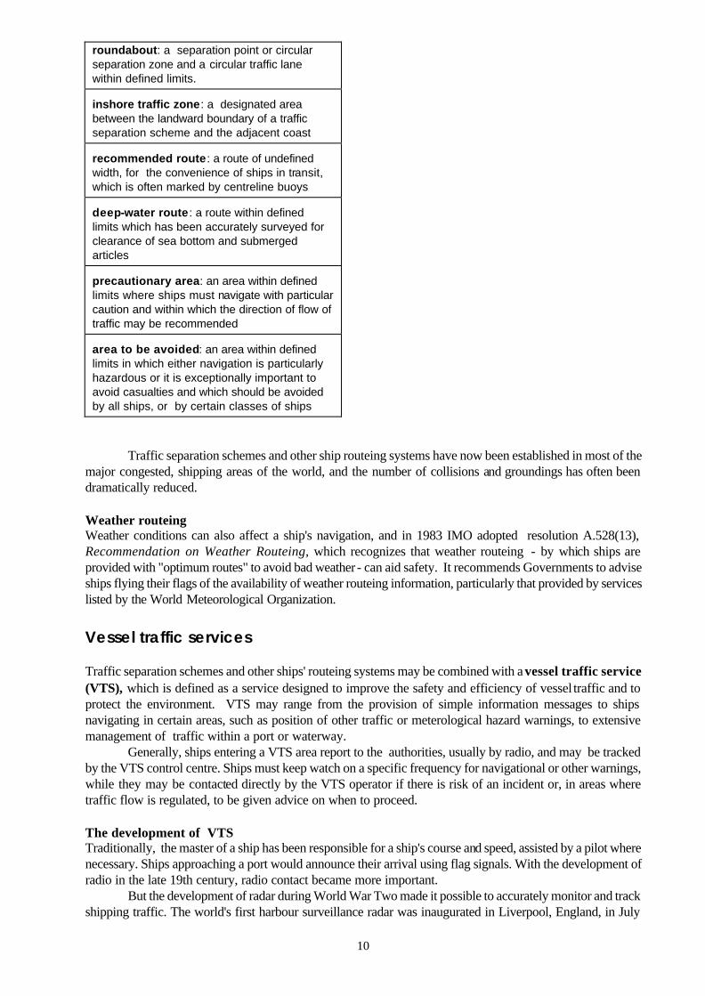
As well as traffic separation schemes, other routeing measures adopted by IMO to improve safety at sea include two-way routes, recommended tracks, deep water routes (for the benefit primarily of ships whose ability to manoeuvre is constrained by their draught), precautionary areas (where ships must navigate with particular caution), and areas to be avoided (for reasons of exceptional danger or especially sensitive ecological and environmental factors).
Ships' routeing systems and traffic separation schemes that have been approved by IMO, are contained in the IMO Publication, Ships' Routeing, a thick volume, which is updated when schemes are amended or new ones added.
The publication includes General provisions on ships' routeing, first adopted by IMO in 1973, and subsequently amended over the years, which are aimed at standardizing the design, development, charted presentation and use of routeing measures adopted by IMO. The provisions state that the objective of ships' routeing is to "improve the safety of navigation in converging areas and in areas where the density of traffic is great or where freedom of movement of shipping is inhibited by restricted searoom, the existence of obstructions to navigation, limited depths or unfavourable meteorological conditions".
Elements used in traffic routeing systems traffic separation scheme: a routeing measure aimed at the separation of opposing streams of traffic by appropriate means and by the establishment of traffic lanes traffic lane: an areas within defined limits in which one-way traffic is established. natural obstacles, including those forming separation zones, may constitute a boundary separation zone or line : a zone or line separating traffic lanes in which ships are proceeding in opposite or nearly opposite directions; or separating a traffic lane from the adjacent sea area; or separating traffic lanes designated for particular classes of ship proceeding in the same direction
10
roundabout: a separation point or circular separation zone and a circular traffic lane within defined limits. inshore traffic zone: a designated area between the landward boundary of a traffic separation scheme and the adjacent coast recommended route : a route of undefined width, for the convenience of ships in transit, which is often marked by centreline buoys deep-water route : a route within defined limits which has been accurately surveyed for clearance of sea bottom and submerged articles precautionary area: an area within defined limits where ships must navigate with particular caution and within which the direction of flow of traffic may be recommended area to be avoided: an area within defined limits in which either navigation is particularly hazardous or it is exceptionally important to avoid casualties and which should be avoided by all ships, or by certain classes of ships
Traffic separation schemes and other ship routeing systems have now been established in most of the major congested, shipping areas of the world, and the number of collisions and groundings has often been dramatically reduced. Weather routeing Weather conditions can also affect a ship's navigation, and in 1983 IMO adopted resolution A.528(13), Recommendation on Weather Routeing, which recognizes that weather routeing - by which ships are provided with "optimum routes" to avoid bad weather - can aid safety. It recommends Governments to advise ships flying their flags of the availability of weather routeing information, particularly that provided by services listed by the World Meteorological Organization. Vessel traffic services Traffic separation schemes and other ships' routeing systems may be combined with a vessel traffic service (VTS), which is defined as a service designed to improve the safety and efficiency of vessel traffic and to protect the environment. VTS may range from the provision of simple information messages to ships navigating in certain areas, such as position of other traffic or meterological hazard warnings, to extensive management of traffic within a port or waterway.
Generally, ships entering a VTS area report to the authorities, usually by radio, and may be tracked by the VTS control centre. Ships must keep watch on a specific frequency for navigational or other warnings, while they may be contacted directly by the VTS operator if there is risk of an incident or, in areas where traffic flow is regulated, to be given advice on when to proceed. The development of VTS Traditionally, the master of a ship has been responsible for a ship's course and speed, assisted by a pilot where necessary. Ships approaching a port would announce their arrival using flag signals. With the development of radio in the late 19th century, radio contact became more important.
But the development of radar during World War Two made it possible to accurately monitor and track shipping traffic. The world's first harbour surveillance radar was inaugurated in Liverpool, England, in July
11
1948 and in March 1950, a radar surveillance system was established at Long Beach, California - the first such system in the United States.
The ability of the coastal authority to keep track of shipping traffic by radar, combined with the facility to transmit messages concerning navigation to those ships by radio, therefore constituted the first formal VTS systems.
The value of VTS in navigation safety was first recognized by IMO in resolution A.158 (ES.IV) Recommendation on Port Advisory Systems adopted in 1968, but as technology advanced and the equipment to track and monitor shipping traffic became more sophisticated, it was clear guidelines were needed on standardising procedures in setting up VTS. In particular, it became apparent that there was a need to clarify when a VTS might be established and to allay fears in some quarters that a VTS might impinge on the ship's master's responsibility for navigating the vessel.
As a result, in 1985, IMO adopted resolution A.578 (14) Guidelines for Vessel Traffic Services, which said that VTS was particularly appropriate in the approaches and access channels of a port and in areas having high traffic density, movements of noxious or dangerous cargoes, navigational difficulties, narrow channels, or environmental sensitivity. The Guidelines also made clear that decisions concerning effective navigation and manoeuvring of the vessel remained with the ship's master.
The Guidelines also highlighted the importance of pilotage (see below) in a VTS and reporting procedures (see below) for ships passing through an area where a VTS operates.
Revised VTS Guidelines Revised Guidelines for vessel traffic services, including Guidelines on Recruitment, Qualifications and Training of VTS Operators, were adopted as Assembly resolution A.857(20) in November 1997. The Guidelines update and expand on the now revoked resolution A.578 (14) and are associated with a new SOLAS regulation V/8-2 on VTS (see below).
VTS and SOLAS Vessel Traffic Services were not specifically referred to in the International Convention for the Safety of Life at Sea (SOLAS) 1974, but in June 1997 IMO's Maritime Safety Committee adopted a new regulation 8-2 to Chapter V (Safety of Navigation), which sets out when VTS can be implemented. The regulation states that VTS contribute to the safety of life at sea, safety and efficiency of navigation and the protection of the marine environment, adjacent shore areas, worksites and offshore installations from possible adverse effects of maritime traffic. Governments may establish VTS when, in their opinion, the volume of traffic or the degree of risk justifies such services.
But no VTS should prejudice the "rights and duties of governments under international law" and a VTS may only be made mandatory in sea areas within a State's territorial waters. The regulation is due to enter into force, under "tacit acceptance", on 1 July 1999. Ship reporting systems In some parts of the world, ships should report to the coastal authorities so that they can keep track, via radar and radio, of ships in the area and respond quickly if there is an emergency.
Ship reporting systems (SRSs) are therefore used to gather or exchange information about ships, such as their position, course, speed and type of cargo carried. The data may be used for search and rescue, vessel traffic services and prevention of marine pollution.
With the development of traffic separation schemes and vessel traffic services in busy shipping areas around the world from the 1970s, it soon became clear there was a need to develop a standardised ship reporting format. This was recognised at the IMO's Search and Rescue Conference in Hamburg in 1979, which adopted a resolution calling on IMO to develop standardised reporting procedures for SRSs.
As a result, in 1983 IMO adopted Assembly resolution A.531(13) General Principles for Ship Reporting Systems which noted that various national systems in use at the time used different procedures and reporting formats which could cause confusion to masters and ships moving from one area to another. The resolution therefore included in an annex a standardised format and procedures for ship reporting.
The resolution noted that reports should be simple and use the standard international ship reporting format and procedures. Where language difficulties exist, the language used should be English, using where

12
possible Standard Marine Navigational Vocabulary (see below). The reporting system should allow for special reports from ships concerning defects or deficiencies with respect to their hull, machinery, equipment or manning, or concerning other limitations which could adversely affect navigation and for special reports concerning marine pollution.
Basic information such as ship's particulars should only be reported once and be retained in the system and updated only when changes in that basic information were reported. Standard reporting format The resolution established a standard reporting system of letters which refer to specific information, so that A (alpha) refers to the ship's name and call sign or identity number, B (bravo) refers to the date and time; C (Charlie) refers to position of ship, and so on.
The resolution was updated in 1987, by resolution A.598(15), to include guidelines for reporting incidents involving harmful substances and dangerous goods, as recommended by the Marine Environment Protection Committee.
The ship reporting Guidelines were revised again in 1989, by resolution A.648(16), where the guidelines were expanded and named General principles for ship reporting systems and ship reporting requirements, including guidelines for reporting incidents involving dangerous goods, harmful substances and/or marine pollutants. The resolution also makes reference to the need for coastal states to be informed by master of an assisting ship, or a ship undertaking salvage, of particulars of an incident.
In 1997 IMO amended the Guidelines again, by adding two new sections to the standard reporting format: Y Relay, for request to relay the report to another system and Z End of report, to end the report (Assembly resolution A.851(20)). See page 22.
In different ship reporting systems, ships may be requested to provide more or fewer details, depending on the needs of the system. Mandatory ship reporting systems Until the mid-1990s, reporting systems had been voluntary, or recommended, but in 1994, IMO adopted an amendment to SOLAS making it possible to introduce mandatory reporting systems.
Regulation 8-1 to SOLAS Chapter V: Ship reporting systems, entered into force on 1 January 1996. The Regulation states that ship reporting systems contribute to safety of life at sea, safety and efficiency of navigation and protection of the marine environment. Ships are required to comply with the provisions of ship reporting systems developed in accordance with IMO guidelines and recognized by IMO. Ship reporting guidelines and general principles SOLAS Chapter V Regulation 8-1 refers in a footnote to the General principles for ship reporting systems (see above), and to MSC resolution MSC.43(64) Guidelines and criteria for ship reporting systems, which highlights the procedures and considerations Governments should follow in proposing mandatory ship reporting systems for adoption by IMO.
Mandatory ship reporting systems in operation Off Ushant (at the western entrance to the English Channel) (adopted 30 May 1996, entered into force 30 November 1996) In the Torres Strait region and the Inner Route of the Great Barrier Reef (Australia) (adopted 30 May 1996, entered into force 1 January 1997) In the Great Belt Traffic Area (adopted 3 December 1996, entered into force 3 June 1997) (Denmark) In the Strait of Gibraltar (adopted 3 December 1996, entered into force 3 June 1997)
13
Off Finisterre (Spain) (adopted 3 December 1996, entered into force 3 June 1997)
In particular, the Guidelines note that ship reporting systems should be considered for adoption only if supported by a "demonstrated need" to address one or more of: the improvement of safety of life at sea, the safety and efficiency of navigation, and/or to increase the protection of the marine environment.
In addition, communication between a shore-based authority and a participating ship should "be limited to information essential to achieve the objectives of the system".
These criteria reflect the tradition in shipping of freedom of navigation and free passage, while accepting that imposing stricter controls on ships' movements in congested waters or environmentally sensitive areas can help reduce accidents involving loss of live or pollution. Automatic ship reporting systems Developments in technology mean that is now feasible for ships entering a ship reporting area to automatically report in their position, speed and other details via VHF radio. It also means the operators of a ship reporting system (the coastal State) can easily track the ships' movements without necessarily having to communicate directly with them, unless there is a specific need to do so. Such a system would have automatic warning systems, so alerts would be given in the case of an incident or impending incident.
The Guidelines and Criteria for ship reporting systems note the possibility of automated ship reporting, pointing out that: "Shore-based authorities should remain alert to the development of non-verbal methods of data transfer which may reduce language difficulties and that have great potential for reducing ships' reporting burden".
IMO's Sub-Committee on Safety of Navigation (NAV), at its 43rd session in July 1997, developed recommended draft performance standards for an Universal Shipborne Automatic Identification Systems (AIS), also known as transponders, due to be presented for adoption by the Maritime Safety Committee meeting in May 1998.
The draft standards state that AIS are designed to provide information from the ship to ships and to coastal authorities, automatically, continuously and with the required accuracy and frequency. AIS should operate in ship-to-ship mode for collision avoidance; ship-to-shore mode for coastal States to obtain information about a ship and its cargo; and as a tool in VTS for traffic management.
The advantage of AIS is that ships can be alerted to the presence of other ships, and coastal authorities can "see" the position of ships, even where with radar this would be impossible, because of islands in the way, or because the radar signals would need to travel around a corner.
A number of AIS systems have already been developed or are in trial stages. Pilotage Pilots with local knowledge have been employed on board ships for centuries to guide vessels into or out of port safely - or wherever navigation may be considered hazardous, particularly when a shipmaster is unfamiliar with the area. In addition to local knowledge and expertise, pilots are able to provide effective communication with the shore and with tugs, often in the local language.
Qualified pilots are usually employed by the local port or maritime administration and provide their services to ships for a fee, calculated in relation to the ship's tonnage, draught or other criteria.
The importance of employing qualified pilots in approaches to ports and other areas where specialized local knowledge is required was formally recognized by IMO in 1968, when the Organization adopted Assembly resolution A.159(ES.IV) Recommendation on Pilotage. The resolution recommends Governments organize pilotage services where they would be likely to prove more effective than other measures and to define the ships and classes of ships for which employment of a pilot would be mandatory.
One of the problems encountered by pilots is that of getting on board the ship - particularly when the weather is bad or the ship is very large. Requirements to make this easier are contained in Chapter V of the SOLAS Convention (Regulation 17), and have also formed the subject of IMO resolutions covering performance standards for mechanical pilot hoists (A.275(VIII); arrangements for embarking and
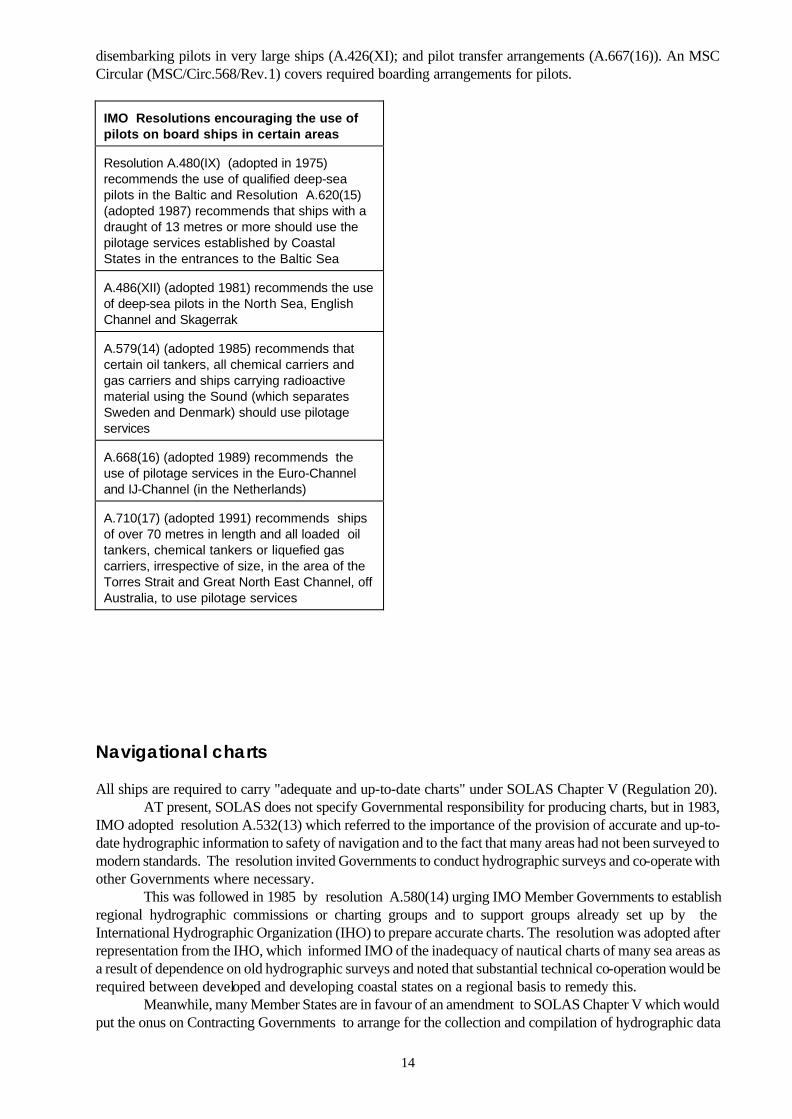
14
disembarking pilots in very large ships (A.426(XI); and pilot transfer arrangements (A.667(16)). An MSC Circular (MSC/Circ.568/Rev.1) covers required boarding arrangements for pilots.
IMO Resolutions encouraging the use of pilots on board ships in certain areas Resolution A.480(IX) (adopted in 1975) recommends the use of qualified deep-sea pilots in the Baltic and Resolution A.620(15) (adopted 1987) recommends that ships with a draught of 13 metres or more should use the pilotage services established by Coastal States in the entrances to the Baltic Sea A.486(XII) (adopted 1981) recommends the use of deep-sea pilots in the North Sea, English Channel and Skagerrak A.579(14) (adopted 1985) recommends that certain oil tankers, all chemical carriers and gas carriers and ships carrying radioactive material using the Sound (which separates Sweden and Denmark) should use pilotage services A.668(16) (adopted 1989) recommends the use of pilotage services in the Euro-Channel and IJ-Channel (in the Netherlands) A.710(17) (adopted 1991) recommends ships of over 70 metres in length and all loaded oil tankers, chemical tankers or liquefied gas carriers, irrespective of size, in the area of the Torres Strait and Great North East Channel, off Australia, to use pilotage services
Navigational charts All ships are required to carry "adequate and up-to-date charts" under SOLAS Chapter V (Regulation 20).
AT present, SOLAS does not specify Governmental responsibility for producing charts, but in 1983, IMO adopted resolution A.532(13) which referred to the importance of the provision of accurate and up-to-date hydrographic information to safety of navigation and to the fact that many areas had not been surveyed to modern standards. The resolution invited Governments to conduct hydrographic surveys and co-operate with other Governments where necessary.
This was followed in 1985 by resolution A.580(14) urging IMO Member Governments to establish regional hydrographic commissions or charting groups and to support groups already set up by the International Hydrographic Organization (IHO) to prepare accurate charts. The resolution was adopted after representation from the IHO, which informed IMO of the inadequacy of nautical charts of many sea areas as a result of dependence on old hydrographic surveys and noted that substantial technical co-operation would be required between developed and developing coastal states on a regional basis to remedy this.
Meanwhile, many Member States are in favour of an amendment to SOLAS Chapter V which would put the onus on Contracting Governments to arrange for the collection and compilation of hydrographic data

15
and the publication, dissemination and keeping up to date of all nautical information necessary for safe navigation.
A draft regulation to this effect, agreed to by the Sub-Committee on Safety of Navigation (NAV) in July 1997, also outlines Governments' responsibilities in carrying out hydrographic surveying, preparing and issuing official nautical charts and promulgating notices to mariners to keep charts up to date.
This draft regulation is part of the revision of Chapter V, which is due to be completed in 1998 with likely date of entry into force 2002. Electronic charts Attention is also focusing on electronic charts, which are already being used on some ships as an addition to paper charts. Electronic charts carry out the same function as paper charts - they are used for planning and displaying the route for the intended voyage and monitoring the ship's position throughout the voyage. But electronic chart systems (ECS) have the advantage of automatically displaying the cartographic data necessary related to the ship's position and they can be automatically updated.
There are basically two types of electronic charts, vector and raster.
Electronic charts A raster chart is basically just a scanned image of a paper chart. It is a computer-based system which uses charts issued by, or under the authority of, a national hydrographic office, together with automatic continuous electronic positioning, to provide an integrated navigational tool. Draft performance standards for raster charts are currently being developed by IMO In a vector chart, each point on the chart is digitally mapped, allowing the information to be used in a more sophisticated way, such as clicking on a feature (for example, a lighthouse) to get all the details of that feature displayed. The international standard for vector charts has been finalised by the International Hydrographic Organization (S-57, Edition 3). Vector charts, used in electronic chart display and information systems (ECDIS), have already been accepted as equivalent to paper charts. Standards for ECDIS were defined by IMO in 1995 in Assembly resolution A.817(19), while a new section on back-up requirements was adopted in December 1996 in the form of an MSC resolution (MSC.64(67)).
Many people accept that ECDIS (vector charts) represent the preferred digital charting system of
the future, but raster charts are available today and it may take years before the data necessary to support ECDIS is globally available.
The IHO said in a submission to the Sub-Committee on Safety of Navigation (NAV) in July 1997 that that the delivery of authorized electronic navigational charts (ENCs), used in ECDIS, has been slower than expected, "thus precluding the use of ECDIS until such data becomes available". An IHO survey on the status of ENC production shows that by March 1998 it is predicted that there will be over 1000 charts produced out of a possible future total of 3000.
16
Navigational equipment Under SOLAS Chapter V, Regulation 12 (Shipborne Navigational Equipment), all ships are required to carry a minimum of navigational equipment, depending on their size - the larger the ship, the more equipment it should have.
Ships under 150 gross tonnage should, "as far as the administration considers it
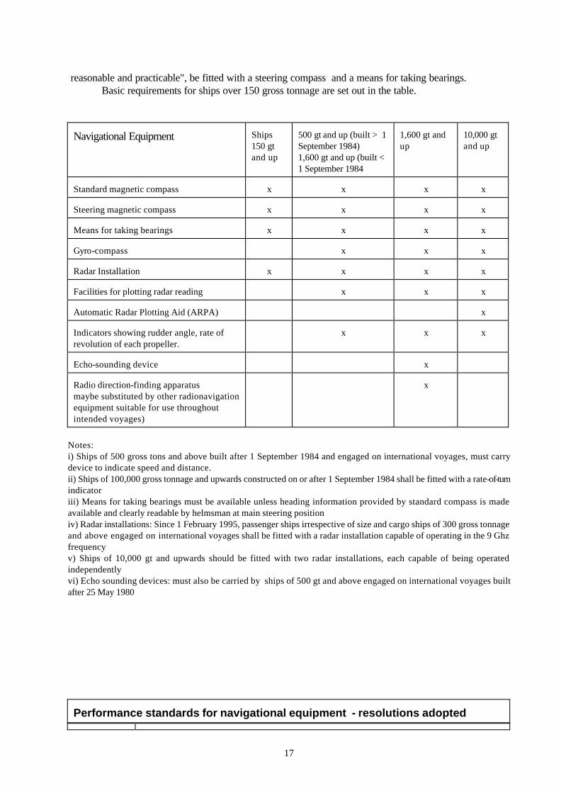
17
reasonable and practicable", be fitted with a steering compass and a means for taking bearings.
Basic requirements for ships over 150 gross tonnage are set out in the table.
Navigational Equipment
Ships 150 gt and up
500 gt and up (built > 1 September 1984) 1,600 gt and up (built < 1 September 1984
1,600 gt and up
10,000 gt and up
Standard magnetic compass
x
x
x
x
Steering magnetic compass
x
x
x
x
Means for taking bearings
x
x
x
x
Gyro-compass
x
x
x
Radar Installation
x
x
x
x
Facilities for plotting radar reading
x
x
x
Automatic Radar Plotting Aid (ARPA)
x
Indicators showing rudder angle, rate of revolution of each propeller.
x
x
x
Echo-sounding device
x
Radio direction-finding apparatus maybe substituted by other radionavigation equipment suitable for use throughout intended voyages)
x
Notes: i) Ships of 500 gross tons and above built after 1 September 1984 and engaged on international voyages, must carry device to indicate speed and distance. ii) Ships of 100,000 gross tonnage and upwards constructed on or after 1 September 1984 shall be fitted with a rate-of-turn indicator iii) Means for taking bearings must be available unless heading information provided by standard compass is made available and clearly readable by helmsman at main steering position iv) Radar installations: Since 1 February 1995, passenger ships irrespective of size and cargo ships of 300 gross tonnage and above engaged on international voyages shall be fitted with a radar installation capable of operating in the 9 Ghz frequency v) Ships of 10,000 gt and upwards should be fitted with two radar installations, each capable of being operated independently vi) Echo sounding devices: must also be carried by ships of 500 gt and above engaged on international voyages built after 25 May 1980
Performance standards for navigational equipment - resolutions adopted

18
A.224(VII) Echo-sounding equipment A.342(IX)
Automatic pilots
A.382(X)
Magnetic compasses: carriage and performance standards
A.384(X)
Radar reflectors
A.424(XI)
Gyro-compasses
A.477(XII)
Radar equipment
A.526(13)
Rate-of-turn indicators
A.665(16)
Radio direction-finding systems
A.700(17)
Narrow-band direct-printing telegraph equipment for the reception of navigational and meteorological warnings and urgent information to ships (MSI) by HF
A.813(19)
Electromagnetic compatibility (EMC) for all electrical and electronic ship's equipment
A.816(19)
Shipborne DECCA navigator receivers
A.817(19)
Electronic chart display and information systems (ECDIS)
A.818(19)
Shipborne LORAN-C and CHAYKA receivers
A.819(19)
Shipborne global positioning system (GPS) receiver equipment
A.820(19)
Navigational radar equipment for high-speed craft
A.821(19)
Gyro-compasses for high-speed craft
A.822(19)
Automatic steering aids (automatic pilots) for high-speed craft
A.422(XI)
Automatic Radar Plotting Aids (ARPAs) (equipment installed before 1 January 1997)
A.823(19)
Automatic Radar Plotting Aids (ARPAs) (equipment installed after 1 January 1997)
A.478(XII)
Devices to indicate speed and distance (equipment installed before 1 January 1997)
A.824(19)
Devices to indicate speed and distance (equipment installed after 1 January 1997)
MSC.53(66)
Shipborne GLONASS receiver equipment
SOLAS Chapter V says that navigational equipment installed on board ships on or after 1 September 1984 must conform to "appropriate performance standards not inferior to those developed by the Organization". A footnote refers to the relevant Assembly resolutions. Revising standards IMO's Sub-Committee on Safety of Navigation continues to work on reviewing and revising existing standards and drafting new ones. Draft performance standards for the following navigational aids will be presented to the 69th session of the Maritime Safety Committee (MSC) in May 1998 for adoption: • shipborne combined GPS/GLONASS (Global Positioning System/Global Navigation Satellite System)
receiver equipment • marine electromagnetic compasses • track control systems • Universal Shipborne Automatic Identification System (AIS) - designed to provide to ships and to
competent authorities, information from the ship, automatically and with the required accuracy and frequency, to facilitate accurate tracking
19
• echo sounding equipment (revision of resolution A.224(VII). Navigation systems Since the earliest days of navigation, seafarers have sought to keep track of their direction and position. The earliest forms of the magnetic compass date back to the 12th century while the crude "dead reckoning" system involved measuring the course and distance sailed from a known position.
By the end of the 15th century navigators were using the quadrant and astrolabe to find latitudinal position from the position of the sun, moon or stars and the horizon, while the chronometer, invented in the 18th century, enabled navigators to find their longitudinal position.
The introduction of radio and wireless technology in the late 19th century permitted the development of more sophisticated navigation systems. Wireless time signals, which were first broadcast from Paris in 1910, enabled more accurate determination of longitude, while the Italians Ettore Bellini and Captain Tosi in 1906 developed a direction finding system used to determine the direction from which wireless signals were transmitted.
After the end of World War Two, the development of radar led to the possibility of ships being able to fix their position, when within 48 to 60 miles of the shore, by making reference to coastal features or responder beacons (Racons) installed on the shore.
Further out to sea, hyperbolic radio systems soon enabled accurate position fixing with a range of at least 250 miles.
These early radio navigation systems - including Decca Navigator and Loran A - involved a ship's radio receiver measuring transmissions from groups of radio transmitters transmitting signals simultaneously or in a controlled sequence. By measuring the phase difference between one pair of transmissions a position line can be established, a second measurement from another pair of stations gives a second line and the intersection of the two lines gives the navigating position.
By the 1970s, Loran C and Differential Omega radio navigation systems were also becoming operational in major areas of the world's oceans and they were combined with early computer technology to provide electronic print outs of the ship's position. The Soviet Tchaika system also became operational.
Meanwhile, the world's first satellites had been launched and their potential for accurate position finding was being actively researched. IMO and navigation systems The importance of using navigation systems in maritime safety and preventing marine pollution, for example as an aid to avoiding hazards, was recognized by IMO in the late 1960s, and in 1968 it adopted resolution A.156(ES.IV) on Recommendation on the Carriage of Electronic Position-Fixing Equipment.
That resolution recommended that ships carrying oil or other noxious or hazardous cargoes in bulk should carry "an efficient electronic position-fixing device".
Performance Standards for Shipborne Receivers for use with Differential Omega (resolution A.479(XII) were adopted in 1981, while in 1983 the Assembly adopted resolution A.529(13) on Accuracy Standards for Navigation.
Resolution A.529(13) is aimed at providing "guidance to Administrations on the standards of navigation accuracy for assessing position-fixing systems, in particular radio-navigation systems, including satellite systems". It notes that "the navigator needs to be able to determine his position at all times".
Accuracy of navigation systems in areas such as harbour entrances and approaches depends on local circumstances, but in other waters, the resolution established that navigation systems should provide accuracy within the order of 4% of the distance from danger with a maximum of 4 nautical miles (for a ship proceeding at not more than 30 knots).
Also in 1983, IMO began a study into a world-wide radio-navigation system, in view of the need for such a system to provide ships with navigational position-fixing throughout the world - but recognizing that it was not considered feasible for IMO to fund a world-wide radio-navigation system.
The objective of the study was to provide a basis by which Regulation 12 (covering shipborne navigational equipment) of SOLAS Chapter V might be amended to include a requirement for ships to carry

20
equipment to receive transmissions from a radio navigation system throughout their intended voyage. SOLAS Chapter V Regulation 12 includes a requirement for ships on international voyages over
1,600 gross tonnage to be fitted with radio direction-finding apparatus. This requirement dates back to the 1948 SOLAS Convention, while in 1988 IMO adopted an amendment which allowed ships the possibility to carry instead radionavigation equipment suitable for use throughout the intended voyage.
IMO is currently looking at a draft regulation which would require all ships to carry means to automatically establish their position. This regulation would be included in the revised version of Chapter V, now being studied by IMO, which is expected to enter into force in 2002. World-wide radio navigation system In 1985, IMO initiated a study into a world-wide satellite position-fixing system for the safety of navigation and a report, Study of a World-Wide Radionavigation System, was adopted by the IMO Assembly in 1989 (resolution A.666(16).
The report gave a detailed summary of the different terrestrial-based radio navigation systems then in operation (Differential Omega, Loran-C, Chayka), and also the satellite systems which were being developed - Global Positioning System (GPS) Standard Positioning Service (SPS), which was being developed by the United States air force; and GLONASS (Global Navigation Satellite System), being developed by the then Soviet military (now managed for the Government of the Russian Federation by the Russian Space Agency.
The 1989 report said that it was not considered feasible for IMO to fund a world-wide radionavigation system, so existing and planned systems provided and operated by Governments or organizations were studied to ascertain whether they could be recognized or accepted by IMO.
OMEGA A very low frequency (VLF) hyperbolic radionavigation system based on phase comparison techniques, which ceased operations in September 1997.
Omega evolved from a low frequency system known as Radux first proposed in 1947 and was further developed in the 1950s, was the first world-wide radio-navigation system offering global coverage. It operated from eight Omega stations in Norway, Liberia, Hawaii, North Dakota, La Reunion, Argentina, Australia and Japan.
Differential Omega refers to the provision of increased accuracy in a local area, such as a harbour, through the use of local transmitters of the Omega signal.
When a radio-navigation system is accepted by IMO, it means the system is regarded as capable of providing adequate position information and that the carriage of receiving equipment satisfies the relevant SOLAS requirements.
The report notes that shipborne receiving equipment should conform to the general requirements for navigational equipment in resolution A.574(14) (later updated by A.694(17) and that detailed requirements for receivers for GPS, differential GPS, GLONASS, differential GLONASS, Loran-C, Chayka, Omega combined with differential Omega and Decca Navigator systems were available to manufacturers to enable them to construct the equipment.
CHAYKA A radionavigation system, similar to LORAN-C, operated by the Russian Federation.
Accuracy is 50 to 200 metres.
The report set operational requirements for world-wide radionavigation systems: they should be
general in nature and be capable of being met by a number of systems. All systems should be capable of being

21
used by an unlimited number of ships. Accuracy should at least comply with the standards set out in resolution A.529(13) Accuracy of Standards for Navigation. 1995 update The report was updated in 1995 by resolution A.815(19), World-Wide Radionavigation system, which takes into account the requirements for general navigation of ships engaged on international voyages anywhere in the world, as well as the requirements of the Global Maritime Distress and Safety System (GMDSS) for the provision of position information.
The revised report also addresses the development of high speed craft, such as fast ferries, noting that ships operating at speeds above 30 knots may need more stringent requirements.
The report states that provision of a radionavigation system is the responsibility of governments or organizations concerned and that these should inform IMO that the system is operational and available for use by merchant shipping while keeping IMO informed in good time of any changes that could affect the performance of shipborne receiving equipment. Updated performance standards for Decca Navigator and Loran-C and Chayka receivers and performance standards for shipborne global positioning system (GPS) receiver equipment were also adopted in 1995. By then, GPS was fully operational, while GLONASS became fully operational in 1996. Global Positioning System (GPS) The Global Positioning System (GPS) Standard Positioning Service (SPS) is a space-based three dimensional positioning velocity and time system which is operated by the United States Air Force. GPS met full operational capability in 1995.
The GPS is expected to be available for the foreseeable future, on a continuous, world-wide basis and free of direct user fees. The United States expects to be able to provide at least six years notice prior to termination of GPS operation or elimination of the GPS. This service, which will be available on a non-discriminatory basis to all users, meets the requirements for general navigation with a horizontal position accuracy of 100 metres (95%).
GPS has been recognized as a component of the World-Wide Radionavigation System (WWRNS) for navigational use.
But without augmentation, GPS accuracy is not suitable for navigation in harbour entrances and approaches or restricted waters. GPS does not provide instantaneous warning of system malfunction. However, differential corrections using maritime radiobeacons can enhance accuracy (in limited geographic areas) to 10 metres (95%) and also offer integrity monitoring. Integrity provision may be possible by receiver autonomous integrity monitoring (RAIM).
The future for terrestrial-based radio-navigation systems - in view of the development of the satellite-
based systems - is unclear. OMEGA was also phased out in 1997 while DECCA will be phased-out in many countries by the
year 2000. The United States-controlled LORAN-C networks are under consideration for phasing out by the

22
year 2000. However, the Russian Federation-controlled CHAYKA networks will not be considered for phasing out until at least the year 2010. Civil-controlled LORAN-C and LORAN-C/CHAYKA networks are being set up in the Far East, North-West Europe and other parts of the world with plans for extension in some areas.
Meanwhile, there are several initiatives to improve the accuracy and/or integrity of GPS and GLONASS by augmentation. The use of different differential correction signals for local augmentation of accuracy and integrity and RAIM (Receiver Autonomous Integrity Monitoring) are examples of such initiative. In addition integrated receivers are being developed, combining signals from GPS, GLONASS, LORAN-C and/or CHAYKA. Wide area augmentation systems are also being developed using differential correction signals from geostationary satellites, in particular Inmarsat III satellites, for instance by the United States and Europe.
However, the main concern is that while GPS and GLONASS are expected to be fully operational until at least the year 2010, their availability beyond that is not guaranteed.
As a result, IMO (and other users, such as civil aviation) has recognised the need for a future system to improve, replace or supplement GPS and GLONASS, which have shortcomings on integrity, availability, control and system life expectancy. As a result, IMO in 1997 adopted resolution A.860(20) on Maritime policy for a future global navigation satellite system (GNSS). GLONASS (Global Navigation Satellite System) GLONASS (Global Navigation Satellite System) is a space-based three dimensional positioning, three dimensional velocity and time system, which is managed by the Russian Space Agency.
GLONASS has been offered and recognized as a component of WWRNS. GLONASS has been fully operational since 1996 and is expected to be operational at least until 2010 for unlimited civilian use on a long-term basis and to be free of direct-user fees.
GLONASS is meant to provide long-term service for national and foreign civil users in accordance with existing commitments. The service will meet the requirements for general navigation with a horizontal position accuracy of 45 metres (95%). Without augmentation GLONASS accuracy is not suitable for navigation in harbour entrances and approaches.
GLONASS does not provide instantaneous warning of system malfunction. However, augmentation can greatly enhance both accuracy and integrity. Differential corrections can enhance accuracy to 10 metres (95%) and offer integrity monitoring. Integrity provision may be possible by RAIM.

23
DECCA A low frequency (LF) hyperbolic radionavigation system based on harmonically related continuous wave transmissions.
The basis principles of the Decca Navigator were invented in the United State sin 1937 and the system was used for guiding the leading minesweepers and landing craft in the Allied invasion of Normandy during World War Two.
In 1945, the Decca Navigator Co, Ltd was formed and the first commercial chain of stations established in south-east England in 1946.
The system expanded and by 1989 had 42 fully operational chains around the world, including 42 master stations and 119 slave transmitters. Chains normally comprise one master station and three slave transmitters. Stations radiate four harmonically related frequencies in the band 70 kHz to 130kHz.
Coastal accuracy is 50 metres by day and 200 metres by night.
LORAN-C A low frequency (LF) hyperbolic radionavigation system based on measurements of the differences of times of arrival of signals using pulse and phase comparison techniques.
The Loran system was initially proposed by the United States in 1940 and the first full-scale trials, of Standard Loran, or Loran-A, took place in 1942. By 1943 coverage extended over much of western and northern Atlantic and by 1945 had extended to cover north and central Pacific, Bay of Bengal, and northern Australia. It was the standard Allied long-range navigation system for ships and aircraft. Coverage in the Japanese and East China Sea Areas was extended in the 1950s and in 1965 stations were established in Portugal and the Azores. Loran-C was a modified version of Loran-A, developed to provide longer range and greater accuracy. Loran-C first came into operation in 1957.
By 1989, there were 16 Loran-C chains comprising 67 stations, transmitting on 100 kHz.
Typical coastal accuracy is 50 to 200 metres.
24
Future global navigation satellite system Maritime policy for a future global navigation satellite system (GNSS) sets out IMO policy in terms of the maritime requirements for a future civil and internationally-controlled Global Navigation Satellite System (GNSS), to provide ships with navigational position-fixing throughout the world for general navigation, including navigation in harbour entrances and approaches and other waters in which navigation is restricted.
The resolution notes that development of a future GNSS is presently only in a design stage and these requirements have been limited only to basic user requirements, without specifying the organizational structure, system architecture or parameters. These maritime requirements, as well as the Organization's recognition procedures, may need to be revised as a result of any subsequent developments.
The resolution sets out the general, operational and institutional requirements for a future GNSS in terms of maritime users and envisages a review of the requirements in 1999 (21st Assembly); consideration of the proposed future GNSS in 2001 (22nd Assembly) and completion of the implementation of the proposed GNSS in 2008.
The resolution notes the following general requirements for the future GNSS: • It should primarily serve the operational user requirements for navigation. For maritime use this
includes navigation in harbour entrances and approaches, and other waters in which navigation is restricted.
• It should have the operational and institutional capability to meet additional area-specific requirements
through local augmentation, if this capability is not otherwise provided. Augmentation provisions should be harmonized world-wide to avoid the necessity of carrying more than one shipborne receiver or other devices.
• It should have the operational and institutional capability to be used by an unlimited number of multi-
modal users at sea, in the air and on land. • It should be reliable and of low user cost. With regard to the allocation and recovery of costs, a
distinction should be made between maritime users that rely on the system for reasons of safety and other users that primarily profit from the system in commercial or economic terms. Also the interests of both shipping and the coastal states should be taken into consideration when dealing with allocation and recovery of costs.
The report identifies three possible cost-recovery options:
• funding by international organizations concerned (IMO, ICAO, etc.); • cost-sharing between Governments or commercial entities (e.g. satellite communication providers); or • private investments and direct user charges or licensing fees. IMO itself is not in a position to provide and operate a GNSS. However, IMO has to be in the position to maintain control over the following aspects of a GNSS: • the continued provision of the service to the maritime users; • the operation of the GNSS in respect of its ability to meet the maritime user requirements; • the application of internationally established cost-sharing and cost-recovery principles; and • the application of internationally established principles on liability issues. Transitional requirements
25
The resolution notes that the the future GNSS should be developed in parallel to the present systems, or could evolve, in part or in whole, from them. At the same time, in advance of full system implementation, a regional system that is fully operational and which has the potential to be a component of a global system, may be recognized as a component of a future GNSS.
The terrestrial infrastructure (surveillance stations and monitoring centre) should, as far as possible, be compatible with the infrastructure used for the present systems, and shipborne receivers or other devices required for a future GNSS should, where practicable, be compatible with those for the present systems.
IMO envisages continuing involvement in developing the future GNSS and the resolution notes that the maritime requirements set out should be continually reassessed and updated on the basis of new developments and specific proposals.
IMO will work closely with the International Civil Aviation Authority (ICAO) on the planned system and is likely to be involved in establishing a forum for discussions with air and land users. Standard Marine Vocabulary The importance of effective communication between shipmasters, crew and coastal authorities, especially during a navigational or other emergency, has long been recognised by IMO. In 1977, IMO adopted a specially developed English language vocabulary designed for use at sea, called the Standard Marine Navigational Vocabulary (SMNV).
In 1981, IMO adopted a resolution recommending the SMNV be used for communications on board ship as well as those between ships and between ship and shore.
SMNV is now being updated by Standard Marine Communication Phrases or SMCP, which is designed to be more comprehensive that SMNV.
Following agreement at the Maritime Safety Committee at its 68th session in May-June 1997, the SMCP has been distributed to Governments, maritime training institutes and others involved in maritime communications so that trials in its use can be conducted with a view to the SMCP being reviewed and finally put forward for formal adoption at IMO's 22nd Assembly in 2001. The SMCP includes phrases which have been developed to cover the most important safety-related fields of verbal shore-to-ship (and vice-versa), ship-to-ship and on-board communications. The aim is to get round the problem of language barriers at sea and avoid misunderstandings which can cause accidents.
The SMCP builds on a basic knowledge of English and has been drafted in a simplified version of maritime English. It includes phrases for use in routine situations such as berthing as well as standard phrases and responses for use in emergency situations. The World-Wide Navigational Warning Service Navigational warnings to ships are provided through the World-Wide Navigational Warning Service (WWNWS), which was established by IMO, in collaboration with the International Hydrographic Organization (IHO), in the 1970s.
Under this system, formally adopted by IMO in 1979 by resolution A.419(XII) (revising a version adopted in 1977), the world's oceans are divided into l6 navigational areas (called NAVAREAs) and one designated country in each area is responsible for disseminating navigational information. The language used is English, although warnings can additionally be broadcast in one or more official United Nations' language. Ships receive the navigational warning via the NAVTEX automated warning system (which has a maximum range of up to about 500 nautical miles) or via INMARSAT satellite SafetyNET service, in areas not covered by NAVTEX. Since 1 August 1993, ships have been required under SOLAS (Chapter IV, Radiocommunications, Regulation 1.4) to carry a receiver capable of receiving the NAVTEX broadcasts if sailing in an area where they can be received.
Information broadcast under WWNWS casualties to lights, fog signals and buoys affecting main shipping lanes dangerous wrecks in or near main shipping lanes
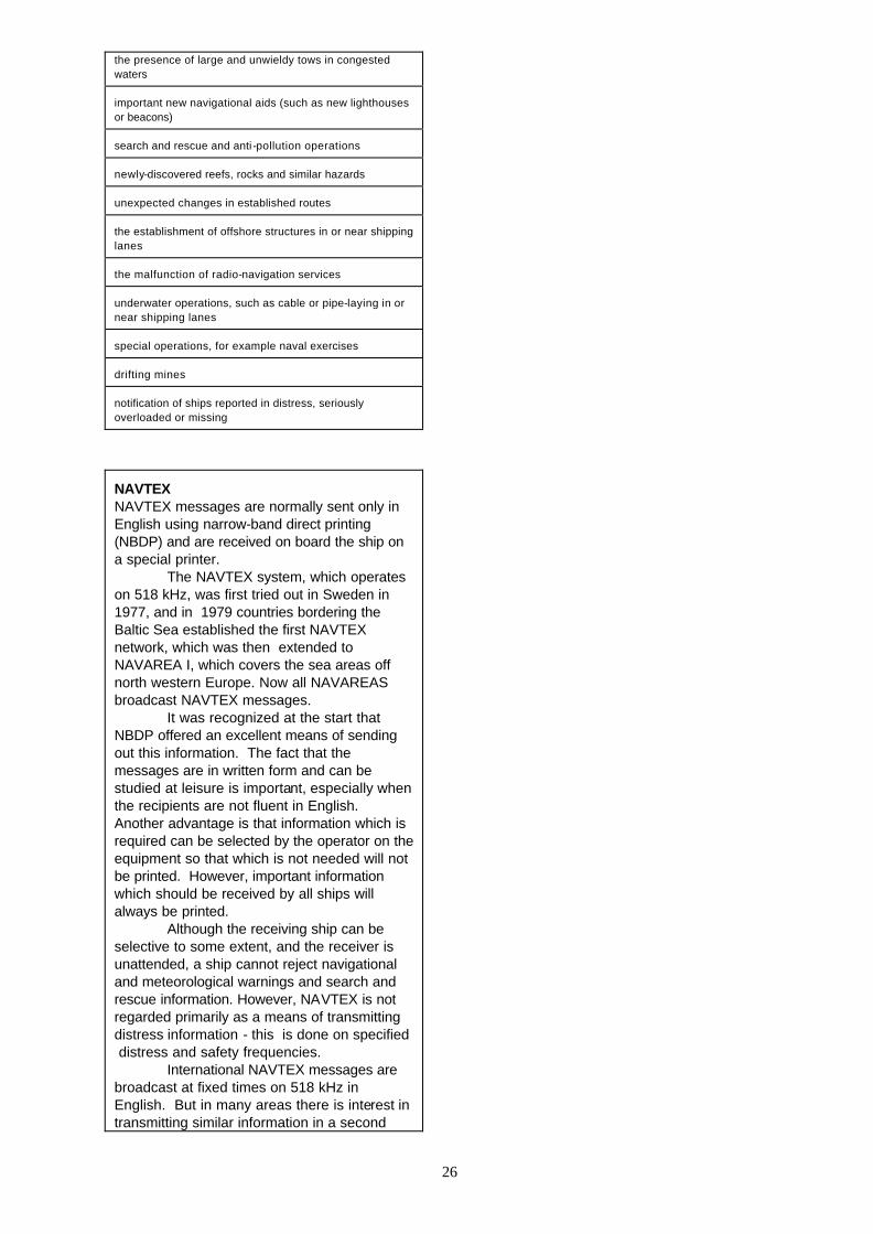
26
the presence of large and unwieldy tows in congested waters important new navigational aids (such as new lighthouses or beacons) search and rescue and anti -pollution operations newly-discovered reefs, rocks and similar hazards unexpected changes in established routes the establishment of offshore structures in or near shipping lanes the malfunction of radio-navigation services underwater operations, such as cable or pipe-laying in or near shipping lanes special operations, for example naval exercises drifting mines notification of ships reported in distress, seriously overloaded or missing
NAVTEX NAVTEX messages are normally sent only in English using narrow-band direct printing (NBDP) and are received on board the ship on a special printer.
The NAVTEX system, which operates on 518 kHz, was first tried out in Sweden in 1977, and in 1979 countries bordering the Baltic Sea established the first NAVTEX network, which was then extended to NAVAREA I, which covers the sea areas off north western Europe. Now all NAVAREAS broadcast NAVTEX messages.
It was recognized at the start that NBDP offered an excellent means of sending out this information. The fact that the messages are in written form and can be studied at leisure is important, especially when the recipients are not fluent in English. Another advantage is that information which is required can be selected by the operator on the equipment so that which is not needed will not be printed. However, important information which should be received by all ships will always be printed.
Although the receiving ship can be selective to some extent, and the receiver is unattended, a ship cannot reject navigational and meteorological warnings and search and rescue information. However, NAVTEX is not regarded primarily as a means of transmitting distress information - this is done on specified distress and safety frequencies.
International NAVTEX messages are broadcast at fixed times on 518 kHz in English. But in many areas there is interest in transmitting similar information in a second
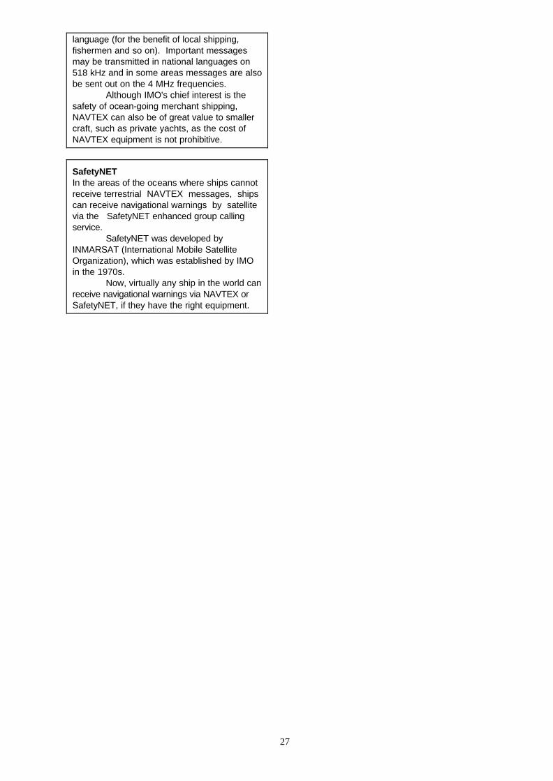
27
language (for the benefit of local shipping, fishermen and so on). Important messages may be transmitted in national languages on 518 kHz and in some areas messages are also be sent out on the 4 MHz frequencies. Although IMO's chief interest is the safety of ocean-going merchant shipping, NAVTEX can also be of great value to smaller craft, such as private yachts, as the cost of NAVTEX equipment is not prohibitive.
SafetyNET In the areas of the oceans where ships cannot receive terrestrial NAVTEX messages, ships can receive navigational warnings by satellite via the SafetyNET enhanced group calling service.
SafetyNET was developed by INMARSAT (International Mobile Satellite Organization), which was established by IMO in the 1970s.
Now, virtually any ship in the world can receive navigational warnings via NAVTEX or SafetyNET, if they have the right equipment.

28
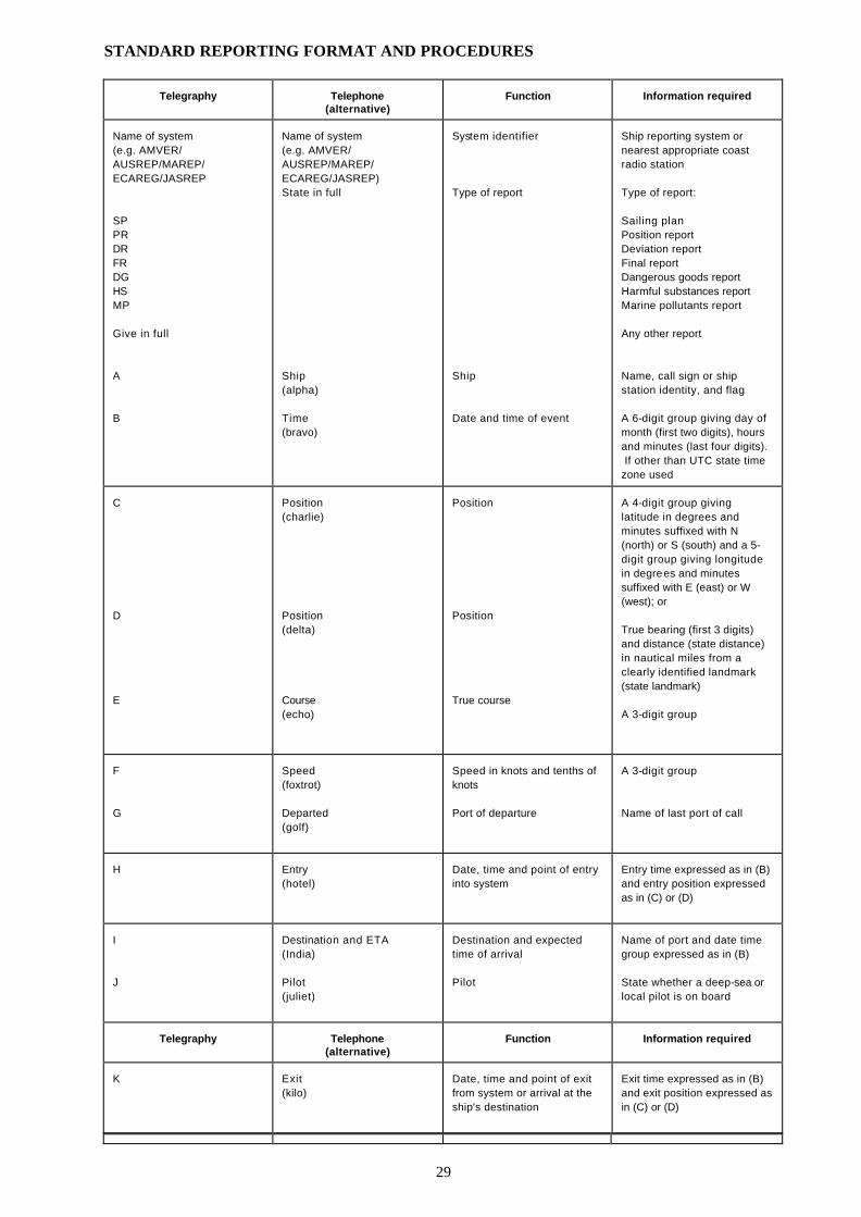
29
STANDARD REPORTING FORMAT AND PROCEDURES
Telegraphy
Telephone
(alternative)
Function
Information required
Name of system (e.g. AMVER/ AUSREP/MAREP/ ECAREG/JASREP SP PR DR FR DG HS MP Give in full A B
Name of system (e.g. AMVER/ AUSREP/MAREP/ ECAREG/JASREP) State in full Ship (alpha) Time (bravo)
System identifier Type of report Ship Date and time of event
Ship reporting system or nearest appropriate coast radio station Type of report: Sailing plan Position report Deviation report Final report Dangerous goods report Harmful substances report Marine pollutants report Any other report Name, call sign or ship station identity, and flag A 6-digit group giving day of month (first two digits), hours and minutes (last four digits). If other than UTC state time zone used
C D E
Position (charlie) Position (delta) Course (echo)
Position Position True course
A 4-digit group giving latitude in degrees and minutes suffixed with N (north) or S (south) and a 5-digit group giving longitude in degrees and minutes suffixed with E (east) or W (west); or True bearing (first 3 digits) and distance (state distance) in nautical miles from a clearly identified landmark (state landmark) A 3-digit group
F G
Speed (foxtrot) Departed (golf)
Speed in knots and tenths of knots Port of departure
A 3-digit group Name of last port of call
H
Entry (hotel)
Date, time and point of entry into system
Entry time expressed as in (B) and entry position expressed as in (C) or (D)
I J
Destination and ETA (India) Pilot (juliet)
Destination and expected time of arrival Pilot
Name of port and date time group expressed as in (B) State whether a deep-sea or local pilot is on board
Telegraphy
Telephone
(alternative)
Function
Information required
K
Exit (kilo)
Date, time and point of exit from system or arrival at the ship's destination
Exit time expressed as in (B) and exit position expressed as in (C) or (D)

30
L M N O P Q R S
Route (lima) Radiocommunications (mike) Next report (november) Draught (oscar) Cargo (papa) Defect, damage, deficiency, limitations (quebec) Pollution/dangerous goods lost overboard (romeo) Weather (sierra)
Route information Radiocommunications Time of next report Maximum present static draught in metres Cargo on board Defects/damage/ deficiencies/other limitations Description of pollution or dangerous goods lost overboard Weather conditions
Intended track State in full names of stations/frequencies guarded Date time group expressed as in (B) 4-digit group giving metres and centimetres Cargo and brief details of any dangerous cargoes as well as harmful substances and gases that could endanger persons or the environment (See detailed reporting requirements) Brief details of defects, damage, deficiencies or other limitations (See detailed reporting requirements) Brief details of type of pollution (oil, chemicals, etc.) or dangerous goods lost overboard; position expressed as in (C) or (D) (See detailed reporting requirements) Brief details of weather and sea conditions prevailing
T U
Agent (tango) Size and type (uniform)
Ship's representative and/or owner Ship size and type
Details of name and particulars of ship's representative or owner or both for provision of information (See detailed reporting requirements) Details of length, breadth, tonnage, and type, etc., as required
V
Medic (victor)
Medical personnel
Doctor, physician's assistant, nurse, personnel without medical training
W
Persons (whiskey)
Total number of persons on board
State number
X
Remarks (x-ray)
Miscellaneous
Any other information as appropriate
Y
Relay (yankee)
Request to relay report to another system e.g., AMVER, AUSREP, JASREP, MAREP etc.
Content of report
Z
End of report (zulu)
End of report
No further information required
Glossary AIS Shipborne Automatic Identification Systems ARPA Automatic radar plotting aid
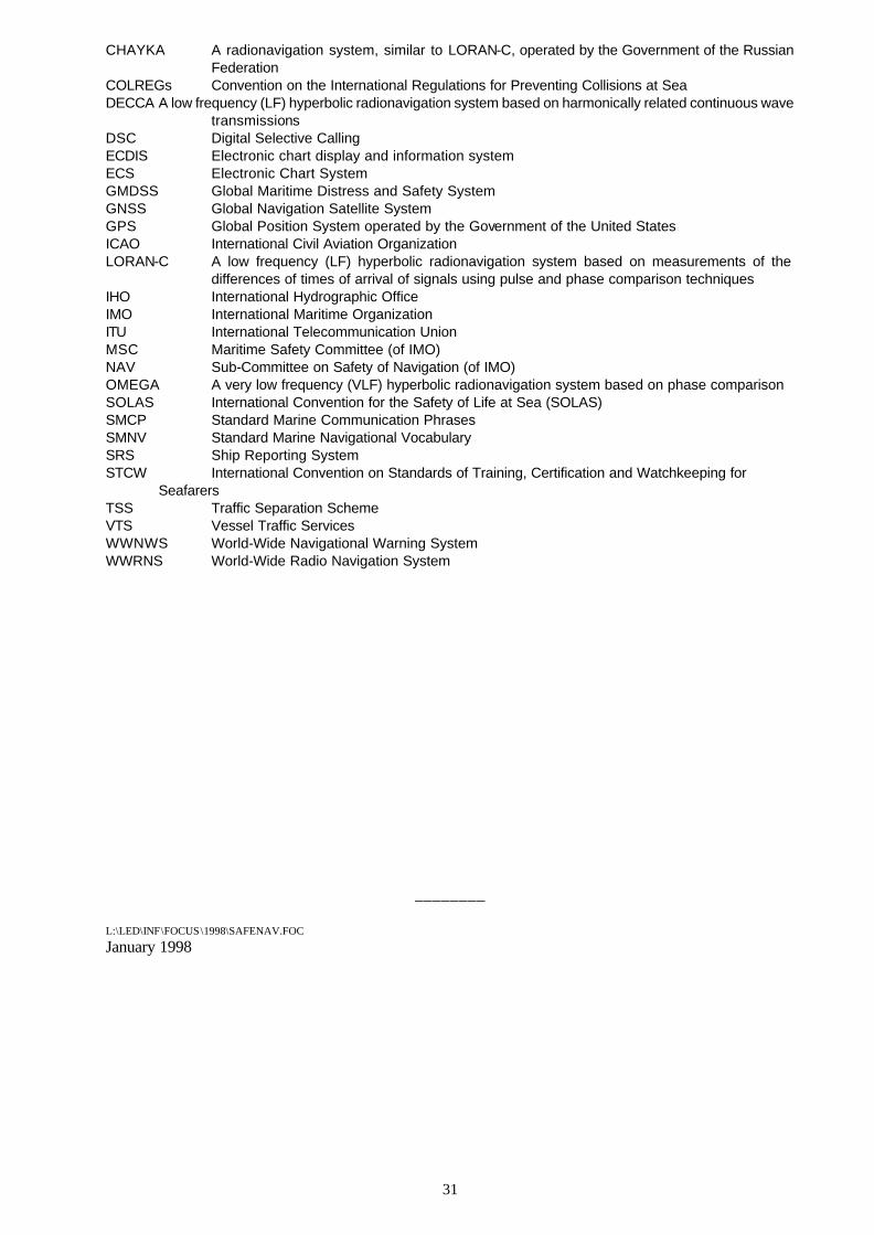
31
CHAYKA A radionavigation system, similar to LORAN-C, operated by the Government of the Russian Federation
COLREGs Convention on the International Regulations for Preventing Collisions at Sea DECCA A low frequency (LF) hyperbolic radionavigation system based on harmonically related continuous wave
transmissions DSC Digital Selective Calling ECDIS Electronic chart display and information system ECS Electronic Chart System GMDSS Global Maritime Distress and Safety System GNSS Global Navigation Satellite System GPS Global Position System operated by the Government of the United States ICAO International Civil Aviation Organization LORAN-C A low frequency (LF) hyperbolic radionavigation system based on measurements of the
differences of times of arrival of signals using pulse and phase comparison techniques IHO International Hydrographic Office IMO International Maritime Organization ITU International Telecommunication Union MSC Maritime Safety Committee (of IMO) NAV Sub-Committee on Safety of Navigation (of IMO) OMEGA A very low frequency (VLF) hyperbolic radionavigation system based on phase comparison SOLAS International Convention for the Safety of Life at Sea (SOLAS) SMCP Standard Marine Communication Phrases SMNV Standard Marine Navigational Vocabulary SRS Ship Reporting System STCW International Convention on Standards of Training, Certification and Watchkeeping for Seafarers TSS Traffic Separation Scheme VTS Vessel Traffic Services WWNWS World-Wide Navigational Warning System WWRNS World-Wide Radio Navigation System ________ L:\LED\INF\FOCUS\1998\SAFENAV.FOC January 1998