SAFE ROUTES TO SCHOOL MASTER PLAN - Leaders for Livable...
18
SAFE ROUTES TO SCHOOL MASTER PLAN City of Baldwin Park Prepared by: October 2014 Baldwin Park Department of Public Works 14403 Pacific Avenue Baldwin Park, CA 91706 (626) 813-5255
Transcript of SAFE ROUTES TO SCHOOL MASTER PLAN - Leaders for Livable...

SAFE ROUTES TO SCHOOL MASTER PLAN City of Baldwin Park
Prepared by:
October 2014
Baldwin Park Department of Public Works 14403 Pacific Avenue Baldwin Park, CA 91706 (626) 813-5255


Safe Routes to School Master Plan City of Baldwin Park
October 2014
Acknowledgements Baldwin Park City Council Mayor Manuel Lozano Mayor Pro-Tem Ricardo Pacheco Councilmember Cruz Baca Councilmember Monica Garcia Councilmember Susan Rubio
City of Baldwin Park Daniel Wall, Public Works Director David Lopez, Associate Engineer California Center for Public Health Advocacy Rosa Soto, Assistant Director Christina Cardenas, Advocacy Manager Connie Gonzalez, Administrative Assistant Alfred Mata, Local Policy Specialist Christine Quintero, Program Assistant
Baldwin Park Unified School District Christine Dennis, Assistant Superintendent Sael Castro, Translator Lupe Palacios THINKTogther Letitia Aguino Johanna Vaca SRTS Master Plan Advisory Committee Jose Contreras Griselda Fernandez Marlen Garcia Maria Gonzalez Marlene Flores-Avila Captain Jill Poe Diana Rivera-Beltran Yolanda Sanchez Steven Storvis
Design Team Local Government Commission Paul Zykofsky, Associate Director Anthony Leonard, Project Manager Ryan Snyder Associates Ryan Snyder, President
Nelson\Nygaard Consulting Associates Michael M. Moule, PE, TE, PTOE, Principal Stantec Rock E. Miller PE, PTOE, Principal
Funding provided through a California Department of Transportation (Caltrans) Community-Based Transportation Planning Grant and the City of Baldwin Park.
Views and opinions presented in this report do not necessarily represent the views or opinions of Caltrans or the California Business Transportation and Housing Agency
2 City of Baldwin Park Safe Routes To School Master Plan
INTRODUCTION The City of Baldwin Park has embarked on an effort to improve safety at all of its public schools. Baldwin Park has received both Federal and State SRTS grants to fund the Maine Avenue Complete Streets project. The Maine Avenue project will make numerous improvements to Maine Avenue from Los Angeles Street to Arrow Highway. These will be completed soon. The Maine Avenue project precedes this current planning effort and sets the stage for improvements called for in this Plan. This Plan will position the City well to receive future grants for both infrastructure projects and non-infrastructure programs. The City partnered with the Local Government Commission and the California Center for Public Health Advocacy, and was awarded a grant from Caltrans to create a City of Baldwin Park Safe Routes to School (SRTS) Plan (the Plan). The Plan will include SRTS plans for each school, and citywide efforts to support and complement the individual plans. This document details work completed thus far and future steps. There are two primary purposes to SRTS programs:
1. To make it safer for students to walk and bicycle to school 2. To increase the number of students walking and bicycling to school
In addition to safety benefits, there are health benefits for students who walk and bike to school. Environmental benefits result as fewer parents drive their children to school every day. Additionally, as children and families adopt more active lifestyles, their quality of life increases, they have more free time from driving less, and community relationships are strengthened. All of these benefits combine to create more livable neighborhoods surrounding schools where children walk or bike to school. This document contains a program for a “5E” approach to making walking and bicycling safer and more attractive to Baldwin Park’s students and parents. The 5Es include the following:
• Engineering—to make physical improvements to the routes that students use to walk or bicycle to school
• Education—to teach students safe walking and bicycling habits, to teach parents the importance of safe driving habits, and to emphasize health and environmental benefits
• Encouragement—to promote walking and bicycling to school so more students
choose to do so
• Enforcement—to ensure that rules and laws of the road are followed, as well as safe pick-up and drop-off practices are adhered to at the schools

3 City of Baldwin Park Safe Routes To School Master Plan
• Evaluation—to track the Plan to assess its success and to modify it accordingly Experience shows that this approach yields successful results in both making our communities safer to walk and bicycle in, and increasing the number of students doing so. The Caltrans grant funded a range of efforts at the schools to initiate this Plan. The grant was used to do the following:
• Conduct SRTS workshops at schools • Assess the safety issues • Plan physical modifications to the routes
This project began in August of 2013. In September of 2013 the consultant team began conducting SRTS workshops for the stakeholders at each school. Three nationally certified SRTS instructors from the consultant team facilitated the workshops. The workshops began with a presentation that described why SRTS is important, along with a sampling of engineering devices that can be applied to make walking and bicycling safer. Attendees also saw presentation modules on education, encouragement, and enforcement programs. The workshops provided Spanish-speaking residents at all the schools with translated presentation slides along with simultaneous interpretation with headphones. After the presentation, stakeholder attendees walked around the school and identified safety concerns at particular locations along common routes to each school. Upon returning to the presentation room, attendees drew on large-scale maps of their schools and surrounding areas. Attendees marked common walking and cycling routes to their school and identified key issues and locations needing improvement. They identified general safety issues, as well as location-specific safety issues. They also listed potential education, encouragement, and enforcement programs that might work at their schools. These led to the creation of SRTS plans for each school. Since Baldwin Park high schools are located adjacent to elementary and middle schools, the team conducted joint workshops and prepared joint plans for these. The plans for each school contain detailed engineering concepts. They also include a bullet-pointed list of some education, encouragement, and enforcement ideas that workshop attendees mentioned as potential programs. After the draft of this plan was released and reviewed by City staff, a final community workshop was conducted on April 29, 2104. Community members were presented with the draft projects and program plans for each school, and offered a chance to comment and offer additional ideas. The ideas received were then incorporated into the existing projects and recommendations in this plan.

4 City of Baldwin Park Safe Routes To School Master Plan
This Plan updates SRTS planning work conducted in 1995 by Baldwin Park. The 1995 SRTS Plan identified specific street improvements near each school in a similar fashion to this Plan. Signals, crosswalk striping, signs and other improvements were called for. Those improvements have been completed. This Plan moves Baldwin Park to the next step. This update utilizes the latest devices and design guidance which have changed significantly since 1995.
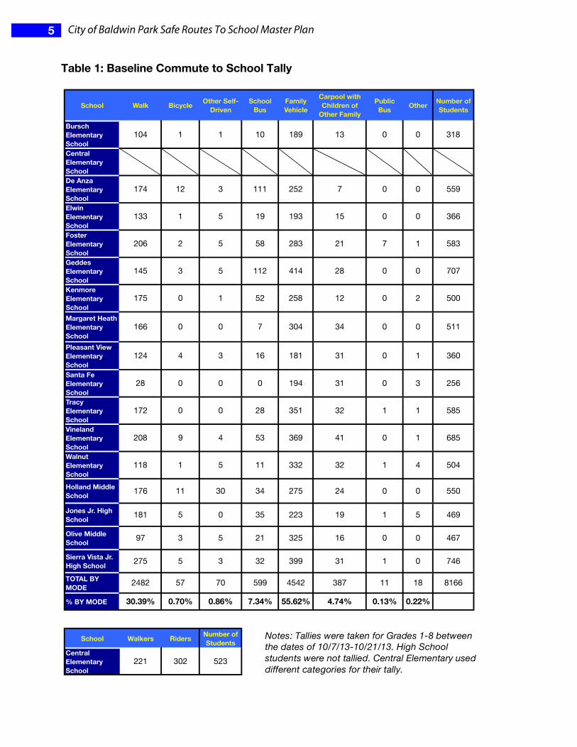
EVALUATION In the beginning of the process, baseline surveys were taken to learn about existing commute to school patterns. As the Plan’s programs unfold, they should show increases in the number of students walking and bicycling. Since engineering improvements (physical modifications made to streets and intersections) will likely be made after this planning effort ends, initial improvements will result from the programs alone. Further increases can be expected once the physical improvements are made. Table 1 below shows results of the first baseline tally conducted in classrooms in the fall of 2013. Students identified the way they commute to school by all the modes that are commonly used. “Other” may include skateboards, scooters or taxis.
5 City of Baldwin Park Safe Routes To School Master Plan
Table 1: Baseline Commute to School Tally
Bursch Elementary School
104 1 1 10 189 13 0 0 318
Central Elementary SchoolDe Anza Elementary School
174 12 3 111 252 7 0 0 559
Elwin Elementary School
133 1 5 19 193 15 0 0 366
Foster Elementary School
206 2 5 58 283 21 7 1 583
Geddes Elementary School
145 3 5 112 414 28 0 0 707
Kenmore Elementary School
175 0 1 52 258 12 0 2 500
Margaret Heath Elementary School
166 0 0 7 304 34 0 0 511
Pleasant View Elementary School
124 4 3 16 181 31 0 1 360
Santa Fe Elementary School
28 0 0 0 194 31 0 3 256
Tracy Elementary School
172 0 0 28 351 32 1 1 585
Vineland Elementary School
208 9 4 53 369 41 0 1 685
Walnut Elementary School
118 1 5 11 332 32 1 4 504
Holland Middle School 176 11 30 34 275 24 0 0 550
Jones Jr. High School 181 5 0 35 223 19 1 5 469
Olive Middle School 97 3 5 21 325 16 0 0 467
Sierra Vista Jr. High School 275 5 3 32 399 31 1 0 746
TOTAL BY MODE 2482 57 70 599 4542 387 11 18 8166
% BY MODE 30.39% 0.70% 0.86% 7.34% 55.62% 4.74% 0.13% 0.22%
School Walkers Riders Number of Students
Central Elementary School
221 302 523
School Walk Bicycle Other Self-Driven
School Bus
Number of Students
Carpool with Children of
Other Family
Public Bus OtherFamily
Vehicle
Notes: Tallies were taken for Grades 1-8 between the dates of 10/7/13-10/21/13. High School students were not tallied. Central Elementary used different categories for their tally.
6 City of Baldwin Park Safe Routes To School Master Plan
SRTS PLANS BY SCHOOL Comments from the SRTS workshops were brought along when fieldwork was conducted so that the resulting plans address the issues raised. The fieldwork also identified issues observed, which the plans address. The schools are presented in the order when the workshops were conducted. The workshops were grouped with the elementary schools that feed each corresponding middle school.
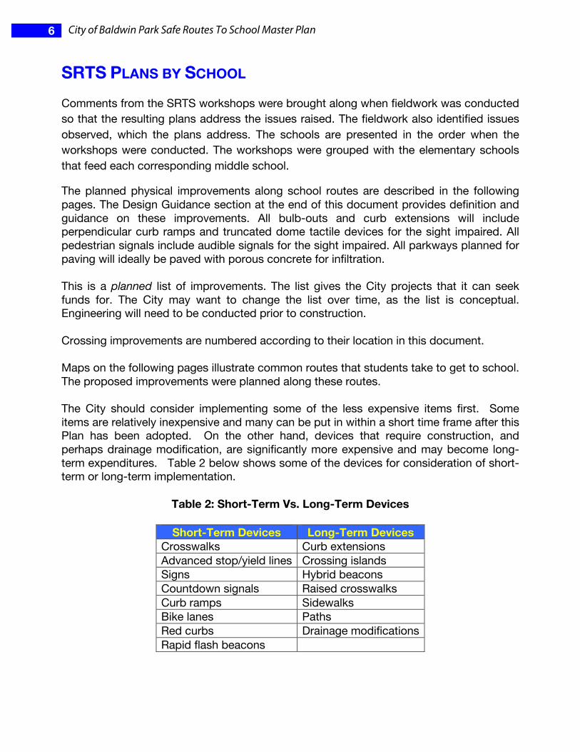
The planned physical improvements along school routes are described in the following pages. The Design Guidance section at the end of this document provides definition and guidance on these improvements. All bulb‐outs and curb extensions will include perpendicular curb ramps and truncated dome tactile devices for the sight impaired. All pedestrian signals include audible signals for the sight impaired. All parkways planned for paving will ideally be paved with porous concrete for infiltration. This is a planned list of improvements. The list gives the City projects that it can seek funds for. The City may want to change the list over time, as the list is conceptual. Engineering will need to be conducted prior to construction. Crossing improvements are numbered according to their location in this document. Maps on the following pages illustrate common routes that students take to get to school. The proposed improvements were planned along these routes. The City should consider implementing some of the less expensive items first. Some items are relatively inexpensive and many can be put in within a short time frame after this Plan has been adopted. On the other hand, devices that require construction, and perhaps drainage modification, are significantly more expensive and may become long-term expenditures. Table 2 below shows some of the devices for consideration of short-term or long-term implementation.
Table 2: Short-Term Vs. Long-Term Devices
Short-Term Devices Long-Term Devices Crosswalks Curb extensions Advanced stop/yield lines Crossing islands Signs Hybrid beacons Countdown signals Raised crosswalks Curb ramps Sidewalks Bike lanes Paths Red curbs Drainage modifications Rapid flash beacons

7 City of Baldwin Park Safe Routes To School Master Plan
However, the City should take extra care with uncontrolled crossings, especially of multi-lane streets. Research has shown that simply marking a crosswalk on multi-lane streets with over 12,000 vehicles per day may result in more pedestrian crashes. The research recommends that other devices, such as but not limited to crossing islands, advanced yield lines, curb extensions and beacons are needed to make these pedestrian crossings safe. So in these cases, new crosswalks should be put in with some devices that are more expensive. In addition to cost, the City should also consider means of prioritizing projects. The City won’t be able to fund all of the improvements at once so they will have to be phased in. In order to prioritize projects the city can apply such criteria as, but not limited to:
• Crash history • Traffic volumes • Pedestrian volumes • Number of travel lanes • Width of the street • Traffic speed • Size of the school • Community support
The City should also seek opportunities to piggy back on other projects. For example, the Maine Avenue project will soon make improvements that will benefit a number of schools. A future Olive Street project could do the same. Implementing a citywide bicycle plan will coincide with bikeway projects in this Plan. Resurfacing projects present ideal opportunities to stripe bike lanes, crosswalks, advanced yield lines, etc.
The plans for each school are presented in an order that groups elementary schools with the middle schools that they feed into in the same area of the city.
192 City of Baldwin Park Safe Routes To School Master Plan
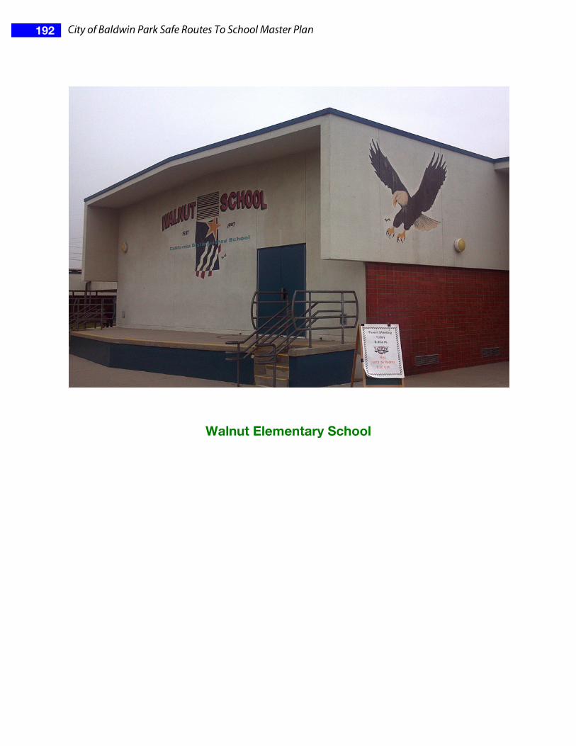
Walnut Elementary School

193 City of Baldwin Park Safe Routes To School Master Plan
SRTS Workshop A SRTS workshop was conducted on October 23, 2013. The following key stakeholders attended:
• Parents • A representative of the California Center
for Public Health Advocacy • School representatives, including the
principal and community liaison • A representative of the Baldwin Park
Unified School District
Safety Issues Raised at the Stakeholder Workshop or Through Field Observations
General
• Narrow and incomplete sidewalks • Trees block signs • Congestion of cars near the school entry • Not enough marked crosswalks • Crosswalks not visible • Streets need to be swept better • Broken speed display signs • Lack of ramps
Location Specific Issues
• Walnut St. at the front of the school o exits of school are sometimes blocked by vehicles o unattended cars o drivers speeding and not being careful
• Walnut St. & Benwood St. o no marked crosswalk
• Walnut St. & Olive St. o concerns that the crossing guard is holding back traffic too long, which
creates congestion and a more chaotic situation. • Walnut St. & Los Angeles St.
o drivers park on the curbs/sidewalks o heavy congestion
• Olive St. & Merced Ave.

194 City of Baldwin Park Safe Routes To School Master Plan
o big intersection with long crossings o buses sometimes get in the way
• Olive St. & Center St. o double parking o drivers make rolling stops o missing crosswalk on the south leg. o northbound stop sign view is blocked
• Center St. & Dunia St. o speeding o missing ramp on the NE corner o crosswalk not visible o school signs blocked by trees
• Ohio St. & Merced Ave. o missing sidewalk
• Along Center St. o narrow sidewalks o speeding o double parking o challenging to cross the street near the back gate
• Along Merced Ave. o missing sidewalks
• Along Olive St. o narrow sidewalks o missing ramps o crosswalks not marked clearly o too wide

195 City of Baldwin Park Safe Routes To School Master Plan
Maps
The following map displays bicyclist and pedestrian involved crashes for a five-year period between 2007 and 2011.
California)Transportation)Injury)Mapping)System)data)(2007<2011))
196 City of Baldwin Park Safe Routes To School Master Plan
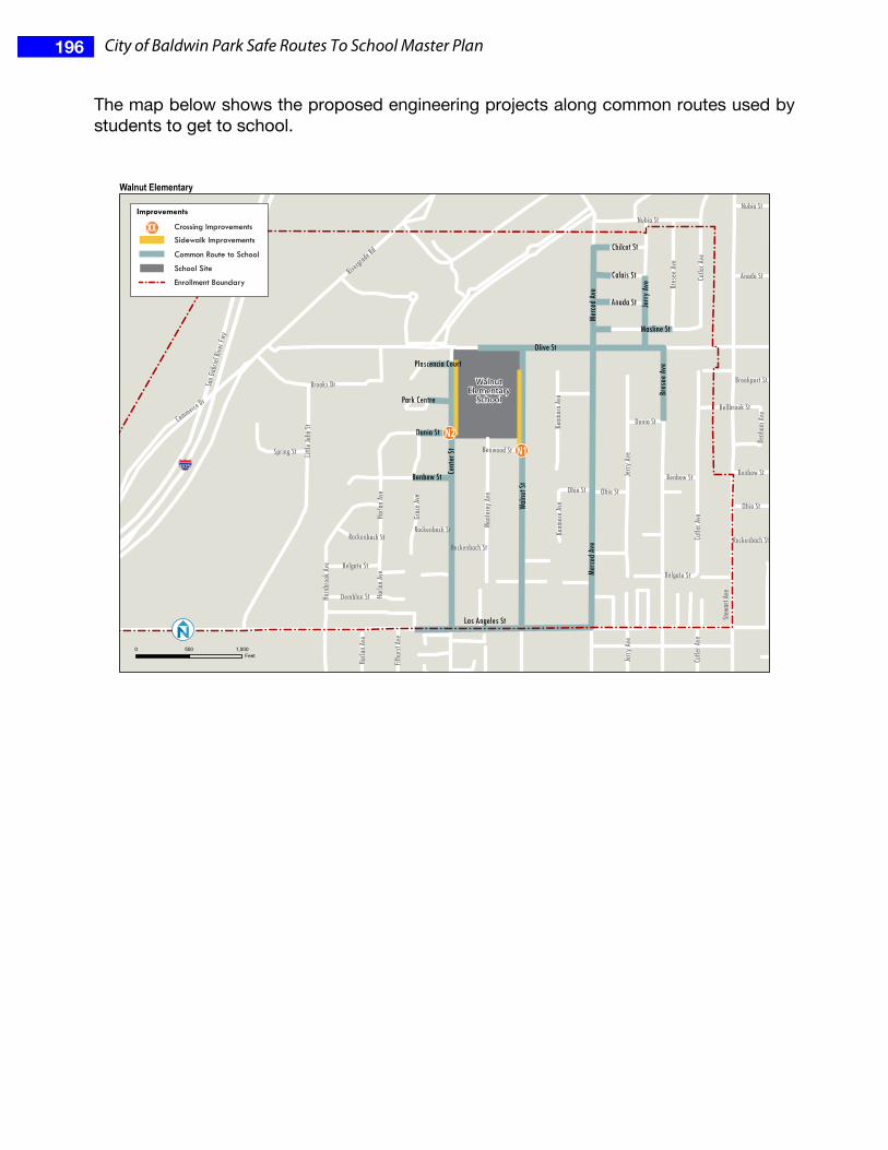
The map below shows the proposed engineering projects along common routes used by students to get to school.
N1N2
§̈¦¦605
Olive St
Stewa
rt Av
e
Cent
er St
Walnu
t St
Riverg
rade R
d
Merce
d Ave
Jerry
AveLit
tle Jo
hn St
San G
abrie
l Rive
r Fwy
Nubia St
Cutle
r Ave
Horn
broo
k Ave
Mont
erey
Ave
Commerce Dr
Benbow St
Bres
ee Av
e
Masline St
Brooks Dr
Kenm
ore A
ve
Demblon St
Spring St
Grac
e Ave
Belgate St
Benh
am Av
e
Ohio St
Calais St
Anada St
Chilcot St
Dunia St
Harla
n Ave
Filhu
rst Av
e
Rockenbach St
Benwood St
Brookport St
Bellbrook St
Plascencia Court
Park Centre
Kenm
ore A
ve
San G
abrie
l Rive
r Fwy
Harla
n Ave
Benbow St
Merce
d Ave
Benbow St
Harla
n Ave
Rockenbach St
Nubia St
Ohio St
Anada St
Cutle
r Ave
Rockenbach St
Jerry
Ave
Ohio St
Bres
ee Av
e
Belgate St
Jerry
Ave
Cutle
r Ave
Dunia St
Rockenbach St
WalnutElementary
School
Los Angeles St
0 500 1,000Feet
Crossing Improvements
Sidewalk Improvements
Common Route to School
School Site
Enrollment Boundary
XXImprovements
Walnut Elementary

197 City of Baldwin Park Safe Routes To School Master Plan
Existing Conditions and Engineering Recommendations Crossing Improvements
N1. Walnut St. & Benwood St.
Existing
• T-intersection • Uncontrolled intersection • No marked crosswalks
Proposed
• Add a yellow zebra-striped crosswalk on the north leg (1) • Provide a ramp on the east side of the street for this crosswalk (1) • Add advanced yield lines to both approaches to the north leg crosswalk (2) • Add R1-5 signs to both approaches to the north leg crosswalk (2) • Add Assembly D signs to both approaches to the north leg crosswalk (2) • Add Assembly B signs to the north leg crosswalk (2)

198 City of Baldwin Park Safe Routes To School Master Plan
N2. Center St. & Dunia St.
Existing
• Uncontrolled intersection • Yellow transverse-line crosswalk on the north leg • Missing ramp on the east end of the crosswalk • Existing Assembly B and Assembly D signs are in place, but some are blocked by
trees
Proposed
• Install zebra-stripe crosswalks on the north and west legs (2) • Add a ramp on the east side for the north leg crosswalk (1) • Add advanced yield lines to both approaches to the north and west leg crosswalks
(2) • Add R1-5 signs to both approaches to the north and west leg crosswalks (2) • Add Assembly D signs to both approaches to the north and west leg crosswalks (2) • Add Assembly B signs to the north and west leg crosswalks (4) • Trim trees blocking the existing Assembly B and Assembly D signs (2) • Work with the school to have the gate near this intersection opened during arrival
and dismissal times (except when the field is wet)

199 City of Baldwin Park Safe Routes To School Master Plan
Linear Improvements
• Change the white curb to a red curb between the school parking lot exit and the fire hydrant (north of the driveway) (approximately 15’)
• Paint the curb red for 20’ of length south of the parking lot exit driveway (approximately 20’)
• Along the school property frontage, widen the sidewalk on Walnut St. from 4’ to 6’, leaving a 3.5’ planter strip. (approximately 660’)
• Widen the sidewalk on Center St. along the school property frontage from 4’ to 6’, leaving a 3’ planter strip. (approximately 660’)
Bicycle, Skateboard and Scooter Parking
• Add racks for 10 bicycles as described in the Design Guidance section. Add racks for 10 skateboards or scooters. Add more if needed.
Program Plan
Over time the schools will form SRTS Committees. These committees will oversee and coordinate ongoing education, encouragement, and enforcement programs at the schools. They will decide which programs to institute. In the meantime, workshop participants at Walnut Elementary School viewed modules on these topics and generated the following list of ideas they thought they would like to participate in. Education
• Education for parents and students about not dropping off children on the east side of the street to reduce children crossing midblock
• Pedestrian and bicycle safety workshops/exercises (e.g., Bike Rodeo) • Training for students related to traffic safety (partner with LACBC or BikeSGV) • Cycling, skateboarding, and scooter classes and resources • A workshop for parents on safety issues; record it to display on the web • Teachers modeling and teaching safety in the classroom
Encouragement
• Walking ambassadors (give community service hours to students/volunteers) • Weekly walking days • Silver dollars or pedometers for children walking • Punch cards for children to get prizes
Enforcement
• Different street sweeping days for each side of the street