“Safe Haven Project” Washington - Red Sísmica de...
70
“Safe Haven Project” Washington Bob Freitag, Director of the Institute for Hazards Mitigation University of Washington
Transcript of “Safe Haven Project” Washington - Red Sísmica de...

“Safe Haven Project” Washington
Bob Freitag, Director of the
Institute for Hazards Mitigation
University of Washington

Project Safe Haven: Tsunami Vertical Evacuation on the Washington Coast
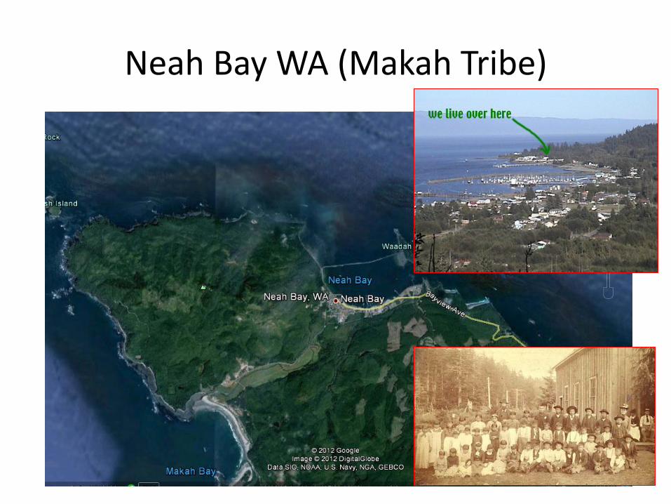
Makah People: People of the Cape (qʷidiččaʔa·tx ̌)

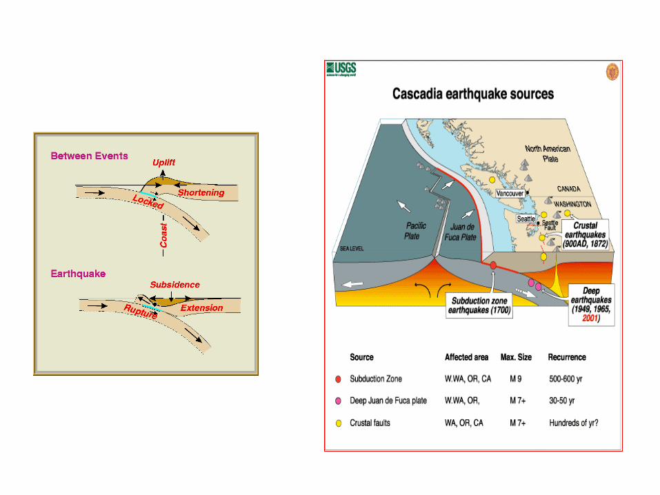
A little geological context
Takeaway : Washington Coasts are located at our continent’s active margin.
(think of the bow wave of a boat…)


West Coasts
Characterized by:
1. Bays (spits and rivers)
2. Sounds
3. High unprotected bluffs
4. No barrier islands
Takeaway 1: Sand spits and beaches provide us with flat coastal lands. Takeaway 2: If we want access to beaches we must accept risks .

http://www.iris.edu/gifs/animations/faults.htm
Tsunamis and the Shore Su
bsid
ence

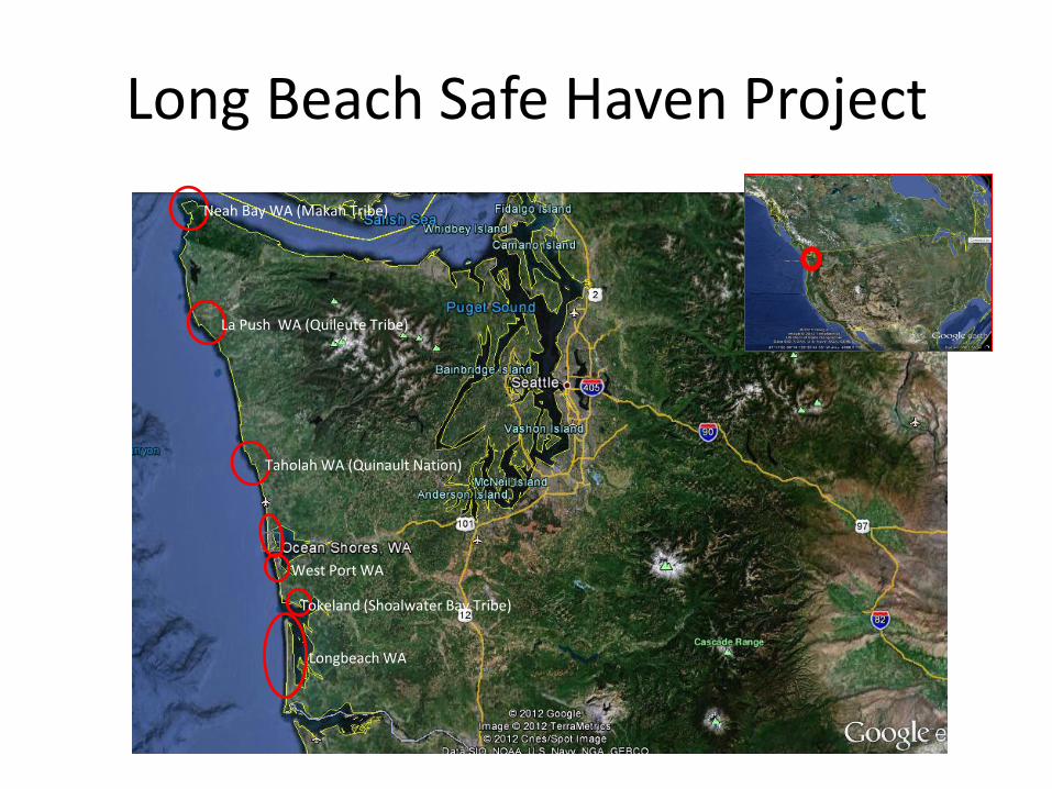
Neah Bay WA (Makah Tribe)
La Push WA (Quileute Tribe)
Taholah WA (Quinault Nation)
Tokeland (Shoalwater Bay Tribe)
Longbeach WA
West Port WA
Safe Haven Project
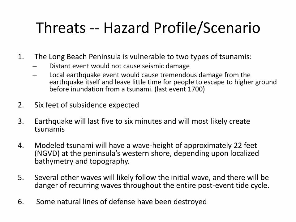
Threats -- Hazard Profile/Scenario
1. The Long Beach Peninsula is vulnerable to two types of tsunamis:
– Distant event would not cause seismic damage – Local earthquake event would cause tremendous damage from the
earthquake itself and leave little time for people to escape to higher ground before inundation from a tsunami. (last event 1700)
2. Six feet of subsidence expected
3. Earthquake will last five to six minutes and will most likely create tsunamis
4. Modeled tsunami will have a wave-height of approximately 22 feet (NGVD) at the peninsula’s western shore, depending upon localized bathymetry and topography.
5. Several other waves will likely follow the initial wave, and there will be danger of recurring waves throughout the entire post-event tide cycle.
6. Some natural lines of defense have been destroyed

Opportunities
1. There will be ample warning – Notice provided by a near earthquake EVENT
2. There will be time to react – 40 minutes 3. Save Havens can be provided 4. There is awareness of Tsunami’s on the Peninsula 5. There are natural lines of defense 6. Lines of defense that have been removed can be
restored. 7. There are few ports and other intense debris
generating built environments

Key Assumptions:
1. The scenario event will be a 9.1 magnitude subduction zone quake. 2. Ground Shaking will provide ample warning. 3. The wave height will be approximately 22 feet at Western shore. 4. Safe Havens will include 6 feet of safety. 5. There will be up to 40 minutes before arrival of the first tsunami wave. 6. Evacuees will need 5- 10 minutes to reorient themselves after the
earthquake and will have 15 minutes to walk to a Safe Haven. 7. Healthy person can walk in 3600 feet in 15 minutes and less healthy
person will be able to walk 2,700 feet. 8. Evacuees will have to remain on Safe Havens through one complete tide
cycle. 9. Routes to Safe Havens will be available and discernible after the
earthquake. 10. Those evacuating will walk to Safe Havens – Vehicular travel will not be
available. 11. Communication will be limited to voice and radio.

What is vertical evacuation? • For when evacuation to other high ground is too slow or not possible • Vertical evacuation structures serve as “safe havens” by allowing people to move above the hazard, within the expected threat area

Is Vertical Evacuation Safe?
• Used successfully in Japanese Tsunami
• Engineering standards ensured by FEMA guidelines
• Structures designed to withstand
earthquakes, debris and water flow
• Structures include a factor of safety

Berms

Towers
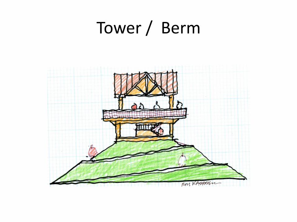
Tower / Berm

Buildings
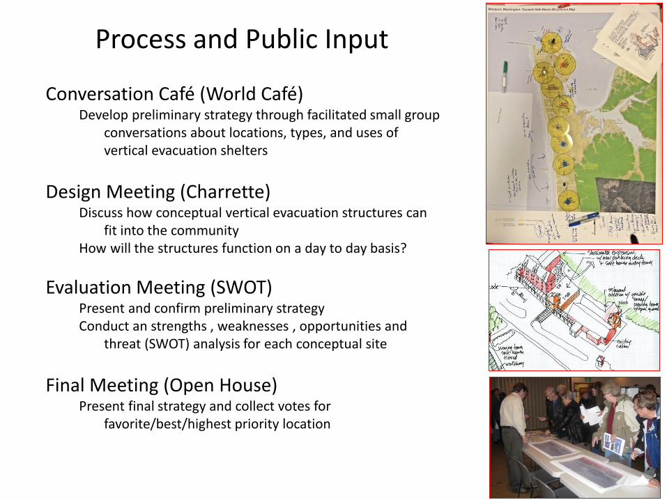
Conversation Café (World Café) Develop preliminary strategy through facilitated small group
conversations about locations, types, and uses of vertical evacuation shelters
Design Meeting (Charrette) Discuss how conceptual vertical evacuation structures can
fit into the community How will the structures function on a day to day basis?
Evaluation Meeting (SWOT) Present and confirm preliminary strategy Conduct an strengths , weaknesses , opportunities and
threat (SWOT) analysis for each conceptual site
Final Meeting (Open House) Present final strategy and collect votes for
favorite/best/highest priority location
Process and Public Input

World (“Conversation”) Cafe’
Berms
Towers
Buildings
Recovery

Decision on Alternatives
Voting Procedure:
Blue: Yes
Yellow: Yes, lower priority
Red: No
Neah Bay WA (Makah Tribe)
La Push WA (Quileute Tribe)
Taholah WA (Quinault Nation)
Tokeland (Shoalwater Bay Tribe)
Longbeach WA
West Port WA
Long Beach Safe Haven Project

Long Beach Washington


Conceptual Design B2: Long Beach Elementary

Conceptual Design B11: Moose Lodge Parking Lot

Conversation Café: Long Beach

Long Beach Resilience Strategy
• Provide for vertical evacuation
• Encourage the sale of flood insurance
With subsidence and wave energy, the post event community would vanish. Individuals would be resilient.
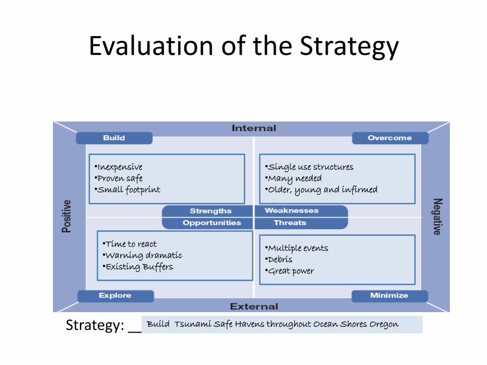
Evaluation of the Strategy
Strategy: ________________________________
•Inexpensive •Proven safe •Small footprint
•Time to react •Warning dramatic •Existing Buffers
•Single use structures •Many needed •Older, young and infirmed
•Multiple events •Debris •Great power
Build Tsunami Safe Havens throughout Ocean Shores Oregon

Neah Bay WA (Makah Tribe)
La Push WA (Quileute Tribe)
Taholah WA (Quinault Nation)
Tokeland (Shoalwater Bay Tribe)
Longbeach WA
West Port WA
Westport: Safe Haven Project

Westport WA

Tsunami Evacuation Map

Ocosta School

Ocosta High School
• Ocosta High School is built on top of the dune and due to the height, the area around the school has been designated as a tsunami evacuation location. It is unclear if the third dune will be high enough as it is to provide refuge following a Cascadia subduction zone near-earthquake with resulting tsunami waves. (See Appendix A for the Westport context map.)

Sites 5: Ocosta School Design Concept
Site 5: Ocosta School • Elevation: 11 feet • Capacity: 1,500 people • Safe Zone area: 15,000 square feet Design concepts: As in other elementary and high school sites in coastal
communities, there is sufficient land and opportunities for safe haven vertical evacuation structures of considerable size. The potentials with the Ocosta School Site include and are not limited to the following:
Covered outdoor recreational sports and play areas, with the roof structures
serving as the safe zone platforms • Play berms • Building components • Maintenance buildings and sheds (tower sheds)

Westport “Conversation” Café

Open house

Resilience Strategy
• Provide for vertical evacuation
• Encourage the sale of flood insurance
With subsidence and wave energy, the post event community may re-emerge.

Neah Bay WA (Makah Tribe)
La Push WA (Quileute Tribe)
Taholah WA (Quinault Nation)
Tokeland (Shoalwater Bay Tribe)
Longbeach WA
West Port WA
Neah Bay Safe Haven Project
Neah Bay WA (Makah Tribe)
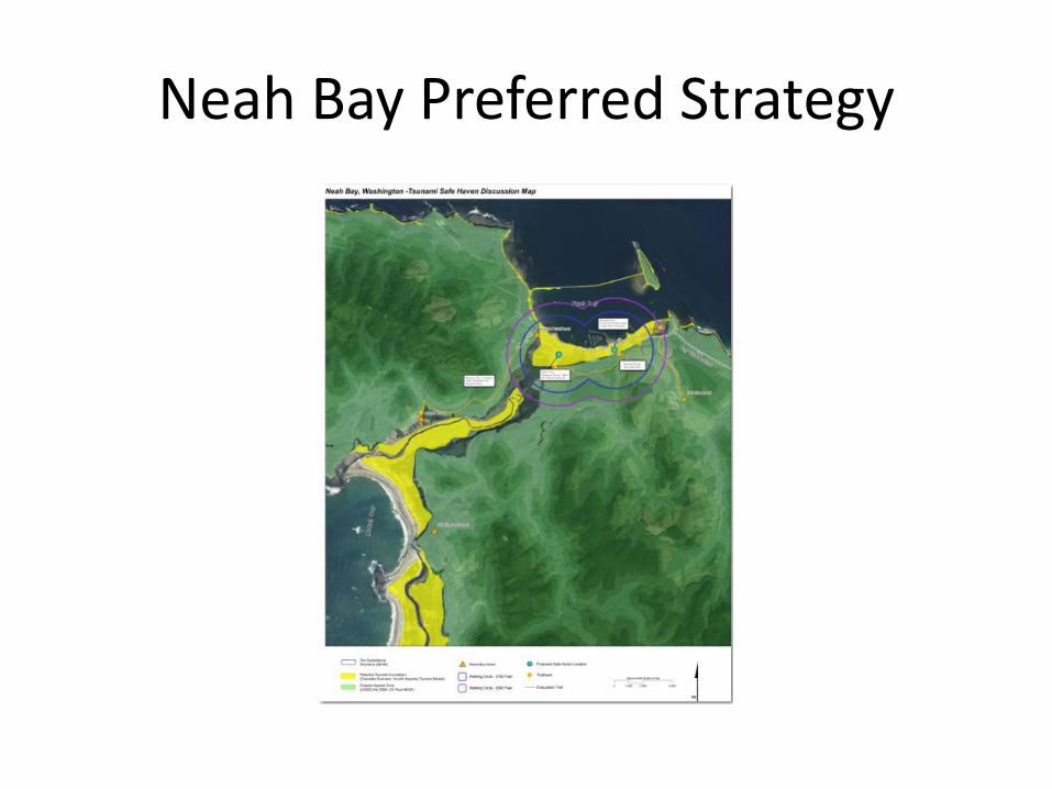
Neah Bay Preferred Strategy

Neah Bay Post Event concept

Lower community Strategy

Neah Bay Uphill Site Development

Elevated Trail System

Neah Bay Conversation Café

Neah Bay Conversation Café’ “Post Tsunami” Table

Evaluation: Open house and SWOT analysis

Neah Bay WA (Makah Tribe)
La Push WA (Quileute Tribe)
Taholah WA (Quinault Nation)
Tokeland (Shoalwater Bay Tribe)
Longbeach WA
West Port WA
La Push: Safe Haven Project

La Push WA (Quileute Tribe)


La Push Post Event Concept

Tribal members discussing alternative strategies at La Push “conversation” café’

La Push and Neah Bay Resilience Strategy
• Provide vertical evacuation until schools could relocate to high ground. (La Push is relocating)
• Construct Trails to high ground • Buy flood insurance • Begin relocating residential and community
infrastructure to high ground. • Restrict coastal land uses to those dependent on
a marine waterfront. Abandonment is not an option for Native
communities before or after an event.

Neah Bay WA (Makah Tribe)
La Push WA (Quileute Tribe)
Taholah WA (Quinault Nation)
Tokeland (Shoalwater Bay Tribe)
Longbeach WA
West Port WA
Tokeland Safe Haven Project

Tokeland


Tokeland
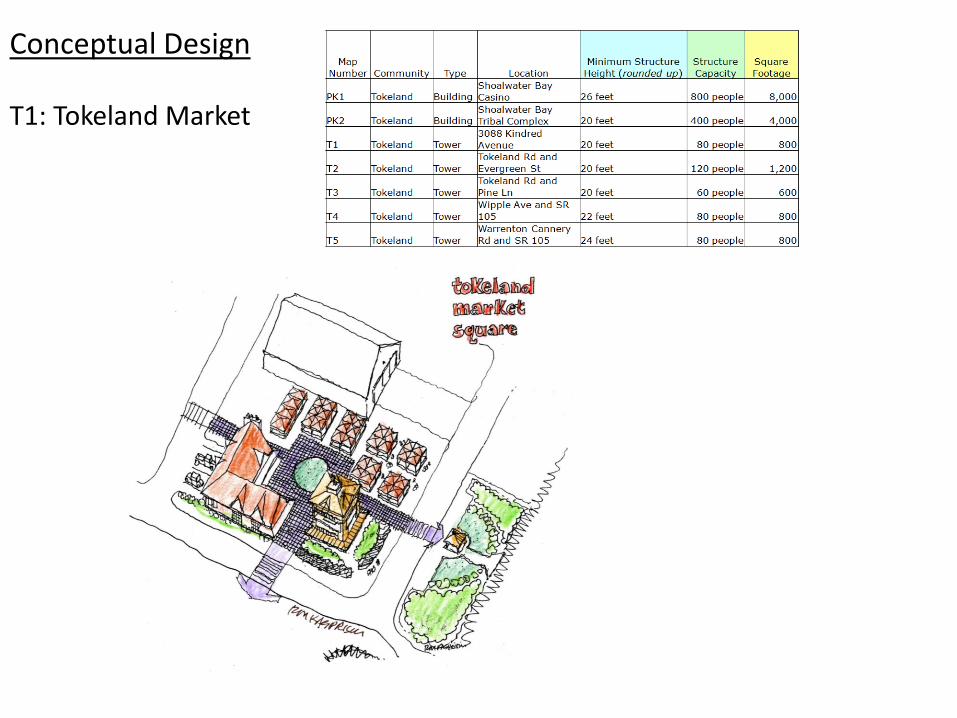
Conceptual Design T1: Tokeland Market

Charrette Tokeland

Tokeland Resilience Strategy
• Provide for limited vertical evacuation and trails to high ground
• Encourage the sale of flood insurance • Begin establishing high ground residential and community
infrastructure.
With subsidence and wave energy, the post event community would consolidate into a :
1. Residential and service community located on high ground and a
2. Lower coastal oriented commercial and industrial community.
Abandonment is not an option for Native communities.

Neah Bay WA (Makah Tribe)
La Push WA (Quileute Tribe)
Taholah WA (Quinault Nation)
Tokeland (Shoalwater Bay Tribe)
Longbeach WA
West Port WA
Ocean Shores Safe Haven Project

Ocean Shores WA

Evacuation maps for Ocean Shores and Westport


Conversation Café at Ocean Shores and Open house

Resilience Strategy
• Provide for vertical evacuation
• Encourage the sale of flood insurance
With subsidence and wave energy, the post event community would vanish. Individuals would be resilient.

Natural Lines of Defense
Near Shore – depositional
Deep Beach
Stable Secondary Dunes
Continuous Primary Dune
Opportunities Threats
Near Shore -- erosion
Interruption in Dunes –
focusing energy
Structures weakening
Dunes
Built environment having NAI
De vegetating Dunes
Questions