SADDLE CREEK PARK NATURE TRAIL SADDLE CREEK II (Teneroc Fish
Saddle Fire BAER assessment Shasta-Trinity National Forests
1
USDA-FOREST SERVICE FS-2500-8 (7/08) Date of Report: 6/30/15
SADDLE FIRE BURNED-AREA REPORT
(Reference FSH 2509.13)
PART I - TYPE OF REQUEST
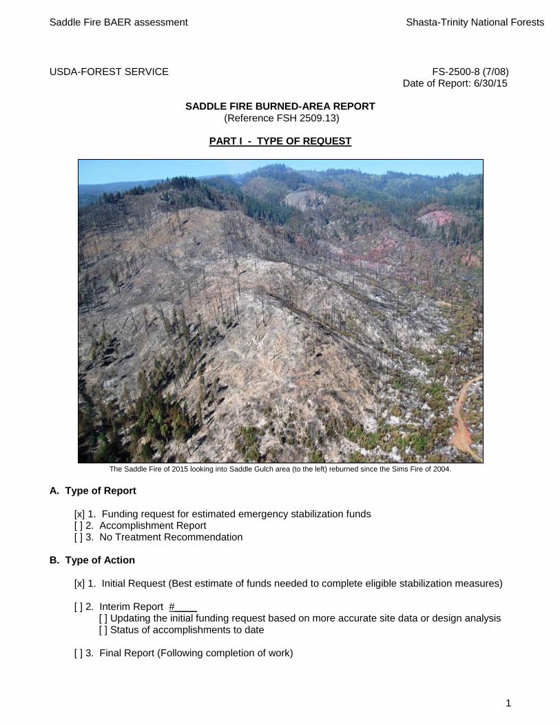
The Saddle Fire of 2015 looking into Saddle Gulch area (to the left) reburned since the Sims Fire of 2004.
A. Type of Report
[x] 1. Funding request for estimated emergency stabilization funds [ ] 2. Accomplishment Report [ ] 3. No Treatment Recommendation
B. Type of Action
[x] 1. Initial Request (Best estimate of funds needed to complete eligible stabilization measures) [ ] 2. Interim Report #____
[ ] Updating the initial funding request based on more accurate site data or design analysis [ ] Status of accomplishments to date
[ ] 3. Final Report (Following completion of work)
Saddle Fire BAER assessment Shasta-Trinity National Forests
2
PART II - BURNED-AREA DESCRIPTION
A. Fire Name: Saddle Fire B. Fire Number: CA-SHF-001371 C. State: CA D. County: Trinity E. Region: 5 F. Forest: Shasta-Trinity G. Districts: South Fork Management Unit H. Fire Incident Job Code: P5JR7U I. Date Fire Started: June 10, 2015 J. Date Fire Contained: June 25, 2015
K. Suppression Cost: Day = $10 million L. Fire Suppression Damages Repaired with Suppression Funds Saddle =
1. Dozerline repaired / waterbarred: 7.5 miles 2. Hand line repaired: 3 miles 3. Hand line still needing repair: 0 miles
M. Watershed Number and Name:
Saddle = 1801021205 – Lower South Fork of Trinity River N. Total Acres Burned:
Saddle: 1,542 NFS Acres (1,178), Private (364)
O. Vegetation Types:
Mixed conifer and woodland consisting largely of tan oak and Douglas fir P. Dominant soils: Dunsmuir and Holland Q. Geologic Types: Rattlesnake Creek Terrane (diamictite) R. Miles of Stream Channels by Order or Class:
5 Miles Perennial, 6 Miles Intermittent, 12 Miles Ephemeral

Saddle Fire BAER assessment Shasta-Trinity National Forests
3
S. Transportation System: Saddle: Trails: 0 miles Roads: 11.4 (8.8 FS, 2.6 County) miles
PART III - WATERSHED CONDITION
A. Soil Burn Severity by total and FS (acres):
Soils B. Soil Resource Condition Assessment Sections: The Saddle fire occurred in the vicinity of Hyampom just west along the South fork of the Trinity River. NFS lands as well as private ownerships were affected. FS BAER team earth scientists assessed the incidents with a whole-watershed approach regardless of ownership. Soil burn severity patterns varied for the fires due to different topographies and fire behavior. Specific dominant soils found in the fire were Dunsmuir, Dunsmuir-Ishi Pishi, Dunsmuir-Olete, Ishi Pishi, and Deadwood (See Table 2). These dominant soil textures on the fire were sandy clay loams, loams and sandy loams. These soils were mainly deep and were in the hydrologic groups B and C. Group B having a moderately low runoff potential and C having a moderately high runoff potential. Average erosion hazard rating for the dominant soils are moderate (See Table 3). Table 2. Soil map units and acreage in the Saddle fire
Soil
Map Soil Name
Hydrologic
GroupAcres Percent
154 Ishi Pishi Family, deep-Ishi Pishi famiily complex, 40-70% slopes C 222 14
204 Neuns Family, 60-80% slopes B 5 0
287 Secca-Parrish families complex, 40-60% slopes C 1 0
33 Deadwood family, 60-80% slopes C 104 7
50 Dunsmuir family, 15-40% slopes B 296 19
53 Dunsmuir-Ishi Pishi, deep families, complex, 20-40% slopes B 394 26
54 Dunsmuir-Olete families complex, 20-40% slopes B 462 30
6 Aquolls-Xerolls complex, 0-20% slopes D 43 3
98 Holland family, 40-60% slopes B 15 1
Grand Total 1542 100

Saddle Fire BAER assessment Shasta-Trinity National Forests
4
The high and moderate soil burn severity classes have evidence of severe soil heating in a patchy distribution. Soil seedbank and infiltration characteristics are impacted in the areas that have burned repeatedly (Sims Fire, 2004 and Saddle Fire, 2015) for the high and moderate soil burn severity (SBS) areas, so natural recovery will be slow in these areas along with high runoff and erosion. The low to very low soil burn severity classes (areas to the south of Saddle Gulch) still have good surface structure, contain intact fine roots and organic matter, and should recover in the short-term once revegetation begins and the soil surface regains cover. Water repellency is common, varying from slight and surficial in all burn classes; so it is expected to exacerbate runoff production. Unburned areas had no repellency. Soils are fine-loamy (Dunsmuir) that generally have moderate infiltration rates; thus surface runoff and erosion should be significant in steep sparsely-vegetated slopes (Noname and Saddle Gulch areas). There is high potential for sediment delivery to the fluvial system due steep burned hillslopes that lack cover, so aquatic habitat and water quality effects from sediment will be significant. C. Water Repellent Soils: Water repellency is common, varying from slight and surficial in in all soil burn classes, so it is expected to greatly exacerbate runoff production. Unburned areas had no repellency.
D. Erosion Potential (erosion hazard rating):
Erosion hazard ratings for low, moderate, and high soil burn severity are listed in the table below. With removal of soil cover and soil burning, low erosion hazard areas on steeper map unit 54 rate as moderate.
Table 3. Erosion Hazard Rating for the dominant soils
E. Sediment Potential:
ERMiT estimates (part 3D) try to account for hillslope re-deposition, and sediment production numbers are delivery to the bottom of the hillslope. Many modeled hillslopes in this fire have streams at the base of the slope; water will run off these fine-loamy soils and fine sediment will be deposited into Saddle and Noname Creeks. Looking at the table below (Table 4) shows for the whole watershed there is a 12 times increase in erosion for a 2-year storm, a 17 times increase for a 5-year storm, and a 27 times increase for a 10-year storm over background levels of 2 ton/acre. Individual watersheds are listed below the whole watershed values. These watersheds were modeled to determine the amount of erosion to a particular value at risk (culvert, bridge, stream, etc.) each with its own watershed size. In all cases the relative increase are the same except in Saddle Gulch watershed burned burned complexly at moderate to high levels with unstable landslide deposits.
Burn Severity
low mod high
50 Dunsmuir family, 15-40% slopes 296 low mod mod
53 Dunsmuir-Ishi Pishi, deep families, complex, 20-40% 394 mod mod mod
54 Dunsmuir-Olete families complex, 20-40% slopes 462 mod mod mod
Erosion HazardMap Unit Name Acres

Saddle Fire BAER assessment Shasta-Trinity National Forests
5
Table 4. Predicted erosion rates for each watershed (tons/acre)
Hydrology
Potential Values at Risk
Critical Values
Values at risk identified by the BAER team lead (B. Rust) were a set of road stream crossings along Trinity County Road 311 (herein TC311) on the west side of the South Fork Trinity River on the west edge of the Shasta-Trinity National Forest. The following crossings (pour points) were assessed in the field and analyzed for fire effects to hydrologic function:
An existing 36” culvert on an unnamed creek in the NE ¼ of the NW ¼ Section 30, Township 4N, Range 6E
An existing 36” culvert on Saddle Gulch
An existing 36” culvert on Canyon Creek
The unnamed creek, Saddle Gulch, and Canyon Creek drain directly to the South Fork Trinity River which is critical habitat for Coho Salmon (Figure 2).
Field survey was conducted on 6/25 and 6/26/15 in cooperation with an FS Engineer (J. Krieg). Roads, stream crossings, stream channels, and soil and vegetation conditions were inspected, and a range of conditions were noted with regard to potential fire effects on hydrologic function.
Saddle Gulch (0.2 miles2 drainage area at County Road 311) was almost entirely burned with approximately 95% of the catchment characterized by moderate or high soil burn severity. Regarding infrastructure, the main value at risk is the 36” culvert and road crossing over Saddle Gulch at TC311. We estimate that post-fire 5-year storm event will produce discharge of approximately 70 cfs, and this rate will likely exceed the culvert capacity.
An analysis of pre- and post-fire discharge was done for the four stream pour points. The USGS StreamStats analysis tool (http://water.usgs.gov/osw/streamstats/california.html) was used to estimate 2, 5, and 10-year return flows. In California the analysis tool relies on regression equations from Waananen and Crippen (1977). These design flow rates were then used as the basis for estimating post-fire increased flows after a method by Kaplan-Henry (2007). Results of the hydrologic assessment are summarized below.
Saddle Fire Ermit
7th Field Watersheds AnalyzedTotal Acres Acres Burned % Burned % Unburned tons/ac tons tons/ac tons tons/ac tons
No Name 713 330 46 54 16.98 3291.3 26.01 4542.8 42.03 6941.6
Canyon Creek 336 328 98 2 16.68 5684.3 24.85 8414.2 42.32 13709.1
Saddle Gulch 123 123 100 0 24.16 4764.0 33.93 6968.0 54.32 11442.6
Total 1172 781 57.83 13739.6 84.80 19925.0 138.67 32093.4
2-year event 5-year event 10-year event
Saddle Fire BAER assessment Shasta-Trinity National Forests
6
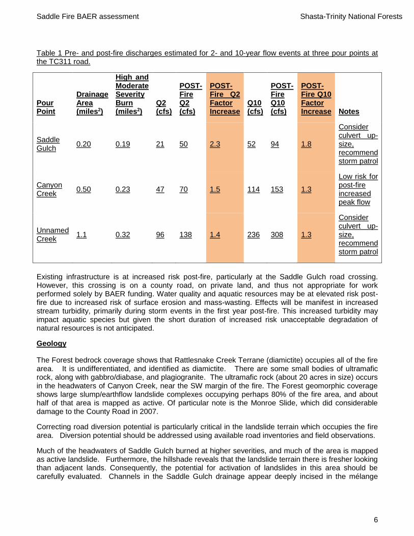
Table 1 Pre- and post-fire discharges estimated for 2- and 10-year flow events at three pour points at the TC311 road.
Pour Point
Drainage Area (miles2)
High and Moderate Severity Burn (miles2)
Q2 (cfs)
POST-Fire Q2 (cfs)
POST-Fire Q2 Factor Increase
Q10 (cfs)
POST-Fire Q10 (cfs)
POST-Fire Q10 Factor Increase Notes
Saddle Gulch
0.20 0.19 21 50 2.3 52 94 1.8
Consider culvert up-size, recommend storm patrol
Canyon Creek
0.50 0.23 47 70 1.5 114 153 1.3
Low risk for post-fire increased peak flow
Unnamed Creek
1.1 0.32 96 138 1.4 236 308 1.3
Consider culvert up-size, recommend storm patrol
Existing infrastructure is at increased risk post-fire, particularly at the Saddle Gulch road crossing. However, this crossing is on a county road, on private land, and thus not appropriate for work performed solely by BAER funding. Water quality and aquatic resources may be at elevated risk post-fire due to increased risk of surface erosion and mass-wasting. Effects will be manifest in increased stream turbidity, primarily during storm events in the first year post-fire. This increased turbidity may impact aquatic species but given the short duration of increased risk unacceptable degradation of natural resources is not anticipated.
Geology
The Forest bedrock coverage shows that Rattlesnake Creek Terrane (diamictite) occupies all of the fire area. It is undifferentiated, and identified as diamictite. There are some small bodies of ultramafic rock, along with gabbro/diabase, and plagiogranite. The ultramafic rock (about 20 acres in size) occurs in the headwaters of Canyon Creek, near the SW margin of the fire. The Forest geomorphic coverage shows large slump/earthflow landslide complexes occupying perhaps 80% of the fire area, and about half of that area is mapped as active. Of particular note is the Monroe Slide, which did considerable damage to the County Road in 2007.
Correcting road diversion potential is particularly critical in the landslide terrain which occupies the fire area. Diversion potential should be addressed using available road inventories and field observations.
Much of the headwaters of Saddle Gulch burned at higher severities, and much of the area is mapped as active landslide. Furthermore, the hillshade reveals that the landslide terrain there is fresher looking than adjacent lands. Consequently, the potential for activation of landslides in this area should be carefully evaluated. Channels in the Saddle Gulch drainage appear deeply incised in the mélange
Saddle Fire BAER assessment Shasta-Trinity National Forests
7
material makes up the earthflow terrain there. As noted in the 2004 Sims Fire BAER hydrology report, the channel banks here are oversteepened and quite high and unstable, subject to streamside debris sliding. With the loss of vegetation and stabilizing woody debris that likely occurred in the high-severity areas of the Saddle Fire, these should be focus areas for probable post-fire elevated sediment delivery and channel instability issues.
PART IV - HYDROLOGIC DESIGN FACTORS
A. Estimated Vegetative Recovery Period, (years): 3-5 B. Design Chance of Success, (percent): 75 C. Equivalent Design Recurrence Interval, (years): 2 D. Design Storm Duration, (hours): 6 E. Design Storm Magnitude, (inches): 1.83 F. Design Flow, (cubic feet / second/ square mile): 90 G. Estimated Reduction in Infiltration, (percent): 40 H. Adjusted Design Flow, (cfs per square mile): 130
PART V - SUMMARY OF ANALYSIS
A. Describe Critical Values/Resources and Threats: Background: The Saddle Fire started on June 9, 2015, in the Saddle Gulch by a lightning strike in a dry snag patch from the 2004 Sims Fire, approximately 3 miles northwest of Hyampom, CA. High winds pushed the fire towards the east over steep terrain with large dead snags in thick brush left over from the Sims Fire. The majority of the fire burned within the 2004 Sims fire footprint. As a result of the reburn, the fire was driven by heavy fuel loads from the previous fire along with windy conditions. Fourteen percent of the fire burned at a high soil burn severity, 33% was moderate soil burn severity and the remaining 53% was low to very low severity. The fire burned into unburned timber slowed and was stopped near Lake Mountain ridge by suppression. A few small spot fires occurred just to the south of Monroe Creek but were quickly contained. A total of 1,509 acres was burned. The Sims Fire footprint covered the northern portion of the current Saddle Fire perimeter and stopped just south of Saddle Gulch.
Saddle Fire BAER assessment Shasta-Trinity National Forests
8
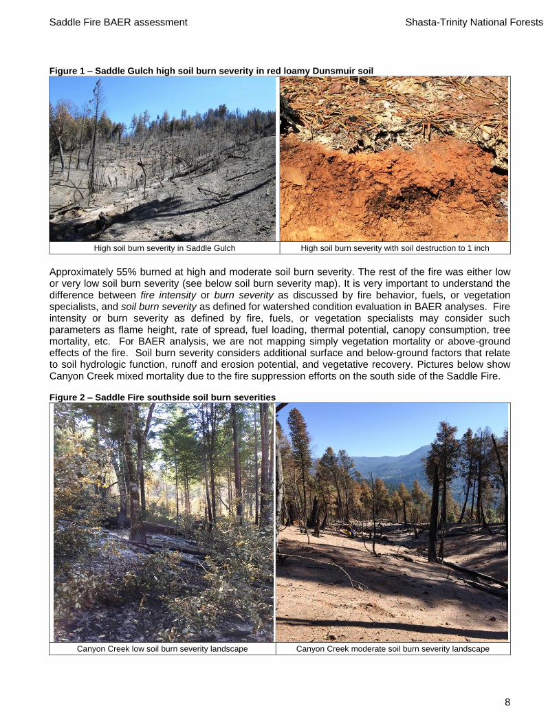
Figure 1 – Saddle Gulch high soil burn severity in red loamy Dunsmuir soil
High soil burn severity in Saddle Gulch High soil burn severity with soil destruction to 1 inch
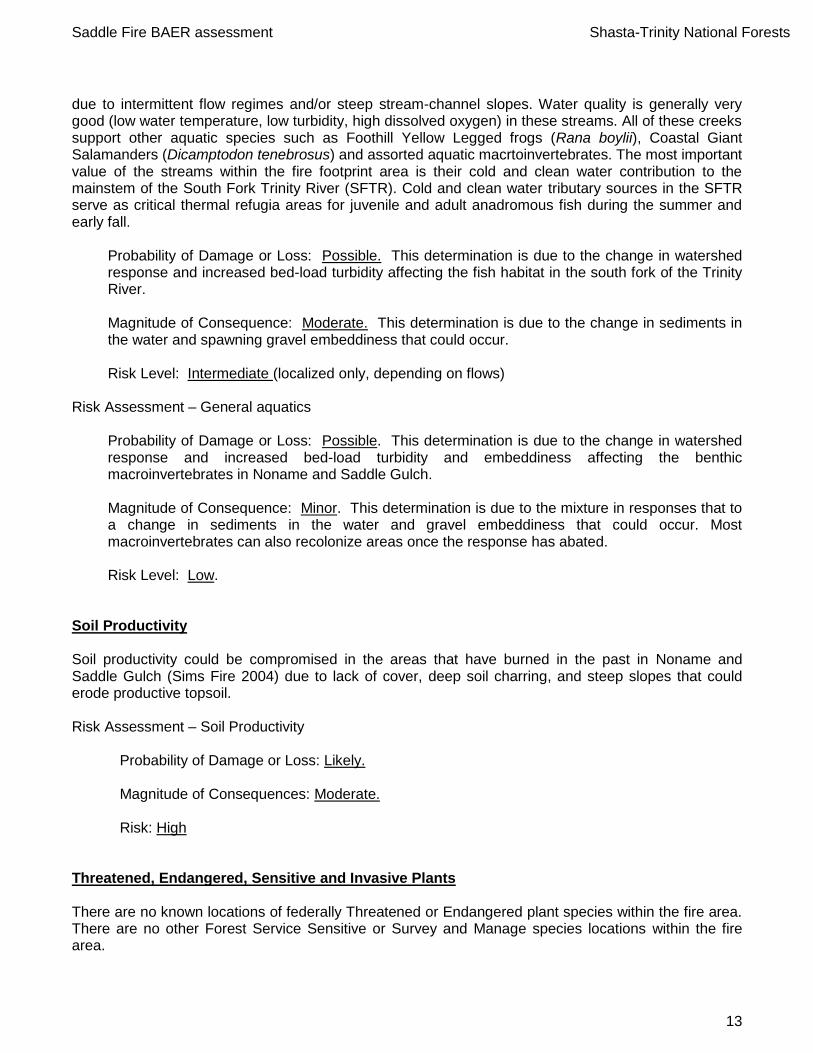
Approximately 55% burned at high and moderate soil burn severity. The rest of the fire was either low or very low soil burn severity (see below soil burn severity map). It is very important to understand the difference between fire intensity or burn severity as discussed by fire behavior, fuels, or vegetation specialists, and soil burn severity as defined for watershed condition evaluation in BAER analyses. Fire intensity or burn severity as defined by fire, fuels, or vegetation specialists may consider such parameters as flame height, rate of spread, fuel loading, thermal potential, canopy consumption, tree mortality, etc. For BAER analysis, we are not mapping simply vegetation mortality or above-ground effects of the fire. Soil burn severity considers additional surface and below-ground factors that relate to soil hydrologic function, runoff and erosion potential, and vegetative recovery. Pictures below show Canyon Creek mixed mortality due to the fire suppression efforts on the south side of the Saddle Fire. Figure 2 – Saddle Fire southside soil burn severities
Canyon Creek low soil burn severity landscape Canyon Creek moderate soil burn severity landscape

Saddle Fire BAER assessment Shasta-Trinity National Forests
9
Based on the observations and fire area conditions described above, an emergency exists for the following: 1) Noname Creek (perennial) and Saddle Gulch (presently intermittent drainage) burned hot and could experience accelerated erosion and debris flows. 2) Damage to drainage structures and road fill occurred on Forest Road 4N14 and county road 311. 3) The potential for spread of noxious weeds by the use of heavy equipment for fire line construction exists. 4) Exposed archeological sites are at risk to vandalism and erosion and will need treatments to protect sensitive resources. 5) Severely burned soils lost litter and duff and have deep soil charring compromising their structure and fertility.
Particular area of concern is Saddle Gulch which was entirely burned at moderate to high soil burn severities. This area is a Dunsmuir soils (moderately deep gravelly loams) in the headwaters of Saddle Gulch draining directly into the south fork of the Trinity River (see cover picture). This area in the past suffered moderate to high soil burning due to the 2004 Sims Fire. Several small landslides exist in the drainage system along with an active deeply incised inner-gorge. All vegetation including an existing conifer stand was 100 percent killed along with in-channel vegetation with an undersized culvert that could plug and cause county road 311 to fail (Figure 3 below). Also Noname Creek just north of Saddle Gulch experienced extensive burning with moderate and high soil burn severity occupying 50% of the drainage. Figure 3 – Saddle Gorge above county road 311
Saddle Creek unstable inner-gorge above county rd. 311 Saddle Creek undersized culvert
There are no known locations of federally Threatened or Endangered plant or wildlife species within the fire area. There are no other Forest Service Sensitive or Survey and Manage species locations but there is suitable habitat within the fire perimeter. Eighteen soil burn samples were taken in the field to confirm the soil burn severity mapping (see Appendix D). Results show that most of the fire area suffered low to moderate soil burn severity with only Noname and Saddle Gulches had high soil burn severity, with Saddle Gulch having the highest proportion of severe burning. Looking at the soil burn severity maps below shows the majority of soil burn severity was moderate to low south of Canyon Creek. Areas that burned the hottest were the west portion of the fire in Noname Creek and Saddle Gulch. This was due to heavy accumulations of dead and down timber left from the Sims fire of 2004.

Saddle Fire BAER assessment Shasta-Trinity National Forests
10
Saddle Fire Soil Burn Severity Map:

Saddle Fire BAER assessment Shasta-Trinity National Forests
11
Values at Risk:
The risk matrix below, Exhibit 2 of Interim Directive No.: 2520-2010-1 was used to evaluate the Risk
Level for each value identified during Assessment:
Probability of Damage
or Loss
Magnitude of Consequences
Major Moderate Minor
RISK
Very Likely Very High Very High Low
Likely Very High High Low
Possible High Intermediate Low
Unlikely Intermediate Low Very Low
Values at Risk Matrix: The values at risk (VAR) matrix displayed below shows all the ratings for the potential values at risk for the Saddle fire. Only ones that rated as high or very high are discussed in detail, all others that rated intermediate to very low are briefly discussed below or listed with their ratings in the table below.
Forest Service Roads Life: As a result of the severely burned watershed risks to life and safety of Forest visitors and personnel entering certain areas of the burn are likely and pose a moderate risk, due to burned hazard trees along roadways and flooding. Property: Based on the watershed response, the BAER Assessment team determined that residences of private property below the fire area are not at increased risk of damaging flooding as a result of the
Saddle BAER Risk Matrix Critical Value Responsibility
Probability Life Property Other Life Property Other Life Property Other
Infastructure
NFS Roads damage (4N14 and county road 311) Likely Moderate High
Install rolling dips, repair fillslopes from
burnouts, install 2 critical-dips, and storm-patrol USFS,Trinity County
Aquatics
T&E Aquatics species (Coho salmon habitat) Possible Moderate Intermediate None USFS
Other aquatics (macroinvertibrates) Possible Moderate Intermediate None USFS
Water QualityDomestic water users Possible Moderate Intermediate None Share info with county
Noname and Saddle Gulch erosion causing turbidity Likely Moderate High Culvert crossing brushing and log debris removalShare info with county
Headcutting channels in Saddle Gulch causing sedimentation Possible Moderate Intermediate None Share info with county
CulturalExposed arch sites to vandalism Likely Moderate Intermediate Mulch sites to protect USFS
Wildlife Habitat for NSO Possible Moderate Intermediate None, share info with F&WS USFS
Soil ProductivityLoss of soil productivity in high to moderate SBS areas Likely Moderate High None, too steep to mulch USFS
GeologyDebris Flow potential above county road 311 Possible Moderate Intermediate Warning signs Share info with county
Saddle Gulch landslide potential Possible Moderate Intermediate
Botany
Native plant community invasive weeds Likely Major High
Weed detection surveys; early detection
rapid response treatments USFS
Magnitude of Consequences Risk Treatment

Saddle Fire BAER assessment Shasta-Trinity National Forests
12
Saddle Fire. Forest roads within the fire area will be repaired as a result of suppression activity which is critical to protect road-bed and associated infrastructure. But because of the expected increase in watershed response, the assessment team feels that significant damage would occur on some roads in the fire perimeter due to undersized culverts and poor drainage (see hydrology and roads report for details). There is a likelihood that post burn conditions will increase runoff and the movement of sediment into drainage features, such as culvert inlets, overside drains, roadway dips and run outs, this occurrence could cause drainage function to fail and uncontrolled water to divert, resulting in a moderate risk of damage to the invested road improvements, loss of road function, and the denial of access. Also county road 311 at Noname and Saddle Gulch could be areas of concern due to limited culvert sizes and potential of flooding. There are two culverts on Trinity County Road 311 that are of concern due to high severity burning in Saddle Guich and an unnamed tributary. There are road fill slope failures and compromised road subgrades caused by tree root and log burning in Trinity County Road 311 and NFSR 4N14. There is a high risk of erosion on the fill slopes greater than 65% slope on NFSR 4N14 Risk Assessment – Forest Service roads
Probability of Damage or Loss: Likely. This determination is based on the expectation that increased erosion and sediment will occur and could plug drainage structures along roads. Magnitude of Consequence: Moderate. This determination was made based on the amount of damage that would occur if culverts were temporarily plugged. Risk Level: High
Water Quality, Water Quantity, and Fisheries Noname Creek and Saddle Gulch sub-watersheds have been impacted by the fire. Both are minimal importance to the South Fork Trinity River anadromous fishery since they contain no fish. Coho salmon and winter run steelhead are federally listed as Threatened fish species and both species are known to occur in the South fork of the Trinity River and within the proximity of the fire. . Increased turbidity in the unnamed creek, Saddle Gulch, and Canyon Creek is expected during storms in winter 2015-16. However, these effects may not persist in to the following winter season (2015-16) and are they not expected to produce unacceptable degradation to natural resources. Risk Assessment – Water Quality
Probability of Damage or Loss: Possible. Magnitude of Consequences: Moderate. Risk: Intermediate
Risk Assessment – Fisheries of South fork of Trinity River Within the fire footprint there are approximately four named streams (Monroe, Canyon, Saddle and Grapevine Creeks) and a single unnamed stream. None of these five streams are known to support fish
Saddle Fire BAER assessment Shasta-Trinity National Forests
13
due to intermittent flow regimes and/or steep stream-channel slopes. Water quality is generally very good (low water temperature, low turbidity, high dissolved oxygen) in these streams. All of these creeks support other aquatic species such as Foothill Yellow Legged frogs (Rana boylii), Coastal Giant Salamanders (Dicamptodon tenebrosus) and assorted aquatic macrtoinvertebrates. The most important value of the streams within the fire footprint area is their cold and clean water contribution to the mainstem of the South Fork Trinity River (SFTR). Cold and clean water tributary sources in the SFTR serve as critical thermal refugia areas for juvenile and adult anadromous fish during the summer and early fall.
Probability of Damage or Loss: Possible. This determination is due to the change in watershed response and increased bed-load turbidity affecting the fish habitat in the south fork of the Trinity River. Magnitude of Consequence: Moderate. This determination is due to the change in sediments in the water and spawning gravel embeddiness that could occur. Risk Level: Intermediate (localized only, depending on flows)
Risk Assessment – General aquatics
Probability of Damage or Loss: Possible. This determination is due to the change in watershed response and increased bed-load turbidity and embeddiness affecting the benthic macroinvertebrates in Noname and Saddle Gulch. Magnitude of Consequence: Minor. This determination is due to the mixture in responses that to a change in sediments in the water and gravel embeddiness that could occur. Most macroinvertebrates can also recolonize areas once the response has abated. Risk Level: Low.
Soil Productivity Soil productivity could be compromised in the areas that have burned in the past in Noname and Saddle Gulch (Sims Fire 2004) due to lack of cover, deep soil charring, and steep slopes that could erode productive topsoil. Risk Assessment – Soil Productivity
Probability of Damage or Loss: Likely. Magnitude of Consequences: Moderate. Risk: High
Threatened, Endangered, Sensitive and Invasive Plants There are no known locations of federally Threatened or Endangered plant species within the fire area. There are no other Forest Service Sensitive or Survey and Manage species locations within the fire area.
Saddle Fire BAER assessment Shasta-Trinity National Forests
14
Forest Sensitive Botanical Species No federally listed plant species were located within the fire perimeter. A sensitive plant population of Sedum laxum ssp. flavidum, is located on serpentine soils on Bennet Peak south of the fire. This plant is considered a “plant of limited distribution- a watch list”. No fire suppression activities occurred at this location. Invasive plants and Noxious Weeds Noxious weeds were identified within the fire perimeter. The majority of the populations were concentrated along the roadsides. See Table 1 for commonly found weed species in the fire area. Table 1. Weeds identified within fire perimeter.
Scientific Name Common Name USDA Symbol
CDFA Weed Rating
Centuarea solstitialis yellow starthistle CESO3 C
Cirsium vulgare bull thistle CIVU -
Bromus tectorum cheatgrass BRTE -
Cynosurus echinatus hedgehog dogtail grass CYEC C
Hypericum perforatum
St. Johnswort/ Klamath weed
HYPE C
Genista monspessulana
French broom GEMO2 C
Other notable weeds in the area include spotted knapweed (Centaurea diffusa), an A listed species, and barbed goatgrass (Aegilops triuncialis), a B listed species, approximately 2 and 6 miles from the fire perimeter, respectively. The value at risk is the ecosystem health and integrity of the native plant communities within the burned areas. The threat is the potential loss of that health and integrity due to new invasive plant introductions and invasive plant spread from existing infestations which could inhibit the return of the native plant communities and crowd out recovering native vegetation resulting in nonfunctioning or poorly functioning ecosystems. The deep taproots of these aggressive species are able to access soil water previously utilized by native vegetation, making it unavailable to the new growth of the native species. For these reasons, loss of the ecosystem health and integrity of the native plant communities from weed invasion in the burned area is an emergency requiring mitigation. A weed washing station arrived a few days after the fire began and was used at the basecamp in Hayfork on equipment being demobilized. As there was no weed washing required for incoming equipment, there is no guarantee that the equipment was free of weeds prior to working on the fire. The value at risk ratings and treatments for the specific fires are as follows:
Risk Assessment – Saddle Fire Invasive Plants
Probability of Damage or Loss: Likely. There is a likely probability of spread and introduction of non-native invasive plants into areas disturbed by the fire.
Saddle Fire BAER assessment Shasta-Trinity National Forests
15
Magnitude of Consequences: Moderate. Damage to these plant communities would be considerable and long-term. Helicopter landings and hand crew activities may have introduced yellow star thistle.
Risk Level: High. Weed detection surveys would occur in the priority areas of dozer lines, drop point, roads, and small, known invasive plant infestations would be conducted outside the fire. Rapid response treatments by manual removal would occur where new, small invasive plant occurrences are discovered. Where large invasive plant occurrences are discovered, additional funding for treatment of these sites may be requested.
Heritage Resources Within the fire perimeter are 2 previously recorded prehistoric related archaeological sites. Only one site, a lithic scatter camp, was damaged by suppression activity.
Risk Assessment – These sites were burned over, but appeared to have received minimal thermal damage. This was due to the rapid spread of this fire burning through relatively light fuels. Temperatures were high, but not sustained which did not significantly harm artifacts. However, any organic cultural material, leather, or wood were destroyed if they were on the ground surface.
Probability of Damage or Loss: Possible. The removal of vegetation by the fire has exposed artifacts leaving these sites vulnerable to looting. Magnitude of Consequence: Major. A major risk to these sites is illegal collecting of artifacts. Risk Level: High. A major risk to these sites is illegal collecting of artifacts. The removal of vegetation by the fire has exposed artifacts leaving these sites vulnerable to looting. Second major risk is water erosion since no vegetation is left on these sites.
Threats to Wildlife: There are wildlife concerns for the Saddle Fire due to NSO T&E species which suffered 2 owl cores being destroyed. Fish & Wildlife Services has been contacted and consultation has begun. There are no other Forest Service Sensitive or Survey and Manage species locations.
B. Emergency Treatment Objectives: To allow safe passage of water to protect infrastructures,
watersheds, cultural sites, and fish habitat from accelerated sheet and rill erosion. Also to protect watersheds from the spread of noxious weeds.
Risk determination is dependent on the design storm selected and downstream values at risk. By
using a set of average storms (2, 5, and 10-year events) emergency planning measures can be designed to mitigate and minumize anticipated risks. Using a 2-year design storm the values at risk can be evaluated to determine if an emergency exists for a typical winter storm.
C. Probability of Completing Treatment Prior to Damaging Storm or Event:
Land 80 % Channel n/a % Roads/Trails 95 % Protection/Safety 90 %

Saddle Fire BAER assessment Shasta-Trinity National Forests
16
D. Probability of Treatment Success
Years after Treatment
1 3 5
Land 90% 85% 80%
Channel n/a n/a n/a
Roads/Trails 95% 90% 85%
Protection/Safety 95% 90% 85%
E. Cost of No-Action (Including Loss): $250,000
F. Cost of Selected Alternative (Including Loss): $33,650
G. Skills Represented on Burned-Area Survey Team:
[x] Hydrology [x] Soils [x] Geology [ ] Range [ ] [ ] Forestry [x] Wildlife [ ] Fire Mgmt. [x] Engineering [ ] [ ] Contracting [x] Aquatics [x] Botany [x] Archaeology [ ] [x] Fisheries [ ] Research [ ] Landscape Arch [ ] GIS
Team Leader: Brad Rust Email: [email protected] Phone: 530-226-2427 FAX: 530-226-2485
H. Treatment Narrative for Forest Service:
See Appendix E for treatment map and narratives below describing treatments.
Land Treatments: Invasive weed detection surveys Invasive weed detection surveys are proposed for the Saddle Fire. Weed detection surveys are the selected treatments to deal with potential invasive weeds affecting the native plant community. TREATMENT COSTS
Cost Summary
Land Treatments Units Unit Cost # of Units BAER $
Noxious Weed Detection Surveys & treatment
miles 700 3 $2,100
Saddle Fire BAER assessment Shasta-Trinity National Forests
17
Each unit cost per mile includes cost to government, supplies, vehicle, and travel costs for two people. Surveys will encompass all the handlines, dozerlines, drop-points, staging areas, and perimeter of the fire. With approximately 3 miles of dozer lines and hand lines, numerous drop points, and staging areas in the fire it is expected that new and expanding invasive plant infestations will proliferate along these vectors and if left unchecked may eventually lead to vegetation type conversion. Surveys and rapid response eradication treatments will begin in 2015 during the flowering periods of invasive plant species. The area requiring assessments 3 miles of dozer line and hand line needing survey, on the Shasta-Trinity National Forest. Natural Recovery: Vegetation in the mixed conifer will recover slowly. Even in areas of moderate soil burn severity, the canopy was mostly killed and the seed source removed. Stands with an element of Ponderosa pine will likely recover more quickly, since at least a few mature trees are likely to have survived to produce seed into newly exposed mineral soil. Meadows dominated by grasses and forbs will recover within a year, because for the most part soil temperatures were not hot enough to kill root systems. The montane chaparral shrubs were mostly killed by the fire, but fire stimulates manzanita seeds stored in the soil to germinate. In riparian areas along Saddle and Noname creeks, sedges and grasses were resprouting within 10 days of the fire, and most riparian shrubs are also likely to resprout. Hillslope mulching: was not selected as a treatment since slopes were too steep and values at risk were not great enough to justify treatments.
Roads Treatments: FS Roads goal of restoring overall drainage function along with installing culvert inlet treatments, critical dips, upsizing culverts and drainage armor will control water from moving off site reducing the risk to adjacent resources along some road.
A. Treatments Type: will include culvert cleaning, fill slope reconstruction, stump hole reconstruction, and rolling dip installation.
B. Treatment Objective: To repair damage caused by the fire, provide safe travel on the public transportation system and to mitigate future damage to the transportation system caused by post fire watershed conditions.
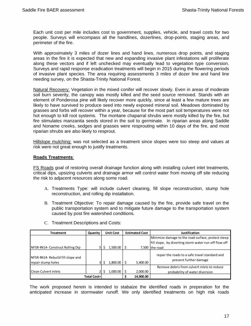
C. Treatment Descriptions and Costs:
The work proposed herein is intended to stabaize the identified roads in preperation for the anticipated increase in stormwater runoff. We only identified treatments on high risk roads
Treatment Quanity Unit Cost Estimated Cost Justification
NFSR 4N14- Construct Rolling Dip 5 1,500.00$ 7,500$
Minimize damage to the road surface, protect steep
fill slope, by diverting storm water run-off flow off
the road
NFSR 4N14- Rebuild fill slope and
repair stump holes 3 1,800.00$ 5,400.00$
repair the roads to a safe travel standard and
prevent further damage
Clean Culvert Inlets 2 1,000.00$ 2,000.00$ Remove debris from culvert inlets to reduce
probability of water diversion14,900.00$ Total Cost=
Saddle Fire BAER assessment Shasta-Trinity National Forests
18
downstream of moderate and high severity burned areas. These treatments were identified as the most cost effective solutions with the highest probability of success to mitigate damage from the post fire stormwater events to the transportation system. County Roads: We will recommend to Trinity County that they should do a post fire condition survey of the portion of County Road 311 affected by the Saddle Fire. We can provide the post fire hydraulic analysis for their stream culvert evaluation, which shows that the road and culverts could be at risk during a large stormwater event. There are tree stumps and roots that burned out in the road prism, which comprimises the structure and safety of County Road 311. Protection/Safety Treatments: Burned area road signs.
Safety: Posting of areas burned will alert the public to potential dangers of falling trees and rolling rocks. Repair of road and trail signs burned will insure public safety. Posting of areas burned will alert the public to potential dangers of falling trees and rolling rocks. It is anticipated that the road crossing over Saddle Gulch is at risk for diversion/overtopping during winter 2015-16, particularly if the catchment produced debris flows. Recommend signage alerting the public to potential increased peak flows post-fire and storm patrol to assess impacts during winter 2015-16. Warning signs for potential for flooding with a 2yr-6hr storms (see Burned Area Report (BAR) source of funds for costs at the end of the report). Heritage Resource Prescriptions:
Treatment Type – The fire exposed a large lithic scatter of heat-treated chert and obsidian artifacts. Projectile points noted when the site was first recorded in 1981 for the Grape Vine Timber Sale included McKee uniface and Oregon series dated between 3000 to 5000 years ago. This variety of point styles reflecting various time periods indicates a multi-component site utilized over a long period of prehistory. This variety of lithic material culture and depth of time argues for this site having National Register eligibility. Recommended treatment for this resource consists of using a four-person hand crew to chip slash piles over exposed areas of the site in order to stabilize the soils and disguise the surface artifacts that have been exposed. Logs should be used to line existing roads in the area to prevent campers, hikers and 4 x 4 road users from causing further damage to exposed areas of the site. Slash piles and logs are available on site.
I. Monitoring Narrative: (Describe the monitoring needs, what treatments will be monitored, how they will be monitored, and when monitoring will occur. A detailed monitoring plan must be submitted as a separate document to the Regional BAER coordinator.)
See Appendix C below for road monitoring.

Saddle Fire BAER assessment Shasta-Trinity National Forests
19
Part VI – Emergency Stabilization Treatments and Source of Funds Initial Request
PART VII - APPROVALS
1. _______________________________ ________ Shasta-Trinity Forest Supervisor (signature) Date 2. _______________________________ ________ Regional Forester (signature) Date
Saddle Fire BAER Costs
NX Weed Det. Survey mile $750 3.0 $2,250 $0 $0 $0 $0
$2,250 $0 $0 $0 $0
$0 $0 $0 $0 $0
Road Stormproofing (rolling-dips, berm removal) ea $1,500 5 $7,500 $0 $0 $0 $0
Clean culvert Inlets ea $1,000 2 $2,000
Rebuild burned-out road fillslope ea $1,800 3 $5,400 $0 $0 $0 $0
$14,900 $0 $0 $0 $0
Heritage Site Protection (1 site) project $3,000 1 $3,000 $0 $0 $0 $0
Bruned Area Warning Signs (large) ea $700 2 $1,400 $0 $0 $0 $0
Flood Warning Signs ea $250 2 $500 $0 $0 $0 $0
Implementation Team Leader ea $1,000 1 $1,000 $0 $0 $0 $0
$5,900 $0 $0 $0 $0
Assessment Team 0520 H5BAER --- --- $14,234 --- $0 --- $0 $0
--- $14,234 --- $0 --- $0 $0
Road Treatment Monitoring ea $500 1 $500 $0 $0 $0 $0
$500 $0 $0 $0 $0
$23,550 $0 $0 $0 $0
$23,550
C. Road and Trails
Subtotal Protection
Subtotal Road & Trails
Subtotal Land Treatments
Subtotal Channel Treatments
Subtotal Evaluation
B. Channel Treatments - none
D. Protection/Safety
Previously approved
Total for this request
Money Left
Total
$Units
Fed
$ Units
Non Fed
$Units
Other Lands
Comments: *
G. Totals
F. Monitoring
E. BAER Evaluation
Subtotal Monitoring
Line Items
A. Land Treatments
NFS Lands
Unit
Cost
# of
Units BAER $
Spent
$

Saddle Fire BAER assessment Shasta-Trinity National Forests
20
APPENDICES: Supporting Information: Appendix A: Saddle Fire BAER Team
Appendix B: Monitoring for Roads
Appendix C: Summary of Cost-Risk Analysis
Appendix D: Soil Burn Severity Soil Sample Points for the Saddle Fire
Appendix E: Treatment Map for the Saddle Fire
Appendix A: Saddle Fire BAER Team:
Position Name Cell Phone Work Phone
Team Leader Brad Rust 530-917-0434 530-226-2427
Hydrology Zack Mondry 530-440-6344
Soils Ashley Knight 209-535-6955 530-226-2432
Fisheries Eric Wiseman 530-949-8816 530-623-1754
Archaeology Mark Arnold 530-628-5227
Botany Ashley Knight 209-535-6955 530-226-2432
Geology Juan delaFluente 530-841-4413
Roads Justin Krieg 701-300-0943 530-623-1726
Saddle Fire BAER assessment Shasta-Trinity National Forests
21
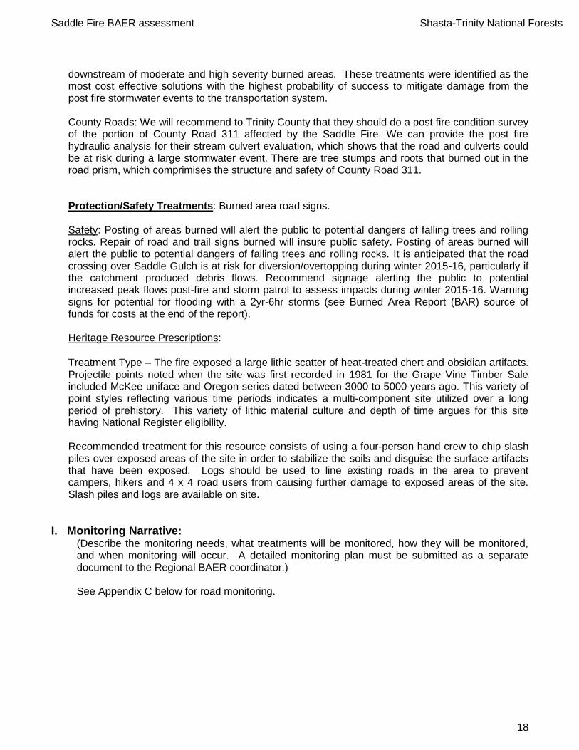
Appendix B: Monitoring Protocols:
Saddle Fire Road Effectiveness Monitoring
The 2500-8 report requests funds to monitor the effectiveness of road treatments on Saddle Fire roads.
4. Monitoring Questions
Is the road-tread stable?
Is the road leading to concentrating runoff leading to unacceptable off-site consequences? 2. Measurable Indicators
Rills and/or gullies forming of the road
Loss of road bed. 3. Data Collection Techniques
Photo documentation of site
Inspection Checklist (attached) 4. Analysis, evaluation, and reporting techniques
Monitoring will be conducted after storm events. If the monitoring shows the treatment to be ineffective at stabilizing road and there is extensive loss of road bed or infrastructure an interim report will be submitted. A several page report would be completed after the site visit. The report would include photographs and a recommendation on whether additional treatments are necessary.
Road Inspection Checklist
Date:__________________ Inspector__________________ Time:__________________ Forest Road________________ Describe locations reviewed during inspection:___________________________
Was there road damage? Was culvert plugged?____________________. GPS _________________________________________________________ Describe damage and cost to repair? (GPS)______________________________ Photo taken of road damage_______________________________________ Recommended actions to repair:___________________________________________________

Saddle Fire BAER assessment Shasta-Trinity National Forests
22
Appendix C: Summary of Cost-Risk Analysis
Saddle Fire Benefit/Cost Analysis:
Total benefits of resource:
Resource Value $
roads $100,000
water quality & fish habitat $50,000
ecosystem stability (native plants & soils productivity) $60,000
public safety $250,000
cultural $50,000
total loss $510,000
Proability of loss without and with treatments:
Resource Proability loss no treatments: Proability loss w/ treatments: Reduction in proability of loss
roads 65% 15% 50%
water quality & fish habitat 70% 55% 15%
ecosystem stability (native plants & soils productivity) 65% 50% 15%
public safety 50% 20% 30%
cultural 50% 15% 35%
Saddle Fire BAER Costs
NX Weed Det. Survey mile $750 3.0 $2,250 $0 $0 $0 $0
$2,250 $0 $0 $0 $0
$0 $0 $0 $0 $0
Road Stormproofing (rolling-dips, berm removal) ea $1,500 5 $7,500 $0 $0 $0 $0
Clean culvert Inlets ea $1,000 2 $2,000
Rebuild burned-out road fillslope ea $1,800 3 $5,400 $0 $0 $0 $0
$14,900 $0 $0 $0 $0
Heritage Site Protection (1 site) project $3,000 1 $3,000 $0 $0 $0 $0
Bruned Area Warning Signs (large) ea $700 2 $1,400 $0 $0 $0 $0
Flood Warning Signs ea $250 2 $500 $0 $0 $0 $0
Implementation Team Leader ea $1,000 1 $1,000 $0 $0 $0 $0
$5,900 $0 $0 $0 $0
Assessment Team 0520 H5BAER --- --- $14,234 --- $0 --- $0 $0
--- $14,234 --- $0 --- $0 $0
Road Treatment Monitoring ea $500 1 $500 $0 $0 $0 $0
$500 $0 $0 $0 $0
$23,550 $0 $0 $0 $0
$23,550
Benefit of treatments:
Resource Value $ Reduction in proability of loss
roads & trails $100,000 50%
water quality & fish habitat $50,000 15%
ecosystem stability (native plants & soils productivity) $60,000 15%
public safety $250,000 30%
cultural $50,000 35%
Benefit/cost ratio:
Resource Benefit of treatment Treatment Cost B/C ratio Justified
roads & trails $50,000 $14,900 3.4 yes
water quality & fish habitat $7,500 $2,000 3.8 yes
ecosystem stability (native plants & soils productivity) $9,000 $2,250 4.0 yes
public safety $75,000 $1,900 39.5 yes
cultural $17,500 $3,000 5.8 yes
overall $159,000 $24,050 6.6
F. Monitoring
Subtotal Monitoring
Comments: *
Total for this request
Subtotal Road & Trails
D. Protection/Safety
Subtotal Protection
E. BAER Evaluation
Subtotal Evaluation
NFS Lands Other Lands Money Left
Total
$Line Items Units
Unit
Cost
# of
Units BAER $
Spent
$ Units
Fed
$ Units
Non Fed
$
A. Land Treatments
Subtotal Land Treatments
B. Channel Treatments - none
Previously approved
Subtotal Channel Treatments
G. Totals
C. Road and Trails
Saddle Fire BAER assessment Shasta-Trinity National Forests
23
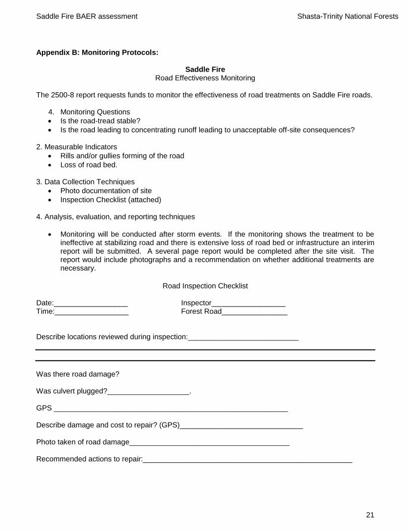
Appendix D: Soil Burn Severity Soil Sample Points for the Saddle Fire
SiteID SurveyDate GroundCover AshColor AshDepth (mm) SoilStructure RootAlteration InfiltTime ObSoilBurn Comment AspectDir Slope% SlopeLenght (ft) SoilText SurfRockPC SoilComments VegComment
1 6/24/2015 0 - 20 Percent Gray 10.00 SlightlyAltered VeryFineConsumed Moderate (10-40 sec) Moderate wr surface Northeast 10 150 Loam 35 metamorph reburn sims fire
2 6/24/2015 0 - 20 Percent Black 15.00 SlightlyAltered VeryFineConsumed Moderate (10-40 sec) Moderate wr 5cm East 15 200 Loam 35 holland reburn sims
3 6/24/2015 0 - 20 Percent Black 5.00 SlightlyAltered VeryFineConsumed Weak (< 10 sec) Moderate weak water repelancy 5mm East 30 1000 Loam 30 holland reburn sims
4 6/24/2015 0 - 20 Percent Gray 20.00 SlightlyAltered VeryFineConsumed None High wr 5cm East 15 800 Loam 25 holland reburn sims
5 6/24/2015 0 - 20 Percent Black 15.00 SlightlyAltered VeryFineConsumed Strong (>40 sec) High strong wr to 25mm East 30 900 Loam 45 skallan sims reburn
6 6/24/2015 20 - 50 Percent Black 3.00 SlightlyAltered VeryFineConsumed None Low skallan Northwest 40 500 Loam 45 new burn
7 6/24/2015 20 - 50 Percent Black 5.00 OriginalStructure NoChange Weak (< 10 sec) Very Low water repelancy on surface East 15 500 Loam 35 callan new burn
8 6/24/2015 0 - 20 Percent Red 0.00 DegradedPowdery VeryFineConsumed Weak (< 10 sec) High Holland wwr 2mm East 20 500 Loam 20 holland new burn
9 6/25/2015 0 - 20 Percent Black 5.00 SlightlyAltered VeryFineConsumed Strong (>40 sec) Moderate swr to 20mm East 15 300 Loam 20 callan sims reburn
10 6/25/2015 0 - 20 Percent Red 10.00 DegradedPowdery ModerateConsumption Strong (>40 sec) High swr to 45mm Southeast 35 20 Loam 15 callan sims reburn tanoak
11 6/25/2015 20 - 50 Percent Black 5.00 OriginalStructure NoChange None Low natural water repelancy Northeast 35 500 Loam 40 new burn
12 6/25/2015 20 - 50 Percent Black 3.00 SlightlyAltered VeryFineConsumed Weak (< 10 sec) Low wr low to 2mm South 25 300 Loam 5 holland new burn
13 6/25/2015 0 - 20 Percent Gray 25.00 SlightlyAltered VeryFineConsumed None Moderate moderate water repelancy to 40mm Southeast 25 200 Other 15 sandy loam reburn sims
14 6/25/2015 > 50 Percent Other 0.00 OriginalStructure NoChange None Unburned unburned island South 10 75 Other 10 sl soil large df
15 6/25/2015 0 - 20 Percent White 10.00 DegradedPowdery VeryFineConsumed Weak (< 10 sec) Moderate wr to 40mm weak Southeast 20 500 Loam 10 holland sims reburn
17 6/25/2015 20 - 50 Percent Gray 5.00 SlightlyAltered VeryFineConsumed Moderate (10-40 sec) Moderate mwr to 30nm South 30 100 Loam 25 callan sims reburn
18 6/25/2015 0 - 20 Percent Gray 5.00 SlightlyAltered VeryFineConsumed Moderate (10-40 sec) Moderate water repelancy mod surface Southeast 25 500 Loam 20 sims reburn

Saddle Fire BAER assessment Shasta-Trinity National Forests
24
Appendix E: Treatment Map - Saddle Fire