SA CORTEZ - Blue Latitude Press - Go Confidently!bluelatitudepress.com/Sea_of_Cortez_sample.pdf ·...
29
A Cruiser’s Guidebook SEA OF CORTEZ Shawn Breeding and Heather Bansmer 2nd Edition
Transcript of SA CORTEZ - Blue Latitude Press - Go Confidently!bluelatitudepress.com/Sea_of_Cortez_sample.pdf ·...

A Cruiser’s GuidebookSEA OF CORTEZ
Shawn Breeding and Heather Bansmer
2nd Edition
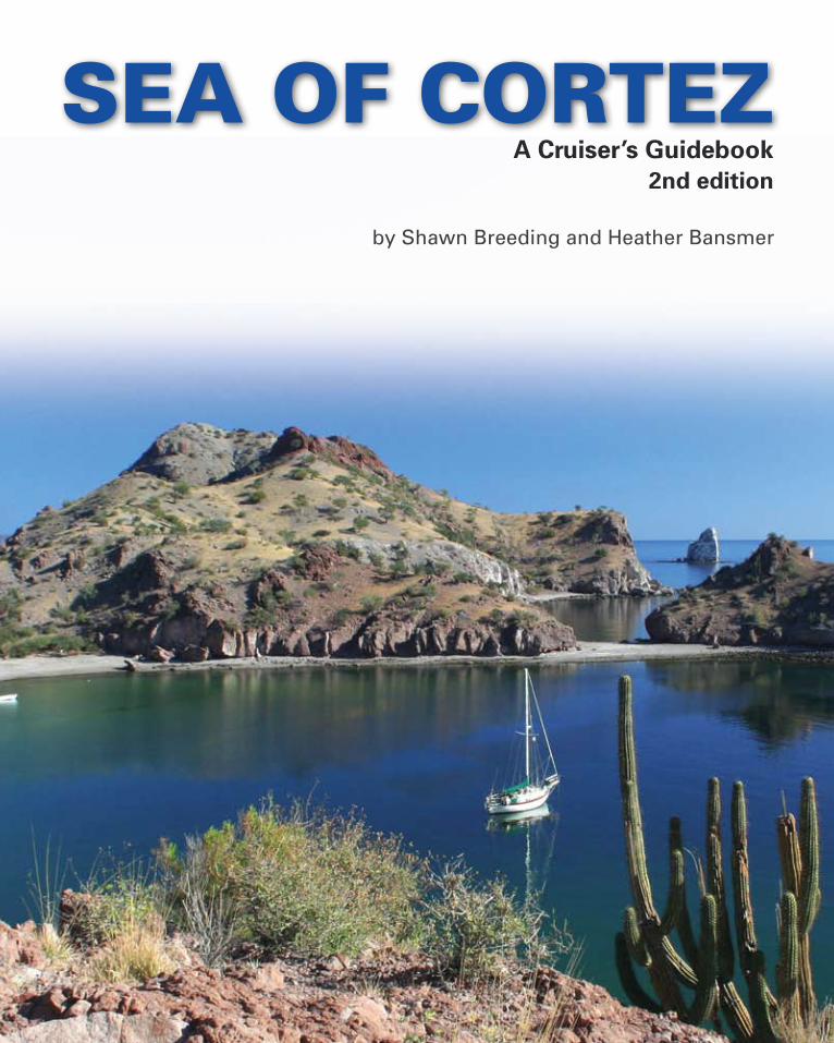
by Shawn Breeding and Heather Bansmer
A Cruiser’s Guidebook2nd edition
SEA OF CORTEZ
Sea of Cortez - A Cruiser’s Guidebook2nd Edition
Shawn Breeding and Heather Bansmer
Published by Blue Latitude Press LLCP.O. Box 2773Kirkland, WA 98083-2773(360) 421-1934(801) 454-1934 faxwww.bluelatitudepress.comwww.exploringcortez.com
Text © 2009 by Shawn Breeding and Heather Bansmer.All rights reserved.Chartlets, maps and GPS waypoints © 2009 by Shawn Breeding and Heather Bansmer.All rights reserved.Photos © 2009 by Shawn Breeding and Heather Bansmer. Some photos are used by permission and are the property of their original owners.Aerial Photos © 2009 by Charles Chandler (www.charleschandlerphotography.com). All rights reserved.
ISBN: 978-0-9800901-1-6
Library of Congress Control Number: 2009907477
Printing History1st edition - 20072nd edition - 2009
All rights reserved. No part of this book may be translated or reproduced in any form without the prior written consent of the authors and the publisher.While the Authors and Blue Latitude Press LLC have made every effort to ensure that the data and information within this guide is accurate and error-free, nevertheless, errors may occur. We ask that you notify us immediately of any errors that you may discover. The authors and publisher do not assume and hereby disclaim any liability to any party for any loss or damage caused by errors or omissions, whether such errors or omissions result from negligence, accident or any other cause.Blue Latitude Press LLC and the Authors make no claims, promises or guarantees about the accuracy, completeness, or adequacy of the contents of this guide and expressly disclaim liability for errors and omissions in the contents of this guide. No warranty of any kind, implied, expressed or statutory, including but not limited to the warranties of non-infringement of third party rights, title, merchantability, fitness for a particular purpose, is given with respect to the contents of this guide. Reference in this guide to any specific commercial products, processes, or services, or the use of any trade, firm or corpora-tion name is for the information and convenience of the public, and does not constitute endorsement, recommendation, or favoring by Blue Latitude Press LLC and the Authors.This guide does not replace prudent seamanship. It is intended as a reference and planning aid and not for navigation. The skipper of the vessel is solely responsible for the safe operation and navigation of his/her vessel and the safety of the crew and/or passengers.
Without the support of our amazing family and wonderful friends, this book would not have been possible.
Thank you for all your support throughout this endeavor.

3
About the Authors ............................................... 6
About the Boat ..................................................... 7
How to Use the Book ............................................ 8
Mexico Information ........................................... 10
Sample Itineraries .............................................. 21
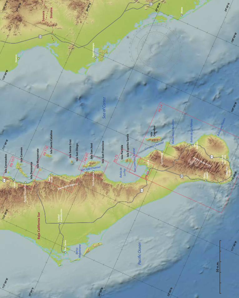
Chapter 1 - The Cape .......................................... 23 Cabo San Lucas ................................................................... 25 San José del Cabo .............................................................. 33 Bahía Los Frailes ................................................................. 35 Ensenada de los Muertos ................................................ 38 Isla Cerralvo .........................................................................41
Chapter 2 - Bahía de La Paz ............................... 43 Canal de San Lorenzo ....................................................... 45 Puerto Balandra .................................................................. 47 Caleta Lobos ........................................................................ 50 Playa Pichilingue ................................................................ 52 Bahía Pichilingue ................................................................ 53 Bahía Falsa ............................................................................ 53 La Paz ..................................................................................... 56
Chapter 3 - Isla Espíritu Santo ........................... 72 Playa Bonanza ..................................................................... 75 Bahía San Gabriel ............................................................... 77 Puerto Ballena ..................................................................... 79 Isla Ballena............................................................................ 81 Ensenada de la Ballena ..................................................... 81 Ensenada del Candelero .................................................. 83 El Mezteño ........................................................................... 83
Caleta Partida ...................................................................... 85 El Cardoncito ....................................................................... 87 Ensenada el Cardónal ...................................................... 88 Ensenada Grande ............................................................... 90 El Embudo ............................................................................ 93 Los Islotes ............................................................................ 93
Chapter 4 - Canal de San José ............................96 Isla San Francisco ............................................................... 98 Isla Coyote (Pardito) ........................................................ 101 Cabeza de Mechudo ....................................................... 102 San Evaristo........................................................................ 104 Nopolo................................................................................. 107 Bahía Amortajada .............................................................110 Punta Salinas (San Ysidro)...............................................113 Mangle Solo ........................................................................115
Chapter 5 - Isla San Diego to Isla Santa Catalina ... 118 Isla San Diego .................................................................... 120 Isla Santa Cruz ................................................................... 120 Timbabiche (Bahía San Carlos) .................................... 121 Puerto Los Gatos .............................................................. 124 Punta San Telmo (Punta Prieta) ................................... 127 Bahía Santa Marta ............................................................ 129 Ensenada la Ballena ......................................................... 129 Bahía San Marte ................................................................ 131 Bahía Agua Verde ............................................................. 135 San Cosme .......................................................................... 139 Isla Monserrate ................................................................. 141 Isla Santa Catalina ............................................................ 144
TAble of ConTenTs
23 43 72 96 118

4
Chapter 6 - Loreto Area ................................... 146 Los Candeleros ................................................................. 148 Caleta Candeleros Chico ................................................ 150 Bahía Candeleros ............................................................. 152 Isla Danzante .................................................................... 153 Honeymoon Cove ...................................................... 153 Puerto Escondido............................................................. 156 Loreto .................................................................................. 161 Isla Carmen ........................................................................ 165 Bahía Marquer ............................................................. 166 Puerto Ballandra ......................................................... 168 Puerto de la Lancha .................................................. 171 El Refugio (V-Cove) .................................................... 171 Painted Cliffs ................................................................ 173 Bahía Cobre .................................................................. 173 Punta Perico South .................................................... 175 Bahía Salinas ................................................................ 176 Punta Colorada ........................................................... 178 Isla Coronados................................................................... 180
Chapter 7 - San Juanico Area ............................. 183 Punta Mangles .................................................................. 185 Caleta San Juanico ........................................................... 188 Saquicismunde Cove ...................................................... 191 Punta Pulpito ..................................................................... 193 San Sebastian .................................................................... 195
Chapter 8 - Bahía Concepción ......................... 197 Punta Santo Domingo .................................................... 199 Bahía Coyote ...................................................................... 201 Playa Santispac ........................................................... 201 Posada Concepción ................................................... 203 Playa el Burro ...............................................................204 Playa Coyote ................................................................205 Playa Santa Barbara ...................................................206 Isla Requesón .................................................................... 207 Mulegé ................................................................................209 Punta Chivato .................................................................... 212
Chapter 9 - Santa Rosalía Area ............................ 215 Craig Channel .................................................................... 217 Isla San Marcos .................................................................. 217 Santa Rosalía .....................................................................220 Caleta Santa Maria ...........................................................225 Cabo Virgenes ................................................................... 226 Punta Trinidad ................................................................... 226 Bahía San Francisquito ................................................... 227 Cala Mujeres ......................................................................229
Chapter 10 - Midriff Islands .............................230 Isla San Pedro Martir ...................................................... 232 Isla San Lorenzo ................................................................ 232 Isla las Animas ................................................................... 232 Isla Salsipuedes ................................................................. 233 Isla Rasa ............................................................................... 233 Isla Partida .......................................................................... 235 Isla San Esteban ................................................................236 Isla Tiburón ........................................................................ 237
TAble of ConTenTs
146 183 197 215 230

5
Chapter 11 - Bahía de las Animas .......................240 Cala Puertocitos de Enmedio ....................................... 243 Animas Slot ........................................................................ 243 Anchorages in East Bahía de las Animas .................. 245 Punta Islotes ...................................................................... 247 Punta el Soldado .............................................................. 249 Punta el Alacrán ............................................................... 251 Punta el Pescador ............................................................ 251 Ensenada el Quemado ................................................... 252
Chapter 12 - Bahía de los Angeles ....................... 254 Puerto Don Juan .............................................................. 257 Bahía de los Angeles Village ........................................260 Gecko Beach ...................................................................... 262 La Mona .............................................................................. 262 Ensenada la Gringa .......................................................... 263 Isla la Ventana ................................................................... 265 Isla Coronado (Isla Smith) .............................................. 267 Laguna Rada ................................................................ 267 Isla Mitlán and Las Rocas ......................................... 269
Chapter 13 - North Sea ..................................... 271 Isla Angel de la Guarda .................................................. 273 Puerto Refugio ............................................................ 274 Isla Estanque ................................................................ 276 Bahía Willard/Bahía San Luis Gonzaga ...................... 277 San Felipe ........................................................................... 278 Puerto Peñasco ................................................................. 279
Chapter 14 - San Carlos Area .................... 280 Bahía Kino........................................................................... 282 Pozo Moreno/Las Cocinas .............................................284 Bahía San Pedro ................................................................ 287 Bahía Algodones ..............................................................289 Caleta Lalo .......................................................................... 293 Martini Cove ...................................................................... 293 San Carlos ........................................................................... 295 Guaymas ............................................................................. 301
GPS Waypoints Table ................................ 305Charts ......................................................... 312Bibliography .............................................. 313Index .......................................................... 315Overview Map ........................................... 318
TAble of ConTenTs
240 254 271 280
Also Available
Pacific Mexico: A Cruiser’s Guidebook
Exploring the Pacific coast of mainland Mexico - from Mazatlán to Bahías de Huatulco
w w w . b l u e l a t i t u d e p r e s s . c o m
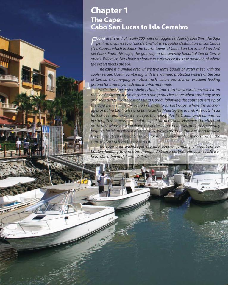
Chapter 1The Cape:Cabo San Lucas to Isla Cerralvo
Found at the end of nearly 800 miles of rugged and sandy coastline, the Baja peninsula comes to a “Land’s End” at the popular destination of Los Cabos
(The Capes), which includes the tourist towns of Cabo San Lucas and San José del Cabo. From this cape, the gateway to the serenely beautiful Sea of Cortez opens. Where cruisers have a chance to experience the true meaning of where the desert meets the sea. The cape is a unique area where two large bodies of water meet, with the cooler Pacific Ocean combining with the warmer, protected waters of the Sea of Cortez. This merging of nutrient-rich waters provides an excellent feeding ground for a variety of fish and marine mammals. While the cape region shelters boats from northwest wind and swell from the Pacific Ocean, it can become a dangerous lee shore when southerly wind and seas arrive. Northeast of Punta Gorda, following the southeastern tip of the Baja peninsula is the region referred to as East Cape, where the anchor-ages of Bahía Los Frailes and Bahía de los Muertos are found. As boats head farther east and around the cape, the rolling Pacific Ocean swell diminishes in strength as it bends around the tip of the peninsula. However, the effects of northwest winds blowing down the entire length of the Sea of Cortez generally begin to be felt northeast of Los Cabos. Waves are built that are short in wave length and steep in height, making for an uncomfortable trip north when the wind is blowing from the northwest. The cape area anchorages are also popular jumping off locations for boaters heading to and from mainland Mexico destinations such as Isla Isa-bela, Mazatlán and Puerto Vallarta.

Tropic of Cancer
Buena Vista
Todos Santos
San José del Cabo
La Paz
Pichilingue
La Ribera
Los Barilles
San Antonio
El Triunfo
La Ventana
El Centenario
San Juande Los Planes
10 n.m.
0350340
320330
310
300
290
280
270
1020
30
4050
6070
8090
180190200
210
220230
240
250260
170160
150140
130
120
110
100
0
30
6090
120
150180
210
240
270
330
300
Mag
netic Var. - 9.0E (2009)
23˚00'
23˚10'
23˚20'
23˚30'
23˚40'
23˚50'
24˚00'
24˚10'
24˚20'
109˚ 30'109˚ 40'109˚ 50' 109˚ 20'110˚ 00'110˚ 10'110˚ 20'
pg 26
pg 36
pg 34
pg 42
pg 39
THE CAPEOverviewNot for navigation
Isla Cerralvo
Punta Arenade La Ventana
Cabo San Lucas
Bahía de La Paz
Bahía Chileno
Bahía Los Frailes
Bahía de Los Muertos
Sea of Cortez
Paci�c Ocean
Bahía de Las Palmas
Cerralvo Channel
(Canal de Cerralvo)
San Lorenzo Channel
Cabo Falso
Punta Pamilla
Punta Gorda
Pulmo Reef
Boca del Tule
Punta Cabeza de Ballena
Punta Pescadero
Punta Perico
Punta Noroeste
Punta Sudeste
Punta Coyote
Punta Arena
Cabo Pulmo
Sier
ra d
e la
Lag
una
Sier
ra N
ovill
o
Sier
ra d
e la
Trin
idad
Bahía de La Ventana
Punta Colorada
Shoals
Gordo Banks
GoldenGate Bank
BancoSan Jaime
Los CabosInt’l Airport
Punta la Tinaja

25
The Cape
Cabo San Lucas
Cabo San Lucas is a bustling tourist town located on the very southern tip of the Baja peninsula. It is a Port of
Entry and a welcome stop for boats traveling down the re-mote west coast of Baja. There are marinas, fuel docks, a haul out facility, marine chandleries, banks, and grocery stores to replenish anything you may want, need or desire. For many decades, Cabo San Lucas had remained a quiet, isolated fishing village. Only within the past thirty years has Cabo become the tourist destination that it is today. With world class game fishing, five star resorts and endless white sand beaches, Cabo San Lucas has become a famous holiday and cruising destination. The cape of Cabo San Lucas is a sliver of land project-ing east towards the Sea of Cortez and lies 4 miles east of Cabo Falso. The cape forms the southwestern edge of Bahía de San Lucas, with Cerro La Vigía, a prominent hill, rising from the tip. Lying off the eastern point of the cape are a group of detached rocky islets named Isla Cer-ro Blanco and Isla Cerro La Bufadora. Wide berth should be given when approaching from the west or south to avoid these rocks when entering Bahía San Lucas. Bahía de San Lucas is a large bay, well protected from the winter’s typical northwest winds, with the protec-
tion of the cape shielding the anchorage from the rolling northwest Pacific swells. A long white sand beach marks the northern portion of the bay, which is lined with palm fringed resorts and condos. At the western edge of the bay is a dredged channel leading to the man-made inner har-bor where the fuel docks, marinas, haul out facility and dinghy dock are located. Moorings are located northeast of the entrance to the inner harbor with a few available for rent for transient moorage. A deep underwater canyon runs roughly west to east through Bahía de San Lucas reaching depths over 100 fathoms inside the bay. Anchoring can be a challenge due to the canyon and its steep sides reaching into the anchor-
ww
w.c
harle
scha
ndle
rpho
togr
aphy
.com
Bahía Santa Maria 175 nmLa Paz 142 nmEnsenada de los Muertos 90 nm Bahía Los Frailes 45 nm
Mazatlán 190 nmIsla Isabela 232 nmPuerto Vallarta 292 nmZihuatanejo 575 nm
Cabo San Lucas to:
N
S
Looking southwest at Land’s End and the harbor of Cabo San Lucas.

26
The Cape
10'
12'
12'24'
181'95'197' 138'
72'
49'
19'
22'
46'
59'
72'
102'
197'
253'253'
184'
108'
732'
791'
732'673'
673'
791'
610'732'
112'190'
59'43'
76'66'
131'154'
154'
138'
167'
76'
167'
167'
174'217'
1450'
240'
192' 282'
463'
282'
732'
394'
853'
853'
1093'
1093'919'
1224'
1811'
210'
217'204'
138'
190'167'
102'
59'
145'
72'
59'76' 30'
43'43'
49'
72'
43'24'
72'
53'
108'197'131'
Soundings from Chart 21126
131'
30'
30'
610'
154'17'
19'
72'
22'
23'24'46'
17'
43'
32'
40'
29'40'66'
76'
82'112'
72'
82'
76'
72' 46'
59'
53'
66'
36'
19'
19'
26'
46'53'
95'
95'
102'
102'
220'
371'
161'184'
167'
197'
184'102'
227'
102'
76'
76'66'
66'
42'
42'
53'56'
36'
82'
66'
60'
95'59'
492'
8'
9'
To San José del Cabo
.25
n.m
.
0350
340
320330
310
300
290280270
1020
30
40
50
6070
8090
180190
200
210
220
230
240
250260
170160
150140
130120
110100
0
30
6090
120
150
180
210
240270
330
300
Magnetic Var. - 9.1E (2009)
22˚52'
22˚53'
22˚54'
109˚ 52'
109˚ 53'
109˚ 54’
pg
28
Fl(R)5s
Fl(G)5s
“Monum
ents”
BCS003
BC
S00
2B
CS0
01
CABO
SAN
LUCA
SD
epths in feetN
ot for navigation
Bahía de San Lucas
Isla Cerro
Blan
co
Isla Cerro
La Bu
fado
raPlaya Solm
ar
Playadel Am
or
Playa El Médano
Cerro
La Vig
ía
351’‘N
eptun
es Fing
er’
‘North
Wall’/
‘An
egad
a Rock’
‘El Arco’
Playa BalconcitoPlaya Escondida
Ran
ge - 268° T
BCS001 - 22° 52.896’N, 109° 52.703’W
BCS002 - 22° 52.850’N, 109° 54.320’W
BCS003 - 22° 53.249’N, 109° 54.000’W

27
The Cape
age. Off the white sand beach, anchorage can be taken in approximately 5 to 8 fathoms on good holding sand shelves. Keep in mind that winds can shift and should a south wind pick up, anchoring too close to shore could place your boat near a dangerous lee shore in breaking waves. This situation happened during a late season storm in Decem-ber 1982, in which many boats were damaged or destroyed including Bernard Moitessier’s beloved boat Joshua. Dur-ing the summer months, southerly winds become more fre-quent and can make Bahía de San Lucas a poor anchorage. Cabo San Lucas is an official Port of Entry where boat, captain and crew can officially be cleared into Mexico if you haven’t done so already. The captain will need to visit Migración (Immigration), the Capitania de Puerto (Port Captain), Aduana (Customs), Administración Portuaria Integral - API (Port Authority), and the bank to have all papers and passports stamped, and official fees paid (see the Immigration, Importation, and Visas section on page 14 for more information on clearing into Mexico).
Marina Cabo San Lucas
Marina Cabo San Lucas offers 380 slips ranging from 20 to 200 feet, each with electricity (110 and 220) and
water. The marina water is purified, coming straight from the marina’s own desalination plant. The fuel dock is lo-cated near the entrance and can accommodate boats up to 200 feet in length and 12 feet of draft. Showers, laundry, pumpout stations, cable TV and wireless internet are also available. Located in the heart of town, Marina Cabo San Lucas is surrounded by numerous restaurants, cantinas, ho-tels and shops. A launch ramp is available for trailer boats.
Marina Cabo San LucasMonitors VHF channel 88ALote A-18 de la DarsenaCabo San Lucas, Baja California Sur(624) 173-9140/ (624) 143-1253 [email protected]
A view of Marina Cabo San Lucas and the surrounding hotels, restaurants and shops.

28
The Cape
.10 n.m.
Mag. Var. 9.1E (2009)
CABO SAN LUCASINNER HARBOR
Not for navigationDP
E
FC
B
G
H
I
J
K
L
M
NO
Q
A
D
CB
A
Navy
A.P.I.
Fuel Dock
FuelDock
Main dock,Cruise ship lauches
Marinas de Baja
Store
Fuel Dock O�ce,Restrooms, Laundry
Marina O�ce,Restrooms, Laundry
Administrative O�ce,Restrooms, Laundry,Pool, Parking
Dinghy Dock
Cabo Hacienda Resort
Hotel TesoroLos Cabos
Plaza Nautica
Sport�shing andtourist boats
Marina FiestaResort
Cabo Yacht Center(Boat yard,Travel lift)
MarinaCabo San Lucas
Plaza Bonita
Shops and
Restaurants
Marina Cabo Plaza
Shops and
Restaurants
Shops and
Restaurants
Puerto Paraiso
Mall
Shops, Theater and
Restaurants
Play
a El
Méd
ano
Fl(R) 5s
Fl(G) 5s
29
The Cape
Marinas de Baja
Marinas de Baja is located just to the south after enter-ing the breakwaters at Cabo San Lucas. There are 35
slips available that can accommodate boats from 23 feet to 120 feet. The marina’s services include a fuel dock, electri-cal and water hookups, showers, laundry facilities, and free wireless internet.
Marinas de BajaMonitors VHF channel 16(624) 143-6523www.marinadebaja.comeduardocorona@[email protected]
Cabo Yacht Center
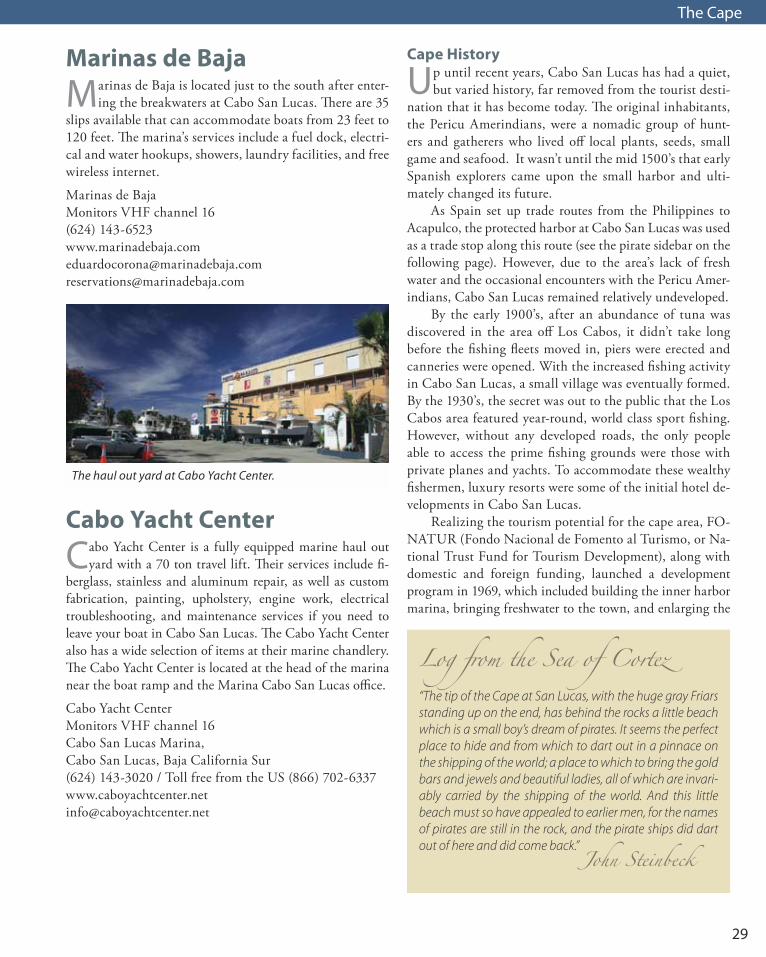
Cabo Yacht Center is a fully equipped marine haul out yard with a 70 ton travel lift. Their services include fi-
berglass, stainless and aluminum repair, as well as custom fabrication, painting, upholstery, engine work, electrical troubleshooting, and maintenance services if you need to leave your boat in Cabo San Lucas. The Cabo Yacht Center also has a wide selection of items at their marine chandlery. The Cabo Yacht Center is located at the head of the marina near the boat ramp and the Marina Cabo San Lucas office.
Cabo Yacht CenterMonitors VHF channel 16 Cabo San Lucas Marina, Cabo San Lucas, Baja California Sur(624) 143-3020 / Toll free from the US (866) [email protected]
The haul out yard at Cabo Yacht Center.
Cape History
Up until recent years, Cabo San Lucas has had a quiet, but varied history, far removed from the tourist desti-
nation that it has become today. The original inhabitants, the Pericu Amerindians, were a nomadic group of hunt-ers and gatherers who lived off local plants, seeds, small game and seafood. It wasn’t until the mid 1500’s that early Spanish explorers came upon the small harbor and ulti-mately changed its future. As Spain set up trade routes from the Philippines to Acapulco, the protected harbor at Cabo San Lucas was used as a trade stop along this route (see the pirate sidebar on the following page). However, due to the area’s lack of fresh water and the occasional encounters with the Pericu Amer-indians, Cabo San Lucas remained relatively undeveloped. By the early 1900’s, after an abundance of tuna was discovered in the area off Los Cabos, it didn’t take long before the fishing fleets moved in, piers were erected and canneries were opened. With the increased fishing activity in Cabo San Lucas, a small village was eventually formed. By the 1930’s, the secret was out to the public that the Los Cabos area featured year-round, world class sport fishing. However, without any developed roads, the only people able to access the prime fishing grounds were those with private planes and yachts. To accommodate these wealthy fishermen, luxury resorts were some of the initial hotel de-velopments in Cabo San Lucas. Realizing the tourism potential for the cape area, FO-NATUR (Fondo Nacional de Fomento al Turismo, or Na-tional Trust Fund for Tourism Development), along with domestic and foreign funding, launched a development program in 1969, which included building the inner harbor marina, bringing freshwater to the town, and enlarging the
Log from the Sea of Cortez“The tip of the Cape at San Lucas, with the huge gray Friars standing up on the end, has behind the rocks a little beach which is a small boy’s dream of pirates. It seems the perfect place to hide and from which to dart out in a pinnace on the shipping of the world; a place to which to bring the gold bars and jewels and beautiful ladies, all of which are invari-ably carried by the shipping of the world. And this little beach must so have appealed to earlier men, for the names of pirates are still in the rock, and the pirate ships did dart out of here and did come back.”
John Steinbeck

30
The Cape
Pirates at Cabo San LucasIn 1587, Sebastián Cermeño captained the largest galleon of the Spanish fleet, named the Santa Ana. Over 600 tons, this galleon was part of the trade route fleet making regular trips to Manila in the Philippines and returning to Acapulco hauling vast quantities of gold, silver, silks, china and spices. From Acapulco, these downwind sailing ships followed a westerly route to reach the Philippines. After having stuffed these ships nearly beyond capacity with valuables from the Orient, these heavy boats had to follow the great-circle route along the Japanese coast, across the north Pacific, and finally down the North American coast to Baja and mainland Mexico, leaving them targets for any number of raiding ships hiding out along the coastline. Captain Thomas Cavendish of the ship Desire, sailing under the English flag, lay in wait near Cabo San Lucas for the Santa Ana and all her riches. Cavendish had originally begun his adventure in July 1586, setting sail from Harwich, England in attempt to circumnavigate the globe. Along his path, Cavendish raided Spanish or Portuguese coastal towns in the new world, and pirated ships such as the Santa Ana for their treasures. In November 1587, the Santa Ana rounded Cabo San Lucas where Cavendish overtook and raided her cargo which included over 122,000 silver dollars.Cermeño, whose life was spared, made his way back to Acapulco and continued captaining galleons along the trade route to the Philippines. However in 1595, Cermeño, who was returning to Acapulco from a trip to the Philippines, once again lost his fully loaded galleon, San Agustín, off Drake’s Bay near San Francisco, California .Cavendish went on to complete his circumnavigation, and landed back in England in September 1588. In 1591, Cavendish set sail on another voyage aboard the Lester, accompanied by a number of other vessels. Cavendish died in the middle of the Atlantic in 1592 due to unknown causes, after returning from a failed trip to Brazil.
airport. The transpeninsular highway, Mexico Highway 1, was completed in 1973, opening a whole new world of tour-ism to Baja. Today, Cabo San Lucas has grown to nearly 57,000 full time inhabitants (2005 census), with over 430 boat slips in the inner harbor, 8 world class golf courses, and numerous daily flights arriving from cities around the world.
Groceries and ServicesAirportThe San José del Cabo International Airport (SJD) is located 6 miles north of San José del Cabo and 12 miles northeast of Cabo San Lucas. Numerous international and national flights arrive and depart each day. Advantage, Alamo, Avis, Budget, Dollar, Europcar, Hertz, National, Payless, and Thrifty car rental agencies are all located either within or nearby the airport.
Aramburo Plaza SupermercadoLocated in the shopping center on Lazaro Cardenas and Igna-cio Zaragoza. A supermarket style grocery with a large selec-tion of domestic and imported foods including fresh produce, meats and frozen foods. Very convenient to the marina.
BanksThere are a number of banks throughout town, conve-niently located, all with ATMs.
Bus StationIntercity - Located on Mexico Highway 19, just north of the Mexico Highway 1 junction. Multiple bus lines travel each day to and from La Paz. There are also daily buses traveling to cities further north all the way to Tijuana.Intracity - The Subercabos are the public buses that run throughout the city. The Subercabos also have routes that run along the highway to and from Cabo San Lucas and San José del Cabo (there is a bus stop in front of the Puerto Paraiso mall on Lazaro Cardenas). These buses are a very efficient and inexpensive way to travel around the city as well as traveling to San José del Cabo. There are specific bus stops with covered seats, but the buses will stop where ever you like, just flag them down.
Neptune’s Finger off Cabo San Lucas.
31
The Cape
C.C.C.Located on Highway 19 to Todos Santos on the northeast end of town, near Soriana. A supermarket stocked with all you might need or want.
Cape MarineLocated in Plaza Marina (Plaza Las Glorias) on Boulevard Marina. Select amount of yachting and fishing equipment, supplies and tools.
City ClubLocated on Lazaro Cardenas and Paseo del Pescador. A large, warehouse style supermarket. Daily membership passes are available as well as annual passes.
CostcoLocated on Mexico Highway 1 at kilometer 4.5. A large, bulk style grocery and housewares store with many of the same products and departments featured in Costco stores found in the U.S. and Canada. Membership is required.
Home DepotLocated on Mexico Highway 1 at kilometer 6.5. The same selection of products as in all North American stores.
Minerva’s Baja TackleLocated on Madero and Boulevard Marina. A wide selection of tackle and fishing supplies. Phone: (624) 143-1282, Web site: www.minervas.com Email: [email protected]
SorianaLocated on Mexico Highway 19 to Todos Santos on the northeast end of town, near CCC. A supermarket stocked with a large selection of fresh produce, food staples, meats, dairy and household items.
RestaurantsCabo Coffee CompanyTwo shops located on Madero and Miguel Hidalgo, as well as Boulevard Marina near the Giggling Marlin. Good cof-fee and wireless internet.
Cabo Wabo CantinaOn Calle Guerrero and Madero. Owned by the famous rock-er, Sammy Hagar, the Cabo Wabo nightclub can keep you up until the wee morning hours. Try the Wabo Grill, open for breakfast, lunch and dinner, serving Mexican specialties.
El Squid RoeOn Lazaro Cardenas and Ignacio Zaragoza. A popular Grupo/Anderson restaurant, serving tourist favorites. A hotspot in the Cabo nightlife with dance floors and bars.
Latitude 22+ RoadhouseOn Mexico Highway 1 at km 4.5, next to Costco and be-hind the power plant. A popular boater’s hangout with authentic marine decor, serving Mexican, American and seafood dishes. The bar serves a tasty caesar and bloody mary as well. Web site: www.lat22nobaddays.com
Mariscos MazatlánOn 16 de Septiembre and 20 de Noviembre. Excellent fresh seafood without the tourist hype or price. Mariscos Mazatlán is a favorite for its casual, local flavor.
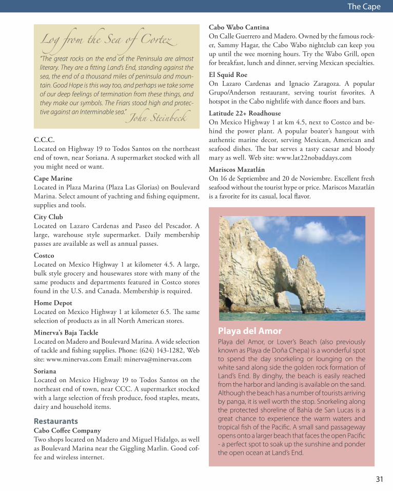
Playa del AmorPlaya del Amor, or Lover’s Beach (also previously known as Playa de Doña Chepa) is a wonderful spot to spend the day snorkeling or lounging on the white sand along side the golden rock formation of Land’s End. By dinghy, the beach is easily reached from the harbor and landing is available on the sand. Although the beach has a number of tourists arriving by panga, it is well worth the stop. Snorkeling along the protected shoreline of Bahía de San Lucas is a great chance to experience the warm waters and tropical fish of the Pacific. A small sand passageway opens onto a larger beach that faces the open Pacific - a perfect spot to soak up the sunshine and ponder the open ocean at Land’s End.
Log from the Sea of Cortez“The great rocks on the end of the Peninsula are almost literary. They are a fitting Land’s End, standing against the sea, the end of a thousand miles of peninsula and moun-tain. Good Hope is this way too, and perhaps we take some of our deep feelings of termination from these things, and they make our symbols. The Friars stood high and protec-tive against an Interminable sea.” John Steinbeck

32
The Cape
Playa Escondida
Playa Balconcito
To San José del Cabo
CABO SAN LUCASSTREETS
Not for navigation
Laza
ro C
arde
nas
Blvd
. Mar
ina
Blvd. Marina
Libertad
20 de Noviembre
Niños Héroes
Calle Revolucíon
Calle Carranza
Calle Obregón
Cabo San Lucas
Pedregal
Vincente Guerra
Matam
orosM
anuel Hidalgo
AbasoloM
elchor Ocam
poIgnacio Zaragoza
José Ma. M
orelosLeona Vicario
Narciso M
endoza
21 de Marzo
Francisco Villa Paseo del Pescador
Góm
ez Farias16 de Septiem
bre
12 de OctubreCalle Alikan
Calle JuventudCalle Orte
gaCalle M
ijares
Encinas Edfonso GreenAlfre
do Lopez Mateos
16 de Septiembre
Madero
Zapata
To Costco (3 mi.),
Home Depot (4 m
i.)
Airport (
12 mi.)
Wal-Mart
Sam’s Club
OfficeDepot
Plaza del Toros(Bullring)
Playa El Médano
A
C
B
3
1
E K
DJ
D
GF
2
I
H
A - Aramburo Plaza SupermercadoB - Cape Marine C - City ClubD - Cabo Co�ee CompanyE - Cabo Wabo CantinaF - Hangout CafeG - Latitude 22+H - Mariscos MazatlanI - Squid RoeJ - Giggling MarlinK - Minerva’s Baja Tackle
1 - Immigration2 - A.P.I. Port Authority3 - Port Capitan
Puerto
Paraiso Mall
To Todos Santos (48 m
i)
Soriana (.7
5 mi,),
C.C.C. (.5 m
i)
To Todos Santos (48 mi)
Soriana (.75 mi,),
C.C.C. (.5 mi)
22˚53'
109˚ 55’
.25 n.m.
Mag. Var. 9.1E (2009)
33
The Cape
San José del Cabo to:
La Paz 123 nmEnsenada de los Muertos 72 nm Bahía Los Frailes 28 nm
Cabo San Lucas 17 nmMazatlán 180 nmIsla Isabela 223 nm
N
S
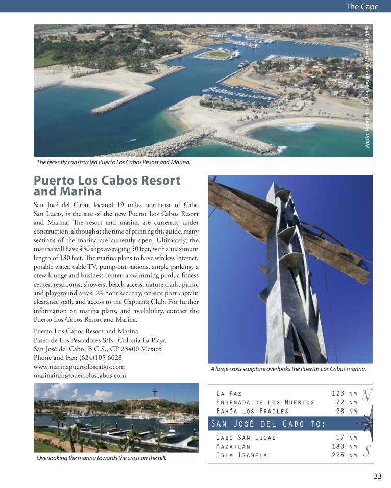
Puerto Los Cabos Resort and MarinaSan José del Cabo, located 19 miles northeast of Cabo San Lucas, is the site of the new Puerto Los Cabos Resort and Marina. The resort and marina are currently under construction, although at the time of printing this guide, many sections of the marina are currently open. Ultimately, the marina will have 430 slips averaging 50 feet, with a maximum length of 180 feet. The marina plans to have wireless Internet, potable water, cable TV, pump-out stations, ample parking, a crew lounge and business center, a swimming pool, a fitness center, restrooms, showers, beach access, nature trails, picnic and playground areas, 24 hour security, on-site port captain clearance staff, and access to the Captain’s Club. For further information on marina plans, and availability, contact the Puerto Los Cabos Resort and Marina.
Puerto Los Cabos Resort and MarinaPaseo de Los Pescadores S/N, Colonia La PlayaSan José del Cabo, B.C.S., CP 23400 MexicoPhone and Fax: (624)105 [email protected]
A large cross sculpture overlooks the Puertos Los Cabos marina.
The recently constructed Puerto Los Cabos Resort and Marina.
Phot
o: P
uert
o Lo
s Cab
os R
esor
t and
Mar
ina
© 2
009
Overlooking the marina towards the cross on the hill.

34
The Cape
N
M
L
K
J
C
B
A
R
S
T
O
P
Q
V
U
I
To Puerto
Los Cabos,
La Playita
To C
abo
San
Luca
s
Toll Roadto Airport
To Airport,
La Paz
San José del Cabo Streets
A - Plaza MijaresB - Estero San JoséC - Palacio MunicipalD - Iglesia San JoséE - MuseumF - Plaza San JoséG - Mega Comercial (grocery)H - Sea Turtle Camp
1 - Port Captain
A
1C
D
BE
H
F
G
Blvd
Mau
rici
o C
astr
o
Blvd A
ntonio M
ijares
Paseo Malecón San José
Hotel Zone
Paseo Fi
nisterra
Paseo Las Misiones
Malvarrosa
Valerio Gonzáles Conseco
Castro
5 de Mayo
Zaragoza
Doblado
ObregonAve. Centenario
CoronadoI. Green
Deg
ollad
oG
uerrero
Hid
algo
Mo
relos
Benito Juárez
Paseo de Los Cabos
.10 n.m.
Mag. Var. 9.1E (2009)
PUERTO LOS CABOSNot for navigation
Fuel Dock
Dry storage,workyard
Boat ramp
MarinaO�ce Note: Marina is still under construction
Slips/facilities shown are installed (2009)Contact Puerto Los Cabos Resort and Marina for updates
Muelle B/C
Muelle D
BCS010
BCS010 - 23° 03.300’N, 109° 40.230’W

35
The Cape
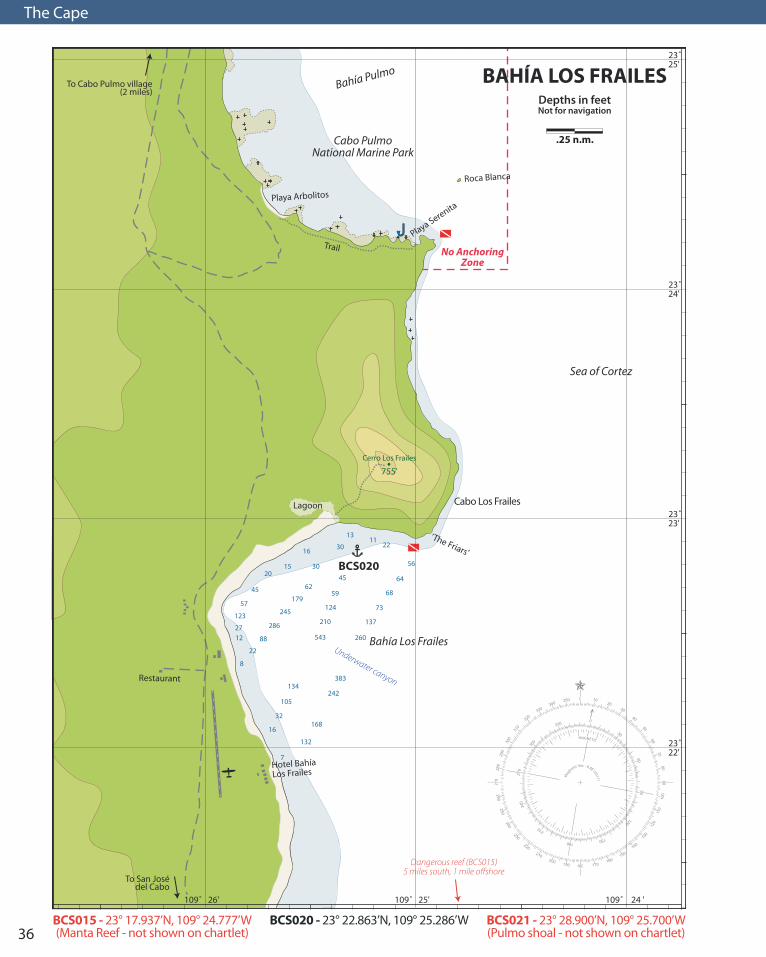
Bahía los Frailes
Bahía los Frailes is a popular anchorage for boats headed north to La Paz and for boats getting ready to cross the
Sea of Cortez bound for mainland Mexico. It is a good north wind anchorage with plenty of room for numerous boats. The Tropic of Cancer crosses the area nearby at 23°27’ N. When approaching Bahía los Frailes from Cabo San Lucas or San José del Cabo, be sure to give the coastline adequate room as many dangerous rocks lie up to 1 to 1.5 miles offshore. Manta Reef is one of these dangerous rocks, found approximately 5 miles south of Cabo los Frailes and 1.25 miles offshore (Manta Reef was aptly named by local diver Terry Kennedy whose first diving experience with giant mantas was at this location). Seas usually do not break over this reef, making it difficult to spot from any distance. The trip from Los Cabos to Bahía los Frailes can be a challenging, upwind beat at times. While the weather at Los Cabos appears to be calm due to the protection of the cape from northwest winds, the sea conditions as you near Bahía los Frailes become less affected by the Pacific Ocean and more affected by the Sea of Cortez. With a stretch of nearly 600 miles, northwest winds can create short, steep seas down the entire length of the Sea of Cortez, with the East Cape lying at the end of those 600 miles. To avoid an uncomfortable trip around the cape and north to La Paz,
listen to the weather forecasts for the Sea of Cortez to de-termine the wind and sea state for rounding the East Cape (see the Weather section on page 17 for a listing of amateur marine forecasts over the SSB and ham radio). For boats approaching from the north, be sure to stand off the coastline at least 2 miles when traveling near the area of Cabo Pulmo due to dangerous reefs and shoals. Pulmo Shoal is located 1.2 miles northeast of Cabo Pulmo and has a reported least depth of 5½ fathoms. Approximately 0.8 miles north-northwest of Cabo Pulmo, the shoreline turns in a northwest direction. A dangerous shoal with a least depth of 6 feet, extends out 1.5 miles due north from this point to an ap-proximate position of 23˚ 28.90’N 109˚ 25.70’W (BCS021). This dangerous shoal occasionally has waves breaking across it and should be given a large berth when traveling between Bahía los Frailes and Ensenada de los Muertos. Bahía Los Frailes is a large bay, free of dangers. A deep underwater canyon running northwest to southeast extends through the bay. A sizeable shelf runs along the northern coastline towards the Friars. During north winds, good an-chorage can be taken in the north-northeast portion of the bay near the large headland of Cabo los Frailes. Anchorage can be taken on the shelf in the northeastern portion of the bay in 4 to 6 fathoms over a sand bottom. During strong northerlies, Cabo los Frailes provides good protection from the steep, square waves built through the nearly 600 miles of fetch stretching the length of the Sea of Cortez. To dinghy ashore, one of the best landing locations is in the northern portion of the bay where the sand beach meets the rocky hillside of the point. From here, there is a good hike (scramble) that takes you to the top of Cerro los Frailes, affording an exceptional view of the rugged, sur-rounding coastline and inland mountains. With no defined trail, it is easiest to pick your way over rocks and through the brush along the moderate ridgeline to the west of the
La Paz 104 nmBonanza (Isla Espíritu Santo) 85 nm Ensenada de los Muertos 46 nm
San José del Cabo 28 nmCabo San Lucas 45 nmMazatlán 162 nm
Bahía los Frailes to:
N
S
ww
w.c
harle
scha
ndle
rpho
togr
aphy
.com
Looking northward toward Cabo Los Frailes
36
The Cape
132
7
16
32
105
168
134242
383
8
22
1227
123
57
45
2015
16
30
62
179
245
543
210
124
59
45
30
1311
22
56
64
68
73
260
137
88
286
Lagoon
Trail
To Cabo Pulmo village(2 miles)
To San Josédel Cabo
BCS020
0350340
320330
310
300
290
280
270
1020
30
40
50
6070
8090
180190200
210
220
230
240
250260
170160
150140
130
120
110
100
0
30
6090
120
150180
210
240
270
330
300
Mag
netic Var. - 8.8E (2011)
.25 n.m.
23˚24'
23˚23'
23˚25'
23˚22'
109˚ 25'109˚ 26' 109˚ 24 '
BAHÍA LOS FRAILESDepths in feetNot for navigation
755'
Sea of Cortez
Cerro Los Frailes
Roca Blanca
Playa Arbolitos
Hotel BahíaLos Frailes
Restaurant
Playa Serenita
‘The Friars’
Bahía Los Frailes
Bahía Pulmo
Cabo PulmoNational Marine Park
Cabo Los Frailes
No AnchoringZone
Underwater canyon
Dangerous reef (BCS015)5 miles south, 1 mile o�shore
BCS020 - 23° 22.863’N, 109° 25.286’W BCS021 - 23° 28.900’N, 109° 25.700’W(Pulmo shoal - not shown on chartlet)
BCS015 - 23° 17.937’N, 109° 24.777’W(Manta Reef - not shown on chartlet)
37
The Cape
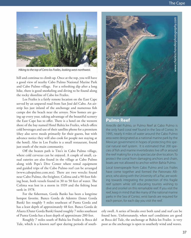
hill and continue to climb up. Once at the top, you will have a good view of nearby Cabo Pulmo National Marine Park and Cabo Pulmo village. For a refreshing dip after a long hike, there is good snorkeling and diving to be found along the rocky shoreline of Cabo los Frailes. Los Frailes is a fairly remote location on the East Cape served by an unpaved road from San José del Cabo. An air-strip lies just inland of the anchorage and numerous fish camps dot the beach near the arroyo. New homes are go-ing up every year, taking advantage of the beautiful scenery the East Cape has to offer. There is a hotel on the western shore of the bay named Hotel Bahía los Frailes, which offers cold beverages and use of their satellite phone for a premium (they also serve meals primarily for their guests, but with advance notice they will also cook for people not staying at the hotel). Also in Los Frailes is a small restaurant, found just south of the main community. Off the beaten path is Tito’s in Cabo Pulmo village, where cold cervezas can be enjoyed. A couple of small, ca-sual eateries are also found in the village at Cabo Pulmo along with Pepe’s Dive Center where rental equipment and guided trips of the Cabo Pulmo reef can be arranged (www.cabopulmo.com.mx). There are two wrecks found near Cabo Pulmo, the freighter, Colima and a 90 foot fish-ing boat, both vessels found in 30 to 50 feet of water. The Colima was lost in a storm in 1939 and the fishing boat sank in 1978. For the fisherman, Gorda Banks has been a longtime hotspot favorite. Banco Gorda de Adentro (Inner Gorda Bank) lies roughly 5 miles southeast of Punta Gorda and has a least depth of approximately 48 feet. Banco Gorda de Afuera (Outer Gorda Bank) found roughly 7 miles southeast of Punta Gorda has a least depth of approximate 200 feet. Roughly 7 miles south of Bahía los Frailes is Boca del Tule, which is a known surf spot during periods of south-
Hiking to the top of Cerro los Frailes, looking west-northwest.
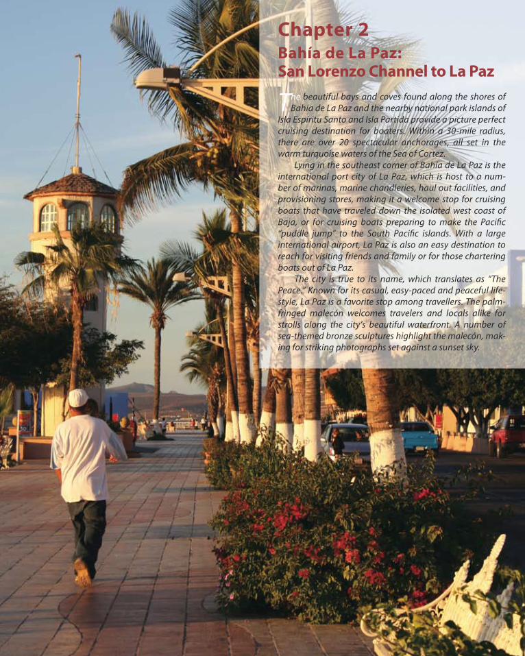
Pulmo ReefArrecife del Pulmo, or Pulmo Reef at Cabo Pulmo is the only hard coral reef found in the Sea of Cortez. In 1995, nearly 4 miles of water around the Cabo Pulmo area were designated as a national marine park by the Mexican government in hopes of protecting this spe-cial natural reef system. It is estimated that 200 spe-cies of fish and marine invertebrates live off or around the reef making for a truly spectacular dive location. To protect the corral from damaging anchors and chain, boats are not allowed to anchor within Bahía Pulmo.Local townspeople from Cabo Pulmo and Los Frailes have come together and formed the Patronato Alli-ance, who along with the University of La Paz, are work-ing towards integrating the protection of this fragile reef system while still educating tourists wishing to dive and snorkel on this remarkable reef. If you visit the reef, keep in mind that like many of the national marine parks in the Sea of Cortez, wrist bands are required for each person, for each day you visit the reef.
ww
w.c
harle
scha
ndle
rpho
togr
aphy
.com
erly swell. A series of breaks over both sand and reef can be found here. Unfortunately, when surf conditions are good at Boca del Tule, the anchorage at Bahía los Frailes is very poor as the anchorage is open to southerly wind and waves.

38
The Cape
Ensenada de los Muertos
Ensenada de los Muertos is a good north wind anchor-age, popular with cruising boats heading north to La
Paz, south towards the mainland, or around the Cape. During a short period in the 1920’s, the cove served as a cargo port for off-loading supplies for a nearby silver min-ing operation. Years later, salt produced in local salt pans was stored in a warehouse near shore and then shipped out. With tourism booming in the cape region, Bahía de los Muertos (Bay of the Dead), also known by developers as Bahía de los Sueños (Bay of Dreams), is slowly acquiring more luxury homes and a new golf course. From Cabo Pulmo north, the coastline recedes back towards the northwest, and the effects of the Pacific swell slowly diminish as you enter the Sea of Cortez. There are a few navigation hazards to be aware of on the way north towards Ensenada de los Muertos. For boats traveling be-tween Bahía los Frailes and Ensenada de los Muertos, be sure to stand off the coastline at least 2 miles when travel-ing near the area of Cabo Pulmo due to dangerous rocks and reefs, including Pulmo Reef and Roca Blanca, as well as dangerous shoals stretching out into the Sea of Cortez. Pulmo Shoal is located 1.2 miles east-northeast of Cabo Pulmo and has a least depth of 5½ fathoms. North of Cabo Pulmo, dangerous shoals extend roughly 1 nauti-cal mile offshore with a least depth of 6 feet reported. This dangerous shoal occasionally has waves breaking across it
and should be given a wide berth, staying at least 2 miles offshore in deeper water. Seven miles northwest of Cabo Pulmo is Punta Arena, a very low and distinctive sandy point that reaches out into the Sea of Cortez. As the water shoals rapidly near and around the point, it is recommended to stay in deeper wa-ter, at least 2 miles offshore, when rounding Punta Arena. Many times waves can be seen breaking along the shallow shores of the point. Punta Colorada is 3.5 miles northwest of Punta Arena. Detached rocks and shoal areas extend from the point. It is recommended to lay a course at least 2 miles offshore between Punta Arena and Punta Colorada to avoid these dangers. Punta Pescadero is a large rocky point of land approxi-mately 16 miles northwest of Punta Colorada, at the north end of Bahía de las Palmas. Dangerous detached rocks and shoal areas extend well off the point. Passage should be made at least 2 miles offshore to avoid these dangers. Punta Pescadero is the southern point of Bahía de los Muertos, with Ensenada de los Muertos located in the northeast portion of the bay, south of Punta Perico.
Looking southwest across Ensenada de los Muertos.
The beautiful waterfront restaurant, El Cardón Tequila Bar & Grill.
La Paz 58 nmCaleta Lobos 46 nmBonanza (Isla Espíritu Santo) 43 nm
Bahía Los Frailes 46 nmCabo San Lucas 90 nmMazatlán 190 nm
Ensenada de los Muertos to:
N
S

39
The Cape
155
100
503625
18
20
18
28
3342
90123
160
Ensenada de los Muertos
Salt ponds
Fl(3)W
BCS030
1.0 n.m.
0350340
320330
310
300
290
280
270
1020
30
40
50
6070
8090
180190200
210
220
230
240
250260
170160
150140
130
120
110
100
0
30
6090
120
150180
210
240
270
330
300
Mag
netic Var. - 9.0E (2011)
24˚00'
24˚02'
24˚04'
23˚59'
24˚01'
24˚03'
109˚ 50' 109˚ 49'109˚109˚ 51'52' 109˚ 48' 109˚ 47'
ENSENADA DE LOS MUERTOSDepths in feetNot for navigation
623'
Cerro Gordo
Cerro El Perico
1081'
Punta Perico
Bahía la Ventana Punta Arena de la Ventana
Pier ruinsEl Cardonrestaurant/bar
Golf Cours
e
Bahía de losSuenos resort
To La Ventana
(6.5 n.m.)
BCS030 - 23° 59.215’N, 109° 49.620’W

40
The Cape
East Cape Wind SportsThe East Cape of Baja has long been world renowned as a premier location for windsurfers and kiteboarders. The relaxed, easy pace of life on the Baja Peninsula along with its clear, warm waters and perfect wind conditions, draws hundreds of wind sport enthusiasts to the East Cape every winter. Camping, B&B’s and hotels dot the long, white sandy beaches of areas like La Ventana and Los Barriles, where rental gear and lessons are easy to come by. The season generally begins in November and continues through March, following the region’s typical north wind winters. During strong north wind blows, the East Cape windsurfers and kiteboarders capitalize on the Sea of Cortez’s nearly 600 miles of wind driven fetch, building waves to an exciting height, perfect for catching big air.
When approaching Ensenada de los Muertos from the north through the Canal de Cerralvo, be sure to give Pun-ta Arena de La Ventana and Punta Perico a wide berth due to detached rocks and shoal areas lying off the points. Do not cut the corner into the anchorage when approaching from the north as a reef lies off the point of land forming the east side of the anchorage. For good north wind and wave protection, anchorage may be taken in 4 to 7 fathoms over a sand bottom, tucked up inside Ensenada de los Muertos. An open, south wind anchorage can be found off the northern shore of Punta Arena de La Ventana. When rounding Punta Arena de la Ventana, be sure to give it ample room as shoal waters sur-round the point. A beautiful white sand beach lines the north and northwest sides of the Ensenada de los Muertos, perfect for strolling after a long day’s travel. For a night away from the galley, the El Cardón Tequila Bar & Grill is located on shore, serving cold beverages and a variety of Mexican and American dishes. El Cardón monitors VHF channel 10, and provides water taxi service to its patrons to save you the time of launching your dinghy. The restaurant also has wireless internet, satellite TV, a dinghy dock, and phone service throughout Mexico, Canada and the United States for a quick call home. Bahía de los Sueños, the planned resort community is quickly taking shape with a small, luxury hotel and golf course. A 5,000 foot long, paved airstrip is also located near-by for tourists and home owners flying in to relax and play.
ww
w.c
harle
scha
ndle
rpho
togr
aphy
.com
A northerly view of Ensenada de los Muertos with Isla Cerralvo in the distance.

41
The Cape
Kiteboarders and windsurfers at Bahía La Ventana.
Isla Cerralvo
Isla Cerralvo is a 16 mile long island lying roughly 6 miles off the Baja peninsula. The waterway between the island
and the Baja peninsula is known as Canal de Cerralvo (Cerralvo Channel). At times, wind, waves and currents flowing through the channel can make for a rough trip. With Ensenada de los Muertos only 7.5 miles south of the channel, it is easy to get an early start and make it through the narrowest part of the channel during the morning hours, before the typical afternoon winds begin to pick up. At its narrowest, the Cerralvo Channel is but 4.5 miles wide near the southern end of Isla Cerralvo and across to Punta Arena de la Ventana. The channel runs approximately 25 miles in length and currents can attain rates of up to 2.5 knots. From November to March, winds typically blow from the north, down the Sea of Cortez. With the restriction of the channel by Isla Cerralvo to the east and the Baja penin-sula to the west, winds tend to funnel through the channel, bringing with it, wind driven waves. With adverse currents, strong winds and steep waves, the Cerralvo Channel can become very challenging, so plan accordingly. To avoid a trying day of bashing into wind and waves, many traveling northbound choose a favorable weather window, tidal flow, and travel through the channel during the typically calmer early morning hours.
Isla Cerralvo has some off lying rocks and reefs on both the north and south ends of the island. Islote de la Reina (Arrecife de la Foca) lies 4 miles northwest of the north end of the island. Roca Montaña lies approximately 0.8 miles southeast of the southern tip of the island and comes within 7 feet of the surface. Both of these spots are popular for fishing and diving with boats from La Paz and the La Ventana area.
ww
w.c
harle
scha
ndle
rpho
togr
aphy
.com
Looking easterly at Punta Viejos and the southern end of Isla Cerralvo.

42
The Cape
San Rosario
La Ventana
El Sargento
La Paz
Fl(3)W 12s
Fl(2)W 8s
Fl W 6s
Fl W
24˚00'
24˚05'
24˚10'
24˚15'
24˚20'
24˚25'
109˚45'
109˚50'
109˚40'
109˚55'
110˚00'
110˚05'
110˚10'
110˚15'
110˚20'
5.0
n.m
.
0350
340
320330
310
300
290280270
1020
30
40
50
6070
8090
180190
200
210
220
230
240
250260
170160
150140
130120
110100
0
30
6090
120
150
180
210
240270
330
300
Magnetic Var. - 9.3E (2009)
CER
RA
LVO
CH
AN
NEL
(Can
al de C
erralvo)
Depths in feet
Not for navigation
Pun
ta Coyo
tePunta Bulle
Pun
ta Go
rda
Punta Santa Cruz
Pun
ta No
roeste
Pun
ta Sud
este
Piedras G
ordas
Punta Viejos
Ro
ca Mo
ntañ
a
Pun
ta Perico
Pun
ta Aren
ad
e la Ventan
a
Bahía deLa Paz
El Limoña
El Mostrador
Ensenada de Los Muertos
Sea of Cortez
Canal de San Lorenzo
Cerralvo Channel
(Canal de Cerralvo)
Isla Espíritu
Santo
Isla Cerralvo
ArrecifeSan Lorenzo
Scout Shoal
Islote de la Reina(Arrecife de la Foca)
Bahía la Ventana
Stong tidalcurrents possible
Stong tidalcurrents possible
Chapter 2Bahía de La Paz:San Lorenzo Channel to La Paz
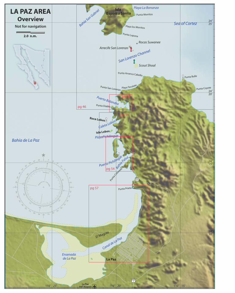
The beautiful bays and coves found along the shores of Bahía de La Paz and the nearby national park islands of
Isla Espíritu Santo and Isla Partida provide a picture perfect cruising destination for boaters. Within a 30-mile radius, there are over 20 spectacular anchorages, all set in the warm turquoise waters of the Sea of Cortez. Lying in the southeast corner of Bahía de La Paz is the international port city of La Paz, which is host to a num-ber of marinas, marine chandleries, haul out facilities, and provisioning stores, making it a welcome stop for cruising boats that have traveled down the isolated west coast of Baja, or for cruising boats preparing to make the Pacific “puddle jump” to the South Pacific islands. With a large international airport, La Paz is also an easy destination to reach for visiting friends and family or for those chartering boats out of La Paz. The city is true to its name, which translates as “The Peace.” Known for its casual, easy-paced and peaceful life-style, La Paz is a favorite stop among travellers. The palm-fringed malecón welcomes travelers and locals alike for strolls along the city’s beautiful waterfront. A number of sea-themed bronze sculptures highlight the malecón, mak-ing for striking photographs set against a sunset sky.
Punta Arranca Cabello
Punta la Dispensa
Punta Lupona
La PazInt’l Airport
24˚10'
24˚15'
24˚20'
24˚25'
110˚ 25' 110˚ 20' 110˚ 15'
pg 48
pg 51
pg 46
pg 54
pg 57
2.0 n.m.
0350340
320330
310
300
290
280
270
1020
30
40
50
6070
8090
180190200
210
220
230
240
250260
170160
150140
130
120
110
100
0
3060
90
120
150180
210
240
270
330
300
Mag
netic Var. - 9.4E (2009)
LA PAZ AREAOverview
Not for navigation
El Magote
San Lorenzo Channel
Isla Espíritu Santo
Roca Lobos
Isla Lobos
Punta Morritos
Playa los Morritos
Playa La Bonanza
Punta San Lorenzo Punta Coyote
Punta Diablo
Punta Bulle
Punta Prieta
Bahía de La Paz
Sea of CortezBahía San Gabrie
l
Puerto Balandra
PlayaPichilingue
La Paz
Punta Lupona
Rocas Suwanee
Arrecife San Lorenzo
Scout Shoal
Ensenadade La Paz
Canal de La Paz
Punta Arranca Cabello
Playa Tecolote
Caleta Lobos
Punta
Colo
rado
Puerto Pichilingue
Bahía Falsa
Notes Sono
ra
Sina
loa
Baja
Cal
iforn
ia S
ur
Isla
Cer
ralv
o
Bahí
a de
La
Paz
Bahí
a Lo
s Fra
iles
Bahí
aM
agde
lana
Bahí
a de
Los M
uert
os
Sea
of C
orte
z
Paci
�c O
cean
Bahí
a de
Las
Pal
mas
Cerralvo Channel
San
Lore
nzo
Chan
nel
Sierra de la Laguna
Sierra de la Giganta
Todo
sSa
ntos
San
José
del C
abo
Cabo
San
Luca
s
La P
az
Los
Baril
les
Lore
to Agua
Verd
e
San
Evar
isto
La V
enta
na
Puer
to E
scon
dido
Isla
San
Jo
sé
Isla
San
Fra
nci
sco
San José Channel
Isla
Esp
írit
u S
anto
Isla
Par
tid
a
Isla
San
Die
go
Isla
San
ta C
ruz
Isla
Mo
nse
rrat
e
Isla
Car
men
Isla
Dan
zan
te
Isla
Co
ron
ado
s Isla
San
ta C
atal
ina
Topo
loba
mpo
San
Carlo
s
Ciud
adCo
nstit
ució
n
Yava
ros
Alta
ta
113°
00'
W11
2° 0
0' W
111°
00'
W11
0° 0
0' W
109°
00'
W
111°
00'
W11
0° 0
0' W
109°
00'
W
108°
00'
W
24° 0
0' N
25° 0
0' N
24° 0
0' N
25° 0
0' N
26° 0
0' N
27° 0
0' N
22° 0
0.00
0' N
23° 0
0' N
035
034
032
033
0
310
300
290
280
270
10
20
3040
50 60 70 8090
180
190
200
210
220
230240250
260
170
160
150
140
130
120
110
100
0
3060
90
120150
180
210240
270
330
300
Magnet
ic V
ar. -
9.6E (2009)
50
n.m
.
pg 2
4
pg 4
4
pg 7
3
pg 9
7
pg 1
47
pg 1
19