
S OVEREIGN C ONSULTING I NC - Town of Ayer MA | · MassDEP Massachusetts Department of...
76
1 S OVEREIGN C ONSULTING I NC . TRANSMITTAL MEMO Copies To: Carol Keating – USEPA 2 – Hard Copy and CD David Chaffin – MADEP Hard Copy and CD Chair – Ayer Board of Selectmen Hard Copy and CD Ayer Board of Health Hard Copy and CD Julie Corenzwit – Co-Chair, Devens Restoration Advisory Board Hard Copy and CD Laurie Nehring – PACE Hard Copy and CD Richard Doherty – Engineering and Consultant Resources, Inc. CD Ken Munney – USFWS Hard Copy and CD Richard Hartley – MA Div. of Fisheries and Wildlife Hard Copy and CD Calvin Moore – Moore Lumber Co. Hard Copy and CD James Greacen – Mabbett & Associates Hard Copy and CD Ayer Conservation Commission Hard Copy and CD Mark Wetzel, P.E., Ayer Public Works Hard Copy and CD From: Rachel Leary – Sovereign Consulting Inc. cc: Robert Simeone – BEC, Devens RFTA Hard Copy and CD Mark Anderson – USACE New England District Hard Copy and CD Stephen LaValle – USACE New England District CD Ron Ostrowski – Mass Development Hard Copy and CD Devens Commerce Center – Mass Development Hard Copy and CD Marc Cicalese – Sovereign Consulting Electronic Date: 25 June 2014 Subject: Final Removal Action Closure Report for Railroad Round House and Red Cove - Plow Shop Pond (AOC 72) – June 2014 Contract Number W912WJ-10-D-0003, Delivery Order 0005 On behalf of the U.S. Army Base Realignment and Closure Office at Devens, Sovereign Consulting Inc. has enclosed the Final Removal Action Closure Report for Railroad Round House and Red Cove - Plow Shop Pond (AOC 72) dated June 2014. Sovereign is pleased to provide the following attachments: 1. Removal Action Completion Report text, tables and figures. 2. CD, including Report text, figures, tables, and appendices. If you have any questions or comments please contact me at 413-540-0650 or Robert Simeone at 978-796-2205. Sincerely, Rachel B. Leary, P.E. Project Manager Enclosure: Final Removal Action Closure Report – Railroad Round House and Red Cove, Plow Shop Pond (AOC 72) – June 2014
Transcript of S OVEREIGN C ONSULTING I NC - Town of Ayer MA | · MassDEP Massachusetts Department of...

1
S O V E R E I G N C O N S U L T I N G I N C .
TRANSMITTAL MEMO Copies To: Carol Keating – USEPA 2 – Hard Copy and CD David Chaffin – MADEP Hard Copy and CD Chair – Ayer Board of Selectmen Hard Copy and CD Ayer Board of Health Hard Copy and CD Julie Corenzwit – Co-Chair, Devens Restoration Advisory Board Hard Copy and CD Laurie Nehring – PACE Hard Copy and CD Richard Doherty – Engineering and Consultant Resources, Inc. CD Ken Munney – USFWS Hard Copy and CD Richard Hartley – MA Div. of Fisheries and Wildlife Hard Copy and CD Calvin Moore – Moore Lumber Co. Hard Copy and CD James Greacen – Mabbett & Associates Hard Copy and CD Ayer Conservation Commission Hard Copy and CD Mark Wetzel, P.E., Ayer Public Works Hard Copy and CD From: Rachel Leary – Sovereign Consulting Inc.
cc: Robert Simeone – BEC, Devens RFTA Hard Copy and CD Mark Anderson – USACE New England District Hard Copy and CD Stephen LaValle – USACE New England District CD Ron Ostrowski – Mass Development Hard Copy and CD Devens Commerce Center – Mass Development Hard Copy and CD Marc Cicalese – Sovereign Consulting Electronic Date: 25 June 2014 Subject: Final Removal Action Closure Report for Railroad Round House and Red Cove - Plow Shop Pond
(AOC 72) – June 2014 Contract Number W912WJ-10-D-0003, Delivery Order 0005 On behalf of the U.S. Army Base Realignment and Closure Office at Devens, Sovereign Consulting Inc. has enclosed the Final Removal Action Closure Report for Railroad Round House and Red Cove - Plow Shop Pond (AOC 72) dated June 2014. Sovereign is pleased to provide the following attachments:
1. Removal Action Completion Report text, tables and figures. 2. CD, including Report text, figures, tables, and appendices.
If you have any questions or comments please contact me at 413-540-0650 or Robert Simeone at 978-796-2205. Sincerely,
Rachel B. Leary, P.E. Project Manager Enclosure: Final Removal Action Closure Report – Railroad Round House and Red Cove, Plow Shop Pond (AOC
72) – June 2014

Prepared for: US Army Corp of Engineers
New England District Concord, Massachusetts
Prepared by: Sovereign Consulting Inc.
Contract No.: W912WJ-10-D-0003 Delivery Order: 0002
REMOVAL ACTION
COMPLETION REPORT FOR RAILROAD ROUND HOUSE AND RED COVE
PLOW SHOP POND (AOC 72)
FORMER FORT DEVENS ARMY INSTALLATION, DEVENS, MA
FINAL
JUNE 2014

Removal Action Completion Report – Plow Shop Pond Sovereign Consulting Inc. Final Version
NOTICE
The United States Department of Defense, Department of Army, funded wholly or in part the preparation of this document and work described herein under Contract No. W912WJ-10-D-0003 and Delivery Order 0005. Mention of trade names or commercial products does not constitute endorsement or recommendation for use.

Removal Action Completion Report – Plow Shop Pond Sovereign Consulting Inc. Final Version
Removal Action Completion Report Plow Shop Pond (AOC 70)
Railroad Round House and Red Cove
FINAL
Devens, Massachusetts
June 2014
CERTIFICATION:
I hereby certify that the enclosed Report, shown and marked in this submittal, is that proposed to be incorporated with Contract Number W912WJ-10-D-0003 DO#0002. This Document has been prepared in accordance with USACE Scope of Work and is hereby submitted for Government Approval.
Reviewed By:
Sovereign Project Manager Date
Sovereign Quality Control Manager Date
Received By:
USACE Project Manager Date
6/25/2014
6/25/2014
25 June 2014
Digitally signed by ANDERSON.MARK.J.JR.1241441683 DN: c=US, o=U.S. Government, ou=DoD, ou=PKI, ou=USA, cn=ANDERSON.MARK.J.JR.1241441683 Date: 2014.06.25 12:23:06 -04'00'

Removal Action Completion Report – Plow Shop Pond Sovereign Consulting Inc. Final Version
ii
TABLE OF CONTENTS
1.0 PROJECT DESCRIPTION ........................................................................................... 1
1.1 SITE BACKGROUND ....................................................................................................................... 1
1.2 SITE HISTORY ................................................................................................................................. 2
2.0 NATURE AND EXTENT OF CONTAMINATION ................................................ 3
2.1 CONTAMINANTS OF CONCERN .................................................................................................... 3
2.1.1 Red Cove.................................................................................................................................. 3
2.1.2 Railroad Round House ............................................................................................................ 3
2.2 CONCEPTUAL SITE MODEL AND RISK ASSESSMENT ................................................................... 4
3.0 OBJECTIVES AND SCOPE ......................................................................................... 6
3.1 PROJECT SCOPE AND OBJECTIVES- RED COVE ............................................................................. 6
3.1.1 Removal Action Objective – Red Cove ................................................................................... 6
3.1.2 Removal Action Scope - Red Cove .......................................................................................... 6
3.2 PROJECT SCOPE AND OBJECTIVES – RAILROAD ROUND HOUSE ................................................ 7
3.2.1 Removal Action Objective – Railroad Round House .............................................................. 7
3.2.2 Removal Action Scope - Railroad Round House ..................................................................... 8
3.3 REMOVAL ACTION DESIGN .......................................................................................................... 8
3.3.1 Local and State Agency Coordination ..................................................................................... 9
3.3.2 Removal Action Design .......................................................................................................... 9
4.0 SEDIMENT REMEDIATION ................................................................................... 11
4.1 WETLAND SURVEY ...................................................................................................................... 11
4.2 SITE PREPARATION ...................................................................................................................... 11
4.2.1 Upland Access Roads ............................................................................................................ 11
4.2.2 Initial Sheet Piling Option .................................................................................................... 12
4.2.3 Lowering the Water Level of Plow Shop Pond ...................................................................... 12
4.2.4 Erosion Control ..................................................................................................................... 13
4.3 ECOLOGICAL MONITORING ....................................................................................................... 13
4.4 EXCAVATION AND SOLIDIFICATION ......................................................................................... 14
4.4.1 Red Cove Excavation and Solidification ............................................................................... 14
4.4.2 Railroad Round House Excavation and Solidification .......................................................... 15
4.4.3 Valve Vault Abandonment ................................................................................................... 15
4.5 CONFIRMATION SAMPLING ........................................................................................................ 16

Removal Action Completion Report – Plow Shop Pond Sovereign Consulting Inc. Final Version
iii
4.5.1 Red Cove................................................................................................................................ 16
4.5.2 Railroad Round House .......................................................................................................... 16
4.6 TRANSPORTATION & DISPOSAL ................................................................................................. 18
4.7 SITE RESTORATION AND DEMOBILIZATION ............................................................................... 18
4.7.1 Site Restoration ..................................................................................................................... 18
4.7.2 Demobilization ...................................................................................................................... 19
5.0 WASTE DISPOSAL .................................................................................................... 19
5.1 OFF-SITE DISPOSAL OF SOLIDIFIED SEDIMENTS ......................................................................... 19
6.0 PERFORMANCE STANDARDS & QUALITY CONTROL (QC) ..................... 20
6.1 GENERAL QUALITY ASSURANCE/QUALITY CONTROL PROCEDURES ..................................... 21
6.2 HEALTH AND SAFETY ................................................................................................................. 21
6.3 DECONTAMINATION ................................................................................................................... 21
6.4 ASSESSMENT OF DATA QUALITY ................................................................................................ 21
6.5 COMPARISON TO CLEANUP GOALS ........................................................................................... 22
7.0 DEMONSTRATION OF COMPLETION ............................................................... 22
8.0 PROJECT COST SUMMARY ................................................................................... 23
9.0 COMMUNITY RELATIONS .................................................................................... 23
10.0 REFERENCES ............................................................................................................... 25

Removal Action Completion Report – Plow Shop Pond Sovereign Consulting Inc. Final Version
iv
LIST OF FIGURES Figure 1 - Site Locus Map Figure 2 - Red Cove Removal Action Areas Figure 3 – Red Cove Confirmation Sampling Grid Figure 4 – Railroad Round House Removal Action Area Figure 5 – Railroad Round House Confirmation Sampling Grid Figure 6 – Bathymetric Survey Figure 7 – Generalized Drawdown Map – 4 ft Figure 8 – Plow Shop Pond Staging Areas Figure 9 – Approximate Surface Water Sampling Locations Figure 10 – Post Excavation Area Red Cove Figure 11 – Abandoned Vault Location with Post Excavation Area Figure 12a – Red Cove Confirmation Sampling Results – 1st Round Figure 12b – Red Cove Confirmation Sampling Results – Final Figure 13a – Railroad Round House Confirmation Sampling Results – 1st Round Figure 13b – Railroad Round House Confirmation Sampling Results – 2st Round Figure 13c – Railroad Round House Confirmation Sampling Results – Final LIST OF TABLES
Table 1 - Surface Water Sampling Summary Table 2 - Summary of Red Cove Sediment Data Table 3 - ProUCL Output of Red Cove Sediment Data Table 4 - Summary of Red Cove Sediment Data APPENDICES Appendix A – MANHESP Letter Appendix B – Wetland Delineation Report for Plow Shop Pond Appendix C – Surface Water Monitoring Forms and Data Appendix D - Red Cove Confirmation Sampling Analytical Data Appendix E – Railroad Round House Confirmation Sampling Analytical Data Appendix F – Waste Characterization Analytical Data Appendix G – Staging Area Analytical Data Appendix H – Bill of Ladings Appendix I - Daily Quality Control Reports Appendix J - Data Validation Reports Appendix K – Response to Comments

Removal Action Completion Report – Plow Shop Pond Sovereign Consulting Inc. Final Version
v
ABBREVIATIONS, ACRONYMS, AND SYMBOLS Alpha Alpha Analytical Laboratories AOC Area of Contamination AM Action Memorandum AMEC AMEC Earth and Environmental, Inc. As Arsenic ASTM American Society of Testing and Materials BCT Base Closure Team bgs Below Ground Surface BMI Benthic Macro Invertebrates CERCLA Comprehensive Environmental Response, Compensation, and Liability Act COC Contaminant of Concern CQC Contractor Quality Control CQCP Contractor Quality Control Plan DQCRs Daily Quality Control Reports CY Cubic Yards DERP Defense Environmental Restoration Program Devens Former Fort Devens DFW Definable Feature of Work DOD Department of Defense DOT Department of Transportation DTW Depth to Water eBMI Epibenthic Macro Invertebrates EE/CA Engineering Evaluation/Cost Analysis ERA Ecological Risk Assessment E&S Erosion and Sedimentation FS Feasibility Study GPS Global Positioning System HSO Health and Safety Officer kg Kilogram MA Massachusetts MassDEP Massachusetts Department of Environmental Protection MassDOT Massachusetts Department of Transportation Maxymillian Maxymillian Technologies, Inc. MCP Massachusetts Contingency Plan mg Milligram NCP National Oil and Hazardous Substances Pollution Contingency Plan NHSEP Natural Heritage and Endangered Species Program Normandeau Normandeau Associates, Inc. NTCRA Non-Time-Critical Removal Action PACE People of Ayer Concerned about the Environment PCBs Polychlorinated Biphenyls QC Quality Control QCM Quality Control Manager RAB Restoration Advisory Board RACR Removal Action Completion Report

Removal Action Completion Report – Plow Shop Pond Sovereign Consulting Inc. Final Version
vi
ABBREVIATIONS, ACRONYMS, AND SYMBOLS (cont’d) RAWP Removal Action Work Plan RC&D RC&D, Inc. RCRA Resource Conservation and Recovery Act RAO Removal Action Objective RI Remedial Investigation ROD Record of Decision RTCs Response to Comments RTK Real Time Kinematic SHL Shepley’s Hill Landfill SOP Standard Operating Procedure Sovereign Sovereign Consulting Inc. SOW Statement of Work SSHP Site Safety and Health Plan SVOCs Semivolatile Organic Compounds SWQS Surface Water Quality Standards TEC Threshold Effects Concentration TPH Total Petroleum Hydrocarbons USCS Unified Soil Classification System USACE United States Army Corp of Engineers USEPA United States Environmental Protection Agency VOCs Volatile Organic Compounds WSP SELLS WSP SELLS Transportation and Infrastructure

Removal Action Completion Report – Plow Shop Pond Sovereign Consulting Inc. Final Version
1
1.0 PROJECT DESCRIPTION This Removal Action Completion Report (RACR) was prepared by Sovereign Consulting Inc. (Sovereign) to document Non-Time-Critical Removal Action (NTCRA) activities and summarize post-remediation conditions at the Railroad Round House and Red Cove areas of Plow Shop Pond (AOC 72). The actions described in this document were performed by Sovereign under United States Army Corps of Engineers (USACE) Contract W912WJ-10-D-0003 DO#0005. The NTCRA was performed pursuant to the U.S. Environmental Protection Agency (USEPA) Comprehensive Environmental Response, Compensation, and Liability Act (CERCLA) and the National Oil and Hazardous Substances Pollution Contingency Plan (NCP). The site falls under CERCLA because of historical activities of the U.S. Department of Defense (DOD). Under CERCLA, the DOD is given lead agency responsibility for implementing appropriate investigations and removal actions where environmental impacts have or may have occurred from historical activities at DOD sites and where such releases may constitute a residual human health threat. Mitigating this site fits within the mission of the Defense Environmental Restoration Program (DERP). An Engineering Evaluation/Cost Analysis (EE/CA) was prepared in support of this NTCRA and describes the decision to proceed with the project and the chosen alternatives (Sovereign, 2012b). The primary project goals were to:
• Mitigate arsenic impacts in sediment in and around Red Cove, in order to be protective of human health and the environment; and,
• Mitigate sediment impacted by maintenance by-product deposits of the former Railroad Roundhouse along the shoreline of Study Area (SA) 71 in order to be protective of human health and the environment.
1.1 Site Background Devens is located approximately 35 miles northwest of the city of Boston, within the towns of Ayer, Shirley (Middlesex County), Harvard and Lancaster (Worcester County) in the Commonwealth of Massachusetts (see Figure 1). The former Fort Devens (Devens) was established in 1917 for military training and logistical support during World War I. Devens became a permanent Base in 1931, and continued service until its Base Realignment and Closure (BRAC) Committee closure in 1996. The 30-acre Plow Shop Pond is located southwest of the business and residential district in Ayer, Massachusetts. Plow Shop Pond is a man-made pond where water levels are maintained by a concrete dam (Nonacoicus Brook Dam). Plow Shop Pond receives inflow from the Grove Pond to the east through the railroad causeway, and discharges to Nonacoicus Brook. Plow Shop Pond has a maximum depth of about 9 feet but most of the pond is less than 6 feet deep. Depth to bedrock under the pond is approximately 40 to 80 feet (AMEC, March 2010). Most of the pond is classified by the MassDEP as a “Deep Marsh”. The pond is eutrophic, organically enriched, and supports dense growth of aquatic vegetation during summer months.

Removal Action Completion Report – Plow Shop Pond Sovereign Consulting Inc. Final Version
2
The pond supports a warm water fish community. A 1992 fisheries study found that 12 species of fish occur in the pond (ABB Environmental Services, 1992). Sunfish, largemouth bass, and chain pickerel were the dominant species based on biomass. Numerically bluegill sunfish was the most common species. The largemouth bass encountered in PSP were often large, with two of the four largemouth bass captured weighing approximately 3.5 kilogram (kg) each. There are no rare species in the pond but adjacent upland is mapped by NHESP for several state listed species and the state and federally listed grasshopper sparrow. The area is posted to prohibit fishing in the pond. The watershed of Plow Shop Pond above the dam is 16.5 square miles and 53% forested (USGS Streamstats). Emergent vegetation is limited to a narrow band along shoreline. Note that adjacent land is largely developed (Railroad, Shepley’s Hill Landfill (SHL), industrial properties), but that there is a wooded buffer along much of the shoreline. Both ponds are in an Area of Critical Environmental Concern (ACEC), due to the proximity to SHL and the protected species habitat in the upland area. Plow Shop Pond is located northeast of SHL, south of Molumco Industrial Park, and west of Grove Pond. The Red Cove area is located in the southwest corner of Plow Shop Pond along the northeast perimeter of SHL. Railroad Round House is located at the southeast corner of Plow Shop Pond and extends south along the northeast boundary of Devens (see Figure 2). 1.2 Site History SHL to the west of Plow Shop Pond was reportedly operating by the early 1940s and evidence from test pits within the landfill suggests earlier usage, possibly as early as the mid-nineteenth century. The landfill was capped in 1993 and contains a variety of waste materials, including incinerator ash, demolition debris, asbestos, sanitary wastes, spent shell casings, glass, and other wastes. Elevated groundwater arsenic concentrations at SHL have subsequently impacted the Red Cove area of Plow Shop Pond which is located hydraulically downgradient of and in close proximity to the northern portion of the landfill. Red Cove is a shallow cove with a water depth of less than three feet. Total sediment thickness in Red Cove is between 0-2 feet. Railroad Round House, at the southeast corner of Plow Shop Pond, is the former location of a railroad roundhouse operated by the Boston and Maine Railroad from approximately 1900 to 1935. The site consists of a 200- to 300-foot wide strip of land extending south from Plow Shop Pond along the northeast boundary of Devens for approximately 1,100 feet (see Figure 2). Historical features included an array of railroad tracks, a coal trestle, ash pit, water tower, and several buildings. The roundhouse was located at the northern end of this strip, immediately adjacent to the southern shore of Plow Shop Pond. The shoreline adjacent to the railroad roundhouse was used as a dumping area for locomotive maintenance by-products. Available maps and aerial photographs indicate that all of the buildings except a brick storeroom and the water tower were removed by 1942. The Hartnett Tannery was located near the northwest corner of Grove Pond, across the railroad causeway from the northeast corner of Plow Shop Pond, from approximately 1854 to 1961 when the tannery burned. The tannery discharged liquid wastes, including chromium, mercury, and arsenic, to Grove Pond until 1953 when a sewer connection was installed. The chemical signature from the tannery is evident throughout Grove and Plow Shop Ponds.

Removal Action Completion Report – Plow Shop Pond Sovereign Consulting Inc. Final Version
3
2.0 NATURE AND EXTENT OF CONTAMINATION
2.1 Contaminants of Concern Sources of the contaminants that drive potential risk in Plow Shop Pond include historic releases of liquid wastes from the Hartnett Tannery containing chromium, mercury, and arsenic distributed throughout the pond and current and historic releases of arsenic impacted groundwater from beneath SHL to the Red Cove area. Metals and polycyclic aromatic hydrocarbons (PAHs) were present in sediment along the shoreline of Railroad Round House as a result of activities in the former railroad roundhouse. This removal action addressed the localized impacts at Red Cove and Railroad Round House only. The impacts on the ponds from the former tannery will be addressed under the Massachusetts Contingency Plan. 2.1.1 Red Cove Arsenic concentrations in groundwater at SHL impacted the pond sediments in the Red Cove area of Plow Shop Pond which is located in a cross gradient to down gradient position relative to SHL. Arsenic in Red Cove sediment was concentrated in iron floc near the sediment surface, where groundwater discharge to surface water from beneath SHL occurs. Dissolved arsenic concentrations in Red Cove surface water decreased rapidly with height above the sediment surface, as the water column transitioned to oxidizing conditions and solid arsenic precipitates or adsorbs to iron floc. Iron oxides precipitated as an orange-red floc or sediment in Red Cove as reduced groundwater discharges to oxygenated surface water. Arsenic was absorbed by or co-precipitated with the iron floc near the sediment surface. The distribution of arsenic in pre-removal action Red Cove sediment was heterogeneous with concentrations varying by a factor of 100 between adjacent samples; ranging from 27 milligram (mg)/kg to 6,940 mg/kg, with an arithmetic mean concentration of 241 mg/kg. Sediment containing the floc exhibited similar physical properties as reference areas of AOC 72. Consideration of the heterogeneous horizontal distribution of arsenic in Red Cove sediment suggested that there is little horizontal transport of contamination. Arsenic (bound to iron floc) appeared to remain concentrated in patchy groundwater discharge zones within the cove and extending about 300 feet to the north, or as far as discharge occurs of landfill-impacted groundwater. The lack of any strong surface water current in the Red Cove area supported the lack of transport in the cove’s sediments. The predominant source of the dissolved arsenic emanating from the landfill appears to be naturally occurring arsenic within aquifer sands and bedrock materials. Arsenic is being mobilized by both naturally-occurring and landfill-induced conditions through the geochemical process of reductive dissolution which releases dissolved arsenic to the aquifer. 2.1.2 Railroad Round House The former roundhouse was located adjacent to the southern shore of Plow Shop Pond. The shoreline adjacent to the railroad roundhouse was used as a dumping area for locomotive maintenance by-products. As noted in the May 2008 Final SA 71 Risk Characterization, the maintenance byproduct deposits “consist predominantly of coal ash, but also contained

Removal Action Completion Report – Plow Shop Pond Sovereign Consulting Inc. Final Version
4
fragments of brick, coal, porcelain, and other debris including occasional pieces of a soft, shiny metal that looked as if it had solidified after splashing, molten, on a solid surface” and “the ash-like material is underlain by a dark, fibrous peat.” Releases of antimony, copper, lead, zinc, and PAHs associated with the maintenance by-product at Railroad Round House appeared limited to the area of waste deposits extending up to 40 feet from shore. Lead and zinc are also broadly distributed in sediment of both Grove Pond and Plow Shop Pond, with elevated concentrations above applicable standards in a few areas: Tannery Cove for lead, Railroad Round House for lead and zinc, and Red Cove for lead and zinc. The highest concentrations of PAHs are present at the shoreline of Railroad Round House, with elevated concentrations also detected at the Grove Pond east inlet and Tannery Cove. Antimony was one constituent in shallow sediments adjacent to Railroad Round House that was elevated relative to shallow sediment in Plow Shop Pond as a whole and was also interpreted to be related to waste disposal practices at the former railroad roundhouse (MACTEC, 2008). Consequently, antimony, along with the physical properties of the deposits, was a useful indicator in determining the extent of sediment removal. Liquid wastes discharged from the former tannery appear to be the source of chromium in sediment of Tannery Cove and throughout Plow Shop Pond. The distribution of mercury in Plow Shop Pond is similar to the distribution of chromium and both are consistent with a source via surface water influent from Grove Pond. Mercury appears to have been used at the tannery as a biocide. 2.2 Conceptual Site Model and Risk Assessment The Army evaluated whether a significant risk to human health or the environment exists at the SHL with the current remedy in place (AMEC, 2011). The human health risk assessment indicated that potential exposures to Contaminants of Potential Concern (COPCs) (principally arsenic) in surface water and sediment in Plow Shop Pond, including Red Cove, by recreational receptors, are within the USEPA’s acceptable cancer risk range and do not exceed a Hazard Index (HI) limit of 1. Furthermore, the results of a qualitative evaluation of the potential for fish ingestion indicate that the estimated risks and hazards associated with arsenic do not exceed the risk management limits, even with conservative exposure assumptions. As a result, no contaminant of concern (COC) is identified in either surface water or sediment in Plow Shop Pond, specifically Red Cove, exceeding risk thresholds based on the quantitative human health risk characterization. Although concentrations of arsenic in surface water exceed the Massachusetts Surface Water Quality Standards (SWQS) protective of fish ingestion, arsenic is not identified as a COC related to SHL’s influence to Red Cove in surface water considering the results of the quantitative risk characterization. The arsenic surface water criterion protective of fish ingestion by humans is currently under review by USEPA. The arsenic cancer slope factor may increase pending toxicological review within the next few years, and such an increase may increase the human health risk estimated in the RI beyond USEPA’s acceptable cancer risk range. Conceptual Site Model states that there was little horizontal migration of metals within pond sediments, based on the site investigation data collected. Lower concentrations of arsenic in sediment east of the Red Cove area were consistent with concentrations detected upstream in

Removal Action Completion Report – Plow Shop Pond Sovereign Consulting Inc. Final Version
5
Grove Pond, specifically Tannery Cove. Credible sources of arsenic at the former Hartnett Tannery included arsenate pesticides, arsenic sulfide for hair removal, and arsenic as a contaminant in the sulfuric acid used in chrome tanning. Therefore, a portion of the arsenic detected in Plow Shop Pond outside the Red Cove area is likely from historic releases in Grove Pond. The ecological risk assessment indicated a risk of adverse effects for several receptors. Risk of adverse effects to benthic macro invertebrates/epibenthic macro invertebrates (BMI/eBMI) from exposure to COPCs is indicated not only in Red Cove, but throughout both Plow Shop Pond and Grove Pond. The BMI/eBMI results suggest that a weight of evidence finding on the potential for ecological impacts associated with Red Cove is not possible. This is because all locations associated with this study show significant indications of impact related to either exceedance of threshold effects concentrations (TECs) or diminishment of benthic and/or epibenthic markers. Hence, the BMI/eBMI risks are not distinguishable between the various sampling locations based on the currently available data. These findings are consistent with earlier ecological risk assessments (ERAs) which identified apparent adverse effects on BMI/eBMI, but were not able to identify specific causes. Those ERAs concluded that sediment quality guidelines were exceeded most often for mercury, chromium, and arsenic, which is similar to the current finding (Gannett Fleming 2006). A localized risk of adverse effects to fish from exposure to ammonia at a Red Cove location is suggested by an aquatic bioassay. As part of the Final SA 71 Sediment Risk Characterization (Mactec, 2008), an ecological exposure and effects assessment was conducted at Railroad Round House. Sediment samples were collected for comparison with sediment benchmarks and toxicity characterization. Maximum detected concentrations were used for the exposure point concentrations (EPCs) and compared to eco-toxicological screening benchmarks selected from various published sources. Two exposure areas, the “ash” area and the “nonash” area were identified based on field observation for risk characterization comparison. Toxicity characterization was based on samples collected from RRRH from twelve locations (71D-05-00X through 71D-05-011X) adjacent to and to the northwest of in October and November 2005. Benthic macroinvertebrate communities were evaluated using total abundance, number of taxa, Shannon Diversity Index, evenness, percent dominance, Hilsenhoff Biotic Index [HBI], and Community Loss Index [CLI]. Total abundance (organisms per sample) in samples collected from RRRH were 592 to 2,128, compared to 200 to 1,191 in reference area samples indicating on average a greater abundance in RRRH samples. The number of different taxa ranged from 14 to 25 in RRRH samples versus 21 to 29 in reference samples. Diversity in RRRH samples ranged from 0.13 to 0.36, below the reference range of 0.21 to 0.74. Evenness values ranged from 0.15 to 0.27 in RRRH samples, compared to the average reference value of 0.29 indicating a slightly less even distribution of species in RRRH samples. Percent dominant family ranged from 52 to 78 percent in RRRH samples relative to 29 to 54 percent in reference locations. HBI values from RRRH ranged between 6.3 and 7.6, compared to the reference area samples which contained an HBI of 5.8 to 7.3, indicating that both the RRRH and the reference area beyond the RRRH are characterized as “fair” to “fairly poor.” The CSI did not establish a distinction between ash and non-ash exposure area locations. However, the sediment toxicity and chemistry data were sufficient for EPA to derive a risk-based preliminary remedial goal (PRG) for antimony.”

Removal Action Completion Report – Plow Shop Pond Sovereign Consulting Inc. Final Version
6
Benthic indices demonstrated that benthic impacts ranged from low to high and could be attributable to low oxygen, chemicals, or a combination of both. Based on the sediment risk characterization, it was concluded that a noticeable difference between ash and nonash study areas was not identified, and ecological impacts at the outer boundary of the nonash samples imply that observed impacts are possibly not do solely to contaminants originating from RRRH. No contaminants of potential concern explained variability of benthic community indices with any statistical significance. 3.0 OBJECTIVES AND SCOPE The primary project goals as established in the EE/CA were to mitigate arsenic impacts in sediment in and around Red Cove and to mitigate sediment impacted by maintenance by-product deposits of the former Railroad Roundhouse along the shoreline of Study Area 71 in order to be protective of human health and the environment. The Removal Actions in each area are discussed separately in the sections below. 3.1 Project Scope and Objectives- Red Cove 3.1.1 Removal Action Objective – Red Cove The Removal Action Objective (RAO) for Red Cove was to:
• Mitigate arsenic-impacted sediment in Red Cove area of AOC 72 to reduce risk to environmental receptors consistent with local conditions in Plow Shop Pond.
In the fall of 2012, an 850-foot long hydraulic barrier wall was installed to the top of bedrock on the eastern boundary of SHL to divert groundwater flow north and away from Plow Shop Pond, under a separate NTCRA. Its purpose is to mitigate the ongoing arsenic flux from SHL to the Red Cove portion of Plow Shop Pond. The implementation of the barrier wall and the removal action for AOC 72 will complete the remedial action objective targeted for the pond. Therefore the long-term monitoring of the success of the removal action of Red Cove will be incorporated into the SHL Long-term Monitoring and Maintenance Plan (LTMMP). 3.1.2 Removal Action Scope - Red Cove The removal action for Red Cove scope of work included the excavation and disposal of arsenic impacted sediment from pre-delineated areas. The water level of Plow Shop Pond was to be lowered by approximately 4 feet below the existing mean water level in order to excavate a 12-inch deep layer of sediment throughout the selected area with various types of excavation equipment. The extent of the proposed removal action in Red Cove is presented on Figure 2. Means and methods for implementation are further discussed in Section 4.4. The extent of the proposed removal action was determined based on a multiple lines of evidence approach, primarily on the spatial extent of arsenic laden iron floc attributed to groundwater from SHL discharging to the pond bottom, as determined in the RI for AOC 72 (AMEC, 2010). The extent of the proposed removal action was presented and approved as part of the Final EE/CA for AOC 72 (Sovereign, 2012b).

Removal Action Completion Report – Plow Shop Pond Sovereign Consulting Inc. Final Version
7
The intent of the removal action was to reduce concentrations within the removal action area to meet or be below the pond-wide background mean concentration. The established arithmetic mean concentration of background levels of arsenic in Plow Shop Pond sediment was calculated to be 241 milligrams per kilogram (mg/kg) (AMEC, 2010). Results were also generated using USEPA’s ProUCL software which calculated a 95% upper confidence limit (UCL) for the mean of 270 mg/kg. Based on this PRG an estimated 3,000 cubic yards (cy) [80,000 square feet (sf) by 12-inches deep] was to be removed from Red Cove. The details of confirmation sampling are discussed in Section 4.5. Post-excavation samples were collected and analyzed for arsenic as five-point composites in the confirmation sampling grid across the Red Cove removal action area (Figure 3) and in accordance with the Field Sampling Plan (FSP) provided as an appendix to the RAWP. If the post-excavation 95% UCL value for the removal action area was above 270 mg/kg, additional excavation in higher concentration areas were conducted and these areas re-sampled until the 95% UCL of the post-excavation samples was below that of the background concentration. Following removal, sediments were stockpiled on the shoreline to dewater and amended, as necessary, with QuickLime©, a pulverized lime compound, to aid in the drying and sufficiently solidify the excavated sediments for shipment off-site. Following sufficient drying and solidification, and waste characterization, the sediment was disposed of off-site according to the appropriate regulations. Design details are presented in Section 3.3 and the execution of the removal action is discussed in Section 4.0. 3.2 Project Scope and Objectives – Railroad Round House A Draft Final RAWP (Sovereign, 2012) was submitted to the regulatory agencies in July, 2012. This initial RAWP described the implementation of the removal action at Railroad Round House to be completed in the “dry”, through installation of 20-foot long steel sheet piling to isolate the shoreline removal action area. This isolated area was to then be dewatered and the impacted sediments excavated in the “dry”. The installation of these sheet piles was unsuccessful due to a lack of structurally stable material for the sheets to tie into below the pond bottom. The installed sheets would not have been stable enough to hold back five feet of water in the pond. Since the originally approved means and methods for the removal action were not implementable a Revised RAWP was submitted in 2013 that included alternative means and methods including the lowering of the water level of Plow Shop Pond. The revised approach is described below. 3.2.1 Removal Action Objective – Railroad Round House The RAO for Railroad Round House was to:
• Mitigate maintenance byproduct-impacted ash-sediment layer along the Railroad Round House shoreline in AOC 72 to reduce risk to environmental receptors.

Removal Action Completion Report – Plow Shop Pond Sovereign Consulting Inc. Final Version
8
3.2.2 Removal Action Scope - Railroad Round House The removal action for Railroad Round House included the excavation and off-site disposal of sediments from previously delineated impacted areas. The water level of Plow Shop Pond was reduced by approximately 4 feet below the existing mean water level in order to remove an approximately 6 to 36-inch deep layer of sediments impacted by railroad maintenance sludge deposits throughout the selected area with a long stick type excavator from shore. The extent of the proposed removal action along the shoreline of Railroad Round House is presented on Figure 4. Means and methods for implementation are further discussed in Section 4.4. The extent of the removal action for Railroad Round House was determined by the location of all visible maintenance byproduct deposits, which appeared as a coal-ash-like material in Plow Shop Pond along the Railroad Round House shoreline. The deposits formed an apron of material that extends out into Plow Shop Pond an estimated 10 to 40 feet. The maximum thickness of the deposits was expected to be 3 feet adjacent to the shoreline, tapering to a few inches away from the shoreline (MACTEC, 2008). In addition to this visual determination of extent, antimony was used as an indicator along with the physical properties of sediment in determining the extent of sediment removal in Railroad Round House. A risk-based preliminary remedial goal (PRG) for antimony of 4.6 mg/kg was used in conjunction with a visible inspection to determine the bounds of the excavation (USEPA, 2011). The impacted area for the railroad roundhouse was originally estimated to be 8,000 sf by 6 to 36-inches deep. Composite confirmatory sediment samples were collected for off-site laboratory analysis for antimony to determine if PRGs were met. These samples were collected as five-point composites as presented in Figure 5, to demonstrate that antimony concentrations in sediment above the established PRG for antimony do not remain in the removal action area. Additional excavation in higher concentration areas was conducted and these areas re-sampled until the average of the post-excavation samples was below the PRG. Following removal, sediments were to be stockpiled on the shoreline to dewater and amended, as necessary, with QuickLime to aid in the drying and sufficiently solidify the excavated sediments for shipment off-site. Following sufficient drying and solidification, the sediment was scheduled to be disposed of off-site according to the appropriate regulations. Additional detail regarding waste characterization and confirmation sampling is discussed in Section 4.5. 3.3 Removal Action Design The purpose of the project design was to describe the implementation of the removal actions in four key areas:
• local and state resource agency coordination • removal action design and restoration plan • management of removal action waste • verification sampling and closure documentation

Removal Action Completion Report – Plow Shop Pond Sovereign Consulting Inc. Final Version
9
3.3.1 Local and State Agency Coordination The site is a freshwater wetland and located in a regulated area, therefore all proposed work was completed in coordination with the Ayer Conservation Commission, Devens Enterprise Commission and the Massachusetts Natural Heritage and Endangered Species Program (MANHESP). All work, plans and construction practices met the substantive requirements of the following:
• The Wetlands Protection Act (310 CMR 10.000) • Clean Water Act (40 CFR Section 401, 402, 404) • Massachusetts Endangered Species Act (MESA).
Because upland areas in excess of one acre were disturbed, the project erosion/sedimentation control plan was designed to meet the substantive requirements of the NPDES Stormwater General Permit and the Wetland Protection Act. Best Management Practices (BMPs) were presented in the RAWP and implemented on site to control potential run-off and erosion from all work areas. The project plans have been revised with MANHESP and will continue to be coordinated as the removal action progresses. The attached letter (Appendix A) from the agency indicates that the upland area of the project is a habitat for a few species but proposed project will not result in a prohibited “take” of the state-listed species. The project will comply with the recommended use of warm season grasses during the restoration phase of the work in the upland. Project and restoration monitoring will also be completed as requested and described in Section 4.7. 3.3.2 Removal Action Design The design elements described below were applied to removal actions at both the Red Cove and along the shoreline of Railroad Round House areas of Plow Shop Pond. Remedial Action Alternatives were evaluated under the AOC 72 Engineering Evaluation/Cost Analysis (EE/CA, (Sovereign, March 2012) where it was determined that removal of the impacted sediments in the “dry” was the most cost-effective and technically feasible option to pursue. The means and methods of the removal action were re-evaluated following the summer/fall 2012 field work attempted at Railroad Round House. Due to the fact that sheet pile was not able to provide a water barrier for the removal of impacted sediments, lowering the pond level was determined to be the best method of accessing the pond sediments in the “dry”. Removal action activities in the Red Cove area of Plow Shop Pond required the excavation of approximately 3,000 yd3 of sediment. The surface area that was directly disturbed encompasses 80,000 sf down to a depth of 12-inches below ground surface (bgs). Removal action activities along the shoreline of Railroad Round House required the excavation of approximately 900 yd3 of sediment from Plow Shop Pond. The surface area that was directly disturbed encompasses 8,000 sf down to a depth of 6- to 36-inches bgs. Removal action activities are designed to be of short duration (approximately 8-10 weeks per area), to minimize any temporary loss of habitat in this area and construction activities could cause temporary indirect impacts. To minimize the duration of removal activities, efforts were

Removal Action Completion Report – Plow Shop Pond Sovereign Consulting Inc. Final Version
10
made to perform work at Railroad Roundhouse and Red Coves concurrently to the extent practical. These issues were addressed in the remedial design to minimize indirect impacts and restore the areas of direct impacts. A bathymetric survey (Figure 6) was completed in December of 2012 to facilitate that design of the dewatering scheme and to provide data by which to assess potential impacts on the pond’s aquatic population. The work area was dewatered 4’ below normal pond water levels prior to sediment excavation (Figure 7). To maintain a suitable water level and environment for the ponds eco-system within Grove Pond, a dam of sandbags was built to isolate Grove Pond from Plow Shop Pond. The sandbags were placed to create a low flow weir, to allow controlled overflow from one pond to another prior to dewatering activities. Because the Nonacoicus Dam is concrete, the pond could not be drained by gravity and was therefore dewatered via pumping. Pond water was pumped over the dam at a rate of approximately 12 inches per day to lower the pond to the desired water level. This rate was maintained to minimize any potential flooding impacts to Nonacoicus Brook and per recommendations in The Practical Guide to Lake Management in Massachusetts (Wagner, 2004) guidance documents. The wetland areas around the pond was delineated and documented prior to commencing invasive work in the pond. It was anticipated that there would be short-term impacts to the pond’s shoreline during the removal action from construction of the access roads that were built to transport the excavated material to shore for solidification and offsite for disposal. There were also expected short-term impacts to the pond and bordering wetland associated with the drawdown of the pond’s water level. Section 4.3 discusses the details of the Site Preparation activities that include erosion control measures and monitoring. All the means and methods of the preparation and excavation activities were designed to minimize the impacts of the wetlands. Section 4.7 discusses the monitoring and restoration of the wetland and upland areas. The pond populations have been previously inventoried by ABB Environmental Services in 1992. Per conversations with State fish and wildlife personnel, there are currently no critical aquatic species in the Plow Shop Pond. The pond species populations would be preserved in Grove Pond during the draw down period, which would aid in the repopulation of Plow Shop Pond after the completion of removal activities, if necessary. Excavated sediments will be staged along the pond shoreline and allowed to decant back into the pond via gravity before a dewatering agent is added. Some sediment may be staged in an upland stock pile area (Figures 8). This design description focuses on the following key elements were presented in the RAWP:
• Site Safety and Health Plan (SSHP) • Site Controls • Dust/Odor Control • Pre-construction Activities • Site Preparation • Excavation and Staging • Transportation and Disposal

Removal Action Completion Report – Plow Shop Pond Sovereign Consulting Inc. Final Version
11
• Restoration and Monitoring 4.0 SEDIMENT REMEDIATION The following is a description of the major elements associated with the removal actions at Red Cove and Railroad Round House. These activities were completed by Sovereign between July 2012 and December 2013. For the implementation of this effort Sovereign subcontracted the following firms:
• Construction Contractors: o Maxymillian Technologies of Waltham, Massachusetts, completed 2012 sheet
pile installation trial; and o RC&D, Inc., of Pawtucket, RI, was responsible for the excavation,
stabilization and disposal of the pond sediments from both areas in 2013. • Consultants:
o Normandeau Associates, Inc., of Bedford, NH was responsible for the ecological monitoring of Plow Shop Pond in conjunction with Sovereign personnel; and
o WSP Sells of Nashua New Hampshire completed all site survey tasks. 4.1 Wetland Survey Between 16 and 23 May 2012 for the Railroad Round House Area and again in June 2013, between 13th and 19th for the Red Cove and other impacted shorelines areas of Plow Shop Pond, Sovereign performed a wetland delineation that included routine assessments of vegetation, hydrology, and soil conditions along proposed removal areas and access points to work areas. Wetland delineation procedures followed the “routine method” outlined in the Corps 1987 Wetlands Delineation Manual, as modified by U.S. Army Corps of Engineers Regional Supplement to the Corps of Engineers Wetland Delineation Manual: Northcentral and Northeast Region (2012). The visual survey and foot traverse of the site during May 2012 and June 2013 indicated that the work zones and a majority of the staging areas were located within wetland and wetland transition/buffer areas, as summarized in the Wetland Delineation Report for Plow Shop Pond (Appendix B). Therefore, all proposed work was completed in coordination with the Ayer Conservation Commission, Devens Enterprise and the MANHESP (Appendix A). 4.2 Site Preparation The following site preparation activities were completed prior to commencing invasive work at Plow Shop Pond and are described in the subsections below. 4.2.1 Upland Access Roads Temporary construction roads comprised of crushed stone, and/or construction mats, or improved corduroy that rests on the ground surface were completed throughout the upland areas as necessary to access and transport impacted sediments. Access roads were constructed to be roadworthy for large track-mounted equipment in and along the circumference of the area

Removal Action Completion Report – Plow Shop Pond Sovereign Consulting Inc. Final Version
12
to be excavated in Railroad Round House and Red Cove (Figure 8). In addition, existing roads over portions of Shepley’s Hill Landfill, which are capable of supporting the heavy equipment, were used for large dump trucks to transport excavated material on and off-site. Clean-fill from on site stockpiles was used for additional road base when needed. Because sediments in Red Cove are as much as 300’ from the closest shore line, a temporary access way was constructed into the pond to allow for the heavy equipment to reach the required area that are not accessible from the shore. The temporary access road to the Railroad Round House work area was completed in the summers of 2012/2013 and is also presented in Figure 8. At the entrance to the haul roads from the loading areas, a decontamination and/or tire rub area will be installed for trucks and equipment. Inspection and decontamination (if necessary) will be performed on all vehicles exiting the site. 4.2.2 Initial Sheet Piling Option In July 2012, Sovereign and its contractor Maxymillian, initiated the removal action described in the Draft Final RAWP (Sovereign, July 2012) for the Railroad Round House sediments slated for removal from Plow Shop Pond. The approach included driving 20-foot long z-channel sheet pile along the extent of the removal action area, to isolate the area for dewatering. This isolated area would then to be dewatered and the impacted sediments excavated in the dry with a long reach excavator situated near the shoreline and the excavated material managed along the shoreline for subsequent off-site disposal. After driving the first 85 linear feet of sheet pile it became evident that the sheets did not encounter sufficiently stable material to tie into below the pond bottom, even at a driven depth of approximately 24 feet below the surface of the pond. Therefore, the activities were terminated since the sheet pile design was competed based on an incorrect engineering analysis that loose fine sand would be sufficient to hold back 5 feet of water, which was not the case based on the subsurface conditions that were encountered at the site. Subsequently, the Revised RAWP (Sovereign, 2013) presented the revised means and methods presented in Section 3.2 and also summarized below. 4.2.3 Lowering the Water Level of Plow Shop Pond The pond level was lowered approximately 4 feet below current water levels, to accommodate the removal action in both targeted areas of the pond (see Figure 3) in order to achieve remedial action objective goals. Grove Pond was hydraulically isolated from Plow Shop Pond utilizing one-ton supersacks of clean sand and smaller 50 pound sand bags. The sand bags were stacked in two tiers to minimize erosion and to allow for overflow to maintain a consistent pond water level. Water from the Plow Shop Pond was pumped over the Nonacoicus Brook dam, which controls the outfall from Plow Shop Pond to Nonacoicus Brook. Two, twelve inch diesel pumps were placed in the waterward side of the dam to dewater the pond at a rate of 5,000 to 10,000 gpm. To minimize the extraction of sediments from the pond, the suction point was located within an
Removal Action Completion Report – Plow Shop Pond Sovereign Consulting Inc. Final Version
13
extraction basin, constructed with a 6’ diameter leaching pit and crushed stone. On the brook side of the dam a velocity dissipation structure or “splash pad” was constructed similarly to reduce the energy and velocity of the water pumped and therefore minimizing the potential for erosion, temporary flooding and prevent scour existing confluence of the brook. The pond’s level was lowered at a rate of approximately 12” per day in accordance with recommendations in Massachusetts guidance documents (Wagner, 2004). Surface water overflowing the sand bag barrier at Grove Pond and from storm events continuously entered Plow Shop Pond throughout the removal action. Periodic dewatering of surface water and groundwater upflow into the pond was pumped on an as-needed basis, utilizing one 4” diesel pump in the same dewatering structure. This periodic pumping at lower flows provided continuous water to Nonacoicus Brook, to the extent practical. Monitoring of the Brook is discussed in Section 4.3. 4.2.4 Erosion Control Specific erosion control practices were followed to minimize the potential for sediment to enter other areas of Plow Shop Pond and Nonacoicus Brook as detailed in the Soil Erosion and Sedimentation Control Plan, Appendix E of the Revised RAWP (Sovereign, 2013). Standard erosion control methods using a staked silt fence and hay bales were installed to protect against runoff into the adjacent surface water, drainage swales and wetlands. Within the excavation areas, siltation prevention measures were implemented in the dewatered pond to prevent the targeted sediments from moving into other parts of the pond. Straw waddles or similar silt barriers were placed at the outer limits of the excavation area to minimize sedimentation in the rest of the exposed pond. See Figure 8 for placement of Erosion Control Measures. 4.3 Ecological Monitoring Prior to dewatering the pond, baseline surface water samples were collected under various weather conditions at three locations in Nonacoicus Brook west of the dam and one location within Plow Shop Pond north of the Grove Pond culvert. Refer to Figure 9 for the locations of surface water monitoring points. These four (4) points were subsequently monitored for field parameters (dissolved oxygen, temperature, and turbidity) and sampled for laboratory analysis of total arsenic on a daily basis during any removal action activities where dewatering was ongoing. When dewatering of the pond was conducted intermittently the brook conditions were monitored for water level, temperature and aquatic activity. These notes are located in Appendix C. After the first month of water quality sampling, monitoring demonstrated that there were no adverse results; therefore, sampling and monitoring frequency was reduced to twice weekly. At no point during removal action activities did total arsenic in surface water sampled exceed 150 ug/l (Massachusetts Surface Water Quality Standard) limit. In addition, water quality parameters showed no statistically significant increase (greater than one standard deviation from baseline) in turbidity. Refer to Table 1 for a summary of surface water quality data and a summary of field parameter data.

Removal Action Completion Report – Plow Shop Pond Sovereign Consulting Inc. Final Version
14
A daily fish survey within Plow Shop Pond was performed by fish biologists from Normandeau and ecologists from Sovereign, during removal action activities where dewatering occurred. After the first month of daily surveys where no deceased fish were found, the survey frequency was reduced to twice weekly. During all removal action activities, the water level of the pond was maintained at a level high enough to support the existing fish population of Plow Shop Pond. There was no fish mortality associated with the decreased pond level, but 2 fish deaths occurred as a result of the fish getting into the pump intake. For this removal action, no ecological sampling was performed during the construction activities. Bordering wetland conditions were monitored before, during, and after the pond drawdown to ensure no long term affects to the pond’s wetland community. Ecological inspection notes are included on the Surface Water Daily Monitoring forms and are included in Appendix C. No state-listed species were observed during the removal activities. 4.4 Excavation and Solidification The excavation areas for Red Cove and Railroad Round were established prior to commencing invasive work. WSP Sells of Nashua, New Hampshire surveyed the water line and established survey control of each area. The long reach excavator was equipped with a 3D GPS+ system and Real Time Kinematic (RTK) communication to its ground base that tracked all sediment removal locations and was utilized to establish confirmation sampling locations. Both of the excavation areas were secured during the removal actions to prevent people from accessing the pond. Temporary fencing (snow fencing) was utilized around areas of the pond that are not owned by the Army to inform and discourage trespassers from entering the pond. 4.4.1 Red Cove Excavation and Solidification Excavation activities at Red Cove began on September 11, 2013 and continued intermittently in the manner described below until October 2, 2013. In accordance with the removal action design, the top 12-inches of sediment from the delineated 80,000 sf area of Red Cove was excavated using a variety of heavy equipment. Wide-base track mounted machinery was utilized for the vast majority of the removal of impacted sediment. Heavy equipment including excavators/amphibious excavators, front-end loaders, cranes, and/or bulldozers accessed the impacted area from the shore via temporary access ways (Figure 8). Final excavation sediment contours are shown on Figure 10. Temporary access ways were constructed from shore to provide a means of entry for wide-based track mounted excavators and dump trucks. One temporary access way was constructed across the middle of Red Cove to allow the long reach excavator additional access to outer pond sediments and to provide a launch area for an amphibious excavator and barge, as the sediments proved to be too soft to allow for the construction of additional accessways in an economical manner. Therefore, the excavation of impacted sediments in the north/northwest areas of Red Cove was completed using an amphibious excavator and a floating barge. Sediments excavated by the amphibious machine were placed into the floating barge and conveyed to the temporary access way, where it was unloaded by the long reach excavator into temporary dewatering basins, constructed of native fill. A solidification agent (QuickLime©,

Removal Action Completion Report – Plow Shop Pond Sovereign Consulting Inc. Final Version
15
calcium oxide) was mixed in at a concentration of approximately 20% by volume with a track-mounted excavator within the temporary dewatering basins. The QuickLime was mixed in utilizing the excavator bucket and then sat over night to allow to react and solidify. Solidified sediments were loaded in to tri-axel dump trucks on the access ways to transport impacted material to the upland staging areas. These sediments were then stockpiled and covered with poly-sheeting and/or tarps until they were transported off-site for disposal. 4.4.2 Railroad Round House Excavation and Solidification Excavation activities at Railroad Round House began on August 26, 2013 and continued intermittently in the manner described above until September 16, 2013 and again on October 11, 2013. It was anticipated that the removal of an approximately 6- to 36-inch deep layer of sediment from Railroad Round House using heavy equipment over an estimated 8,000 sf area was required (Figure 5) and an estimated 900 yd3 of material would be removed from this area. Based on the extent of impact, it was necessary to remove an additional 200 yd3, resulting in a total sediment removal of approximately 1,100 yd3 from the Railroad Round House area to achieve the clean-up goal of removing all visual evidence of railroad maintenance by-product. The details of the confirmation sampling and re-digging are described in Section 4.5. Final excavation sediment contours are shown on Figure 11. Sediments from Railroad Round House were to be excavated from the shore with long reach equipment and then stacked on the edge of the removal action area to allow material to dewater by gravity in temporary dewatering basins constructed from native fill along the shoreline of Railroad Round House. Once the excavated sediments were allowed to dewater in the temporary dewatering basins, QuickLime©, was mechanically mixed into the sediments with an excavator. Following the completion of the mechanical dewatering, the sediments were relocated to upland staging/loading areas established outside the excavation area pending off-site disposal. Staging and dewatering activities relating to Railroad Round House sediments began concurrently with the excavation activities on August 26, 2013 and continued intermittently through October 2, 2013. 4.4.3 Valve Vault Abandonment During the shoreline excavation of Railroad Round House, a buried pre-cast concrete vault was discovered just below the ground surface on the eastern side of the excavation area (Figure 11). The vault was opened and sediment samples were taken from inside and outside of the vault for Total Petroleum Hydrocarbons (TPH). Sediments sampled from within the vault contained TPH concentrations of 5,670 ppm and TPH in soils outside the vault were detected at only 159 ppm. The debris and sediment found in the vaults interior was removed by a vacuum truck and hand cleaned with a shovel. The interior of the vault was inspected and all influent and effluent pipe openings were sealed with hydraulic cement. During the inspection of the vault, it was discovered that the vault’s bottom was perforated. Following the cleaning, the concrete top was broken up and the vault back filled with clean gravel in accordance with the USACE tank abandonment requirements.

Removal Action Completion Report – Plow Shop Pond Sovereign Consulting Inc. Final Version
16
Detections of TPH outside the vault were below S-1/GW-1 thresholds established by 301 CMR 40.0000, therefore no removal or disposal of this material was necessary. 4.5 Confirmation Sampling 4.5.1 Red Cove Following the removal of 12 inches of impacted sediment from the Red Cove area, confirmation sampling was completed to assess if clean-up goals had been met. A 50 foot by 50 foot grid pattern was established over the Red Cove excavation area using the GPS system equipped on the long-reach excavator or using a handheld Trimble Geo XT or equivalent GPS unit with sub-meter accuracy. The area of excavation along with an overlay of the sampling grids was loaded into the GPS unit(s) on the excavator bucket or the handheld GPS unit. In accordance with the approved Revised RAWP (Sovereign, 2013), post-excavation, five-point composite confirmation sediment samples were collected in accordance with the Field Sampling Plan, from each grid square in 60 cells (Figure 4). Samples were submitted for laboratory analysis of arsenic by USEPA Method 3050B/6020A at Alpha Analytical Laboratory of Westborough, Massachusetts. The statistical average of arsenic concentrations from the composite confirmatory samples from all the cells was calculated and compared to the established background 95% Upper Concentration Limit (UCL) of 270 mg/kg arsenic. Because the post-excavation average arsenic concentration was above the established background 95% UCL value, additional excavation in two particular higher concentration areas (Cells 40 and 41 –see Figure 12a) was conducted. This re-dig resulted in excavation down to a finish depth of 24” in these cells and collection of additional confirmatory post-excavation sediment samples. Based on the final confirmation sample laboratory results (Figure 12b), the post-excavation statistical average for arsenic over all the cells was recalculated at 207.9 mg/kg arsenic which was below the established background 95% UCL value of 270 mg/kg. The summary table of Red Cove data and Pro-UCL calculations are presented in Tables 2 and 3. Analytical data is also attached as Appendix D. 4.5.2 Railroad Round House The area of excavation along with a 30 foot by 30 foot overlay of the sampling grids were loaded into the GPS unit on the excavator bucket to provide the operator a real-time depiction of the bucket’s spatial location and the ability to determine elevations. The targeted depth of the excavation ranged from 36-inches in the south and tapered off to approximately six (6) inches in the north. These targeted depths were based on observation from sediment cores completed during previous site characterization investigations. All excavated sediments were inspected for visual evidence of the targeted railroad maintenance byproduct deposits and removed as noted below. During the first sampling round for the northernmost cells in Railroad Round House, 6-12” of sediments were removed from cells 1-9 (see Figure 13a). There was no visual evidence of maintenance by-product in the sediments excavated. Each bucket of sediments was inspected prior to deposition in the shore line stockpiles. In the second row of the sampling cells, sediments from cells 10-18 did contain maintenance byproduct deposits, and were removed to

Removal Action Completion Report – Plow Shop Pond Sovereign Consulting Inc. Final Version
17
an excavation depth based on visual evidence (or lack of) by inspection of each excavation bucket. In accordance with the approved Revised RAWP (Sovereign, 2013), five-point composite post excavation confirmation sediment samples were collected from each cell square in 18 cells (Cells 1 through 18 – see Figure 13b). Samples were submitted for laboratory analysis of total antimony by USEPA Method 3050B/6020A. Based on the results of the first round laboratory analysis, 10 of the 18 cells remained above the PRG for antimony of 4.6 mg/kg (Cells 01, 03, 04, 05, 06, 07, 11, 13, 14, and 15). In an effort to reduce the total antimony concentrations at these listed cells to the PRG, an additional 12-inches of material was removed, even though there was no evidence of any maintenance by-product deposits in these areas. This re-dig resulted in excavating down to the peat layer in all locations (Cells 01, 03, 04, 05, 06, 07, 11, 13, 14, and 15,) where additional confirmatory post-excavation sediment samples were collected. Based on laboratory results from final confirmation samples, 4 of these 10 cells remain above the 4.6 mg/kg PRG (Cells 04, 05, 11, and 14 – see Figure 13c). Site personnel inspected each bucket load of material from each cell to determine if any maintenance byproduct remained in that cell and there was no material in the cell above the peat layer before determining the removal action was complete in that area, prior to completing the second round of confirmation sampling. This includes perimeter bucket loads at the northern boundary of the removal action area. No visible maintenance by-product deposits remained in these cells. The summary table of Railroad Round House data is presented in Tables 4. Analytical data is also attached as Appendix E. In the southernmost Cells (19-24), sediments containing visual evidence of the maintenance by-product were removed to a depth of approximately 3’ below pond bottom in most locations. An additional 3’ of material was removed from Cell 20, where maintenance deposits were observed deeper. At the depth of 3’ below the pond bottom miscellaneous debris (coal ash and brick) or urban fill was encountered. Analytical data for cells 19-22 are above the PRG of 4.6 mg/kg of antimony, ranging from 6.0 -11.0 mg/kg. Test pits and trenches were dug to determine the extent of the debris deposits and it was determined to be approximately 4-6 feet below the current excavation depth and extending along approximately 200 feet of shoreline. The materials encountered in these cells were within the upland shoreline areas that were addressed in the prior SA-71 removal action. As part of the site restoration plan, the shoreline was returned to the pre-removal action topography therefore, the miscellaneous debris was adequately covered with clean fill material. It is noted that in areas where antimony exceeded the PRG, excavation proceeded vertically down to the peat layer or to the debris layer (along the shoreline) thereby removing all visual evidence of the railroad maintenance by-product. The arithmetic mean of all the cells, post excavation, is below the 4.6 mg/kg antimony limit. Given the confirmation sampling results and site conditions discussed above, no additional excavation was performed. The confirmation sampling approach and results, as described above were submitted to the BCT in a summary memo in October 2013 (Sovereign, 2013b). The EPA provided comments on the memo and a response was prepared and submitted to the BCT in November 2013 ((Sovereign, 2013c). The conclusion of the summary memo and the response to comments

Removal Action Completion Report – Plow Shop Pond Sovereign Consulting Inc. Final Version
18
(RTCs) is that the removal of all visual evidence of the railroad maintenance by-product meets the remedial action objective for the Railroad Round House area. 4.6 Transportation & Disposal Stockpiled materials removed from Red Cove and Railroad Round House were sampled for waste characterization parameters prescribed by Waste Management, Inc. All waste characterization data is included as Appendix F. Based on the results of the waste classification completed, stabilized sediments from Red Cove were disposed of at the Waste Management Turnkey Landfill facility in Rochester, New Hampshire as non-hazardous waste and stabilized sediments from Railroad Round House were disposed of at the Waste Management Fitchburg Landfill facility in Westminster, Massachusetts. When the dewatered material was released from the staging area, it was loaded into dump trailers utilizing a track-mounted excavator for immediate transportation to the off-site disposal facility by a fully insured and licensed hauler (W.L. French Excavation Corporation (WLF) of North Billerica, Massachusetts). The WLF trucks transporting the material were covered to minimize air borne particulates to the destination facility with all required transportation permits, shipping papers, and approvals. Every truck departing the site was provided a complete and signed Massachusetts Department of Environmental Protection (MassDEP) Material Shipping Record and Log Sheet and a log was maintained to track all shipments that leave the site. Transportation and Disposal of Red Cove sediments began on November 12, 2013 and continued through November 14, 2013 and again on November 19, 2013 through November 26, 2013, and were completed on December 4, 2013. A total of 141 loads (4,458.69 tons) were transported off-site to the Waste Management Turnkey Landfill as non-hazardous waste. Transportation and Disposal of Railroad Round House sediments began on December 3, 2013 and continued through December 5, 2013. A total of 43 loads (1,350.59 tons) were transported off-site to the Waste Management Fitchburg Landfill facility as landfill cover. 4.7 Site Restoration and Demobilization 4.7.1 Site Restoration Site restoration activities began on October 11, 2013. Upland areas disturbed for staging and loading were re-graded to approximate pre-construction elevations, based on on-site topographic data. Any crushed gravel added to the constructed access roads and tire rubs was taken up and the materials were stockpiled for reuse or disposal as appropriate. The top layer of bedding material of the staging areas was scraped off and was disposed of with the pond sediments. Confirmatory samples were collected, as random composite samples for arsenic, in areas outside the pond; 1 per every 2,500 sq. feet of staging area. All the arsenic data collected was below or within range of regional background arsenic concentrations (USACE, 2004). Analytical data and a map of sample locations from the staging areas are also attached as Appendix G.
Removal Action Completion Report – Plow Shop Pond Sovereign Consulting Inc. Final Version
19
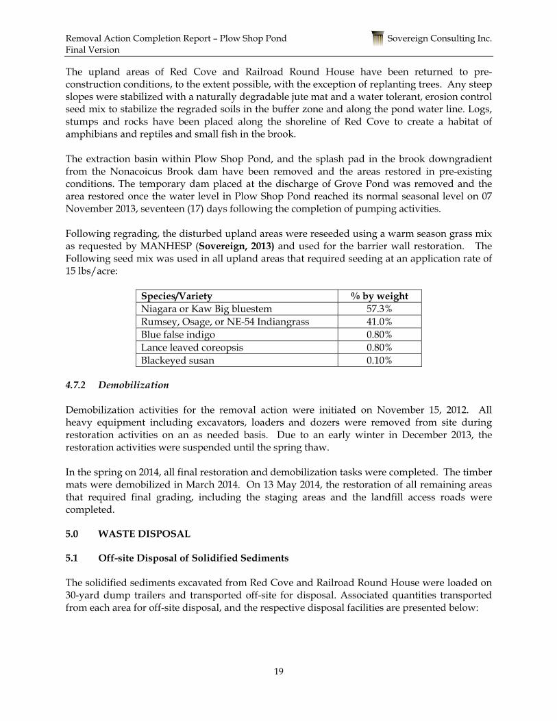
The upland areas of Red Cove and Railroad Round House have been returned to pre-construction conditions, to the extent possible, with the exception of replanting trees. Any steep slopes were stabilized with a naturally degradable jute mat and a water tolerant, erosion control seed mix to stabilize the regraded soils in the buffer zone and along the pond water line. Logs, stumps and rocks have been placed along the shoreline of Red Cove to create a habitat of amphibians and reptiles and small fish in the brook. The extraction basin within Plow Shop Pond, and the splash pad in the brook downgradient from the Nonacoicus Brook dam have been removed and the areas restored in pre-existing conditions. The temporary dam placed at the discharge of Grove Pond was removed and the area restored once the water level in Plow Shop Pond reached its normal seasonal level on 07 November 2013, seventeen (17) days following the completion of pumping activities. Following regrading, the disturbed upland areas were reseeded using a warm season grass mix as requested by MANHESP (Sovereign, 2013) and used for the barrier wall restoration. The Following seed mix was used in all upland areas that required seeding at an application rate of 15 lbs/acre:
Species/Variety % by weight Niagara or Kaw Big bluestem 57.3% Rumsey, Osage, or NE-54 Indiangrass 41.0% Blue false indigo 0.80% Lance leaved coreopsis 0.80% Blackeyed susan 0.10%
4.7.2 Demobilization Demobilization activities for the removal action were initiated on November 15, 2012. All heavy equipment including excavators, loaders and dozers were removed from site during restoration activities on an as needed basis. Due to an early winter in December 2013, the restoration activities were suspended until the spring thaw. In the spring on 2014, all final restoration and demobilization tasks were completed. The timber mats were demobilized in March 2014. On 13 May 2014, the restoration of all remaining areas that required final grading, including the staging areas and the landfill access roads were completed. 5.0 WASTE DISPOSAL 5.1 Off-site Disposal of Solidified Sediments The solidified sediments excavated from Red Cove and Railroad Round House were loaded on 30-yard dump trailers and transported off-site for disposal. Associated quantities transported from each area for off-site disposal, and the respective disposal facilities are presented below:

Removal Action Completion Report – Plow Shop Pond Sovereign Consulting Inc. Final Version
20
Summary of Wastes Disposed Off-Site
Work Area Classification Quantity Disposal/Recycling Facility & Location
Red Cove Non-Hazardous 4,458.7 tons Turnkey Landfill, Rochester, New Hampshire
Railroad Round House
Non- Hazardous Landfill Cover 1,350.6 tons Fitchburg State Landfill
Westminster, Massachusetts Copies of weight slips and the Mass DEP Bill of Lading Forms are included in Appendix H. 6.0 PERFORMANCE STANDARDS & QUALITY CONTROL (QC) In accordance with the quality control standards set forth in the RAWP (Sovereign, 2012a), Sovereign implemented the Contractor Quality Control Plan (CQCP) to provide a programmatic method for assuring that the required levels of quality are consistently achieved for all off-site and on-site project operations, including work completed by Sovereign and its subcontractors and vendors. This plan addressed each component of the Construction Quality Control (CQC) system, including responsibility and authority of project personnel, inspection programs, inspection activities, monitoring tests and observations, submittals procedure, and documentation and reporting requirements. The CQC system was implemented by using a three-phase process for all project Definable Features of Work (DFWs). A DFW is a task that is separate and distinct from all other tasks and has a specific set of quality control requirements (e.g., construction of working platform). All DFWs were controlled during execution using the three phases of control discussed and presented in the CQCP and underwent a completion inspection at the conclusion of the work associated with the DFW. The DFWs for the removal actions at Plow Shop Pond included the following:
• Red Cove Mobilization and Site Preparation • Red Cove Removal Action (Dewatering/Excavation, Sampling, Transportation/
Disposal) • Red Cove Site Restoration and Demobilization • SA 71 Mobilization and Site Preparation • SA 71 Removal Action (Dewatering/Excavation, Sampling, Transportation/ Disposal) • SA 71 Site Restoration and Demobilization
The DFWs were implemented by Sovereign, following the three-phase quality control system: including a Preparatory Phase, an Initial Phase, and a Follow-Up Phase, as described in the CQCP. Representatives of the USACE were on-site to participate in three-phase inspections as well as to conduct inspections of the removal action activities at regular intervals and convey any concerns or discrepancies to the on-site Sovereign management. Separate additional on-site visits were conducted by MassDEP and USEPA to measure progress during the removal action activities.

Removal Action Completion Report – Plow Shop Pond Sovereign Consulting Inc. Final Version
21
6.1 General Quality Assurance/Quality Control Procedures Sample analysis via an off-site laboratory adhered to QA/QC requirements and guidance provided in the MCP, the Statement of Work (SOW) (USACE, 2011), the Department of Defense (DOD) Quality Systems Manual for Environmental Laboratories (Final Version 4.2) (DOD, 2006), and the Uniform Federal Policy - Quality Assurance Project Plan (UFP-QAPP) (Sovereign, 2011c). Field QA/QC was achieved via collection of field duplicate and matrix spike/matrix spike duplicate (MS/MSD) samples used by the project chemist to determine precision in percent relative standard deviation and matrix interferences. Quality control samples were also collected in the field, including equipment rinsate blanks, to ensure compliance with decontamination procedures. Quality assurance split samples were not required per the SOW (USACE, 2011). Sovereign maintained daily Contractor’s Quality Control Reports (CQCR) for every day of construction activities as required in the specifications. The CQCRs included a daily log of construction documenting the site personnel, the materials received, changes, and the work conducted. The daily DQCRs are presented in Appendix I. 6.2 Health and Safety All removal action field activities were performed in accordance with the requirements of the SSHP (Sovereign, 2011b). Health and safety issues encountered during the implementation of field activities were addressed immediately and recorded in daily QA/QC logs. Daily safety briefings were held prior to the start of work and included all field personnel. Daily safety inspections were conducted on all heavy equipment prior to use. Periodic safety inspections were carried out by the Sovereign Health and Safety Officer. 6.3 Decontamination Decontamination of equipment was necessary to prevent cross-contamination between sample locations. Equipment was properly decontaminated prior to sample collection, between sampling locations, and following a sampling event. Decontamination procedures were performed in accordance with USEPA Region 1 Decontamination SOP No. 2000 (USEPA, 1994b) as presented in Section 5.6 of the RAWP (Sovereign, 2013). 6.4 Assessment of Data Quality The UFP-QAPP (Sovereign, 2011c) identifies QA/QC policies and procedures for laboratory analysis, instrument calibration, data reduction and reporting, internal quality control, and corrective action. The RAWP (Sovereign, 2013) presents QA/QC procedures implemented during field work and sampling activities. The purpose of the QA/QC procedures is to address specific objectives for analytical accuracy, precision, completeness, representativeness, and comparability. The project chemist performed a review of groundwater, sediment, and confirmatory soil data collected during the remediation activities for completeness, consistency, and compliance with the project QA requirements. All appropriate data was provided by the laboratories as required for a complete Tier III data validation. A 90% Tier II and 10% Tier I data validation was

Removal Action Completion Report – Plow Shop Pond Sovereign Consulting Inc. Final Version
22
performed on all the data. The validation effort was guided by project-specific information presented in the site-specific UFP-QAPP (Sovereign, 2011c). The validation results concluded that all required data elements were reported for each sample, and that all analyses were in accordance with requirements. Based on the level of review completed in the validation process, there were no significant findings that impacted data usability for the intended purposes. The data validation reports are included in Appendix J along the with the laboratory data packages. As noted in the DQE, all of the Q qualifiers were removed because the quality control check at the laboratory that caused them is not within the description of Level 2 data validation. So, all of the results were usable. Page 5 of the DQE discusses the removal of the Qs.
6.5 Comparison to Cleanup Goals Overall, the removal of impacted sediments in the Red Cove and Railroad Round House area within the excavation areas achieved the remedial action objectives. The remedial action objectives for these areas along with a discussion of the qualitative and quantitative data was provided within Sections 4.5.1 and 4.5.2 for the Red Cove and Railroad Round House areas, respectively. 7.0 DEMONSTRATION OF COMPLETION On 12 December 2013, a final walkthrough and inspection was performed at the Railroad Round House and Red Cove Areas of Plow Shop Pond by members of USACE to determine if site activities were substantially complete. A punch-list of three items were identified that were not able to be completed in 2013, due to the colder temperatures. A final inspection will be completed in the spring 2014. The following issues will identified:
• Removal of drum of decontamination fluids – Completed 26 December 2013 • Demobilize timber mats - Completed March 2014 • Grade and dress SHL access roads and Red Cove Staging area - Planned for Spring
2014

Removal Action Completion Report – Plow Shop Pond Sovereign Consulting Inc. Final Version
23
8.0 PROJECT COST SUMMARY The following table presents the approximate cost associated with the design, excavation, and reporting for the removal actions at Plow Shop Pond.
REMOVAL ACTION COSTS
Planning and Design Costs: $316,862
Project Management and Meetings Costs: $166,182
Mobilization / Demobilization Costs: $62,225
Site Preparation Costs: $310,631
Lowering and Maintaining Water Level: $206,116
Excavation and Solidification of Red Cove: $621,448
Excavation and Solidification of RRRH: $185,793
Confirmation Sampling of Red Cove: $58,359
Confirmation Sampling of RRRH: $36,076
Transportation & Disposal - Red Cove: $509,238
Transportation & Disposal - RRRH: $92,579
Site Restoration Costs: $74,191
Removal Action Completion Reports Costs: $38,201
Total Removal Action Costs: $2,677,901
9.0 COMMUNITY RELATIONS
Prior to the commencement of removal action, the Army prepared an EE/CA (Sovereign, 2012), Action Memorandum (AM) (Sovereign, 2012), and RAWP (Sovereign, 2013) in support of this NTCRA and made these documents available to the Base Closure Team (BCT) for comment. Throughout the removal action, the BCT, including representatives from USEPA, MassDEP, Massachusetts Division of Fisheries and Wildlife, U.S. Fish and Wildlife Service, MassDevelopment, the Devens Restoration Advisory Board (RAB), and the People of Ayer Concerned about the Environment (PACE), ), were kept informed of activities at the site through informational correspondence and monthly meetings. In addition, Sovereign

Removal Action Completion Report – Plow Shop Pond Sovereign Consulting Inc. Final Version
24
conducted a public information meeting at the site, which included a tour and presentation of the removal action activities being undertaken for all public stakeholders on August 29, 2013.

Removal Action Completion Report – Plow Shop Pond Sovereign Consulting Inc. Final Version
25
10.0 REFERENCES ABB, 1992. Analysis of Selected Metals and Organic Compounds in Fish Collected in Plow Shop Pond and Cold Spring Brook Pond, Fort Devens, Massachusetts. March 1993. AMEC 2010. Feasibility Study Screening Report for AOC 72, Plow Shop Pond. June. AMEC 2011. Draft Final Remedial Investigation for AOC 72. Prepared for USACE-NAE. March. USEPA 2011. Devens SA 71 Risk-Based Concentration for Antimony. September. DOD 2006. Quality Systems Manual for Environmental Laboratories (Final Version 3). January. DOD 2006. Uniform Federal Policy for Quality Assurance Project Plans (UFP-QAPPs) March. Gannet Fleming, 2006. Final Expanded Site Investigation: Remedial Oversight of Activities at Fort Devens Plow Shop Pond and Grove Pond. Prepared for the USEPA Region I. May. MassDEP. 2008. Massachusetts Contingency Plan (310 Code of Massachusetts Regulations 40.0000). MACTEC 2008. SA 71 Sediment Risk Characterization, Prepared for USACE-NAE. May. Sovereign 2012. Engineering Evaluation/Cost Analysis, AOC 72, Former Fort Devens Army Installation, Ayer, Massachusetts. December. Sovereign 2013. Revised Remedial Action Work Plan, AOC 72, Former Fort Devens Army Installation, Ayer, Massachusetts. August. Sovereign 2013b. Memorandum. “Summary of Railroad Round House Confirmation Sampling” October 2013. Sovereign 2013c Response to Comments. “EPA Comments: Summary of Railroad Round House Confirmation Sampling” November 2013. USAEC 1995. Record of Decision, Shepley’s Hill Landfill Operable Unit, Fort Devens, Massachusetts. Signed by USEPA Region I on September 26, 1995. USEPA 1994a. SOP #2016 Sediment Sampling. November. USEPA 1994b. Emergency Response Team. Sampling Equipment Decontamination, SOP No. 2000, Revision 0. September. USACE 2001. USACE Requirements for the Preparation of Sampling and Analysis Plans. (EM-200-1-3). 1 February.

Removal Action Completion Report – Plow Shop Pond Sovereign Consulting Inc. Final Version
26
USACE 2004. USACE, Final Soil Arsenic Background Study at the Former Fort Devens, Devens, Massachusetts. March 2004. Wagner, 2004. The Practical Guide to Lake Management in Massachusetts.

FIGURES

Co p yrig h t:© 2013 Na tio n a l Geo g ra p h ic So ciety, i-cubed
¨
FIGURE 1 - SITE LOCUS MAPPlo w Sh o p Po n d
Fo rm er Fo rt Deven s, Ayer, Ma ssa ch usettsLa titude: 42̊ 33' 19.93"NLo n g itude: 71̊ 35' 32.27"W
SOVEREIGN CONSULTING INC.
01/09/2014 ROV
E
GENERAL SITE LOCATION
0 2,000 4,0001,000Feet
16 CHESTNUT STREETFOXBOROUGH, MA 02035
Tel: 508-339-3200 Fax: 508-339-3248www.sovcon.com
LegendSh ep ley's Hill La n dfill (Ap p ro x.)Gro ve Po n dPlo w Sh o p Po n d

PLOW SHOP POND
RED COVESEDIMENT REMOVAL
AREA (APPROX.)
WETLANDS
APPROXIMATE WETLANDBOUNDARY FOR PLOW
SHOP POND
Source: Esri, DigitalGlobe, GeoEye, i-cubed, USDA, USGS, AEX,Getmapping, Aerogrid, IGN, IGP, swisstopo, and the GIS User Community
¨
02/03/2012 ROVUpdated 05/29/2014 ROV
National Wetland Inventory Layer. 2010. US Fish & Wildlife Service.
PLOW SHOP PONDFORMER FORT DEVENS, AYER, MA
SOVEREIGN CONSULTING INC.16 CHESTNUT STREET, SUITE 520FOXBOROUGH, MA 02035Tel: 508-339-3200 Fax: 508-339-3248www.sovcon.com
FIGURE 2 - RED COVEREMOVAL ACTION AREAS
0 400 800200
Feet

+U
+U
+U+U
+U+U
+U
+U
+U
+U
+U
+U
+U
+U
+U
+U+U
+U
+U+U
+U
+U
+U
SHP 05-43
SHP 05-44
SHP 01-36X
SHL 11SHL 20
SHP 01-38A
N-2, P-2/ N-2, P-1
SHL 10
SHM-93-10C/D/E
N3-P1/P2
SHL 4
SHL 19
SHP 01-38B
RSK-26
RSK-27
RSK-28
RSK-29SHM-11-07
SHP-01-37X23
6
226
246
255
236
246
246
236
246
246
255
Source: Esri, DigitalGlobe, GeoEye, i-cubed, USDA, USGS, AEX,Getmapping, Aerogrid, IGN, IGP, swisstopo, and the GIS User Community
Legend
Grid Number
+U Well, Piezometer, or Stage Board
Extent of Drainage Swale
Landfill Cap Boundary
Seismic Refraction Line
Topographic Elevation Contour (ft)
50x50' Area
Excavation Area (Approx.)
¨TYPICAL 5-POINT COMPOSITE SAMPLE LOCATIONS
(NOT TO SCALE)
12/23/2013 ROV Updated 05/29/2014 ROV
1 2
3 4
5 6 7 8
9 10 11 12
13 14 15 16 17
18 19 20 21 22 23 24
25 26 27 28 29 30 31
3938
47
37
46
36
45
35
44
34
43
52
33
42
51
32
41
50
55
40
49
54
48
53 56 57 58
59 60
59
PLOW SHOP PONDFORMER FORT DEVENS, AYER, MA
SOVEREIGN CONSULTING INC.16 CHESTNUT STREET, SUITE 520FOXBOROUGH, MA 02035Tel: 508-339-3200 Fax: 508-339-3248www.sovcon.com
FIGURE 3 - RED COVECONFIRMATION SAMPLING GRID
0 120 24060
Feet

RAILROAD ROUNDHOUSEEXCAVATION AREA (APPROX.)
PLOW SHOP POND
WETLAND BOUNDARYFOR PLOW SHOP POND
(APPROX.)
WETLANDS
Source: Esri, DigitalGlobe, GeoEye, i-cubed, USDA, USGS, AEX,Getmapping, Aerogrid, IGN, IGP, swisstopo, and the GIS User Community
¨
02/03/2012 ROVUpdated 04/08/2014 ROV
Data Source: National Wetland Inventory Layer. 2010. US Fish & Wildlife Service.
PLOW SHOP PONDFORMER FORT DEVENS, AYER, MA
SOVEREIGN CONSULTING INC.
0 400 800200
Feet
16 CHESTNUT STREET, SUITE 520FOXBOROUGH, MA 02035Tel: 508-339-3200 Fax: 508-339-3248www.sovcon.com
FIGURE 4 - RAILROAD ROUNDHOUSE REMOVAL ACTION AREA

01 02 03 04 05 06 07 08 09
10 11 12 13 14 15 16 17 18
19 20 21 22 23 24
226
236
246
236
22623
6
Source: Esri, DigitalGlobe, GeoEye, i-cubed, USDA, USGS, AEX,Getmapping, Aerogrid, IGN, IGP, swisstopo, and the GIS User Community
LegendTopographic Elevation Contour (ft)
Excavation Area (Approx.)
30x30' Grid
Grid Number
¨(NOT TO SCALE)
TYPICAL 5-POINT COMPOSITE SAMPLE LOCATIONS
10/18/2013 ROV05/29/2014 ROV
04
PLOW SHOP PONDFORMER FORT DEVENS, AYER, MA
FIGURE 5 - RAILROAD ROUND HOUSECONFIRMATION SAMPLING GRID
SOVEREIGN CONSULTING INC.16 CHESTNUT STREET, SUITE 520FOXBOROUGH, MA 02035Tel: 508-339-3200 Fax: 508-339-3248www.sovcon.com
0 80 16040
Feet

1
2
3
4
5
6
7
8
9
6
5
6
4
5
3
6
5
5
4
4
5
58
5
8
35
6
85
5
5
6
4
4
4
7
4
6
4
8
4 5
5
6
4
5
4
8
5
5
4
4
3
5
4
4
7
5
5
5
7
45
4
3
5
7
4
6
5
7
4
7
8
4
4
4
5
8
5
4
7
6
3
4
5
8
6
4
5
5
4
4
5
5
4
5
5
4
7
4
4
4
6
7
8
8
4
5
5
5
4
4
4
8
8
4
6
8
4
3
7
4
7
5
2
7
6
5
5
5
46
7
6
5
5
5
6
3
4
7
3
7
5
7
6
4
3
4
5
5 5
5
4
3 4
4
8
5
5
4
6
6
4
3
2
4
4
6
4
45
5
5
5
7
3
4
5
5
5
4
4
5
5
4
8
Source: Esri, DigitalGlobe, GeoEye, i-cubed, USDA, USGS, AEX,Getmapping, Aerogrid, IGN, IGP, swisstopo, and the GIS User Community
¨
Note: Bathymetric data collected and analyzed by Normandeau Environmental Consultants in December 2012.
U.P.
01/10/2010 ROVUpdated 05/29/2014 ROV
PLOW SHOP PONDFORMER FORT DEVENS, AYER, MA
SOVEREIGN CONSULTING INC.16 CHESTNUT STREET, SUITE 520FOXBOROUGH, MA 02035Tel: 508-339-3200 Fax: 508-339-3248www.sovcon.com
FIGURE 4BATHYMETRIC SURVEY
0 250 500125
Feet

POTENTIAL PUMPLOCATION
POTENTIAL PUMPLOCATION
DAMNONACOICUS BROOK
CULVERT TOGROVE POND
Source: Esri, DigitalGlobe, GeoEye, i-cubed, USDA, USGS, AEX,Getmapping, Aerogrid, IGN, IGP, swisstopo, and the GIS User Community
¨
LegendExcavation Area
6'
5'
4'
Note: 1. Bathymetric data collected and analyzed by Normandeau Environmental Consultants in December 2012. 2. Remaining areas at respective draw down level are approximate.
SOVEREIGN CONSULTING INC.
FIGURE 7GENERALIZATION OF DRAW
DOWN LEVELS - 4' to 6' PLOW SHOP POND
FORT DEVENS, AYER, MASSACHUSETTS
05/22/2013 ROVUpdated 07/24/2013 ROV
0 250 500125
Feet
16 Chestnut StreetFoxborough, MA 02305
Tel: 508-339-3200 www.sovcon.com


!.
!.
!.
!.
POTENTIAL PUMPLOCATION
POTENTIAL PUMPLOCATION
DAMNONACOICUS BROOK
CULVERT TOGROVE POND
SW-010
SW-011
SW-012
SW-013
Source: Esri, DigitalGlobe, GeoEye, i-cubed, USDA, USGS, AEX,Getmapping, Aerogrid, IGN, IGP, swisstopo, and the GIS User Community
¨
Legend
!. Surface Water Sample Location
Excavation Area
SOVEREIGN CONSULTING INC.
FIGURE 9 - APPROXIMATESURFACE WATER SAMPLE
LOCATIONSPLOW SHOP POND
FORT DEVENS, AYER, MASSACHUSETTS
03/05/2013 CASUpdated 06/20/2013 ROV
0 300 600150
Feet
16 Chestnut StreetFoxborough, MA 02305
Tel: 508-339-3200 www.sovcon.com

SHL 3
211
212
212212
213
214
214215
215
216
217
213
212
226
23624
6
255
246
236
236
246
246
255
Source: Esri, DigitalGlobe, GeoEye, i-cubed, USDA, USGS, AEX,Getmapping, Aerogrid, IGN, IGP, swisstopo, and the GIS User Community
¨
SOVEREIGN CONSULTING INC.
FIGURE 10POST EXCAVATION AREA
RED COVEFORT DEVENS, AYER, MASSACHUSETTS
12/24/2013 ROV
16 Chestnut StreetFoxborough, MA 02305
Tel: 508-339-3200 www.sovcon.com
LegendPost Excavation Elevation Contour (Ft)
Topographic Elevation Contour (Ft)
Excavation Area (Approx.)
0 100 20050
Feet
Contour Detail:
216
215214213
217
212
218
219
220
221
217
0 25 50 Feet
Note: The 211' contour is approximate and is used to represent the edge of the approximate excavation area. Source: Elevation Contours. 2003. Office of Geographic Information (MassGIS.

Vault Dimension:10.5' x 10.5' x 8'
212213214 215
211210
216
211
210
211
21221
1
210
214
211
215
212
216
226
236
Source: Esri, DigitalGlobe, GeoEye, i-cubed, USDA, USGS, AEX,Getmapping, Aerogrid, IGN, IGP, swisstopo, and the GIS User Community
¨
SOVEREIGN CONSULTING INC.
FIGURE 11ABANDONED VAULT LOCATIONWITH POST EXCAVATION AREA
RAILROAD ROUND HOUSEFORT DEVENS, AYER, MASSACHUSETTS
01/09/2014 ROV Updated 05/28/2014
16 Chestnut StreetFoxborough, MA 02305
Tel: 508-339-3200 www.sovcon.com
LegendPost Excavation Elevation Contour (Ft)
Topographic Elevation Contour (Ft)
Abandoned Vault (Approx.)
Excavation Area (Approx.)
Source: Elevation Contours. 2003. Office of Geographic Information (MassGIS).Note: The abandoned vault locaiton is approximate.
0 40 8020
Feet

+U
+U
+U+U
+U+U
+U
+U
+U
+U
+U
+U
+U
+U
+U
+U+U
+U
+U+U
+U
+U
+U
SHL-21N1-P1/P2/P3
SHP 05-43
SHP 05-44
SHP 01-36X
SHL 11SHL 20
SHP 01-38A
N-2, P-2/ N-2, P-1
SHL 10
SHM-93-10C/D/E
N3-P1/P2
SHL 4
SHL 19
SHP 01-38B
SHM-10-06A
SHM-10-06
RSK-26
RSK-27
RSK-28
RSK-29SHM-11-07
236
226
246
255
236
246
246
236
246
246
255
Source: Esri, DigitalGlobe, GeoEye, i-cubed, USDA, USGS, AEX,Getmapping, Aerogrid, IGN, IGP, swisstopo, and the GIS User Community
Legend+U Well, Piezometer, or Stage Board
Extent of Drainage Swale
Landfill Cap Boundary
Seismic Refraction Line
Topographic Elevation Contour (ft)
50x50' Area
Excavation Area (Approx.)
Arsenic Sample Result (mg/kg)
Arsenic Result < 270 (mg/kg)
Arsenic Result > 270 (mg/kg)
¨TYPICAL 5-POINT COMPOSITE SAMPLE LOCATIONS
(NOT TO SCALE)
""274
")12.5")7.3
")32.9")22.4")5.5")29.2")31.7")6.8
""510")15 ")183 ")39.5
")229 ")25.3 ")197 ")23.7 ")156 ")127
")35.6 ""664 ""506 ")251 ")195 ""291 ")93.9 ")110
")130 ")164 ")104 ")157 ")133 ")95.2""657
""291 ")117 ")185 ")185 ")157 ")120 ")73.8
")221 ")244 ")101 ")232 ")113
")89.2 ")65.2 ")78.3""449
")86.4 ")128 ")98""339
""302 ")163
")177")174
SOVEREIGN CONSULTING INC.
FIGURE 12a - FIRST ROUNDOF CONFIRMATION SAMPLING
RED COVE - PLOW SHOP PONDFORT DEVENS, AYER, MASSACHUSETTS
12/24/2013 ROV
0 120 24060
Feet
16 Chestnut StreetFoxborough, MA 02305
Tel: 508-339-3200 www.sovcon.com") ""
6.8
""2910""2090

+U
+U
+U+U
+U+U
+U
+U
+U
+U
+U
+U
+U
+U
+U
+U+U
+U
+U+U
+U
+U
+U
SHL-21N1-P1/P2/P3
SHP 05-43
SHP 05-44
SHP 01-36X
SHL 11SHL 20
SHP 01-38A
N-2, P-2/ N-2, P-1
SHL 10
SHM-93-10C/D/E
N3-P1/P2
SHL 4
SHL 19
SHP 01-38B
SHM-10-06A
SHM-10-06
RSK-26
RSK-27
RSK-28
RSK-29SHM-11-07
236
226
246
255
236
246
246
236
246
246
255
Source: Esri, DigitalGlobe, GeoEye, i-cubed, USDA, USGS, AEX,Getmapping, Aerogrid, IGN, IGP, swisstopo, and the GIS User Community
Legend+U Well, Piezometer, or Stage Board
Extent of Drainage Swale
Landfill Cap Boundary
Seismic Refraction Line
Topographic Elevation Contour (ft)
50x50' Area
Excavation Area (Approx.)
Arsenic Sample Result (mg/kg)
Arsenic Result < 270 (mg/kg)
Arsenic Result > 270 (mg/kg)
¨TYPICAL 5-POINT COMPOSITE SAMPLE LOCATIONS
(NOT TO SCALE)
""274
")12.5")7.3
")32.9")22.4")5.5")29.2")31.7")6.8
""510")15 ")183 ")39.5
")58.6 ")228 ")229 ")25.3 ")197 ")23.7 ")156 ")127
")35.6 ""664 ""506 ")251 ")195 ""291 ")93.9 ")110
")130 ")164 ")104 ")157 ")133 ")95.2""657
""291 ")117 ")185 ")185 ")157 ")120 ")73.8
")221 ")244 ")101 ")232 ")113
")89.2 ")65.2 ")78.3""449
")86.4 ")128 ")98""339
""302 ")163
")177")174
SOVEREIGN CONSULTING INC.
FIGURE 12b - SECOND ROUNDOF CONFIRMATION SAMPLING
RED COVE - PLOW SHOP PONDFORT DEVENS, AYER, MASSACHUSETTS
12/24/2013 ROV
0 120 24060
Feet
16 Chestnut StreetFoxborough, MA 02305
Tel: 508-339-3200 www.sovcon.com") ""
6.8

226
236
246
236
22623
6
Source: Esri, DigitalGlobe, GeoEye, i-cubed, USDA, USGS, AEX,Getmapping, Aerogrid, IGN, IGP, swisstopo, and the GIS User Community
¨(NOT TO SCALE)
TYPICAL 5-POINT COMPOSITE SAMPLE LOCATIONS
SOVEREIGN CONSULTING INC.
FIGURE 13a - FIRST ROUND OFCONFIRMATION SAMPLING
RAILROAD ROUND HOUSEFORT DEVENS, AYER, MASSACHUSETTS
09/26/2013 ROV Updated 04/16/2014 ROV
16 Chestnut StreetFoxborough, MA 02305
Tel: 508-339-3200 www.sovcon.com
""6.1
LegendAntimony Result (mg/kg)
Antimony Results < 4.6 mg/kg
Antimony Results > 4.6 mg/kg
Excavation Area (Approx.)
30x30' Grid
Topographic Elevation Contour (ft)
""
""
""4.5
4.5
""2.8 ""2.3
""2.8 ""3.2 ""2.0 ""1.1 ""0.7
""1.7""3.4
""5.9 ""5.9 ""5.5 ""6.3 ""6.0
""10.1 ""6.6""10.4 ""8.2
""6.2 ""46.3 ""7.8 ""6.0
0 80 16040
Feet

226
236
246
236
22623
6
Source: Esri, DigitalGlobe, GeoEye, i-cubed, USDA, USGS, AEX,Getmapping, Aerogrid, IGN, IGP, swisstopo, and the GIS User Community
¨(NOT TO SCALE)
TYPICAL 5-POINT COMPOSITE SAMPLE LOCATIONS
SOVEREIGN CONSULTING INC.
FIGURE 13b - SECOND ROUND OFCONFIRMATION SAMPLING
RAILROAD ROUND HOUSEFORT DEVENS, AYER, MASSACHUSETTS
09/26/2013 ROV Updated 04/16/2014 ROV
16 Chestnut StreetFoxborough, MA 02305
Tel: 508-339-3200 www.sovcon.com
")-- ")-- ")-- ")-- ")-- ")--""2.8
""4.5
""3.2
""2.3
""0.7
""2.8
""1.1""2.0
""7.8 ""6.9
""50.8 ""7.5
LegendNot Sampled
Antimony Result (mg/kg)
Antimony Results < 4.6 mg/kg
Antimony Results > 4.6 mg/kg
30x30' Grid
Excavation Area (Approx.)
Topographic Elevation Contour (ft)
")
""
""
""1.5 ""0.6 ""3.0 ""0.9
""1.6 ""2.8
4.5 0 80 16040
Feet

226
236
246
236
22623
6
Source: Esri, DigitalGlobe, GeoEye, i-cubed, USDA, USGS, AEX,Getmapping, Aerogrid, IGN, IGP, swisstopo, and the GIS User Community
¨(NOT TO SCALE)
TYPICAL 5-POINT COMPOSITE SAMPLE LOCATIONS
SOVEREIGN CONSULTING INC.
FIGURE 13c - THIRD ROUND OFCONFIRMATION SAMPLING
RAILROAD ROUND HOUSEFORT DEVENS, AYER, MASSACHUSETTS
10/17/2013 ROV Updated 04/16/2014 ROV
16 Chestnut StreetFoxborough, MA 02305
Tel: 508-339-3200 www.sovcon.com
""1.5 ""7.8
LegendAntimony Result (mg/kg)
Antimony Results < 4.6 mg/kg
Antimony Results > 4.6 mg/kg
30x30' Grid
Excavation Area (Approx.)
Topographic Elevation Contour (ft)
""
""
3.4
""4.5 ""0.6 ""3.0 ""0.9 ""2.8 ""2.3""6.9
""2.8 ""3.2 ""1.6 ""2.8 ""2.0 ""1.1 ""0.7""5.8 ""7.5
""6.2 ""11.0 ""7.8 ""6.0 ""3.4 ""1.7
0 80 16040
Feet

TABLES

TABLE 1SUMMARY OF SURFACE WATER DATA - TOTAL ARSENIC
PLOW SHOP POND
Surface Water Turbidity Temp DO(ug/L) NTU Celsius mg/L Notes
Cleanup Criteria 150 ug/LPSP-SW-10 PSP-SW-10-073013 7/30/2013 8.944 B 9.0 26.33 6.38
PSP-SW-10-080113 8/1/2013 8.517 3.9 24.74 6.69PSP-SW10-080913 8/9/2013 5.900 2.1 23.77 6.56PSP-SW10-081513 8/15/2013 5.725 B 7.2 26.05 6.26PSP-SW10-081613 8/16/2013 9.116 6.0 22.32 6.86PSP-SW10-081913 8/19/2013 9.831 B 2.3 24.55 8.26PSP-SW10-082013 8/20/2013 8.920 2.3 24.50 8.60PSP-SW10-082113 8/21/2013 8.920 4.1 26.20 7.72PSP-SW10-082213 8/22/2013 9.110 3.2 25.28 6.08PSP-SW10-082313 8/23/2013 10.30 9.8 24.66 5.70PSP-SW10-082613 8/26/2013 11.34 11.0 22.75 5.78PSP-SW10-082713 8/27/2013 10.93 10.1 23.66 6.09PSP-SW10-082813 8/28/2013 12.27 11.6 23.35 5.62PSP-SW10-082913 8/29/2013 14.47 11.9 23.83 4.82PSP-SW10-083013 8/30/2013 20.06 12.9 20.88 3.97PSP-SW10-090313 9/3/2013 14.81 26.0 24.84 4.95
Location unavailable by boat 9/4/2013 NC - - -PSP-SW10-090513 9/5/2013 12.86 23.0 22.00 5.19PSP-SW10-090613 9/6/2013 13.33 20.8 18.50 6.63PSP-SW10-091013 9/10/2013 13.23 18.8 18.63 5.58PSP-SW10-091313 9/13/2013 18.37 20.2 24.42 5.17
9/17/2013 14.1 15.75 5.60PSP-SW-10-091913 9/19/2013 9.38 9.2 16.77 6.45PSP-SW-10-092413 9/24/2013 8.77 13.7 15.45 7.11PSP-SW10-092713 9/27/2013 9.335 16.4 17.41 5.93PSP-SW10-100113 10/1/2013 8.040 13.4 15.94 7.17
Inaccessible - No sample collected 10/3/2013 NC - - -PSP-SW10-100813 10/8/2013 7.75 11.6 16.87 5.96PSP-SW10-101113 10/11/2013 6.38 9.9 14.20 7.50
PSP-SW-11 PSP-SW-11-073013 7/30/2013 9.277 B 4.2 25.18 6.95FD-073013 7/30/2013 9.140 B - - -
PSP-SW-11-080113 8/1/2013 14.16 4.3 25.51 6.65FD-080113 8/1/2013 12.30 - - -
PSP-SW11-080913 8/9/2013 6.080 1.9 24.02 7.50PSP-SW11-081513 8/15/2013 7.023 B 3.5 23.04 7.31PSP-SW11-081613 8/16/2013 8.948 4.6 23.49 7.45PSP-SW11-081913 8/19/2013 11.72 B 3.5 26.36 7.63PSP-SW11-082013 8/20/2013 9.640 4.4 24.84 7.50PSP-SW11-082113 8/21/2013 10.25 5.2 26.52 7.56PSP-SW11-082213 8/22/2013 10.27 6.6 24.98 5.51PSP-SW11-082313 8/23/2013 12.88 11.4 24.36 5.85PSP-SW11-082613 8/26/2013 11.93 8.6 22.73 7.52PSP-SW11-082713 8/27/2013 13.79 10.4 24.46 6.75PSP-SW11-082813 8/28/2013 14.04 8.6 23.15 4.38PSP-SW11-082913 8/29/2013 15.73 14.2 22.86 6.50PSP-SW11-083013 8/30/2013 14.49 15.1 19.43 5.45PSP-SW11-090313 9/3/2013 16.91 22.8 25.79 7.58PSP-SW11-090413 9/4/2013 14.54 20.4 21.13 1.86PSP-SW11-090513 9/5/2013 15.94 21.8 18.09 10.03PSP-SW11-090613 9/6/2013 13.79 19.1 17.30 11.09PSP-SW11-091013 9/10/2013 16.77 15.5 18.46 8.02PSP-SW11-091313 9/13/2013 19.29 17.5 24.71 7.23
9/17/2013 10.5 14.78 8.08PSP-SW-11-091913 9/19/2013 16.06 19.7 15.67 6.49PSP-SW-11-092413 9/24/2013 13.47 26.8 15.10 7.39PSP-SW11-092713 9/27/2013 16.62 25.2 17.05 6.31PSP-SW11-100113 10/1/2013 12.45 14.8 15.27 8.98PSP-SW11-100313 10/3/2013 12.84 14.2 16.03 8.19PSP-SW11-100813 10/8/2013 19.02 14.5 16.09 1.11PSP-SW11-101113 10/11/2013 13.15 7.2 12.62 1.17
Field Parameters
Q
Total Arsenic
Sample ID DateLocation ID
Page 1 of 3

TABLE 1SUMMARY OF SURFACE WATER DATA - TOTAL ARSENIC
PLOW SHOP POND
Surface Water Turbidity Temp DO(ug/L) NTU Celsius mg/L Notes
Cleanup Criteria 150 ug/L
Field Parameters
Q
Total Arsenic
Sample ID DateLocation ID
PSP-SW-12 PSP-SW-12-073013 7/30/2013 8.948 B 3.9 25.24 7.10PSP-SW-12-080113 8/1/2013 10.26 3.8 24.78 6.23PSP-SW12-080913 8/9/2013 5.750 1.5 23.97 8.59PSP-SW12-081513 8/15/2013 7.472 B 5.6 22.97 7.65PSP-SW12-081613 8/16/2013 8.120 1.8 23.40 7.33PSP-SW12-081913 8/19/2013 10.81 B 3.6 26.44 7.10PSP-SW12-082013 8/20/2013 9.160 3.2 24.77 7.20PSP-SW12-082113 8/21/2013 9.800 4.2 26.44 7.39PSP-SW12-082213 8/22/2013 9.770 5.9 25.11 5.29PSP-SW12-082313 8/23/2013 11.90 8.4 24.14 5.60PSP-SW12-082613 8/26/2013 11.72 8.5 22.65 7.07PSP-SW12-082713 8/27/2013 12.56 10.8 24.38 6.59
FD-082713 8/27/2013 12.57 - - -PSP-SW12-082813 8/28/2013 12.61 9.5 23.12 4.80PSP-SW12-082913 8/29/2013 13.16 10.3 22.91 5.74PSP-SW12-083013 8/30/2013 12.77 10.3 19.60 3.49PSP-SW12-090313 9/3/2013 15.95 20.3 25.26 6.68PSP-SW12-090413 9/4/2013 22.24 38.3 20.01 1.36PSP-SW12-090513 9/5/2013 13.41 17.5 20.05 7.01PSP-SW12-090613 9/6/2013 12.17 14.6 13.22 11.60PSP-SW12-091013 9/10/2013 16.13 17.1 18.49 7.98PSP-SW12-091313 9/13/2013 18.95 22.0 24.44 6.61
9/17/2013 10.5 14.38 7.96PSP-SW-12-091913 9/19/2013 15.90 17.9 15.14 5.85PSP-SW-12-092413 9/24/2013 12.18 23.5 14.43 6.49
FD-092413 9/24/2013 12.37 - - -PSP-SW12-092713 9/27/2013 16.43 21.6 16.97 6.21PSP-SW12-100113 10/1/2013 12.10 15.1 15.00 8.45PSP-SW12-100313 10/3/2013 12.07 14.0 15.98 7.90PSP-SW12-100813 10/8/2013 17.01 12.2 13.43 0.99PSP-SW12-101113 10/11/2013 8.41 5.7 11.71 1.42
Page 2 of 3

TABLE 1SUMMARY OF SURFACE WATER DATA - TOTAL ARSENIC
PLOW SHOP POND
Surface Water Turbidity Temp DO(ug/L) NTU Celsius mg/L Notes
Cleanup Criteria 150 ug/L
Field Parameters
Q
Total Arsenic
Sample ID DateLocation ID
PSP-SW-13 PSP-SW-13-073013 7/30/2013 8.788 B 3.0 25.30 6.74PSP-SW-13-080113 8/1/2013 9.466 2.8 24.89 6.35PSP-SW13-080913 8/9/2013 5.820 2.7 24.01 6.88PSP-SW13-081513 8/15/2013 7.878 B 3.9 22.96 7.48PSP-SW13-081613 8/16/2013 8.673 1.8 23.42 6.99PSP-SW13-081913 8/19/2013 9.968 B 1.9 26.37 7.10
FD-081913 8/19/2013 9.904 B - - -PSP-SW13-082013 8/20/2013 8.750 3.3 24.52 7.08PSP-SW13-082113 8/21/2013 9.740 5.1 26.26 7.03PSP-SW13-082213 8/22/2013 9.460 6.2 24.96 5.41PSP-SW13-082313 8/23/2013 11.74 8.5 23.93 5.27PSP-SW13-082613 8/26/2013 11.33 8.3 22.38 6.85PSP-SW13-082713 8/27/2013 12.41 10.6 24.16 6.60PSP-SW13-082813 8/28/2013 13.02 12.2 23.84 6.21PSP-SW13-082913 8/29/2013 12.69 8.7 22.92 5.35PSP-SW13-083013 8/30/2013 13.22 11.7 19.35 7.01PSP-SW13-090313 9/3/2013 15.76 18.4 24.87 6.70
FD-090313 9/3/2013 14.67 - - -PSP-SW13-090413 9/4/2013 16.92 21.4 20.82 1.69PSP-SW13-090513 9/5/2013 12.46 15.9 18.07 9.93PSP-SW13-090613 9/6/2013 12.22 14.2 17.48 8.58PSP-SW13-091013 9/10/2013 15.22 18.8 18.42 7.88
FD-091013 9/10/2013 15.66 - - -PSP-SW13-091313 9/13/2013 19.32 19.1 24.19 6.38
9/17/2013 10.6 14.30 7.77PSP-SW-13-091913 9/19/2013 15.53 16.8 14.71 5.60PSP-SW-13-092413 9/24/2013 10.87 12.7 13.70 6.23PSP-SW13-092713 9/27/2013 16.12 22.3 16.92 5.85PSP-SW13-100113 10/1/2013 11.43 12.2 14.77 8.41
FD-100113 10/1/2013 11.57 - - -PSP-SW13-100313 10/3/2013 11.55 14.3 15.97 7.86PSP-SW13-100813 10/8/2013 16.42 12.8 14.15 1.50
FD-100813 10/8/2013 16.79 - - -PSP-SW13-101113 10/11/2013 11.87 9.5 11.88 1.47
Notes:
QUALIFIER 'B' :- The analyte was detected above the reporting limit in the associated method blank. Flag only applies to associated field samples that have detectable concentrations of the analyte at less than five times (5x) the concentration found in the blank. For MCP-related projects, flag only applies to associated times (10x) field samples that have detectable concentrations of the analyte at less than ten the concentration found in the blank. NC Not Collected- Not Available
Page 3 of 3

Table 2Summary of Red Cove Sediment Data - Total Arsenic
Railroad Round House Removal ActionFormer Fort Devens
Sediment
(mg/kg)Cleanup Criteria 270 mg/kgRC-SD-01-001 RC-SD-01-001-100713 1 12 10/7/2013 174 Q (a), (b)
FD-100713-01 10/7/2013 163 Q
RC-SD-02-001 RC-SD-02-001-100713 2 12 10/7/2013 177 Q (a), (b)
RC-SD-03-001 RC-SD-03-001-100713 3 12 10/7/2013 302 Q (a), (b)
RC-SD-04-001 RC-SD-04-001-100713 4 12 10/7/2013 163 Q (a), (b)
RC-SD-05-001 RC-SD-05-001-100713 5 12 10/7/2013 86.4 Q (a), (b)
RC-SD-06-001 RC-SD-06-001-100413 6 12 10/4/2013 399 Q (a), (b)
RC-SD-07-001 RC-SD-07-001-100413 7 12 10/4/2013 128 Q (a), (b)
RC-SD-08-001 RC-SD-08-001-100413 8 12 10/4/2013 98.0 Q (a), (b)
RC-SD-09-001 RC-SD-09-001-100713 9 12 10/7/2013 89.2 Q (a), (b)
RC-SD-10-001 RC-SD-10-001-100313 10 12 10/3/2013 449 Q (a), (b)
RC-SD-11-001 RC-SD-11-001-100413 11 12 10/4/2013 65.2 Q (a), (b)
RC-SD-12-001 RC-SD-12-001-100413 12 12 10/4/2013 78.3 Q (a), (b)
RC-SD-13-001 RC-SD-13-001-100313 13 12 10/3/2013 221 Q (a), (b)
RC-SD-14-001 RC-SD-14-001-100313 14 12 10/3/2013 244 (a), (b)
RC-SD-15-001 RC-SD-15-001-100313 15 12 10/3/2013 101 (a), (b)
RC-SD-16-001 RC-SD-16-001-100313 16 12 10/3/2013 232 Q (a), (b)
RC-SD-17-001 RC-SD-17-001-100413 17 12 10/4/2013 113 Q (a), (b)
RC-SD-18-001 RC-SD-18-001-100313 18 12 10/3/2013 291 Q (a), (b)
RC-SD-19-001 RC-SD-19-001-100313 19 12 10/3/2013 117 Q (a), (b)
RC-SD-20-001 RC-SD-20-001-100313 20 12 10/3/2013 185 Q (a), (b)
Note
Total Arsenic
Location ID Sample ID Date QualifierGrid Number
Sampling Depth
(Inches)
Page 1 of 4

Table 2Summary of Red Cove Sediment Data - Total Arsenic
Railroad Round House Removal ActionFormer Fort Devens
Sediment
(mg/kg)Cleanup Criteria 270 mg/kg
Note
Total Arsenic
Location ID Sample ID Date QualifierGrid Number
Sampling Depth
(Inches)
RC-SD-21-001 RC-SD-21-001-100313 21 12 10/3/2013 185 Q (a), (b)
RC-SD-22-001 RC-22-001-100213 22 12 10/2/2013 157 Q (a), (b)
RC-SD-23-001 RC-SD-23-001-100213 23 12 10/2/2013 120 Q (a), (b)
RC-SD-24-001 RC-SD-24-001-100213 24 12 10/2/2013 73.8 Q (a), (b)
RC-SD-25-001 RC-SD-25-001-092513 25 12 9/25/2013 130 Q (a), (b)
RC-SD-26-001 RC-SD-26-001-100313 26 12 10/3/2013 164 Q (a), (b)
RC-SD-27-001 RC-SD-27-001-100313 27 12 10/3/2013 657 Q (a), (b)
RC-SD-28-001 RC-SD-28-001-100313 28 12 10/3/2013 104 QFD-100313-001 10/3/2013 166 Q (a), (b)
RC-SD-29-001 RC-SD-29-001-100213 29 12 10/2/2013 157 Q (a), (b)
RC-SD-30-001 RC-SD-30-001-100213 30 12 10/2/2013 133 Q (a), (b)
RC-SD-31-001 RC-SD-31-001-100213 31 12 10/2/2013 95.2 Q (a), (b)
RC-SD-32-001 RC-SD-32-001-091213 32 12 9/12/2013 35.6 Q (a), (b)
RC-SD-33-001 RC-SD-33-001-091313 33 12 9/13/2013 664 Q (a), (b)
FD-091313-01 9/13/2013 632 Q
RC-SD-34-001 RC-SD-34-001-092513 34 12 9/25/2013 506 Q (a), (b)
FD-092513-01 9/25/2013 492 Q
RC-SD-35-001 RC-SD-35-001-092513 35 12 9/25/2013 251 Q (a), (b)
RC-SD-36-001 RC-SD-36-001-100213 36 12 10/2/2013 195 Q (a), (b)
RC-SD-37-001 RC-SD-37-001-100213 37 12 10/2/2013 291 Q (a), (b)
RC-SD-38-001 RC-SD-38-001-100213 38 12 10/2/2013 93.9 Q (a), (b)
Page 2 of 4

Table 2Summary of Red Cove Sediment Data - Total Arsenic
Railroad Round House Removal ActionFormer Fort Devens
Sediment
(mg/kg)Cleanup Criteria 270 mg/kg
Note
Total Arsenic
Location ID Sample ID Date QualifierGrid Number
Sampling Depth
(Inches)
RC-SD-39-001 RC-SD-39-001-100213 39 12 10/2/2013 110 Q (a), (b)
RC-SD-40-001 RC-SD-40-001-091913 40 12 9/19/2013 2,090 QFD-091913-01 9/19/2013 2,690
RC-SD-40-002-100713 40 24 10/7/2013 58.6 Q (a), (b)
RC-SD-41-001 RC-SD-41-001-091813 41 12 9/18/2013 2,910 QFD-091813-01 9/18/2013 2,510 Q
RC-SD-41-002-100813 41 24 10/18/2013 228 Q (a), (b)
RC-SD-42-001 RC-SD-42-001-091213 42 12 9/12/2013 229 Q (a), (b)
FD-091213-01 9/12/2013 216 Q
RC-SD-43-001 RC-SD-43-001-091113 43 12 9/11/2013 25.3 Q (a), (b)
RC-SD-44-001 RC-SD-44-001-092513 44 12 9/25/2013 197 Q (a), (b)
RC-SD-45-001 RC-SD-45-001-100213 45 12 10/2/2013 23.7 Q (a), (b)
RC-SD-46-001 RC-SD-46-001-100213 46 12 10/2/2013 156 QFD-100213-01 10/2/2013 163 Q (a), (b)
RC-SD-47-001 RC-SD-47-001-100213 47 12 10/2/2013 127 Q (a), (b)
RC-SD-48-001 RC-SD-48-001-100813 48 12 10/8/2013 15.0 QFD-100813-01 10/8/2013 16.9 Q (a), (b)
RC-SD-49-001 RC-SD-49-001-092013 49 12 9/20/2013 274 Q (a), (b)
RC-SD-50-001 RC-SD-50-001-091713 50 12 9/17/2013 510 QFD-091713-01 9/17/2013 543 Q (a), (b)
RC-SD-51-001 RC-SD-51-001-091213 51 12 9/12/2013 183 Q (a), (b)
RC-SD-52-001 RC-SD-52-001-091113 52 12 9/11/2013 39.5 Q (a), (b)
FD-091113-01 9/11/2013 27.6 Q
RC-SD-53-001 RC-SD-53-001-092013 53 12 9/20/2013 6.81 Q (a), (b)
RC-SD-54-001 RC-SD-54-001-092313 54 12 9/23/2013 31.7 Q (a), (b)
Page 3 of 4

Table 2Summary of Red Cove Sediment Data - Total Arsenic
Railroad Round House Removal ActionFormer Fort Devens
Sediment
(mg/kg)Cleanup Criteria 270 mg/kg
Note
Total Arsenic
Location ID Sample ID Date QualifierGrid Number
Sampling Depth
(Inches)
RC-SD-55-001 RC-SD-55-001-091713 55 12 9/17/2013 29.2 Q (a), (b)
RC-SD-56-001 RC-SD-56-001-092413 56 12 9/24/2013 5.56 Q (a), (b)
RC-SD-57-001 RC-SD-57-001-092413 57 12 9/24/2013 22.4 Q (a), (b)
RC-SD-58-001 RC-SD-58-001-092413 58 12 9/24/2013 32.9 Q (a), (b)
RC-SD-59-001 RC-SD-59-001-092413 59 12 9/24/2013 7.39 Q (a), (b)
RC-SD-60-001 RC-SD-60-001-092413 60 12 9/24/2013 12.5 Q (a), (b)
Sample ID Date Units: ug/L QualifierEQUIPMENT BLANK EB-091113-02 9/11/2013 <0.5000 Q
EB-091213-01 9/12/2013 0.1361 JQEB-091313-01 9/13/2013 <0.5000 QEB-091713-01 9/17/2013 0.1975 JQEB-091813-01 9/18/2013 0.1371 JQEB-091913-01 9/19/2013 0.1277 JQEB-092013-01 9/20/2013 <0.5000 QEB-092313-01 9/23/2013 <0.5000 QEB-092413-01 9/24/2013 <0.5000 QEB-092513-01 9/25/2013 0.1279 JQEB-100213-01 10/2/2013 0.2095 JQEB-100313-01 10/3/2013 0.1211 JQEB-100413-001 10/4/2013 0.1907 JQEB-100713-01 10/7/2013 0.0909 JQEB-100813-01 10/8/2013 0.3270 JB
Notes:Qualifier 'J' :- Estimated value. The Target analyte concentration is below the quantitation limit (RL), but above the Method Detection Limit (MDL) or Estimated Detection Limit (EDL) for SPME-related analyses. This represents an estimated concentration for Tentatively Identified Compounds (TICs).
Qualifier 'Q' :- The quality control sample exceeds the associated acceptance criteria. Note: This flag is not applicable for matrix spike recoveries when the sample concentration is greater than 4x the spike added or for batch duplicate RPD when the sample concentrations are less than 5x the RL. (Metals only.)
Qualifier 'B' :- The analyte was detected above the reporting limit in the associated method blank. Flag only applies to associated field samples thathave detectable concentrations of the analyte at less than ten times (10x) the concentration found in the blank. For MCP-relatedprojects, flag only applies to associated field samples that have detectable concentrations of the analyte at less than ten times (10x)the concentration found in the blank. For DOD-related projects, flag only applies to associated field samples that have detectableconcentrations of the analyte at less than ten times (10x) the concentration found in the blank AND the analyte was detected aboveone-half the reporting limit (or above the reporting limit for common lab contaminants) in the associated method blank. For NJAir-related projects, flag only applies to associated field samples that have detectable concentrations of the analyte above thereporting limit.
BOLD Indicates detections above applicable standard
(b) - Samples used for ProUCL calculations.
(a) - Samples used to calculate the average. Among the original sample and its duplicate, sample with higher concenration is considered for the calculation.
Page 4 of 4

TABLE 3ProUCL OUTPUT
RED COVE DATA - TOTAL ARSENICPLOW SHOP POND
Kolmogorov-Smirnov 5% Critical Value 0.117 95% BCA Bootstrap UCL 207.6
Anderson-Darling 5% Critical Value 0.774 95% Hall's Bootstrap UCL 208.3
Kolmogorov-Smirnov Test Statistic 0.0762 95% Percentile Bootstrap UCL 202.1
95% Standard Bootstrap UCL 199.8
Anderson-Darling Test Statistic 0.455 95% Bootstrap-t UCL 208
Adjusted Level of Significance 0.046 95% CLT UCL 201.1
Adjusted Chi Square Value 116 95% Jackknife UCL 201.6
nu star 143.2
Approximate Chi Square Value (.05) 116.6 Nonparametric Statistics
MLE of Mean 169.2
MLE of Standard Deviation 154.9
Gamma Distribution Test Data Distribution
k star (bias corrected) 1.194 Data appear Gamma Distributed at 5% Significance Level
Theta Star 141.8
95% Modified-t UCL (Johnson-1978) 202.3 99% Chebyshev (MVUE) UCL 534.7
95% UCLs (Adjusted for Skewness) 95% Chebyshev (MVUE) UCL 344.2
95% Adjusted-CLT UCL (Chen-1995) 205.6 97.5% Chebyshev (MVUE) UCL 408.5
Assuming Normal Distribution Assuming Lognormal Distribution
95% Student's-t UCL 201.6 95% H-UCL 286.7
Lilliefors Critical Value 0.114 Lilliefors Critical Value 0.114
Data not Normal at 5% Significance Level Data not Lognormal at 5% Significance Level
Normal Distribution Test Lognormal Distribution Test
Lilliefors Test Statistic 0.16 Lilliefors Test Statistic 0.138
Skewness 1.665
Relevant UCL Statistics
Std. Error of Mean 19.37
Coefficient of Variation 0.887
Median 131.5 SD of log Data 1.108
SD 150.1
Maximum 664 Maximum of Log Data 6.498
Mean 169.2 Mean of log Data 4.679
Raw Statistics Log-transformed Statistics
Minimum 5.56 Minimum of Log Data 1.716
Sed Arsenic
General Statistics
Number of Valid Observations 60 Number of Distinct Observations 56
Full Precision OFF
Confidence Coefficient 95%
Number of Bootstrap Operations 2000
General UCL Statistics for Full Data Sets
User Selected Options
From File C:\Documents and Settings\sjanga\Desktop\ProUCL Datafiles\TO5\As Sediment Input.wst

TABLE 3ProUCL OUTPUT
RED COVE DATA - TOTAL ARSENICPLOW SHOP POND
Note: Suggestions regarding the selection of a 95% UCL are provided to help the user to select the most appropriate 95% UCL.
These recommendations are based upon the results of the simulation studies summarized in Singh, Singh, and Iaci (2002)
and Singh and Singh (2003). For additional insight, the user may want to consult a statistician.
Potential UCL to Use Use 95% Approximate Gamma UCL 207.9
95% Approximate Gamma UCL 207.9
95% Adjusted Gamma UCL 209
97.5% Chebyshev(Mean, Sd) UCL 290.2
Assuming Gamma Distribution 99% Chebyshev(Mean, Sd) UCL 362
Data appear Gamma Distributed at 5% Significance Level 95% Chebyshev(Mean, Sd) UCL 253.7

TABLE 4SUMMARY OF RAILROAD ROUND HOUSE SEDIMENT DATA - TOTAL ANTIMONY
PLOW SHOP POND
Sediment(mg/kg)
Cleanup Criteria 4.6 mg/kgSA71-SD-01-001 SA71-SD-01-001-082613 8/29/2013 Saturated, gray, organic material. Some f-sand. Little c-sand and f-gravel. Slight sheen. 6.16
SA71-SD-01-002-091013 9/10/2013 Saturated, brown, peat, lots of organic material. Some silt. 1.56 QSA71-SD-02-001 SA-71-SD-02-001-082813 8/28/2013 Saturated, gray, organic material. Lots of f-sand, some c-sand, little f-gracvel. Slight sheen. 4.53 QSA71-SD-03-001 SA-71-SD-03-001-082813 8/28/2013 Saturated, gray, organic material. Lots of f-sand, some c-sand, little f-gracvel. Slight sheen. 5.98 Q
SA71-SD-03-002-091013 9/10/2013 Saturated, brown, organic material and peat. Some silt. 0.602 QSA71-SD-04-001 SA-71-SD-04-001-082813 8/28/2013 Saturated, gray, organic material. Lots of f-sand, some c-sand, little f-gracvel. Slight sheen.
Some peat.5.95 Q
SA-71-SD-04-002-090613 9/6/2013 Saturated, gray, organic material. Some f-sand and silt. 7.81 QSA71-SD-05-001 SA-71-SD-05-001-082813 8/28/2013 Saturated, gray, organic material. Lots of f-sand, some c-sand, little f-gracvel. Slight sheen.
Some peat.5.59 Q
SA-71-SD-05-002-090613 9/6/2013 Saturated, gray, organic material. Some f-sand and silt. 6.93 QFD-090613-01 9/6/2013 6.10 Q
SA71-SD-06-001 SA-71-SD-06-001-082813 8/28/2013 Saturated, gray, organic material. Lots of f-sand, some c-sand, little f-gracvel. Slight sheen. 6.37 QSA-71-SD-06-002-090613 9/6/2013 3.08 Q
SA71-SD-07-001 SA-71-SD-07-001-082813 8/28/2013 Saturated, gray, organic material. Lots of f-sand, some c-sand, little f-gracvel. Slight sheen. 6.05 QSA-71-SD-07-002-091113 9/11/2013 Saturated, dark, brown, organic material. Little f-sand and silt. Some gray sludge. 0.985 Q
SA71-SD-08-001 SA71-SD-08-001-082613 8/26/2013 Saturated, gray, organic material. Lots of f-sand, some c-sand, little f-gravel. Slight sheen. 2.81SA71-SD-09-001 SA71-SD-09-001-082613 8/26/2013 Saturated, gray, organic material. Lots of f-sand, some c-sand, little f-gravel. Sliglht sheen. 2.36
FD-082613 8/26/2013 2.39SA71-SD-10-001 SA-71-SD-10-001-083013 8/30/2013 Saturated, gray, organic material. Some f-m sand. Little c-sand. Some brick and f-gravel. 2.89 QSA71-SD-11-001 SA-71-SD-11-001-083013 8/30/2013 Saturated, gray, organic materail, lost of c-sand and some f-sand. Little f-gravel. 10.1 Q
SA71-SD-11-002-091013 9/10/2013 Saturated, brown, organic material and peat. Lots of brick and coal/gravel removed from location.
50.8 QSA-71-SD-11-003-091913 9/19/2013 Wet, dark, brown/black, peat, organic material. Some coal ash. Some f-m sand. 5.81 Q
FD-091913-02 9/19/2013 4.50 QSA71-SD-12-001 SA-71-SD-12-001-082813 8/28/2013 Saturated, gray, organic material. Lots of f-sand, some c-sand, little f-gracvel. Slight sheen. 3.23 Q
Sediment Description
Gray, brown, organic material. Wet-saturated. Some f-sand and silt. Lots of gray coal ash. Removed from grid.
Qualifier
Total Antimony
Sample ID DateLocation ID

TABLE 4SUMMARY OF RAILROAD ROUND HOUSE SEDIMENT DATA - TOTAL ANTIMONY
PLOW SHOP POND
Sediment(mg/kg)
Cleanup Criteria 4.6 mg/kg
Sediment Description Qualifier
Total Antimony
Sample ID DateLocation ID
SA71-SD-13-001 SA-71-SD-13-001-082813 8/28/2013 Saturated, gray, organic material. Some m-c sand. Little f-sand. Some brick and glass. 10.4 QFD-082813-01 8/28/2013 8.25 Q
SA71-SD-13-002-091013 9/10/2013 Saturated, brown, organic material and peat. Some silt. 1.62 QFD-091013-01 9/10/2013 2.43 Q
SA71-SD-14-001 SA-71-SD-14-001-082813 8/28/2013 Saturated organic material. Gray black. Some f-m sand. Little coal ash. Some c-sand and brick. 6.66 Q
SA-71-SD-14-002-090613 9/6/2013 7.52 QSA71-SD-15-001 SA-71-SD-15-001-082813 8/28/2013 Saturated organic material. Some m-c sand. Little peat. Many coal ash. Gray black. 8.28 Q
SA-71-SD-15-002-090613 9/6/2013 2.89
SA71-SD-16-001 SA-71-SD-16-001-083013 8/30/2013 Saturated, black, organic material. Some m-sand, some c-sand, little bit of gravel. 2.04 QFD-083013-01 8/30/2013 3.14 Q
SA71-SD-17-001 SA-71-SD-17-001-083013 8/30/2013 Saturated, black, organic material. Some m-sand, some c-sand, little bit of gravel. 1.18 QSA71-SD-18-001 SA71-SD-18-001-082613 8/26/2013 Moist, gray f-m sand, some c-sand and f-gravel. Trace coal. 0.702SA71-SD-19-001 SA-71-SD-19-001-100913 10/9/2013 Brown to black f-m sand. Organic, peat, bricks, little coal ash. 6.22
SA71-SD-20-001 SA-71-SD-20-001-100913 10/9/2013 Wet m-c sand, lots of coal ash. Little f-sand, some gravel (m-l). Some brick and glass. 46.30SA-71-SD-20-001-100913 10/9/2013 11.00SA71-SD-20-002-101113 10/11/2013 Black, wet, m-sand and f-gravel, and coal/coal ash/debris. No peat observed. 11.0
FD-101113-01 10/11/2013 22.9
SA71-SD-21-001 SA-71-SD-21-001-100913 10//9/13 Wet m-c sand, lots of coal ash. Little f-sand, some gravel (m-l). Some brick and glass. 7.88
SA71-SD-22-001 SA71-SD-22-001-100413 10/4/2013 5.98SA-71-SD-22-002-100913 10/9/2013 Wet m-c sand, lots of coal ash. Little f-sand, some gravel (m-l). Some brick and glass. 6.04
SA71-SD-23-001 SA71-SD-23-001-100413 10/4/2013 2.64SA-71-SD-23-002-100913 10/9/2013 Wet m-c sand, lots of coal ash. Little f-sand, some gravel (m-l). Some brick and glass. 3.41
SA71-SD-24-001 SA-71-SD-24-001-100913 10//9/13 Wet m-c sand, lots of coal ash. Little f-sand, some gravel (m-l). 1.70FD-100913-01 10/9/2013 1.20
Gray, brown, organic material. Wet-saturated. Some f-sand and silt. Lots of gray coal ash. Removed from grid.
Gray, brown, organic material. Wet-saturated. Some f-sand and silt. Lots of gray coal ash. Removed from grid.

TABLE 4SUMMARY OF RAILROAD ROUND HOUSE SEDIMENT DATA - TOTAL ANTIMONY
PLOW SHOP POND
Sediment(mg/kg)
Cleanup Criteria 4.6 mg/kg
Sediment Description Qualifier
Total Antimony
Sample ID DateLocation ID
Sample ID Date Units: ug/L QualifierEQUIPMENT BLANK EB-082613-01 8/26/2013 0.36 J
EB-082813-01 8/28/2013 0.1394 JQEB-082913-01 8/29/2013 0.1104 JQEB-083013-01 8/30/2013 0.2620 JBEB-090613-01 9/6/2013 0.1054 JQEB-091013-01 9/10/2013 0.1590 JQEB-091113-01 9/11/2013 0.1336 JQEB-091913-02 9/19/2013 <0.5000 QEB-100413-001 10/4/2013 0.119 JEB-100913-01 10/9/2013 <0.5000EB-101113-01 10/11/2013 0.124 J
Notes:Qualifier 'J' :- Estimated value. The Target analyte concentration is below the quantitation limit (RL), but abovethe Method Detection Limit (MDL) or Estimated Detection Limit (EDL) for SPME-related analyses. This represents an estimated concentration for Tentatively Identified Compounds (TICs).Qualifier 'Q' :- The quality control sample exceeds the associated acceptance criteria. Note: This flag is not applicable for matrix spike recoveries when the sample concentration is greater than 4x the spike added or for batch duplicate RPD when the sample concentrations are less than 5x the RL. (Metals only.)BOLD Indicates detections above applicable standard

APPENDIX A
MANHESP Letter
(See CD Included Separately)

APPENDIX B
Wetland Delineation Report for Plow Shop Pond
(See CD Included Separately)

APPENDIX C
Surface Water Monitoring Forms
(See CD Included Separately)

APPENDIX D
Red Cove Confirmation Sampling Analytical Data
(See CD Included Separately)

APPENDIX E
Round House Confirmation Sampling Analytical Data
(See CD Included Separately)

APPENDIXF
Waste Characterization Analytical Data
(See CD Included Separately)

APPENDIX G
Staging Area Analytical Data
(See CD Included Separately)

APPENDIX H
Bill of Ladings
(See CD Included Separately)

APPENDIX I
Daily Quality Control Reports
(See CD Included Separately)

APPENDIX J
Data Validation Reports
(See CD Included Separately)

APPENDIX K
Response to Comments
(See CD Included Separately)