
S MARGARITA - Bureau of Reclamation · Stetson Engineers Inc. i Permit 15000 Analysis March 23,...
70
Transcript of S MARGARITA - Bureau of Reclamation · Stetson Engineers Inc. i Permit 15000 Analysis March 23,...

Stetson Engineers Inc. i Permit 15000 Analysis March 23, 2001 Project Feasibility Study
SANTA MARGARITA RIVER RECHARGE AND RECOVERY ENHANCEMENT PROGRAM TABLE OF CONTENTS LIST OF TABLES..............................................................................................................................iv LIST OF FIGURES ............................................................................................................................vi ACRONYM AND ABBREVIATION LIST.......................................................................................... viii EXECUTIVE SUMMARY ...................................................................................................................ix 1.0 INTRODUCTION…………………………………………………………………………….1-1
1.1 Study Authority.............................................................................................................. 1-1 1.2 Previous Studies............................................................................................................. 1-1 1.3 Project Objectives .......................................................................................................... 1-3 1.4 Study Purpose and Scope............................................................................................... 1-4 1.5 Study Area Description.................................................................................................. 1-5
1.5.1 Study Area and Land Use ..................................................................................... 1-5 1.5.2 Major Water Purveyors......................................................................................... 1-6
2.0 HISTORICAL AND LEGAL BACKGROUND………………………………………………….2-1
2.1 1940 Stipulated Judgment.............................................................................................. 2-2 2.2 United States v Fallbrook Public Utilities District......................................................... 2-3
2.2.1 The 1968 Memorandum of Understanding........................................................... 2-4 2.2.2 The Santa Margarita Project ................................................................................. 2-4
2.3 Water Rights and Water Rights Applications ................................................................ 2-5 2.4 Year 2001 Water Resource Management Agreement.................................................... 2-7
3.0 GENERAL WATERSHED CHARACTERISTICS………………………………………………3-1
3.1 Overview........................................................................................................................ 3-1 3.2 Existing Conditions........................................................................................................ 3-2
3.2.1 Regulatory Framework ......................................................................................... 3-3 3.2.2 Biological Resources............................................................................................. 3-8 3.2.3 Cultural Resources .............................................................................................. 3-16 3.2.4 Archaeological and Historical Resources ........................................................... 3-17 3.2.5 Paleontological Resources .................................................................................. 3-18 3.2.6 Hazardous Materials and Wastes ........................................................................ 3-18
3.3 Climate ......................................................................................................................... 3-19 3.4 Geology........................................................................................................................ 3-19 3.5 Ground Water............................................................................................................... 3-20

Stetson Engineers Inc. ii Permit 15000 Analysis March 23, 2001 Project Feasibility Study
3.6 Surface Hydrology ....................................................................................................... 3-22 3.7 Water Quality............................................................................................................... 3-24
4.0 GROUND-WATER MODEL…………………………………………………………………4-1
4.1 General ........................................................................................................................... 4-1 4.2 Previous Studies............................................................................................................. 4-2 4.3 Ground-Water Model Construction ............................................................................... 4-3 4.4 Ground-Water Flow Model Properties .......................................................................... 4-4 4.5 Ground-Water Flow Model Boundary Conditions ........................................................ 4-5 4.6 Well Inventory and Water Level Data ........................................................................... 4-6 4.7 Surface Water Analysis.................................................................................................. 4-6
4.7.1 Streamflow at Model Boundary............................................................................ 4-8 4.7.2 Diversion Capacity.............................................................................................. 4-11 4.7.3 Evaporation ......................................................................................................... 4-12 4.7.4 Infiltration Rates ................................................................................................. 4-13
4.8 Model Calibration ........................................................................................................ 4-13 4.9 Water Budget ............................................................................................................... 4-14 4.10 Model Scenarios of Anticipated Basin Changes.......................................................... 4-15 4.11 Model Results .............................................................................................................. 4-19
5.0 INVENTORY AND PERFORMANCE OF EXISTING FACILITIES……………………………...5-1
5.1 Overview of Existing System ........................................................................................ 5-1 5.2 Size and Capacity of Existing Facilities ........................................................................ 5-2
5.2.1 Santa Margarita River Diversion Structure........................................................... 5-2 5.2.2 Diversion Channel (O’Neill Ditch)....................................................................... 5-3 5.2.3 Ground-Water Recharge Ponds ............................................................................ 5-5 5.2.4 Lake O’Neill ......................................................................................................... 5-6
5.3 Overall Performance of Existing System....................................................................... 5-7 5.3.1 River Diversion Weir (Functional Inefficiencies) ................................................ 5-7 5.3.2 River Diversion Inlet Headwall (Location Inefficiency) ...................................... 5-9 5.3.3 O’Neill Ditch (Conveyance Capacity Restrictions)............................................ 5-10 5.3.4 Recharge Ponds (Lack of Water Level Control and Flow Measurement).......... 5-10 5.3.5 Recharge Ponds (Cleaning and Maintenance Inefficiencies) ............................. 5-11
6.0 MAINTENANCE AND REPAIR……………………………………………………………..6-1
6.1 Performance of Existing Facilities................................................................................. 6-2 6.2 Mandatory Maintenance and Repair Projects ................................................................ 6-4
6.2.1 Replacement of Existing Headwall and Headgate ................................................ 6-4 6.2.2 Weir Gate Structures For Recharge Pond Nos. 1-5 .............................................. 6-6 6.2.3 Excavation and Removal of Fine Sediment From Pond Nos. 1-3 ........................ 6-8 6.2.4 Operation and Maintenance Costs ........................................................................ 6-9

Stetson Engineers Inc. iii Permit 15000 Analysis March 23, 2001 Project Feasibility Study
7.0 ALTERNATIVE EVALUATION………………………………………………………………7-1 7.1 Development of Alternatives ......................................................................................... 7-4
7.1.1 Alternative 1 – No Project ................................................................................... 7-4 7.1.2 Alternative 2 – Diversion Weir and Ditch Improvements ................................... 7-5 7.1.3 Alternative 3 – Diversion Weir, Ditch Improvements and Construction of New Recharge Ponds ........................................ 7-5 7.1.4 Alternative 4 – Diversion Weir, Ditch Improvements, and Construction of New Recharge Ponds and Off-Stream Reservoirs........................................................ 7-5 7.1.5 Alternative 5 – Aquifer Storage and Recovery Wells.......................................... 7-6 7.1.6 Alternative 6 – Recharge and Recovery of Storm Water in the Upper Basin................................................................................. 7-6 7.1.7 Alternative 7 – Enlargement of Lake O’Neill...................................................... 7-6 7.1.8 Alternative 8 – In-Stream Reservoir Sites ........................................................... 7-7
7.2 Chosen Alternatives ....................................................................................................... 7-7 7.2.1 Alternative 1 – No Project Alternative ................................................................ 7-8 7.2.2 Alternative 2 – Diversion Weir and Ditch Improvements ................................. 7-17 7.2.3 Alternative 3 – Diversion Weir, Ditch Improvements and Construction of New Recharge Ponds ...................................... 7-35 7.2.4 Alternative 4 – Diversion Weir, Ditch Improvements, and Construction of New Recharge Ponds and Off-Stream Reservoirs .............................................................. 7-50
8.0 CONCLUSIONS AND RECOMMENDATIONS…...……………………………………………8-1
8.1 Recommendations.......................................................................................................... 8-2 8.2 Establish A Monitoring Program ................................................................................... 8-5 8.3 Perform Additional Studies............................................................................................ 8-6
9.0 REFERENCES………………………………………………………………………………9-1 APPENDIX A. Legal Documents APPENDIX B. Related Interlocutory Judgments APPENDIX C. Drilling Program APPENDIX D. Ground-Water Model APPENDIX E. Surface Water Model APPENDIX F. Diversion Dam and Canal Memorandum APPENDIX G. Off-Stream Reservoir Memorandum

Stetson Engineers Inc. iv Permit 15000 Analysis March 23, 2001 Project Feasibility Study
LIST OF TABLES TABLE PAGE Table 2-1 Selected Appropriative Water Rights, Santa Margarita River Basin Permits and Licenses...........................................................................................2-6 Table 3-1 Threatened and Endangered Species in the Vicinity of the ROI ......................3-14 Table 3-2 Streamflow Gaging Stations In The Santa Margarita River Basin ...................3-24 Table 4.1 Production Well Inventory..................................................................................4-7 Table 4.2 Monitoring Well Water Level Data ....................................................................4-7 Table 4-3 Curve Numbers For SMR Watershed .................................................................4-9 Table 4-4 Multipliers Used To Recalibrated Baseflows ...................................................4-10 Table 4-5 Specific Monthly Additions ..............................................................................4-11 Table 4.6 Model Calibration -- Average Annual Water Budget For 1980-1999 ..............4-15 Table 4-7 Summary Of Model Scenarios For Anticipated Basin Changes.......................4-16 Table 4-8 Summary Of Ground-Water Production Schedules..........................................4-17 Table 4-9 Anticipated Basin Changes -- Average Annual Water Budget ........................4-18 Table 5-1 Capacity Of Existing Ground-Water Recharge Ponds, Camp Pendleton Marine Corps Base ..................................................................5-5 Table 5-2 Summary Of Existing Facilities Santa Margarita River Diversion and Ground-Water Recharge System ........................................................................5-8 Table 6-1 Average Annual Diversions From The Santa Margarita River...........................6-2 Table 6-2 Water Diverted To Lake O’neill During The Pre-1914 Water Right Allocated Period From April 1st To October 31st (1961 Through 1999) ...........6-3 Table 6-3 Cost Estimate for Maintenance and Repair Items...............................................6-6 Table 7-1 Summary Of Alternatives ...................................................................................7-1 Table 7-2 Summary of Water Rights and Project Yield......................................................7-2 Table 7-3 Alternative 1 Diversions To The Recharge Ponds And Lake O’Neill..............7-12 Table 7-4 Alternative 1 Diversion Schedule To The Recharge Ponds And Lake O’Neill..............................................................................................7-13 Table 7-5 Alternative 1 – Summary Of Augmented Baseline Conditions........................7-14 Table 7.6 Alternative 1 -- Average Annual Water Budget For My 1 – 20 .......................7-16 Table 7.7 Summary Of Alternative 1 Costs ......................................................................7-17 Table 7.8 F3 And 80% F3 Pumping Volumes ..................................................................7-21 Table 7.9 Vegetative Communities Potentially Affected by Alternative 2 Project Features.................................................................................................7-23 Table 7-10 Alternative 2 Estimated Regulatory Constraints...............................................7-24 Table 7-11 Alternative 2 Diversion Schedule To The Recharge Ponds And Lake O’Neill..............................................................................................7-28

Stetson Engineers Inc. v Permit 15000 Analysis March 23, 2001 Project Feasibility Study
LIST OF TABLES (CONT.) TABLE PAGE Table 7-12 Alternative 2 - Augmented Flow Obermeyer Dam, New Headgate, And Improved Chan ...................................7-29 Table 7-13 Maximizing The Pre-1914 Water Right............................................................7-30 Table 7-14 Alternative 2 -- Average Annual Water Budget For My 1 – 20 .......................7-32 Table 7-15 Alternative 2 – Average Annual Ground-Water Yield and Surface Diversions ......................................................................................7-33 Table 7-16 Cost Estimate For Alternative No. 2 – Obermeyer Dam ..................................7-34 Table 7.17 Capacity Of Improved Ground-Water Recharge Pond System Camp Pendleton Marine Corps Base ................................................................7-38 Table 7-18 F3 And 95% F3 Pumping Volumes ..................................................................7-40 Table 7-19 Vegetative Communities Potentially Affected by Alternative 3 Project Features...........................................................................7-41 Table 7-20 Alternative 3 Estimated Regulatory Constraints...............................................7-42 Table 7-21 Alternative 3 Augmented Flow Obermeyer Dam, New Headgate, Improved Channel, New Recharge Ponds ........................................................7-44 Table 7-22 Alternative 3 -- Average Annual Water Budget For My 1 – 20 .......................7-46 Table 7-23 Alternative 3 – Average Annual Ground-Water Yield and Surface Diversions .............................................................................................7-47 Table 7-24 Cost Estimate For Alternative No. 3 – New Recharge Ponds ..........................7-49 Table 7-25 F3 Pumping Volumes........................................................................................7-54 Table 7-26 Vegetative Communities Potentially Affected by Alternative 4 Project Features...........................................................................7-56 Table 7-27 Alternative 4 Estimated Regulatory Constraints...............................................7-57 Table 7-28 Diversion Schedule To Recharge Ponds...........................................................7-59 Table 7-29 Alternative 4 Augmented Flow Obermeyer Dam, New Headgate, Improved Channel, New Recharge Ponds, and Off-Stream Storage ................7-59 Table 7-30 Alternative 4 -- Average Annual Water Budget For My 1 – 20 .......................7-62 Table 7-31 Alternative 4 – Average Annual Ground-Water Yield and Surface Diversion.......................................................................................7-64 Table 7-32 Cost Estimate For Alternative No. 4 – Off-Stream Reservoir Storage .............7-65
Stetson Engineers Inc. vi Permit 15000 Analysis March 23, 2001 Project Feasibility Study
LIST OF FIGURES FIGURE FOLLOWING PAGE Figure 1-1 Project Vicinity Map...........................................................................................1-5 Figure 1-2 Lower Ground-Water Basin................................................................................1-5 Figure 1-3 Major Water Purveyors .......................................................................................1-6 Figure 2-1 Draft Santa Margarita River Legal Timeline ......................................................2-2 Figure 2-2 Historical Streamflow at the Gorge, Water Years 1925 to 1999, USGS Gage 44000 ..............................................................................................2-7 Figure 3-1 Ground-Water Basins in the Santa Margarita River Watershed .........................3-1 Figure 3-2 Ground-Water Basins, Marine Corps Base, Camp Pendleton ............................3-1 Figure 3-3 Cumulative Departure from Mean, Lake O’Neill (1876-1999)........................3-19 Figure 3-4 Geology of the Study Area................................................................................3-20 Figure 3-5 Geologic Cross Section of the Lower Santa Margarita River Basin.................3-20 Figure 3-6 Stream Flow Gaging Stations, Santa Margarita River Watershed....................3-23 Figure 4-1 Ground-Water Model Boundary Conditions and Active Cells...........................4-1 Figure 4-2 Minor Tributaries Drainages, Camp Pendleton Marine Corps Base ..................4-5 Figure 4-3 Ground-Water Production Using Historical Pumping Schedule ........................4-6 Figure 4-4 Well Locations Within the Model Area..............................................................4-6 Figure 4-5 Diversions and Storage in Santa Margarita River Basin.....................................4-8 Figure 4-6 July 1989 and March 1992 Historic Water Levels ...........................................4-13 Figure 4-7 Model Calibration: Observed vs. Simulated Hydrographs ...............................4-13 Figure 4-8 Model Calibration – Observed vs. Simulated Monthly Flows at Ysidora Gage.....................................................................................................4-14 Figure 4-9 F1 and F2 Pumping Schedule ...........................................................................4-16 Figure 4-10 Existing and Proposed Well Locations within the Model Area........................4-16 Figure 4-11 F3 Pumping during Normal Streamflow, Second Below Normal Winter, and following the Third Below Normal Winter...................................4-16 Figure 5-1 Diversion and Ground-Water Recharge System – Existing Facilities................5-2 Figure 5-2 Footprint of Existing Diversion Structure...........................................................5-2 Figure 5-3 Sheet Pile Diversion Weir...................................................................................5-7 Figure 5-4 Diversion Weir and Headgate .............................................................................5-9 Figure 5-5 Total Diversions from the Santa Margarita River...............................................5-9 Figure 5-6 Upper Road Crossing on O’Neill Ditch............................................................5-10 Figure 5-7 Ground-Water Recharge Pond No. 1 ................................................................5-11 Figure 5-8 Ground-Water Recharge Pond No. 2 ................................................................5-12 Figure 5-9 Flow into Pond No. 1 and Measured Water Levels in Pond Nos. 1 & 2 ..........5-12

Stetson Engineers Inc. vii Permit 15000 Analysis March 23, 2001 Project Feasibility Study
LIST OF FIGURES (CONT.) FIGURE FOLLOWING PAGE Figure 6-1 Relocated Diversion Headgate Structure ............................................................6-5 Figure 6-2 Sluice Gate and Headgate Structure Maintenance and Repair Project ...............6-5 Figure 6-3 Sliding Weir Gate Structure for Controlling and Measuring Flow Between Recharge ponds ...................................................................................................6-6 Figure 6-4 Maintenance Improvements for Recharge Pond Nos. 1, 2 and 3........................6-8 Figure 6-5 Diversion and Ground-Water Recharge System – Maintenance and Repair Items............................................................................6-9 Figure 7-1 Surface Water Analysis Reservoir Operations Model ......................................7-11 Figure 7-2 Alternative 1 - Operation of Lake O’Neill, Model Years 9, 10 & 11...............7-13 Figure 7-3 Alternative 1 Baseline and Calibrated Monthly Streamflows at Ysidora Gage and South Model Boundary Lower Ysidora .....................................................7-15 Figure 7-4 Calibrated vs. Simulated Baseline Hydrographs (Upper Ysidora Well, Chappo Well and Lower Ysidora Well.............................................................7-13 Figure 7-5 Diversion and Ground-Water Recharge System – Proposed Facilities (Alternative 2) ...................................................................................................7-17 Figure 7-6 Inflatable Obermeyer Spillway Gate.................................................................7-18 Figure 7-7 Sluice Gate and Headgate Structure..................................................................7-19 Figure 7-8 Ground-Water Production using 80% F3 Pumping Schedule ..........................7-21 Figure 7-9 Surface Water Analysis Reservoir Operations Model – Alternative 2 .............7-26 Figure 7-10 Alternative 2 - Operation of Lake O’Neill, Model Years 9, 10 & 11...............7-27 Figure 7-11 Alternative 2 w/80% F3 Pumping – Simulated Hydrographs...........................7-31 Figure 7-12 Alternative 2 w/80% F3 Pumping – Calibrated vs. Simulated Monthly Flows ..................................................................................................7-31 Figure 7-13 Diversion and Ground-Water Recharge System – Proposed Facilities (Alternative 3) .........................................................................................7-35 Figure 7-14 Ground-Water Recharge Pond Profile ..............................................................7-37 Figure 7-15 Ground-Water Production using 95% F3 Pumping Schedule ..........................7-38 Figure 7-16 Surface Water Analysis Reservoir Operation Model – Alternative 3...............7-43 Figure 7-17 Alternative 3 w/95% F3 Pumping – Simulated Hydrographs...........................7-45 Figure 7-18 Alternative 3 w/95% F3 Pumping – Monthly Flows ........................................7-45 Figure 7-19 Off-Stream Reservoir Storage, Alternative D...................................................7-52 Figure 7-20 Ground-Water Production Using F3 Pumping Schedule..................................7-53 Figure 7-21 Alternative 4 - Surface Water Analysis Reservoir Operations Model..............7-58 Figure 7-22 Off-Stream Storage Reservoir – Volume vs. Surface Area ..............................7-60 Figure 7-23 Alternative 4 2/F3 Pumping – Simulated Hydrographs....................................7-61 Figure 7-24 Alternative 4 w/F3 Pumping – Calibrated vs. Simulated Monthly Flows ........7-61

Stetson Engineers Inc. viii Permit 15000 Analysis March 23, 2001 Project Feasibility Study
ACRONYM AND ABBREVIATION LIST ACOE...............................................................................................United States Army Corps of Engineers AF .................................................................................................................................................. Acre-Feet AFY ................................................................................................................................ Acre-Feet per Year BA ...............................................................................................................................Biological Assessment BAT..................................................................................................................... Best Available Technology CAA ..........................................................................................................................................Clean Air Act CEQA................................................................................................. California Environmental Quality Act CERCLA.........................................Comprehensive Environmental Response, Compensation and Liability cfs................................................................................................................................Cubic Feet per Second CWA .................................................................................................................................... Clean Water Act DOD...........................................................................................................................Department of Defense EIS.............................................................................................................. Environmental Impact Statement ESA .......................................................................................................................... Endangered Species Act ET......................................................................................................................................Evapotranspiration FPUD .........................................................................................................Fallbrook Public Utilities District Ft/day .......................................................................................................................................... Feet per day FWS ....................................................................................................................... Fish and Wildlife Service HP ...............................................................................................................................................Horse power IJ.................................................................................................................................Interlocutory Judgment In/year .....................................................................................................................................Inches per year MCBCP.................................................................................................Marine Corps Base Camp Pendleton mi2 .............................................................................................................................................. Square miles MOU ............................................................................................................Memorandum of Understanding NAGPRO .............................................................Native American Graves Protection and Repatriation Act NEPA ......................................................................................................National Environmental Policy Act NHPA.......................................................................................................National Historic Preservation Act NMFS....................................................................................................... National Marine Fisheries Service NPDES............................................................................. National Pollutant Discharge Elimination System psi...............................................................................................................................Pounds per square inch PUD.............................................................................................................................. Public Utility District RCWD........................................................................................................Rancho California Water District RWQCB............................................................................................Regional Water Quality Control Board SARA............................................................................... Superfund Amendments and Reauthorization Act SCAQMD...............................................................................South Coast Air Quality Management District SCS ........................................................................................................................ Soil Conservation Survey SHPO .......................................................................................................State Historic Preservation Officer SMMWC........................................................................................Santa Margarita Mutual Water Company SMP........................................................................................................................... Santa Margarita Project SMR .............................................................................................................................Santa Margarita River SMRRREP ...................................... Santa Margarita River Recharge and Recovery Enhancement Program SMW................................................................................................................... Santa Margarita Watershed SWRCB.................................................................................................State Water Regional Control Board US ..............................................................................................................................................United States USGS ..........................................................................................................United States Geological Survey VOC ...................................................................................................................Volatile Organic Compound WY................................................................................................................................................Water Year
_______ Stetson Engineers Inc. / North State Resources ix Permit 15000 Analysis March 23, 2001 Project Feasibility Study
ES EXECUTIVE SUMMARY The Bureau of Reclamation currently holds Permit 15000 for Camp Pendleton allowing for the diversion and storage of up to 165,000 AF of surface water per year from the Santa Margarita River. Originally issued in 1965, Permit 15000 was intended to be used to appropriate water from the Santa Margarita River for storage in the Santa Margarita Project’s De Luz Reservoir, located on the main stem of the Santa Margarita River. Following the completion of the 1989 Basewide Water Requirement/Availability Study, it was concluded that the two-dam Santa Margarita Project was no longer a feasible solution to water supply. The primary goal of this study is to analyze the feasibility of alternatives and projects that would utilize surface water from the Santa Margarita River, appropriated under Permit 15000. Equally important as the primary purpose of this project, an additional goal that was addressed in this study included the review of the existing diversion facilities for the continued use and diversion of water under Camp Pendleton’s existing water rights. Continued urban and agricultural development upstream of Camp Pendleton will likely jeopardize existing water rights licenses and permits to water of the Santa Margarita River, necessitating the need to perfect Permit 15000 and demonstrate the continued appropriation and beneficial use of water diverted under the Base’s existing rights. Camp Pendleton relies on the surface waters of the Santa Margarita River for domestic, military and agricultural supplies. In order to legally divert the waters of the Santa Margarita River for these purposes, the Base currently holds a pre-1914 water right to divert surface water of the Santa Margarita River to Lake O’Neill, a license to divert surface water from the same source for the purpose of recharge and recovery from the ground-water aquifer, and a riparian water right. As discussed above, the Base also holds Permit 15000, issued by the California Division of Water Rights in 1965, allowing for the diversion and storage of up to 165,000 AFY of water for domestic, military, municipal, and agricultural uses, as well as incidental flood control and recreation purposes. As discussed in detail in Chapter 2, the legal and historical background that controls the waters of the Santa Margarita River and its tributaries is lengthy and somewhat complicated. The first major lawsuit was filed in state court in 1924 by the Rancho Santa Margarita y Las Flores, the early predecessor of Camp Pendleton. Later, in 1951, the United States filed suit in federal court on behalf of Camp Pendleton, to quiet its title to the waters of the Santa Margarita River. Although there was an early settlement to the state lawsuit in 1940, the federal lawsuit remains active today. As recently as November 2000, the successors in interest to the 1924 state lawsuit have

_______ Stetson Engineers Inc. / North State Resources x Permit 15000 Analysis March 23, 2001 Project Feasibility Study
reached a draft agreement to supply and maintain a dependable supply of water to the Base. The projects recommended in this feasibility study and the development of Permit 15000 will allow Camp Pendleton to divert high flows and efficiently capture and develop the additional water to be made available under this agreement. The hydrology of the river system that controls recharge to the ground-water aquifers on Camp Pendleton has been greatly affected by land development in the cities of Temecula and Murrieta. As urban development has increased outside of the Base, available streamflow and sediment production have also changed dramatically. The winter season baseflows that historically averaged as much as 12 cfs or more have now been replaced by flows that are less than 3 cfs. Similarly, intermediate flows that used to following peak events have also disappeared from the river, requiring new facilities that are able to divert a greater volume of the peak flow events. These changes in hydrology have necessitated the need to review the Base’s method of diversion and future available water supply to ensure that adequate supplies of water will be available in the future to meet the Base’s demand well into the twenty-first century.
In order to meet future demands on the water supply of Camp Pendleton, the objective of this feasibility study is to analyze projects that may perfect Permit 15000 into a license that will allow the Base to use the available water supply from the Santa Margarita River. In addition, this study also provides necessary maintenance and repair recommendations to exercise and maintain the Base’s existing water rights. An important by-product of this study is a detailed ground-water model that can be used as a water management tool to maximize pumping without harm to the riparian habitat. ES.1 EXISTING SYSTEM
The existing water diversion and production facilities located in the Santa Margarita River basin serve domestic, military, and agricultural water to the southern portion of Camp Pendleton. Some of the developed areas in the southern portion of the Base include the military headquarters, the United States Naval Hospital, the Marine Corps Air Station, and military and civilian residential areas. The source of water supply serving these developments is ground water that is pumped from the Upper Ysidora, Chappo, and Lower Ysidora ground-water basins. An off-channel surface water spreading system, in operation since 1960, replenishes water pumped from the ground-water basins. The existing off-channel surface water spreading system, located west of the Naval Hospital, consists of a steel sheet pile diversion weir constructed across the Santa Margarita River and an earthen channel to convey river diversions to a series of five interconnected ground-water recharge ponds and to Lake O’Neill. Details regarding

_______ Stetson Engineers Inc. / North State Resources xi Permit 15000 Analysis March 23, 2001 Project Feasibility Study
the size, capacity and performance of the surface water diversion and ground-water recharge facilities are described in the following chapters.
Review of the historical operations of the diversion ditch, ground-water recharge
ponds, and Lake O’Neill suggest that the diversion facilities are generally operated between October 1st and June 30th of each year. Available surface water is first diverted to Lake O’Neill, then to the recharge ponds based on available supply. Factors that control the timing and rate of diversion throughout the year include inefficiencies due to sedimentation and clogging behind the diversion weir and limited surface flows available for diversion. The amount of sediment transported in the Santa Margarita River and deposited in the headgate and diversion facilities was likely unanticipated and contributed to the poor efficiency of the existing system. Review of the data and analysis presented in this study shows that the poor design and placement of the existing headgate and headwall have drastically reduced the amount of water that was diverted into either the ground-water recharge ponds or Lake O’Neill. ES.2 MAINTENANCE AND REPAIR PROJECTS Prior to describing alternatives and recommendations for improving and expanding the Base’s ability to divert and use water from the Santa Margarita River, it was found that maintenance and repair projects are necessary to fix the existing system in order to bring it to the original design capacity of approximately 5,500 AFY. Due to the inefficiencies attributed to the poor design of the existing facilities and unanticipated sediment loads in the Santa Margarita River, an average annual volume of only 2,600 AFY has historically been diverted by O’Neill ditch from the Santa Margarita River between 1961 and 1999. Improvements in technology and a better understanding of the sediment process on the Santa Margarita River provide a means to correct the original design flaws that prevent Camp Pendleton from diverting the maximum amount of water authorized under its license and pre-1914 right. The maintenance and repair projects recommended in this study will increase the annual average diversion rate to 5,500 AFY at a cost $1.1 million.
The existing diversion facilities were not designed and constructed to meet the design capacity required to fully exercise the Base’s water rights. The performance review of the existing diversion facilities shows that the system has failed to produce its original intended design capacity. The location of the existing headwall is designed such that large amounts of sediment accumulate in and in front of the headgate, making diversion to O’Neill Ditch impossible at times. Diversion records, aerial photographs, and site visits provide data for the large flood years of 1980 and 1993 showing that the
_______ Stetson Engineers Inc. / North State Resources xii Permit 15000 Analysis March 23, 2001 Project Feasibility Study
diversion facilities were either washed-out or clogged with sediment, resulting in zero and 800 AF of diversions, respectively.
Three projects are recommended for improving the efficiency of the existing diversion system: relocation of existing headwall and headgate; installation of weirs and control structures between ground-water recharge ponds; and, excavation to the bottoms of ponds 1 through 3. The headgate replacement project will relocate the existing headwall and headgate and install sluice gates at the side of the existing sheet pile diversion dam near the east abutment, as shown on Figure 6-2. Sluice gates located adjacent to the headgate will help prevent sediment from accumulating in front of the headgate and subsequently restricting the diversions to O’Neill Ditch. The remaining two maintenance and repair projects will improve the efficiency, control, and monitoring of the five existing ground-water recharge ponds. Historical operation and maintenance procedures have reduced the infiltration rate within the recharge ponds, reducing the amount of water available for recharge and recovery. All three maintenance and repair projects will cost a total of approximately $1.1 million and increase the average annual diversions to 5,500 AFY. ES.3 PROJECT ALTERNATIVES
Following review of the maintenance and repair projects required to maintain the
facilities at their original design capacity, additional analysis were made to further increase the capacity in perfection of Permit 15000. Four alternatives, including a no project alternative, were chosen for further evaluation following initial review of all possible alternatives. The most feasible project for each of these four alternatives, including conceptual designs and cost estimates, is discussed in detail Chapter 7 of this study. Projects that were considered included different types of diversion weirs, various locations of recharge basins, storage reservoirs, injection wells, and other related facilities located both within and outside Camp Pendleton. The alternatives outlined below describe the most feasible project(s) required to implement that alternative. The purpose of this study was to evaluate the feasibility of all possible projects for each alternative recommended to perfect Permit 15000, not to suggest any one alternative. Instead, the decision for choosing the most viable alternative to meet the Base’s water supply needs has been left to Camp Pendleton and the Bureau.
The feasibility study reviews various project alternatives throughout many locations in the Santa Margarita River Basin. Factors that were considered when determining various alternative projects included, but were not limited to: quantity of

_______ Stetson Engineers Inc. / North State Resources xiii Permit 15000 Analysis March 23, 2001 Project Feasibility Study
water diverted from the Santa Margarita River; amount of water available for direct or indirect use; impact to local environment; and, the ability to fully exercise existing water rights. The four alternatives that were considered for further review are described below. Alternative 1 – No Project
Alternative 1 is considered the “No Project” alternative and provides baseline conditions for comparison to other alternatives. Alternative 1 includes augmented stream flows to the Santa Margarita River provided by the 2000 draft settlement agreement between Camp Pendleton and the Rancho California Water District. The no project baseline conditions also account for the elimination of wastewater release to the Santa Margarita River from Sewage Treatment Plants 1, 2, 3, 8 and 13. For the purposes of this study, it is assumed that treated wastewater will be exported to the Oceanside outfall and not be released within the Santa Margarita River Basin. Additional baseline conditions accounted for in Alternative 1 include all maintenance and repair projects recommended in Chapter 6.
A ground-water model scenario was run to represent baseline conditions under the
no project conditions. Assumptions and conditions of this model included: augmented stream flow, no wastewater discharge to the basin, full diversion under existing license and pre-1914 water rights, and historical ground-water pumping. The results of this model run are used to compare impacts from Alternatives 2 through 4 to baseline conditions. Augmentation streamflow is expected to begin by June 2002. Alternative 2 – Diversion Weir and Ditch Improvements
Alternative 2 includes the construction of a new diversion weir, improvements to
the existing ditch capacity, and expansion of the instantaneous capacity of the head-gate diversion from 100 cfs to 200 cfs. In addition to these improvements, new ground-water wells have also been added to increase extractions from the ground-water basins. This alternative was considered for further investigation because it minimized the impact to the environment and maximized the amount of water available for diversion. Alternative 3 – Diversion Weir, Ditch Improvements and Construction of New
Recharge Ponds Alternative 3 includes the construction of a new diversion weir, improvements to
the existing ditch capacity, expansion of the instantaneous capacity of the headgate diversion from 100 cfs to 200 cfs, and construction of two additional recharge ponds.

_______ Stetson Engineers Inc. / North State Resources xiv Permit 15000 Analysis March 23, 2001 Project Feasibility Study
Similar to Alternative 2, new ground-water wells have been included in this alternative. This alternative was considered for further investigation because it minimized the impact to the environment and maximized the amount of water available for diversion. Alternative 4 – Diversion Weir, Ditch Improvements, and Construction of New
Recharge Ponds and Off-Stream Reservoirs Alternative 4 includes the construction of a new diversion weir, improvements to
the existing ditch capacity, expansion of the instantaneous capacity of the head-gate diversion from 100 cfs to 200 cfs, construction of new recharge ponds, and construction of off-stream reservoir sites and related facilities. Similar to Alternatives 2 and 3, new ground-water wells have been included in this alternative. This alternative was considered for further investigation because it minimized the impact to the environment, maximized the amount of water available for diversion, and provided water for drought relief during extended dry periods. ES.4 PROJECT SUMMARY Table ES-1 summarizes the four project alternatives described above. Alternative 4 includes all the projects recommended and described in Alternative 3 plus the addition of off-stream storage. Similarly, Alternative 3 includes all the projects included in Alternative 2 and the addition of two new recharge ponds. Alternative 1 is the “no project” alternative, providing baseline conditions to compare the additional ground-water yield and cost of the other three “project” alternatives.
TABLE ES-1 SUMMARY OF ALTERNATIVES
Project Alternative 1 Alternative 2 Alternative 3 Alternative 4
New Diversion Dam ü ü ü Improve Existing Ditch Capacity ü ü ü New Recharge Ponds ü ü New Off-Stream Storage Reservoir ü
Alternative Capital Cost ($ Mil) 0 3.5 5.5 47.7
Annual Median Ground-
Water Yield (AFY) N/A 3,000 5,500 6,00
Annual Cost Per Acre-Foot N/A $120 $100 $730

_______ Stetson Engineers Inc. / North State Resources xv Permit 15000 Analysis March 23, 2001 Project Feasibility Study
A summary of the water rights for the four alternatives, including the increase in average annual project yield is shown in Table ES-2. The row labeled Maximum Existing License Yield represents the maximum water that Camp Pendleton may divert from the Santa Margarita River under license 21471A. The Maximum Pre-1914 Right Yield shows the maximum water, not including evaporation losses, that may be diverted to Lake O’Neill for use as a water supply. The Maximum Alternative Riparian Water Right Yield varies between 3,200 AFY, as determined by historical water use, and 3,700 AFY based on build-out conditions in the Santa Margarita River Basin. Finally, the Maximum Additional Ground-water Yield describes the annual median amount of water, for each alternative, that could be developed under Permit 15000. The Total Annual Project Yield represents the total amount of water that may be recovered from the ground-water aquifers on Camp Pendleton for each alternative. Due to varying hydrologic conditions and the availability of water, the maximum diversion under any one water right or license may not be realized every year. The Total Annual Project Yield represents the long-term median annual ground-water yield of each alternative, not the total of all water rights and licenses held by Camp Pendleton. While some years may provide available water for maximum diversion under license 21471A and Permit 15000, drier than normal hydrologic conditions may prevent the Base from pumping its maximum riparian water right. During conditions similar to those described above, the riparian water right would be not be extracted from the ground so that it may remain in the aquifer and allowed to prevent seawater intrusion in the Lower Ysidora sub-basin.
TABLE ES-2 SUMMARY OF WATER RIGHTS AND PROJECT YIELD
Water Right Alternative 1
(AFY)
Alternative 2
(AFY)
Alternative 3
(AFY)
Alternative 4
(AFY)
Maximum Existing License Yield 4,000 4,000 4,000 4,000
Maximum Pre-1914 Rights Yield 1,100 1,100 1,100 1,100
Maximum Alternative Riparian
Water Right Yield 3,200 3,700 3,700 3,700
Minimum Additional Ground-
Water Yield (AFY) N/A 3,000 5,500 6,000
Total Annual Project Yield 8,300 11,800 14,300 14,800
Maximum Additional Surface
Water Diversion (AFY) N/A 8,600 16,300 21,000

_______ Stetson Engineers Inc. / North State Resources xvi Permit 15000 Analysis March 23, 2001 Project Feasibility Study
The minimum additional ground-water yield shown in the third to last line is the average annual increase in recoverable ground water with respect to Alternative 1. Alternative 2 projects increase the median annual ground-water yield to a total of 11,800 AFY, representing an increase of 6,300 AFY above the historical ground-water baseline conditions of 5,500 AFY. Similarly, Alternatives 3 and 4 increase total ground-water yield to 14,300 AFY and 14,800 AFY, respectively. Diversions to Lake O’Neill average more than 1,500 AFY, with an average yield of 1,100 AFY after evaporative losses.
The impact of each project with respect to Permit 15000 is measured by the
amount of surface water available for diversion from the Santa Margarita River. As shown in Table ES-2, Alternatives 2, 3, and 4 increase the average annual amount of water diverted from the Santa Margarita River by 8,600 AFY, 16,300 AFY, and 21,000 AFY based on the 20-year hydrology from 1980 through 1999. Similar, but opposite in trend, the amount of surface water that infiltrates between the stream and the ground-water aquifer also increases above no project conditions. The ground-water model indicates that the median annual increase in recharge to the ground-water system is 4,600 AFY, 2,800 AFY, and 2,400 AFY for Alternatives 2, 3 and 4, respectively. The reverse trend in infiltration of surface water to ground water between Alternatives 2 through 4 is expected since greater amounts of surface water are diverted and recharged to the ponds under each successive alternative, leaving less available for recharge from the stream. The alternatives described above dictate that amount of water that may be appropriated under Permit 15000. Similar to the original intent of the two-dam Santa Margarita Project design to capture large flood flow events to be used during subsequent dry years, the alternatives described above are also based on large surface water diversions during wet years to help ground-water conditions during dry years. Based on the 1980 to 1999 surface water hydrology with augmented surface flows, the maximum amount of water diverted from the Santa Margarita River would be 26,500 AFY, not including the 4,000 AFY license and 1,500 AFY pre-1914 water right. The 26,500 AFY maximum annual diversion is required to achieve the average annual increase in ground-water yield shown in Alternative 4, Table ES-2. A summary of environmental factors, including biological and cultural, as they relate to each of the chosen alternatives is provided in Table ES-3. The region of influence (ROI) for this project is defined as the area potentially affected by the four alternatives proposed in this feasibility analysis. This would include those areas of the Upper Ysidora and Chappo sub-basins of the Santa Margarita River ground-water basin supporting features, and those areas in the immediate vicinity which support sensitive resources, which may constrain implementation of the selected project.

_______ Stetson Engineers Inc. / North State Resources xvii Permit 15000 Analysis March 23, 2001 Project Feasibility Study
TABLE ES-3 Summary of Environmental Factors
Project Alternative Environmental Constraints
Biological Resources Permitting Summary
Cultural Resources Surface and Ground Water Resources
Hazardous Materials
Habitats/Acres Potentially Affected Sensitive Species
1) No Project (Existing Conditions) 1) Not applicable. For purposes of this comparison, the “no project” alternative represents existing conditions at the time of report publication.
1) Not applicable. For purposes of this comparison, the “no project” alternative represents existing conditions at the time of report publication.
1) Not Applicable
1) Not applicable. For purposes of this comparison, the “no project” alternative represents existing conditions at the time of report publication.
1) Not applicable. For purposes of this comparison, the “no project” alternative represents existing conditions at the time of report publication.
Not applicable. For purposes of this comparison, the “no project” alternative represents existing conditions at the time of report publication.
2) Replacement of the existing sheet pile diversion dam with an Obermeyer dam; increased capacity of existing diversion headgate; enhancing existing conveyance ditch capacity; adding four new ground-water recovery wells; and improvements to related diversion and control structures.
2) Minor disturbance to Southern Cottonwood Riparian Forest, Grasslands, and southern willow scrub habitats. <5 acres.
Least Bell’s Vireo Southwestern Willow Flycatcher Arroyo Toad
NEPA-EIS FESA-Consultation Possible SHPO
CWA 404 permit and ACOE consultation required for installation of Obermeyer dam.
None. Project not in the vicinity of known IR or UST sites.
3) Alternative 2 and addition of new percolation ponds
3) Minor disturbance to Southern Cottonwood Riparian Forest and southern willow scrub habitats. Disturbance to non-native grassland habitat. 5-10 acres.
Least Bell’s Vireo Southwestern Willow Flycatcher Arroyo Toad
NEPA-EIS FESA-Consultation Likely SHPO
CWA 404 permit and ACOE consultation required for installation of Obermeyer dam., possibly new percolation ponds, and new wells.
None. Project not in the vicinity of known IR or UST sites.
4) Alternative 3 and off-site reservoir storage
4) Significant loss of Southern Cottonwood Riparian Forest and Diegan coastal sage scrub habitats. Disturbance in southern willow scrub habitats. Disturbance to non-native grassland habitat. 5-10 acres. 55 acres for proposed reservoir.
Least Bell’s Vireo Southwestern Willow Flycatcher Arroyo Toad California gnatcatcher Short-nosed kangaroo rat
NEPA-EIS FESA-Consultation SHPO- Consultation
CWA 404 permit and ACOE consultation required for installation of Obermeyer dam., possibly new percolation ponds, new wells, and inundation of streams, creeks, and tributaries within reservoir footprint.
Potential for IR or UST site within the footprint of the proposed reservoir site. No known sites along pipeline or pump station features.
* estimated cost in millions, FY 2000 dollars.
_______ Stetson Engineers Inc. / North State Resources xviii Permit 15000 Analysis March 23, 2001 Project Feasibility Study
ES.4 RECOMMENDATIONS
The results of this feasibility study show that it is possible to expand the existing recharge and recovery program to perfect Permit 15000. Three of the four alternatives provide feasible projects that can be followed to implement the facilities required to increase recharge and ground-water production from the lower Santa Margarita River ground-water basin. It is recommended that the Base choose a project alternative and pursue the environmental and regulatory requirements associated with that alternative. It is further recommended that the Base implement the construction of the maintenance and repair projects discussed in Chapter 6. The construction of the maintenance and repair projects will allow the Base to fully exercise its existing water rights to the Santa Margarita River and increase the efficiency of the existing diversion facilities. A summary of the recommendations is shown below and described in further detail in chapter 9. 1) Perform a new land survey of the diversion and pond facilities. 2) Design and construct the recommended Maintenance and Repair projects.
a. Relocate headwall and install sluice way. b. Scrape ponds 1 through 3.
c. Install control structures and monitoring devices in ponds and two new ground-water piezometers.
3) Use the Model as a predictive, investigative, and design tool to study potential
hydrogeologic and environmental impacts prior to management decisions. It is recommended that the Model be updated with future field data, thereby continually improving its reliability.
4) Develop a complete and up-to-date cross-Division/cross-Department ground-
water management and monitoring plan. This could potentially reduce detrimental impacts of contaminated sites on drinking water wells, potential salt water intrusion, reduce unnecessary or duplicate sampling and monitoring, and streamline the planning and development process.
5) Expand the ground-water flow model with particle tracking and contaminant
transport models to study issues specific to each sub-basin:
Upper Ysidora: Contaminant transport issues, residence time of infiltrated water, drinking water quality concerns.

_______ Stetson Engineers Inc. / North State Resources xix Permit 15000 Analysis March 23, 2001 Project Feasibility Study
Chappo: Contaminant transport issues, drinking water quality
concerns. Lower Ysidora: Salt water intrusion, study estuary impacts from
changes in the hydrologic regime, irrigation water quality concerns.
6) Improve the model with field data measurements of gaining and loosing stream
reaches, and streambed conductance. This would help to better define the relationship between surface and ground water.
7) Install three data loggers to measure water levels over a full year, with each data
logger located in a central well in each sub-basin, to better quantify background ground-water flow under different pond infiltration, precipitation, and pumping conditions.
In order to increase the capacity of the existing diversion and recharge recovery
program and reduce operation and maintenance cost associated with sediment removal, the following minimum recommendations should be followed. The following recommendations apply to Alternatives 2 through 4
8) Install new Obermeyer spillway gate system to reduce sediment accumulations
and increase diversion capacity. 9) Enlarge or replace the portions of O’Neill ditch that restrict flow including: the
upper road crossing, restricted ditch areas above the turnout to the ground-water recharge ponds, the upper Parshall flume, and the turnout to the recharge pond system.
10) Install new ground-water production wells to lower the water table below the
recharge ponds, thereby creating ground-water storage, increasing recharge, and minimizing mounding effects.

Stetson Engineers Inc./North State Resources 1-1 Permit 15000 Analysis March 23, 2001 Project Feasibility Study
1.0 INTRODUCTION
1.1 STUDY AUTHORITY
This report presents results of a feasibility-level study of the Santa Margarita River Recharge and Recovery Enhancement Program on the Marine Corps Base Camp Pendleton (Base). The United States Bureau of Reclamation (USBR) authorized this study under Delivery Order No. 993420D012, dated August 26, 1999. Funding for the project was provided from Camp Pendleton and the Department of Defense.
1.2 PREVIOUS STUDIES
The first documented water resource studies began shortly after the filing of the state lawsuit, Santa Margarita y Las Flores v Vail Ranch, in 1924. Following years of diminished summer surface flows, the downstream landowner, Santa Margarita y Las Flores filed the lawsuit to maintain an adequate supply of agricultural water and protect their right to water of the Santa Margarita River. During these early years, water was restricted to agricultural and incidental domestic uses. Ranchers throughout the area relied on surface flow during the summer months to irrigate fields and replenish stock water supplies. Ground-water use was limited and did not become a substantial source of supply until electricity became more available later in the decade. Due to the dependence on surface flow of the Santa Margarita River, especially in the area defined today by Camp Pendleton, the effect of changes in water use by upstream diverters was readily observed downstream. Although large stream flow events in the winter account for the greatest source of water supply, facilities to capture these storm events did not become available until the middle of the century. The studies that ensued in the decades following the 1920s addressed the ability to harvest the entire crop of the Santa Margarita River, including the large flood flows.
Initial investigations regarding the available water supply of the Santa Margarita River
were begun in 1925 by the Fallbrook Public Utilities District (Fallbrook PUD). The results of the Fallbrook PUD’s initial engineering study by J. B. Lippincott suggested that a ground-water well field be constructed in Temecula Creek and a canal built to deliver water to the Fallbrook PUD. Although other studies reviewed the available surface water and ground-water supplies in the area addressed in this initial study, no facilities were ever constructed to deliver water to the Fallbrook PUD during this early period. Following numerous dam site studies in the 1920s and 1930s, the U.S. Army Corps of Engineers prepared an unpublished preliminary report dated April 1944, recommending dam sites in the Temecula and Pauba Valleys.

Stetson Engineers Inc./North State Resources 1-2 Permit 15000 Analysis March 23, 2001 Project Feasibility Study
The original investigation into the Santa Margarita Project by the USBR began in July 1945. At the same time, both the Base and Fallbrook were pursuing independent investigations to build reservoirs at the Fallbrook and De Luz dam sites, respectively. Both parties filed applications with the State Engineer of California for permits to construct reservoirs on the Santa Margarita River. By 1949, the two parties reached agreement to pool their appropriative water rights and construct a single reservoir at the De Luz site. Shortly thereafter, in 1951, the United States filed a lawsuit to quiet its title to the waters of the Santa Margarita River.
In 1967, after almost 16 years of litigation between the two parties, the USBR undertook
a reconnaissance investigation of the feasibility of constructing dams on the Santa Margarita River. The report, completed in June 1966, found that a joint project, consisting of either one or two dams, appeared to be feasible and recommended further consideration of a two-dam project (USBR, 1971). The USBR completed the Final Environmental Impact Statement (USBR, 1971) for the Proposed Santa Margarita Project in 1971. In 1984, a supplemental Environmental Impact Statement was completed for the purpose of requesting Congress to approve an appropriations bill to build the Santa Margarita Project. Funding for the Santa Margarita Project was delayed in Congress due to insufficient information regarding Camp Pendleton’s requirements for water supply and water quality. Subsequently, Congress then requested the U.S. Navy to conduct studies to investigate the type of projects and potential sources for satisfying Camp Pendleton’s water requirements. In addition, the study was also intended to investigate the feasibility of all types of projects that would also provide flood control. In 1986, the Department of the Navy and Camp Pendleton initiated a Basewide Water Requirement/Availability Study to investigate the feasibility of constructing the Santa Margarita Project. The conclusions of this report did not find that the two-dam Santa Margarita Project should be constructed. Instead, the Basewide Study recommended guidelines for developing water supply and flood control protection that are highlighted and summarized below.
• Meet increased water requirements on Base by first increasing pumpage from the ground water to the full safe yield of the ground-water basins, before importing supplies.
• Construct a connecting pipeline to the San Diego County Water Authority (SDCWA)
aqueduct and purchase treated imported water from SDCWA/MWD to meet water requirements exceeding safe yield of ground-water basins.
• Implement ground-water banking.
• Test ground-water basins for safe yield.

Stetson Engineers Inc./North State Resources 1-3 Permit 15000 Analysis March 23, 2001 Project Feasibility Study
• Actively protect the United States water rights and water quality on the Santa Margarita River.
• Construct a levee to protect high-value facilities that would be inundated by the 100-year
flood on the Santa Margarita River The findings and conclusions of this previous report provide an outline for some of the alternatives and projects addressed in this feasibility study. As described in the first bullet, this study focuses on maximizing ground-water supply and does not address use of imported water. All of the recommended projects outlined throughout this feasibility study focus on the protection of the United States water rights, including riparian and appropriative rights used to divert and use water from the Santa Margarita River. The physical recommendations of the Basewide Study are also addressed in this feasibility study. For instance, the ground-water model outlined in Chapter 4 provides a tool for testing and using the safe yield of the ground-water basins. Outside the scope of this report, the Base has recently completed a levee to guard against the 100-year flood and protect valuable assets. Most recently, the Base is also addressing ground-water banking in the Upper Santa Margarita ground-water basin to provide water during emergencies and extreme drought. 1.3 PROJECT OBJECTIVES
Based on the previous studies that address the availability of Santa Margarita River water, the objective of this study is to review the feasibility of different projects that can be used to exercise the full and legal extent of Camp Pendleton’s water rights. The projects described throughout this study provide physical alternatives to the original two-dam Santa Margarita Project. Furthermore, this study addresses the recommendations of the Basewide Study by providing the data necessary to construct projects to meet the future water requirements of Camp Pendleton. The construction of these projects will provide the Base with the actions necessary to convert Permit 15000 into a license to divert water from the Santa Margarita River.
The Base holds a pre-1914 appropriative water right to divert Santa Margarita River water to Lake O’Neill and a licensed appropriative right to divert 4,000 AFY from the Santa Margarita River to recharge ponds near the Naval Hospital. The 4,000 AFY license to divert water for underground storage may be exercised using the O’Neill Ditch or stream channel infiltration. In addition, Camp Pendleton also holds riparian rights to the waters of the Santa Margarita River. In order to meet future water supply demands on Camp Pendleton, the objective of this study is to analyze the feasibility of possible alternatives for perfecting Permit 15000 into a license that will allow the Base to use the available water supply from the Santa Margarita River. In addition, this study also provides necessary maintenance and repair recommendations to exercise and maintain the Base’s existing water rights.

Stetson Engineers Inc./North State Resources 1-4 Permit 15000 Analysis March 23, 2001 Project Feasibility Study
The Permit 15000 Feasibility Study described in this document utilizes a ground-water
model to estimate the changes in ground-water storage and stream flow that would occur under future developed scenarios. The calibration period chosen to represent existing conditions begins in 1980 and ends in 1999, using the most current data available. The hydrology during this period represents extended dry and wet cycles, allowing for the repeated use of this hydrology to represent extreme future conditions (Model Years 1 through 20). Enhanced diversions and recharge ponds provide the Base with the ability to divert large storm events in order to recharge local basins and increase ground-water supplies. Limitations and constraints to future ground-water pumping scenarios will be determined by relative changes in stream flow and ground-water conditions. A ground-water model run was simulated for each of the chosen alternatives comparing surface and ground-water levels to root extinction depth of riparian vegetation. 1.4 STUDY PURPOSE AND SCOPE
The purpose of this Feasibility Study is to analyze the alternatives for perfecting Permit
15000, maximizing the amount of water available for diversion without adversely impacting the ground-water basins located on the Base. Permit 15000 was issued by the California Division of Water Resources office in 1965, providing an appropriative water right for the Base to divert and store up to 165,000 AF of water on an annual basis. Although numerous time extensions have been granted by the State of California, the Base is in jeopardy of losing the permit if facilities to divert surface water from the Santa Margarita River or its tributaries are not planned and constructed by December 2007. In addition to reviewing and recommending facilities to maximize the surface diversions from the Santa Margarita River, this study also provides an inventory and performance review of the existing facilities.
Alternatives that were considered for review included, but were not limited to: off-stream
reservoirs, additional recharge ponds, new diversion structure, aquifer storage and recovery wells, and the enlargement of Lake O’Neill. A total of eight alternatives were considered for review, four of which were considered in detail. The remaining four alternatives that were eliminated from further review were not considered to be feasible due to environmental or physical limitations. The off-stream storage alternative was considered for the purpose of storing large flood flow events, providing seasonal storage, and providing a source of recharge during dry summer months. In this study, four alternatives are discussed in detail. A description of each alternative, their expected yield and related capital and operating and maintenance costs, is discussed in Chapter 7.0.
The first documented efforts to utilize the surface waters of the Santa Margarita River for domestic and agricultural uses began with the construction of the ditch and Lake O’Neill. A

Stetson Engineers Inc. / North State Resources 1-5 Permit 15000 Analysis March 23, 2001 Project Feasibility Study
diversion dam and canal were initially constructed on the Santa Margarita River in the area now known as Camp Pendleton, in 1882 (Camp Pendleton, 1989). In 1970, a flood damaged diversion dam was reconstructed as a rock weir. This reconstructed diversion dam was again replaced in 1982 with a sheet piling diversion dam structure that currently exists today. Notches were installed in the sheet pile in the mid-1990s to help remove the accumulated sediment located behind the dam. Currently the diversion dam is not functioning optimally. Additional description of the existing facilities and the necessary maintenance and repair projects required to return these facilities to their original design capacity is provided in Chapters 5 and 6.
1.5 STUDY AREA DESCRIPTION
1.5.1 STUDY AREA AND LAND USE
The study area is located approximately 45 miles north of downtown San Diego in the coastal region of northern San Diego County, California on the Marine Corps Base, Camp Pendleton (Figure 1-1). The areas considered in the modeling portions of this report are entirely located within the Santa Margarita River downstream of the confluence of De Luz Creek and the Santa Margarita River and upstream of Stuart Mesa Road. Portions of the study area are also located in the Aliso Canyon and the De Luz Creek Watersheds to the north and west of the Santa Margarita River and Windmill Canyon, Publitos Canyon, and Pilgrim Creek to the east and south of the Santa Margarita River basin. The study also reviewed possible off-stream storage reservoir sites to the south in the San Luis Rey River Watershed. Additional ground-water storage sites were reviewed in the Upper Basin in the vicinity of the cities of Temecula and Murrieta. These additional sites were reviewed in relationship to the United States Army Corps of Engineers flood control project on Murrieta Creek. The existing diversion dam and canal are located on Camp Pendleton near the Naval Hospital approximately two miles upstream of the Basilone Road, Santa Margarita River Bridge, as shown on Figure 1-2.
Land use outside the study area affects water quantity and quality in the Santa Margarita River basin. Land use within the study area is primarily related to activities associated with Camp Pendleton. Existing land use on the Base includes limited agriculture, sewage treatment, landing field activities, housing, hospital, and military training. Outside the study area, the Santa Margarita River basin is affected by land uses relating to agriculture, grazing, commercial and industrial activities, and residential development from upstream communities. 1.5.2 MAJOR WATER PURVEYORS
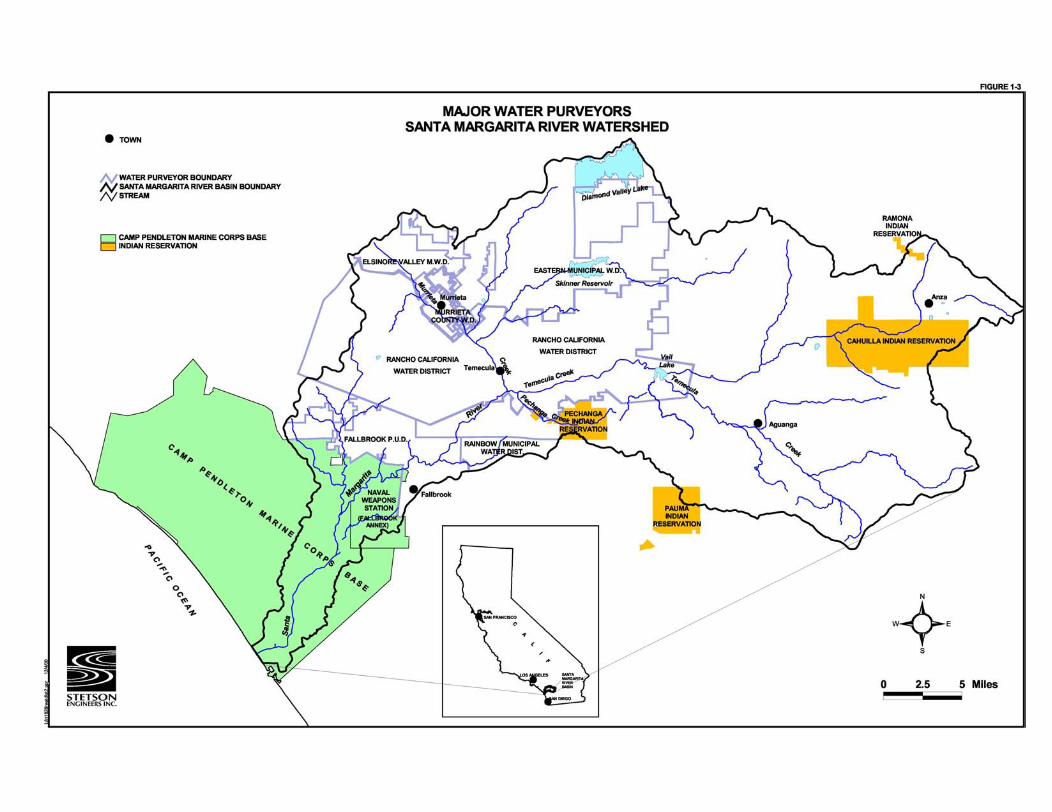
Water purveyors and substantial water users in the Santa Margarita River basin include water districts, Indian Reservations, mobile home parks, and several private landowners (Figure 1-3). A substantial water user is defined in the United States v. Fallbrook PUD litigation as a


Stetson Engineers Inc. / North State Resources 1-6 Permit 15000 Analysis March 23, 2001 Project Feasibility Study
water user who irrigates eight or more acres or produces or uses an equivalent quantity of water. The major water purveyors include: the Anza Mutual Water Company (AMWC); Eastern Municipal District (EMWD); Elsinore Valley Municipal Water District (EVMWD); Fallbrook Public Utility District (FPUD); Murrieta County Water District (MCWD); Rainbow Municipal Water District (RMED), Rancho California Water District (RCWD); Western Municipal Water District (WMWD); and Camp Pendleton, which includes the U.S. Naval Weapons Station, Fallbrook Annex. Except for Camp Pendleton, all other substantial water users are upstream of the Base and represent a threat to the surface water and ground-water supplies available to the Base. The federal court has assigned a Watermaster that accounts for substantial water users in the basin. An annual report produced by the Watermaster reports on water production, imports, exports, wastewater production, water quality, and hydrologic conditions affecting the basin. Both monthly and historical annual data of water production and use by each substantial water user is available in the annual report. Camp Pendleton also participates on the five-member panel of the Santa Margarita River Steering Committee that oversees and directs the Watermaster in his duties.

Stetson Engineers Inc./North State Resources 2-1 Permit 15000 Analysis March 23, 2001 Project Feasibility Study
2.0 HISTORICAL AND LEGAL BACKGROUND The historical and legal background surrounding Camp Pendleton’s water rights establish the foundation for this feasibility study. The various licenses and water rights described below represent valuable assets in water short Southern California. The rehabilitation of existing facilities and the recommendation to build future facilities described throughout this study represent physical solutions to maintaining and securing the Base’s valuable existing water rights. Future surface diversions addressed in the establishment of a license associated with Permit 15000 will allow the Base to meet its future demands, and most importantly, prevent other upstream water users from establishing appropriative rights to the waters of the Santa Margarita River. The continued urban development throughout Southern California and the Santa Margarita River basin also threatens the Base’s legal right to divert and store water. The cities of Temecula and Murrieta are considered among the fastest growing cities in California and are located within the same watershed, directly upstream of Camp Pendleton. Historical use of surface and ground water by these cities, and their predecessors, has established one of the longest lasting legal disputes in California history. The continued development upstream of the Base directly and indirectly threatens the Base’s self-reliance to meet existing and future water demands. Increased use of local water supplies by upstream water users diminishes the streamflow of the Santa Margarita River, potentially affecting the ability of the riparian habitat to meet the needs of numerous listed and endangered species living on Camp Pendleton. Potential loss of habitat could prevent the Base from pumping ground-water supplies to meet demand. This feasibility study directly addresses the need to perform under the Base’s existing license and water rights, as well as perform under any future license established by Permit 15000.
The Mexican government granted the lands of the Rancho Santa Margarita y Las Flores to Andres and Pio Pico in 1841. Following the annexation of California to the United States, a patent to all the lands of the rancho was issued in 1879. In 1882, the title to the rancho passed to Richard O’Neill and James Flood who operated the land as a cattle and farming ranch until 1942, when it was sold to the United States. Including the U.S. Marine Corps Base Camp Pendleton and the Naval Weapons Station, operated by the U.S. Navy, approximately 135,000 acres of land are used for military training, domestic, and incidental agricultural purposes.
The legal history of Camp Pendleton closely follows the land development surrounding
the Base, including those lands located directly upstream along the Santa Margarita River. Around the same time that the Mexican government granted the Santa Margarita y Las Flores land grant, the Pauba and Santa Rosa land grants were granted upstream in the areas now defined by the cities of Temecula and Murrieta. The legal battle for Santa Margarita River commenced

Stetson Engineers Inc./North State Resources 2-2 Permit 15000 Analysis March 23, 2001 Project Feasibility Study
in 1924 in San Diego County Superior Court. Beginning in 1926, the state court trial lasted four years resulting in an injunction issued against the defendant in 1930. Following reversal of the decision by the California Supreme Court in 1938, a division of the water between four parties was agreed to in the 1940 Stipulated Judgment. The following sections describe each of these disputes, their outcome, and how each relates to Permit 15000. Figure 2-1 depicts a timeline demonstrating the legal water rights history of Camp Pendelton. 2.1 1940 STIPULATED JUDGMENT
In 1924, Rancho Santa Margarita y Las Flores brought suit against the Vail Ranch, predecessors to the Rancho California Water District (RCWD). At that time, the two ranches were the only major water users on the Santa Margarita River and its tributaries. In 1930, after 444 court days, 55,171 pages of transcripts, and 2,201 exhibits the court rendered its decision. On appeal by the Vail Ranch, the California Supreme Court overturned the 1926 decision and a new trial was ordered. In October 1930, an injunction was issued to Vail Rancho to reduce ground-water pumping and the adverse impact it caused to the flow of the Santa Margarita River.
In the 1930s, following the Supreme Court’s order to retry the case, both litigation and
negotiations between the two parties re-commenced. The result was a Stipulated Judgment issued in 1940 allocating 2/3 of the natural water crop of the Santa Margarita River to Rancho Santa Margarita y Las Flores and 1/3 to the Vail Ranch. As successors in interest to these parties, the United States and Camp Pendleton are allocated 2/3 of the natural flow of the Santa Margarita River while the RCWD retains the remaining 1/3 share of the river. In addition to the division of streamflow between the two parties, the 1940 Stipulated Judgment also addressed issues such as minimum base flows, ground-water pumping, and surface storage of flood flows.
One of the many provisions of the 1940 Stipulated Judgment established a minimum flow
requirement of 3 cfs at the head of the Santa Margarita River between May 1st and October 31st of each year. The minimum flow of the river helped to provide surface water to the Santa Margarita y Las Flores Ranch and two other intervenors to the state lawsuit. Although there are many other provisions of the 1940 Stipulated Judgment, the division of the natural flows of the Santa Margarita River and the establishment of a base flow during the summer irrigation season provided a basis for the recent settlement discussed in Section 2.4 below.

Stetson Engineers Inc./North State Resources 2-3 Permit 15000 Analysis March 23, 2001 Project Feasibility Study
2.2 UNITED STATES V FALLBROOK PUBLIC UTILITIES DISTRICT
In 1945, investigations toward a more dependable water supply were initiated by the Fallbrook Public Utility District (Fallbrook PUD), the Department of the Navy, and the Bureau of Reclamation. A tentative agreement to build a reservoir at the De Luz damsite was reached between the parties in January 1949. Before a final agreement was reached, the United States brought suit against the Fallbrook PUD in 1951 to settle its title to the waters of the Santa Margarita River. The defendants to this lawsuit included not only the Fallbrook PUD, but also approximately 6,000 landowners in the Santa Margarita River basin. The State of California acted as an intervenor for its own rights as well as for the rights of its citizens.
A trial between the United States, the Santa Margarita Mutual Water Company
(SMMWC) and the State of California was held. The outcome of this trial assigned the United States with prescriptive and riparian rights to the flow that remained after upstream diversions by Vail Company (pursuant to the Stipulated Judgment) and other riparian owners. Thus, it was determined that there were no surplus waters subject to appropriations by others. The United States Circuit Court of Appeals for the Ninth Circuit, reversed this decision and ordered a new trial on appeals by the State of California and the SMMWC. During this trial, the court issued 45 Interlocutory Judgments identifying the riparian, appropriative and prescriptive rights to the waters of the Santa Margarita River and its tributaries. Although all riparian lands were identified in the Interlocutory Judgments, the court failed to quantify water rights to the plaintiff, defendants and intervenors. In 1963, the court issued an order establishing that there was surplus water subject to appropriation and that the United States had developed no prescriptive or appropriative rights other than for Lake O’Neill. The court also established that the 1940 Stipulated Judgment was no longer valid due to changed circumstances. The United States and the Fallbrook PUD appealed to the United States Court of Appeals for the Ninth Circuit. The decision by the appellate court upheld the findings from the lower court except that it reinstated the 1940 Stipulated Judgment.
On April 6, 1966, the District Court issued its Modified Final Judgment and Decree;
adopting 44 of the 45 Interlocutory Judgments and reinstating the 1940 Stipulated Judgment. The District Court retains continuing jurisdiction of all surface waters and supporting ground waters of the Santa Margarita River system. Water extracted from lands where subsurface flow does not add to, contribute to and support the Santa Margarita River stream system was found to be outside the Court’s jurisdiction.
Although there were many important aspects of the 1960’s federal litigation,
Interlocutory Judgments 24, 24A, and 37 established appropriative and riparian water rights for Camp Pendleton. Interlocutory Judgments 24 and 24A define the pre-1914 water right to divert and store water in Lake O’Neill, while Interlocutory Judgment 37 defines the rights of the United

Stetson Engineers Inc./North State Resources 2-4 Permit 15000 Analysis March 23, 2001 Project Feasibility Study
States as a riparian landowner. A description of the timing and use of these water rights is provided in Section 2.3 below. 2.2.1 THE 1968 MEMORANDUM OF UNDERSTANDING
In 1968, following seventeen years of litigation in Federal Court, the division and allocation of water between the United States and the Fallbrook PUD had yet to be established. Therefore, the United States and the Fallbrook PUD entered into an agreement to jointly pursue a physical solution to the litigation and share the water produced by the project. Under the terms of the agreement, referred to as the 1968 Memorandum of Understanding (MOU), the United States, through the Department of the Interior, agreed to conduct a feasibility study of the two-dam Santa Margarita Project.
Based on the 1968 MOU, if the project was determined to be feasible the yield of the project would be divided 60 percent to the United States and 40 percent to the Fallbrook PUD. The 4,000 AFY apportioned to Camp Pendleton through its license would continue to be delivered through the De Luz Dam (BOR, 1971). The Base would be allowed to fulfill all their water rights regardless of project yield, granted that the Fallbrook PUD would receive credit when their share of the project yield was less than 40%. 2.2.2 THE SANTA MARGARITA PROJECT
The Santa Margarita Project consisted of the 36,500 acre-foot Fallbrook Dam and Reservoir; the 142,950 acre-foot Deluz Dam and Reservoir; the Fallbrook Pumping Plants and Conveyance Line; the Cross-Base Aqueduct and Pumping Plants; recreation and fishing facilities; and wildlife conservation and enhancement management areas. The average project yield varied from 10,400 AF under initial conditions to 11,500 AF under 2020 conditions. Sixty percent would go to Camp Pendleton and forty percent to Fallbrook PUD.
As part of the Santa Margarita Project, a cross-base aqueduct was designed to deliver
water to training camps in the central and northern part of the Base through an 18-mile pipeline varying in diameter from 10 inches to 24 inches. The maximum capacity of the aqueduct would be 10 cfs near the dam site, decreasing to 2.5 cfs near the terminus. The Fallbrook conveyance line consisted of 1.6 miles of aqueduct, pumping plants, and other related facilities to lift the water 560 vertical feet from the toe of the Fallbrook Dam to a distribution tank. The maximum capacity of the pipeline and pumping facilities was designed to be 28 cfs.
Approximately 450 acres of private land near the Fallbrook Reservoir site were to be
acquired for recreation facilities to include campsites and related structures, fishing and boat launching facilities, access roads and parking, and other related facilities. Two plans were

Stetson Engineers Inc./North State Resources 2-5 Permit 15000 Analysis March 23, 2001 Project Feasibility Study
developed for fish and wildlife management and conservation areas. The first consisted of 1,800 acres of public domain and private land while the second totaled over 3,000 acres of both public and private land. 2.3 WATER RIGHTS AND WATER RIGHTS APPLICATIONS
The United States and the Fallbrook PUD hold various water rights permits to waters of the Santa Margarita River Basin. Among the various water rights applications is the United States Application 21471 for the two-dam project filed in September 1963 following the 1963 Final Judgment and Decree in the United States v. Fallbrook case. The Fallbrook PUD holds three 10,000 acre-foot permits issued in 1946 and 1947 for use at the Fallbrook Reservoir Site. Together, these water rights permits were to be used for diversion and storage of Santa Margarita River water in the two dam project.
Application 21471 addressed diversion from the Santa Margarita River and storage of up
to 4,000 AFY in the ground-water basins in Camp Pendleton and diversion and storage of up to 165,000 AFY in De Luz Reservoir. In 1973, the State Water Resources Control Board separated the two portions of Application 21471 and issued a license to the United States Navy for the ground water portion (Application 21471A) and allowed the surface water portion (Application 21471B) to be held by the U.S. Bureau of Reclamation. At the same time, the State Water Resources Control Board allowed Fallbrook PUD to assign its three 10,000 acre-foot permits to the U.S. Bureau of Reclamation for storage of water in Fallbrook Reservoir. Table 2-1 summarizes selected appropriative water rights on the Santa Margarita River held by Camp Pendleton, the U.S. Bureau of Reclamation, and Rancho California Water District. Water rights held by Camp Pendleton, but not listed below, also include the riparian water rights, the pre-1914 water right, and the rights to 2/3 share of the natural flow of the Santa Margarita River as established in the 1940 Stipulated Judgment. Interlocutory Judgment No. 37 establishes Camp Pendleton’s riparian water right to the use of the waters of the Santa Margarita River. The court established that the sands and gravels of the floodplain alluvium on Camp Pendleton contain subsurface flow of the Santa Margarita River, which the State of California legally considers to be surface flow. The Base may exercise its riparian rights for use within the watershed, but based on riparian rights alone, Camp Pendleton may not call on upstream users to reduce their use to allow Camp Pendleton greater sources of supply for use outside the watershed during times of limited water supply. The Base may call on upstream users to reduce their use based on Camp Pendleton’s appropriative right if those appropriative rights were established prior to the upstream users rights.

Stetson Engineers Inc./North State Resources 2-6 Permit 15000 Analysis March 23, 2001 Project Feasibility Study
TABLE 2-1 SELECTED APPROPRIATIVE WATER RIGHTS
SANTA MARGARITA RIVER BASIN PERMITS AND LICENSES
Application
Number
Current
Status Owner Date Filed Storage Site
Annual
Amount (AF) Storage Period
11518 Permit Rancho California
Water District
08/19/46 Vail
Reservoir
40,000 11/01 – 04/30
11587 Permit Bureau of
Reclamation
10/11/46 Fallbrook
Reservoir
10,000 01/01 – 12/31
12178 Permit Bureau of
Reclamation
11/28/47 Fallbrook
Reservoir
10,000 01/01 – 06/01
12179 Permit Bureau of
Reclamation
11/28/47 Fallbrook
Reservoir
10,000 01/01 – 06/01
21471 A License U.S. Navy 09/23/63 Underground 4,000 10/01 – 06/30
21471 B Permit Bureau of
Reclamation
09/23/63 De Luz
Reservoir
165,000 01/01 – 12/31
Although the Base may exercise the riparian right for use within the watershed, the Base
may not call on upstream users to reduce their use to allow Camp Pendleton greater sources of supply for use outside the watershed during times of limited water supply. Although many provisions are provided in Interlocutory Judgment No. 37, the court found that there is no water right recognized or provided by the State of California to the use of riparian water outside the watershed, but as the last water user on the stream, the court stated that the Base may use the waters which are physically available on or within its lands. Other appropriate uses of the water provided by the riparian water right include the use of water as a barrier to prevent salt-water intrusion in the Lower Ysidora sub-basin.
The pre-1914 vested water right that allows Camp Pendleton to divert water to Lake O’Neill is outlined in Interlocutory Judgments 24 and 24a. The Base’s right to divert water for storage in Lake O’Neill is an appropriative water right, and as such, there is no absolute legal restriction on use of the waters being used outside the Santa Margarita River Basin. Similar to the rights granted the Base under its riparian uses, Camp Pendleton may call upon upstream diverters to either curtail diversions or release water so diversion may be made. The pre-1914 water right allows the Base to divert water from the Santa Margarita River between April 1st and October 31st of each year at a rate not to exceed 20 cfs.
Stetson Engineers Inc./North State Resources 2-7 Permit 15000 Analysis March 23, 2001 Project Feasibility Study
2.4 YEAR 2001 WATER RESOURCE MANAGEMENT AGREEMENT
The 1924 State Court water rights case culminated with the 1940 Stipulated Judgment, which was eventually upheld by the Federal Court in 1968. This established the division of water between Camp Pendleton and the RCWD, successors to the original plaintiff and defendant, respectively. Based on the Stipulated Judgment, Camp Pendleton would receive 2/3 of the natural flow of the Santa Margarita River while the RCWD would be allocated the remaining 1/3 share of the river. As previously discussed, the 1940 Stipulated Judgment and the 1966 Modified Final Judgment and Decree allowed for other provisions of water management and allocation, including the construction of storage reservoirs, pumping of ground-water basins, and continuing jurisdiction of ground water that supports and contributes to the flow of the Santa Margarita River.
Following years of rapid urban growth, along with continued use and development of
ground water and surface water in the Upper Basin, Camp Pendleton experienced declines in the available streamflow during both the winter and non-winter months. This followed a declining trend in base flow since the mid-1940’s (Figure 2-2). Historical records of streamflow at the Gorge clearly showed the impact of development and the diminishing of natural streamflow. The declining trend in baseflow affected Camp Pendleton’s allocation to two-thirds of the natural flow of the Santa Margarita River. This decline of available surface water prompted Camp Pendleton to initiate discussions with the Rancho California Water District so that a dependable supply of surface water would be available for domestic, military, environmental, and agricultural needs on Camp Pendleton.
Initial discussion between Camp Pendleton and the RCWD commenced in 1987 and
continued through December 2000 with the issuance of a Draft Cooperative Water Resource Management Agreement (Agreement). Although this agreement is in draft form, it represents six years of negotiations between Camp Pendleton and the RCWD and allows Camp Pendleton to obtain, to the extent agreed to in the agreement, its 2/3 share of the natural baseflows of the Santa Margarita River. The Agreement also allows Camp Pendleton to receive additional supplies of water during periods of prolonged drought or for emergency needs. Agreed to within the framework of the 1940 Stipulated Judgment, the Agreement provides guidance for management of the watershed, including safe yield practices, surface water storage provisions and technical oversight procedures.
Referred to throughout the remainder of the feasibility study as “Augmented Flows,” the
RCWD will supplement daily streamflow in the Santa Margarita River in order to replicate, to the extent agreed to in the Agreement, two-thirds of the natural baseflow. The Agreement is structured such that baseflows will match monthly variations as well as variations due to changes in hydrologic conditions. Four different hydrologic conditions have been established that

Historical Streamflow at the GorgeWater Years 1925 to 1999
USGS Gage 44000
0.1
1
10
100
1000
10000
100000O
ct-2
4
Oct
-27
Oct
-30
Oct
-33
Oct
-36
Oct
-39
Oct
-42
Oct
-45
Oct
-48
Oct
-51
Oct
-54
Oct
-57
Oct
-60
Oct
-63
Oct
-66
Oct
-69
Oct
-72
Oct
-75
Oct
-78
Oct
-81
Oct
-84
Oct
-87
Oct
-90
Oct
-93
Oct
-96
Oct
-99
Date
Dai
ly S
trea
mfl
ow
at
the
Go
rge
[cfs
]
FIG
UR
E 2-2

Stetson Engineers Inc./North State Resources 2-8 Permit 15000 Analysis March 23, 2001 Project Feasibility Study
prescribe flows for “Extremely Dry,” “Below Normal,” “Above Normal” and “Very Wet” conditions. The flow requirements to the Santa Margarita River are further defined for Winter and Non-Winter periods for each hydrologic condition. While a single flow requirement has been established for the January through April winter period, monthly streamflow requirements have been established for the May through December Non-Winter period. The analyses provided in this feasibility study show the importance of the augmented flows to both the Base water supply and riparian ecological uses. Elevated base flows in both the summer and winter months will provide the Base with dependable water supplies that can be managed to meet existing water rights. The Agreement will provide augmentation to the Santa Margarita River varying between 3 cfs and 11.5 cfs, with a maximum annual augmentation not to exceed 4,000 AF. In addition to the daily augmentation flows, the Base will have the ability to draw 2,250 AFY from a ground-water storage bank during periods of extreme drought and/or emergencies. The augmentation of water to the Santa Margarita River is an important aspect to the success of this feasibility study, allowing the Base to produce ground water to satisfy its current and future needs. A copy of the Agreement will be added to this study at a later date as an addendum following the completion and signing of the document.
Stetson Engineers Inc./North State Resources 3-1 Permit 15000 Analysis March 23, 2001 Project Feasibility Study
3.0 GENERAL WATERSHED CHARACTERISTICS
The 744 square mile Santa Margarita River Basin lies within the counties of San Diego and Riverside in southern California. Hydrological conditions within the basin are controlled by wintertime tropical and northern pacific storm events; and, to a minor degree, summer monsoon events. While most of the precipitation occurs as rainfall throughout the watershed, snowfall may occur in the higher mountain ranges located in the upper reaches of the watershed. The confluence of the Murrieta and Temecula Creeks, which drain the upper parts of the watershed, forms the 27-mile-long Santa Margarita River, which flows to the Pacific Ocean.
Over 60 square miles of the Santa Margarita River Basin are located in the southern portion of Camp Pendleton. The Santa Margarita River flows from the coastal mountains to the coastal floodplain that begins near the Naval Hospital. The Santa Margarita River experiences extreme peak events during winter rains and minimum base flows during the summer months, typical of many southwestern stream systems. The following section of this report describes the environment, climate, geology and soils, ground water, surface hydrology, and water quality that characterize the watershed.
3.1 OVERVIEW
Four major watersheds are located on Camp Pendleton including the Santa Margarita, San Onofre, Las Pulgas, and San Mateo drainages. The Santa Margarita Watershed is divided into an upper basin and a lower basin where the Santa Margarita River passes through the Gorge. The Gorge is located just south of the town of Temecula as shown in Figure 3.1. The Upper Santa Margarita River Watershed contains the Upper Santa Margarita River Ground-Water Basin and the Lower Santa Margarita River Watershed contains the Lower Santa Margarita River Ground-Water Basin. The Santa Margarita Watershed is the largest basin on Camp Pendleton, totaling over 10 miles in length and draining approximately 60 square miles. Three hydrologic sub-basins within the Lower Santa Margarita River Ground-Water Basin, totaling approximately 4,580 acres, form the ground-water area that supplies domestic, military, and agricultural water to Camp Pendleton. The sub-basins are the Upper Ysidora, Chappo, and Lower Ysidora (Figure 3-2). The Upper Ysidora Sub-basin covers an area of approximately 860 acres. The Chappo Sub-basin covers an area of approximately 2,640 acres and the Lower Ysidora Sub-basin covers an area of 1,080 acres (Leedshill-Herkenhoff, 1988).
The Santa Margarita River Basin is typified by a relatively flat alluvial floodplain that
drains the watershed from the northeast to the southwest. Terraces and gently to steeply sloping hillsides border the watershed on Camp Pendleton. At the Lower Ysidora Sub-basin, the


Stetson Engineers Inc./North State Resources 3-2 Permit 15000 Analysis March 23, 2001 Project Feasibility Study
topography flattens as the river enters the Pacific Ocean. Surface and ground water is largely restricted to the alluvial regions that are bounded by rock units that form the sloped borders to the north and to the south of the alluvium. 3.2 EXISTING CONDITIONS
This section describes the existing environment in the Santa Margarita Basin as it relates to the primary resource areas associated with the feasibility study. Existing environmental conditions within the basin are described to provide a setting and baseline information for an environmental Opportunities and Constraints (O&C) analysis.
The purpose of the O&C portion of the feasibility study is to identify natural resource-
related constraints and opportunities associated with each Permit 15000 feasibility study alternative. Constraints may consist of timing of permit acquisition, location and status of sensitive natural resources such as threatened and endangered species or hazardous materials, or regulatory limitations related to critical habitat or delineated archaeological sites. Opportunities may include identification of suitable remediation or restoration sites, avoidance of sensitive biological or cultural resources, and potential reductions in mitigation obligations as a result of alternative project feature siting.
This O&C describes the potential environmental benefits and constraints of the four
alternatives outlined in the feasibility study. Four resource areas were identified that best illustrate project constraints from a time and budget perspective based on current regulatory compliance in these issue areas. The purpose of the upcoming Permit 15000 Environmental Impact Statement (EIS) will be to fully evaluate the potential environmental impacts under these four resource issue areas (as well as others resource issues that are mandated in the National Environmental Policy Act [NEPA]). This is not to say that other resource areas may or may not be directly or indirectly affected by implementation of the four alternatives for ground-water (GW) recharge augmentation described in this feasibility study, but these four resource areas were deemed to have the greatest potential to constrain project implementation timing and affect project costs:
w Biological Resources w Cultural Resources w Hazardous Materials and Wastes w Surface and Ground-Water Resources
Stetson Engineers Inc./North State Resources 3-3 Permit 15000 Analysis March 23, 2001 Project Feasibility Study
The feasibility study focuses on the engineering and, to a lesser degree, the economic feasibility of the various GW augmentation scenarios, while the O&C Analysis evaluates constraints using selected natural resource issue areas. Although the feasibility study focuses on the natural environment (geology and soils, surface water and ground water), certain man-made influencing elements, such as hazardous materials and wastes, are addressed in Chapter 7 of this study.
The Base comprises 135,000 acres, which includes the U.S. Naval Weapons Station
Annex in Fallbrook and the U.S. Naval Hospital. The Base shares its eastern border with the San Mateo Wilderness Area of the Cleveland National Forest. The U.S. Marine Corps purchased the Base land in 1942 to train Marines for deployment to World War II arenas. The federal government owns the 17.1 miles of coastal land to the mean high tide line. Camp Pendleton supports about 36,000 military personnel, employs 4,600 civilians, and houses more than 12,300 military dependents.
The majority of the undeveloped portion and the adjoining National Forest comprise one
of the largest remaining contiguous open space and wildlife habitat in coastal Southern California (Refer to Figure 1-1, Vicinity Map). The Base supports a unique mosaic of remnant vegetation communities endemic to California’s south coast. The relatively large, high quality fragments of riparian, coastal sage scrub, grasslands, and chaparral support a wide array of declining vertebrate species, including several species listed as threatened or endangered under the federal Endangered Species Act (FESA) and California Endangered Species Act (CESA). On average, air-to-ground training bases (such as Camp Pendleton) generally disturb a small percentage (less than 10 percent) of the Base’s surface area (personal communication, Col Tom Lillie, HQ USAF, November 2000). The remainder of the Base (including Camp Pendleton) provides environmental and habitat benefits to these threatened and endangered (commonly known as T&E) species.
The region of influence (ROI) for the O&C is defined as the area potentially directly
affected by project features in the four alternatives proposed in the feasibility study. This would include portions of the Upper Ysidora, the Chappo and the Lower Ysidora Subareas of the Santa Margarita River ground-water basin. The ROI also includes the southernmost portion of the U.S. Naval Weapons Station (Fallbrook Annex) as shown on Figure 1-2, Lower Ground-water Basin. 3.2.1 REGULATORY FRAMEWORK
The Base is subject to a variety of laws, regulations, and policies relating to the protection of natural resources and the human environment. Collectively, these statutes and policies comprise the regulatory framework within which project opportunities and constraints may be evaluated. This framework is intended to provide a foundation for the present evaluation

Stetson Engineers Inc./North State Resources 3-4 Permit 15000 Analysis March 23, 2001 Project Feasibility Study
and a basis for determining the scope and intensity of project impacts during project NEPA analysis.
As a Department of Defense facility, Base compliance with state environmental
regulations is limited by sovereign immunity and federal supremacy. Accordingly, the Base is not required to comply with certain regulations including the California Endangered Species Act (CESA) or the California Department of Fish and Game’s Streambed Alteration Agreement program. While compliance with these state regulations is not required, the Base is committed to protecting and conserving sensitive natural resources and typically evaluates project effects against all regulations. For this reason, both state and federal statutes are addressed in this framework.
The following laws, regulations, and policies were compiled from a variety of sources
and represent those most likely to impose a significant time or mitigation constraint on the project alternatives. It should not be considered an exhaustive list of all relevant regulations but instead an identification of those with the highest potential to impact project construction scheduling. Federal
National Environmental Policy Act (NEPA)
The National Environmental Policy Act (NEPA) requires federal agencies to assess the environmental consequences of major federal actions significantly affecting the quality of the human environment. NEPA further stipulates that federal agencies employ an interdisciplinary approach in the decision making process and develop means to ensure that environmental values are given appropriate consideration along with economic and technical considerations. Typically, NEPA compliance is documented in an Environmental Assessment (EA) or Environmental Impact Statement (EIS).
Should the Santa Margarita River Recharge and Recovery Enhancement Program
proceed to the implementation stage, NEPA compliance would be required for the project. The selection of an alternative from among those presented in this Feasibility Study would represent a federal action or “project” under NEPA. For alternatives considered for implementing Permit 15000, the Marine Corps Base, Camp Pendleton would likely be lead agency.
Clean Water Act
Section 404 of the Clean Water Act regulates the discharge of dredged or fill material into waters of the United States including wetlands and other waters. The Act also authorizes the

Stetson Engineers Inc./North State Resources 3-5 Permit 15000 Analysis March 23, 2001 Project Feasibility Study
U.S. Army Corps of Engineers (USACE) to issue permits for discharge into, or fill of, wetlands. Projects are permitted under either a federal nationwide or an individual permit. The specific type of permit required for individual projects is determined on a case-by-case basis through consultation with the USACE. The USACE reviews permit applications following the guidelines that have been established in Section 404(b)(1) of the Act. USACE, Regulatory Branch, have indicated that an individual permit would likely be required for some alternatives discussed in the feasibility study and that Section 404(b)(1) guidelines must be followed during project alternatives development.
Section 404(b)(1) guidelines mandate that no discharge of dredged or fill material shall
be permitted if there is a practicable alternative to the proposed discharge that would have less adverse impact on the aquatic ecosystem, provided the alternative does not result in other significant adverse environmental consequences. The analysis of alternatives under NEPA can provide the information for the evaluation of alternatives under Section 404(b)(1) guidelines. To ensure this outcome, alternatives development in the NEPA Process should conform to Section 404(b)(1) guidelines.
Prior to issuance of a 404 permit, the USACE must ensure that project related discharges do not violate State and federal water quality standards. The State Water Resources Control Board (SWRCB), through the Regional Water Quality Control Board (RWQCB), is responsible for issuing water quality certifications, or waivers thereof, pursuant to Section 401 of the Clean Water Act.
The RWQCB also regulates point source and non-point source waste discharges through
the issuance of National Pollutant Discharge Elimination System (NPDES) permits. An NPDES general permit authorizes discharge of storm water from construction sites involving five acres or more and prohibits the discharge of materials other than storm water such as hazardous substances. NPDES general permits also require preparation of a Storm Water Pollution Prevention Plan and monitoring program. Issuance of an NPDES general permit supercedes and incorporates water quality certification. A NPDES general permit may be required for this Project.
Federal Endangered Species Act (FESA)
Section 7 of FESA requires all federal agencies, in consultation with the U.S. Fish & Wildlife Service (USFWS) and National Marine Fisheries Service (NMFS), to ensure that their actions do not jeopardize the continued existence of endangered or threatened species or result in the destruction or modification of critical habitat for these species. The NMFS is the lead agency responsible for consultation for projects that may affect endangered anadromous fish.

Stetson Engineers Inc./North State Resources 3-6 Permit 15000 Analysis March 23, 2001 Project Feasibility Study
Should the Santa Margarita River Recharge and Recovery Enhancement Program proceed, the federal lead agency under NEPA should request from the USFWS information on the presence of listed threatened or endangered species or their critical habitat that are likely to occur in the project area. This information would form the basis for a Biological Assessment (BA) which would determine effects on listed species as a result of project actions. If the Project would result in impacts to listed species, formal consultation with the USFWS or NMFS must be initiated by the Department of Defense. The consultation process would result in a determination (Biological Opinion) by either the USFWS or NMFS whether the Project would jeopardize the continued existence of listed species affected by the Project. If the Biological Opinion finds that the Project would jeopardize the continued existence of a listed species (jeopardy opinion), then reasonable and prudent measures would be incorporated into the Project alternatives to reduce potential affects to a level that is not likely to jeopardize the continued existence of the species.
Migratory Bird Treaty Act (MBTA)
The MBTA of 1918 was enacted to provide legal protection to migratory birds. Except as allowed by implementing regulations, the Act makes it unlawful to pursue, hunt, kill, capture, possess, buy, sell, purchase, or barter any migratory bird, including the feathers or other parts, nests, eggs, or migratory bird products. The MBTA is the primary statute for protection against destruction of nests of raptors and neotropical migrant songbirds.
Executive Order 11998 (Floodplain Management)
Executive Order 11998 requires all federal agencies to take actions to reduce the risk of flood loss, restore and preserve the natural and beneficial values in floodplains, and minimize the impacts of floods on human safety, health, and welfare. To comply with this Executive Order, project alternatives consider ways to avoid the risk of flood loss and identify methods to restore the natural functions and beneficial values of floodplains. These are all identified objectives for the Santa Margarita River Recharge and Recovery Enhancement Program.
Executive Order 11990 (Protection Of Wetlands)
Executive Order 11990 requires federal agencies to follow avoidance, mitigation, and preservation procedures with public input before proposing new construction in wetlands. To comply with Executive Order 11990 the federal agency will coordinate with the USACE, under Section 404 of the Clean Water Act, and mitigate for impacts to wetland habitats.

Stetson Engineers Inc./North State Resources 3-7 Permit 15000 Analysis March 23, 2001 Project Feasibility Study
Section 106 Of the National Historic Preservation Act
The National Historic Preservation Act (NHPA) requires coordination with the State Historic Preservation Officer (SHPO) and the Advisory Council on Historic Preservation (ACHP) regarding the effects that federal action may have on properties listed, or eligible for listing, on the National Register of Historic Places. The National Park Service (NPS) has been identified as having historic or cultural significance at the national, State and local levels. A list of these properties is available in the National Register of Historic Properties maintained by the NPS.
Archaeological Resource Protection Act of 1979
The purpose of this Act is to secure, for the present and future benefit of the American people, the protection of archaeological resources and sites which are on public lands and Indian lands, and to support the exchange of information between governmental authorities, the professional archaeological community, and private individuals having collections of archaeological resources and data which were obtained before October 31, 1979.
The Archaeological Resource Protection Act of 1979 acknowledges that archaeological
resources on public lands and Indian lands are an accessible and irreplaceable part of the Nation's heritage. It addresses the issues of urbanization, inadequate Federal laws, the extent of potentially valuable information, and protection and security of archeological resources. (University of Maryland College Park website, Nov. 30, 2000).
Native American Graves Protection and Repatriation Act (NAGPRA) of 1990.
The Native American Graves Protection and Repatriation Act (25 U.S.C. §§ 3001-3013) requires museums and Federal agencies to (1) document certain Native American human remains and cultural items within their collections, (2) notify all Indian Tribes and Native Hawaiian organizations that are or are likely to be affiliated with these holdings, and (3) provide an opportunity for the repatriation of appropriate human remains or cultural items.
These requirements apply to any department, agency, or instrumentality of the United
States, except the Smithsonian Institution. They also apply to any institution or state or local government agency (including any institution of higher learning) that has possession or control over human remains or cultural items and received Federal funds. Federal agencies are responsible for ensuring that the requirements are met for all collections from their lands, whether the collections are held by the Federal agency or by a non-Federal institution.

Stetson Engineers Inc./North State Resources 3-8 Permit 15000 Analysis March 23, 2001 Project Feasibility Study
The statute established general processes for implementing these requirements. The Secretary of the Interior is responsible for promulgating regulations to carry out the law. This document describes the summary, inventory, and notification provisions of the law and outlines the processes for implementation presently under consideration by the Secretary in the development of regulations. Museums and Federal agencies may wish to consider these processes in any repatriation actions they take prior to promulgation of the required regulations, but this document does not have the force and effect of a regulation and is not legally binding on any museum or Federal agency (National NAGPRA website, Nov. 30, 2000).
State
Section 1601 Streambed Alteration Agreement
Section 1601 of the California Fish and Game Code requires public agencies that propose work that will divert or obstruct the natural flow or change the bed, channel, or bank of any river of stream to enter into a Streambed Alteration Agreement with the CDFG. Streambed Alteration Agreements are not required for federal actions contained entirely within federal land ownership, although in most cases federal agencies enter into such an agreement.
3.2.2 BIOLOGICAL RESOURCES
The headwaters of the Santa Margarita River originate on the western slopes of the Santa Margarita Mountains, which are part of the Peninsular Ranges, that transverse north/south from Orange and Riverside counties into Mexico. The river flows southwesterly towards the Pacific Ocean. Santa Margarita Peak, at 3,189 feet, is about ten miles inland from the Pacific Ocean.
The Santa Margarita River corridor is relatively undisturbed, and contains extensive high
quality riparian habitats. The lower section of the river fans out into a broad, alluvial plain that terminates at the Pacific Ocean. The project area represents the least disturbed, most continuous corridor of extensive riparian habitat remaining in coastal Southern California (SMR Foundation, 1991), thus several T&E species occur in, or near, the river. Below the confluence of Murrieta and Temecula Creeks, the Santa Margarita is Southern California’s only “free flowing” river with no major dams.
Over 800 plant species have been confirmed on Camp Pendleton; almost one-quarter of
these are non-natives, or exotics. These species combine to form plant communities and wildlife habitats of the Camp. They occur in their current mosaic pattern as a result of climate, slope and aspect, soil substrate (especially as it affects water and nutrient availability), fire patterns, and man-related disturbances. Fires are a common occurrence in coastal sage scrub communities. In

Stetson Engineers Inc./North State Resources 3-9 Permit 15000 Analysis March 23, 2001 Project Feasibility Study
many areas of the Base, the coastal sage scrub species occur sparsely in a grassland matrix as a result of frequent fire. Fire ignition rates are unusually high on Camp Pendleton, due to training activities with vehicles, weaponry and pyrotechnics.
3.2.2.1 Vegetative Communities
Vegetative community information was gathered from a variety of sources including A Manual of California Vegetation (Sawyer Keeler-Wolfe 1999), Preliminary Descriptions of the Terrestrial Natural Communities of California (Holland 1986), Wildlife Habitats of California (Mayer and Laudenslayer 1990), and Vegetative Communities of the Marine Corp Base, Camp Pendleton (Zedler et al 1997). Vegetative communities on the Base have been described using several different vegetation classification systems with more recent efforts describing the communities using a combination of the Holland and Sawyer and Keeler-Wolfe systems. Although usage of the Sawyer and Keeler-Wolfe system has largely replaced the Holland system, community descriptions often continue to be described using the Holland system to facilitate more direct interpretation using long-standing, standardized information sources such as the California Natural Diversity Database (CNDDB). This O&C analysis describes vegetative communities within the project area (ROI) using only the Sawyer and Keeler-Wolfe system as this system has now been adopted and is in regular use by natural resource regulatory agencies and conservation organizations. In addition, the Sawyer and Keeler-Wolfe system is more refined than the Holland system and describes vegetative series in a more or less hierarchical manner allowing for use at a variety of spatial scales.
The following descriptions of vegetative series (communities) have been documented
within the project area were developed using the preceding methods: Ruderal Communities
Areas that have been severely disturbed, such as road fills and construction sites, or that are subject to recurrent disturbance, such as roadsides, support vegetation in which weedy grasses and forbs (non-grasslike plants) predominate. Annual grasses of the same species as those of the annual grasslands can be very abundant. The flora of such disturbed areas is dominated by introduced exotic species such as mustards (Brassica spp., Hirschfeldia incana), Russian thistle (Salsola spp.), fennel (Foeniculum vulgare), and wild lettuces (Lactuca spp.). It is generally believed that the ability of exotic species to invade disturbances arises from their relationship to old-world ancestors that have co-existed with humans for millennia and, thus, are better able than native species to exploit disturbances. Most of our worst weedy species are annuals or short-lived perennials with high seed production and small easily dispersed seeds. But there were disturbed areas before Europeans arrived, and some native species also are able to

Stetson Engineers Inc./North State Resources 3-10 Permit 15000 Analysis March 23, 2001 Project Feasibility Study
thrive where disturbance is frequent or intense. For example, the native telegraph weed (Heterothica grandiflora) is common along the edge of highways and in vacant lots.
If ruderal areas are left undisturbed, they generally undergo succession toward one or
another of the more stable and less weedy community types such as coastal sage scrub or grassland. If soil disturbance has not been severe, recovery can be complete. The time for this succession to occur varies widely from a few years to centuries or longer. In areas subject to recurrent disturbance, such as roadsides where traffic and road maintenance provide continual disruption, the vegetation can be maintained as a ruderal community more or less permanently.
Ruderal communities are a mixed blessing. They provide valuable erosion protection,
and the taller herbs provide concealment cover that may be useful in training exercises. But such communities also are a threat to biodiversity because they create a continual rain of propagules into native vegetation and thus can colonize natural disturbances such as burns and compete with more desirable natives. (Paul Zedler et. Al., February 1997).
Non-Native Grasslands
Non-native grasslands are prevalent on the Base and throughout California replacing once extensive native annual and perennial grasslands. This type on the Base consists of one or more of the following introduced species; ripgut (Bromus diandrus), foxtail chess (B. madritensis rubens), soft chess (B. mollis), slender oat (Avena barbata), wild oat (A. fatua), wild barley (Hordeum sp.), Italian ryegrass (Lolium multiflorum). Non-native grasslands provide habitat value for some listed wildlife species and support a few sensitive plant species.
Mixed Willow Series
The mixed willow series is located throughout Cismontane and Transmontane California. This series is typically found seasonably flooded freshwater wetland habitats in floodplains and along low gradient river and stream banks. In this series, more than one willow species is dominant in the shrub or tree canopy. Some other species present include arroyo willow, bigleaf maple, black cottonwood, black willow, California sycamore, Fremont cottonwood, Hooker willow (Salix hookeriana), narrowleaf willow, Pacific willow (Salix lucida ssp. lasiandra), red alder (Alnus rubra), red willow (Salix laevigata), Sitka willow (Salix sitchensis), and white alder. Trees generally do not reach a height of greater than ten (10) meters. The canopy is continuous, shrubs are sparse, and the ground layer is sparse.
Stetson Engineers Inc./North State Resources 3-11 Permit 15000 Analysis March 23, 2001 Project Feasibility Study
Arroyo Willow Series
The arroyo willow series is located along the northern and central coasts, the Central Valley, the Klamath, Sierra Nevada, and Cascade foothills, southern California, the Great Basin, and Baja California. This series is typically found in seasonably flooded freshwater wetland habitats in floodplains or along low gradient river and stream banks. Arroyo willow is the sole or dominant shrub or tree in the canopy. Other species such as bigleaf maple, black cottonwood (Populus balsamifera), buttonbush (Cephalanthus occidentalis), California sycamore (Platanus racemosa), coyote brush (Baccharis pilularis), Fremont cottonwood, Mexican elderberry (Sambucus mexicana), mulefat (Baccharis salicifolia), red osier (Cornus sericea), wax-myrtle (Myrica californica), white alder, and willows may also be present. Trees generally do not reach a height of greater than ten (10) meters. The canopy is continuous, shrubs are sparse and the ground layer can be sparse or abundant.
Black Willow Series
The black willow series is located along the northern and southern coasts, the Central Valley, the Cascade and Sierra Nevada foothills, montane peninsular ranges, and the Mojave and Colorado deserts. This series is typically found in seasonably flooded freshwater wetland habitats in floodplains, along low gradient river and stream banks, or meadow edges. Black willow is the sole or dominant shrub or tree in the canopy. Other species such as California sycamore, coyote brush, Fremont cottonwood, Mexican elderberry, mulefat, white alder, and willows may be present. Trees generally do not reach a height of greater than thirty (30) meters. The canopy is continuous, shrubs are sparse and the ground layer is variable.
Red Willow Series
The red willow series is located throughout Cismontane and Transmontane California, and intermountain West. This series is typically found seasonably flooded freshwater wetland habitats in ditches, floodplains, lake edges, and along low gradient river and stream banks. Red willow is the sole or dominant shrub or tree in the canopy. Other species such as California sycamore, coyote brush, Fremont cottonwood, Mexican elderberry, mulefat, white alder, and willows may be present. Trees generally do not reach a height of greater than fifteen (15) meters. If the stand is red willow shrubland, emergent trees may be present. The canopy is continuous, shrubs are sparse, and the ground layer is variable.

Stetson Engineers Inc./North State Resources 3-12 Permit 15000 Analysis March 23, 2001 Project Feasibility Study
Mixed Willow Series
The mixed willow series is located throughout Cismontane and Transmontane California. This series is typically found seasonably flooded freshwater wetland habitats in floodplains and along low gradient river and stream banks. In this series, more than one willow species is dominant in the shrub or tree canopy. Some other species present include arroyo willow, bigleaf maple, black cottonwood, black willow, California sycamore, Fremont cottonwood, Hooker willow (Salix hookeriana), narrowleaf willow, Pacific willow (Salix lucida ssp. lasiandra), red alder (Alnus rubra), red willow (Salix laevigata), Sitka willow (Salix sitchensis), and white alder. Trees generally do not reach a height of greater than ten (10) meters. The canopy is continuous, shrubs are sparse, and the ground layer is sparse.
Diegan Coastal Sage Scrub Series
The Diegan coastal sage scrub is typically found along the southern coasts of California. Steep slopes and dry sites are home to this series. The most dominant shrub species are soft-leaved, drought-deciduous shrubs that are generally less than six (6) feet high. Drought-deciduous species refers to species which drop leaves late in the summer season. By doing this, they reduce water stress. The Diegan coastal sage scrub community has suffered great losses due to the wide-spread urbanization typical of this area in southern California. Various coastal sage sub-types have been recognized across the different gradients of exposure, elevation, and soil type.
Fremont Cottonwood Series
The Fremont cottonwood series is located along the northern, central, and southern coasts, Central Valley, the Klamath, Sierra Nevada, and Cascade foothills, montane traverse ranges, montane peninsular ranges, the Great Basin, Mojave and Colorado deserts, and Baja California. This series is typically found in intermittently or seasonably flooded freshwater wetland habitats in riparian corridors, floodplains subject to high-intensity flooding, and along low gradient river and stream banks and terraces. Fremont cottonwood is the sole or dominant tree in the canopy. Other species such as black willow, box elder, California sycamore, narrowleaf willow, Oregon ash (Fraxinus latifolia), Pacific willow, red willow, walnuts (Juglans californica ssp.), and yellow willow may be present. Trees generally do not reach a height of greater than twenty-five (25) meters. The canopy is continuous or open. Shrubs and grape lianas are infrequent to common, and the ground layer is variable.

Stetson Engineers Inc./North State Resources 3-13 Permit 15000 Analysis March 23, 2001 Project Feasibility Study
California Sycamore Series
The California sycamore series is located along the central and southern coasts, the Sacramento Valley, the Sierra Nevada foothills, montane traverse ranges, montane peninsular ranges, the Mojave and Colorado deserts, and Baja California. This series is typically found in permanently saturated freshwater wetland habitats. Riparian corridors, braided depositional channels of intermittent streams, gullies, springs, seeps, stream and river banks, and terraces adjacent to floodplains subject to high-intensity flooding are common locations this series is found. Soils are typically alluvial, open cobbly, and rocky. In the uplands, this series is found on rocky slopes. California sycamore is the sole or dominant tree in the widely spaced canopy. Other species such as arroyo willow, black willow, California bay, coast live oak, Fremont cottonwood, red willow, valley oak (Quercus lobata), white alder, and yellow willow may be present. Trees generally do not reach a height of greater than thirty-five (35) meters. The canopy is open, shrubs are infrequent to common, and the ground layer is grassy. For this series, grazing causes a reduction in regeneration. The California sycamore also suffers from anthracnose in the spring.
Sensitive Species
The Base hosts a wide variety of sensitive wildlife and plant species including species listed as threatened or endangered under the FESA or CESA, state and federal species of special concern, California Native Plant Society (CNPS) List 1 and 2 species, and species identified by other state and federal agencies as declining or vulnerable.
For purposes of the O&C, those listed species which occur in the vicinity of the ROI and
have the potential to constrain implementation of any project Alternative were identified and listed in Table 3-1. Identification and consideration of additional species is beyond the scope of this O&C analysis but will be appropriate for NEPA review of the selected Alternative.
The Camp, as well as the U.S. Fish and Wildlife Service, carefully monitor the following T&E species in the project ROI:
The California Gnatcatcher inhabits arid coastal scrub communities below 1,500 feet in
elevation throughout the coastal foothills of San Diego County. Gnatcatchers roost and nest in low, dense coastal scrub habitat (i.e., California buckwheat and coastal sage) in arid washes, on mesas, and on the slopes of coastal hills. Peak egg laying occurs in April and May. Brood parasitism by cowbirds occurs in most of the counties where California Gnatcatchers historically occur in southwest California. Eggs and nestlings are subject to predation by a variety of mammals, birds, and reptiles.

Stetson Engineers Inc./North State Resources 3-14 Permit 15000 Analysis March 23, 2001 Project Feasibility Study
Table 3-1 Threatened and Endangered Species in the Vicinity of the ROI
Scientific Name/ Common Name
Status: USFWS/CDFG/
CNPS/Other
Habitat in Project Area
Comments
Invertebrates Branchinecta sandiegonensis San Diego Fairy Shrimp
Endangered/None Vernal pools Does not occur within the ROI and would not be impacted by project actions
Euphydryas editha quino Quino Checkerspot Butterfly
Endangered/None Sunny openings within chaparral & coastal sage shrublands in parts of riverside & San Diego counties.
Likely occurs within the ROI and would likely be impacted by project alternatives
Streptocephalus woottoni Riverside Fairy Shrimp
Endangered/None Vernal pools Does not occur within the ROI and would not be impacted by project actions
Amphibians Bufo microscaphus californicus Arroyo Southwestern Toad
Endangered/None/Species of Concern
semi-arid regions near washes or intermittent streams, including valley-foothill and desert riparian, desert wash, etc.
Likely occurs within the ROI and would likely be impacted by project alternatives
Birds Vireo bellii pusillus (nesting) Least Bell's Vireo
Endangered/Endangered
Summer resident of southern California inhabits low riparian growth in vicinity of water or in dry river bottoms; below 2000 ft.
Likely occurs within the ROI and would likely be impacted by project alternatives.
Empidonax traillii extimus Southwestern Willow Flycatcher
Endangered/None Neotropical migrant nesting in willow and Baccharus sp. In riparian and willow scrub habitats.
Likely occurs within the ROI and would likely be impacted by project alternatives
Polioptila californica californica Coastal California Gnatcatcher
Threatened/None/Species of Concern
Obligate, permanent resident of coastal sage scrub below 2500 ft in southern California.
Likely occurs within the ROI and would likely be impacted by project alternatives.
Mammals Dipodomys stephensi Stephens' Kangaroo Rat
Endangered/Threatened
Primarily annual & perennial grasslands, but also occurs in coastal scrub & sagebrush with sparse canopy cover.
Does not occur within the project ROI and would not be impacted by project actions
Plants Eryngium aristulatum var. parishii San Diego Button-Celery
Endangered/Endagered/1B
Vernal pools, coastal scrub, valley and foothill grassland. In California, known only from Riverside & San Diego counties.
Does not occur within the project ROI and would not be impacted by project actions
Least Bell’s Vireo is a subspecies of the Bell’s Vireo. The Least Bell’s Vireo breeds in
southwestern California and adjacent northwestern Baja California. They arrives at Camp Pendleton between mid-March to early April, and leave for their wintering grounds in Baja California by early September. Vireos primarily inhabit low, dense willow-dominated riparian habitats with lush understory vegetation. They are usually found near water, but Vireo also

Stetson Engineers Inc./North State Resources 3-15 Permit 15000 Analysis March 23, 2001 Project Feasibility Study
inhabits thickets along dry, intermittent streams. The Bell’s Vireo is known for its lively, complex song. However, given its penchant for dense vegetation, it is more often heard than seen. They typically arrive from Mexican wintering areas by the end of March, and depart by the end of August.
In 1986 the Camp executed a Memorandum of Understanding (MOU) with the U.S. Fish
and Wildlife Service for the purpose of managing and perpetuating the Vireo on Camp Pendleton. Management activities under the MOU include habitat enhancement, removal of exotic species, habitat management to maintain an appropriate balance of the various successional stages, and cowbird trapping. Low of habitat, combined with increased brood parasite pressure from Brown-headed Cowbirds, snakes and cats, led to the Bell’s Vireo being listed as endangered by the California Department of Fish and Game and the U.S. Wildlife Service. The Camp also conducts annual Bell’s Vireo censuses to determine breeding activity and reproductive success. According to the California Department of Fish and Game, numbers of Bell’s Vireo are so low that they may be nearly extinction in California.
The Southwestern Willow Flycatcher is a nearly transcontinental species that breeds
widely across temperate North America, and migrates for the winter to Middle and northwestern South America. All four subspecies are completely migratory. The SW Willow Flycatcher usually arrives in early May, and it departs the latter half of August or early September. It inhabits riparian areas along rivers, streams and other wetlands, where dense growths of willows, mulefat, tamarisk, and other plants with a scattered cottonwood overstory are present. Males maintain and advertise an area by singing. Territorial defense begins immediately after spring arrival. Females occasionally sing, apparently when stimulated by territorial disputes.
Throughout the 20th century the subspecies has declined precipitously, becoming
restricted to a few small, scattered populations. However, the SW Willow Flycatcher population on Camp Pendleton is believed to be stable at this time; however, the population has varied considerably over the years. The loss and degradation of riparian habitat (i.e., heavy grazing of willows by livestock), combined with brood-parasitism by the invading Brown-headed Cowbird, are apparently responsible for the SW Willow Flycatcher’s decline. Loss of riparian wetlands has been especially severe in California, estimated at 91 percent. In coastal southern California these losses have been due largely to the conversion of floodplains to agriculture, overgrazing, residential and/or commercial development, and flood-control projects.
The Arroyo Southwestern Toad is found in the southern part of the Coast Range from
northern San Luis Obispo County, south to Baja California. The Southwestern toad is found in semi-arid regions near washes or intermittent streams, in mixed chaparral and sagebrush. They are often found near rivers with sandy banks, willows, cottonwoods and sycamores in valley-foothill and desert riparian habitats. They inhabit shallow, loose gravelly areas of streams in

Stetson Engineers Inc./North State Resources 3-16 Permit 15000 Analysis March 23, 2001 Project Feasibility Study
drier portions of its range. This type of habitat is extremely susceptible to seasonal fluctuations. Breeding occurs on large streams with persistent water from late March to July. Vegetation communities on the Camp that would support this species are open sand/gravel areas, shallow streamside edge freshwater marsh, riparian scrub and mature stands of riparian woodland, and mixed woodland with little vegetative cover at ground level within 300 feet of stream channels.
There is no specific information on the seasonal movement/migration of the Arroyo SW toad (California Department of Fish and Game, in cooperation with the California Interagency Wildlife Task Group, California Wildlife Habitat Relationships Systems, 1999). The toad’s breeding season is primarily March to July, and occasionally into September. On Camp Pendleton confirmed sitings of the Arroyo SW Toad have been reported in the upper Santa Margarita River and De Luz Creek.
On Camp Pendleton the Stephens’ Kangaroo Rat is typically found in upland, disturbed
areas such as dirt roadsides, firebreaks and grazing lands. Stephens’ Kangaroo Rat (SKR) occurs primarily in annual and perennial grassland habitats, but may occur in coastal scrub or sagebrush with sparse canopy cover, or in disturbed areas (such as the Naval Weapons Station, much of which has been disturbed by grazing activities). Most individuals occupy abandoned pocket gopher burrows, but some individuals excavate their own burrows in firm soil.
SKR have been sited in the San Jacinto Valley, western Riverside County south to Vista,
and San Diego County. The number of verified localities has declined over the past half century, due mainly to urbanization and cultivation of suitable habitat. There is little information available on the SKR’s reproductive activities. It is believed that they breed from April into June (California Department of Fish and Game, in cooperation with the California Interagency Wildlife Task Group, California Wildlife Habitat Relationships Systems, 1999). Predators to the SKR include snakes, owls, and predatory mammals.
3.2.3 CULTURAL RESOURCES
Published literature states that Native Americans as far back as 10,000 B.C inhabited Camp Pendleton. The region’s mild climate and wealth of natural food and water sources infuses Camp Pendleton with a rich cultural history. The original inhabitants are thought to have been bands of hunters-gatherers that immigrated from the Great Basin. Milling and shellfish-gathering tribes followed them. The Native American groups that occupied the Camp up until 1769 are known for their use of mortar and ceramics. They were Shoshonean-speaking people know as Luiseno (after the San Luis Rey Mission) and Juaneno (after mission San Juan Capistrano). They gathered shellfish and vegetable foods near the coast, and also extended into upland inland areas for acorn gathering and deer hunting. It is believed there may have been about 10,000 Native Americans in the Camp Pendleton area at the time of European contact in
Stetson Engineers Inc./North State Resources 3-17 Permit 15000 Analysis March 23, 2001 Project Feasibility Study
1769, when the San Diego Mission was founded. This was the first mission in Alta California. The mission at San Luis Rey de Francia followed in 1798.
Much of the Santa Margarita and other nearby watersheds were used by Mission San Luis
Rey to raise crops and livestock. The missions were under the control of Franciscan monks when Spain was in control of Mexico. After the Mexicans overthrew the Spanish in 1821, the new government disbanded the missions and appointed civilian administrators to replace the Franciscans. Pio Pico and his brother, Andres, were appointed to administer the San Luis Rey Mission. Under the Mexican Liberal Colonization Act of 1824 the brothers were then granted cattle ranchos, or “land grants”. As friends of the Mexican leadership, by 1841 the Pico brothers had acquired the Santa Margarita, San Onofre and the Las Flores properties. They then changed the name of their vast land holdings to Rancho Santa Margarita y Las Flores.
The Rancho Santa Margarita ranch house chapel was first built in 1810. It was the
former wine cellar and blacksmith shop of Pio Pico, and is part of the current home of the Commanding General, 1st Marine Expeditionary Force, Camp Pendleton. The chapel has been restored after being damaged in the 1993 flood at the Camp. Cattle and sheep were grazed on Rancho Santa Margarita, and grazing leases continued after the military took over the property in 1942, during World War II. By 1946, the Department of Defense decided that Camp Pendleton would be the headquarters for all Marine Corps activities on the West Coast.
3.2.4 ARCHAEOLOGICAL AND HISTORICAL RESOURCES
The region’s mild climate and abundance of natural food and water sources afford Camp Pendleton a rich cultural history. The cultural assets of the Camp are summarized in the 1994 Historic and Archaeological Resources Preservation Plan (commonly referred to as the HARP). The HARP sets objectives for managing cultural resources on the Camp. The Plan is meant to provide local performance standards for compliance with state and federal laws and regulations regarding archaeological and historic resources on the Camp.
The HARP describes at least 168 prehistoric sites that are mapped on Camp Pendleton
outside of impact (restricted access) and cantonment areas, which have not been surveyed. Four of these prehistoric sites are eligible for listing on the National Register. Sixty-seven sites may be eligible, but require further testing for final determination by the State Historic Preservation Officer (SHPO). There are 50 known historic properties on the Camp. The ranch house, chapel and bunkhouse from the Santa Margarita y Las Flores Rancho complex are listed on the National Register of Historic Places (NRHP).
Stetson Engineers Inc./North State Resources 3-18 Permit 15000 Analysis March 23, 2001 Project Feasibility Study
3.2.5 PALEONTOLOGICAL RESOURCES
Camp Pendleton has not been systemically surveyed for fossils. However, ancient species of fish, frogs, lizards, turtles, birds, rodents, mammoths and other mammals have been recorded on the Camp (Camp personnel, 1972).
At least four major fossil discoveries have occurred on the Camp since the 1960’s. A
mammoth femur bone that weighed over 60 pounds was discovered in 1966. A mammoth tusk was unearthed by erosion in a coastal arroyo in 1984. Other discoveries on the Camp include a baleen whale skeleton and a sea cow humerus dating back about 9 million years ago, to the Pliocene era. Two mid-Eocene deposits (about 45 million years old) contained the remains of frogs, lizards, turtles, birds, and over 15 species of mammals. These remains were recovered and are catalogued in the Museum of Paleontology at the University of California at Berkeley.
3.2.6 HAZARDOUS MATERIALS AND WASTES
The third resource area addressed in this O&C is hazardous materials and wastes. Potential waste generation areas on Camp Pendleton include suspected landfills, buried septic tanks from World War II, fuel storage tanks for emergency generators, electrical transformers, facility operations shops, and aircraft maintenance shops. Hazardous materials stored and transported on Camp Pendleton have included solid wastes, petroleum, oils and lubricants (POLS), paints, thinners and cleaning solvents, aircraft degreasers, pesticides and herbicides, and the removal of live and inert ordnance.
Contaminated underground sites on Camp Pendleton are divided into two categories:
underground storage tank (UST) sites and installation restoration (IR) sites. There is an underground storage tank MTBE plume (Area 22/23) in the Chappo Basin that is migrating past existing monitoring wells in the area. The plume is quite shallow, only 25-30 feet below ground surface, and contains very low concentrations of contaminants of volatile organic compounds (VOCs). This site appears to be an exception to what is happening at most of the UST sites on base. The feasibility study identified some contamination in the area, but it is not very large in lateral extent. This contaminated site is over three miles away from the proposed new percolation ponds. Hazardous waste contamination has been detected in soil and shallow ground water on the Camp, but not in the deep aquifer supplying drinking water. Ground-water monitoring reveals that no contamination has migrated off of the Camp’s property.
In 1989 the Camp was placed by the Environmental Protection Agency (EPA) on the
National Priorities List for cleanup of hazardous waste. A cleanup program is currently in operation.
Stetson Engineers Inc./North State Resources 3-19 Permit 15000 Analysis March 23, 2001 Project Feasibility Study
3.3 CLIMATE
The Santa Margarita River Basin is characterized as having a Mediterranean climate with average annual precipitation of 12 inches near the coast (Oceanside) to over 40 inches in the mountainous areas (Santa Rosa Plateau). Warm dry summers and cool rainy winters characterize the climate of the Santa Margarita watershed at Camp Pendleton. The climate can be described as typical for southern California and is a semi-arid coastal climate. The climate of the basin is controlled by the Pacific Ocean, which provides light to moderate precipitation during the winter months (November to April). Summers are typically dry since 90 percent of the precipitation occurs during the winter months.
The long-term average annual precipitation at Lake O’Neill is 13.9 inches. Annual
precipitation amounts at the Lake O’Neill station fluctuate drastically from a minimum of 4.2 inches in 1961 to as much as 40 inches in 1993. Figure 3-3 is an annual departure from mean precipitation graph that represents the wet and dry cycles within the Santa Margarita River Basin at Lake O’Neill. The solid line describes the hydrologic trend in the basin: a negative slope indicates that the trend is to dry conditions and a positive slope indicates that trend is to wetter conditions. For example, a wet period occurred from 1936 until 1941 and 1977 to 1998, while the period from 1942 through 1976 indicates an extended drought. The most recent period from 1991 through 1998 represents a very wet period throughout the Santa Margarita Basin and Camp Pendleton.
Hourly data from the Oceanside rainfall gage in Southern California was used as the
primary source of precipitation data for daily calculations for surface water analysis (Chapter 4). Data sets for the period of record were obtained from the Desert Research Institute (DRI). The hourly data from the Oceanside Station provided the required time increment to accurately estimate streamflow below the confluence of the Santa Margarita River and De Luz Creek.
Temperatures generally range between 33° and 90° Fahrenheit. The region is exposed to
dry easterly Santa Ana winds in the fall and heavy fog in the summer. The region experiences an occasional winter frost (PRC, 1983). 3.4 GEOLOGY
The Santa Margarita River Basin originated during the Triassic period when the region was part of a pre-batholithic group of sandstone and shales. Granites of the Peninsular Range Batholith were formed due to tectonic forces during the Cretaceous period. Beginning during the uplift of the batholith, the overlying rocks were eroded and deposited along the sea causing some sedimentation. In the Tertiary Period sedimentation was amplified, sea levels fluctuated, marine


Stetson Engineers Inc./North State Resources 3-20 Permit 15000 Analysis March 23, 2001 Project Feasibility Study
and continental sedimentation increased, and the area was subjected to regional uplift and tilting. During the Quaternary Period, the sea receded and rose during glacial interludes and created marine terraces. In more recent times, movements along faults have caused breaking up of the region into blocks of varying altitudes. Additional rises in sea level filled the current river channels with alluvium. Currently the Santa Margarita basin is a stream-eroded channel filled with unconsolidated alluvium; consolidated sedimentary and igneous rocks underlie it.
The geology of the Santa Margarita River Basin includes the Basement Complex, the San
Onofre Formation, the La Jolla Group, and unconsolidated deposits. The Basement Complex is from the Jurassic and Cretaceous age; it is the oldest rock formation in the study area and consists of metamorphic and igneous rocks from the Peninsular Range Batholith (Leedshill-Herkenhoff, 1988). The occurrence of the varying rock types is displayed in plan view on Figure 3-4 and in cross-section on Figure 3-5. As shown in these figures, the Basement Complex is generally limited to the Upper Ysidora Sub-area and composes the slopes around the basin floodplain in the region of the De Luz Creek confluence. The Eocene-age La Jolla Group dominates the perimeter of the floodplain in the Chappo and Lower Ysidora Sub-areas. The La Jolla Group is a thinning-upward sequence of medium sandstone to siltstone and claystone with expansive clays in some sections. This Group is the dominating rock type around the Ysidora Sub-Basin, and it is found primarily to the east and south bordering the valley regions. The middle to upper Miocene age San Onofre Formation consists mostly of breccia but it also has decreasing amounts of conglomerate and sandstone. In the Santa Margarita River Basin it is found only in the Lower Ysidora Sub-Basin in small amounts to the west of the basin. The unconsolidated deposits consist of terrace and old sand dune deposits of Pleistocene age and alluvium and channel deposits of Recent age. The Pleistocene marine terrace deposits range in thickness between 20 and 100 feet. The deposits in the fluvial terraces range between 10 and 40 feet. The marine terraces are composed of sand, silt and clay with lenses ranging in size from gravels to boulders. Streams that flowed across the region during the last ice age also deposited terraces. These deposits are most abundant in the northern portion of the Chappo Sub-Basin. Alluvial material of Recent age occurs as floodplain deposits, alluvial fans, and stream channel deposits. The alluvial valley fill occurs throughout the length of the Santa Margarita River Basin. Thickness of these deposits ranges from 50 to 70 feet in the Upper Ysidora Sub-basin to 100 to 150 feet in the Lower Ysidora Sub-basin (Leedshill-Herenhoff, 1988).
3.5 GROUND WATER
Alluvium is the principal source of ground water in the lower Santa Margarita River Basin. The unconsolidated alluvial deposits are made up of three distinct geologic units: the Upper Alluvium, Lower Alluvium, and Terrace Deposits. The Upper and Lower Alluvium are difficult to differentiate; however, the Lower Alluvium is generally more coarse-grained except


Stetson Engineers Inc./North State Resources 3-21 Permit 15000 Analysis March 23, 2001 Project Feasibility Study
in the Upper Ysidora sub-basin where the entire section consists of coarse sand and gravel. These two units are the main ground-water bearing formations. The overlying Terrace deposits consist of older, decomposing partially indurated channel sediments. The total thickness of the alluvium increases downstream from about 120 feet at the De Luz Creek confluence to about 200 feet at the coast.
The lower Santa Margarita River basin on Camp Pendleton is composed of three
hydrogeologic sub-basins, the Upper Ysidora, the Chappo, and the Lower Ysidora. Ground water in the Upper Ysidora and Chappo sub-basins is essentially unconfined, while in the Lower Ysidora sub-basin it is semi-confined due to lenses of fine sediments. The Basement Complex in the Upper Ysidora sub-basin forms the sides and bottom of the basin. Sandstone and shale of the La Jolla formation forms the sides and bottom of the basin in the Chappo sub-basin and part of the Lower Ysidora Sub-basin. The Basement Complex transmits little or no water to the alluvium. The La Jolla formation transmits small quantities of water to the basin.
As the sea level rose approximately 200 feet during the Quaternary period, the Santa
Margarita River deposited alluvial fill in the three basins forming two distinct geologic layers, the upper alluvium (Qu) and the lower alluvium (Ql). In each sub-basin, the subsurface hydraulic properties vary within these two alluvial units based on the sorting of gravels, sands, and finer grained sediments as the river deposited them in response to the rising seawater levels.
In the Upper Ysidora Sub-Basin, the Ql and Qu units consist of very permeable, well
sorted sands and gravels with cobbles resulting in high infiltration rates from river water, percolation basins, and rainfall. Five Base water supply wells pump in the Upper Ysidora. In the Chappo, the Qu is mostly composed of less transmissive silt, sandy silt, and clay, except beneath the river where there are sands and gravels, and in an apparent subsurface stream channel beneath the supply depot area. The Ql unit of the Chappo Sub-Basin consists of well-sorted gravels and sands and comprises another main water bearing unit for eight production wells. The Lower Ysidora Sub-Basin’s Qu consists of less permeable silt and clay, intermixed with some sand. The Ql of the Lower Ysidora Sub-Basin contains mixed gravel, sand, silt, and clay. Some areas are very permeable, especially near the Lower Ysidora-Chappo narrows that define the boundary between the two sub-basins. Currently, two irrigation wells are producing in the Lower Ysidora.
The Upper Ysidora sub-basin extends from the confluence of De Luz Creek and the Santa
Margarita River to the Basilone Road narrows comprising a length of approximately 2 miles and a surface area of approximately 860 acres. Within this sub-basin, the primary recharge to the ground-water aquifer is seepage from the river and underflow from subsurface gravels in the Santa Margarita River stream channel alluvium. Other ground-water inflows include percolation from precipitation, range front recharge, percolation pond recharge, and infiltration from
Stetson Engineers Inc./North State Resources 3-22 Permit 15000 Analysis March 23, 2001 Project Feasibility Study
conveyance channels (from the diversion weir, spill and release from Lake O’Neill). The release channel receives flows from Lake O’Neill, and prior to September 12, 1999, from Sewage Treatment Plant (STP) Oxidation Pond 1. Primary outflows within this sub-basin include production well pumping, evapotranspiration (ET) from phreatophytes along the riparian corridor, and underflow through the narrows at Basilone Road. Water is diverted from the Santa Margarita River as it flows through the Upper Ysidora sub-basin, near the Naval Hospital, to five percolation recharge ponds and Lake O’Neill. The estimated ground-water storage capacity of the Qu is 7,500 AF and of the Ql is 5,000 AF (Troxall and Hofman, 1954).
The Chappo sub-basin extends for approximately 3.3 miles from the narrows at Basilone
Road to the narrows at the northern end of the Lower Ysidora sub-basin. The surface area of the alluvium in the Chappo sub-basin is approximately 2,180 acres. Within this sub-basin, the primary recharge to the ground-water aquifer is seepage from the river and underflow from the upper sub-basin. Other ground-water inflows include percolation from precipitation, range front recharge and infiltration from Oxidation Ponds 8 and 3. There is minor return flow from irrigation of parade grounds and plants, but this is not considered a source of ground-water recharge as the grasses and trees use most of the applied water before it reaches the ground-water table. Primary outflows within this sub-basin include production well pumping, phreatophyte ET along the riparian corridor, and underflow through the narrows to the Lower Ysidora. The estimated ground-water storage capacity of the Chappo is 27,000 AF (Troxall and Hofman, 1954).
The Lower Ysidora Sub-Basin extends for approximately 2.7 miles from the narrows
beneath the Chappo to another narrows in the bedrock near the estuary and mouth of the Santa Margarita River. The surface area of the Lower Ysidora sub-basin is approximately 1,020 acres. Within this sub-basin, the primary recharge to the ground-water aquifer is seepage from the river, underflow from the Chappo Sub-Basin, and infiltration from the wetlands where discharge from Oxidation Pond 2 enters the basin. Until 1993, another primary inflow was the percolation of secondary treated effluent from Oxidation Pond 13. Other ground-water inflows include percolation from precipitation and range front recharge. Primary outflows within this sub-basin include irrigation well pumping, ET by phreatophytes along the riparian corridor and wetland areas, and underflow through the narrows at the base of the Lower Ysidora. 3.6 SURFACE HYDROLOGY
Historically, the Santa Margarita River has supplied Camp Pendleton with water through direct diversion to Lake O’Neill, direct diversion to the ground-water recharge ponds, and recharge to the ground-water aquifer directly from stream infiltration. Water recharged to the ground-water aquifer through stream infiltration is extracted by ground-water wells operating
Stetson Engineers Inc./North State Resources 3-23 Permit 15000 Analysis March 23, 2001 Project Feasibility Study
under License 21471A or the Base’s riparian right. The amount of water Camp Pendleton can physically divert from the Santa Margarita River is the amount of available runoff in the Santa Margarita River, water rights, and by settlements and agreements established between various claimants (Camp Pendleton 1987).
In the Upper Basin of the Santa Margarita River, Murrieta Creek and Temecula Creek
combine to form the Santa Margarita River and provide surface water flow to the Base. Immediately downstream from the confluence of these two creeks, USGS streamflow gage #11044000 marks the location of the station referred to as the “Gorge”. The 77-year period of record associated with this gage records the run-off from the 586 square mile drainage area that dominates the Santa Margarita Basin. A hydrograph of historical streamflow at the Gorge is shown in Figure 2-2. The remaining 154 square miles drainage area below the Gorge is defined as the Lower Santa Margarita River Basin.
Below the confluence of Murrieta Creek and Temecula Creek, the Santa Margarita River
flows through a narrow, precipitous canyon, from the Gorge downstream to a point below its confluence with De Luz Creek. Beyond this point, it flows onto the coastal floodplain until eventually draining into the Pacific Ocean (Camp Pendleton 1987). The entire lower basin has a drainage area of approximately 156 square miles, where De Luz Creek is the primary tributary to the Santa Margarita River. DeLuz Creek drains a relatively undeveloped 47.5 square mile watershed, and precipitation runoff comprises virtually all flow in the creek (FPUD, 1994).
The locations of the major tributaries that feed into the Santa Margarita River and the
gaging station locations maintained by the USGS and the DWR are presented in Figure 3-6. Table 3-2 below lists the location and available periods of record for all streamflow gages in the Santa Margarita River Basin.
Precipitation runoff comprises a significant majority of surface flow in the Santa
Margarita River basin. Local runoff generated by precipitation events is dependent on soil characteristics, land slopes, existing soil moisture, storm intensity, and storm duration. Due to these factors, the runoff varies greatly from year to year, month to month, and location to location. Within the alluvial floodplain on Camp Pendleton, runoff is generally minimal due to the flatness of topography, undeveloped characteristic of the area, and sandy soil. In the foothills and mountainous areas dominated by bedrock formations, runoff may be significant during large precipitation events.
The Santa Margarita River is often dry for several months of the year in parts of the
Chappo and Lower Ysidora sub-basins. In extremely dry years, historical records at the Ysidora stream gage indicate that there has been no surface flow at all reaching the ocean. In extremely wet years, the mean daily flow has reached as high as 19,500 cfs and the peak daily flow has
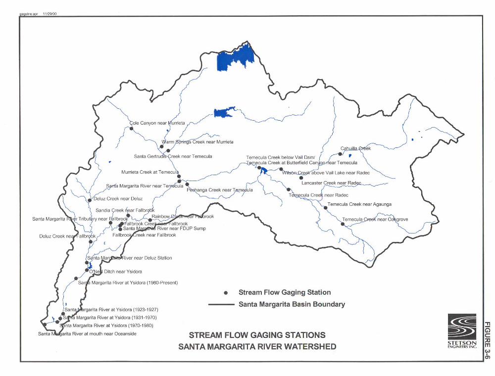

Stetson Engineers Inc./North State Resources 3-24 Permit 15000 Analysis March 23, 2001 Project Feasibility Study
exceeded 44,000 cfs (January 1993). The hydrologic variability of the Santa Margarita River makes it both a destructive and vulnerable source of water for its many users.
TABLE 3-2 STREAMFLOW GAGING STATIONS IN THE SANTA MARGARITA RIVER BASIN
Drainage Operating Period of Area
Station Name Station ID # Agency Record [mi2]
Cahuilla Creek DWR 12/50-9/54 80.0 Cole Canyon Creek near Murrieta DWR 12/52-5/54 8.8 Deluz Creek near Deluz 11044800 USGS 10/92-Present 33.0 Deluz Creek near Fallbrook 11044900 USGS 10/51-9/67, 10/89-Present 47.5 Fallbrook Creek near Fallbrook 11045300 USGS 10/93-Present 7.0 Lancaster Creek near Radec DWR 12/50-12/51 115.0 Murrieta Creek at Temecula 11043000 USGS 10/25-Present 222.0 O’Neill Ditch near Ysidora USGS 10/30-9/60 - Pechanga Creek near Temecula 11042631 USGS 10/87-9/91,10/93-Present 13.8 Rainbow Creek near Fallbrook 11044250 USGS 11/89-Present 10.3 Sandia Creek near Fallbrook 11044350 USGS 10/89-Present 21.1 Santa Gertrudis Creek DWR 12/52-4/54 88.0 Santa Gertrudis Creek near Temecula 11042900 USGS 10/87-9/91,10/93-Present 90.1 Santa Margarita River at FPUD Sump 11044300 USGS 10/89-Present 620.0 Santa Margarita River at mouth near Oceanside 11046050 USGS 10/89-Present 744.0 Santa Margarita River at Ysidora 11046000 USGS 3/23-Present 723.0 Santa Margarita River near Deluz Station 11045000 USGS 10/24-9/26 705.0 Santa Margarita River near Fallbrook 11044500 USGS 10/24-9/80 644.0 Santa Margarita River near Temecula (Gorge) 11044000 USGS 2/23-Present 588.0 Santa Margarita River Tributary near Fallbrook 11044600 USGS 10/61-9/65 0.5 Temecula Crk. at Butterfield Canyon nr. Temecula 11042520 USGS 2/23-9/48 320.0 Temecula Creek below Vail Dam 11042600 USGS 10/77-9/78 - Temecula Creek near Aguanga DWR 1/51-9/54 71.0 Temecula Creek near Aguanga 11042400 USGS 8/57-Present 131.0 Temecula Creek near Oakgrove DWR 2/51-9/54 61.0 Temecula Creek near Radec DWR 12/50-9/54 133.0 Warm Springs Creek near Murrieta DWR 9/52-6/54 58.0 Warm Springs Creek near Murrieta 11042800 USGS 10/87-Present 55.4 Wilson Creek above Vail Lake near Radec 11042490 USGS 10/89-Present 122.0
3.7 WATER QUALITY
The Base water supply is provided by wells completed in the aquifer underlying the Santa Margarita River Basin. Water from the wells is known to have high levels of total dissolved solids (TDS), total organic carbon (TOC), and iron/manganese. The drinking water TDS and

Stetson Engineers Inc./North State Resources 3-25 Permit 15000 Analysis March 23, 2001 Project Feasibility Study
piping system corrosion byproducts (copper) have a negative impact on wastewater sludge generated at the treatment plants. At well locations closer to the ocean, higher dissolved solids concentrations are observed, indicating a saltwater-freshwater interface typical in a coastal area.
Water quality monitoring stations indicate that the river suffers from excessive total
dissolved solids (TDS) and nitrate. Since Camp Pendleton is the last water user on the extensive Santa Margarita River system, nutrient levels, particularly nitrogen, have increased in recent years due to the intensive use of agricultural fertilizers in the Upper Watershed. Likewise, a dramatic expansion of residential, commercial and industrial development during the past decade in the Upper Basin has produced more urban runoff and wastewater discharge.