S E S 2060 C F R - Skagit County, Washington CC Final...ii skagitcounty.net/envisionskagit Envision...
85
October 2011 Preserving Our Heritage, Shaping Our Future SKAGIT COUNTY ENVISION SKAGIT 2060 CITIZEN COMMITTEE FINAL RECOMMENDATIONS
Transcript of S E S 2060 C F R - Skagit County, Washington CC Final...ii skagitcounty.net/envisionskagit Envision...

October 2011
Preserving Our Heritage, Shaping Our Future
SKAGIT
COUNTY
ENVISION SKAGIT 2060 CITIZEN COMMITTEE
FINAL RECOMMENDATIONS

ii skagitcounty.net/envisionskagit
Envision Skagit 2060 Citizen Committee
Final Recommendations October, 2011
Board of County Commissioners
Ron Wesen, Chairman
Kenneth A. Dahlstedt
Sharon D. Dillon
Citizen Committee
John Cheney Peggy Flynn Grace Popoff Tim Rosenhan
Kerri Cook Jim Meyer Gustavo Ramos, Jr. Ryan Sakuma
Cory Ertel Kim Mower Doris Robbins Nate Youngquist
Staff to the Citizen Committee
Kirk Johnson, AICP
Envision Project Manager
Skagit County Planning &
Development Services
Josh Greenberg, PhD., GISP
Skagit County Geographic
Information Services
Linda Christensen
Grant Administrator
Skagit County Planning &
Development Services
Emma Whitfield
Skagit County Public
Information Officer
Lisa Dally Wilson
Facilitator
Dally Environmental
John Lombard
President
Lombard Consulting
Mark Personius, AICP
Growth Management
Consultant
Dr. John Bolte
Department of Biological &
Ecological Engineering
Oregon State University
Gary Christensen
Director Skagit County Planning
and Development Services
Skagit County Administrative Building
1800 Continental Place
Mount Vernon WA 98273
An electronic version of this document is available at
www.skagitcounty.net/envisionskagit
Blue text in the electronic version of this document indicates a web link
This project has been funded wholly or in part by the United States Environmental Protection Agency under assistance
agreement WS-96082901 and PO-00J08201 to Skagit County. The contents of this document do not necessarily reflect the views
and policies of the Environmental Protection Agency, nor does mention of trade names or commercial products constitute
endorsement or recommendation for use.
Printed on 100% post-consumer recycled paper

iii
Table of Contents
Envision Skagit Citizen Committee Vision Statement .................................................................................................... 4
Message from Your Skagit County Commissioners ....................................................................................................... 5
Executive Summary ....................................................................................................................................................... 6
Goal Statement 1: A Regional Vision: Stronger Regional Coordination, Collaboration and Cooperation ..................... 9
Goal Statement 2: Protect Natural Resource Lands, Aquatic Resources and Industries (Agriculture, Forestry, Fish and
Shellfish) ...................................................................................................................................................................... 14
Goal Statement 3: Protect, Preserve, Restore Environmental Resources and Values ................................................. 19
Goal Statement 4: Compact Communities and Conservation Development .............................................................. 25
Goal Statement 5: Sustainable Transportation ........................................................................................................... 35
Goal Statement 6: Water/ Wastewater ...................................................................................................................... 38
Goal Statement 7: Housing Variety and Affordability ................................................................................................. 41
Goal Statement 8: Economic Vitality ........................................................................................................................... 44
Goal Statement 9: Climate Change .............................................................................................................................. 48
Conclusion ................................................................................................................................................................... 49
List of Appendices ........................................................................................................................................................ 51
Appendix A: Envision Skagit Citizen Committee...................................................................................................... 52
Appendix B: Minority Opinion on Floodplain Development within Existing UGAs .................................................... 54
Appendix C: Implementation Matrix for All Recommendations ............................................................................. 57
Appendix D: Longer-Term Implementation Steps and Financial Implications ........................................................ 73
Appendix E: Glossary ............................................................................................................................................... 79
Appendix F: Envision Skagit Citizen Committee: List of Meetings, Field Trips, Community Events ........................ 82
Appendix G: Reports and Data Sources Developed for Envision Skagit .................................................................. 85

4 skagitcounty.net/envisionskagit
Envision Skagit Citizen Committee Vision Statement
We overwhelmingly desire to preserve diverse agriculture and local food production, access to
outdoor recreation opportunities for all ages, and the innate value of healthy, functioning
ecosystems. The quality, diversity, and productivity of our defining agricultural and ecological
landscapes in Skagit County are globally significant and increasingly rare.
To preserve the character of our defining landscapes and foster economically vibrant
communities, we recommend that population growth be directed to cities as much as possible,
that an effort be made to protect lands now that will maintain our agricultural heritage, conserve
our ecosystems, and serve as connected open space into the future, and that all of us in Skagit
County work collaboratively toward our common goals. We cannot continue to sprawl as we
have and preserve what we most value. Our vision is to see Skagit County become an even better
place to live as we grow.
- Envision Skagit Citizen Committee
Envision Skagit Citizen Committee and County Commissioners. Missing: John Cheney, Nate Youngquist.

skagitcounty.net/envisionskagit 5
Message from Your Skagit County Commissioners
We thank the Envision Skagit Citizen Committee for their hard work and service and for the thoughtful
recommendations contained in this report.
The Board of County Commissioners wanted this committee to broadly reflect the interests of the Skagit
community. And the committee did what we asked them to do: they came together with their different ideas and
backgrounds, listened to each other and to the broader community in an extensive public outreach process, and
worked as a team to develop these recommendations.
Now it’s our turn as elected officials – and yours as citizens of Skagit County – to consider how these
recommendations can help us address the challenges and opportunities of the next 50 years. Let’s work together
to plan for and maintain a bright future for our children, grandchildren, and great grandchildren.
Ron Wesen, Chairman
District 1
Ken Dahlstedt
District 2
Sharon Dillon
District 3

6 skagitcounty.net/envisionskagit
Executive Summary
The Envision Skagit 2060 Citizens Committee has developed this vision and set of recommendations for what we
believe today’s Skagit County residents want Skagit County to be like in 2060—and what we should do now to help
bring that about.
We formulated our recommendations as a group of 12 citizen volunteers, who were selected from a larger pool of
applicants by a committee of county commissioners and city and town mayors. Hailing from east of Rockport to
Anacortes, we do not formally represent interest groups. The commissioners and mayors sought Citizen
Committee members with a broad outlook, readiness to talk through difficult issues, and a diversity of experience
(including age—some members can look back on the last 50 years of change, others will likely be here for the next
50).
Over the past ten months, our primary task has been to listen. In addition to meeting with local, regional, and
national experts, we hosted community meetings in Edison, Anacortes, La Connor, Concrete, Mount Vernon,
Sedro-Woolley, and Burlington. We held additional listening sessions with specific groups, including our
agricultural community, our Latino and Spanish-speaking community, and youth from our local schools. The
committee also received comments through the project website and from presentations to a wide variety of
service and interest groups. In total we heard from well over 400 residents.
What did we hear? Again and again, Skagit residents said they most wanted to preserve diverse agriculture and
local food production, access to outdoor recreation opportunities, and the innate value of healthy, functioning
ecosystems. These are the elements that define Skagit’s character and provide quality of life for us all.
Details 50 years out are inherently uncertain, but one trend that shows no sign of letting up is that our population
will grow substantially. From 1960 to 2010, Skagit County’s population more than doubled, from 51,000 to almost
120,000. Over the next 50 years, we are likely to grow by another 100,000. (This is less than the State’s projection,
but consistent with recent experience and with projections by local planners.) Where will this growth go? How can
we preserve these deeply expressed values, with the county’s population expected to nearly double over the next
50 years?
skagitcounty.net/envisionskagit 7
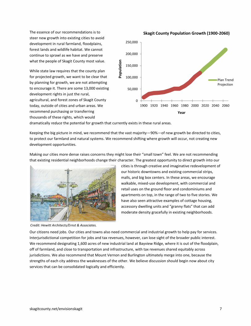
The essence of our recommendations is to
steer new growth into existing cities to avoid
development in rural farmland, floodplains,
forest lands and wildlife habitat. We cannot
continue to sprawl as we have and preserve
what the people of Skagit County most value.
While state law requires that the county plan
for projected growth, we want to be clear that
by planning for growth, we are not attempting
to encourage it. There are some 13,000 existing
development rights in just the rural,
agricultural, and forest zones of Skagit County
today, outside of cities and urban areas. We
recommend purchasing or transferring
thousands of these rights, which would
dramatically reduce the potential for growth that currently exists in these rural areas.
Keeping the big picture in mind, we recommend that the vast majority—90%—of new growth be directed to cities,
to protect our farmland and natural systems. We recommend shifting where growth will occur, not creating new
development opportunities.
Making our cities more dense raises concerns they might lose their “small town” feel. We are not recommending
that existing residential neighborhoods change their character. The greatest opportunity to direct growth into our
cities is through creative and imaginative redevelopment of
our historic downtowns and existing commercial strips,
malls, and big box centers. In these areas, we encourage
walkable, mixed-use development, with commercial and
retail uses on the ground floor and condominiums and
apartments on top, in the range of two to five stories. We
have also seen attractive examples of cottage housing,
accessory dwelling units and “granny flats” that can add
moderate density gracefully in existing neighborhoods.
Our citizens need jobs. Our cities and towns also need commercial and industrial growth to help pay for services.
Interjurisdictional competition for jobs and tax revenues, however, can lose sight of the broader public interest.
We recommend designating 1,600 acres of new industrial land at Bayview Ridge, where it is out of the floodplain,
off of farmland, and close to transportation and infrastructure, with tax revenues shared equitably across
jurisdictions. We also recommend that Mount Vernon and Burlington ultimately merge into one, because the
strengths of each city address the weaknesses of the other. We believe discussion should begin now about city
services that can be consolidated logically and efficiently.
Credit: Hewitt Architects/Ernst & Associates.
0
50,000
100,000
150,000
200,000
250,000
1900 1920 1940 1960 1980 2000 2020 2040 2060
Po
pu
lati
on
Year
Skagit County Population Growth (1900-2060)
Plan Trend Projection

8 skagitcounty.net/envisionskagit
In rural and resource areas, we seek to prevent as
much future residential and commercial development
in the floodplain as possible, through purchases or
transfers of existing development rights. We do not
support uncompensated down zoning. We recommend
doubling funding for the County’s successful Farmland
Legacy Program. Rural development out of the
floodplain should generally be clustered, including
moderate expansion of existing villages, such as Alger
and Conway Hill. The County should strive for no net
loss of land zoned for agriculture. Potential
replacement lands should be identified in the near
future for rezoning to achieve this standard over time.
When asked what was missing or lacking in this county, Skagit residents consistently identified the need to
improve open space and trails. As our cities become denser, this need will become even more important for the
health of our communities. We recommend that our open space networks be strengthened and that Skagit County
and other local jurisdictions act now to develop and implement a long-range conservation plan for the entire
county. We must plan for “green infrastructure”—an interconnected network of natural lands and open space,
including trails—as seriously as for any other infrastructure, such as water, sewer, or roads. Determining our most
valued open space network now will also indirectly identify where future development should go, which increases
predictability and certainty for all sides.
Lastly—although really, this is our very first and perhaps most critical recommendation—we offer a plea to all
Skagit residents to work together more collaboratively toward a common vision of the future. We recommend
establishing a broad-based regional entity, the Skagit Alliance, to implement a unified approach to growth,
development and conservation over the next 50 years. The Skagit Alliance would be comprised of diverse regional
leaders from both the public and private sectors, who can rise above the individual silos of a particular jurisdiction
or interest group and make decisions that will benefit our region as a whole.
Our recommendations are described in more detail in nine “goal statements.” While our work as a formal
committee has ended by issuing these recommendations, that is far from the end of the larger Envision Skagit
process. We anticipate a broad community discussion that continues into the fall of 2011 and beyond. Before any
law or significant government policy can be changed, we encourage elected officials to hold public listening
sessions to take further public comment. A 50-year plan takes time to implement.
The conversation is just starting. It is the people of Skagit County that will make this happen. Please speak up and
make your voice heard.

skagitcounty.net/envisionskagit 9
Goal Statement 1: A Regional Vision: Stronger Regional Coordination, Collaboration and Cooperation
The challenge of protecting what Skagit County residents love most about their landscape in the face of population
growth over the next 50 years is enormous. In later sections of this report, we state our recommendations for
protecting working lands and the ecosystem, while increasing the vibrancy and economic health of our human
communities. However, these recommendations cannot be implemented without changes in how we envision the
future and work together toward a common vision.
To accomplish these changes, the Citizen Committee recommends:
I.A) Regional Coordination, Collaboration and Cooperation
1. Establish a broad-based regional “Skagit Alliance” that calls for a unified approach to Skagit County’s growth, development and conservation of natural resources and the environment.
Currently the Skagit Council of Governments (SCOG) is the lone entity with a mandate to foster regional
cooperation, related primarily to transportation and economic development. Planning for a 50-year future,
however, involves a broader set of issues and should involve a broader set of parties. Given the inherent
complexities, conflicts and competition for limited resources and priorities, the Committee believes it is unrealistic
to expect governments alone to solve the challenges we face today and into the future. The Committee sees a
need for the formation of a Skagit Alliance comprised of
regional leaders from both the public and private sectors.
Through coordination, collaboration, cooperation and
inclusiveness, the Skagit Alliance would continue the work
begun by Envision Skagit to implement a long-term,
regional vision and action plan, with the goal of providing
stability and predictability for residents, developers,
planners and governing bodies alike. It would:
Map of Skagit County, Washington. Map provided by Skagit County GIS.

10 skagitcounty.net/envisionskagit
Build a common vision of shared principles;
Speak for the interests of the entire county, both public and private;
Foster creative approaches to manage future growth and leverage that growth as a regional opportunity;
Break down the silos that each jurisdiction operates within;
Consider opportunities for consolidating governments or programs for the more efficient delivery of
services; and
Make recommendations that are best for the region as a whole.
Because this is a complex issue that extends beyond the scope of the Citizen Committee’s charge and
knowledge, the Committee is not prepared to recommend the exact structure and composition of such an
entity. However, the guiding philosophy is to bring everyone together under “one big tent” and work together
to achieve a unified vision.
2. As a precursor to the establishment of the Skagit Alliance, the Committee recommends engaging a broad cross-section of Skagit County’s leaders in a long-range planning exercise that would result in:
a. Establishing guiding principles related to Skagit County’s future growth; and
b. Creating a task force to perform an in-depth study and make recommendations about the formation,
structure and composition of an enduring Skagit Alliance.
An example of such a long-range planning exercise is “Reality Check,” developed by the Urban Land Institute.
Reality Check is a day-long unique regional visioning process that explores ways to accommodate economically,
environmentally and socially sustainable growth. Building upon the work of Envision Skagit 2060, it would bring
diverse citizens and regional leaders around large-scale regional maps that function like a game board. Beginning
with a consensus process to establish guiding principles for Skagit County’s future growth, each group of
participants negotiates how and where to locate projected numbers of new residents and jobs, and where to
establish major transportation corridors and open space networks. The process has proven very successful
elsewhere at identifying shared principles and visions for future growth from participants who might normally
focus on their differences.1
We recommend that a Leadership Skagit alumni committee sponsor and coordinate a Reality Check exercise for
Skagit County. The participants in the Reality Check exercise should be broad-based from across the County,
including tribes and all Skagit governmental jurisdictions and representatives from groups such as (but not limited
to) business, developers, ports, agriculture, forestry, environmental and recreation groups, utilities, financial
institutions, chambers of commerce, non-profits and other special interest groups.
I.B) Industrial Tax Revenue Sharing
3. The Committee recommends establishing a new industrial tax revenue sharing mechanism (“Industrial Tax Basket”), to develop a more regional and effective approach to designating and marketing industrial lands, while providing tax revenue benefits in an equitable manner to all participating jurisdictions.
The concept is to provide some regional tax base support for cities and towns that accept residential growth
consistent with a 90/10 ratio of urban vs. rural growth, while reducing the need to expand their UGAs to do so.
1 For information on Reality Check, see ULI Seattle - Reality Check Event, or
http://seattle.uli.org/Community%20Building/Quality%20Growth%20Alliance/Reality%20Check%20Event.aspx

skagitcounty.net/envisionskagit 11
Photo: Ozzie Wiese
To implement the proposal, the proposed Skagit Alliance, working with participating jurisdictions, would
set a point in time after which a substantial portion of tax revenues collected from new industries in
industrial-zoned land would be allocated to cities and towns by population (formula to be determined),
not according to the location of the industry. As discussed in Recommendation 4 below, we believe the
logical location for new industrial land is Bayview Ridge. Existing
industries’ (before launch of the Industrial Tax Basket) tax revenues
would continue to be allocated by the current formula so as not to
shock the system. That is, cities and towns would not add established
industry taxes to the industrial tax basket. The population formula
would count city and town populations within existing urban growth
areas, thus rewarding cities and towns with higher populations and
higher densities.2
To qualify for the Industrial Tax Basket, the cities and towns would
be required to accept a population increase consistent with the
allocations determined by the Skagit Alliance and agree to do so
within their existing UGAs. An additional requirement would be to
contribute a portion of financing for the Skagit Alliance, whose
purpose would be to collaboratively implement the long-range
regional growth strategy.
Revenue sharing would avoid interjurisdictional competition for industrial tax
base, allowing industrial land to be sited and zoned rationally out of the floodplain,
off of natural resource lands, and close to transportation and infrastructure. While the time it would take to realize
the benefits would depend on the pace of industrial growth, it could actually lead to more overall industrial
development in the County, because it will be easier to market a larger basket of properties, which should in turn
be more attractive to industry, providing better locations, greater certainty, and better preservation of our high
quality of life.
4. Identify 1,600 acres in the Bayview Ridge Urban Growth Area for light industrial use and redirect projected residential growth from Bayview Ridge into existing cities with established municipal services and tax structures (see Goal Statement 4, Recommendation 7). The new industrial land would be subject to the industrial tax basket for distribution of resulting tax revenues.
The Port of Skagit County estimates that 3,429 acres of industrial land will be needed in the county by 2060 to
meet employment goals, while only 1,772 acres exist today, leaving a deficit of 1,657 acres. This is an important
land use to plan for far in advance, to ensure that desirable industrial lands are not occupied by other land uses
whose siting needs are much more flexible.
Much of the land surrounding the Skagit Regional Airport at Bayview Ridge meets key criteria for industrial
designation: it is relatively undeveloped currently, falls within the airport environs and is therefore less desirable
for residential use, is adjacent to existing industrial uses, is served by appropriate infrastructure, is within
reasonable trucking distance of I-5 or SR 20, and lies outside of the floodplain and NRL land. Locating new
industrial land at the airport also helps protect the airport from encroaching residential development and
promotes public safety by keeping residential development outside of areas with concentrated aircraft overflight.
2 Some percentage of revenues would accrue to the county to support its proposed 10% population growth share, county
services provided to all county residents whether urban or rural, and any costs the county incurs in making a particular industrial site “development ready” and providing ongoing services such as law enforcement.

12 skagitcounty.net/envisionskagit
Given the prevalence of wetlands at Bayview Ridge, more than 1,600 acres of land may need to be designated to
achieve a net 1,600 acres available for industrial use. Potential impacts on stormwater and farm roads would also
need to be addressed.
Potential additional industrial lands in Bay View Ridge area. Map provided by Skagit County GIS.
The committee’s vision is for most future population growth to be contained within existing cities. Consistent with
this vision and the above identification of industrial land, we recommend that most or all of the newly projected
residential development within the Bayview Ridge Urban Growth Area be redirected to existing cities (see Goal
Statement 4, Recommendations 1 and 7).
I.C) Consolidation of Services/City Merger
5. Consider possible consolidation of government services and taxing districts as the region grows, both to gain efficiencies and to promote the regional interest and a regional identity.
We believe there are significant opportunities for consolidating separate governments and taxing districts in Skagit
County, including school districts, library districts, hospital districts and other special purpose taxing districts. While
separate governments can enhance local access and a sense of local representation, they also can create
inefficiencies, with each district requiring its own administrative programs, and can promote narrow views of the
public interest. As Skagit County grows, it will be increasingly important for local governments and local residents
to consider their future as interconnected. Consolidating government services and taxing districts, where that
makes sense, would be one of the most concrete and meaningful ways of recognizing that fact.

skagitcounty.net/envisionskagit 13
6. The two cities of Mount Vernon and Burlington should ultimately merge or consolidate into one, because the strengths of each city address the weaknesses of the other. While this would likely be an evolutionary process, the process itself should begin now and would logically start with discussions between the two cities of how they combine various services to improve efficiencies and delivery of those services.
This consolidation is the most important example for the previous recommendation, with added rationales rooted
in land use. Essentially the entire City of Burlington is in the floodplain. Mount Vernon has room to grow—and is
allocated a large share of the entire county’s future growth—but has an inadequate commercial tax base to pay for
the services needed by that additional population. Burlington has a very strong existing commercial tax base
through many retail businesses that serve the region, including many Mount Vernon residents. Mount Vernon has
no prime locations for adding new commercial areas that are not in the floodplain or agricultural lands.
In the short-term, this idea may appear extreme or politically infeasible, but we believe that looking over the long-
term it makes eminent sense. It also would be far from the first time in our area that such a merger took place.
Sedro and Woolley came together, as did the town of Concrete from the separate communities of Baker and
Cement City. To the north, modern Bellingham is the result of a merger between Fairhaven, Sehome, Whatcom,
and historic Bellingham. Just as with other government consolidations that may be possible, a merger of Mount
Vernon and Burlington offers great potential for efficiencies. In the case of these two cities, however, the unique
ways in which each complements the other make for an even stronger argument. The two cities are already
collaborating on an appeal of FEMA’s floodplain mapping. The merger of Mount Vernon and Burlington would help
Skagit Valley move beyond strategies that benefit only one jurisdiction to consider what would be best for the
region as a whole.
Because this issue goes beyond Burlington and Mount Vernon, and is about the overall balance and equity in the
allocation of population relative to commercial (especially retail) and industrial lands and resulting tax revenues
across jurisdictions in the Skagit Valley, the Citizen Committee also recommends the following:
7. Future planning decisions allocating population and employment among Skagit jurisdictions should address and analyze the fiscal (public financial) costs and benefits associated with those allocations among jurisdictions with an overall goal to ensure that the cities, towns, county, and tribes have the financial resources needed to support the population growth allocated to them.
14 skagitcounty.net/envisionskagit
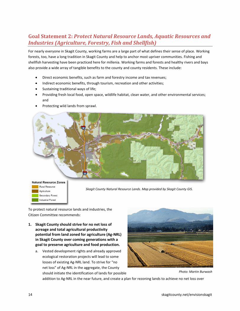
Goal Statement 2: Protect Natural Resource Lands, Aquatic Resources and Industries (Agriculture, Forestry, Fish and Shellfish)
For nearly everyone in Skagit County, working farms are a large part of what defines their sense of place. Working
forests, too, have a long tradition in Skagit County and help to anchor most upriver communities. Fishing and
shellfish harvesting have been practiced here for millenia. Working farms and forests and healthy rivers and bays
also provide a wide array of tangible benefits to the county and county residents. These include:
Direct economic benefits, such as farm and forestry income and tax revenues;
Indirect economic benefits, through tourism, recreation and other activities;
Sustaining traditional ways of life;
Providing fresh local food, open space, wildlife habitat, clean water, and other environmental services;
and
Protecting wild lands from sprawl.
To protect natural resource lands and industries, the
Citizen Committee recommends:
1. Skagit County should strive for no net loss of acreage and total agricultural productivity potential from land zoned for agriculture (Ag-NRL) in Skagit County over coming generations with a goal to preserve agriculture and food production.
a. Vested development rights and already approved
ecological restoration projects will lead to some
losses of existing Ag-NRL land. To strive for “no
net loss” of Ag-NRL in the aggregate, the County
should initiate the identification of lands for possible
addition to Ag-NRL in the near future, and create a plan for rezoning lands to achieve no net loss over
Photo: Martin Burwash
Skagit County Natural Resource Lands. Map provided by Skagit County GIS.
skagitcounty.net/envisionskagit 15
time. Lands to consider for replacement of lost Ag-NRL land are those that have high quality agricultural
soils and/or display active agriculture use and are located within a reasonable proximity to existing farm
operations (primarily Rural Resource-NRL and Rural Reserve). Affected landowners would be
compensated for reduced development potential through purchase of lost development rights. Lands that
are not recommended as replacement lands include forested lands that would require clearing, especially
in the vicinity of wetlands and streams.
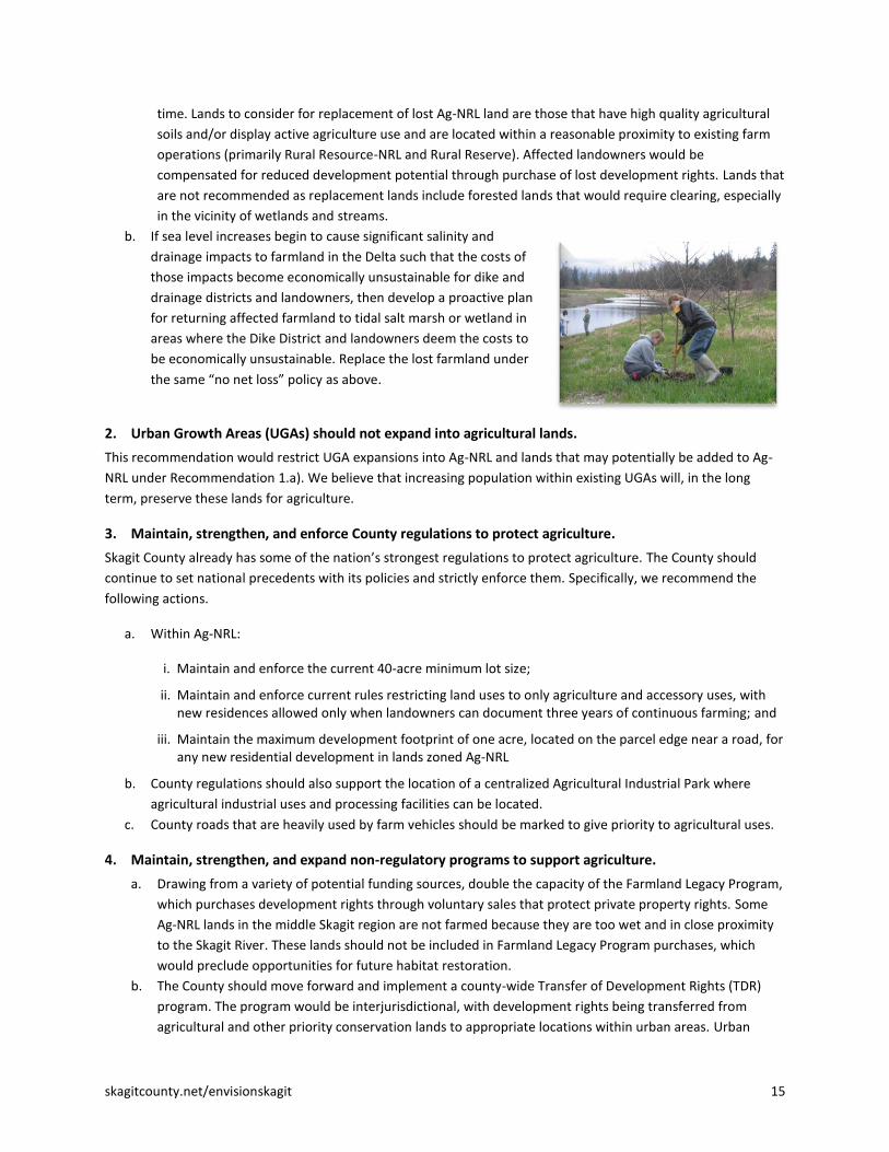
b. If sea level increases begin to cause significant salinity and
drainage impacts to farmland in the Delta such that the costs of
those impacts become economically unsustainable for dike and
drainage districts and landowners, then develop a proactive plan
for returning affected farmland to tidal salt marsh or wetland in
areas where the Dike District and landowners deem the costs to
be economically unsustainable. Replace the lost farmland under
the same “no net loss” policy as above.
2. Urban Growth Areas (UGAs) should not expand into agricultural lands.
This recommendation would restrict UGA expansions into Ag-NRL and lands that may potentially be added to Ag-
NRL under Recommendation 1.a). We believe that increasing population within existing UGAs will, in the long
term, preserve these lands for agriculture.
3. Maintain, strengthen, and enforce County regulations to protect agriculture.
Skagit County already has some of the nation’s strongest regulations to protect agriculture. The County should
continue to set national precedents with its policies and strictly enforce them. Specifically, we recommend the
following actions.
a. Within Ag-NRL:
i. Maintain and enforce the current 40-acre minimum lot size;
ii. Maintain and enforce current rules restricting land uses to only agriculture and accessory uses, with new residences allowed only when landowners can document three years of continuous farming; and
iii. Maintain the maximum development footprint of one acre, located on the parcel edge near a road, for any new residential development in lands zoned Ag-NRL
b. County regulations should also support the location of a centralized Agricultural Industrial Park where
agricultural industrial uses and processing facilities can be located.
c. County roads that are heavily used by farm vehicles should be marked to give priority to agricultural uses.
4. Maintain, strengthen, and expand non-regulatory programs to support agriculture.
a. Drawing from a variety of potential funding sources, double the capacity of the Farmland Legacy Program,
which purchases development rights through voluntary sales that protect private property rights. Some
Ag-NRL lands in the middle Skagit region are not farmed because they are too wet and in close proximity
to the Skagit River. These lands should not be included in Farmland Legacy Program purchases, which
would preclude opportunities for future habitat restoration.
b. The County should move forward and implement a county-wide Transfer of Development Rights (TDR)
program. The program would be interjurisdictional, with development rights being transferred from
agricultural and other priority conservation lands to appropriate locations within urban areas. Urban

16 skagitcounty.net/envisionskagit
areas that receive greater density should also receive additional resources to provide adequate
infrastructure and amenities to support it. As part of program implementation, a TDR expert should be
consulted to evaluate the local situation and develop strategies that consider local obstacles and
opportunities. It is crucial that the TDR program be designed to complement rather than undercut the
successful Farmland Legacy Program.
c. Support continued operation and maintenance of the dike and drainage system consistent with current
requirements and agreements, including the Tidegate Fish Initiative.
5. Manage stormwater effectively to protect fish, shellfish, and agriculture.
Stormwater from developed areas has profound impacts on salmon habitat, by changing the hydrology and water
quality of streams; on shellfish beds, by introducing pollutants that can lead to harvest restrictions to protect
human health; and on agriculture, by creating or aggravating drainage problems and by leaving behind pollutants
that are taken up by farm soils or crops.
Road projects and urban and rural development should bear the full cost of mitigating these impacts. Stormwater
management must, at a minimum, include managing water quantity (e.g., not giving drainage districts more water
than they can handle) and water quality (runoff must meet water quality standards per NPDES regulation).
6. Encourage local/regional efforts to support natural resource industries and the ecosystem, forged by those with the greatest on-the-ground knowledge of how to meet the needs of both.
The Citizen Committee does not believe that we in Skagit County must choose between farms and fish. Both are
crucial to the heritage of this place. We who live here must find solutions that allow both to flourish into the
future.
a. We support local initiatives to conserve farms and fish together, such as the Tidegate Fish Initiative, which
authorizes the conversion of 2,700 acres of delta farmland to salmon habitat in return for regulatory
certainty necessary to operate and maintain the dike and drainage system.
b. We support voluntary programs that allow farmers and foresters to generate additional revenue streams
while enhancing sustainability (e.g., certification of forests or farms for sustainable practices, foresters
tapping emerging carbon markets that provide an economic incentive to extend harvest rotations, or
farmers tapping markets or incentives for clean water by planting filter strips along streams to generate
supplemental income to keep their farm operations economically viable). We strongly encourage
environmental services that landowners can provide on a rotation basis or which otherwise do not take
working farm or forest land out of permanent production. An example is The Nature Conservancy’s
Farming for Wildlife program, which is working with three farms on the Skagit Delta to experiment with
flooding, mowing, and grazing during crop rotations.
c. Agriculture, particularly food production, should be the primary and preferred use on designated
agricultural lands (Ag-NRL). When habitat conservation and restoration projects are proposed on Ag-NRL
land, they should be developed and implemented in a collaborative and cooperative manner, involving all
affected stakeholders, with the goal of achieving multiple positive outcomes and benefits, including
advancement of ecological, agricultural, and, where possible, flood management goals (examples include
the Tidegate Fish Initiative and the Fisher Slough restoration project).
7. Seek state, federal or international designation for Skagit Valley as a Cultural and Natural Heritage Site.
The Skagit Valley has some of the most productive agricultural soils in Washington State and the world, an ideal
climate for sustainable agriculture, and remains the most intact agricultural landscape in Western Washington.
skagitcounty.net/envisionskagit 17
Moreover, Skagit Valley is just as worthy of recognition as an outstanding natural area, as the largest watershed in
Puget Sound, supporting all five native species of Pacific salmon and an enormous diversity of wildlife and habitats.
The Skagit Valley and its marine shoreline also support a rich human history and heritage, beginning with the
Native American communities, through later settlement by Euro-Americans and the immigrants who have come
since. Skagit Valley should be nationally and internationally known for the variety and quality of its farm products,
fish and shellfish, the sustainable practices of those who live and work here, and the continued majesty of its
landscape.
To strengthen this recognition and protect this heritage, Skagit County should consider seeking state, federal or
international designation of the Skagit Valley as a cultural and natural heritage site. This would increase
protections from development beyond those offered by the Growth Management Act, generate additional support
for the protection of our agricultural and other natural resource lands and environmental resources, and secure
additional financial resources to assist with those goals. We are hopeful that this designation would also increase
the level of certainty for young farmers, fish and shellfish harvesters, and foresters that their land will remain
viable for sustainable commercial agriculture and other resource production throughout their lives.
An example of a federal designation with some parallels can be found on neighboring Whidbey Island, where
Ebey’s Landing has been designated as a National Historical Reserve. Ebey’s Landing is the nation’s first historical
reserve, created in 1978 to protect a rural working landscape and community on Central Whidbey Island. It is a
17,500-acre reserve managed by a nine-member Trust Board and includes 18 working farms, 400 historical
structures, native prairies, two state parks, miles of shoreline, a network of trails and the second oldest town in
Washington State. A Skagit heritage designation should not focus on freezing history, but should recognize the
dynamic nature of both our ecosystem and resource industries.
8. Develop and Implement a Skagit Food System Strategy.
Skagit County should appoint a Skagit Food Policy Council in the fall of 2011 to develop specific strategies and
county policy recommendations by the spring of 2012. The Council would then work to implement a Skagit Food
System Strategy, help to access additional resources, facilitate communication throughout the local food system
and provide ongoing policy advice.
Similar to the Regional Food System Strategy being developed by Metro Vancouver, the Skagit Food System
Strategy would tie together local producers, processors, purveyors, and consumers. Among other goals, the Skagit
Food System Strategy would:
Enhance the sustainability of the Skagit Valley’s diverse agricultural system, providing policies that work
with the various stakeholders to provide economic viability, ecological integrity and social equity;
Increase local food distribution and consumption through retailers, restaurants, and institutional
consumers like school districts, hospitals, and jails, as well as farmers markets;
Educate students and the general public about the value of the Skagit Food System and how it works;
Encourage value-added programs, from the development of farm products to agri-tourism; and
Collaborate regionally to encourage trade outside of Skagit County, promoting Skagit as the “grocery
basket” of western Washington.

18 skagitcounty.net/envisionskagit
9. Maintain existing zoning protections for forestry.
a. We support existing zoning densities for forest-NRL
lands and recommend against increases to higher
rural densities.
b. We support the existing prohibition of UGA
expansions into industrial forest (IF-NRL) lands, and
restrictions against UGA expansions into secondary
forest (SF-NRL) and rural resource forest (RRc-NRL)
lands unless there is no alternative.
10. Reform the Conservation and Reserve Development (CaRD) program, particularly on Natural Resource Lands.
We believe CaRD density bonuses are not being implemented in ways that protect the public’s interest in the
ecological and commercial value of intact forests and agricultural and forest lands, particularly in the County’s
Rural Resource and Rural Reserve zones, where CaRD density bonuses are granted. At a minimum, current
requirements for clustering developments allowed through CaRD bonuses along parcel edges near roads must be
strictly enforced. However, the County should consider options to transfer the additional development allowed
through CaRDs to strategic locations that would minimize impacts on forestry, agricultural lands, and the
ecosystem. The County should also consider setting stricter limits on the amount of clearing allowed for new
development in forest zones.

skagitcounty.net/envisionskagit 19
Goal Statement 3: Protect, Preserve, Restore Environmental Resources and Values
Skagit County is a beautiful, often still wild place with an amazingly productive and diverse ecosystem. The people
of Skagit County value their proximity and access to nature, abundant fish and wildlife, and clean water and air.
Maintaining the environmental character and nature of the Valley will be a challenge over the next 50 years due to
projections of continued population growth and impacts from climate change. To provide the best chance of
meeting that challenge, the Citizen Committee recommends the following:
Skagit County Floodway and Floodplain. Map provided by Skagit County GIS.
Long-Range Conservation Planning
1. Skagit County and its partners develop and implement a long-range conservation vision and plan.
Our community needs a long-range conservation plan, just like it needs long-range transportation and
development plans; in fact, the two go hand in hand. To achieve environmental and economic goals over the next
50 years, we must identify and protect our most valued open space lands and natural and environmental
resources, determining at the same time where future development should go. This needs to be a broadly shared
community vision that is implemented through education, incentives, partnerships and voluntary initiatives, not
just regulations. The Skagit Alliance could play a leadership role in developing the plan.
As part of the long-range conservation vision and plan, we encourage the community to embrace the concept of
“green infrastructure,” which means “an interconnected network of natural lands and other open spaces that
conserves ecosystem values and functions and provides associated benefits to human populations.” “Green
infrastructure” helps to emphasize that the network of natural lands and open spaces is fundamental to the health
and well being of our community, just like other forms of infrastructure. Also like other forms of infrastructure, the
network must be connected, not isolated, to be effective. Skagit County already has two important building blocks
of a long-range conservation plan:

20 skagitcounty.net/envisionskagit
One is the Skagit County Comprehensive Plan, which designates and protects significant public open space
areas, and natural resource (farm and forest) lands of long-term significance.
The second is the Skagit Countywide UGA Open Space Plan.3
Image from adopted Skagit County UGA Open Space Concept Plan.
2. Skagit County should move forward with its many public and private partners, as outlined in the adopted Skagit County UGA Open Space Plan, to identify funding sources for open space protection within and between Urban Growth Areas, and to implement a “bottom up” approach for allocating funds and prioritizing proposed open space projects. As part of this process:
a. Solicit competitive proposals on an annual basis from interested parties to creatively implement open
space and greenbelt enhancements, rather than Skagit County issuing a list of presumed acquisition
targets.
b. Skagit County and its partners should appoint a balanced and
broadly representative Open Space Advisory Committee to
evaluate and prioritize open space project proposals on an
annual basis for consideration of outside funding, award open
space funds when they become available, and monitor ongoing
projects for compliance and expenditures.
c. Skagit County and other members of the Skagit Alliance should
take the next step in moving from a conceptual Open Space
Plan to identifying actual interconnected networks using GIS-
level data that accounts for habitat connectivity of critical
species and non-motorized transportation connectivity where
appropriate. This information should be used by the Open
Space Advisory Committee to prioritize open space projects.
d. Development of the Skagit open space network should
emphasize a wide variety of open space greenbelt
enhancement approaches, including cooperative agreements, easements
3 This plan was developed cooperatively and in a highly public process by Skagit County, the Skagit Council of Governments, and
36 other public agencies and non-profit organizations involved in open space efforts. The plan was adopted by the Board of County Commissioners in January, 2009
Photo: David Snyder

skagitcounty.net/envisionskagit 21
and other innovative measures, in addition to outright acquisition. When the potential for loss of
critical open space to development becomes imminent, immediate public acquisition through
purchase should be considered as a necessary course of action.
e. Skagit County and all local jurisdictions within the Skagit Council of Governments (SCOG) should
budget for and manage green infrastructure as prudently as any other civic asset such as water,
sewer, or roads.
Protect and Conserve the Skagit River and its Functions
3. We implore our local and federal elected officials and responsible government agencies to complete the federal General Investigation study of flood hazard management options on the Skagit River, and related local flood hazard management planning. This should be done as soon as possible, using best available science. Included in this effort should be a watershed-based floodplain management plan to help inform land use planning decisions.
The federal GI study began in 1997. It should provide crucial information for local decision-making, along with the
basis for federal cost-sharing to implement recommended flood hazard management actions. Skagit County is not
adequately prepared for future flooding. This is a major threat to our community. Further delay is unacceptable.
4. Purchase and remove rural and urban residences from the Skagit River floodway and other parts of the “functional floodplain” – such as Hamilton and Cape Horn – that experience repeated flood damage.
There are 447 existing dwellings in the Skagit River
floodway. As part of buying out floodway residences,
the Skagit community must work to increase the supply
of affordable housing so very low-income people have
options other than living in the floodway; see
recommendations in Goal Statement 7, Housing
Variety and Affordability.
5. Purchase or transfer development rights from the floodplain outside of UGAs.
Skagit County should explore ways to eliminate all future residential and commercial development in the
floodplain outside of current urban growth boundaries, while providing landowners appropriate compensation for
loss of development rights and also providing continued flexibility for farmers to construct barns and other farm-
related structures as needed to support farm operations.4 This would minimize conflicts for agriculture with other
land uses, while protecting the best remaining opportunities for ecological restoration in the Skagit and Samish
River watersheds.
Development outside of the floodplain but within the channel migration zone should be allowed to proceed,
consistent with federal requirements and other relevant regulations. The County should, however, notify
landowners and developers in these areas that they are building at their own risk, and that the county assumes no
obligation to protect them from flood damages.
4 GIS and Envision analysis indicate there are currently 1,795 unexercised development rights in the floodplain.
Hamilton, 2003

22 skagitcounty.net/envisionskagit
6. Maintain the current pace of restoration in the middle Skagit floodplain.
Beside the marine shoreline, natural floodplains provide the most complex and dynamic set of habitats found
across the landscape. Levees, while protecting against flood damage at the local scale, eliminate or degrade these
complex habitats and also remove storage capacity in the floodplain that can help reduce flooding downstream.
Setting back or removing levees, as has been proposed in a number of places in the middle Skagit River, is a simple
and proven way to increase flood storage and improve habitats for Chinook and coho salmon and a wide range of
other wildlife.
Ecological restoration projects should work in partnership with landowners and compensate them for losses in
economic value, prioritizing areas that are not actively farmed or where agricultural land does not have high-
quality soils or is not of long-term commercial significance. Any Ag-NRL land that can no longer be farmed after
restoration should be replaced under the “no net loss” policy in Goal Statement 2, Recommendation 1.
7. As part of long-term and comprehensive flood control efforts, investigate opportunities to widen the Skagit and Samish River corridors to regain floodplain ecological functioning and improve flood storage and conveyance; and purchase flooding easements from willing rural landowners in the floodplain to create additional emergency flood storage.
To the extent these projects may be located in the Skagit Delta, they should be part of the 2,700 acres of
restoration performed as part of the Tidegate Fish Initiative.
Strategically Restore Parts of the Skagit Delta
8. In Goal Statement 2, Natural Resource Lands and Industries, we support implementation of the Tidegate Fish Initiative, which authorizes the conversion of 2,700 acres of delta farmland to salmon habitat in return for regulatory certainty necessary to operate and maintain the dike and drainage system. The Citizen's Committee supports the efforts made by all of the parties involved, encourages full implementation of the agreement over the next 25 years, and seeks to highlight this effort as an outstanding model for creating effective partnerships to accomplish diverse objectives.
9. If sea level increases begin to cause significant salinity and drainage impacts to farmland in the Delta such that the costs of those impacts become economically unsustainable for dike and drainage districts and landowners, then develop a proactive plan for returning affected farmland to tidal salt marsh or wetland in areas where the Dike District and landowners deem the costs to be economically unsustainable. Replace the lost farmland under the “no net loss” policy in Goal Statement 2, Recommendation 1.
Work Together to Restore Our Salmon Runs The Skagit River is the only river system in Puget Sound
that still supports all five native species of Pacific
salmon. Some of those runs remain strong, while others
are threatened with extinction. Humans now occupy and
have altered virtually all of the habitats that these
amazing fish require for survival - from the Skagit River
Delta that was once a massive saltwater estuary, to the
low lands and riverbanks where we have built many of
our cities and towns, to the forest lands that surround
Pohto: Skagit Fisheries Enhancement Group
skagitcounty.net/envisionskagit 23
the salmon's native spawning streams.5
We call on residents of Skagit County to work together in a positive, forward-looking manner with the goal of
protecting and restoring the Skagit River’s once abundant salmon and steelhead trout runs, the salmon runs of the
Samish River and smaller direct tributaries to Puget Sound, and the shellfish along our shorelines. These goals
affect us all, reflect on our stewardship of the Skagit and Samish watersheds, and will require action by all.
Unfortunately, the management and harvest of Skagit and Samish salmon in the Pacific Ocean is largely beyond
our local control, but it plays a significant role in the salmon's survival. Nonetheless, each of us can help protect
and restore these runs and we call on all sectors, jurisdictions, and Skagit County residents to work cooperatively
and aggressively to ensure survival and vitality of our salmon heritage by implementing the following
recommendations:
All fishers should observe the fishing seasons and regulations intended to allow sustainable harvest of
salmon. We encourage both fishers and harvest managers to consider the benefits of reduced harvests in
the short-term to serve the long-term interest of rebuilding salmon runs.
Farmers in the Delta and along the many fish-bearing Skagit tributaries should observe best management
practices, and engage in voluntary stewardship efforts to maintain clean water, healthy riparian areas,
and other habitat conditions necessary for the salmon's survival.
Forest landowners, who already work under strict regulations to benefit salmon, should take
responsibility to be good stewards over their large share of the middle Skagit Watershed.
The County, cities and towns, should implement and enforce effective critical areas ordinances and other
land development and management rules and regulations, including management of urban runoff and
stormwater, to improve water quality and habitat integrity.
All Skagit property owners, urban and rural, should embrace stewardship activities on their land, and
support through voluntary efforts and financial contributions the many worthy organizations, projects,
and programs seeking to restore the Skagit's once great salmon runs.
Conservation organizations and tribes should recognize that, because much of the work of protecting and
restoring salmon runs will occur on private land, a cooperative, voluntary, incentive-based approach will
be more successful than an adversarial approach in the long run. We have been impressed by the holistic
and comprehensive visions shared with us by many people throughout this process.
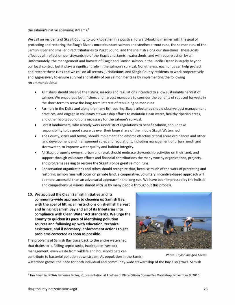
10. We applaud the Clean Samish Initiative and its community-wide approach to cleaning up Samish Bay, with the goal of lifting all restrictions on shellfish harvest and bringing Samish Bay and all of its tributaries into compliance with Clean Water Act standards. We urge the County to quicken its pace of identifying pollution sources and following up with education, technical assistance, and if necessary, enforcement actions to get problems corrected as soon as possible.
The problems of Samish Bay trace back to the entire watershed
that drains to it. Failing septic tanks, inadequate livestock
management, even waste from wildlife and household pets can
contribute to bacterial pollution downstream. As population in the Samish
watershed grows, the need for both individual and community-wide stewardship of the Bay also grows. Samish
5 Tim Beechie, NOAA Fisheries Biologist, presentation at Ecology of Place Citizen Committee Workshop, November 9, 2010.
Photo: Taylor Shellfish Farms
24 skagitcounty.net/envisionskagit
Bay supports an important commercial shellfish industry with more than $3 million in annual sales, a $1.2 million
annual payroll, and more than 40 full time equivalent employees working directly for shellfish farms. It is also a
vitally important environmental and recreational asset.
The County has received substantial grant funds to identify specific sources of high concentrations of pollution for
prompt and targeted follow up with responsible parties. The County and the Skagit Conservation District also have
received substantial funding to provide landowners with technical and financial assistance to clean up problem
locations.
11. The County, its government partners, and everyone in the Samish watershed should take advantage of this opportunity to clean up this precious resource and keep it clean for the future.
12. Skagit County and its partners should apply lessons and techniques from the Clean Samish effort to other rivers and bays suffering from non-point source pollution.
Protect Riparian Areas and Other Critical Areas
13. We support the use of a variety of tools, including regulation, incentives, education, and voluntary partnerships to protect critical areas on those rural and resource lands that develop in the future.
We do not have the time or the technical knowledge to become experts in the county’s existing regulations that
protect critical areas and other environmental features, but we do support the implementation and enforcement
of those regulations currently in effect.
14. Heighten protections to maintain the ecological functions and values of riparian areas. The Citizen Committee recognizes the importance of riparian areas (particularly along salmon-bearing streams) for protection and restoration of salmon and other fish species, as important wildlife habitat and wildlife corridors, for the maintenance of water quality and overall watershed function and integrity. To increase protections:
Strongly enforce existing critical area regulations affecting land clearing, development and other land use
and resource management activities;
Implement strong education programs that help landowners understand and appreciate the ecological
functions and values of riparian areas and the most important actions they can take to protect or enhance
them;
Implement innovative and voluntary land conservation techniques, including conservation easements,
transfer and purchase of development rights, and other measures that purchase development rights from
or allow their transfer out of the riparian corridor;
Implement innovative site development techniques, including conservation development and use of low
impact development measures to preserve water quality and reduce water flows;
Coordinate these site-specific actions with a broader plan for maintaining the integrity and connectivity of
important riparian and habitat areas and corridors – the green infrastructure network.
A similar range of measures can and should be applied to protect wetlands and other critical areas.
Implement Low Impact Development The Citizen Committee supports expanded voluntary use of Low-Impact Development (LID) techniques in public
and private projects, especially in sensitive stream basins and where downstream agriculture would likely benefit.
The Committee also supports early amendment of local codes to encourage or require LID where feasible, giving
special attention to these same places.

skagitcounty.net/envisionskagit 25
Goal Statement 4: Compact Communities and Conservation Development
In all of our meetings with the public, we heard very strongly that the people of Skagit County want to preserve
farmland, the local ecosystem, and their access to the natural world as the county grows. Given even low
estimates for the amount of population growth that is likely over the next 50 years, this cannot be accomplished
without urban areas becoming, on average, much more compact and dense. With this reality in mind, this is the
Citizen Committee’s vision for future development in Skagit County:
The predominant growth pattern for the future will be up, not out.
Along with greater urban densities, our urban areas will feature more amenities including parks, open spaces,
and trails; higher quality site development, design and architecture; a wider variety of housing options and a
mix of compatible uses allowing people to meet many of their daily needs on foot, by transit, or with short car
trips.
For the areas outside of our cities and towns – the county’s rural and natural resource lands – we see a less
scattered and dispersed development pattern than current plans and trends would allow.
We fear the current rural development pattern amounts to low-density rural sprawl. In the future, we see
development rights transferred or purchased from areas that should be protected– including hazardous and
environmentally sensitive areas and natural resource lands. Those rights are transferred to logical and
desirable places for development, including existing urban areas, rural clusters, and existing rural villages,
situated on high ground, out of harm’s way, away from natural resource lands, with good access to the
transportation and transit network and other rural infrastructure. Rural development is well situated and well
designed, and zoning rules are enforced.
Distribution of New Population to Urban and Rural Areas
based on Envision Modeling (~100,000 people)

26 skagitcounty.net/envisionskagit
Skagit County dwellings, 1960. Map provided by Skagit County GIS.
Skagit County dwellings, 2010. Map provided by Skagit County GIS.

skagitcounty.net/envisionskagit 27
2060 Plan Trend. Each dot represents a new residence. Map provided by Skagit County GIS.
2060 Preferred Future. Each dot represents a new residence. Map provided by Skagit County GIS.

28 skagitcounty.net/envisionskagit
Distribution, Location and Impacts of Future Development
1. The County should modify its population distribution goal to direct 90 percent of new population growth to urban areas – mostly cities and towns – and 10 percent to rural areas, instead of the current 80/20 split. Moreover, the County should seek to direct half of the rural 10% to clustered “conservation developments” (see recommendation 9) and/or expanded rural villages in the vicinity of Alger and Conway Hill (see recommendation 10).
In addition to directing a higher percentage of new population growth to urban areas, the Committee recommends
downplaying Bayview Ridge Urban Growth Area as a location for significant new residential development. Instead,
that area is ideally suited for future industrial uses, as discussed in more detail in Recommendation #7 below.
The reduced development capacity in rural areas implied by these targets should be achieved through purchase or
transfer of development rights. Development rights that are transferred should be sent to urban areas and existing
rural villages, or encouraged to develop in small clusters, where they will have less impact on the environment and
will be more efficient to serve with transportation and other infrastructure.
There would be practical challenges to transferring thousands of development rights, and purchasing large
numbers of rights would not be cheap. However, we do not believe that it is fair or potentially even legal to
attempt to achieve this scale of a reduction in rural development rights through uncompensated downzoning.
We discuss these challenges further in Appendix B, Longer-Term Implementation Steps and Financial Implications.
Given the regional, national and even international significance of conserving Skagit agriculture and the Skagit
ecosystem, we do not see these challenges as insurmountable in the coming 50 years.
Urban Development – Compact Urban Communities
2. Existing urban communities in Skagit County should grow up rather than out, become more compact rather than more sprawling, and mix compatible uses to create more complete, walkable communities, rather than continuing to isolate uses in ways that create ever greater reliance on the automobile to meet basic daily needs. The following recommendations are intended to achieve quality urban environments in Skagit County:
a. Higher densities can be achieved gracefully
in existing residential neighborhoods
through quality infill (e.g., well-designed
cottage housing, accessory dwelling units
and “granny flats”). However, the greatest
potential for bringing more residents into
the urban environment is through creative
and imaginative redevelopment of our
historic downtowns and existing commercial
strips, malls and big box centers. In these
areas encourage mixed-use development
with commercial and retail on the ground
floor, and condominiums and apartments
on top, in the range of two to five stories.
b. Without proper attention, redevelopment might in some cases threaten existing affordable housing
units. However, with proactive goals and policies to promote housing affordability and variety (as
Photo: Mike Seidl
skagitcounty.net/envisionskagit 29
outlined in greater detail in Goal Statement 7), creative redevelopment projects can and should be
used as a tool to increase the overall supply of affordable housing units.
c. Emphasize quality in site planning, design and construction, and the provision of abundant,
affordable urban amenities, including parks and open spaces, bicycle and pedestrian friendly street
networks and trails, youth and adult athletic fields, and community gathering spaces or “greens.”
d. Encourage the development of distinct neighborhoods with individual character to which residents
are proud to belong. Each neighborhood should include a point of access to the public transportation
network, the city or county-wide greenway network, and a public park or open space.
e. Work at the community and neighborhood levels to build a shared vision among residents and
neighborhood groups, elected officials and planning staff, builders and developers for more compact,
livable, high-amenity, sustainable communities. Sustainability would include “green” construction
and redevelopment methods, low-impact development approaches for stormwater management,
energy conservation, comprehensive recycling programs, and other features to minimize
environmental impacts.
f. Convene multi-disciplinary groups, including builders, developers, planners, public safety officials,
public works departments and residents of existing neighborhoods, to ensure that the vision can be
translated into attractive, affordable, marketable, economically successful, safe, environmentally-
sound and neighborhood-compatible developments on the ground.
g. Implement community and neighborhood visions and plans through zoning code reform to allow
smaller lot sizes and context-sensitive infill, tax incentives, density credit programs, reformed parking
requirements, design standards and review, and other innovative planning tools.
h. For both new construction as well as redevelopment, support small-scale projects rather than larger
ones as a way to enable the natural evolution of communities.
Redevelopment of Existing Urban Areas in the Floodplain
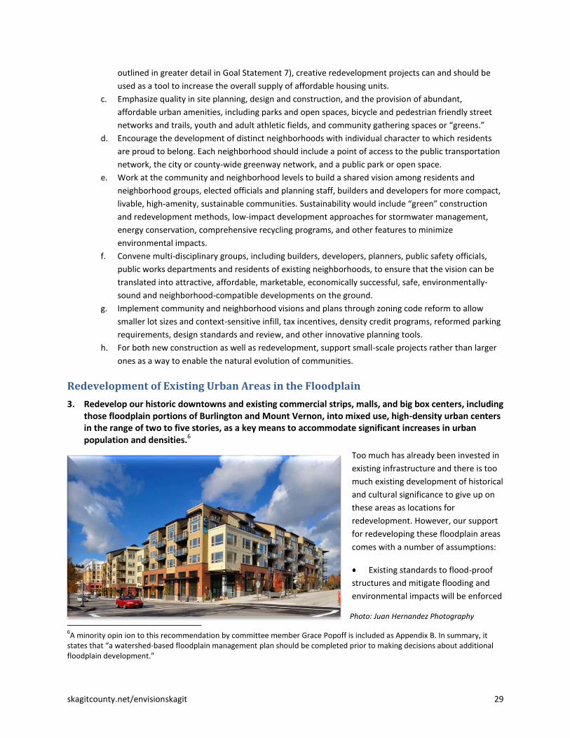
3. Redevelop our historic downtowns and existing commercial strips, malls, and big box centers, including those floodplain portions of Burlington and Mount Vernon, into mixed use, high-density urban centers in the range of two to five stories, as a key means to accommodate significant increases in urban population and densities.6
Too much has already been invested in
existing infrastructure and there is too
much existing development of historical
and cultural significance to give up on
these areas as locations for
redevelopment. However, our support
for redeveloping these floodplain areas
comes with a number of assumptions:
Existing standards to flood-proof
structures and mitigate flooding and
environmental impacts will be enforced
6A minority opin ion to this recommendation by committee member Grace Popoff is included as Appendix B. In summary, it
states that “a watershed-based floodplain management plan should be completed prior to making decisions about additional floodplain development.”
Photo: Juan Hernandez Photography

30 skagitcounty.net/envisionskagit
and, at least in places, will likely grow stricter under evolving federal standards for floodplain development;
Cities will have effective evacuation plans for all at-risk areas; and
All parties involved with constructing and maintaining the levee system will use the best available technology
and methods to ensure that the levees and the entire flood prevention and control system perform as
effectively as possible.
Urban Growth Area (UGA) Expansion Thresholds and Criteria
4. Establish higher thresholds than currently exist in the Countywide Planning Policies, county, city and town comprehensive plan policies and the adopted UGA expansion criteria for when urban growth areas are eligible to expand. This will encourage greater infill, redevelopment, and intensification within our existing urban areas.
As long as cheaper lands remain available at the outskirts of our communities there will be little or no economic
incentive to intensify development within them. Tight UGA boundaries will encourage urban rejuvenation from
within our cities, while loose boundaries will encourage continued low-density outward expansion. The following
specifics should be implemented through negotiations between the county, the cities and the towns:
a. Urban areas should achieve a 50 percent increase over current planned or anticipated residential
capacity before UGA expansions are allowed. This would not require 50% increases in residential
density across all zones, but could instead be achieved through larger increases in specific areas –
such as downtowns and mixed-use commercial corridors.
b. Employment densities used to calculate commercial and industrial acreage needs should be increased
by 25% over existing capacities as found in the Comprehensive Economic Development Strategy
(CEDS). This would reflect current and future trends toward more compact, vertical (multi-floor)
commercial development, and create greater incentives for commercial infill and redevelopment.
5. Existing Urban Growth Areas should be prohibited from expanding into environmentally sensitive areas, including the floodplain and agricultural lands (which in Skagit County are generally synonymous).
Recommendation 2 in Goal Statement 2 (for Natural Resource Lands), already recommends against expanding
UGAs into agricultural lands, consistent with the “no net loss” goal for Ag-NRL lands. Because virtually all
agricultural land in Skagit County is in the floodplain, it is a simple extension of this prohibition to apply it to the
floodplain. We recommend redevelopment of the floodplain within existing UGAs because there already is so
much existing investment, infrastructure and local history and culture present in many of these areas. However,
urban boundaries should not be further expanded into the floodplain.
6. Existing Urban Growth Areas should be discouraged from expanding into sensitive stream basins.
Examples of sensitive stream basins include the East Fork Nookachamps (east of Mount Vernon) and Hansen Creek
(north of and partly included in the Sedro-Woolley UGA at Northern State). Both are important lowland tributaries
for Skagit River salmon—particularly for coho, but also used by Chinook, chum, pink salmon and steelhead.
7. Direct future residential population growth into existing cities and towns with established municipal services and tax structures. Avoid locating residents near incompatible land uses or in proximity to specific site hazards.
The committee’s vision is for most future population growth to be contained within existing cities and towns. This
is at odds with the adopted Subarea Plan for Bayview Ridge, which would allow approximately 2,500 to 3,000
additional residents in the northeast portion of this unincorporated UGA. At full build out, the Bayview Ridge UGA

skagitcounty.net/envisionskagit 31
would have 5,000 to 5,500 people living in an area currently without established municipal services, in proximity to
industrial lands, astride two existing petroleum pipelines, and within a half mile of a runway end at Skagit Regional
Airport.
The public would be better served by directing that future population to the cities and towns. The committee
recommends that most or all of the proposed additional residential development within the Bayview Ridge UGA be
redirected to existing cities and towns, and rezoning 1,600 acres at Bayview Ridge to Light Industrial, as discussed
in more detail in Goal Statement 1, Recommendation 4. So doing would also protect the airport from conflicting
residential encroachment and make available needed contiguous industrial acreage close to utility and
transportation infrastructure and adjacent existing light industrial uses.
The Rural Landscape and Development The Committee is concerned about the dispersed pattern of “red dots” in Skagit County rural and resource lands,
as reflected in the Envision Plan Trend scenario modeling, representing potential new residences. All told, there
are around 13,000 not-yet-exercised development rights in the rural and resource lands. Not all of these are
anticipated to be built out by 2060, but under current plans and policies the large majority likely would be. This
could have very serious negative impacts on environmental resources, natural resource lands and industries, and
rural character. At the same time, we respect and acknowledge private property rights. We do not support
uncompensated downzoning.
8. Skagit County should use all available tools to shape future development in rural and resource lands to minimize negative impacts.
Through the use of land use designations and zoning, purchase and transfer of development rights and
conservation easements, the County should discourage development where it will cause the most environmental
harm, including in the floodway, the functional floodplain (areas that flood frequently and have hydrologic
continuity with the floodplain), the channel migration zone (areas that will likely be occupied by river channels
over time), the lahar zone (the paths that mudflows from volcanic activity would likely follow), natural resource
lands and other areas with very high open space values.
a. Skagit County should work with other jurisdictions and organizations (including the Skagit Alliance) to
develop and implement a successful county-wide transfer of development rights (TDR) program to
protect natural resource lands (such as Agriculture and Forest-NRL), environmental resources
(including salmon and wildlife habitat) and rural character. In so doing, the County should set a
consistent policy for preserving rural character, recognizing that the character of rural Skagit County
is not the same everywhere.
b. Skagit County should consider creating a purchase of development rights program (PDR) to protect
the most environmentally sensitive lands, taking care not to undercut the successful Farmland Legacy
Program.

32 skagitcounty.net/envisionskagit
Full residential buildout potential based on current rural zoning. Map provided by Skagit County GIS.
Clustering via “Conservation Development”
9. Skagit County should amend its development regulations to enable and require clustering via "conservation development" for rural and natural resource lands. This would involve amending the County’s current CaRD7 ordinance to do a better job of protecting a site’s most valuable open space, its natural hydrologic functioning, and any associated natural resource lands.
Credit: Randall Arendt, Conservation Design for Subdivisions, Island Press, 1999
7 Conservation and Reserve Development.
skagitcounty.net/envisionskagit 33
Conservation development is an approach to development where green space is laid out first, the site’s natural
hydrologic function is preserved, development lots are typically small and clustered, the majority of the site
remains undeveloped, and the site’s protected open space connects to the county’s broader open space or green
infrastructure network. Done well, conservation development also enhances a property’s economic value.
We do not know the exact mix of planning, legal, economic, regulatory and incentive tools to make this vision a
reality. We do not believe that the County's current CaRD or cluster ordinance is well suited to achieve these goals
and this vision. We strongly encourage Skagit County to work with the Skagit Alliance, the Urban Land Institute and
other knowledgeable experts, local landowners, land development professionals, conservation organizations and
other interested parties to implement this vision through the Skagit County comprehensive plan and development
regulations.
Rural Villages
10. The Committee supports moderately increasing densities in Alger and Conway Hill8, where expansion of rural villages makes the most sense in terms of transportation and other infrastructure and is least disruptive to natural resource lands, environmental systems and rural character. These existing rural villages should achieve their higher/clustered densities through transfers or purchases of development rights from rural and resource lands only. High quality design guidelines should be developed with the help of community residents so these communities retain their distinct character.
Expansion of these existing rural villages is not currently allowed under the Growth Management Act. However,
with appropriate safeguards we believe our proposal would better serve the goals of the Growth Management Act
than existing law, and so it is the law that should be amended. Using development rights transferred from rural
and resource lands, and with environmentally sensitive water and wastewater service, development in these
expanded rural villages would have considerably less impact on natural systems, working lands, and rural character
than if it took place where the development rights are currently located. Bringing the multiple affected landowners
together to accomplish this would be a challenge, but we believe that with effective public-private coordination
the end result can provide greater value to the landowners themselves while also better serving the many public
interests involved.
Current residents of the affected communities should, of course, help shape these expansions. In the case of Alger,
we also recommend that Skagit County coordinate with the Upper Skagit Tribe, which has interests in
development near its casino at the affected I-5 interchange, and with Whatcom County, which has authority over
adjacent development across the county line.
Other rural villages exist outside of the floodplain and agricultural lands. Under their existing zoning they may
receive some limited additional infill development. These rural villages might be considered at some point in the
future for moderate expansion and densification, allowing them to serve as receiving zones for scattered rural
development rights.
8 The referenced “Conway Hill” area is currently designated Rural Intermediate; the existing Conway Rural Village is located
west of I-5, in the floodplain and surrounded by Ag-NRL lands. This proposal envisions a portion of the Conway Hill area – out of the floodplain and Ag-NRL - becoming an “expanded rural village.”

34 skagitcounty.net/envisionskagit
11. The Town of Hamilton can and should play a similar role to these expanded Rural Villages, receiving transferred development rights and developing residential and mixed uses (shops, restaurants, services, etc.) at walkable scale and densities. With the recent expansion of Hamilton’s urban growth area north of Highway 20 out of the floodway and floodplain, and the town’s investments in urban infrastructure, Hamilton is a logical location for new development in the middle Skagit region.
Fully Contained Communities
12. The Citizen Committee believes that fully contained communities (FCCs) should be avoided in Skagit County unless they can achieve their urban densities strictly through transfers of development rights from rural or resource lands at a ratio of one-to-one. If this means that FCCs are infeasible in Skagit County for the foreseeable future, we find that an acceptable outcome.
Fully contained communities are different from rural villages as discussed above because under current law they
require an urban population allocation and are required to develop at urban densities and with urban services. By
definition, they are new urban areas placed on land that was previously rural. If they achieve their density through
the creation of new development rights or the transfer of urban population allocations, they therefore add to the
total amount of development that could occur outside of existing urban areas. Moreover, that development would
be located where there is currently little to no existing infrastructure capable of serving urban densities. We
believe that it is far better to locate new urban development within or adjacent to existing urban areas, where
infrastructure can be extended cost-effectively and impacts on working lands and natural systems can be
minimized.
Given future population increases and the degree to which existing urban areas in Skagit County are located in the
floodplain or adjacent to farmland, it is possible that there may come a time when an FCC may offer the
opportunity for smaller impacts on natural systems or working lands than an equivalent expansion of an urban
area. For now, however, given all of the above as well as concerns that Citizen Committee members have over
issues of affordable housing and impacts on transportation, we believe that the standard for considering an FCC
should be set very high, including a one-to-one ratio for transferring its development rights from rural and
resource lands.
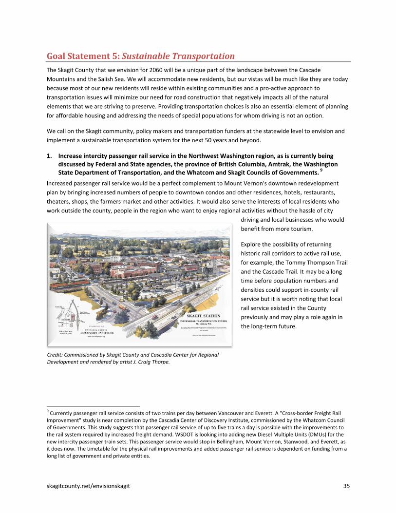
skagitcounty.net/envisionskagit 35
Goal Statement 5: Sustainable Transportation
The Skagit County that we envision for 2060 will be a unique part of the landscape between the Cascade
Mountains and the Salish Sea. We will accommodate new residents, but our vistas will be much like they are today
because most of our new residents will reside within existing communities and a pro-active approach to
transportation issues will minimize our need for road construction that negatively impacts all of the natural
elements that we are striving to preserve. Providing transportation choices is also an essential element of planning
for affordable housing and addressing the needs of special populations for whom driving is not an option.
We call on the Skagit community, policy makers and transportation funders at the statewide level to envision and
implement a sustainable transportation system for the next 50 years and beyond.
1. Increase intercity passenger rail service in the Northwest Washington region, as is currently being discussed by Federal and State agencies, the province of British Columbia, Amtrak, the Washington State Department of Transportation, and the Whatcom and Skagit Councils of Governments. 9
Increased passenger rail service would be a perfect complement to Mount Vernon's downtown redevelopment
plan by bringing increased numbers of people to downtown condos and other residences, hotels, restaurants,
theaters, shops, the farmers market and other activities. It would also serve the interests of local residents who
work outside the county, people in the region who want to enjoy regional activities without the hassle of city
driving and local businesses who would
benefit from more tourism.
Explore the possibility of returning
historic rail corridors to active rail use,
for example, the Tommy Thompson Trail
and the Cascade Trail. It may be a long
time before population numbers and
densities could support in-county rail
service but it is worth noting that local
rail service existed in the County
previously and may play a role again in
the long-term future.
9 Currently passenger rail service consists of two trains per day between Vancouver and Everett. A "Cross-border Freight Rail
Improvement" study is near completion by the Cascadia Center of Discovery Institute, commissioned by the Whatcom Council of Governments. This study suggests that passenger rail service of up to five trains a day is possible with the improvements to the rail system required by increased freight demand. WSDOT is looking into adding new Diesel Multiple Units (DMUs) for the new intercity passenger train sets. This passenger service would stop in Bellingham, Mount Vernon, Stanwood, and Everett, as it does now. The timetable for the physical rail improvements and added passenger rail service is dependent on funding from a long list of government and private entities.
Credit: Commissioned by Skagit County and Cascadia Center for Regional Development and rendered by artist J. Craig Thorpe.

36 skagitcounty.net/envisionskagit
2. Encourage more compact urban development and more clustered rural development to facilitate more efficient transportation.
Public transit is much more cost-effective and efficient to provide in compact communities. Residential densities of
about seven dwelling units per acre generally can support basic bus service, while densities of 15 units per acre or
higher are needed to support more frequent service. 10
As that better transit network is built along a system of
major hubs and corridors, it can then help to shape future land-use patterns that are mutually reinforcing.
3. Place greater emphasis on non-motorized transportation, including more and better bike lanes and pedestrian facilities built into the road network as well as a more developed system of non-motorized trails.
We have learned the hard way that unless we specifically plan for
sidewalks, bike lanes, bike paths and trails these features will likely
be missing in the end.
a. The Skagit Council of Governments or Skagit Alliance
should look for appropriate opportunities to integrate non-
motorized transportation routes and networks with the
existing and proposed open space network. This should be
done in a cooperative, voluntary manner that enhances
mobility and respects community values and individual
property rights.
b. Within Urban Growth Areas, open space should emphasize
public access and integrate seamlessly with non-motorized transportation. Open space adjacent to UGAs
that is appropriate for public access should be directly linked to open space corridors within the UGA to
create a contiguous network.
c. Road standards should be modified to improve safety for bicyclists, particularly on designated bicycle
routes.
4. Explore and embrace innovative transit options.
Although we do have small buses that serve rural areas, this service needs to be much more frequent for most
people to view as an alternative to cars.
a. For long, skinny corridors such as SR 20, explore a system such as the “colectivos” that run successfully
south of Cancun and in other parts of Latin America. Colectivos are fleets of passenger vans that run with
high frequency along the highway.
b. Creative options everywhere: run colectivos around our towns; consider Bus Rapid Transit as an
alternative to high-speed rail; consider river taxis from La Conner to at least Mount Vernon and
Burlington; work directly with employers to find ways to reduce commute trips for workers; create
options for shoppers such as shuttle buses or fixed-cost taxi service; set up mini park-and-rides in rural
areas to simplify use of public transit; provide rain protection at bus stops; explore possible rail-to-trail
and trail-to-rail conversions; require serious attention to transportation alternatives in all development
plans.
c. Establish education and outreach programs to increase awareness and provide easy access to
transportation options for first-time as well as frequent users.
10
Transportation Research Board, Transit-Oriented United States: Experiences, Challenges, and Prospects, Washington D.C., 2004, p. 67.
Credit: Pedestrian and Bicycle Information Center

skagitcounty.net/envisionskagit 37
5. Preserve and enhance our ferry connections to the islands and the international ferry service to Vancouver Island.
Ferry service is essential for our tourism economy and the providers of goods and service on the mainland that
supply the islands.
6. Protect existing airport facilities from encroaching incompatible land uses that could limit their future aircraft operations.
Skagit County has three paved airports: Skagit Regional at Bayview, Anacortes and Concrete. These facilities are
important to the current and future economics of Skagit County. These facilities should be protected from
encroaching incompatible land uses that could limit their future aircraft operations.
7. Preserve our current navigable waterways into the future.
Swinomish Channel is dependent on periodic dredging for the safe passage of commercial and recreational vessels,
a large number of which are based in La Conner. Every effort should be made to preserve this navigable channel
for the economic health of our region and the safety of the vessels that transit our county.

38 skagitcounty.net/envisionskagit
Goal Statement 6: Water/ Wastewater
Because population growth will increase demands on domestic, commercial and industrial water use and
associated water and wastewater infrastructure, water and wastewater issues are integral to many of the other
topics in our recommendations. The Citizen Committee did not have the time or resources to address this topic in
great detail; however, general recommendations associated with water and wastewater capacity, technology and
infrastructure are addressed in this section. Stormwater and flooding issues are addressed in the context of other
issues that relate to them and are included in recommendations that appear in Goal Statements 2, 3 and 4.
The federal Clean Water Act established water quality
goals for the nation’s waters to protect beneficial uses
including consumption, recreation and fisheries. While
the Act led to some very significant improvements,
parts of the Skagit and Samish River watersheds still do
not meet water quality standards. Population growth
will likely make attainment of clean water standards
even more difficult and expensive. Planning ahead and
being informed about technological advances already
being explored or implemented in other parts of the
United States and countries abroad can help improve
outcomes and reduce costs.
State water law and state appropriated water right permits and certificates govern how much water is available for
domestic, commercial, agricultural and industrial water use, as well as for in-stream uses. The natural supply of
surface and groundwater in the Skagit will not likely increase in the future. If snowpack declines and glaciers melt
because of climate change, seasonal low flows will actually decline over time. In any case, the state is unlikely to
approve increased appropriations for out-of-stream uses in the future out of concern for in-stream flows. Water
rights are mostly focused on peak withdrawals. In the Pacific Northwest, peak withdrawals are in the summer,
generally coinciding with natural low flows.
The continued availability of a safe and reliable supply of water into the future is of fundamental concern to Skagit
County’s citizens. Drinking water supply to service growth in Skagit County will actually depend on water rights
(legal rights to water) rather than the amount of water in the Skagit River and associated tributaries and
groundwater. Limits on water availability already have constrained growth in the Fisher-Carpenter Creek sub-
basin. In the future, the state may establish similar constraints on growth in the East Fork and Upper Nookachamps
Creek basins. More widespread limitations are possible in the future.
A recent study11
estimated future water demand in Skagit County over 50 years and compared that demand to the
legal rights for water held by the Skagit PUD and the City of Anacortes. The study did not address installed facility
capacity, but rather assumed that facilities could be expanded. The study also accounted for rural water demand
via permit-exempt wells. This study found that when aggregating all water supply and all projected water demand,
projected shortfalls occurred under all proposed growth scenarios (GMA Steering Committee low to medium,
medium and high) when considering maximum day demand. The report goes on to state that some of the deficit
11
Hydrologic Services Company (HSC), Current and Projected Water Demands for Skagit County’s Domestic, Commercial and Industrial Sectors, Prepared for Skagit County Public Works Department and Mentor Law Group, January 2006.

skagitcounty.net/envisionskagit 39
can likely be met through operational strategies implemented by major purveyors, but that additional water
sources will likely be required to provide a reliable supply of water to the forecasted population.
Recommendations
1. Plan proactively, using appropriate and innovative methods, to provide future water and wastewater services and infrastructure. Consider the following:
a. Conduct feasibility studies to determine how to best provide wastewater and water services and systems to rural clustered housing and/or expanded rural villages prior to their development. Strive for minimal surface and groundwater consumptive use and minimal impact to groundwater quality and the water quality of local water bodies.
b. Building codes should allow innovative wastewater and fresh water systems (e.g., use of grey water or rooftop stormwater for irrigation) for residential, industrial and agricultural use in order to reduce demand on fresh water sources.
c. Plan for future services, including the citing of both regional and smaller scale wastewater systems. As part of that planning consider innovative wastewater treatment technologies and practices that:
Reduce overall water use;
Have the capacity to augment potable water supplies by using highly treated wastewater effluent and stormwater for irrigation and other uses;
Consider separating stormwater and provide alternative stormwater treatment;
Use alternative energy technologies; and
Enable the use of waste system by-products such as energy production and biosolids.
2. Be proactive in assessing future water needs prior to permitting additional new uses and ensure a sustainable supply.
a. Determine how much water will be needed to support projected growth, agriculture, and commercial and industrial needs out-of-stream, and environmental needs in-stream over the next 50 years and beyond. We encourage that a comprehensive study of all water uses and needs be conducted to help guide the future sustainable use of this resource. As part of this study, consider forecasted municipal supply needs, rural water supply needs from permit-exempt uses of groundwater, low tributary flows and in-stream needs to sustain ecosystem function and species diversity, salt water intrusion in our island environs, and agricultural needs including flexibility in place of use to address cropping rotations and crop movement.
b. Use available water resources in a manner that will sustain healthy groundwater and surface water supplies long into the future.
c. Consider more aggressive water conservation activities and technologies for all uses: domestic, commercial, industrial, agricultural.
The Citizen Committee has not had the time or resources to conduct an in-depth study of the adequacy of the
regional water resources to meet the projected needs of our population, natural resource industries, ecosystems,
Septic tank inspection in process

40 skagitcounty.net/envisionskagit
and commercial and industrial sectors 50 years into the future. However, we feel such a study is warranted when
considering future growth and the location of that growth.
3. We encourage the continued public ownership of our County’s water systems and discourage efforts to privatize our water supply.
4. Municipal water and wastewater service providers should coordinate extension of their service areas with County land use plans and the land use recommendations provided in this document.
5. Consider our long-term water needs within Skagit County prior to extending Skagit waters across watershed boundaries and into other counties.
Skagit County water service providers currently provide some water for rural and industrial use outside of county
boundaries and project increased service to their out-of-county customers as outlined in their water system plans.
It is possible that rural “out-of-county” demand for water could also occur. The PUD and Anacortes have
accounted for some service area expansion to rural areas outside the County as part of their long range planning. It
is possible that rural areas in North Snohomish, South Whatcom and Whidbey Island could request additional
expansions.

skagitcounty.net/envisionskagit 41
Goal Statement 7: Housing Variety and Affordability
Living in Skagit County appeals to people of all income levels, but keeping the county accessible to people of all
income levels will require planning now and course corrections in the future as we watch how our policy decisions
play out. Increases in the supply of housing available in urban areas, consistent with the recommendations in our
goal statement for Compact Communities, are necessary but not sufficient to promote affordable housing in our
community.
There is already a serious lack of affordable housing in Skagit County – meaning housing that is affordable to the
average working individual or family, as well as assistance programs for those with special needs -- as the following
figures illustrate:
The Housing Authority of Skagit County has more than 3,000 people on the waiting list for its housing
vouchers program, representing a 7-year backlog for this type of housing assistance.
Skagit County’s 2009 homeless count of 2,306 (compared to 1,182 in 2005) was the highest per capita in
Washington State.
1. We urge Skagit County, the cities and towns, the Housing Authority of Skagit County and other housing providers, builders and developers, social service organizations, and others, to work together to provide a wider variety of housing options for our urban and rural residents, as one means to address the serious lack of affordable housing in Skagit County.
Demographics are changing. Both nationally and locally, we are
seeing more single-person households in addition to single-parent
households. Baby boomers are retiring and looking for new
housing options. In response to these changes, we are seeing
smaller houses; smaller lots; attached townhouses, condos, and
apartments; and mixed-use projects that combine retail space,
office space, and living space. We have learned that all of these
options can be both attractive and affordable. Affordability is
partly a result of lot and home size, but proximity to work,
entertainment, and necessary goods and services greatly reduces
transportation costs which also contributes to affordability. An
adequate supply of affordable housing is important for meeting social needs in our communities and also for
housing the region’s workforce.
We are encouraged by, and supportive of, the work being done by the Skagit Affordable Housing Advisory
Committee, which includes elected officials, city and town planners, housing providers, developers, farmers, and
other members and is developing a coordinated, regional affordable housing action plan. Particularly if we move
toward accommodating 90 percent of new population in urban areas, the cities and towns, housing providers, and
the building industry must continue to work on this issue aggressively and over the long-term. Affordable housing
is another area where the Skagit Alliance can play an important role, drawing on local, regional and national
housing expertise to address this serious local issue.
2. Affordable housing should be integrated into the fabric of our communities, not isolated in low-income enclaves.
We know this can be done, because we've seen it in action elsewhere. Well-designed projects can incorporate
housing units for many income levels, but this may not happen by chance. More often, it happens when planners

42 skagitcounty.net/envisionskagit
and developers are deliberate about creating mixed-income projects. Citizen Committee members were able to
see a well-designed project at High Point in Seattle where subsidized housing and market-rate housing were side
by side and we could not discern the difference. In this manner, we believe farmworker housing (including for
migrant workers) should and will be increasingly provided within our communities, rather than in seasonal labor
camps located on farms. Affordable housing should also be safe and secure.
Some noteworthy examples of attractive, well located, affordable housing developments in our own communities
include the Villa Santa Maria apartments in Mount Vernon and the Raspberry Ridge apartments in Burlington, both
of which provide housing for farmworkers; and the very nicely restored New Wilson Hotel Apartments in
downtown Anacortes.
3. As discussed in greater detail in our Compact Communities and Transportation recommendations, developing more compact, mixed-use, and transit-friendly urban communities and rural villages, where people have options to live and work, can increase housing opportunities for all income levels and reduce commuting costs.
At present, people often locate in some of our rural areas because homes are more affordable than in our cities.
Many of these people commute long distances to their work sites and are vulnerable to higher energy costs.
Unless more affordable homes are offered in urban areas, transportation options will be essential for these rural
families.
Affordability is not the only factor that draws people to rural areas. People choose rural properties so they can
engage in home businesses, raise their own food, experiment with alternative energy ideas, be close to outdoor
recreation, and have space for creative activities. Others simply do not want to live in urban areas. When
commuting is not essential – because people live and work in their rural communities -- rural living can remain a
viable option.
Develop compact, mixed use, transit-friendly urban communities. Credit: City of Eugene, Walnut Street Subarea Plan
4. The Home Trust of Skagit and other interested partners should develop and construct a pilot project in Skagit County to demonstrate that the provision of affordable housing can be combined with quality design and green building and low-impact development techniques.
Home trusts and housing partnerships in surrounding counties are developing outstanding examples of well-
designed, affordable and environmentally responsible housing. Examples include the San Juan Community Home

skagitcounty.net/envisionskagit 43
Trust’s Sun Rise and Salal neighborhoods. (See http://www.hometrust.org/. ) From the innovative housing projects
members of the Citizen Committee have visited, the examples we’ve seen and heard about and the housing
innovators we have met, we believe the same type of projects can and should be built here in Skagit County.

44 skagitcounty.net/envisionskagit
Goal Statement 8: Economic Vitality
Economic vitality is inseparable from all of the other issues discussed in our recommendations. Maintaining the
high quality of life in Skagit County is key to our economy and our attractiveness as a place to do business. Without
a job, it is difficult for anyone to enjoy what Skagit County has to offer.
We firmly believe that the recommendations in each of the goal statements in this document would strengthen
the local economy, as briefly described below. We also offer several additional recommendations for improving
local economic vitality and sustainability. We applaud the outstanding work of the Economic Development
Association of Skagit County (EDASC), the Ports of Skagit County and Anacortes, local chambers of commerce, and
other organizations dedicated to improving the Skagit economy.
Goal Statement 1: Stronger Regional Coordination, Collaboration and Cooperation: Our future economic strength
lies in working together to improve the well-being of the county as a whole.
Increasingly, successful economic development strategies work
at the regional level, with local jurisdictions cooperating with,
rather than competing against, one another.
The Skagit Alliance would help to forge this regional
economic vision.
Designating 1,600 acres of new, highly-marketable
industrial land in upland areas near supporting
infrastructure and transportation land will help EDASC
and other economic development organizations find
homes for expanding and new industrial firms.
Sharing revenues from this new industrial
development will benefit all local jurisdictions.
Exploring opportunities to consolidate local services without
sacrificing the quality of those services will help stretch
increasingly scarce public resources. The proposed merger of
Mount Vernon and Burlington will allow each city to benefit
from the other’s strengths. It also provides an alternative to
the possible expansion by either city into ag land and floodplain
for commercial development.
Goal Statement 2: Protect Natural Resource Lands, Aquatic Resources and Industries (agriculture, forestry, fish
and shellfish). Natural resource industries are an important part of the Skagit economy and a critical part of our
unique character and sense of place. These industries provide local jobs and revenues and generally require lower
public expenditures than other land uses.12
Our recommendations would:
Strengthen the agricultural economy by ensuring no net loss of agricultural lands, expand non-regulatory
programs to support agriculture (such as doubling funding for the Farmland Legacy Program) and
implement a Skagit Food System Strategy.
12
American Farmland Trust, Cost of Community Services, Skagit County Washington, 1999.
Photo: Janicki Industries

skagitcounty.net/envisionskagit 45
Maintain existing zoning protections for forest land and look for opportunities to purchase or transfer
forest land development rights to retain these lands in active forestry.
Encourage effective management of stormwater to protect fish, shellfish, and agriculture; and encourage
local/regional efforts to support natural resource industries and the ecosystem forged by those with the
greatest on-the-ground knowledge of how to meet the needs of both.
Goal Statement 3: Protect, Preserve, and Restore and Environmental Resources and Values. To achieve
environmental and economic goals over the next 50 years, we must identify and protect our most valued open
space lands and natural and environmental resources, while at the same time determining where future
development should go. We have heard powerful evidence from local and national experts that Skagit County’s
diverse natural environment and scenic open spaces –increasingly rare attributes across the country – are
powerful forces for sustainable economic development.13
Our recommendations would protect and enhance these
economic assets by:
Developing and implementing a long-range conservation vision and plan;
Protecting and conserving the Skagit and Samish rivers, including their floodplains and ecological
functions;
Drawing on a variety of tools, including incentives, voluntary efforts, education and regulation, limit
future development in the Skagit and Samish River floodplains outside of existing urban areas; protect
and restore fish habitat and salmon runs in the Skagit and Samish rivers and their tributaries; and improve
water quality in the Samish River and Samish Bay and other water bodies suffering from non-point source
pollution.
Goal Statement 4: Compact Communities and Conservation Development: An essential strategy for protecting
the Skagit’s natural environment and natural resource industries – both of which are important long-term
economic assets – is to concentrate new growth in more compact urban areas and to limit low-density rural
sprawl. Numerous reputable land use experts indicate that powerful economic and demographic forces are
creating increasing market demand for just this kind of development – particularly compact, walkable, high-
amenity, mixed-use communities and redevelopment of existing strip malls and commercial areas into mixed-use
urban centers.14
Many similar sources have documented that compact development, infill and redevelopment
(often called “Smart Growth”) is much less expensive to serve with public infrastructure than more sprawling,
dispersed growth patterns.15
For these reasons, we believe the growth patterns that are best for protecting Skagit
County’s scenic quality, natural environment and natural resource industries dovetail well with powerful economic
– and economic development – trends of the future.
13
Patsy Martin, Port of Skagit County, “Addressing Economic Opportunity,” presentation to the Envision Skagit Citizen Committee. January 6, 2011. Edward T. McMahon, Urban Land Institute, “The Dollars and Sense of Sustainable Development,” presentation for Envison Skagit at the Lincoln Theatre. April 28, 2011. 14
For instance, see: A.C. Nelson, “Leadership in a New Era,” Journal of the American Planning Association, Vol. 72, Issue 4, 2006, pages 393-407. Christopher B. Leinberger, The Option of Urbanism: Investing in a New American Dream, Island Press, 2009. National Association of Realtors, The 2011 Community Preference Survey: What Americans are looking for when deciding where to live, March 2011. 15
Terry Moore, Lorelei Juntunen, Tom Soulhas, Whit Perkins, Evaluation of Fiscal Implications of Growth Management Options in Skagit County, Washington, ECONorthwest, July 2011 (Draft), pages 31-33.

46 skagitcounty.net/envisionskagit
Redevelop existing strip malls and commercial areas. Photos: Kirk Johnson; GGLO
Goal Statement 5: Sustainable Transportation: This section includes a number of recommendations that would
directly benefit the Skagit economy:
Increase intercity passenger rail service in Northwest Washington as is currently being discussed by
federal, state, regional, and local agencies and rail providers. This would be a perfect complement to
Mount Vernon’s downtown redevelopment plan and to enhanced tourism in the county.
Explore innovative ways to improve transit service to east Skagit County – for instance, a system of
“colectivos” or fleets of small passenger vans running with high frequency along Highway 20 – to help east
county residents commute more easily to jobs in central Skagit County or adjoining counties, and to
access central county businesses and services.
Preserve and enhance our ferry connections to the islands and the international ferry services to
Vancouver Island, which is important for our tourism economy.
Protect existing airport facilities from encroaching incompatible land uses that could limit their future
aircraft operations.
Preserve our current navigable waterways into the future, including Swinomish Channel, which carries
large volumes of commercial and recreational vessels based in La Conner.
Goal Statement 6: Water/ Wastewater. Ensuring an adequate supply of water for residential, industrial, and
agricultural use and protecting water quality and quantity in our aquifers, lakes, rivers, and bays are essential to a
healthy and sustainable economy in Skagit County.
Goal Statement 7: Housing Variety and Affordability: There is a serious lack of affordable housing in Skagit County
– meaning housing that is affordable to the average working individual or family as well as assistance programs for
those with special needs. This section urges all parties involved to provide a wider variety of housing options and a
broader supply of affordable housing for the county’s residents. This is important for meeting social needs in our
communities and also for providing housing for the county’s workforce – a key component of a strong local
economy.
Additional Committee Recommendations We offer the following additional recommendations not already addressed in the above goal statements:

skagitcounty.net/envisionskagit 47
1. Develop an economic development strategy for eastern Skagit County and other rural areas that is unique to their circumstances.
Economic development approaches that work in the urban
areas near the I-5 corridor are not necessarily transferable
to rural Skagit County. A rural economic strategy should
support small-scale, sustainable businesses and industries
that enable people to work without commuting long
distances. Affordable broadband services comparable to
those offered in urban areas is essential in rural areas as
well. Broadband enables people to work from home, run
successful small businesses, provide services to both local
residents and tourists, and access government information
and services on an equal basis with urban residents.
2. Encourage businesses and industries that make sustainable use of our natural resources.
The sustainable management of natural resources recommended in Goal Statements 2 and 3 will be best
supported by businesses that make sustainable use of natural resources, including agricultural, forest, fish and
shellfish products as well as water resources. A healthy local economy is essential to meeting the broader goals
identified in these recommendations. We acknowledge the importance of all of our existing businesses and
industries. As we look to the future, we want to recognize and encourage those businesses and industries that are
incorporating the concept of sustainability into their long-term business strategies. This includes striving for the
sustainable rate of harvest and utilization of renewable resources, adding as much value locally as possible to
Skagit resources, meeting local needs while also selling to external markets, becoming increasingly efficient in the
use of energy, and exploring alternative and renewable energy sources.
3. Encourage economic diversity as a key means to promoting a resilient local economy.
A diverse mix of business and industry adds to the county’s economic resilience just as maintaining ecological
diversity retains resilience and sustainability in the natural world. The county’s economic development strategy
should strive to retain existing businesses and industries where we are already strong or have natural advantages –
including agriculture and, increasingly, adding value to our agricultural products; forestry and wood processing;
fishing and shellfish; and boat building and other marine industries – while seeking to promote and recruit new
businesses and industries consistent with overall community goals. This can be done by:
a. Retaining our natural resource base;
b. Designating land in appropriate places for natural resource processing industries;
c. Retaining zoning for boat building and shoreline dependent marine uses;
d. Providing incubators for small business startups, such as the recently-created food processing incubator
at the Port of Skagit County;
e. Providing advanced technical education and training through such programs as the new Marine
Technology Center in Anacortes (and associated programs through Skagit Valley College) and the Skagit
Valley College Vocational/Technical Education Center; and
f. Providing training to young people in sustainable natural resource management and production at the
high school and technical levels (one great local example is Viva Farms, a joint venture of WSU Extension
and GrowFood.org, an international non-profit dedicated to recruiting, training and capitalizing the next
generation of sustainable farmers).
Photo: Concrete Herald
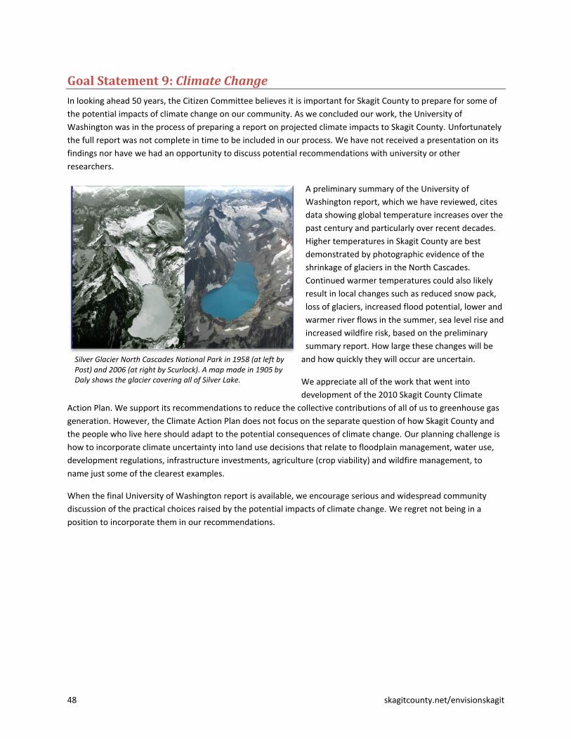
48 skagitcounty.net/envisionskagit
Goal Statement 9: Climate Change
In looking ahead 50 years, the Citizen Committee believes it is important for Skagit County to prepare for some of
the potential impacts of climate change on our community. As we concluded our work, the University of
Washington was in the process of preparing a report on projected climate impacts to Skagit County. Unfortunately
the full report was not complete in time to be included in our process. We have not received a presentation on its
findings nor have we had an opportunity to discuss potential recommendations with university or other
researchers.
A preliminary summary of the University of
Washington report, which we have reviewed, cites
data showing global temperature increases over the
past century and particularly over recent decades.
Higher temperatures in Skagit County are best
demonstrated by photographic evidence of the
shrinkage of glaciers in the North Cascades.
Continued warmer temperatures could also likely
result in local changes such as reduced snow pack,
loss of glaciers, increased flood potential, lower and
warmer river flows in the summer, sea level rise and
increased wildfire risk, based on the preliminary
summary report. How large these changes will be
and how quickly they will occur are uncertain.
We appreciate all of the work that went into
development of the 2010 Skagit County Climate
Action Plan. We support its recommendations to reduce the collective contributions of all of us to greenhouse gas
generation. However, the Climate Action Plan does not focus on the separate question of how Skagit County and
the people who live here should adapt to the potential consequences of climate change. Our planning challenge is
how to incorporate climate uncertainty into land use decisions that relate to floodplain management, water use,
development regulations, infrastructure investments, agriculture (crop viability) and wildfire management, to
name just some of the clearest examples.
When the final University of Washington report is available, we encourage serious and widespread community
discussion of the practical choices raised by the potential impacts of climate change. We regret not being in a
position to incorporate them in our recommendations.
Silver Glacier North Cascades National Park in 1958 (at left by Post) and 2006 (at right by Scurlock). A map made in 1905 by Daly shows the glacier covering all of Silver Lake.

skagitcounty.net/envisionskagit 49
Conclusion
We have made many bold recommendations. Looking out over 50 years, our choice in Skagit County is either to act
boldly or to remain on a path that will incrementally lose the defining features of our landscape. Our agricultural
heritage, our connections to nature, and the integrity and productivity of our ecosystems cannot stand up to the
forces of growth without some fundamental changes.
Our recommendations are not radical. Even the boldest of them, taken alone, is imminently feasible. But
implementing one or just a few of these recommendations will not conserve the best of our landscape over 50
years. As a county and a community we must make progress on the whole range of issues addressed in these
recommendations if Skagit County is to become an even better place to live as we grow.
If these recommendations were simply the product of our committee, they probably would not have the power
behind them to result in fundamental change. But the recommendations are the result of our reaching out to the
wider Skagit community. We firmly believe the vision and recommendations contained in this report are widely
shared—and would be even more broadly embraced if other Skagit citizens had the opportunity to join together
and engage deeply with the challenges that face our common future, as we have over the past ten months. That is
why our two top priorities are also our very first two recommendations: creating a broad-based “Skagit Alliance,”
and engaging a broad cross-section of Skagit County’s leaders in a long-range planning exercise, in part to develop
recommendations for the formation, structure, and composition of the Skagit Alliance.
The Skagit Alliance would play a key role in many of our recommendations, including:
Identifying new lands for industrial zoning and creating a program to share revenues from those lands
across jurisdictions;
Developing a long-range, county-wide conservation plan to guide investments in our “green
infrastructure”;
Planning a new, interjurisdictional program to transfer development rights from the places we most want
to conserve to the places where new growth is most appropriate; and
Exploring options for state, federal or even international designation for the Skagit Valley as a cultural and
natural heritage site.
On these and other recommendations, the Skagit Alliance would not always be in the lead, but without the
Alliance we believe that implementation would be less successful, if it happened at all.
We also make a variety of recommendations where action should begin as soon as possible, even without the
Skagit Alliance in place, because opportunities will be lost with delay. Urgent actions include:
Identifying replacement lands for Ag-NRL acreage that is lost to ecological restoration or vested
development;
Conducting a market analysis for a transfer of development rights program;
Initiating a comprehensive study of the water needed to support in-stream and out-of-stream uses in the
county over the next 50 years and beyond; and
Amending Skagit County’s Conservation and Reserve Development (CaRD) ordinance to better enable and
in some cases require clustered “conservation development” for rural and natural resource lands.
In all of the above cases, Skagit County would be the lead implementer. Other jurisdictions have roles to play,
though, particularly for a comprehensive water study or a transfer of development rights program. Moreover,

50 skagitcounty.net/envisionskagit
while development is currently in a lull with the down economy, all jurisdictions, together with landowners and
developers, have responsibility for the development that is approved and built. Each new development—based on
its location, size, purpose, and design—will help determine whether we are, in fact, living up to the goal of
becoming an even better place to live as we grow.
The following table identifies responsible parties and a timeline for all recommendations in this report.
A 50-year plan takes time to implement. However, actions that we take now and over the next few years will have
consequences for 50 years and beyond. Our recommendations are far from the last word on what should be done.
No laws or major governmental policies will be changed without public comment and discussion. That process will
undoubtedly lead to refining and, we expect, improving our recommendations before they are acted on. But act
we must.
We appreciate the opportunity to serve on the Envision Skagit Citizen Committee. It has been an extraordinary
experience. We look forward to a broad community discussion of our recommendations.
Skagit County Tulip Fields. Photo by Martin Burwash.

skagitcounty.net/envisionskagit 51
List of Appendices
Appendix A: Envision Skagit Citizen Committee
Appendix B: Minority Opinion on Floodplain Development within Existing UGAs
Appendix C: Implementation Matrix for All Recommendations
Appendix D: Longer-Term Implementation Steps and Financial Implications
Appendix E: Glossary
Appendix F: Envision Skagit Citizen Committee: List of Meetings, Field Trips, Community Events
Appendix G: Reports and Data Sources Developed for Envision Skagit

52 skagitcounty.net/envisionskagit
Appendix A: Envision Skagit Citizen Committee Selected September 1, 2010 by the Skagit County Commissioners and mayors of Anacortes, Burlington, La Conner,
Mount Vernon, and Sedro-Woolley
Name Residence Experience
John C.
Cheney Mount
Vernon
Architect (retired); former Mount Vernon City Council; former member, Skagit
Community Action Agency Board, Skagit County Boundary Review Board, former
Skagit Transit board member.
Kerri L.
Cook Alger area
North Cascades National Park, facility operations specialist, civil engineering
technician; Leadership Skagit graduate 2009. Raised in Marblemount and Concrete,
Concrete high school valedictorian 1998.
Cory Ertel Anacortes
Skagit County Community Services Manager with Puget Sound Energy. Formerly
with the Skagit/Island Counties Builders Association (SICBA). Leadership Skagit 2010
graduate. Active with local Chambers of Commerce. Board Alternate on Skagit
County Community Action Agency. Young father of two.
Peggy Flynn Anacortes
Project management, business and organizational consultant. Graduate of UW
Executive MBA program; 2004 Leadership Skagit graduate and curriculum
committee member and team coach; on Anacortes chamber of commerce board of
directors; Anacortes futures project Steering Committee; board member with
Skagitonians to Preserve Farmland, United Way of Skagit County.
James A.
Meyer Rockport
Manager of Cascadian Farm "home farm" in Rockport. On board of Skagit
Community Action Agency, Hamilton Public Development Authority, Festival of
Family Farms. Previously on board of Marblemount Chamber of Commerce and
Forest Concerns of the Upper Skagit.
Kim D.
Mower Hamilton
area
Dairy farmer with keen interest in registered Brown Swiss cows. Member and past
president of Skagit County Agricultural Advisory Board. Active in Dairy 4-H,
Immaculate Conception Regional School, Boy Scouts of America.
Grace
Popoff Concrete
area
Active with Friends of the Upper Skagit Library and library board; started Concrete
area "conversation café" to encourage civil dialogue about local issues. Retired
special-needs program developer. Applied because feels it's important that upper
valley be represented.
Gustavo
Ramos, Jr. Mount
Vernon
Executive director, Housing Authority of Skagit County; has held similar positions in
Nevada and California. Vice president elect of Mount Vernon Kiwanis, member of
the Mount Vernon Downtown Merchants Association representing Housing
Authority, and bilingual radio announcer on KSVR-FM 91.7.
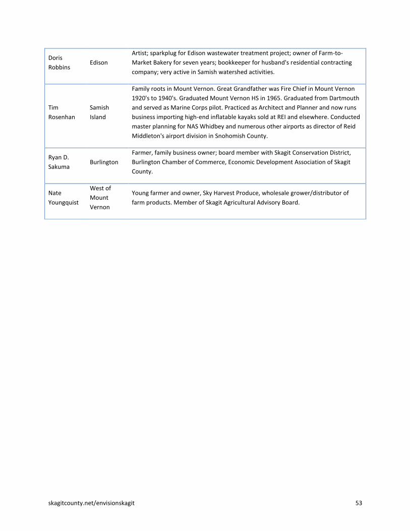
skagitcounty.net/envisionskagit 53
Doris
Robbins Edison
Artist; sparkplug for Edison wastewater treatment project; owner of Farm-to-
Market Bakery for seven years; bookkeeper for husband's residential contracting
company; very active in Samish watershed activities.
Tim
Rosenhan Samish
Island
Family roots in Mount Vernon. Great Grandfather was Fire Chief in Mount Vernon
1920's to 1940's. Graduated Mount Vernon HS in 1965. Graduated from Dartmouth
and served as Marine Corps pilot. Practiced as Architect and Planner and now runs
business importing high-end inflatable kayaks sold at REI and elsewhere. Conducted
master planning for NAS Whidbey and numerous other airports as director of Reid
Middleton's airport division in Snohomish County.
Ryan D.
Sakuma Burlington
Farmer, family business owner; board member with Skagit Conservation District,
Burlington Chamber of Commerce, Economic Development Association of Skagit
County.
Nate
Youngquist
West of
Mount
Vernon
Young farmer and owner, Sky Harvest Produce, wholesale grower/distributor of
farm products. Member of Skagit Agricultural Advisory Board.

54 skagitcounty.net/envisionskagit
Appendix B: Minority Opinion on Floodplain Development within Existing UGAs Submitted by Grace Popoff, Envision Skagit 2060 Citizen Committee member, June 20, 2011
These comments are specifically in response to the recommendation to support:
Redevelopment of our historic downtowns and existing commercial strips, malls, and big-box centers,
including those floodplain portions of Burlington and Mount Vernon, into mixed use, high density urban
centers, in the range of 2 to 5 stories, as a key means to accommodate significant increases in urban
population and densities.
I am unable to support this recommendation because it simply puts the cart before the horse. I recommend the
following alternative:
Decisions about continued development and redevelopment of floodplain properties within existing UGAs
should be made only after a comprehensive watershed-based floodplain management plan is completed. In
developing this plan, stakeholders should anticipate floods in excess of FEMA “100 year” events based on
the best available climate science, consider alternatives such as shrinking UGAs in the floodplain, explore a
variety of strategies to reduce our reliance on levees, anticipate and plan for impacts on farmland, and
emphasize alternatives that would concentrate development in upland areas.
The Envision Skagit 2060 project has given us a rare opportunity to pause and reflect on major policies such as our
approach to floodplain development before making decisions that will affect the Skagit valley for many
generations. Yet during this process, we have had speaker after speaker informing us of the virtues of new
urbanism and none to inform us of new approaches to floodplain management.
Consider these thoughts from the book Floodplain Management: A New Approach for a New Era, by Freitag, et al1:
“Much of the thrust of contemporary growth management is to increase density in existing urban areas as
a means of preserving farmland, forest, and other open space on the periphery. There are limits,
however. At some point, high urban densities begin to preclude any options for returning an area of land
or a section of river to a more natural hydrology. Local governments should establish their objectives and
plans for floodplain management first, and then consider land-use options and development
opportunities that are consistent with those plans.”
It would be so sadly ironic if we, in one of the least damaged watersheds in our region, intensify development in
the floodplain just as communities elsewhere are finding ways to retreat from theirs and restore them when
possible.
Supporters of floodplain development say that without adding people to UGAs within the floodplain, we will need
to “sprawl” into the rural areas, or that we will burden our other cities, or they assume that the GI study will solve
the problem. But I suggest that:
1 Floodplain Management: A New Approach for a New Era, by Bob Freitag, Susan Bolton, Frank Westerlund, and J.L.S. Clark,
2009, Island Press, Washington D.C. This refreshing book is remarkably lacking in dogma. It includes case studies that illustrate a wide variety of strategies adopted by communities seeking alternatives to long-term reliance on levees. Often communities use a combination of strategies that enable a city to preserve valued assets. These strategies might include areas of major levee setbacks, modifications in upper and lower watershed areas, and considerations for farmland and critical habitat.

skagitcounty.net/envisionskagit 55
1. Our first priority should be to complete a watershed-based floodplain and flood risk management plan that
addresses the concerns of multiple stakeholders including future generations, and that this plan should go
beyond FEMA projections since FEMA cannot factor climate change into its calculations.
2. Decisions about floodplain development should come after this plan is developed. If a moratorium on
floodplain permits would stimulate creativity and add urgency to the planning process, then one should be
implemented.
3. The choices are not just a) exit the floodplain, or b) double the population within existing UGAs. A careful
consideration of the costs, impacts, and benefits of a range of options will lead to the best solution.
4. There is no housing emergency; we have sufficient upland areas within Sedro-Woolley, Mount Vernon, and
Anacortes to accommodate growth in the near future. Our concern for lives and property should lead us to
develop away from hazardous areas unless and until comprehensive planning mitigates hazards without
adverse environmental impacts.
5. From the Mississippi2 to the Netherlands
3, where people have been “conquering” rivers and the sea for
hundreds of years, communities are rethinking their strategies. “Retreat” and “naturalizing” are discussed
as communities assess the long-term effects of levees and potential effects of climate change. The lesson
for us is that we should develop only in ways that preserve maximum flexibility in the future.
6. Although occasional controlled flooding does not necessarily destroy farmland, increased floodplain
development can only increase pressure to flood farmland whenever urban levees are threatened.
Increased development without specific provisions for controlled flooding puts all of our valuable
farmlands at risk.
All lands within floodplain UGAs are not equally valuable for preservation or development. Given the costs and
limitations of levees along with the need for additional farmland, fish habitat, and flood storage, it is simply
premature to declare that current city boundaries are non-negotiable. As habitat needs and affordable flood
protection options are considered, some reduction of floodplain UGAs should remain an option.
The Citizen Committee could not agree on an alternative to “assigning” 10,000 people to Burlington4 over the next
50 years. We have concerns about fully-contained communities, which are currently the only option for creating an
area of urban density outside of existing UGAs; it’s hard to judge how more neighborhoods of townhouses,
apartments, and condos will play out for our other cities; we would like to minimize development in rural areas.
But I suggest that holding Burlington’s “basket” of people aside, with the understanding that they will be “placed”
after a floodplain management plan is agreed upon, is preferable to encouraging floodplain development now, a
move that will only limit our options in the future.
2 Managing Northwest watersheds: Should we care about the Mississippi River floods?
http://www.oregonlive.com/opinion/index.ssf/2011/05/managing_northwest_watersheds.html By Julie Clark, Guest Columnist for the Oregonian, May 20, 2011 3 Waterland: Water Information Network/Water in the Netherlands
http://www.waterland.net/index.cfm/site/Water%20in%20the%20Netherlands/pageid/E3B3B416-FB4E-0AB8-2FB6E2B271F1BD6E/index.cfm “Sustainable solutions. The Dutch realised that they can’t continue to rely on only building stronger defences, higher dikes and increased drainage to withstand the flood prone threats. Instead, more sustainable solutions are needed to safeguard the natural functioning of wetlands, coasts, rivers and delta’s. Various programmes have been started to achieve this, with impressive titles such as ‘Living Rivers’, ‘Water as a guiding principle’, ‘Dynamic coastal management’ and ‘Building with nature’. These programmes aim to ensure that the Netherlands will be able to face the growing risks associated with water.” 4 I refer to Burlington because it is almost entirely in the floodplain. I have similar concerns about development floodplain
portions of Mount Vernon and Sedro-Woolley, but both cities have the option of focusing growth in upland acres.

56 skagitcounty.net/envisionskagit
Most often in our society, development begets more development. The proposal to add development to the
floodplain exists only because there is already development in the floodplain. If Burlington did not exist, no one
would suggest that we create it today. So I ask: at what point would you stop development in Burlington?
If 10,000 more people live in Burlington in 2060, would you stop then? If you did decide to stop then, where would
you put additional people over the following 50 years? You would face the same choices we have today, along with
even more pressure to expand into farmland with fewer options for floodplain management and habitat
restoration.
Let us exercise restraint and consider a full range of options before committing to further development in the
floodplain.

skagitcounty.net/envisionskagit 57
Appendix C: Implementation Matrix for All Recommendations
Recommendation Responsible Parties
(Lead in Bold Italics)
Timeline/Process for
Implementation
Regional Coordination, Collaboration, and Cooperation
1.1. Establish a broad-based regional “Skagit Alliance” that calls for a unified
approach to Skagit County’s growth, development and conservation of
natural resources and the environment.
Leadership Skagit and Skagit Council of
Governments (SCOG); task force proposed
through recommendation 1.2
As soon as possible
1.2. Engage a broad cross-section of Skagit County’s leaders in a long-range
planning exercise that would result in:
a. establishing guiding principles related to Skagit County’s future growth; and
b. creating a task force to perform an in-depth study and make recommendations about the formation, structure and composition of an enduring Skagit Alliance.
Leadership Skagit alumni committee, others
recruited by the committee
As soon as possible
1.3. Establish a new industrial tax revenue sharing mechanism (“Industrial
Tax Basket”), to develop a more regional and effective approach to
designating and marketing industrial lands, while providing tax revenue
benefits in an equitable manner to all participating jurisdictions.
Skagit Alliance, GMA Steering Committee,
Skagit County, cities and towns, ports, EDASC
After Skagit Alliance is
established (assuming
timely action)
1.4 Identify 1,600 acres in the Bayview Ridge Urban Growth Area for light
industrial use and redirect projected residential growth from Bayview Ridge
into existing cities with established municipal services and tax structures.
Skagit County, GMA Steering Committee,
cities and towns, ports, EDASC, Skagit Alliance
Initial planning as soon as
possible; final action after
Skagit Alliance is
established (assuming
timely action)
1.5 Consider possible consolidation of government services and taxing
districts as the region grows, both to gain efficiencies and to promote the
regional interest and a regional identity.
Skagit Alliance, SCOG, affected governments After Skagit Alliance is
established
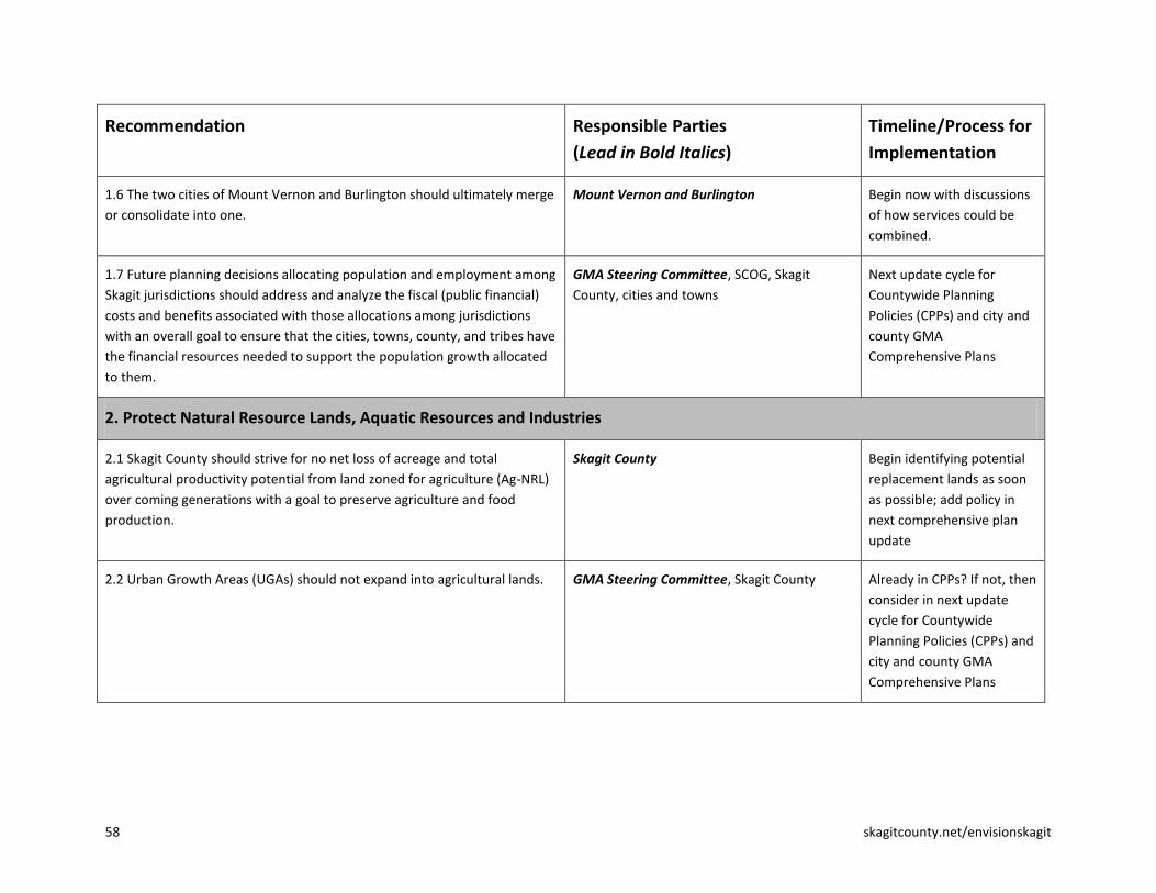
58 skagitcounty.net/envisionskagit
Recommendation Responsible Parties
(Lead in Bold Italics)
Timeline/Process for
Implementation
1.6 The two cities of Mount Vernon and Burlington should ultimately merge
or consolidate into one.
Mount Vernon and Burlington Begin now with discussions
of how services could be
combined.
1.7 Future planning decisions allocating population and employment among
Skagit jurisdictions should address and analyze the fiscal (public financial)
costs and benefits associated with those allocations among jurisdictions
with an overall goal to ensure that the cities, towns, county, and tribes have
the financial resources needed to support the population growth allocated
to them.
GMA Steering Committee, SCOG, Skagit
County, cities and towns
Next update cycle for
Countywide Planning
Policies (CPPs) and city and
county GMA
Comprehensive Plans
2. Protect Natural Resource Lands, Aquatic Resources and Industries
2.1 Skagit County should strive for no net loss of acreage and total
agricultural productivity potential from land zoned for agriculture (Ag-NRL)
over coming generations with a goal to preserve agriculture and food
production.
Skagit County Begin identifying potential
replacement lands as soon
as possible; add policy in
next comprehensive plan
update
2.2 Urban Growth Areas (UGAs) should not expand into agricultural lands. GMA Steering Committee, Skagit County Already in CPPs? If not, then
consider in next update
cycle for Countywide
Planning Policies (CPPs) and
city and county GMA
Comprehensive Plans

skagitcounty.net/envisionskagit 59
Recommendation Responsible Parties
(Lead in Bold Italics)
Timeline/Process for
Implementation
2.3 Maintain, strengthen, and enforce County regulations to protect
agriculture.
a. Maintain Ag-NRL restrictions for lot size, development footprint, and agricultural uses.
b. Support the location of a centralized Agricultural Industrial Park where agricultural industrial uses and processing facilities can be located.
c. County roads that are heavily used by farm vehicles should be marked to give priority to agricultural uses.
2.3.a., Skagit County
2.3.b., EDASC, Port of Skagit County
2.3.c., Skagit County
2.3.a., ongoing
2.3.b., next update of
county comprehensive plan;
2.3.c.,ongoing
2.4 Maintain, strengthen, and expand non-regulatory programs to support
agriculture.
a. Double the capacity of the Farmland Legacy Program, drawing from a variety of funding sources.
b. Implement a county-wide Transfer of Development Rights (TDR) program.
c. Support continued operation and maintenance of the dike and drainage system.
Skagit County, Farmland Legacy Program,
Skagitonians to Preserve Farmland (a.); Skagit
County, cities and towns (b.); dike and
drainage districts (c.).
2.4.a. , as soon as possible
2.4.b., begin planning
(including outreach to
landowners and market
analysis) as soon as possible
2.4.c., ongoing
2.5 Manage stormwater effectively to protect fish, shellfish, and agriculture. Skagit County, cities and towns Incorporate in stormwater
plans, NPDES permits
2.6 Encourage local/regional efforts to support natural resource industries
and the ecosystem, forged by those with the greatest on-the-ground
knowledge of how to meet the needs of both.
Many local/regional organizations and
landowners
Ongoing
2.7 Seek state, federal or international designation for Skagit Valley as a
Cultural and Natural Heritage Site.
Skagit County, Skagit Alliance Initial inquiries in near-term
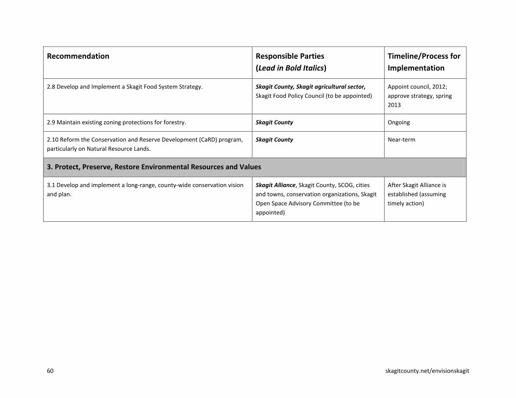
60 skagitcounty.net/envisionskagit
Recommendation Responsible Parties
(Lead in Bold Italics)
Timeline/Process for
Implementation
2.8 Develop and Implement a Skagit Food System Strategy. Skagit County, Skagit agricultural sector,
Skagit Food Policy Council (to be appointed)
Appoint council, 2012;
approve strategy, spring
2013
2.9 Maintain existing zoning protections for forestry. Skagit County Ongoing
2.10 Reform the Conservation and Reserve Development (CaRD) program,
particularly on Natural Resource Lands.
Skagit County Near-term
3. Protect, Preserve, Restore Environmental Resources and Values
3.1 Develop and implement a long-range, county-wide conservation vision
and plan.
Skagit Alliance, Skagit County, SCOG, cities
and towns, conservation organizations, Skagit
Open Space Advisory Committee (to be
appointed)
After Skagit Alliance is
established (assuming
timely action)

skagitcounty.net/envisionskagit 61
Recommendation Responsible Parties
(Lead in Bold Italics)
Timeline/Process for
Implementation
3.2 Identify funding sources for open space protection within and between
Urban Growth Areas, and implement a “bottom up” approach for allocating
funds and prioritizing proposed open space projects.
a. Solicit competitive proposals on an annual basis from interested parties to creatively implement open space and greenbelt enhancements, rather than Skagit County issuing a list of presumed acquisition targets.
b. Appoint a balanced and broadly representative Open Space Advisory Committee.
c. Take the next step in moving from a conceptual Open Space Plan to identifying actual interconnected networks using GIS-level data that accounts for habitat connectivity of critical species and non-motorized transportation connectivity where appropriate. Use this information to prioritize projects.
d. Emphasize a wide variety of open space greenbelt enhancement approaches, including cooperative agreements, easements and other innovative measures, in addition to outright acquisition. When the potential for loss of critical open space to development becomes imminent, immediate public acquisition through purchase should be considered as a necessary course of action.
e. Budget for and manage green infrastructure as prudently as any other civic asset such as water, sewer, or roads.
3.2.a., Skagit County, SCOG, Skagit Open
Space Advisory Committee
3.2.b., Skagit County, SCOG
3.2.c., Skagit County, SCOG, Skagit Open Space
Advisory Committee
3.2.d., Skagit County, SCOG, Space Advisory
Committee
3.2.e., SCOG and member jurisdictions
3.2.a., ongoing
3.2.b., as soon as possible
3.2.c., as soon as possible
3.2.d., ongoing
3.2.e., ongoing
3.3 Complete the federal General Investigation study of flood hazard
management options on the Skagit River and related local flood hazard
management planning, using best available science.
U.S. Army Corps of Engineers, federal and
local elected officials, Skagit County, cities and
towns, other responsible government agencies
As soon as possible

62 skagitcounty.net/envisionskagit
Recommendation Responsible Parties
(Lead in Bold Italics)
Timeline/Process for
Implementation
3.4 Purchase and remove rural and urban residences from the Skagit River
floodway and other parts of the “functional floodplain” – such as Hamilton
and Cape Horn – that experience repeated flood damage.
Skagit County and FEMA Ongoing
3.5 Purchase or transfer development rights from the floodplain outside of
UGAs. Skagit County, other participants in transfer of
development rights program (to be developed
(see 2.4.b.)
As soon as possible (see 2.4)
3.6 Maintain the current pace of restoration in the middle Skagit floodplain. Skagit Watershed Council and member
organizations
Ongoing
3.7 Investigate opportunities to widen the Skagit and Samish River corridors
to regain floodplain ecological functioning and improve flood storage and
conveyance; purchase flooding easements from willing rural landowners in
the floodplain to create additional emergency flood storage.
Skagit County, other parties in General
Investigation study (see 3.3.)
Incorporate in long-term
and comprehensive flood
control efforts
3.8 Support implementation of the Tidegate Fish Initiative Washington Department of Fish and Wildlife,
NOAA Fisheries and Western Washington
Agricultural Association, Skagit River System
Cooperative
Ongoing
3.9 If sea level increases begin to cause significant salinity and drainage
impacts to farmland in the Delta such that the costs of those impacts
become economically unsustainable, then develop a proactive plan for
returning affected farmland to tidal salt marsh or wetland in areas where
the Dike District and landowners deem the costs to be economically
unsustainable. Replace the lost farmland under the “no net loss” policy in
Goal Statement 2, Recommendation 1.
Dike and drainage districts and affected
landowners, Skagit Watershed Council and
member organizations
As projections of sea level
rise become more definite
and cost issues arise

skagitcounty.net/envisionskagit 63
Recommendation Responsible Parties
(Lead in Bold Italics)
Timeline/Process for
Implementation
3.10 Work together in a positive, forward-looking manner with the goal of
protecting and restoring the Skagit River’s once abundant salmon and
steelhead trout runs, the salmon runs of the Samish River and smaller direct
tributaries to Puget Sound, and the shellfish along our shorelines.
All Skagit County residents and jurisdictions
(including tribal governments)
Near-term and ongoing
3.11 Quicken the Clean Samish Initiative’s pace in identifying pollution
sources and following up with education, technical assistance and, if
necessary, enforcement actions to get problems corrected as soon as
possible.
Skagit County, partners in Clean Samish
Initiative, affected landowners
As soon as possible
3.12 Use a variety of tools, including regulation, incentives, education, and
voluntary partnerships, to protect critical areas on those rural and resource
lands that develop in the future.
Skagit County Near-term and ongoing
3.13 Heighten protections to maintain the ecological functions and values
of riparian areas, particularly along salmon-bearing streams.
Skagit County, Skagit Conservation District,
cities and towns, affected landowners
Near-term and ongoing;
coordinate with long-range
conservation plan (3.1.)
3.14 Expand voluntary use of Low-Impact Development (LID) techniques in
public and private projects, especially in sensitive stream basins and where
downstream agriculture would likely benefit. Support early amendment of
local codes to encourage or require LID where feasible, giving special
attention to these same places.
Skagit County, cities and towns, public and
private construction projects
Near-term
4. Compact Communities and Conservation Development

64 skagitcounty.net/envisionskagit
Recommendation Responsible Parties
(Lead in Bold Italics)
Timeline/Process for
Implementation
4.1 The County should modify its population distribution goal to direct 90
percent of new population growth to cities and 10 percent to rural areas,
instead of the current 80/20 split. Moreover, the County should seek to
direct half of the rural 10% to clustered “conservation developments” (see
recommendation 4.9) and/or expanded rural villages in the vicinity of Alger
and Conway Hill (see recommendation 4.10).
GMA Steering Committee and Skagit County,
cities and towns, SCOG
Next update of county-wide
planning policies and
county, city and town
comprehensive plans
4.2 Existing urban communities should grow up rather than out, become
more compact rather than more sprawling, and mix compatible uses to
create more complete, walkable communities rather than continuing to
isolate uses in ways that create ever-greater reliance on the automobile to
meet basic daily needs.
Cities, towns and local developers, GMA
Steering Committee, community groups
As soon as possible,
incorporating new policies
in updates of county-wide
planning policies and city
comprehensive plans
4.3 Redevelop our historic downtowns and existing commercial strips,
malls, and big box centers, including those floodplain portions of Burlington
and Mount Vernon, into mixed use, high-density urban centers in the range
of two to five stories, as a key means to accommodate significant increases
in urban population and densities.
Cities and towns, local developers, downtown
associations and chambers of commerce,
Skagit County (for related flood control
responsibilities), GMA Steering Committee,
community groups
As soon as possible,
incorporating new policies
in updates of county-wide
planning policies and city,
town, and county
comprehensive plans
4.4 Establish higher thresholds than currently exist in the Countywide
Planning Policies, county, city and town comprehensive plan policies, and
the adopted UGA expansion criteria for when urban growth areas are
eligible to expand.
GMA Steering Committee, SCOG, Skagit
County, cities and towns
Next update of county-wide
planning policies and
county and city
comprehensive plans
4.5 Existing Urban Growth Areas should be prohibited from expanding into
environmentally sensitive areas, including the floodplain and agricultural
lands.
GMA Steering Committee, SCOG, Skagit
County, cities and towns
Next update of county-wide
planning policies and
county and city
comprehensive plans
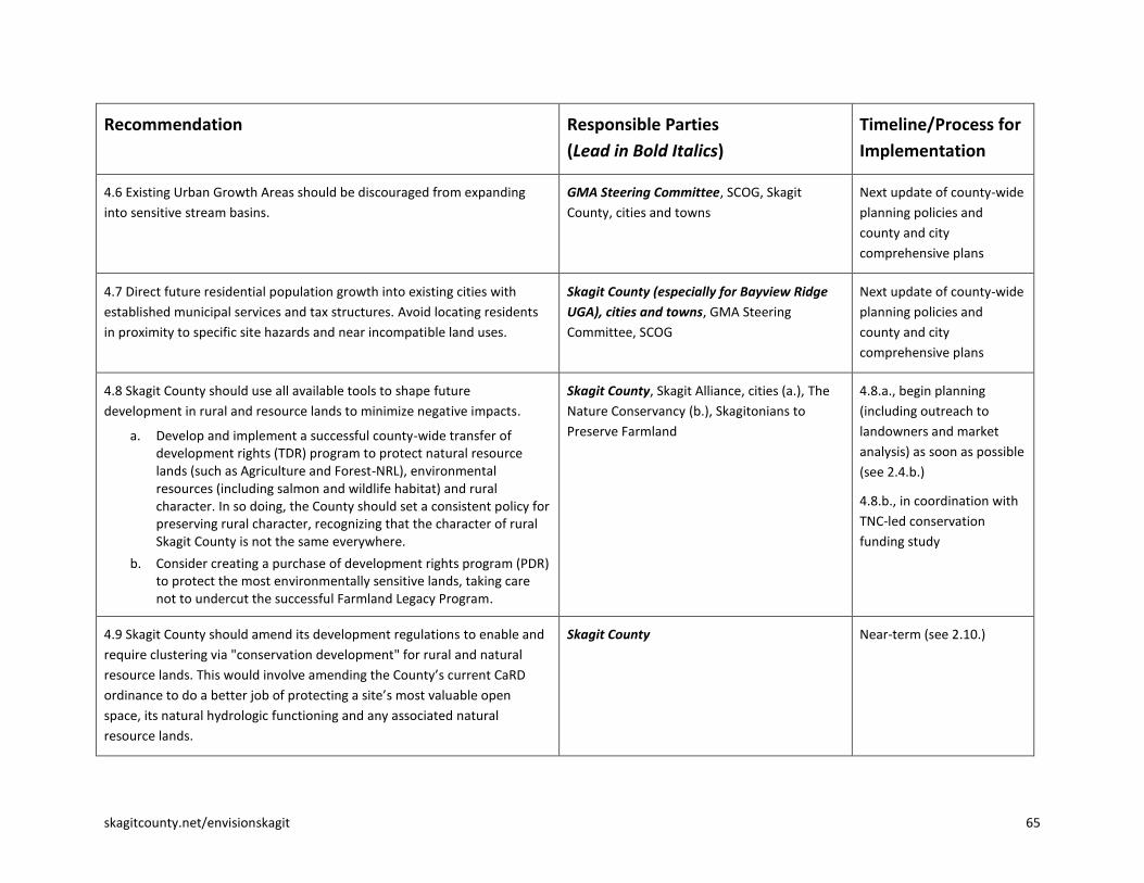
skagitcounty.net/envisionskagit 65
Recommendation Responsible Parties
(Lead in Bold Italics)
Timeline/Process for
Implementation
4.6 Existing Urban Growth Areas should be discouraged from expanding
into sensitive stream basins.
GMA Steering Committee, SCOG, Skagit
County, cities and towns
Next update of county-wide
planning policies and
county and city
comprehensive plans
4.7 Direct future residential population growth into existing cities with
established municipal services and tax structures. Avoid locating residents
in proximity to specific site hazards and near incompatible land uses.
Skagit County (especially for Bayview Ridge
UGA), cities and towns, GMA Steering
Committee, SCOG
Next update of county-wide
planning policies and
county and city
comprehensive plans
4.8 Skagit County should use all available tools to shape future
development in rural and resource lands to minimize negative impacts.
a. Develop and implement a successful county-wide transfer of development rights (TDR) program to protect natural resource lands (such as Agriculture and Forest-NRL), environmental resources (including salmon and wildlife habitat) and rural character. In so doing, the County should set a consistent policy for preserving rural character, recognizing that the character of rural Skagit County is not the same everywhere.
b. Consider creating a purchase of development rights program (PDR) to protect the most environmentally sensitive lands, taking care not to undercut the successful Farmland Legacy Program.
Skagit County, Skagit Alliance, cities (a.), The
Nature Conservancy (b.), Skagitonians to
Preserve Farmland
4.8.a., begin planning
(including outreach to
landowners and market
analysis) as soon as possible
(see 2.4.b.)
4.8.b., in coordination with
TNC-led conservation
funding study
4.9 Skagit County should amend its development regulations to enable and
require clustering via "conservation development" for rural and natural
resource lands. This would involve amending the County’s current CaRD
ordinance to do a better job of protecting a site’s most valuable open
space, its natural hydrologic functioning and any associated natural
resource lands.
Skagit County Near-term (see 2.10.)

66 skagitcounty.net/envisionskagit
Recommendation Responsible Parties
(Lead in Bold Italics)
Timeline/Process for
Implementation
4.10 Moderately increase densities in Alger and Conway Hill, achieving
higher/clustered densities through transfers or purchases of development
rights from rural and resource lands only. High quality design guidelines
should be developed with the help of community residents so these
communities retain their distinct character.
Skagit County, GMA Steering Committee Next update of county-wide
planning policies and
county comprehensive plan
4.11 The Town of Hamilton can and should play a similar role to these
expanded Rural Villages, receiving transferred development rights and
developing residential and mixed uses (shops, restaurants, services) at
walkable scale and densities.
Hamilton and Skagit County Next update of county-wide
planning policies and
Hamilton and county
comprehensive plans
4.12 Fully contained communities (FCCs) should be avoided in Skagit County
unless they can achieve their urban densities strictly through transfers of
development rights from rural or resource lands at a ratio of one-to-one.
Skagit County, GMA Steering Committee,
SCOG
Next update of county-wide
planning policies and
county comprehensive plan
5. Sustainable Transportation
5.1 Increase intercity passenger rail service in the Northwest Washington
region.
Amtrak, WSDOT, other federal and State
agencies, the province of British Columbia, and
the Whatcom and Skagit Councils of
Governments
Near-term
5.2 Encourage more compact urban development and more clustered rural
development to facilitate more efficient transportation.
Skagit County and cities See goal statement 4
(especially 4.2., 4.3., and
4.9.)

skagitcounty.net/envisionskagit 67
Recommendation Responsible Parties
(Lead in Bold Italics)
Timeline/Process for
Implementation
5.3 Place greater emphasis on non-motorized transportation, including
more and better bike lanes and pedestrian facilities built into the road
network, as well as a more developed system of non-motorized trails.
a. Look for appropriate opportunities to integrate non-motorized transportation routes and networks with the existing and proposed open space network. This should be done in a cooperative, voluntary manner that enhances mobility and respects community values and individual property rights.
b. Within Urban Growth Areas, open space should emphasize public access and integrate seamlessly with non-motorized transportation. Open space adjacent to UGAs that is appropriate for public access should be directly linked to open space corridors within the UGA to create a contiguous network.
c. Road standards should be modified to improve safety for bicyclists, particularly on designated bicycle routes.
5.3.a., Skagit Council of Governments, cities
and towns, Skagit County, Skagit Open Space
Advisory Committee (see 3.2.), Skagit Alliance
5.3.b., Skagit Council of Governments, cities
and towns, Skagit County, Skagit Open Space
Advisory Committee (see 3.2.), Skagit Alliance
5.3.c., Skagit County, cities and towns, SCOG
5.3.a., near-term,
coordinated with long-
range conservation plan
(3.1.) and open space
purchases (3.2.)
5.3.b., near-term,
coordinated with long-
range conservation plan
(3.1.) and open space
purchases (3.2.)
5.3.c., near-term
5.4 Explore and embrace innovative transit options.
a. For long, skinny corridors such as SR 20, explore a system such as the colectivos of Latin America—fleets of passenger vans that run with high frequency along the highway.
b. Creative Options Everywhere: Run colectivos around our towns; consider Bus Rapid Transit as an alternative to high speed rail; consider river taxis from La Conner to at least Mount Vernon and Burlington; work directly with employers to find ways to reduce commute trips for workers; create options for shoppers such as shuttle buses or fixed-cost taxi service; set up mini park-n-rides in rural areas to simplify use of public transit; provide rain protection at bus stops; explore possible rail-to-trail and trail-to-rail conversions; require serious attention to transportation alternatives in all development plans.
Skagit Transit, SCOG and member
organizations (potential leads on 5.4.b.), Skagit
Alliance
Near-term

68 skagitcounty.net/envisionskagit
Recommendation Responsible Parties
(Lead in Bold Italics)
Timeline/Process for
Implementation
5.5 Preserve and enhance our ferry connections to the islands and the
international ferry service to Vancouver Island.
Skagit County and WSDOT Ongoing
5.6 Protect existing airport facilities from encroaching incompatible land
uses that could limit their future aircraft operations.
Skagit County, Anacortes, Concrete, Ports of
Skagit County and Anacortes
Ongoing (for Skagit Regional
Airport, see 4.7. and 1.4.)
5.7 Preserve our current navigable waterways into the future. U.S. Army Corps of Engineers, Skagit County,
La Conner, Swinomish Indian Tribal
Community
Ongoing

skagitcounty.net/envisionskagit 69
Recommendation Responsible Parties
(Lead in Bold Italics)
Timeline/Process for
Implementation
6. Water/Wastewater
6.1 Plan proactively, using appropriate and innovative methods, to provide
future water and wastewater services and infrastructure. Consider the
following:
a. Determine how to best provide wastewater and water services to rural clustered housing and/or expanded rural villages prior to their development. Strive for minimal consumptive water use and minimal impact to groundwater quality and the water quality of local water bodies.
b. Building codes should allow innovative wastewater and fresh water systems for residential, industrial and agricultural use in order to reduce demand on fresh water sources.
c. Plan for future services, including the siting of both regional and smaller scale wastewater systems. Consider innovative wastewater treatment technologies and practices that:
reduce overall water use;
have the capacity to augment potable water supplies by using highly treated wastewater effluent and storm water for irrigation and other uses;
consider separating stormwater and provide alternative storm water treatment;
use alternative energy technologies; and
enable the use of waste system by-products such as energy production and biosolids.
6.1.a., Skagit County, potentially affected
utilities
6.1.b., Skagit County and cities and towns
6.1.c., Skagit County, GMA Steering
Committee, SCOG and member organizations
6.1.a., prior to modifying
codes and comprehensive
plan policies regarding rural
development
6.1.b., near-term and
ongoing
6.1.c., near-term and
ongoing

70 skagitcounty.net/envisionskagit
Recommendation Responsible Parties
(Lead in Bold Italics)
Timeline/Process for
Implementation
6.2 Be proactive in assessing future water needs prior to permitting
additional new uses and ensure a sustainable supply.
a. Determine how much water will be needed to support projected growth, agriculture and commercial and industrial needs out-of-stream, and environmental needs in-stream over the next 50 years and beyond, through a comprehensive study.
b. Use available water resources in a manner that will sustain healthy groundwater and surface water supplies long into the future.
c. Consider more aggressive water conservation activities and technologies for all uses: domestic, commercial, industrial, agricultural.
Skagit County and water utilities 6.2.a., near-term
6.2.b., ongoing
6.2.c., near-term
6.3 Encourage the continued public ownership of our County’s water
systems and discourage efforts to privatize our water supply.
Skagit County and water utilities Ongoing
6.4 Coordinate extension of municipal water and wastewater service areas
with County land use plans and the land use recommendations provided in
this document.
Skagit County and water utilities Ongoing
6.5 Consider long-term water needs within Skagit County prior to extending
Skagit waters across watershed boundaries and into other counties.
Skagit County and water utilities Ongoing

skagitcounty.net/envisionskagit 71
7. Housing Variety and Affordability
7.1 Work together to provide a wider variety of housing options for our
urban and rural residents, as one means to address the serious lack of
affordable housing in Skagit County.
All involved parties (Skagit County, cities and
towns, the Housing Authority of Skagit County,
other housing providers, builders and
developers, social service organizations and
others)
Near-term
7.2 Integrate affordable housing into the fabric of our communities, not
isolated in low-income enclaves.
All involved parties (Skagit County, cities and
towns, the Housing Authority of Skagit County,
other housing providers, builders and
developers, social service organizations and
others)
Near-term
7.3 Develop more compact, mixed use, and transit-friendly urban
communities and rural villages, where people have options to live and work,
to increase housing opportunities for all income levels and reduce
commuting costs.
Cities and towns, Skagit County, Skagit
Transit (SKAT), Housing Authority of Skagit
County
See goal statement 4
(especially 4.2., 4.3., and
4.9.) and 5.2.
7.4 Develop and construct a pilot project to demonstrate that the provision
of affordable housing can be combined with quality design and green
building and low impact development techniques.
Home Trust of Skagit, other interested
partners
Near-term
8. Economic Vitality
8.1 Develop an economic development strategy for eastern Skagit County
and other rural areas that supports small-scale, sustainable businesses and
industries that enable people to work without commuting long distances.
This includes affordable broadband services comparable to that offered in
urban areas.
Skagit County, Concrete, Hamilton, Lyman,
Economic Development Association of Skagit
County, Skagit Alliance
Near-term

72 skagitcounty.net/envisionskagit
8.2 Encourage businesses and industries that make sustainable use of our
natural resources (e.g., striving for the sustainable rate of harvest and
utilization of renewable resources, adding as much value locally as possible
to Skagit resources, meeting local needs while also selling to external
markets, becoming increasingly efficient in the use of energy, and exploring
alternative and renewable energy sources).
All involved parties (including Economic
Development Association of Skagit County,
local businesses, Skagit County, ports, cities
and towns)
Ongoing
8.3 Encourage economic diversity as a key means to promoting a resilient
local economy. This involves:
a. Retaining our natural resource base;
b. Designating land in appropriate places for natural resource processing industries;
c. Retaining zoning for boat building and shoreline dependent marine uses;
d. Providing incubators for small business startups such as the recently-created food processing incubator at the Port of Skagit County; and
e. Providing advanced technical education and training through such programs as the new Marine Technology Center in Anacortes (and associated programs through Skagit Valley College) and the Skagit Valley College [Vocational/Technical Education Center].
f. Providing training to young people in sustainable natural resource management and production at the high school and technical levels.
8.3.a., Skagit County, local natural resource
businesses and industry organizations
8.3.b., Skagit County, GMA Steering
Committee, SCOG
8.3.c., Skagit County and Anacortes, Ports of
Anacortes and Skagit County, La Conner
8.3.d., Ports, EDASC, Skagit County
8.3.e., Skagit Valley College, other involved
parties
8.3.f., School districts and Skagit Valley
College
8.3.a., ongoing (see goal
statement 2)
8.3.b., near-term (see
2.3.b.)
8.3.c., ongoing and near-
term, including updates of
shoreline master programs
8.3.d., ongoing
8.3.e., ongoing
8.3.f., near-term

skagitcounty.net/envisionskagit 73
Appendix D: Longer-Term Implementation Steps and Financial Implications By Kirk Johnson, John Lombard, and Mark Personius1
The Citizen Committee’s recommendations call for a significant shift in future land use development patterns from
those sought through the existing countywide planning policies and Skagit County comprehensive plan, and
experienced over the last 15 years of planning under the Growth Management Act. More specifically, the
recommendations would direct a larger share of new population growth – 90% – into existing urban areas, reduce
development in the rural area to 10%, and seek to transfer or purchase development rights from the most
sensitive lands – including natural resource lands, environmentally sensitive areas, and other open space lands.
The Citizen Committee recommends that these changes be accomplished through an emphasis on financial,
voluntary, education and incentive-based mechanisms, rather than through strict regulatory controls.
Current countywide planning policies which guide county and city and town comprehensive plans call for 80
percent of new population growth to be directed to urban areas – cities, towns, and non-municipal urban growth
areas such as the Bayview Ridge urban growth area (UGA) and the Swinomish UGA.2 The trend experienced over
the last 10 years is that about 70% of new population growth has located in urban areas, with the remaining 30%
locating in the rural area (or more technically, rural and natural resource lands).
Citizen Committee Recommendations
The Citizen Committee recommends changing the existing framework as follows:
Direct 90 percent of new population growth to urban areas.
At a broad policy level, implementing this recommendation would require changes to the Skagit
Countywide Planning Policies through negotiations and agreement among the county, the cities and
towns, tribes, and other governing entities. The countywide planning policy amendments would then
need to be implemented through amendments to the various jurisdictions’ comprehensive plans and
development regulations.
Direct only 10% of future population growth to the rural area (lands outside of UGAs, including rural
and natural resource lands); cluster half of the rural growth in rural villages and rural cluster
developments.
Under the committee’s recommendations, this goal would primarily be achieved through purchases or
transfers of rural development rights, as discussed in greater detail below.
Discourage new residential and commercial development in the floodplain outside of UGAs.
There are approximately 1,200 total development rights in the 100-year floodplain. Approximately 438
are on lands designated Ag-NRL, and another 762 in other land use designations. The Committee’s
preferred method for eliminating this potential development is through purchase or transfer of
development rights, the mechanics and cost of which are discussed below.
1 This appendix, which analyzes the Citizen Committee’s recommendations, was written by project staff and is not a product of
the Citizen Committee. 2 These policies are sometimes misunderstood as a mandate to require that 80 percent of new population growth occur in
urban areas. The precise wording is that urban growth areas should be “sized to accommodate” 80 percent of the county’s future population growth, with county, city and town, and tribal comprehensive plans enacting policies to implement this goal. While comprehensive plans and development regulations seek to guide the location of future growth, market forces, personal choice and the supply of existing development rights also play a major role in determining where Skagit County residents choose to live.

74 skagitcounty.net/envisionskagit
Recommended Implementation Mechanisms
The Citizen Committee’s recommendations specifically acknowledge development rights that exist under current
zoning. The Committee recommends achieving its land use vision through financial mechanisms (development
rights purchases), market mechanisms (transfers of development rights), and incentive, voluntary, and education-
based measures (including making urban areas highly attractive places to live).
The Committee does not recommend strict regulatory measures to force development to meet the 90/10 ratio for
new population growth and other related Committee goals. At the same time, the Committee’s recommendations
indicate awareness that new regulatory requirements from the state and federal governments may reduce
development potential, or increase costs, in rural Skagit County. Some of the measures most likely to affect the
potential for or cost of rural development in Skagit County are:
State-mandated limitations on ground water withdrawals in the Fisher-Carpenter Creek stream basin
because low flows in that creek system are below legally agreed-upon levels. Similar restrictions may
apply in the future in the East Fork and Upper Nookachamps Creek basins.
Implementation of new regulations on development within the Skagit and Samish River floodplains. These
new regulations are required by a federal “biological opinion” that the Federal Emergency Management
Agency’s flood insurance program has encouraged floodplain development, causing harm to Puget Sound
Chinook salmon and Puget Sound resident orca whales, both of which are protected under the federal
Endangered Species Act.
Pending remapping of the Skagit River’s 100-year floodplain by the Federal Emergency Management
Agency, which will likely result in significantly higher “base flood elevations” in portions of the floodplain.
This will likely lead to higher costs for development due to requirements that such development be
elevated to reduce flood damage and risk.
Some of the major mechanisms to implement the Committee’s recommendation are as follows:
1. Make cities and towns great places to live.
The more attractive and affordable urban living is, the more people will choose it. Implementing this goal is a
major focus of the Committee’s recommendations in Goal Statement 2 (Compact Communities) and Goal
Statement 7 (Housing Variety and Affordability). A great deal of demographic and economic research points to
growing market demand for urban, compact, walkable, mixed-use communities. To the extent these trends
currently apply or will develop in Skagit County in the future, they will support achievement of the Committee’s
vision and recommendations. Additionally, currently high gasoline prices and continued projected increases under
“peak oil” scenarios will create an additional economic incentive for Skagit County residents to choose to live in
closer-in urban communities over more distant rural communities requiring longer daily commutes.3
2. Create capacity within cities and towns to accommodate 90% of the future growth.
Appropriate UGA sizing is the major mechanism under the current countywide planning policies for achieving the
current goal for 80% of new population growth to locate in urban areas. It will remain a key mechanism for
implementing the Citizen Committee’s goal that 90% of new growth should locate in urban areas. The Committee
emphasizes increasing capacity within existing urban boundaries, rather than expanding those boundaries
3 “Peak oil is the point in time when the maximum rate of global petroleum extraction is reached, after which the rate of
production enters terminal decline... Optimistic estimations of peak production forecast the global decline will begin by 2020 or later, and assume major investments in alternatives will occur before a crisis, without requiring major changes in the lifestyle of heavily oil-consuming nations….Pessimistic predictions of future oil production operate on the thesis that either the peak has already occurred that oil production is on the cusp of the peak, or that it will occur shortly.” Source: Wikipedia.

skagitcounty.net/envisionskagit 75
outward. This would be achieved by promoting greater density within urban areas through quality infill and small
lot development, and greater emphasis on mixed-use development with residences (apartments or
condominiums) over commercial uses.
Implementing higher densities would require action by the cities and towns (and the county in the case of the
Bayview Ridge urban growth area) to reform their zoning and related development regulations. The Citizen
Committee also recommends tightening the thresholds that must be met before urban growth areas may expand –
on the belief that this will stimulate the market for infill and intensification within those existing urban boundaries.
That would require negotiation among the county, the cities and the towns to amend existing UGA modification
criteria.
3. Explore additional policies and incentives to stimulate the market for quality infill and redevelopment projects within existing urban areas.
A report developed for Envision Skagit by ECONorthwest, titled Evaluation of Fiscal Implications of Growth
Management Options in Skagit County Washington,4 suggests that local jurisdictions that want to encourage
quality infill and redevelopment may need to jump-start the market until the economy improves and local demand
grows for such development. Some strategies discussed in greater detail in the report include:
a. Amending land use policies and zoning and building codes to support and encourage infill and
redevelopment of existing sites; and
b. Providing development support for selected development types. Options might include:
i. Public acquisition of key development sites to reduce land costs, catalyze redevelopment of adjacent
sites, and help to “prove the market.”
ii. Waivers of impact fees for developments meeting a particular set of public-sector goals.
iii. Public funding of pre-development studies by design firms and market analysts to reduce
development costs and encourage community-supported design options.
iv. Improvements to public spaces, as higher-density development is generally most successful when it is
adjacent to high-quality urban spaces with adequate and attractive access for multiple modes of
transportation, and with inviting and well-designed streetscapes.
It would be very difficult to quantify or estimate how significantly efforts like those outlined above could shift
future development patterns from the 70% urban/30% rural ratio that has been experienced over the past 10
years. Likely they can make a difference but will not account for the entire shift just as establishing policies and
goals to achieve an 80% urban/20% rural ratio have not resulted in exactly that outcome.
Some members of the public who commented on the Citizen Committee’s recommendations, while supporting the
90% urban/10% rural goal, asserted that goal would not be met unless tougher regulatory restrictions are placed
on future development. These restrictions might include uncompensated downzones of rural and natural resource
lands, to reduce the number of developable lots that are available, or metering of development permits, with one
rural development permit issued for every 9 urban development permits. Other commentators questioned the
assumption that Skagit County’s population will continue to grow over the next 50 years at a similar rate as it has
grown over the past 50 years, or that Skagit County and its cities and towns need to accommodate projected
population growth. However, few offered specifics on how such growth – if the regional population projections
prove true – could practically or legally be prevented in Skagit County given current state Growth Management Act
4 This report and other information sources drawn upon by the Citizen Committee are referenced in Appendix G and are
available for review and download on the Envision Skagit website at: www.skagitcounty.net/envisionskagit.
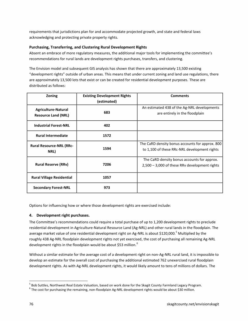
76 skagitcounty.net/envisionskagit
requirements that jurisdictions plan for and accommodate projected growth, and state and federal laws
acknowledging and protecting private property rights.
Purchasing, Transferring, and Clustering Rural Development Rights
Absent an embrace of more regulatory measures, the additional major tools for implementing the committee’s
recommendations for rural lands are development rights purchases, transfers, and clustering.
The Envision model and subsequent GIS analysis has shown that there are approximately 13,500 existing
“development rights” outside of urban areas. This means that under current zoning and land use regulations, there
are approximately 13,500 lots that exist or can be created for residential development purposes. These are
distributed as follows:
Zoning
Existing Development Rights
(estimated)
Comments
Agriculture-Natural
Resource Land (NRL) 683
An estimated 438 of the Ag-NRL developments
are entirely in the floodplain
Industrial Forest-NRL 402
Rural Intermediate 1572
Rural Resource-NRL (RRc-
NRL) 1594
The CaRD density bonus accounts for approx. 800
to 1,100 of these RRc-NRL development rights
Rural Reserve (RRv) 7206 The CaRD density bonus accounts for approx.
2,500 – 3,000 of these RRv development rights
Rural Village Residential 1057
Secondary Forest-NRL 973
Options for influencing how or where those development rights are exercised include:
4. Development right purchases.
The Committee’s recommendations could require a total purchase of up to 1,200 development rights to preclude
residential development in Agriculture-Natural Resource Land (Ag-NRL) and other rural lands in the floodplain. The
average market value of one residential development right on Ag-NRL is about $120,000.5 Multiplied by the
roughly 438 Ag-NRL floodplain development rights not yet exercised, the cost of purchasing all remaining Ag-NRL
development rights in the floodplain would be about $53 million.6
Without a similar estimate for the average cost of a development right on non-Ag-NRL rural land, it is impossible to
develop an estimate for the overall cost of purchasing the additional estimated 762 unexercised rural floodplain
development rights. As with Ag-NRL development rights, it would likely amount to tens of millions of dollars. The
5 Bob Suttles, Northwest Real Estate Valuation, based on work done for the Skagit County Farmland Legacy Program.
6 The cost for purchasing the remaining, non-floodplain Ag-NRL development rights would be about $30 million.

skagitcounty.net/envisionskagit 77
cost of purchasing existing, unexercised commercial and industrial development rights in the rural floodplain areas
is also not estimated here.
Obviously these are very sizable amounts. The county currently generates about $740,000 per year through local
property taxes for purchase of Ag-NRL development rights by the Farmland Legacy Program. Additional matching
funds are obtained from state, federal, and private sources; those additional funds ranged from about $225,000 in
2009 to $995,000 in 2010.
A rough estimate of an additional $1.5 million is spent per year for other conservation purchases in Skagit County
by various governmental and non-governmental organizations.
The Nature Conservancy has suggested there might be support among Skagit County voters, when economic times
improve, to generate in the range of $20 million – $40 million in local financial support for land conservation
purchases over a 10 year period.
State, federal, or international designation of Skagit County as a unique cultural and natural heritage site, as
recommended by the Committee, could make the community eligible for additional state, federal or international
funds for land conservation purposes.
Additional revenues for conservation purposes may be available from private, state, and federal sources because
Skagit County is increasingly becoming recognized in the Puget Sound region and beyond as supporting unique and
diverse natural and environmental assets. If markets for environmental services continue to develop, local
property owners and land managers may realize new revenue streams for conservation and stewardship activities.
5. Development Right Transfers
In addition to development right purchases, the Committee’s recommendations anticipate requiring a significant
number of development right transfers to achieve the goals of 90% urban and 10% rural population growth, and to
move potential development out of Secondary Forest-NRL and Rural Resource-NRL lands and into urban areas or
expanded rural villages. These transfers would be the result of a countywide (and preferably multi-jurisdictional)
transfer of development rights program. 7
The details of such a program should be developed based on a market analysis, which would examine the supply of
development rights to be transferred, the market value of those rights, the market price of increased development
rights in areas where the rights would be transferred, and appropriate exchange rates (e.g., allowing a developer in
an urban area to build two new units of housing for every one rural development right purchased).
Burlington and Mount Vernon both have existing, small-scale TDR programs. King County has a very successful
large-scale program. Montgomery County, Maryland, pioneered TDR programs to protect agricultural land many
years ago. A program in Skagit County, however, would need to be tailored to unique local conditions, beginning
with a market analysis. One feature that would likely be important for success is the creation of a central TDR
“bank,” which can bridge the time gap between a willing buyer and a willing seller, stabilize a market by providing
a steady supply of TDR credits, and reduce transaction costs when developers wish to purchase large number of
development rights.
7 An issue paper on transfer of development rights programs, produced for the Citizen Committee by John Lombard, is fully
referenced in Appendix G and is available for review and download on the Envision Skagit website at: www.skagitcounty.net/envisionskagit.

78 skagitcounty.net/envisionskagit
6. Development Right Clustering
A final key tool for implementing the Committee recommendations would be an improved system for clustering
development rights in certain identified rural villages or smaller rural residential clusters. The county’s
Conservation and Reserve Development (CaRD) ordinance allows clustering and in certain zones provides a density
bonus in exchange for clustering.8 The county has acknowledged that the CaRD ordinance is due for review and
possible revision to achieve more ambitious land conservation goals while continuing to meet and possibly
enhance property owners’ development expectations.
The Urban Land Institute’s Ed McMahon presented a number of “conservation development” examples and
techniques that, if implemented in Skagit County, could help to move the Committee’s rural lands
recommendations forward. In fact, Ed McMahon presented the Citizen Committee with data showing that, at least
in some cases, clustered developments that preserve attractive open space can be worth considerably more than
individual rural developments that sprawl over that same area. The County should work out the mechanics and
feasibility of such a program with rural property owners, local conservationists and development experts, and with
organizations such as the Cascade Land Conservancy and Urban Land Institute that have significant technical
expertise in this area.
8 For instance, the standard density in Rural Reserve is 1 development right per 10 acres. An additional development right may
be obtained in exchange for clustering the two lots, each no larger than 1 acre in size, on a portion of the property.

skagitcounty.net/envisionskagit 79
Appendix E: Glossary These definitions are provided for the purposes of this report only. Official definitions of terms used in
implementing Skagit County Code can be found at on the Skagit County website at
http://www.codepublishing.com/wa/skagitcounty/
Accessory Dwelling Unit: A separate living quarters located on the same lot and either detached from or included
within a primary residence.
Ag-NRL (Agricultural – Natural Resource Lands): A land use designation and zone established by Skagit County for
land that is primarily devoted to the commercial production of agricultural products and that has long-term
commercial significance for agricultural production.
Airport environs: An area surrounding the Skagit Regional Airport that Skagit County has designated to promote
land uses compatible with the airport, to protect public health, safety, and general welfare, and to limit nuisance
complaints because of the inherent risks and noise from low-flying aircraft, given continued operation of the
airport as an essential public facility.
Base Flood is a flood having a 1 percent chance of occurring in a given year. Sometimes this is misleadingly called a
“100 year flood.”
Base Flood Elevation is the elevation of the surface water of a base flood.
CaRD (Conservation and Reserve Development): a technique of residential land development characterized by the
placement of lots, dwellings and accessory buildings in a pattern which reduces impervious surface area, lowers
costs of development and maintenance, and retains larger expanses of property available for agriculture, forestry,
recreation, future development or continuity of open space or ecological functions characteristic of the property to
be developed. A CaRD, in some cases, allows higher densities than normally permitted in the zone, but also has
greater design requirements.
Channel migration zone: The area where river channel(s) can reasonably be predicted to migrate over time as a
result of natural and normally occurring hydrological and related processes and their interaction with surrounding
land.
Comprehensive Economic Development Strategy: The Skagit County Comprehensive Economic Development
Strategy, last updated for Skagit Council of Governments by E.D. Hovee and Company, Vancouver, WA, July 2003.
(Available at http://www.skagitcounty.net/PlanningandPermit/Documents/2003EconDevStrategy.pdf, July 2011)
Comprehensive plan: A document guiding land use and infrastructure investments that must be adopted by all
cities and counties planning under the Growth Management Act, RCW 36.70A.070. Each comprehensive plan must
be both internally consistent and consistent with the jurisdiction’s future land use map.
Conservation development: A process of planning, designing, building, and managing communities that preserves
landscapes or other community resources that are considered valuable for their aesthetic, environmental, cultural,
agricultural, and/or historic characteristics. The term also can refer to a community that results from this process.
Conveyance (flood): The transport of floodwaters downstream with minimal backup.

80 skagitcounty.net/envisionskagit
Countywide planning policies: A countywide policy framework for county and city comprehensive plans, intended
to ensure that city and county comprehensive plans are consistent. In Skagit County, countywide planning policies
are adopted by the Growth Management Act Steering Committee.
Critical area: Environmentally valuable or hazardous areas that must be designated and protected under the
Growth Management Act, including wetlands, fish and wildlife habitat conservation areas, floodplains, geologically
hazardous areas, and critical aquifer recharge areas.
Density credit: A credit that authorizes a developer to build more intensively on a site than would otherwise be
allowed.
Downzone: A reduction in the number of units that can be developed on a site compared to existing zoning
regulations.
FEMA (Federal Emergency Management Agency): The lead federal agency for disaster mitigation, preparedness,
response, recovery, and education. FEMA issues guidelines for development in floodplains as well as maps that
designate the floodplain, both of which are used to determine eligibility for flood insurance.
Floodplain is any land susceptible to being flooded by the base flood – a flood having a 1 percent chance of
occurring in a given year.
Floodway: the river channel and adjacent overbank areas through which the base flood is discharged without
cumulatively increasing the water surface elevation more than 1 foot. The floodway is the area most at risk of
hazardous flooding. Floodways identified on flood boundary and floodway maps (FBFM) become “regulatory
floodways” within which encroachment or obstructions are prohibited.
GIS (Geographic information system): A system for storing and manipulating geographical information on a
computer.
Granny flat: Slang term for a separate, self-contained unit in a house or above a garage, suitable for occupation by
an elderly relative.
Green infrastructure: An interconnected network of natural lands and open space, including trails, providing an
array of ecological benefits.
Greenbelt: An area of largely undeveloped, wild, or agricultural land that surrounds or serves an urban area.
Grey water: Wastewater generated from domestic activities such as laundry, dishwashing, and bathing, which can
be recycled on-site for other uses, such as landscape irrigation.
Growth Management Act: The Washington State law, RCW 36.70A, that regulates how local governments should
plan for and regulate land uses and population and economic growth.
Growth Management Act Steering Committee: The committee responsible for establishing and amending
countywide planning policies in Skagit County. Members include the three county commissioners and the mayors
of Anacortes, Burlington, La Conner, Mount Vernon and Sedro-Woolley.
Industrial tax basket: A mechanism proposed by the Envision Skagit Citizen Committee for sharing tax revenues
from industrial lands across multiple jurisdictions.

skagitcounty.net/envisionskagit 81
Infill: Development that takes place on vacant or underused parcels within an area that is already characterized by
urban or more intensive rural development.
Low-impact development: Development that mimics or retains natural ways of reducing, detaining, and filtering
stormwater runoff. Example techniques include, but are not limited to, green roofs, rain gardens, and permeable
pavement, as well as broader considerations of site design, such as retaining native trees and soils and locating
buildings where they will minimize runoff.
Mixed-use development: A development or group of developments that combine multiple land uses, such as
residential, commercial, industrial, office, or institutional.
Non-point source pollution: Pollution that is discharged by multiple parties over a wide land area, not from one
specific location. Examples include oil and grease from cars, fertilizers and pesticides from lawns or farms, pet
waste, etc.
NRL (Natural Resource Land): Land designated by Skagit County under the Growth Management Act as having
long-term commercial significance for natural resource production, including agriculture, forestry, and mining.
Open space: Undeveloped land that provides an array of public benefits, potentially including, but not limited to,
natural resource use, recreational opportunities, scenic beauty, and fish and wildlife habitat.
Purchase of development rights: Removing the right to develop a property through purchase, without purchasing
other ownership rights attached to the underlying land (e.g., agricultural or forestry use might continue).
Rural Villages: Unincorporated, compact, and predominantly residential rural communities that provide limited
commercial and community services, typically including a post office, church, elementary school, fire hall, grocery
store, service station, restaurant or other small retail business.
SCOG (Skagit Council of Governments): A voluntary organization of local governments in Skagit County that
addresses shared concerns including regional transportation planning. Members include Skagit County, Skagit PUD,
Skagit Transit, all cities and towns within the county, the Swinomish Tribal Community, the Samish Indian Nation,
and the ports of Anacortes and Skagit County.
Stormwater: runoff during and following precipitation and snowmelt events, including surface runoff and
drainage.
Sustainable: Meeting the needs of the present without compromising the ability of future generations to meet
their needs.
Tidegate Fish Initiative: An agreement between the Western Washington Agricultural Association, the National
Marine Fisheries Service, and the Washington Department of Fish and Wildlife, which authorizes the conversion of
2,700 acres of delta farmland to salmon habitat in return for regulatory certainty necessary to operate and
maintain the dike and drainage system.
Transfer of development rights: The removal of development rights from one property in exchange for the right to
develop another property more intensively.
UGA (Urban Growth Area): An area where county, city and town comprehensive plans encourage urban growth,
outside of which the Growth Management Act does not allow urban growth.
82 skagitcounty.net/envisionskagit
Appendix F: Envision Skagit Citizen Committee: List of Meetings, Field Trips,
Community Events
Citizen Committee Meetings with Presenters
*PowerPoint slides from these presentations may be viewed on the Citizen Committee section of the Envision Skagit
website: www.skagitcounty.net/envisionskagit
*Ecology of Place, November 4, 2010
Presenters: John Riedel, North Cascades National Park; Tim Beechie, National Oceanic and Atmospheric
Administration Fisheries Service; Eric Beamer, Skagit River System Cooperative; Libby Mills, Wildlife
Biologist.
*Economic Development and the Built Environment, January 6, 2011
Economic Development Presenters: Don Wick, Economic Development Association of Skagit County; Patsy
Martin, Port of Skagit County; Bob Hyde, Port of Anacortes; Sally Harris, Washington Department of
Commerce; Jan Ellingson, Keller Williams Western Realty.
Built Environment Presenters: Mayors Bud Norris, City of Mount Vernon; Ed Brunz, City of Burlington;
Dean Maxwell, City of Anacortes; Mike Anderson, City of Sedro-Woolley; Ramon Hayes, Town of La
Conner. Skagit County Commissioners Ron Wesen, Ken Dahlstedt, Sharon Dillon.
Land Use Planning: Planning Directors Jana Hanson, City of Mount Vernon; Margaret Fleek, City of
Burlington; Ryan Larson, City of Anacortes; Jack Moore, City of Sedro-Woolley; John Doyle, Town of La
Conner; Gary Christensen, Skagit County.
Natural Resources, Ecosystems, and Conservation, January 21, 2011
Agriculture Presenters: Allen Rozema, Skagitonians to Preserve Farmland; Mike Shelby, Western
Washington Agriculture Association.
Forestry Presenters: Paul Kriegel, Goodyear Nelson; Steve Tift, Longview Timber; Kendra Smith, Skagit
County Forest Advisory Board.
Ecosystem Conservation Presenters: Bob Warriner, Washington Department of Fish and Wildlife; Martha
Bray, Skagit Land Trust; Roger Fuller, The Nature Conservancy; Larry Wasserman, Swinomish Indian Tribal
Community; Shirley Solomon, Skagit Watershed Council; Kevin Morse, The Nature Conservancy.
*Smart Growth Presentation, Honey I Shrunk the Lots, February 10, 2011
Presenter: Bill Kreager, FAIA, Seattle Architect. Panelists: Rebecca Bradley, City of Mount Vernon; Brian
Gentry, Landed Gentry; John Doyle, Town of La Conner; Jan Ellingson, Keller Williams Western Realty.
*Sustainability Planning, March 10, 2011
Presenter: Lee-Ann Garnett, Senior Regional Planner, Metro Vancouver, B.C.
Revenue Sharing, Regional Governance and Industrial lands, April 18, 2011
Presenter: Patsy Martin, Executive Director, Port of Skagit County.
*Green Infrastructure and Conservation Development, April 29, 2011
Presenter, Edward T. McMahon, Senior Resident Fellow for Sustainable Development and Environmental
Policy, Urban Land Institute, Washington, D.C.
skagitcounty.net/envisionskagit 83
Citizen Committee Field Trips:
Lower Skagit Valley, October 20, 2010
Three Bridge Corridor (flood issues). Presenters: Tim DeVries, Skagit County Flood Plain Manager; Dan
Berentson, Skagit County Natural Resources Division Manager.
Downtown Burlington (redevelopment). Presenter: Margaret Fleek, Planning Director, City of Burlington.
Sakuma farm field (agriculture). Presenters: Steve Sakuma, Sakuma Brothers Farms; Allen Rozema,
Skagitonians to Preserve Farmland.
Town of LaConner/Swinomish Channel (climate change). Presenters, Ed Knight, Senior Planner, Swinomish
Indian Tribal Community; John Doyle, Administrator, Town of La Conner.
Fisher Slough Restoration Project (salmon restoration, flood control, agricultural drainage). Presenters,
Kevin Morse, Kris Knight, The Nature Conservancy; Mike Shelby, Western Washington Agricultural
Association.
Mount Vernon revetment (downtown redevelopment, flood control). Presenter, Jana Hanson, Community
and Economic Development Director, City of Mount Vernon.
Upper Valley Watershed, November 19, 2010
Hansen Creek restoration project (salmon restoration, flood control). Presenters: Doreen Maloney,
General Manager, Upper Skagit Tribe; Lauren Rich, Manager of Environmental Planning and Community
Development, Upper Skagit Tribe.
Sierra Pacific forest land (forestry issues). Presenters: Tom Nelson, Sierra Pacific; Paul Krieger, Goodyear
Nelson; Kendra Smith, Skagit County Natural Resources Coordinator.
Town of Concrete (community development). Presenters: Val Stafford, Concrete Chamber of Commerce;
Jason Miller, Concrete Herald; Barbara Hawkings, Concrete School District.
Elysium conservation easement (land conservation). – Presenters: Molly Duran and Brenda Cunningham,
Skagit Land Trust; Barb Trask and Ger van den Engh, landowners.
Town of Hamilton drive-through (flood issues).
Janicki Industries (economic development). Presenters, Rob Janicki, Co-Owner, and Tom Doughty, Vice
President of Administration, Janicki Industries.
Envision Skagit Guest Speakers:
A video production of each of the following events is viewable on the Envision Skagit website.
The Cascadia Corridor: How Regional Growth will Shape Skagit County and Northern Puget Sound, October
27, 2010, Historic Lincoln Theatre, Mount Vernon, Washington. Presentation by Robert Lang, PhD,
Professor and Director, Brookings Mountain West, University of Nevada, Las Vegas, Nevada.
Honey, I Shrunk The Lots, February 15, 2011, Historic Lincoln Theatre, Mount Vernon, Washington.
Presentation by Bill Kreager, FAIA, Seattle Architect. Panel discussion with: John Doyle, Town of LaConner;
Brian Gentry, Landed Gentry; Ellen Gray, Washington Sustainable Food and Farming Network. Moderated
by Jan Ellingson, Realtor.
The Dollar$ & Sense of Sustainable Development, April 28, 2011, Historic Lincoln Theatre, Mount Vernon,
Washington. Presentation by Edward T. McMahon, Senior Resident Fellow for Sustainable Development
and Environmental Policy, Urban Land Institute, Washington, D.C.
Revitalizing Aging Commercial Strips: Learning from the Past to Build the Future, May 25, 2011, City of
Burlington Council Chambers, Burlington, WA. Presenters: Beth Dwyer, GGLO; Ron Sher, Sher Partners;
Kelly Mann, Urban Land Institute-Seattle.
84 skagitcounty.net/envisionskagit
Community Visioning Meetings:
January 24, 2011, Bayview/Alger/Edison meeting, Edison Elementary School
February 1, 2011, Skagit County Planning Commission meeting, County Administration Building
February 8, 2011, Upriver meeting, Concrete High School
February 16, 2011, Fidalgo Island meeting, City of Anacortes Council Chambers
February 17, 2011, Agriculture meeting, WSU Mount Vernon Research Center
March 3, 2011, Mount Vernon meeting, Mount Vernon High School
March 8, 2011, Sedro-Woolley meeting, City of Sedro-Woolley Council Chambers
March 16, 2011, Burlington meeting, City of Burlington Council Chambers
April 18, 2011, High School student meeting, United General Hospital, Sedro-Woolley
April 27, 2011, Hispanic/Latino Community meeting, Mount Vernon High School
June 16, 2011, Public Open House meeting, NW Pipe Trades Apprenticeship Building, Burlington

skagitcounty.net/envisionskagit 85
Appendix G: Reports and Data Sources Developed for Envision Skagit These reports, papers and data analyses are viewable on the Envision Skagit website at:
www.skagitcounty.net/envisionskagit/reports
Major Reports:
Economic Indicators of Agriculture’s Future in Skagit County, Tasks 1 & 2 Final Report, prepared by ECONorthwest
for Envision Skagit 2060, November 2010.
Evaluation of Fiscal Implications of Growth Management Options in Skagit County, Washington, prepared for
Skagit County and Envision Skagit by Terry Moore, Lorelei Juntunen, Tom Soulhas, and Whit Perkins,
ECONorthwest, Portland, OR, draft in process, will be posted when available.
Skagit River Basin Climate Science Report, prepared for Envision Skagit and Skagit County by Se-Yeun Lee and Alan
F. Hamlet, Department of Civil and Environmental Engineering and The Climate Impacts Group, University of
Washington, September, 2011.
Research Papers and Data Analysis
Low-Impact Development: A Briefing Paper for the Envision Skagit 2060 Citizen Committee, by John Lombard,
Lombard Consulting LLC, April 2011.
Rural Villages & Fully Contained Communities (FCCs), by Mark Personius, AICP, Growth Management Consultant,
April 2011.
Skagit County Preliminary and Alternative Employment Forecasts, prepared for Envision Skagit by Beth Goodman,
ECONorthwest, September 28, 2010 and December 17, 2010.
Transfer of Development Rights: A Brief Discussion Paper for the Envision Skagit 2060 Citizen Committee, by John
Lombard, Lombard Consulting LLC, March 2011.
2000-2060 Population Projection Scenarios, memo and spreadsheets developed by Mark Personius, AICP, Growth
Management Consultant, April 2009.