RV Dump Stations in USA Sample e-book 2017 Edition …€¦ · RV Dump Stations in USA Sample...
160
RV Dump Stations in USA Sample e-book 2018 Edition
Transcript of RV Dump Stations in USA Sample e-book 2017 Edition …€¦ · RV Dump Stations in USA Sample...

RV Dump Stations in USA Sample e-book2018 Edition

USA e-bookIndex
About Sanidumps.comWhat is a dump station?About the ListingsOur Plea
USA
Alabama Alaska Arizona Arkansas California
Colorado Connecticut Delaware Florida Georgia
Hawaii Idaho Illinois Indiana Iowa
Kansas Kentucky Louisiana Maine Maryland
Massachusetts Michigan Minnesota Mississippi Missouri
Montana Nebraska Nevada NewHampshire
NewJersey
New Mexico New York NorthCarolina
NorthDakota Ohio
Oklahoma Oregon Pennsylvania RhodeIsland
SouthCarolina
South Dakota Tennessee Texas Utah Vermont
Virginia Washington West Virginia Wisconsin Wyoming
Appendix Section
Step by step instructions on dumping your holding tanksDump Station EtiquetteChecklist:
EssentialsBed and BathKitchenPantryDeparture
Product TestingUpdatesTerms of Service
About Sanidumps.comThe web site www.sanidumps.com was created in 2006 by founder John Clarke with the explicit goal ofimproving the lifestyle of RVers and helping the environment. Today the site lists over dump stations in the USA,Canada, Australia, New Zealand, Mexico and Central America.
The Sanidumps team includes Chris Clarke who helps John managing the listings, KC Chavda who handles allthe marketing, sales and RV presentations, Karen Chavda who handles all the editing of our web content andRV articles while keeping us organized in general. John Clarke is our resident IT expert and brings additionaltechnical expertise in fixing common RV issues such as 12 volt DC electrical systems and solar power.
As RVer's ourselves, we try to make as much time as possible for RVing and to meeting fellow RVers in order toexchange ideas, best practices and down a few cold ones.
The year 2016 has been a very successful one. We updated many dump sites with GPS coordinates, and ourgrowth of RVers using our website to find dump stations continues! Many of our updates resulted from yourinputs, so thank you to all who sent us those updates. As a token of our appreciation, we drew 12 names for afree e-Book for their choice. We will continue this tradition in so keep sending us those updates.
Who knows, you could be the next winner! Over books have been won.
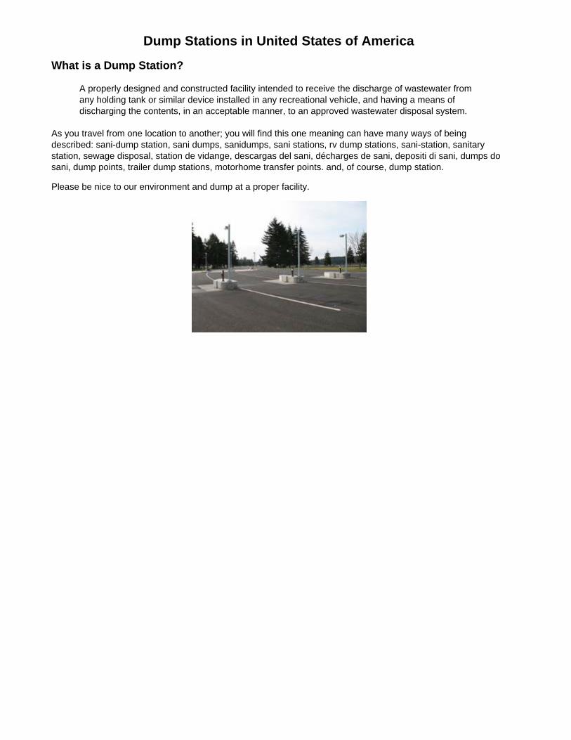
Dump Stations in United States of AmericaWhat is a Dump Station?
A properly designed and constructed facility intended to receive the discharge of wastewater fromany holding tank or similar device installed in any recreational vehicle, and having a means ofdischarging the contents, in an acceptable manner, to an approved wastewater disposal system.
As you travel from one location to another; you will find this one meaning can have many ways of beingdescribed: sani-dump station, sani dumps, sanidumps, sani stations, rv dump stations, sani-station, sanitarystation, sewage disposal, station de vidange, descargas del sani, décharges de sani, depositi di sani, dumps dosani, dump points, trailer dump stations, motorhome transfer points. and, of course, dump station.
Please be nice to our environment and dump at a proper facility.

About the ListingsThis e-Book contains listing for 13,000+ dump stations. Each site would contain the following information:
Name of the dump stationNearest town or cityDriving directions from a major highway or land markAddress of the location if knownGPS location if knownOperating hours and seasonality informationAvailability of potable and non-potable waterPrice or user feeAny special conditions or restrictions
Our comprehensive lists includes: Private and public parks, non-park, free, pay, donation and commerciallocations for dumping your gray and black holding tanks.
New EditionThis is our edition and we made several additions based upon your feedback, namely:
Updated information:Number of dump stations in the areaGPS coordinates for many locations
Appendix Section that includes:Step by step dumping process as reminder of good practices which has shared by fellow RVersDump station etiquette. Used as a reference or reminder to avoid unpleasant outcomesWrite-ups of product we have tested
Checklists to assist in trip planning and managementEssentials checklist - Stuff to make camping funBedroom and Bathroom checklist - includes bedding, toiletries and moreKitchen checklist - Includes pots, pans, dishes, cutlery, glasses and morePantry checklist - Includes dry goods, spices, canned foods and moreDeparture checklist - Itemized steps to do before departing
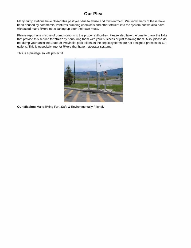
Our PleaMany dump stations have closed this past year due to abuse and mistreatment. We know many of these havebeen abused by commercial ventures dumping chemicals and other effluent into the system but we also havewitnessed many RVers not cleaning up after their own mess.
Please report any misuse of dump stations to the proper authorities. Please also take the time to thank the folksthat provide this service for "free" by honouring them with your business or just thanking them. Also, please donot dump your tanks into State or Provincial park toilets as the septic systems are not designed process 40-60+gallons. This is especially true for RVers that have macerator systems.
This is a privilege so lets protect it.
Our Mission: Make RVing Fun, Safe & Environmentally Friendly

RV Dump Stations in USARegion: United States of America (US)Area in square miles: 3,537,438Population: 307,898,000Capital: WashingtonLargest city: New YorkLargest city population: 8,363,710
UPDATE: 12,600+ dump stations listed in 50 states.
Every effort is made to ensure the accuracy of the information presented, Sanidumps.com or its management shall have neither liability norresponsibility to any person or entity with respect to any loss or damage caused, or alleged to be caused, directly or indirectly by the information
contained herein. We thank all the RVers that have contributed information.
The Sanidumps.com Team
State

RV Dump Stations & Sani Dump Stations in Alabama, United States ofAmerica
Sample E-book
Region: Alabama (AL)Area in square miles: 50,744Population: 4,557,808Capital: MontgomeryLargest city: BirminghamLargest City Population: 231,483Flower: CamelliaNickname: The Heart of DixieTourist Information Website: http://www.touralabama.org/Tourist Information Phone: 800.252.2262
161 dump stations listed arround 180 cities/towns.
Every effort is made to ensure the accuracy of the information presented, Sanidumps.com or its management shallhave neither liability nor responsibility to any person or entity with respect to any loss or damage caused, or
alleged to be caused, directly or indirectly by the information contained herein. We thank all the RVers that havecontributed information.
The Sanidumps.com Team
There's an e-Book for each country organized by location alphabetically.
NearestCity Name / Address / Directions Latitude / Longitude / Notes
Cost / Seasons/ Water
AbbevilleAL
U.S. Army Corps of Engineers - HardridgeCreek Campground• from Eufaula, AL, follow US 431 South, turn Lefton State Route 95, turn Left on County Road 97for 10 miles, follow signs into campground
Latitude: 31.640561Longitude: -85.102221
For RegisteredGuests Only• Open MarchthroughDecember• water isavailable
AdgerAL
U.S. Army Corps of Engineers - BurchfieldBranch Park• 15036 Bankhead Road
Latitude: 33.452137Longitude: -87.356468
• Open yearround
AlbertaAL
Chilatchee Creek Campground• from Alberta, AL on State Route 5, turn ontoWilcox County Road 29 and travel Southeast for11 miles, make a Left on Chilatchee Creek Road,campground is 2 miles ahead
Latitude: 32.14139Longitude: -87.27417
• Open Marchthrough midNovember• water isavailable
AlexanderCity
Wind Creek State Park• 4325 Alabama Hwy. 128
Latitude: 32.85915Longitude: -85.959497
• Open yearround

AL • Hwy.63 & Hwy.128; go 1-1/2 mile East on Hwy.128
• water isavailable
AlicevilleAL
U.S. Army Corps of Engineers - CochraneCampground• from Aliceville South State Route 17. 2 milesWest of Huyuck Bridge
Latitude: 33.0842Longitude: -88.2697
• Open yearround• water isavailable
AlpineAL
Logan Landing RV Resort & Campground• 1036 Paul Bear Bryant Road
Latitude: 33.436325Longitude: -86.268035
Free forRegisteredGuests or feefor dumpstation useonly• Open yearround• potable andrinse water(non-potable)available
AndalusiaAL
Conecuh National Forest - Open PondCampground• located off of AL 137 6 miles South of the US29/AL 137 junction, or 6 miles North of thecommunity of Wing; also near mile marker 8; fromthe junction of CR 24, go 1/2 mile East on CountyRoute 24, then 1 mile Southeast on NationalForest Road (FR) 336; dump station is on the Leftat the pay station
Latitude: 31.091154Longitude: -86.545621• camp sites are about 1/2 milefrom the dump station
$3.00 as partof the day usefee• Open yearround• water isavailable
AnnistonAL
Camping World - Anniston• 2772 Hwy.78 East Suite #2
Latitude: 33.614448Longitude: -85.773037
Free to GoodSam members• water isavailable
ArdmoreAL
Rest Area - I-65 Welcome Center, Southbound• 28232 Upper Elkton Road• 1 miles South of Ardmore on I-65 at milepost364
Latitude: 34.953194Longitude: -86.893592
Free• Open yearround
ArelyAL
Hidden Cove Outdoor Resort• 687 County Road 3916• Southbound I-65 Exit 308 (U.S. Hwy. 278) West,go 16 miles to Hwy. 77 North for 9 miles Left onHwy. 12, then stay to the Left until Hidden Coveentrance
Latitude: 34.050783Longitude: -87.157728
Free forRegisteredGuests or feefor dumpstation useonly• Open year

round• potable andrinse water(non-potable)available

RV Dump Stations & Sani Dump Stations in Alaska, United States ofAmerica
Sample E-book
Region: Alaska (AK)Area in square miles: 571,951Population: 663,661Capital: JuneauLargest city: AnchorageLargest City Population: 275,043Flower: Forget Me NotNickname: The Last FrontierTourist Information Website: http://www.travelalaska.com/Tourist Information Phone: 907.465.2010
233 dump stations listed arround 84 cities/towns.
Every effort is made to ensure the accuracy of the information presented, Sanidumps.com or its management shallhave neither liability nor responsibility to any person or entity with respect to any loss or damage caused, or
alleged to be caused, directly or indirectly by the information contained herein. We thank all the RVers that havecontributed information.
The Sanidumps.com Team
There's an e-Book for each country organized by location alphabetically.
NearestCity Name / Address / Directions Latitude / Longitude / Notes
Cost / Seasons/ Water
AnchorPointAK
Anchor River State Recreation Area • Open MaythroughSeptember
AnchorPointAK
Short Stop Storage & Camping• 30870 Sterling Hwy.• Milepost 153.2 Sterling Highway
Latitude: 59.8078Longitude: -151.832
• water isavailable
AnchorageAK
Anchorage Ship Creek Landing R.V. Park• 150 North Ingra Street• close to downtown Anchorage
Latitude: 61.22217Longitude: -149.8688
Free forRegisteredGuests or feefor dumpstation useonly• Open Maythrough midSeptember• water isavailable

AnchorageAK
Cabela's - Anchorage• 155 West 104th Avenue
Latitude: 61.127414Longitude: -149.881443• automated locking cap gives 1minute to open after swipingcredit card
$5.00• rinse water(non-potable)available
AnchorageAK
Centennial Park Campground• 8300 Glenn Hwy.
Latitude: 61.226745Longitude: -149.733965
Free forRegisteredGuests or$10.00 fordump stationuse only• Open mid Maythrough October• water isavailable
AnchorageAK
Chevron Latitude: 61.218204Longitude: -149.732834
Free
AnchorageAK
Chevron Station• 832 East 6th Avenue
Latitude: 61.216463Longitude: -149.868359
AnchorageAK
Creekwood Inn Motel & R.V. Park• 2150 Seward Hwy.
Latitude: 61.200975Longitude: -149.869345
Free forRegisteredGuests or feefor dumpstation useonly• Open yearround• water isavailable
AnchorageAK
Essential 1 Gas Station• 9250 King Street
Latitude: 61.137002Longitude: -149.879821
Free• potable andrinse water(non-potable)available
AnchorageAK
Fountain Chevron Station• 3608 Minnesota Drive• North of Spenard Road & Minnesota Drive
Latitude: 61.18788Longitude: -149.913484

RV Dump Stations & Sani Dump Stations in Arizona, United States ofAmerica
Sample E-book
Region: Arizona (AZ)Area in square miles: 113,635Population: 5,939,292Capital: PhoenixLargest city: PhoenixLargest City Population: 1,461,575Flower: Saguaro Cactus BlossNickname: The Grand Canyon StateTourist Information Website: http://www.arizonaguide.com/Tourist Information Phone: 800.842.8257
303 dump stations listed arround 152 cities/towns.
Every effort is made to ensure the accuracy of the information presented, Sanidumps.com or its management shallhave neither liability nor responsibility to any person or entity with respect to any loss or damage caused, or alleged
to be caused, directly or indirectly by the information contained herein. We thank all the RVers that havecontributed information.
The Sanidumps.com Team
There's an e-Book for each country organized by location alphabetically.
NearestCity Name / Address / Directions Latitude / Longitude / Notes
Cost / Seasons/ Water
AjoAZ
Belly Acres R.V. Park• 2050 Hwy. 85• from Plaza (center of town) and Hwy. 85; go 2miles North on Hwy. 85
Latitude: 32.37967Longitude: -112.872409
Free forRegisteredGuests or feefor dumpstation useonly• Open yearround• water isavailable
AjoAZ
Shadow Ridge R.V Resort• 431 2nd Avenue• 40 miles South on Hwy. 85, between TexacoStation and Shell Station on the Right
Latitude: 32.375375Longitude: -112.873457• we offer Free WiFi at all sites,large rig friendly
$10.00• Open yearround• water isavailable; $3.00
AlpineAZ
Alpine Village RV Park• 42702 US Highway 180• US 180 about 1/2 mile East of town
Latitude: 33.844981Longitude: -109.13727
$10.00• Open yearround• potable andrinse water
(non-potable)available
AmadoAZ
Mountain View R.V. Ranch• 2843 East Frontage Road• from Tucson Interstate 19 to Arivaca Road (Exit48), Left at bottom of highway ramp, Right onEast Frontage Road
Latitude: 31.705392Longitude: -111.064331
Free forRegisteredGuests or feefor dumpstation useonly• Open yearround• water isavailable
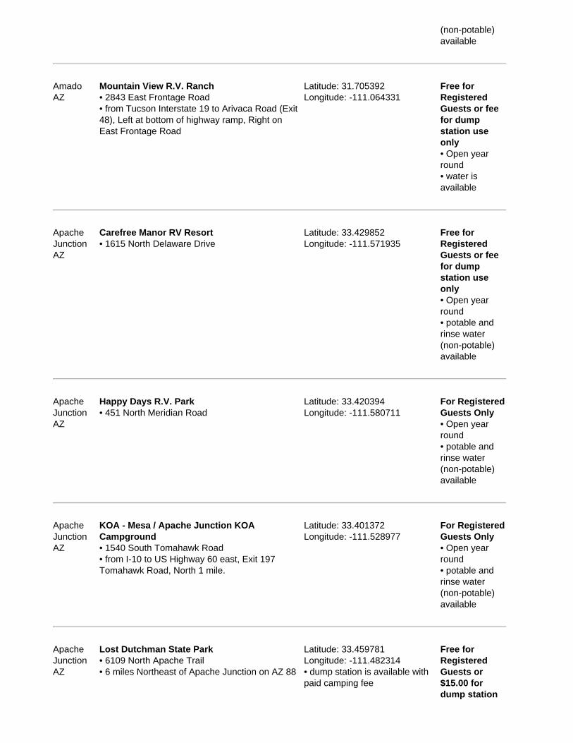
ApacheJunctionAZ
Carefree Manor RV Resort• 1615 North Delaware Drive
Latitude: 33.429852Longitude: -111.571935
Free forRegisteredGuests or feefor dumpstation useonly• Open yearround• potable andrinse water(non-potable)available
ApacheJunctionAZ
Happy Days R.V. Park• 451 North Meridian Road
Latitude: 33.420394Longitude: -111.580711
For RegisteredGuests Only• Open yearround• potable andrinse water(non-potable)available
ApacheJunctionAZ
KOA - Mesa / Apache Junction KOACampground• 1540 South Tomahawk Road• from I-10 to US Highway 60 east, Exit 197Tomahawk Road, North 1 mile.
Latitude: 33.401372Longitude: -111.528977
For RegisteredGuests Only• Open yearround• potable andrinse water(non-potable)available
ApacheJunctionAZ
Lost Dutchman State Park• 6109 North Apache Trail• 6 miles Northeast of Apache Junction on AZ 88
Latitude: 33.459781Longitude: -111.482314• dump station is available withpaid camping fee
Free forRegisteredGuests or$15.00 fordump station

use only• Open yearround• water isavailable
ApacheJunctionAZ
Rock Shadows R.V. Resort• 600 South Idaho Road• Hwy. 10 Exit 154; Hwy. 60 toward Globe to Exit196, North on Idaho Road
Latitude: 33.40955Longitude: -111.545923
For RegisteredGuests Only• Open yearround• potable andrinse water(non-potable)available
ApacheJunctionAZ
Shady RV Storage• 3705 South Colt Road• I-60 Exit South on Idaho Road (Hwy. 88) toBaseline Road, turn East to Winchester Road,turn North go to the 2nd street, turn Right on 37thAvenue and it is on the corner of Colt Road and37th Avenue
Latitude: 33.381182Longitude: -111.539288• RV wash rack (coin operated),wet/dry vacuum (coin operated)and free tire air; : back into washbay (no pull through)
$10.00• Open yearround; Mondayto Friday9:00AM -6:00PM,Saturday9:00AM -6:00PM,Sunday10:00AM -2:00PM; Closedfor StatutoryHolidays• water isavailable

RV Dump Stations & Sani Dump Stations in Arkansas, United States ofAmerica
Sample E-book
Region: Arkansas (AR)Area in square miles: 52,068Population: 2,779,154Capital: Little RockLargest city: Little RockLargest City Population: 184,564Flower: Apple BlossomNickname: The Natural StateTourist Information Website: http://www.arkansas.com/Tourist Information Phone: 800.628.8725
231 dump stations listed arround 136 cities/towns.
Every effort is made to ensure the accuracy of the information presented, Sanidumps.com or its management shall haveneither liability nor responsibility to any person or entity with respect to any loss or damage caused, or alleged to be
caused, directly or indirectly by the information contained herein. We thank all the RVers that have contributedinformation.
The Sanidumps.com Team
There's an e-Book for each country organized by location alphabetically.
NearestCity Name / Address / Directions Latitude / Longitude / Notes
Cost / Seasons/ Water
AlmaAR
Crabtree RV Park• 405 Heather Lane
Latitude: 35.4908160Longitude: -94.2294810
Free forRegisteredGuests or feefor dumpstation useonly• Open yearround• water isavailable
AlmaAR
KOA - Fort Smith / Alma KOA Campground• 3539 North US Hwy. 71
Latitude: 35.5219Longitude: -94.2217
Free forRegisteredGuests or feefor dumpstation useonly• Open yearround• potable andrinse water(non-potable)available

AlmaAR
U.S. Army Corps of Engineers - Clear CreekCampground• 3610 Clear Creek Road• from Alma, AR, take State Route 162 5.2 milesSouth
Latitude: 35.437328Longitude: -94.168139
Free forRegisteredGuests or$6.00 for dumpstation useonly• Open MarchthroughNovember• water isavailable
ArkadelphiaAR
Arkadelphia Campground & RV Park• 221 Frost Road• I-30 & Hwy. 7, 300 yards North on Hwy. 7, 1mile Northeast on Frost Road
Latitude: 34.19609Longitude: -93.05732
Free forRegisteredGuests or feefor dumpstation useonly• Open yearround• water isavailable
ArkadelphiaAR
DeGray Lake State Park• 2027 State Park Entrance Road• from Arkadelphia exit off I-30; 7 miles North onState Hwy. 7
Free forRegisteredGuests or$6.00 for dumpstation useonly• Open yearround• water isavailable
ArkadelphiaAR
U.S. Army Corps of Engineers - Alpine RidgeCampground• I-30 Exit 73; take State Hwy. 8 West 19 miles toAlpine, turn Right onto Fendley Road, go 8.5miles to Alpine Ridge
Free forRegisteredGuests or$6.00 for dumpstation useonly• Open yearround• water isavailable
ArkadelphiaAR
U.S. Army Corps of Engineers - Arlie MooreCampground• I-30 take Exit 78, take State Hwy. 7 North for 9miles, turn Left onto Arlie Moore Road, go 2miles to campground
Latitude: 34.272736Longitude: -93.194167
Free forRegisteredGuests or$6.00 for dumpstation useonly

• Open yearround• water isavailable
ArkadelphiaAR
U.S. Army Corps of Engineers - Caddo Drive• I-30 take Exit 78, take State Hwy. 7 North, turnLeft onto Edgewood Road and go 3 miles toCaddo Drive
Free forRegisteredGuests or$6.00 for dumpstation useonly• Open yearround
ArkadelphiaAR
U.S. Army Corps of Engineers - Edgewood• I-30 Exit 78; State Hwy. 7 North, turn Left onEdgewood Road and go 2 miles to Edgewood
Free forRegisteredGuests or$6.00 for dumpstation useonly• Open yearround
ArkadelphiaAR
U.S. Army Corps of Engineers - IronMountain Campground• I-30 Exit 78; State Hwy. 7 North, Left ontoSkyline Drive, take Skyline Drive 2.5 miles, Righton Iron Mountain Road
Free forRegisteredGuests or$6.00 for dumpstation useonly• Open yearround• water isavailable

RV Dump Stations & Sani Dump Stations in California, United States ofAmerica
Sample E-book
Region: California (CA)Area in square miles: 155,959Population: 36,132,147Capital: SacramentoLargest city: Los AngelesLargest City Population: 3,844,829Flower: California PoppyNickname: The Golden StateTourist Information Website: http://www.visitcalifornia.com/Tourist Information Phone: 800.462.2543
923 dump stations listed arround 757 cities/towns.
Every effort is made to ensure the accuracy of the information presented, Sanidumps.com or its management shallhave neither liability nor responsibility to any person or entity with respect to any loss or damage caused, or
alleged to be caused, directly or indirectly by the information contained herein. We thank all the RVers that havecontributed information.
The Sanidumps.com Team
There's an e-Book for each country organized by location alphabetically.
NearestCity Name / Address / Directions Latitude / Longitude / Notes
Cost / Seasons/ Water
ActonCA
KOA - Acton / Los Angeles North KOACampground• 7601 Soledad Canyon Road
Latitude: 34.439114Longitude: -118.265937
For RegisteredGuests Only• Open yearround• potable andrinse water(non-potable)available
ActonCA
Robin's Nest RV Park• 8237 Soledad Canyon Road
Latitude: 34.438482Longitude: -118.278601
Free forRegisteredGuests or feefor dumpstation useonly• water isavailable
ActonCA
Soledad Canyon Thousand Trails• 4700 Crown Valley Road• I-5 to Hwy. 14
Latitude: 34.450985Longitude: -118.201891
For RegisteredGuests Only• Open yearround

• water isavailable
ActonCA
The Californian RV Resort• 1535 West Sierra Hwy.
Latitude: 34.4876Longitude: -118.14271
For RegisteredGuests Only• Open yearround• potable andrinse water(non-potable)available
AdelantoCA
Adelanto RV Park & Resort• 11301 Air Expressway• Hwy. 395
Latitude: 34.571763Longitude: -117.418114
Free forRegisteredGuests or$12.00 fordump stationuse only• Open yearround• potable andrinse water(non-potable)available
AguangaCA
Jojoba Hills Resort (Co-op)• 45120 Hwy. 79 South• I-15; take Hwy. 79 South; 17 mile to resort onLeft, 1/2 mile West of Aguanga
Latitude: 33.435458Longitude: -116.849208• $5.00 dump fee if you are notpaying for a full hook up site;California DOT restricts all roadsleading to Jojoba Hills tomotorhomes of 40 ft or less inlength, trailers are not restricted
For RegisteredGuests Only• Open yearround• potable andrinse water(non-potable)available
AguangaCA
Outdoor Resorts Rancho California RV Resort• 45525 Hwy. 79 South• Hwy. 371 and Hwy. 79 South
Latitude: 33.44042Longitude: -116.857835• the following types of RVs areallowed at the resort: Class A,5th wheels, no toy haulers, mustbe 10 years or newer
For RegisteredGuests Only• Open yearround• potable andrinse water(non-potable)available
AlbionCA
Albion River Campground• 34500 Highway 1
Latitude: 39.226295Longitude: -123.766481
Free forRegisteredGuests or feefor dumpstation useonly• Open year
round• potable andrinse water(non-potable)available
AlpineCA
Viejas Indian Reservation - Ma-Tar-Awa RVCamper Park• 25 Browns Road
Latitude: 32.844241Longitude: -116.690819
$15.00• Open yearround• water isavailable
AlturasCA
Sully's R.V. Park• 602 South East Street
Latitude: 41.479452Longitude: -120.539738
For RegisteredGuests Only• Open yearround• potable andrinse water(non-potable)available

RV Dump Stations & Sani Dump Stations in Colorado, United States ofAmerica
Sample E-book
Region: Colorado (CO)Area in square miles: 103,718Population: 4,665,177Capital: DenverLargest city: DenverLargest City Population: 557,917Flower: Rocky Mountain ColumNickname: The Centinnial StateTourist Information Website: http://www.colorado.com/Tourist Information Phone: 800.265.6723
294 dump stations listed arround 203 cities/towns.
Every effort is made to ensure the accuracy of the information presented, Sanidumps.com or its management shallhave neither liability nor responsibility to any person or entity with respect to any loss or damage caused, or
alleged to be caused, directly or indirectly by the information contained herein. We thank all the RVers that havecontributed information.
The Sanidumps.com Team
There's an e-Book for each country organized by location alphabetically.
NearestCity Name / Address / Directions Latitude / Longitude / Notes
Cost / Seasons/ Water
AlamosaCO
Alamosa Economy Campground• 12532 East US Highway 160
Latitude: 37.4733295Longitude: -105.8072892
Free forRegisteredGuests or feefor dumpstation useonly• Open yearround• water isavailable
AlamosaCO
KOA - Alamosa KOA Campground• 6900 Juniper Lane
Latitude: 37.4751053Longitude: -105.7985095
Free forRegisteredGuests or feefor dumpstation useonly• Open MarchthroughDecember• potable andrinse water(non-potable)available

AlamosaCO
Wright Valley Oil Station• Highway US 160 / US 285; on North side ofhighway next to TruValue about 1 block East ofWalmart
Latitude: 37.474909Longitude: -105.892857
$10.00
AlmontCO
Taylor Park Trading Post / Colorado DreamRanch RV Park• 23044 County Road 742
Latitude: 38.8135Longitude: -106.5478• public RV dump station
$7.00• potable andrinse water(non-potable)available
AlmontCO
USDA Forest Service - Lakeview Big HornCampground• from Gunnison, travel North on Hwy. 135approximately 10 miles to Almont, turn Right onCounty Road 742, travel 25 miles
Latitude: 38.818447Longitude: -106.578957
For RegisteredGuests Only• Open MaythroughSeptember• water isavailable
AnteroJunctionCO
Antero Division of Wildlife• Pike National Forest
AntonitoCO
Conejos River Campground• 26714 Hwy. 17• from junction of US 285 & State Highway 17,West 12 miles on State Highway 17
Latitude: 37.0677570Longitude: -106.2175776
Free forRegisteredGuests or feefor dumpstation useonly• Open mid Maythrough October• water isavailable
AntonitoCO
Rio Grande National Forest - Lake Fork• 23 miles West of Antonito on State Hwy. 17; 16miles Northwest on FS 250
• water isavailable
ArbolesCO
Navajo State Park• 1526 County Road
Latitude: 37.0292Longitude: -107.4168
$18.00 and$8.00 to getinto the park• Open yearround• water isavailable

ArbolesCO
Pinon Park Campground and RV Resort• 19 Lazy Lane• located 35 miles from Pagosa Springs and 45miles from Durango
Latitude: 37.027065Longitude: -107.416947
Free forRegisteredGuests or feefor dumpstation useonly• Open midApril throughNovember• potable andrinse water(non-potable)available

RV Dump Stations & Sani Dump Stations in Connecticut, United Statesof America
Sample E-book
Region: Connecticut (CT)Area in square miles: 4,845Population: 3,510,297Capital: HartfordLargest city: BridgeportLargest City Population: 139,008Flower: Mountain LaurelNickname: The Constitution StateTourist Information Website: http://www.ctvisit.com/Tourist Information Phone: 800.282.6863
72 dump stations listed arround 115 cities/towns.
Every effort is made to ensure the accuracy of the information presented, Sanidumps.com or its management shallhave neither liability nor responsibility to any person or entity with respect to any loss or damage caused, or
alleged to be caused, directly or indirectly by the information contained herein. We thank all the RVers that havecontributed information.
The Sanidumps.com Team
There's an e-Book for each country organized by location alphabetically.
Nearest City Name / Address / Directions Latitude / Longitude / NotesCost / Seasons/ Water
AbingtonCT
Mashamoquet Brook State Park $13.00• Open midApril throughmid October• water isavailable
AshfordCT
Brialee RV & Tent Park• 174 Laurel Lane
Latitude: 41.885219Longitude: -72.176122
Free forRegisteredGuests or feefor dumpstation useonly• Open AprilthroughDecember• water isavailable
BantamCT
Cozy Hills Campground• 1311 Bantam Road• Route 202
Latitude: 41.709424Longitude: -73.269318
Free forRegisteredGuests or fee
for dumpstation useonly• Open Maythrough midOctober• water isavailable
BantamCT
White Memorial Family Campgrounds -Windmill Hill• 123 North Shore Road
Latitude: 41.712848Longitude: -73.227158
Free forRegisteredGuests or feefor dumpstation useonly• Open earlyApril throughmid October• potable andrinse water(non-potable)available
BarkhamstedCT
White Pines Campsites• 232 Old North Road
Latitude: 41.93814Longitude: -73.03909
For RegisteredGuests Only• Open midApril throughmid October• potable andrinse water(non-potable)available
BozrahCT
Acorn Acres Campground• 135 Lake Road
Latitude: 41.530436Longitude: -72.223663
Free forRegisteredGuests or feefor dumpstation useonly• water isavailable
BozrahCT
Odetah Campground• 38 Bozrah Street
Latitude: 41.554108Longitude: -72.166609
Free forRegisteredGuests or feefor dumpstation useonly• Open Maythrough October• water isavailable

CanaanCT
Lone Oak Campsites• 360 Norfolk Road• Lone Oak is just 4 miles East of Canaan, CTon Route 44
Latitude: 42.0098Longitude: -73.26257
Free forRegisteredGuests or feefor dumpstation useonly• Open midApril throughmid October• water isavailable
ChaplinCT
Nickerson Park Campground• 1036 Phoenixville Road
Latitude: 41.830891Longitude: -72.097412
Free forRegisteredGuests or feefor dumpstation useonly• Open yearround• water isavailable
ClintonCT
Riverdale Farm Campsites• 111 River Road
Latitude: 41.307194Longitude: -72.581956• cash or check no credit cards
Free forRegisteredGuests or$15.00 fordump stationuse only• potable andrinse water(non-potable)available

RV Dump Stations & Sani Dump Stations in Delaware, United States ofAmerica
Sample E-book
Region: Delaware (DE)Area in square miles: 1,954Population: 843,524Capital: DoverLargest city: WilmingtonLargest City Population: 72,786Flower: Peach BlossomNickname: The First StateTourist Information Website: http://www.visitdelaware.com/Tourist Information Phone: 800.441.8846
22 dump stations listed arround 24 cities/towns.
Every effort is made to ensure the accuracy of the information presented, Sanidumps.com or its management shallhave neither liability nor responsibility to any person or entity with respect to any loss or damage caused, or
alleged to be caused, directly or indirectly by the information contained herein. We thank all the RVers that havecontributed information.
The Sanidumps.com Team
There's an e-Book for each country organized by location alphabetically.
NearestCity Name / Address / Directions Latitude / Longitude / Notes
Cost / Seasons/ Water
BethanyBeachDE
Military Park- Bethany Beach Training Site• 10 miles from Ocean City, MD, and 12 milesfrom Rehoboth Beach; from Hwy. 1 to BethanyBeach; after entering main gate, past helicopterdisplay, take next Right by VFW BBQ stand
Latitude: 38.54702Longitude: -75.06237• Delaware National Guard
Free forMilitary UseOnly withMilitary IDCard• Open yearround
DoverDE
Dover Downs Casino / Dover InternationalSpeedway• 1131 North DuPont Highway• from US-13 in Dover, come into the mainentrance for the casino, follow drive around toyour Left; dump station is on Left between twoyellow poles on the edge of the gravel lot, look fora green pipe and a red water spigot; can beapproached from either direction as long as youdon't block the road
Latitude: 39.188785Longitude: -75.536396• overnight RV parking permittedin the gravel / grass area Northof the RV dump station
Free• Open yearround• rinse water(non-potable)available
DoverDE
Military Park - Dover AFB FamCamp• enter through North Gate (Commercial Gate)only
Latitude: 39.1138Longitude: -75.4574
Free forMilitary UseOnly with

Military IDCard• Open yearround• water isavailable
FeltonDE
• 3015 Paradise Ally Road• US 13; 1 miles Southeast of Felton
Latitude: 38.977162Longitude: -75.534669
Free forRegisteredGuests or$7.00 for dumpstation useonly• Open yearround• water isavailable
FeltonDE
Killens Pond State Park• 5025 Killens Pond Road• US 13; 1 miles Southeast of Felton
Latitude: 38.990328Longitude: -75.545289
Free forRegisteredGuests or$7.00 for dumpstation useonly• Open yearround• water isavailable
FenwickIslandDE
Treasure Beach Recreational Vehicle (RV)Park and Campground• 37291 Lighthouse Road
Latitude: 38.462738Longitude: -75.079724
Free forRegisteredGuests or feefor dumpstation useonly• Open lateApril throughmid October• water isavailable
GlasgowDE
Lums Pond State Park• 1068 Howell School Road
Latitude: 39.573147Longitude: -75.706245• back in only
Free forRegisteredGuests or$7.00 for dumpstation useonly• Open yearround• water isavailable

HarringtonDE
Delaware State Fairgrounds• Hwy. 13; Dupont Hwy.
Latitude: 38.907598Longitude: -75.570573• for Registered Guests Onlywho pay $30 per night
For RegisteredGuests Only• water isavailable
HarringtonDE
G & R Campground• 4075 Gun & Rod Club Road
Latitude: 38.912508Longitude: -75.534528
Free forRegisteredGuests or feefor dumpstation useonly• Open yearround• water isavailable
LaurelDE
Trap Pond State Park• 33587 Baldcypress Lane• 5 miles Southeast of Laurel on Hwy. 24
Latitude: 38.527022Longitude: -75.482643
Free forRegisteredGuests or$7.00 for dumpstation useonly• Open MarchthroughNovember• water isavailable

RV Dump Stations & Sani Dump Stations in Florida, United States ofAmerica
Sample E-book
Region: Florida (FL)Area in square miles: 53,927Population: 17,789,964Capital: TallahasseeLargest city: JacksonvilleLargest City Population: 782,623Flower: Orange BlossomNickname: The Sunshine StateTourist Information Website: http://www.visitflorida.com/Tourist Information Phone: 888.735.2872
529 dump stations listed arround 267 cities/towns.
Every effort is made to ensure the accuracy of the information presented, Sanidumps.com or its management shallhave neither liability nor responsibility to any person or entity with respect to any loss or damage caused, or
alleged to be caused, directly or indirectly by the information contained herein. We thank all the RVers that havecontributed information.
The Sanidumps.com Team
There's an e-Book for each country organized by location alphabetically.
NearestCity Name / Address / Directions Latitude / Longitude / Notes
Cost / Seasons/ Water
AlachuaFL
Travelers Campground• 17701 April Blvd.
Latitude: 29.814317Longitude: -82.513472
Free forRegisteredGuests or feefor dumpstation useonly• Open yearround• water isavailable
AltoonaFL
Ocala National Forest - Big Bass Campground • Open midOctober throughmid April• water isavailable
AltoonaFL
Ocala National Forest - Clearwater LakeCampground• 26301 Southeast Highway 42
Latitude: 28.9881Longitude: -81.711487
Free forRegisteredGuests or feefor dumpstation use

only• Open yearround• water isavailable
AltoonaFL
USDA Forest Service - Alexander SpringsRecreation Area• I-75 take Hwy. 40 East through Ocala and SilverSprings approximately 40 miles to Hwy. 19. Southon Hwy. 19 approximately 5 miles to CountryRoad 445 (CR-445). East on CR-445
Latitude: 29.078953Longitude: -81.578011
• Open yearround
AlvaFL
U.S. Army Corps of Engineers - W.P. FranklinNorth Campground• 17850 North Franklin Lock Road
Latitude: 26.723549Longitude: -81.692321
• Open yearround• water isavailable
ApopkaFL
Orange Blossom RV Park• 3800 West Orange Blossom Trail• Hwy. 441
Latitude: 28.69924Longitude: -81.572433
$25.00• Open yearround• water isavailable
ApopkaFL
Sun Resorts• 3000 Clarcona Road
Latitude: 28.637251Longitude: -81.500946
For RegisteredGuests Only• Open yearround• potable andrinse water(non-potable)available
ApopkaFL
Wekiwa Springs State Park• 1800 Wekiwa Circle
Latitude: 28.710511Longitude: -81.462905
Free forRegisteredGuests or$10.00 fordump stationuse only• Open yearround• water isavailable
ArcadiaFL
Arcadia Peace River Campground• 2998 Northwest Hwy. 70
Latitude: 27.22659Longitude: -81.890106
Free forRegisteredGuests or feefor dump

station useonly• Open yearround• water isavailable
ArcadiaFL
Big Tree RV Resort• 2626 NE Hwy. 70
Latitude: 27.209Longitude: -81.83057
Free forRegisteredGuests or feefor dumpstation useonly• Open yearround• potable andrinse water(non-potable)available
RV Dump Stations & Sani Dump Stations in Georgia, United States ofAmerica
Sample E-book
Region: Georgia (GA)Area in square miles: 59,428Population: 9,685,744Capital: AtlantaLargest city: AtlantaLargest City Population: 5,376,285Flower: Cherokee RoseNickname: The Peach StateTourist Information Website: http://www.georgia.gov/Tourist Information Phone: 404.656.3590
203 dump stations listed arround 170 cities/towns.
Every effort is made to ensure the accuracy of the information presented, Sanidumps.com or its management shallhave neither liability nor responsibility to any person or entity with respect to any loss or damage caused, or
alleged to be caused, directly or indirectly by the information contained herein. We thank all the RVers that havecontributed information.
The Sanidumps.com Team
There's an e-Book for each country organized by location alphabetically.
NearestCity Name / Address / Directions Latitude / Longitude / Notes
Cost / Seasons/ Water
AdelGA
Reed Bingham State Park• 542 Reed Bingham Road• 6 miles West of Adel off GA 37
Latitude: 31.160241Longitude: -83.535905
$3.00• Open yearround• water isavailable
AlbanyGA
Creekside Plantation Campground and R.V.• 2700 Liberty Expressway East
Latitude: 31.45291Longitude: -84.117819
Free forRegisteredGuests or feefor dumpstation useonly• Open yearround• water isavailable
AlbanyGA
Military Park - MCLB Albany RV Park• Interstate 75 South to Exit 99 Continue on 300W to Albany (approximately 45 miles) right ontoOglethorpe left onto Mock Road left onto ShortStreet
Latitude: 31.553Longitude: -84.034• Marine Corps Logistics Base
Free forMilitary UseOnly withMilitary IDCard

• Open yearround• water isavailable
AlbanyGA
The Parks at Chehaw Campground• 105 Chehaw Park Road• US 19 bypass and exit at North Jefferson StreetExit (first exit after you cross the Flint Rivercoming from East); take a Right at the Philema(Hwy. 91) intersection and the park will be about1 mile on the Left
Latitude: 31.617688Longitude: -84.138185• RV dump station is near bathhouse in RV campground; roadsin campground are dirt;campground located in localpark, with campground, zoo,playground, and other activities;easy to find and easy access
$2.00• Open yearround• rinse water(non-potable)available
AmericusGA
Brickyard Plantation Golf Club and RV Park• 1619 US Hwy. 280 East
Latitude: 32.004592Longitude: -84.112411
Free forRegisteredGuests or feefor dumpstation useonly• Open yearround• water isavailable
ApplingGA
Military Park - Pointes West Recreation Area• I-20, take US221 North for about 9 miles, turnLeft on Hwy. 104 and go about 4.75 miles, stay tothe Right at Hwy. 47, after 1/2 miles, turn Rightonto Pike Avenue which goes to the campground
Latitude: 33.689201Longitude: -82.315137• Fort Gordon
Free forMilitary UseOnly withMilitary IDCard• Open yearround
ApplingGA
Military Park -Leitner Lake Recreation Area• I-20 East from Atlanta or I-20 West fromColumbia; Exit #196 I-520 Bobby JonesExpressway Eastbound, Exit & turn Right, Hwy.78 Gordon Hwy. (about 3 miles), follow GordonHwy. and turn Left into Gate 1
Latitude: 33.37Longitude: -82.255• Fort Gordon
Free forMilitary UseOnly withMilitary IDCard• Open yearround
ApplingGA
Mistletoe State Park• 3725 Mistletoe Road• I-20 Exit 60; 12 miles North
Latitude: 33.6357937Longitude: -82.3964903
$3.00• Open yearround• water isavailable

ApplingGA
Rest Area - Appling, Eastbound• I-20 Milemarker 182; Eastbound
Latitude: 33.498045Longitude: -82.334468
Free• Open yearround
ApplingGA
Rest Area - Appling, Westbound• I-20 Milemarker 182; Westbound
Latitude: 33.499273Longitude: -82.330185
Free• Open yearround
RV Dump Stations & Sani Dump Stations in Hawaii, United States ofAmerica
Sample E-book
Region: Hawaii (HI)Area in square miles: 6,423Population: 1,275,194Capital: HonoluluLargest city: HonoluluLargest City Population: 377,379Flower: Pua AloaloNickname: The Aloha StateTourist Information Website: http://www.hawaiitourismauthority.org/Tourist Information Phone: 808.923.1811
2 dump stations listed arround 18 cities/towns.
Every effort is made to ensure the accuracy of the information presented, Sanidumps.com or its management shallhave neither liability nor responsibility to any person or entity with respect to any loss or damage caused, or
alleged to be caused, directly or indirectly by the information contained herein. We thank all the RVers that havecontributed information.
The Sanidumps.com Team
There's an e-Book for each country organized by location alphabetically.
NearestCity Name / Address / Directions Latitude / Longitude / Notes
Cost / Seasons/ Water
HiloHI
Wastewater Treatment Plant• 108 Railroad Avenue
Latitude: 19.709575Longitude: -155.063546
Free• Open yearround
HonoluluHI
KOA - Honolulu KOA Campground• 500 Alakawa Street 212
Latitude: 21.318052Longitude: -157.873647
Free forRegisteredGuests or feefor dumpstation useonly• Open yearround• potable andrinse water(non-potable)available

RV Dump Stations & Sani Dump Stations in Idaho, United States ofAmerica
Sample E-book
Region: Idaho (ID)Area in square miles: 82,747Population: 1,429,096Capital: BoiseLargest city: BoiseLargest City Population: 193,161Flower: SyringaNickname: The Gem StateTourist Information Website: http://www.accessidaho.org/tourism_transport/Tourist Information Phone: 800.635.7820
354 dump stations listed arround 158 cities/towns.
Every effort is made to ensure the accuracy of the information presented, Sanidumps.com or its management shallhave neither liability nor responsibility to any person or entity with respect to any loss or damage caused, or
alleged to be caused, directly or indirectly by the information contained herein. We thank all the RVers that havecontributed information.
The Sanidumps.com Team
There's an e-Book for each country organized by location alphabetically.
NearestCity Name / Address / Directions Latitude / Longitude / Notes
Cost / Seasons/ Water
AberdeenID
Sportsman Park on American Falls Reservoir• 1359 Hansen Avenue• 3 miles from Aberdeen on East Boat Dock Road
Latitude: 42.949974Longitude: -112.778422
Free• water isavailable
AhsahkaID
U.S. Army Corps of Engineers - Dent AcresCampground• Hwy. 12; cross the bridge at Orofino, Left ontoHwy. 7, Right and travel 19 miles, turn Left atcampground sign
Latitude: 46.627334Longitude: -116.220161
• Open midApril throughmid November• water isavailable
AmericanFallsID
Indian Springs Resort• 3249 Indian Springs Road• 3 miles West of American Falls
Latitude: 42.726515Longitude: -112.874888
Free forRegisteredGuests or feefor dumpstation useonly• Open MaythroughSeptember• potable andrinse water(non-potable)
available
AmericanFallsID
Massacre Rocks State Park• 3592 North Park Lane• 10 miles West on I-86 Exit 28
Latitude: 42.670212Longitude: -112.996186
Free forRegisteredGuests or feefor dumpstation useonly• Open yearround• water isavailable
AmericanFallsID
Seagull Bay Yacht Club• 2595 Seagull Bay Road• I-86 Seagull Bay Exit
Latitude: 42.826147Longitude: -112.809451
Free forRegisteredGuests or feefor dumpstation useonly• Open Maythrough October• potable andrinse water(non-potable)available
AmericanFallsID
Selcho Oil Company• Madison Street and Oregon Trail Road
Latitude: 42.789527Longitude: -112.854638
AmericanFallsID
Willow Bay Marina• 702 Roosevelt Street• 1.25 miles North on Fort Hall Avenue
Latitude: 42.782833Longitude: -112.845562
Free forRegisteredGuests or feefor dumpstation useonly• water isavailable
AmericanFallsID
Willow Bay Recreation Area• 2830 Marina Road• I-86 Exit 40; Hwy. 39 1/2 mile Right on MarinaRoad
Latitude: 42.799472Longitude: -112.846201
Free• Open Aprilthrough October• water isavailable
ArcoID
Butte County Dump Station• 2437 US 20• Hwy. 20 / Hwy. 26 South of town; located next to
Latitude: 43.461765Longitude: -113.562962
Free

Jack's Travel Plaza
ArcoID
Jack's Travel Plaza• 2437 US Highway 20• Hwy. 20/26
Latitude: 43.630809Longitude: -113.292891
Free• Open mid Maythrough earlyOctober• rinse water(non-potable)available
RV Dump Stations & Sani Dump Stations in Illinois, United States ofAmerica
Sample E-book
Region: Illinois (IL)Area in square miles: 55,584Population: 12,763,371Capital: SpringfieldLargest city: ChicagoLargest City Population: 2,842,518Flower: Purple VioletNickname: Land of LincolnTourist Information Website: http://www.illinois.gov/visiting/Tourist Information Phone: 800.487.2446
252 dump stations listed arround 268 cities/towns.
Every effort is made to ensure the accuracy of the information presented, Sanidumps.com or its management shallhave neither liability nor responsibility to any person or entity with respect to any loss or damage caused, or
alleged to be caused, directly or indirectly by the information contained herein. We thank all the RVers that havecontributed information.
The Sanidumps.com Team
There's an e-Book for each country organized by location alphabetically.
NearestCity Name / Address / Directions Latitude / Longitude / Notes
Cost / Seasons/ Water
AddisonIL
Addison Water Treatment Plant• 249 South Villa Avenue• North of Fullerton Avenue on Villa Avenue
Latitude: 41.922298Longitude: -87.975791
Free• closes at3:00PM• no wateravailable
AmboyIL
Green River Oaks Camping Resort• 1442 Sleepy Hollow Road
Latitude: 41.6824319Longitude: -89.3551110
Free forRegisteredGuests or feefor dumpstation useonly• Open lateApril throughmid October• potable andrinse water(non-potable)available
AmboyIL
Mendota Hills Campground• 642 US Route 52
Latitude: 41.6783989Longitude: -89.2814336
Free forRegistered

Guests or feefor dumpstation useonly• Open yearround• water isavailable
AmboyIL
O'Connell's Yogi Bear's Jellystone ParkCamp-Resort• 970 Green Wing Road
Latitude: 41.7233960Longitude: -89.2656330
Free forRegisteredGuests or feefor dumpstation useonly• Open yearround• potable andrinse water(non-potable)available
AmboyIL
Pine View Campground• 1273 Sleepy Hollow Road
Latitude: 41.671463Longitude: -89.386947
Free forRegisteredGuests or feefor dumpstation useonly• Open Maythrough October• water isavailable
AppleRiverIL
Apple River Canyon State Park• 8763 East Canyon Road
Latitude: 42.448218Longitude: -90.043451
Free forRegisteredGuests or$5.00 for dumpstation useonly• Open Maythrough October• water isavailable
ArthurIL
Arthur City Park• South side of Highway 133
Latitude: 39.708587Longitude: -88.471171
Free• rinse water(non-potable)available
Astoria Anderson Lake State Fish & Wildlife Area Latitude: 40.196521 Free for

IL • 647 North State Hwy. 100 Longitude: -90.203366 RegisteredGuests or feefor dumpstation useonly• Open yearround• water isavailable
AuburnIL
Auburn Travel Center• 329 West State Route 104• I-55 Exit 82; IL 104
Latitude: 39.590094Longitude: -89.653953• Mobil
Free
AugustaIL
Weinberg-King State Park• Hwy. 101
Latitude: 40.227445Longitude: -90.89763
Free forRegisteredGuests or$5.00 for dumpstation useonly• water isavailable
RV Dump Stations & Sani Dump Stations in Indiana, United States ofAmerica
Sample E-book
Region: Indiana (IN)Area in square miles: 35,867Population: 6,271,973Capital: IndianapolisLargest city: IndianapolisLargest City Population: 784,118Flower: PeonyNickname: The Hoosier StateTourist Information Website: http://www.in.gov/visitindiana/Tourist Information Phone: 800.289.6646
192 dump stations listed arround 178 cities/towns.
Every effort is made to ensure the accuracy of the information presented, Sanidumps.com or its management shallhave neither liability nor responsibility to any person or entity with respect to any loss or damage caused, or
alleged to be caused, directly or indirectly by the information contained herein. We thank all the RVers that havecontributed information.
The Sanidumps.com Team
There's an e-Book for each country organized by location alphabetically.
NearestCity Name / Address / Directions Latitude / Longitude / Notes
Cost / Seasons/ Water
AlbionIN
Chain O'Lakes State Park• 2355 East 75 South
Latitude: 41.3414174Longitude: -85.3784725
• Open yearround• water isavailable
AndersonIN
Mounds State Park• 4306 Mounds Road
Latitude: 40.0957880Longitude: -85.6201070
• Open MaythroughNovember• water isavailable
AndersonIN
Timberline Family Campground• 3230 East County Road 75 North
Latitude: 40.162176Longitude: -85.575831
Free forRegisteredGuests or feefor dumpstation useonly• Open MarchthroughDecember• water isavailable

AngolaIN
Buck Lake Ranch• 2705 West Buck Lake Road• junction I-69 & US 20, go 1-1/2 miles East onUS 20, then 1 mile North on S 200 W, then 1/2mile West on Buck Lake Road
Latitude: 41.646722Longitude: -85.037598• Captain Carl's Famous BuckLake Ranch
Free forRegisteredGuests or feefor dumpstation useonly• Open midApril throughmid October• water isavailable
AngolaIN
Buck Lake Ranch Camping Resort• 2705 West Buck Lake Road
Latitude: 41.646316Longitude: -85.036445
For RegisteredGuests Only• potable andrinse water(non-potable)available
AngolaIN
Camp Sack-In• 8740 East 40 South
Latitude: 41.639637Longitude: -84.8245
Free forRegisteredGuests or feefor dumpstation useonly• Open midApril throughmid October• water isavailable
AngolaIN
Circle B Campground• 5251 West US 20
Latitude: 41.63457Longitude: -85.0871
Free forRegisteredGuests or feefor dumpstation useonly• Open yearround• water isavailable
AngolaIN
Pokagon State Park• 450 Lane 100
Latitude: 41.6977579Longitude: -85.0056839
• Open yearround• water isavailable
Attica Summers Campground Latitude: 40.3964169 Free for

IN • 5509 North 200 East Longitude: -87.2821961 RegisteredGuests or feefor dumpstation useonly• Open lateApril throughmid October• water isavailable
AuburnIN
Classic City Campground & RV Park• 5612 County Road 11A
Latitude: 41.3253887Longitude: -85.0909403
Free forRegisteredGuests or feefor dumpstation useonly• Open yearround• water isavailable
RV Dump Stations & Sani Dump Stations in Iowa, United States ofAmerica
Sample E-book
Region: Iowa (IA)Area in square miles: 55,869Population: 2,966,334Capital: Des MoinesLargest city: Des MoinesLargest City Population: 194,163Flower: Wild Prairie RoseNickname: The Hawkeye StateTourist Information Website: http://www.traveliowa.com/Tourist Information Phone: 800.345.4692
282 dump stations listed arround 220 cities/towns.
Every effort is made to ensure the accuracy of the information presented, Sanidumps.com or its management shallhave neither liability nor responsibility to any person or entity with respect to any loss or damage caused, or
alleged to be caused, directly or indirectly by the information contained herein. We thank all the RVers that havecontributed information.
The Sanidumps.com Team
There's an e-Book for each country organized by location alphabetically.
NearestCity Name / Address / Directions Latitude / Longitude / Notes
Cost / Seasons/ Water
AckleyIA
Prairie Bridges Park• from junction of State Hwy. 20 & State Route S-56, North 2/10 mile on State Route S-56
Latitude: 42.5625Longitude: -93.05833
• Open Aprilthrough October
AdairIA
City Park• I-80 Exit 76; South edge of town
Latitude: 41.497883Longitude: -94.6432
AdairIA
Rest Area - Adair, Eastbound• I-80 Milemarker 80; Eastbound
Latitude: 41.496402Longitude: -94.560648
Free• water isavailable
AdairIA
Rest Area - Adair, Westbound• I-80 Milemarker 80; Westbound
Latitude: 41.497181Longitude: -94.571439
Free• water isavailable
AdelIA
Dallas County Fairgrounds• 28057 Fairgrounds Road• Hwy. 169; North end of town
Latitude: 41.6311850Longitude: -94.0218569
• Open Aprilthrough October• water is

available
AdelIA
KOA - Des Moines West KOA Campground• 34308 L Avenue
Latitude: 41.54261Longitude: -94.07984
Free forRegisteredGuests or feefor dumpstation useonly• Open Marchthrough earlyNovember• potable andrinse water(non-potable)available
AftonIA
Three Mile Lake Recreation Area• 3 miles NW of Afton
Latitude: 41.080058Longitude: -94.214243• camping fee of $15 per night
Free forRegisteredGuests or feefor dumpstation useonly• water isavailable
Albert CityIA
City Park• West edge of town
Latitude: 42.785843Longitude: -94.952813
AlbiaIA
Indian Hills RV Park• 100 Hwy. 34 East
Latitude: 41.01574Longitude: -92.80457
Free forRegisteredGuests or feefor dumpstation useonly• Open yearround• water isavailable
AlbiaIA
Miami Lake Park• 1270 635th Avenue
Latitude: 41.1359233Longitude: -92.8408457
Free forRegisteredGuests or feefor dumpstation useonly• Open yearround• water isavailable


RV Dump Stations & Sani Dump Stations in Kansas, United States ofAmerica
Sample E-book
Region: Kansas (KS)Area in square miles: 81,815Population: 2,744,687Capital: TopekaLargest city: WichitaLargest City Population: 354,865Flower: SunflowerNickname: The Sunflower StateTourist Information Website: http://www.kansas.gov/tourism/Tourist Information Phone: 785.296.2009
257 dump stations listed arround 170 cities/towns.
Every effort is made to ensure the accuracy of the information presented, Sanidumps.com or its management shallhave neither liability nor responsibility to any person or entity with respect to any loss or damage caused, or
alleged to be caused, directly or indirectly by the information contained herein. We thank all the RVers that havecontributed information.
The Sanidumps.com Team
There's an e-Book for each country organized by location alphabetically.
NearestCity Name / Address / Directions Latitude / Longitude / Notes
Cost / Seasons/ Water
AbileneKS
Covered Wagon RV Park• 803 South Buckeye Avenue
Latitude: 38.907372Longitude: -97.214066
Free forRegisteredGuests or feefor dumpstation useonly• Open yearround• water isavailable
AbileneKS
Four Seasons RV Acres• 2502 Mink Road
Latitude: 38.959723Longitude: -97.110496
Free forRegisteredGuests or feefor dumpstation useonly• Open yearround• water isavailable

AnthonyKS
Q-Mart• 519 North LL & G Avenue• Hwy. 2
Latitude: 37.155944Longitude: -98.039154
• Open yearround
ArgoniaKS
Argonia River Park• 210 South Main Street• 3/4 mile South on Argonia Road
Latitude: 37.26019Longitude: -97.765518
• Open yearround
ArkansasCityKS
Newman Park• 1801 South Summit Street• Hwy. 77
Latitude: 37.041667Longitude: -97.040525
Free• Open yearround• water isavailable
AssariaKS
Lakeside Recreational Park• 1288 East Lapsley Road
Latitude: 38.652848Longitude: -97.589769
AtchisonKS
Atchison City Dump Station• between Hwy. 59 and RR tracks
Latitude: 39.554044Longitude: -95.154019
Free• rinse water(non-potable)available
AtchisonKS
Muni Park• Hwy. 9
Latitude: 39.55617Longitude: -95.15216
AtchisonKS
Warnock Lake Campground• 17862 274th Road• South off Hwy. 59/73 on Rawlins Road, West on274 Road to Warnock; 1/2 mile West of CountryMart on Hwy. 59
Latitude: 39.5425638Longitude: -95.1516738
Free forRegisteredGuests or feefor dumpstation useonly• Open yearround• water isavailable
AugustaKS
Santa Fe Lake and Campground• 11367 Southwest Shore Drive• 1 3/4 miles North of Highway 54/400 on SantaFe Lake Road to Shore Drive, turn East on ShoreDrive
Latitude: 37.699918Longitude: -97.052942• electric and primitive sitesavailable
Free forRegisteredGuests or$10.00 fordump stationuse only• Open yearround• water isavailable

RV Dump Stations & Sani Dump Stations in Kentucky, United States ofAmerica
Sample E-book
Region: Kentucky (KY)Area in square miles: 39,728Population: 4,173,405Capital: FrankfortLargest city: LouisvilleLargest City Population: 556,429Flower: GoldenrodNickname: The Bluegrass StateTourist Information Website: http://www.kytourism.com/Tourist Information Phone: 800.225.8747
187 dump stations listed arround 178 cities/towns.
Every effort is made to ensure the accuracy of the information presented, Sanidumps.com or its management shall have neitherliability nor responsibility to any person or entity with respect to any loss or damage caused, or alleged to be caused, directly or
indirectly by the information contained herein. We thank all the RVers that have contributed information.
The Sanidumps.com Team
There's an e-Book for each country organized by location alphabetically.
NearestCity Name / Address / Directions Latitude / Longitude / Notes
Cost / Seasons/ Water
BardstownKY
Holt's Campground• 2351 Templin Avenue
Latitude: 37.839664Longitude: -85.491311
Free forRegisteredGuests or feefor dumpstation useonly• Open yearround• water isavailable
BardstownKY
My Old Kentucky Home State Park• 501 East Stephen Foster Avenue
Latitude: 37.808066Longitude: -85.45883
• Open yearround• water isavailable
BardstownKY
White Acres Campground• 3022 Boston Road
Latitude: 37.808423Longitude: -85.517558
Free forRegisteredGuests or feefor dumpstation useonly• Open year
round• water isavailable
BeeSpringKY
U.S. Army Corps of Engineers - Dog CreekCampground• I-65 South to Exit75 at Upton; Hwy. 224 WestMillerstown, Left on Hwy. 479, 8 miles to Hwy. 88,Left 2.1 miles Right on Hwy. 1015, then 1.1 milesto campground entrance
• Open midApril throughmid September• water isavailable
BeeSpringKY
U.S. Army Corps of Engineers - MoutardierCampground• I-65 South to the Western Kentucky Parkway;West for 30 miles to Hwy. 259 Hwy. 259 South toHwy. 2067; Left onto Hwy. 2067
Latitude: 37.317385Longitude: -86.238928
• Open midApril throughmid October• water isavailable
BeeSpringKY
U.S. Army Corps of Engineers - WaxCampground• I-65 South to Exit 76 take Hwy. 224 West toMillerstown, Left on Hwy. 479 and go 8 miles toHwy. 88, turn Left
Latitude: 37.345276Longitude: -86.127199
• Open midApril throughmid September• water isavailable
BentonKY
Big Bear Resort and Marina• 30 Big Bear Resort Road
Latitude: 36.89624Longitude: -88.224184
Free forRegisteredGuests or feefor dumpstation useonly• Open Aprilthrough October• potable andrinse water(non-potable)available
BentonKY
King Creek Resort and Marina• 972 King Creek Road
Latitude: 36.889738Longitude: -88.226777
Free forRegisteredGuests or feefor dumpstation useonly• potable andrinse water(non-potable)available
Berea Oh Kentucky Campground Latitude: 37.56683 Free for

KY • 562 Paint Lick Road Longitude: -84.32235 RegisteredGuests or feefor dumpstation useonly• Open yearround• water isavailable
BereaKY
Walnut Meadow R.V Park• 1201 Paint Lick Road
Latitude: 37.565294Longitude: -84.32339
Free forRegisteredGuests or feefor dumpstation useonly• Open yearround• water isavailable

RV Dump Stations & Sani Dump Stations in Louisiana, United States ofAmerica
Sample E-book
Region: Louisiana (LA)Area in square miles: 43,562Population: 4,523,628Capital: Baton RougeLargest city: New OrleansLargest City Population: 454,863Flower: MagnoliaNickname: The Pelican StateTourist Information Website: http://www.louisianatravel.com/Tourist Information Phone: 800.334.8626
127 dump stations listed arround 107 cities/towns.
Every effort is made to ensure the accuracy of the information presented, Sanidumps.com or its management shallhave neither liability nor responsibility to any person or entity with respect to any loss or damage caused, or
alleged to be caused, directly or indirectly by the information contained herein. We thank all the RVers that havecontributed information.
The Sanidumps.com Team
There's an e-Book for each country organized by location alphabetically.
NearestCity Name / Address / Directions Latitude / Longitude / Notes
Cost / Seasons/ Water
AbbevilleLA
Abbeville R.V. Park• 1501 West Port Street• Business Hwy. 14
Latitude: 29.976591Longitude: -92.149286
Free forRegisteredGuests or feefor dumpstation useonly• Open yearround• potable andrinse water(non-potable)available
AbbevilleLA
Audubon RV Park• 11310 Audubon Road
Latitude: 29.87468Longitude: -92.165925
• Open yearround• potable andrinse water(non-potable)available
AbbevilleLA
Palmetto Island State Park• 19501 Pleasant Road
Latitude: 29.869564Longitude: -92.150338
Free forRegistered
Guests or feefor dumpstation useonly• Open yearround• potable andrinse water(non-potable)available
AbitaSpringsLA
Abita Springs Resort• 24150 Hwy. 435
Latitude: 30.496309Longitude: -90.004272
Free forRegisteredGuests or feefor dumpstation useonly• Open yearround• potable andrinse water(non-potable)available
AnacocoLA
South Toledo Bend State Park• 648 Bass Haven Resort Drive• 120 Bald Eagle Road
Latitude: 31.217353Longitude: -93.575194• for GPS and navigational unitsuse Bass Haven Resort Drive
Free forRegisteredGuests or feefor dumpstation useonly• Open yearround• potable andrinse water(non-potable)available
ArcadiaLA
Bonnie & Clyde Trade Days & Campground• 20550 Louisiana 9• I-20 Exit 69 & follow the signs South forapproximately 3 1/2 miles; 1 mile South on Hwy.151, then continue South 2.5 miles on Hwy. 9
Latitude: 32.519508Longitude: -92.938865
Free forRegisteredGuests or feefor dumpstation useonly• Open yearround• potable andrinse water(non-potable)available
BastropLA
Chemin-A-Haut State Park• 14656 State Park Road
Latitude: 32.908903Longitude: -91.849211
Free forRegistered

• East of LA 129; 10 miles North of Bastrop Guests or feefor dumpstation useonly• Open yearround• potable andrinse water(non-potable)available
BatonRougeLA
Farr Park Campground & Horse ActivityCenter• 6402 River Road
Latitude: 30.387363Longitude: -91.206703
For RegisteredGuests Only• Open yearround• potable andrinse water(non-potable)available
BentonLA
Cypress Black Bayou Recreation Area• 135 Cypress Park Drive• take Airline Drive North, then turn Right onLinton Road, follow the signs to the park entrance
Latitude: 32.681495Longitude: -93.678171
For RegisteredGuests Only• Open yearround• potable andrinse water(non-potable)available
BlanchardLA
Polk Salad Park• intersection of East Alexander Avenue and EastDaugherty Avenue
Latitude: 32.584029Longitude: -93.887499
Free• Open yearround• no wateravailable
RV Dump Stations & Sani Dump Stations in Maine, United States ofAmerica
Sample E-book
Region: Maine (ME)Area in square miles: 30,862Population: 1,321,505Capital: AugustaLargest city: PortlandLargest City Population: 63,889Flower: White pine cone andNickname: The Pine Tree StateTourist Information Website: http://www.visitmaine.com/Tourist Information Phone: 888.624.6345
217 dump stations listed arround 166 cities/towns.
Every effort is made to ensure the accuracy of the information presented, Sanidumps.com or its management shallhave neither liability nor responsibility to any person or entity with respect to any loss or damage caused, or
alleged to be caused, directly or indirectly by the information contained herein. We thank all the RVers that havecontributed information.
The Sanidumps.com Team
There's an e-Book for each country organized by location alphabetically.
NearestCity Name / Address / Directions Latitude / Longitude / Notes
Cost / Seasons/ Water
AbbotME
Balsam Woods Campground• 112 Pond Road
Latitude: 45.207361Longitude: -69.473778
Free forRegisteredGuests or feefor dumpstation useonly• Open mid Maythrough midOctober• water isavailable
ActonME
Apple Valley Campground• 120 Applevalley Lane• Route 109
Latitude: 43.522461Longitude: -70.891324
Free forRegisteredGuests or feefor dumpstation useonly• Open mid Maythrough midOctober• water isavailable

AddisonME
Pleasant River RV Park• 11 West Side Road
Latitude: 44.6152277Longitude: -67.7530295
Free forRegisteredGuests or feefor dumpstation useonly• Open Maythrough October• water isavailable
AlexanderME
Pleasant Lake Camping Area• 371 Davis Road
Latitude: 45.05907Longitude: -67.491821
For RegisteredGuests Only• Open late Maythrough midOctober• water isavailable
AlfredME
Scott's Cove Camping Area - Bunganut Lake• 356 Brock Road• I-5 North Exit 19; I-5 South Exit 32; Route 22;Brock Road
Latitude: 43.513778Longitude: -70.709472
• Open Maythrough midOctober• water isavailable
AlfredME
Walnut Grove Campground• 599 Gore Road
Latitude: 43.517848Longitude: -70.752097
Free forRegisteredGuests or feefor dumpstation useonly• Open Maythrough midOctober• water isavailable
AndoverME
South Arm Campground• 62 Kennett Drive
Latitude: 44.74833Longitude: -70.8383
Free forRegisteredGuests or feefor dumpstation useonly• Open earlyMay throughlate September• water isavailable

AppletonME
Sennebec Lake Campground• 100 Lodge Lane
Latitude: 44.257221Longitude: -69.274092
Free forRegisteredGuests or feefor dumpstation useonly• Open Maythrough October• water isavailable
ArundelME
Hemlock Grove Campground• 1299 Portland Road
Latitude: 43.411711Longitude: -70.520615
Free forRegisteredGuests or feefor dumpstation useonly• Open mid Maythrough midOctober• water isavailable
AuburnME
Minot Avenue Dump Station• 747 Minot Avenue• behind the Fastnal
Latitude: 44.082574Longitude: -70.258087
$7.00
RV Dump Stations & Sani Dump Stations in Maryland, United States ofAmerica
Sample E-book
Region: Maryland (MD)Area in square miles: 9,774Population: 5,600,388Capital: AnnapolisLargest city: BaltimoreLargest City Population: 635,815Flower: Black-eyed susanNickname: The Old Line StateTourist Information Website: http://www.mdisfun.org/Tourist Information Phone: 800.543.1036
58 dump stations listed arround 102 cities/towns.
Every effort is made to ensure the accuracy of the information presented, Sanidumps.com or its management shall haveneither liability nor responsibility to any person or entity with respect to any loss or damage caused, or alleged to be
caused, directly or indirectly by the information contained herein. We thank all the RVers that have contributedinformation.
The Sanidumps.com Team
There's an e-Book for each country organized by location alphabetically.
NearestCity Name / Address / Directions Latitude / Longitude / Notes
Cost / Seasons/ Water
AbingdonMD
Bar Harbor RV Park• 4228 Birch Avenue
Latitude: 39.461108Longitude: -76.242827
Free forRegisteredGuests or feefor dumpstation useonly• Open yearround• water isavailable
AnnapolisMD
Military Park - Annapolis FamCamp• US-50/301 Exit 27 to MD-450 South go left onMD-648 to traffic light entrance to Naval Station
Latitude: 38.99Longitude: -76.4715• United States NavalAcademy/Annapolis NavalStation
Free forMilitary UseOnly withMilitary IDCard• Open yearround• water isavailable
Berlin Assateague Island National Seashore - • Open year

MD Bayside Campground• US Route 50 East to MD Route 611 South,proceed over Verrazano Bridge, Right ontoBayBerry Drive, continue 2-1/4 miles to entrancestation
round• water isavailable
BerlinMD
Assateague Island National Seashore - NorthBeach Campground
• water isavailable
BoonsboroMD
Greenbrier State Park• 21843 National Pike• Route 2
Latitude: 39.5508557Longitude: -77.6127335
• Open Aprilthrough October• water isavailable
BrunswickMD
Brunswick Family Campground• 1 West Potomac Street
Latitude: 39.313064Longitude: -77.62704
Free forRegisteredGuests or feefor dumpstation useonly• Open AprilthroughNovember• water isavailable
CallowayMD
Take It Easy Campground• 45285 Take It Easy Ranch Road
Latitude: 38.227002Longitude: -76.511905
Free forRegisteredGuests or feefor dumpstation useonly• Open yearround• water isavailable
CampSpringsMD
Military Park - Andrews AFB FamCamp• I-95/495 Exit 11A; go Right at Dower HouseRoad, take the first Right after approximately8/10 mile into the Pearl Harbor commercialdelivery/24 hour RV arrival gate
Latitude: 38.7849Longitude: -76.8822
$5.00 forMilitary UseOnly withMilitary IDCard• Open yearround• water isavailable
Chestertown Duck Neck Campground Latitude: 39.234713 Free for

MD • 500 Double Creek Point Road Longitude: -75.976715 RegisteredGuests or feefor dumpstation useonly• water isavailable
ClarksburgMD
Little Bennett Campground• 23705 Frederick Road
Latitude: 39.243047Longitude: -77.285514
Free forRegisteredGuests or$35.00 fordump stationuse only• Open Marchthrough October• potable andrinse water(non-potable)available
RV Dump Stations & Sani Dump Stations in Massachusetts, UnitedStates of America
Sample E-book
Region: Massachusetts (MA)Area in square miles: 7,840Population: 6,398,743Capital: BostonLargest city: BostonLargest City Population: 559,034Flower: Trailing-ArbutusNickname: The Bay StateTourist Information Website: http://www.massvacation.com/Tourist Information Phone: 800.447.6277
118 dump stations listed arround 161 cities/towns.
Every effort is made to ensure the accuracy of the information presented, Sanidumps.com or its management shallhave neither liability nor responsibility to any person or entity with respect to any loss or damage caused, or
alleged to be caused, directly or indirectly by the information contained herein. We thank all the RVers that havecontributed information.
The Sanidumps.com Team
There's an e-Book for each country organized by location alphabetically.
NearestCity Name / Address / Directions Latitude / Longitude / Notes
Cost / Seasons/ Water
AgawamMA
Bondies Island Waste Treatment Plant• I-91 Exit 3, for Route 5 North; take 2nd Exit(not marked as it's not an official exit, just for thedump and waste plant use); follow signs towaste plant
• hours 8-4 call at gate phone,they will open the gate, ask fordirections to dump station, upthe ramp to the Right after goingthrough the gate
$1.00• Open yearround; 8:00AM -4:00PM
AmesburyMA
Tuxbury Shore Vacation Resort• 2 Powow Cove Lane
Latitude: 42.86188Longitude: -70.983209
Free forRegisteredGuests or feefor dumpstation useonly• potable andrinse water(non-potable)available
AshbyMA
The Pines Campground• 49 Davis Road• Route 31
Latitude: 42.696463Longitude: -71.785317
Free forRegisteredGuests or a feeof oneovernight stay

for dumpstation useonly• Open Maythrough midOctober• water isavailable
BarreMA
Morgan RV Resorts - Camp Coldbrook RVResort• 864 Old Coldbrook Road
Latitude: 42.400337Longitude: -72.068129
Free forRegisteredGuests or feefor dumpstation useonly• Open midApril throughmid October• potable andrinse water(non-potable)available
Bass RiverMA
Bass River Trailer Park Inc.• 698 Willow Street• Route 28
Latitude: 41.65537Longitude: -70.204359
Free forRegisteredGuests or feefor dumpstation useonly• water isavailable
BecketMA
Bonny Rigg Camping Club Inc.• 59 Main Street
Latitude: 42.265428Longitude: -73.051179
For RegisteredGuests Only• potable andrinse water(non-potable)available
BellinghamMA
Circle C G Farm Campground Adult RV Park• 131 North Main Street
Latitude: 42.101074Longitude: -71.472915
For RegisteredGuests Only• Open yearround• water isavailable
BernardstonMA
Travelers Woods of New England• 152 River Street• I-91 Exit 28B Northbound or I-91 Exit 28Southbound; 11 foot railroad bridge underpass
Latitude: 42.660904Longitude: -72.544444
Free forRegisteredGuests or$25.00 for

on river road North of grounds, take cross streetover the tracks
dump stationuse only• Open Maythrough midOctober• rinse water(non-potable)available
BourneMA
Bay View Campgrounds Inc.• 260 MacArthur Boulevard
Latitude: 41.724386Longitude: -70.584783
Free forRegisteredGuests or feefor dumpstation useonly• Open Maythrough midOctober• water isavailable
BourneMA
Bourne Scenic Recreation Campground• 370 Scenic Highway• Route 28
Latitude: 41.7508530Longitude: -70.5898920
Free forRegisteredGuests or feefor dumpstation useonly• Open Aprilthrough October• water isavailable
RV Dump Stations & Sani Dump Stations in Michigan, United States ofAmerica
Sample E-book
Region: Michigan (MI)Area in square miles: 56,804Population: 10,120,860Capital: LansingLargest city: DetroitLargest City Population: 886,671Flower: Apple BlossomNickname: The Wolverine StateTourist Information Website: http://www.michigan.org/Tourist Information Phone: 888.784.7328
468 dump stations listed arround 354 cities/towns.
Every effort is made to ensure the accuracy of the information presented, Sanidumps.com or its management shallhave neither liability nor responsibility to any person or entity with respect to any loss or damage caused, or
alleged to be caused, directly or indirectly by the information contained herein. We thank all the RVers that havecontributed information.
The Sanidumps.com Team
There's an e-Book for each country organized by location alphabetically.
NearestCity Name / Address / Directions Latitude / Longitude / Notes
Cost / Seasons/ Water
AcmeMI
Traverse Bay RV Resort• 5555 MI 72 East
Latitude: 44.778173Longitude: -85.461939
Free forRegisteredGuests or feefor dumpstation useonly• potable andrinse water(non-potable)available
AdrianMI
Camp Sequoia• 2675 Gady Road
Latitude: 41.962924Longitude: -83.974671
For RegisteredGuests Only• Open MaythroughSeptember• water isavailable
AdrianMI
Lenawee County Fairgrounds• 601 North Dean Street• East Side of Adrian
Latitude: 41.89841Longitude: -84.018532• easy access
Free forRegisteredGuests or
$10.00 fordump stationuse only• Open MaythroughNovember• water isavailable;nearby
AhmeekMI
Sunset Bay Campground & RV Resort• 2701 Sunset Bay Beach Road
Latitude: 47.378675Longitude: -88.396521
Free forRegisteredGuests or feefor dumpstation useonly• Open late Maythrough earlyOctober• potable andrinse water(non-potable)available
AlbionMI
Rockey's Campground• 19880 27 1/2 Mile Road
Latitude: 42.361787Longitude: -84.764415
Free forRegisteredGuests or feefor dumpstation useonly• Open Maythrough October• water isavailable
AlgerMI
Greenwood Campground• 636 West Greenwood Road
Latitude: 44.176274Longitude: -84.150969
Free forRegisteredGuests or feefor dumpstation useonly• Open midApril throughNovember• water isavailable
AlgonacMI
Algonac State Park Latitude: 42.62168Longitude: -82.53127• Entrants to state parks musthave a state park motor vehiclepermit
Free withMichigan StatePark permits$9.00• Open year
round• water isavailable
AlleganMI
Dumont Lake Campground• 3106 125th Avenue
Latitude: 42.6018504Longitude: -85.8502804
Free forRegisteredGuests or feefor dumpstation useonly• Open Maythrough midOctober• water isavailable
AlleganMI
Gile's Campground on Swan Lake• 697 44th Street
Latitude: 42.469051Longitude: -85.973733
Free forRegisteredGuests or feefor dumpstation useonly• Open Maythrough October• water isavailable
AlleganMI
Tri Pond Family Camp Resort• 3687 Dumont Road
Latitude: 42.593027Longitude: -85.909018
Free forRegisteredGuests or feefor dumpstation useonly• Open Maythrough October• potable andrinse water(non-potable)available
RV Dump Stations & Sani Dump Stations in Minnesota, United States ofAmerica
Sample E-book
Region: Minnesota (MN)Area in square miles: 79,610Population: 5,132,799Capital: Saint PaulLargest city: MinniapolisLargest City Population: 372,811Flower: Pink and white lady'Nickname: The North Star StateTourist Information Website: http://www.exploreminnesota.com/Tourist Information Phone: 800.657.3700
318 dump stations listed arround 316 cities/towns.
Every effort is made to ensure the accuracy of the information presented, Sanidumps.com or its management shall haveneither liability nor responsibility to any person or entity with respect to any loss or damage caused, or alleged to be caused,
directly or indirectly by the information contained herein. We thank all the RVers that have contributed information.
The Sanidumps.com Team
There's an e-Book for each country organized by location alphabetically.
NearestCity Name / Address / Directions Latitude / Longitude / Notes
Cost / Seasons/ Water
AdrianMN
Adrian Campground - Municipal Park• North Indiana Avenue
Latitude: 43.640173Longitude: -95.938626• not big rig friendly
Free forRegisteredGuests or feefor dumpstation useonly• Open midApril throughmid November• rinse water(non-potable)available
AitkinMN
Aitkin Campground• 814 4th Ave NW• 4 Avenue Northwest at Mississippi River
Latitude: 46.540766Longitude: -93.712832
$5.00• Open MaythroughSeptember• water isavailable
AitkinMN
Hickory Lake Campground• 29510 U.S. Highway 169
Latitude: 46.533604Longitude: -93.690299• privately owned for seasonal or
For RegisteredGuests Only• Open May
owner campers throughSeptember• potable andrinse water(non-potable)available
AitkinMN
Pete's Retreat Family Campground & RV Park• 22337 State Highway 47• 2 miles North of the State Hwy. 47 and StateHwy. 18 intersection
Latitude: 46.338307Longitude: -93.516104
Free forRegisteredGuests or feefor dumpstation useonly• Open MaythroughSeptember• water isavailable
AkeleyMN
Akeley City Campground• MN 34; West side of town
Latitude: 47.004289Longitude: -94.735589
Free forRegisteredGuests or$5.00 for dumpstation useonly• Open late Maythrough earlySeptember• water isavailable
AlbanyMN
Holiday Stationstore• 800 Shamrock Lane• I-94 Exit 147
Latitude: 45.628629Longitude: -94.57493
Free• water isavailable
Albert LeaMN
City Sewage Plant• 216 East Pearl Street
Latitude: 43.645911Longitude: -93.370416
Albert LeaMN
KOA - Albert Lea / Austin KOA Campground• 84259 County Road 46
Latitude: 43.6477226Longitude: -93.4146123
Free forRegisteredGuests or feefor dumpstation useonly• Open midApril throughmid October• potable andrinse water(non-potable)

available
Albert LeaMN
Myre Big Island State Park formally calledHelmer Myre State Park• I-35 & County Road 46; 3 miles East on 46; 2miles South on County Road 38
Latitude: 43.635982Longitude: -93.308933• Entrants to the state parksneed a state permit
Free• Open lateApril throughlate October• potable andrinse water(non-potable)available
Albert LeaMN
TravelCenters of America; Trail's TA AlbertLea• 820 Happy Trails Lane• I-90 & I-35 Exit 11
Latitude: 43.657696Longitude: -93.316239
Free• Open yearround• potable andrinse water(non-potable)available;potable wateraccess lockedduring freezingtemperatures,has frost proofhydrant forflushing blacktank

RV Dump Stations & Sani Dump Stations in Mississippi, United Statesof America
Sample E-book
Region: Mississippi (MS)Area in square miles: 46,907Population: 2,921,088Capital: JacksonLargest city: JacksonLargest City Population: 177,977Flower: MagnoliaNickname: The Magnolia StateTourist Information Website: http://www.ms.gov/Tourist Information Phone: 800.927.6378
139 dump stations listed arround 107 cities/towns.
Every effort is made to ensure the accuracy of the information presented, Sanidumps.com or its management shallhave neither liability nor responsibility to any person or entity with respect to any loss or damage caused, or
alleged to be caused, directly or indirectly by the information contained herein. We thank all the RVers that havecontributed information.
The Sanidumps.com Team
There's an e-Book for each country organized by location alphabetically.
NearestCity Name / Address / Directions Latitude / Longitude / Notes
Cost / Seasons/ Water
AberdeenMS
U.S. Army Corps of Engineers - Blue BluffCampground• 20051 Blue Bluff Road• Aberdeen, MS via US Hwy. 45
Latitude: 33.845107Longitude: -88.534969
• Open yearround• water isavailable
AckermanMS
Tombigbee National Forest - Choctaw LakeRecreation Area• located about 3 miles South of Ackerman off ofState Highway 15, follow National Forest Road967, clearly marked by a national forest sign; thedump station is about 1 mile down the recreationarea road on the Left. u-turn to enter properly
Latitude: 33.27167Longitude: -89.14361• dump station is primarily foruse by those using the 21 siteChoctaw Lake Campground, itis, however, outside of the feecollection date, but behind theUS Fee Area sign;recommended that the fee ispaid
$5.00• Open MarchthroughNovember• rinse water(non-potable)available
BatesvilleMS
Rest Area - Batesville• I-55 Milemarker 239
Free• Open yearround

BeldenMS
Trace State Park• 2139 Faulkner Road
Latitude: 34.26034Longitude: -88.88669
Free forRegisteredGuests or$3.00 for dumpstation useonly• Open yearround• water isavailable
BiloxiMS
Cajun RV Park• 1860 Beach Blvd.
Latitude: 30.39378Longitude: -88.94928
Free forRegisteredGuests or feefor dumpstation useonly• Open yearround• water isavailable
BiloxiMS
Fox's RV Park & Complex• 190-B Beauvoir Road
Latitude: 30.39591Longitude: -88.972601
Free forRegisteredGuests or feefor dumpstation useonly• Open yearround• water isavailable
BiloxiMS
Majestic Oaks RV Resort• 1750 Pass Road
Latitude: 30.403104Longitude: -88.942093
Free forRegisteredGuests or feefor dumpstation useonly• Open yearround• potable andrinse water(non-potable)available
BiloxiMS
Mazalea Travel Park• 8220 West Oaklawn Road
Latitude: 30.45738Longitude: -88.97282
Free forRegisteredGuests or feefor dumpstation useonly
• Open yearround• water isavailable
BiloxiMS
Military Park - Keesler AFB FamCamp• I-10, Exit I-110 South to US 90 West to BeauvoirRoad then Right to Pass Road East to Jim MoneyRoad
Latitude: 30.40788Longitude: -88.95578
Free forMilitary UseOnly withMilitary IDCard• Open yearround• water isavailable
BiloxiMS
Southern Comfort Camping Resort• 1766 Beach Blvd.
Latitude: 30.39426Longitude: -88.94124
Free forRegisteredGuests or feefor dumpstation useonly• Open yearround• potable andrinse water(non-potable)available

RV Dump Stations & Sani Dump Stations in Missouri, United States ofAmerica
Sample E-book
Region: Missouri (MO)Area in square miles: 68,866Population: 5,800,310Capital: Jefferson CityLargest city: Kansas CityLargest City Population: 444,965Flower: HawthornNickname: The Show Me StateTourist Information Website: http://www.visitmo.com/Tourist Information Phone: 800.877.1234
265 dump stations listed arround 194 cities/towns.
Every effort is made to ensure the accuracy of the information presented, Sanidumps.com or its management shallhave neither liability nor responsibility to any person or entity with respect to any loss or damage caused, or
alleged to be caused, directly or indirectly by the information contained herein. We thank all the RVers that havecontributed information.
The Sanidumps.com Team
There's an e-Book for each country organized by location alphabetically.
NearestCity Name / Address / Directions Latitude / Longitude / Notes
Cost / Seasons/ Water
AlleySpringMO
Alley Spring• Hwy. 19 on Hwy. 106, 6 miles West ofEminence
Latitude: 37.144095Longitude: -91.444225
AndersonMO
Indian Summer RV Park• 25 Summer Lane
Latitude: 36.6474Longitude: -94.476
Free forRegisteredGuests or feefor dumpstation useonly• water isavailable
AnnapolisMO
Big Creek RV Park• 47247 Hwy. 49
Latitude: 37.425046Longitude: -90.696721
For RegisteredGuests Only• Open yearround• water isavailable
AnnapolisMO
Highway K Campground• 4 miles Southwest
Latitude: 37.324608Longitude: -90.768401
• Open Aprilthrough October• water isavailable
ArrowRockMO
Arrow Rock State Park• 39521 Visitor Center Drive• 13 miles North of I-70 Hwy. 41, 15 miles East ofMarshall
Latitude: 39.06796Longitude: -92.946651
• Open yearround• water isavailable
AuroraMO
Wastewater Treatment Plant• 305 North Highway 39• Highway 39
Latitude: 36.979213Longitude: -93.736627
• Open Mondayto Friday7:00AM -4:00PM
BagnellMO
Camp Bagnell• 401 Old Bagnell Road
Latitude: 38.2263Longitude: -92.6009
Free forRegisteredGuests or feefor dumpstation useonly• water isavailable
BaxterMO
U.S. Army Corps of Engineers - Baxter Park Latitude: 36.567894Longitude: -93.497692
• Open AprilthroughSeptember
BevierMO
Shoemaker RV Center / RV Park• 955 North Macon Street
Latitude: 39.757101Longitude: -92.563587
Free forRegisteredGuests or feefor dumpstation useonly• Open yearround• water isavailable
BigelowMO
Big Lake State Park• 11 miles Southeast of Mound City on Hwy. 118& Hwy. 159
Latitude: 40.083309Longitude: -95.342327
• Open yearround• water isavailable
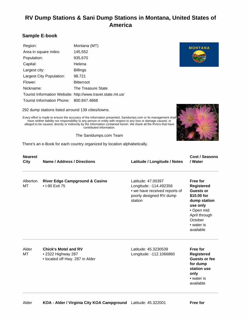
RV Dump Stations & Sani Dump Stations in Montana, United States ofAmerica
Sample E-book
Region: Montana (MT)Area in square miles: 145,552Population: 935,670Capital: HelenaLargest city: BillingsLargest City Population: 98,721Flower: BitterrootNickname: The Treasure StateTourist Information Website: http://www.travel.state.mt.us/Tourist Information Phone: 800.847.4868
292 dump stations listed arround 139 cities/towns.
Every effort is made to ensure the accuracy of the information presented, Sanidumps.com or its management shallhave neither liability nor responsibility to any person or entity with respect to any loss or damage caused, or
alleged to be caused, directly or indirectly by the information contained herein. We thank all the RVers that havecontributed information.
The Sanidumps.com Team
There's an e-Book for each country organized by location alphabetically.
NearestCity Name / Address / Directions Latitude / Longitude / Notes
Cost / Seasons/ Water
AlbertonMT
River Edge Campground & Casino• I-90 Exit 75
Latitude: 47.00397Longitude: -114.492356• we have received reports ofpoorly designed RV dumpstation
Free forRegisteredGuests or$10.00 fordump stationuse only• Open midApril throughOctober• water isavailable
AlderMT
Chick's Motel and RV• 2322 Highway 287• located off Hwy. 287 in Alder
Latitude: 45.3230539Longitude: -112.1066860
Free forRegisteredGuests or feefor dumpstation useonly• water isavailable
Alder KOA - Alder / Virginia City KOA Campground Latitude: 45.322001 Free for
MT • 2280 Highway 287• Highway 287, 9 miles West of historic VirginiaCity and Nevada City
Longitude: -112.10395 RegisteredGuests or feefor dumpstation useonly• Open yearround• potable andrinse water(non-potable)available
AlzadaMT
B & J's Convenience Store and RV Park• intersection of Highway 326 and Highway 212
Latitude: 45.02233Longitude: -104.406197
Free forRegisteredGuests or feefor dumpstation useonly• water isavailable
AnacondaMT
Big Sky RV Park• 200 North Locust Street
Latitude: 46.133396Longitude: -112.954736
Free forRegisteredGuests or feefor dumpstation useonly• water isavailable
AnacondaMT
Conoco• East end of town on MT 1 & Jackson Street; theRV dump is right across form McDonalds on theeast side of Anaconda
Latitude: 46.12657Longitude: -112.933161
Free
AnacondaMT
Exxon• 301 Montana 1
Latitude: 46.126961Longitude: -112.923041• easy access for big rigs
Free• rinse water(non-potable)available
AnacondaMT
Fairmont RV Park• 1700 Fairmont Road
Latitude: 46.042866Longitude: -112.805307
Free forRegisteredGuests or feefor dumpstation useonly• Open midApril throughmid October• water is
available
ArleeMT
Jocko Hollow Campground• 58 Old US Highway 93
Latitude: 47.177503Longitude: -114.098951
For RegisteredGuest orbuyingmerchandisein order to usethe RV dumpstation• water isavailable
AugustaMT
Wagons West• 956 Hwy. 287
Latitude: 47.49587Longitude: -112.387424

RV Dump Stations & Sani Dump Stations in Nebraska, United States ofAmerica
Sample E-book
Region: Nebraska (NE)Area in square miles: 76,872Population: 1,758,787Capital: LincolnLargest city: OmahaLargest City Population: 414,521Flower: GoldenrodNickname: The Cornhusker StateTourist Information Website: http://www.visitnebraska.org/Tourist Information Phone: 800.228.4307
184 dump stations listed arround 147 cities/towns.
Every effort is made to ensure the accuracy of the information presented, Sanidumps.com or its management shall have neitherliability nor responsibility to any person or entity with respect to any loss or damage caused, or alleged to be caused, directly or
indirectly by the information contained herein. We thank all the RVers that have contributed information.
The Sanidumps.com Team
There's an e-Book for each country organized by location alphabetically.
NearestCity Name / Address / Directions Latitude / Longitude / Notes
Cost / Seasons/ Water
AinsworthNE
East City Park• Hwy. 20; East end of town, South on NorthRichardson Drive; park is on East side
Latitude: 42.54827Longitude: -99.84632• reports of not a nice facility,dump area is unpaved and thesewer opening is in a mud hole;tight area not big rig friendly
$5.00• Open yearround• rinse water(non-potable)available
AlbionNE
County Fairground• 11 Street & Fairview Street
Latitude: 41.683531Longitude: -98.008928
AldaNE
TravelCenters of America; Grand Island TravelCenter• I-80 Exit 305, go North to first Left
Latitude: 40.800331Longitude: -98.494971
Free
AlexandriaNE
Alexandria Lakes State Recreation Area• 4 miles East of Alexandria Sate Hwy. 53
Latitude: 40.235759Longitude: -97.336803
AllianceNE
City Park• 2 Street
Latitude: 42.096408Longitude: -102.863049
Free• Open year
round• water isavailable
AllianceNE
Sunset Motel & RV Park• 1210 East Hwy. 2
Latitude: 42.0968708Longitude: -102.8857485
Free forRegisteredGuests or feefor dumpstation useonly• Open yearround• water isavailable
AllianceNE
Terry's Corner• US 2 West
Latitude: 42.09781Longitude: -102.89796
AlmaNE
Alma Travel Trailer Park• 501 South Street
Latitude: 40.0957234Longitude: -99.3600157
Free forRegisteredGuests or feefor dumpstation useonly• Open midApril throughmid October• water isavailable
ArnoldNE
Arnold Lake Recreation Area• State Route 40/92, South 1 mile
Latitude: 41.412716Longitude: -100.193708
ArnoldNE
City Treatment Plant• South end of town, West side of highway 100feet or so
Latitude: 41.414445Longitude: -100.193765• town population of 500 veryfriendly; there is also a city park1/4 mile North & 1/4 mile West;20 amp electric (donation)
Free

RV Dump Stations & Sani Dump Stations in Nevada, United States ofAmerica
Sample E-book
Region: Nevada (NV)Area in square miles: 109,826Population: 2,414,807Capital: Carson CityLargest city: Las VegasLargest City Population: 545,147Flower: SagebrushNickname: The Silver StateTourist Information Website: http://travelnevada.com/Tourist Information Phone: 800.638.2328
115 dump stations listed arround 65 cities/towns.
Every effort is made to ensure the accuracy of the information presented, Sanidumps.com or its management shall haveneither liability nor responsibility to any person or entity with respect to any loss or damage caused, or alleged to be caused,
directly or indirectly by the information contained herein. We thank all the RVers that have contributed information.
The Sanidumps.com Team
There's an e-Book for each country organized by location alphabetically.
NearestCity Name / Address / Directions Latitude / Longitude / Notes
Cost / Seasons/ Water
AlamoNV
Alamo RV Park• 115 Broadway Street• park is right off Hwy. 93 in Alamo, turn by thegas station and drive just a short few hundredyards down Broadway Street, the RV park will beon your Right
Latitude: 37.364255Longitude: -115.161954
$5.00• Open yearround• potable andrinse water(non-potable)available; $5.00
AmargosaValleyNV
Fort Amargosa; Exxon• US 95 & NV 373
Latitude: 36.642558Longitude: -116.398099
$5.00• Open yearround
AmargosaValleyNV
Longstreet Hotel Casino RV Resort• 4400 South Highway 373• Route 373, HCR 70
Latitude: 36.411477Longitude: -116.423308• overnight RV parking - Free
Free forRegisteredGuests or$10.00 fordump stationuse only• Open yearround• potable andrinse water(non-potable)
available
AustinNV
Berlin-Ichthyosaur State Park• park is 23 miles East of Gabbs, Nevada off ofRoute 844
Latitude: 38.5021Longitude: -117.0226
Free forRegisteredGuests or$7.00 for dumpstation useonly• Open midApril throughOctober• potable andrinse water(non-potable)available
BakerNV
Border Inn RV Park• Hwy. 6
Latitude: 39.05623Longitude: -114.049386
Free forRegisteredGuests or feefor dumpstation useonly• Open yearround• water isavailable
BakerNV
Sinclear Gas Station• from US 50, five miles South on Nevada Route487 to Baker
• sani dump and water fill selfpay box
$5.00• Open yearround• water isavailable
BattleMountainNV
Broadway Colt Service Center• 650 West Front Street• I-80 Exit 229
Latitude: 40.647256Longitude: -116.941259
Free• Open yearround
BattleMountainNV
Colt RV Park at the Flying J• 654 West Front Street• I-80 Exit 229
Latitude: 40.649636Longitude: -116.945959
$3.00• Open yearround• potable andrinse water(non-potable)available
BattleMountainNV
Pilot Flying J Travel Plazas #966• 650 West Front Street• I-80 Exit 231
Latitude: 40.6475Longitude: -116.942777• RV overnight parking; RV
$10.00 or $5.00with Flying JCard or Pilot
electric hookups Flying J RVPlus Card• Open yearround
BeattyNV
Beatty RV Park• from town on Hwy. 95 go 3 miles North to park
Latitude: 36.94615Longitude: -116.71719
Free forRegisteredGuests or feefor dumpstation useonly• Open yearround• water isavailable

RV Dump Stations & Sani Dump Stations in New Hampshire, UnitedStates of America
Sample E-book
Region: New Hampshire (NH)Area in square miles: 8,968Population: 1,309,940Capital: ConcordLargest city: ManchesterLargest City Population: 109,691Flower: Purple lilacNickname: The Granite StateTourist Information Website: http://www.visitnh.gov/Tourist Information Phone: 800.386.4664
111 dump stations listed arround 101 cities/towns.
Every effort is made to ensure the accuracy of the information presented, Sanidumps.com or its management shallhave neither liability nor responsibility to any person or entity with respect to any loss or damage caused, or
alleged to be caused, directly or indirectly by the information contained herein. We thank all the RVers that havecontributed information.
The Sanidumps.com Team
There's an e-Book for each country organized by location alphabetically.
NearestCity Name / Address / Directions Latitude / Longitude / Notes
Cost / Seasons/ Water
AlbanyNH
Pine Knoll Campground• 57 Pine Knoll Road
Latitude: 43.954855Longitude: -71.209122
Free forRegisteredGuests or feefor dumpstation useonly• water isavailable
AllenstownNH
Allenstown Wastewater Treatment Facility• 35 Canal Street• corner of Canal Street & Ferry Street, use CanalStreet (Ferry Street is posted no trucks)
Latitude: 43.127209Longitude: -71.459451
$20.00;vehiclesregistered inAllenstown orPembroke arefree• Open yearround• no wateravailable
AllenstownNH
Bear Brook State Park• 157 Deerfield Road
Latitude: 43.1542585Longitude: -71.3662475
• Open earlyMay through
mid October• water isavailable
AshlandNH
Ames Brook Campground• 104 Winona Road
Latitude: 43.68796Longitude: -71.62323
Free forRegisteredGuests or feefor dumpstation useonly• Open mid Maythrough lateOctober• water isavailable
AshlandNH
Yogi Bear's Jellystone Park Camp Resort• 35 Jellystone Park• I-93
Latitude: 43.6629490Longitude: -71.6513615
Free forRegisteredGuests or feefor dumpstation useonly• Open late Maythrough midOctober• potable andrinse water(non-potable)available
BarnsteadNH
Sun River Campground• Route 28
Free forRegisteredGuests or feefor dumpstation useonly• Open mid Maythrough midOctober• water isavailable
BarringtonNH
Ayers Lake Farm Campground• 497 Washington Street
Latitude: 43.2486Longitude: -71.049767
For RegisteredGuests Only• Open late Maythrough midSeptember• water isavailable

BarringtonNH
Barrington Shores Campground• 7 Barrington Shores Drive
Latitude: 43.184609Longitude: -71.026389• GPS users use 70 Hall Roadinstead of 7 Barrington ShoresDrive or the GPS coordinateslisted here
For RegisteredGuests Only• Open Maythrough midSeptember• potable andrinse water(non-potable)available
BathNH
Twin River RV Park & Cottages• Route 112
Free forRegisteredGuests or feefor dumpstation useonly• Open mid Maythrough midOctober• water isavailable
BelmontNH
Silver Lake Park Campground• 389 Jamestown Road
Latitude: 43.452446Longitude: -71.518123
For RegisteredGuests Only• Open earlyMay throughearly November• water isavailable

RV Dump Stations & Sani Dump Stations in New Jersey, United Statesof America
Sample E-book
Region: New Jersey (NJ)Area in square miles: 7,417Population: 8,717,925Capital: TrentonLargest city: NewarkLargest City Population: 280,666Flower: VioletNickname: The Garden StateTourist Information Website: http://www.state.nj.us/travel/Tourist Information Phone: 800.847.4865
120 dump stations listed arround 167 cities/towns.
Every effort is made to ensure the accuracy of the information presented, Sanidumps.com or its management shallhave neither liability nor responsibility to any person or entity with respect to any loss or damage caused, or allegedto be caused, directly or indirectly by the information contained herein. We thank all the RVers that have contributed
information.
The Sanidumps.com Team
There's an e-Book for each country organized by location alphabetically.
NearestCity Name / Address / Directions Latitude / Longitude / Notes
Cost / Seasons/ Water
AbseconHighlandsNJ
Shady Pines Campground• 443 South 6th Avenue
Latitude: 39.463968Longitude: -74.503292
Free forRegisteredGuests or feefor dumpstation useonly• Open Marchthrough October• water isavailable
AndoverNJ
Columbia Valley Campground• 3 Ghost Pony Road
Latitude: 40.962621Longitude: -74.719298
For RegisteredGuests Only• potable andrinse water(non-potable)available
AndoverNJ
Panther Lake Camping Resort• 6 Panther Lake Road
Latitude: 40.963388Longitude: -74.738662
Free forRegisteredGuests or feefor dump
station useonly• Open Aprilthrough October• potable andrinse water(non-potable)available
AsburyNJ
Jugtown Mountain Campsites• 1074 State Route 173
Latitude: 40.654312Longitude: -75.020678
Free forRegisteredGuests or$22.00 fordump stationuse only• Open yearround• rinse water(non-potable)available; rinsewater is onlyavailable Aprilthrough October
BarnegatNJ
Brookville Campground• 224 Jones Road
Latitude: 39.77987Longitude: -74.303254
Free forRegisteredGuests or feefor dumpstation useonly• Open MaythroughSeptember• water isavailable
BarnegatNJ
Long Beach Carefree RV Resort• 30 Route 72
Latitude: 39.75901Longitude: -74.31654
Free forRegisteredGuests or feefor dumpstation useonly• Open Aprilthrough October• potable andrinse water(non-potable)available
BayvilleNJ
Cedar Creek Campground• 1052 Route 9• Route 9; 7 miles South of Toms River
Latitude: 39.873834Longitude: -74.167217
Free forRegisteredGuests or fee

for dumpstation useonly• Open yearround• water isavailable
BeachHavenNJ
Long Beach Island Trailer Park• 19 Harding Avenue
Latitude: 39.534495Longitude: -74.263358
For RegisteredGuests Only• Open yearround• water isavailable
BelfordNJ
Middletown Sewerage Authority• 100 Beverly Way• North on Route 36, turn Right on Main Street,turn Right on Center Street, turn Left on BeverlyWay leads right in to Sewerage Authority
Latitude: 40.426687Longitude: -74.082677• stop and sign in at office
Free• Open yearround; Mondayto Friday8:00AM -4:30PM• no wateravailable
BlairstownNJ
Triple Brook Family Camping Resort• 58 Honey Run Road
Latitude: 40.911723Longitude: -75.018598
Free forRegisteredGuests or feefor dumpstation useonly• Open yearround• potable andrinse water(non-potable)available

RV Dump Stations & Sani Dump Stations in New Mexico, United Statesof America
Sample E-book
Region: New Mexico (NM)Area in square miles: 121,356Population: 1,928,384Capital: Santa FeLargest city: AlbuquerqueLargest City Population: 494,236Flower: Yucca flowerNickname: Land of EnchanmentTourist Information Website: http://www.newmexico.org/Tourist Information Phone: 800.282.5022
188 dump stations listed arround 100 cities/towns.
Every effort is made to ensure the accuracy of the information presented, Sanidumps.com or its management shallhave neither liability nor responsibility to any person or entity with respect to any loss or damage caused, or allegedto be caused, directly or indirectly by the information contained herein. We thank all the RVers that have contributed
information.
The Sanidumps.com Team
There's an e-Book for each country organized by location alphabetically.
NearestCity Name / Address / Directions Latitude / Longitude / Notes
Cost / Seasons/ Water
AbiquiuNM
U.S. Army Corps of Engineers - RianaCampground• from Espanola, travel 30 miles North on U.S.Hwy. 84, turn West on to State Hwy. 96 1 mile
Latitude: 36.245279Longitude: -106.427315
• Open midApril throughmid October• water isavailable
AcomaNM
Sky City RV Park• I-40 Exit 102
Latitude: 35.079076Longitude: -107.557755
For RegisteredGuests Only• Open yearround• potable andrinse water(non-potable)available
AlamogordoNM
Chamber of Commerce• US Hwy. 54
Latitude: 32.903731Longitude: -105.960771
Free• Open yearround• water isavailable

AlamogordoNM
Edgington RV Park• 6 Edgington Road
Latitude: 32.96351Longitude: -105.976554
Free forRegisteredGuests or feefor dumpstation useonly• Open yearround• water isavailable
AlamogordoNM
Fairgrounds• North White Sands Blvd. & Fairgrounds Road
Latitude: 32.92698Longitude: -105.959• asked the attendant what thefee was, said he has nevercharged a fee, never been toldto
Free• Open yearround• water isavailable
AlamogordoNM
KOA - Alamogordo / White Sands KOA• 412 24th Street
Latitude: 32.918107Longitude: -105.957467
Free forRegisteredGuests or feefor dumpstation useonly• Open yearround• potable andrinse water(non-potable)available
AlamogordoNM
Military Park - Holloman AFB FamCamp• US-70, West of Alamagordo, campground ison base
Latitude: 32.8308Longitude: -106.07258• Holloman Air Force Base
Free forMilitary UseOnly withMilitary IDCard• Open yearround• water isavailable
AlamogordoNM
Oliver Lee Memorial State Park• Oliver Lee Memorial State Park is 12 milesSouth of Alamogordo via US 54, then East 4miles on Dog Canyon Road
Latitude: 32.747639Longitude: -105.918631
• Open yearround• water isavailable
AlbuquerqueNM
Albuquerque Auto Truck Plaza• I-25 and NM Route 44; Exit 242
• Open yearround

AlbuquerqueNM
American RV Park of Albuquerque• 13500 Central Avenue SW• I-40
Latitude: 35.060533Longitude: -106.797463
$20.00• Open yearround• water isavailable

RV Dump Stations & Sani Dump Stations in New York, United States ofAmerica
Sample E-book
Region: New York (NY)Area in square miles: 47,214Population: 19,254,630Capital: AlbanyLargest city: New YorkLargest City Population: 8,143,197Flower: RoseNickname: The Empire StateTourist Information Website: http://www.iloveny.com/Tourist Information Phone: 800.225.5697
318 dump stations listed arround 284 cities/towns.
Every effort is made to ensure the accuracy of the information presented, Sanidumps.com or its management shall haveneither liability nor responsibility to any person or entity with respect to any loss or damage caused, or alleged to be caused,
directly or indirectly by the information contained herein. We thank all the RVers that have contributed information.
The Sanidumps.com Team
There's an e-Book for each country organized by location alphabetically.
NearestCity Name / Address / Directions Latitude / Longitude / Notes
Cost / Seasons/ Water
AkronNY
Sleepy Hollow Lake Resort• 13800 Siehl Road
Latitude: 42.954428Longitude: -78.471252
Free forRegisteredGuests or feefor dumpstation useonly• Open Maythrough October• potable andrinse water(non-potable)available
AlexandriaBayNY
1000 Islands Campground• 42099 State Route 12
Latitude: 44.272772Longitude: -76.000274
Free forRegisteredGuests or feefor dumpstation useonly• Open mid Maythrough midOctober• water isavailable
AlexandriaBayNY
Grass Point State Park• 42247 Grassy Point Road• Route 12; 1 mile West of Route 81
Latitude: 44.281141Longitude: -75.999444• $8.00 daily entrance fee to thepark which includes using theRV dump station
$8.00• Open mid Maythrough midOctober• water isavailable
AlexandriaBayNY
Kring Point State Park• off Route 12; 6 miles East of Alexandria Bay
Latitude: 44.37444Longitude: -75.86028• $8.00 daily entrance fee to thepark which includes using theRV dump station
$8.00• Open yearround• water isavailable
AlexandriaBayNY
Wellesley Island State Park• 44927 Cross Island Road• Route 81; Exit 51, 2 miles West
• $8.00 daily entrance fee to thepark which includes using theRV dump station; dump station isseasonal only
$8.00• Open Maythrough October• water isavailable
AngelicaNY
Evergreen Trails Campground• 8403 County Road 15
Latitude: 42.360765Longitude: -78.015485
Free forRegisteredGuests or feefor dumpstation useonly• Open lateApril throughNovember• water isavailable
AngelicaNY
Jones Pond Campground & RV Park• 9835 Old State Road
Latitude: 42.349045Longitude: -78.014554
Free forRegisteredGuests or feefor dumpstation useonly• water isavailable
AngelicaNY
McCarthy Ranch• 9628 Old State Road
Latitude: 42.348889Longitude: -78.014229
Free forRegisteredGuests or feefor dumpstation useonly• water isavailable
ArkportNY
Sun Valley Campsites• 10740 Poags Hole Road
Latitude: 42.4651840Longitude: -77.7325660
Free forRegisteredGuests or feefor dumpstation useonly• Open Maythrough midOctober• water isavailable
Au SabelForksNY
Douglas Resort & Campground• 18 Douglas Lane
Latitude: 44.5253Longitude: -73.866
Free forRegisteredGuests or feefor dumpstation useonly• potable andrinse water(non-potable)available
RV Dump Stations & Sani Dump Stations in North Carolina, UnitedStates of America
Sample E-book
Region: North Carolina (NC)Area in square miles: 48,711Population: 8,683,242Capital: RaleighLargest city: CharloteLargest City Population: 610,949Flower: American DogwoodNickname: The Tar Heel StateTourist Information Website: http://www.visitnc.com/Tourist Information Phone: 800.847.4862
169 dump stations listed arround 180 cities/towns.
Every effort is made to ensure the accuracy of the information presented, Sanidumps.com or its management shallhave neither liability nor responsibility to any person or entity with respect to any loss or damage caused, or
alleged to be caused, directly or indirectly by the information contained herein. We thank all the RVers that havecontributed information.
The Sanidumps.com Team
There's an e-Book for each country organized by location alphabetically.
NearestCity Name / Address / Directions Latitude / Longitude / Notes
Cost / Seasons/ Water
AberdeenNC
Long Leaf Pine Oasis• 15340 Palmer Road
Latitude: 34.9045Longitude: -79.4677
Free forRegisteredGuests or feefor dumpstation useonly• Open yearround• water isavailable
AberdeenNC
Pine Lake RV Resort• 32482 Hill Creek Road
Latitude: 34.98497Longitude: -79.41535
Free forRegisteredGuests or feefor dumpstation useonly• Open yearround• potable andrinse water(non-potable)available
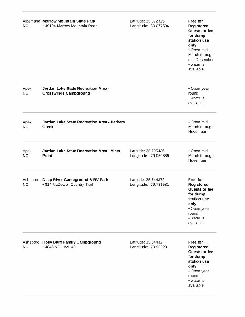
AlbemarleNC
Morrow Mountain State Park• 49104 Morrow Mountain Road
Latitude: 35.372325Longitude: -80.077506
Free forRegisteredGuests or feefor dumpstation useonly• Open midMarch throughmid December• water isavailable
ApexNC
Jordan Lake State Recreation Area -Crosswinds Campground
• Open yearround• water isavailable
ApexNC
Jordan Lake State Recreation Area - ParkersCreek
• Open midMarch throughNovember
ApexNC
Jordan Lake State Recreation Area - VistaPoint
Latitude: 35.705436Longitude: -79.050889
• Open midMarch throughNovember
AsheboroNC
Deep River Campground & RV Park• 814 McDowell Country Trail
Latitude: 35.744372Longitude: -79.731581
Free forRegisteredGuests or feefor dumpstation useonly• Open yearround• water isavailable
AsheboroNC
Holly Bluff Family Campground• 4846 NC Hwy. 49
Latitude: 35.64432Longitude: -79.95623
Free forRegisteredGuests or feefor dumpstation useonly• Open yearround• water isavailable

AsheboroNC
Trails End Family Campground• 2846 Old Cox Road
Latitude: 35.634137Longitude: -79.77095
Free forRegisteredGuests or feefor dumpstation useonly• Open Aprilthrough October• water isavailable
AshevilleNC
Asheville Bear Creek RV Park & Campground• 81 South Bear Creek Road
Latitude: 35.558125Longitude: -82.605224• no special RV dump location,so you can only dump if there isan open site with sewage
Free forRegisteredGuests or$25.00 fordump stationuse only• rinse water(non-potable)available

RV Dump Stations & Sani Dump Stations in North Dakota, United Statesof America
Sample E-book
Region: North Dakota (ND)Area in square miles: 68,976Population: 636,677Capital: BismarckLargest city: FargoLargest City Population: 90,672Flower: Wild Prairie RoseNickname: The Peace Garden StateTourist Information Website: http://www.ndtourism.com/Tourist Information Phone: 800.435.5663
186 dump stations listed arround 116 cities/towns.
Every effort is made to ensure the accuracy of the information presented, Sanidumps.com or its management shallhave neither liability nor responsibility to any person or entity with respect to any loss or damage caused, or
alleged to be caused, directly or indirectly by the information contained herein. We thank all the RVers that havecontributed information.
The Sanidumps.com Team
There's an e-Book for each country organized by location alphabetically.
NearestCity Name / Address / Directions Latitude / Longitude / Notes
Cost / Seasons/ Water
AlexanderND
Alexander First Responders RV Park• Manning Avenue & Elk Street
Latitude: 47.84313Longitude: -103.64193
Free forRegisteredGuests or feefor dumpstation useonly• water isavailable
ArvillaND
Turtle River State Park• Hwy. 2
Latitude: 47.938356Longitude: -97.490232
• Open yearround• water isavailable
AshleyND
Hoskins Lake Recreation Park• Hwy. 11, North on 45th Avenue SE; 3 milesWest of Ashley
Latitude: 46.047625Longitude: -99.441316
• Open yearround
BeachND
Pilot Flying J Travel Plazas #684• I-94 & Hwy. 16
Latitude: 46.929668Longitude: -104.007622
$10.00 or $5.00with Flying J
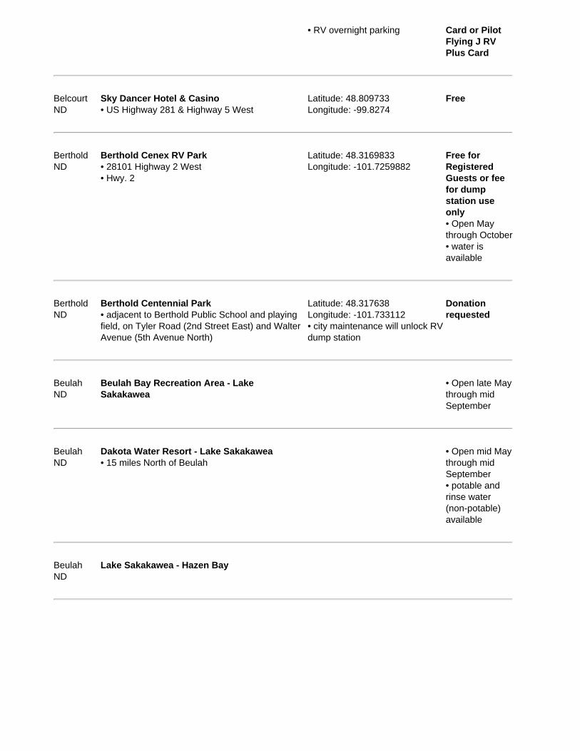
• RV overnight parking Card or PilotFlying J RVPlus Card
BelcourtND
Sky Dancer Hotel & Casino• US Highway 281 & Highway 5 West
Latitude: 48.809733Longitude: -99.8274
Free
BertholdND
Berthold Cenex RV Park• 28101 Highway 2 West• Hwy. 2
Latitude: 48.3169833Longitude: -101.7259882
Free forRegisteredGuests or feefor dumpstation useonly• Open Maythrough October• water isavailable
BertholdND
Berthold Centennial Park• adjacent to Berthold Public School and playingfield, on Tyler Road (2nd Street East) and WalterAvenue (5th Avenue North)
Latitude: 48.317638Longitude: -101.733112• city maintenance will unlock RVdump station
Donationrequested
BeulahND
Beulah Bay Recreation Area - LakeSakakawea
• Open late Maythrough midSeptember
BeulahND
Dakota Water Resort - Lake Sakakawea• 15 miles North of Beulah
• Open mid Maythrough midSeptember• potable andrinse water(non-potable)available
BeulahND
Lake Sakakawea - Hazen Bay

RV Dump Stations & Sani Dump Stations in Ohio, United States ofAmerica
Sample E-book
Region: Ohio (OH)Area in square miles: 40,948Population: 11,464,042Capital: ColumbusLargest city: ColumbusLargest City Population: 730,657Flower: Scarlet CarnationNickname: The Buckeye StateTourist Information Website: http://consumer.discoverohio.com/Tourist Information Phone: 800.282.5393
299 dump stations listed arround 268 cities/towns.
Every effort is made to ensure the accuracy of the information presented, Sanidumps.com or its management shall haveneither liability nor responsibility to any person or entity with respect to any loss or damage caused, or alleged to be caused,
directly or indirectly by the information contained herein. We thank all the RVers that have contributed information.
The Sanidumps.com Team
There's an e-Book for each country organized by location alphabetically.
NearestCity Name / Address / Directions Latitude / Longitude / Notes
Cost / Seasons/ Water
AkronOH
Cherokee Park Campground• 3064 State Route 43
Latitude: 41.07267Longitude: -81.34692
Free forRegisteredGuests or feefor dumpstation useonly• Open midApril throughmid October• water isavailable
AkronOH
Countryside Campground• 2687 State Route 43
Latitude: 41.06202Longitude: -81.34744
Free forRegisteredGuests or feefor dumpstation useonly• Open Maythrough midOctober• water isavailable
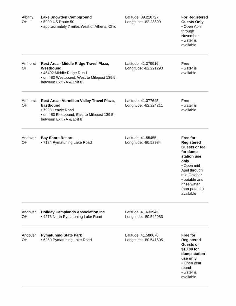
AlbanyOH
Lake Snowden Campground• 5900 US Route 50• approximately 7 miles West of Athens, Ohio
Latitude: 39.210727Longitude: -82.23599
For RegisteredGuests Only• Open AprilthroughNovember• water isavailable
AmherstOH
Rest Area - Middle Ridge Travel Plaza,Westbound• 46402 Middle Ridge Road• on I-80 Westbound, West to Milepost 139.5;between Exit 7A & Exit 8
Latitude: 41.379916Longitude: -82.221293
Free• water isavailable
AmherstOH
Rest Area - Vermilion Valley Travel Plaza,Eastbound• 7998 Leavitt Road• on I-80 Eastbound, East to Milepost 139.5;between Exit 7A & Exit 8
Latitude: 41.377645Longitude: -82.224211
Free• water isavailable
AndoverOH
Bay Shore Resort• 7124 Pymatuning Lake Road
Latitude: 41.55455Longitude: -80.52984
Free forRegisteredGuests or feefor dumpstation useonly• Open midApril throughmid October• potable andrinse water(non-potable)available
AndoverOH
Holiday Camplands Association Inc.• 4273 North Pymatuning Lake Road
Latitude: 41.633945Longitude: -80.542083
AndoverOH
Pymatuning State Park• 6260 Pymatuning Lake Road
Latitude: 41.580676Longitude: -80.541605
Free forRegisteredGuests or$10.00 fordump stationuse only• Open yearround• water isavailable
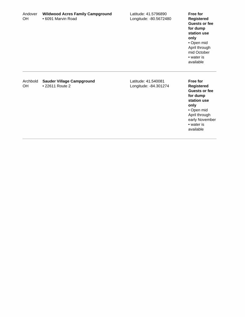
AndoverOH
Wildwood Acres Family Campground• 6091 Marvin Road
Latitude: 41.5796890Longitude: -80.5672480
Free forRegisteredGuests or feefor dumpstation useonly• Open midApril throughmid October• water isavailable
ArchboldOH
Sauder Village Campground• 22611 Route 2
Latitude: 41.540081Longitude: -84.301274
Free forRegisteredGuests or feefor dumpstation useonly• Open midApril throughearly November• water isavailable
RV Dump Stations & Sani Dump Stations in Oklahoma, United States ofAmerica
Sample E-book
Region: Oklahoma (OK)Area in square miles: 68,667Population: 3,547,884Capital: Oklahoma CityLargest city: Oklahoma CityLargest City Population: 531,324Flower: MistletoeNickname: The Sooner StateTourist Information Website: http://www.travelok.com/Tourist Information Phone: 800.652.6552
229 dump stations listed arround 158 cities/towns.
Every effort is made to ensure the accuracy of the information presented, Sanidumps.com or its management shallhave neither liability nor responsibility to any person or entity with respect to any loss or damage caused, or
alleged to be caused, directly or indirectly by the information contained herein. We thank all the RVers that havecontributed information.
The Sanidumps.com Team
There's an e-Book for each country organized by location alphabetically.
NearestCity Name / Address / Directions Latitude / Longitude / Notes
Cost / Seasons/ Water
AdaOK
Twin Lakes RV Park• 14148 County Road 1554
Latitude: 34.76116Longitude: -96.70305
Free forRegisteredGuests or$1.00 for dumpstation useonly• Open yearround• rinse water(non-potable)available
AltusOK
City Sewer Repair Facility• Main Street to Falcon Road, turn East on FalconRoad, proceed 2 blocks East on Falcon Road,turn North on unmarked Road (looks like anextension of North Jackson Street), proceedapprox 100 feet and take either Left fork of Yintersection, follow road another few hundred feet
Latitude: 34.652168Longitude: -99.330373• bring your own hose to flushtanks; facility operated by City ofAltus
Free• Open yearround• potable andrinse water(non-potable)available
AltusOK
Military Park - Altus AFB FamCamp• I-44 Exit 39 West; go on US 62 for about 51
Latitude: 34.653Longitude: -99.2904
Free forMilitary Use

miles to the base Only withMilitary IDCard• Open yearround• water isavailable
AnadarkoOK
Randlett City Park• West of town on Oklahoma Street; from Hwy.62/281, go North on Hwy. 281 to BroadwayStreet, then 7 blocks West to park
Latitude: 35.073792Longitude: -98.255846
• Open yearround
AntlersOK
Antlers RV Park• 220 NW J Street
Latitude: 34.233911Longitude: -95.634358
Free forRegisteredGuests or$10.00 fordump stationuse only• potable andrinse water(non-potable)available
ArdmoreOK
Hidden Lake RV Park• 4661 Hedges Road
Latitude: 34.119337Longitude: -97.158237
Free forRegisteredGuests or feefor dumpstation useonly• Open yearround• water isavailable
ArdmoreOK
Lake Murray State Park• 18407 Scenic State Hwy. 77
$3.00• Open yearround• water isavailable
ArdmoreOK
Lake Murray State Park - Buzzard's RoostCampground• 3323 Lodge Road
Latitude: 34.085499Longitude: -97.103779
Free• Open yearround• water isavailable
Ardmore Pilot Flying J Travel Plazas #701 Latitude: 34.191069 $10.00 or $5.00

OK • 2450 Cooper Drive• I-35 Exit 33
Longitude: -97.169981 with Flying JCard or PilotFlying J RVPlus Card• Open yearround
ArkomaOK
Arkoma Park • Open yearround
RV Dump Stations & Sani Dump Stations in Oregon, United States ofAmerica
Sample E-book
Region: Oregon (OR)Area in square miles: 95,997Population: 3,641,056Capital: SalemLargest city: PortlandLargest City Population: 533,427Flower: Oregon GrapeNickname: The Beaver StateTourist Information Website: http://www.traveloregon.com/Tourist Information Phone: 800.547.7842
332 dump stations listed arround 195 cities/towns.
Every effort is made to ensure the accuracy of the information presented, Sanidumps.com or its management shall haveneither liability nor responsibility to any person or entity with respect to any loss or damage caused, or alleged to be caused,
directly or indirectly by the information contained herein. We thank all the RVers that have contributed information.
The Sanidumps.com Team
There's an e-Book for each country organized by location alphabetically.
NearestCity Name / Address / Directions Latitude / Longitude / Notes
Cost / Seasons/ Water
AlbanyOR
Knox Butte RV Park• 125 Expo Parkway NE• I-5 Exit 234
Latitude: 44.644625Longitude: -123.055428
For RegisteredGuests Only• Open yearround• water isavailable
AlbanyOR
KOA - Albany / Corvallis KOA Campground• 33775 Oakville Road South
Latitude: 44.563409Longitude: -123.153583
For RegisteredGuests Only• Open yearround• potable andrinse water(non-potable)available
AlbanyOR
McClinton Auto / Collison• 3960 East Commercial Way SE
Latitude: 44.631449Longitude: -123.053909
$5.00• water isavailable
Albany McKay Truck & RV Center Latitude: 44.695398 $8.00

OR • I-5 Exit 238 Longitude: -123.058816 • Open yearround; Mondayto Friday
ArlingtonOR
Port of Arlington Marina and RV Park• Exit 137, East of park, go North to Marina stayRight of RV entrance; Arlington Point Road
Latitude: 45.723498Longitude: -120.205444
Free• no wateravailable
AshlandOR
Glenyan Campground• 5310 Highway 66
Latitude: 42.155527Longitude: -122.628986
For RegisteredGuests Only• Open yearround• potable andrinse water(non-potable)available
AshlandOR
Howard Prairie Lake Resort• 3249 Hyatt Prairie Road
Latitude: 42.235001Longitude: -122.41621
Free forRegisteredGuests or$3.00 for dumpstation useonly• Open midApril throughOctober• potable andrinse water(non-potable)available
AshlandOR
Hyatt Lake Resort• 7979 Hyatt Prairie Road
Latitude: 42.174009Longitude: -122.47042
Free forRegisteredGuests or feefor dumpstation useonly• Open midApril throughOctober• potable andrinse water(non-potable)available
AshlandOR
The Point RV Campground• 4 miles Southeast junction I-5 & Hwy. 66
Latitude: 42.161177Longitude: -122.616777
Free forRegisteredGuests or feefor dumpstation use
only• Open midMarch throughmid October• water isavailable
AshlandOR
Valero Station• 2495 Ashland Street• I-5 Exit 14
Latitude: 42.185829Longitude: -122.664231• easy turn around for large RVs;debit card same as cash price,just go inside the for transaction;reports of filthy, dirty and sewerline plugged
$8.00

RV Dump Stations & Sani Dump Stations in Pennsylvania, UnitedStates of America
Sample E-book
Region: Pennsylvania (PA)Area in square miles: 44,817Population: 12,429,616Capital: HarrisburgLargest city: PhiladelphiaLargest City Population: 1,463,281Flower: Mountain LaurelNickname: The Keystone StateTourist Information Website: http://www.pa.gov/Tourist Information Phone: 800.847.4872
328 dump stations listed arround 271 cities/towns.
Every effort is made to ensure the accuracy of the information presented, Sanidumps.com or its management shallhave neither liability nor responsibility to any person or entity with respect to any loss or damage caused, or
alleged to be caused, directly or indirectly by the information contained herein. We thank all the RVers that havecontributed information.
The Sanidumps.com Team
There's an e-Book for each country organized by location alphabetically.
NearestCity Name / Address / Directions Latitude / Longitude / Notes
Cost / Seasons/ Water
AirvillePA
Otter Creek Campground• 1101 Furnace Road
Latitude: 39.877Longitude: -76.38216
Free forRegisteredGuests or feefor dumpstation useonly• Open yearround• water isavailable
AllentownPA
Allentown Plaza• I-476 Milemarker 55.9; Northbound &Southbound
Latitude: 40.574119Longitude: -75.558531
$5.00
AllentownPA
Lehigh Valley Service Plaza• I-476 Exit 33
• pay inside $5.00• Open yearround; 24 hours• rinse water(non-potable)available

AltoonaPA
Wright's Orchard Station Campground• 2381 Old Route 220
Latitude: 40.4522Longitude: -78.4098
Free forRegisteredGuests or feefor dumpstation useonly• Open Maythrough October• water isavailable
AuburnPA
Christmas Pines Campground• 50 Red Church Road
Latitude: 40.614744Longitude: -76.090738
Free forRegisteredGuests or feefor dumpstation useonly• Open midApril throughlate October• water isavailable
AustinPA
Austin Campground• 364 Nelson Run Road
Latitude: 41.56901Longitude: -78.020257• at Nelson Run
Free forRegisteredGuests or$10.00 fordump stationuse only• Open yearround• water isavailable
AustinPA
Sinnemahoning State Park• 4843 Park Road
Latitude: 41.450398Longitude: -78.047075
Free forRegisteredGuests or$10.00 for PAresidents or$11.00 for outof state fordump stationuse only• Open midApril throughmid December• water isavailable
AvocaPA
Petro Stopping Center• 98 Grove Street
Latitude: 41.329365Longitude: -75.741298
$5.00• Open year

• I-81 Exit 178 B • the directions are not postedgood at the center, you take theLeft where the sign says autoLeft trucks Right, go straight uphill, RV dump station is notmarked, go straight up hill has achain in front of station, see thecashier for the keys, pay in store,no discount for fuel purchase oraffinity cards, dump site could bemarked
round• potable andrinse water(non-potable)available
BarnesvillePA
Locust Lake State Park• 220 Locust Lake Road
Latitude: 40.7849470Longitude: -76.1185160
Free forRegisteredGuests or$10.00 for PAresidents or$11.00 for outof state fordump stationuse only• Open midApril throughmid October• water isavailable
BathPA
Evergreen Lake Campground• 2375 Benders Drive
Latitude: 40.810286Longitude: -75.39966
Free forRegisteredGuests or$18.00 fordump stationuse only• Open midApril throughmid October• potable andrinse water(non-potable)available
RV Dump Stations & Sani Dump Stations in Rhode Island, United Statesof America
Sample E-book
Region: Rhode Island (RI)Area in square miles: 1,045Population: 1,076,189Capital: ProvidenceLargest city: ProvidenceLargest City Population: 176,862Flower: Common Blue VioletNickname: The Ocean StateTourist Information Website: http://www.visitrhodeisland.com/Tourist Information Phone: 800.556.2484
16 dump stations listed arround 26 cities/towns.
Every effort is made to ensure the accuracy of the information presented, Sanidumps.com or its management shallhave neither liability nor responsibility to any person or entity with respect to any loss or damage caused, or
alleged to be caused, directly or indirectly by the information contained herein. We thank all the RVers that havecontributed information.
The Sanidumps.com Team
There's an e-Book for each country organized by location alphabetically.
NearestCity Name / Address / Directions Latitude / Longitude / Notes
Cost / Seasons/ Water
CharlestownRI
Burlingame State Park• 1 Burlingame State Park Road• on US 1
Latitude: 41.362989Longitude: -71.700007
Free forRegisteredGuests or$5.00 for dumpstation useonly• Open midApril throughOctober• water isavailable
ChepachetRI
Bowdish Lake Camping Area• 40 Safari Road• junction of I-395 & Route 44, East 6 miles onRoute 44
Latitude: 41.9269120Longitude: -71.7795710
Free forRegisteredGuests or feefor dumpstation useonly• Open mid Maythrough midOctober• water isavailable

CoventryRI
Colwell's Family Campground• 119 Peckham Lane
Latitude: 41.704Longitude: -71.632
Free forRegisteredGuests or feefor dumpstation useonly• water isavailable
EastGreenwichRI
Arlington RV Supercenter• 966 Quaker Lane• North on I-95 take Exit 8B; South on I-95 takeExit 8
Latitude: 41.669949Longitude: -71.499226• free overnight parking withelectric and water for one night;free parking area is in frontparking lot area on Right side,RV dump is located in the back,behind the gate; courteousservice; dump hose provided;not open during the Christmasholidays December 23 - January3
$10.00• Open yearround• water isavailable; wateris off duringfreezingtemperatures
FosterRI
Ginny-B Family Campground• 7 Harrington Road
Latitude: 41.75383Longitude: -71.75455
Free forRegisteredGuests or feefor dumpstation useonly• Open MaythroughSeptember• water isavailable
HarmonyRI
Holiday Acres Camping Resort• 591 Snake Hill Road
Latitude: 41.87909Longitude: -71.6221
Free forRegisteredGuests or feefor dumpstation useonly• Open yearround• potable andrinse water(non-potable)available
Hope ValleyRI
Whispering Pines Campground• 41 Sawmill Road• Hope Valley
Latitude: 41.526986Longitude: -71.736864
Free forRegisteredGuests or feefor dump

station useonly• Open Aprilthrough October• water isavailable
JamestownRI
Fort Getty Recreation Area• located just West of Mackerel Cove Beach, offof Beavertail Road; Fort Getty Road
Latitude: 41.487636Longitude: -71.397336
MiddletownRI
Meadowlark Recreational Vehicle Park• 132 Prospect Avenue
Latitude: 41.5004970Longitude: -71.2726150
Free forRegisteredGuests or feefor dumpstation useonly• Open midApril throughOctober• water isavailable
MiddletownRI
Second Beach Family Campground• 474 Sachuest Point Road
Latitude: 41.48996Longitude: -71.2659
Free forRegisteredGuests or feefor dumpstation useonly• water isavailable

RV Dump Stations & Sani Dump Stations in South Carolina, UnitedStates of America
Sample E-book
Region: South Carolina (SC)Area in square miles: 30,109Population: 4,255,083Capital: ColumbiaLargest city: ColumbiaLargest City Population: 117,088Flower: Yellow JessamineNickname: The Palmetto StateTourist Information Website: http://www.discoversouthcarolina.com/Tourist Information Phone: 800.346.3634
117 dump stations listed arround 98 cities/towns.
Every effort is made to ensure the accuracy of the information presented, Sanidumps.com or its management shallhave neither liability nor responsibility to any person or entity with respect to any loss or damage caused, or
alleged to be caused, directly or indirectly by the information contained herein. We thank all the RVers that havecontributed information.
The Sanidumps.com Team
There's an e-Book for each country organized by location alphabetically.
NearestCity Name / Address / Directions Latitude / Longitude / Notes
Cost / Seasons/ Water
AbbevilleSC
Sumter National Forest - Parson's MountainLake Campground• 454 Parson's Mountain Road
Latitude: 34.0977001Longitude: -82.3573873
Free forRegisteredGuests or feefor dumpstation useonly• Open Aprilthrough midDecember• water isavailable
AikenSC
Aiken State Park• 1145 State Park Road• US 78, 16 miles East of Aiken
Latitude: 33.55356Longitude: -81.49• a fee is charged for use ofdump stations by non-campersat the state parks
Free forRegisteredGuests or feefor dumpstation useonly• Open yearround• water isavailable
AikenSC
Pine Acres Campground• 205 Duke Drive
Latitude: 33.59891Longitude: -81.687832
Free forRegisteredGuests or feefor dumpstation useonly• Open yearround• water isavailable
AndersonSC
KOA - Anderson / Lake Hartwell KOACampground• 200 Wham Road• I-85 Exit 14; South on Hwy. 187 for 1 mile
Latitude: 34.535609Longitude: -82.801075
Free forRegisteredGuests or feefor dumpstation useonly• Open yearround• potable andrinse water(non-potable)available
AndersonSC
Lake Hartwell Camping & Cabins• 400 Ponderosa Point Road
Latitude: 34.56366Longitude: -82.85731
Free forRegisteredGuests or feefor dumpstation useonly• Open yearround• water isavailable
AndersonSC
Sadlers Creek State Park• 940 Sadlers Creek Road• SC 187, 13 miles Southwest of Anderson
Latitude: 34.418288Longitude: -82.809299• a fee is charged for use ofdump stations by non-campersat the state parks
Free forRegisteredGuests or feefor dumpstation useonly• Open yearround• water isavailable
AndersonSC
Tiger Cove Campground• 4023 Whitehall Road
Latitude: 34.515397Longitude: -82.784815
For RegisteredGuests Only• Open yearround• water isavailable

AndersonSC
U.S. Army Corps of Engineers - SpringfieldCampground• 1915 Providence Church Road• I-85 Exit14
Latitude: 34.448421Longitude: -82.822654
• Open yearround• water isavailable
AwendawSC
Buck Hall National Forest Campground• 995 Buck Hall Landing Road• East of town 3 miles on State Route 17
Latitude: 33.038628Longitude: -79.561424
• Open yearround• water isavailable
BarnwellSC
Barnwell State Park• 16577 South Carolina 3• South Carolina 3, 7 miles Northeast of Barnwell
Latitude: 33.328796Longitude: -81.300844• a fee is charged for use ofdump stations by non-campersat the state parks
Free forRegisteredGuests or feefor dumpstation useonly• Open yearround• water isavailable
RV Dump Stations & Sani Dump Stations in South Dakota, UnitedStates of America
Sample E-book
Region: South Dakota (SD)Area in square miles: 75,885Population: 775,933Capital: PierreLargest city: Sioux FallsLargest City Population: 139,317Flower: Pasque FlowerNickname: The Mount Rushmore StateTourist Information Website: http://www.travelsd.com/Tourist Information Phone: 800.732.5682
210 dump stations listed arround 96 cities/towns.
Every effort is made to ensure the accuracy of the information presented, Sanidumps.com or its management shallhave neither liability nor responsibility to any person or entity with respect to any loss or damage caused, or
alleged to be caused, directly or indirectly by the information contained herein. We thank all the RVers that havecontributed information.
The Sanidumps.com Team
There's an e-Book for each country organized by location alphabetically.
NearestCity Name / Address / Directions Latitude / Longitude / Notes
Cost / Seasons/ Water
AberdeenSD
Melgaard Park Campground• South Lloyd Street
Latitude: 45.44528Longitude: -98.47792
• Open Aprilthrough October• water isavailable
AberdeenSD
Mina Lake Recreation Area• 37908 Youth Camp Road• 11 miles West of Aberdeen off US Hwy. 12
Latitude: 45.446806Longitude: -98.742028
$6.00 DailyEntrance Fee• Open Maythrough October• potable andrinse water(non-potable)available
AberdeenSD
Richmond Lake Recreation Area• 37908 Youth Camp Road• 10 miles Northwest of Aberdeen off US 281
Latitude: 45.540043Longitude: -98.614811
$6.00 DailyEntrance Fee• Open Maythrough October• potable andrinse water(non-potable)available

AberdeenSD
Wylie Park Campground• 2202 24th Ave• Hwy. 281
Latitude: 45.49027Longitude: -98.51652
• Open midApril throughOctober• water isavailable
AkaskaSD
D & S Campground• 103 Swan Creek Road• US 83 & Hwy. 144
Latitude: 45.33316Longitude: -100.12143
Free forRegisteredGuests or feefor dumpstation useonly• Open yearround• water isavailable
AkaskaSD
Swan Creek Recreation Area• 9 miles West of Akaska, off South Dakota Hwy.83
• Open yearround
ArlingtonSD
Lake Poinsett Recreation Area• 46109 202nd Street• 12 miles North of Arlington on US 81, 2 milesEast
Latitude: 44.534417Longitude: -97.086833
• Open yearround
ArlingtonSD
Maxwell City Park• Hwy. 14 then North Main Street
Latitude: 44.364967Longitude: -97.134033• dump station is West side oflaundromat
ArmourSD
Lions Park• North edge of town, East side of Hwy. 281
Latitude: 43.321864Longitude: -98.342938
Donationrequested
BelleFourcheSD
Belle Fourche Visitor Information Center• Hwy. 85 in Belle Fourche; Fulk Street and 6thAvenue
Latitude: 44.673737Longitude: -103.851961• the visitor center and chamberof commerce is located on Hwy.85 in Belle Fourche, RV dumpstation is along the East side ofthe parking lot
Free• rinse water(non-potable)available
RV Dump Stations & Sani Dump Stations in Tennessee, United Statesof America
Sample E-book
Region: Tennessee (TN)Area in square miles: 41,216Population: 5,962,959Capital: NashvilleLargest city: MemphisLargest City Population: 672,277Flower: IrisNickname: The Volunteer StateTourist Information Website: http://www.tnvacation.com/Tourist Information Phone: 800.836.6200
167 dump stations listed arround 109 cities/towns.
Every effort is made to ensure the accuracy of the information presented, Sanidumps.com or its management shallhave neither liability nor responsibility to any person or entity with respect to any loss or damage caused, or
alleged to be caused, directly or indirectly by the information contained herein. We thank all the RVers that havecontributed information.
The Sanidumps.com Team
There's an e-Book for each country organized by location alphabetically.
NearestCity Name / Address / Directions Latitude / Longitude / Notes
Cost / Seasons/ Water
AllonsTN
U.S. Army Corps of Engineers - LillydaleCampground & Day Use• 985 Lily Dale Road• Hwy. 111; 13.5 miles South of Byrdstown, 3.5miles North of Livingston to 294 North--WillowGrove Road for 13.3 miles, turn Right ontoLillydale Road
Latitude: 36.602856Longitude: -85.301531
• water isavailable
AllonsTN
U.S. Army Corps of Engineers - Willow Grove• 10788 Willow Grove Highway• 1/2 mile North of Allons on State Hwy. 52; 15miles Northeast on Willow Grove Road
Latitude: 36.587241Longitude: -85.341962
AshlandCityTN
U.S. Army Corps of Engineers - Lock ACampground• US 12; 8 miles West to Cheap Hill. Left onCheatham Dam Road travelling West 4 miles
• Open MaythroughNovember• water isavailable
Athens Athens I-75 Campground Latitude: 35.460571 Free for

TN • 2509 Decatur Pike• I-75
Longitude: -84.641987 RegisteredGuests or feefor dumpstation useonly• Open yearround• water isavailable
AthensTN
Over-Niter RV Park• 316 Hwy. 305
Latitude: 35.4944140Longitude: -84.5981290
Free forRegisteredGuests or feefor dumpstation useonly• Open yearround• water isavailable
BaileytonTN
Baileyton RV Park• 7485 Horton Hwy.
Latitude: 36.339212Longitude: -82.823007
Free forRegisteredGuests or feefor dumpstation useonly• Open yearround• water isavailable
BaxterTN
Love's - Travel Stops & Country Stores• 110 Fast Lane• I-40 Exit 280
Latitude: 36.139761Longitude: -85.630919• reported unusable for traveltrailers as dump pipe is too high,OK for 5th wheels and motorhomes
$5.00• Open yearround
BaxterTN
Twin Lakes Catfish Farm and Campground• 580 Gainesboro Hwy.
Latitude: 36.176962Longitude: -85.626321
$15.00• Open yearround• water isavailable
BlountvilleTN
Rocky Top Campground & RV Park• 496 Pearl Lane
Latitude: 36.511211Longitude: -82.440011
For RegisteredGuests Only• Open yearround• potable and

rinse water(non-potable)available
BristolTN
Cherokee National Forest - Little OakCampground• 1051 Little Oak Road
Latitude: 36.519977Longitude: -82.06091
• Open midMarch throughNovember• water isavailable

RV Dump Stations & Sani Dump Stations in Texas, United States ofAmerica
Sample E-book
Region: Texas (TX)Area in square miles: 261,797Population: 22,859,968Capital: AustinLargest city: HoustonLargest City Population: 2,016,582Flower: BluebonnetNickname: The Lone Star StateTourist Information Website: http://www.traveltex.com/Tourist Information Phone: 800.452.9292
596 dump stations listed arround 495 cities/towns.
Every effort is made to ensure the accuracy of the information presented, Sanidumps.com or its management shall haveneither liability nor responsibility to any person or entity with respect to any loss or damage caused, or alleged to be caused,
directly or indirectly by the information contained herein. We thank all the RVers that have contributed information.
The Sanidumps.com Team
There's an e-Book for each country organized by location alphabetically.
NearestCity Name / Address / Directions Latitude / Longitude / Notes
Cost / Seasons/ Water
AbileneTX
Buck Creek RV Park• 12445 Buck Creek Road
Latitude: 32.43663Longitude: -99.60504
Free forRegisteredGuests or feefor dumpstation useonly• Open yearround• water isavailable
AbileneTX
KOA - Abilene KOA Campground• 4851 West Stamford Street• I-20 Exit 282
Latitude: 32.478146Longitude: -99.783692
Free forRegisteredGuests or$15.00 fordump stationuse only• Open yearround• potable andrinse water(non-potable)available

AlamoTX
Alamo Paradise Acres• 1513 West Crockett Street
Latitude: 26.1797Longitude: -98.1262
For RegisteredGuests Only• Open yearround• potable andrinse water(non-potable)available
AlamoTX
Alamo Recreation Vehicle Park• 1320 West Frontage Road
Latitude: 26.192422Longitude: -98.127833
For RegisteredGuests Only• Open yearround• water isavailable
AlamoTX
Casa del Valle• 1048 North Alamo Road
Latitude: 26.195336Longitude: -98.121061
For RegisteredGuests Only• Open yearround• water isavailable
AlbanyTX
Fort Griffen State Historical Park• 1701 North US Highway 283
• Open yearround
AledoTX
Cowtown RV Park• 7000 East I-20
Latitude: 32.72736Longitude: -97.597762
Free forRegisteredGuests or feefor dumpstation useonly• Open yearround• water isavailable
AllenTX
Cabela's - Allen• 1 Cabela Drive• US 75 at Stacy Road Exit; East side of parkinglot / building
Latitude: 33.121537Longitude: -96.662619• water is turned off Novemberthrough May
$5.00• Open yearround• rinse water(non-potable)available
AlpineTX
BC Ranch RV Park• 45560 State Hwy. 118• State Highway 118; approximately three miles
Latitude: 30.39786Longitude: -103.68104• sewer hook-ups at all 20 sites,
Free forRegisteredGuests or

North of downtown Alpine, and 1/4 mile North ofTexas Deptment of Safety building, look forwindmill in front of park office
make arrangement at office $8.00 for dumpstation useonly• Open yearround• water isavailable
AlpineTX
Lost Alaskan RV Park• 2401 North Highway 118
Latitude: 30.376575Longitude: -103.667957
For RegisteredGuests Only• Open yearround• potable andrinse water(non-potable)available

RV Dump Stations & Sani Dump Stations in Utah, United States ofAmerica
Sample E-book
Region: Utah (UT)Area in square miles: 82,144Population: 2,469,585Capital: Salt Lake CityLargest city: Salt Lake CityLargest City Population: 178,097Flower: Sego lilyNickname: The Beehive StateTourist Information Website: http://www.utah.gov/visiting/travel.htmlTourist Information Phone: 801.538.1030
206 dump stations listed arround 142 cities/towns.
Every effort is made to ensure the accuracy of the information presented, Sanidumps.com or its management shallhave neither liability nor responsibility to any person or entity with respect to any loss or damage caused, or
alleged to be caused, directly or indirectly by the information contained herein. We thank all the RVers that havecontributed information.
The Sanidumps.com Team
There's an e-Book for each country organized by location alphabetically.
NearestCity Name / Address / Directions Latitude / Longitude / Notes
Cost / Seasons/ Water
AmericanForkUT
American Camp Ground• 418 East 620 South• take the American Fork 500 East Exit (Exit 276)from I-15 either Southbound or Northbound, makesure you are on the North-East side of I-15, makea Left hand turn at the Carls Jr., make a secondLeft immediately into American Campground; thesewer dump is on your Right hand side
Latitude: 40.363866Longitude: -111.786891
Free forRegisteredGuests or$10.00 fordump stationuse only• potable andrinse water(non-potable)available
AntimonyUT
Otter Creek State Park• Travel East 11 miles on U-62 from the junctionUS 89 and U-62, where U-62 turns North,continue East for 1/2 miles on U-22
Latitude: 38.1663Longitude: -112.017325
Free• Open yearround• water isavailable
BeaverUT
Beaver Camperland• 1603 South Campground Road• I-15 Exit 109, 1 block East, 1 block South onCampground Road
Latitude: 38.24873Longitude: -112.64627
Free forRegisteredGuests or feefor dumpstation use

only• Open yearround• water isavailable
BeaverUT
KOA - Beaver KOA Campground• 1428 Manderfield Road• I-15 Exit 112, 1/2 mile East, 1/4 mile North onManderfield Road
Latitude: 38.29397Longitude: -113.63882
Free forRegisteredGuests or feefor dumpstation useonly• Open yearround• potable andrinse water(non-potable)available
BeaverUT
Minersville State Park• Hwy. 21
Latitude: 38.217844Longitude: -112.826613
Free• Open yearround• water isavailable
BeaverUT
USDA Forest Service - Mahogany CoveCampground• 12 miles East of Beaver
Latitude: 38.269416Longitude: -112.485768
• Open Maythrough October• water isavailable
BlandingUT
Gofer Kampark• 851 South Main Street• Hwy. 191
Latitude: 37.612396Longitude: -109.478481
Free forRegisteredGuests or feefor dumpstation useonly• Open yearround• water isavailable
BlandingUT
Hall's Crossing Recreation Area• 95 miles Southwest of Blanding; Hwy. 95 toHwy. 263
BluffUT
Cadillac Ranch RV Park• 640 East Highway 191 (Main Street)
Latitude: 37.282773Longitude: -109.551538
For RegisteredGuests Only• Open year

round• water isavailable
BluffUT
Cottonwood RV Park Latitude: 37.27984Longitude: -109.56647
For RegisteredGuests Only• Open lateFebruarythrough lateNovember• potable andrinse water(non-potable)available

RV Dump Stations & Sani Dump Stations in Vermont, United States ofAmerica
Sample E-book
Region: Vermont (VT)Area in square miles: 9,250Population: 623,050Capital: MontpelierLargest city: BurlingtonLargest City Population: 38,531Flower: Red CloverNickname: The Green Mountain StateTourist Information Website: http://www.1-800-vermont.com/Tourist Information Phone: 800.837.6668
72 dump stations listed arround 71 cities/towns.
Every effort is made to ensure the accuracy of the information presented, Sanidumps.com or its management shallhave neither liability nor responsibility to any person or entity with respect to any loss or damage caused, or
alleged to be caused, directly or indirectly by the information contained herein. We thank all the RVers that havecontributed information.
The Sanidumps.com Team
There's an e-Book for each country organized by location alphabetically.
NearestCity Name / Address / Directions Latitude / Longitude / Notes
Cost / Seasons/ Water
AndoverVT
Horeshoe Acres Campground• 1978 Weston Andover Road
Latitude: 43.284156Longitude: -72.715001
Free forRegisteredGuests or feefor dumpstation useonly• Open mid MaythroughNovember• water isavailable
ArlingtonVT
Camping on The Battenkill• 48 Camping on the Battenkill
Latitude: 43.08382Longitude: -73.14579
Free forRegisteredGuests or feefor dumpstation useonly• Open midApril throughmid October• water isavailable

AscutneyVT
Running Bear Camping Area• 6248 Route 5
Latitude: 43.42216Longitude: -72.40304
Free forRegisteredGuests or feefor dumpstation useonly• Open yearround• water isavailable
AscutneyVT
Wilgus State Park• I-91 Exit 8; 1-1/2 miles South on Hwy. 5
Latitude: 43.4071Longitude: -72.4073
Free forRegisteredGuests or$30.00 (RVsover 30 feet) or$10.00 fordump stationuse only• Open late Maythrough earlyOctober• water isavailable
BarnardVT
Silver Lake State Park• 214 North Road
Latitude: 43.731145Longitude: -72.616583
Free forRegisteredGuests or$10.00 fordump stationuse only, RVsover 30 feet is$30.00• Open late Maythrough earlySeptember• water isavailable
BarreVT
Lazy Lions Campground• 281 Middle Road• I-89
Latitude: 44.1566470Longitude: -72.4954680
Free forRegisteredGuests or feefor dumpstation useonly• Open earlyMay throughOctober• water isavailable
BarreVT
Limehurst Lake Campground• 4104 VT Route 14
Latitude: 44.09846Longitude: -72.54774
Free forRegisteredGuests or feefor dumpstation useonly• Open midApril throughmid October• water isavailable
BenningtonVT
Woodford State Park• 10 miles East on Hwy. 9
Latitude: 42.890682Longitude: -73.037596• located at entrance across fromranger station; will need to eitheru turn and back up into dumpstation, or drive down intocampsites and back; site gradingwas such that trailer leanedopposite side to drain (driverside higher up), so not easy tototally drain the tank
Free forRegisteredGuests or$30.00 (RVsover 30 feet) or$15.00 fordump stationuse only• Open late Maythrough earlyOctober• water isavailable
BomoseenVT
Lake Bomoseen Campground• 18 Campground Drive
Latitude: 43.68348Longitude: -73.18905
Free forRegisteredGuests or feefor dumpstation useonly• Open Maythrough midOctober• water isavailable
BraintreeVT
Abel Mountain Campground• 354 Mobile Acres Road• I-89 Exit 4 to VT Route 66 West, atapproximately 2 miles take VT Route 12A North,campground is approximately 3 miles on the Left
Latitude: 43.930541Longitude: -72.700251
$5.00 forRegisteredGuests or$20.00 fordump stationuse only• Open mid Maythrough midOctober• rinse water(non-potable)available

RV Dump Stations & Sani Dump Stations in Virginia, United States ofAmerica
Sample E-book
Region: Virginia (VA)Area in square miles: 39,594Population: 7,567,465Capital: RichmondLargest city: Virginia BeachLargest City Population: 438,415Flower: American DogwoodNickname: Old DominionTourist Information Website: http://www.virginia.gov/cmsportal/visiting_883/Tourist Information Phone: 800.847.4882
155 dump stations listed arround 164 cities/towns.
Every effort is made to ensure the accuracy of the information presented, Sanidumps.com or its management shallhave neither liability nor responsibility to any person or entity with respect to any loss or damage caused, or
alleged to be caused, directly or indirectly by the information contained herein. We thank all the RVers that havecontributed information.
The Sanidumps.com Team
There's an e-Book for each country organized by location alphabetically.
NearestCity Name / Address / Directions Latitude / Longitude / Notes
Cost / Seasons/ Water
AbingdonVA
Riverside Campground• 18496 North Fork River Road
Latitude: 36.7850030Longitude: -82.0331910
Free forRegisteredGuests or feefor dumpstation useonly• Open AprilthroughNovember• water isavailable
AmeliaCourtHouseVA
Amelia Family Campground• 9720 Military Road, SR153• located Southeast of town; from junction of USHwy. 360 and State Route 153, go South 1/2mile on Hwy. 153, campground on right
Latitude: 37.349782Longitude: -77.883202• nice family run rustic campsiteswith yearly jazz festivals
Free forRegisteredGuests or$10.00 per tankfor dumpstation useonly• Open yearround• rinse water(non-potable)available
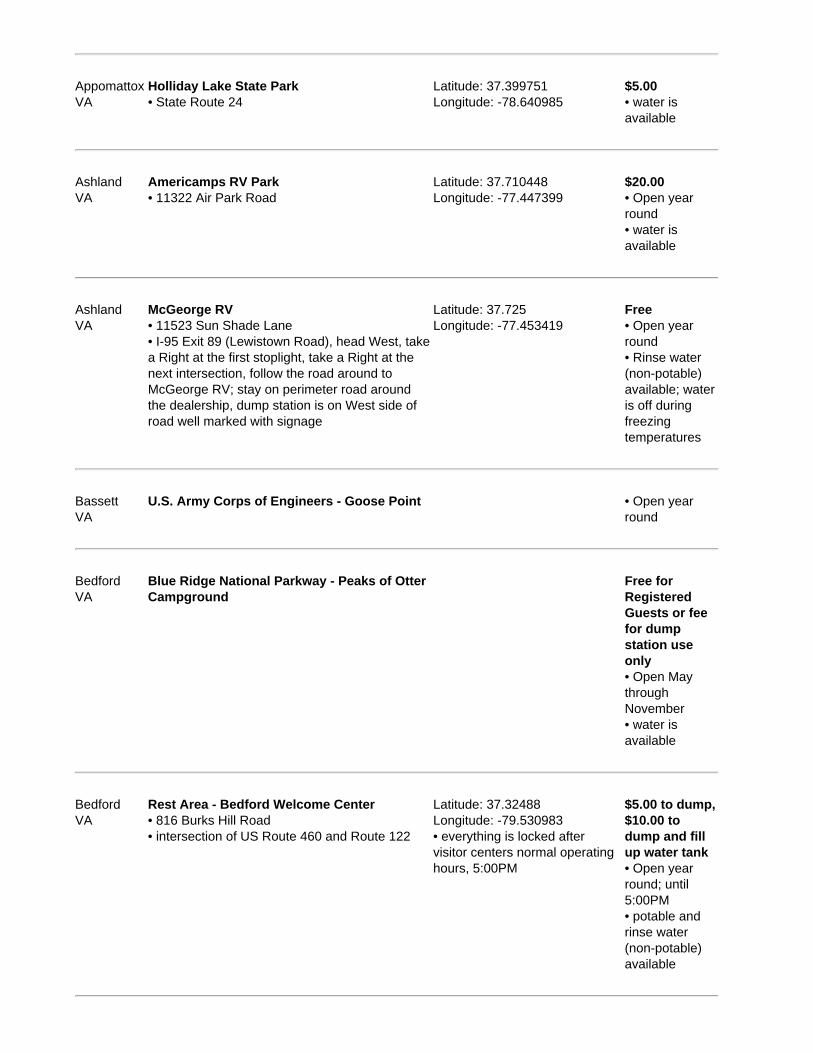
AppomattoxVA
Holliday Lake State Park• State Route 24
Latitude: 37.399751Longitude: -78.640985
$5.00• water isavailable
AshlandVA
Americamps RV Park• 11322 Air Park Road
Latitude: 37.710448Longitude: -77.447399
$20.00• Open yearround• water isavailable
AshlandVA
McGeorge RV• 11523 Sun Shade Lane• I-95 Exit 89 (Lewistown Road), head West, takea Right at the first stoplight, take a Right at thenext intersection, follow the road around toMcGeorge RV; stay on perimeter road aroundthe dealership, dump station is on West side ofroad well marked with signage
Latitude: 37.725Longitude: -77.453419
Free• Open yearround• Rinse water(non-potable)available; wateris off duringfreezingtemperatures
BassettVA
U.S. Army Corps of Engineers - Goose Point • Open yearround
BedfordVA
Blue Ridge National Parkway - Peaks of OtterCampground
Free forRegisteredGuests or feefor dumpstation useonly• Open MaythroughNovember• water isavailable
BedfordVA
Rest Area - Bedford Welcome Center• 816 Burks Hill Road• intersection of US Route 460 and Route 122
Latitude: 37.32488Longitude: -79.530983• everything is locked aftervisitor centers normal operatinghours, 5:00PM
$5.00 to dump,$10.00 todump and fillup water tank• Open yearround; until5:00PM• potable andrinse water(non-potable)available

Big IslandVA
Blue Ridge National Parkway - Otter Creek Free forRegisteredGuests or feefor dumpstation useonly• Open Maythrough October• water isavailable
BlackstoneVA
Pickett RV Park• I-85 to VA 460W, South on RT40/460 business,follow signs to Fort Pickett, go through gate, Leftonto W 10th Street then Right to Bakers Row,follow to camping area
Latitude: 37.044217Longitude: -77.922903• open to public, no ID cardrequired
Free forRegisteredGuests or feefor dumpstation useonly• Open yearround• no wateravailable

RV Dump Stations & Sani Dump Stations in Washington, United Statesof America
Sample E-book
Region: Washington (WA)Area in square miles: 66,544Population: 6,287,759Capital: OlympiaLargest city: SeattleLargest City Population: 573,911Flower: Coast RhododendronNickname: The Evergreen StateTourist Information Website: http://www.experiencewa.com/Tourist Information Phone: 800.544.1800
346 dump stations listed arround 274 cities/towns.
Every effort is made to ensure the accuracy of the information presented, Sanidumps.com or its management shallhave neither liability nor responsibility to any person or entity with respect to any loss or damage caused, or
alleged to be caused, directly or indirectly by the information contained herein. We thank all the RVers that havecontributed information.
The Sanidumps.com Team
There's an e-Book for each country organized by location alphabetically.
NearestCity Name / Address / Directions Latitude / Longitude / Notes
Cost / Seasons/ Water
AirwayHeightsWA
Chevron at Legacy Landing• 220 South Hayford Road
Latitude: 47.659535Longitude: -117.560934• $.10 per gallon discount on gaswith casino club card
$5.00• potable andrinse water(non-potable)available
AnacortesWA
Fidalgo Bay Road• 4701 Fidalgo Bay Road• from junction of I-5 & Exit 230, West 14 miles onState Route 20 to Fidalgo Bay Road (500 feetpast Whidrey Island turnoff), Northwest 1 mile(Right)
Latitude: 48.466629Longitude: -122.586949
Free forRegisteredGuests or$5.00 for dumpstation useonly• Open yearround• potable andrinse water(non-potable)available
AnacortesWA
Northern Lights Casino• 12885 Casino Drive• I-5 Exit 230, 20 minutes West on Highway 20,
Latitude: 48.45655Longitude: -122.518637• dump site sign says black
Free forRegisteredGuests or fee

take the first Right after crossing the TwinBridges, then turn Right onto Casino Drive
water only, no gray water;associated rv park on North sideof the casino
for dumpstation useonly• water isavailable
AnacortesWA
Pioneer Trails RV Resort & Campground• 7337 Miller Road
Latitude: 48.452449Longitude: -122.590489
Free forRegisteredGuests or feefor dumpstation useonly• Open yearround• potable andrinse water(non-potable)available
AnacortesWA
Swinomish Northern Lights Casino & RV Park• 12885 Casino Drive• I-5 Exit 230, West on Highway 20
Latitude: 48.456525Longitude: -122.519825
Free forRegisteredGuests or feefor dumpstation useonly• Open yearround• water isavailable
AnacortesWA
Washington Park - Anacortes ParkDepartment• 6300 Sunset Avenue• follow Route 20 (Oakes Avenue) towards theSan Juan Islands Ferry Exit onto Sunset Avenue;follow Sunset Avenue to entrance of Park
Latitude: 48.498906Longitude: -122.689995• potable/rinse available at samespigot
Free• Open yearround• rinse water(non-potable)available
AnacortesWA
Wastewater Treatment Plant• 500 T Avenue• 4 Street side of plant
Latitude: 48.518063Longitude: -122.606506• fresh water is located on theside of the administration officebuilding, directions are at thedump station, the faucet can onlybe accessed by parkinghandicapped parking space, lookbehind the bushes for the faucet,a green hose is provided; thedump station is narrow butshould be okay for big rigs; bigrigs may not be able to accessthe fresh water
Free• Open yearround; daily8:00AM -4:30PM,StatutoryHolidays8:00AM -11:30AM• potable andrinse water(non-potable)available

AnatoneWA
Field Springs State Park• 4 Miles South of Anatone State Route 129
Latitude: 46.081998Longitude: -117.166637
$5.00• Open yearround• potable andrinse water(non-potable)available
ArlingtonWA
Military Park - Jim Creek WildernessRecreation Area• I-5 Exit 208 East on State Route 530 then Righton Jim Creek Road
Latitude: 48.20038Longitude: -121.93574• Jim Creek Naval Radio Station
$5.00 forMilitary UseOnly withMilitary IDCard• Open yearround
ArlingtonWA
Rest Area - Smokey Point, Northbound• I-5 Milemarker 207; Northbound
Latitude: 48.168849Longitude: -122.188868• for use by private RV owners,and not to be used bycommercial vehicles
Free

RV Dump Stations & Sani Dump Stations in West Virginia, UnitedStates of America
Sample E-book
Region: West Virginia (WV)Area in square miles: 24,078Population: 1,816,856Capital: CharlestonLargest city: CharlestonLargest City Population: 51,176Flower: RhododendronNickname: The Mountain StateTourist Information Website: http://www.wvtourism.com/Tourist Information Phone: 800.225.5982
75 dump stations listed arround 73 cities/towns.
Every effort is made to ensure the accuracy of the information presented, Sanidumps.com or its management shallhave neither liability nor responsibility to any person or entity with respect to any loss or damage caused, or
alleged to be caused, directly or indirectly by the information contained herein. We thank all the RVers that havecontributed information.
The Sanidumps.com Team
There's an e-Book for each country organized by location alphabetically.
NearestCity Name / Address / Directions Latitude / Longitude / Notes
Cost / Seasons/ Water
AldersonWV
Greenbrier River Campground Latitude: 37.74117Longitude: -80.57175
Free forRegisteredGuests or feefor dumpstation useonly• Open midApril throughmid October• water isavailable
AshlandWV
Ashland West Virginia ATV Resort Free forRegisteredGuests or feefor dumpstation useonly• Open yearround• potable andrinse water(non-potable)available

AspinallWV
Rest Area - Aspinall• I-79 Milemarker 85
Latitude: 38.946451Longitude: -80.531081
Free
BeckleyWV
Beckley Travel Plaza• 500 Vankirk Drive• I-77 Exit 45, North and Southbound
Latitude: 37.801205Longitude: -81.213453• Tamarack / Exxon Station, offto side of Exxon station
Free• Open yearround• rinse water(non-potable)available
BeckleyWV
Twin Falls State Park• 27 miles Southeast of Beckley on Routes 16,54 & 97
Latitude: 37.63033Longitude: -81.44179
Free• Open midApril throughOctober• water isavailable
BowdenWV
Revelle's River Resort• 5-1/2 Faulkner Road
Latitude: 38.91089Longitude: -79.7076
Free forRegisteredGuests or feefor dumpstation useonly• Open yearround• potable andrinse water(non-potable)available
BrandywineWV
George Washington National Forest -Brandywine Lake Campground
• Open mid Maythrough midDecember• water isavailable
BrucetonMillsWV
Big Bear Lake Family Camplands• 450 Big Bear Lake Road• I-68 Exit 29, Hazelton 3 miles South
Latitude: 39.6113150Longitude: -79.5113600
Free forRegisteredGuests or feefor dumpstation useonly• water isavailable
Bruceton Chestnut Ridge Park and Campground Latitude: 39.67801 Free for
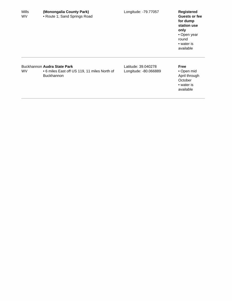
MillsWV
(Monongalia County Park)• Route 1; Sand Springs Road
Longitude: -79.77057 RegisteredGuests or feefor dumpstation useonly• Open yearround• water isavailable
BuckhannonWV
Audra State Park• 6 miles East off US 119, 11 miles North ofBuckhannon
Latitude: 39.040278Longitude: -80.066889
Free• Open midApril throughOctober• water isavailable

RV Dump Stations & Sani Dump Stations in Wisconsin, United States ofAmerica
Sample E-book
Region: Wisconsin (WI)Area in square miles: 54,310Population: 5,536,201Capital: MadisonLargest city: MilwaukeeLargest City Population: 578,887Flower: Wood VioletNickname: The Badger StateTourist Information Website: http://www.tourism.state.wi.us/Tourist Information Phone: 800.432.8747
386 dump stations listed arround 286 cities/towns.
Every effort is made to ensure the accuracy of the information presented, Sanidumps.com or its management shallhave neither liability nor responsibility to any person or entity with respect to any loss or damage caused, or
alleged to be caused, directly or indirectly by the information contained herein. We thank all the RVers that havecontributed information.
The Sanidumps.com Team
There's an e-Book for each country organized by location alphabetically.
NearestCity Name / Address / Directions Latitude / Longitude / Notes
Cost / Seasons/ Water
AlgomaWI
Ahnapee River Trails Campground• E6053 West Wilson Road
Latitude: 44.631951Longitude: -87.464438
Free forRegisteredGuests or feefor dumpstation useonly• Open Maythrough midOctober• water isavailable
AlgomaWI
Algoma Wastewater Plant / Algoma SewerDistrict• 179 6th Street• State Highway 54 East to Algoma, North on 6thStreet, dump station is at far North end
Latitude: 44.612012Longitude: -87.441051• easy access
Donationrequested;$1.00• Open yearround• rinse water(non-potable)available
Algoma Big Lake Campground Latitude: 44.5921760 Free for
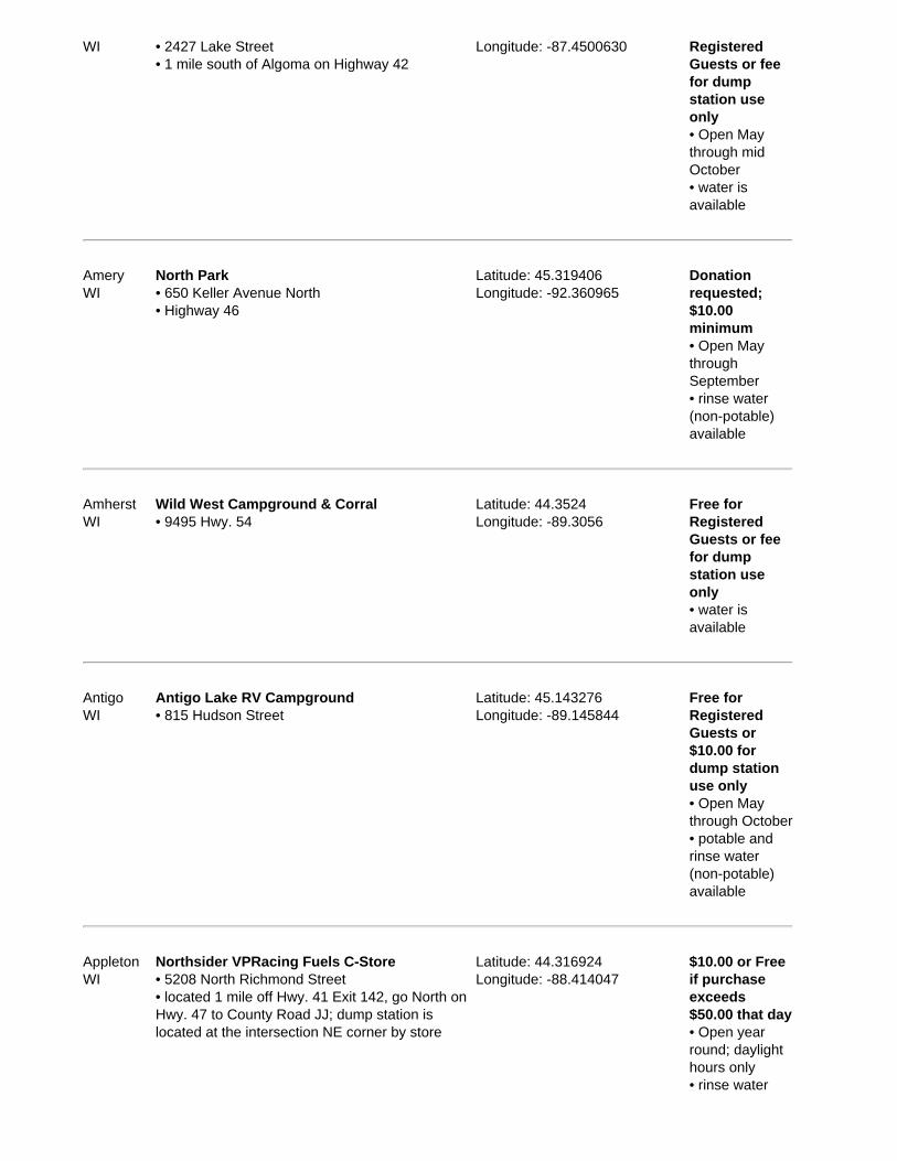
WI • 2427 Lake Street• 1 mile south of Algoma on Highway 42
Longitude: -87.4500630 RegisteredGuests or feefor dumpstation useonly• Open Maythrough midOctober• water isavailable
AmeryWI
North Park• 650 Keller Avenue North• Highway 46
Latitude: 45.319406Longitude: -92.360965
Donationrequested;$10.00minimum• Open MaythroughSeptember• rinse water(non-potable)available
AmherstWI
Wild West Campground & Corral• 9495 Hwy. 54
Latitude: 44.3524Longitude: -89.3056
Free forRegisteredGuests or feefor dumpstation useonly• water isavailable
AntigoWI
Antigo Lake RV Campground• 815 Hudson Street
Latitude: 45.143276Longitude: -89.145844
Free forRegisteredGuests or$10.00 fordump stationuse only• Open Maythrough October• potable andrinse water(non-potable)available
AppletonWI
Northsider VPRacing Fuels C-Store• 5208 North Richmond Street• located 1 mile off Hwy. 41 Exit 142, go North onHwy. 47 to County Road JJ; dump station islocated at the intersection NE corner by store
Latitude: 44.316924Longitude: -88.414047
$10.00 or Freeif purchaseexceeds$50.00 that day• Open yearround; daylighthours only• rinse water

(non-potable)available
ArkdaleWI
Pineland Camping Park• 916 Hwy.13
Latitude: 44.123688Longitude: -89.807633
Free forRegisteredGuests or$25.00 fordump stationuse only• Open AprilthroughDecember• water isavailable
AshlandWI
Kreher Park• Hwy. 2; Northeast of town; Prentice Avenue
Latitude: 46.5955Longitude: -90.8817• County park
Free• Open Maythrough October
AshlandWI
Saxon Harbor County Park• 10045 County Hwy. A• Hwy. 2 then Hwy. 122 North
Latitude: 46.5955Longitude: -90.8817• City Park at the boat launch;also RV camping available
Free forRegisteredGuests or$15.00 fordump stationuse only• Open mid MaythroughSeptember
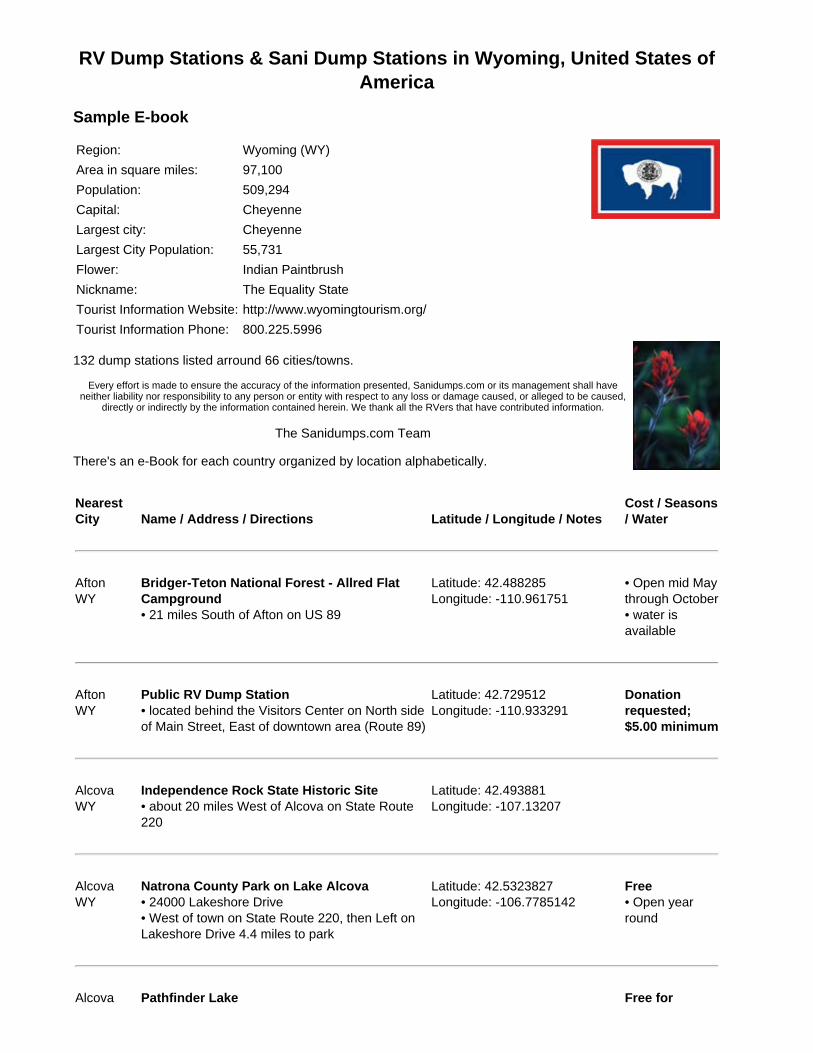
RV Dump Stations & Sani Dump Stations in Wyoming, United States ofAmerica
Sample E-book
Region: Wyoming (WY)Area in square miles: 97,100Population: 509,294Capital: CheyenneLargest city: CheyenneLargest City Population: 55,731Flower: Indian PaintbrushNickname: The Equality StateTourist Information Website: http://www.wyomingtourism.org/Tourist Information Phone: 800.225.5996
132 dump stations listed arround 66 cities/towns.
Every effort is made to ensure the accuracy of the information presented, Sanidumps.com or its management shall haveneither liability nor responsibility to any person or entity with respect to any loss or damage caused, or alleged to be caused,
directly or indirectly by the information contained herein. We thank all the RVers that have contributed information.
The Sanidumps.com Team
There's an e-Book for each country organized by location alphabetically.
NearestCity Name / Address / Directions Latitude / Longitude / Notes
Cost / Seasons/ Water
AftonWY
Bridger-Teton National Forest - Allred FlatCampground• 21 miles South of Afton on US 89
Latitude: 42.488285Longitude: -110.961751
• Open mid Maythrough October• water isavailable
AftonWY
Public RV Dump Station• located behind the Visitors Center on North sideof Main Street, East of downtown area (Route 89)
Latitude: 42.729512Longitude: -110.933291
Donationrequested;$5.00 minimum
AlcovaWY
Independence Rock State Historic Site• about 20 miles West of Alcova on State Route220
Latitude: 42.493881Longitude: -107.13207
AlcovaWY
Natrona County Park on Lake Alcova• 24000 Lakeshore Drive• West of town on State Route 220, then Left onLakeshore Drive 4.4 miles to park
Latitude: 42.5323827Longitude: -106.7785142
Free• Open yearround
Alcova Pathfinder Lake Free for

WY RegisteredGuests or feefor dumpstation useonly• Open Aprilthrough October• water isavailable
AlcovaWY
Rest Area - Independence Rock• Hwy. 220
Latitude: 42.49318Longitude: -107.1375
Free• potable andrinse water(non-potable)available
AlpineWY
Targhee National Forest - Alpine Campground• US Route 26 West 2.6 miles to campgroundsign, turn Left at sign into campground
Latitude: 43.196977Longitude: -111.041264
• Open late Maythrough midSeptember• water isavailable
BasinWY
City Park• West side of Hwy-16/20, North of post office,turn West on D Street
Latitude: 44.382304Longitude: -108.04498
BasinWY
Overland Express Mart• 155 North 4th Street
Latitude: 44.380517Longitude: -108.038933
Free
BoulderWY
Highline Trail RV Park• 8718 Hwy. 191
Latitude: 42.738567Longitude: -109.714408
Free forRegisteredGuests or feefor dumpstation useonly• Open yearround• water isavailable
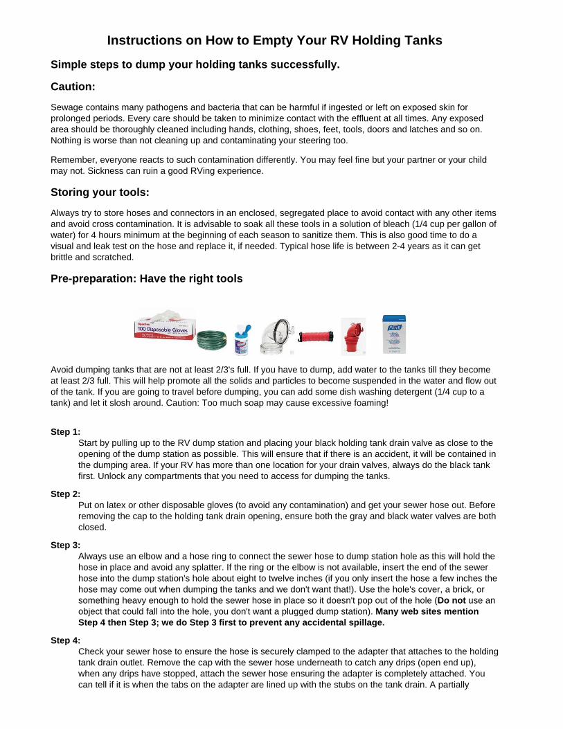
Instructions on How to Empty Your RV Holding TanksSimple steps to dump your holding tanks successfully.
Caution:
Sewage contains many pathogens and bacteria that can be harmful if ingested or left on exposed skin forprolonged periods. Every care should be taken to minimize contact with the effluent at all times. Any exposedarea should be thoroughly cleaned including hands, clothing, shoes, feet, tools, doors and latches and so on.Nothing is worse than not cleaning up and contaminating your steering too.
Remember, everyone reacts to such contamination differently. You may feel fine but your partner or your childmay not. Sickness can ruin a good RVing experience.
Storing your tools:
Always try to store hoses and connectors in an enclosed, segregated place to avoid contact with any other itemsand avoid cross contamination. It is advisable to soak all these tools in a solution of bleach (1/4 cup per gallon ofwater) for 4 hours minimum at the beginning of each season to sanitize them. This is also good time to do avisual and leak test on the hose and replace it, if needed. Typical hose life is between 2-4 years as it can getbrittle and scratched.
Pre-preparation: Have the right tools
Avoid dumping tanks that are not at least 2/3's full. If you have to dump, add water to the tanks till they becomeat least 2/3 full. This will help promote all the solids and particles to become suspended in the water and flow outof the tank. If you are going to travel before dumping, you can add some dish washing detergent (1/4 cup to atank) and let it slosh around. Caution: Too much soap may cause excessive foaming!
Step 1:Start by pulling up to the RV dump station and placing your black holding tank drain valve as close to theopening of the dump station as possible. This will ensure that if there is an accident, it will be contained inthe dumping area. If your RV has more than one location for your drain valves, always do the black tankfirst. Unlock any compartments that you need to access for dumping the tanks.
Step 2:Put on latex or other disposable gloves (to avoid any contamination) and get your sewer hose out. Beforeremoving the cap to the holding tank drain opening, ensure both the gray and black water valves are bothclosed.
Step 3:Always use an elbow and a hose ring to connect the sewer hose to dump station hole as this will hold thehose in place and avoid any splatter. If the ring or the elbow is not available, insert the end of the sewerhose into the dump station's hole about eight to twelve inches (if you only insert the hose a few inches thehose may come out when dumping the tanks and we don't want that!). Use the hole's cover, a brick, orsomething heavy enough to hold the sewer hose in place so it doesn't pop out of the hole (Do not use anobject that could fall into the hole, you don't want a plugged dump station). Many web sites mentionStep 4 then Step 3; we do Step 3 first to prevent any accidental spillage.
Step 4:Check your sewer hose to ensure the hose is securely clamped to the adapter that attaches to the holdingtank drain outlet. Remove the cap with the sewer hose underneath to catch any drips (open end up),when any drips have stopped, attach the sewer hose ensuring the adapter is completely attached. Youcan tell if it is when the tabs on the adapter are lined up with the stubs on the tank drain. A partially

attached hose is more common than you think.
Step 5:If you have a permanent-mount black tank rinse system, now is the time to connect it up to both the RVand the dump station water supply with a dedicated garden hose. Do not use your fresh water hose forthe black tank rinse and do not turn on the water until the next step has started.
Step 6:Once you are certain everything is secured, pull open the Black water tank valve first. You will hear theeffluent rush through the hose, start to slow down, and finally become a trickling sound. Some solids maystill stay lodged at the bottom of the tank as well as on the tank sidewall.
Step 7:If you have connected a black tank rinse, turn on the water, let this run fortwo-five minutes to help remove solids left behind, then shut off the waterand disconnect the garden hose. Now close the black water tank drain valveby pushing the handle completely closed.If you do not have a black tank rinse system, you can fill the toilet bowl withwater using the internal pump and water from your fresh tank. Ask yourpartner to flush the toilet to duplicate the action of black tank rinse system.You may need to do this twice. Please be sensitive if there is a line up at thedump station.
Step 8:Now open the gray tank valve. As in step 6, you'll hear water flow, thenslow, and stop. Close the gray tank valve. Repeat this step if you have morethan one gray tank.
Step 9:At this point, you're almost done. If you want to flush and rinse your tanks once more, you can do so byfilling your tanks to 2/3 full (if you don't have a gray tank rinse system) and repeat the emptying process. Ifothers are waiting to use the dump station, be courteous and skip this step. Do not put non-potablerinse water into your fresh water system for this as it will contaminate your system and it willrequire complete sanitization.
Step 10:Recheck that both your black and gray water tank valves are closed and then disconnect the sewer hosefrom your tank outlet.
Step 11:Lift the end of the sewer hose (the end you just disconnected) to completely drain the hose into the dumpstation. If a non-potable water hose is available, run water through the sewer hose to rinse it out. Removethe sewer hose from the dump station hole and rinse the outside of the hose. Rinse the area around thehole to ensure that any spillage has been cleaned up and cover the dump station hole. Replace the tankoutlet cover.
Step 12:Return you sewer hose etc. to storage.
Step 13:Dispose of the latex gloves into the garbage bin (we don't mean down the dump station) or put them inyour garbage bin in the rig. Clean all the surfaces you touched when wearing your gloves with bleachwipes. Wash or hand sanitize your hands just in case the gloves leaked.
Step 14:If there is a line up, move your rig to allow the next user to use the dump station and then check holdingtanks display panel. If they do not read empty, this is an early sign that your sensors may be gettinggummed up. Visit our site for an inexpensive environmentally friendly tip for solving this problem.
Step 15:Now add about three to three gallons of water (about three full bowlflushes) to your black tank and then add the appropriate amount ofholding tank treatment. If you use a treatment for your gray tank, dothat as well. This will ensure that everything stays moist and healthy inthe tank till your next trip.

Step 16:Record any notes or updated information about the RV dump station tobe submitted to Sanidumps.com for other RVers.
Step 17:The task of emptying your RV's holding tanks is now finished.
Step 18:Submit the updated or validation information to Sanidumps.com when you have an internet connection.
Step 19:Enjoy your RVing journeys.
Happy RVing!

Dump Station EtiquetteBy KC Chavda
Today, while many dump stations are free to use, some are starting to charge anywhere from $2 to upwards of$60+, and I am not talking about honey wagon service. In America many state run dump stations located at restareas have been closed. The main reason for this is pure and simple: ABUSE. To be fair, non-RVers are also toblame, some dump toxic waste like commercial cleaning waste, to avoid paying handling fees.
Consider access to dump stations as a privilege not a right.
I am going to touch on what we can do to try to ensure this privilege continues.
Etiquette Rules
1. Report anyone abusing the dump station. They are compromising our privilege.2. Always thank the operator/owner for letting us use their dump station. If possible reward them by
purchasing something: fuel, supplies, meal.3. Make sure that the dump station can accommodate your rig. For example, some dump stations require
you to back in or back out, and for a Motorhome with a toad, this is a nightmare scenario.4. Be ready to dump at the dump station.5. Have the right equipment: hoses, connectors, elbows, extensions, ...etc6. Always wear protective gloves (disposable are preferable) when dumping. Chlorine wipes are great to
wipe off storage bin doors and latches if you have to touch them.7. Make sure to pull up close enough to a dump station for both your sewer and flusher (non potable) hose
to reach. This will avoid the need to move the rig during the dumping process.8. Always connect the sewer hose to the dump station outlet first. Then hold the tank end of the hose under
the cap as you open it to capture any leakage in the tank drain. This will avoid accidental spillage on theground.
9. Do not fill your fresh water tank while dumping as it is highly likely you may contaminate your watersupply. Also, you may block someone else from dumping as it takes 5-10 min to fill a typical tank thesedays.
10. Always clean up the area before you leave. Like good fisherman, leave the site cleaner than you found it.Do a walk about to ensure you have taken all your equipment. Wipe off any areas that may becontaminated with a chlorine wipe.
Just a moment, I think I have a fish on the line... Oh it's just a sunfish. Ah well it's only eggs and toast forbreakfast.
Happy RVing!
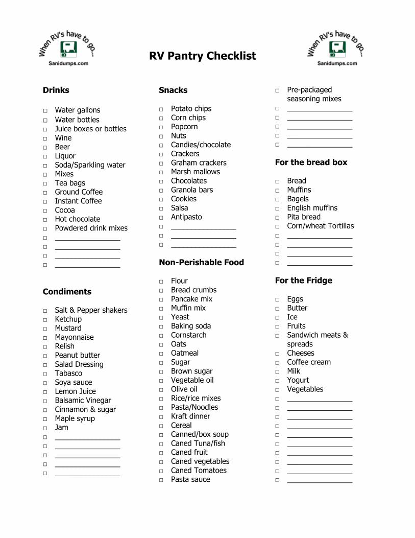
RV Pantry Checklist
Drinks □ Water gallons □ Water bottles □ Juice boxes or bottles □ Wine □ Beer □ Liquor □ Soda/Sparkling water □ Mixes □ Tea bags □ Ground Coffee □ Instant Coffee □ Cocoa □ Hot chocolate □ Powdered drink mixes □ ________________ □ ________________ □ ________________ □ ________________
Condiments □ Salt & Pepper shakers □ Ketchup □ Mustard □ Mayonnaise □ Relish □ Peanut butter □ Salad Dressing □ Tabasco □ Soya sauce □ Lemon Juice □ Balsamic Vinegar □ Cinnamon & sugar □ Maple syrup □ Jam □ ________________ □ ________________ □ ________________ □ ________________ □ ________________
Snacks □ Potato chips □ Corn chips □ Popcorn □ Nuts □ Candies/chocolate □ Crackers □ Graham crackers □ Marsh mallows □ Chocolates □ Granola bars □ Cookies □ Salsa □ Antipasto □ ________________ □ ________________ □ ________________
Non-Perishable Food □ Flour □ Bread crumbs □ Pancake mix □ Muffin mix □ Yeast □ Baking soda □ Cornstarch □ Oats □ Oatmeal □ Sugar □ Brown sugar □ Vegetable oil □ Olive oil □ Rice/rice mixes □ Pasta/Noodles □ Kraft dinner □ Cereal □ Canned/box soup □ Caned Tuna/fish □ Caned fruit □ Caned vegetables □ Caned Tomatoes □ Pasta sauce
□ Pre-packaged seasoning mixes
□ ________________ □ ________________ □ ________________ □ ________________ □ ________________
For the bread box □ Bread □ Muffins □ Bagels □ English muffins □ Pita bread □ Corn/wheat Tortillas □ ________________ □ ________________ □ ________________ □ ________________
For the Fridge □ Eggs □ Butter □ Ice □ Fruits □ Sandwich meats &
spreads □ Cheeses □ Coffee cream □ Milk □ Yogurt □ Vegetables □ ________________ □ ________________ □ ________________ □ ________________ □ ________________ □ ________________ □ ________________ □ ________________ □ ________________ □ ________________

Product TestingIn the spirit of making RVing, fun, safe and environmentally friendly, we have been testing products and servicesthat will aid RVers in this quest. It is also one of our more popular sections of our website, which tells us as this isimportant to you too. Our approach to product testing is looking at products from RVers point of view (notcomparing other similar products or performing a scientific test). Testing includes reviewing packaging,installation instructions, customer support, actual installation procedure and tips, product usage, any unstatedbenefit, and longer term usage. This provides us with initial and long term viability of products.
Disclosure
Some of the manufacturers of the products we test do advertise on our site or sponsor us at events and RVshows. We do provide the write-up to the manufacturers for review so that they can use the feedback for futureenhancement and make suggestions for our testing and usage of their products. The comments and opinionsexpressed are purely based upon our experience with the products or services and are notinfluenced/edited/changed by the manufacturers or their representatives.
You can always tell us if you want us to test a product or want to add any additional information about a productwe have tested by writing to us at [email protected]
Feel free to visit our site https://www.sanidumps.com/product-testing.php for additional products tested in theprevous year.
Product Reviews
Electronic Tank Sensors, SeeLevel II SystemRV Emergency FlasherPanels and InverterGo Power!™ Solar PanelsInverter and ChargerDrive Safe RV VideoiSeries Tank System MonitorRV Toilet Paper Test (TPT)WaterCounterCorrect Track II Bolt-on System
KC and John

Updates
When RVs have to go...™
We hope that you will get great enjoyment from using our Dump Station guide.
Our goal is to continually update and improve the product and we could use your help in this regard. If youidentiry any errors in the information regarding any information in our guide, please let us know so that we can fixthe problem. The best way of doing this is to visit our online site:
www.sanidumps.com
To submit and correction or update. Another method is to send an email to the following email address:
Thank you for you help,
Sanidumps.com
When RVs have to go...™

Terms of ServiceEnd User License Agreement
The Service
The following Terms of Service grants you access to the dump station eBook including all content anddocumentation (“Licensed eBook”), if any, delivered with it that are attached to or accompanied by this End UserLicense Agreement. The purchase of a www.Sanidumps.com (“SANIDUMPS”) eBook is a license, not a sale ofthe licensed eBook or its content. You are granted personal, noncommercial use according to the terms andconditions of this Agreement. By accessing the licensed eBook, you do not become the owner of the licensedeBook. You do have the right to use it in accordance with the provisions of this Agreement.
Your use of the licensed eBook indicates your acceptance of the terms and conditions of this Agreement.
The License and Conditions
SANIDUMPS grants you a personal non-exclusive and non-transferable license to access the licensed eBook.You may reproduce and store portions of the licensed eBook content for your personal use, and noncommercialuse. Full-scale reproduction of book contents is expressly prohibited.
You may not use the Licensed eBook on more than one computer system concurrently, make or distributeunauthorized copies of the Licensed eBook, create by decompilation or otherwise the source code of theLicensed eBook, or use, copy, modify, or transfer the Licensed eBook, in whole or in part, except as expresslypermitted by this Agreement. If you transfer possession of the licensed eBook to a third party, the license isautomatically terminated. Such termination will be in addition to any civil or other remedies available toSANIDUMPS.
The License Term
www.Sanidumps.com is continually adding, updating and enhancing the information and its delivery. It is highlyrecommended that you update your ebook periodically to access the latest information.
SANIDUMPS may, at its sole discretion, terminate or suspend your access to the licensed eBook for cause,including, without limitation, your breach of this Agreement, including for a violation of these terms andconditions. Upon such termination you shall immediately cease using the licensed eBook and will have no furtherrights under your registered use.
Terms of Use
You are granted the right to access all content of the licensed eBook, for the term described above. Youmay also print pages of the eBook for your personal use and reference in connection with your courseusing the print function included in the program functionality. You may create and save bookmarks,highlights and notes as provided by the functionality of the program.You agree to protect the licensed eBook from unauthorized use, reproduction, or distribution. You furtheragree not to translate, decompile, or disassemble the licensed eBook.SANIDUMPS reserves the right to modify, add or remove content, features and functionality of thelicensed eBook at the publisher's sole discretion.You acknowledge that the use of the licensed eBook is for your personal use only. Multi-useconfigurations or network distribution of the licensed eBook is expressly prohibited.
Copyright
The entire contents of the licensed eBook and other material available through your registration are protected bycopyright, unless otherwise indicated. Full-scale copying of licensed eBook contents is expressly prohibited. Youmay not remove, delete, transmit or create derivative works from any of the licensed eBook content. No part ofany chapter of any book may be transmitted in any form by any means or reproduced for any other purpose,without the prior written permission from SANIDUMPS except as permitted under relevant fair dealing provisions.Any other use violates this Agreement and is strictly prohibited.
All interfaces, look and feel, navigation schemes, designs and program features and functional of the Licensed
eBook are the property of SANIDUMPS and may not be copied or reproduced or used in derivative works.
DISCLAIMER
THE LICENSED eBOOK IS PROVIDED “AS IS”, WITHOUT WARRANTY OF ANY KIND, EXPRESSED ORIMPLIED INCLUDING WIHTOUT LIMITATIONS ACCURACY, OMISSIONS, COMPLETENESS OR IMPLIEDWARRANTIES OR MERCHANTABILITY OR FITNESS FOR A PARTICULAR PURPOSE OR OTHERINCIDENTAL DAMAGES ARISING OUT OF THE USE OR THE INABILITY TO USE THE LICENSED eBOOK.YOU ACKNOWLEDGE THAT THE USE OF THIS SERVICE IS ENTIRLY AT YOUR OWN RISK.
This Agreement is governed by United States of America law. You acknowledge that you have read thisAgreement, and agree to be bound by its terms and conditions.
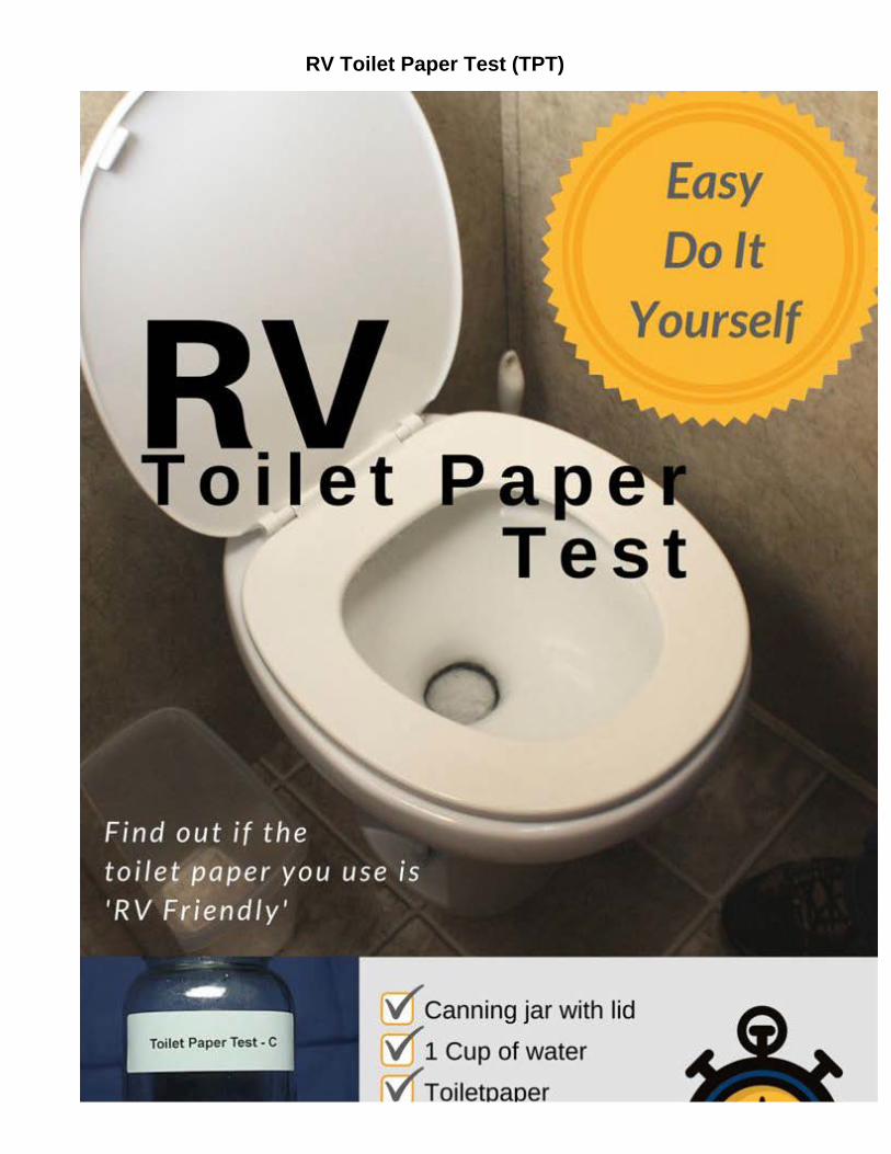
RV Toilet Paper Test (TPT)

Have you ever wondered about what type of toilet paper you should use in your RV?
Have you heard that you can only use single ply RV toilet paper?
We did! And we wanted to find out more for ourselves.