Ruston - Home | Soils 4 Teachers · 3 Ruston soils are low in organic matter and have high levels...
5
Ruston Louisiana State Soil Soil Science Society of America Photo Soil Monolith: Chip Clark/Smithsonian Institution Introduction Many states have a designated state bird, flower, fish, tree, rock, etc. And, many states also have a state soil – one that has significance or is important to the state. The “Rus- ton” is the official state soil of Louisiana. Let’s explore how the Ruston is important to Louisiana. History Established in 1909, the Ruston series was named for the town of Ruston which is the parish seat of Lincoln Parish, Louisiana. It is located in the north-central part of the state. In 1884, the town of Ruston was named for Robert E. Russ who offered 640 acres to the Vicksburg, Shreveport, and Pacific Railroad, stipulating that the tracks run across the property and that the land be used as a town site. At the time Ruston was selected as the state soil, it had the most extensive acreage and widespread distri- bution in the upland areas of Louisiana. What is Ruston Soil? The Ruston series consists of very deep, well drained, moderately permeable soils that formed in loamy marine or stream deposits on the uplands of Western and South- ern Coastal Plains (see CLORPT below). They are found on landscapes with slopes up to 8%. Every soil can be separated into three size fractions called sand, silt, and clay which makes up the soil texture. Other characteristics commonly used to differentiate soil series are the kind, thickness, and arrangement of soil horizons or layers based on their color, texture, and other physical and chemical properties. The arrangement of soil horizons can tell you a lot about the age of a soil and how it developed over time. Some common horizon designations are A, E, B, and C horizons or combinations of those. The A horizon is characteristically a surface layer that has accumulations of organic matter from plant roots and residues; E horizons (named for the process of eluviation) are characterized by some loss of iron, aluminum, clays, and organic matter through leaching; B horizons (illuvial horizons) are characterized by the ac- cumulation of iron, aluminum, and clays (from the above horizons in most cases); and C horizons typically have relatively little change due to soil forming processes. In Ruston soil, the topsoil or A horizon is a thin layer of dark grayish brown fine sandy loam over an E horizon of pale brown fine sandy loam. The subsoil consists of a B horizon of red clay loam in the upper part, a B/E horizon of yellowish red fine sandy loam in the middle part and an underlying B horizon of red sandy clay loam in the lower part (Figure 1).
Transcript of Ruston - Home | Soils 4 Teachers · 3 Ruston soils are low in organic matter and have high levels...

RustonLouisiana State Soil
Soil Science Society of America
Photo Soil Monolith: Chip Clark/Smithsonian Institution
IntroductionMany states have a designated state bird, flower, fish, tree, rock, etc. And, many states also have a state soil – one that has significance or is important to the state. The “Rus-ton” is the official state soil of Louisiana. Let’s explore how the Ruston is important to Louisiana.
HistoryEstablished in 1909, the Ruston series was named for the town of Ruston which is the parish seat of Lincoln Parish, Louisiana. It is located in the north-central part of the state. In 1884, the town of Ruston was named for Robert E. Russ who offered 640 acres to the Vicksburg, Shreveport, and Pacific Railroad, stipulating that the tracks run across the property and that the land be used as a town site. At the time Ruston was selected as the state soil, it had the most extensive acreage and widespread distri-bution in the upland areas of Louisiana.
What is Ruston Soil?The Ruston series consists of very deep, well drained, moderately permeable soils that formed in loamy marine or stream deposits on the uplands of Western and South-ern Coastal Plains (see CLORPT below). They are found on landscapes with slopes up to 8%.
Every soil can be separated into three size fractions called sand, silt, and clay which makes up the soil texture. Other characteristics commonly used to differentiate soil series are the kind, thickness, and arrangement of soil horizons or layers based on their color, texture, and other physical and chemical properties. The arrangement of soil horizons can tell you a lot about the age of a soil and how it developed over time. Some common horizon designations are A, E, B, and C horizons or combinations of those. The A horizon is characteristically a surface layer that has accumulations of organic matter from plant roots and residues; E horizons (named for the process of eluviation) are characterized by some loss of iron, aluminum, clays, and organic matter through leaching; B horizons (illuvial horizons) are characterized by the ac-cumulation of iron, aluminum, and clays (from the above horizons in most cases); and C horizons typically have relatively little change due to soil forming processes.
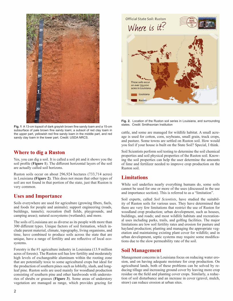
In Ruston soil, the topsoil or A horizon is a thin layer of dark grayish brown fine sandy loam over an E horizon of pale brown fine sandy loam. The subsoil consists of a B horizon of red clay loam in the upper part, a B/E horizon of yellowish red fine sandy loam in the middle part and an underlying B horizon of red sandy clay loam in the lower part (Figure 1).
2
Fig. 2. Location of the Ruston soil series in Louisiana, and surrounding states. Credit: Smithsonian InstitutionFig. 1 A 13-cm topsoil of dark grayish brown fine sandy loam and a 15-cm
subsurface of pale brown fine sandy loam; a subsoil of red clay loam in the upper part, yellowish red fine sandy loam in the middle part, and red sandy clay loam in the lower part. Credit: USDA NRCS.
Where to dig a RustonYes, you can dig a soil. It is called a soil pit and it shows you the soil profile (Figure 1). The different horizontal layers of the soil are actually called soil horizons.
Ruston soils occur on about 296,924 hectares (733,714 acres) in Louisiana (Figure 2). This does not mean that other types of soil are not found in that portion of the state, just that Ruston is very common.
Uses and ImportanceSoils everywhere are used for agriculture (growing fibers, fuels, and foods for people and animals); support engineering (roads, buildings, tunnels); recreation (ball fields, playgrounds, and camping areas); natural ecosystems (wetlands); and more.
The soils of Louisiana are as diverse as its people with more than 300 different types. Unique factors of soil formation, which in-clude parent material, climate, topography, living organisms, and time, have combined to produce soils across the state that are unique, have a range of fertility and are reflective of local eco-systems.
Forestry is the #1 agriculture industry in Louisiana (13.9 million acres of forests). The Ruston soil has low fertility and moderately high levels of exchangeable aluminum within the rooting zone that are potentially toxic to some agricultural crops but ideal for the production of southern pines such as loblolly, slash, and long-leaf pine. Ruston soils are used mainly for woodland production consisting of southern pine and other hardwoods with understo-ries of shrubs or grasses (Figure 3). Some areas of understory vegetation are managed as range, which provides grazing for
cattle, and some are managed for wildlife habitat. A small acre-age is used for cotton, corn, soybeans, small grain, truck crops, and pasture. Some towns are settled on Ruston soil. How would you feel if your house is built on the State Soil? Special, I think.
Soil Scientists perform soil testing to determine the soil chemical properties and soil physical properties of the Ruston soil. Know-ing the soil properties can help the user determine the amounts of lime and fertilizer needed to improve crop production on the Ruston soil.
LimitationsWhile soil underlies nearly everything humans do, some soils cannot be used for one or more of the uses (discussed in the use and importance section). This is referred to as a “limitation”.
Soil experts, called Soil Scientists, have studied the suitabil-ity of Ruston soils for various uses. They have determined that there are very few limitations that restrict the use of Ruston for woodland crop production; urban development, such as houses, buildings, and roads; and most wildlife habitats and recreation-al uses including parks, trails, and golfing facilities. The major limitations are low soil fertility rates and erosion for pasture and hayland production; planting and managing the appropriate veg-etation and maintaining existing plant cover for wildlife; and in urban development, septic systems may require some modifica-tions due to the slow permeability rate of the soil.
Soil ManagementManagement concerns in Louisiana focus on reducing water ero-sion, and on having adequate moisture for crop production. On agricultural lands, both of these problems can be solved by re-ducing tillage and increasing ground cover by leaving more crop residue on the field and planting cover crops. Similarly, a reduc-tion of soil disturbance and an increase in cover (gravel, mulch, straw) can reduce erosion at urban sites.

3
Ruston soils are low in organic matter and have high levels of exchangeable aluminum but are productive with added fertilizer and lime. Since these are sandy clay loam soils, added fertilizer and lime can easily leach from the soils causing nutrients to enter natural waterways. The soil has a seasonal high water table at a depth of 184 cm or greater (6 feet) below the surface. The natural low fertility and high exchangeable aluminum of this soil is the main limitation for crops other than woodlands, but using mini-mum tillage and returning all crop residue to the soil or regularly adding organic matter can help to improve fertility, maintain tilth and organic matter content, and reduce runoff.
Ruston Soil Formation
Before there is soil there were rocks and in between, CLORPT. Without CLORPT, there will be no soil. So, what is CLORPT? There are five major factors that are responsible for forming a soil like the Ruston series. These are Climate, Organisms, Relief (topography), Parent material, and Time – CLORPT, for short. CLORPT is responsible for the development of soil profiles and chemical properties that differentiate soils. So, the characteristics of Ruston soil (and all other soils) are determined by the influ-ence of CLORPT. Weathering takes place when environmental processes such as rainfall, freezing, and thawing act on rocks causing them to fracture and break into pieces. CLORPT now acts on rock pieces, marine sediments, and vegetative materials to form soils.
Climate – Temperature and precipitation influence the rate at which parent materials weather and, dead plants and animals decompose. They affect the chemical, physical, and biologi-cal relationships in the soil. Ruston soils formed in marine or stream deposits of Pleistocene age. The climate is warm and humid with mean annual temperature of 65 degrees Fahren-heit and mean annual precipitation of 59 inches.
Organisms – This refers to plants and animal life. Plant roots spread, animals burrow, and bacteria break down plant and
Fig. 3 A stand of longleaf pine with understories of shrubs or grasses. Credit: USDA NRCS.
animal tissue. These and other soil organisms speed up the breakdown of large soil particles into smaller ones. Plants and animals also influence the formation and differentiation of soil horizons. Plants determine the kinds and amounts of organic matter that are added to a soil under normal conditions. Ani-mals breakdown complex compounds into small ones and in so doing add organic matter to soil. Ruston soils formed under marine sediments, which led to being low in organic matter and high in sodium.
Relief – Landform position or relief describes the shape of the land (hills and valleys), and the direction it faces makes a difference in how much sunlight the soil gets and how much water it keeps. Deeper soils form at the bottom of the hill than at the top because gravity and water move soil particles down-hill. Ruston soils formed on nearly flat to moderately sloping uplands. Soils on flat surfaces are more stable and more devel-oped than those found on slopes (Figure 4).
Parent material – Just like people inherit characteristics from their parents, every soil inherited some traits from the material from which it forms. Some parent materials are transported and deposited by glacier, wind, or water. Some parent materi-als are just deposited by gravity (for example, volcanic lava). Ruston soils formed in mixed marine and fluvial sediments on uplands and stream terraces.
Time – All of these factors act together over a very long time to produce soils. As a result, soils vary in age. The length of time that soil material has been exposed to the soil-forming processes makes older soils different from younger soils. Gen-erally, older soils have better defined horizons than younger soils. Less time is needed for a soil profile to develop in a humid and warm area with dense vegetative cover than in a cold dry area with sparse plant cover. Ruston is an older soil. It is an Ultisol which is among the most highly weathered of the soil orders.

4
Fig. 5 Major land resource areas of Louisiana. (Credit: USDA NRCS)
Ecoregions and Land Use in Louisiana
The Ruston soils are located in the Ecoregions of the Western and Southern coastal plains. Across Louisiana, soils are grouped into 11 major land resource areas (Figure 5). Many of the areas fea-ture the terms alluvium or loess in their names. These are types of soil parent ma-terial. Alluvium indicates a soil that has been deposited or reworked by running water. Given the large number of rivers that cross Louisiana, it is no wonder that so many of our soils are alluvial. Loess (pronounced “luss”) indicates that soils formed from wind-blown sediments, and the texture of the soils are very silty, but may contain significant amounts of clay and very fine sand.
Major Land Resources Areas (MLRA) Louisiana
Fig. 4. Relationship of soils, landform position (relief) and parent material. Credit: USDA NRCS.
Shubuta, Ruston, hard substratum
Shubuta, Ruston, hard substratum
Shubuta, Ruston, hard substratum
Shubuta, Ruston, hard substratum
5585 Guilford RoadMadison WI 53711-5801Tel. 608-273-8080 • Fax 608-273-2021www.soils.org • [email protected]
This state soil booklet was developed under the auspices of the Soil Science Society of America’s K-12 Committee—their dedication to developing outreach materials for the K-12 audience makes this material possible.
Additional ResourcesSoil! Get the Inside Scoop. David Lindbo and others. Soil Science Society of America, Madison, WI.Know Soil, Know Life. David L. Lindbo, Deb A. Kozlowski, and Clay Rob-inson, editors. Soil Science Society of America, Madison, WI.
Web Resources Soils for Teachers—www.soils4teachers.orgSoils for Kids—http://www.soils4kids.org/Have Questions? Ask a Soil Scientist—https://www.soils.org/askSoil Science Society of America—https://www.soils.org/
NRCS LINKSNRCS Louisiana—http://www.nrcs.usda.gov/wps/portal/nrcs/site/la/home/Web Soil Survey—http://websoilsurvey.nrcs.usda.gov/
LOUISIANA LINKSLouisiana State Univ.—http://www.lsu.eduLouisiana State Univ. Agriculture Center—http://www.lsuagcenter.comLouisiana Department of Agriculture—http://www.ldaf.state.la.us
ReferencesNational Cooperative Soil Survey, Official Series Description-Ruston Series https://soilseries.sc.egov.usda.gov/OSD_Docs/R/RUSTON.htmlUSDA Louisiana Cooperative Soil Survey Programhttp://www.nrcs.usda.gov/wps/portal/nrcs/main/la/soils/Natural Resources Conservation Service, USDA. Web Soil Survey Archives. 2003. Soil Survey of Vernon Parish, Louisiana.Natural Resources Conservation Service, USDA. Web Soil Survey Archives. 1986. Soil Survey of Grant Parish, Louisiana.Natural Resources Conservation Service, USDA. Web Soil Survey Archives. 1980 Soil Survey of Rapides Parish, Louisiana.
Authors: Michael Lindsey, State Soil Scientist Mitchell Mouton, Assistant State Soil Scientist Marc Bordelon, Soil Scientist Ann Kinney, Editor
GlossaryClay: A soil particle that is less than 0.002 mm in diameter. They can be separated from most soils and used to determine soil textural class. A clay soil is a soil that has more than 40% clay, less than 45% sand, and less than 40% silt.Ecoregion: Represents areas with similar biotic and abiotic charac-teristics which determine the resource potential and likely responses to natural and man-made disturbances. Characteristics such as, cli-mate, topography, geology, soils and natural vegetation define an ecoregion. They determine the type of land cover that can exist and influence the range of land use practices that are possible.Eluviation: The removal of soil material in suspension (or in solution) from a layer or layers of a soil. Usually, the loss of material in solution is described by the term “leaching.” Soil horizons that have lost mate-rial through eluviation are eluvial; those that have received material are illuvial.Horizon: see Soil horizonsIlluviation: The process of deposition of soil material removed from one horizon to another in the soil; usually from an upper to a lower horizon in the soil profile.Loess: Parent material transported to and deposited in its current location by wind.Organic Matter: Soil material derived from the decay of plants and animals. Always contains compounds of carbon and hydrogen.Pleistocene age: Typically referred to as the Ice Age – the time pe-riod that began about 2.6 million years ago and lasted until about 11,700 years ago. Glaciers covered many parts of the planet.Sand: A soil particle between 0.05 and 2.0 mm in diameter. Sand is also used to describe soil texture according to the soil textural tri-angle, for example, loamy sand.Silt: A soil particle between 0.002 and 0.05 mm diameter. It is also used to describe a soil textural class.Soil Forming Factors: The surrounding environment that leads to differences in soil properties. The factors include Parent Material, Climate, Relief (Topography), Biological Activity, Time, and in some cases, Human Activity.Soil Horizon: A layer of soil with properties that differ from the layers above or below it.Soil Management: The sum total of how we prepare and nurture soil, select types of crops that suitable for a type of soil, tend the crop and the soil together, determine types of fertilizers and other materi-als added to soil so as to maintain productivity and preserve the soil.Soil Order: The highest category of soil classification – a basic sys-tem for classifying and interpreting soil surveys. Soil orders are di-vided into Suborders and the Suborders are further divided into the Great Groups.Soil Profile: The sequence of natural layers, or horizons, in a soil. It extends from the surface downward to unconsolidated material. Most soils have three major horizons, called the surface horizon, the sub-soil, and the substratum.Soil Scientist: A soil scientist studies the upper few meters of the Earth’s crust in terms of its physical and chemical properties; distribu-tion, genesis and morphology; and biological components.Soil Texture: The relative proportion of sand, slit, and clay particles that make up a soil. Sand particles are the largest and clay particles the smallest. Learn more about soil texture at http://www.soils4teach-ers.org/physical-propertiesSubsoil: (B horizon) The soil horizon rich in minerals that eluviated, or leached down, from the horizons above it. Not present in all soils.Topsoil: (A horizon) – Mostly weathered minerals from parent mate-rial with a little organic matter added. The horizon that formed at the land surface.