Russian Urban Planning: modern ideas (Legislative Base ... · PDF fileRussian Urban Planning:...
8
REAL CORP 2010 Proceedings/Tagungsband Vienna, 18-20 May 2010 – http://www.corp.at Editors: Manfred SCHRENK, Vasily V. POPOVICH, Peter ZEILE 1229 Russian Urban Planning: modern ideas (Legislative Base, Spatial Planning, Transport and Ecology, GIS Technology) Anna Beregovskih, Irina Grishechkina, Dghamilia Shalakhina, Sergey Miller, Mikhail Petrovich (General Director, ZAO “Institute Territorial Planning”, Omsk, Russia, [email protected]) (Chief Architector, State Urban Planner Institute, St. Petersburg, Russia, [email protected]) (Chief Engineer, State Urban Planner Institute, St. Petersburg, Russia, [email protected]) (President, Noncommercial Partnership “GIS-Assosiation”, Moscow, Russia, [email protected]) (Head of Department, ZAO “Peterburgsky NIPIGrad”, St. Petersburg, Russia, [email protected]) 1 ABSTRACT In the early 21st century Russia once again became a site for dramatic transformatoions in urban planning. The 2004 Urban Planning Code completely changed the traditional urban planning system. The initiative in developing General City Plans was handed over from the State to the local administration. The main task of urban planning was shifted to providing for the interests of the new land owners, who made their appearance in the 1990ies- 2000s, in the process of real estate privatization and land market restoration. The review considers the positive and negative aspects of this new stage of attitudes in urban planning in Russia. The aspects considered as achievements include giving a start to the new urban planning school, large-scale mastering of geo-informational technologies as applied to urban planning and territorial development control, as well as envolvement of the population into urban planning activities. At the same time, we happened to lose the traditional values characteristic of urban planning, those of ordered public space. The priority task in the coming decade is believed to be restoration of mechanisms controlling public space development and urban social and transport infrastructure, as well as revival of the theory and methods in urban planning in the new social and economic context. 2 RUSLAND AS SITE FOR URBAN PLANNING EXPERIMENTS 2.1 St Petersburg and others cities in the 18th -19th centuries During the recent three decades Russia has been a sort of a testing site for experiments in urban planning. In the early 18th century Peter I founded Saint-Petersburg, and the plan of the city was based on the idea of regularity. In the second half of the 18th century, the regular planning methods were spread to many cities of the Russian Empire. They were used both in building new cities and reconstructing old ones. During the reign of Catherine II, more then 160 (!) cities received “standard plans”. The attitude to the city space was undergoing radical changes; this spave was strting to be formed by “street facades”, rather than by auxiliary buildings bordering the estates [1]. Fig. 1: St.Petersburg, 1737 Both new construction and re-planning violated existing land use boundaries and required pulling down buildings which had been put up earlier. In the first part of the 19th century urban planning became even stricter when the Building Code was approved, which was active until the Revolution of 1917. Regularizing process was dramatic enough, and now we perceive the space of a regularly built city as the most valuable,
Transcript of Russian Urban Planning: modern ideas (Legislative Base ... · PDF fileRussian Urban Planning:...

REAL CORP 2010 Proceedings/Tagungsband Vienna, 18-20 May 2010 – http://www.corp.at
Editors: Manfred SCHRENK, Vasily V. POPOVICH, Peter ZEILE
1229
Russian Urban Planning: modern ideas (Legislative Base, Spatial Planning, Transport and Ecology, GIS Technology)
Anna Beregovskih, Irina Grishechkina, Dghamilia Shalakhina, Sergey Miller, Mikhail Petrovich
(General Director, ZAO “Institute Territorial Planning”, Omsk, Russia, [email protected]) (Chief Architector, State Urban Planner Institute, St. Petersburg, Russia, [email protected])
(Chief Engineer, State Urban Planner Institute, St. Petersburg, Russia, [email protected]) (President, Noncommercial Partnership “GIS-Assosiation”, Moscow, Russia, [email protected])
(Head of Department, ZAO “Peterburgsky NIPIGrad”, St. Petersburg, Russia, [email protected])
1 ABSTRACT
In the early 21st century Russia once again became a site for dramatic transformatoions in urban planning. The 2004 Urban Planning Code completely changed the traditional urban planning system. The initiative in developing General City Plans was handed over from the State to the local administration. The main task of urban planning was shifted to providing for the interests of the new land owners, who made their appearance in the 1990ies- 2000s, in the process of real estate privatization and land market restoration. The review considers the positive and negative aspects of this new stage of attitudes in urban planning in Russia. The aspects considered as achievements include giving a start to the new urban planning school, large-scale mastering of geo-informational technologies as applied to urban planning and territorial development control, as well as envolvement of the population into urban planning activities. At the same time, we happened to lose the traditional values characteristic of urban planning, those of ordered public space. The priority task in the coming decade is believed to be restoration of mechanisms controlling public space development and urban social and transport infrastructure, as well as revival of the theory and methods in urban planning in the new social and economic context.
2 RUSLAND AS SITE FOR URBAN PLANNING EXPERIMENTS
2.1 St Petersburg and others cities in the 18th -19th centuries During the recent three decades Russia has been a sort of a testing site for experiments in urban planning. In the early 18th century Peter I founded Saint-Petersburg, and the plan of the city was based on the idea of regularity. In the second half of the 18th century, the regular planning methods were spread to many cities of the Russian Empire. They were used both in building new cities and reconstructing old ones. During the reign of Catherine II, more then 160 (!) cities received “standard plans”. The attitude to the city space was undergoing radical changes; this spave was strting to be formed by “street facades”, rather than by auxiliary buildings bordering the estates [1].
Fig. 1: St.Petersburg, 1737
Both new construction and re-planning violated existing land use boundaries and required pulling down buildings which had been put up earlier. In the first part of the 19th century urban planning became even stricter when the Building Code was approved, which was active until the Revolution of 1917. Regularizing process was dramatic enough, and now we perceive the space of a regularly built city as the most valuable,

Russian Urban Planning: modern ideas (Legislative Base, Spatial Planning, Transport and Ecology, GIS Technology)
1230
REAL CORP 2010: CITIES FOR EVERYONE. Liveable, Healthy, Prosperous
human-compatible, ready to incorporate new functions and new transport flows. It is the planning structure of St.Petersburg that has become the main object of protection by UNESCO in the city.
2.2 “Garden cities” and “Le’Corbusie urban space” in the 20th century
Fig. 2: The sample of micro-district space organisation: Moskovsky prospect, Leningrad, 1930s
Search for new urban planning solutions which had started in the 19th century Europe was also spreading to Russia. Many projects of “garden-cities” appeared, “cities for workers”, which were partly implemented. However, the main obstacle for their implementation was private property on land. Land nationalization in 1918 made it possible to conduct large-scope experiments in this direction. The sample to follow was Le’Corbusie’s type of design, with freely spaced buildings standing in green areas between motorways. The sample was reconsidered, and the intra-motorway area began to be viewed as a relatively enclosed social space, “a micro-district”. In the 1950s-1960s the micro-district became the main method of urban space development in the USSR. Strict national rules were established for siting social infrastructure in such micro-districts, including schools, kindergartens, shops, health care institutions and sports grounds. Two generations of urban planners, up until 1991, were drawing, calculating, discussing and looking for optimal decisions for organizing micro-district space.
Also characteristic of the Soviet urban planning period were projects of large administrative areas and spacious park zones incorporating sports facilities. Figure 2 shows the layout diagram and as build drawing of Moskovsky Prospect in Leningrad accomplished in the 1930s. The design combines a pompous administrative area and micro-district housing, as well as a park zone. It was implemented and is now one of the most prestigeous residential areas in the city.
2.3 “Perestroika time” – late 20th and early 21st centuries When the subsidies for housing construction were cut and private property on land restored in the 1990s, uban planning based on the former standards came to an abrupt standstill. Attempts made by civil architects of the “Soviet” school to work with new customers using old traditions failed completely. The new customers needed, first, to register their right to land ownership and, second, get authorization for site development. The social infrastructure, ecological requirements and space organization were looked upon as obstacles to new socio-economic relations and investment flows. Figure 3 shows the results of land

Anna Beregovskih, Irina Grishechkina, Dghamilia Shalakhina, Sergey Miller, Mikhail Petrovich
REAL CORP 2010 Proceedings/Tagungsband Vienna, 18-20 May 2010 – http://www.corp.at
Editors: Manfred SCHRENK, Vasily V. POPOVICH, Peter ZEILE
1231
privitazation in the micro-district area that took shape in the 1960s as a single space and territory. The areas are outlined in a way that makes it possible to calculate the cost of land ownership, but this contradicts the existing system of passages and exits and ruins themeaningdulness of the space as a place of communal use. Such privatization is characteristic of nearly all Russian cities and towns.
Fig. 3 Modern subdivision system for a “micro-district”. St. Petersburg, 2009.
The positive experience from this period can be seen as follows: city shaping stopped being the prerogative of the selected few – the city administration and architects – and was taken over by a larger number of actors: individuals, families, financial and construction companies. It is these actors that K.Linch calls the “true urban planners” [2].
One can say that modern urban planning is more than ever directed to accounting for the interests of different social strata, of those in power, of investors and common residents. Modern land development is more variable than in the previous period.
3 MODERN WINS AND FALLS
3.1 Legislative Base Reconsideration of relations in urban panning resulted in the Urban Planning Code of the Russian Federation adopted in 2004. году [3]. It passed on the initiative in General Plans development to the municipal bodies (until 2004 the planning documentation of the lower level could only be based on those of the upper level). The General Plans of city districts and settlements became the main basis for developing a new type of document: The Rules of Land Use and Development. These Rules are a law developed by the local administration and are functionally very close to the European and North American Zoning Plans . The General Plans and Rules are the basis for developing Planning design and Land Surveying Projects of a particular area. A boost to the development of General Plans, Planning Designs and Land surveying Projects was given when they were included into the obligatory document package for getting construction permit.
The Urban Planning Code of 2004 was innovative in that it specified the titles, purpose and content of the documents dealing with territorial planning at the national level. Instead of a single document – the Population Distribution Scheme of the Russian Federation – it envisages development of a large number of Territorial Planning Schemes by branch.
3.2 Spatial Planning
3.2.1 Functional map as a main document of General Plans
The main point in present-day General Plans is functional territory zoning. As a rule, the following set of functional zones is used: 1) the residential zone, separated into low-rise, medium-rose and high-rise housing; 2) business zone; 3) industrial zone, graded according to the sanitary class; 4) recreational zone; 5) engineering and transport structure zones; 6) special purpose zone. The number of zones varies from city to city, depending on the local conditions.
The type of functional zone is established mainly based on the demands and supply on the part of developers. Customers often think of General Plans as a sum of various plans superimposed over each other on the same
Russian Urban Planning: modern ideas (Legislative Base, Spatial Planning, Transport and Ecology, GIS Technology)
1232
REAL CORP 2010: CITIES FOR EVERYONE. Liveable, Healthy, Prosperous
map. However, the “summing up” operation serves to elucidate the contradictions among the designs previously made. The zones are revealed, where development is restricted by the natural processes taking place there. Preservation zones of historical monuments become manifest. The motorway diagram is adjusted. All of this makes the planners look for a compromise, and urban planning results are very different from a simple sum of designs.
Notably, the main requirement to the new General Plans is the observation of the public hearing procedure.
After 2004, the General Plan began to be treated as a standard document, where all elements of the drawing came to be considered as “precise”, including the zone borderlines and motorway axes, all on 1:10000 scale map. On the one hand, it was an advantage, because the planners were now forced to study the land use system as it is. On the other hand, it was a disadvantage, because it became impossible to adjust the borderlines and axes for 1:2000 and 1:500 scales.
At present, proposals are being developed to update the 2004 Urban Planning Code.
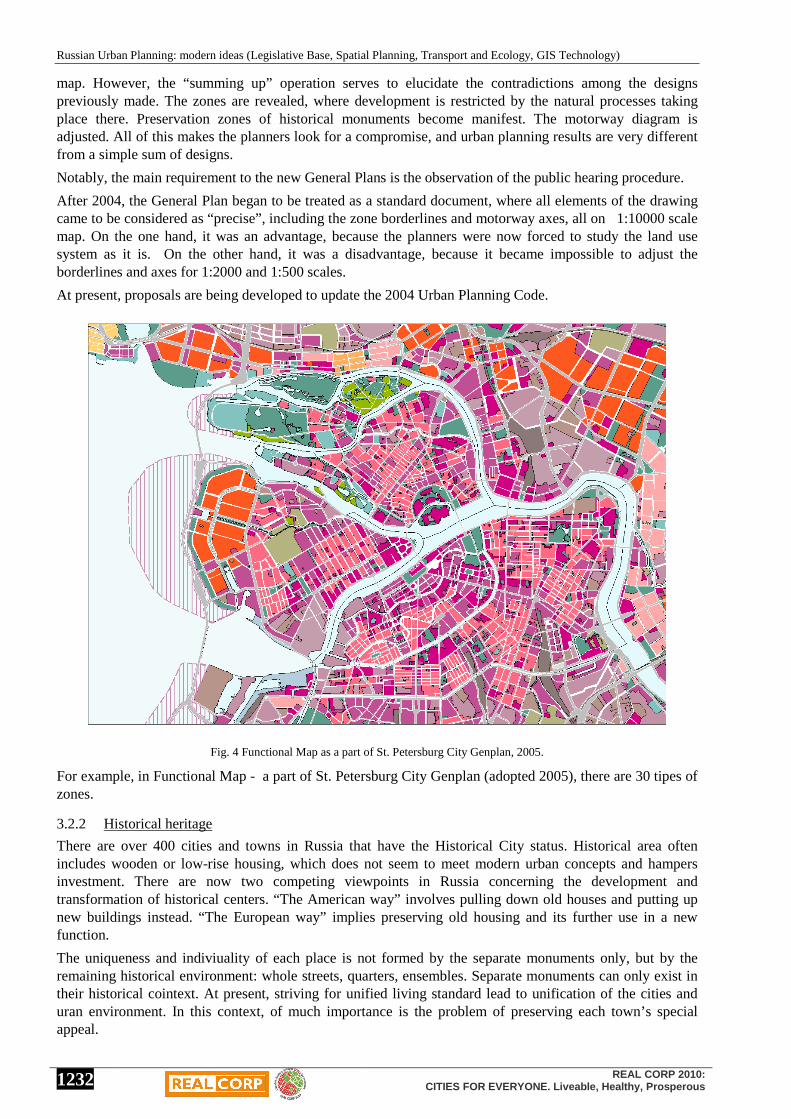
Fig. 4 Functional Map as a part of St. Petersburg City Genplan, 2005.
For example, in Functional Map - a part of St. Petersburg City Genplan (adopted 2005), there are 30 tipes of zones.
3.2.2 Historical heritage
There are over 400 cities and towns in Russia that have the Historical City status. Historical area often includes wooden or low-rise housing, which does not seem to meet modern urban concepts and hampers investment. There are now two competing viewpoints in Russia concerning the development and transformation of historical centers. “The American way” involves pulling down old houses and putting up new buildings instead. “The European way” implies preserving old housing and its further use in a new function.
The uniqueness and indiviuality of each place is not formed by the separate monuments only, but by the remaining historical environment: whole streets, quarters, ensembles. Separate monuments can only exist in their historical cointext. At present, striving for unified living standard lead to unification of the cities and uran environment. In this context, of much importance is the problem of preserving each town’s special appeal.

Anna Beregovskih, Irina Grishechkina, Dghamilia Shalakhina, Sergey Miller, Mikhail Petrovich
REAL CORP 2010 Proceedings/Tagungsband Vienna, 18-20 May 2010 – http://www.corp.at
Editors: Manfred SCHRENK, Vasily V. POPOVICH, Peter ZEILE
1233
With the procedure of public hearing on any urban planning document approval in place, the public opinion on the issue of historical monuments preservation has acquired some weight.
Fig. 5. Example of successful approach to preserving historical heritage. The project for central district of Rostov-na-Donu city.
3.2.3 Suburbanization
Suburbanization, unregulated spread of the cities, is a very familiar problem for Russia. The demand for low-rise, individual housing is growing. So far Russia has not been faced by the task of restraining this type of housing. During the recent 5-8 years, indidual housing amounted to 50-70% among other housing types. In fact, all the territories around large cities, which had previously been used for agricultural purposes, has been taken over by new owners, who are engaged in individual housing.
While such plans are developed, little care is taken of ecological issues, preserving plantation and open space, which is essential for any city. Attempts to regulate such construction by urban planning do not find any understanding on the part of the land owners and local administration. Uncontrolled suburbanization results in economically unjustified withdrawal of land from agricultural use.
3.2.4 Densified development
In the recnt years, the term “densified development” has come into use. This term is used for the prcess of building up open spaces in already existing residential areas. This densifying is carried out at the expense of the green plants and objects of social infrastructure, which are necessary for providing adequate living conditions. Thus the positive experience of the Soviet period is rejected of creating the adequate infrastructure. Protection of green plants and open spaces has become the target for many grass-root organizations.
3.3 Transport The situation with transport in modern Russian cities reminds of that in the European cities some 30 years ago:
• Motorization of the population has peaked: in large cities during the recent 20 years it has increased 5 to 6 times and reached 300-350 cars per 1000 residents;

Russian Urban Planning: modern ideas (Legislative Base, Spatial Planning, Transport and Ecology, GIS Technology)
1234
REAL CORP 2010: CITIES FOR EVERYONE. Liveable, Healthy, Prosperous
• Traffic jams in all large cities have become the order of the day;
• Public rail transport is stagnating: trams are cut, underground construction has slowed down. In Petersburg, underground stations are designed to open in 2010-2012, which have been started in the 1980s.
It should be noted that by now we have lost the civil institutions that were able to manage the public transport systems, study the population’s mobility and passenger flows, and plan the development of urban motor road density and design elements of urban transport system. According to H. Mayer [4], the same process was taking place in the European cities some 25-30 years ago. The requirements to street planning parameters, the consistent road network planning system developed in the Soviet period seemed an obstacle in the way of the new market relations. The Urban Planning Code (2004) did not even include the main principles of the urban transport infrastructure.
Behind the external, uncouth aspect of the transport system in Russian cities we should see the dramatic internal changes that have occurred:
• cities have become independent economic entities and are now associating their development with involvement in international and national transport ways;
• streets and roads, as well as public transport objects are distributed among owners, and the system of property management is being set up;
• state support for public transport has been replaced by self-financing, involving local and regional budgets;
• in providing transport services, competitive environment has been formed;
• public transport has become attuned to working with new flow directions and new passenger categories.
At the same time, we still do not have a general strategy of reforming urban transport systems. There are some cities that focus on large-scale high-class motorways, with state-of-the-art interchanges to facilitate the traffic. If the tram tracks are in the way, they are removed. This is the strategy chosen by Moscow, partly St.Petersburg and some others. However, practical implementation of these tasks takes years, and by the time a bridge or motorway section is completed, the problems far outstrip the advantages.
The second solution, which can be expected to produce quick pay-off, is creating intellectual transport systems including both road traffic and satellite monitoring of traffic flow, etc. However, work in this direction is hampered by the lack of experience at the local administration level and the opposition on the part of the State Traffic Safety Inspectorate.
The third way is to restore the effective work of the public transport. This would require much funding, but is quite promising in the long run, as the foreign experience shows us.
Notably, all the three options require revitalizing the civil institutions responsible for monitoring urban transport infrastructure [5].
Fig. 6. Scheme of transport flows – the result of researching with transport model. Perm city, 2008.

Anna Beregovskih, Irina Grishechkina, Dghamilia Shalakhina, Sergey Miller, Mikhail Petrovich
REAL CORP 2010 Proceedings/Tagungsband Vienna, 18-20 May 2010 – http://www.corp.at
Editors: Manfred SCHRENK, Vasily V. POPOVICH, Peter ZEILE
1235
We expect the new territorial and transport planning technologies to be widely introduced in the nearest future, based on mathematical modeling of transport flows. We used to have rich experience in such modeling in many scientific centers in the USSR, and it still survives in St.Petersburg, Moscow, Yekaterinburg and Irkutsk. The companies are developing fast which are using new software products [6].
New research will focus on the social psychology of urban communities, developing “network cities”, living within the transport, informational and engineering communication networks and “the problems concerned with the interaction of large-scale global structure objects with the delicate tissue of historical cities”[7].
3.4 Ecology In the context of demographic slump, the main condition for effective long-term territorial development in the country is ensuring high-quality living environment, as well as formation of favorable ecological and environmental conditions for life activity in the territory. The territory is becoming the source of budgetary income, and its quality (natural and environmental conditions, ecological status and infrastructural adequacy) plays a large role in determining the prospects of the residential settlements there.
Notwithstanding the practical elimination of the institute of state ecological expertise for the documents concerned with territorial planning, ecological issues are key points at all planning stages.
Current state policy in regional development is oriented to working out new approaches to territorial planning, aimed at ensuring ecological safety for the population and preservation of natural complexes.
3.5 GIS Technology GIS Technology began to be introduced into the Russian urban planning practices at the turn of 1980s and 1990s. At present, in 2010, 200 design organizations are using GIS Technology in developing urban planner documentation. New technologies turned out to be a sort of “driving engine” for planning activities. They helped to attract young specialists into the field and contributed to developing new design technologies. Young private companies, when trying to establish their business, have relied on technological innovations as their competitive edge. They set themselves a large-scale business task of developing planning documentation in digital mode, rather than in traditional form. Discussion of various aspects of GIS-Product application resulted in formation of the expert community. In 1994 GIS Association was formed, which is a public organization of professionals in the field of development and application of digital spatial data. The Association discusses issues concerned with GIS application at its conferences and publishes a quarterly edition called “Management of Territorial Development”, as well as manages a site for urban planners in the Internet and organizes foreign business trips.
The Urban Planning Code adopted in 2004 gave impetus to setting up municipal information systems on urban planning. In many municipal bodies, such information systems are based on GIS.
According to yearly 2010 estimates, GIS technology is used in 50-100 organizations engaged in urban planning. The number of municipal information systems using GIS technology is estimated at 250 for the whole of Russia.
Of the problems that hamper wide GIS introduction, the following should be mentioned:
• lack of the standards in the Urban Planning Code envisaging obligatory introduction of digital databases for entities subject to urban planning control;
• excess secrecy concerning precise geographic co-ordinates when describing spatial objects, which has remained from the Soviet times;
• lack of spatial data infrastructure in the RF, which could provide for more efficient use of existing maps, probing data and digital modeling.
In 2006, the Government of the RF approved the Concept of Development of Spatial Data Infrastructure in this country; however, the chain of structural transformations in the Federal bodies that followed is still in the way of the actual implementation of the Concept.
At present, GIS Association sees its main tasks in legal confirmation of compulsory digital base availability, which would be consistent with the planning documentation on the level of the Federal, sub-federal and local levels.

Russian Urban Planning: modern ideas (Legislative Base, Spatial Planning, Transport and Ecology, GIS Technology)
1236
REAL CORP 2010: CITIES FOR EVERYONE. Liveable, Healthy, Prosperous
4 CONCLUSION
The new period in urban planning development in Russia is exciting to research. One can easily imagine being taken back into the 16th-17th centuries, when urban planning awareness was just starting to revive. This is a great period for renovating old ideas and testing them out in the new economic conditions. We look at urban planning as synthetic art, close to the art of healing. To develop new “healing practices”, we would like to use the best domestic urban planning examples, as well as consider the European experience and the Asian culture of space development. Much effort is needed to work out new design and space management methodologies, as well as to train a new generation of customers and urban documentation developers.
5 REFERENCES 1.Градостроительство. Под редакцией В. Шкварикова. - М.: Академия архитектуры СССР, 1945 – 327 с. ил. , pp. 110-111 2. Lynch K. A theory of good city form – The MIT Pre ss/ Translate to Russian, Moscow 1986. 3. Закон Российской Федерации «Градостроительный кодекс Российской Федерации» №190-ФЗ от 29.12.2004. 4. Meyer H. City and Port, Utrecht, The Netherlandes, International Books, 1999, 424 p. 5. Блинкин М., Сарычев А. Качество институтов и транспортные риски. Москва, 2008. 6. Социально-экономические проблемы развития транспортных систем городов и зон их влияния. Материалы и тезисы
докладов – Екатеринбург: Комвакс АМБ, 1997 - 2009 7. Graham S. and Marvin S. Splintering Urbanism, London, 2001, 477 p.